mense en plekke van die piketberg-kontrei - home - vassa · · 2015-03-24mense en plekke van die...
TRANSCRIPT

THE SANDVELD ORAL HISTORY PROJECT
Mense en plekke
van die Piketberg-kontrei
2015

1
HOW THE PROJECT STARTED
We are members of the Vernacular Architecture Society of South Africa (Volksboukundige Vereniging
van Suid-Afrika), a group of people interested in old buildings and the people who designed and built
and lived in them. In 2012 the Vernacs went on a weekend excursion to the Sandveld and Piketberg.
We were curious to see how much remained of the old buildings of the region that we had studied
and visited in the past, but which seemed to have become forgotten in more recent times. We visited
farms and villages between the Verlorenvlei estuary on the coast to the eastern flanks of the
Piketberg, and talked to the people who lived there.
During this excursion we saw that over the last 20 years many of the buildings had disappeared or had
become ruins, and previous family-farming practices had changed dramatically. From our
conversations with owners and inhabitants we also realised that the elders, who remembered the
history of events and the tales about the places and families, were getting old or had recently passed
on. We therefore decided to start an oral history project in the Sandveld, to record personal histories
and people’s memories of the places they knew.
The Vernacular Architecture Society asked the Tracing History Trust (that promotes heritage
research) to apply to the National Heritage Council of South Africa for funding for the project. We
were fortunate to be awarded some money. The Sandveld Project team started work in October 2013
and our fieldwork was completed in June 2014.
© Vernacular Architecture Society of South Africa, 2015
VASSA is not responsible for authors’ opinions or factual errors

2
THE SANDVELD AND PIKETBERG
The Piketberg is a distinctive geographical landmark on the N7 West Coast road about 140 km from
Cape Town, but today the mountain and town and settlements in the valleys around the mountain are
often by-passed by travellers who are heading from the City towards the impressive Cedarberg
mountain ranges or driving up to Namibia.
Maps showing location of study area and places mentioned in the text.

3
The Southern Sandveld, between the Berg and Langevlei rivers, is now a quiet sparsely populated area,
but in the 18th century it was a busy frontier region criss-crossed by hunters, pastoralists, explorers,
traders, livestock dealers, militiamen and outlaws. The area became occupied by descendants of
Khoekhoe and San, Europeans, slaves from Africa and Asia and oceanic island fishermen.
The land supported herds of cattle and sheep to supply the Dutch East India Company ships that
stopped on their way between Europe and Asia. At first the Company allocated grazing licences to
farmers from the Drakenstein and Stellenbosch, but after about 1740 families of European descent
moved to the Sandveld and settled down to build houses and raise families. This disrupted and
eventually destroyed the traditional Khoekhoe system of nomadic pastoralism. In the 1770s the
independent Khoekhoe were persecuted to such an extent that many abandoned the area, such as
the Kok and Afrikaner families, and they moved further north and east to eventually form the ‘Griqua
nation’. Most of the land became the private property of a few inter-related families of free-burghers
(such as the ‘Smit clan’). They owned and lived on farms and in small settlements, practising
agriculture where enough water was available, grazing herds of cattle, goats and sheep in drier places,
and fishing in the estuaries and sea along the west coast.
Landowners’ livelihoods depended on the work of slave, free and indentured Khoekhoe and Bastaard
labour, together with contributions from the network of younger members of their large extended
families and landless relatives. During the 19th century, commercial fishing and farming remained the
mainstay of the local economy and resulted in settlements at Velddrif and along the Verlorenvlei and
the Langevlei. The emancipation of slaves in 1838 did not mean that they were free from other forms
of bondage. This period saw the introduction of restrictive labour laws and ‘vagrancy’ acts to keep
workers on the farms and to control the movement of people without land and property. The
establishment of mission villages (such as Wittewater and Goedverwacht) provided some
independence for the inhabitants, both ex-slaves and Khoesan descendants, but they were not
entirely self-sufficient.
Despite a reliance on the markets of Cape Town, the Sandvelders avoided too much interference from
government authorities. The town of Piketberg (Piquetberg) was only founded in 1840 when erven
were laid out around the original thatched church and a large open square.
New and upgraded roads and the arrival of the railway in 1903 opened the area to new markets and
opportunities. Improved communications also brought with them the troops and trauma of the South
African War (c.1900) that drove a wedge between Boer and Brit loyalists in Sandveld communities.
The Depression (c.1930), discriminatory policies to support ‘poor Whites’ and two World Wars (c. 1920
and c.1940) marked the early 20th century. The consequences of enforced racial, social and economic
barriers and forced removals under an Apartheid regime from the 1950s harmfully affected relations
between individuals and longstanding associations between Sandveld families.

4
THE PROJECT TEAM
Carohn Cornell works mainly in the field of public history, as an oral history interviewer and as a writer and/or editor of exhibition texts and publications for community-based researchers.
Liane Greeff specialises in photography and videography: filming, editing and producing videos regarding environmental and social justice and water-related issues.
Antonia Malan is a historical archaeologist with many years of experience as an academic and a heritage consultant. She is a trustee of the Tracing History Trust and edits the VASSA Journal on behalf of the Vernacular Architecture Society of South Africa.
Kay McCormick has retired from Applied Linguistic Studies at UCT, and is developing expertise as a photographer for social history projects.
The recorded interviews were transcribed by Leon van Wyk and Claire James.
The team was assisted by Maureen Archer (VASSA member and oral historian), Elsa Naudé (born Burger, a local family) and Guy Thomas (MA candidate, Department of Archaeology, UCT).

5
AIMS AND OBJECTIVES OF THE PROJECT
The aim of the project was to make an audio-visual record of the stories of families associated with
Southern Sandveld farms and settlements, to identify and record the built environment and cultural
landscape, and to carry out archival research related to tracing the past history of these families and
places. The recording process had already started in 2011 on the farms Wagenpad and ‘t Voetpad
(Ezelshoek). Due to an enthusiastic network of contacts and referrals, this second phase became
focused on the farms of the Piketberg rather than the ‘real Sandveld’ area further to the west. We
hope that the next phase should extend to farms beyond Aurora and towards the coast.
A secondary intention was to collate information into a collection of resources for future work in the
region. The results of intensive fieldwork and some preliminary processing of information during this
phase is therefore only a beginning. This project is still a work in progress with much future potential.
Interviewees were at first selected on the basis of representing a range of economic and cultural
backgrounds. Once the project started, we were passed from person to person. The original target
was Wagenpad (Droërystkloof), now owned by Pierre le Roux, and then we met the Van Zyl brothers
of ‘ Voetpad (Ezelshoek). An introduction to the Burger family lead to the work being extended to
Banghoek and other farms in the Kapteinskloof. We visited the Lambrechts farm of Groenfontein on
the southern flank of the Piketberg because of a picture of the farm werf by J.C. Poortermans in 1848.
As a result of staying at the Kapteinskloof Guest House, interviews were also carried out at the
Moravian kerkgrond in Kapteinskloof, at the Moravian mission village of Goedverwacht, and in the
town of Piketberg. Some notes were also taken during conversations related to the project, but these
were not formally recorded.
Interviews were carried out at the subject’s home or place of work, and mostly in Afrikaans. The
records include digital voice recordings and video footage. The recordings were then transcribed into
written text. This is a specialised and time-consuming task. The transcribed records have undergone a
first edit (to improve readability) but no amendments have yet been made to factual errors or
inconsistencies regarding person or place names, spelling, etc. The transcripts are unfinished business.
Due to the enthusiasm of the team and the people we met, many more interviews were conducted
than originally proposed and there was neither time nor budget to prepare them for public access in
this phase. The interview material is therefore being retained by the team until that process has been
completed. Similarly, the preparation and editing of video footage is also a work in progress.
Still photographs of the places and portraits of the people are an important component of the
research and recording process. The context in which the buildings are set – the cultural landscape -
and the scenic properties of the area are a strong theme in the stories that were told. Participants
have been presented with a printed portrait, as a gift, and a collection of posters has been prepared
for exhibition at the Piketberg Musuem.
A parallel process is the verification of ‘stories’ and ‘traditions’ through research into published and
primary historical and archival resources. The history of ownership of properties was traced in the
Deeds Office and Western Cape Archives Repository (WCAR) and on the online search facility of the
Surveyor-General’s Office. The official records are particularly patchy for the Piketberg region and the
boundaries of administrative districts kept changing so several series of files had to be searched. Due
to time constraints we were restricted to producing an annotated catalogue and to providing some
examples and images of what was found. The family historical research includes following up
references in published material, consulting online databases and searching manuscripts in the
Archives.

6
THE PEOPLE & THEIR STORIES
The farm-owning families that we interviewed are generally descended from the extended ‘Smit clan’
that controlled the region in the 19th century, but by the later 19th century the establishment of several
churches and secondary schools in the area lead to increased separation of this huge family into
groups or networks that were economically and socially centered on these new settlements. For
instance, the farm families of Kapteinskloof and Groenfontein attended church and high school in
Aurora and Zuurfontein, but people from ‘t Voetpad and surrounds travelled to Redelinghuys, and
those of Wagenpad to Eendekuil.
The farm workers’ families depended on individual farmers and Moravian missionary support for
religious and educational facilities. In the case of Kapteinskloof, Gelie Basson of Bokloof provided a
wood-and-iron building (the blikkerk) to accommodate services and school classes within walking
distance of the farms, and it was erected in 1925 on a sliver of land that was granted to the Moravians.
The children of farm workers from Wagenpad had classes in a building on Winkelshoek, the
neighbouring farm, which also served for church services. The mission settlements at Wittewater and
Goedverwacht were important economic and cultural centres for the whole region.
Several families lived on the various farms in the Piketberg, a few permanent and some itinerant.
During times of economic stress especially, landless families were taken in or ended up being
accommodated on farms. Some were relations and some were not. They contributed labour for
agricultural work and animal husbandry, and artisanal skills such as building, blacksmithing, etc. Farm
worker families were also a combination of permanent residents who stayed over many generations
and itinerants needing seasonal work, whether locally born or from far away.

7

8
WRITTEN & SPOKEN EVIDENCE
Marthinus Melk Brand van Zyl, co-owner of ‘t Voetpad (Ezelshoek) with his brothers Hermanus and
Jan, prepared written notes for us. We made two visits to the farm during which we wrote our own
notes and made digital recordings. The voice recordings were then transcribed. When several people
speak of the same place, the different versions of the stories can be compared to each other. The
brothers’ memories were vivid but sometimes contradictory. In the Deeds Office we found a sequence
of survey diagrams showing the layout of the farm and the buildings on it, including the subdivision
boundaries. Measured drawings were made of the remaining buildings and ruins. One of the most
remarkable documents that Thinus vay Zyl produced was an annotated aerial photograph of the farm,
on which he had named 65 features such as rocks, water sources and pastures.

9
Our first introduction into the memories and experiences of farm workers at Wagenpad came from
John Goliath and Hendrik van Wyk. Their lives and those of their ancestors have revolved around the
valleys which look out towards the Cedarberg at the far northern end of the Piketberg. This area is
known as Droërystkloof, and the two main farms are Winkelshoek and Wagenpad. As the names
suggest, the former is marked by a sharply angled rocky cliff and the latter lies on an old wagon road
that provided a short-cut between the Krom Antoniesrivier valley and Eendekuil. Patrick Carter, the
farm manager, estimates that about 250 people once lived in the Wagenpad valley. In the 1950s
Barbara Barnard’s mother (a Smit) ran the winkel, and there were a post office, school, taphuis and
other shared facilities on the central werf. Barbara still has the account book from the shop. Over the
years of visiting Wagenpad we have watched the reconsolidated land gradually flourish through
ecological farming practices, under the patient husbandry of farmworkers, managers and owner.
Eric Burger was born on Banghoek and spent his very early days there when his grandfather, Barend
Burger, was alive. There is a photograph of Oom Barend, his second wife Cecilia Bosman and the boy
Eric. The patriarch of Banghoek was confined to a home-made wheelchair but this did not prevent him

10
from ruling over his family, the ‘volk’, the farm and most of the neighbourhood. Eric describes it as “a
feudal system”. Much later Eric came back to farm the property, due to the untimely death of his
father. Eric also provided some written notes about the farm. The notes were mostly genealogical in
nature, because it seems that all the property-owning families are interested in who is related to
whom and how (and who inherited or not). Since the families have intermarried over generations and
their names are repeated, it is not a simple issue. Eric Burger was interviewed at his home in
Porterville. We planned to film him at Banghoek, but he became ill at the time and so we hope to do
this later. He has strong and wide-ranging memories of the farm and its people, and enjoys telling
stories.
These stories formed a background to our interview with his cousin, Kowie Brand, who is descended
from Oom Barend’s first wife, Anna Kotze, who died in childbirth. Kowie was brought up on Banghoek
and lived there until adulthood. He provided details about the people on the farm, neighbours and
farming practices. His stories also provided information about the network of schooling, church and
maternal family connections throughout the Sandveld. Kowie did not benefit from farmland
inheritance, and his career was in the civil service.
11
The Lambrechts and Coetzee families have been living in the Kapteinskloof valley for hundreds of
years. They are also linked with the Bassons, Burgers, and so on. Frans Coetzee showed us the family
bible in which births and deaths are recorded, and a published genealogy of the family. It is difficult to
sort out who’s who because names are inherited down the generations and people are known by their
byname or nick-names. We heard about Oom Appel and Tant Ben, Klaas Winkel, Frans Khaki,
Scotsman, Kaatje Dikbossie and Takkielak.
Groenfontein, which overlooks the Berg River from the south-western slopes of the Piketberg, was a
Lambrechts farm. ‘JJ’ Lambrechts and his wife have now sold their portion and retired to Stellenbosch,
but his strong love for the place and vibrant memories of the farm and the people living there were
emotionally revealed during the interview. Hennie Lambrechts, whose widow Hannah and son Henk
still live on the farm, took early retirement from the railways to return to live in the house his father
built in 1935. It is designed and constructed in the same vernacular style as earlier buildings, with the
kitchen, voorhuis, slaapkamer and buitekamer in a row under a thatched roof. Unfortunately, the
oldest buildings on Groenfontein were demolished in the 1970s.
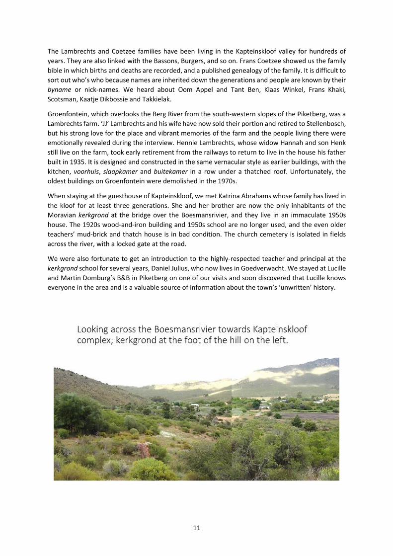
When staying at the guesthouse of Kapteinskloof, we met Katrina Abrahams whose family has lived in
the kloof for at least three generations. She and her brother are now the only inhabitants of the
Moravian kerkgrond at the bridge over the Boesmansrivier, and they live in an immaculate 1950s
house. The 1920s wood-and-iron building and 1950s school are no longer used, and the even older
teachers’ mud-brick and thatch house is in bad condition. The church cemetery is isolated in fields
across the river, with a locked gate at the road.
We were also fortunate to get an introduction to the highly-respected teacher and principal at the
kerkgrond school for several years, Daniel Julius, who now lives in Goedverwacht. We stayed at Lucille
and Martin Domburg’s B&B in Piketberg on one of our visits and soon discovered that Lucille knows
everyone in the area and is a valuable source of information about the town’s ‘unwritten’ history.

12
In the same way that the property-owning families are interlinked over generations, so are the families
who helped work the land, build and clean the buildings and tend the children and animals. The names
of Adams, Abrahams, Diedricks, Faro and Smit are part of the area’s deep history, but their story is not
so easy to find in official documents and the families do not often have written family records. Their
memories are their heritage.

13
Many people have left the area, and those who remain are mostly retired or still working as domestic
servants and farm labourers. Some are illiterate, but others took advantage of the schooling that was
available and have broken through the barriers of poverty, race and lack of opportunities. Our
interview with Lucille Domberg in Piketberg, a high school teacher, provided insights into what
happened to the children from the farms in more recent years as well as the historical impacts of
Apartheid in Piketberg.
All speak of great numbers of ‘coloured’ people once living in Kapteinskloof and on the other farms,
and families were large. Work was hard and there was little time off, and the ‘dop’ system was
debilitating, but there was a sense of community. Men seem to have moved around the Sandveld to
various family-linked farms, working where and as needed in a farming system that was largely
seasonal. Some worked in the fishing industry as well. Household and farm chores were extensive and
children were expected to help. Women and girls did seasonal farm work and also worked at times in
domestic service in the town houses of their employers’ families, in the city of Cape Town and in the
suburbs. Older women were also (and still are) responsible for raising grandchildren. They performed
skilled services such as midwifery and treated injuries and sickness. People walked great distances to
visit, including to the Bo-Piketberg plateau on top of the mountain which is directly accessible by
footpaths.

14

15
ARCHIVAL RESEARCH
The property records form a separate and specialised part of the overall archive of the Project and
include maps, grants, transfers, survey diagrams and aerial photographs.
Property histories can be researched from records kept at the Deeds Office (DO) in Plein Street, Cape
Town. The documents include registers of grants and transfers of each farm and erf. These provide
basic information about the sequence of events and registered owners from original formal grant
(though not always the first occupation of a place) through the subsequent sequence of subdivisions
and amalgamations. However, these are just a summary. Files with the full documentation about
these transaction are stored in special strong rooms. It is here that intermediate transfers, full title
deeds and conditions, valuations, family details, conflicts over boundaries, land and water, and other
interesting information is found. The files for the farm Wagenpad alone run to hundreds of pages.
Survey diagrams can be found in the Deeds Office (DO), the Surveyor-General’s Office (SGO), the
Western Cape Archives Repository (WCAR), and in the property transfer files. These show the
boundaries of a property, major roads and watercourses, springs, topography, land use, etc. They
sometimes mark structures such as a dwelling house and outbuildings, especially when the purpose
of the survey is to map subdivisions. The survey diagrams can therefore help to date when buildings
existed. An online facility provides simplified versions of surveys (http://csg.dla.gov.za/esio/) but
researchers are advised to follow up by inspecting the original documents. The old plans are often
beautifully drawn and coloured documents.
In the Cape Archives are the births and deaths registers, court cases, and labour registers (slaves,
‘Hottentots/Basters’, apprentices). Several of these documentary collections date from the 1860s to
the 1940s and so the names include those of direct ancestors of our interviewees and the descriptions
of places that can still be retraced today. The potential for further research is enormous as we were
only able to scratch the surface during this phase of the project. Topical themes would be aspects of
race relations and ‘hidden histories’ (that are difficult to trace due to absence of records or bias in
record-keeping). A particularly interesting aspect of the court cases is the inclusion of byname
(nicknames), a common practice both in the past and today, whereas more formal documents, such
as the property registers, only record the baptismal names of people.
Online family history resources include the Genealogical Society of SA (e.g. general genealogical
information and the cemetery recording project) and Inventories of the Orphan Chamber of the Cape
of Good Hope (listing the heirs and possessions of a deceased person, including fixed and movable
property, slaves, produce and livestock, debts and credits of the estate). The inventories also provide
dated evidence for the existence of buildings and outbuildings on a farm, the internal layout of houses
(when listed room-by-room), and other details. See Cornell & Malan (2005) and:
http://www.eggsa.org/
http://tanap.net/content/activities/documents/Orphan_Chamber-Cape_of_Good_Hope/index.htm
Aerial photographs (taken from a small plane) are available for the Sandveld region from the 1930s
until today. They can be found at the Chief Directorate Surveys & Mapping in Mowbray. The early
photographs are fascinating records of the cultural landscape at that moment, and with a sequence
of images from every ten years you can see changes over time as new features are added and old
ones disappear, as new crops are introduced and as roads and dams are built. We can see stone-
walled boundary lines, kraals and pens being replaced by wire fencing and electric fences. We can
see tobacco fields replaced by citrus orchards, and grain crops replaced by potatoes. Today, of
course, we can use Google Earth to track changes by the month.

16
Wagenpad: aerial photo 1942 and survey diagram 1939. Most of these buildings are now gone.
People caught selling and buying alcohol List of Apprentices in the Tulbagh District, 1900-14.
without paying excise tax, 1870.
17
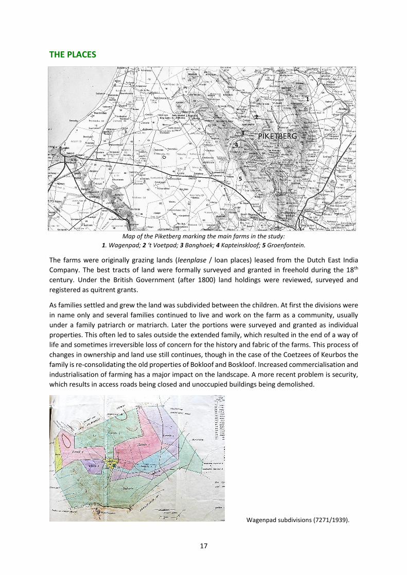
THE PLACES
Map of the Piketberg marking the main farms in the study:
1. Wagenpad; 2 ‘t Voetpad; 3 Banghoek; 4 Kapteinskloof; 5 Groenfontein.
The farms were originally grazing lands (leenplase / loan places) leased from the Dutch East India
Company. The best tracts of land were formally surveyed and granted in freehold during the 18th
century. Under the British Government (after 1800) land holdings were reviewed, surveyed and
registered as quitrent grants.
As families settled and grew the land was subdivided between the children. At first the divisions were
in name only and several families continued to live and work on the farm as a community, usually
under a family patriarch or matriarch. Later the portions were surveyed and granted as individual
properties. This often led to sales outside the extended family, which resulted in the end of a way of
life and sometimes irreversible loss of concern for the history and fabric of the farms. This process of
changes in ownership and land use still continues, though in the case of the Coetzees of Keurbos the
family is re-consolidating the old properties of Bokloof and Boskloof. Increased commercialisation and
industrialisation of farming has a major impact on the landscape. A more recent problem is security,
which results in access roads being closed and unoccupied buildings being demolished.
Wagenpad subdivisions (7271/1939).
1
2
3
4
5

18
FARMS
Wagenpad (farm 50) (Môrewag, Waterval, Rooiheuwel, Sitmaarso, Keurbos and Wagenpad)
A Smit family farm. The land around ‘Droogerijstkloof’ became incorporated into the Smit family
properties in the 1730s. In 1839 the portion of Wagenpad itself was granted to Johanna Smit, the
widow of the late Gideon Koegelenberg. She lived in the thatched mud-brick dwelling house that over
the years had expanded to become a sprawling T-plan. It is now a ruin.
By the time the farm was formally subdivided into 11 portions in 1939, it had developed into a proto-
settlement with a central werf on which stood a shop, tavern, smithy, post office, school, and so on,
and with a cemetery nearby. Most of the portions had their own farmhouse and outbuildings. By the
late 20th century the farm became very run down and the land was then devastated by fire. It now
belongs to an enthusiastic absentee owner, who, together with a farm manger, is fixing and reusing
what buildings he can and introducing ecological and sustainable farming practices.
Wagenpad: outbuildings on the main werf.

19
‘t Voetpad / Ezelshoek (farm 82) (Bovlei, Zwartrug, Matjesfontein)
A Van Zyl family farm. Originally a loan place, it was granted to Johannes Erasmus van Zyl in 1839
together with the adjoining government ground (3200 morgen, survey 281/1834). Portions named
Bovlei, Zwartrug and Matjesfontein were sold off in 1925, but the ‘t Voetpad portion survived intact
and in the family hands until it was divided right through the main werf (and even through buildings)
in 1953. Only a portion of the werf now remains in Van Zyl ownership. It has examples of old mud-
brick dwellings (ruins), a well maintained double-dwelling longhouse and outbuildings, and an
eccentric dwelling house dating to 1899. Great-grandfather Van Zyl was a keen innovator, artisan and
builder. His great-grandsons maintain the werf, old vineyard and cemetery themselves, visiting
regularly from their homes in Bellville and Vredenburg. They are understandably concerned about the
future of the property when they are no longer able to maintain it themselves.

20
Banghoek (farm 87) (Boskloof, Somerdou, Dwarsvlei, Ondertuin, Asoorsepos) & Bokloof, Keurbos
A Burger family farm. Originally part of a larger grant of ‘Boschkloof en de Banghoek’ in 1821 to J.H.
Fischer, the Banghoek portion passed into the hands of the Kotze / Burger family (consolidated 1890),
the portion Keurbos and Bokloof is associated with the Coetzee / Basson family (1916), and further
subdivisions took place in 1946. Banghoek is now part of a Nature Conservancy with an absentee
owner, though it is still farmed. The Keurbos complex is occupied by the Coetzees, and the Bokloof
farm house is still standing at the upper end of the kloof. Of the several dwellings on the original
Boskloof property, one was demolished and the other is a ruin – Boskloof and Ondertuin respectively.
Dina Abrahams now lives in Dwarsvlei. The farm house of Somerdou (originally Valsgat) is currently
occupied by a Burger descendant. Over the years, additions have been made around the old Sandveld
house type core. The huge wild olive trees were protected by order of Bosman Burger senior.

21
Wittewater (farm 93) / Kapteinskloof (Kapteinskloof, Weltevrede, winkel, kerkgrond, Klipdrif)
Various families including Coetzee, Lambrechts and Heyns. Originally the whole valley was
incorporated into a large tract of grazing land called Wittewater (survey 233/1819) which was granted
to Daniel Lambrechts in 1831. The various portions were inherited by members of the family
throughout the 19th century, but only split up in 1919. The small plots beside the Boesmansrivier are
marked as tuinland (garden land) on the survey diagrams, which indicates a very different and
intensive land use in contrast to the more commonly marked wyland or zaailand, which are suitable
for grazing and seed crops. The transfer history and ownership of the 15 portions of this area is
complex. Most farmers had a combination of garden land and pastures. An important feature was the
winkel (general store and later a fuel pump) situated half way along the valley road.
22
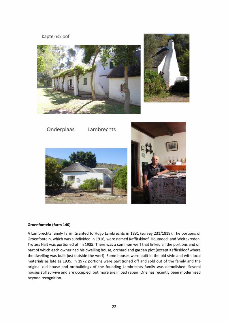
Groenfontein (farm 140)
A Lambrechts family farm. Granted to Hugo Lambrechts in 1831 (survey 231/1819). The portions of
Groenfontein, which was subdivided in 1916, were named Kaffirskloof, Houmoed, and Weltevreden.
Truters Halt was portioned off in 1935. There was a common werf that linked all the portions and on
part of which each owner had his dwelling house, orchard and garden plot (except Kaffirskloof where
the dwelling was built just outside the werf). Some houses were built in the old style and with local
materials as late as 1935. In 1972 portions were partitioned off and sold out of the family and the
original old house and outbuildings of the founding Lambrechts family was demolished. Several
houses still survive and are occupied, but more are in bad repair. One has recently been modernised
beyond recognition.

23

24
BUILDINGS
Regional styles of building developed in the Sandveld during the 18th century, one of which is today
typified by the surviving long-houses of Wagenpad, ‘t Voetpad and Groenfontein. Others were
demolished or fell into disuse, such as the reed-walled dwellings of pioneer families and families of
fishermen-farm labourers. There are several other types and periods of building that were constructed
in a ‘vernacular’ manner as late as the mid-20th century. Even the more substantial and fashionable
buildings were designed and built without architects or commercial builders and so no records exist
of their designers and makers except in people’s memories. For example, at ‘t Voetpad the ‘new’
house built by great-grandfather Erasmus van Zyl at the end of the 19th century was based on his
admiration of a town house. According to the story, the footprint for foundations was measured and
laid out by his wife, using her apron strings.
The interviews include descriptions of the built environment by descendants of those who designed
and constructed the older buildings, and who made alterations and additions themselves. There is
much still to be done on this aspect of the project. Guy Thomas’s forthcoming MA thesis is a beginning.

25
House built in 1899 at ‘t Voetpad (drawing by Guy Thomas).

26
PUBLICATIONS
The Piketberg region has been the focus of very few substantial publications, in comparison with the
neighbouring Cape Winelands and the Cederberg district. Two outstanding exceptions are
Boerepioniers van die Sandveld by M.H.D. Smith (1985) and Forgotten Frontiers by Nigel Penn (2005).
Living memories and the evidence from physical remains of past activities on the landscape are
therefore valuable additional sources of information. We list some of the books, articles and reports
we found to be useful, in general and in particular.
Amschwand, N. (ed.). 2001. Historical Survey Group report on the farm Matjesfontein in the Bokkeveld. Vernacular Architecture Society of South Africa.
Amschwand, N. 2009. A Short History of the Onder Bokkeveld. Pinelands: Aquaknowledge.
Archer, M. & Amschwand, N. 2012. Historical Survey Group report on the farm Klipperivier, also known as Willemsrivier, in the Onder-Bokkeveld. Vernacular Architecture Society of South Africa.
Burger, W.A. 1975. Piket teen ‘n Berg: die geskiedenis van Piketberg 1660-1970. Kaapstad.
Clift, H. 1995. The assimilation of the Khoikhoi into the rural labour force of Paarl, Drakenstein District. BA (Hons), University of Cape Town.
Cornell, C. 2005. Slaves at the Cape: a guidebook for beginner researchers. Second Edition. Department of Historical Studies, University of Cape Town.
Cornell, C. & Malan, A. 2005. Household inventories at the Cape: a guidebook for beginner researchers. Department of Historical Studies, University of Cape Town.
Cornell, C. & Malan, A. 2008. Places at the Cape: a guidebook for beginner researchers. Department of Historical Studies, University of Cape Town.
Dougherty, J. & Simpson, C. 2014. Who owns oral history? A Creative Commons Solution. http://ontheline.trincoll.edu/oral-history/creative-commons/.
Fagan, G. 1999. Nauti se Gwendoline. Cape Town: Breestraat Publications.
Floyd, H. 1980. Verlorenvlei Recorded. Unpublished report, School of Architecture, University of Cape Town.
Fransen, H. 2004. The Old Buildings of the Cape. Johannesburg: Jonathan Ball
Fransen, H. & Cook, M. 1965. The Old Houses of the Cape. Cape Town: A.A. Balkema.
Fransen, H. & Cook, M. 1980. The Old Buildings of the Cape. Cape Town: A.A. Balkema.
Giliomee, H. 2003. The Afrikaaners: biography of a people. Cape Town: Tafelberg.
Godby, M. 2013. Landscape from below: the representation of farmland in Tracey Derrick’s EarthWorks: the lives of farm labourers in the Swartland. Paper for Land Divided Conference, University of Stellenbosch. http://www.landdivided2013.org.za/papers.
Gribble, J. 1989. Archives and ruins: aspects of the historical settlement of Verlorenvlei in the 18th century. Unpublished BA (Hons) project, University of Cape Town.
Gribble, J. 1990. Verlorenvlei vernacular: a structuralist analysis of Sandveld folk architecture. Unpublished MA dissertation, University of Cape Town.
Hall, M. 1991. A study in the archaeology of early colonial settlement: Cape Town in the 17th, 18th and early 19th centuries. Unpublished report to the Human Sciences Research Council, Pretoria.
Hall, M. 1993. The archaeology of colonial settlement in southern Africa. Annual Review of Anthropology, 22: 177-200.

27
James, W. & Simons, M. 1992. Class, Caste and Color: a social and economic history of the South African Western Cape. New Brunswick: Transaction Publishers.
Johnson, M. 1997. Vernacular Architecture: the loss of innocence. Vernacular Architecture 28: 13-19.
Le Roux, J.G., Niemandt, J.J. & Olivier, M. 2012. Bewaarders van ons erfenis. Deel 1: Inleiding. Paarl: Drakenstein Heemkring. [See vol.13 for the Piketberg District.]
Malan, A. 2012. Excursion to the Sandveld (Verlorenvlei and Piketberg). Vernacular Architecture Society of South Africa.
Malan, A. & Webley, L. 2010. West Coast buildings: the architecture of a coastal frontier. VASSA Journal, 23: 2-22.
Marincowitz, J.N.C. 1985. Rural production and labour in the Western Cape, 1838 to 1888, with special reference to the wheat growing districts. Unpublished PhD dissertation. London: University of London.
Marks. S. 1972. Khoisan resistance to the Dutch in the seventeenth and eighteenth centuries. Journal of African History 13(1), 55-80.
Mitchell. L. 2009. Belongings: Property, Family, and Identity in Colonial South Africa. an exploration of frontiers, 1725-c.1830. New York: Columbia University Press. (www.gutenberg-e.org/Mitchell).
Obholzer, A., Baraitser, M. and Malherbe, W. 1985. The Cape House and its Interior. Stellenbosch Museum.
Penn, N. 1989. Labour, land and livestock in the Western Cape during the eighteenth century: the Khoisan and the colonists. In W.G. James & M. Simons, The Angry Divide: Social and Economic History of the Western Cape, pp.2-19. Cape Town: David Philip.
Penn, N. 2005. The Forgotten Frontier. Cape Town: Double Storey Books.
Pretorius, A. 1997. Our Threatened Heritage. Milnerton: André Pretorius.
Ross, R. 1976. Adam Kok’s Griquas: a study in the development of stratification in South Africa. Cambridge: Cambridge University Press.
Schoeman, K. 2011. Cape Lives of the Eighteenth Century. Pretoria: Protea Book House.
Sinclair, S. 1980. The rural settlement of Verlorenvlei in historical perspective. Research Report no. 20, School of Environmental Studies, University of Cape Town.
Sinclair, S. 1986. Conservation Development Plan, with Guidelines, for the Elands Bay Coastal Region (EBCR). Prepared for the Department of Environment Affairs. School of Environmental Studies, University of Cape Town.
Smith, M.H.D. 1985. Boerepioneers van die Sandveld. Pretoria: Raad vir Geesteswetenskaplike Navorsing.
South African History Online. 2006. http://www.sahistory.org.za/article/1700s.
SPP & LRC. 2000. An inventory and description of the historical acquisition of Moravian Church land. Report compiled for the Moravian Church of SA by the Surplus People Project & Legal Resource Centre.
Sunde, J. 2003. Vaalplaas community claim: Paternoster, West Coast. Report compiled for Masifundise Development Organisation.
Swanepoel, N.J. 1996. “Aan der Clawer Fonteijn”: a contribution towards the study of Klaarefontein and the Verlorenvlei. Unpublished BA (Hons) project, University of Cape Town.
Truter, C. 1998. West Coast: a tourist guide. Rondebosch: University of Cape Town.

28
Van Sittert, L. 1992. Labour, capital and the state in the St Helena Bay fisheries, c1856-c1956. Unpublished PhD thesis, University of Cape Town.
Van Sittert, L. 2001. ‘Velddrift’: the making of a South African company town. Urban History 28 (2): 194-216.
Viljoen, Y. 2011. The story of a Clanwilliam farm: the history and archaeology of Warmhoek. Unpublished MPhil, University of Cape Town.
Walton, J. 1982. Some early Piquetberg farms illustrated by Johannes Cornelius Poortermans. Restorica, 12: 8-15.
Walton, J. 1983. Klaarefontein. Antiques in South Africa: 40-42.
Walton, J. 1995. Cape Cottages. Cape Town: Intaka.
Zamudio, R. 2008. The Stephan Brothers, entrepreneurs of the West Coast. In: Athiros, G.L. & N. & Taylor, M. (eds). A West Coast Odyssey: 71–72. Tokai: Historical Media.
ACKNOWLEDGEMENTS
This oral history project was only possible because of generous funding from the National Heritage
Council. The Vernacular Architecture Society and the Project Team would like to warmly thank all who
allowed us on to their farms and into their homes, and who shared information and stories with trust,
humour and graciousness. We hope that we can do justice to the material that has been collected,
and look forward to returning something of value to our sources. Several people have contributed to
the project with professional assistance, advice, introductions, accommodation, friendship, and in
many other ways. Thank you.

SPONSORS
www.vassa.org.za
www.tracinghistorytrust.co.za
www.nhc.org.za
www.topcopy.co.za
www.piketbergmuseum.co.za