measuring drought in a social way
TRANSCRIPT

image: usgs.gov

“How bad is the drought?”
“How long will it last?”
“What does that mean?”
“Did this rain end the drought?”
“I hear El Niño is coming –we’re saved, right?”
Shaver Lake, CA – Aug 2014
M

How to accurately convey the severity and predicted evolution of the California drought in a continually changing environment to consumers with widely ranging tastes, appetites, and palettes.
P

DROUGHT INFORMATION STATEMENT
NATIONAL WEATHER SERVICE SAN JOAQUIN VALLEY - HANFORD CA
850 AM PST THU MAR 26 2015
...EXCEPTIONAL DROUGHT CONDITIONS ACROSS MOST OF THE WFO HANFORD
WARNING/FORECAST AREA WITH EXTREME DROUGHT CONDITIONS
ELSEWHERE...
SYNOPSIS...
ON JANUARY 17TH 2014...GOVERNOR BROWN DECLARED A DROUGHT
EMERGENCY FOR THE STATE OF CALIFORNIA. ON APRIL 25TH...THE
GOVERNOR SIGNED AN EMERGENCY DROUGHT PROCLAMATION. ON SEPTEMBER
16TH...GOVERNOR BROWN SIGNED LEGISLATION THAT REGULATES
GROUNDWATER FOR THE FIRST TIME IN CALIFORNIA/S HISTORY.
Challenge!ALL-CAPS TEXT
PRODUCTS with no graphics.
P

P

Challenge!WFOs generally see this info at the same time as local media.
P

P

P

Challenge!Explaining a nuanced
statistical forecast (with terciles) to our
customers.
P

Challenge!Lots of info, but where to start and what does
it mean.
M

M

M

M

M

From: Michelle Mead - NOAA Federal <[email protected]>Date: Thu, Jan 30, 2014 at 2:07 PMSubject: Some interesting statistics about updated drought monitor and latest round of precipitation
Hi all~
Wanted to add some interesting statistics about the new drought monitor that was shared with me.
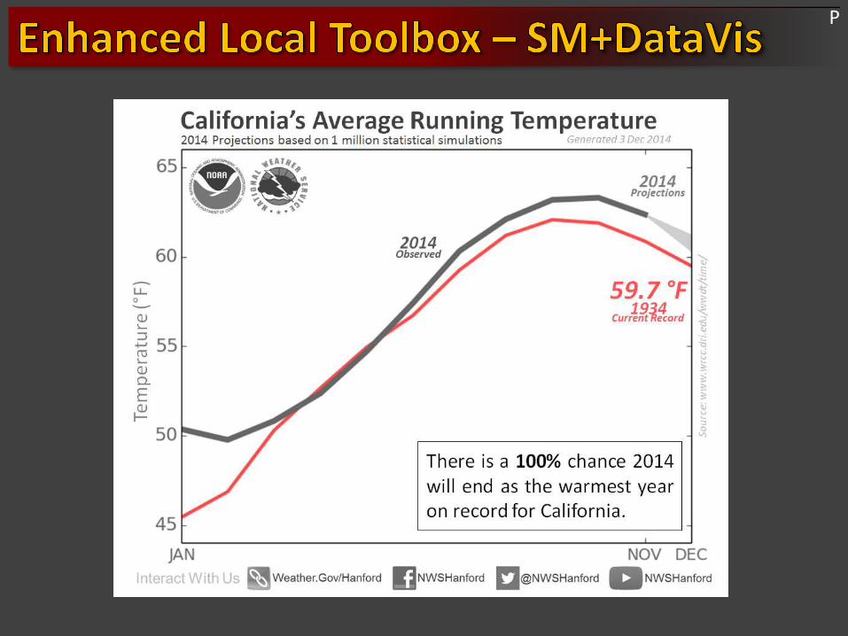
The D4 (Exceptional Drought) is the worst drought category on the Drought Monitor and the first time it's been used in California since this monitoring system started in 2000. The degradation was made due to historically low rainfall amounts so far this winter, long-term precipitation deficits stretching several years, and a growing number of increasingly significant drought impacts. In addition, 67% of California is now covered by D3/D4 conditions, also the highest since the Drought Monitor began.
Like I stated this morning, the precipitation received over the last 24 hours is not expected to provide much beyond temporary short-term drought relief. For drought improvements to occur, a very persistent wet pattern of at least moderate precipitation intensity is needed. This is not a very high probability based on the current outlooks for the next two weeks, month of February, and next three months (please see our Drought information page for CPC outlook images under Forecast Precipitation and Seasonal Outlooks).
Note: during the heart of winter, much of central and northern California, especially in the mountains, average 2-4” of rain each week, anything less than that means deficits will continue to grow. The rain this week will simply be a pause in the continually worsening conditions.
M

M
M

M

M

P

M

P

P
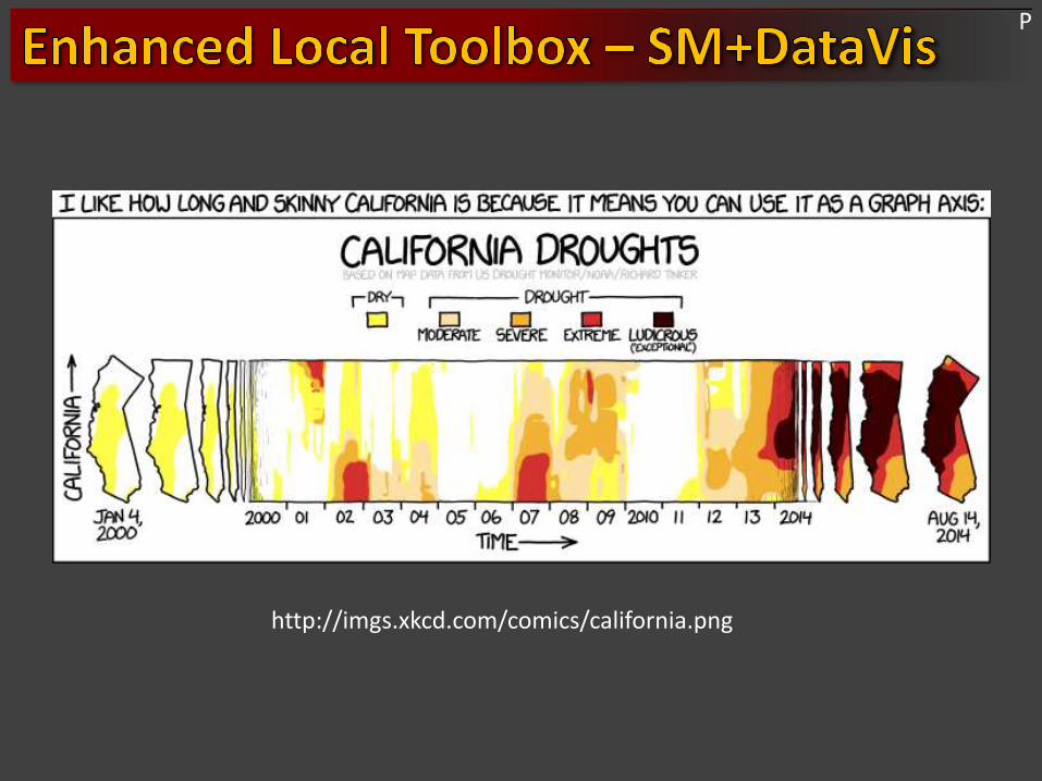
http://imgs.xkcd.com/comics/california.png
P

P
P

M

image: usgs.gov