measuring and improving walkability in hong kong · measuring and improving walkability in hong...
TRANSCRIPT

Measuring and Improving Walkability in Hong Kong
Final ReportDecember 2016
Simon NgCarine LaiPenny LiaoMandy LaoWilson LauCivic Exchange
Sujata GovadaWidemar SpruijtUDP International

2
About Civic Exchange
Civic Exchange is an independent Hong Kong-based public policy think tank established in 2000. With the mission to advance civic education and engage society to shape public policy, Civic Exchange undertakes research in air quality, nature conservation and the urban environment, along the framework of wellbeing.

3
Table of Contents
Acknowledgements............................................................................................4
Executive Summary......................................................................................................5
1. Introduction.........................................................................................7
1.1. Background..............................................................................................7
1.2. Benefits of Good Walkability....................................................................7
2. Measuring Walkability in Hong Kong............................................................10
2.1. Good Walkability in Hong Kong..........................................................10
2.2. The Link-Place Function.........................................................................13
2.3. Performance of Street Functions...........................................................14
2.4. Walkability Checklists............................................................................18
3. Kowloon West - A Case Study Hong Kong........................................................22
3.1. Current problems...................................................................................23
3.2. Recommendations for Kowloon West...................................................26
4. Four-neighbourhood Comparison....................................................................30
4.1. Introduction...............................................................................30
Appendix 1: Benefits of Walking.................................................................................37
Appendix 2: The Link-Place Function of Streets.........................................................42
Appendix 3: The Professional Checklist......................................................................46
Appendix 4: The User Checklist...................................................................................53
Endnote..............................................................................................................55

4
The authors are grateful to the local and professional stakeholders who participated in the various engagement events and activities organised under this project, as well as the collaborators who were involved in this project, notably friends from the Planning Department, Leisure and Cultural Services Department, Energizing Kowloon East Office, West Kowloon Cultural District Authority, and the Hong Kong Institute of Planners. In addition, the authors would like to thank the following individuals who volunteered during the planning workshops and walk audit: Carol Chan, Keith Chan, Sandy Chan, Jennifer Frisinger, Fontane Lau, Caleb Leung, Jonathan Pile, Benson Poon, Eva Tam, John Wang and Maura Wong. Last but not least, the authors of this report are thankful to the MTRC for sponsoring the project.
Acknowledgements

5
Acknowledgements
Walking is a necessity in Hong Kong, given the city’s density, compact and layered urban structure, and heavy reliance on public transport. Walking is part of daily commuting for a majority of Hong Kong people. There is a growing consensus that good walkability will bring substantial benefits to the city and its people. These benefits include better public health, higher property values, travel time savings and greater accessibility, increased economic opportunities, as well as other environmental and social gains.
A starting point to improve a city’s walkability is to measure the current state of the pedestrian environment. While numerous assessment tools have been developed in recent years in different parts of the world, Hong Kong needs a tool that is suitable for the city’s unique urban features and characteristics, such as its high density, mixed land use, constant traffic and pedestrian flow, hilly topography, use of space and connection with public transport. To this end, it has been determined that a walkable Hong Kong should embrace the following principles – (a) accessibility and connectivity to nearby destinations; (b) easy wayfinding; (c) safe, comfortable and healthy walking environments; (d) equitable access; (e) diversity and vitality; (f) attention to human scale; (g) streets treated as public spaces that require appropriate management; and (h) integration with public transport.
It is also important to appreciate the link and place functions of streets, in order to re-frame the conventional approach to street design that puts an emphasis on facilitating pedestrian flow, into a broadened perspective that also values streets as an attractive destination and an important public space for people and communities to use for non-transport purposes. Criteria that define a walkable city should therefore be extended from the basic requirements that make it possible and efficient for people to walk, to other aspects that provide pedestrians with more comfortable and enjoyable places to walk.
Based on all the considerations above, two walkability assessment checklists have been developed for Hong Kong: one for general users and one for professionals. The user checklist enables pedestrians to assess different aspects of walkability in a defined area through a 5-point scale rating system. It is a handy tool for identifying bottlenecks and problematic locations, as well as for spotting good examples. The professional checklist comes with greater detail. It is constructed with 42 indicators under 10 categories and reference points are provided as benchmarks for scoring. The 10 categories generally reflect the 10 aspects that are considered integral to a walkable environment in Hong
Executive Summary

6
Kong, which include (a) accessibility and connectivity; (b) physical and visual permeability; (c) public realm amenities; (d) scale and density;(e) variety and diversity; (f) legibility and orientation; (g) streetscape and visual quality; (h) microclimate and environment; (i) safety and security; and (j) transit and pedestrian friendliness.
In Kowloon West, a series of planning and engagement events were organized to assess the walkability of different neighbourhoods in the area together with local stakeholders and planning professionals. A number of problems were identified through the use of the checklists. Several interventions were recommended in the short and long term to improve the walking environment in Kowloon West.
Neighbourhoods in Central, Mongkok, Kwun Tong and Choi Hung were selected as pilot areas to conduct walk audits, as well as to test the applicability and user-friendliness of the checklists. Choi Hung Estate was found to be a very walkable community according to the walk score. Central is well connected and efficient for walkers, but not the most interesting place to walk. Mongkok is attractive to pedestrians but too crowded for comfort and efficiency. The Kwun Tong industrial area is not walkable, but it is under transformation into a commercial district, which offers opportunities to improve its walking environment.
It is demonstrated in the project that a walk audit is a useful way of getting a baseline assessment about how walkable a location is, as well as identifying key areas for short-term and long-term improvement. Civic Exchange therefore recommends a broad adoption and use of the checklists developed in the project by government departments, professional planners, academics and other community stakeholders for measuring and assessing walkability in different districts and neighbourhoods in Hong Kong. The collective findings of these assessments will contribute significantly to making Hong Kong a world-class city for walking.
7
1.1. Background
In October 2012, Civic Exchange published a report called Walkable City, Living Streets. It profiles the recent global movement towards pro-people planning, and shows, in particular, how city mayors and planners are reclaiming road and street spaces from cars in places like New York, London, Tokyo, Melbourne, Seoul and Singapore. These changes are taking place often in the densest and most congested parts of the cities where the conflict between vehicles and pedestrians is fierce. The purpose of pro-people planning is to give back urban space to the public for the realisation of various socio-economic and environmental benefits. The report explores walking environments in four Hong Kong districts and concludes that there are good individual examples of walkability in Hong Kong, notably in Central, however the city’s general pedestrian environment is unattractive and unfriendly, especially at the district and neighbourhood levels. While there is a need to improve connectivity for people through better pedestrian networks, there are also reasons to sustain the city’s vibrant street life. The report has re-kindled interest in past projects, such as the Des Voeux Road Central pedestrianisation proposal from 2000, and reunited sporadic but ongoing efforts to enhance walkability in Hong Kong.
1.2. Benefits of Good Walkability
There are substantial benefits associated with walking which accrue to individuals, communities and society as a whole. However, due to long negligence of these benefits, and strongly favouring vehicles over pedestrians, planning traditionally received little attention or funding from the Hong Kong Government or the private sector. In recent years, however, more research and projects on walkability have emerged. Outside Hong Kong, the Local Government Commission’s Center for Livable Communities based in Sacramento, California, observes that a walkable community may have higher property values, attract businesses and talented workers, and boost tourism as well as retail sales.1 Another report by the Victoria Transport Policy Institute (VTPI) in Canada identifies eight categories for the economic impacts of walking, and briefly discusses how to evaluate each: accessibility, consumer cost savings, public cost savings, efficient land use, liveability, public fitness and health, economic development, and equity.2 However, these studies are based on Western cities that have much lower densities than Hong Kong. While the benefits of high urban walkability might apply across
1 Introduction

8
geographies, the magnitude of these benefits and ways to realise them could be quite different from one place to another.
Walking plays a unique and important role in Hong Kong. Due to its high density, limited land supply, and heavy reliance on public transportation, Hong Kong has a large pedestrian population. Walking trips account for 39 percent of daily trips in Hong Kong, according to a 2010 study.3 The specific benefits associated with walking in Hong Kong are numerous and interrelated. It is crucial to recognise them, and in light of that to rethink our transport and urban planning strategies. Major benefits of good walkability include:
Public health. In Hong Kong, where the service economy hires an overwhelmingly large workforce in sedentary white-collar occupations, walking is a good way for people to engage in regular physical activity, to maintain fitness, and to reduce the risks of cardiovascular diseases and diabetes. Regular walking also promotes mental health, effectively preventing mental diseases such as depression, which are increasing at an alarming rate among urbanites.
Property prices and rents. Recent studies have found that homeowners prefer to live in walkable communities and are willing to pay a higher premium for that. Higher property values also mean that government income from property tax revenue will increase.
Time savings/greater accessibility. Walkable street designs that make pedestrian flow more efficient could save daily commuting time. Commuters are found to use the saved time to walk further distances. For example, MTR patrons in Hong Kong on average would walk 500 metres or a 10-minute journey to the MTR station in a typically cluttered and crowded urban street environment. With better street design and pedestrian facilities, such as widened sidewalks and prioritized pedestrian crossings, MTR patrons could complete over 800 metres in 10 minutes, instead of 500 metres, as they can walk more efficiently. As a result, the 10-minute walking catchment of an MTR station would be enlarged from a 500-meter radius to an 800-meter radius.
Increased economic opportunities. Lively and walkable streets attract more pedestrians, and hence are able to provide better economic opportunities for retail and restaurant businesses along those streets. As a result, employment and the public tax base expands.
Environmental benefits. Walkability improvements may help mitigate the negative environmental factors caused by motorised transportation, as well as reduce greenhouse gas emission. Promoting walking on short trips to replace driving or other motorised feeder transport can help alleviate persistent air pollution woes so prevalent in Hong Kong.

9
Social benefits. The sidewalk is an important public space where pedestrians interact with each other. A better pedestrian environment raises the amount as well as the quality of such interactions. Since less well-off households tend to walk more, improving walkability may help achieve greater social equality.
Further discussion on these benefits can be found in Appendix 1.
10
2.1. Good Walkability in Hong Kong
There has been considerable interest globally in recent years in developing evaluation systems, instruments and tools to assess the walkability of streets, neighbourhoods and cities. Many of the established measures, however, were developed in the urban context of the Western world, and may not be entirely appropriate for Hong Kong’s distinct urban morphology and culture. Density is an obvious case in point. Urban planners in North America and Europe tend to think about walkability in terms of increasing density in urban centres in order to foster an active street life, whereas in Hong Kong, densities are already so high that the streets are overcrowded. Other criteria that are highly relevant to Hong Kong include “directness,” “efficiency,” and “integration with public transport.”
There is a need to develop a measurement tool that is suitable for Hong Kong’s dense mix of uses, cultural richness, unique topography of hills and harbour, and space limitations. Such instruments for measuring walkability should be capable of auditing the existing state or condition of an area, and be utilised for tracking improvements. The instrument should also be amenable to changes and enhancements and to evolving societal aspirations.
To develop the assessment tool, internal discussions and meetings with urban planners and designers in Hong Kong were convened as part of this study. After considering the city’s urban morphology, population density, juxtaposition of the built and natural environment, high public transport patronage, proximity to water, and many other factors, several guiding principles important to Hong Kong were identified:
i. Accessibility and connectivity to nearby destinations. The most-used routes to destinations should not contain long detours. The pedestrian network should be well-connected. Crossing the road should be easy, and at-grade crossing is preferred. At the very least, routes should not involve multiple overhead footbridges or underground tunnels, so that pedestrians need not walk up and down several times. The street should at most be moderately crowded, and everyone should be able to walk at his/her own pace without being blocked or pushed around. The number of obstacles should be minimized. This principle also applies to the physically constrained, such as the disabled, the elderly, and pedestrians with luggage. The accessible facilities and paths should be conveniently located. However, detours, lack of at-grade crossings, and over-crowding are all problems in Hong Kong’s current walking environment.
2 Measuring Walkability in Hong Kong

11
ii. Easy wayfinding. There should be sufficient signage and street maps in the MTR stations and appropriate locations on the streets. The signage should be clear, with special references to common destinations in the neighbourhood. Since the accessible routes for the physically constrained are usually different from normal routes, they should be clearly marked as well. The pedestrian network should be planned so that routes are intuitive to find. This is especially important in Hong Kong, due to a large number of tourists and shoppers who might not be familiar with local areas. When people are lost, they tend to add to pedestrian flow and cause greater over-crowding on the streets. Hence, it is important that those who are not familiar with the area can find their way easily and quickly.
iii. Safe, comfortable and healthy walking environment. Pedestrians should not be subjected to danger or other negative externalities from motorized traffic. Measures should be taken to calm the traffic, to resolve modal conflicts, and to mitigate the emissions of gas and particles by vehicles that are harmful to the health of pedestrians. In areas where pedestrians might be exposed to the scorching summer sun or rain, shade should be provided in the form of awnings or trees. Street trees might also serve to physically segregate pedestrians from traffic, and to block the noise and smells of traffic from entering the sidewalks. Benches and resting points should be provided at appropriate locations. The major benefits of walking, especially ones concerning public health, would only be substantiated when the walking environment follows this principle.
iv. Equitable access. Pedestrian networks and public spaces should allow access for all. Pedestrian networks and public spaces should be designed with public spaces with mobility-impaired users in mind, including wheelchair users, the visually impaired, people carrying luggage, parents with baby strollers, pregnant women, and the elderly. In addition to providing access ramps, tactile paving and elevators, unnecessary level changes and steps should be avoided. As much as possible, routes for the mobility impaired should be well-integrated with the main network to avoid further detours. Another aspect of equitable access is ensuring that public open spaces are accessible to all sectors of society both physically and psychologically. It is important to recognize that even when a public space can be physically accessible, other barriers may discourage usage. For example, a parent may find it inconvenient to bring young children to a park on the other side of a highway crossable only at certain points by footbridge. Teenagers may not feel welcome in the podium garden of an upscale shopping mall as the security guards may assume them to be troublemakers.
v. Diversity and vitality. A vibrant street is not just clean, comfortable and aesthetically pleasing, it is also an interesting place in which to spend time. There should be a wide variety of things to see and do in close proximity. Building frontages should be built on a human scale and

12
active. Shops, eateries, entrances to buildings and windows activate a street by enabling interaction between the private and public realms. Long stretches of blank walls should be discouraged. Pocket parks and sitting-out areas should not be placed in isolated locations, but close to a variety of different activities. Seating should be positioned to offer a good view of nearby human activities as people tend to stay where there is something interesting to watch. To provide variety and foster a sense of exploration, large spaces can be differentiated aesthetically and spatially. Public spaces should offer flexibility in how they can be used. For example, a fountain can also provide seating, or be a play area for children.
vi. Built on a human scale. While many buildings in Hong Kong may be a wonder to look at from afar, their height and size dwarfs human proportions up close. When the scale between the built environment and people is so vastly different, it creates a degree of discomfort for the pedestrian. Such places should adopt measures that stress the human scale. Awnings can function as a source of shade and protection from rain, while providing an enclosure that offers a sense of psychological comfort. A street lined with trees and other greenery can also create a degree of enclosure. Trees with medium-size canopies are ideal for this, and add colour that is soothing for most people, giving the street an immediate aesthetic quality. A tree’s capacity to provide shading, cooling and improving air quality by absorbing particulates and releasing oxygen are all qualities that should be embraced for Hong Kong’s streets.
vii. Streets as public spaces that require appropriate management. The features of the streets enable them to fulfill their unique social functions as public spaces. First, busy streets in commercial districts can facilitate casual interactions between different people living or traveling in Hong Kong. Second, local streets help foster a sense of community. Pedestrian spaces should be managed appropriately to enhance a walker’s enjoyment. Under-managed pedestrian areas can become unpleasant and unwalkable due to excessive noise and obstruction caused by unregulated promotional stands, hawkers, and performers. On the other hand, over-managed public spaces can be made sterile by excessive limits on permissible activities (e.g. no walking on the grass, no lying down, no dogs, no playing music). Compromises must be struck between the conflicting needs of different users of public spaces, particularly since they are in such short supply in Hong Kong. However, management should not be driven by fear of complaints.
viii. Integration with public transport. The easiest way to get around Hong Kong is to use public transport and walking offers the most natural, emission-free and healthy option for public transport patrons to complete the first- or last-mile of their journeys. Pedestrian networks should be well integrated with MTR stations, bus terminals, and other public transport nodes and interchanges, and it can be achieved at different levels and by different means – at-grade, above-ground,

13
underground, as well as through vertical integration by a combination of elevators, escalators and stairways.
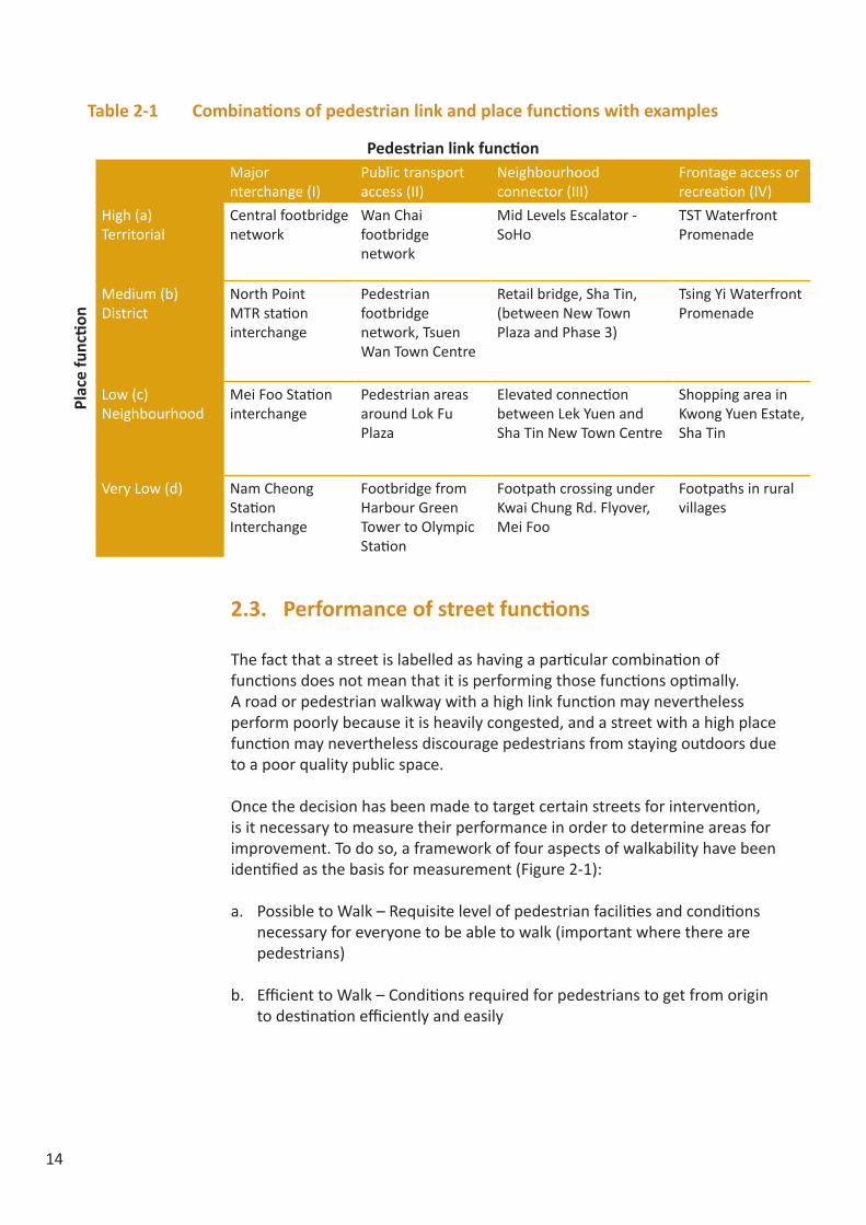
2.2. The Link-Place Function
Conceptually, streets have two primary roles: as a link and a place (Government of South Australia, 2012). “Link” refers to the street’s function as a conduit for traffic. It can be defined and ranked according to its designed capacity, or in the case of Hong Kong where public transport is heavily used, according to its importance in the public transport network. On the other hand, “place” refers to its function as a destination where people spend time recreationally. Imagine the difference between a waterfront promenade in Central and a neighbourhood retail street in terms of the level of attractiveness. Traditionally, transport engineers and urban planners have focused mainly on maximizing the “link” function, but the “place” function is now becoming increasingly recognised as a valuable function with numerous social, environmental and economic benefits (Jones and Boujenko, 2009).
The link-place matrixIt is often expected that once the function of a street has been clearly defined and understood, facilities will be provided by the relevant government departments to support the primary function of the street. In practice, however, street function(s) may change over time, leading to inadequate or inappropriate infrastructure or amenities to support the new function. In some cases, streets may serve dual functions and have different combinations of the “link” and “place” functions in varying degrees, as demonstrated in Table 2-1, leading to complications and the higher likelihood of mismanagement. Placing streets and pedestrian routes into the matrix helps planners conceptualise both the current role(s) of streets and pedestrian walkways within a district, and the strategic direction they want to take. A major public transport interchange or a major waterfront promenade, located on the bottom left and top right corners, represents a mono-functional space. Attempting to change their roles would be both infeasible and inadvisable. However, those with mixed functions may experience conflicts which may be resolved by raising one function and lowering the other. An extended discussion on the link-place function can be found in Appendix 2.
14
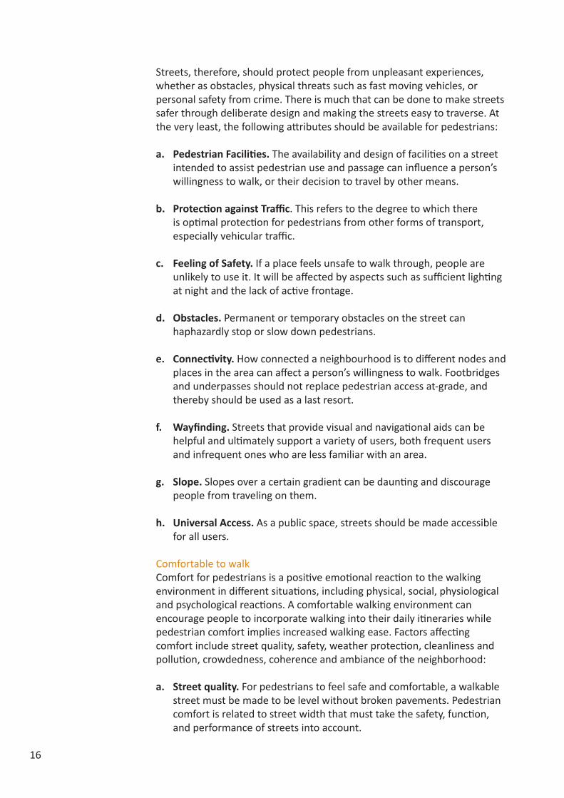
2.3. Performance of street functions
The fact that a street is labelled as having a particular combination of functions does not mean that it is performing those functions optimally. A road or pedestrian walkway with a high link function may nevertheless perform poorly because it is heavily congested, and a street with a high place function may nevertheless discourage pedestrians from staying outdoors due to a poor quality public space.
Once the decision has been made to target certain streets for intervention, is it necessary to measure their performance in order to determine areas for improvement. To do so, a framework of four aspects of walkability have been identified as the basis for measurement (Figure 2-1):
a. Possible to Walk – Requisite level of pedestrian facilities and conditions necessary for everyone to be able to walk (important where there are pedestrians)
b. Efficient to Walk – Conditions required for pedestrians to get from origin to destination efficiently and easily
Table 2-1 Combinations of pedestrian link and place functions with examples
Pedestrian link function
Plac
e fu
ncti
on
Major nterchange (I)
Public transport access (II)
Neighbourhood connector (III)
Frontage access or recreation (IV)
High (a)Territorial
Central footbridge network
Wan Chai footbridge network
Mid Levels Escalator - SoHo
TST Waterfront Promenade
Medium (b) District
North Point MTR station interchange
Pedestrian footbridge network, Tsuen Wan Town Centre
Retail bridge, Sha Tin, (between New Town Plaza and Phase 3)
Tsing Yi Waterfront Promenade
Low (c)Neighbourhood
Mei Foo Station interchange
Pedestrian areas around Lok Fu Plaza
Elevated connection between Lek Yuen and Sha Tin New Town Centre
Shopping area in Kwong Yuen Estate, Sha Tin
Very Low (d) Nam Cheong Station Interchange
Footbridge from Harbour Green Tower to Olympic Station
Footpath crossing under Kwai Chung Rd. Flyover, Mei Foo
Footpaths in rural villages

15
Figure 2-1 4-criterion framework for good walkability
c. Comfortable to Walk – Qualities required for pedestrians to feel comfortable and at ease
d. Interesting to Walk – Qualities required for pedestrians to stay in the space and use it for recreational and social activities
This was inspired by a similar three-criterion framework articulated by the Danish urban designer Jan Gehl (2006): protection, comfort, and enjoyment. Gehl’s framework was modified to better fit Hong Kong’s environment. This can be thought of as a set of criteria for the design of public areas. When satisfied, such places are likely to allow people to enjoy walking and staying on streets and other public areas.
Possible to walk“Possible to Walk” contains criteria that are necessary to create a good walking environment anywhere that pedestrian activities exist. The other three criteria can be given different priorities based on the desired role of the street. Streets with a high place function will give more weight to “enjoyable” but less weight to “efficient,” since popular places with many pedestrian attractors may contain more obstacles such as market stalls. Meanwhile, a route with a high link function may give more weight to “efficient” since it does not have to be interesting or encourage staying, it merely needs to get people to and from a public transport hub with a minimum of difficulty.
Efficient to walkCity planners should not stop at simply providing basic pedestrian facilities, such as pavements and crossings. These alone will not suffice in Hong Kong’s dense and built-up urban environment. The network of pavements should be arranged so that they connect people to important points of the neighbourhood in the most direct way possible.
Obstacles, in various shapes or forms, can slow pedestrians down and stop them in their tracks. These barriers can be as minor as litter, railing or street furniture, to as major as excessive crowds or big structures like high-speed roadways. This can make getting to places that people need to get to, such as transport stations, shops or offices, seem like a chore, and places that people desire to get to, such as the waterfront, parks and other places for recreation, a major impediment.
Efficient to Walk Comfortable to Walk Interesting to Walk
Possible to Walk
16
Streets, therefore, should protect people from unpleasant experiences, whether as obstacles, physical threats such as fast moving vehicles, or personal safety from crime. There is much that can be done to make streets safer through deliberate design and making the streets easy to traverse. At the very least, the following attributes should be available for pedestrians:
a. Pedestrian Facilities. The availability and design of facilities on a street intended to assist pedestrian use and passage can influence a person’s willingness to walk, or their decision to travel by other means.
b. Protection against Traffic. This refers to the degree to which there is optimal protection for pedestrians from other forms of transport, especially vehicular traffic.
c. Feeling of Safety. If a place feels unsafe to walk through, people are unlikely to use it. It will be affected by aspects such as sufficient lighting at night and the lack of active frontage.
d. Obstacles. Permanent or temporary obstacles on the street can haphazardly stop or slow down pedestrians.
e. Connectivity. How connected a neighbourhood is to different nodes and places in the area can affect a person’s willingness to walk. Footbridges and underpasses should not replace pedestrian access at-grade, and thereby should be used as a last resort.
f. Wayfinding. Streets that provide visual and navigational aids can be helpful and ultimately support a variety of users, both frequent users and infrequent ones who are less familiar with an area.
g. Slope. Slopes over a certain gradient can be daunting and discourage people from traveling on them.
h. Universal Access. As a public space, streets should be made accessible for all users.
Comfortable to walkComfort for pedestrians is a positive emotional reaction to the walking environment in different situations, including physical, social, physiological and psychological reactions. A comfortable walking environment can encourage people to incorporate walking into their daily itineraries while pedestrian comfort implies increased walking ease. Factors affecting comfort include street quality, safety, weather protection, cleanliness and pollution, crowdedness, coherence and ambiance of the neighborhood:
a. Street quality. For pedestrians to feel safe and comfortable, a walkable street must be made to be level without broken pavements. Pedestrian comfort is related to street width that must take the safety, function, and performance of streets into account.
17
b. Safety. To provide a safe walking environment, it is necessary to separate pedestrians from vehicular traffic as much as possible. Traffic calming measures can also help to maintain a safe walking environment.
c. Weather protection. Weather protection in pedestrian streets is critical especially in hot climates or rainy climates that affect the comfort of walking on the street.
d. Cleanliness and pollution. A good physical environment comprises streets devoid of unsightly trash and foul smells, air pollution caused by heavy traffic, and other unfavourable elements.
e. Crowd management. A street’s crowdedness has a major impact on social and psychological comfort. To maintain a pleasant environment for walking, proper street management measures must be applied.
f. Seating. Provision of comfort facilities, particularly seating, has an influence on the distance people are prepared to walk from destination to destination or for leisure.
g. Landscaping. The sense of comfort for streets could be enhanced by landscaping which adds value to streets through softening the urban street-scene, creating visual and sensory interest, and providing streets with habitats for wildlife.
Interesting to walkEnjoyable streets and public spaces are not just for walking, but for remaining in as well. They function not just as conduits for through-traffic, but as destinations in and of themselves (Government of South Australia, 2011). In lower-density cities overseas, planners seeking to bring vitality to cities have focused on encouraging mixed uses and improving public transportation in order to attract pedestrians. However, in Hong Kong, high densities, mixed land uses, an excellent public transport network, and a culture of meeting recreational and social needs outside the home ensure that urban streets are often crowded. Hong Kong’s problems lie in the frequently poor quality of the public realm. Air pollution, excessive traffic, poor quality street furniture, crowding, and a lack of places to rest, all combine to discourage people to stay outdoors. This has gone hand-in-hand with the privatisation of public space, in which both developers and planners have abandoned the street in favour of air-conditioned shopping malls.
Enjoyability comes from the interaction between stimulation and relaxation. There should be a variety of activities for people to do, with good quality space nearby for them to stop, relax and enjoy the life around them. The following factors are identified as important:
18
a. Basic amenities for staying in an area. Three important amenities to meet people’s basic physiological needs are seating, toilets, and food and drink.
b. Stimulation. A public space where people will stay must be interesting. It should have plenty of things to see and do, as well as provide an environment suitable for social interaction. Active frontages along buildings promote interaction between the private and public realms. Public open spaces should also offer a wide variety of activities, including commercial, social, recreational, and cultural activities. Human-scaled environments allow people to relate better to their surroundings. Street furniture, including seating, public art and water features should be designed to encourage interaction with the environment.
c. Social activity. A street should be active at different times of the day and night. A street or public space should be welcoming to all groups of people including men, women, children and the elderly.
d. Local character. Local character gives a place a unique identity. It can strengthen residents’ senses of attachment to and pride in a place. For visitors, local character provides an experience that cannot be found elsewhere.
e. Public space management. If well-managed, on-street activities such as performers, artists, and vendors can add to the character and enjoyableness of a public place. However, both over-management and under-management can diminish a place’s appeal.
2.4. Walkability Checklists
Based on the framework and criteria discussed above, two walkability checklists were developed, one for users (pedestrians, community members) and one for professionals (urban planners, urban designers, traffic engineers, government officials, etc.) to assess walkability in Hong Kong.
2.4.1. The user checklistThe user checklist was designed to enable pedestrians to assess the walkability of a neighborhood area by giving an overall rating, on a scale of 1 to 5, to a list of indicators grouped under the four criteria of (a) possible to walk, (b) efficient to walk, (c) comfortable to walk, and (d) enjoyable to walk (Table 2-1). Spaces are provided for each indicator for additional comments, such as problematic locations or good examples. A fifth section asks about the respondent’s views and aspirations about the area, and the checklist is completed with questions about trips and demographics.

19
Table 2-1 User checklist and indicators
Criteria IndicatorPossible to walk • Width of pedestrian sidewalks and paved pathways
• Evenness of paved surfaces
• Universal access to paved pedestrian areas• Safety from road traffic • Feeling of security and personal safety from danger
Efficient to walk • Ease of crossing roads with traffic signals• Ease of crossing roads without traffic signals• Provision of street-level connections where there is a
footbridge or subway• Convenience of footbridges/subways location• Clear and useful pedestrian signs and directions• Directness of routes to main destinations in the
neighbourhood• Ease of transferring between public transport modes
Comfortable to walk • Weather protection of the area (rain, sun, excessive wind)• General quality, cleanliness and hygiene of the area• Roadside air and noise pollution• Provision of seating space and rest areas• Landscaping and greenery of paved pedestrian areas• Provision of public toilet and other amenities • Crowdedness of the area• Amount of street obstructions in walking paths
Interesting to walk • Visually attractive streetscape and pleasant environment (e.g. public art, street furniture, landscaping, paving, lighting etc.)
• The area’s appeal for staying and walking around• Variety of shops and restaurants• Variety of leisure and recreational activities• Overall quality and flexible use of public open spaces• Diverse range of activities, but not too crowded • The area is appealing to a wide cross section of people

20
2.4.2. The professional checklistThe professional checklist was developed in much greater detail for government officials, urban planners and designers, transport planners and others who are responsible for enhancing the city’s walking environment. They need to (a) understand the main function of a location (in other cases to determine or to influence change to the function) before setting priorities to walkability criteria; (b) identify bottlenecks or problems before planning and designing for improvements; (c) implement plans with the support of different stakeholders; and (d) track changes in terms of performance after implementation to evaluate effectiveness of the action items.The professional checklist comprises 10 categories and a total of 42 indicators. Each indicator is also assigned to the four criteria of “possible to walk,” “efficient to walk,” “comfortable to walk” and “interesting to walk.” There is a clear explanation for each of the broad categories, and for each indicator, further clarification is provided on the checklist for benchmarking purposes. Table 2-2 below summarises all the indicators included on the checklist. A copy of the professional checklist is attached to the report as Appendix 3.
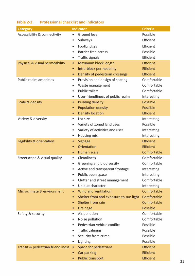
21
Table 2-2 Professional checklist and indicators
Category Indicator CriteriaAccessibility & connectivity • Ground level Possible
• Subways Efficient
• Footbridges Efficient• Barrier-free access Possible• Traffic signals Efficient
Physical & visual permeability • Maximum block length Efficient• Intra-block permeability Efficient• Density of pedestrian crossings Efficient
Public realm amenities • Provision and design of seating Comfortable• Waste management Comfortable• Public toilets Comfortable• User-friendliness of public realm Interesting
Scale & density • Building density Possible• Population density Possible• Density location Efficient
Variety & diversity • Lot size Interesting• Variety of zoned land uses Possible• Variety of activities and uses Interesting• Housing mix Interesting
Legibility & orientation • Signage Efficient• Orientation Efficient• Human scale Comfortable
Streetscape & visual quality • Cleanliness Comfortable• Greening and biodiversity Comfortable• Active and transparent frontage Interesting• Public open space Interesting• Clutter and street management Comfortable• Unique character Interesting
Microclimate & environment • Wind and ventilation Comfortable• Shelter from and exposure to sun light Comfortable• Shelter from rain Comfortable• Drainage Possible
Safety & security • Air pollution Comfortable• Noise pollution Comfortable• Pedestrian-vehicle conflict Possible• Traffic calming Possible• Security from crime Possible• Lighting Possible
Transit & pedestrian friendliness • Space for pedestrians Efficient• Car parking Efficient• Public transport Efficient

22
In the Study, Kowloon West was selected as a real-life example for the purpose of assessing walkability with local stakeholders and professionals, and to envision a convenient and attractive walking environment in the long term. Geographically speaking, the area covers part of Tsim Sha Tsui and Jordon west of Nathan Road, and the new residential and commercial development on the reclaimed site at the Kowloon and Austin stations of the Mass Transit Rail (MTR) system (Figure 3-1). The West Kowloon Cultural District and the Express Rail Link Terminus, both under construction at the moment, are also located in the study area. The contrast in terms of size, scale and land uses between the old urban area adjacent to Nathan Road and the new areas closer to the waterfront, pose difficult challenges for physical connectivity and for “place making.”
Figure 3-1 Kowloon West – Study Area
3 Kowloon West - A Case Study Hong Kong

23
In the summer of 2014, two planning workshops were organised – the first one with local residents and people working in the neighbourhood, and the second one mainly with professional urban and transport planners, as well as representatives from government departments. Over the two workshops, a site reconnaissance with the user checklist was conducted to identify challenges faced by pedestrians in the study area (Figure 3-2), and a small-group discussion was convened to brainstorm possible solutions for improving walkability and to solicit planning input from the professionals in terms of prioritisation and implementation. Specifically in the second workshop, participants were divided into groups and asked to (a) come up with a vision for the study area; (b) suggest ideas for improving walkability in the area; (c) set priorities for the suggestions; and (d) recommend an action plan with short-, mid- and long-term action items.
Notes: Route 1 (blue): Elements to Temple Street to Breakthrough Centre Route 2 (brown): Elements to Bowling Street to Breakthrough Centre Route 3 (red): Elements to waterfront to Austin Road to Breakthrough Centre
Figure 3-2 3 walking routes for site reconnaissance
3.1. Current problems After the site survey, major problems identified by pedestrians (the local users) in this area include:
• Poor integration between old and new districts• Construction sites causing air and noise pollution• Confusing and poorly organised signage• Lack of seating
24
• Boring streetscapes• Cars dominating the area• Lack of and inflexible use of green space• Little space for people and overcrowding• Narrow pavement and wheelchair inaccessible• Pavement obstruction and poor hygiene
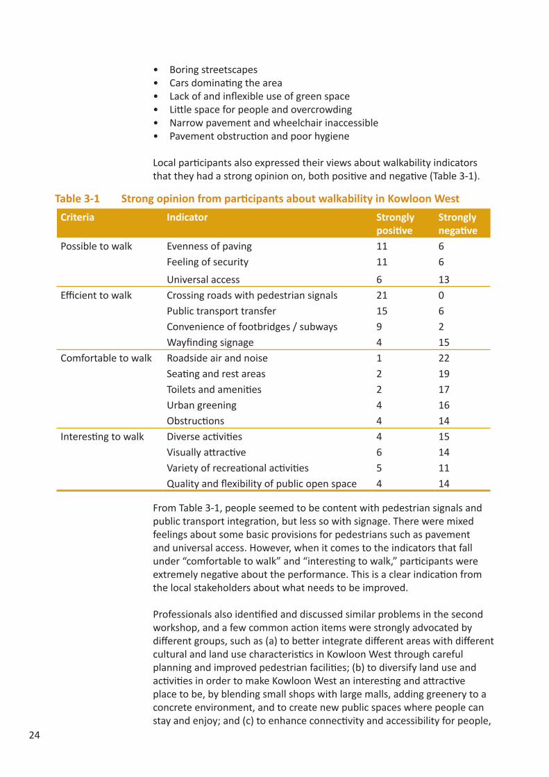
Local participants also expressed their views about walkability indicators that they had a strong opinion on, both positive and negative (Table 3-1).
Table 3-1 Strong opinion from participants about walkability in Kowloon West
From Table 3-1, people seemed to be content with pedestrian signals and public transport integration, but less so with signage. There were mixed feelings about some basic provisions for pedestrians such as pavement and universal access. However, when it comes to the indicators that fall under “comfortable to walk” and “interesting to walk,” participants were extremely negative about the performance. This is a clear indication from the local stakeholders about what needs to be improved.
Professionals also identified and discussed similar problems in the second workshop, and a few common action items were strongly advocated by different groups, such as (a) to better integrate different areas with different cultural and land use characteristics in Kowloon West through careful planning and improved pedestrian facilities; (b) to diversify land use and activities in order to make Kowloon West an interesting and attractive place to be, by blending small shops with large malls, adding greenery to a concrete environment, and to create new public spaces where people can stay and enjoy; and (c) to enhance connectivity and accessibility for people,
Criteria Indicator Strongly positive
Strongly negative
Possible to walk Evenness of paving 11 6Feeling of security 11 6
Universal access 6 13Efficient to walk Crossing roads with pedestrian signals 21 0
Public transport transfer 15 6Convenience of footbridges / subways 9 2Wayfinding signage 4 15
Comfortable to walk Roadside air and noise 1 22Seating and rest areas 2 19Toilets and amenities 2 17Urban greening 4 16Obstructions 4 14
Interesting to walk Diverse activities 4 15Visually attractive 6 14Variety of recreational activities 5 11Quality and flexibility of public open space 4 14

25
by extending the pedestrian network from Nathan Road to the waterfront and to plan it in a way that is user friendly, with fewer level changes, weather-proof, and universally accessible.
In terms of priorities for actions, most groups proposed that improvement to the walking environment should be prioritised, such as pedestrianisation of the old district, reduction in the need of level changes for pedestrians, and improvement of way-finding and signage systems. Other priorities were related to transport and land use, such as traffic segregation and the encouragement of mixed land use with diversity in scale was evident. Diversify activities and experience in the study area, and waterfront development, were also mentioned as priorities.
Figure 3-3 below includes six annotated drawings of the key ideas discussed by the groups during a planning workshop.
Figure 3-3 Concept drawings prepared by participants in a planning workshop

26
3.2. Recommendations for Kowloon West
Based on the findings and ideas gathered in the two planning workshops, this section aims to (a) summarise the current challenges in Kowloon West in terms of its walking environment; and (b) suggest potential interventions for improvement.
ChallengesOne of the fundamental walkability problems in Kowloon West is the great disconnect in street patterns between the old Jordan and the new West Kowloon reclaimed site, which impedes pedestrian movements and a better integration between the two areas (Figure 3-4). There is also a gap in terms of the variety of uses between the two, with Jordan being much more attractive and vibrant with small but diverse shop frontage. In addition, there is a lack of space in Jordan for efficient pedestrian movement, whereas in the reclaimed area, pedestrian movement is also inefficient because of the relatively large block size and wide roads, leading to poor permeability. The problem is exacerbated by the presence of a barrier in the road median and a lack of pedestrian crossings, which work to isolate different neighbourhoods in the study area. In general, there is a lack of greenery in the area, and little focus is placed on quality of the public space. Subways are used at main road junctions where at-grade crossings are not provided, but underground walkways are usually unattractive and can be disorientating.

27
Figure 3-4 Disconnected street patterns in Kowloon West
Physical interventionsTo improve the pedestrian environment, several physical interventions were recommended:
• Extend fine-grained streets network with smaller block size from ‘old’ Jordan to West Kowloon. (Figure 3-5)
• Increase permeability by adding pedestrian crossings. (Figure 3-6)• Provide more space for pedestrians by widening footpaths,
pedestrianising secondary streets and creating urban parks. (Figure 3-7)• Introduce traffic calming measures such as speed bumps and a lower
speed limit. • Encourage mixed use and active frontages. • Improve signage. • Landscaped deck over Western Harbour Crossing toll plaza to enhance
accessibility to the waterfront. (Figure 3-8)
Figure 3-5 Extending fine-grained street grid

28
Figure 3-6 Photo montage: adding a crossing to improve permeability
Figure 3-8 Photo montage: adding a landscaped deck to connect with the waterfront
Figure 3-7 Photo montage: widening footpath
29
ConclusionThrough the case study, it has been demonstrated that the level of walkability can be quite varied across a large area such as Kowloon West. The walkability checklists, in particular the four criteria – “possible to walk,” “efficient to walk,” “comfortable to walk,” and “interesting to walk” – become useful reference points for identifying problems, focusing discussions, and looking for solutions. With further refinement, the two checklists would become an important tool and benchmark for measuring walkability in Hong Kong, and a starting point from which the multiple benefits associated with walking can be realised and enhanced.

30
4.1. Introduction
To test the comprehensiveness, applicability and user friendliness of the professional checklist (see Appendix 3) in Hong Kong, walk audits were carried out in four selected districts, including: (a) Central, representing a business district; (b) Mongkok, representing an old urban district with mixed land uses; (c) Kwun Tong, representing an industrial area under transformation; and (d) Choi Hung Estate, representing a residential area with public housing. These four areas are all served by the MTR within 500 metres.
Since Central, Mongkok and Kwun Tong are all large districts that contain smaller neighbourhoods with distinct characteristics, efforts were made to select an area in each of these three districts for the assessment with similar building morphology, land use mix, and walking environment. For example in Kwun Tong, the industrial area south of Kwun Tong Road was chosen for walkability assessment. The residential area built on higher elevation north of Kwun Tong Road, and therefore representing a very different walking environment, was not included in the audit. In Central, the area sandwiched between Connaught Road Central and Queen’s Road Central was selected, but not the newly reclaimed area north of Connaught Road Central with very dissimilar block size, permeability, and connectivity. In Mongkok, the area surrounding the Mongkok MTR stations was chosen, including the part-time pedestrianized street along Sai Yeung Choi Street. In Choi Hung, Choi Hung Estate was selected as the study area. (Figures 4-1 to 4-4).
Figure 4-1 Kwun Tong: study area
4 Four-neighbourhood Comparison

31
Figure 4-2 Choi Hung: study area
Figure 4-3 Mongkok: study area
Figure 4-4 Central: study area

32
4.2. Walk audit results
It was found that among the four selected neighbourhoods, Choi Hung (Choi Hung Estate) scored the highest with 41 points (out of a maximum of 42) and is therefore considered a very walkable community. It is followed by Central with 23 points, which ranks average in terms of walkability. At the lower end of the spectrum, Mongkok scored 18 points, and Kwun Tong had 11 points. According to the scale, both Mongkok and Kwun Tong (the industrial area) are not quite walkable. (Table 4-1)
Walk score by design categoryWhile the aggregate score provides a quick reference point about the overall walkability of the audited area, further analysis by the 10 key components of walkability would offer additional insights into how well or poorly an area is performing in certain aspects of walkability, and what could become the key focus areas for improvement. (Figure 4-5)
Table 4-1 Walk score by study area
* The highest possible score is 42, based on the 42 indicators on the checklist, but the maximum score for some locations could be lower than 42, as some indicators may not be applicable to the selected area under assessment.Walk score by design category
Figure 4-5 Walk score of the four neighbourhoods by design category
Location Actual Score
Maximum Score*
Adjusted Score (out of 42)
Walkability Ranking
Kwun Tong (industrial area) 10 39 11 PoorChoi Hung (Choi Hung Estate) 35 36 41 Very good
Mongkok (near MTR station) 18 42 18 PoorCentral (south of Connaught Road and north of Queen’s Road)
23 42 23 Average

33
* Some indicators may not be applicable to the selected area under assessment, hence maximum score for each category may vary from one location to another.
Figure 4-5 shows that Choi Hung Estate performs very well in almost all the 10 key aspects of walkability. By observation during the walk audit, Choi Hung Estate is a well planned community with connected sidewalks; small block size with high permeability; clear signage; diverse, local shops; seating provision; traffic calming measures; traffic speed restriction; greenery; a high residential density and vibrant street activities that foster a sense of security; and good connection with the MTR station and other public transport facilities. (Figure 4-6)
Figure 4-6 Choi Hung: active shop frontage (left) and speed bump (right)
On the other hand, the Kwun Tong industrial area performs rather poorly in all aspects of walkability, except for scale and density. It is important to note that this is an area under transition from a traditional, industrial base into a commercial district. Street facilities were originally designed with priorities given to vehicles, especially for the efficient movement of heavy-duty trucks and their loading and unloading activities. (Figure 4-7) Little attention was made in the past to the needs of pedestrians and their level of comfort and enjoyment. Despite the unsatisfactory overall performance, it was witnessed during the walk audit that the Kwun Tong industrial area is undergoing some positive changes. For example, alleys and back lanes are recently beautified and incorporated as part of the pedestrian network, which in turn enhances permeability of the entire area. (Figure 4-7) New activities such as eateries are attracted to the area, which improves variety and diversity of uses and makes the walking environment more attractive, interesting and secured.

34
Central is often considered a very walkable district in Hong Kong, with the elevated walkway system being acclaimed as a positive example of walkability. (Figure 4-8) This is also reflected in the walk audit results, with Central scoring very high in terms of “accessibility and connectivity.” Figure 4-5 shows that Central also performs well in “physical and visual permeability,” “scale and density,” “variety and diversity” and “transit and pedestrian friendliness.” These positive results are attributable to the small block size and the active and diverse shop frontage along Des Voeux Road Central and Queen’s Road Central, as well as good integration with public transport nodes. However, it is apparent that Central performs less well in “public realm amenities,” “streetscape and visual quality,” “legibility and orientation,” “microclimate and environment,” and “safety and security.” These are the shortfalls that make Central average in the walkability assessment.
Figure 4-7 Kwun Tong: direct crossing block by railing (left) and back lanes adding permeability (right)
Figure 4-8 Central: footbridges connecting buildings

35
Finally, a breakdown of the walk score shows that Mongkok performs very well in terms of “scale and density” and “variety and diversity.” This is self-explanatory as Mongkok is well known for its street markets, local shops and the part-time pedestrianised streets. (Figure 4-9) However, there is a major deficiency with respect to the accessibility and connectivity as Nathan Road is a major barrier to pedestrians’ east-west movement. Scores in other aspects related to streetscape, amenities, safety, and local environment are also very low. In short, Mongkok is very attractive to pedestrians due to its vibrancy and on-street activities, but the general walking environment is far from satisfactory. (Figure 4-9)
Figure 4-9 Mongkok: overcrowding (left) and diverse shop frontage (right)
Walk score by pedestrian experience criteriaAnother way to dissect the walk score is to look at it based on the four different pedestrian experience criteria: “possible to walk,” “efficient to walk,” “comfortable to walk,” and “interesting to walk.” (Figure 4-10). Again, with the exception of Choi Hung Estate, the other three selected neighbourhoods fall short in one or more criteria.
For example, Central is physically walkable due to high connectivity and efficiency. It will become a truly walkable neighbourhood only if efforts are made to make people’s walking experience more comfortable and enjoyable.In contrast to Central, Mongkok is a very interesting and attractive place for pedestrians. However, the street environment is very crowded and poorly managed, making it very inefficient and uncomfortable to walk.The Kwun Tong industrial area is lacking in almost all criteria, and would require a dedicated planning effort and a pedestrian-first planning approach to enhance its walkability.

36
* Some indicators may not be applicable to the selected area under assessment, hence maximum score for each pedestrian experience criterion may vary from one location to another.
Figure 4-10 Walk score of the four neighbourhoods by pedestrian experience criteria

37
Appendix 1 Benefits of Walking
(A) Public HealthA city’s transportation system has important impacts on public health, according to Dr. Angie Cradock from the Harvard T.H. Chan School of Public Health.4 In particular, encouraging people to walk more in their daily commutes can bring about public health benefits. These benefits have not only been qualitatively analyzed, but also quantified in terms of economic values by many studies. In Hong Kong, such benefits can be substantial.
At the individual level, walking promotes physical fitness. As a rhythmic, dynamic, and aerobic activity of large muscles, it can effectively stimulate the circulatory system and improve cardio-pulmonary function.5,6 Walking reduces the risks of heart disease, stroke, osteoporosis, breast and colon cancer, and type 2 diabetes. It also strengthens bones, improves balance, and increases muscle strength. In Hong Kong, heart diseases and chronic lower respiratory diseases are among the ten leading causes of death.7 Therefore, it is possible to substantially reduce the mortality rate by promoting walking. A 2009 study found that 51.4% of Hong Kong people fail to meet the physical activities recommended for good health in the US.8 Since for most people, walking is the most accessible and cost-effective way to fulfill the physical fitness requirement, a convenient solution to this problem is to promote walking.
Another notable impact is related to obesity, which is growing in Hong Kong. Nearly one fifth of the population is obese, thanks to the prevalence of an unhealthy lifestyle.9 Among the most notable age groups are the 25-39 group and children. The former group consists of a large workforce in sedentary white-collar occupations, 60 percent of which exercises less than once a week. This group is the most vulnerable to weight-related problems such as diabetes and cardiovascular diseases. The increasing childhood obesity in recent years is no less alarming. From 1997/1998 to 2010/2011, the obesity rate among primary and secondary school students has risen from 16.4% to 21.4%.10 These obesity-related disorders have been found to develop at a younger age for Asians than in Western populations due to genetic factors.11 A US study shows that walkable neighborhoods are a key contributing factor in lowering childhood obesity rates.12 This disease, as it threatens the health of the current and future population, imposes a grave economic burden of diminished public health in Hong Kong.
In addition to physical health, walking also influences mental health. For school children, it is found that a stroll to school in the morning helps to handle classroom stress.13 For the elderly, various studies have indicated that

38
walking slows mental decline, lowers the risk of Alzheimer’s, improves sleep, and lightens moods.14 More importantly, quick walking is effective in relieving depression, with evidence from a meta-analysis.15 There are over 3 million depressive patients in Hong Kong, due to the fast-paced and stressful urban lifestyle. A more walkable environment would encourage people to “walk depression off.”
Part of the public health benefits of walking bring about considerable healthcare cost savings. In 2003, the US Center for Disease Control (CDC) estimated that US$5.6 billion in national cost associated with heart disease would be saved if 10% of the adult population were engaged in a regular walking program.16 A 2008 study estimates public health cost savings that would result from the walking trips to access a new light rail transit system in Charlotte, North Carolina in the US.17 Although the main focus is on medical costs associated with obesity only, the total estimate of public health cost savings amounted to US$12.6 million over nine years. A later study estimated the total value of walkability improvements in Portland, Oregon to be in the range of US$1 million to US$8 million in present discounted value.18 A study by the New Zealand Transport Agency estimated that new pedestrian facilities created a composite benefit of New Zealand Dollar $2.70 per kilometer for each pedestrian using the facility, of which $2.60 was attributed to health benefits.19 Although these studies are at best able to offer only a partial monetary valuation of improved walkability, the estimates suggest there are considerable public health benefits to be derived from greater walkability.
(B) Property ValuesAnother benefit of walkability is reflected in property values. For a long time, walkability was not considered as a contributing factor to property prices. However, several recent studies have suggested that the link is apparent. A study in London, “Paved with Gold,” is the first to explicitly estimate the relationship between the quality of the local street design and property values.20 The study employed a walkability measure called PERS in London. It was found that each point increase in the PERS score corresponded to an increase of £13,600 in residential prices, or about a 5.2% increase in the price of a flat; also, one PERS point increase gives rise to £25 per square meter in retail rent per year, which is a 4.9% increase in shop rents.
In the US, there are similar studies based on another walkability measure, the Walk Score. The Walk Score aims to discover how the walkability of each street affects the property value on the same street. One such study is “Walking the Walk.”21 With data on 93,725 recent home sales in 15 different markets across the US, researchers found a premium value between $700 and $3,000 for each Walk Score point increase. The study also notes that improvements in walkability may help alleviate the fiscal burden of the local government. In 2010, another study extended the scope of analysis to include not only residential housing, but also office, retail, and industrial property types.22 Again, the results indicated a positive and significant correlation: a one point increase in the Walk Score is associated with 0.9%, 0.9% and 0.1% increase in the market values of office, retail, and apartment spaces, respectively. Another

39
study by the Brookings Institute verified again that more walkable places command significantly higher office rents, retail rents, residential rents and home values. Furthermore, the study discovered that walkable urban districts perform better than stand-alone walkable urban locations like shopping malls, supporting the relationship between economic prosperity and high property values.
The above studies unanimously suggest that higher walkability leads to higher property values in a Western context. Although no similar studies have been conducted in Hong Kong, it may be inferred that people here share the same preference for good walking environments. In fact, “Walking the Walk” has found that the “walkability premium” is higher in more populous urban areas and those with extensive public transit.
(C) Time Savings and Greater AccessibilityFor every transportation project, an important aspect is travel efficiency. The immediate benefit of an efficient system is travel time savings, which has been central to transportation planning and evaluation since the 1960s. In Britain, for example, travel time savings have accounted for around 80% of the monetised benefits of major road schemes.23 However, time saving is only temporary, while the real “structural” impact of improved efficiency lies in longer trips and greater access.24 In other words, when connectivity and efficiency are enhanced, which results in people taking less time than before to reach a destination, people tend to use the time saved to travel for even longer distances, rather than just to “cash in” the time saved.
Hong Kong has a fairly comprehensive public transport system which consists of railways, trams, buses, minibuses, taxis and ferries. Every day, over 11 million passenger journeys are made on these systems.25 Public transport and pedestrian activities are complementary, because people usually walk to and from the public transport system. The more extensive the public transport network is, the more benefits of walking can be derived. The structural benefit of greater access on foot is significant in Hong Kong. While pedestrian planning is low in priority in Hong Kong, the Planning Department at least places some focus on strengthening the knot between walking and public transport, as evidenced in the Hong Kong Planning Standards and Guidelines.26 More specifically, all three components of the planning strategy integrate pedestrian planning with public transportation:
a. Promotion of pedestrian planning for railway catchment area;b. Strengthening of pedestrian planning for non-rail based public transport
network;c. Development of pedestrian network at local level, in particular, the
linkages between private residential areas and transport nodes.
It should be noted that the first point on railway connectivity is the most important, as the current catchment area of railways covers almost 70% of the population and 80% of jobs. By creating more efficient walking environments, the catchment area would be further enlarged, stimulating

40
more commercial activities and residential developments, as well as attracting more rail patrons.
(D) Increased Economic OpportunitiesThe transportation mode of a city partly determines what economic opportunities it can offer. For instance, in the US cities where the private car is the dominant mode, most commercial activities take place in gigantic shopping malls and supermarkets. Even if there are street-side stores outside of the downtown area, each store has its own car park to make it accessible by private vehicles. In contrast, Hong Kong’s retail sector is organised in a completely different pattern, which is determined by the dominant use of public transportation and walking. Greater walkability can help expand the business capacity of a street or a community in Hong Kong. Furthermore, improved walkability helps make a city more attractive to skilled professionals, since walkability fosters the development of more vibrant and exciting neighbourhoods.
Retail and restaurant businesses are attracted to lively streets because they are subject to scale economics. In other words, it is profitable to open a store only when the demand is sufficiently large in that area. Therefore, creating more walkable environments and thus attracting a larger pedestrian flow would bring in opportunities for commercial activities as well as employment. Vision42, a project in New York City, makes a strong case for the economic and fiscal impacts of improved walkability.32 Set in a similarly dense urban area, this is a suitable reference for Hong Kong. The project has two parts, a new local light rail transport service and the pedestrianisation of 42nd Street in connection to it. It is expected to result in a 35% increase in pedestrian flow to 42nd Street and the nearby area, and consequently, significant economic benefits will accrue. Retail and restaurant businesses are the biggest winners, with an expected expansion from US$1.1 billion to US$1.5 billion in annual size. Hotels and theatres are expected to increase revenue by 2-3%. Expected increases in annual tax revenue from property tax and sales tax is evaluated to be US$28.4 million. Aggregating the costs and benefits, annualised net benefit is estimated to be US$358 million.
(E) Environmental BenefitsIt is widely recognised that motorised transportation is generally bad for the environment, contributing to noise and smell, air pollution, as well as the emission of greenhouse gases. These are all persistent and aggravating problems in Hong Kong. Promoting walking as an alternative to motorised transport is one of the means that helps alleviate these problems.
Many European cities have found that encouraging greater use of non-motorised transport and public transport is an effective approach to tackling environmental problems.27 One success story comes from Freiburg, Germany. With the aim to reduce motorised traffic, the historic city core was planned so that it can only be accessed by trams, pedestrians, and bicycles. Traffic calming is employed in the rest of the city, with careful planning so that the negative

41
environmental impacts are not passed off to surrounding districts. These approaches effectively reduce traffic fatalities and air pollution, and create a pleasant pedestrian environment.28
In Hong Kong, the levels of respirable suspended particulates (RSP)29 and nitrogen dioxide (NO2) at the roadside continue to exceed the Air Quality Objectives, sometimes by a large amount. Since RSP can reach deep in the lungs, it causes greater risks of breathing and respiratory diseases, and damages to lung tissues.30 Therefore, these problems not only cause unpleasant neighbourhood environments, but also compromise people’s health.
Reduction of greenhouse gas emissions is another important reason for promoting walking trips to replace motorised traffic. After the Paris Agreement, it is anticipated that governments around the world will commit further to carbon emission reduction, and one of the main focuses will be cutting down greenhouse gas emissions from the transportation sector, which is currently the second largest local source after electricity generation.31 Building walkable and livable communities and promoting non-motorised transportation is more compatible with the trend towards climate change mitigation and sustainable development goals.
(F) Social BenefitsThe sidewalk is a public space in itself. This revolutionary idea by Jane Jacobs, first promoted in the 1960s, has now been widely recognised in urban planning. Plenty of social benefits result from improving sidewalks. Though hardly quantifiable, these benefits represent an important aspect of social life in a city. 22
According to Jacobs, the sidewalk is not just a place people walk on when going to a destination, but also the location for casual contacts with people living in the same city. Sidewalks accommodate a great diversity of activities and people: commuters, shoppers, street artists, newspaper hawkers, street vendors, etc. It is through such interactions, as Jacobs explained, that “a web of public respect and trust” is woven. Sidewalks also serve a number of implicit purposes such as the maintenance of public peace, portrayal of a city’s characteristics, and facilitating the socialisation process of children.33 Walkability improvements to public sidewalks help a society to achieve greater social equality. Some public infrastructure projects provide service only to a certain social group. For example, public parking and road facilities mainly serve vehicle owners, while walking environments such as sidewalks are accessible to everyone. In fact, a walkability survey has found that walking is an important transport means especially for low- and middle-income households in Hong Kong.34 Therefore, walkability improvements are suitable measures for redistributing public spending to the less well-off, and rebalancing the priorities to different social groups in transportation planning.

42
(A) Conceptual FrameworkThis walkability measurement tool is designed to help planners and community groups improve walkability on a neighbourhood scale, here defined as approximately a 500m radius from an agreed focal point. The neighbourhood scale was chosen because on any given walking trip, people utilise a collection of connected streets to get to their destination. Hence, assessing the walkability of such trips requires a consideration of the network of streets in a neighbourhood area. A neighbourhood may lie within the boundaries of a district, or span across a boundary.
The aim of this measuring tool is to help stakeholders to assess two aspects of a neighbourhood’s street network – function and performance. Evaluators will initially assess the function of different streets within a neighbourhood in terms of link and place. Then, having determined which streets fulfill (or should fulfill) an important pedestrian function, they will then assess their performance in order to make targeted improvements. This matters because the idea is not that every street must be rendered fun for pedestrians, or splashed with art and cafés. It would not be economically and spatially feasible to do this, nor would it fulfil the needs of an efficient street network. Rather, walkable streets should exist at the overall neighbourhood level so that getting to destinations is straightforward and trouble-free, and enjoyment of public space is possible near points of interest.
The measure should facilitate users to identify desirable attributes, and ways in which the planning authorities can accentuate the distinctive and address the shortcomings. The intended users may ideally be city planners and community groups. Community residents are likely to have the greatest interest in improving the walkability of their local areas.
The link-place function
Link functionA road’s link status can ranked by its role in the city’s transportation network (Government of South Australia, 2012). Roads carrying long-distance traffic have a higher link function than roads carrying short-distance or local traffic. In Hong Kong, the Transport Department’s official road hierarchy outlines the roles of three types of roads (HKSAR Planning Department, 2011):
• Trunk roads (Territorial): for longer-distance traffic movements between main centres of population and activities;
Appendix 2 The Link-Place Function of Streets
43
• Primary distributor roads (Urban): for traffic between centres within the main urban areas forming a primary road network;
• District distributor roads (District): for traffic between the primary road network and districts within the main urban areas; and
• Local distributor roads (Local): giving direct access from district distributor roads to buildings and land within districts.
The link function of these four categories can therefore be designated Territorial, Urban, District and Local. This is consistent with overseas practice, for example the Government of South Australia’s Streets for People: Compendium for South Australian Practice, roads are ranked on a five-point hierarchy from metropolitan to local.
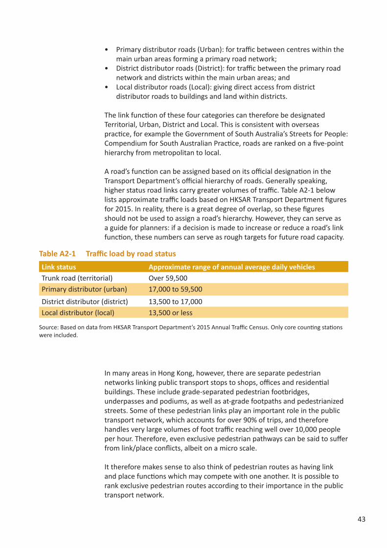
A road’s function can be assigned based on its official designation in the Transport Department’s official hierarchy of roads. Generally speaking, higher status road links carry greater volumes of traffic. Table A2-1 below lists approximate traffic loads based on HKSAR Transport Department figures for 2015. In reality, there is a great degree of overlap, so these figures should not be used to assign a road’s hierarchy. However, they can serve as a guide for planners: if a decision is made to increase or reduce a road’s link function, these numbers can serve as rough targets for future road capacity.
In many areas in Hong Kong, however, there are separate pedestrian networks linking public transport stops to shops, offices and residential buildings. These include grade-separated pedestrian footbridges, underpasses and podiums, as well as at-grade footpaths and pedestrianized streets. Some of these pedestrian links play an important role in the public transport network, which accounts for over 90% of trips, and therefore handles very large volumes of foot traffic reaching well over 10,000 people per hour. Therefore, even exclusive pedestrian pathways can be said to suffer from link/place conflicts, albeit on a micro scale.
It therefore makes sense to also think of pedestrian routes as having link and place functions which may compete with one another. It is possible to rank exclusive pedestrian routes according to their importance in the public transport network.
Table A2-1 Traffic load by road status
Link status Approximate range of annual average daily vehicles Trunk road (territorial) Over 59,500Primary distributor (urban) 17,000 to 59,500
District distributor (district) 13,500 to 17,000Local distributor (local) 13,500 or less
Source: Based on data from HKSAR Transport Department’s 2015 Annual Traffic Census. Only core counting stations were included.

44
• Major hub: Pedestrian routes feeding directly into major public transport hubs or corridors, or used to carry travellers from one transport mode to another. Examples include pedestrian routes in and around major public transport hubs and modal interchanges.
• Public transport access: Pedestrian routes used for direct access to a rail station, or a street used by a several bus stops.
• Local connector: pedestrian routes providing an important link within a neighbourhood, but which are not used to directly access public transport stations
• Frontage access: Pedestrian routes used for immediate access to shop frontage or primarily for recreational purposes.
Place functionA street’s place status can be ranked by its attractiveness as a destination in which people stay. This is determined by the street’s catchment area, i.e. the distance which people are willing to travel to visit it. In overseas practice, planning authorities rank place hierarchy on a scale of national (or international) to local significance, with nationally significant places being those of high cultural and tourist value, and locally significant places being those used primarily by nearby residents or workers. This can be adapted for Hong Kong with the caveat that it may not be appropriate to place too much weight on tourist visits because of the unique nature of Hong Kong’s tourism industry. Due to the prevalence of parallel trading and until recently, forced shopping tours, tourists from Mainland China can often be found in shopping destinations that are of relatively low place significance for Hong Kong residents, such as supermarkets in border New Towns. The presence of tourists does not necessarily indicate a high place significance unless it is also visited by people from all over Hong Kong.
The following place categories correspond roughly to the Hong Kong Planning Department’s retail hierarchy classification:
• Territorial (high): The place attracts users from all over Hong Kong. There may also be a significant number of tourists from the Mainland and overseas. Territorial place value streets provide a vibrant mix of high-order comparison goods and dining, leisure and entertainment services. They are located within neighbourhoods that offer a diverse array of goods, services, and recreational activities. (An individual street may not appear diverse: themed shopping streets focus on one type of product, but offer a range and selection unavailable elsewhere in the city). High place value streets may also support commercial facilities such as offices and hotels, or unique recreational facilities such as museums, theatres, and large high quality urban parks. Buildings along the street, or the street itself, may also be of high cultural, tourist or heritage value.
• District (medium): The place attracts mainly visitors from the same district or neighbouring districts. District place value streets are of district level significance. They mainly serve the population within the district, providing a variety of durable household goods, personal consumer goods, personal durable goods, leisure and entertainment facilities as well as dining

45
services. They may also support district-level facilities such as libraries, parks, sports facilities or schools.
• Neighbourhood (low): The place primarily attracts people from the surrounding neighbourhoods. They mainly offer convenience goods, household retail services, personal retail services and dining services to the population within walking distance. Examples include supermarkets, housewares shops, and noodle shops. They may also include local open space such as small rest gardens and sitting out areas.
• Very low: The street is used primarily by people who live or work on that street. It has few or no attractions or land uses that would attract other pedestrians, and has inactive frontage. Streets located in large, mono-functional neighbourhoods are often very low place value, such as pure residential neighbourhoods, offices districts without ground floor retail, or industrial districts.
The catchment size of a street does not necessarily correlate with the number of people that can be observed spending time in public spaces. Due to Hong Kong’s high urban densities, some neighbourhood public spaces may see a relatively high degree of use, even if all the users are nearby residents. On the other hand, a high level destination may not encourage outdoor staying due to poor environmental quality.
Place designation can be made by observing the mix of land uses, activities and facilities fronting onto the street. (Those land uses need to have frontage opening onto the street; walls without entrances do not attract pedestrians no matter the activities going on inside). The mix of available activities is a strong indicator of the size of a street’s catchment area – specialty goods shops, shops selling durable goods, and entertainment venues need a wider catchment area than shops selling everyday convenience goods such as groceries and household products. Unique facilities, such as sports stadiums or museums, also attract visitors from wider areas.

46
Appendix 3 The Professional Checklist
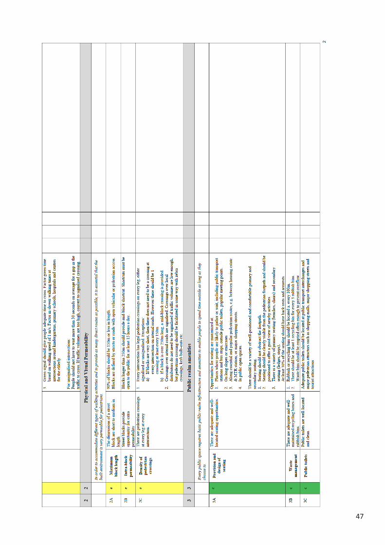
47

48

49

50

51

52

53
Appendix 4 The User ChecklistRoute: ______________________ Date: _____/________/________ Start Time: _____:______ Finish Time: _____:______
1
WALKABILITY CHECKLIST FOR USERS Please complete the checklist below by giving an overall rating (on a scale of 1 to 5) to each item according to your walking
experience in this area. Use the “comments” section to note down problematic spots or highlight good points. For several
questions, you will be asked to check off items that apply.
Scoring Scale:
A. POSSIBLE TO WALK
Indicators Score Comments (location of problems/ good points)
1 Width of pedestrian sidewalks and paved pathways
2 Evenness of paved surfaces
3 Universal access of paved pedestrian areas
(especially for people using strollers, wheelchairs, or
other assistive mobility devices)
4 Safety from road traffic
5 Feeling of security and personal safety from danger
(especially while walking alone or at night)
B. EFFICIENT TO WALK
6 Ease of crossing roads with traffic signals
7 Ease of crossing roads without traffic signals
8 Provision of street level connections where there is a
footbridge or subway
9 Convenience of footbridges/subways location
10 Clear and useful pedestrian signs and directions
11 Directness of routes to main destinations in the
neighbourhood
12 Ease of transferring between public transport modes
C. COMFORTABLE TO WALK
13 Weather protection of the area (rain, sun, excessive
wind)
14 General quality, cleanliness and hygiene of the area
15 Roadside air and noise pollution
(especially from vehicles, construction, etc.)
16 Provision of seating space and rest areas
17 Landscaping and greenery of paved pedestrian areas
18 Provision of public toilet and other amenities
19 Crowdedness of the area
20 Amount of street obstructions in walking paths
1 2 3 4 5
Bad Not Good Fair Good Excellent

54 2
D. INTERESTING TO WALK
Indicators Score Comments (location of problems/ good points)
21 Visually attractive streetscape and pleasant environment
(e.g. public art, street furniture, landscaping, paving,
lighting etc.)
22 The area’s appeal for staying and walking around
23 Variety of shops and restaurants
24 Variety of leisure and recreational activities
25 Overall quality and flexible use of public open spaces
26 Diverse range of activities, but not too overcrowded
27 The area is appealing to a wide cross section of people
E. YOUR VIEWS AND ASPIRATIONS -‐ In general, what do you think of the area?
28 Has sufficient basic pedestrian infrastructure (e.g.
quality of sidewalk, crossing facilities etc.) for walking
29 Efficient to walk to and from other areas
30 Comfortable to walk around
31 Encourages and attracts people to walk around here
32 What do you like most and dislike most about this area?
33 What kind of changes/modifications to the walking environment of this area do you want to see?
F. USUAL PURPOSE AND FREQUENCY OF VISIT (Please tick the appropriate box)
34 Usual purpose of visit ¨ Commute to work; ¨ Commute to school; ¨ Shopping; ¨ Entertainment; ¨ Visiting family or
friends; ¨ Other (please specify) ___________________
35 Frequency of visiting
this area
¨ At least once a day; ¨ At least once a week; ¨ At least once a month; ¨ At least a few
times a year; ¨ Once a year or less
G. DEMOGRAPHIC (Please tick the appropriate box)
36 Gender ¨ Male ¨ Female
37 Age ¨ 18-‐29 ¨ 30-‐39 ¨ 40-‐49 ¨ 50-‐59 ¨ 60-‐69
¨ 70 and over
38 Highest level of
education achieved
¨ Primary or below; ¨ Secondary and 6th form; ¨ Diploma/Certificate/Sub-‐degrees;
¨ Degree; ¨ Post-‐graduate degree
39 District of residence ¨ Islands; ¨ Kwai Tsing; ¨ North; ¨ Sai Kung; ¨ Sha Tin; ¨ Tai Po; ¨ Tsuen Wan;
¨ Tuen Mun; ¨ Yuen Long; ¨ Kowloon City; ¨ Kwun Tong; ¨ Sham Shui Po; ¨ Wong Tai Sin;
¨ Yau Tsim Mong; ¨ Central & Western; ¨ Eastern; ¨ Southern; ¨ Wan Chai
40 Participant type ¨Resident in district; ¨ Shopkeeper/worker in district; ¨ Government; ¨ District Council;
¨ Planning/Engineering/Architecture professional; ¨ Non-‐profit organisation; ¨ Student;
¨ Other (please specify) _____________________

55
Endnote1. Local Government Commission Center for Livable
Communities, (1999). The Economic Benefits of Walkable Communities. http://www.lgc.org/wordpress/docs/freepub/community_design/focus/walk_to_money.pdf (accessed on 18 July 2016)
2. Litman, T. A., (2011). Economic Value of Walking. Victoria Transport Policy Institute. http://www.vtpi.org/walkability.pdf (accessed on 18 July 2016)
3. Hung, Manandhar and Ranasinghe, (2010). “A Walkability survey in Hong Kong”, Proceedings of 12th
4. Cradock, A. (2012). Transportation and Public Health: Ensuring Health and Equity in Livable Communities. Paper presented at the Transportation Systems for Livable Communities. http://onlinepubs.trb.org/onlinepubs/conf/cpw6.pdf (accessed 18 July 2016)
5. Improving Cardio-Pulmonary Function: Walking and Jogging (translated from Chinese). http://www.cuhk.edu.hk/healthpromotion/ha/ha08.pdf (accessed 18 July 2016)
6. Parkkari et al. (2000). A Controlled Trial of the Health Benefits of Regular Walking of a Golf Course. The American Journal of Medicine 109(2), 102-108.
7. Healthy HK, Department of Health. (2011). Leading Causes of All Deaths. http://www.healthyhk.gov.hk/phisweb/en/healthy_facts/disease_burden/major_causes_death/major_causes_death/ (accessed 18 July 2016)
8. Leisure and Culture Services Department. (2009). Consultancy Study on Sport for All – Participation Patterns of Hong Kong People in Physical Activities.
9. Ngo. (14 August, 2012). Warning as Study Shows One in Five are Obese. South China Morning Post. http://www.scmp.com/article/973456/warning-study-shows-one-five-are-obese (accessed 18 July 2016)
10. Department of Health. Obesity Rate of Hong Kong Primary School Children. http://school.eatsmart.gov.hk/files/pdf/Childhood_obesity_en.pdf (accessed 18 July 2016)
11. Ramachandran & Snehalatha, (2010). Rising Burden of Obesity in Asia. Journal of Obesity, 2010. http://www.hindawi.com/journals/jobes/2010/868573/ (accessed 18 July 2016)
12. Saelens et al., (2012). Obesogenic Neighborhood
Environments, Child and Parent Obesity. American Journal of Preventive Medicine, 42(5).
13. Lambiase, Barry & Roemmich, (2010). Effect of a Simulated Active Commute to School on Cardiovascular Stress Reactivity. Medicine & Science in Sports & Exercise, 42(8).
14. Arthritis Foundation. Mental Benefits of Walking. http://www.arthritistoday.org/what-you-can-do/staying-active/walking/mental-benefits-of-walking.php (accessed 18 July 2016)
15. Robertson et al., (2012). Walking for Depression or Depressive Symptoms: A Systematic Review and Meta-analysis. Mental Health and Physical Activity, 5(1), 66-75.
16. CDC, (2003). Preventing Obesity and Chronic Diseases through Good Nutrition and Physical Activity. http://www.cdc.gov/nccdphp/publications/factsheets/prevention/pdf/obesity.pdf (accessed 18 July 2016)
17. Stokes, Robert, MacDonald, & Ridgeway, (2008). Estimating the effects of light rail transit on health care costs. Health and Place.
18. Boarnet, Greenwald, & McMillan, (2008). “Walking, Urban Design, and Health: Toward a Cost-Benefit Analysis Framework,” Journal of Planning Education and Research, Vol. 27, No. 3, pp. 341-358.
19. New Zealand Transport Agency, (2010). Economic evaluation manual. Volume 2.Wellington: New Zealand Transport Agency. http://www.nzta.govt.nz/resources/economic-evaluation-manual/volume-2/docs/eem2-july-2010.pdf (accessed 18 July 2016)
20. Colin Buchanan, (2007). Paved with Gold: The real value of good street design. London: CABE. http://www.peoplepoweredmovement.org/site/images/uploads/Paved_with_Gold_the_Real_Value_of_Good_Street_Design.pdf (accessed 18 July 2016)
21. Joe Cortright, Impresa, Inc. (2009). Walking the Walk: How Walkability Raises Home Values in U.S. Cities. Chicago: CEOs for Cities.
22. Pivo, G., & Fisher, J. D., (2010). The Walkability Premium in Commercial Real Estate Investments. http://www.u.arizona.edu/~gpivo/Walkability%20Paper%208_4%20draft.pdf (accessed 18 July 2016)
23. Mackie, P., Jara-Diaz, S. and Fowkes, A., (2001) The value of travel time saving in evaluation, Transportation Research Part E, 37(2–3), pp. 91–106.

56
http://www.cec.uchile.cl/~dicidet/sjara/The%20Value%20of.pdf (accessed 18 July 2016)
24. David Metz, (2008). The Myth of Travel Time Saving, Transport Reviews: A Transnational Transdisciplinary Journal, 28:3, 321-336. http://dx.doi.org/10.1080/01441640701642348 (accessed 18 July 2016)
25. Transportation Department, (2013). Public Transport: Introduction. http://www.td.gov.hk/en/transport_in_hong_kong/public_transport/introduction/index.html (accessed 18 July 2016)
26. The Planning Department, (2011). Hong Kong Planning Standards and Guidelines. http://www.pland.gov.hk/pland_en/tech_doc/hkpsg/full/index.htm (accessed 18 July 2016)
27. Foletta & Field, (2011). Europe’s Vibrant New Low Car(bon) Communities. Institute for Transportation & Development Policy (ITDP). http://www.itdp.org/documents/092611_ITDP_NED_Desktop_Print.pdf (accessed 18 July 2016)
28. Green Urbanism: Reducing the Ecological Footprint of Our Cities. http://postcarboncities.net/green-urbanism-learning-european-cities-timothy-beatley-2000 (accessed 18 July 2016)
29. RSP are particles with a diameter of 10 micrometres or less.
30. Environmental Protection Department. Health Effects of Total and Respirable Suspended Particulates. http://www.epd.gov.hk/epd/english/environmentinhk/air/air_quality/backgdf_4_1_5.html (accessed 18 July 2016)
31. Ruth, (2012). Harnessing Cobenefits of Urban Adaptation to Climate Change. Paper presented at the Transportation Systems for Livable Communities. http://onlinepubs.trb.org/onlinepubs/conf/cpw6.pdf (accessed 18 July 2016)
32. Jacobs, (1961). The Death and Life of Great American Cities. New York: Random House.
33. Ibid.
34. Hung, Manandhar and Ranasinghe, (2010). “A Walkability survey in Hong Kong”, Proceedings of 12th International Conference on Mobility and Transport for Elderly and Disabled Persons (TRANSED2010), Hong Kong, China, 2-4 June 2010.

57

58

59

(c) Civic Exchange, December 2016The view expressed in this report are those of the authors, and do not necessarily represent the opinions of Civic Exchange.
23/F, Chun Wo Commercial Centre, 23-29 Wing Wo Street, Central, Hong Kong. T (852) 2893 0213 F (852) 3105 9713 www.civic-exchange.org