may1997 volume 39 number 5 storm data · may1997 volume 39 number 5 storm data and unusualweather...
TRANSCRIPT

MAY 1997VOLUME 39NUMBER 5
STORMDATASTORMDATA
AND UNUSUAL WEATHER PHENOMENAWITH LATE REPORTS AND CORRECTIONS
noaa NATIONAL OCEANIC AND NATIONAL ENVIRONMENTAL SATELLITE NATIONAL CLIMATIC DATA CENTERATMOSPHERIC ADMINISTRATION DATA, AND INFORMATION SERVICE ASHEVILLE, N.C.
Cover: A photograph of the Jarrell, Texas F5 tornado as it was approaching the town of Jarrell, TX. The tornado was spawned by a supercellthunderstorm which formed along the dryline (a line of sharp contrast between moist and dry air). The tornado tracked south through the Double CreekEstates subdivision where it leveled houses and killed 27 poeple. (Photo courtesy of Scott Beckwith, Jarrell Farm Supply, Jarrell, Texas)
PageOutstanding Storms of the Month. . . . . . . . . . . . . . . . . . . . . . . . . . . . . . . . . . . . . . . . . . . . . . . .. 5Storm Data and Unusual Weather Phenomena. . . . . . . . . . . . . . . . . . . . . . . . . . . . . . . . . . . . . . . . .. 9
STORM DATA(ISSN 0039-1972)
National Climatic Data CenterEditor: Stephen Del Greco
Assistant Editor: Stuart Hinson
STORM DATA is prepared, funded, and distributed by the National Oceanic and Atmospheric Administration (NOAA). TheOutstanding Storms of the Month section is prepared by the Data Operations Branch of the National Climatic Data Center.
The Storm Data and Unusual Weather Phenomena narratives and Hurricane/Tropical Storm summaries are prepared by the NationalWeather Service. Monthly and annual statistics and summaries of tornado and lightning events resulting in deaths, injuries, and damageare compiled by cooperative efforts between the National Climatic Data Center and the Storm Prediction Center.
STORM DATA contains all confirmed information on storms available to our staff at the time of publication. However, due todifficulties inherent in the collection of this type of data, it is not all-inclusive. Late reports and corrections are printed in each edition.
Maps of the National Weather Service County Warning Areas which are used in the Storm Data and Unusual Weather Phenomenasection wil l be printed in all editions.
Except for limited editing to correct grammatical errors, materials submitted are generally published as received.
Note: "None Reported" means that no severe weather occurred and "Not Received" means that no reports were received for this regionat the time of printing.
Subscription, pricing, and ordering information is available from:
The editor of STORM DATA solicits your help in acquiring photographs (prints or slides; black and white, or color), maps, clippings,etc. of significant or unusual weather events (past or present). These could be for use in the "Outstanding Storms of the Month'' or "EtCetera'' sections of STORM DATA. We request our subscribers or other interested persons to mail such items to:
Any such items received by the editor wil l be for use in STORM DATA only. Any other use wil l be with the permission of the ownerof said items. Materials submitted wil l be returned if requested in the original submission.
TABL E OF CONTENTS
Stuart HinsonNational Climatic Data Center
151 Patton AvenueAsheville, NC 28801-5001
National Climatic Data Center151 Patton Avenue
Asheville, NC 28801-5001(704) 271-4800 or (704) CLIMATE
"I certify that this is an official publication of theNational Oceanic and Atmospheric Administrationand is compiled from information received at theNational Climatic Data CenterAsheville, North Carolina28801-2733."
Kenneth D. DavidsonActing Director,National Climatic Data Center
2

M ay 1997 C on firm ed T ornadoes
4
F S ca le F 0 F 1 F 2 F 3 F 4 F 5 T o ta lN u m b er 15 3 39 10 2 1 1 207
F Sca le
F 0
F 1
F 2
F 3
F 4
F 5

OUTSTANDING STORMS OF THE MONTH
On May 27th, an F5 tornado was spawned by a supercell thunderstorm which developed along the drylinein central Texas. Morning upper air soundings indicated thermodynamic conditions were favorable forthe development of severe weather. The thunderstorm grew rapidly in intensity and size during the earlyafternoon. The Storm Prediction Center posted a tornado watch at 11:54AM CST (12:54PM CDT). Atornado warning was issued by the National Weather Service (NWS) Office in New Braunfels, TX at2:30PM CST (3:30PM CDT). The F5 tornado touched down at approximately 2:40 PM CST and enteredthe Double Creek Estates subdivision near Jarrell, TX at 2:48PM CST. Six tornadoes swept throughWilliamson and Travis Counties causing 29 fatalities and damage estimated over $125 Million. Eventhough the upper level winds were moving from southwest to northeast, the tornadic thunderstormsdeveloped in a south-southwest direction, due to a back-building formation of new cells along the dryline.Other reports of severe weather included four inch hail in Cedar Park and Kelly Air Force Base recordeda 122 mph wind gust. Other incredible phenomena include: The F5 tornado completely removed thepavement from the roads it crossed. Three hundred head of cattle were killed, a few were found as faraway as a quarter mile.
JARRELL, TEXAS IS DEVASTATED BY F5 TORNADO
Right: A photograph of the above tornadotaken by a different photographerapproximately 5 minutes later as itapproached the Double Creek Estatessubdivision on the outskirts of Jarrell.Note the multiple vortices.
(Photo courtesy of Scott Beckwith, JarrellFarm Supply, Jarrell, TX)
Left: A photograph of the tornado atapproximately 2:40PM CST. Thefunnel dropped out of the wallcloud and touched down 3.5 milesnorth of Jarrell, TX and movedsouth-southwest.
(Photo courtesy of Charlotte Vancil,Jarrell, TX)
5

Right: Another aerial view near Jarrell. Thepowerful F5 tornado scoured theground in its path. The driveway inthis photo led to a house which stooddirectly in the tornado’s path.
(Photo courtesy of Troy Kimmel, KimCoMeteorological Services, Austin, TX)
Left: An aerial view of the tornado pathand the remnants of the DoubleCreek estates. The tornadocompletely removed the homesfrom their foundations. (Note thecement slab foundations and theabsence of debris) The dark linesin the photo are tire tracks ofrescue vehicles as they drovethrough the fields looking forsurvivors.
(Photo courtesy of Troy Kimmel, KimCoMeteorological Services, Austin, TX)
Left: One of the many foundations left by thetornado. Most of the homes in this areawere fabricated on cement slabs similar tothis one. All of the homes were completelydemolished and debris was scattered formiles. Few homes had a basement or stormshelter of any type.
(Photo courtesy of Larry Eblen, Jeff Orrock andBruce Thoren, NWS, Austin/San Antonio, TX)
6

The remnants of a mobile home and a trailerlocated at the Double Creek Estates. Note theabsence of large debris. (Photo courtesy of NWS, Austin/San Antonio, TX)
This vehicle, one of many destroyed by thetornado, is located next to the remnants of a home.
(Photo courtesy of NWS, Austin/San Antonio, TX)
This house located in Cedar Park, TX was heavilydamaged by airborne debris and tornadic winds.
(Photo courtesy of NWS, Austin/San Antonio, TX)
This house, also located in Cedar Park, wasseverely damaged. The tornado passed withinclose proximity to this house.(Photo courtesy of NWS, Austin/San Antonio, TX)
An aerial view of a collapsed roof of a store inCedar Park, just north of Austin, TX.(Photo courtesy of Troy Kimmel, KimCo , Austin,TX)
An aerial view of the Buttercup Creek section ofCedar Park depicts how a tornado can destroy ahome and leave neighbors homes untouched.(Photo courtesy of Troy Kimmel, KimCo, Austin,TX)
7

Right: The parent cloud that produced theJarrell F5 tornado began as a smallthunderstorm at the intersection oftwo cloud lines in East-CentralTexas about 10:00AM CST. Thethunderstorms developed southwestalong a strong “dryline” and by thetime (1:02PM CST) of the GOES-8Visible Image (right), the primarycell was well established .
Left: By 2:45PM CST, the primary cellwas showing a distinctive“overshooting top” near thesouthwest edge (center of photo) ofthe anvil cloud, while below, theJarrell F5 tornado was already on theground. The Doppler radar indicateda maximum cell height of 58,000 feetat 2:35PM CST. Note also the “wakeeffect” in the cloud top as strong SWto NE winds aloft were forced to flowaround the “overshooting top”.
Right: By 4:02PM CST, the primary cellhad continued to develop southwestand was about to merge into thecirrus “anvil” cloud shield that wasstreaming northeast from a cellcomplex that developed near theTexas-Mexico border.
(Satellite images courtesy of the NationalClimatic Data Center)
8

ALABAMA, North CentralMarion County
Trees were reported down in Hamilton.Thunderstorm Wind (G50) 5K0002Hamilton 01515CST
Trees and a few power lines were reported down between Sulligent and Vernon. Time estimated.Thunderstorm Wind (G50) 6K0002 10 N Vernon 01520CST
Lamar County
A gust to 64 mph was recorded by the ASOS at the Muscle Shoals Airport.Thunderstorm Wind (G56) 5K0002Muscle Shoals 01526CST
Colbert County
Trees were down in Double Springs, and dime size hail was reported in many locations in the western part of the county.Tstm Wind/Hail 6K0002Double Spgs 01605CST
Winston County
Dime size hail was reported in Eldridge, in the northwest part of the county.Hail (0.75) 3K0002Eldridge 01630CST
Walker County
Dime size hail was reported in the northwest part of the county.Hail (0.75) 3K0002 3 W West Pt 01652CST
Cullman County
Several trees were uprooted in Decatur and Hartselle. There were also some power outages due to trees falling on the lines.Thunderstorm Wind (G50) 6K0002Decatur 01700CST
Morgan County
Trees were down near Guin in the southwest part of the county, in the southern part of the county, reported by the EMA.Thunderstorm Wind (G50) 5K0002Guin 01705CST
Marion County
Nickel size hail was reported in Haleyville.Hail (0.88) 4K0002Haleyville 01740CST
Winston County
Trees were down in Guin, in the southwest part of the county.Thunderstorm Wind (G50) 5K0002Guin 01755CST
Marion County
Trees and limbs were blown onto power lines causing power outages for over 12 hours in some locations in Scottsboro.Thunderstorm Wind (G55) 7K0002Scottsboro 01800CST
Jackson County
Three-quarter inch hail was reported, and several trees blown down in Sulligent, in the western part of the county.Tstm Wind/Hail 6K0002Sulligent 01800CST
Lamar County
Flash Flood 15K0002Hamilton 2K1800CST2200CST
Marion County
Flash Flood 20K0002Winfield 2K1800CST2200CST
Marion County
Up to seven inches of rain fell causing several roads to wash out including CR 95 between SR 253 and SR 44. In Winfield, thecity park was under up to 6 feet of water, destroying an ice machine, a pitching machine and a concession stand. The next day, a31 year old Mississippi woman drowned, when her raft capsized while rafting along the Buttahatchee River near Hamilton.
Golf ball size hail was reported in Baileyton, in the northeast part of the county.Hail (1.75) 7K0002Baileyton 01830CST
Cullman County
Golf ball sized hail covered the ground in Guntersville. The high school roof and parking lot were damaged with. The wheat cropwas also damaged.
Hail (1.75) 15K0002Guntersville 5K1848CSTMarshall County
Golf ball sized hail was reported in Geraldine.Hail (1.75) 7K0002Geraldine 01916CST
Dekalb County
Trees were reported down near Jamestown, in the northern part of the county.Thunderstorm Wind (G50) 5K0002Jamestown 02000CST
Cherokee County
Over 5 inches of rain fell over parts of the county causing storm drains to fill up quickly. Several roads were washed away and
Flash Flood 40K000203
Guntersville 5K2000CST0200CST
Marshall County
19
Storm Data and Unusual Weather Phenomena
Location Date Character of Storm
TimeLocal/Standard
PathLength(Miles)
PathWidth(Yards)
Number ofPersons
Killed Injured
EstimatedDamage
Property Crops
May 1997

ALABAMA, North Centralwater businesses and homes had up to 1 1/2 feet of water in them. The fire station in Guntersville had several inches of water inthe truck bay.
A few trees and power lines were down north of Vernon.Thunderstorm Wind (G50) 7K0002 3 N Vernon 02015CST
Lamar County
Hail the size of quarters was reported in Winfield.Hail (1.00) 5K0002Winfield 02045CST
Marion County
Golf ball size hail was reported just north of Fayette.Hail (1.75) 5K0002Fayette 02050CST
Fayette County
A gust to 67 mph was reported by a spotter.Thunderstorm Wind (G58) 3K0002Jasper 02115CST
Walker County
Quarter sized hail was reported in Mt. Olive, in the southern part of the county.Hail (1.00) 5K0002 6 N Millport 02145CST
Lamar County
Golf ball size hail was reported in Hanceville.Hail (1.75) 6K0002Hanceville 02200CST
Cullman County
Trees were reported down in the Royal community, in the central part of the county.Thunderstorm Wind (G50) 5K0002Royal 02225CST
Blount County
Four trees were blown down within the city limits of Cordova, in the eastern part of the county, requiring clean up.Thunderstorm Wind (G50) 5K0002Cordova 02250CST
Walker County
A few trees were down in the Sand Rock area, in the northwest part of the county.Thunderstorm Wind (G50) 5K0002 8 NW Centre 02340CST
Cherokee County
Eighteen people had to be evacuated from a mobile home park, some of them by boat, when a small creek flooded causing severalfeet of water in the park. Several cars were totally submerged and the water reached into a few of the homes.
Flash Flood 35K0003Blountsville 3K0100CST0500CST
Blount County
Trees were down in several areas around Vernon. One fell on a house knocking a hole in the roof and damaging the ceiling andwalls.
Thunderstorm Wind (G50) 15K0003Vernon 00105CSTLamar County
Lightning struck a house and it was totally destroyed by the ensuing fire. Three cows were also killed while standing under a treethat was struck by lightning.
Lightning 85K0003Gadsden 00230CSTEtowah County
Power lines were down along Highway 11, just west of Tuscaloosa.Thunderstorm Wind (G50) 8K0003Tuscaloosa 00305CST
Tuscaloosa County
Trees were down and power was out in Ashville.Thunderstorm Wind (G50) 5K0003Ashville 00350CST
St. Clair County
The entire city of Lincoln was without power due to trees on power lines.Thunderstorm Wind (G50) 8K0003Lincoln 00415CST
Talladega County
Trees and power lines were down throughout the city.Thunderstorm Wind (G50) 7K0003Talladega 00420CST
Talladega County
Several trees were blown down on a NWS employee's property.Thunderstorm Wind (G50) 3K0003Prattville 00530CST
Autauga County
There were widespread power outages across the county due to downed power lines.Thunderstorm Wind (G50) 8K0003Rockford 00530CST
Coosa County
210
Storm Data and Unusual Weather Phenomena
Location Date Character of Storm
TimeLocal/Standard
PathLength(Miles)
PathWidth(Yards)
Number ofPersons
Killed Injured
EstimatedDamage
Property Crops
May 1997

ALABAMA, North CentralRussell County
Hail the size of quarters was reported in northern Phenix City.Hail (1.00) 4K0003Phenix City 00700CST
A small tornado touched down at Paradise Shores on the Limestone County side of the Tennessee River downing several trees andcausing minor damage to several houses. One tree fell on a car while another fell into a three-car garage damaging a collection ofHarley-Davidson motocylces.
Tornado (F0) 45K0 50 1 003 4.5 WSW Reid 5.5 WSW Reid to 01545CST
Limestone County
A tornado, rated at F2 on the Fujita scale, struck the southern and eastern sections of Athens in Limestone County. The tornadopath began about 2 miles south-southwest of Athens near the intersection of Sanderfer Road and County Road 45. The tornadomoved northeasterly crossing through southern and eastern sections of Athens. It crossed the intersection of State Road 127 andUS 72 where several businesses were damaged. Some damage was caused at Athens Middle School.The tornado continued northeast dissipating near the intersection of Proyr Street and US 31 near Athens High School.According to EMA officals, siz homes were destroyed, 14 homes sustained major damage, and an additional 14 homes had minordamage. Three apartment buildings, each with eight units, were damaged, 13 businesses had major damage, and two businessesreported minor damage.Of the 12 injuries, two were described as serious.
Tornado (F2) 2.3M 12 75 3.2 003 1.5 ENE Athens 2 SSW Athens to 50K1602CST
1607CST
Limestone County
A short but powerful tornado struck the area northwest of Meridianville destroying four homes along with major damage to twootehrs and minor damage to twelve more. The tornado path began in an hope area just southwest of the Colonial Golf Course.The torndo moved through a small subdivision on the north and east sides of the golf course and moved into an open area again asit dissipated.
Tornado (F2) 600K 1 70 1.3 003 2 NNW Meridianville 1.7 NW Meridianville to 01626CST
1628CST
Madison County
A short tornado hit the Big Cove area of southeast Madison County damaging several houses and the wastewater treatment plant.A busienss with machinery outside and several tin-roofed buildings were also damaged. One older house that appeared abandonedwas destroyed.
Tornado (F0) 85K0 40 1.3 003
4.5 N Owens Xrds
4.5 NNW Owens Xrdsto
01634CST1636CST
Madison County
A small tornado damaged roofs to 15 homes and downed a number of trees in Owens Crossroads.
Tornado (F0) 100K0 50 1.5 003Owens Xrds 01640CST1642CST
Madison County
Several trees were blown down in Samantha.Thunderstorm Wind (G50) 5K0009Samantha 00834CST
Tuscaloosa County
Several trees were blown down and windows were blown out at the Bell South building downtown.Thunderstorm Wind (G60) 10K0009Birmingham 00900CST
Jefferson County
Dime size hail was reported near Beauregard, in the central part of the county.Hail (0.75) 4K0009 6 S Auburn 01500CST
Lee County
Hail the size of half dollars was reported in Smiths Station, in the eastern part of the county.Hail (1.25) 6K0009Smiths Station 01512CST
Lee County
Dime size hail was reported in Phenix City.Hail (0.75) 4K0009Phenix City 01515CST
Russell County
A weak tornado touched down briefly south of Huntsville at the corner of Airport Road and Memorial Parkway. The awning of aWinn Dixie was ripped off. It was seen and video taped by several citizens and by a Channel 31 meteorologist.
Tornado (F0) 10K0 30 0.2 025Huntsville 01823CST1824CST
Madison County
Three-quarter inch hail covered the ground.Hail (0.75) 4K0026Oakland 1K2125CST
Lauderdale County
311
Storm Data and Unusual Weather Phenomena
Location Date Character of Storm
TimeLocal/Standard
PathLength(Miles)
PathWidth(Yards)
Number ofPersons
Killed Injured
EstimatedDamage
Property Crops
May 1997
ALABAMA, North CentralColbert County
Hail (0.75) 4K0026 8 N Cherokee 1K2133CST
Hail (1.00) 5K0026 8 SW Tuscumbia 1K2203CSTColbert County
Hail (0.75) 4K0026 10 SE Tuscumbia 1K2205CSTColbert County
Tstm Wind/Hail 6K0026Littleville 1K2206CSTColbert County
Three-quarter to one inch hail was reported throughout the county. Trees were also reported down in Littleville.
Hail (0.75) 4K0026Russellville 02207CSTFranklin County
Hail (1.75) 7K0026 7 NE Russellville 2K2212CSTFranklin County
Hail (0.75) 4K0026Philcampbell 02215CSTFranklin County
Penny to golf ball sized hail was reported in the eastern sections of the county.
Hail (3.50) 10K0026Mt Hope 6K2217CSTLawrence County
Hail (0.75) 3K0026Moulton 02223CSTLawrence County
Larger than tea cup sized hail was reported in Mt. Hope in the southeast part of the county along with three-quarter inch hail atMoulton..
Three-quarter inch hail was reported in Moreland, in northern Winston county.Hail (0.75) 6K0026Moreland 1K2248CST
Winston County
Wind knocked down several trees onto power lines, causing power outages for up to three hours in many locations across the city.Thunderstorm Wind (G50) 9K0028Albertville 00715CST
Marshall County
Several trees were reported down in Snead, in the northern part of the county.Thunderstorm Wind (G50) 7K0031Snead 01230CST
Blount County
Numerous trees and power lines were down in Steele near CR 42 and US 11.Thunderstorm Wind (G50) 8K0031Steele 01245CST
St. Clair County
NONE REPORTED.
ALABAMA, Southeast
Dime size hail was reported around Rock Springs.Hail (0.75)0003Rock Spgs 0405CST
ALABAMA, SouthwestChoctaw County
Golfball to dime size hail was reported along I65 from Saraland to Mobile.
Hail (1.75)0015MobileSaraland to 1420CST
1440CST
Mobile County
Gusty winds, around 50 mph, caused minor roof damage to two homes. Also. a couple of carports suffered damage and atrampoline was turned over.
Thunderstorm Wind (G45) 5K0019Creola 1410CST1411CST
Mobile County
Lightning hit an old live oak tree and ripped a 20 ft. strip of wood from the 4 foot wide and 70 foot t all tree. The exploding stripof wood, from the tree, damaged two nearby historical homes built in 1850.
Lightning 15K0019Mobile 1815CSTMobile County
Dime size hail was reported along I65 just west of Wallace.
Hail (0.75)0023Wallace 1450CST1451CST
Escambia County
412
Storm Data and Unusual Weather Phenomena
Location Date Character of Storm
TimeLocal/Standard
PathLength(Miles)
PathWidth(Yards)
Number ofPersons
Killed Injured
EstimatedDamage
Property Crops
May 1997

ALABAMA, SouthwestWashington County
Quarter size hail was reported in McIntosh.
Hail (1.00)0023Mc Intosh 1720CST1721CST
Trees and power lines were blown down near Millry.
Thunderstorm Wind (G50) 2K0023Millry 1730CST1734CST
Washington County
Dime size hail was reported near Wagarville.
Hail (0.75)0023Wagarville 1800CST1801CST
Washington County
Several trees were blown down along US HWY 84 near River Falls.
Thunderstorm Wind (G50) 1K0024River Falls 2305CST2306CST
Covington County
Lightning struck a house in Chatom and caused it to catch on fire.Lightning 5K0027Chatom 2000CST
Washington County
Dime size hail was reported along US HWY 29 between Flomaton and Brewton.
Hail (0.75)0027BrewtonFlomaton to 2023CST
2028CST
Escambia County
Dime size hail was reported along CR 27 about three miles west of Alma.
Hail (0.75)0027 3 W Alma 2125CST2126CST
Clarke County
Dime size hail was reported along SH 59 about five miles south of Chrysler.
Hail (0.75)0027 5 S Chrysler 2200CST2201CST
Baldwin County
Dime size hail was reported along CR 8 near Eliska.
Hail (0.75)0027Eliska 2210CST2211CST
Monroe County
Several trees were blown down near Gilbertown. A couple of awnings were damaged near SH 17 in the same area.
Thunderstorm Wind (G50) 2K0028Gilbertown 0040CST0045CST
Choctaw County
Dime size hail was reported around Butler.
Hail (0.75)0028Butler 0120CST0121CST
Choctaw County
Several trees were blown down along CR 34 just northeast of Millry.
Thunderstorm Wind (G50) 1K0028Millry 0130CST0132CST
Washington County
Several trees were blown down near Alberta.
Thunderstorm Wind (G50) 1K0028Alberta 0300CST0301CST
Wilcox County
Dime size hail was reported in Millers Ferry.
Hail (0.75)0028Millers Ferry 1435CST1436CST
Wilcox County
Several large limbs were blown down in the McIntosh community.
Thunderstorm Wind (G50) 1K0028Mc Intosh 1630CST1632CST
Washington County
Several trees and power lines were blown down in the Jackson community.
Thunderstorm Wind (G50) 2K0028Jackson 1640CST1642CST
Clarke County
513
Storm Data and Unusual Weather Phenomena
Location Date Character of Storm
TimeLocal/Standard
PathLength(Miles)
PathWidth(Yards)
Number ofPersons
Killed Injured
EstimatedDamage
Property Crops
May 1997

ALABAMA, SouthwestClarke County
Sections of SH 177 were washed out and other roads in the south part of the county were impassable from the early evening hoursinto the early morning hours because of high water. WSR-88D estimated that 8 to 10 inches of rain fell in this area from lateafternoon through the early morning hours. Most of the rain fell during the evening hours.
Flash Flood 2K002829
Jackson 1830CST0330CST
Several trees were blown down in southern sections of the county near the McKenzie community.
Thunderstorm Wind (G50) 1.5K0028Mc Kenzie 1835CST1836CST
Butler County
Several roads in the Butler community were closed overnight due to high water. Also, several secondary roads in the southernsections of the county had to be closed overnight due to high water. WSR-88D estimated that 6 to 8 inches of rain fell in centraland southern sections of the county during the afternoon into the early morning hours. Most of the rain fell during the eveninghours.
Flash Flood 1K002829Bolinger
Butler to 1845CST0330CST
Choctaw County
Several secondary roads were closed in central and southeastern sections of the county overnight due to high water. WSR-88Destimated that 5 to 7 inches of rain fell in this area during the afternoon into the early morning hours. Most of the rain fell duringthe evening.
Flash Flood 2K002829Seaboard
St Stephens to 1845CST0300CST
Washington County
Heavy rains fell around the Mobile area during the evening. The heaviest rain fell in the twelvemile and threemile creek basins,from Moffett Road, across Municipal Park across Airport Blvd to Cottage Hill Road at University. Up to 9 inches of rain fell inthis area in 3 to 4 hours with 4.52 inches falling in one hour near the USA Campus. Several Streets in this area had standing water3 to 4 feet deep in intersections. One such intersection was at University and Old Shell, near where the 4.52 inches of rainfalloccurred. A mother and her young son tried to avoid this flooded intersection and became disoriented, driving into a floodeddrainage ditch. The car they were in was then swept away into swollen twelvemile creek. Someone tried to save them but wasunable to do so. The automobile was found one mile down the ditch and the two bodies were recovered two days later inMunicipal Park Lake.
Flash Flood 10K0028Mobile 2015CST2215CST
Mobile County
Several trees and power lines were blown down near Dawes Road, just south of the airport.
Thunderstorm Wind (G50) 1.5K0028Mobile Bates Fld 2040CST2042CST
Mobile County
Heavy rains caused Persimmon Creek, southeast of Garland, to overflow its banks at CR 8. The road was closed for several hoursuntil the water receded. WSR-88D estimated that 2 to 4 inches of rain fell in this area, during a three hour period.
Flash Flood 1.5K002829
Garland 2100CST0100CST
Butler County
Two males were fishing in a wooden boat, when lightning struck and killed one occupant. The other occupant was not injured.They were fishing along the northern section of the island when the lightning struck. There were numerous storms in the area atthe time.
Lightning0 1 28Dauphin Is 2230CSTMobile County
M55BO
High Wind (G35)0019 1015AST1735AST
ALASKA, NorthernAKZ024 St. Lawrence Island-Bering Strait Coast
A storm crossed the central aleutian chain and moved north over the southern and central Bering Sea before curving northwest andweakening. Max winds at Gambell: 35g41 kts 19th 1815 AST, at Savoonga 35g43 kts occasionally between 1015am and 1735 onthe 19th.
NONE REPORTED.
ALASKA, Southeast
614
Storm Data and Unusual Weather Phenomena
Location Date Character of Storm
TimeLocal/Standard
PathLength(Miles)
PathWidth(Yards)
Number ofPersons
Killed Injured
EstimatedDamage
Property Crops
May 1997
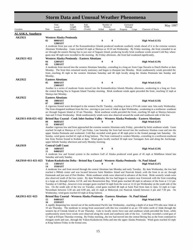
ALASKA, SouthernAKZ021 Western Alaska Peninsula
High Wind (G35)0002 0000AST1200AST
A moderate front just east of the Komandorskiye Islands produced moderate southerly winds ahead of it in the extreme westernAleutians Wednesday. Gusts reached 43 mph at Shemya at 10:10 am Wednesday. By Friday morning...the front extended in anarc through the eastern Bering Sea to just east of Seguam Island, producing locally brisk southeast winds around Cold Bay wheregusts near 40 mph were recorded in the morning. By Friday afternoon...the front had weakened significantly.
High Wind (G39)000405
1200AST1200AST
AKZ021>022 Western Alaska Peninsula - Eastern Aleutians
A moderate front moved into the western Aleutians Saturday...extending in a long arc from Cape Navarin to Dutch Harbor at 4amMonday. The front then remained nearly stationary and began to dissipate late Monday. Brisk southeasterly winds preceded thefront...reaching 45 mph in the western Aleutians Saturday and 40 mph locally along the Alaska Peninsula late Sunday andMonday.
High Wind (G45)0005 0000AST2300AST
AKZ022 Eastern Aleutians
Another in a series of moderate fronts moved into the Komandorskiye Islands Monday afternoon...weakening in a long arc fromthe central Bering Sea to Seguam Island Tuesday morning. Brisk southeast winds again preceded the front...reaching 52 mph atShemya late Monday.
High Wind (G58)000607
1800AST1800AST
AKZ022 Eastern Aleutians
A vigorous frontal wave developed in the western Pacific Tuesday...reaching at least a 974 mb center near Attu early Wednesday.The front elongated northeast from the low...moving to just west of Adak at 4pm Wednesday...weakening in a northwest- southeastarc through Seguam Island at 10 am Thursday. Brisk southeast winds preceded the front...reaching 58 mph at Shemya between2am and 3:15am Wednesday. Brisk southwesterly winds were also observed around the south and southwest side of the low.
High Wind (G47)000912
0600AST0300AST
AKZ011-018-021>022 Bristol Bay Coastal - Cook Inlet-Susitna Valley - Western Alaska Peninsula - Eastern Aleutians
Another vigorous low and front approached the extreme western Aleutians early Friday...preceded by brisk southeast winds. Gustsreached 54 mph at Shemya at 12:27 pm Friday. Late Saturday the front had moved into the southwest Alaskan coast and into theupper Alaska Peninsula and weakened. Cold Bay recorded wind gusts of 40 mph prior to the frontal passage late Saturday. OnSunday, wind gusts reached 41 mph at King Salmon. The front continued to weaken Monday...extending in a northwest-southeastline from Norton Sound to Kodiak at 4pm. Wind gusts locally reached 50 mph near Turnagain Arm and along the Anchorageupper hillside Sunday afternoon and early Monday morning.
High Wind (G39)001011
1600AST0400AST
AKZ019 Central Gulf Coast
A moderate low and frontal system in the northern Gulf of Alaska produced wind gusts of 45 mph at Middleton Island lateSaturday and early Sunday.
High Wind (G47)001314
1300AST1930AST
AKZ010>011-021-023 Yukon-Kuskokwim Delta - Bristol Bay Coastal - Western Alaska Peninsula - St. Paul Island
A moderate low and front moved through the central Aleutians late Monday and early Tuesday. By 4am Wednesday, the low hadreached a 990mb center and was located between Saint Matthew Island and Nunivak Island...with the front in an arc throughEmmonak and just east of Port Heiden. Brisk southeast winds were observed in advance of the front. Brisk westerly winds werealso observed south of the low center. By 4pm Wednesday the low had begun to weaken near Emmonak with the front extendingin a large arc through Galena A.F.B. and into Resurrection Bay. Wind gusts reached 48 mph in advance of the front at 1:12 pmTuesday at Cold Bay...however even stronger gusts reached 54 mph from the west at 12:22 pm Wednesday on the south side of thelow. On the south side of the low on Tuesday...wind gusts reached 48 mph at Saint Paul from 4am to 2pm, 53 mph at CapeNewenham between 5:30 am and 6:00 pm, and 41 mph at Mekoryuk (on Nunivak Island) between 4 pm and 7:30 pm. OnWednesday, wind gusts reached 43 mph at King Salmon.
High Wind (G49)001516
0400AST2359AST
AKZ011-021>023 Bristol Bay Coastal - Western Alaska Peninsula - Eastern Aleutians - St. Paul Island
A rapidly deepening low moved out of the northcentral Pacific late Wednesday...reaching a depth of at least 970 mbs near Adak at10 am Thursday. The moderate to strong front associated with this low extended in an arc 150 miles north of Adak through thewestern tip of Umnak Island at 10 am Thursday. Gale to locally storm force east and southeast winds preceded the front...whilesouthwesterly storm force winds were observed along the south and southwest side of the low. Cold Bay recorded a wind gust of57 mph at 8:01pm Thursday evening. By Friday morning...the low had moved into the central Bering Sea as the front continued toelongate north and east...through the Yukon-Kuskokwim Delta and into the upper Alaska Peninsula. Wind gusts reached 43 mphat King Salmon Friday in the frontal area.
715
Storm Data and Unusual Weather Phenomena
Location Date Character of Storm
TimeLocal/Standard
PathLength(Miles)
PathWidth(Yards)
Number ofPersons
Killed Injured
EstimatedDamage
Property Crops
May 1997

ALASKA, SouthernAKZ010>011-018-021>023
Yukon-Kuskokwim Delta - Bristol Bay Coastal - Cook Inlet-Susitna Valley - Western Alaska Peninsula -Eastern Aleutians - St. Paul Island
High Wind (G66)001719
2100AST1800AST
A major north Pacific low moved by Atka Island with at least a 970 mb central pressure early Sunday. The low then continuednorth through the Bering Sea...to 180 miles west of Saint Matthew Island Monday morning...weakening a bit. The front elongatedboth north and east from the center...extending in a wide arc through the Chukotsk Peninsula of Russia through the SewardPeninsula and into extreme eastern Bristol Bay Monday morning. Strong southeasterly winds preceded the front. Wind gustsreached 45 mph at King Salmon and along the Anchorage Upper Hillside Monday. Strong westerly winds were also observedaround the south and west sides of the low. By 4am Tuesday...the low had weakened to 996 mbs near Cape Navarin, Russia andthe front had all but dissipated across the western Alaska mainland. Cold Bay recorded gusts of 76 mph early Sunday morning.
High Wind (G34)002122
1800AST1200AST
AKZ022 Eastern Aleutians
A moderate frontal system approached the western Aleutians late Wednesday and early Thursday...preceded by brisk easterly windgusts around 40 mph.
Temperature Record0025 0000AST2359AST
AKZ011 Bristol Bay Coastal
New record high temperature of 80 at King Salmon.
High Wind (G34)002930
1200AST2300AST
AKZ022 Eastern Aleutians
A moderate front just south of the Aleutians brought easterly wind gusts of 40 mph to most areas Thursday and Friday.
NOT RECEIVED.
AMERICAN SAMOA
Single thunderstorm gust to 59 kts/68 mph near Beaver Creek Country Club in Lake Montezuma.
Thunderstorm Wind (G59)00009 6 NE Camp Verde 00735MST0736MST
ARIZONA, Central and NortheastYavapai County
Spotter reported a funnel cloud but the report was unconfirmed and only minor thunderstorms were in the area at the time.
Funnel Cloud00011Mayer 01420MST1428MST
Yavapai County
A thunderstorm caused wind damage to eastern sections of Camp Verde. One report was received from the public of a tornado,but no witnesses could be found to verify this. We concluded the damage was caused by gusty winds, but no winds speeds wererecorded. Several trailers were moved off their foundations in the White Hills Trailer Park. On Hardy Lane branches broke offtrees and were scattered over the road. In the Sierra Verde area an older barn lost part of its roof.
Thunderstorm Wind (G50) 5K0016 5 E Camp Verde 02045MST2115MST
Yavapai County
Thunderstorm Wind (G60)0011Lake Havasu City 1650MST
ARIZONA, NorthwestMohave County
A weather spotter in Lake Havasu City reported a 69 mph wind gust from a nearby thunderstorm. There was no report of damage.
A tin roof was blown off a shed.
Thunderstorm Wind0.50K0018Tubac 1430MST1433MST
ARIZONA, SouthSanta Cruz County
Road was closed due to boulder being washed onto road. Water overflowed banks of wash.
Flash Flood0019Dudleyville 1430MST1500MST
Pinal County
Dime size hail was reported.
Hail (0.75)0019San Manuel 1445MST1450MST
Pinal County
816
Storm Data and Unusual Weather Phenomena
Location Date Character of Storm
TimeLocal/Standard
PathLength(Miles)
PathWidth(Yards)
Number ofPersons
Killed Injured
EstimatedDamage
Property Crops
May 1997

ARIZONA, SouthPima County
Winds gusted to 55kts.Thunderstorm Wind (G55)0020Davis Monthan Afb 1259MST
A woman camping with her two sons in a tent was killed when lightning struck the tent. Her two sons, one inside the tent, theother outside the tent, were not injured. F39CA
Lightning0 1 20 10 N Ft Huachuca 1440MSTCochise County
A man camping in his tent was killed when lightning struck his tent. M55CALightning0 1 20 30 W Willcox 1700MST
Cochise County
Wind gust was estimated by a weather spotter at Apache Trail and Ellsworth Road.Thunderstorm Wind (G52)0020Mesa 1430MST
ARIZONA, SouthwestMaricopa County
Hail (0.75)0002Warren 1340CST
ARKANSAS, Central and North CentralBradley County
Hail (0.75)0002Morrilton 1621CSTConway County
Hail (1.00)0002 3 N Camden 1625CSTOuachita County
Hail (0.75)0002Cleveland 1630CSTConway County
Hail (1.00)0002Charleston 1637CSTFranklin County
Thunderstorm winds gusted to 60 mph at Charleston.Thunderstorm Wind (G52)0002Charleston 1637CST
Franklin County
Hail (1.75)0002Monticello 1710CSTDrew County
Hail (1.00)0002 2 W London 1725CSTPope County
Thunderstorm winds downed a few trees.Thunderstorm Wind (G50)0002 2 W London 1725CST
Pope County
Several large trees were knocked down.Thunderstorm Wind (G50)0002London 1730CST
Pope County
Hail (0.75)0002Beebe 1755CSTWhite County
Hail (0.75)0002Monticello 1932CSTDrew County
Lightning struck a house which resulted in a fire. The fire spread from the attic area and eventually destroyed much of the house.Lightning 30K0002Hazen 1945CST
Prairie County
Hail (0.75)0008 6 E Mena 1945CSTPolk County
Hail (0.75)0026Mammoth Spg 2045CSTFulton County
Thunderstorm winds downed some large trees.Thunderstorm Wind (G50)0026 4 S Mammoth Spg 2055CST
Fulton County
Hail (1.75)0026Hardy 2100CSTSharp County
Thunderstorm winds downed some trees.Thunderstorm Wind (G50)0026Nail 2240CST
Newton County
Several trees were knocked down.Thunderstorm Wind (G50)0026Swain 2240CST
Newton County
917
Storm Data and Unusual Weather Phenomena
Location Date Character of Storm
TimeLocal/Standard
PathLength(Miles)
PathWidth(Yards)
Number ofPersons
Killed Injured
EstimatedDamage
Property Crops
May 1997

ARKANSAS, Central and North CentralNewton County
Several large trees were blown down.Thunderstorm Wind (G50)0026Deer 2245CST
Thunderstorm winds downed some trees and damaged several farm buildings.Thunderstorm Wind (G50)0026Hatfield 2245CST
Polk County
Some trees were knocked down and a few outbuildings were also damaged.Thunderstorm Wind (G50)0026Cove 2245CST
Polk County
Thunderstorm winds blew down a few trees.Thunderstorm Wind (G50)0026Potter 2250CST
Polk County
Thunderstorm winds downed several trees.Thunderstorm Wind (G50)0026Lurton 2300CST
Newton County
Thunderstorm winds gusted to 65 mph at the intersection of Highways 65 and 62.Thunderstorm Wind (G56)0026 7 NW Harrison 2300CST
Boone County
Thunderstorm winds downed some trees just north of Harrison.Thunderstorm Wind (G50)0026 1 N Harrison 2300CST
Boone County
Thunderstorm winds damaged a number of boats and boat sheds along a portion of Norfork Lake. A number of trees and powerlines were also blown down.
Thunderstorm Wind (G50) 50K0026 8 ENE Mountain Home 2315CSTBaxter County
Thunderstorm winds blew down several trees.Thunderstorm Wind (G50)0026Buffalo 2315CST
Baxter County
Several trees and power lines were knocked down.Thunderstorm Wind (G50)0026 1 SW Mammoth Spg 2315CST
Fulton County
Hail (0.88)0026Salem 2315CSTFulton County
Thunderstorm winds downed numerous trees.Thunderstorm Wind (G50)0026Marshall 2337CST
Searcy County
Thunderstorm winds destroyed a farm building. Several buildings also sustained roof damage.Thunderstorm Wind (G50)0026Oden 2345CST
Montgomery County
Hail (0.75)0026Calico Rock 2345CSTIzard County
Thunderstorm winds blew over a trailer and caused roof damage to several buildings. A number of trees and power lines were alsoknocked down.
Thunderstorm Wind (G50)0026 5 NW Onia 2350CSTStone County
Hail (0.88)0026 6 ESE Hardy 2355CSTSharp County
Some trees were blown down.Thunderstorm Wind (G50)0026Poughkeepsie 2355CST
Sharp County
Several buildings sustained roof damage.Thunderstorm Wind (G50)0027Danville 0015CST
Yell County
Thunderstorm winds downed some large tree limbs.Thunderstorm Wind (G50)0027Prim 0015CST
Cleburne County
Hail up to one inch in diameter damaged a vehicle.
Hail (1.00)0027Prim 0015CST0020CST
Cleburne County
1018
Storm Data and Unusual Weather Phenomena
Location Date Character of Storm
TimeLocal/Standard
PathLength(Miles)
PathWidth(Yards)
Number ofPersons
Killed Injured
EstimatedDamage
Property Crops
May 1997

ARKANSAS, Central and North CentralPike County
Hail (0.75)0027Kirby 0020CST
Hail (0.75)0027Glenwood 0020CSTPike County
Thunderstorm winds downed some trees and destroyed an outbuilding.Thunderstorm Wind (G50)0027Salado 0040CST
Independence County
Hail (1.00)0027Campbell Station 0047CSTJackson County
Thunderstorm winds destroyed several outbuildings and damaged the roofs of a few buildings.Thunderstorm Wind (G50)0027Oil Trough 0050CST
Independence County
Thunderstorm Wind (G56)0027Lake Catherine 0055CSTGarland County
Thunderstorm winds downed some trees.Thunderstorm Wind (G50)0027 2 W Arkadelphia 0100CST
Clark County
Some trees were blown down.Thunderstorm Wind (G50)0027Malvern 0100CST
Hot Spring County
Several trees were knocked down.Thunderstorm Wind (G50)0027 1 W Searcy 0100CST
White County
Thunderstorm winds downed several trees and damage the roofs of some buildings.Thunderstorm Wind (G50)0027Paron 0115CST
Saline County
Thunderstorm winds downed some trees. A storage shed was damaged and some buildings sustained roof damage.Thunderstorm Wind (G50)0027Solgohachia 0120CST
Conway County
Thunderstorm winds damaged the roofs of several buildings.Thunderstorm Wind (G50)0027 5 NE Mc Crory 0130CST
Woodruff County
Several buildings suffered roof damage.Thunderstorm Wind (G50)0027Conway 0140CST
Faulkner County
Thunderstorm winds damaged the roofs of a few buildings.Thunderstorm Wind (G50)0027Greenbrier 0140CST
Faulkner County
A couple of buildings sustained roof damage.Thunderstorm Wind (G50)0027Sheridan 0145CST
Grant County
An F1 tornado touched down about 4 miles west of Jacksonville. The tornado first damaged the roof of a building 1.5 miles eastof Highway 107. Several trees were also blown down in the same area. The tornado lifted several times as it moved eastwardtowards Highway 167, downing a number of trees and power poles. The tornado then moved into the City of Jacksonville whereseveral buildings sustained roof damage. One store in a local mall suffered heavy structural damage. The tornado later lifted abouta half mile east of Highway 167.
Tornado (F1) 200K0 50 4 027Jacksonville 4 W Jacksonville to 0145CST
0150CST
Pulaski County
Thunderstorm winds blew down several trees.Thunderstorm Wind (G50)0027Vilonia 0150CST
Faulkner County
Thunderstorm winds downed trees and power lines.Thunderstorm Wind (G50)0027Furlow 0210CST
Lonoke County
Thunderstorm winds blew down some large tree limbs.Thunderstorm Wind (G50)0027Tucker 0215CST
Jefferson County
Some trees were knocked down in and around Fordyce.Thunderstorm Wind (G50)0027Fordyce 0225CST
Dallas County
1119
Storm Data and Unusual Weather Phenomena
Location Date Character of Storm
TimeLocal/Standard
PathLength(Miles)
PathWidth(Yards)
Number ofPersons
Killed Injured
EstimatedDamage
Property Crops
May 1997

ARKANSAS, Central and North CentralPrairie County
Several trees were knocked down.Thunderstorm Wind (G50)0027Hickory Plains 0225CST
Hail up to one inch in diameter damaged some crops at Slovak.
Hail (1.00)0027Slovak 0235CST0240CST
Prairie County
Several buildings sustained roof damage.Thunderstorm Wind (G50)0027Brinkley 0245CST
Monroe County
Thunderstorm winds knocked down some trees.Thunderstorm Wind (G50)0027Stephens 0305CST
Ouachita County
Thunderstorm winds damaged the roofs of a couple of buildings.Thunderstorm Wind (G50)0027Gillett 0315CST
Arkansas County
Hail up to quarter size damaged some crops.
Hail (1.00)0027Gillett 0315CST0318CST
Arkansas County
Thunderstorm winds knocked down some trees and damaged the roofs of a few buildings.Thunderstorm Wind (G50)0027Dumas 0330CST
Desha County
Thunderstorm winds damaged the roofs of some buildings and blew down several trees.Thunderstorm Wind (G50)0027Mc Gehee 0340CST
Desha County
Several buildings sustained roof damage in Hampton.Thunderstorm Wind (G50)0027Hampton 0355CST
Calhoun County
Thunderstorm winds damaged the roofs of some buildings.Thunderstorm Wind (G50)0027 15 S Warren 0425CST
Bradley County
Thunderstorm winds downed some trees.Thunderstorm Wind (G50)0027 15 SW Monticello 0430CST
Drew County
Hail (0.88)0027Leslie 1530CSTSearcy County
Hail (0.88)0027Mc Gehee 1900CSTDesha County
Thunderstorm winds downed some large tree limbs.Thunderstorm Wind (G50)0027Jacksonville 1920CST
Pulaski County
Hail (0.75)0027Furlow 1945CSTLonoke County
A funnel cloud was observed by local law enforcement officials.Funnel Cloud0027Furlow 1945CST
Lonoke County
Hail (0.88)0027Antioch 2015CSTWhite County
Thunderstorm winds downed several trees.Thunderstorm Wind (G50)0027Stuttgart 2205CST
Arkansas County
Hail (1.75)0028Enola 0030CSTFaulkner County
Hail (1.00)0028Romance 0045CSTWhite County
Hail (0.88)0028 4 S Cabot 0050CSTLonoke County
1220
Storm Data and Unusual Weather Phenomena
Location Date Character of Storm
TimeLocal/Standard
PathLength(Miles)
PathWidth(Yards)
Number ofPersons
Killed Injured
EstimatedDamage
Property Crops
May 1997
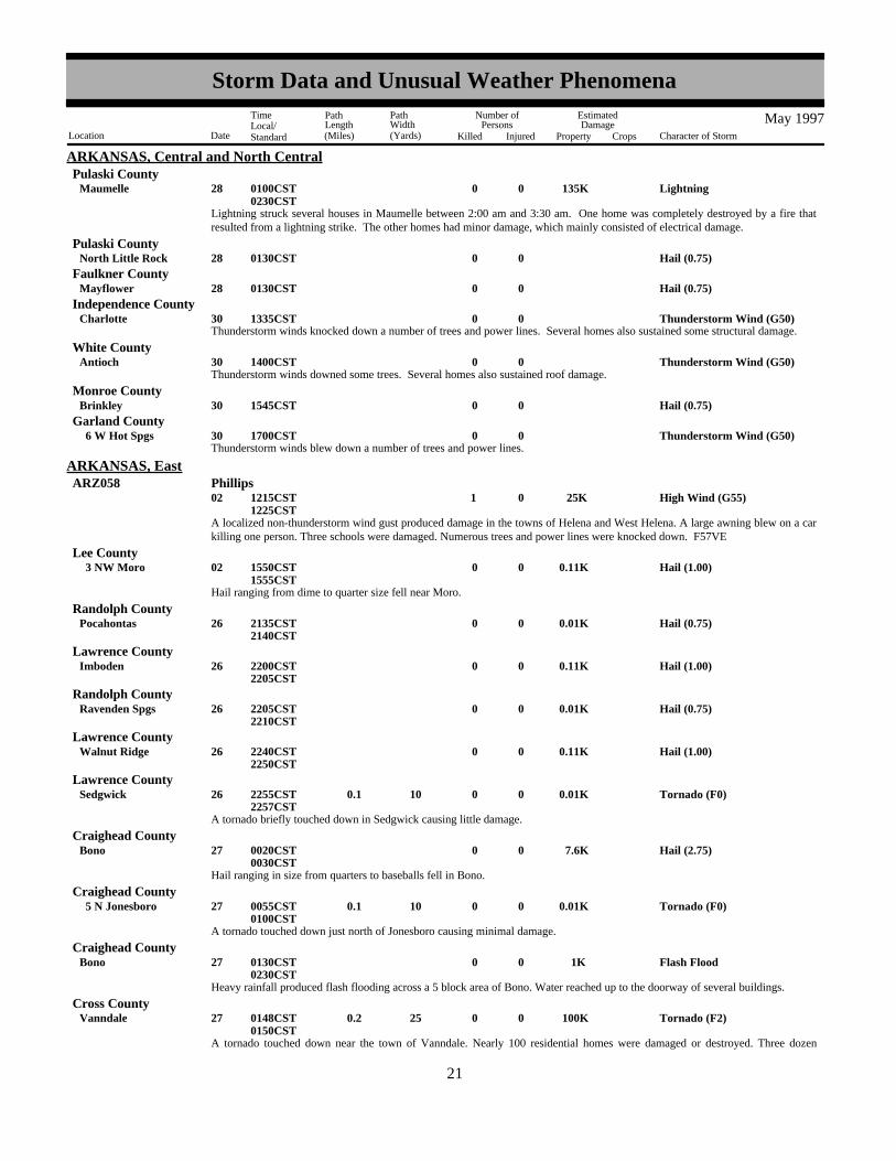
ARKANSAS, Central and North CentralPulaski County
Lightning struck several houses in Maumelle between 2:00 am and 3:30 am. One home was completely destroyed by a fire thatresulted from a lightning strike. The other homes had minor damage, which mainly consisted of electrical damage.
Lightning 135K0028Maumelle 0100CST0230CST
Hail (0.75)0028North Little Rock 0130CSTPulaski County
Hail (0.75)0028Mayflower 0130CSTFaulkner County
Thunderstorm winds knocked down a number of trees and power lines. Several homes also sustained some structural damage.Thunderstorm Wind (G50)0030Charlotte 1335CST
Independence County
Thunderstorm winds downed some trees. Several homes also sustained roof damage.Thunderstorm Wind (G50)0030Antioch 1400CST
White County
Hail (0.75)0030Brinkley 1545CSTMonroe County
Thunderstorm winds blew down a number of trees and power lines.Thunderstorm Wind (G50)0030 6 W Hot Spgs 1700CST
Garland County
A localized non-thunderstorm wind gust produced damage in the towns of Helena and West Helena. A large awning blew on a carkilling one person. Three schools were damaged. Numerous trees and power lines were knocked down. F57VE
High Wind (G55) 25K0 1 02 1215CST1225CST
ARKANSAS, EastARZ058 Phillips
Hail ranging from dime to quarter size fell near Moro.
Hail (1.00)0.11K0002 3 NW Moro 1550CST1555CST
Lee County
Hail (0.75)0.01K0026Pocahontas 2135CST2140CST
Randolph County
Hail (1.00)0.11K0026Imboden 2200CST2205CST
Lawrence County
Hail (0.75)0.01K0026Ravenden Spgs 2205CST2210CST
Randolph County
Hail (1.00)0.11K0026Walnut Ridge 2240CST2250CST
Lawrence County
A tornado briefly touched down in Sedgwick causing little damage.
Tornado (F0)0.01K0 10 0.1 026Sedgwick 2255CST2257CST
Lawrence County
Hail ranging in size from quarters to baseballs fell in Bono.
Hail (2.75) 7.6K0027Bono 0020CST0030CST
Craighead County
A tornado touched down just north of Jonesboro causing minimal damage.
Tornado (F0)0.01K0 10 0.1 027 5 N Jonesboro 0055CST0100CST
Craighead County
Heavy rainfall produced flash flooding across a 5 block area of Bono. Water reached up to the doorway of several buildings.
Flash Flood 1K0027Bono 0130CST0230CST
Craighead County
A tornado touched down near the town of Vanndale. Nearly 100 residential homes were damaged or destroyed. Three dozen
Tornado (F2) 100K0 25 0.2 027Vanndale 0148CST0150CST
Cross County
1321
Storm Data and Unusual Weather Phenomena
Location Date Character of Storm
TimeLocal/Standard
PathLength(Miles)
PathWidth(Yards)
Number ofPersons
Killed Injured
EstimatedDamage
Property Crops
May 1997

ARKANSAS, Eastmobile homes were damaged or destroyed. Three persons were injured. One cow was killed. Numerous trees and power lineswere knocked down.
Hail (0.75)0.01K0027Marion 0230CST0235CST
Crittenden County
Several power poles were bent over. Some trees and power lines were blown down as well.
Thunderstorm Wind 5K0030Jonesboro 1440CST1450CST
Craighead County
Hail (1.00)0.11K0030Lake City 1 N Jonesboro to 1445CST
1510CST
Craighead County
Hail (0.75)0002 1 N Rogers 1525CST
ARKANSAS, NorthwestBenton County
Thunderstorm Wind0.10K0002 5 S Eureka Spgs 1550CSTCarroll County
Hail (1.00)0002Jenny Lind 1605CSTSebastian County
Hail (1.75)0002 5 S Ft Smith 1608CSTSebastian County
Thunderstorm Wind0.10K0002 5 S Ft Smith 1608CSTSebastian County
Severe thunderstorms developed in northwest Arkansas during the afternoon of May 2nd. Strong thunderstorm winds downed trees5 miles south of Eureka Springs and 5 miles south of Fort Smith, and golfball size hail also fell 5 miles south of Fort Smith. Halfdollar size hail fell at Greenwood, quarter size hail fell at Jenny Lind, and dime size hail fell 1 mile north of Rogers.
Hail (1.25)0002Greenwood 1615CSTSebastian County
A severe thunderstorm produced dime size hail at Mountainburg.Hail (0.75)0008Mountainburg 0220CST
Crawford County
Thunderstorm Wind0.10K0026 7 SE Strickler 2130CSTCrawford County
Thunderstorm Wind0.10K0026 5 SE Strickler 2145CSTWashington County
Thunderstorm Wind 5K0026 2 NNE Elkins 2200CSTWashington County
Thunderstorm Wind 15K0026Berryville 2210CSTCarroll County
Hail (0.75)0026Metalton 2220CSTCarroll County
Severe thunderstorms moved across northwest Arkansas during the evening of May 26th. Strong thunderstorm winds blew the roofoff a warehouse in an industrial area on the south side of Berryville, and other roof damage also occurred in this area. 2 large treeswere also blown down in Berryville. A semi was blown off the road 2 miles north northeast of Elkins, and trees were blown down7 miles southeast of Strickler and 5 miles southeast of Strickler. Thunderstorm winds gusted to 60 miles an hour in Clifty, anddime size hail fell at Metalton.
Thunderstorm Wind (G52)0026Clifty 2230CSTMadison County
A severe thunderstorm produced dime size hail 1 mile south of Hindsville.Hail (0.75)0030 1 S Hindsville 0730CST
Madison County
Several trees were blown down.Thunderstorm Wind 2K0002Eudora 1758CST
ARKANSAS, SoutheastChicot County
1422
Storm Data and Unusual Weather Phenomena
Location Date Character of Storm
TimeLocal/Standard
PathLength(Miles)
PathWidth(Yards)
Number ofPersons
Killed Injured
EstimatedDamage
Property Crops
May 1997

ARKANSAS, SoutheastAshley County
Several trees were blown down.Thunderstorm Wind 2K0002Crossett 2110CST
Several power lines were blown down.Thunderstorm Wind 3K0027Crossett 0445CST
Ashley County
Hail (0.75)0027Lake Vlg 0515CSTChicot County
Hail (0.88)0002El Dorado 1719CST
ARKANSAS, SouthwestUnion County
Hail (0.75)0008 15 SE De Queen 2250CSTSevier County
Several trees were toppled across Hwy 41 south of town.Thunderstorm Wind (G60)0014 1 S Horatio 2240CST
Sevier County
Thunderstorm Wind (G60)0027Horatio 0155CSTSevier County
Several large trees toppled across Hwy 41.Thunderstorm Wind (G60)0027 8 N Foreman 0200CST
Little River County
Trees were toppled along with powerlines resulting in power outages in town.Thunderstorm Wind (G60)0027Nashville 0215CST
Howard County
Tress and power lines were toppled.Thunderstorm Wind (G60)0027 5 NW Blevins 0230CST
Hempstead County
Thunderstorm Wind (G60)0027Canfield 0300CSTLafayette County
Hail (1.00)0027Ravanna 1450CSTMiller County
Numerous reports of broken windows and damaged roofs on homes and automobiles.Hail (3.00) 10K0027Brightstar 1456CST
Miller County
Thunderstorm Wind (G61)0018Blythe Arpt 1825MST
CALIFORNIA, Extreme SoutheastRiverside County
Wild/Forest Fire 150K0029Suisun City 01510PST
CALIFORNIA, North CentralSolano County
Winds exacerbated a grass fire, destroying one house and damaging a second.
NONE REPORTED.
CALIFORNIA, Northeast
NONE REPORTED.
CALIFORNIA, Northwest
Wild/Forest Fire001620
10 N Taft 1600PST0645PST
CALIFORNIA, South CentralKern County
The Lokern fire between McKittrick and Tupman in Kern County burned 47,350 acres from the time it was set by lightning onMay 16 until contained on May 20. While no damage was done to the threatened petroleum fields and structures, onetractor-trailer was destroyed in the fire. No injuries or other damage reported. NWS HNX supported suppression efforts byweather forecast support from the office.
Lightning 1.5M0019 15 NNE Fresno 300K1430PST1900PST
Fresno County
1523
Storm Data and Unusual Weather Phenomena
Location Date Character of Storm
TimeLocal/Standard
PathLength(Miles)
PathWidth(Yards)
Number ofPersons
Killed Injured
EstimatedDamage
Property Crops
May 1997

CALIFORNIA, South CentralLightning spawned and wind driven fire destroyed 600 acres of grassland and 3 upscale homes north-northeast of Fresno. Windfrom the thunderstorm provided the driving force pushing the fire through fire-breaks and into expensive homes and through drypastures.
Fresno CountyThunderstorm Wind (G30) 150K 15 019 3 NW Selma 01540PST
1600PSTA large thunderstorm north of Fresno developing at 1400 PST provided an outflow with winds raising loose dust along Highway99 southeast of the city after 1500 PST. Blowing dust lowered visibility to such an extent that 30 cars/trucks were involved in achain-reaction crash injuring 15. Spotter reports gave wind speeds only as high as 35 MPH with measured wind at the Fresno AirTerminal ASOS at 31 MPH as the gust front crossed the airport.
Flash Flood 200K0019Twenty Nine Palms 1210PST1255PST
CALIFORNIA, SoutheastSan BernardinoCounty
A southern California radio station reported that more than 20 homes were flooded in Twentynine Palms from heavy thunderstormrains. Also...the flooding closed Route 62 for about 10 hours due to mud and debris across the road.
Hail (0.75)0019
Twenty Nine Palms
8 W Twenty NinePalms to
1240PST
San BernardinoCounty
A weather spotter reported three-quarter inch diameter hail near Twentynine Palms.
Tornado (F1)0 40 0.2 011Apple Vly 01330PST1338PST
CALIFORNIA, SouthwestSan BernardinoCounty
Thunderstorm Wind (G70)0011Apple Vly 01340PST1350PST
San BernardinoCounty
Thunderstorm Wind (G58)0011Hesperia 01410PST1420PST
San BernardinoCounty
Afternoon thunderstorm activity spawned a tornado and produced strong winds in the high desert areas. The small twisterdestroyed a metal shed, knocked over fences, uprooted trees, and ripped shingles off of roofs. Shortly afterward, strong winds,lasting about ten minutes, blew part of a roof off one home, destroyed a shed, and blew a camper shell off of a truck near the AppleValley High School. Elsewhere around town, trees and utility lines were blown down, and visibilities were reduced in blowingdust and sand . Shortly after 3:00 pm local time, a wall of blowing dust was observed approaching Hesperia from the northeast.As the gust front passed by, winds increased and visibilities dropped to around 100 feet in blowing dust. Lightning, thunder, anddrops of rain were observed during the storm, although due to the large amount of airborne dust and dirt, it was more mud thanrain. During the storm, an auction building near Spruce and C Streets was demolished and several steel sheds were tossed about.
A moist, unstable atmosphere set the stage for numerous thunderstorms throughout the desert areas beginning at daybreak. Gustywinds knocked down power poles, utility lines, and broke tree limbs.
Thunderstorm Wind (G52)0018Coachella 0600PST0715PST
Riverside County
Tornado (F1)0100 3.5 018
1.5 N Apple Vly Arpt
4.5 NW Apple Vly Arptto
01537PST1550PST
San BernardinoCounty
Tornado (F1)0 40 9 018 9.7 ENE Apple VlyArpt
1.5 N Apple Vly Arpt to 01550PST1600PST
San BernardinoCounty
1624
Storm Data and Unusual Weather Phenomena
Location Date Character of Storm
TimeLocal/Standard
PathLength(Miles)
PathWidth(Yards)
Number ofPersons
Killed Injured
EstimatedDamage
Property Crops
May 1997

CALIFORNIA, SouthwestSan BernardinoCounty
Thunderstorm Wind (G60) 1 018 1 N Apple Vly Arpt 01610PST1615PST
A thunderstorm moving slowly from west to east, produced two tornadoes and a wet microburst north of the Apple Valley Airport.The first tornado moved through mostly open country, flattening a few out buildings along it's 3.5 mile path. The second formedas the first one dissipated, and continued moving east through Apple Valley, south of Waalew Road. Damage was sporadic as thistwister was rather narrow and did not make contact with the ground continuously. Several power poles were blown down, smallstructures destroyed, and the roof was ripped off of a garage. Arcing power lines set several blazes which were quicklyextinguished by fire fighters. A microburst followed, which ripped a 55 foot awning from a mobile home and blew it against a car,pinning, and slightly injuring a young girl.
As temperatures climbed into the nineties, a funnel, pendant from a cumulus congestus, was observed to briefly touch the desertfloor.
Tornado (F0)00 25 0.1 020 7 E Borrego Spgs 01645PST1650PST
San Diego County
NONE REPORTED.
CALIFORNIA, Upper
Lightning0012Lake Hughes 1845PST
CALIFORNIA, West South CentralLos Angeles County
Lightning struck an electrical pole in the Lake Hughes area. Nearly 1000 people lost power for about two hours.
Wild/Forest Fire002729
Happy Canyon 1715PST1800PST
Santa Barbara County
Gusty winds fueled another fire in the Santa Ynez Valley. The fire burned 840 acres in the Happy Canyon area.Authorities reported the fire was started by humans.
NONE REPORTED.
CALIFORNIA, Western
Strong thunderstorm winds blew the top off a corn receiving mill south of Proctor during the afternoon. Two of the corn receivinglegs were blown down, toppling the top of the mill. The peak wind gust was estimated and the exact time of the incident wasunknown.
Thunderstorm Wind (G50)0021Proctor 1300MST1600MST
COLORADO, Central and NortheastLogan County
Heavy rain and small hail associated with a stationary line of thunderstorms developed over eastern Arapahoe County. Severalbasements were flooded in the town of Deer Trail as well as pastures and fields around town. Some streets and intersections in thedowntown area were covered by 18 inches of standing water. A storm spotter located 2 miles northeast of Deer Trail recordednearly 4 inches of rainfall in less than 2 hours.
Flood0021Deer Trail 1400MST1530MST
Arapahoe County
Hail (0.75)0023Broomfield 01516MSTJefferson County
Hail (0.75)0023Tonville 1556MSTWeld County
Hail (0.75)0023 10 SE Roggen 1625MST1635MST
Weld County
Hail (1.00)0024Broomfield 1340MSTBoulder County
Hail (1.00)0024Briggsdale 1410MSTWeld County
Hail (0.75)0024Boulder 1635MSTBoulder County
1725
Storm Data and Unusual Weather Phenomena
Location Date Character of Storm
TimeLocal/Standard
PathLength(Miles)
PathWidth(Yards)
Number ofPersons
Killed Injured
EstimatedDamage
Property Crops
May 1997

COLORADO, Central and NortheastWeld County
Large hail and heavy rain damaged beet, corn and wheat crops throughout Weld County during the afternoon and into the eveninghours. Spotters 21 and 23 miles north of New Raymer reported hail up to 3 inches deep had blanketed the highways and ditches.Later in the evening, and into the early morning hours of the 25th, the town of Grover received up to 5 inches of rainfall as a seriesof thunderstorms trained over the area. Several roads east of the town were flooded and impassable. No estimates of the damagewere available.
Flood002425
Grover 1830MST0130MST
Hail (1.50)0024 21 N New Raymer 1910MSTWeld County
Hail (1.25)0024 23 N New Raymer 1912MSTWeld County
Hail (0.75)0025Broomfield 1516MSTBoulder County
Hail (0.75)0025 3 E Lochbuie 1557MSTWeld County
Tornado (F0)00 50 0.1 025 6 SW Prospect 1601MST1602MST
Weld County
Hail (0.75)0025 10 E Prospect 1630MSTWeld County
Hail (1.75)0025 6 E Watkins 1643MSTAdams County
Hail (0.75)0025 6 W Watkins 1705MSTAdams County
Tornado (F0)00 50 0.1 027 3 NW Ft Morgan 01315MST1316MST
Morgan County
Large hail caused $2.0 million in damage to several car dealerships in Greeley. Spotty crop damage was reported near Eaton,extending along the east side of Greeley to just east of Kersey. Three hundred acres of beets were destroyed.
Hail (1.00)0027KerseyEaton to 1515MST
Weld County
Hail (1.00)0027 3 E Evans 1515MSTWeld County
Hail (1.00) 2M0027 1 E Greeley 1515MSTWeld County
High Wind (G52)0002 1000MST1800MST
COLORADO, East CentralCOZ090>092 Yuma County - Kit Carson County - Cheyenne County
High winds were reported with gusts to 66 mph north of Arapahoe, 63 mph at Stratton, and 63 mph at Burlington.
Hail (0.75)0018 4 SE Kit Carson 1515MSTCheyenne County
Hail (0.75)0018 9 ESE Kit Carson 1520MSTCheyenne County
Hail (1.75)0024 7 WNW CheyenneWells
1430MSTCheyenne County
Hail (1.75)0024 5 W Hale Bonny DamArpt
1545MSTYuma County
Hail (0.75)0024 8 NW Cheyenne Wells 1600MSTCheyenne County
Hail (1.00)0024 5 NE Hale Bonny DamArpt
1653MSTYuma County
Hail (1.00)0027 3 NW Joes 1537MSTYuma County
1826
Storm Data and Unusual Weather Phenomena
Location Date Character of Storm
TimeLocal/Standard
PathLength(Miles)
PathWidth(Yards)
Number ofPersons
Killed Injured
EstimatedDamage
Property Crops
May 1997

COLORADO, East CentralYuma County
Hail (0.75)0027Joes 1553MST
Hail (1.00)0027 16 N Vona 1600MSTKit Carson County
Hail (1.00)0028 10 N Flagler 1655MSTKit Carson County
Hail (0.75)0028Vona 1750MSTKit Carson County
Heavy Snow0001 0100MST1600MST
COLORADO, South Central and SoutheastCOZ060>061 La Garita Mountains - Eastern San Juan Mountains
A weather disturbance quickly moved across southern Colorado, bringing heavy snow above 9000 feet to the eastern San Juan andLa Garita Mountains. Four to eight inches of snow fell across the higher terrain.
Hail (0.88)0015 2 NW San Isabel 1540MST1545MST
Custer County
Hail (1.75)0016 30 SE Springfield 1530MST1535MST
Baca County
Hail (1.00)0022Holly 1550MST1605MST
Prowers County
Hail (1.00)0028Bristol 1 W Bristol to 1547MST
1555MST
Prowers County
Hail (0.75)0028 5 N Sheridan Lake 1930MST1935MST
Kiowa County
Hail (0.75)0028 2 W Sheridan Lake 1956MST2001MST
Kiowa County
A trained weather spotter saw a funnel cloud moving south toward Granada.
Funnel Cloud0031 2 NNW Granada 8 N Granada to 1625MST
1635MST
Prowers County
Hail (0.75)0031 4 W Bristol 1645MST1650MST
Prowers County
Hail (0.75)0031Granada 1650MST1655MST
Prowers County
Heavy Snow000102
0200MST1200MST
COLORADO, WestCOZ002-004>005-012-015
Central Yampa River Basin/Craig-Hayden And Vicinity - Elkhead And Park Mountains/Flat Tops/WhiteRiver Plateau - Upper Yampa River Basin/Steamboat Springs And Vicinity - West Elk And SawatchMountains/Taylor Park - Leadville And Vicinity
A cold Pacific trough moved across the area, followed by a moist northwest flow aloft to produce heavy snow mainly over somenorthern and central mountains of western Colorado. 6 to 12 inches of new snow were common above the 7000 foot level with 4to 6 inches below the 7000 foot level. 14 to 15 inches of snow fell on the Flat Tops and Park Mountains.
Dry Microburst0.30K 1 005Pagosa Spgs 1415MST1420MST
Archuleta County
A microburst wind struck while students were leaving their elementary school. The children and adults were blown to the ground.One adult required stitches. A child grabbed hold of a railing and was extended sideways like a flag. The wind yanked backpacks,jackets, and lunch pails out of the hands of the children, sending the items sailing across the road and onto a hillside. Many adultsand children were pelted by windblown debris. Minor property damage was reported.
1927
Storm Data and Unusual Weather Phenomena
Location Date Character of Storm
TimeLocal/Standard
PathLength(Miles)
PathWidth(Yards)
Number ofPersons
Killed Injured
EstimatedDamage
Property Crops
May 1997

COLORADO, WestArchuleta County
Heavy Rain0020Pagosa Spgs 1630MST1800MST
A weather spotter reported 1.25 inches of rain, most of which fell within an hour. The heavy rain resulted in street flooding andsome stalled vehicles. Half-inch diameter hail was also reported.
Lightning 1K0022 7 NW Dove Creek 1200MSTDolores County
Lightning struck a telephone pole on a county road in Northdale, then traveled through the wires into a nearby house. Manyelectronic items were damaged, including a microwave oven and a satellite receiver. A picture was also damaged when it wasknocked off a wall.
Hail (0.75)0025Grand Jct 12 WSW Grand Jct to 1215MST
1300MST
Mesa County
Hail and strong winds caused minor damage to some gardens and trees. The intense thunderstorm also resulted in the evacuationof baseball fans from Suplizio Field and a delay of the Junior College World Series until the next day.
Heavy Snow002526
1800MST0500MST
COZ004 Elkhead And Park Mountains/Flat Tops/White River Plateau
A cold upper trough deposited 6 to 12 inches of new snow in most areas, except 16 inches at the top of Steamboat Ski Area.
Hail (0.75)0001North Windham 1715EST
CONNECTICUT, NortheastWindham County
Hail (0.75)0001Woodstock 1745ESTWindham County
Thunderstorms moved in from the southwest during the early evening and one particular thunderstorm cell produced the firstsignificant convective weather event of the season. Dime size hail was reported by the local fire station personnel in NorthWindham and in Woodstock, near the Thompson line, as reported by the Connecticut State Police. There were no reports ofdamage.
Hail (0.75)0006Farmington 1408ESTHartford County
Hail (0.88)0006West Hartford 1419ESTHartford County
Hail (0.75)0006New Britain 1440ESTHartford County
There were several reports of large hail and numerous reports of pea size hail during thunderstorm activity in northernConnecticut. Dime size hail was reported by a spotter in the Unionville section of Farmington. Nickel size hail fell in WestHartford as reported by a spotter there. Amateur radio reports indicated that dime size hail also fell in New Britain. There were noreports of damage.
During the late evening hours of May 19, an isolated severe thunderstorm downed several trees at New Preston in LitchfieldCounty.
Thunderstorm Wind 2K0019New Preston 2200EST
CONNECTICUT, NorthwestLitchfield County
Tstm Wind/Hail0001North BranfordHamden to 1645EST
1650EST
CONNECTICUT, SouthernNew Haven County
Hail (1.75)0001Colchester 1720ESTNew London County
A line of scattered severe thunderstorms developed ahead of a cold front extending from New England south across the Carolinas.
Thunderstorms produced 58 mph wind gusts in Hamden and 1 inch diameter hail in North Branford. They also produced 1.75inch diameter hail that dented cars in Colchester.
Lightning struck a house at 730 pm in Lyme of New London County. The extent of damage was unknown.
Thunderstorm Wind (G58)0006GreenwichNorwalk to 1302EST
Fairfield County
2028
Storm Data and Unusual Weather Phenomena
Location Date Character of Storm
TimeLocal/Standard
PathLength(Miles)
PathWidth(Yards)
Number ofPersons
Killed Injured
EstimatedDamage
Property Crops
May 1997

CONNECTICUT, SouthernFairfield County
Funnel Cloud0006Stratford 1340EST
Thunderstorm Wind (G50)0006Easton 1343ESTFairfield County
Thunderstorm Wind (G50)0006Milford 1405ESTNew Haven County
Thunderstorm Wind (G50)0006North Branford 1413ESTNew Haven County
A line of severe thunderstorms (squall line) raced across the area early Tuesday afternoon. It produced high winds that causedscattered damage in several locations.
High winds downed several trees and power lines, especially across Southern Fairfield County. Funnel clouds were also sighted inSouthern Fairfield County. However, the damage was caused by straight line winds along the leading edge of the squall line.
Here is an example of the damage thunderstorms caused at a house in Greenwich: two large trees were uprooted in the yard,shingles were blown off the house, the tops of 10 to 15 pine trees snapped off and areas of grass were flattened.
Hail (0.75)0001Newark 1655EST
DELAWARENew Castle County
Funnel Cloud00006Hollyville 01325ESTSussex County
A funnel cloud was sighted near Hollyville at the intersection of Delaware State Route 5 and Sussex County Route 47. Itapparently did not touch down as no damage was reported.
Thunderstorm Wind0006Nassau 01330ESTSussex County
A severe thunderstorm knocked over several billboards in the southern part of Sussex County.
Heavy Rain0025Countywide 0700EST2100EST
New Castle County
Heavy Rain002526
Countywide 1300EST0300EST
Kent County
Heavy Rain002526
Countywide 1500EST0600EST
Sussex County
A series of low pressure systems traveling west to east along a nearly stationary frontal boundary produced some locally heavy rainacross the Delmarva Peninsula from the daylight hours on the 25th through the early morning of the 26th. Bands of heavier rainaffected northern parts of the peninsula mainly on the 25th and southern parts of the peninsula during the late evening on the 25thand the early morning on the 26th. Storm totals averaged 1 to 2 inches, with some locally higher amounts in Kent County.Representative totals included 3.68 inches at the Dover AFB, 3.5 inches in Camden, 1.90 inches in Bridgeville, 1.3 inches inGeorgetown and 1.00 inch in Pennyhill.
Unseasonably Cool0031 2359ESTDEZ001>003 New Castle - Kent - Inland Sussex
May 1997 was an unseasonably cool month. For most locations, it was the coolest May since 1967 with monthly departures thataveraged 3 to 4 degrees below normal. At the New Castle County Airport, the monthly mean temperature of 58.6 degrees was 3.9degrees below normal and the 6th coolest May of this century.
Flash Flood0025Upper Northwest 2100EST2259EST
DISTRICT OF COLUMBIADistrict Of Columbia
Tropical moisture, feeding along a south moving cold front, produced training thunderstorms over portions of the Washingtonmetropolitan region during the late evening of the 25th. In general, between 3 and 4 inches of rain fell throughout the event, withat least 2 inches falling just prior to frontal passage around midnight. One spotter in upper Northwest reported just over 4 inchesof rain prior to midnight. The rapid accumulation of water brought Rock Creek well out of its banks, with Beach Drive closedthrough late morning on the 26th.
Thunderstorm winds damaged roofs on 10 homes and destroyed a porch screen room. Thunderstorm Wind0003Kissimmee 1350EST
FLORIDA, East CentralOsceola County
2129
Storm Data and Unusual Weather Phenomena
Location Date Character of Storm
TimeLocal/Standard
PathLength(Miles)
PathWidth(Yards)
Number ofPersons
Killed Injured
EstimatedDamage
Property Crops
May 1997

FLORIDA, East CentralOkeechobee County
Thunderstorm winds uprooted trees and damaged a motor home. Thunderstorm Wind0003Okeechobee 1412EST
Dime size hail fell in Port Salerno.Hail (0.75)0003Salerno 1420EST
Martin County
Thunderstorm winds blew down power lines in Apopka.Thunderstorm Wind0020Apopka 1244EST
Orange County
Thunderstorms produced a wind gust to 70 mph and one inch hail at Orlando International Airport. A Boeing 747 aircraft waspivoted on the ground and a large hanger door was damaged.
Tstm Wind/Hail0020Orlando 1353ESTOrange County
Thunderstorm winds blew down trees and power lines in Daytona Beach. Thunderstorm Wind0025Daytona Beach 1845EST
Volusia County
Thunderstorm winds blew down trees and power lines and produced one inch hail in Hobe Sound. Falling trees damaged one homeand hail cracked car windshields.
Thunderstorm Wind0026Hobe Sound 1620ESTMartin County
Thunderstorm winds blew down large signs and damaged a railroad crossing gate.Thunderstorm Wind0027Sanford 1730EST
Seminole County
Thunderstorm winds blew down trees and power lines in De Bary and Deltona.Thunderstorm Wind0027De Bary 1730EST
Volusia County
Thunderstorm winds blew down a few trees in Sanford.Thunderstorm Wind0027Sanford 1745EST
Seminole County
Golf ball size hail was reported in Orlando. Hail (1.75)0027Orlando 1830EST
Orange County
Golf ball size hail was reported in Kissimmee.Hail (1.75)0027Kissimmee 1910EST
Osceola County
Thunderstorm winds produced a wind gust to 64 mph at Cape Canaveral.Thunderstorm Wind (G56)0027Cape Canaveral 1935EST
Brevard County
Dime size hail fell in Melbourne.Hail (0.75)0027Melbourne 1945EST
Brevard County
Numerous strong rip currents occurred along the coast of Volusia County. Beach safety personnel reported 140 people wererescued from the water on May 30 and 31. A 36 year old man drowned in a rip current on the 30th when he attempted to assist hiswife who was in the rip current.
Rip Currents0 1 30Daytona Beach Shrs 1130ESTVolusia County
M36IW
Funnel Cloud0031Clermont 1420ESTLake County
Dime size hail fell in Port Orange.Hail (0.75)0031Port Orange 1500EST
Volusia County
2230
Storm Data and Unusual Weather Phenomena
Location Date Character of Storm
TimeLocal/Standard
PathLength(Miles)
PathWidth(Yards)
Number ofPersons
Killed Injured
EstimatedDamage
Property Crops
May 1997

FLORIDA, East CentralVolusia County
Funnel Cloud0031Daytona Beach Shrs 1525EST
Thunderstorm winds blew down trees and damaged the roof of a house. Thunderstorm Wind0031Melbourne 1630EST
Brevard County
One inch diameter hail fell in Ft. PierceHail (1.00)0031Ft Pierce 1801EST
St. Lucie County
One inch diameter hail fell in Ft. Pierce.Hail (1.00)0031Ft Pierce 1830EST
St. Lucie County
Hail (0.75)0003Callahan 1350EST
FLORIDA, NortheasternNassau County
Large trees and power lines were blown down across New Berlin Road.Thunderstorm Wind0.50K0003Jacksonville 1400EST
Duval County
Skywarn spotter reportedThunderstorm Wind (G60)0003Jacksonville 1420EST
Duval County
A portion of a farm supply business was destroyed.Thunderstorm Wind 8K0024Macclenny 1730EST
Baker County
Large trees were blown down in Sawgrass.Thunderstorm Wind 2K0025Ponte Vedra 1600EST
St. Johns County
Waterspout0025 2.1 E Flagler Beach 2 E Flagler Beach to 1808EST
Flagler County
Hail (1.00)0027 8 E Hastings 6 E Hastings to 1530EST
St. Johns County
Large trees were blown down on the westside.Thunderstorm Wind 2K0027Palatka 1530EST
Putnam County
Numerous reports of large trees and power lines blown down.Thunderstorm Wind 2.5K0027Orange Park 1530EST
Clay County
Hail (1.00)0027 10 N Beverly Beach 1550ESTFlagler County
Numerous reports of large trees blown down. A mobile home was damaged.Thunderstorm Wind 4K0027Jennings 1610EST
Hamilton County
Large trees were blown down along SR-40 in the Ocala National Forest.Thunderstorm Wind 1K0027Lynne 1620EST
Marion County
Large trees were blown down.Thunderstorm Wind0.50K0027 2 S Callahan 1620EST
Nassau County
Large trees and power lines were blown down.Thunderstorm Wind0.50K0027Dowling Park 1630EST
Suwannee County
Trees and power lines were blown down along University Blvd.Thunderstorm Wind 75K0027Gainesville 1630EST
Alachua County
Hail (0.75)0027Moss Bluff 1630ESTMarion County
Thunderstorm Wind (G94) 2M0027Jacksonville NasJacksonville to 1635EST
1642EST
Duval County
2331
Storm Data and Unusual Weather Phenomena
Location Date Character of Storm
TimeLocal/Standard
PathLength(Miles)
PathWidth(Yards)
Number ofPersons
Killed Injured
EstimatedDamage
Property Crops
May 1997
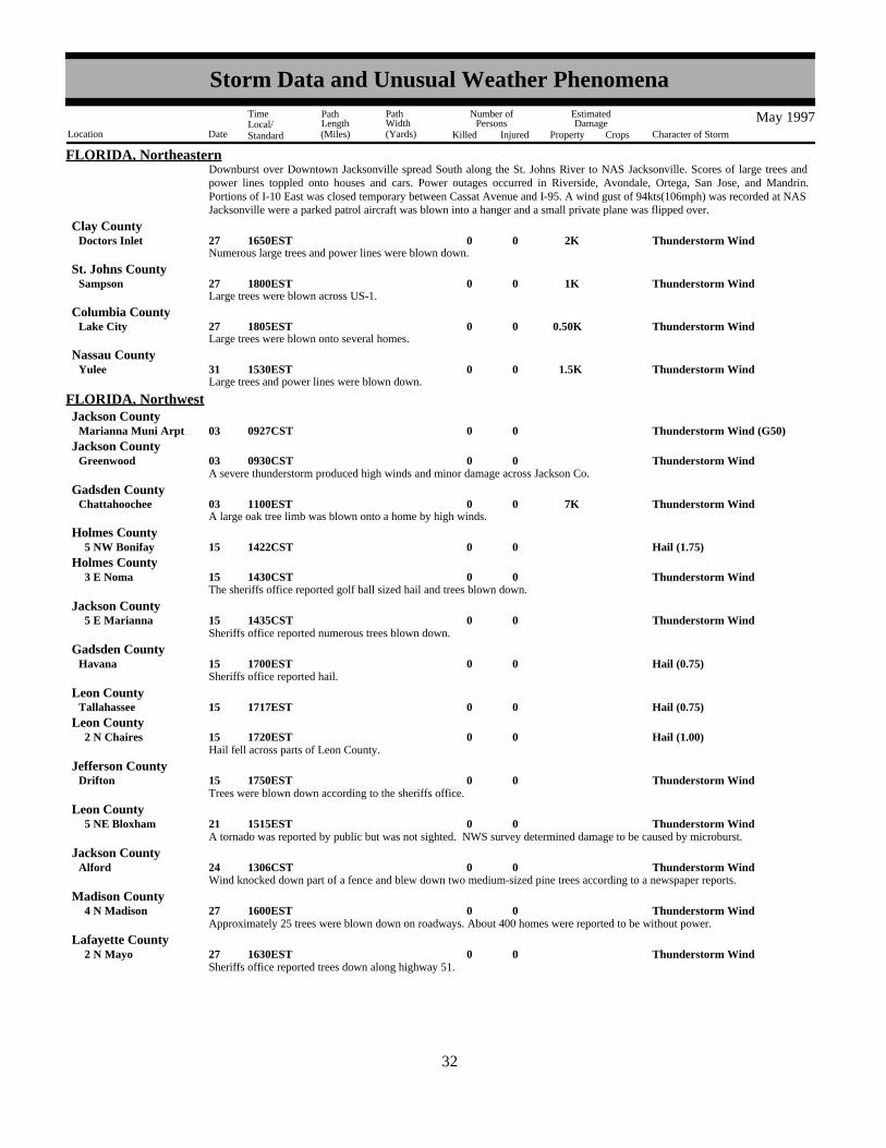
FLORIDA, NortheasternDownburst over Downtown Jacksonville spread South along the St. Johns River to NAS Jacksonville. Scores of large trees andpower lines toppled onto houses and cars. Power outages occurred in Riverside, Avondale, Ortega, San Jose, and Mandrin.Portions of I-10 East was closed temporary between Cassat Avenue and I-95. A wind gust of 94kts(106mph) was recorded at NASJacksonville were a parked patrol aircraft was blown into a hanger and a small private plane was flipped over.
Clay County
Numerous large trees and power lines were blown down.Thunderstorm Wind 2K0027Doctors Inlet 1650EST
Large trees were blown across US-1.Thunderstorm Wind 1K0027Sampson 1800EST
St. Johns County
Large trees were blown onto several homes.Thunderstorm Wind0.50K0027Lake City 1805EST
Columbia County
Large trees and power lines were blown down.Thunderstorm Wind 1.5K0031Yulee 1530EST
Nassau County
Thunderstorm Wind (G50)0003Marianna Muni Arpt 0927CST
FLORIDA, NorthwestJackson County
Thunderstorm Wind0003Greenwood 0930CSTJackson County
A severe thunderstorm produced high winds and minor damage across Jackson Co.
A large oak tree limb was blown onto a home by high winds.Thunderstorm Wind 7K0003Chattahoochee 1100EST
Gadsden County
Hail (1.75)0015 5 NW Bonifay 1422CSTHolmes County
Thunderstorm Wind0015 3 E Noma 1430CSTHolmes County
The sheriffs office reported golf ball sized hail and trees blown down.
Thunderstorm Wind0015 5 E Marianna 1435CSTJackson County
Sheriffs office reported numerous trees blown down.
Hail (0.75)0015Havana 1700ESTGadsden County
Sheriffs office reported hail.
Hail (0.75)0015Tallahassee 1717ESTLeon County
Hail (1.00)0015 2 N Chaires 1720ESTLeon County
Hail fell across parts of Leon County.
Thunderstorm Wind0015Drifton 1750ESTJefferson County
Trees were blown down according to the sheriffs office.
Thunderstorm Wind0021 5 NE Bloxham 1515ESTLeon County
A tornado was reported by public but was not sighted. NWS survey determined damage to be caused by microburst.
Thunderstorm Wind0024Alford 1306CSTJackson County
Wind knocked down part of a fence and blew down two medium-sized pine trees according to a newspaper reports.
Thunderstorm Wind0027 4 N Madison 1600ESTMadison County
Approximately 25 trees were blown down on roadways. About 400 homes were reported to be without power.
Thunderstorm Wind0027 2 N Mayo 1630ESTLafayette County
Sheriffs office reported trees down along highway 51.
2432
Storm Data and Unusual Weather Phenomena
Location Date Character of Storm
TimeLocal/Standard
PathLength(Miles)
PathWidth(Yards)
Number ofPersons
Killed Injured
EstimatedDamage
Property Crops
May 1997

FLORIDA, SouthernGlades County
Tornado (F0) 25K 2 50 1.5 003Buckhead Ridge 1430EST1500EST
Tornado (F0)0 20 0.1 0049300 Fountain Blue 1520EST1530EST
Dade County
outdoor furniture tossed about.
Tornado (F1) 525K 12 150 8 012Collins Ave/41St StSw 25Th Ave/24Th St to 1253EST
1308EST
Dade County
Waterspout00172-3E Bal Harbour 0540EST0545EST
Dade County
metro-dade police reported.
Waterspout00175N Of Duck Key 1415EST1425EST
Monroe County
pilot reported.
Funnel Cloud0019Sr 80 1102EST1115EST
Palm Beach County
3 funnel clouds spotted near 20 mile bend of sr 80 by sfwmd.
Funnel Cloud0020Near Loxahatchee 1445EST1500EST
Palm Beach County
observed by public between loxahatchee and wellington.
Funnel Cloud002020Wnw Fll 1545EST1600EST
Broward County
observed by fll tower.
Waterspout0022Just S Summerland Ky 1810EST1820EST
Monroe County
public reported.
Tornado (F1) 150K0 25 0.3 022Mm58.5Mm58.5 Grassy Key to 2035EST
2036EST
Monroe County
Waterspout0023Islamorada3Nm S Mm 84.5 to 1300EST
1310EST
Monroe County
monroe county sheriff reported one waterspout formed/dissipated then two more formed.
Waterspout00234Nm Sw Cape Sable 1430EST1445EST
Monroe County
reported by ocean tug.
Waterspout0023
Sw Everglades City
~10Nm Sw Evrglds Ctyto
1500EST1510EST
Monroe County
pilot reported.
Waterspout0023Just Nw Eyw 1800EST1815EST
Monroe County
observed by eyw tower.
Hail (1.50)0026Tequesta 1630ESTPalm Beach County
hail size ranged from .75 to 1.50 inches. reported by channel 25west palm beach.
2533
Storm Data and Unusual Weather Phenomena
Location Date Character of Storm
TimeLocal/Standard
PathLength(Miles)
PathWidth(Yards)
Number ofPersons
Killed Injured
EstimatedDamage
Property Crops
May 1997

FLORIDA, SouthernPalm Beach County
Hail (1.00)0026Near JupiterIndiantown/Central to 1636EST
reported by storm spotter.
Lightning0026Royal Palm Beach55Th Rd/P.B. Blvd to 1730EST
Palm Beach County
48 year old male injured.
Hail (0.75)0028Kendall Dr/Galloway 0051ESTDade County
reported by nws employee.
Waterspout0028Over Biscayne Bay 1155EST1200EST
Dade County
Tornado (F0)0 25 0.5 028 7 NW Opalocka 1645EST1700EST
Dade County
citizens reported tornado over sawgrass area west of i75 nearflorida turnpike. numerous reports of funnel clouds. no damagereported.
Thunderstorm Wind (G52)0028Doral Country Club 1653ESTDade County
Thunderstorm Wind (G48)0028Mia Int Arpt 1653ESTDade County
Thunderstorm Wind (G55) 1K0028Big Pine KeyN End Big Pine Key to 2027EST
2040EST
Monroe County
nws employee reported several small trees down. one tree 18 inchesin diameter and 35 feet tall fell and smashed a fence.
Funnel Cloud0031W Of PmpCypress Creek/I95 to 1605EST
1620EST
Broward County
two reports.
Tornado (F0)0 25 0.1 031 1 W Fll 1630EST1635EST
Broward County
tornado with two brief touchdowns. several trees down.
Waterspout0031Near Beach3550 S Ocean Ave to 1658EST
1715EST
Palm Beach County
6 waterspouts reported by palm beach e.o.c.
Thunderstorm winds ripped off the roof of a mobile home on Sonora Road near State Road 557-A.Thunderstorm Wind 10K0003 4.5 ESE Polk City 01315EST
FLORIDA, West CentralPolk County
A Skywarn Spotter reported golfball sized hail on Old Polk City Road.Hail (1.75)00022Auburndale 01635EST
Polk County
Hail, slightly larger than golf balls, caused over one-hundred thousand dollars worth of damage to the roofs of homes and thesurfaces of vehicles in Lakeland.
Hail (2.00) 100K0022Lakeland 01638EST1649EST
Polk County
Thunderstorm winds damaged the roofs of a couple of homes in Polk City.Thunderstorm Wind 12K0022Polk City 01640EST
Polk County
Thunderstorm winds overturned a mobile home on Alderman Road, damaged mobile homes at the Hampton Mobile Home Park
Thunderstorm Wind 60K0022 2 E Lakeland 2 W Lakeland to 01650EST
1705EST
Polk County
2634
Storm Data and Unusual Weather Phenomena
Location Date Character of Storm
TimeLocal/Standard
PathLength(Miles)
PathWidth(Yards)
Number ofPersons
Killed Injured
EstimatedDamage
Property Crops
May 1997
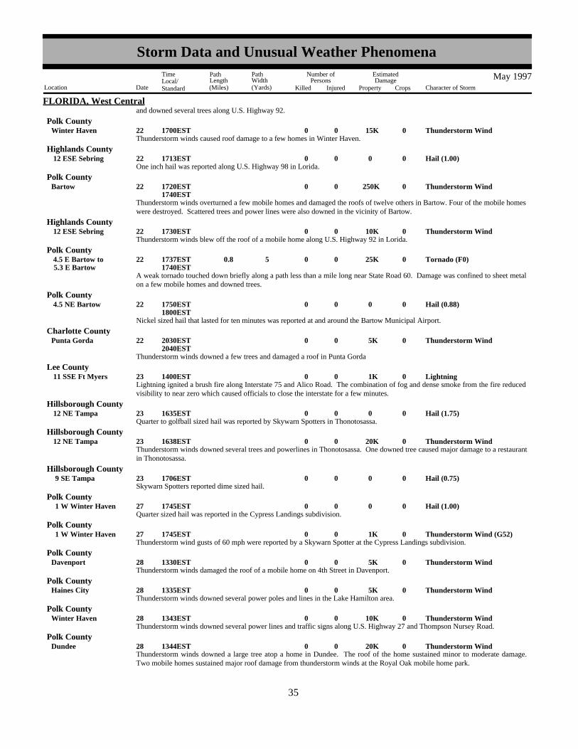
FLORIDA, West Centraland downed several trees along U.S. Highway 92.
Thunderstorm winds caused roof damage to a few homes in Winter Haven.Thunderstorm Wind 15K0022Winter Haven 01700EST
Polk County
One inch hail was reported along U.S. Highway 98 in Lorida.Hail (1.00)00022 12 ESE Sebring 01713EST
Highlands County
Thunderstorm winds overturned a few mobile homes and damaged the roofs of twelve others in Bartow. Four of the mobile homeswere destroyed. Scattered trees and power lines were also downed in the vicinity of Bartow.
Thunderstorm Wind 250K0022Bartow 01720EST1740EST
Polk County
Thunderstorm winds blew off the roof of a mobile home along U.S. Highway 92 in Lorida.Thunderstorm Wind 10K0022 12 ESE Sebring 01730EST
Highlands County
A weak tornado touched down briefly along a path less than a mile long near State Road 60. Damage was confined to sheet metalon a few mobile homes and downed trees.
Tornado (F0) 25K0 5 0.8 022 5.3 E Bartow 4.5 E Bartow to 01737EST
1740EST
Polk County
Nickel sized hail that lasted for ten minutes was reported at and around the Bartow Municipal Airport.
Hail (0.88)00022 4.5 NE Bartow 01750EST1800EST
Polk County
Thunderstorm winds downed a few trees and damaged a roof in Punta Gorda
Thunderstorm Wind 5K0022Punta Gorda 02030EST2040EST
Charlotte County
Lightning ignited a brush fire along Interstate 75 and Alico Road. The combination of fog and dense smoke from the fire reducedvisibility to near zero which caused officials to close the interstate for a few minutes.
Lightning 1K0023 11 SSE Ft Myers 01400ESTLee County
Quarter to golfball sized hail was reported by Skywarn Spotters in Thonotosassa.Hail (1.75)00023 12 NE Tampa 01635EST
Hillsborough County
Thunderstorm winds downed several trees and powerlines in Thonotosassa. One downed tree caused major damage to a restaurantin Thonotosassa.
Thunderstorm Wind 20K0023 12 NE Tampa 01638ESTHillsborough County
Skywarn Spotters reported dime sized hail.Hail (0.75)00023 9 SE Tampa 01706EST
Hillsborough County
Quarter sized hail was reported in the Cypress Landings subdivision.Hail (1.00)00027 1 W Winter Haven 01745EST
Polk County
Thunderstorm wind gusts of 60 mph were reported by a Skywarn Spotter at the Cypress Landings subdivision.Thunderstorm Wind (G52) 1K0027 1 W Winter Haven 01745EST
Polk County
Thunderstorm winds damaged the roof of a mobile home on 4th Street in Davenport.Thunderstorm Wind 5K0028Davenport 01330EST
Polk County
Thunderstorm winds downed several power poles and lines in the Lake Hamilton area.Thunderstorm Wind 5K0028Haines City 01335EST
Polk County
Thunderstorm winds downed several power lines and traffic signs along U.S. Highway 27 and Thompson Nursey Road.Thunderstorm Wind 10K0028Winter Haven 01343EST
Polk County
Thunderstorm winds downed a large tree atop a home in Dundee. The roof of the home sustained minor to moderate damage.Two mobile homes sustained major roof damage from thunderstorm winds at the Royal Oak mobile home park.
Thunderstorm Wind 20K0028Dundee 01344ESTPolk County
2735
Storm Data and Unusual Weather Phenomena
Location Date Character of Storm
TimeLocal/Standard
PathLength(Miles)
PathWidth(Yards)
Number ofPersons
Killed Injured
EstimatedDamage
Property Crops
May 1997

FLORIDA, West CentralHillsborough County
Thunderstorm winds estimated at 50 mph blew down a scaffolding at the construction site of the new Tampa stadium. A couple ofwind toppled trees damaged the roof and carport of a residence at the corner of Florida Avenue and Elm Street.
Tstm Wind (G45) 5K0028Tampa 01346EST
Thunderstorm wind downed two power poles on Waverly Road in Waverly.Thunderstorm Wind 1K0028Waverly 01355EST
Polk County
Dime sized hail was reported by a Skywarn Spotter along U.S. Highway 27.Hail (0.75)00028 3 N Lake Wales 01400EST
Polk County
A Skywarn Spotter measured a wind gust of 64 mph and reported trees and power lines downed near Cypress Gardens.Thunderstorm Wind (G56) 1K0028 8 NW Lake Wales 01403EST
Polk County
A short-lived tornado touched down and shredded a 14-by-42 foot aluminum and screen enclosure of a home along U.S. Highway27. The enclosure was tossed over the home and the remains scattered over an area 150 yards downstream from the damage site.
Tornado (F0) 5K0 5 0.1 028Lake Wales 01406ESTPolk County
Quarter to dime sized hail was reported from Palmetto to Ellenton to Parrish along U.S. Highway 301.
Hail (0.75)00028 7 NE Bradenton 1 N Bradenton to 01535EST
1542EST
Manatee County
A waterspout formed and quickly dissipated offshore of Bradenton Beach.Waterspout00028Bradenton Beach 01557EST
Manatee County
A waterspout formed and quickly dissipated offshore of Indian Rocks Beach.Waterspout00028Indian Rocks Beach 01614EST
Pinellas County
Dime sized hail was reported near the intersection of Bee Ridge road and Swift Road.Hail (0.75) 1K0028Sarasota 01615EST
Sarasota County
Thunderstorm wind toppled two large trees on top of a house which caused major damage to the roof of the home. A second homereceived minor to moderate roof damage from large branches downed by thunderstorm winds.
Thunderstorm Wind 1K0028North Port 01630ESTSarasota County
Thunderstorm wind toppled a large tree and a few power lines in the Hidden Acres subdivision.Tstm Wind (G45) 1K0031Arcadia 01320EST
De Soto County
Thunderstorm wind displaced four recreational vehicles three to four feet into their fixed propane tanks and destroyed one carport.Thunderstorm Wind 2K0031Haines City 01420EST
Polk County
Dime size hail was reported around Molino.
Hail (0.75)0015Molino 1520CST1521CST
FLORIDA, West PanhandleEscambia County
Lightning struck near a garden center, injuring a customer at a department store in Mary Esther. The male was taken to a localhospital and kept overnight for observation. He was released the next day.
Lightning 1 015Mary Esther 1615CSTOkaloosa County
Lightning struck a house near Laurel Hill and caused the house to catch on fire, causing major damage.Lightning 10K0024Laurel Hill 2310CST
Okaloosa County
EPD Director reports hail damage in north end of county. Several home owners reported roofs and vshicles damaged from the hailstorm. No damage estimates were given.
Hail (1.25)0003 5 N Thomson 1042EST1049EST
GEORGIA, East CentralMcduffie County
Thunderstorm Wind (G50)0003Augusta 1120ESTRichmond County
2836
Storm Data and Unusual Weather Phenomena
Location Date Character of Storm
TimeLocal/Standard
PathLength(Miles)
PathWidth(Yards)
Number ofPersons
Killed Injured
EstimatedDamage
Property Crops
May 1997

GEORGIA, East CentralA severe thunderstorm downed a few trees and powerlines.
GEORGIA, LowerAtkinson County
Large trees and limbs blocked King Street.Thunderstorm Wind0.50K0003Pearson 1331EST
Large trees blocked US-441.Thunderstorm Wind0.60K0003Douglas 1358EST
Coffee County
Several large trees were blown down.Thunderstorm Wind0.60K0003Homerville 1418EST
Clinch County
Hail (0.75)0003Tarver 1505ESTEchols County
Hail (0.88)0003St Marys 1530ESTCamden County
Large tree and power lines were blown down.Thunderstorm Wind0.50K0015Homerville 1758EST
Clinch County
Numerous reports of large trees blown down. A carport was damaged.Thunderstorm Wind 2.5K0024Waresboro 1646EST
Ware County
Hail (1.00)0027Snipesville 1210ESTJeff Davis County
Hail (1.00)0027Denton 1245ESTJeff Davis County
Large trees were blown down across US-221.Tstm Wind/Hail 2K0027West Green 1300EST
Coffee County
Large trees and power lines were blown down.Thunderstorm Wind0.50K0027Nicholls 1310EST
Coffee County
Hail (0.88)0027 1 N Alma 1320ESTBacon County
Large trees and power lines were blown down along SR-82.Thunderstorm Wind 1.5K0027 2 W Waycross 1345EST
Ware County
Large trees were blown across US-23.Thunderstorm Wind 2K0027Dixie Union 1350EST
Ware County
Hail (1.00)0027Blackshear 1355ESTPierce County
Hail (1.00)0027Blackshear 1420ESTPierce County
Large trees blocked US-441.Thunderstorm Wind0.50K0027 2 S Homerville 1450EST
Clinch County
Thunderstorm winds knocked down trees throughout the county. Power outages were also reported as several power lines snappedas limbs fell on them.
Thunderstorm Wind 2.5K0002Trenton 1840EST
GEORGIA, North and CentralDade County
The tornado touched down just southwest of Chickamauga in the Ridgecrest Acre mobile home park. Touchdown was noted to beat the intersection of Georgia Highway 136 and 193. Three mobile homes were completely destroyed, and a total of 28 homes/mobile homes had damage varying from moderate to being totally destroyed. Homes were moved off their foundations andnumerous trees were either snapped or uprooted.
Tornado (F1) 100K 3 100 10 1 02Chickamauga 6 SW Chickamauga to 1840EST
1850EST
Walker County
2937
Storm Data and Unusual Weather Phenomena
Location Date Character of Storm
TimeLocal/Standard
PathLength(Miles)
PathWidth(Yards)
Number ofPersons
Killed Injured
EstimatedDamage
Property Crops
May 1997

GEORGIA, North and CentralF9MH
Walker CountyHail (0.75)0002Rossville 1850EST
Hail (1.00)0002Flintstone 1859ESTWalker County
Hail (0.75)0002Ft Oglethorpe 1910ESTCatoosa County
Hail (1.00)0002Summerville 1925ESTChattooga County
Thunderstorm Wind 2K0002 10 NE Dalton 1930ESTWhitfield County
Several trees were knocked down by thunderstorm winds near Houston Valley Road in Rocky Face.
Hail (1.00)0002Sugar Valley 2000ESTGordon County
Hail (0.75)0002Dalton 2005ESTWhitfield County
Hail (1.00)0002 8 S Chatsworth 2012ESTMurray County
Hail (0.75)0002Summerville 2100ESTChattooga County
Thunderstorm winds completely destroyed a two story apartment complex under construction.Thunderstorm Wind 10K0002Dalton 2115EST
Whitfield County
Hail (0.75)0002Calhoun 2140ESTGordon County
Hail (0.75)0002Ellijay 2155ESTGilmer County
Several trees were knocked down and power lines were snapped in Ellijay.Thunderstorm Wind 3K0002Ellijay 2155EST
Gilmer County
Dime to quarter sized hail fell between Ellijay and Talking Rock.
Hail (1.00)0002Talking RockEllijay to 2210EST
2215EST
Gilmer County
Hail (0.75)0002Dahlonega 2255ESTLumpkin County
Flash Flood 3K0003Summerville 0100EST0300EST
Chattooga County
Flash Flood 4K0003Ellijay 0100EST0300EST
Gilmer County
Flash Flood 200K0003FairmountSugar Vly to 0100EST
0300EST
Gordon County
Flash Flood 25K0003ChatsworthRamhurst to 0100EST
0300EST
Murray County
Flash Flood 5K0003Dalton 0100EST0300EST
Whitfield County
A slow moving line of storms crossed into northwest Georgia from Alabama and moved southeast across the Peach State. Thesestorms produced more than 5 inches of rain in a less than twelve hour period late Friday night and early Saturday morning.Numerous roads had to be closed due to water covering them. In Gordon county, more than 200 thousand dollars in damage toroads were reported. Several roads were closed and four apartments flooded throughout Summerville in Chattooga county.Whitfield county reported that water covered Red Wine Cove Road, south of Dalton. Several areas of the county reported floodingduring the early morning hours. Gilmer and Murray counties also reported flooding of several roadways.
Dime to half dollar sized hail was reported between 10 and 8 miles north of Rome.
Hail (1.25)0003 8 N Rome 10 N Rome to 0115EST
0125EST
Floyd County
3038
Storm Data and Unusual Weather Phenomena
Location Date Character of Storm
TimeLocal/Standard
PathLength(Miles)
PathWidth(Yards)
Number ofPersons
Killed Injured
EstimatedDamage
Property Crops
May 1997

GEORGIA, North and Central
Hail (0.75)0003Calhoun 0130ESTGordon County
A couple of large trees were downed by thunderstorm winds, and several power lines were snapped in the Fish Creek area.Thunderstorm Wind 2K0003 4 W Rockmart 0145EST
Polk County
Hail (1.00)0003Rome 0150ESTFloyd County
Several trees were downed.Thunderstorm Wind 3K0003 5 E Rome 0155EST
Floyd County
Dime to quarter size hail was reported in the area.
Hail (1.00)0003Cartersville 10 NW Cartersville to 0155EST
0205EST
Bartow County
Hail (0.75)0003Dawsonville 0224ESTDawson County
Hail (0.75)0003Ball Ground 0225ESTCherokee County
Hail (1.00)0003 2 S Conyers 0700ESTRockdale County
Hail (1.75)0003 2 S Luella 0715EST0730EST
Henry County
Trees were downed in the southern area of Newnan, and several trees were knocked down by thunderstorm winds in a subdivisionoff Fisher Road in Sharpsburg as well.
Thunderstorm Wind 1K0003SharpsburgNewnan to 0720EST
0745EST
Coweta County
Several trees were knocked down by thunderstorm winds. Falling trees caused structural damage to a couple of homes, as well asa fence and sidewalk. In another incident a man narrowly escaped injury when a tree fell on his car as he travelled east on FosterStreet.
Thunderstorm Wind 2.5K0003Manchester 0725EST0740EST
Meriwether County
Thunderstorm winds knocked down trees and tree limbs. Several tree limbs were downed onto power lines resulting in widespreadpower outages.
Thunderstorm Wind 1.5K0003La Grange 0740ESTTroup County
A 75 foot high, 12 inch in diameter tree was knocked down in Peachtree City. A tree was also downed in Fayetteville on WagonWheel Road.
Thunderstorm Wind 2K0003FayettevillePeachtree City to 0800EST
0805EST
Fayette County
Thunderstorm Wind 3.5K0003Griffin 0800ESTSpalding County
Several tree limbs were knocked down on power lines, and numerous power outages were reported.
Hail (0.75)0003Covington 0820ESTNewton County
Several trees were knocked down by thunderstorm winds; power lines were snapped as well.
Thunderstorm Wind 1K0003CataulaWhitesville to 0900EST
Harris County
Thunderstorm Wind 1K0003 10 NW Woodland 0901ESTTalbot County
Several trees were downed by thunderstorm winds.
Several trees were knocked down across the area. Fallen tree limbs caused power lines to snap. Much of the county was withoutpower for more than 7 hours.
Thunderstorm Wind 3.5K0003KnoxvilleRoberta to 0920EST
0930EST
Crawford County
3139
Storm Data and Unusual Weather Phenomena
Location Date Character of Storm
TimeLocal/Standard
PathLength(Miles)
PathWidth(Yards)
Number ofPersons
Killed Injured
EstimatedDamage
Property Crops
May 1997

GEORGIA, North and CentralJasper County
Thunderstorm Wind 1K0003Monticello 0930ESTNumerous tree limbs were down in Monticello.
Thunderstorm Wind 2K0003ForsythRussellville to 0940EST
Monroe County
Several trees were downed across the area between Russellville and Forsyth.
Thunderstorm Wind 5K0003 16 SW Milledgeville 0945ESTJones County
A trailor was moved off of its foundation. Several to numerous trees were alao downed across the area.
Hail (0.90)0003Byron 0950EST1005EST
Peach County
Dime to nickel sized hail reported.
Several trees were knocked down and nickel to dime sized hail reported.
Tstm Wind/Hail 3K0003 5 S Macon 0952EST0957EST
Bibb County
Hail (0.90)0003Macon 0955ESTBibb County
Thunderstorm Wind 4K0003Buena Vista 0955ESTMarion County
Several power lines were snapped by fallen tree limbs.
Hail (1.00)0003Warner Robins 18 S Macon to 0958EST
1000EST
Houston County
Nickel to quarter sized hail was reported between Warner Robbins and the Bibb/Houston Counties line.
Hail (0.90)0003 2 N CentervilleCenterville to 1000EST
1015EST
Houston County
Dime to nickel sized hail reported.
Thunderstorm Wind (G90) 4K0003Fort ValleyByron to 1005EST
Peach County
Several trees knocked down by thunderstorm winds.
Thunderstorm Wind 2K0003 4 E MontezumaMontezuma to 1015EST
1030EST
Macon County
Several trees down across the area from Montezuma to 4 miles east of Montezuma. At least 8 to 10 trees were down within thecity limits. A large tree had fallen on power lines 4 miles east of Montezuma.
Hail (0.90)0003 1 N Sandersville 1042ESTWashington County
Thunderstorm Wind 16K0003Dublin 1105ESTLaurens County
Several trees were knocked down by thunderstorm winds. At least two homes sustained structural damage when tree limbs fellupon them.
Numerous trees were knocked down and power lines snapped throughout the Hogansville area. Dime size hail was also reported.Tstm Wind/Hail 1.5K0009Hogansville 1406EST
Troup County
Numerous trees were downed between Lone Oak and Luthersville by thunderstorm winds.
Thunderstorm Wind 1K0009LuthersvilleLone Oak to 1428EST
Meriwether County
Hail (0.75)0009La Grange 1440ESTTroup County
Several trees were downed.Thunderstorm Wind 1K0009Zebulon 1500EST
Pike County
Nickel to quarter sized hail reported.
Hail (1.00)0009Barnesville 1510EST1512EST
Lamar County
3240
Storm Data and Unusual Weather Phenomena
Location Date Character of Storm
TimeLocal/Standard
PathLength(Miles)
PathWidth(Yards)
Number ofPersons
Killed Injured
EstimatedDamage
Property Crops
May 1997

GEORGIA, North and CentralUpson County
Hail (0.75)0009Thomaston 1523EST1536EST
Hail (0.75)0009Gray 1548ESTJones County
Several trees down along Georgia Highway 29 north.Thunderstorm Wind 1K0009Gray 1548EST
Jones County
Dime sized hail covered the ground near the Monroe/ Bibb county line.Hail (0.75)0009 2 SE Bolingbroke 1550EST
Monroe County
Several large trees were downed near the Monroe/Bibb County line.Thunderstorm Wind 1K0009 16 N Macon 1550EST
Bibb County
Trees were downed in six different locations across Bibb County.
Thunderstorm Wind 2K0009Macon 1604EST1615EST
Bibb County
Dime to quarter sized hail reported.Hail (1.00)0009Dry Branch 1615EST
Twiggs County
Several trees were downed by thunderstorm winds. Trees were reportedly on mobile homes, and power lines near Georgiahighway 18.
Thunderstorm Wind 6K0009Irwinton 1640ESTWilkinson County
Hail (0.75)0009Irwinton 1640ESTWilkinson County
Trees were downed on power lines. Thunderstorm Wind 2K0009Dublin 1653EST
Laurens County
Hail (0.75)0015Chauncey 1450ESTDodge County
The owner of the house reported seeing smoke and then fire in an electrical outlet shortly after an electrical storm passed throughthe area. The fire spread through the living room and garage. Extensive damage was caused by a delayed explosion whichfirefighters believed was the result of mixing magnesium (common in motors of lawn mowers) and water.
Lightning 60K0019Hickory Flat 1930ESTCherokee County
Hail (0.90)0024Hawkinsville 2020EST2025EST
Pulaski County
Lightning started a fire in the attic of a home, causing extensive damage.Lightning 20K0027Jonesboro 0800EST
Clayton County
Hail (0.90)0027 10 NW Atlanta 0815EST0820EST
Fulton County
Hail (0.75)0027Sandy Spgs 6 N Atlanta to 0850EST
0900EST
Fulton County
Hail (1.25)0027Perry 1030ESTHouston County
Hail (0.75)0027Norcross 0917ESTGwinnett County
Dime sized hail was reported across the county.Hail (0.75)0027Ft Vly 1011EST
Peach County
Dime to quarter sized hail was reported.
Hail (1.00)0027 2 N NewnanSargent to 1036EST
1050EST
Coweta County
3341
Storm Data and Unusual Weather Phenomena
Location Date Character of Storm
TimeLocal/Standard
PathLength(Miles)
PathWidth(Yards)
Number ofPersons
Killed Injured
EstimatedDamage
Property Crops
May 1997

GEORGIA, North and CentralCoweta County
Pictures were knocked off of the wall by golfball sized hail.Hail (1.75)0027 3 N Newnan 1044EST
Hail (0.75)0027 5 NE Thomaston 1115ESTUpson County
Hail (1.75)0027Zebulon 1115ESTPike County
One whole tree and several large limbs fell on power lines. A metal shelter attached to a nursing home was ripped off the building.Two nursing home employees were knocked down by the wind gust as it blew through the door.
Thunderstorm Wind 15K 2 027 2 W Thomaston 1205ESTUpson County
Hail (0.75)0027Cobb 1330EST1345EST
Sumter County
Thunderstorm Wind (G50)0002Countywide 2315EST2330EST
GEORGIA, NortheastRabun County
A few trees were blown down in different locations in the county.
Thunderstorm Wind (G50)0003Herndon 1150EST1153EST
GEORGIA, SoutheastJenkins County
Numerous trees down.
Thunderstorm Wind (G50)0003Sylvania 1155EST1157EST
Screven County
Trees down.
Thunderstorm Wind (G52)0003Statesboro 1200EST1202EST
Bulloch County
Trees down. Tree fell on a house.
Thunderstorm Wind (G55) 20K0003Millen 1225EST1228EST
Jenkins County
Tree fell on two cars.
Thunderstorm Wind (G50) 15K0003Hinesville 1240EST1244EST
Liberty County
Numerous trees and powerlines down.
Thunderstorm Wind (G50)0003 3 N Midway 1240EST1243EST
Liberty County
Scattered areas of trees, large limbs and powerlines down.
Thunderstorm Wind (G55) 50K0003GlennvilleReidsville to 1330EST
1340EST
Tattnall County
Trees down.
Thunderstorm Wind (G50)0003Richmond Hill 1352EST1355EST
Bryan County
Hail (0.75)0003Savannah 1400EST1404EST
Chatham County
Powerlines down.
Thunderstorm Wind (G52)0003 3 S Springfield 1410EST1412EST
Effingham County
Numerous trees and powerlines down between Hiltonia and Millhaven..
Thunderstorm Wind (G55)0009MillhavenHilltonia to 1715EST
1730EST
Screven County
3442
Storm Data and Unusual Weather Phenomena
Location Date Character of Storm
TimeLocal/Standard
PathLength(Miles)
PathWidth(Yards)
Number ofPersons
Killed Injured
EstimatedDamage
Property Crops
May 1997
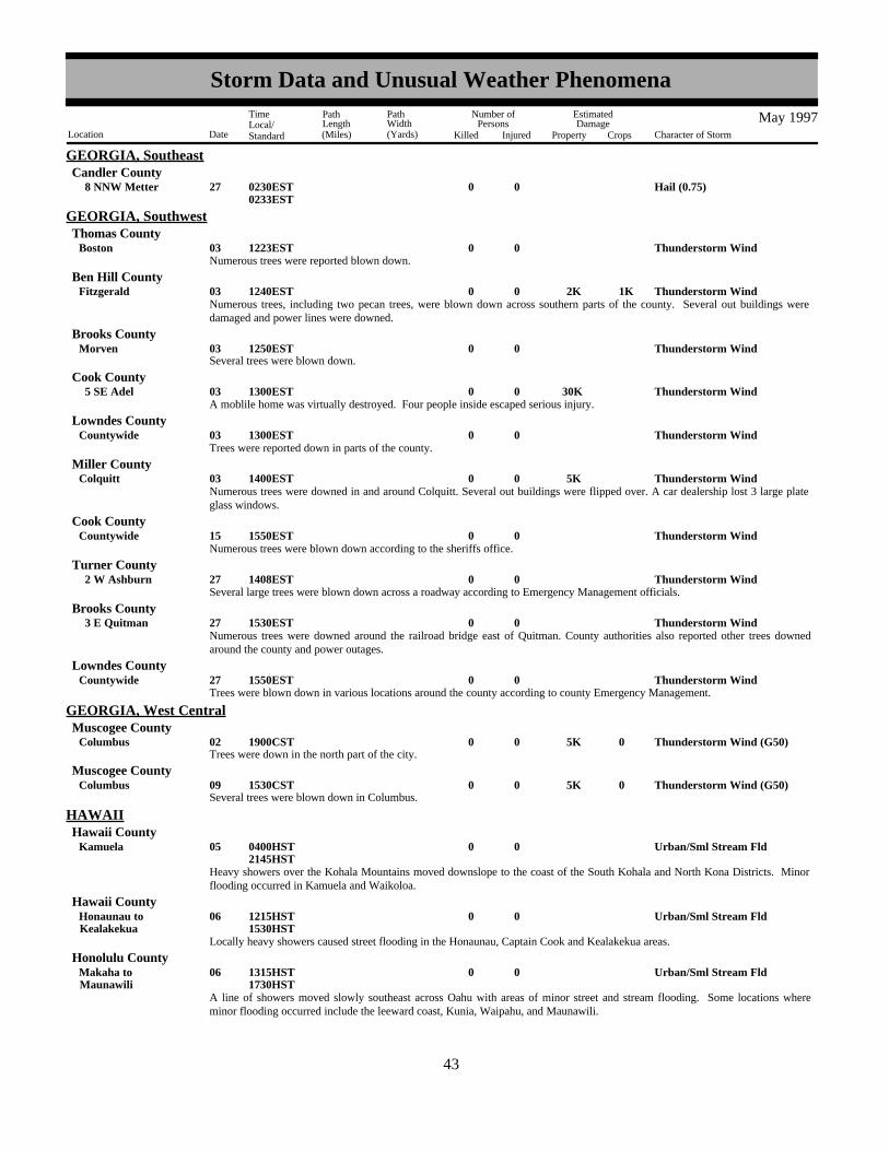
GEORGIA, SoutheastCandler County
Hail (0.75)0027 8 NNW Metter 0230EST0233EST
Thunderstorm Wind0003Boston 1223EST
GEORGIA, SouthwestThomas County
Numerous trees were reported blown down.
Thunderstorm Wind 2K0003Fitzgerald 1K1240ESTBen Hill County
Numerous trees, including two pecan trees, were blown down across southern parts of the county. Several out buildings weredamaged and power lines were downed.
Several trees were blown down.Thunderstorm Wind0003Morven 1250EST
Brooks County
Thunderstorm Wind 30K0003 5 SE Adel 1300ESTCook County
A moblile home was virtually destroyed. Four people inside escaped serious injury.
Thunderstorm Wind0003Countywide 1300ESTLowndes County
Trees were reported down in parts of the county.
Thunderstorm Wind 5K0003Colquitt 1400ESTMiller County
Numerous trees were downed in and around Colquitt. Several out buildings were flipped over. A car dealership lost 3 large plateglass windows.
Thunderstorm Wind0015Countywide 1550ESTCook County
Numerous trees were blown down according to the sheriffs office.
Thunderstorm Wind0027 2 W Ashburn 1408ESTTurner County
Several large trees were blown down across a roadway according to Emergency Management officials.
Thunderstorm Wind0027 3 E Quitman 1530ESTBrooks County
Numerous trees were downed around the railroad bridge east of Quitman. County authorities also reported other trees downedaround the county and power outages.
Thunderstorm Wind0027Countywide 1550ESTLowndes County
Trees were blown down in various locations around the county according to county Emergency Management.
Trees were down in the north part of the city.Thunderstorm Wind (G50) 5K0002Columbus 01900CST
GEORGIA, West CentralMuscogee County
Several trees were blown down in Columbus.Thunderstorm Wind (G50) 5K0009Columbus 01530CST
Muscogee County
Urban/Sml Stream Fld0005Kamuela 0400HST2145HST
HAWAIIHawaii County
Heavy showers over the Kohala Mountains moved downslope to the coast of the South Kohala and North Kona Districts. Minorflooding occurred in Kamuela and Waikoloa.
Urban/Sml Stream Fld0006KealakekuaHonaunau to 1215HST
1530HST
Hawaii County
Locally heavy showers caused street flooding in the Honaunau, Captain Cook and Kealakekua areas.
Urban/Sml Stream Fld0006MaunawiliMakaha to 1315HST
1730HST
Honolulu County
A line of showers moved slowly southeast across Oahu with areas of minor street and stream flooding. Some locations whereminor flooding occurred include the leeward coast, Kunia, Waipahu, and Maunawili.
3543
Storm Data and Unusual Weather Phenomena
Location Date Character of Storm
TimeLocal/Standard
PathLength(Miles)
PathWidth(Yards)
Number ofPersons
Killed Injured
EstimatedDamage
Property Crops
May 1997

HAWAIIHonolulu County
Waterspout0006 13 NW Haleiwa 1410HSTWaterspout was moving toward the northeast away from land.
Urban/Sml Stream Fld0007Hilo 1330HST1630HST
Hawaii County
Rainfall rates of 0.60 inches in 15 minutes in the Waiakea Uka area caused minor street flooding in parts of the South HiloDistrict, including Hilo Town.
Urban/Sml Stream Fld000708Lihue
Hanalei to 2015HST0430HST
Kauai County
Nearly stationary showers produced rainfall of 2.94 inches at Hanalei, 1.75 inches at Kapahi and 1.63 inches at Lihue Airportduring the four hour period from 7 p.m. to 11 p.m. Minor flooding of roads and low lying areas occurred from Hanalei to Anaholato Lihue.
High Surf001112
1100HST0600HST
HIZ001>006 Kauai - Oahu - Maui - Island Of Hawaii - Molokai - Lanai
Swell generated by a storm low near New Zealand produced surf of 4 to 8 feet along the south facing shores of the HawaiianIslands.
Funnel Cloud0013 10 SW Kamuela 1515HSTHawaii County
Two funnel clouds were spotted in the vicinity of Waikoloa Village.
Waterspout0013 17 E Kalaupapa 1632HSTMaui County
Waterspout near Molokai's Cape Halawa reported by an aircraft pilot.
Urban/Sml Stream Fld0015Mountain ViewHonokaa to 0400HST
1200HST
Hawaii County
Heavy showers with rainfall rates briefly as high as 1.5 inches per hour caused minor flooding of several roads and low lying areasin the Hamakua, Hilo, and Puna Districts.
High Wind (G70)002125
1730HST0600HST
HIZ004 Island Of Hawaii
A mid level trough and the subtropical jet stream brought southwest winds of 60 to 80 mph to the summits and upper slopes ofMauna Kea and Mauna Loa.
Funnel Cloud0025Mililani Town 1310HSTHonolulu County
Stationary funnel cloud reported over Mililani.
Urban/Sml Stream Fld0031Kealakekua 1530HST1830HST
Hawaii County
1.29 inches of rain was recorded in 45 minutes at Kealakekua, with minor flooding in the neighboring Captain Cook area.
Tstm Wind/Hail 4K0031MontpelierBern to 2K1835MST
1900MST
IDAHO, Extreme SoutheastBear Lake County
A severe thunderstorm moved through southeast Idaho producing strong winds in the town of Bern. A spotter measured a peakwind gust of 60 mph (52 knots) with this storm. This same storm produced 3/4" hail in the town of Montpelier about 20 minuteslater. Minor damage to trees and gardens occurred.
Hail from a thunderstorm fell in Grangeville, one inch in diameter, but "shaped like a mint" (flat). Another report in Grangevillemeasured the hail as dime to nickel sized.
Tstm Wind/Hail0016Grangeville 1620PST1650PST
IDAHO, NorthIdaho County
Two reports of thunderstorm wind gusts 60-70 mph at Riggins. They broke off small tree limbs, and blew shingles and parts ofroofs off structures. The storm lasted about an hour.
Thunderstorm Wind (G61)0020Riggins 1600MST1700MST
Idaho County
3644
Storm Data and Unusual Weather Phenomena
Location Date Character of Storm
TimeLocal/Standard
PathLength(Miles)
PathWidth(Yards)
Number ofPersons
Killed Injured
EstimatedDamage
Property Crops
May 1997

IDAHO, NorthClearwater County
Thunderstorm Wind (G52)0031Orofino 1300PST1400PST
Wind gusts from thunderstorms 50-60mph blew a tree across U.S. Highway 12 near Orofino. Other trees up to three feet indiameter and limbs 18 to 20 inches thick were blown down, with trees down on cars. Also damaged were car ports and decks.
Funnel Cloud0031Orofino 1338PSTClearwater County
Two brief funnel clouds were reported at Orofino.
Hail from a thunderstorm, nickel sized, fell at Elk RiverTstm Wind/Hail0031Elk River 1345PST
Clearwater County
57 mph thunderstorm gustThunderstorm Wind (G57)00031Lewiston 1259PST
IDAHO, NorthwestNez Perce County
nws survey team concluded f2 tornado touched down and caused damage to old growth trees
Tornado (F2) 50K0 50 5 031 4 ESE Athol 8 SE Athol to 1305PST
1310PST
Kootenai County
roof blown off houseTstm Wind/Hail 15K0031 1 E Lewiston 1305PST
Nez Perce County
eyewitness interviewed, concluded f0 tornadoTornado (F0)00 25 0 031 2 E Lewiston 1310PST
Nez Perce County
60 mph gustThunderstorm Wind (G60)00031Hayden 1315PST
Kootenai County
roofs blown off housesTstm Wind/Hail 50K0031Post Falls 1315PST
Kootenai County
60 mph gustThunderstorm Wind (G60)00031 1 E Rathdrum 1315PST
Kootenai County
3/4 inch hail
Hail (0.75)00031 5 W Lapwai 5 W Craigmont to 1315PST
Lewis County
1/2 inch hailTstm Wind/Hail00031Deary 1325PST
Latah County
68 mph gustThunderstorm Wind (G68)00031Helmer 1326PST
Latah County
3/4 inches of rain in 35 minutesHeavy Rain00031Cocolalla 1345PST
Bonner County
3/4 inch hailHail (0.75)00031Pinehurst 1346PST
Shoshone County
60 mph gust and 1/2 inch hailThunderstorm Wind (G60)00031Bonners Ferry 1415PST
Boundary County
trees down by windThunderstorm Wind (G60) 5K0031St Maries 01330PST
Benewah County
tree in house from windThunderstorm Wind (G60) 10K0031Coeur D Alene 01330PST
Kootenai County
3745
Storm Data and Unusual Weather Phenomena
Location Date Character of Storm
TimeLocal/Standard
PathLength(Miles)
PathWidth(Yards)
Number ofPersons
Killed Injured
EstimatedDamage
Property Crops
May 1997
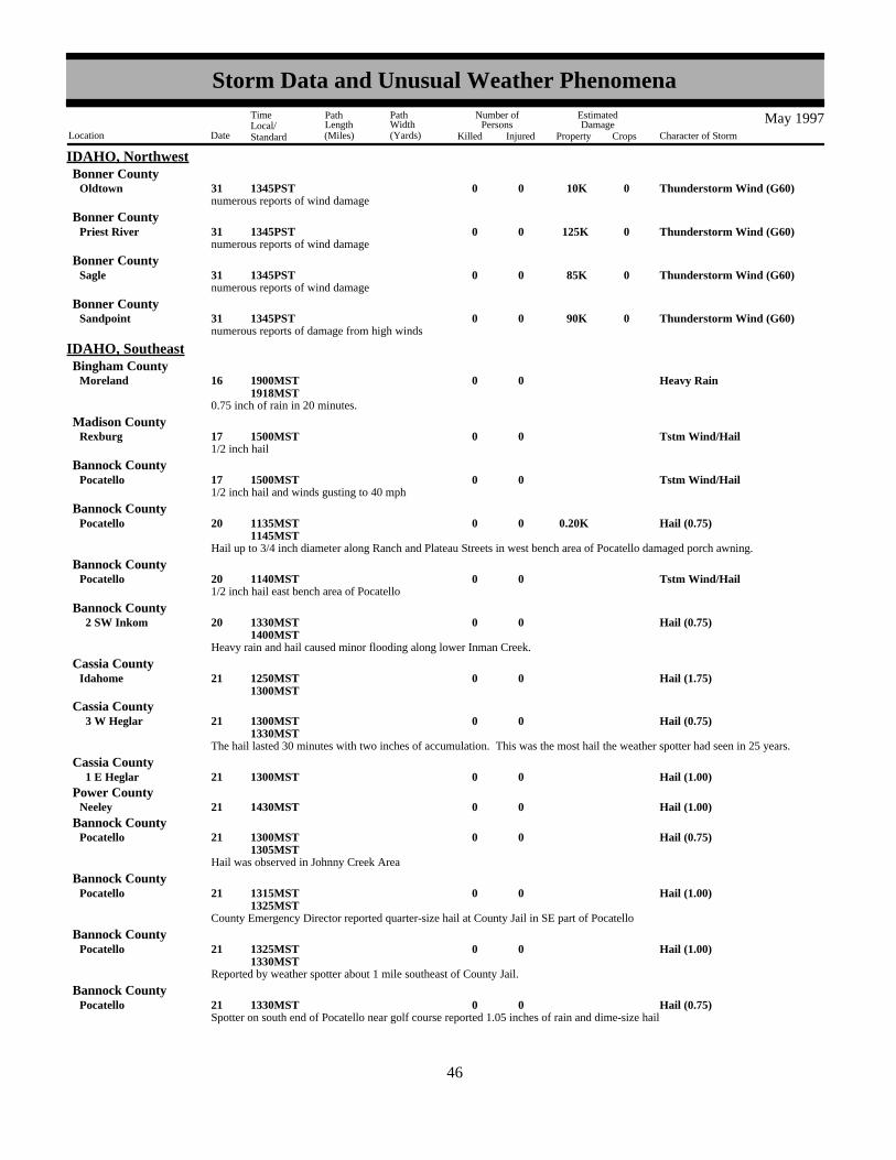
IDAHO, NorthwestBonner County
numerous reports of wind damageThunderstorm Wind (G60) 10K0031Oldtown 01345PST
numerous reports of wind damageThunderstorm Wind (G60) 125K0031Priest River 01345PST
Bonner County
numerous reports of wind damageThunderstorm Wind (G60) 85K0031Sagle 01345PST
Bonner County
numerous reports of damage from high windsThunderstorm Wind (G60) 90K0031Sandpoint 01345PST
Bonner County
0.75 inch of rain in 20 minutes.
Heavy Rain0016Moreland 1900MST1918MST
IDAHO, SoutheastBingham County
1/2 inch hailTstm Wind/Hail0017Rexburg 1500MST
Madison County
1/2 inch hail and winds gusting to 40 mphTstm Wind/Hail0017Pocatello 1500MST
Bannock County
Hail up to 3/4 inch diameter along Ranch and Plateau Streets in west bench area of Pocatello damaged porch awning.
Hail (0.75)0.20K0020Pocatello 1135MST1145MST
Bannock County
1/2 inch hail east bench area of PocatelloTstm Wind/Hail0020Pocatello 1140MST
Bannock County
Heavy rain and hail caused minor flooding along lower Inman Creek.
Hail (0.75)0020 2 SW Inkom 1330MST1400MST
Bannock County
Hail (1.75)0021Idahome 1250MST1300MST
Cassia County
The hail lasted 30 minutes with two inches of accumulation. This was the most hail the weather spotter had seen in 25 years.
Hail (0.75)0021 3 W Heglar 1300MST1330MST
Cassia County
Hail (1.00)0021 1 E Heglar 1300MSTCassia County
Hail (1.00)0021Neeley 1430MSTPower County
Hail was observed in Johnny Creek Area
Hail (0.75)0021Pocatello 1300MST1305MST
Bannock County
County Emergency Director reported quarter-size hail at County Jail in SE part of Pocatello
Hail (1.00)0021Pocatello 1315MST1325MST
Bannock County
Reported by weather spotter about 1 mile southeast of County Jail.
Hail (1.00)0021Pocatello 1325MST1330MST
Bannock County
Spotter on south end of Pocatello near golf course reported 1.05 inches of rain and dime-size hailHail (0.75)0021Pocatello 1330MST
Bannock County
3846
Storm Data and Unusual Weather Phenomena
Location Date Character of Storm
TimeLocal/Standard
PathLength(Miles)
PathWidth(Yards)
Number ofPersons
Killed Injured
EstimatedDamage
Property Crops
May 1997

IDAHO, SoutheastPower County
1/2 inch hailTstm Wind/Hail0021 7 S Cold Water 1335MST
Weather spotter in Chubbuck reported 1/2 inch hail.
Tstm Wind/Hail0021 2 N Pocatello 1405MST1410MST
Bannock County
1/4 inch hail on east bench of Pocatello near Fairgrounds.
Tstm Wind/Hail0021Pocatello 1415MST1420MST
Bannock County
1/3 inch hail observed at KMART in north Pocatello.
Tstm Wind/Hail0021Pocatello 1415MST1420MST
Bannock County
Wind gust 45 mph at Pocatello airport.Tstm Wind/Hail0021Pocatello Arpt 1423MST
Power County
Teton County Sheriff reported a funnel cloud about 4 miles southwest of Driggs which extended only a few hundred feet frombase of cloud and did not touch the ground. The thunderstorm associated with this funnel also produced pea-size hail.
Funnel Cloud0031 4 SW Driggs 1107MST1109MST
Teton County
Dime-size hail accumulated to 3 inches on ground over the Doublespring Pass
Hail (0.75)0031 8 NE Dickey 1400MST1415MST
Custer County
Golfball-size hailHail (1.75)0031 4 E Rupert 1420MST
Minidoka County
Two separate reports of dime-size hail in AberdeenHail (0.75)0031Aberdeen 1430MST
Bingham County
Hail (1.00)0031 1 N Aberdeen 1440MSTBingham County
Hail (1.00)0031Arco 1435MSTButte County
1/2 inch hail in StanleyTstm Wind/Hail0031Stanley 1440MST
Custer County
1/4 inch hail and extremely heavy rain in Cold WaterTstm Wind/Hail0031Cold Water 1515MST
Power County
1/2 inch hail and extremely heavy rain at Massacre Rocks State ParkTstm Wind/Hail0031 8 SW American Falls 1525MST
Power County
Weather spotter remarked the rain was the heaviest he had ever seen in Idaho.
Heavy Rain0031Springfield 1525MST1530MST
Bingham County
Hail (1.00)0031 2 E Howe 1540MSTButte County
Golfball-size hailHail (1.75)0031Howe 1540MST
Butte County
Hail (1.50)0031 7 E Howe 1545MSTButte County
Rotating wall cloud and possible funnel observed by weather spotter in Chubbuck
Funnel Cloud0031 2 N Pocatello 1545MST1550MST
Bannock County
3947
Storm Data and Unusual Weather Phenomena
Location Date Character of Storm
TimeLocal/Standard
PathLength(Miles)
PathWidth(Yards)
Number ofPersons
Killed Injured
EstimatedDamage
Property Crops
May 1997

IDAHO, SoutheastBannock County
Tornado briefly touched down on hillside east of Pocatello Drive-Inn Theatre
Tornado (F0)0 20 0.1 031 1 SE Pocatello 1555MST1556MST
Brief funnel cloud observed north of Chubbuck.
Funnel Cloud0031 5 N Pocatello 1600MST1605MST
Bannock County
A F1 Tornado touch down about one mile west of Mud Lake demolishing a shed, damaging a quanset hut, lifting a roof off anothershed, and rolling over an irrigation circle line. The tornado moved east toward Mud Lake knocking down trees, large branches andtwo power poles. In Mud Lake metal siding was stripped off a few buildings and a large portion of a restaurant roof was blownoff. An approximate 100 x 50 foot roof was lifted off a building at the Feed Company Shed on the NW corner of town anddeposited on two trucks. The tornado continued to move northeast causing damage to sheds, roofs, trees and other structures 1 to2 miles north of Terreton. Two miles north of Terreton a large roof was lifted off a shed and thrown over 150 feet landing on topof a home. The large funnel associated with the tornado was visible from the NWS in Pocatello at 5:05 pm MDT...a distance ofabout 65 miles.
Tornado (F1)0200 4 031 2 N Terreton 3 W Terreton to 1605MST
Jefferson County
Hail associated with Terreton tornadic stormHail (1.50)0031 2 N Terreton 1612MST
Jefferson County
Quarter-size hail covered the ground.
Hail (1.00)0031 1 S Inkom 1620MST1630MST
Bannock County
Hail observed along Marsh Creek Road.Hail (0.75)0031 2 S Inkom 1630MST
Bannock County
1/4 inch hail and very heavy rain occurred with thunderstorm.
Tstm Wind/Hail0031 5 SW Cheserfield 5 SW Chesterfield to 1700MST
Caribou County
1/2 inch hail in Hatch area.
Tstm Wind/Hail0031Hatch 1705MST1715MST
Caribou County
Quarter-size hail covered the ground and stripped leaves from trees.
Hail (1.00)0031Sublett 1705MST1715MST
Cassia County
Hail the size of quarters dented metal siding of sheds and trailer homes, severly damaged outside house plants, chopped downalfalfa, severely damaged outside house plants, and accumulated to about one inch on ground. Weather spotter remarked that hailremained on the ground until the next morning. Sublett Road from Sublett to Sublett Reservoir was flooded with 6 to 12 inches ofwater.
Hail (1.00)0031Sublett 1705MST1715MST
Cassia County
Brief funnel cloud observed with Sublett storm.
Funnel Cloud0031Sublett 1710MST1715MST
Cassia County
Hail occured in Inkom Gap immediately southwest of Pocatello.Hail (0.75)0031 4 SW Pocatello 1830MST
Bannock County
Flood 4M000131
0000MST2359MST
IDAHO, SouthwestIDZ001>005-018-020>021
Northern Panhandle - Coeur D'Alene Area - Lewiston And The Palouse - Shoshone - Northern ClearwaterMountains - Salmon/Sawtooth Mountains - Upper Snake River Plain - Lower Snake River Plain
During the month of May, unusually heavy snow pack at the higher elevations of Idaho began to melt. Runoff swelled manyrivers statewide to flood stage. Hardest hit by damaging floods were the counties in the Idaho Panhandle. where seven counties
4048
Storm Data and Unusual Weather Phenomena
Location Date Character of Storm
TimeLocal/Standard
PathLength(Miles)
PathWidth(Yards)
Number ofPersons
Killed Injured
EstimatedDamage
Property Crops
May 1997

IDAHO, Southwestwere declared state disaster areas. An estimated 4 Million dollars in property damages were suffered and miles of road wereflooded throughout the region disrupting transportation. The major rivers of the region...the Pend Oreille, St. Joe and Coeurd'Alene...remained above flood stage for most of the second half of May.
Elsewhere in Idaho less serious flooding occurred on the Portneuf, Teton,Henry's Fork and Snake Rivers. Flooding along theserivers inundated mostly agricultural land. The Big Wood River flooded near the town of Hailey where a few houses wereflooded.
Payette County
Winds generated by a severe thunderstorm ripped the roof off of a trailer home in Payette, Idaho.Thunderstorm Wind (G60)0004Payette 2035MST
A severe thunderstorm formed over the Central Mountains and produced 3/4 inch hail .Hail (0.75)0016 30 NW Council 1730MST
Adams County
A very slow moving thunderstorm dumped heavy rain upon the Owyhee Mountains of Southwest Idaho. Flash flooding ensuedwhich left one foot of water on highway 78. Numerous dry washes and gullies were flowing with water.
Flash Flood0016 15 SE Murphy 2030MST2130MST
Owyhee County
A severe thunderstorm produced 3/4 inch hail in Twin Fallls County.Hail (0.75)0031Kimberly 1435MST
Twin Falls County
Hail (1.00)00018Abingdon 02019CST
ILLINOIS, CentralKnox County
A tornado briefly touched down in a field 8 miles west southwest of Yates City. No injuries or damage were reported. Tornado (F0)00 50 0.1 018 8 WSW Yates City 02019CST
Knox County
Hail (1.00)00018Oneida 02120CSTKnox County
Thunderstorm winds blew down numerous large tree limbs in Pekin. No injuries were reported and no damage estimate wasavailable.
Thunderstorm Wind0018Pekin 02123CSTTazewell County
Thunderstorm winds blew down a few trees and tree limbs in Benson. Also, the "doglegs" of a grain bin were blown off, severallarge sheds had their doors blown in, and some siding damage was reported in the area. No injuries were reported and damagewas estimated around $80,000.
Thunderstorm Wind 80K0018Benson 02126CSTWoodford County
A waterspout briefly formed over Lake Shelbyville 2 miles southeast of Kirksville. No damage or injuries were reported.Waterspout00025 2 SE Kirksville 01110CST
Moultrie County
An Illinois Department of Conservation officer reported a brief touchdown of a tornado in a field 1 mile north of Ashmore. Noinjuries or damage were reported.
Tornado (F0)00 10 0.1 025 1 N Ashmore 01155CST1200CST
Coles County
Hail (0.75)0005Orland Park 1315CST
ILLINOIS, NortheastCook County
Hail (1.75)0005Kankakee 1315CSTKankakee County
Thunderstorm Wind (G52)0005Morris 1357CSTGrundy County
Hail (1.75)0005Wilmington 1440CSTWill County
Strong thunderstorms that moved through portions of northeast Illinois during the afternoon hours produced hail, strong winds andlocally heavy rain.
Hail (1.00)0018Brookville 1650CSTOgle County
4149
Storm Data and Unusual Weather Phenomena
Location Date Character of Storm
TimeLocal/Standard
PathLength(Miles)
PathWidth(Yards)
Number ofPersons
Killed Injured
EstimatedDamage
Property Crops
May 1997

ILLINOIS, NortheastOgle County
Hail (0.75)0018Stillman Vly 1730CST
Hail (0.75)0018Rockford 1803CSTWinnebago County
Thunderstorm Wind (G57)0018Lake Villa 1808CSTLake County
A tornado touched down on the southeast side of Lindenhurst and damaged trees and the roofs of several homes. The tornadoreached F2 intensity near Sand Lake Road and Route 45 where 2 barns were destroyed, two foot diameter oak trees were brokenoff or uprooted and the roof was taken off a nursery. Signs were blown down along Sand Lake Road and Stearns School Road. Asubdivision on the north side of Gurnee had damage to trees, a chimney blown off a house, windows broken, walls damaged, agarage door blown in and a fence blown down. Three quater inch hail also occurred in Lindenhurst.
Tornado (F2)0 75 6 018GurneeLindenhurst to 1818CST
1823CST
Lake County
Three quarter inch diameter hail fell at Amboy and golf ball size hail fell at Paw Paw.
Hail (1.75)0018Paw PawAmboy to 1815CST
1820CST
Lee County
A 73 mph wind gust was reported at Du Page Airport in West Chicago. Trees and limbs were blown down throughout the countycausing power outages. Some trees or limbs fell on cars and roofs of houses. At Carol Stream winds peeled off part of the roof of aPizza Hut, an apartment building and ice skating rink. The roof debris damaged cars. In Naperville a woman was injured by flyingglass at a hotel at I-88 and Naperville Road. Wind damaged the roof of a house in Willowbrook.
Thunderstorm Wind (G64) 1 018Willowbrook(Dpa)Dupage Co Arpt to 1834CST
1850CST
Du Page County
Thunderstorm Wind (G59)0018Batavia 1835CSTKane County
Thunderstorm Wind (G52)0018Mendota 1837CSTLa Salle County
Thunderstorm winds caused damage at a farm southeast of Yorkville. A semi-trailer was blown over, windows were broken andshingles peeled off a barn, and trees and limbs were blown down.
Thunderstorm Wind (G50)0018 2 SE Yorkville 1845CSTKendall County
Wind damaged trees and roofs at a farm and blew an empty grain bin across the road southwest of Bolingbrook. The wall of ahouse under construction was blown down in Bolingbrook. Large tree limbs were blown down and a house roof was damaged inRomeoville.
Thunderstorm Wind (G50)0018Romeoville 3 SW Bolingbrook to 1850CST
1900CST
Will County
Intense downbursts or possibly a brief gustnado blew down large tree limbs and trees, damaging homes and cars. Strong windscaused some roof damage. At the Brookfield Zoo, trees were damaged and a tram overturned.
Thunderstorm Wind0018BerwynBrookfield to 01900CST
1915CST
Cook County
High winds and possible gustnadoes in southern and central Cook County downed many tree limbs, some trees and powerlines.Specific wind gusts reported: Meigs field 63 mph, NBC Tower in downtown Chicago 61 mph, 3SW Midway 61 mph, andMidway airport 62 mph.
Thunderstorm Wind (G55)0018Chicago 01900CST1925CST
Cook County
Strong winds caused roof and tree damage to homes or businesses in Orland Park, Country Club HIlls and Tinley Park. A windgust of 65 mph was reported at Orland Park. A 58 mph wind gust was recorded at the Lansing, IL AWOS.
A very intense downburst or possibly a gustnado produced F0-F1 intensity damage for about a 2 mile long and 50 yard wide paththrough Lynwood, from Stoney Island Road to Burnham Road, parallel to and about 1/2 mile north of Glenwood-Dyer Road.Several businesses had roof damage west of Lynwood. In a subdivision in Lynwood about 30 homes sustained some damage.Mostly shingles removed, antennas down, windows broken, tree limbs down, gutters and awnings damages. Two houses atLakewood and 201st had about half the roof torn of, a church had roof damage and a bell tower damaged. About half dozen otherhouses had small sections of the roof peeled off.
Thunderstorm Wind (G57)0018LynwoodOrland Park to 01900CST
1920CST
Cook County
4250
Storm Data and Unusual Weather Phenomena
Location Date Character of Storm
TimeLocal/Standard
PathLength(Miles)
PathWidth(Yards)
Number ofPersons
Killed Injured
EstimatedDamage
Property Crops
May 1997

ILLINOIS, NortheastCook County
On the south side of Chicago, roof and tree damage at 6800 S. California, 8700 Kostner, 7900 South Harlem, 6300 S. Cicero and5600 Kolmar. A wind gust of 60 mph was reported at Calumet City around 815pm.
Thunderstorm Wind (G52)0018Chicago 01905CST1910CST
Strong winds caused roof and tree damage at businesses or homes in New Lenox and Mokena. In Beecher, near the Indiana stateline, a barn was destroyed.
Thunderstorm Wind0018BeecherNew Lenox to 01920CST
1930CST
Will County
A wind gust to 70 mph and hail of 1.75 inches in diameter were reported in North Utica.Hail (1.75)0018Utica 2038CST
La Salle County
Hail (0.75)0018Coal City 2100CSTGrundy County
Strong winds downed trees.Thunderstorm Wind0018 5 NE Watseka 02220CST
Iroquois County
High Wind (G60)000708
2230CST0100CST
ILLINOIS, NorthwestILZ001>002-007-009 Jo Daviess - Stephenson - Carroll - Whiteside
Gradient winds behind a line of thunderstorms produced damage to area trees and power lines as they passed out of extremeeastern Iowa into northwest Illinois.
Hail (1.00)0018Thomson 1715CSTCarroll County
Hail (1.75)0018East Dubuque 1750CSTJo Daviess County
Hail (1.50)0018East Moline 1905CST1910CST
Rock Island County
Hail (1.00)0018East Moline 1905CSTRock Island County
Hail (1.75)0018East Moline 1908CSTRock Island County
Hail (0.75)0018Silvis 1911CSTRock Island County
Hail (1.00)0018Colona 1917CST1924CST
Henry County
Hail (3.00)0018Milan 1925CSTRock Island County
Brief tornado touchdown with no damage.Tornado (F0)000 018Smithshire 1930CST
Warren County
Hail (0.75)0018Moline 1941CSTRock Island County
Tornado (F0)0 10 0.1 018Manlius 1955CSTBureau County
Hail (1.75)0018 2 W Princeton 2004CSTBureau County
Hail (1.50)0018Princeton 2009CSTBureau County
Hail (1.00)0018Princeton 2011CSTBureau County
A very costly hail storm passed across northeast Iowa into extreme western Illinois, bringing several waves of hail greater than 1.5inches. While there were a few reports of tornadoes; by far the most significant event was the large hail.
Trees down across roadThunderstorm Wind (G50)0024 1 E Mineral 1617CST
Bureau County
4351
Storm Data and Unusual Weather Phenomena
Location Date Character of Storm
TimeLocal/Standard
PathLength(Miles)
PathWidth(Yards)
Number ofPersons
Killed Injured
EstimatedDamage
Property Crops
May 1997

ILLINOIS, SouthILZ084 Jackson
Flood000109
0001CST2300CST
The Big Muddy River fell below flood stage at Murphysboro on May 9, after cresting 4.3 feet above flood stage in early April.There was little damage, since the bottomlands were not planted for the most part. The Big Muddy River again rose above floodstage on May 31. This would likely cause problems where crops were planted.
Large tree limbs were down.Thunderstorm Wind (G52)0002 1 N Metropolis 2110CST
Massac County
A spotter reported trees over the road.Thunderstorm Wind (G52)0025New Burnside 2244CST
Johnson County
Hail (1.75)0026Ava 1527CSTJackson County
As much as 4 inches of rain was estimated to have fallen near Unionville in 3 hours time. In Metropolis, one inch of rain fell in 30minutes, causing significant street flooding.
Flash Flood 10K0028Metropolis 1530CST1740CST
Massac County
Radar estimated as much as 4.5 inches of rain fell within 3 hours across the southern tip of Pope County near the Ohio River.Thunderstorms repeatedly moved slowly over the same areas, causing the excessive rainfall.
Flash Flood0028New Liberty 1530CST1740CST
Pope County
County sheriff reported quarterr size hail.Hail (1.00)0002Grafton 2250CST
ILLINOIS, SouthwestJersey County
County sheriff reported trees and power lines down.Thunderstorm Wind (G50)0025Valmeyer 2015CST
Monroe County
County sheriff reported trees down.Thunderstorm Wind (G50)0025Foster Pond 2020CST
Monroe County
County sheriff reported power lines down and roof damage to a building at an baseball field.Thunderstorm Wind (G51) 1K0025Steeleville 2115CST
Randolph County
Lightning 1K0005Plainfield 1850EST
INDIANA, CentralHendricks County
Flood0031 2159EST2359EST
INZ048>049-055>057 Hancock - Henry - Johnson - Shelby - Rush
Heavy rains brought the Big Blue River out of its banks in central Indiana though flodding was contained to agricultural lands andparts of roadways near streams. Young corn crops were damaged substantially but a damage estimate was uncertain. This floodingcontinued into June 1 and will be continued in June Storm Data.
Flood0031 2250EST2359EST
INZ048>049-056>057-064>065-070>072
Hancock - Henry - Shelby - Rush - Bartholomew - Decatur - Lawrence - Jackson - Jennings
Heavy rains brought most small streams out of their banks in east central and south central Indiana. The flooding affectedagricultural bottomlands and parts of roads near the streams. Some crop losses likely occured but were difficult to estimate a cost.This event carried on into June 1 and will also appear there in the June Storm Data.
Tornado (F0) 1.5M 1 100 1 01846.5 NW Stone Lake 46 NW Stone Lake to 02130EST
2131EST
INDIANA, NortheastLagrange County
Tornado at Stone Lake at 930 pm est threw boat from lake intoliving room, house collapsed. Eight homes damaged.
4452
Storm Data and Unusual Weather Phenomena
Location Date Character of Storm
TimeLocal/Standard
PathLength(Miles)
PathWidth(Yards)
Number ofPersons
Killed Injured
EstimatedDamage
Property Crops
May 1997

INDIANA, NortheastLagrange County
Tornado (F0) 1.5M 1 200 1 018 43 NW Lagrange 02138EST2139EST
Highway 9 near county road 200N near Lagrange, tornado picked upsheriffs car and spun it around, minor injury to deputy fromflying glass. Several trailers and cars in vicinity damaged.
Thunderstorm Wind 1.5M0018 47 NW East OfShipshewana
46 NW Shipshewana to 02139EST2141EST
Lagrange County
Thunderstorm winds destroyed several business and other buildings in town and just east of town. Large trees and power linesdown.
Thunderstorm Wind 4M0018 30 N Near Kendallville 35 NW Near Ligonier to 02155EST
2231EST
Noble County
Thunderstorm winds near kendallville downed large trees and power lines.Thunderstorms moving across north side of county damaged farmbuildings, a church, homes and utility towers.
Tornado (F0) 10M0200 1 018 45 N Angola Airport 44 N Angola Airport to 02200EST
2202EST
Steuben County
Angola Airport had 21 aircraft and 3 hangars damaged. In surrounding area farm buildings, homes and business, utility towers alsodamaged.
Thunderstorm Wind0.50K0018 5 N Ft Wayne 02246EST2247EST
Allen County
Eighteen inch tree blown down north side of fort wayne.
Hail (2.00)0005Lowell 1443EST
INDIANA, NorthwestLake County
Hail (2.00)0005Hebron 1518ESTPorter County
Hail (0.75)0005South Bend 1542ESTSt. Joseph County
Strong thunderstorms that moved through northwest Indiana during the afternoon hours, produced hail, strong winds and locallyheavy rain.
Trees and limbs downed throughout the county, especially southwest of Valparaiso.Thunderstorm Wind0018Valparaiso 02050EST
Porter County
Damage occurred mainly in the northern portion of the county, with many trees and large limbs down in LaPorte. Some limbs fellacross roads and houses.
Thunderstorm Wind0018La Porte 02100ESTLa Porte County
Strong winds downed trees north of Knox.Thunderstorm Wind0018Knox 02110EST
Starke County
A 93 mph wind gust was recorded at the Michiana Regional Airport in South Bend. The re was widespread damage to trees, limbsand power lines. Trees and limbs fell on houses.
Thunderstorm Wind (G81)0018South Bend 2113ESTSt. Joseph County
Trees and limbs downed.Thunderstorm Wind (G56)0018Mishawaka 2114EST
St. Joseph County
4553
Storm Data and Unusual Weather Phenomena
Location Date Character of Storm
TimeLocal/Standard
PathLength(Miles)
PathWidth(Yards)
Number ofPersons
Killed Injured
EstimatedDamage
Property Crops
May 1997

INDIANA, NorthwestElkhart County
A 75 mph wind gust was recorded at Goshen at 930pm. Winds were estimated at 70 mph or greater at Elkhart, Bristol andMiddlebury. Goshen was hardest hit with many large trees and limbs, broken uprooted, down on houses and cars. Most damageoccurred around 3rd and Main Streets. Shingles were torn off roof tops. Reported 30 or 40 power poles blown down in the county.
Thunderstorm Wind (G65)0018Elkhart 2130EST2140EST
A trailer was blown over, one person was injured.Thunderstorm Wind 1 018Tippecanoe 02130EST
Marshall County
Trees and limbs downed.Thunderstorm Wind0018Warsaw 02200EST
Kosciusko County
Flood000204
2330EST0300EST
INDIANA, South CentralINZ079 Jefferson
The Muscatatuck River crested at 23.4 feet (flood stage is 15 feet) at 10 am edt on May 3. A few country roads were watercovered.
Persistent heavy rainfall caused Greens Fork Creek to rise out of its banks and across several roads.
Flood 10K0031Williamsburg 1523EST2300EST
INDIANA, SoutheastWayne County
Persistent heavy rainfall caused the Whitewater River at Alpine to rise above the flood stage of 12.0 feet. The river stayed aboveflood stage through June 2nd and reached a crest of 16.7 feet.
Flood0031 1600EST2359EST
INZ058 Fayette
NONE REPORTED.
INDIANA, Southwest
Flood 5K000103
0000CST1200CST
IOWA, CentralIAZ037-049>050 Hardin - Marshall - Tama
Minor flooding continued in the Des Moines County Warning Area as runoff from the spring melt continued. The flooding wasmostly limited to the Iowa River Basin. Damage was minor.
Hail (2.00) 75K0002Pleasanton 1805CSTDecatur County
Hail (3.00) 100K0002Clio 1828CSTWayne County
Hail (0.75) 1K0002 7 S Centerville 1930CSTAppanoose County
A strong storm system moved out of the southern Rockies across Kansas and passed just south of Iowa during the evening of the2nd. The airmass was quite unstable as a cold pool aloft moved into the state along with the upper level low pressure system.Severe weather was limited across Iowa due to the location relative to the warm sector, however elevated convection developedduring the late afternoon and evening hours in the cloud filled dry slot that moved into the state. The storms produced large haildue to the low freezing levels and wet bulb zero heights. Hail larger than baseball size fell in Decatur County near Pleasanton,with two inch diameter hail falling near Clio in Wayne County. The storms weakened as they moved east with three quarter inchdiameter hail reported south of Centerville in Appanoose County. There were no significant winds reported with the storms as thejet structure was not favorable for high winds. Damage resulted as the large hail damaged roofs and vehicles in the area.
High Wind (G52) 75K 1 005 1230CST1930CST
IAZ004>007-015>017-023>028-033>039-044>050-057>062
Emmet - Kossuth - Winnebago - Worth - Palo Alto - Hancock - Cerro Gordo - Pocahontas - Humboldt -Wright - Franklin - Butler - Bremer - Sac - Calhoun - Webster - Hamilton - Hardin - Grundy - Black Hawk- Crawford - Carroll - Greene - Boone - Story - Marshall - Tama - Audubon - Guthrie - Dallas - Polk -Jasper - Poweshiek
A strong cold front slid southeast across the state during the morning of the 5th. The pressure gradient was quite tight behind thefront producing strong winds in its wake. There was one injury as a result of the high winds. A motorcyclist was blown off hismotorcycle near Ames in Story county. He suffered minor injuries. A tractor-semitrailer truck was overturned by the high winds
4654
Storm Data and Unusual Weather Phenomena
Location Date Character of Storm
TimeLocal/Standard
PathLength(Miles)
PathWidth(Yards)
Number ofPersons
Killed Injured
EstimatedDamage
Property Crops
May 1997

IOWA, Centralnear Story City, also in Story County. Overall, damage around the state was minor and quite spotty. Sustained wind speeds werein the 30 to 40 MPH range through the afternoon. The highest official gusts occurred at Carroll, Estherville, and Emmetsburg with56 MPH winds. There were unofficial wind gusts reported around 60 mph however.
Emmet CountyLightning 40K0007 3.5 E Estherville 0730CST
Thunderstorms fired up during the early morning hours and crossed over Emmet County. Although they were not severe, lightningstruck a farm house and barn east of Estherville. They were set on fire. Both were saved, but some fire damage and considerablesmoke damage occurred in spite of the relatively minor fire.
Lightning 15K0007Webster City 1126CSTHamilton County
Thunderstorms moved across Hamilton County. Lightning struck a window air conditioner on a house in Webster City. It set thewall on fire. Though the fire damage was slight, considerable smoke damage occurred.
Hail (1.75) 25K0007Denison 1435CSTCrawford County
Hail (0.75)0007 6 SE Denison 1450CSTCrawford County
Hail (0.75)0007 2 SW Manning 1509CSTCarroll County
Hail (0.75)0007 2 W Coon Rapids 1515CSTCarroll County
Hail (1.00) 1K0007 3 N Viola Center 1526CSTAudubon County
Hail (0.75)0007 7 W Audubon 1540CSTAudubon County
Lightning 100K0007Lenox 1630CSTTaylor County
Hail (0.75) 1K0007Martensdale 1631CSTWarren County
Urban/Sml Stream Fld 15K0007Des Moines 1700CST1830CST
Polk County
Urban/Sml Stream Fld 40K0007Indianola 1700CST1830CST
Warren County
Urban/Sml Stream Fld 75K0007Winterset 1700CST2200CST
Madison County
Flood 10K000708
1800CST2200CST
IAZ073>075-083>086 Warren - Marion - Mahaska - Clarke - Lucas - Monroe - Wapello
Much of the raihnfall in Iowa during the month of May occurred during the first week of the month. A significant rainfall eventoccured on the 7th. Rainfall amounts of 1 to 3 inches were common east and south of Des Moines, with some spotty amounts to 4inchs. This in combination with above normal streamflow from the last of the spring snow melt resulted in minor flooding overparts of southern Iowa. Once again, damage was quite minor.
Hail (1.75) 20K0007 1 W Peru 1802CSTMadison County
A strong weather system moved into the state bringing with it the seasons first push of deep gulf moisture. A warm front pushedinto southwest Iowa during the afternoon bring with it surface dew point temperatures in the low to mid 60s. Meanwhile, a coldfront was approaching from the west. Convection fired during the morning and rolled southeast across the state. During the earlyafternoon, dry air moved into southwest Iowa, destabilizing the atmosphere. By early afternoon, CAPE values were near 3000J/kg, with Lifted Indices near -8 degrees C. The first thunderstorms erupted over west central Iowa. Within 20 minutes the stormsbecame severe. WSR-88D reports showed VIL values in the storm topped 73 Kg/m/m. This storm produced golf ball size hail inthe town of Denison. The storms continued to develop into a line during the late afternoon and early evening hours. Most of thehail along the line was smaller, with reports of three quarters to one inch diameter hail received as the storms advanced east. Acluster of thunderstorms develped over central Iowa during the late afternoon. The line from the west merged with this cluster,producing copious amounts of rain over Polk, Warren, and Marion Counties. Reports indicate that 2 to 4 inches was common overmuch of the area. Far southeast Polk County had about 2 1/2 inches, over 3 inches fell in Indianola of Warren County, with 4 tospotty 5 inch amounts reported over Marion County. Flooding occurred as a result of the heavy rainfall. Much of the flooding waslimited to urban flooding, however larger streams flooded ovenight in Warren and Marion Counties as the North and MiddleRivers crested several feet above flood stage. Damage was not very serious however as the flooding that did occur was in areaswere it is quite common and there was not much to flood. During the early evening, a lone thunderstorms developed and moved
4755
Storm Data and Unusual Weather Phenomena
Location Date Character of Storm
TimeLocal/Standard
PathLength(Miles)
PathWidth(Yards)
Number ofPersons
Killed Injured
EstimatedDamage
Property Crops
May 1997

IOWA, Centralinto Madison County. This storm was not long lived, however it did produce golf ball size hail as it passed west of Peru. Duringthe early evening hours, a thunderstorm rolled through Taylor County. As it passed over the city of Lenox, lightning struck thetelevision station there. Damage to the equipment took the station, as well as the city's cable system, off the air for several weeks.
Polk CountyTornado (F0)0 15 6.7 012
MitchellvilleBondurant to 1627CST
1644CST
Tornado (F0)0 10 0.1 012Baxter 1648CST1650CST
Jasper County
Tornado (F0)0 15 8 012 4 NE Pleasantville 2 E Hartford to 1712CST
1722CST
Warren County
An upper level low pressure system dropped south-southeast across Iowa during the afternoon hours. The air mass becameunstable with the afternoon heating. Lifted indices were around -3 C. Thunderstorms erupted under the cold pool aloft.Temperatures at 500 mb were near -30 C. Although the thunderstorms were not all that impressive, funnel clouds were observedover north central Iowa as early as mid afternoon. The air at the surface was very dry with dew point temperatures in the 20s F.By late afternoon, brief tornado touchdowns were reported. One touched down in Polk County and was on the groundintermittently for nearly 7 miles. Another touched down in Jasper County, but only briefly. Yet another tornado touched down ineastern Warren County and skipped along the ground for about 8 miles before lifting near the west enf of the Red Rock Reservoir.No damage was reported with any of the tonadoes however.
Frost/Freeze 1M0013 100K0000CST0700CST
IAZ004>007-015>017-023>028-033>039-044>050-057>062-070>075-081>086-092>097
Emmet - Kossuth - Winnebago - Worth - Palo Alto - Hancock - Cerro Gordo - Pocahontas - Humboldt -Wright - Franklin - Butler - Bremer - Sac - Calhoun - Webster - Hamilton - Hardin - Grundy - Black Hawk- Crawford - Carroll - Greene - Boone - Story - Marshall - Tama - Audubon - Guthrie - Dallas - Polk -Jasper - Poweshiek - Cass - Adair - Madison - Warren - Marion - Mahaska - Adams - Union - Clarke -Lucas - Monroe - Wapello - Taylor - Ringgold - Decatur - Wayne - Appanoose - Davis
A large area of Canadian high pressure settled over the central U.S. bringing with it unseasonably cold weather. Frost or freezingtemperatures covered all of Iowa during the early morning hours of the 13th. Readings as low as -5 degrees C. were recorded overthe north and west part of the state with readings near or at freezing over the south. Des Moines recorded its latest freeze in 34years as the mercury touched the freezing mark. Damage was widespread to outdoor plants with nurserys reporting heavy losses toannuals. Some crop damage was reported, however much of the crop that was planted had not yet emerged keeping damageamounts low.
Hail (0.75)0016Elkhart 1654CSTPolk County
Hail (0.75)0016 2 S Greenfield 1716CSTAdair County
Hail (1.00) 2K0016 5 SE Greenfield 1725CSTAdair County
Hail (1.00) 4K0016Macksburg 1747CSTMadison County
Hail (0.75)0016 2 SE Macksburg 1750CSTMadison County
Hail (1.00) 1K0016 6 N Afton 1750CSTUnion County
Hail (0.75)0016 2 S Lorimor 1807CSTUnion County
Hail (0.75) 5K0016Murray 1822CSTClarke County
Hail (0.75)0016 1 E Murray 1827CSTClarke County
Hail (1.75) 10K0016 2 S Osceola 1833CSTClarke County
A cold front moved southeast across the state during the late afternoon and evening hours. Temperatures ahead of the front werein the 80s to low 90s. The air mass became quite unstable ahead of the front with Lifted Indices around -6 C. The air was quitedry in the low levels, thus thunderstorms development was quite scattered with only isolated severe weather reported. Most of thestorms that produced hail only produced pea to marble size hail. However isolated reports of dime size hail were received. Dimesize hail accumulated to a depth of 2 inches near Murray in Clarke County. Trees were partly stripped by golf ball size hail southof Osceola, also in Clarke County.
4856
Storm Data and Unusual Weather Phenomena
Location Date Character of Storm
TimeLocal/Standard
PathLength(Miles)
PathWidth(Yards)
Number ofPersons
Killed Injured
EstimatedDamage
Property Crops
May 1997

IOWA, CentralTama County
Hail (0.85) 3K0018Toledo 1510CSTA strong cold front moved southeast across Iowa during the late afternoon hours. The low pressure associated with this frontmoved southeast across northeast and east central Iowa. The airmass became very unstable, though it was capped aloft. LiftedIndices fell to between -8 and -12 C during the afternoon with CAPE values around 3000 J/kg. An MCS developed over eastcentral Iowa with several supercells embedded. The back edge developed over Tama County. VIL values in the storm reached 72Kg/m/m as the storm dropped hail larger than dime size. This was the only severe weather in the Des Moines County WarningArea. The rest of the severe weather occurred to the east, across east central and southeast Iowa.
High Wind (G60)000708
2230CST0100CST
IOWA, East Central and SoutheastIAZ054-066 Jackson - Clinton
Gradient winds behind a line of thunderstorms produced damage to area trees and power lines as they passed out of extremeeastern Iowa into northwest Illinois.
Hail (1.00)0018Vinton 1435CSTBenton County
Hail (1.75)0018Van Horne 1450CSTBenton County
Hail (1.75)0018Shellsburg 1505CSTBenton County
Hail (1.75)0018 2 N Vinton 1505CSTBenton County
Hail (1.75)0018 3 S Vinton 1505CSTBenton County
Hail (1.00)0018Cedar Rapids 1515CSTLinn County
Tornado passed across open country along highway 30.
Tornado (F1)0 50 0.2 018 1 E Lisbon .8 E Lisbon to 1540CST
1542CST
Linn County
Tornado passed across open country along highway 30.
Tornado (F1)0 50 3 018 2 W Mechanicsville 5 W Mechanicsville to 1542CST
1545CST
Cedar County
Hail (0.75)0018Farley 1550CSTDubuque County
Hail (0.75)0018Worthington 1550CSTDubuque County
One inch hail fell for 10 minutes.
Hail (1.00)0018Peosta 1600CST1610CST
Dubuque County
Hail (1.75)0018 3 N Oxford Jct 1605CSTJones County
Hail (0.75)0018Dewitt 1615CSTClinton County
Hail (1.75)0018Van Horne 1620CSTBenton County
Hail (1.00)0018 2 NW Maquoketa 1630CSTJackson County
New grain bin destroyed and several old outbuildings damaged.Thunderstorm Wind (G65) 20K0018Mt Vernon 1630CST
Linn County
Hail (1.00)0018Dyersville 1632CSTDubuque County
Hail (1.00)0018Farley 1632CSTDubuque County
Hail (1.00)0018West Amana 1643CSTIowa County
4957
Storm Data and Unusual Weather Phenomena
Location Date Character of Storm
TimeLocal/Standard
PathLength(Miles)
PathWidth(Yards)
Number ofPersons
Killed Injured
EstimatedDamage
Property Crops
May 1997

IOWA, East Central and SoutheastDubuque County
Hail (0.75)0018Graf 1655CST
Hail (0.75)0018Dubuque 1700CSTDubuque County
Numerous reports of hail damage.Hail (2.00)0018Coggon 1700CST
Linn County
Tree damage and report of 70 mph winds.Thunderstorm Wind (G61)0018Fairfax 1700CST
Linn County
Hail (4.50)0018Hopkinton 1705CSTDelaware County
Hail (1.75)0018Peosta 1730CSTDubuque County
Hail broke several windshields.Hail (1.75) 1K0018Oxford 1735CST
Johnson County
Hail (1.75)0018Coralville 1742CSTJohnson County
A 15 minute "rain" of baseball sized hail caused $30 to $50 million dollars of damage. One insurance agent said "this was theworst storm since 1967." He went on to say; "everyone he insures who has a skylight now has a broken skylight." This includedthe skylights over the swimming pool in the downtown Iowa City Holliday Inn. The average home claim was $3500 and theaverage car claim was $2500. The hail caused widespread damage to individuals cars and between 300 and 500 thousand dollarsworth of damage to each of four car dealerships interviewed.
Hail (2.75) 40M0018Iowa City 1745CST1800CST
Johnson County
Hail (1.75)0018Dubuque 1750CSTDubuque County
Hail (1.00)0018 .5 S Rochester 1823CSTCedar County
Hail (1.00)0018Davenport 1858CSTScott County
Hail (0.75)0018Davenport 1858CSTScott County
Brief tornado touchdown near 18th and Middle Road.Tornado (F0)0 10 0 018Bettendorf 1900CST
Scott County
Hail (0.75)0018Bettendorf 1914CSTScott County
Hail (1.75)0018Muscatine 1930CSTMuscatine County
Thunderstorm Wind (G50)0018Burlington 1953CSTDes Moines County
A very costly hailstorm passed across northeast Iowa into extreme northwestern Illinois, bringing several waves of hail greater than1.5 inches. While there were a few reports of tornadoes; by far the most significant damage was done by large hail. In particularthe hailstorm which hit Iowa City did around 40 million dollars of damage in just fifteen minutes.
NONE REPORTED.
IOWA, Northeast
Flood000113
0000CST0600CST
IOWA, NorthwestIAZ001-012-020 Lyon - Sioux - Plymouth
Flooding from spring snowmelt continued along the Big Sioux River at the beginning of May. Although secondary crests occurredearly in the month, flooding was still well down from early April. Farmland and other lowland flooding abated as the river fellbelow flood stage by the middle of May.
5058
Storm Data and Unusual Weather Phenomena
Location Date Character of Storm
TimeLocal/Standard
PathLength(Miles)
PathWidth(Yards)
Number ofPersons
Killed Injured
EstimatedDamage
Property Crops
May 1997

IOWA, NorthwestBuena Vista County
Thunderstorm Wind (G61) 20K0007 2 E RembrandtRembrandt to 0852CST
0910CSTThunderstorm winds blew down several barns and uprooted trees.
Thunderstorm Wind (G52) 5K0007Albert City 0920CST0925CST
Buena Vista County
Thunderstorm winds caused tree damage and minor damage to structures.
Flood000103
0000CST1200CST
IOWA, SouthwestIAZ055 Harrison
Flooding along the Missouri river continued as a result of snowmelt runoff from the northern plains and subsequent high releasesfrom upstream dams.
Flood000120
0000CST1200CST
IAZ069 Pottawattamie
FLooding along the Missouri river continued as the result of snowmelt runoff from the northern plains and subsequent highreleases from upstream dams.
Flood000131
0000CST2359CST
IAZ079-090 Mills - Fremont
Flooding along the Missouri river continued as a result of snowmelt runoff from the northern plains and subsequent high releasesfrom upstream dams.
Hail (0.75)0002 2 NW Sidney 1525CSTFremont County
Funnel Cloud0002 1 NE Sidney 1540CSTFremont County
Hail (0.75)0007Council Bluffs 1524CSTPottawattamie County
South of Iowa School for the Deaf near junction of Highways 275 and 92.
Extreme Cold0013 0100CST0800CST
IAZ043-055>056-069-079>080-090>091
Monona - Harrison - Shelby - Pottawattamie - Mills - Montgomery - Fremont - Page
A record breaking late season cold snap generated the latest freeze on record over portions of southwest Iowa as temperaturesdipped into the 26-32F degree range. Some minor crop and fruit tree damage resulted from the cold temperatures. This wasespecially true in low lying areas since the cold air tended to drain into those areas. Damage was generally minor as many of theplants had just begun to emerge and were not particularly succeptible to the cold.
Hail (1.00)0016College Spgs 1805CSTPage County
Hail (1.00)0016Blanchard 1810CSTPage County
Hail (1.25)0007Minneapolis 800K1523CST1537CST
KANSAS, EastOttawa County
An extended period of hail fell mainly on the north side of Minneapolis as well as much of the surrounding counties. The haildestroyed at least 5000 acres of crops.
Hail (1.00)0007Jamestown 1536CSTCloud County
Hail (1.00)0007 5 NE Clay Center 1545CSTClay County
Hail (0.75)0007 1 N Clay Center 1545CSTClay County
Thunderstorm Wind (G61)0007Bennington 1558CSTOttawa County
Flash Flood 10K0007Sabetha 1600CST1700CST
Nemaha County
5159
Storm Data and Unusual Weather Phenomena
Location Date Character of Storm
TimeLocal/Standard
PathLength(Miles)
PathWidth(Yards)
Number ofPersons
Killed Injured
EstimatedDamage
Property Crops
May 1997

KANSAS, EastThree to four inches of rain in less than 45 minutes produced widespread flooding of roads and lowlands. Some roads werecovered with several feet of water. One store in town was damaged from the high water.
Ottawa CountyTornado (F0) 80K0 25 5 007
Verdi 5 NE Bennington to 1606CST
1616CSTA tornado touched down briefly at several locations along a five mile path. It produced most of its damage 5 to 6 miles southeastof Bennington where it tore off shingles and blew out windows on one house and damaged two barns, including some of the farmmachinery inside. The tornado also knocked over several trees.
Hail (0.75)0007Bern 1608CSTNemaha County
Hail (1.00)0007Sabetha 1615CSTNemaha County
Thunderstorm Wind (G52) 40K0007 23 S Sabetha 3 S Sabetha to 1615CST
Nemaha County
A Strong wind gust levelled two barns.
Hail (1.00)0007Frankfort 1629CSTMarshall County
Thunderstorm Wind (G52) 5K0007 5 SW Morrill 2 SW Morrill to 1650CST
Brown County
Strong winds damaged a barn.
Thunderstorm Wind (G52)0007Talmage 1650CSTDickinson County
Hail (1.00)0007Morrill 1705CSTBrown County
Lightning 25K0007 1 N Keats 1715CSTRiley County
Lightning set fire to a house.
Hail (1.25)0007Herington 1715CSTDickinson County
Tornado (F0)0 25 0.1 007 3 NW Council Grove 1809CSTMorris County
County sheriff reported that a tornado touched down briefly but produced no damage.
Thunderstorm Wind (G56)0007 5 E Council Grove 1818CSTMorris County
Strong winds broke a few large tree limbs.
Lightning0007Lawrence 1835CSTDouglas County
Lightning set fire to a home but caused minimal damage.
Lightning0007Lawrence 1840CSTDouglas County
Several hundred residents lost power after lightning struck an electrical substation.
Thunderstorm Wind (G52)0007Admire 1900CSTLyon County
Thunderstorm Wind (G52)0007Reading 1917CSTLyon County
Hail (0.75)0007Lebo 1927CSTCoffey County
Lightning0007Lawrence 2010CSTDouglas County
Lightning produced minor damage to the chimney of a house.
Hail (0.75)0007Welda 2021CSTAnderson County
Hail (1.50)0016 2 S Glasco 1515CSTCloud County
Hail (0.75)0016 3 W Delphos 1547CSTOttawa County
5260
Storm Data and Unusual Weather Phenomena
Location Date Character of Storm
TimeLocal/Standard
PathLength(Miles)
PathWidth(Yards)
Number ofPersons
Killed Injured
EstimatedDamage
Property Crops
May 1997

KANSAS, EastOttawa County
Hail (0.75)0016Ada 1605CST
Hail (0.75)0016Minneapolis 1645CSTOttawa County
Hail (0.75)0016Waterville 1658CSTMarshall County
Hail (0.75)0016 6 N Bennington 1658CSTOttawa County
Hail (1.00)0016Waterville 1700CSTMarshall County
Hail (1.00)0016 2 W Blue Rapids 1716CSTMarshall County
Hail (1.00)0016 6 S Blue Rapids 1734CSTMarshall County
Hail (0.75)0016Summerfield 1743CSTMarshall County
Hail (0.75)0016 1 NW Westmoreland 1810CSTPottawatomie County
Hail (1.00)0016Manhattan 1813CSTRiley County
Hail (0.75)0016 6 W Westmoreland 1830CSTPottawatomie County
Large hail covered the ground.
Hail (1.00)0016Manhattan 1830CSTRiley County
Hail (0.75)0016Lillis 1835CSTMarshall County
Large hail covered the ground.
Hail (0.75)0016Wamego 1852CST1900CST
Pottawatomie County
Thunderstorm Wind (G61)0016Morrill 1935CSTBrown County
Thunderstorm Wind (G61)0016 2 W Sabetha 1941CSTNemaha County
Hail (0.75)0016Horton 2005CSTBrown County
Thunderstorm Wind (G52) 2K0016 3 S Oskaloosa 2100CSTJefferson County
Strong winds damaged a barn.
Thunderstorm Wind (G60) 1K0016 7 W Lawrence 2145CSTDouglas County
Strong winds knocked over a camper at Clinton State Park.
Thunderstorm Wind (G60) 10K 2 016 10 S Lawrence 2200CSTDouglas County
Strong winds damaged a barn and tore the roof off a mobile home, injuring two people.
Hail (0.75)0017 2 SW Carlton 1636CSTDickinson County
Hail (1.00)0017 1 SW Elmo 1641CSTDickinson County
Thunderstorm Wind (G52)0017 5 S Navarre 1652CSTDickinson County
Hail (0.75)0017 5 S Navarre 1652CSTDickinson County
Hail (0.75)0017Carlton 1710CSTDickinson County
Hail (0.75)0017 5 W Junction City 1735CSTGeary County
5361
Storm Data and Unusual Weather Phenomena
Location Date Character of Storm
TimeLocal/Standard
PathLength(Miles)
PathWidth(Yards)
Number ofPersons
Killed Injured
EstimatedDamage
Property Crops
May 1997

KANSAS, EastGeary County
Hail (1.25)0017Junction City 1735CST
Hail (1.75)0017Junction City 1736CST1741CST
Geary County
Hail (0.75)0017Alta Vista 1752CSTWabaunsee County
Hail (0.75)0017Alma 1815CSTWabaunsee County
Hail (1.00)0017Alma 1818CSTWabaunsee County
Hail (0.75)0017Keene 1840CSTWabaunsee County
Funnel Cloud0017 3 W Carbondale 1845CSTOsage County
County sheriff reported a funnel cloud.
Hail (0.75)0017Dover 1845CSTShawnee County
Hail (1.00)0017Scranton 1845CSTOsage County
Thunderstorm Wind (G52)0017Dover 1845CSTShawnee County
Hail (1.00)0017Carbondale 1846CSTOsage County
Hail (1.25)0017 1 S Carbondale 1847CSTOsage County
Thunderstorm Wind (G52)0017 1 S Carbondale 1850CSTOsage County
Hail (1.75)0017Overbrook 1852CST1854CST
Osage County
Hail (1.00)0017Marysville 1936CSTMarshall County
Hail (0.75)0017Williamstown 1940CSTJefferson County
Thunderstorm Wind (G69)0017Globe 1942CSTDouglas County
Hail (1.00)0017 4 E Marysville 1942CSTMarshall County
Hail (0.75)0017 9 N Seneca 1945CSTNemaha County
Hail (0.75)0017 10 N Seneca 2005CSTNemaha County
Hail (0.75)0017Garnett 2033CSTAnderson County
Hail (1.00)0018Diamond Spgs 1751CSTMorris County
Hail (0.75)0018Berryton 1818CSTShawnee County
Hail (1.00)0018Pauline 1818CST1826CST
Shawnee County
Funnel Cloud0018 4 W Council Grove 1825CSTMorris County
Hail (1.00)0018Topeka Forbes Fld 1826CSTShawnee County
Hail (0.75)0018 10 W Eskridge 1845CSTWabaunsee County
5462
Storm Data and Unusual Weather Phenomena
Location Date Character of Storm
TimeLocal/Standard
PathLength(Miles)
PathWidth(Yards)
Number ofPersons
Killed Injured
EstimatedDamage
Property Crops
May 1997

KANSAS, EastShawnee County
Thunderstorm Wind (G52) 1K0018Auburn 1850CSTStrong winds damaged a shed along Auburn Road between the intersections 69th and 77th streets. The strong winds also knockeddown 8 power line poles.
Hail (1.25)0018 7 NW Perry 1855CSTJefferson County
Hail (0.75)0018 5 E Grantville 1856CSTJefferson County
Hail (2.75) 1M0018Perry 1859CST1905CST
Jefferson County
Hail up to baseball size caused extensive damage to at least 14 homes and smashed the windshields of several vehicles.
Hail (1.00)0018Vassar 1900CSTOsage County
Hail (0.75)0018Topeka Forbes Fld 1915CSTShawnee County
Hail (1.00)0018 1 SW Topeka 1920CSTShawnee County
Thunderstorm Wind (G50)0018 1 SW Topeka 1920CSTShawnee County
Strong winds downed several power lines and road signs.
Hail (0.75)0018 6 S Oskaloosa 1933CSTJefferson County
Hail (0.75)0018Topeka Billard Arpt 1935CSTShawnee County
Hail (0.75)0018 5 S Mc Louth 1950CSTJefferson County
Hail (0.75)0018 4 SW Carlton 1957CSTDickinson County
Hail (1.75)0018 1 S Lecompton 2000CSTDouglas County
Hail (0.75)0018 5 S Oskaloosa 2000CSTJefferson County
Thunderstorm Wind (G52)0018 5 S Oskaloosa 2000CSTJefferson County
Hail (1.00)0018Oskaloosa 2010CSTJefferson County
Thunderstorm Wind (G52) 1K0018 4 N Quenemo 2030CSTOsage County
Strong winds damaged a mobile home.
Hail (0.75)0018 2 N Ottawa 2105CSTFranklin County
Hail (0.75)0018 2 SE Ottawa 2105CSTFranklin County
Flash Flood002324
Minneapolis 2200CST0040CST
Ottawa County
Heavy rain caused the Lindsay Creek to flood US highway 81 east of Minneapolis which received about 4 inches of rainfall duringthe evening of the 23rd. Flooding also occurred on several roads in the county, mainly on lower bridges.
Flash Flood002324
Clay Center 2200CST0040CST
Clay County
Clay Center received 4.9 inches of rain during the middle to late evening of the 23rd with many other sections of the countyreceiving 2 to 3 inches of rain. The heavy rain caused extensive flooding of lowlands with many roads flooded as well.
Flash Flood002324
Riley 2340CST0200CST
Riley County
Locally heavy rain exceeding 3 inches in some spots caused flooding of several roads in the north half of the county in an areaextending from the town of Riley north to Tuttle Creek State Park.
5563
Storm Data and Unusual Weather Phenomena
Location Date Character of Storm
TimeLocal/Standard
PathLength(Miles)
PathWidth(Yards)
Number ofPersons
Killed Injured
EstimatedDamage
Property Crops
May 1997

KANSAS, EastPottawatomie County
Flash Flood002324
Westmoreland 2340CST0200CST
Locally heavy rain in excess of 3 inches produced flooding of several roads, especially in low lying areas west of Westmoreland inthe vicinity of Tuttle Creek Lake.
Flood 50K0024 0600CST1800CST
KSZ021 Clay
The pressure of high water in the Chapman Creek, which resulted from 2 to 4 inches of rain which fell the previous night, caused alevee to break near the town of Industry. The water flooded the basements of several houses.
Hail (1.00)0025 8 SE Alma 1928CSTWabaunsee County
Hail (2.00)0025 2 S Maple Hill 1950CSTWabaunsee County
Tornado (F0)0 25 0.1 025 2 NE Keene 1950CSTWabaunsee County
A tornado touched down briefly in the extreme east central part of the county between the towns of Keene and Dover.
Thunderstorm Wind (G60) 2K0025Paxico 1950CSTWabaunsee County
Strong winds broke windows out of several homes.
Hail (0.75)0025Williamsburg 2039CSTFranklin County
Thunderstorm Wind (G52)0025 2 E Dover 2045CSTShawnee County
Hail (0.75)0025Lone Star 2113CSTDouglas County
Hail (0.75)0007Hiatville 2143CST
KANSAS, Extreme SoutheastBourbon County
Hail (0.88)0013Arcadia 2020CSTCrawford County
Hail (1.75) 60K0026Baxter SpgsFaulkner to 30K1909CST
1929CST
Cherokee County
Golfball size hail fell in a four mile wide, ten mile long path from near Faulkner to Baxter Springs in the southern part of thecounty. Hail caused damage to roofs and windows to about 30 farmsteads and affected about 4000 acres of wheat, 300 acres ofcorn and 300 acres of beans.
Flash Flood00026Baxter Springs 02200CSTCherokee County
Up to 3 inches of rain caused flooding of roads in the Baxter Springs area. Flooding was also reported in the Galena area.
Hail00030Galena 00930CSTCherokee County
Heavy rains closed the intersection for Clem Road and Highway 69.
Hail (0.88)00007Randall 01510CST
KANSAS, North CentralJewell County
Hail (1.75)00025 5 S Palco 75K1539CSTRooks County
Hail (0.75)00026 6 SW Phillipsburg 01750CSTPhillips County
Flood000116
0000CST2359CST
KANSAS, NortheastKSZ025-103 Atchison - Leavenworth
The Missouri River remained in flood through the middle of May. The river had been in flood since mid April.
5664
Storm Data and Unusual Weather Phenomena
Location Date Character of Storm
TimeLocal/Standard
PathLength(Miles)
PathWidth(Yards)
Number ofPersons
Killed Injured
EstimatedDamage
Property Crops
May 1997

KANSAS, Northeast
Missouri River
Atchison, KS
Flood Stage 22 ftAbove Flood Stage 5/1 to 5/16 Crest 23.7 ft back on 4/11
Leavenworth, KS
Flood Stage 20ftAbove Flood Stage 5/1 to 5/12Crest 21.8 ft back on 4/11
Doniphan County
Thunderstorms dropped 1 to 3 inches of rain across the county resulting highway flooding. County sherrif office reported runningwater on numerous county roads.
Urban/Sml Stream Fld0007HighlandDoniphan to 1830CST
2030CST
The Linn County Sheriff's office reported golfball-size hail in Centerville during a severe thunderstorm.Hail (1.00)0007Centerville 2040CST
Linn County
The county sheriff's office reported dime-size hail along the south side of Effingham just off Highway 159.Hail (0.75)0016Effingham 2030CST
Atchison County
A severe weather spotter reported 2 inch diameter hail in a severe thunderstorm along Highway 169 about 3 miles east ofHillsdale.
Hail (2.00)0017 3 E Hillsdale 1820CSTMiami County
A slow moving super cell type severe thunderstorm developed over Miami County during the evening and produced numerousreports of large hail. Golfball-size hail was reported in and around Paola. Softball-size hail, approximately 4.5 inches in diameter,was reported by a spotter 3 miles southeast of Hillsdale.
Hail (4.50)0017 3 SE Hillsdale 2 E Paola to 1835CST
1934CST
Miami County
Dime-size hail was reported in a severe thunderstorm near Aubry.Hail (0.75)0017Aubry 1848CST
Johnson County
Strong winds from the same severe thunderstorm that dropped the large hail near Paola produced damaging winds in theLouisburg area. Winds gusted to 70 MPH in downtown Louisburg and were also reported by a spotter at the intersection ofHighways 169 and 58.
Thunderstorm Wind (G70)0017Louisburg 1935CST2021CST
Miami County
A severe weather spotter reported golfball-size hail near Osawatomie during a slow moving super cell severe thunderstorm.Hail (1.75)0017Osawatomie 2010CST
Miami County
Severe thunderstorm winds gusted to 70 MPH at Parker.
Thunderstorm Wind (G70)0017Parker 2027CST2030CST
Linn County
The same super cell severe thunderstorm that produced 70 MPH winds in Parker, dropped golfball-size hail 5 miles east of Parker.Hail (1.75)0017 5 E Parker 2040CST
Linn County
The Leavenworth County Sheriff's office reported golfball-size hail during a severe thunderstorm in Lansing, Jarbalo andBasehor.
Hail (1.75)0018JarbaloLansing to 1911CST
1917CST
Leavenworth County
Quarter-size hail was reported by the county sheriff's office 4 miles west of Springdale.Hail (1.00)0018 4 W Springdale 2021CST
Leavenworth County
5765
Storm Data and Unusual Weather Phenomena
Location Date Character of Storm
TimeLocal/Standard
PathLength(Miles)
PathWidth(Yards)
Number ofPersons
Killed Injured
EstimatedDamage
Property Crops
May 1997

KANSAS, NortheastMiami County
A Ham radio operator reported golfball-size hail in the community of Hillsdale Lake about 8 miles northwest of Paola.
Hail (1.75)0018 8 NW Hillsdale 8 NW Paola to 2113CST
Thunderstorms dropped 1 to 3 inches of rain over Miami County on top of the several inches of rain that fell the previous day. Thisresulted in flash flooding in the Hillsdale area. The county sheriff's office reported water covering Old KC Road a mile south ofHillsdale and a foot of water over 255th St west of Highway 169 in town.
Flash Flood0018Hillsdale 2200CST2300CST
Miami County
Thunderstorms produced 1 to 3 inches of rain in a two hour time frame. Numerous streets were flooded in New Lancaster . Themain road through New Lancaster was closed due to high water on the roadway.
Flash Flood0026New Lancaster 2230CST2330CST
Miami County
Flood002729
0000CST2359CST
KSZ060 Linn
Thunderstorms dropped 1 to 3 inches of rain across Miami County and Northern Linn County. The runoff from this rain causedminor to moderate river flooding on the Marais Des Cygnes.
Marais Des Cygne River
La Cygne, KS
Flood Stage 25 ftAbove Flood Stage 5/27 to 5/29Crest 28.02 ft on 5/28
Trading Post, KS
Flood Stage 25 ftAbove Flood Stage 5/28 to 5/29Crest 25.41 ft on 5/28
Hail (1.00)0001 13 NNE Edson 1355MST
KANSAS, NorthwestSherman County
Hail (0.88)0001 5 SE Mc Donald 1515CSTRawlins County
High Wind (G52)0002 0900MST1800MST
KSZ001>002-013>014-027>028-041>042
Cheyenne - Rawlins - Sherman - Thomas - Wallace - Logan - Greeley - Wichita
Wind gusts up to 70 mph knocked out power and overturned a cattle truck. Wind gusts reported in miles per hour were Brewster70 mph, St. Francis 69, Atwood 66, Bird City 65, Goodland 65, Grinnell 62, Leoti 62. There was 1 minor injury in the truckaccident.
Hail (1.00)0006 10 SSW Atwood 1720CST1740CST
Rawlins County
Hail (1.00)0006Goodland 1755MSTSherman County
Three quarter inch hail also reported at 547 pm in Goodland.
Hail (0.75)0018 14 SSE Tribune 1705MSTGreeley County
Thunderstorm Wind (G54)0018 14 SSE Tribune 1705MSTGreeley County
Thunderstorm Wind (G52)0018 14 SSE Tribune 1720MSTGreeley County
5866
Storm Data and Unusual Weather Phenomena
Location Date Character of Storm
TimeLocal/Standard
PathLength(Miles)
PathWidth(Yards)
Number ofPersons
Killed Injured
EstimatedDamage
Property Crops
May 1997

KANSAS, NorthwestSherman County
Thunderstorm Wind (G52)0018(Gld)Renner Fld Good 1738MSTGust to 66 mph also reported at KLOE Radio 2 miles south of Goodland at 543 pm.
Thunderstorm Wind (G52)0018 20 SSE Herndon 1920CSTRawlins County
Spotter reported 10 branches 2 inches in diameter were downed.
Hail (1.00)0024 8 NE Goodland 1745MSTSherman County
Hail (0.75)0024 1 NNE Ruleton 1755MSTSherman County
Hail (2.50)0024 20 SW St Francis 15 SW St Francis to 1807CST
Cheyenne County
Hail and wind damaged 37,000 acres of wheat.
Thunderstorm Wind (G52)0024 6 SE Mingo 2001CSTThomas County
Hail (1.00)0024Grinnell 2003CSTGove County
Hail (0.75)0024 7.5 N Brewster 2030CSTThomas County
Hail (1.75)0024 11 N Levant 2130CSTThomas County
Golfball hail and wind broke windows.
Hail (0.75)0024 16 S Beardsley 2150CSTRawlins County
Hail (0.75)0024 8 NW Colby 2158CSTThomas County
Hail (1.00)0025 14 S Quinter 1510CSTGove County
Hail (0.75)0025 14 S Hoxie 1616CSTSheridan County
Hail (1.75)0025Gove 1638CSTGove County
Hail (1.00)0025 4 ENE Quinter 1650CSTGove County
Hail (0.75)0025 3 W Hill City 1715CSTGraham County
Hail (0.75)0026Bird City 1250CSTCheyenne County
Hail (0.75)0026 15 SW Atwood 1330CSTRawlins County
Hail (0.75)0026 7 NW Rexford 1410CSTThomas County
Hail (0.75)0005Niotaze 1030CST
KANSAS, SoutheastChautauqua County
Hail (1.00)0007 2 SW Corbin 1603CSTHarper County
Hail (1.00)0007 1 N Waldron 1619CSTHarper County
Hail (1.75)0007Waldron 1622CSTHarper County
Hail (1.75)0007Waldron 1700CSTHarper County
Hail (0.75)0007 2 NE Waldron 1705CSTHarper County
5967
Storm Data and Unusual Weather Phenomena
Location Date Character of Storm
TimeLocal/Standard
PathLength(Miles)
PathWidth(Yards)
Number ofPersons
Killed Injured
EstimatedDamage
Property Crops
May 1997

KANSAS, SoutheastHarvey County
Tornado (F0)0 50 1 025 15 E Patterson 2 SW Patterson to 1836CST
Hail (1.00)0007Lindsborg 1702CSTMcpherson County
Hail (0.75)0007 2 S Hedville 1713CSTSaline County
Hail (1.75)0007 5 W Salina 1715CSTSaline County
Hail (1.75)0007Lindsborg 1730CSTMcpherson County
Hail (1.75)0007 8 SW Salina 1741CSTSaline County
Hail (1.75)0007 5 E Lindsborg 1743CSTMcpherson County
Hail (2.75)0007 5 S Salina 1745CSTSaline County
Hail (1.25)0007 4 W Roxbury 1755CSTMcpherson County
Hail (0.75)0007 1 N Salina Arpt 1800CSTSaline County
Hail (1.75)0007 5 S Roxbury 1822CSTMcpherson County
Hail (1.75)0007 4 N Canton 1822CSTMcpherson County
Hail (0.75)0007Mc Pherson 1844CSTMcpherson County
Hail (0.75)0007Hillsboro 1850CSTMarion County
Hail (0.75)0007Moundridge 1907CSTMcpherson County
Hail (0.75)0007 3 N Burns 1950CSTMarion County
Hail (1.00)0013Chanute 1946CSTNeosho County
Thunderstorm Wind (G52)0013Douglass 2020CSTButler County
Hail (1.00)0013Douglass 2025CSTButler County
Hail (0.88)0013Douglass 2029CSTButler County
Hail (0.75)0013 9 NW Moline 2040CSTElk County
Hail (1.00)0013 4 E Udall 2042CSTCowley County
Hail (1.00)0013Burden 2051CSTCowley County
Hail (4.50)0013Wilmot 2052CSTCowley County
Hail (1.00)0013New Salem 2105CSTCowley County
Thunderstorm Wind (G52)0013Winfield 2107CSTCowley County
Hail (1.00)0013Winfield 2107CSTCowley County
Thunderstorm Wind (G61)0013Sedan 2110CSTChautauqua County
6068
Storm Data and Unusual Weather Phenomena
Location Date Character of Storm
TimeLocal/Standard
PathLength(Miles)
PathWidth(Yards)
Number ofPersons
Killed Injured
EstimatedDamage
Property Crops
May 1997

KANSAS, SoutheastChautauqua County
Hail (1.00)0013Sedan 2110CST
Hail (0.75)0013 5 S Burden 2116CSTCowley County
Hail (1.00)0013Dexter 2116CSTCowley County
Hail (1.00)0013Dexter 2150CSTCowley County
Hail (0.75)0016Russell 1629CSTRussell County
Hail (1.00)0016Hoisington 1736CSTBarton County
Hail (1.00)0017 8 N Mc Pherson 1600CSTMcpherson County
Hail (1.75)0017Gypsum 1622CSTSaline County
Hail (1.00)0017Salina Arpt 1624CSTSaline County
Hail (1.50)0017Salina Arpt 1627CSTSaline County
Hail (1.75)0017Salina 1628CSTSaline County
Hail (1.50)0017Hesston 1827CSTHarvey County
Hail (1.75)0017Peabody 1842CSTMarion County
Hail (0.88)0017 5 W Cassoday 1950CSTButler County
Hail (0.75)0018 6 SW Inman 1637CSTMcpherson County
Tornado (F0)0 50 0.5 018 5 W Nickerson 1647CSTReno County
Tornado (F0)0 50 0.5 018 5 W Nickerson 1707CSTReno County
Tornado (F0)0 50 0.2 018 1 W Sylvia 1743CSTReno County
Hail (0.75)0018 3 S Cunningham 1910CSTKingman County
Tornado (F0)0100 3 025Crossed Highway 281Highway 281 to 1520CST
1532CST
Barton County
Tornado (F0) 20K0100 1 025 4 E Milberger 3 E Milberger to 01525CST
1528CST
Russell County
TWO (2) FARM BUILDINGS DESTROYED 11 MILES SOUTH OF RUSSELL OR 3 MILES EAST OF MILBERGER.
Hail (1.75)0025 2 N Milberger 1525CST1530CST
Russell County
Tornado (F0)0100 1 025 3 N Claflin 1610CST1614CST
Barton County
Tornado (F0)0100 1 025 6 N Claflin 1616CST1622CST
Barton County
Tornado (F0)0 50 0.5 025 5 N Holyrood 1635CSTEllsworth County
6169
Storm Data and Unusual Weather Phenomena
Location Date Character of Storm
TimeLocal/Standard
PathLength(Miles)
PathWidth(Yards)
Number ofPersons
Killed Injured
EstimatedDamage
Property Crops
May 1997

KANSAS, SoutheastEllsworth County
Hail (2.75) 50K0025 5 SW Blackwolf 01635CST1637CST
BASEBALL-SIZED HAIL DAMAGED SOME WHEAT AND CARS AS WELL AS BROKE ALL THE WINDOWS ON ONESIDE OF A FARMHOUSE. NOTE! THE TIME OF THIS EVENT IS AN ESTIMATE BASED ON THE FOLLOWING: 1) THETIMES OF THE 3 WESTERN ELLSWORTH COUNTY TORNADOES AND 2) THE POSITIONING AND TIMING OF THISEVENT RELATIVE TO THE TORNADOES AS PROVIDED TO A NEWSPAPER.
Tornado (F0)0100 1 025 7 W Ellsworth 8 W Ellsworth to 1636CST
1638CST
Ellsworth County
Hail (1.75)0025Geneseo 1700CSTRice County
Thunderstorm Wind (G61)0025 2 N Geneseo 1715CSTEllsworth County
Hail (0.75)0025Gorham 1715CSTRussell County
Thunderstorm Wind (G61) 50K0025Marquette 01715CST1730CST
Mcpherson County
SEVERE THUNDERSTORM WINDS CAUSED THE FOLLOWING DAMAGE: WIDESPREAD TREE DAMAGE,DESTROYED ANIMAL HOUSING, BLEW OVER A WINDMILL, TORE PART OF A ROOF OFF A SHED AS WELL ASSLIGHTLY MOVING THE SHED FROM IT'S FOUNDATION, COMPLETELY DESTROYED A MACHINE SHEDDAMAGING MUCH OF IT'S CONTENTS, TIPPED OVER 2 SECTIONS OF A PIVOT IRRIGATION SYSTEM AND BLEWA SECOND IRRIGATION SYSTEM FROM ONE FARM ACROSS AN EIGHT FOOT DRAINAGE DITCH AND INTO ANADJACENT FARM.
Hail (1.00)0025Gorham 1724CSTRussell County
Tornado (F0)0 50 0.5 025 3 S Holyrood 1730CSTEllsworth County
Thunderstorm Wind (G65)0025Mc Pherson 1730CSTMcpherson County
CANOPY BLOWN OFF A CONOCO SERVICE STATION AND INTO THE STREET. NOTE! THE EVENT TIME IS ANESTIMATE BASED ON AN EARLIER REPORT IN MARQUETTE. THIS EVENT WAS RETRIEVED FROM A NEWSREPORT.
Hail (1.00)0025Zenda 1750CSTKingman County
Hail (1.00)0025 1 N Hutchinson 1753CSTReno County
Hail (1.75)0025Hutchinson 1755CSTReno County
Hail (1.75)0025Hutchison 1757CSTReno County
Tornado (F0)0 50 0.5 025 10 W Duquoin 1800CSTKingman County
Tornado (F0)0 50 1 025 10 N Attica 1801CST1805CST
Harper County
Thunderstorm Wind (G61)0025 1 W Mc Pherson 1816CSTMcpherson County
Thunderstorm Wind (G61)0025Galva 1823CSTMcpherson County
Thunderstorm Wind (G52)0025Marion Lake 1830CSTMarion County
Tornado (F0)0 50 0.5 025 1 E Anthony 1835CSTHarper County
Tornado (F0) 250K0100 2 025 8 E Haven 6 E Haven to 01835CST
1843CST
Reno County
FOUR (OF EIGHT) TOWERS OF A PIVOT IRRIGATION SYSTEM DAMAGED.
6270
Storm Data and Unusual Weather Phenomena
Location Date Character of Storm
TimeLocal/Standard
PathLength(Miles)
PathWidth(Yards)
Number ofPersons
Killed Injured
EstimatedDamage
Property Crops
May 1997
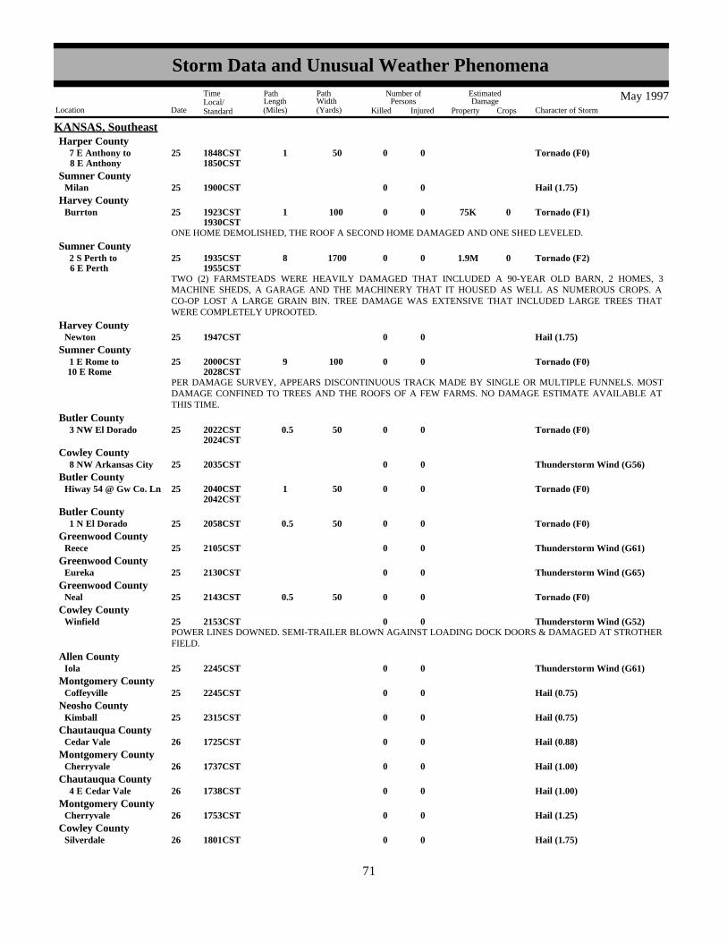
KANSAS, SoutheastHarper County
Tornado (F0)0 50 1 025 8 E Anthony 7 E Anthony to 1848CST
1850CST
Hail (1.75)0025Milan 1900CSTSumner County
Tornado (F1) 75K0100 1 025Burrton 01923CST1930CST
Harvey County
ONE HOME DEMOLISHED, THE ROOF A SECOND HOME DAMAGED AND ONE SHED LEVELED.
Tornado (F2) 1.9M01700 8 025 6 E Perth 2 S Perth to 01935CST
1955CST
Sumner County
TWO (2) FARMSTEADS WERE HEAVILY DAMAGED THAT INCLUDED A 90-YEAR OLD BARN, 2 HOMES, 3MACHINE SHEDS, A GARAGE AND THE MACHINERY THAT IT HOUSED AS WELL AS NUMEROUS CROPS. ACO-OP LOST A LARGE GRAIN BIN. TREE DAMAGE WAS EXTENSIVE THAT INCLUDED LARGE TREES THATWERE COMPLETELY UPROOTED.
Hail (1.75)0025Newton 1947CSTHarvey County
Tornado (F0)0100 9 025 10 E Rome 1 E Rome to 2000CST
2028CST
Sumner County
PER DAMAGE SURVEY, APPEARS DISCONTINUOUS TRACK MADE BY SINGLE OR MULTIPLE FUNNELS. MOSTDAMAGE CONFINED TO TREES AND THE ROOFS OF A FEW FARMS. NO DAMAGE ESTIMATE AVAILABLE ATTHIS TIME.
Tornado (F0)0 50 0.5 025 3 NW El Dorado 2022CST2024CST
Butler County
Thunderstorm Wind (G56)0025 8 NW Arkansas City 2035CSTCowley County
Tornado (F0)0 50 1 025Hiway 54 @ Gw Co. Ln 2040CST2042CST
Butler County
Tornado (F0)0 50 0.5 025 1 N El Dorado 2058CSTButler County
Thunderstorm Wind (G61)0025Reece 2105CSTGreenwood County
Thunderstorm Wind (G65)0025Eureka 2130CSTGreenwood County
Tornado (F0)0 50 0.5 025Neal 2143CSTGreenwood County
Thunderstorm Wind (G52)0025Winfield 2153CSTCowley County
POWER LINES DOWNED. SEMI-TRAILER BLOWN AGAINST LOADING DOCK DOORS & DAMAGED AT STROTHERFIELD.
Thunderstorm Wind (G61)0025Iola 2245CSTAllen County
Hail (0.75)0025Coffeyville 2245CSTMontgomery County
Hail (0.75)0025Kimball 2315CSTNeosho County
Hail (0.88)0026Cedar Vale 1725CSTChautauqua County
Hail (1.00)0026Cherryvale 1737CSTMontgomery County
Hail (1.00)0026 4 E Cedar Vale 1738CSTChautauqua County
Hail (1.25)0026Cherryvale 1753CSTMontgomery County
Hail (1.75)0026Silverdale 1801CSTCowley County
6371
Storm Data and Unusual Weather Phenomena
Location Date Character of Storm
TimeLocal/Standard
PathLength(Miles)
PathWidth(Yards)
Number ofPersons
Killed Injured
EstimatedDamage
Property Crops
May 1997

KANSAS, SoutheastChautauqua County
Hail (2.50)0026 6 E Cedar Vale 1802CST
Hail (1.00)0026 4 SE Belle Plaine 1805CSTSumner County
Hail (1.00)0026Park City 1815CSTSedgwick County
Hail (1.75)0026Park City 1817CSTSedgwick County
Hail (0.75)0026Cedar Vale 1820CSTChautauqua County
Hail (0.75)0026Sedan 1825CSTChautauqua County
Hail (1.75)0026Havana 1830CSTMontgomery County
Hail (0.75)0026Liberty 1835CSTMontgomery County
Hail (1.25)0026Oswego 1835CSTLabette County
Hail (1.00)0026Benton 1850CSTButler County
Hail (0.75)0001Holcomb 1557CST
KANSAS, SouthwestFinney County
Trees and power lines blown down in center of town.Thunderstorm Wind 5K0001Garden City 1615CST
Finney County
Hail (0.75)0001 17 ENE Garden City 1630CSTFinney County
Hail (1.75)0001 11 SW Garden City 1632CSTFinney County
Hail (0.88)0001Garden City Arpt 1648CSTFinney County
Hail (0.75)0001 15 WNW Jetmore 1705CSTHodgeman County
Hail (0.88)0001 7 NNE Charleston 1706CSTGray County
Hail (0.75)0001Liberal 1707CSTSeward County
Hail (1.00)0001Liberal 1710CSTSeward County
Hail (0.75)0001 7 N Jetmore 1722CSTHodgeman County
Hail (1.00)0001 4 S Jetmore 1753CSTHodgeman County
Thunderstorm Wind (G61)0001 4 S Jetmore 1753CSTHodgeman County
Hail 1 to 2 inches deepHail (0.88)0001Rozel 1805CST
Pawnee County
Hail (0.88)0001 16 SSW Meade 1810CSTMeade County
Thunderstorm Wind (G52)0001 10 N Kinsley 1815CSTEdwards County
Hail (0.75)0001 4 E Rozel 1820CSTPawnee County
Hail (0.75)0001 8 N Jetmore 1835CSTHodgeman County
6472
Storm Data and Unusual Weather Phenomena
Location Date Character of Storm
TimeLocal/Standard
PathLength(Miles)
PathWidth(Yards)
Number ofPersons
Killed Injured
EstimatedDamage
Property Crops
May 1997

KANSAS, SouthwestHodgeman County
Hail (0.75)0001Hanston 1840CST
Hail (0.75)0001 10 S Protection 1925CSTComanche County
Hail (0.75)0001 14 WNW Jetmore 1940CSTHodgeman County
Hail (0.75)0001 1 N Sanford 1950CSTPawnee County
High Wind (G63)0002 1130CST1200CST
KSZ043 Scott
Damage to a porch, door and shingles as a cold front moved through.Wind Damage0002Cimarron 1237CST
Gray County
Hail (0.75)0007Kiowa 1521CSTBarber County
Hail (0.75)0007Kiowa 1528CSTBarber County
Hail (1.00)0007 2 E Kiowa 1530CSTBarber County
Hail (1.00)0007Kiowa 1530CSTBarber County
Hail (0.75)0007 6 ENESE Kiowa 6 ENE Kiowa to 1546CST
Barber County
Hail (1.50)0007 3 S Hazelton 1547CSTBarber County
Hail (0.88)0007Kiowa 1600CSTBarber County
Hail (0.75)0016 3 N Walker 1545CSTEllis County
Hail (0.75)0016 9 NW Hugoton 1608CSTStevens County
Thunderstorm Wind (G52)0016 9 NW Hugoton 1608CSTStevens County
Hail (0.75)0016 6 N Burdett 1630CSTPawnee County
Hail (0.75)0016Hugoton 1632CSTStevens County
Hail (1.00)0016 3 SE Burdett 1635CSTPawnee County
Hail (0.88)0016 1 NE Feterita 1638CSTStevens County
Hail (0.75)0016Rozel 1642CSTPawnee County
Hail (1.00)0016 13 E Jetmore 13 SE Jetmore to 1647CST
Hodgeman County
Hail (0.75)0016Kinsley 1658CSTEdwards County
Hail (1.00)0016 11 N Ash Valley 1700CSTPawnee County
Hail (1.00)0016Kinsley 1710CSTEdwards County
Hail (1.75)0016 7 NW Feterita 1710CSTStevens County
Hail (0.75)0016Dodge City 1725CSTFord County
6573
Storm Data and Unusual Weather Phenomena
Location Date Character of Storm
TimeLocal/Standard
PathLength(Miles)
PathWidth(Yards)
Number ofPersons
Killed Injured
EstimatedDamage
Property Crops
May 1997

KANSAS, SouthwestFord County
Hail (1.25)0016Dodge City 1735CST
Hail (1.00)0016Dodge City 1740CSTFord County
Hail (1.00)0016 5 WNW Rolla 1740CSTMorton County
Hail (0.75)0016Dodge City 1743CSTFord County
Hail (0.88)0016Dodge City 1747CSTFord County
Hail swath 3 miles wide by 15 miles longHail (1.00)0016 12 SSW Dodge City 1813CST
Ford County
Hail (1.00)0016Ensign 1824CSTGray County
Thunderstorm Wind (G56)0016Ensign 1824CSTGray County
Hail (1.00)0016 11 SW Dodge City 1828CSTFord County
Hail (0.75)0016 7 N Fowler 1843CSTMeade County
Hail (0.75)0016 5 W Minneola 1850CSTClark County
Hail (0.88)0016 2 N Fowler 1854CSTMeade County
Hail (0.75)0016 1 N Fowler 1856CSTMeade County
Hail (0.75)0016 6 SW Minneola 1900CSTClark County
Hail (1.00)0016 16 SSE Meade 1905CSTMeade County
Hail (0.88)0016 4 W Minneola 1906CSTClark County
Hail (1.00)0016 4 W Minneola 1912CSTClark County
Hail (0.88)0017 5 ESE Loretta 1515CSTRush County
Hail (0.88)0018Preston 1638CSTPratt County
Hail (0.75)0018 8 NE Pratt 1642CSTPratt County
Hail (0.75)0018 6 W Preston 1654CSTPratt County
Hail (1.25)0018 4 S Zenith 1720CSTStafford County
Hail (1.75)0018 3 W Preston 1731CSTPratt County
Hail (0.75)0018 3 W Preston 1732CSTPratt County
Hail (1.00)0018 2 S Preston 1755CSTPratt County
Hail (0.75)0018 13 NE Syracuse 1815CSTHamilton County
Thunderstorm Wind (G52)0018 13 NE Syracuse 1815CSTHamilton County
Hail (2.75)0018 6 SW Preston 1817CSTPratt County
6674
Storm Data and Unusual Weather Phenomena
Location Date Character of Storm
TimeLocal/Standard
PathLength(Miles)
PathWidth(Yards)
Number ofPersons
Killed Injured
EstimatedDamage
Property Crops
May 1997

KANSAS, SouthwestPratt County
Hail (2.75)0018 3 W Preston 1820CST
Thunderstorm Wind (G52)0018 3 W Preston 1820CSTPratt County
Thunderstorm Wind (G52)0018 10 E Preston 1824CSTPratt County
Hail (0.75)0018 2 S Pratt 1828CSTPratt County
Hail (1.75)0018 3 E Pratt 1831CSTPratt County
Hail (1.00)0018Pratt 1835CSTPratt County
Hail (1.00)0018 12 WNW Lakin 1840CSTKearny County
Thunderstorm Wind (G52)0018Pratt 1844CSTPratt County
Thunderstorm Wind (G52)0018 12 NNW Lakin 1850CSTKearny County
Hail (1.00)0018 5 S Cullison 1921CSTPratt County
Hail (0.88)0018Garden City 1925CSTFinney County
Hail (1.50)0018Pratt 1925CSTPratt County
Hail (1.00)0018Garden City 1928CSTFinney County
Water over highway 283 and over Coats roadFlash Flood0018 3 S Pratt 1930CST
Pratt County
Power lines blown downThunderstorm Wind 4K0018 3 N Johnson 1930CST
Stanton County
Hail (1.75)0018 5 W Coats 1934CSTPratt County
Thunderstorm Wind (G52)0018Garden City 1937CSTFinney County
Also had 3.5 inches of rain at CROFTHail (0.75)0018 2 N Croft 1950CST
Pratt County
Thunderstorm Wind (G62)0018Garden City Arpt 1958CSTFinney County
Thunderstorm Wind (G52)0018 4 S Ulysses 2005CSTGrant County
Thunderstorm Wind (G52)0018Pierceville 2012CSTFinney County
Hail (0.88)0018Cimarron 2015CSTGray County
Thunderstorm Wind (G52)0018 5 S Cimarron 2025CSTGray County
Hail (0.88)0018 4 SW Cimarron 2027CSTGray County
Thunderstorm Wind (G51)0018Liberal Arpt 2034CSTSeward County
Hail (0.88)0018 6 SSW Howell 2035CSTFord County
Hail piled deep - residents of 80 years had never seen hail that deep. Also, had 5 inches of rain.Hail (1.00)0018 6 W Belvidere 2051CST
Kiowa County
6775
Storm Data and Unusual Weather Phenomena
Location Date Character of Storm
TimeLocal/Standard
PathLength(Miles)
PathWidth(Yards)
Number ofPersons
Killed Injured
EstimatedDamage
Property Crops
May 1997

KANSAS, SouthwestFord County
Swath of 5 miles wide flattened crops, broke branches and destroyed fences.
Thunderstorm Wind 15.2K0018Ford 9 SW Dodge City to 100K2100CST
2115CST
Sprinkler irrigation system damaged...tree limbs down...fence tore down.Thunderstorm Wind 15K0018 7 SW Dodge City 2105CST
Ford County
Thunderstorm Wind (G52)0018 8 S Plains 2105CSTMeade County
Hail (1.75)0018 11 SW Dodge City 2107CSTFord County
Location is Meade State Park
Hail (0.88)0018Collano 11 SW Meade to 2120CST
Meade County
Thunderstorm Wind (G52)0018Meade 2127CSTMeade County
Ten inches of rain fell in 4 hours. Some basements had 8 feet of water in them.Heavy Rain0018Belvidere 2200CST
Kiowa County
Thunderstorm Wind (G56)0018Ashland 2201CSTClark County
Hail (0.75)0018Protection 2206CSTComanche County
Thunderstorm Wind (G56)0018 10 N Englewood 2227CSTClark County
Water over highway 281Flash Flood0018 4 S Pratt 2312CST
Pratt County
Several roads flooded at the Pratt County Lake.Flash Flood0018 2 E Pratt 2355CST
Pratt County
Hail (0.75)0022 1 E Coolidge 1750CSTHamilton County
Hail (0.88)0024 2 SW Manter 1530CSTStanton County
Hail (0.75)0024 11 ENE Richfield 1625CSTMorton County
Hail (0.75)0024 5 S Ulysses 1700CSTGrant County
Hail (1.75)0024 20 ENE Garden City 1735CSTFinney County
Hail (0.75)0024 14 ENE Garden City 1815CSTFinney County
Hail (1.00)0024Scott City 1837CSTScott County
Thunderstorm Wind (G51)0024Liberal Arpt 1855CSTSeward County
Hail (0.75)0024Fowler 2010CSTMeade County
Hail (0.88)0024Fowler 2015CSTMeade County
Moved very slowly...video taped by pilot.
Tornado (F0)0 50 2 025 13 SE Scott City 1515CST1517CST
Scott County
Simultaneously with another small tornado.
Tornado (F0) 5K0 30 0.5 025 9 NNE Garden CityArpt
1529CST1530CST
Finney County
6876
Storm Data and Unusual Weather Phenomena
Location Date Character of Storm
TimeLocal/Standard
PathLength(Miles)
PathWidth(Yards)
Number ofPersons
Killed Injured
EstimatedDamage
Property Crops
May 1997

KANSAS, SouthwestFinney County
Tornado (F0)0 30 0.5 025 10 NNE Garden CityArpt
1530CST1531CST
Hail (1.75)0025 10 NE Garden City 1543CSTFinney County
Tornado (F0)0 50 0.5 025 17 SW Wakeeney 1544CSTTrego County
Hail (1.25)0025 14 SW Wakeeney 1600CSTTrego County
Hail (1.75)0025 6 NW Hays 1617CSTEllis County
Hail (1.00)0025 4 N Hays 1633CSTEllis County
Hail (0.75)0025 11 NE Hays 1710CSTEllis County
Hail completely covered the ground.Hail (0.75)0028 9 NW Elkhart 1509CST
Morton County
Hail (0.75)0028 5 W Elkhart 1515CSTMorton County
Hail covered the ground to 6 inches deep.Hail (1.00)0028 6 E Meade 1740CST
Meade County
Hail (0.88)0029 3 N Richfield 1404CSTMorton County
Hail (0.75)0029 8 NE Cimarron 1410CSTGray County
Very brief tornado filmed by chaser.Tornado (F0)0 20 0.2 029 8 NW Dodge City 1429CST
Ford County
Hail (0.75)0029 20 SW Jetmore 1430CSTHodgeman County
Two brief tornadoes filmed by chaser.Tornado (F0)0 30 0.3 029 8 NW Dodge City 1431CST
Ford County
Tornado (F0)0 30 0.2 029 8 NW Dodge City 1431CSTFord County
Tornado (F0)0 40 0.5 029 7 NW Dodge City 1439CST1440CST
Ford County
Fifth tornado filmed by chaser.
Tornado (F0)0100 1.7 029 4 NW Dodge City 5 NW Dodge City to 1442CST
1446CST
Ford County
Hail (0.75)0029 8 N Dodge City 1455CSTFord County
Tornado filmed by another chaser.Tornado (F0)0 20 0.2 029 3 N Dodge City 1458CST
Ford County
Hail (0.75)0029 1 N Ulysses 1500CSTGrant County
Hail (0.75)0029Ulysses 1515CSTGrant County
Hail (0.75)0029 8 SW Ulysses 1518CSTGrant County
Hail (0.75)0029 8 N Dodge City 1523CSTFord County
Hail (1.75) 100K0029Dodge City 1537CSTFord County
6977
Storm Data and Unusual Weather Phenomena
Location Date Character of Storm
TimeLocal/Standard
PathLength(Miles)
PathWidth(Yards)
Number ofPersons
Killed Injured
EstimatedDamage
Property Crops
May 1997

KANSAS, SouthwestFord County
Thirteen year old youth was swept down a drainage ditch and carried 1.5 miles before being rescued.Urban/Sml Stream Fld 1 029Dodge City 1550CST
Hail (0.75)0029 9 NW Elkhart 1550CSTMorton County
Tornado wrapped in rain much of the time, filmed by chaser.
Tornado (F0)0100 5 029 13 SSE Dodge City 12 S Dodge City to 1600CST
1607CST
Ford County
Hail (1.75) 10K0029 11 SE Dodge City 1603CSTFord County
Irrigation system overturned.Thunderstorm Wind (G73) 5K0029 11 SE Dodge City 1603CST
Ford County
Thunderstorm Wind (G64)0029Bloom 1615CSTFord County
Hail (0.88)0029 6 E Minneola 1625CSTClark County
Hail (0.88)0029 12 E Richfield 1625CSTMorton County
Hail (0.88)0029 14 SE Johnson 1630CSTStanton County
Hail (0.75)0029Kingsdown 1634CSTFord County
Water over highway 94.Flood0029 2 S Kingsdown 1700CST
Ford County
Hail (0.75)0029 8 NE Elkhart 1702CSTMorton County
Hail (0.88)0029 12 NE Ashland 1704CSTClark County
Hail (0.75)0029 2 N Protection 1723CSTComanche County
Water over highway 94 1 mile east of Clark Sate Lake.Flood0029 13 N Ashland 1740CST
Clark County
Thunderstorm Wind (G60) 40K0019 2 E Hodgenville 1343EST
KENTUCKY, CentralLarue County
A spotter reported a semi was blown over and several trees were blown down 2 miles east of Hodgenville.
Thunderstorm Wind (G52)0019Hardinsburg 1440ESTBreckinridge County
Dispatch reported trees down.
Flash Flood0019Harrodsburg 1615EST1745EST
Mercer County
Dispatch reported parts of Highway 127 closed due to high waters. Also, the intersection of Cummings Ferry road and Unity Pikenear Highway 127 had 3 feet of flowing water across it.
Urban/Sml Stream Fld0019Bowling Green 1745EST1830EST
Warren County
Most streets in Bowling Green had 1-2 inches of water across them. Minor street also reported across other parts of the county.
Trees were downed along High Street. Power lines were also downed.Thunderstorm Wind 3K0001Somerset 00035EST
KENTUCKY, EasternPulaski County
7078
Storm Data and Unusual Weather Phenomena
Location Date Character of Storm
TimeLocal/Standard
PathLength(Miles)
PathWidth(Yards)
Number ofPersons
Killed Injured
EstimatedDamage
Property Crops
May 1997

KENTUCKY, EasternWayne County
Part of the roof was blown off of a bi-level house. A large tree and a couple of smaller ones were also blown down.Thunderstorm Wind 10K0001 3 NW Mill Spgs 00035EST
Hail (0.75)00014Morehead 01710ESTRowan County
Hail (0.88)00014Green 01740ESTElliott County
Hail (0.88)00014Bethany 01815ESTWolfe County
Hail (0.88)00014Vancleve 01820ESTBreathitt County
Hail (0.75)00014 5 S Salyersville 01845ESTMagoffin County
Flash flooding occurred along Christy Creek in eastern Rowan County. People had to be evacuated in the Elliotville area.
Flash Flood 5K0031Elliottville 01815EST1930EST
Rowan County
Cold And Frost0011 0600EST
KENTUCKY, NortheastKYZ101>103-105 Greenup - Carter - Boyd - Lawrence
Temperatures in the lower 30s and frost were common, away from the major rivers. One observer from Grayson of Carter Countyhad 29 degress for the coldest.
Hail (0.75)0014Burnaugh 1800ESTBoyd County
Hail (0.88)0014Fallsburg 1810ESTLawrence County
Hail (0.88) 5K0014Louisa 1845ESTLawrence County
Minor damage occurred to a few roofs in town.
Camper overturned and roof blown off a shed.
Thunderstorm Wind (G50) 10K0019 3 W Dry Ridge 1640EST1645EST
KENTUCKY, NorthernGrant County
Numerous trees downed and a roof was damaged.
Thunderstorm Wind (G50) 7K0019 2 E Concord 1645EST1650EST
Pendleton County
Persistent heavy rainfall caused area creeks and streams to rise out of their banks and across county roads. In Maysville, 4 carswere washed away by the flood waters. The heavy rainfall and flooding continued into June 1st.
Flood 25K0031Countywide 2030EST2359EST
Mason County
Persistent heavy rainfall caused may roads to be flooded by area creeks. The heavy rainfall and flooding continued into June 1st.
Flood 10K0031Countywide 2330EST2359EST
Campbell County
Large tree limbs were across a road, resulting in a vehicle accident.Thunderstorm Wind (G52)0002South Carrollton 1440CST
KENTUCKY, SouthwestMuhlenberg County
A round of thunderstorms moved over ground saturated by 2 to 3 inches of rain earlier in the day. Water was over U.S. Highway60 outside of Morganfield. A secondary road was flooded off U.S. 60.
Flash Flood 5K0002Morganfield 2100CST2330CST
Union County
Three trees were blown down.Thunderstorm Wind (G52)0019Bardwell 1445CST
Carlisle County
7179
Storm Data and Unusual Weather Phenomena
Location Date Character of Storm
TimeLocal/Standard
PathLength(Miles)
PathWidth(Yards)
Number ofPersons
Killed Injured
EstimatedDamage
Property Crops
May 1997

KENTUCKY, SouthwestFulton County
Thunderstorms tracked southeast across Fulton County from southeast Missouri, producing copious rainfall amounts. These stormsoccurred after 2 to 3 inches of rain fell earlier in the day. Storm water pumps were out of service in Hickman, which contributed tosignificant flooding of streets there. Creeks rose out of their banks near Fulton.
Flash Flood 20K0026Hickman 1600CST1715CST
Slow moving thunderstorms produced rainfall amounts estimated as high as 3 inches in 3 hours from Smithland east across thecounty. Areas of major flooding affected Highways 60, 70, and 453, but no closures were reported.
Flash Flood0028Smithland 1600CST1845CST
Livingston County
Slow moving thunderstorms produced rainfall amounts estimated as much as 2 inches per hour over downtown Paducah. Thepolice department reported all major intersections in downtown Paducah were covered by water. Water went over the CrookedCreek bridge. Evacuations were advised for a small neighborhood on the west side of paducah. Several roads were closed by highwater.
Flash Flood 50K0028Paducah 1600CSTMccracken County
Slow moving thunderstorms dumped as much as 3 inches of rain over extreme northeast Graves County within 3 hours, accordingto radar estimates. Although other parts of the county received less rain, there was still some road flooding. Highway 96 wascovered with a couple inches of water south of Mayfield.
Flash Flood0028Symsonia 1845CST1945CST
Graves County
A slow-moving line of thunderstorms produced as much as 3 inches of rain in 3 hours near U.S. 68 in northern Marshall County.U.S. 68 was under water near Palma.
Flash Flood0028Palma 1845CST1945CST
Marshall County
Numerous trees were blown down near Bastrop and several other locations throughout the parrish.Thunderstorm Wind 5K0002 1 SE Bastrop 1525CST
LOUISIANA, NortheastMorehouse Parish
Hail (0.88)0002Lake Providence 1545CSTEast Carroll Parish
The tornado touched down 5 miles west-southwest of Lake Providence where it destroyed a shed. It moved to the northeast andmoved over a lake at Lake Providence. To the northeast of the lake it destroyed several sheds and destroyed two grain bins. At thispoint it reached its maximum width. It then moved northeast to near the Mississippi River, but apparently did not cross the river.Many trees were blown down along the path of this storm as well as several power lines.
Tornado (F1) 100K0400 13 002
8 ENE Shelburn
5 WSW LakeProvidence to
1545CST1605CST
East Carroll Parish
Hail (0.75)0002Oak Grove 1610CSTWest Carroll Parish
Hail (0.75)0002Dewdrop 1630CSTMorehouse Parish
Numerous trees and power lines were blown down and a shed was damaged.Thunderstorm Wind 3K0002Gassoway 1645CST
East Carroll Parish
Hail (1.00)0002Oak Grove 2215CSTWest Carroll Parish
Several trees and power lines were blown down.Thunderstorm Wind 3K0027Oak Ridge 1830CST
Morehouse Parish
Numerous trees and power lines downed throughout Rayville.Thunderstorm Wind 3K0027Rayville 1945CST
Richland Parish
Numerous trees were blown down throughout the parrish.Thunderstorm Wind 5K0027Jonesburg 2015CST
Richland Parish
7280
Storm Data and Unusual Weather Phenomena
Location Date Character of Storm
TimeLocal/Standard
PathLength(Miles)
PathWidth(Yards)
Number ofPersons
Killed Injured
EstimatedDamage
Property Crops
May 1997

LOUISIANA, NortheastMadison Parish
Thunderstorm Wind (G52)0027 3 E Tallulah 2055CST
Numerous roads were flooded throughout the parrish.
Flash Flood0028Ferriday 1600CST1700CST
Concordia Parish
Numerous automobiles and roofs of houses were damaged by baseball size hail.Hail (2.75) 100K0028 5 S Harrisonburg 1702CST
Catahoula Parish
Several trees were blown down.Thunderstorm Wind 2K0028St Joseph 1959CST
Tensas Parish
Significant flooding developed on Lake Bistineau for the fifth time since November 1996. Several homes, camps, and secondaryroadways suffered damage from the flood waters.
Flood 120K000109
0000CST1200CST
LOUISIANA, NorthwestLAZ001>003-012 Caddo - Bossier - Webster - Bienville
Numerous reports of city street flooding and stalled cars which drove into the high waters. A portion of I-20 was closed with overtwo feet of water over the highway.
Flash Flood0002Shreveport 0900CSTCaddo Parish
Flash Flood0002Bossier City 0915CSTBossier Parish
Numerous rural roads were flooded as well as water entering several homes in town.Flash Flood0002Keithville 0950CST
Caddo Parish
Strong thunderstorms produced locally heavy rainfall across much of the Parish but the northeastern third was hit the hardest with4.90 inches of rain in less than one hour. Many businesses along Hwy 151 North suffered water damage including a shoppingcenter, a grocery store, and an auto parts store. Water reached two feet in some businesses in downtown while many cars werestalled in high water. Numerous roads were closed and/or washed out including U.S. Hwy 80 between Gibsland and Arcadiawhich had to be closed for several hours.
Flash Flood0002GibslandArcadia to 1030CST
1415CST
Bienville Parish
U.S. Highway 171 was closed for a period of time due to excessive heavy rainfall. Cars were also stalled in high water across theroad.
Flash Flood0002Grand Cane 1130CSTDe Soto Parish
Highways 7, 163, and 164 were flooded due to excessive rainfalls.Flash Flood0002Minden 1430CST
Webster Parish
Slow moving thunderstorms led to 4 to 5 inches of rain over a short period of time. This resulted in flash flooding with numerousroads underwater and flooding of homes in the town. Sixty separate sites were reported by the Public Works Director for the area.Bridges, culverts, blacktop, driveways, and dirt roads suffered extensive damage.
Flash Flood 325K0002Sibley 1430CST1600CST
Webster Parish
Several large trees were toppled along Lake Claiborne.Thunderstorm Wind (G60)0002Homer 1515CST
Claiborne Parish
Hail (1.00)0002Powhatan 1715CSTNatchitoches Parish
Hail (1.00)0002Campti 1740CSTNatchitoches Parish
Hail (1.00)0002Minden 2015CST2019CST
Webster Parish
Hail (1.00)0002 6 E Logansport 2025CSTDe Soto Parish
7381
Storm Data and Unusual Weather Phenomena
Location Date Character of Storm
TimeLocal/Standard
PathLength(Miles)
PathWidth(Yards)
Number ofPersons
Killed Injured
EstimatedDamage
Property Crops
May 1997

LOUISIANA, NorthwestClaiborne Parish
Hail (1.75)0002Athens 2042CST
Hail (1.75)0002 5 W Simsboro 2105CSTLincoln Parish
Hail (0.75)0002Ruston 2130CSTLincoln Parish
Numerous trees were toppled across powerlines hear Hwy 15 resulting in power outages in the area. Thunderstorm Wind (G60)0004 4 E Downsville 1400CST
Union Parish
Hail (1.75)0014Heflin 1837CSTWebster Parish
Hail (1.00)0027Vivian 1430CSTCaddo Parish
Hail (0.75)0027Stonewall 1653CSTDe Soto Parish
Hail (0.75)0027Frierson 1707CSTDe Soto Parish
The south bound lane of U.S. Highway 167 was closed due to the numerous trees across the roadway. A few trees were alsoreported on homes in the area.
Thunderstorm Wind (G70)0027Ruston 1845CSTLincoln Parish
Numerous reports of trees down in the town and surrounding communities. Some motorists were injured in car accidents whentheir cars slammed into fallen trees. One accident occurred at La. Hwy 34 and La. Hwy 810 where one driver sustained seriousinjuries after his car hit a downed tree.
Thunderstorm Wind (G70) 2 027Chatham 1845CSTJackson Parish
Hail (0.75)0027Sligo 1854CSTBossier Parish
Lightning struck the roof of a home sparking a fire. The front porch was fully consumed by the fire while part of the roof over thedining area fell in from the fire weakened structure.
Lightning 60K0027Ruston 1855CSTLincoln Parish
Lightning struck an oil storage tank near stateline road.Lightning0027 3 W Greenwood 1900CST
Caddo Parish
Hail (0.75)0027 2 E Eros 1915CSTJackson Parish
A squall line pushed through Ouachita Parish during the evening toppling trees and power lines. Many homes suffered winddamage and roads were blocked by trees. Several people were trapped inside their cars by downed power lines. Over 200telephone poles were snapped leaving 45,000 people without power. The damage area was nearly 180 square miles which coveredmuch of the southern half of the Parish. In the city and surrounding communities over 400 homes suffered some sort of structuraldamage. The damage was so severe that Ouachita Parish was put under a declaration of emergency by the governor of Louisiana.The State Department of transportation and Development donated several trucks to help with the clean-up.
Thunderstorm Wind (G100) 3M0027Monroe 1915CSTOuachita Parish
Hail (1.75)0003Independence 0215CST
LOUISIANA, SoutheastTangipahoa Parish
Thunderstorm Wind 10K0003Independence 0215CSTTangipahoa Parish
Hail (1.75)0003Folsom 0300CSTSt. Tammany Parish
Thunderstorm Wind 15K0003Folsom 0300CSTSt. Tammany Parish
Severe thunderstorms caused wind damage over Tangipahoa and St. Tammany Parishes. Trees were downed in Independence andgolf ball size hail also accompanied the thunderstorm. In the Folsom area, over 20 trees were toppled and several hundred hadlarge branches ripped from the trunk. A large tree fell onto a house causing considerable damage. Golf ball size hail alsoaccompanied the storm.
7482
Storm Data and Unusual Weather Phenomena
Location Date Character of Storm
TimeLocal/Standard
PathLength(Miles)
PathWidth(Yards)
Number ofPersons
Killed Injured
EstimatedDamage
Property Crops
May 1997

LOUISIANA, SoutheastSt. Charles Parish
Hail (1.50)0015DestrehanLuling to 1558CST
1602CST
Hail (0.75)0015Kenner 1630CSTJefferson Parish
Thunderstorm Wind0.50K0015Kenner 1630CSTJefferson Parish
A severe thunderstorm produced large hail in St. Charles Parish and adjacent areas of Jefferson Parish.Thunderstorm wind gusts also knocked down a tree and power pole in Jefferson Parish.
Urban/Sml Stream Fld0019New Orleans 1600CST1900CST
Orleans Parish
Flash Flood 10K0019Arabi 1600CST1900CST
St. Bernard Parish
Heavy rain occurred over the upper portion of St. Bernard Parish and the southeast corner of New Orleans. A National WeatherService Cooperative observer in Chalmette recorded 5.14 inches of rain during the afternoon and early evening. St. Bernard Parishemergency management reported much greater rainfall amounts in the Arabi area where several homes were flooded and manystreets were impassable due to flooding. Adjacent areas of New Orleans had considerable street flooding.
Funnel Cloud0023 10 N Baton Rouge Arpt 1208CST
East Baton RougeParish
Tornado (F0) 20K0 20 0.6 024White Castle 0915CSTIberville Parish
Urban/Sml Stream Fld0024GramercyVacherie to 1315CST
St. James Parish
Wind0 3 024Waggaman 1500CSTJefferson Parish
A line of thunderstorm moved across southeast Louisiana. A weak tornado touched down briefly in White Castle. A mobile homeand 12 houses suffered minor damage. Heavy rain brought street flooding to several communities in St. James Parish. InWaggaman, gusty winds, less than 58 mph, overturned an inflatable carnival amusement ride. Three children were injured when itoverturned.
The sheriffs office reported that thunderstorm wind gusts downed numerous trees.Thunderstorm Wind 1K0025Gibson 0535CST
Terrebonne Parish
Hail (1.50)0028Convent 1432CSTSt. James Parish
Lightning 1 028Chalmette 1500CSTSt. Bernard Parish
Hail (0.88)0028Galliano 1658CSTLafourche Parish
Thunderstorm Wind 5K0028 4 SW New Roads 1733CSTPointe Coupee Parish
Thunderstorms produced large hail in a couple of locations in south Louisiana. Near New Roads, the sheriffs office reported thatthunderstorm wind gusts downed trees. In Chalmette, a woman was injured from a lightning strike while she was getting out of anautomobile.
A man was injured by a lightning strike at a golf course.Lightning 1 030Terrytown 1400CST
Jefferson Parish
A waterspout was visible for several minutes over Lake Pontchartrain north of Kenner.Waterspout0030 5 N Kenner 1600CST
Jefferson Parish
Thunderstorm Wind 15K0002Arnaudville 2349CST
LOUISIANA, SouthwestSt. Landry Parish
Several power poles were snapped in Arnaudville and Whiteville in St. Landry Parish.
Power poles were blown down by severe thunderstorm winds.Thunderstorm Wind 5K0015Singer 1600CST
Beauregard Parish
7583
Storm Data and Unusual Weather Phenomena
Location Date Character of Storm
TimeLocal/Standard
PathLength(Miles)
PathWidth(Yards)
Number ofPersons
Killed Injured
EstimatedDamage
Property Crops
May 1997
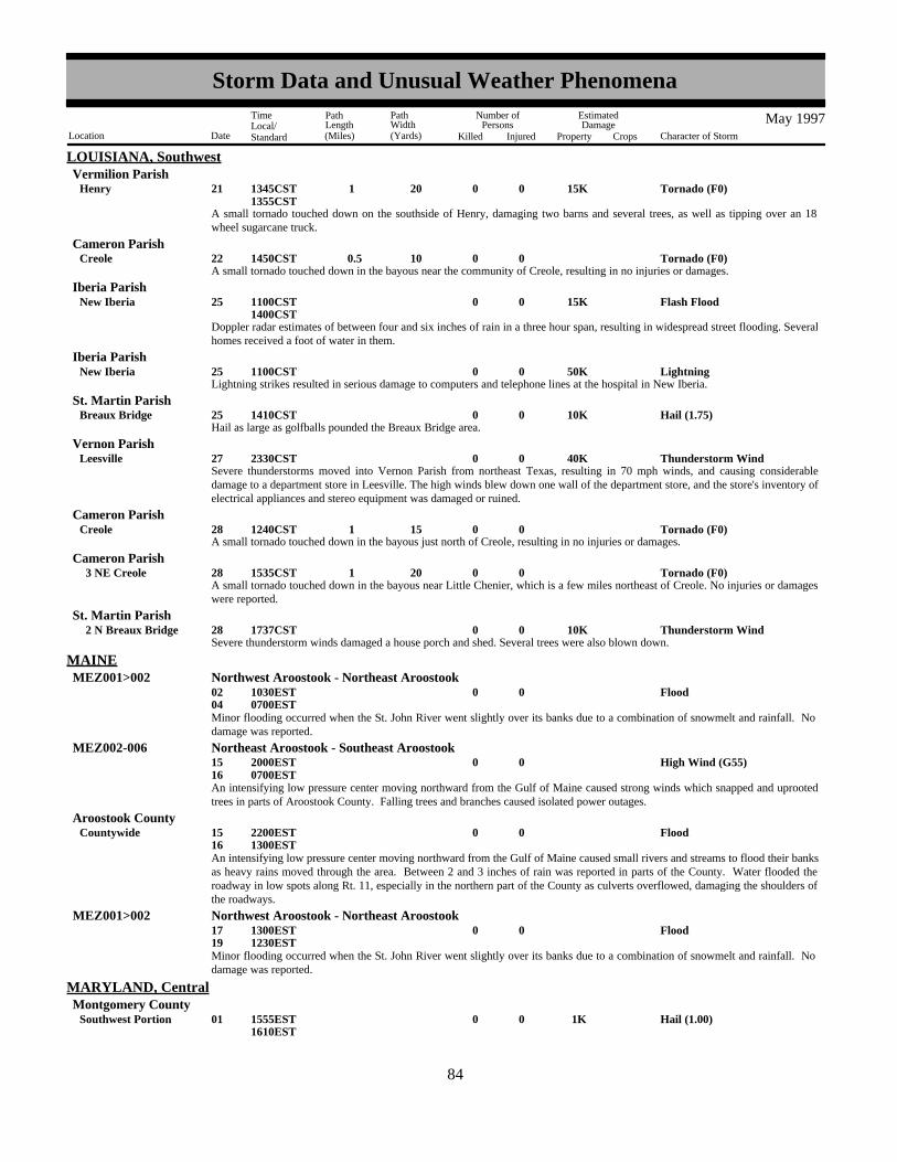
LOUISIANA, SouthwestVermilion Parish
A small tornado touched down on the southside of Henry, damaging two barns and several trees, as well as tipping over an 18wheel sugarcane truck.
Tornado (F0) 15K0 20 1 021Henry 1345CST1355CST
A small tornado touched down in the bayous near the community of Creole, resulting in no injuries or damages.Tornado (F0)0 10 0.5 022Creole 1450CST
Cameron Parish
Doppler radar estimates of between four and six inches of rain in a three hour span, resulting in widespread street flooding. Severalhomes received a foot of water in them.
Flash Flood 15K0025New Iberia 1100CST1400CST
Iberia Parish
Lightning strikes resulted in serious damage to computers and telephone lines at the hospital in New Iberia.Lightning 50K0025New Iberia 1100CST
Iberia Parish
Hail as large as golfballs pounded the Breaux Bridge area.Hail (1.75) 10K0025Breaux Bridge 1410CST
St. Martin Parish
Severe thunderstorms moved into Vernon Parish from northeast Texas, resulting in 70 mph winds, and causing considerabledamage to a department store in Leesville. The high winds blew down one wall of the department store, and the store's inventory ofelectrical appliances and stereo equipment was damaged or ruined.
Thunderstorm Wind 40K0027Leesville 2330CSTVernon Parish
A small tornado touched down in the bayous just north of Creole, resulting in no injuries or damages.Tornado (F0)0 15 1 028Creole 1240CST
Cameron Parish
A small tornado touched down in the bayous near Little Chenier, which is a few miles northeast of Creole. No injuries or damageswere reported.
Tornado (F0)0 20 1 028 3 NE Creole 1535CSTCameron Parish
Severe thunderstorm winds damaged a house porch and shed. Several trees were also blown down.Thunderstorm Wind 10K0028 2 N Breaux Bridge 1737CST
St. Martin Parish
Flood000204
1030EST0700EST
MAINEMEZ001>002 Northwest Aroostook - Northeast Aroostook
Minor flooding occurred when the St. John River went slightly over its banks due to a combination of snowmelt and rainfall. Nodamage was reported.
High Wind (G55)001516
2000EST0700EST
MEZ002-006 Northeast Aroostook - Southeast Aroostook
An intensifying low pressure center moving northward from the Gulf of Maine caused strong winds which snapped and uprootedtrees in parts of Aroostook County. Falling trees and branches caused isolated power outages.
Flood001516
Countywide 2200EST1300EST
Aroostook County
An intensifying low pressure center moving northward from the Gulf of Maine caused small rivers and streams to flood their banksas heavy rains moved through the area. Between 2 and 3 inches of rain was reported in parts of the County. Water flooded theroadway in low spots along Rt. 11, especially in the northern part of the County as culverts overflowed, damaging the shoulders ofthe roadways.
Flood001719
1300EST1230EST
MEZ001>002 Northwest Aroostook - Northeast Aroostook
Minor flooding occurred when the St. John River went slightly over its banks due to a combination of snowmelt and rainfall. Nodamage was reported.
Hail (1.00) 1K0001Southwest Portion 1555EST1610EST
MARYLAND, CentralMontgomery County
7684
Storm Data and Unusual Weather Phenomena
Location Date Character of Storm
TimeLocal/Standard
PathLength(Miles)
PathWidth(Yards)
Number ofPersons
Killed Injured
EstimatedDamage
Property Crops
May 1997

MARYLAND, CentralBaltimore County
Hail (0.75)0001Towson 1605EST
Hail (0.75)0001Columbia 1610ESTHoward County
Hail (0.88)0001Southeast Portion 1610EST1625EST
Montgomery County
Hail (1.75) 1K0001Bel Air 1612ESTHarford County
Hail (1.00)0001Calverton 1630EST
Prince George'SCounty
A rapidly developing line of low-topped thunderstorms, aided by an unusually steep lapse rate, produced a swath of large hail fromthe northern suburbs of Washington, DC to northeastern Maryland. The severe storms were triggered by a vigorous cold front. InMontgomery Co, numerous residents reported hail "showers" covering the ground. Nickel to quarter-sized hail affected Bethesda,Potomac, Rockville, Aspen Hill, and Silver Spring in a half-hour period.
As the storms continued east and northeast, one-inch diameter hail fell in Calverton, 3/4 inch diameter hail fell in Columbia andTowson, and golf ball-sized hail fell in Bel Air.
Localized wind gusts of at least 62 mph blew down trees in Cumberland, and knocked an empty tractor trailer rig off Interstate 68near Flintstone.
High Wind (G54) 5K0003 1310ESTMDZ002 Allegany
Dime-sized hail fell briefly in Capitol Heights. Marble-sized hail fell a bit earlier in downtown Washington, DC. One tree fellonto wires near Greenbelt, causing a disruption of service to 2300 Potomac Electric Power customers.
Hail (0.75)00006Capitol Heights 1130EST
Prince George'SCounty
A waterspout touched down briefly in the Bush River near the intersection of federal highway 40 and the Amtrak railroad bridge.Waterspout0006 5 SW Aberdeen 1150EST
Harford County
Urban/Sml Stream Fldg0025S Portion 2100EST2259EST
Montgomery County
Tropical moisture feeding along a south-moving cold front produced training thunderstorms over portions of the Washingtonmetropolitan region during the late evening of the 25th. In general, between 3 and 4 inches of rain fell throughout the event, withat least 2 inches falling just prior to frontal passage around midnight. The rapid accumulation of water brought Rock Creek wellout of its banks; portions of Beach Drive in Kensington were closed through the late morning on the 26th.
Hail (0.75)0001Elkton 1655EST
MARYLAND, NortheastCecil County
Hail (0.75)0001 2 E Elkton 1710ESTCecil County
The severe thunderstorm also pulled down numerous limbs.
Heavy Rain002526
Countywide 0900EST0100EST
Cecil County
Heavy Rain002526
Countywide 1200EST0200EST
Kent County
Heavy Rain002526
Countywide 1300EST0300EST
Queen Anne'S County
Heavy Rain002526
Countywide 1500EST0500EST
Caroline County
7785
Storm Data and Unusual Weather Phenomena
Location Date Character of Storm
TimeLocal/Standard
PathLength(Miles)
PathWidth(Yards)
Number ofPersons
Killed Injured
EstimatedDamage
Property Crops
May 1997

MARYLAND, NortheastTalbot County
Heavy Rain002526
Countywide 1500EST0500EST
A series of low pressure systems traveling west to east along a nearly stationary frontal boundary produced some locally heavy rainacross the Delmarva Peninsula from the daylight hours on the 25th through the early morning of the 26th. Bands of heavier rainaffected northern parts of the peninsula mainly on the 25th and southern parts of the peninsula during the late evening on the 25thand the early morning on the 26th. Storm totals averaged 1.5 to 2.5 inches, with some locally lower amounts. Representativetotals included 2.08 inches at the Baltimore-Washington International Airport, 1.90 inches in Bridgeville, DE and 1.39 inches inSalisbury.
Tornado (F1) 250K0100 0.5 025Fair Hill 1820ESTCecil County
An F1 (Fujita Scale) tornado touched down in Fair Hill at about 720 p.m. EDT and damaged four homes - two severely,overturned tombstones and damaged or uprooted hundreds of trees. Property damage was estimated at $250,000. No injuriesoccurred.
The tornado touched down over farmland near the Foxcatcher Development and moved eastward paralleling Maryland State Route273. It remained on the ground for about half a mile before lifting over the Fair Hill Nature Center. The worst damage occurred toa log home on Maryland State Route 213. Its second story sun room was destroyed by two fallen trees. Damage also occurred toits deck and roof. The owner estimated that nearly 95 percent of the trees on the property were either damaged or destroyed. Mostof the trees were 80 to 100 feet tall. Damage also occurred to several homes on Hunt Valley Road. One home had two trees on itand its siding embedded in a tree. The tornado also moved over Sharpes Cemetery and overturned about 100 tombstones and toredown a section of its black wrought-iron fence. About 1,600 homes lost power due to the fallen trees. At its maximum strength inthe cemetery and around the log home, the tornado winds were estimated near the high end of the F1 Fujita scale at about 100mph.
Unseasonably Cool0031 2359EST
MDZ008-012-015-019>020
Cecil - Kent - Queen Annes - Talbot - Caroline
May 1997 was an unseasonably cool month. For most locations, it was the coolest May since 1967. Monthly departures averaged3 to 4 degrees below normal.
Hail (1.75)0001Westover 1545EST
MARYLAND, SouthSomerset County
Hail (0.88)0001Newark 1600ESTWorcester County
Hail (0.75)0009Ocean City 1630ESTWorcester County
NONE REPORTED.
MARYLAND, West
Hail (0.88)0001Holliston 1759EST
MASSACHUSETTS, Central and EastMiddlesex County
Hail (0.75)0001Milford 1759ESTWorcester County
Hail (0.75)0001Newton 1809ESTMiddlesex County
Hail (0.88)0001Weston 1811ESTMiddlesex County
Hail (1.75)0001WalthamLexington to 1814EST
Middlesex County
Thunderstorms moved in from the southwest during the early evening and one particular thunderstorm cell produced the firstsignificant convective weather event of the season. Dime size hail was reported in extreme southeast Worcester County in thetown of Milford, as reported by the local police. In Middlesex County, spotters in Holliston reported dime to nickel size hail.Nickel size hail also fell in Newton. The largest hailstones (the size of golf balls) were reported by the spouse of a NationalWeather Service employee in Lexington. Golfball hail also was reported in Waltham. There were no reports of damage.
A cold front crossed western New England during the afternoon of May 1. The front produced an isolated severe thunderstormHail (0.75)0001Adams 1820EST
MASSACHUSETTS, WestBerkshire County
7886
Storm Data and Unusual Weather Phenomena
Location Date Character of Storm
TimeLocal/Standard
PathLength(Miles)
PathWidth(Yards)
Number ofPersons
Killed Injured
EstimatedDamage
Property Crops
May 1997

MASSACHUSETTS, Westwith hail at Adams in Berkshire County.
Thunderstorm Wind 4K0006Hinsdale 1400ESTBerkshire County
Hail (0.88) 2K0006Pittsfield 1400ESTBerkshire County
A cold front crossed western New England during the afternoon hours of May 6. Widely scattered severe thunderstormsdeveloped along this front as it crossed Berkshire County. At Hinsdale trees were downed by the wind and hail was observed atPittsfield.
Thunderstorm Wind (G50)0005Oxford 1830EST
MICHIGAN, EastOakland County
Hail (1.75)0005Hemlock 1920ESTSaginaw County
Thunderstorm Wind (G60) 5K0005Hemlock 1930ESTSaginaw County
Hail (0.75)0005Merrill 1933ESTSaginaw County
Hail (0.75)0005Grand Blanc 2050ESTGenesee County
Hail (0.75)0005Dexter 2232ESTWashtenaw County
Hail (0.75)0005Westland 2252ESTWayne County
Hail (0.75)0005Livonia 2254ESTWayne County
Hail (0.75)0005Dearborn 2305ESTWayne County
A cold front tracked across southeast Michigan late on the 5th, triggering scattered thunderstorms. A severe storm in Saginawcounty near Hemlock produced golf ball-sized hail and strong winds that flipped a 10-foot snowmobile trailer, tore siding off of agarage, and flattened a 45-foot tree. Trees were also uprooted in Oxford, in Oakland county. Three-quarter inch hail was reportedat Grand Blanc in Genesee county, and in Westland, Livonia and Dearborn in Wayne county.
Hail (1.00) 1K0008Poseyville 2040ESTMidland County
Hail (1.00)0008Freeland 2055ESTSaginaw County
Hail (0.88)0008 5 SE Bay City 2115ESTBay County
Hail (1.00)0008 5 W Kingston 2225ESTTuscola County
Hail (0.75)0008 2 S Caro 2230ESTTuscola County
Hail (0.75)0008 2 S Caro 2235ESTTuscola County
Hail (0.75)0008Deckerville 2300ESTSanilac County
A strong low pressure system tracking across lake Superior pushed a cold front across southeast Michigan late on the 8th.Scattered thunderstorms developed along the front, with the strongest storms affecting the Saginaw Valley. Hail with diameters ofup to an inch was reported at several locations.
NONE REPORTED.
MICHIGAN, Extreme Southwest
Hail (0.75)0005 2 N St Helen 1745EST
MICHIGAN, NorthRoscommon County
Hail (0.75)0005 3 NE Gladwin 1835ESTGladwin County
7987
Storm Data and Unusual Weather Phenomena
Location Date Character of Storm
TimeLocal/Standard
PathLength(Miles)
PathWidth(Yards)
Number ofPersons
Killed Injured
EstimatedDamage
Property Crops
May 1997

MICHIGAN, NorthArenac County
Hail (1.00)0008Standish 2110EST
Hail (0.88)0008 25 NNE Newberry 1845EST1847EST
MICHIGAN, UpperLuce County
Heavy Snow001112
2000EST2100EST
MIZ002-004-009 Ontonagon - Baraga - Gogebic
A late winter storm deposited 13 inches of snow at Herman, 12 inches at Ironwood and Wakefield, and 11 inches at Bergland. Thesnow established new single season snowfall records at Herman with 384.0 inches, Ironwood with 301.8 inches, and Berglandwith 284.9 inches. It broke single season snowfall records set just last year of 347.0, 291.9 and 284.2 inches respectively.
Nickel sized hail reported covering the ground.Hail (0.88)0005Grand Haven 1541EST
MICHIGAN, WestOttawa County
Hail covered the ground.Hail (0.75)0005Zeeland 1541EST
Ottawa County
Hail (0.75)0005Holland 1545ESTAllegan County
Hail (0.75)0005Grand Haven 1547ESTOttawa County
Hail (0.75)0005Byron Center 1602ESTKent County
Golfball sized hail reported by NWS spotter at the John Ball Park Public Zoo.Hail (1.50)0005Grand Rapids 1603EST
Kent County
Hail (0.75)0005Kentwood 1608ESTKent County
Hail covered the ground.Hail (0.75)0005Byron Center 1612EST
Kent County
Hail (0.75)0005 4 S Cutlerville 1612ESTKent County
Hail (1.00)0005Graafschap 1615ESTAllegan County
Hail (0.75)0005Jenison 1615ESTOttawa County
Hail (0.75)0005Mattawan 1623ESTVan Buren County
Hail (0.88)0005Baldwin 1656ESTLake County
Hail (0.75)0005Idlewild 1658ESTLake County
Hail (0.88)0005Hickory Corners 1700ESTBarry County
Hail (0.75)0005 3 E Grand Ledge 1705ESTEaton County
Hail (0.75)0005Coldwater 1720ESTBranch County
Hail (0.75)0005Quincy 1734ESTBranch County
Hail (0.75)0005Mason 1739ESTIngham County
Hail (0.75)0005Rodney 1754ESTMecosta County
8088
Storm Data and Unusual Weather Phenomena
Location Date Character of Storm
TimeLocal/Standard
PathLength(Miles)
PathWidth(Yards)
Number ofPersons
Killed Injured
EstimatedDamage
Property Crops
May 1997

MICHIGAN, WestIsabella County
Hail (1.50)0005 10 W Mount Pleasant 1815EST
Hail (0.75)0005Lake Isabella 1819ESTIsabella County
A line of strong to severe thunderstorms developed along a cold front which moved through Michigan's Lower Peninsula duringthe late afternoon and evening hours of May 5, 1997. Low atmospheric freezing levels supported considerable hail with some ofthese storms. Numerous reports of hail were received by the National Weather Service Office in Grand Rapids, including golfballsized hail in Grand Rapids and near Mount Pleasant. No injuries or significant property damage was reported, but crop damage didoccur across Ottawa, Kent, Allegan, Lake, and Isabella Counties, although damage estimates were not available.
Hail (1.00)0008Ashton 1915ESTOsceola County
Nickel sized hail reported.Hail (0.88)0008Evart 1930EST
Osceola County
Half dollar sized hail reported.Hail (1.25)0008Lake George 2005EST
Clare County
Nickel sized hail reported.Hail (0.88)0008Chippewa Lake 2020EST
Mecosta County
A cold front moving across the Great Lakes Region triggered thunderstorms across Central Lower Michigan. A few of thesethunderstorms produced severe criteria hail during the evening hours of May 8, 1997. No damage was reported.
Record-cold temperatures in the upper 20s across the southwest quarter of Lower Michigan on May 16, 1997, caused financiallosses for many West Michigan farmers. A hard frost wiped out approximately 20 percent of Oceana County's annual asparaguscrop, causing an estimated $2 million in damages.
Extreme Cold0016 2M0000EST0800EST
MIZ043 Oceana
Thunderstorm Wind (G61)0018St Joseph 2041ESTBerrien County
Berrien County officials reported winds snapped off pine trees and blew the roof off of a resident's garage and dumped it 300 feetaway from the garage.Downed power lines cut power to approximately 1300 customers in Berrien County.
Thunderstorm Wind 5K0018Three Oaks 2050ESTBerrien County
At 1020 PM EDT Sunday, May 18, a wet microburst hit the Americana Estates mobile home park in western Kalamazoo,Michigan. The mobile home park is located one mile northeast of the U.S. Highway 131/Stadium Street (Business I-94)interchange. One injury (a broken wrist) was caused when a microburst approximately 150 yards long and 50 yards wide struck the park.The first damage was noted on Stadium Street at the Burger King and Lee's Restaurant. Two light poles were downed at a BurgerKing restaurant. The Lee's Restaurant sign was broken with large fragments of 1 to 2 feet driven into the front siding of therestaurant. Some shingles and siding were also blown off. To the northeast, about a dozen mobile homes were pushed off foundations or received major roof damage. Two homes werecompletely destroyed, one of which was tied down. In the tied down mobile home, the wind ripped off the upper portions of thehome, leaving only debris and the flooring. Five people were in the home at the time of the incident, one of whom was a teenagemale injured with a broken wrist. The second destroyed trailer was not tied down and the back half of the trailer was broken andtwisted onto its side. Debris was blown over 1/4 mile away, where a 2X4 was embedded at a downward angle into the side of ahome.
Thunderstorm Wind 500K 1 018Kalamazoo 2120ESTKalamazoo County
Branch County Central Dispatch and Road Commission reported downed trees and power lines in Sherwood Township, in thenorthwest part of the county. A recreational trailer, parked on the side of the road on Division Street was torn open and thecontents were strewn several yards. Some minor damage was done to mobile homes. Several trees and large limbs were downedalong Sherwood Road. Extensive damage was done to a nature trail at Sherwood Elementary School.
Thunderstorm Wind 10K0018Sherwood 2130EST2145EST
Branch County
Kalamazoo HAM radio personnel reported six inch diameter trees were blown down in Portage.Thunderstorm Wind 1K0018Portage 2130EST
Kalamazoo County
8189
Storm Data and Unusual Weather Phenomena
Location Date Character of Storm
TimeLocal/Standard
PathLength(Miles)
PathWidth(Yards)
Number ofPersons
Killed Injured
EstimatedDamage
Property Crops
May 1997

MICHIGAN, WestSt. Joseph County
St. Joseph Central Dispatch reported several trees and power lines downed in Sturgis.Thunderstorm Wind 2.5K0018Sturgis 2135EST
Several trees and power lines downed in Three Rivers.Thunderstorm Wind 2.5K0018Three Rivers 2135EST
St. Joseph County
Hillsdale County Central Dispatch reported a residence at 13080 South Edon Road was damaged by severe thunderstorm winds. Amachine shop, another out-building, and the home received minor damage.
Thunderstorm Wind 5K0018Camden 2215ESTHillsdale County
Hillsdale County officials reported trees and power lines were downed by straight-line thunderstorm winds across Allen, Adams,and Wheatland townships. Four barns were destroyed at 3120 East Bacon Road in Hillsdale and damage was done to the home atthe same address. One woman sustained minor injuries when the trailer she was in parked on Meadow Lane tipped over.
Thunderstorm Wind 50K 1 018Hillsdale 2215ESTHillsdale County
A strong area of low pressure located in Wisconsin on the evening of Sunday, May 18, 1997, triggered severe thunderstorms alonga convergence boundary across northern Illinois, northern Indiana, and extreme southern Lower Michigan.
Flood000116
0000CST0600CST
MINNESOTA, Central and South CentralMNZ054>056-060-064>065-067>070-073-075>076-083
Lac Qui Parle - Swift - Chippewa - Hennepin - Yellow Medicine - Renville - Sibley - Carver - Scott - Dakota- Redwood - Nicollet - Le Sueur - Blue Earth
The Minnesota River remained in flood stage through mid May. The river first went above flood stage in late March. Peak crestsof the river were reached during the first two weeks of April. The crest at Montevideo reached 23.9 feet on 4/7/97 which set a newrecord crest. Minnesota River flooding resulted in severe losses to public and private property. Please check the April edition ofStorm Data for a more detailed description.
Strong Wind 10 1 05 0920CSTMNZ066 Mcleod
Gradient wind gust caused apartment building under construction in Hutchinson to collapse, killing one worker and injuring 10.Wind gust of 50 knots recorded at local radio station. M33OT
Roof torn off cabin on southeast shore of Lake Florida. Wind estimated at 45 knots.Strong Wind Gust0024 6 W Spicer 2140CST
Kandiyohi County
Roof torn off restaurant.Thunderstorm Wind (G50)0024New London 2145CST
Kandiyohi County
NONE REPORTED.
MINNESOTA, Northeast
NONE REPORTED.
MINNESOTA, Northwest
NONE REPORTED.
MINNESOTA, Southeast
High Wind (G52) 17K0005 1000CST1600CST
MINNESOTA, SouthwestMNZ071>072-080>081-089>090-097>098
Lincoln - Lyon - Murray - Cottonwood - Nobles - Jackson - Pipestone - Rock
High winds estimated as high as 60 mph caused tree and scattered other damage, including the roof and a wall torn off a bar inAdrian and a large sign blown out at Tyler.
Hail (0.88)0017Westbrook 1915CSTCottonwood County
NONE REPORTED.
MINNESOTA, West
8290
Storm Data and Unusual Weather Phenomena
Location Date Character of Storm
TimeLocal/Standard
PathLength(Miles)
PathWidth(Yards)
Number ofPersons
Killed Injured
EstimatedDamage
Property Crops
May 1997
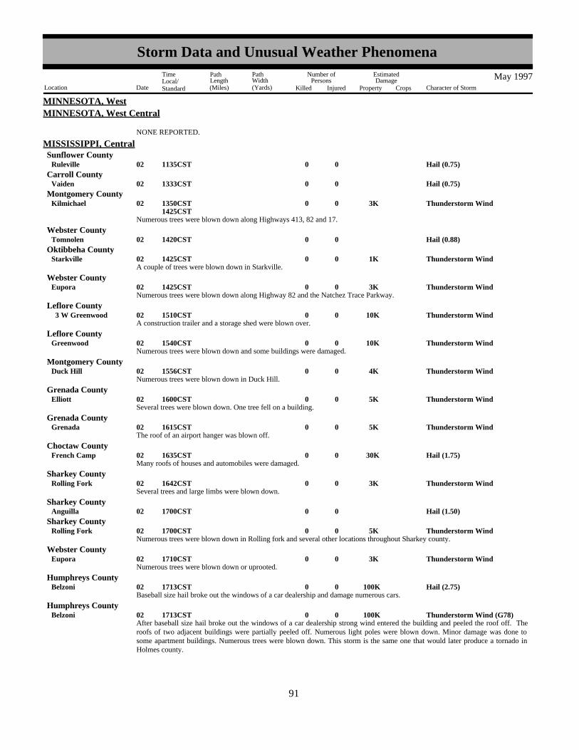
MINNESOTA, WestMINNESOTA, West Central
NONE REPORTED.
Hail (0.75)0002Ruleville 1135CST
MISSISSIPPI, CentralSunflower County
Hail (0.75)0002Vaiden 1333CSTCarroll County
Numerous trees were blown down along Highways 413, 82 and 17.
Thunderstorm Wind 3K0002Kilmichael 1350CST1425CST
Montgomery County
Hail (0.88)0002Tomnolen 1420CSTWebster County
A couple of trees were blown down in Starkville.Thunderstorm Wind 1K0002Starkville 1425CST
Oktibbeha County
Numerous trees were blown down along Highway 82 and the Natchez Trace Parkway.Thunderstorm Wind 3K0002Eupora 1425CST
Webster County
A construction trailer and a storage shed were blown over.Thunderstorm Wind 10K0002 3 W Greenwood 1510CST
Leflore County
Numerous trees were blown down and some buildings were damaged.Thunderstorm Wind 10K0002Greenwood 1540CST
Leflore County
Numerous trees were blown down in Duck Hill.Thunderstorm Wind 4K0002Duck Hill 1556CST
Montgomery County
Several trees were blown down. One tree fell on a building.Thunderstorm Wind 5K0002Elliott 1600CST
Grenada County
The roof of an airport hanger was blown off.Thunderstorm Wind 5K0002Grenada 1615CST
Grenada County
Many roofs of houses and automobiles were damaged.Hail (1.75) 30K0002French Camp 1635CST
Choctaw County
Several trees and large limbs were blown down.Thunderstorm Wind 3K0002Rolling Fork 1642CST
Sharkey County
Hail (1.50)0002Anguilla 1700CSTSharkey County
Numerous trees were blown down in Rolling fork and several other locations throughout Sharkey county.Thunderstorm Wind 5K0002Rolling Fork 1700CST
Sharkey County
Numerous trees were blown down or uprooted.Thunderstorm Wind 3K0002Eupora 1710CST
Webster County
Baseball size hail broke out the windows of a car dealership and damage numerous cars.Hail (2.75) 100K0002Belzoni 1713CST
Humphreys County
After baseball size hail broke out the windows of a car dealership strong wind entered the building and peeled the roof off. Theroofs of two adjacent buildings were partially peeled off. Numerous light poles were blown down. Minor damage was done tosome apartment buildings. Numerous trees were blown down. This storm is the same one that would later produce a tornado inHolmes county.
Thunderstorm Wind (G78) 100K0002Belzoni 1713CSTHumphreys County
8391
Storm Data and Unusual Weather Phenomena
Location Date Character of Storm
TimeLocal/Standard
PathLength(Miles)
PathWidth(Yards)
Number ofPersons
Killed Injured
EstimatedDamage
Property Crops
May 1997

MISSISSIPPI, CentralHolmes County
This tornado initially touched down 1 mile south of Tchula and moved northeast to 2 miles east southeast of Emory. The pathwidth and strength varied along the path, but at its widest point was 200 yards.
The worst damage occurred at a school 2 miles east of Tchula where major damage was done. Fortunately the the school wasalmost vacant. Along the remainder of the path mostly F1 and F2 damage occurred. Several houses were damaged and one mobilehome was flipped over. Of course numerous trees were blown down along the entire path.
Tornado (F3) 200K0200 20 002 2 ESE Emory 1 S Tchula to 1730CST
1755CST
Several trees were blown down.Thunderstorm Wind 2K0002Leland 1730CST
Washington County
Golf ball size hail damaged roofs and automobiles.Hail (1.75) 20K0002Panther Burn 1740CST
Sharkey County
Numerous trees were blown down or uprooted.
Tornado (F1) 4K0 50 2 002 12 NE Hesterville 10 NE Hesterville to 1800CST
1803CST
Attala County
This tornado touched down in Attala county and traveled a short distance into Montgomery county. Several trees were blown downin Montgomery county.
Tornado (F1) 2K0 50 1 002 5 SE Poplar Creek 5 SSE Poplar Creek to 1803CST
1805CST
Montgomery County
Hail (0.75)0002Carrollton 1815CSTCarroll County
Numerous trees were blown down.Thunderstorm Wind 3K0002Carrollton 1815CST
Carroll County
Hail (0.75)0002Winona 1815CSTMontgomery County
Hail (1.25)0002Belzoni 1818CSTHumphreys County
Hail (0.88)0002 2 N Ackerman 1848CSTChoctaw County
Hail (0.75)0002Vaiden 1853CSTCarroll County
Hail (1.00)0002 8 SE Kilmichael 1900CSTMontgomery County
Numerous trees were blown down.Thunderstorm Wind 3K0002Indianola 1915CST
Sunflower County
Hail (0.75)0002Benoit 1930CSTBolivar County
Numerous trees were blown down through the city.Thunderstorm Wind 3K0002Lexington 1930CST
Holmes County
Hail (0.75)0002Greenville 1930CSTWashington County
Hail (0.75)0002 3 W Ackerman 1940CSTChoctaw County
Several trees were blown down at the intersection of Highways 82 and 25.Thunderstorm Wind 2K0002Starkville 1945CST
Oktibbeha County
This tornado touched down briefly and only blew down a couple of trees.Tornado (F0) 1K0 40 1 002Vaiden 1950CST
Carroll County
Many streets were flooded in Carrollton. Water washed out a culvert.
Flash Flood 5K0002Carrollton 2000CST2100CST
Carroll County
8492
Storm Data and Unusual Weather Phenomena
Location Date Character of Storm
TimeLocal/Standard
PathLength(Miles)
PathWidth(Yards)
Number ofPersons
Killed Injured
EstimatedDamage
Property Crops
May 1997

MISSISSIPPI, CentralMontgomery County
Numerous streets and roads were flooded in Winona.
Flash Flood0002Winona 2000CST2100CST
Hail (1.00)0002Tomnolen 2000CSTWebster County
Several trees were blown down on to homes and cars.Thunderstorm Wind 10K0002Duck Hill 2005CST
Montgomery County
Several windows were broken out of buildings and automobiles. Numerous automobiles were damaged.Hail (2.00) 50K0002Winona 2015CST
Montgomery County
This tornado was sighted by a trained spotter. It touched down briefly in an open field and then dissipated. It caused no damage.Tornado (F0)0 40 1 002Schlater 2025CST
Leflore County
Trees were blown down throughout the city of Starkville.Thunderstorm Wind 5K0002Starkville 2050CST
Oktibbeha County
Many roads and streets were flooded throughout the county.
Flash Flood 10K0002Starkville 2100CST2230CST
Oktibbeha County
Hail (0.75)0002Clarkson 2100CSTWebster County
Hail (0.75)0002Shaw 2130CSTBolivar County
Many streets were flooded and water came very close to getting into some residences..
Flash Flood0002Eupora 2200CST2230CST
Webster County
Several trees were blown down along Interstate 55.Thunderstorm Wind 2K0002 5 NE Carrollton 2255CST
Carroll County
Numerous streets were flooded across the city of Grenada.
Flash Flood0002Grenada 2300CST2330CST
Grenada County
Hail (0.75)0002Jackson 2315CSTHinds County
Several trees were blown down.Thunderstorm Wind 1K0003Oak Ridge 0015CST
Warren County
Hail (1.00)0003Flora 0030CSTMadison County
Thunderstorm Wind (G52)0003Bolton 0040CSTHinds County
Several limbs were blown out of trees..Thunderstorm Wind (G52)0.50K0003Florence 0115CST
Rankin County
Hail (0.75)0003Walnut Grove 0135CSTLeake County
Several trees were blown down.Thunderstorm Wind 2K0003 3 E Ludlow 0135CST
Scott County
Sixty mile an hour winds blew numerous large branches and limbs out of trees.Thunderstorm Wind (G52) 2K0003Porterville 0150CST
Kemper County
Numerous trees were blown down.
Thunderstorm Wind 3K0003Enterprise 0340CST0440CST
Clarke County
8593
Storm Data and Unusual Weather Phenomena
Location Date Character of Storm
TimeLocal/Standard
PathLength(Miles)
PathWidth(Yards)
Number ofPersons
Killed Injured
EstimatedDamage
Property Crops
May 1997

MISSISSIPPI, CentralLamar County
Numerous trees and power lines were blown down.Thunderstorm Wind 4K0003Sumrall 0430CST
Several trees were blown down.Thunderstorm Wind 1K0003Hattiesburg 0435CST
Forrest County
Trees and power lines were blown down and windows were blown out of several buildings.Thunderstorm Wind (G57) 6K0009Cleveland 0410CST
Bolivar County
Thunderstorm Wind (G52)0009Sunflower 0425CSTSunflower County
A tin roof was blown off a building.Thunderstorm Wind 3K0009Doddsville 0439CST
Sunflower County
Several trees and large limbs were blown down.Thunderstorm Wind 1K0009Greenwood 0455CST
Leflore County
Several power lines were blown down.Thunderstorm Wind 2K0009Carrollton 0520CST
Carroll County
Several trees were blown down.Thunderstorm Wind 1K0009 4 SE Carrollton 0525CST
Carroll County
Several trees were blown down on to power ines.Thunderstorm Wind 2K0009 6 NW Ackerman 0630CST
Choctaw County
Several power lines were blown down.Thunderstorm Wind 3K0009Winona 0640CST
Montgomery County
Several trees were blown down.Thunderstorm Wind 2K0009Starkville 0645CST
Oktibbeha County
Hail (0.75)0014Minter City 1450CSTLeflore County
Hail (0.75)0014Vaiden 1515CSTCarroll County
Many cars and roofs were damaged and numerous windows were broken out.Hail (1.75) 50K0014Lexington 1550CST
Holmes County
Hail (0.75)0014Eupora 1600CSTWebster County
Nickel size hail completely covered the ground.Hail (0.88)0014 2 NE Durant 1620CST
Holmes County
This tornado was filmed as it crossed Interstate 55. No damage occurred with this tornado.
Tornado (F0)0 30 2 014 2 N Durant 10 E Lexington to 1635CST
1639CST
Holmes County
Many windows were broken out by hail. severa houses had roof damage and the roof of a school was damaged.Hail (2.00) 50K0014Mc Adams 1640CST
Attala County
This short track tornado moved east-southeast through the town of Mc Adams. Many trees were blown down or uprooted. Some ofthe trees fell on buildings. Minor damage was down to a few buildings and many windows were blown out of a school.
Tornado (F1) 20K0 70 1.5 014Mc Adams 1640CSTAttala County
Several automobiles and roofs were damaged.Hail (1.75) 20K0014Carthage 1652CST
Leake County
Several small trees were blown down.Thunderstorm Wind 1K0014 3 N Philadelphia 1715CST
Neshoba County
8694
Storm Data and Unusual Weather Phenomena
Location Date Character of Storm
TimeLocal/Standard
PathLength(Miles)
PathWidth(Yards)
Number ofPersons
Killed Injured
EstimatedDamage
Property Crops
May 1997

MISSISSIPPI, CentralLeake County
Several trees were blown down.Thunderstorm Wind 2K0014Singleton 1720CST
Hail (1.00)0014Winona 1725CSTMontgomery County
Hail (0.75)0015Lorman 0135CSTJefferson County
Hail (0.75)0019Bude 1440CSTFranklin County
Minor damage was done to a high school roof. Several trees and power lines were blown down.Thunderstorm Wind 10K0019Mendenhall 1500CST
Simpson County
Thunderstorm Wind (G52)0020Prentiss 1813CSTJefferson Davis County
Hail (0.75)0023Purvis 1415CSTLamar County
Many streets were flooded in south Jackson.
Flash Flood0023Jackson 1615CST1645CST
Hinds County
Hail (0.88)0024 6 NE Laurel 1515CSTJones County
Windows were blown out of a house.Thunderstorm Wind 1K0027Pace 0438CST
Bolivar County
Hail (0.75)0027Ruleville 0455CSTSunflower County
Hail (0.75)0027 8 W Hollandale 0557CSTWashington County
Several trees were blown down and a trailer was destroyed.Thunderstorm Wind 20K0027Metcalf 1855CST
Washington County
Hail (0.75)0027Yazoo City 1945CSTYazoo County
Hail (0.88)0027Ludlow 2020CSTScott County
A mobile home was overturned and several trees were blown down.Thunderstorm Wind 20K0027Metcalf 2042CST
Washington County
Hail (0.88)0027Polkville 2045CSTSmith County
Numerous trees were blown down throughout the county.Thunderstorm Wind 5K0027Vicksburg 2110CST
Warren County
Hail (1.00)0027Pelahatchie 2125CSTRankin County
Several trees were blown down.Thunderstorm Wind 2K0027Lake 2125CST
Scott County
Several roofs of houses were damaged.Hail (1.75) 20K0027Byram 2153CST
Hinds County
Several trees were blown down.Thunderstorm Wind 2K0027Benton 2200CST
Yazoo County
Police department saw this tornado briefly touch down and no damage was done.Tornado (F0)0 30 0.5 027 1 S Madison 2210CST
Madison County
8795
Storm Data and Unusual Weather Phenomena
Location Date Character of Storm
TimeLocal/Standard
PathLength(Miles)
PathWidth(Yards)
Number ofPersons
Killed Injured
EstimatedDamage
Property Crops
May 1997
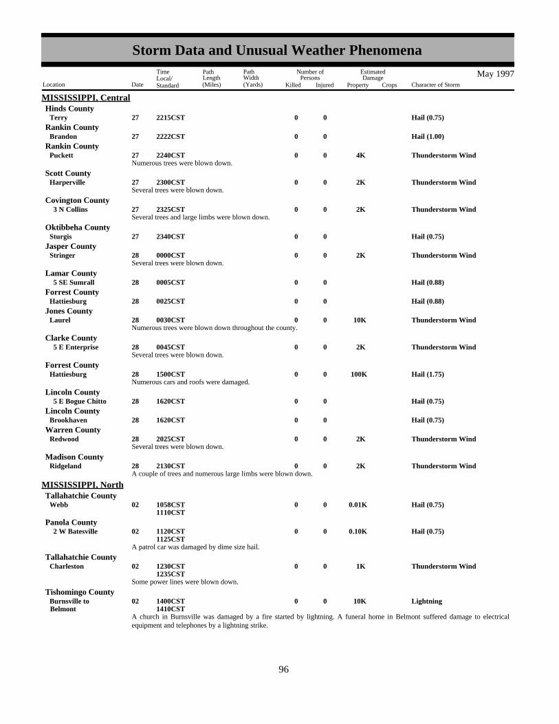
MISSISSIPPI, CentralHinds County
Hail (0.75)0027Terry 2215CST
Hail (1.00)0027Brandon 2222CSTRankin County
Numerous trees were blown down.Thunderstorm Wind 4K0027Puckett 2240CST
Rankin County
Several trees were blown down.Thunderstorm Wind 2K0027Harperville 2300CST
Scott County
Several trees and large limbs were blown down.Thunderstorm Wind 2K0027 3 N Collins 2325CST
Covington County
Hail (0.75)0027Sturgis 2340CSTOktibbeha County
Several trees were blown down.Thunderstorm Wind 2K0028Stringer 0000CST
Jasper County
Hail (0.88)0028 5 SE Sumrall 0005CSTLamar County
Hail (0.88)0028Hattiesburg 0025CSTForrest County
Numerous trees were blown down throughout the county.Thunderstorm Wind 10K0028Laurel 0030CST
Jones County
Several trees were blown down.Thunderstorm Wind 2K0028 5 E Enterprise 0045CST
Clarke County
Numerous cars and roofs were damaged.Hail (1.75) 100K0028Hattiesburg 1500CST
Forrest County
Hail (0.75)0028 5 E Bogue Chitto 1620CSTLincoln County
Hail (0.75)0028Brookhaven 1620CSTLincoln County
Several trees were blown down.Thunderstorm Wind 2K0028Redwood 2025CST
Warren County
A couple of trees and numerous large limbs were blown down.Thunderstorm Wind 2K0028Ridgeland 2130CST
Madison County
Hail (0.75)0.01K0002Webb 1058CST1110CST
MISSISSIPPI, NorthTallahatchie County
A patrol car was damaged by dime size hail.
Hail (0.75)0.10K0002 2 W Batesville 1120CST1125CST
Panola County
Some power lines were blown down.
Thunderstorm Wind 1K0002Charleston 1230CST1235CST
Tallahatchie County
A church in Burnsville was damaged by a fire started by lightning. A funeral home in Belmont suffered damage to electricalequipment and telephones by a lightning strike.
Lightning 10K0002BelmontBurnsville to 1400CST
1410CST
Tishomingo County
8896
Storm Data and Unusual Weather Phenomena
Location Date Character of Storm
TimeLocal/Standard
PathLength(Miles)
PathWidth(Yards)
Number ofPersons
Killed Injured
EstimatedDamage
Property Crops
May 1997
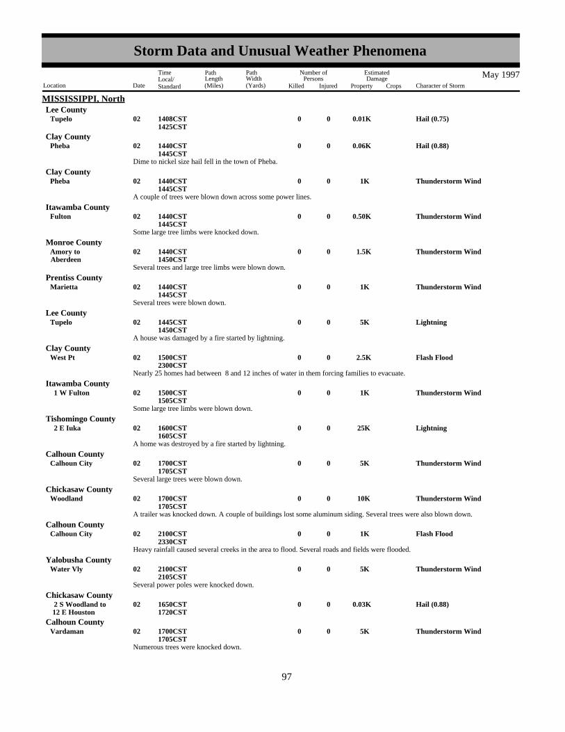
MISSISSIPPI, NorthLee County
Hail (0.75)0.01K0002Tupelo 1408CST1425CST
Dime to nickel size hail fell in the town of Pheba.
Hail (0.88)0.06K0002Pheba 1440CST1445CST
Clay County
A couple of trees were blown down across some power lines.
Thunderstorm Wind 1K0002Pheba 1440CST1445CST
Clay County
Some large tree limbs were knocked down.
Thunderstorm Wind0.50K0002Fulton 1440CST1445CST
Itawamba County
Several trees and large tree limbs were blown down.
Thunderstorm Wind 1.5K0002AberdeenAmory to 1440CST
1450CST
Monroe County
Several trees were blown down.
Thunderstorm Wind 1K0002Marietta 1440CST1445CST
Prentiss County
A house was damaged by a fire started by lightning.
Lightning 5K0002Tupelo 1445CST1450CST
Lee County
Nearly 25 homes had between 8 and 12 inches of water in them forcing families to evacuate.
Flash Flood 2.5K0002West Pt 1500CST2300CST
Clay County
Some large tree limbs were blown down.
Thunderstorm Wind 1K0002 1 W Fulton 1500CST1505CST
Itawamba County
A home was destroyed by a fire started by lightning.
Lightning 25K0002 2 E Iuka 1600CST1605CST
Tishomingo County
Several large trees were blown down.
Thunderstorm Wind 5K0002Calhoun City 1700CST1705CST
Calhoun County
A trailer was knocked down. A couple of buildings lost some aluminum siding. Several trees were also blown down.
Thunderstorm Wind 10K0002Woodland 1700CST1705CST
Chickasaw County
Heavy rainfall caused several creeks in the area to flood. Several roads and fields were flooded.
Flash Flood 1K0002Calhoun City 2100CST2330CST
Calhoun County
Several power poles were knocked down.
Thunderstorm Wind 5K0002Water Vly 2100CST2105CST
Yalobusha County
Hail (0.88)0.03K0002 12 E Houston 2 S Woodland to 1650CST
1720CST
Chickasaw County
Numerous trees were knocked down.
Thunderstorm Wind 5K0002Vardaman 1700CST1705CST
Calhoun County
8997
Storm Data and Unusual Weather Phenomena
Location Date Character of Storm
TimeLocal/Standard
PathLength(Miles)
PathWidth(Yards)
Number ofPersons
Killed Injured
EstimatedDamage
Property Crops
May 1997

MISSISSIPPI, NorthChickasaw County
Thunderstorm winds damaged parts of Woodland and Egypt. In Woodland, One house lost a porch and a second house had a treeblown on top of it. A mobile home was damaged. Several trees were knocked down with one tree hitting a pick-up truck. In Egypt,several homes were damaged with some windows blown in. A shed was knocked down and several trees were also blown down.
Thunderstorm Wind 20K0002EgyptWoodland to 1710CST
1735CST
Several trees were blown down.
Thunderstorm Wind 1K0002Montpelier 1715CST1720CST
Clay County
A car was blown off the road. Several large tree limbs were blown down.
Thunderstorm Wind 1K0002Aberdeen 1730CST1735CST
Monroe County
High winds behind a line of thunderstorms produced damage in southern Lee county. A tractor trailer flipped over on a highway.Several trees were also knocked down.
High Wind 5K0002 1855CST1920CST
MSZ016 Lee
A tornado touched down near the town of Caledonia. The only damage reported with the storm was several downed trees.
Tornado (F0) 5K0 50 5 002Caledonia 2000CST2010CST
Lowndes County
A widespread area of trees were knocked down.
Thunderstorm Wind 10K0002Hamilton 2000CST2005CST
Monroe County
Hail (0.75)0.01K0002Columbus 2120CST2125CST
Lowndes County
A grain silo fell on top of a house.
Thunderstorm Wind 1K0002Houston 2320CST2325CST
Chickasaw County
A few trees and power lines were blown down.
Thunderstorm Wind 2K0002Aberdeen 2335CST2340CST
Monroe County
A thirty foot storage building was blown over a house, through a front yard, across a mobile home and into some trees.
Thunderstorm Wind 5K0002 6 W Tupelo 2150CST2155CST
Lee County
Over four inches of rain prodcued flash flooding in the town of West Point. Twenty families had to be evacuated from their homesdue to the flood waters.
Flash Flood 1K000203West Point
West Pt to 2200CST0100CST
Clay County
Numerous trees were blown down.
Thunderstorm Wind 5K0009Columbus 0730CST0735CST
Lowndes County
A few trees were knocked down.
Thunderstorm Wind 2K0026Iuka 2115CST2120CST
Tishomingo County
Hail (0.75)0.01K0027Mt Pleasant 0340CSTMarshall County
Several business suffered roof damage. A utility building was lifted off the ground and destroyed.
Thunderstorm Wind 10K0027Clarksdale 0400CST0405CST
Coahoma County
9098
Storm Data and Unusual Weather Phenomena
Location Date Character of Storm
TimeLocal/Standard
PathLength(Miles)
PathWidth(Yards)
Number ofPersons
Killed Injured
EstimatedDamage
Property Crops
May 1997

MISSISSIPPI, NorthTallahatchie County
Several trees were blown down.
Thunderstorm Wind 1K0027Charleston 0455CST0500CST
A house was damaged by a fire started by lightning.Lightning 5K0027Corinth 0500CST
Alcorn County
A few trees were knocked down on top of some power lines.
Thunderstorm Wind 1K0027Woodland 0545CST0550CST
Chickasaw County
Hail (0.75)0.02K0030Senatobia 1812CST1823CST
Tate County
Thunderstorm Wind 10K0003PicayuneOzona to 0420CST
MISSISSIPPI, SouthPearl River County
Thunderstorm Wind 10K0003Kiln 0430CSTHancock County
Hail (1.75)0003Saucier 0430CSTHarrison County
Severe thunderstorms downed trees in several areas resulting in power outages. A mobile home was also overturned.
Flash Flood 100K0019Bay St LouisWaveland to 1600CST
2000CST
Hancock County
Urban/Sml Stream Fld0019GulfportPass Christian to 1700CST
1900CST
Harrison County
Thunderstorm persisted over the same region of coastal Mississippi producing torrential rainfall. A National Weather Servicecooperative observer in Waveland recorded 7.75 inches of rain during the afternoon and evening hours. Hancock County civildefense reported up to 12 inches of rain in some areas. Civil Defense officials reported approximately 60 houses had some type offlooding along with 12 businesses. In Harrison County, rainfall amounts were much less and flooding was confined to streets andsmall streams.
Civil Defense director reported several trees were downed by wind gusts.Thunderstorm Wind0.50K0021Summit 1208CST
Pike County
The sheriffs office reported considerable street flooding after heavy rain. Urban/Sml Stream Fld0021Poplarville 1430CST
Pearl River County
Hail (0.88)0028Picayune 1420CSTPearl River County
Thunderstorm Wind 1K0028 5 N Mc Neil 5 N Picayune to 1435CST
Pearl River County
Thunderstorm Wind 25K0028 14 E Liberty 1615CSTAmite County
Trees were downed by thunderstorm wind gusts in several locations between Picayune and Mc Neil. East of Liberty, near theAmite-Pike County line, several large oak trees were downed by thunderstorm wind gust. A truck and mobile home were heavilydamaged by fallen trees.
Dime size hail was reported northeast of Wiggins.
Hail (0.75)0023Wiggins 1420CST1421CST
MISSISSIPPI, SoutheastStone County
Dime size hail was reported along SH 29 about five miles south of Janice.
Hail (0.75)0023 5 S Janice 1425CST1426CST
Perry County
9199
Storm Data and Unusual Weather Phenomena
Location Date Character of Storm
TimeLocal/Standard
PathLength(Miles)
PathWidth(Yards)
Number ofPersons
Killed Injured
EstimatedDamage
Property Crops
May 1997

MISSISSIPPI, SoutheastWayne County
Several trees were blown down just northwest of Waynesboro.
Thunderstorm Wind (G50) 1.5K0028Waynesboro 0030CST0032CST
Several trees were blown down just west of Richton.
Thunderstorm Wind (G50) 1.5K0028Richton 0035CST0037CST
Perry County
Several trees were blown down along US HWY 98 just northwest of Lucedale.
Thunderstorm Wind (G50) 1K0028Lucedale 1545CST1546CST
George County
Several secondary roads off of US HWY 45 between State Line and Waynesboro were closed during the evening into the earlymorning hours because of high water. WSR-88D estimated that 5 to 6 inches of rain fell in this area beginning during the lateafternoon and continuing into the early morning hours. Most of the rain fell during the early evening hours.
Flash Flood 2K002829Waynesboro
State Line to 1830CST0330CST
Wayne County
Skywarn spotters reported 1 inch hail.Hail (1.00)0002Hitt 2045CST
MISSOURI, EastScotland County
Skywarn spotters reported 1 inch hail.Hail (1.00)0002 2 E Middletown 2137CST
Montgomery County
County sheriff reported power lines down in the southern part of the county.Thunderstorm Wind (G50)0002 2 E Perry 2150CST
Ralls County
County sheriff reported 1 inch hail.Hail (1.00)0002Cyrene 2210CST
Pike County
County sheriff reported 1 inch hail.Hail (0.75)0002Elsberry 2225CST
Lincoln County
Skywarn spotters reported 3/4 inch hail.Hail (0.75)0017Irondale 1930CST
Washington County
Skywarn spotters reported 3/4 inch hail.Hail (0.75)0017Potosi 1945CST
Washington County
Skywarn spotters reported 1 inch hail.Hail (1.00)0017Potosi 1950CST
Washington County
Cuba police reported a brief tornado touchdown south of Cuba along Highway 19.. Damage was liimited to a few trees down.
Tornado (F0)0 50 0.1 017 4 S Cuba 2045CST2046CST
Crawford County
Skywarn spotters reported golfball size hail.Hail (1.75)0017Mineral Pt 2115CST
Washington County
County sheriff reported golfball size hail. Hail (1.75)0018Memphis 1915CST
Scotland County
County sheriff reported 3/4 inch hail.Hail (0.75)0018Lewistown 2055CST
Lewis County
Rainfall from 3 to 4 inches in 2 hours caused flash flooding across Knox County. Up to a foot of water was reported on roads inEdina. Cars were flooded on Route 16. Storm sewers were also flooded.
Flash Flood001819
Countywide 2115CST0015CST
Knox County
92100
Storm Data and Unusual Weather Phenomena
Location Date Character of Storm
TimeLocal/Standard
PathLength(Miles)
PathWidth(Yards)
Number ofPersons
Killed Injured
EstimatedDamage
Property Crops
May 1997

MISSOURI, EastCole County
County sheriff reported nickel size hail. Hail (0.88)0025Centertown 1640CST
Hail (0.75)0025Union 1829CSTFranklin County
Thunderstorm Wind (G51)0025Union 1829CSTFranklin County
Amateur radio spotters and the county sheriff reported golfball size hail and wind gusts of at least 60 mph in Union. Trees andpower lines were also downed. Most of the hail and high winds occurred at the intersection of I-44 and US 50.
Amateur radio spotters reported golfball size hail.Hail (0.75)0025Catawissa 1840CST
Franklin County
Amateur radio spotters reported a few trees and power lines down .Thunderstorm Wind (G50)0025Marthasville 1937CST
Warren County
County sheriff reported trees and power lines down.Thunderstorm Wind (G50)0025Byrnes Mill 1945CST
Jefferson County
County sheriff reported 3/4 inch hail.Hail (0.75)0025Barnhart 1950CST
Jefferson County
Skywarn spotters reported 3/4 inch hail.Hail (0.75)0025De Soto 2000CST
Jefferson County
De Soto police reported trees and power lines down.Thunderstorm Wind (G50)0025De Soto 2000CST
Jefferson County
County sheriff reported trees and power lines down.Thunderstorm Wind (G51)0025Ste Genevieve 2045CST
Ste. Genevieve (C)
NONE REPORTED.
MISSOURI, Lower
Flood000131
0000CST2359CST
MISSOURI, NorthwestMOZ020-028-032-039-044-046-054
Buchanan - Platte - Chariton - Saline - Johnson - Cooper - Henry
Several episodes of heavy rain across West Central and Northwest Missouri during May caused minor to moderate river flooding.The heaviest rains fell on May 17,18 then again on May 25,26.
South Grand River
Urich, MO
Flood Stage 24 ftAbove Flood Stage 5/18 to 5/22 5/25 to 5/31Crest 26.6 ft on 5/19 27.95 ft on 5/28
Big Creek
Blairstown, MO
Flood Stage 20 ftAbove Flood Stage 5/26 to 5/28Crest 24.8 ft on 5/27
Platte River
Agency, MO
93101
Storm Data and Unusual Weather Phenomena
Location Date Character of Storm
TimeLocal/Standard
PathLength(Miles)
PathWidth(Yards)
Number ofPersons
Killed Injured
EstimatedDamage
Property Crops
May 1997

MISSOURI, NorthwestFlood Stage 20 ftAbove Flood Stage 5/1 to 5/2 5/8 to 5/9Crest 22.5 ft on 5/1 21.1 ft on 5/19
Sharps Station, MO
Flood Stage 26 ftAbove Flood Stage 5/2 to 5/4Crest 26.9 ft on 5/3
Platte City, MO
Flood Stage 20 ftAbove Flood Stage 5/2 to 5/4Crest 23.2 ft on 5/3
Grand River
Sumner, MO
Flood Stage 26 ftAbove Flood Stage 5/2 to 5/5Crest 28.5 ft on 5/2
Brunswick, MO
Flood Stage 19 ftAbove Flood Stage 5/5Crest 19.3 ft
Blackwater River
Valley City, MO
Flood Stage 22 ftAbove Flood Stage 5/27 to 5/28Crest 23.5 ft on 5/27
Blue Lick, MO
Flood Stage 25 ftAbove Flood Stage 5/27 to 5/31Crest 27.02 ft on 5/30
Lamine River
Otterville, MO
Flood Stage 15 ftAbove Flood Stage 5/26 to 5/28Crest 20.64 ft on 5/27
MOZ020-037>040-046 Buchanan - Jackson - Lafayette - Saline - Howard - CooperFlood0001
31 0000CST
2359CSTThe Missouri River , in flood since mid April, remained above flood stage through much of May.
Missouri River
St. Jospeh, MO
Flood Stage 17 ftAbove Flood Stage 5/1 through 5/31
94102
Storm Data and Unusual Weather Phenomena
Location Date Character of Storm
TimeLocal/Standard
PathLength(Miles)
PathWidth(Yards)
Number ofPersons
Killed Injured
EstimatedDamage
Property Crops
May 1997

MISSOURI, NorthwestCrest 20.97 ft on 5/3
Sibley, MO
Flood Stage 22 ftAbove Flood Stage 5/1 to 5/6 5/7 to 5/12Crest 28.46 ft on 4/11 23.4 ft on 5/9
Napolean, MO
Flood Stage 17 ftAbove Flood Stage 5/1 to 5/16 5/27 to 5/31Crest 24.2 ft on 4/12 17.77 ft on 5/31
Waverly, MO
Flood Stage 20 ftAbove Flood Stage 5/1 to 5/17 5/27 to 5/31Crest 26.53 ft from 4/13 20.66 ft on 5/31
Miami, MO
Flood Stage 18 ftAbove Flood Stage 5/1 to 5/6 5/8 to 5/12Crest N/A N/A
Glasgow, MO
Flood Stage 25 ftAbove Flood Stage 5/3 to 5/5Crest 25.4 ft on 5/4
Boonville, MO
Flood Stage 21 ftAbove Flood Stage 5/3 to 5/6 5/10 to 5/11Crest 21.8 ft on 5/4 21.2 ft on 5/10
Worth County
Worth County Sheriff office reported golfball-size hail which covered the ground 2 inches deep a mile west of Grant City.
Hail (1.75)0002 1 W Grant City 1634CST1639CST
Severe thunderstorms dropped one inch hail in Allendale extending a mile to the east. Two miles west of Allendale the hailcompletely covered the ground.
Hail (1.00)0002 1 E Allendale 2 W Allendale to 1645CST
1705CST
Worth County
The Livingston County Sheriffif office reported dime-size hail 2 miles southeast of Chula.
Hail (0.75)0002 2 SE Chula 1749CST1755CST
Livingston County
Quarter-size hail was reported by the public 3 miles southeast of Andover while dime-size hail was observed by the countysherrif's office 4 miles northeast of Blythedale.
Hail (1.00)0002 3 SE Andover 4 NE Blythedale to 1753CST
1755CST
Harrison County
Quarter-size hail was reported by a resident of Saline during a severe thunderstorm.Hail (1.00)0002Saline 1805CST
Mercer County
Severe thunderstorms dropped dime-size hail over portions of Mercer County. Spotters reported dime-size hail at Cleopatra and amile east of Mercer.
Hail (0.75)0002Cleopatra 1 E Mercer to 1826CST
1845CST
Mercer County
95103
Storm Data and Unusual Weather Phenomena
Location Date Character of Storm
TimeLocal/Standard
PathLength(Miles)
PathWidth(Yards)
Number ofPersons
Killed Injured
EstimatedDamage
Property Crops
May 1997

MISSOURI, NorthwestPutnam County
A Putnam County resident reported half dollar -size hail 2 miles southwest of Powersville. The county sheriff office reportednickel-size hail coverering the ground at Lake Thunderhead.
Hail (1.25)0002 5 NW Unionville 2 SW Powersville to 1855CST
1920CST
The Schuyler County Sherrif's office reported golfball-size hail a mile southeast of Lancaster and dime-size hail 2 miles northwestof Downing.
Hail (1.75)0002 2 NW Downing 1 SE Lancaster to 2018CST
2040CST
Schuyler County
Macon County highway patrol reported one inch hail that covered the roadway 6 miles east of La Plata. Four miles north ofWoodville, a citizen reported nickel -size hail.
Hail (1.00)0002 6 E La Plata 4 N Woodville to 2030CST
2056CST
Macon County
Dime-size hail was reported by the public during a severe thunderstorm 13 miles north of Rockport.Hail (0.75)0007 13 N Rockport 1525CST
Atchison County
Severe thunderstorms dropped large hail across the county. At Burlington Junction, the sheriff's office reported golfball-size hail .A local radio station in Maryville reported dime-size hail.
Hail (1.75)0016MaryvilleBurlington Jct to 1625CST
1649CST
Nodaway County
A local radio station reported a wind gust to 65 MPH at Sheridan during a severe thunderstorm.Thunderstorm Wind (G65)0016Sheridan 1810CST
Worth County
Severe weather spotters reported wind gusts to 60 MPH about 5 miles south of Barnard during a severe thunderstorm.Thunderstorm Wind (G60)0016 5 S Barnard 1910CST
Nodaway County
Emergency Management officials reported wind gusts to 60 MPH at Bolckow during a severe thunderstorm.Thunderstorm Wind (G60)0016Bolckow 1915CST
Andrew County
A private citizen reported a wind gust to 60 MPH during a severe thunderstorm at Gallatin.Thunderstorm Wind (G60)0016Gallatin 1925CST
Daviess County
Golfball-size hail was reported by the county sheriff's office in Harrisonville and an inch and a quarter size hail was reported inFreeman by the local fire department.
Hail (1.75)0017FreemanHarrisonville to 1838CST
1857CST
Cass County
Severe weather spotters reported golfball-size hail from severe thunderstorms at Gunn City and about 7 miles northeast of PleasantHill.
Hail (1.75)0017 7 NE Pleasant HillGunn City to 1921CST
1940CST
Cass County
A spotter just south of the Lafayette County line about 10 miles north of Elm reported golfball-size hail during a severethunderstorm while another spotter observed dime-size hail in Kingsville.
Hail (1.75)0017 10 N ElmKingsville to 1944CST
Johnson County
Golfball-size hail was reported in a severe thunderstorm just off Z Highway in Chapel Hill.Hail (1.75)0017Chapel Hill 2005CST
Lafayette County
A second round of severe thunderstorms produced large hail over portions of Cass County. A HAM Radio operator reportedgolfball-size hail at Gunn City.
Hail (1.75)0017Gunn City 2027CSTCass County
A Bates County citizen reported a 60 MPH wind gust at Merwin. No significant damage was reported.Thunderstorm Wind (G60)0017Merwin 2035CST
Bates County
Severe thunderstorm winds blew down an old barn at Hughesville. Thunderstorm Wind (G60)0017Hughesville 2115CST
Pettis County
96104
Storm Data and Unusual Weather Phenomena
Location Date Character of Storm
TimeLocal/Standard
PathLength(Miles)
PathWidth(Yards)
Number ofPersons
Killed Injured
EstimatedDamage
Property Crops
May 1997

MISSOURI, NorthwestBates County
Severe thunderstorm winds were observed at 75 MPH in Butler. Several large trees were knocked down with the strong winds. InRich Hill the thunderstorm winds knocked down power lines. The same severe thunderstorm produced dime-size hail as reportedby the Rich Hill Police Department.
Thunderstorm Wind (G75)0017Rich HillButler to 2120CST
2147CST
Lightning struck a power line which carries a surge of electricity into a a Richmond home during a thunderstorm. The electricalsurge sparked a fire which resulted in about 10,000 dollars in damage to the home. No one was injured in the fire.
Lightning 10K0018Richmond 1130CSTRay County
A Trenton radio station reported that hail an inch in diameter fell during a severe thunderstorm in Laredo.Hail (1.00)0018Laredo 1717CST
Grundy County
The public reported golfball-size hail 4 miles southwest of Humpheys and quarter-size hail in Browning during a severethunderstorm.
Hail (1.75)0018Browning 4 SSW Humphreys to 1728CST
1759CST
Sullivan County
The public reported nickel-size hail in Northwest Linn County along Route MM about 15 miles northwest of Purdin.Hail (0.88)0018 15 NW Purdin 1736CST
Linn County
Golfball-size hail was reported by the public about a mile east of Winigan.Hail (1.75)0018 1 E Winigan 1830CST
Sullivan County
The public reported dime-size hail about 13 miles east of Savannah.Hail (0.75)0018 13 E Savannah 1836CST
Andrew County
A spotter reported dime-size hail along Route F about 10 miles south of Union Star.Hail (0.75)0018 10 S Union Star 1837CST
De Kalb County
Jackson County Emergency Management reported dime-size hail about a mile north of Oak Grove.Hail (0.75)0018 1 N Oak Grove 1837CST
Jackson County
Spotters and a Kirksville radio station reported dime to nickel-size hail near Novinger, Greentop and Kirksville.
Hail (0.88)0018KirksvilleNovinger to 1846CST
1939CST
Adair County
Spotters reported one inch diameter hail 5 miles east of Greentop.Hail (1.00)0018 5 E Greentop 1910CST
Schuyler County
A storm spotter reported one inch diameter hail in Kearney along I-35.
Hail (1.00)0018Kearney 1946CST1955CST
Clay County
Spotters reported dime-size hail along the southern end of Gifford.Hail (0.75)0018Gifford 1951CST
Macon County
The Platte County Sheriff Office reported nickel-size hail at Waldron.Hail (0.88)0018Waldron 1952CST
Platte County
A Kirksville radio station reported that golfball-size hail fell for 5 minutes during a severe thunderstorm.
Hail (1.75)0018Kirksville 1955CST2000CST
Adair County
A spotter reported a 60 MPH wind gust along I-35 in Kearney during a severe thunderstorm.Thunderstorm Wind (G60)0018Kearney 1955CST
Clay County
A spotter reported golfball-size hail 4 miles southwest of Hamilton near the intersection of highway 13 and Route P.Hail (1.75)0018 4 SW Hamilton 2027CST
Caldwell County
97105
Storm Data and Unusual Weather Phenomena
Location Date Character of Storm
TimeLocal/Standard
PathLength(Miles)
PathWidth(Yards)
Number ofPersons
Killed Injured
EstimatedDamage
Property Crops
May 1997

MISSOURI, NorthwestJackson County
Lee's Summit Fire Department reported several large trees down from thunderstorm wind gusts to 65 MPH. Thunderstorm Wind (G65)0018Lees Summit 2103CST
Up to two inches of rain fell during slow moving thunderstorms. These rains resulted in the flooding of several road waysthroughout Western Cass County. Up to a foot of water covered the roads in Pecular.
Flash Flood0025Peculiar 0200CST0400CST
Cass County
Severe thunderstorms dropped large hail over sections of Cass County. A weather spotter in Archie reported golfball-size hailduring the storms and the Belton Emergency Management reported dime-size hail in Belton.
Hail (1.75)0025Archie 5 SW Belton to 2108CST
2135CST
Cass County
Severe thunderstorms produced golfball-size hail in parts of Bates County. A Kansas City television station reported golfball-sizehail a mile north of Adrian. The Adrian Police Department reported golfball-size hail in Rich Hill.
Hail (1.75)0025Rich Hill 1 N Adrian to 2128CST
2132CST
Bates County
The Bates County sheriff office reported tree limbs down up to 6 inches in diameter in Amsterdown and 5 miles east of Worland.Wind speeds were estimated at 70 MPH by severe weather spotters.
Thunderstorm Wind (G70)0025 5 E WorlandAmsterdam to 2313CST
2315CST
Bates County
The Mississippi River fell below flood stage at Cape Girardeau on May 8, after cresting a few feet above flood stage in late April.Planting season was generally delayed until after the river fell below flood stage, so damage was minimal. The Mississippi againrose above flood stage on May 31, which resulted in significant problems for bottomland farmers.
Flood000108
0001CST1800CST
MISSOURI, SoutheastMOZ076-087 Perry - Cape Girardeau
A spotter measured a wind gust to 64 MPH.Thunderstorm Wind (G56)0002Perryville 1240CST
Perry County
A spotter estimated wind gusts near 60 MPH.Thunderstorm Wind (G52)0002Poplar Bluff 1940CST
Butler County
Hail (0.88)0002BloomfieldPuxico to 1950CST
Stoddard County
Hail (1.00)0002Commerce 2023CSTScott County
Trees were blown down along a path half a mile to one mile wide.Thunderstorm Wind (G60)0017 11 N Doniphan 1625CST
Ripley County
Golf ball size hail fell around Highway K.Hail (1.75)0017 2 N Doniphan 1645CST
Ripley County
Hail (0.75)0019Bloomfield 1340CSTStoddard County
A funnel cloud was observed by a trained spotter just northeast of Sikeston. The brief funnel cloud was not produced by a supercellthunderstorm. It was a gustnado type of phenomenon caused by the interaction of thunderstorm outflow boundaries. Noconfirmations of a touchdown were received. No damage was reported.
Funnel Cloud0019 2 N Sikeston 1356CSTScott County
A spotter estimated winds near 60 MPH.Thunderstorm Wind (G52)0025Brewer 2100CST
Perry County
Hail (0.75)0026Greenville 1406CSTWayne County
98106
Storm Data and Unusual Weather Phenomena
Location Date Character of Storm
TimeLocal/Standard
PathLength(Miles)
PathWidth(Yards)
Number ofPersons
Killed Injured
EstimatedDamage
Property Crops
May 1997
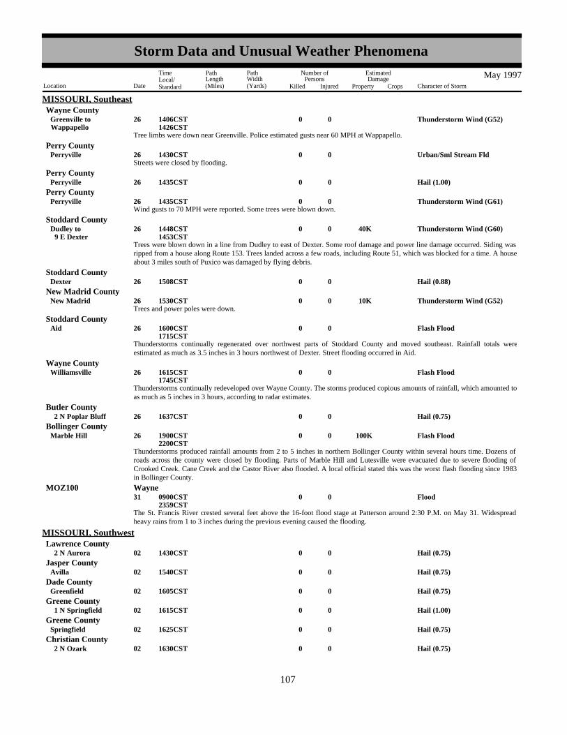
MISSOURI, SoutheastWayne County
Tree limbs were down near Greenville. Police estimated gusts near 60 MPH at Wappapello.
Thunderstorm Wind (G52)0026WappapelloGreenville to 1406CST
1426CST
Streets were closed by flooding.Urban/Sml Stream Fld0026Perryville 1430CST
Perry County
Hail (1.00)0026Perryville 1435CSTPerry County
Wind gusts to 70 MPH were reported. Some trees were blown down.Thunderstorm Wind (G61)0026Perryville 1435CST
Perry County
Trees were blown down in a line from Dudley to east of Dexter. Some roof damage and power line damage occurred. Siding wasripped from a house along Route 153. Trees landed across a few roads, including Route 51, which was blocked for a time. A houseabout 3 miles south of Puxico was damaged by flying debris.
Thunderstorm Wind (G60) 40K0026 9 E DexterDudley to 1448CST
1453CST
Stoddard County
Hail (0.88)0026Dexter 1508CSTStoddard County
Trees and power poles were down.Thunderstorm Wind (G52) 10K0026New Madrid 1530CST
New Madrid County
Thunderstorms continually regenerated over northwest parts of Stoddard County and moved southeast. Rainfall totals wereestimated as much as 3.5 inches in 3 hours northwest of Dexter. Street flooding occurred in Aid.
Flash Flood0026Aid 1600CST1715CST
Stoddard County
Thunderstorms continually redeveloped over Wayne County. The storms produced copious amounts of rainfall, which amounted toas much as 5 inches in 3 hours, according to radar estimates.
Flash Flood0026Williamsville 1615CST1745CST
Wayne County
Hail (0.75)0026 2 N Poplar Bluff 1637CSTButler County
Thunderstorms produced rainfall amounts from 2 to 5 inches in northern Bollinger County within several hours time. Dozens ofroads across the county were closed by flooding. Parts of Marble Hill and Lutesville were evacuated due to severe flooding ofCrooked Creek. Cane Creek and the Castor River also flooded. A local official stated this was the worst flash flooding since 1983in Bollinger County.
Flash Flood 100K0026Marble Hill 1900CST2200CST
Bollinger County
The St. Francis River crested several feet above the 16-foot flood stage at Patterson around 2:30 P.M. on May 31. Widespreadheavy rains from 1 to 3 inches during the previous evening caused the flooding.
Flood0031 0900CST2359CST
MOZ100 Wayne
Hail (0.75)0002 2 N Aurora 1430CST
MISSOURI, SouthwestLawrence County
Hail (0.75)0002Avilla 1540CSTJasper County
Hail (0.75)0002Greenfield 1605CSTDade County
Hail (1.00)0002 1 N Springfield 1615CSTGreene County
Hail (0.75)0002Springfield 1625CSTGreene County
Hail (0.75)0002 2 N Ozark 1630CSTChristian County
99107
Storm Data and Unusual Weather Phenomena
Location Date Character of Storm
TimeLocal/Standard
PathLength(Miles)
PathWidth(Yards)
Number ofPersons
Killed Injured
EstimatedDamage
Property Crops
May 1997

MISSOURI, SouthwestDallas County
Hail (0.75)0002Long Lane 1640CST
Hail (0.75)0002Sparta 1645CSTChristian County
Hail (0.75)0002 1 N Elkhead 1700CSTChristian County
Hail (0.75)0002Vichy 1742CSTMaries County
Hail (0.88)0002Appleton City 1906CSTSt. Clair County
Hail (0.75)0013Irwin 2035CSTBarton County
Hail (1.75)00013 9 NE Greenfield 5K2105CSTDade County
Large hail caused damage to wheat crop.
Thunderstorm Wind (G55)0013Strafford 2120CSTGreene County
Hail (0.75)0013Grovespring 2140CSTWright County
Hail (1.00)0013Rogersville 2147CSTWebster County
Hail (0.75)0017Lincoln 1920CSTBenton County
Hail (1.75)0017 5 N Warsaw 1938CSTBenton County
Hail (1.75)00017Rolla 02000CSTPhelps County
Hail (0.75)0017 2 W Warsaw 2016CSTBenton County
Hail (1.00)0017Iberia 2017CSTMiller County
Hail (0.75)0017Warsaw 2045CSTBenton County
Flash Flood 10K0017 5 N Warsaw 02100CST2200CST
Benton County
Rainfall of up to 3 inches in less than two hours caused flash flooding across the central sections of the county. Highway 65 wasclosed in three places between Warsaw and Lincoln. State Highways BB and T were closed temporarily with numerous othersecondary roads under water. One truck was washed off a low water bridge, but no injuries were reported. Civil Defense directorreported some road and bridge damage.
Hail (1.75)00017Hancock 02110CSTPulaski County
Hail (0.75)0017Rolla 2115CSTPhelps County
Hail (0.75)0017 5 S Vienna 2125CSTMaries County
Hail (1.75) 5K0017Dixon 02140CSTPulaski County
Flash Flood00017Rolla 02200CSTPhelps County
Rainfall of up to 3 inches caused widespread street flooding in Rolla.
Hail (0.75)0017 5 SE Warsaw 2245CSTBenton County
100108
Storm Data and Unusual Weather Phenomena
Location Date Character of Storm
TimeLocal/Standard
PathLength(Miles)
PathWidth(Yards)
Number ofPersons
Killed Injured
EstimatedDamage
Property Crops
May 1997

MISSOURI, SouthwestMiller County
Hail (0.88)0025Eldon 1645CST
Thunderstorm Wind 15K0025Fristoe 02223CSTBenton County
Thunderstorm winds demolished a pole barn and downed trees.
Thunderstorm Wind (G55)0025Horton 2230CSTVernon County
Tornado (F0)0.50K0 2 0.1 025 6 S Appleton City 02320CSTSt. Clair County
A brief tornado touchdown occurred 6 miles south of Appleton City, just south of Highway P near the Bates County line. The onlydamage noted was to an old barn, which sustained roof damage.
Hail (1.00)0026Osceola 0015CSTSt. Clair County
Flash Flood0026Vista 0042CSTSt. Clair County
Heavy rains caused flooding of low water crossings along Highway V.
Flash Flood00 2 26 4 N Tuscumbia 00250CSTMiller County
A flash flood along the Saline Creek swept away 2 girls while they were camping along the creek. F5CA, F9CA
Hail (1.75)00026 2 S Joplin 01740CSTNewton County
Hail (2.75) 3K0026Crane 01746CSTStone County
Hail (1.00)0026Billings 1755CSTChristian County
Hail (0.75)0026Duenweg 1801CSTJasper County
Hail (1.75)00026Theodosia 01821CSTOzark County
Hail (0.75)0026Nixa 1831CSTChristian County
Hail (0.75)0026Riverton 1857CSTOregon County
Hail (0.88)0026Springfield 1909CSTGreene County
Hail (0.75)0026 7 W Sarcoxie 1930CSTJasper County
Hail (0.88)0026Wasola 1930CSTOzark County
Hail (1.00)0026Taneyville 2005CSTTaney County
Hail (2.50) 10K0026Springfield 02008CSTGreene County
Large hail was reported at the eastern and southeastern edge of the city. Cars at a dealership along Highway 65 were dented by thehail.
Hail (2.50)00026Sterling 02046CSTHowell County
Hail (2.50) 10K0026Cabool 02046CSTTexas County
Large hail knocked out windshields at a Truck Stop along Highway 60.
101109
Storm Data and Unusual Weather Phenomena
Location Date Character of Storm
TimeLocal/Standard
PathLength(Miles)
PathWidth(Yards)
Number ofPersons
Killed Injured
EstimatedDamage
Property Crops
May 1997

MISSOURI, SouthwestOregon County
Hail (1.00)0026 2 W Thayer 2050CST
Thunderstorm Wind 5K0026Stark City 5K2100CSTNewton County
Thunderstorm winds downed numerous trees and blew roof off a porch in Stark City. Tree limbs were also down in Newtonia anda 20 acres oat field was flattened.
Tornado (F0) 5K0200 4 026 6 ENE Powell 3 NE Powell to 02113CST
2115CST
Mcdonald County
A tornado touchdown occurred in a rural area uprooting numerous trees. One tree destroyed a outbuilding.
Hail (1.75)00026Anderson 02122CSTMcdonald County
Thunderstorm Wind00026Purdy 02155CSTBarry County
Thunderstorm winds downed numerous trees.
Flash Flood 10K0026Neosho 02200CSTNewton County
Heavy rainfall of up to 3 inches in one hour caused widespread flash flooding throughout the city. Many city streets becameimpassable and some vehicles from a car lot floated into a ditch.
Thunderstorm Wind0026Mc Dowell 2204CSTBarry County
Thunderstorm winds downed numerous trees.
Hail (0.75)0026Theodosia 2212CSTOzark County
Flash Flood00026 10 S West Plains 02230CSTHowell County
Heavy rains of up to 3 inches in three hours caused flooding of Highway 17, south of town.
Flash Flood00026Elijah 02330CSTOzark County
Heavy rainfall caused flooding of low water crossings along Highway H.
Flash Flood00030Waco 00700CSTJasper County
Rainfall of up to 2 inches in less than two hours caused rapid rises along area creeks and caused some street flooding.
Hail00030Neosho 00800CSTNewton County
Rainfall of up to 2 inches fell on saturated ground resulting in street flooding.
Flash Flood00030Springfield 00920CSTGreene County
Over an inch of rain in less than one hour caused urban flooding in the city. Numerous streets and low spots were flooded withwater up to the curb in many cases. One vehicle got stranded in high water and its occupants rescued.
Flash Flood00030 6 NW Fordland 01040CSTWebster County
Heavy rains caused flooding of low water crossings between Fordland and Marshfield.
Flash Flood0030Lebanon 1100CSTLaclede County
102110
Storm Data and Unusual Weather Phenomena
Location Date Character of Storm
TimeLocal/Standard
PathLength(Miles)
PathWidth(Yards)
Number ofPersons
Killed Injured
EstimatedDamage
Property Crops
May 1997

MISSOURI, SouthwestRainfall of up to two inches caused flooding of low water crossings along Highway 32.
Texas CountyFlash Flood00030Raymondville 01130CST
Rainfall of up to 2 inches in less than two hours caused flooding of low water crossings along Highway B, east of town.
Flash Flood00030 5 S Grovespring 01130CSTWright County
Heavy rains caused flooding of low water crossings throughout northwest Wright county.
Flash Flood00030Alley Spring 01420CSTShannon County
Rainfall of up to 3 inches in less than two hours caused rapid rises along rivers and creeks in the county. The National ParkService Ranger Station at Alley Spring was flooded.
Hail00030Montauk 01530CSTDent County
Rainfall of up to 3 inches caused rapid rises along the Current River and Pigeon Creek near Montauk State Park. Low watercrossings were also flooded.
Hail (0.75)0007Great Falls 1800MST
MONTANA, CentralCascade County
National Weather Service employee reported 7/8 inch hail at his residence.
Thunderstorm Wind (G63)0031Winifred 1425MSTFergus County
Thunderstorm Wind (G60)0031Roy 1613MSTFergus County
Thunderstorm Wind (G54)0031Cutbank 1900MSTGlacier County
Thunderstorm Wind (G51)0031Shelby 1910MSTToole County
Thunderstorm Wind (G52)0031Valier 1915MSTPondera County
Late Freeze0019 10 N Sidney 0600MST0800MST
MONTANA, EastRichland County
A hard late season freeze took a toll on sugar beets. Temperatures dipped down to 20 to 25 degrees. An early estimate on thenumber of acres lost ranged between 3500 to 8000 acres.
High Wind0004 1320MST1330MST
MONTANA, SouthMTZ032 Custer
boat was blown into a shed, railroad crossing arm was broken, and several buildings had shingles blown off in miles city.
Hail0006 10 S Rosebud 1630MST1645MST
Rosebud County
law enforement official reported 3/4 inch hail 10 miles south of miles city.
Urban/Sml Stream Fld0021 20 S Roundup 1715MSTMusselshell County
numerous reports of small stream flooding south of roundup.
Urban/Sml Stream Fld0021 10 W Reed Pt 1755MST1820MST
Stillwater County
small stream flooding into low lying areas west of ryegate
103111
Storm Data and Unusual Weather Phenomena
Location Date Character of Storm
TimeLocal/Standard
PathLength(Miles)
PathWidth(Yards)
Number ofPersons
Killed Injured
EstimatedDamage
Property Crops
May 1997
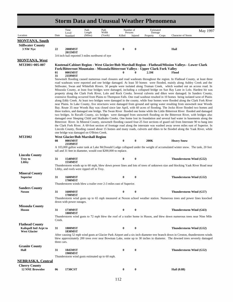
MONTANA, SouthStillwater County
Hail0022 3 NW Nye 2008MST2015MST
3/4 inch hail reported 3 miles northwest of nye
Flood 2.3M000131
0001MST2359MST
MONTANA, WestMTZ001>005-007 Kootenai/Cabinet Region - West Glacier/Bob Marshall Region - Flathead/Mission Valleys - Lower Clark
Fork/Bitterroot Mountains - Missoula/Bitterroot Valleys - Upper Clark Fork Valley
Snowmelt flooding caused numerous road closures and road washouts throughout the region. In Flathead County, at least threeroad washouts were reported and one bridge damaged. At least 50 homes were flooded, mainly along Ashley Creek and theStillwater, Swan and Whitefish Rivers. 50 people were isolated along Truman Creek, which washed out an access road. InMissoula County, at least four bridges were damaged, including a collapsed bridge on Sun Ray Lane in Lolo. Hardest hit wasproperty along the Clark Fork River, Lolo and Rock Creeks. Several culverts and dikes were damaged. In Sanders County,extensive flooding occurred from Plains to Thompson Falls. One road washout resulted in 10 homes being isolated west of Plainsalong Eddy Creek. At least two bridges were damaged in the county, while four homes were flooded along the Clark Fork Rivernear Plains. In Lake County, five structures were damaged from ground and spring water resulting from snowmelt near WoodsBay. Route 35 near Woods Bay was closed since late April, with 60 acres of flooding. The Jocko River flooded two homes andthree trailers, and damaged one bridge. The Swan River flooded one home while the Little Bitterroot River flooded and damagedtwo bridges. In Ravalli County, six bridges were damaged from snowmelt flooding on the Bitterroot River, with bridges alsodamaged over Sleeping Child and Skalkaho Creeks. One home lost its foundation and several had water in basements along theBitterroot River. In Mineral County, snowmelt flooding caused four-25 foot sections of guard rail from Interstate 90 to hang intothe Clark Fork River. A 60-foot section of frontage road along the interstate was washed away seven miles east of Superior. InLincoln County, flooding caused about 15 homes and many roads, culverts and dikes to be flooded along the Yaak River, whileone bridge was damaged on O'Brien Creek.
A 103,000 gallon water tank at Lake McDonald Lodge collapsed under the weight of accumulated winter snow. The tank, 20 feettall and 31 feet in diameter, would cost $200,000 to replace.
Heavy Snow 200K0008 0001MST2359MST
MTZ002 West Glacier/Bob Marshall Region
Thunderstorm Wind (G52)0031LibbyTroy to 1540MST
1550MST
Lincoln County
Thunderstorm winds up to 60 mph, blew down power lines and lots of trees of unknown size and blocking Yaak River Road nearLibby, and roofs were ripped off in Troy.
Thunderstorm Wind (G52)0031Superior 1600MST1700MST
Mineral County
Thunderstorm winds blew a trailer over 2-3 miles east of Superior.
Thunderstorm wind gusts up to 65 mph measured at Noxon school weather station. Numerous trees and power lines knockeddown with power outages.
Thunderstorm Wind (G57)0031Noxon 1600MST1700MST
Sanders County
Thunderstorm Wind (G63)0031Huson 1730MST1800MST
Missoula County
Thunderstorm wind gusts to 72 mph blew the roof of a trailer home in Huson, and blew down numerous trees near Nine MileCreek.
Thunderstorm Wind (G52)0031West GlacierKalispell Intl Arpt to 1800MST
1830MST
Flathead County
After causing 52 mph wind gusts at Glacier Park Airport and a six inch diameter tree branch down in Creston, thunderstorm windsblew approximately 200 trees over near Bowman Lake, some up to 30 inches in diameter. The downed trees severely damagedthree cars.
Thunderstorm wind gusts estimated up to 60 mph.
Thunderstorm Wind (G52)0031Hall 1845MST1900MST
Granite County
Hail (0.88)0006 12 NNE Brownlee 1730CST
NEBRASKA, CentralCherry County
104112
Storm Data and Unusual Weather Phenomena
Location Date Character of Storm
TimeLocal/Standard
PathLength(Miles)
PathWidth(Yards)
Number ofPersons
Killed Injured
EstimatedDamage
Property Crops
May 1997

NEBRASKA, CentralBrown County
Hail (1.75)0006 26 SW Ainsworth 1830CST1915CST
Hail (1.25)0006 11 NNW Brewster 1930CSTBlaine County
Hail (1.25)0006Almeria 2030CSTLoup County
Hail (0.88)0006Comstock 2115CSTCuster County
Hail (0.75)0016 1 N Gordon 1421CSTSheridan County
Hail (1.00)0017 22 NNW O Neill 1730CSTHolt County
Flood000103
0000CST1200CST
NEBRASKA, EastNEZ045 Washington
Flooding along the Missouri river continued as a result of snowmelt runoff over the northern plains and subsequent high releasesfrom upstream dams.
Flood000120
0000CST1200CST
NEZ052 Douglas
Flooding along the Missouri river continued as the result of snowmelt runoff from the northern plains and subsequent high releasesfrom upstream dams.
Flood000131
0000CST2359CST
NEZ053-067>068-091-093
Sarpy - Cass - Otoe - Nemaha - Richardson
Flooding along the Missouri river continued as a result of snowmelt runoff from the northern plains and subsequent high releasesfrom upstream dams.
Hail (1.00)0007 8 W (Oma)Eppley FldOmah
1410CSTDouglas County
At the corner of 90TH and BLONDO.
Hail (1.75)0007Bellevue 1504CSTSarpy County
At the corner of 48TH and GILES Roads.
Tornado (F0)00 20 1.2 007 1 E Hallam 1 WNW Hallam to 1508CST
1512CST
Lancaster County
Funnel Cloud0007 1.5 W Cortland 1510CSTGage County
Tornado (F0)00 20 1.8 007 .5 ESE Hallam 1 WSW Hallam to 1512CST
1514CST
Lancaster County
Hail (1.00)0007 5 SE Auburn 1513CSTNemaha County
Thunderstorm Wind 4K0007 5 SE Auburn 1513CSTNemaha County
Thunderstorm winds blew a window out of a shop and part of a roof off a shed.
Tornado (F0)00 20 2 007 1 WNW Cortland 3 WNW Cortland to 1514CST
1515CST
Gage County
Hail (1.50)0007 1 S Sprague 1517CSTLancaster County
Hail (1.00)0007Hickman 1520CSTLancaster County
105113
Storm Data and Unusual Weather Phenomena
Location Date Character of Storm
TimeLocal/Standard
PathLength(Miles)
PathWidth(Yards)
Number ofPersons
Killed Injured
EstimatedDamage
Property Crops
May 1997

NEBRASKA, EastGage County
Funnel Cloud0007 1 NW Clatonia 1520CST
Tornado (F1) 300K0100 4 007 3 ESE Princeton 2 WNW Princeton to 1520CST
1528CST
Lancaster County
Seven to ten homes in Princeton sustained roof damage and one hone had metal siding stripped off. Numerous trees were blowndown near Princeton. Many windows were broken out from businesses and homes.
Tornado (F0)00 20 2.5 007 1 E Firth 3 N Firth to 1531CST
1536CST
Lancaster County
Extreme Cold0013 0100CST0800CST
NEZ011>012-015>018-030>034-042>045-050>053-065>068-078-088>093
Knox - Cedar - Thurston - Antelope - Pierce - Wayne - Boone - Madison - Stanton - Cuming - Burt - Platte -Colfax - Dodge - Washington - Butler - Saunders - Douglas - Sarpy - Seward - Lancaster - Cass - Otoe -Saline - Jefferson - Gage - Johnson - Nemaha - Pawnee - Richardson
A record breaking late season cold snap generated the latest spring freeze on record over portions of eastern Nebraska astemperatures dipped into the 26-32F degree range. Some minor crop and fruit tree damage resulted from the cold temperatures.This was especially true in low lying areas since the cold air tended to drain into those areas. Damage was generally minor asmany of the plants had just begun to emerge and were not particularly succeptible to the cold.
Hail (0.88)0016Barneston 1643CSTGage County
Hail (1.00)0017 6 N Falls City 2045CSTRichardson County
NONE REPORTED.
NEBRASKA, Extreme Northeast
NONE REPORTED.
NEBRASKA, Extreme Southwest
Hail (0.75)00006Loup City 02155CST
NEBRASKA, South CentralSherman County
Severe thunderstorms rolled across parts of south central Nebraska during the late evening. Funnel clouds were observed nearLoup City while hail covered the ground west of Dannebrog with the storms passage.
Hail (0.75)00006 5 W Dannebrog 02300CSTHoward County
An isolated thunderstorm produced a dry microburst south of Henderson. The resulting wind partially damaged an irrigation pivotwhich was running at the time.
Dry Microburst 10K0017 2 S Henderson 01820CSTYork County
The weight from near 3 inches of rain over 3 days may have contributed to the collapse of an already weakened theatre roof indowntown Ravenna. The building was used for storage and contained 5 cars, washing machines and old toys at the time of thecollapse.
Heavy Rain 60K0027Ravenna 01400CSTBuffalo County
A weak tornado touched down briefly over open rangeland.
Tornado (F0)00 10 0.1 024 8 NW Kimball 01840MST1842MST
NEBRASKA, WestKimball County
Ping Pong ball sized hail fell in southwest Kimball County.
Hail (1.50) 10K0024 10 SW Kimball 18 SW Kimball to 30K1845MST
1900MST
Kimball County
106114
Storm Data and Unusual Weather Phenomena
Location Date Character of Storm
TimeLocal/Standard
PathLength(Miles)
PathWidth(Yards)
Number ofPersons
Killed Injured
EstimatedDamage
Property Crops
May 1997

NEBRASKA, WestKimball County
A series of thunderstorms produced in excess of 7.5 inches of rain over parts of western Kimball County during a 5-hour timeframe. Flooding occurred along Lodgepole Creek from Bushnell east to the county line.
Flash Flood 1M002425 6 E Dix
Bushnell to 500K1900MST0330MST
A second storm dumped Ping Pong ball sized hail and very heavy rain within 2 miles of the location that received 1.5 inch hail anhour earlier.
Hail (1.50) 10K0024 10 SW Kimball 15 SW Kimball to 20K1915MST
1930MST
Kimball County
Widespread flooding occurred along Lodgepole Creek and Sand Draw from heavy rains upstream in Kimball County. A 7 footwall of water washed out a 30 foot section of a bridge on U.S. Highway 30 at Potter at 430 am MST.
Flood 2M002526Lodgepole
3 W Potter to 500K0330MST1200MST
Cheyenne County
A large area of western Kimball County received in excess of 5 inches of rain in less than 5 hours, with the remainder of thecounty and western Cheyenne County averaging more than 2 inches. The maximum rainfall reported was 7. 5 inches in thesouthwest corner of the county. Cropland flooding was widespread throughout both counties, and Lodgepole Creek spilled out ofits banks from Bushnell in western Kimball County to Lodgepole in extreme eastern Cheyenne County, affecting severalcommunities. Two bridges were washed out along Lodgepole Creek--one on a county road north of Dix in eastern KimballCounty, and the second on Highway 30 outside of Potter in western Cheyenne County. While flood waters were reported inBushnell and Lodgepole, the most severe occurred in Potter, where 4 feet of water inundated numerous homes and businesses,washing away a dozen large propane tanks and washing out 30 feet of Union Pacific Railroad track serving as a dike on LodgepoleCreek. Numerous county roads in both counties were damaged or washed out, and more than 80 miles of farmland alongLodgepole Creek and Sand Draw were covered with several feet of flood water.
NONE REPORTED.
NEVADA, North
Wild/Forest Fire0013 30 NW Las Vegas 1430PST
NEVADA, SouthClark County
Lightning sparked a fire on the west side of the Spring Mountain Range near Wheeler Well. The fire burned approximately 75acres of the Toiyabe National Forest before it was contained.
A man was struck by lightning while walking in Idlewild Park in Reno, NV. He was injured and taken to the hospital fortreatment.
Lightning 1 011Reno 1629PST1630PST
NEVADA, WestWashoe County
Record Snowfall000131
0000EST2359EST
NEW HAMPSHIRE, North and CentralNHZ002 Southern Coos
Record snowfall occurred atop Mount Washington during the month of May. Snowfall for the month totalled 95.8 inches, whichcompares to a normal May snowfall of 10.3 inches. The previous record May snowfall was 52.2 inches, set in 1967. The summitalso set a record for total precipitation for the month. The summit received 19.00 inches of precipitation (liquid equivalent)compared to a normal precipitation of 7.51 inches. The old record of 18.82 inches was set in 1984.
Winter Storm0007 0300EST2200EST
NHZ001 Northern Coos
Rain changed to snow across northern Coos county after a low pressure center moved across the area and strong northwesterlywinds brought in colder air. Snow continued throughout much of the day as upslope winds continued. Generally, snowfallamounts were in the 6 to 10 inch range across northern Coos county with little or no accumulation elsewhere in the state.
Hail (0.75)0015Henniker 1440ESTMerrimack County
A severe thunderstorm moving northeastward through New Hampshire dropped hail in southern and central parts of the state withpenny-sized hail reported in Henniker in Merrimack County. Lightning and/or the resultant fires damaged several homes in thestate.
Thunderstorm Wind (G59)0001Alstead 1835EST
NEW HAMPSHIRE, SouthernCheshire County
107115
Storm Data and Unusual Weather Phenomena
Location Date Character of Storm
TimeLocal/Standard
PathLength(Miles)
PathWidth(Yards)
Number ofPersons
Killed Injured
EstimatedDamage
Property Crops
May 1997

NEW HAMPSHIRE, SouthernA severe thunderstorm produced a wind gust to 69 mph, as reported by the local police in Alstead. There were no reports ofdamage.
NEW JERSEY, NortheastEssex County
Thunderstorm Wind (G50)0001Nutley 1816EST
Thunderstorm Wind (G50)0001Clifton 1816ESTPassaic County
A line of scattered severe thunderstorms developed ahead of a cold front extending from New England south across the Carolinas.
Thunderstorms produced high winds that knocked down trees in both Clifton and Nutley.
Thunderstorm Wind (G50)0006Caldwell 1205ESTEssex County
Thunderstorm Wind (G50)0006Cranford 1215ESTUnion County
Thunderstorm Wind (G50)0006North ArlingtonRutherford to 1222EST
Bergen County
Thunderstorm Wind (G50)0006UnionMurray Hill to 1222EST
Union County
Funnel Cloud0006Winfield 1225ESTUnion County
Hail (0.88)0006Paramus 1230ESTBergen County
Thunderstorm Wind (G50)0006Clifton 1231ESTPassaic County
Thunderstorm Wind (G50)0006Newark 1235ESTEssex County
Thunderstorm Wind (G51)0006Jersey City 1238ESTHudson County
A line of severe thunderstorms raced across the area early Tuesday afternoon. It produced high winds that caused scattereddamage to several locations. High winds downed several trees and power lines across the area. The heaviest damage was inJersey City (and on Staten Island, NY).
A survey was conducted in Jersey City later Tuesday afternoon. It was determined that damage was caused by high winds blowingfrom the same direction (straight-line winds) along the leading edge of the line of thunderstorms. Damage occurred in threeseparate areas, in line with the movement of this squall line. Eyewitnesses stated they saw a black cloud advancing toward thembefore the occurrence of rain, thunder, and lightning. When this cloud arrived, winds drastically increased and damage occurred inless than one minute. High winds blew roofs of houses, downed several trees, and caused a 2000 pound trailer to roll over. Windspeeds were estimated from 90 to 100 mph. Reports of funnel clouds were received, but these were "gustnadoes" associated withthe strong gust front.
Thunderstorm Wind (G52)0019Paterson 2125ESTPassaic County
Thunderstorm Wind (G50)0019Saddle River 2140ESTBergen County
A line of scattered severe thunderstorms moved east at 50 mph across the area. It caused high winds, that downed trees in SaddleRiver. Thunderstorms also produced small hail and heavy rain.
Hail (0.88)0001Bedminster 1700EST
NEW JERSEY, South and NorthwestSomerset County
Hail (0.75)0001Somerdale 1735ESTCamden County
108116
Storm Data and Unusual Weather Phenomena
Location Date Character of Storm
TimeLocal/Standard
PathLength(Miles)
PathWidth(Yards)
Number ofPersons
Killed Injured
EstimatedDamage
Property Crops
May 1997

NEW JERSEY, South and NorthwestCamden County
Hail (0.75)0001Berlin 1745EST
Hail (1.00)0001Mt LaurelBurlington to 01745EST
1755EST
Burlington County
A severe thunderstorm produced a very wide swath of penny to quarter size hail from Burlington City south through Willingboro,Westampton and Mount Laurel. In Mount Laurel, the hail covered grassy areas and accumulated to around six inches near houses'downspouts.
Hail (0.75)0001 2 S Pennington 01745ESTMercer County
Thunderstorm Wind0001Pennington 01745ESTMercer County
A severe thunderstorm sheared off several trees in Pennington. The fallen limbs damaged several roofs and vehicles. Thedamaging winds also knocked over the goal posts on a soccer field. Also, dime size hail fell between Trenton and Penningtonduring the same thunderstorm.
Thunderstorm Wind0001Union Beach 01810ESTMonmouth County
Numerous trees were uprooted in both Hazlet and Union Beach by a severe thunderstorm.
Lightning0 1 01Tinton Falls 1825ESTMonmouth County
An adult male was killed while driving southbound on Hockkockson Road in Tinton Falls when lightning struck a tree and sliced itin half. The tree fell down and crushed the vehicle he was driving. M?VE
Thunderstorm Wind (G50)0001Lakehurst 1827ESTOcean County
Hail (0.75)0001Neptune 1830ESTMonmouth County
Thunderstorm Wind 11 006Branchville 01130ESTSussex County
A severe thunderstorm blew over several huge tents at a dog show near Northrup in Frankford Township. Eleven persons wereinjured, most with minor bruises. Several cars were also damaged when struck by the flying tents, stakes and debris.
Thunderstorm Wind0006Basking Ridge 01145ESTSomerset County
A severe thunderstorm knocked over several trees and wires in Bernards Township in Basking Ridge.
Thunderstorm Wind0006RingoesFlemington to 01145EST
Hunterdon County
A severe thunderstorm knocked down several trees and electrical, telephone and cable wires and closed a road within Flemington.It also knocked over numerous trees in Ringoes.
Thunderstorm Wind0006East HanoverSchooleys Mtn to 01150EST
1230EST
Morris County
Severe thunderstorms produced wind damage in a number of townships across Morris County, mainly across the southerntwo-thirds of the county. About 4,500 homes and businesses lost power, a quarter of them occurred in the Denville and MountainLakes areas. Nearly 2,000 GPU customers were still without power as of 10 p.m. EDT. Numerous trees and power lines wereknocked down. Over 30 trees were knocked down in East Hanover Township in the Lincoln Street area alone. In MountainLakes, a woman narrowly escaped serious injury when a tree fell on her vehicle and it burst into flames. A tree fell through theroof of a house in Mount Olive Township. Another tree fell on a garage and damaged the corner of a Florham Park Boroughhouse. Other hard hit municipalities included Boonton, Randolph, Rockaway, Washington and Wharton.
Thunderstorm Wind0006North Plainfield 01205ESTSomerset County
A severe thunderstorm knocked over a few trees in North Plainfield.
Thunderstorm Wind (G62)0006 1 S Marlton 01220ESTBurlington County
Along with the 71 mph severe thunderstorm gust, a SKYWARN spotter reported marble size hail.
Lightning struck a Rock Ridge Home in Boonton Township and blew up its television and VCR. Lightning 1K0006Boonton 1230EST
Morris County
Thunderstorm 1 006East Brunswick 1240ESTMiddlesex County
109117
Storm Data and Unusual Weather Phenomena
Location Date Character of Storm
TimeLocal/Standard
PathLength(Miles)
PathWidth(Yards)
Number ofPersons
Killed Injured
EstimatedDamage
Property Crops
May 1997

NEW JERSEY, South and NorthwestA 66-year-old golfer was injured in East Brunswick when a falling tree limb struck him during a thunderstorm.
Middlesex CountyThunderstorm Wind0006Woodbridge 01245EST
A severe thunderstorm peeled an aluminum roof from one house in Woodbridge and damaged some homes in the Ideal TrailerPark. It also knocked over several trees and headstones in a cemetery. In South Plainfield, the same thunderstorm blew aheating/ventilation/air conditioning unit off an abandoned building.
Thunderstorm0006 2 N Keansburg 01300ESTMonmouth County
A thunderstorm capsized a boat in Raritan Bay north of Keansburg. The one person in the boat was rescued.
Thunderstorm Wind0019LafayetteStillwater to 02030EST
2040EST
Sussex County
Severe thunderstorms caused wind damage in the southwest and central parts of Sussex County. Uprooted trees fell on homes inFredon and Stillwater. But, the worst damage occurred along the Frankford/Lafayette Township lines where numerous trees weredowned. About 1,600 homes lost power, mainly in the southeast part of the county. Also a large section of the county's JuvenileDetention Center fencing was blown down.
Thunderstorm Wind0019Anthony 02050ESTHunterdon County
A severe thunderstorm pulled down wires and trees along Anthony and Pleasant Grove Roads in the northern part of LebanonTownship.
Thunderstorm Wind (G61)0019Chatham 2115ESTMorris County
A severe thunderstorm caused wind gusts of 70 mph and 63 mph in separate parts of Chatham Township. Downed wires causedpower outages to about 300 homes.
Heavy Rain0025Countywide 0600EST2100EST
Hunterdon County
Heavy Rain0025Countywide 0600EST2100EST
Middlesex County
Heavy Rain0025Countywide 0600EST2100EST
Monmouth County
Heavy Rain0025Countywide 0600EST2100EST
Somerset County
Heavy Rain0025Countywide 0700EST2200EST
Burlington County
Heavy Rain0025Countywide 0700EST2200EST
Camden County
Heavy Rain0025Countywide 0700EST2200EST
Gloucester County
Heavy Rain0025Countywide 0700EST2200EST
Mercer County
Heavy Rain0025Countywide 0700EST2200EST
Ocean County
Heavy Rain002526
Countywide 0900EST0100EST
Salem County
Heavy Rain002526
Countywide 1300EST0300EST
Atlantic County
Heavy Rain002526
Countywide 1300EST0300EST
Cumberland County
110118
Storm Data and Unusual Weather Phenomena
Location Date Character of Storm
TimeLocal/Standard
PathLength(Miles)
PathWidth(Yards)
Number ofPersons
Killed Injured
EstimatedDamage
Property Crops
May 1997

NEW JERSEY, South and NorthwestCape May County
Heavy Rain002526
Countywide 1400EST0400EST
A series of low pressure systems traveling west to east along a nearly stationary frontal boundary produced some locally heavy rainacross central and southern New Jersey from the daylight on the 25th through the early morning of the 26th. The heaviest rainaffected the central part of the state during the afternoon of the 25th, the southwest part of the state during the evening of the 25thand the southeast part of the state around midnight on the 26th. Storm totals averaged 1 to 2.5 inches, with some locally higheramounts. This caused the usual poor drainage flooding problems. Representative totals included 2.66 inches in Freehold(Monmouth County), 2.60 inches at McGuire AFB (Burlington County), 2.34 inches in Hightstown (Mercer County), 2.04 inchesin Pennsauken (Camden County), 1.99 inches in Wertsville (Hunterdon County), 1.92 inches in New Brunswick (MiddlesexCounty), 1.91 inches in Harvey Cedars (Ocean County), 1.43 inches at the Atlantic City International Airport and 1.12 inches inVerga (Gloucester County).
Thunderstorm Wind0025Blue BellStar Cross to 01940EST
Gloucester County
A severe thunderstorm pulled down wires in seven locations across southeast Gloucester County.
Unseasonably Cool0031 2359EST
NJZ001-007>010-012>013-015>023
Sussex - Warren - Morris - Hunterdon - Somerset - Middlesex - Western Monmouth - Mercer - Salem -Gloucester - Camden - Burlington - Western Ocean - Cumberland - Western Atlantic - Western Cape May
May 1997 was an unseasonably cool month. For most locations, it was the coolest May since 1967 with monthly departures thataveraged around 3 degrees below normal. Departures along the shore though averaged around 1 degree below normal. At theAtlantic City International Airport in Pomona, the monthly mean temperature of 57.5 degrees was 2.9 degrees below normal andthe 6th coolest May on record. At the nearby Philadelphia International Airport, the monthly mean temperature 59.5 degrees wastied for the 8th coolest May on record and at the Lehigh Valley International Airport, the mean temperature of 55.7 degrees was the2nd coolest May on record.
Nickel hail recorded by NWS observer in city.
Hail (0.88)0006Clovis 1700MST1710MST
NEW MEXICO, Central and NorthCurry County
Hail (0.88)0007Pasamonte 1410MSTUnion County
Dime to quarter hail covering the ground north of Dunlap.Hail (1.00)0008 4 N Dunlap 1335MST
De Baca County
Ham radio spotters reported soft and mushy hail up to 2 inches in diameter.Hail (2.00)0008Clines Corners 1420MST
Torrance County
Hail (0.75)0008Clines Corners 1440MSTTorrance County
Dime to quarter hail covering ground to two inches deep north of Dunlap.Hail (1.00)0008 1 N Dunlap 1545MST
De Baca County
Small tornado reported by Portales Police.Tornado (F0)0 50 0.1 008 12 SW Portales 1702MST
Roosevelt County
Hail (2.00)0008 5 NE Elida 1725MSTRoosevelt County
Rope tornado and 2 inch hail observed by spotters near Elida.
Tornado (F0)0 40 0.3 008 6 NE Elida 5 NE Elida to 1725MST
1730MST
Roosevelt County
Hail (0.75)0008Tucumcari 1715MSTQuay County
Hail (0.75)0015Moriarty 1325MST1335MST
Torrance County
A rancher was struck and instantly killed by lightning northwest of Tres Piedras. The man and his 13 year old son were mendingfence on open range and took shelter from a thunderstorm under isolated, but separate trees. The son was not injured.
Lightning0 1 20 5 NW Tres Piedras 1200MSTRio Arriba County
111119
Storm Data and Unusual Weather Phenomena
Location Date Character of Storm
TimeLocal/Standard
PathLength(Miles)
PathWidth(Yards)
Number ofPersons
Killed Injured
EstimatedDamage
Property Crops
May 1997

NEW MEXICO, Central and NorthM49OU
Quay CountyHail (0.75)0029 15 W Glenrio 1940MST
Hail (0.88)0030Watrous 1701MSTMora County
Funnel Cloud observed over open range north of Santa Rosa by National Weather Service employee traveling along Interstate 40 atCuervo.
Funnel Cloud0030 15 N Santa Rosa 1750MSTGuadalupe County
Dime hail covered the ground to one inch deep.Hail (0.75)0030Cimarron 1752MST
Colfax County
Hail (1.50)0030Santa Rosa 1812MSTGuadalupe County
Hail (1.75)0030Dilia 1825MSTGuadalupe County
Hail (0.75)0030 17 W Santa Rosa 1850MSTGuadalupe County
Hail (1.75)0030Dilia 1855MSTGuadalupe County
Hail (1.75)0030 20 SSW Santa Rosa 1855MSTGuadalupe County
State Police reported marble hail covering Interstate 25 to three inches deep south of Springer.Small Hail0030 4 S Springer 1858MST
Colfax County
Billard ball size hail damaged cars along Highway 60 east of Yeso.Hail (2.50) 30K0030 8 E Yeso 1915MST
De Baca County
Dime hail covered the ground.Hail (0.75)0030 17 W Santa Rosa 1922MST
Guadalupe County
Hail (1.00)0030 15 W Yeso 1925MSTDe Baca County
Hail (2.50)0030 17 S Yeso 1948MSTDe Baca County
Hail (1.00)0030Las Vegas 2004MSTSan Miguel County
Several supercells developed near the Colorado border and moved rapidly southward through the highlands of northeast NewMexico. One cell formed west of Raton and moved south with hail over Cimarron, then continued southward over open range westof Wagon Mound in Mora county and into San Miguel county near Trujillo. This storm continued south through Guadalupe andDe Baca counties with numerous reports of large hail and at least one funnel cloud. The storm finally ended over northern Chavescounty. A second storm formed near Ocate and also moved south with hail at Watrous, Dilia, Pintada, and near Vaughn beforedissipating over northern Lincoln county.
Hail (1.00)0031Tres Piedras 1400MSTTaos County
Hail (0.88)0031Tres Piedras 1632MSTTaos County
Hail (1.00)0031Ocate 1645MST1705MST
Mora County
Hail (0.75)0015Cloudcroft 1140MST1235MST
NEW MEXICO, South Central and SouthwestOtero County
Hail (1.75)0031Organ 1615MST1715MST
Dona Ana County
112120
Storm Data and Unusual Weather Phenomena
Location Date Character of Storm
TimeLocal/Standard
PathLength(Miles)
PathWidth(Yards)
Number ofPersons
Killed Injured
EstimatedDamage
Property Crops
May 1997

NEW MEXICO, SoutheastEddy County
Hail (0.75)0006 23 W Carlsbad 1503MST
Hail (0.75)0006 5 N Whites City 1537MSTEddy County
Carlsbad airport observer reported 70 mph winds.Thunderstorm Wind (G61)0006(Cnm)Carlsbad Arpt 1605MST
Eddy County
Hail (0.75)0006Lovington 1627MSTLea County
Hail (0.75)0006Carlsbad 1659MSTEddy County
Hail (0.75)0006 3 N Hobbs 1710MSTLea County
A strong mesocyclone on the leading edge of the severe thunderstorm moving to the ESE produced a tornado on the southeastflank of the storm. This storm displayed some characteristics of an HP supercell, but with much of the forward flank missing.
Damage ranged from F0 on the southern end (probably from an RFD) to F1 damage in the heart of the tornado path. A damagesurvey discovered a highly convergent pattern to the debris path of the tornado. Damage ranged from travel trailers overturned, tomobile homes pushed from foundation and roof sections missing, to a barn that was levelled and unrecognizable.
Tornado (F1) 60K0200 1 006 6.5 NNW Hobbs 7.2 NNW Hobbs to 1809MST
1813MST
Lea County
With temperatures in the lower 90s in dew points in the upper 50s to lower 60s there was plenty of buoyant energy forthunderstorm development in southeast New Mexico. Also an old frontal boundary was in the area to help focus the activity.Storms moved to the ESE and making for good relative inflow.
A supercell moving to the southeast spawned a tornado about 2 miles north of Tatum. The tornado reportedly came straight intotown, but luckily was very weak. Eyewitnesses said although there was no condensation funnel, the wall cloud above the dust tubeshowed significant rotation. The tornado dissipated on the southeast edge of town.
Tornado (F0)0 60 2.5 008 .5 SE Tatum 2 N Tatum to 1800MST
1810MST
Lea County
A non-supercell storm produced a small tornado in open country northwest of Carlsbad. The storm appeared relatively weak onradar.
Tornado (F0)0 80 2 022 25 NW Carlsbad 1546MST1600MST
Eddy County
This storm moving to the southeast became an HP Supercell as it passed over the city of Hobbs. By the time the storm arrivedover the southern parts of town, hail up to tennis ball size was falling along with strong winds. Most of the trees over the southern1/3 of town were stripped of their leaves, and numerous houses and cars suffered damage. Streets had hail stacked up over onefoot deep in some areas.
This storm moved to the southeast into Texas and continued to produce severe weather in Andrews, Winkler, and Ward Counties.
Hail (2.50) 27M0028 2 S Hobbs 1455MST1520MST
Lea County
The storm that hit Hobbs continued to the southeast with other cells developing on its western flank. One of these cells haddownbursting winds that knocked down 3 utility poles along State Highway 18 north of Eunice. The poles were blown from eastto west.
Thunderstorm Wind 15K0028 5 NNE Eunice 1608MSTLea County
Damage occurred just west of the Hobbs city limit where RFD and tornadic winds were superimposed. The damage included a15x20 ft wooden roof taken off an old shed, parts of two other roofs damaged, an awning from a trailer destroyed, a trailer pushed3-4 feet off its foundation, and two utility poles downed. The tornado was sighted, and a faint trail of it could be traced in thedebris pattern upon inspection, but RFD winds occurred in the area as well with much of the debris blown in a divergent pattern.
Tornado (F0) 20K0 50 0.3 028 4 W Hobbs 1855MST1900MST
Lea County
The storms from this day formed in a northwest flow with a Lifted Index in the -8 to -10 range. Afternoon temperatures were inthe mid 80s with dew points in the upper 50s. The most notable feature of this day was the strong directional shear with low-levelwinds from the ESE at about 20 kt through the lowest 3000 feet and mid to upper-level winds from the northwest at over 40 kt. A
113121
Storm Data and Unusual Weather Phenomena
Location Date Character of Storm
TimeLocal/Standard
PathLength(Miles)
PathWidth(Yards)
Number ofPersons
Killed Injured
EstimatedDamage
Property Crops
May 1997
NEW MEXICO, Southeastweak layer of winds at about 7-10k ft MSL may have kept the environment from producing more (and stronger) supercells.
Lea County
This storm developed along an E-W oriented stationary outflow boundary and moved to the southeast toward Eunice. Beforearriving at Eunice the cell stopped and grew into a large multicell complex that covered much of southern Lea County, Thenorthern part of this area branched off to the east and moved into Eunice.
Hail (1.75)0029Eunice 1748MST
The southern end of the large complex headed toward the southeast toward Jal. The cell that passed over Jal weakened as it cameinto town.
Hail (0.75)0029Jal 1842MSTLea County
Daily synopsis : This event was characterized by a northwest flow aloft and moisture farther west than typically found for thistime in the year. Dew point temperatures were in the lower to mid 60s with temperatures in the lower 90s. An outflow boundarythat had moved through the Lubbock, TX area early in the morning lay across the area from Central Lea County into DawsonCounty, TX.
A line of showers and thunderstorms entered Delaware county between 445 and 500 pm EDT. A cluster of thunderstormsalong this line quickly became severe as it raced across the southern portions of the county shortly after 5 pm. This storm wasresponsible for downing numerous trees and power lines in Hancock around 5 pm and again in Colchester about 515 pm.
Thunderstorm Wind 15K0001ColchesterHancock to 1600EST
1615EST
NEW YORK, CentralDelaware County
The same group of thunderstorms that produced wind damage earlier in Delaware county reintensified to severe levels overnorthern portions of Sullivan county. Strong winds toppled large trees in a plot about a half mile wide and 50 feet long near thetown of Liberty around 605 pm EDT. Nickel sized hail was then reported in Grahamsville at 610 pm.
Tstm Wind/Hail 30K0001GrahamsvilleLiberty to 1705EST
1710EST
Sullivan County
A cluster of thunderstorms became severe near the Delaware river and moved through southern portions of the county,producing scattered wind damage. Trees and wires were downed in Wurtsboro around 1210 pm EDT and in Bloomingburg about1215 pm.
Thunderstorm Wind 15K0006BloomingburgWurtsboro to 1110EST
1115EST
Sullivan County
A thunderstorm quickly became severe over northeastern portions of the county. Widespread wind damage occurred in theFloyd/Westernville/Delta Lake areas around and shortly after 200 pm EDT. Large trees were uprooted and power lines weretoppled in the town of Floyd. In Westernville, more trees were blown down. Near Delta Lake, several trailers and mobile homeswere blown off their anchors and severely damaged.
Thunderstorm Wind 50K0009WesternvilleFloyd to 1300EST
1305EST
Oneida County
A thunderstorm cell became severe along the Delaware river and moved through southern portions of the county. The stormbriefly produced isolated wind damage before weakening. At around 920 pm EDT, large trees and power lines were blown down in the town of Colchester.
Thunderstorm Wind 10K0019Colchester 2020ESTDelaware County
A cluster of thunderstorms became severe over Sullivan county and produced scattered wind damage across northern sectionsof the county. At 925 pm EDT, trees and wires were downed in the town of Shandelee. The storm then moved east and blew down morelarge trees and power lines in the Fallsburgh and Woodbourne areas.
Thunderstorm Wind 25K0019FallsburghShandelee to 2025EST
2045EST
Sullivan County
114122
Storm Data and Unusual Weather Phenomena
Location Date Character of Storm
TimeLocal/Standard
PathLength(Miles)
PathWidth(Yards)
Number ofPersons
Killed Injured
EstimatedDamage
Property Crops
May 1997

NEW YORK, CoastalSuffolk County
Hail (1.00)0001Kings Park 1615EST
Thunderstorm Wind (G50)0001Baldwin 1845ESTNassau County
A line of scattered severe thunderstorms developed ahead of a cold front extending from New England south across the Carolinas.
Thunderstorms produced 1 inch diameter hail in Kings Park and high winds that knocked down large tree limbs and power lines inBaldwin.
Lightning struck a house in Coram at 745pm. The extent of damage was unknown.
Thunderstorm Wind (G50)0006Middletown 1144ESTOrange County
Thunderstorm Wind (G57)0006Newburgh 1210ESTOrange County
Thunderstorm Wind (G50)0006New RochelleMt Vernon to 1229EST
Westchester County
Lightning 2 006Yonkers 1229ESTWestchester County
Funnel Cloud0006Richmond 1230ESTRichmond County
Thunderstorm Wind (G50)0006Richmond 1230ESTRichmond County
Thunderstorm Wind (G50)0006New York 1235ESTNew York County
Thunderstorm Wind (G50) 1 006Bronx 1255ESTBronx County
Thunderstorm Wind (G50)0006East Meadow 1315ESTNassau County
Thunderstorm Wind (G50)0006Bayside 1315ESTQueens County
Thunderstorm Wind (G50)0006Bronx 1321ESTBronx County
Thunderstorm Wind (G50)0006New York 1321ESTNew York County
A line of severe thunderstorms raced across the area early Tuesday afternoon. It produced high winds that caused scattereddamage in several locations. The heaviest damage occurred on Staten Island and in Jersey City, NJ.
A survey was conducted on Staten Island later Tuesday afternoon. It was determined that damage was caused by straight linewinds. A roof was blown off a two family house with damage occurring to several trees and a satellite dish. Eyewitnesses statedthat this damage occurred before the rain arrived from the thunderstorm. A few eyewitnesses reported seeing funnel clouds. Itwas determined that the damage was caused by a strong gust front about 10 miles in advance of the line of thunderstorms. Thefunnel clouds reported were actually small vortices called "gustnadoes." These vortices sometimes accompany strong gust fronts.
Examples of damage include:
For Staten Island: The roof of a car dealership at 1590 Hyland Blvd. partially collapsed and caused damage to some vehicles in theback lot.
For the Bronx: A tree fell onto a house and utility cables at 5932 and 5934 Liebig Street. The roof, windows, gutters, andsidewalks of both homes were damaged.
For Manhattan: The front support wall of a structure located at 327 West 112th Street collapsed.
Two men were struck by lightning while on a roof in Yonkers (Westchester County).
In other areas, thunderstorms produced high winds that downed trees and power lines.
Wind0 1 16 1144ESTNYZ081 Southeast Suffolk
115123
Storm Data and Unusual Weather Phenomena
Location Date Character of Storm
TimeLocal/Standard
PathLength(Miles)
PathWidth(Yards)
Number ofPersons
Killed Injured
EstimatedDamage
Property Crops
May 1997
NEW YORK, Coastal
Strong and gusty winds caused a 38 foot fishing boat to capsize south of Amagansett. It resulted in the death of a 76 year oldfisherman. M76BO
Orange CountyThunderstorm Wind (G50)0019Middletown 2053EST
Thunderstorm Wind (G50)0019Peekskill 2140ESTWestchester County
Thunderstorm Wind (G50)0019Sea Cliff 2152ESTNassau County
A line of scattered severe thunderstorms raced east at around 50 mph across the area. It caused high winds, small hail and heavyrain.
High winds downed wires in Middletown and caused a tree to fall on a house at Blooming Grove in Orange County. High windsalso downed trees in Peekskill (Westchester County) and downed wires in Sea Cliff (Nassau County).
Thunderstorm Wind 4K0001Petersburg 1730EST1800EST
NEW YORK, EastRensselaer County
Thunderstorm Wind 4K0001Schodack Lndg 1730ESTRensselaer County
Thunderstorm Wind 25K0001Menands 1735ESTAlbany County
Hail (1.00) 4K0001Coxsackie 1745ESTGreene County
Hail (0.75)0001Lake Katrine 1745ESTUlster County
Hail (0.75)0001Ghent 1757ESTColumbia County
Thunderstorm Wind 15K0001Ft Edward 1800ESTWashington County
A cold front crossed eastern New York during the afternoon of May 1. This front produced scattered severe thunderstorms acrossAlbany, Rensselaer, Ulster, Greene, Columbia and Washington Counties. At Menands in Albany County, approximately one thirdof the Menands Elementary School gymnasium roof was blown off or damaged. In that local vicinity, aluminium siding was alsoripped from a house and several trees were downed by the damaging winds. At Fort Edward in Washington County, windsdowned several power poles and damaged a roof and chimney.
Thunderstorm Wind 6K0006Fonda 1116ESTMontgomery County
Thunderstorm Wind 1K0006West Milton 1205ESTSaratoga County
Thunderstorm Wind 4K0006Tabasco 1218ESTUlster County
Thunderstorm Wind 15K0006Lake Katrine 1225ESTUlster County
Thunderstorm Wind 8K0006Wappingers Falls 1226ESTDutchess County
Thunderstorm Wind 4K0006Bloomington 1230ESTUlster County
Thunderstorm Wind 1K0006Ballston Spa 1247ESTSaratoga County
Thunderstorm Wind 3K0006Galway 1247ESTSaratoga County
Hail (0.75)0006Ghent 1300ESTColumbia County
A cold front crossed eastern New York during the afternoon hours of May 6. Along the front scattered severe thunderstormsdeveloped across Montgomery, Saratoga, Ulster, Dutchess, Columbia and Washington Counties. At Galway in Saratoga County,
Hail (0.75)0006Hudson Falls 1300ESTWashington County
116124
Storm Data and Unusual Weather Phenomena
Location Date Character of Storm
TimeLocal/Standard
PathLength(Miles)
PathWidth(Yards)
Number ofPersons
Killed Injured
EstimatedDamage
Property Crops
May 1997

NEW YORK, Easta fifty foot pine tree was downed by the wind and part of a roof was blown off a residence. At Lake Katrine in Ulster County,trees were blown over on a house and car. In northern Montgomery County between Fonda and Hagaman, wires were downed bythunderstorm winds. At Wappingers Falls in Dutchess County, a fallen tree landed on a house. The severe thunderstorms inColumbia and Washington Counties produced hail.
An isolated severe thunderstorm at Amsterdam in Montgomery County, downed a tree onto a power line. The power line brokewhich resulted in a power outage for several hours in parts of the city.
Thunderstorm Wind 4K0009Amsterdam 1504ESTMontgomery County
Lightning destroyed a head start classroom and office building on the Warrensburg Elementary School Campus during theafternoon of May 9.
Lightning 20K0009Warrensburg 1600ESTWarren County
Thunderstorm Wind (G54)0019Wallkill 2110ESTUlster County
Thunderstorm Wind 4K0019New Paltz 2130ESTUlster County
Thunderstorm Wind 4K0019Poughkeepsie 2137ESTDutchess County
During the late evening hours of May 19, a cold front initiated several severe thunderstorms across the Mid-Hudson Valley ofeastern New York. Trees were downed by the wind in Ulster and Dutchess Counties. Scattered power outages also occurredwhen trees knocked down several power lines. Approximately 1,000 customers lost power for several hours.
Thunderstorm Wind 2K0019Hyde Park 2140ESTDutchess County
NONE REPORTED.
NEW YORK, North
High Wind (G53) 65K0001 0915EST1248EST
NEW YORK, WestNYZ001-010-019 Niagara - Erie - Chautauqua
Low pressure moving across Ontario brought strong southwest winds to the extreme western counties of New York. The highwinds toppled trees and power lines causing scattered power outages throughout the area. Minor structure damage was caused bythe falling trees in Jamestown, Buffalo and Lockport.
Thunderstorm Wind (G50) 15K0019Panama 1605ESTChautauqua County
Thunderstorm Wind (G50) 23K0019Randolph 1635ESTCattaraugus County
Thunderstorms developed along a lake breeze in the late afternoon hours. The thunderstorms produced damaging winds whichdowned trees and power lines. Heavy rains accompanied the thunderstorms and resulted in poor drainage and urban flooding.
Hail (0.75)0001Franklinton 1435EST
NORTH CAROLINA, CentralFranklin County
DIME SIZE HAIL FELL IN FRANKLINTON AND TREES FELL ON POWER LINES.
Hail (0.75)0001 4 S Thomasville 1437ESTDavidson County
DIME SIZE HAIL FELL FOUR MILES SOUTH OF THOMASVILLE.
Hail (0.75)0001 7 NW Asheboro 1457ESTRandolph County
DIME SIZE HAIL FELL 7 MILES NW OF ASHEBORO IN THE SOPHIA COMMUNTIY.
Hail (0.75)00015Nw Rdu Airport 1542ESTDurham County
0.75 HAIL FELL IN EXTREME SE DURHAM COUNTY ON INTERSTATE 40 ABOUT 5NW RDU INTERNATIONAL AIRPORT.
Hail (0.75)0001East Durham 1550ESTDurham County
0.75 HAIL IN THE PARKWOOD AREA OF SE DURHAM COUNTY.
117125
Storm Data and Unusual Weather Phenomena
Location Date Character of Storm
TimeLocal/Standard
PathLength(Miles)
PathWidth(Yards)
Number ofPersons
Killed Injured
EstimatedDamage
Property Crops
May 1997

NORTH CAROLINA, CentralWake County
Hail (0.75)0001Wake Forest 1553EST0.75 HAIL FELL IN THE TOWN OF WAKE FOREST
Hail (0.75)0001Nw Raleigh 1554ESTWake County
0.75 HAIL FELL ON GLENWOOD AVENUE/HIGHWAY 70 IN NW RALEIGH.
Hail (0.88)00012S Rdu Airport 1559ESTWake County
0.88 HAIL FELL ON AVIATION PARKWAY/I-40 INTERCHANGE AT THE RDUINTERNATIONAL AIRPORT EXIT IN MORRISVILLE.
Hail (0.75)0001 5 N Raleigh 1609ESTWake County
0.75 HAIL REPORTED BY SKYWARN AT DURANT ROAD AND CAPITAL BLVD5N RALEIGH.
Thunderstorm Wind (G50)0001Rolesville 1615ESTWake County
SEVERAL TREES WERE UPROOTED AND FELL ON POWER LINES IN THE ROLESVILLE AREA OF EASTERN WAKECOUNTY.
Hail (0.88)0001Asheboro 1620ESTRandolph County
NICKEL SIZED HAIL WAS REPORTED IN THE CITY OF ASHEBORO IN RANDOLPH COUNTY.
Thunderstorm Wind (G50) 30K0001Raleigh 1620ESTWake County
A LARGE TREE WAS BLOWN ON A HOUSE AT THE CORNER OF SAWMILL AND CARTTRACK ROADS IN NRALEIGH. OTHER LIMBS WERE TORN OFF TREES THROUGHOUT N RALEIGH CAUSING MINOR POWEROUTAGES.
Thunderstorm Wind (G50) 15K0001Wendell 1624ESTWake County
A ROOF OF A MOBILE HOME WAS BLOWN OFF IN THE DEERHURST TRAILER PARK COMMUNITY IN WENDELL.
Thunderstorm Wind (G50)0001Pilot 1630ESTFranklin County
SEVERAL TREES WERE SNAPPED OFF AND UPROOTED IN THE PILOT AREAOF FRANKLIN COUNTY.
Thunderstorm Wind (G50)0001Bunn 1630ESTFranklin County
SEVERAL TREES WERE UPROOTED IN THE BUNN COMMUNITY OF SE FRANKLIN COUNTY.
Thunderstorm Wind (G50)0001Franklinton 1635ESTFranklin County
SEVERAL TREES WERE UPROOTED IN THE TOWN OF FRANKLINTON.
Thunderstorm Wind (G50) 20K0001Zebulon 1638ESTWake County
NUMEROUS TREES WERE BLOWN DOWN ON STAG TRAIL BETWEEN ZEBULON AND WENDELL. A TRAILERWAS OVERTURNED AND SERIOUSLY DAMAGED IN ZEBULON.
Thunderstorm Wind (G50)0001Middlesex 1640ESTNash County
SEVERAL TREES WERE DOWNED IN THE MIDDLESEX COMMUNITY OF SOUTHERN NASH COUNTY NEAR US-64.
Tornado (F0) 70K0 50 2 001Wilson 1700ESTWilson County
A SMALL TORNADO TOOK DOWN NUMEROUS TREES ABOUT TWO MILES NORTH OF WILSON, ALONGTILGHMAN ROAD AND LONGLEAF DRIVE. THE TREES DAMAGED THE ROOFS OF 15 HOMES AND 10 VEHICLES.THE TORNADO DEVELOPED ALONG THE EDGE OF A GUST FRONT ASSOCIATED WITH A VERY STRONGTHUNDERSTORM. THIS TYPE OF TORNADO IS FREQUENTLY CALLED A GUSTNADO. IT IS ESTIMATED THATTHE FUNNEL EXISTED FOR ONLY 3 MINUTES.
TREE DAMAGE WAS ALSO NOTED IN OTHER AREAS OF NORTHERN WILSON COUNTY.
Thunderstorm Wind (G60)0001Macclesfield 1720ESTEdgecombe County
LARGE TREES WERE BLOWN DOWN IN MACCLESFIELD.
118126
Storm Data and Unusual Weather Phenomena
Location Date Character of Storm
TimeLocal/Standard
PathLength(Miles)
PathWidth(Yards)
Number ofPersons
Killed Injured
EstimatedDamage
Property Crops
May 1997

NORTH CAROLINA, CentralJohnston County
Hail (0.88)0001Peacock Crossroads 1805ESTNICKLE SIZE HAIL WAS REPORTED COVERING THE GROUND IN PEACOCK CROSSROADS.
Hail (1.00)0001Kenly 1807ESTJohnston County
QUARTER SIZE HAIL WAS REPORTED BY THE KENLY SHERIFF.
Hail (0.75)0001Black Creek 1815ESTWilson County
DIME SIZE HAIL WAS REPORTED ON ROUTE 117 ON THE COUNTY LINE JUST SOUTH OF BLACK CREEK.
Hail (0.75)0001Stantonsburg 1840ESTWilson County
STANTONSBURG POLICE REPORTED A HEAVY SHOWER OF DIME SIZE HAIL.
Thunderstorm Wind (G70) 50K 4 003Wilson 0923ESTWilson County
THE ROOF OF THE GYM AT THE VINSON-BYNUM ELEMENTARY SCHOOL, IN THE SOUTHERN PART OFWILSON, WAS DAMAGED DUE TO A MICROBURST. THE GYM WAS OCCUPIED BY 300 PEOPLE. FORTUNATELY,ONLY 4 MINOR INJURIES WERE REPORTED.
PEOPLE INSIDE THE GYM REPORTED HEARING A FEW SECONDS OF STRONG WIND AND VERY HEAVY RAIN.
Thunderstorm Wind (G50)0003Fremont 0925ESTWayne County
TREES DOWN ON POWER LINES CAUSED POWER OUTAGES IN THE FREMONT AREA.
Thunderstorm Wind (G50)0003Pinetops 0945ESTEdgecombe County
TREES AND POWER LINES WERE DOWNED THROUGH THE SOUTHERN THIRD OF EDGECOMBE COUNTYESPECIALLY IN THE PINETOPS AND MACCLESFIELD AREAS.
Hail (0.75)0001Bethel 1725EST
NORTH CAROLINA, Central CoastalPitt County
Hail (0.75)0001 10 SW Williamston 1732ESTMartin County
Several 12 inch diameter trees knocked down.Thunderstorm Wind (G56)0001 5 S Jamesville 1758EST
Martin County
Trees down on Highway 32 and 99.Thunderstorm Wind (G50)0001 3 E Hoke 1807EST
Washington County
Trees down and roads flooded.Thunderstorm Wind0003Walstonburg 0930EST
Greene County
Roof blown off a mobile home and numerous trees down.Thunderstorm Wind 25K0003Farmville 0945EST
Pitt County
Trees down.Thunderstorm Wind0003 5 W Williamston 1000EST
Martin County
Reported by a ferry dock operator.Thunderstorm Wind (G50)0009Bayview 1805EST
Beaufort County
Several trees down.Thunderstorm Wind (G50)0009Sladesville 1805EST
Hyde County
Wind gust to 60 mph.Thunderstorm Wind (G52)0009Swanquarter 1827EST
Hyde County
Hail (0.75)0013Richlands 1850ESTOnslow County
Hail (1.00)0015Frying Pan 1315ESTTyrrell County
119127
Storm Data and Unusual Weather Phenomena
Location Date Character of Storm
TimeLocal/Standard
PathLength(Miles)
PathWidth(Yards)
Number ofPersons
Killed Injured
EstimatedDamage
Property Crops
May 1997
NORTH CAROLINA, Central CoastalWashington County
Winds estimated to 60 mph rolled a gas storage tank.Thunderstorm Wind (G52)0015Scuppernong 1315EST
Tree down onto power lines.Thunderstorm Wind0026Hubert 1640EST
Onslow County
Trees and power lines down.Thunderstorm Wind0026Stella 1655EST
Carteret County
NONE REPORTED.
NORTH CAROLINA, Extreme Southwest
Hail (1.00)0001Jackson 1700EST
NORTH CAROLINA, North CoastalNorthampton County
Hail (0.88)0001Como 1738ESTHertford County
Several trees and power lines down.Thunderstorm Wind 2K0003Aulander 0952EST
Bertie County
Several trees and power lines down.Thunderstorm Wind 2K0003Ahoskie 1010EST
Hertford County
Several trees down on power lines.Thunderstorm Wind 2K0003Colerain 1030EST
Bertie County
Hail (0.75)0003Gatesville 1030ESTGates County
Tree down, partially blocking a road.Thunderstorm Wind 1K0003Camden 1100EST
Camden County
Tree down on power line.Thunderstorm Wind 2K0003Maple 1115EST
Currituck County
Hail (0.75)0015 3 W Weeksville 1330ESTPasquotank County
Hail (1.00)0015Old Trap 1335ESTCamden County
Hail (0.75)0015Coinjock 1350ESTCurrituck County
NONE REPORTED.
NORTH CAROLINA, Northwest and North Central
Waterspout reported off Carolina Beach moving southeast at 25 knots.
Waterspout0026Carolina Beach 1848EST1915EST
NORTH CAROLINA, South CoastalNew Hanover County
Hail (1.00) 1K0001Statesville 1435EST1445EST
NORTH CAROLINA, SouthwestIredell County
Hail (1.00) 10K0001 5 S Statesville 1508EST1518EST
Iredell County
Hail (1.00) 1K0001Troutman 1514EST1524EST
Iredell County
Multicell severe thunderstorms developed over Iredell county. Each caused severe sized hail along with some gusty winds to about
120128
Storm Data and Unusual Weather Phenomena
Location Date Character of Storm
TimeLocal/Standard
PathLength(Miles)
PathWidth(Yards)
Number ofPersons
Killed Injured
EstimatedDamage
Property Crops
May 1997

NORTH CAROLINA, Southwest50 mph. Each storm developed a few miles south of the previous and moved east into Rowan county where they brought gustywinds and small hail, but no severe weather was reported. The hail in Iredell county caused considerable damage to some of thecars travelling along I-77 and US 21.
Gaston CountyDam Break 2K0004Bessemer City 1300EST
A small dam on a 3 acre lake broke following several heavy rain episodes. Flooding was not severe but caused some damage toroads and resulted in the loss of a large number of fish.
High Wind (G50)0013 1745EST1800EST
NCZ053 Buncombe
Mesoscale high winds occurred well behind an area of strong thunderstorms which moved quickly through the mountains andmainly affected the Asheville area. A number of trees and power lines were downed and about 5700 customers were reported tohave lost power for several hours.
75 MPH WINDThunderstorm Wind (G65)0004Bowman 1525MST
NORTH DAKOTA, Central and WestBowman County
68 MPH WINDThunderstorm Wind (G55)0004Dickinson 1540MST
Stark County
60 MPH WIND SHINGLES BLOWN OFF NUMEROUS ROOFSThunderstorm Wind (G52)0004Gladstone 1600MST
Stark County
64 MPH WINDThunderstorm Wind (G56)0004Hettinger 1607MST
Adams County
60 MPH WINDThunderstorm Wind (G52)0004Mott 1630MST
Hettinger County
70 MPH WINDThunderstorm Wind (G61)0004 3 S Leith 1653MST
Grant County
60 MPH WINDThunderstorm Wind (G52)0004Shields 1725MST
Grant County
60 MPH WIND NUMEROUS TREE BRANCHES REPORTED DOWNThunderstorm Wind (G52)0004Selfridge 1730MST
Sioux County
70 MPH WIND TREE BRANCHES UP TO 6 INCHES IN DIAMETER DOWNThunderstorm Wind (G61)0004Ft Yates 1755MST
Sioux County
68 MPH WINDThunderstorm Wind (G59)0007Glen Ullin 1415MST
Morton County
70 MPH WIND WITH REPORTS OF TREES BEING BLOWN OVERThunderstorm Wind (G61)0007 5 N Bismarck 1610CST
Burleigh County
0.75 INCH HAILHail (0.75)0017 1 E Fullerton 1740CST
Dickey County
0.75 INCH HAILHail (0.75)0017 5 S Guelph 1812CST
Dickey County
Hail (0.75)0017Straubville 1830CST
NORTH DAKOTA, EastSargent County
Hail (1.75)0017Buffalo 1853CSTCass County
121129
Storm Data and Unusual Weather Phenomena
Location Date Character of Storm
TimeLocal/Standard
PathLength(Miles)
PathWidth(Yards)
Number ofPersons
Killed Injured
EstimatedDamage
Property Crops
May 1997

OHIO, EastMuskingum County
Thunderstorm winds gusted to 50 knots (58 mph).Thunderstorm Wind (G50)0003Zanesville Muni Arpt 1321EST
Thunderstorm winds downed some small trees and large branches, some onto power lines, throughout the county.
Thunderstorm Wind 5K0003Zanesville 1335EST1400EST
Muskingum County
Trees and power lines were downed throughout the county. Fifteen miles north of East Liverpool several trees were downed andpea size hail was also reported. Three miles northwest of Georgetown, in the northwest part of the county, some large highwaysigns were blown down.
Thunderstorm Wind 12K0003 15 N East Liverpool 1405EST1430EST
Columbiana County
Some small trees and several large branches were downed by thunderstorm winds throughout the county.Thunderstorm Wind 5K0003Steubenville 1405EST
Jefferson County
Thunderstorm winds downed fifteen 30 foot tall pine trees. A trampoline was blown through a fence. Shingles were blown off ofa roof and a television antenna was bent down into power lines that resulted in a house fire.
Thunderstorm Wind 15K0003Hanoverton 1430ESTColumbiana County
A couple of large pine trees were downed.Thunderstorm Wind 1K0003Carrollton 1500EST
Carroll County
Thunderstorm winds blew down a produce stand. Two large trees also fell and a small shed was destroyed along Rt. 26 nearWoodsfield.
Thunderstorm Wind 5K0018Woodsfield 1530EST1535EST
Monroe County
Thunderstorm winds damaged a pavilion. Ten large trees and some power lines were also downed.
Thunderstorm Wind 8K0018Barnesville 1545EST1550EST
Belmont County
Hail (0.75)0018Morristown 1550ESTBelmont County
Thunderstorm winds destroyed a garage under construction. Several large trees were also downed.Thunderstorm Wind 6K0018Morristown 1550EST
Belmont County
Hail (1.00)0018Dover 1739ESTTuscarawas County
Power lines were reported downed in the western part of the county.
Thunderstorm Wind 2K0018Dellroy 1800EST1810EST
Carroll County
Trees were downed by thunderstorm winds at a campground.Thunderstorm Wind 2K0018Harlem Spgs 1835EST
Carroll County
A mobile home was flipped over by strong thunderstorm winds. Large trees were also blown over.Thunderstorm Wind 25K0018Richmond 1845EST
Jefferson County
Extensive road flooding was reported 5 miles northeast of St. Clairsville. Road flooding and a few basements were flooded inBridgeport and Blaine.
Flash Flood 3K0019 5 NE St Clairsville 1747EST1830EST
Belmont County
Large branches were downed by thunderstorm winds.Thunderstorm Wind 1K0019Flushing 1750EST
Belmont County
McMahon Creek went out of its banks. A car was swept into the creek. No injuries were reported.
Flash Flood0019Bellaire 1800EST1830EST
Belmont County
122130
Storm Data and Unusual Weather Phenomena
Location Date Character of Storm
TimeLocal/Standard
PathLength(Miles)
PathWidth(Yards)
Number ofPersons
Killed Injured
EstimatedDamage
Property Crops
May 1997

OHIO, EastColumbiana County
Low-land flooding was reported near Salem. A few small streams went out of their banks throughout the county.
Flash Flood 1K0025Salem 1125EST1325EST
State Route 21 near Newcomerstown was flooded.
Flash Flood0025Newcomerstown 1445EST1635EST
Tuscarawas County
A bridge was flooded in Jefferson Lake State Park.Flash Flood0025 3 NW Richmond 1617EST
Jefferson County
Roads and a few basements were flooded.
Flash Flood 4K0025 8 N Hopedale 1632EST1750EST
Harrison County
County Road 5 near Jacobsburg was flooded. Trough Run in the southeast part of the county went out of its banks.
Flash Flood 1K002526
Jacobsburg 2135EST0200EST
Belmont County
Other000131
Countywide 34.5K0000EST2359EST
OHIO, NorthAshland County
Other000131
Countywide 34.5K0000EST2359EST
Ashtabula County
Other000131
Countywide 34.5K0000EST2359EST
Crawford County
Other000131
Countywide 34.5K0000EST2359EST
Cuyahoga County
Other000131
Countywide 34.5K0000EST2359EST
Erie County
Other000131
Countywide 34.5K0000EST2359EST
Fulton County
Other000131
Countywide 34.5K0000EST2359EST
Geauga County
Other000131
Countywide 34.5K0000EST2359EST
Hancock County
Other000131
Countywide 34.5K0000EST2359EST
Henry County
Other000131
Countywide 34.5K0000EST2359EST
Holmes County
Other000131
Countywide 34.5K0000EST2359EST
Huron County
Other000131
Countywide 34.5K0000EST2359EST
Knox County
Other000131
Countywide 34.5K0000EST2359EST
Lake County
123131
Storm Data and Unusual Weather Phenomena
Location Date Character of Storm
TimeLocal/Standard
PathLength(Miles)
PathWidth(Yards)
Number ofPersons
Killed Injured
EstimatedDamage
Property Crops
May 1997

OHIO, NorthLorain County
Other000131
Countywide 34.5K0000EST2359EST
Other000131
Countywide 34.5K0000EST2359EST
Lucas County
Other000131
Countywide 34.5K0000EST2359EST
Mahoning County
Other000131
Countywide 34.5K0000EST2359EST
Marion County
Other000131
Countywide 34.5K0000EST2359EST
Medina County
Other000131
Countywide 34.5K0000EST2359EST
Morrow County
Other000131
Countywide 34.5K0000EST2359EST
Ottawa County
Other000131
Countywide 34.5K0000EST2359EST
Portage County
Other000131
Countywide 34.5K0000EST2359EST
Richland County
Other000131
Countywide 34.5K0000EST2359EST
Sandusky County
Other000131
Countywide 34.5K0000EST2359EST
Seneca County
Other000131
Countywide 34.5K0000EST2359EST
Stark County
Other000131
Countywide 34.5K0000EST2359EST
Summit County
Other000131
Countywide 34.5K0000EST2359EST
Trumbull County
Other000131
Countywide 34.5K0000EST2359EST
Wayne County
Other000131
Countywide 34.5K0000EST2359EST
Wood County
Other000131
Countywide 34.5K0000EST2359EST
Wyandot County
Due to excess rainfall and lower than normal temperatures, approximately 75 percent of field planting was not done on time.Some farmers got an early start, but crops already in the ground were underwater and rotting. Farmers were urged to plantsoybeans instead of corn which does not fare well in wet conditions. But, corn that was sprayed with chemicals that kill beanscould not be replanted to soybeans. The rain could aslo affect this year's wheat crop which is susceptible to head scab when wetweather occurs while the wheat is flowering. In the northwestern counties, where truck farming is prevalent, the planting oftomatoes, cucumbers and other produce was also behind schedule.
124132
Storm Data and Unusual Weather Phenomena
Location Date Character of Storm
TimeLocal/Standard
PathLength(Miles)
PathWidth(Yards)
Number ofPersons
Killed Injured
EstimatedDamage
Property Crops
May 1997

OHIO, NorthOHZ003-007-010>012-017-029>030-032-037-047
Lucas - Ottawa - Lorain - Cuyahoga - Lake - Hancock - Richland - Ashland - Stark - Morrow - Knox
High Wind (G60) 63K0001 0427EST1630EST
High winds, at times gusting to 69 miles per hour, damaged buildings and downed trees, limbs and power lines. In Minerva (StarkCounty), a pavilion in Rotary Park was blown down. The wall of a building under construction collapsed in Findlay (Hancock).At Mt. Gilead (Morrow), a 135 foot sign fell on three cars and, in Willoughby (Lake), a 40 foot section of sheet metal roof waspartially lifted off a building.
Thunderstorm Wind 2K0003Mt Vernon 1200ESTKnox County
Thunderstorm Wind 20K0003Chesterville 1230ESTMorrow County
Thunderstorm Wind 5K0003Meyers 1330ESTStark County
Thunderstorm Wind 50K0003Warren 1400ESTTrumbull County
Thunderstorm Wind 2K0003Akron 1643ESTSummit County
Thunderstorm Wind 50K0003Palmyra 1650ESTPortage County
Thunderstorm Wind 20K0003Randolph 1650ESTPortage County
Thunderstorm Wind 50K0003Canal Fulton 1650ESTStark County
Thunderstorm Wind 2K0003Youngstown 1655ESTMahoning County
Trees and power lines were downed, and cars and buildings were damaged or destroyed. In Chesterville (Morrow County), amachine shed was destroyed and the roof blown off a barn. Large pieces of the roof of a fabric store were blown off and showeredonto parked cars in Warren (Trumbull). In Portage County, near Palmyra, a tractor trailer carrying 76 drums of chemicals wastoppled and Interstate 76 was closed for two hours while the spill was being contained. Also, in Portage County, in RandolphTownship, a tree fell on a pickup truck traveling on US Rt. 224. The passengers were unhurt. In Canal Fulton (Stark), a man wastrapped in a car after a tree fell on a utility pole, pushing live wires onto the vehicle. The tree destroyed one other car and damageda third. Also in Stark County, a tree limb fell on a house in Minerva.
Hail (0.75)0005Metamora 1915ESTFulton County
Hail (0.75)0006Welshfield 0200ESTGeauga County
Lightning struck a tree, traveled to a house and started a fire that damaged a back bedroom and a porch.Lightning 5K0014Creston 1900EST
Wayne County
Hail (0.88)0014Mt Vernon 1945ESTKnox County
Hail (0.75)0018Meeker 1435ESTMarion County
Thunderstorm Wind (G52) 60K0018Countywide 1500ESTWood County
Hail (1.00)0018Bowling Green 1504ESTWood County
Hail (0.88)0018Marion 1530ESTMarion County
Hail (0.88)0018Galion 1535ESTCrawford County
Hail (1.00)0018Iberia 1535ESTMorrow County
Hail (0.88)0018Mansfield 1538ESTRichland County
Thunderstorm Wind 2K0018Bucyrus 1540ESTCrawford County
125133
Storm Data and Unusual Weather Phenomena
Location Date Character of Storm
TimeLocal/Standard
PathLength(Miles)
PathWidth(Yards)
Number ofPersons
Killed Injured
EstimatedDamage
Property Crops
May 1997

OHIO, NorthStark County
Hail (0.75)0018Massillion 1600EST
Hail (0.88)0018Wellington 1615ESTLorain County
Thunderstorm Wind 5K0018Countywide 1620ESTStark County
Hail (1.00)0018Ashland 1628ESTAshland County
Thunderstorm Wind 5K0018Kirkpatrick 1630ESTMarion County
Hail (0.75)0018Wooster 1646ESTWayne County
Thunderstorm Wind 7K0018Countywide 1700ESTRichland County
Hail (1.00)0018Mt Eaton 1700ESTWayne County
Thunderstorm Wind 2K0018Marion 1708ESTMarion County
Hail (0.88)0018Brewster 1711ESTStark County
Hail (0.88)0018Navarre 1715ESTStark County
Hail (0.75)0018Winesburg 1720ESTHolmes County
Thunderstorm Wind 2K0018Countywide 1730ESTKnox County
Hail (0.75)0018Leavittsburg 2128ESTTrumbull County
Hail (0.88)0018Warren 2147ESTTrumbull County
Hail (0.75)0018Chardon 2220ESTGeauga County
Thunderstorm Wind (G58) 2K0018Ridgeville Corners 2232ESTHenry County
Thunderstorm Wind 2K0018Delta 2240ESTFulton County
Thunderstorm Wind (G50) 10K0018Whitehouse 2315ESTLucas County
Thunderstorm Wind 3K0018Countywide 2320ESTHancock County
Thunderstorm Wind (G52) 20K0018Fostoria 2320ESTSeneca County
Thunderstorm Wind 3K0018Countywide 2325ESTOttawa County
Thunderstorm Wind 4K0018Countywide 2325ESTSandusky County
Thunderstorm Wind (G56) 2K0018Countywide 2329ESTErie County
Thunderstorm Wind 2K0018Countywide 2330ESTLorain County
Thunderstorm Wind (G52) 50K0018Bettsville 2331ESTSeneca County
Hail (0.75)0018Upper Sandusky 2345ESTWyandot County
Thunderstorm Wind (G50) 2K0018Norwalk 2351ESTHuron County
Hail (1.00)0018Ashtabula 2355ESTAshtabula County
126134
Storm Data and Unusual Weather Phenomena
Location Date Character of Storm
TimeLocal/Standard
PathLength(Miles)
PathWidth(Yards)
Number ofPersons
Killed Injured
EstimatedDamage
Property Crops
May 1997

OHIO, NorthLarge hail, up to one inch in diameter, fell in several locations. In Marion (Marion County), hail was reported up to two inchesdeep on some roads. Thunderstorm winds downed trees, large branches, and power lines, and several buildings were damaged ordestroyed. In Bowling Green (Wood), several barn roofs were blown off with some of the pieces landing on a nearby house. Also,in Bowling Green, a 60 foot tree fell on a house and at least one tree fell on a car The tops were blown off several trees, a campingtrailer was blown 100 feet and an awning was ripped off a house in Kirkpatrick (Marion). In Richland County, trees were downedon a house in Bellville, and in Mansfield, a barn considered to be in good shape was blown down. A 67 mile per hour wind gustwas reported in Ridgeville Corners in Henry County. In Liberty Center, also in Henry County, an enclosed porch was blown off ahouse, a garage collapsed, a barn roof was blown off and vehicles were damaged by falling trees and limbs. A construction trailerwas blown across a road in Fremont (Sandusky). In Fostoria (Seneca), a barn roof was blown 2000 feet into a field and pieces ofwood were pushed into the side of a barn by the force of the wind. In Bettsville, also in Seneca County, two garages were blownaway, with one landing on railroad tracks and one in a field. In Sandusky County, a 65 mile per hour wind was reported in Erie.
Ashtabula CountyFlash Flood 50K0018Countywide 2347EST
Heavy thunderstorm rain caused flooding of streets and low lying areas. In New Lyme, some cars were floating on the water.
Thunderstorm Wind 2K0019Countywide 0000ESTCrawford County
Thunderstorm Wind (G50)0019Berlin Hgts 0004ESTErie County
Thunderstorm Wind 15K0019Countywide 0004ESTLorain County
Thunderstorm Wind 2K0019Castalia 0045ESTErie County
Numerous trees and limbs were downed. In North Ridgeville (Lorain County), an 80 foot tree fell and damaged three vehicles.
Lightning struck a building complex, causing water and smoke damage. One person was treated and released from the hospital.Lightning 25K 1 019Shelby 0134EST
Richland County
Thunderstorm Wind 5K0019Bay Vlg 1355ESTCuyahoga County
Trees and power lines were downed.
Flood 100K002526
0545EST2345EST
OHZ017 Hancock
The Blanchard river at Findlay exceeded its flood stage of 11.0 feet and crested at 13.7 feet at 0535 EST on 05/26/97. Floodingoccurred on County Highway 140 and East Main Cross Street. Riverside Park experienced flooding as did the sewage plant.There was also flooding of the downtown area and residences near Eagle and Lyle Creeks.
Flash Flood0025Countywide 0600ESTHancock County
Flash Flood0025Countywide 0600ESTWood County
Flash Flood0025Countywide 0714ESTHuron County
Flash Flood0025Countywide 0810ESTMedina County
Flash Flood0025Countywide 1015ESTCrawford County
Heavy thunderstorm rain caused flooding of low lying areas, streams and roads. There was 5 feet of water on some roads in WoodCounty , and in Hancock County some people had to be rescued from their cars.
Flood 50K002526
1145EST1700EST
OHZ009 Erie
The Huron River at Milan exceeded its flood stage of 14.0 feet and and crested at 17.5 feet at 23:14 EST on 05/25/97. Floodingoccurred in lagoon communities from Milan to Huron and flood waters approached some small businesses in Milan near Route250.
Flash Flood0025Countywide 1450ESTAshland County
Flash Flood0025Countywide 1451ESTRichland County
Flash Flood0025Countywide 1458ESTCrawford County
127135
Storm Data and Unusual Weather Phenomena
Location Date Character of Storm
TimeLocal/Standard
PathLength(Miles)
PathWidth(Yards)
Number ofPersons
Killed Injured
EstimatedDamage
Property Crops
May 1997
OHIO, NorthHancock County
Flash Flood0025Countywide 1530EST
Flash Flood 20K0025Carey 1545ESTWyandot County
Flash Flood0025Countywide 1610ESTHuron County
Flash Flood0025Countywide 1610ESTSeneca County
Flash Flood0025Countywide 1808ESTWayne County
Heavy thunderstorm rain caused flooding of streets, streams, low lying areas and basements. Some roads were closed due to thehigh water. Spring Run in Carey (Wyandot County), crested at seven feet.
Flood002529
2345EST0000EST
OHZ003 Lucas
The Maumee River at Waterville exceeded its flood stage of 9.0 feet and crested at 11.1 feet at 0300 EST on 05/27/97. Floodingwas confined to low lying areas along the river.
Flood002529
2345EST1815EST
OHZ008 Sandusky
The Portage River at Woodville exceeded its flood stage of 9.0 feet and crested at 11.3 feet at 1736 EST on 05/27/97. Floodingwas confined to low lying areas along the river.
Thunderstorm Wind 10K0018 46 E Near Defiance 45 E Near Defiance to 02233EST
2235EST
OHIO, NorthwestDefiance County
Trees and power lines down in county.
Cold And Frost0011 0600EST
OHIO, SoutheastOHZ066>067-075>076-083>087
Perry - Morgan - Athens - Washington - Jackson - Vinton - Meigs - Gallia - Lawrence
Temperatures in the lower 30s and frost were widespread across southeast Ohio. Athens had 29 degrees for the coldest. NewLexington felt 30 degrees, while McConnelsville and Waterloo registered 31 degrees near dawn.
Hail (0.75)0014 1 S Nelsonville 1905ESTAthens County
Hail (1.00)0014 2 S Nelsonville 1905ESTAthens County
Hail (1.00)0018Crooksville 1830ESTPerry County
Hail (1.00)0018Mc Connelsville 1848ESTMorgan County
Thunderstorm Wind 3K0019 1 NW Jackson 1730ESTJackson County
Trees and power lines were blown down.
Cold0023 0600EST
OHZ066>067-075>076-083>087
Perry - Morgan - Athens - Washington - Jackson - Vinton - Meigs - Gallia - Lawrence
Dawn temperatures were in the mid 30s for much of southeast Ohio.
Hail (0.88)0003 3 W Pataskala 0950EST
OHIO, SouthwestLicking County
Numerous trees downed
Thunderstorm Wind (G60) 5K0003Pataskala 1210EST1215EST
Licking County
Hail (1.00)0014Spring Vly 2 S Spring Vly to 1621EST
1630EST
Greene County
128136
Storm Data and Unusual Weather Phenomena
Location Date Character of Storm
TimeLocal/Standard
PathLength(Miles)
PathWidth(Yards)
Number ofPersons
Killed Injured
EstimatedDamage
Property Crops
May 1997

OHIO, SouthwestWarren County
Hail (1.00)0014Waynesville 1621EST
Hail (1.25)0014 2 NE Sabina 1650ESTClinton County
A mini supercell spawned a tornado along a warm frontal boundary. Roofs were blown off a grain bin, hog harrowing house, andseveral farm buildings.
Tornado (F1) 20K0500 2 014 4 NE Sabina 1705EST1710EST
Clinton County
A mini supercell spawned a tornado that moved out of Clinton county into Fayette county. A shed was destroyed, a barn and 2houses were damaged, and 8 trees were downed.
Tornado (F1) 30K0500 3 014 5 SW WashingtonCourt Hou
2 W Jasper Mills to 1710EST1720EST
Fayette County
Hail (1.00)0014Washington Court Hou 1720EST1725EST
Fayette County
Hail (0.75)0014Grove City 1732ESTFranklin County
A second tornado formed from a mini-supercell which tracked across much of northern Ross county. Much of the county is openfields so very little structural damage occurred. However, a barn roof was ripped off and power lines were downed near Kingston.
Tornado (F1) 25K0500 25 014Adelphi 2 N Greenland to 1800EST
1825EST
Ross County
Hail (0.75)0014 2 SW Whisler 1803ESTPickaway County
Numerous trees downed.Thunderstorm Wind (G50) 5K0014Canal Winchester 1820EST
Franklin County
Hail (1.25)0014Laurelville 1847ESTHocking County
Hail (0.75)0018Lewis Center 0415ESTDelaware County
Hail (1.75)0018Roundhead 1350EST1355EST
Hardin County
Several barns were damaged or destroyed and numerous trees and power lines were downed.Thunderstorm Wind (G60) 25K0018Lafayette 1527EST
Allen County
Hail (0.88)0018New Carlisle 1600ESTClark County
Numerous trees downed.
Thunderstorm Wind (G50) 5K0018North Hampton 1615EST1620EST
Clark County
Numerous trees downed and a roof blown off a barn.
Thunderstorm Wind (G50) 10K0018Mechanicsburg 1620EST1625EST
Champaign County
Numerous trees downed with a few falling on homes and a barn.
Thunderstorm Wind (G50) 10K0018RosedaleLondon to 1640EST
1650EST
Madison County
Numerous trees downed. Six homes were damaged when trees fell on them.
Thunderstorm Wind (G60) 100K0018Delaware 1650EST1700EST
Delaware County
Numerous trees downed.
Thunderstorm Wind (G50) 5K0018Marysville 1650EST1655EST
Union County
129137
Storm Data and Unusual Weather Phenomena
Location Date Character of Storm
TimeLocal/Standard
PathLength(Miles)
PathWidth(Yards)
Number ofPersons
Killed Injured
EstimatedDamage
Property Crops
May 1997

OHIO, SouthwestFranklin County
Several trees and large limbs downed. Barn destroyed.
Thunderstorm Wind (G60) 10K0018Columbus 1720EST1725EST
Numerous trees downed.
Thunderstorm Wind (G50) 5K0018Paulding 2245EST2250EST
Paulding County
Numerous trees down including one that fell on a car causing a fatality. F42VEThunderstorm Wind (G50) 10K0 1 18Ottawa 2300EST
Putnam County
Several barns damaged or destroyed. Two silos were damaged and trees downed.
Thunderstorm Wind (G50) 25K0018Beaverdam 2325EST2330EST
Allen County
Numerous trees downed with some falling on residences and a church.
Thunderstorm Wind (G60) 100K0019Bethel 1550EST1555EST
Clermont County
Numerous trees downed.
Thunderstorm Wind (G50) 5K0019GeorgetownMt Orab to 1604EST
1610EST
Brown County
Numerous trees downed.
Thunderstorm Wind (G50) 5K0019Londonderry 1625EST1630EST
Ross County
Numerous trees and power lines downed. Several roofs blown off.
Thunderstorm Wind (G50) 5K0019Cherry Fork 1630EST1635EST
Adams County
Several power lines downed.Thunderstorm Wind (G50) 3K0019East Monroe 1645EST
Highland County
Numerous trees downed.
Thunderstorm Wind (G50) 5K0019Cynthiana 1645EST1650EST
Pike County
Several trees downed.
Thunderstorm Wind (G50) 3K0019Mt Joy 1700EST1705EST
Scioto County
Over 6 inches of rainfall occurred in only a few hours causing numerous roads to be flooded and creeks to rise out of their banks.A few people had to be rescued from cars and area bridges.
Flash Flood 100K0019Countywide 1743EST2040EST
Adams County
Several streets flooded by over 6 inches of rainfall in only a few hours.
Flood 10K0019Rarden 1930EST2000EST
Scioto County
Numerous roads closed due to persistent heavy rainfall.
Flood 10K0025Payne 0830EST1100EST
Paulding County
Numerous roads closed due to persistent heavy rainfall.
Flood 10K0025Ottawa 0830EST1100EST
Putnam County
Riley creek in Bluffton rose out of its banks causing 6 residents to be evacuated. Several roads flooded across the county.
Flood 10K0025BlufftonLima to 1210EST
1400EST
Allen County
130138
Storm Data and Unusual Weather Phenomena
Location Date Character of Storm
TimeLocal/Standard
PathLength(Miles)
PathWidth(Yards)
Number ofPersons
Killed Injured
EstimatedDamage
Property Crops
May 1997

OHIO, SouthwestOHZ016 Putnam
The Blanchard River at Ottawa rose to 26.5 feet on the 27th around 200 am est causing extensive flooding of the town. Floodstage is 23.0 feet.
Flood002628
0500EST0300EST
Many roads were closed due to flooding from persistent heavy rainfall.
Flood 10K0031Countywide 1715EST2300EST
Darke County
Numerous roads flooded from heavy rainfall.
Flood 10K0031Countywide 2038EST2359EST
Brown County
Many roads closed due to flooding from persistent heavy rainfall.
Flood 20K0031Countywide 2055EST2359EST
Adams County
Persistent heavy rainfall caused many roads to be closed.
Flood 10K0031Countywide 2130EST2359EST
Highland County
Thunderstorm Wind (G53)0001 3 ENE Pawnee 2255CST
OKLAHOMA, EasternPawnee County
Thunderstorm Wind (G50)0001 3 ENE Pawnee 2300CSTPawnee County
Thunderstorm Wind (G52)0001Fairfax 2330CSTOsage County
Hail (0.88)0001 1 N Pawnee 2340CSTPawnee County
Thunderstorm Wind (G52)0001Pawnee 2356CSTPawnee County
Thunderstorm Wind0.10K0002Oilton 0015CSTCreek County
Thunderstorm Wind (G56)0002 7 W Sand Spgs 0025CSTTulsa County
Thunderstorm Wind (G52)0002 7 NW Sand Spgs 0030CSTOsage County
Hail (0.75)0002 2 W Bristow 0120CSTCreek County
Hail (0.75)0002 2 W Bristow 0122CSTCreek County
Hail (0.88)0002Glenpool 0143CSTTulsa County
Thunderstorm Wind0.10K0002 11 N Okmulgee 0145CSTOkmulgee County
Thunderstorm Wind0.10K0002 7 E Broken Arrow 0210CSTWagoner County
Severe thunderstorms moved across northeast Oklahoma during the late evening of May 1st and early morning of May 2nd. Strongthunderstorm winds blew down large tree limbs in Oilton, 11 miles north of Okmulgee, and 7 miles east of Broken Arrow, andthunderstorm winds gusted to 65 miles an hour 7 miles west of Sand Springs and near Muskogee. Thunderstorm winds gusted upto 61 miles an hour at an automated observing site 3 miles east northeast of Pawnee and to 60 miles an hour in Fairfax, in Pawnee,and 7 miles northwest of Sand Springs. Nickel size hail fell 1 mile north of Pawnee and at Glenpool, and dime size hail fell 2 mileswest of Bristow.
Thunderstorm Wind (G56)0002Nr Muskogee 0228CSTMuskogee County
A severe thunderstorm produced dime size hail 1 mile north of Vinita.Hail (0.75)0002 1 N Vinita 1135CST
Craig County
131139
Storm Data and Unusual Weather Phenomena
Location Date Character of Storm
TimeLocal/Standard
PathLength(Miles)
PathWidth(Yards)
Number ofPersons
Killed Injured
EstimatedDamage
Property Crops
May 1997

OKLAHOMA, Eastern
A severe thunderstorm produced quarter size hail at Spiro.Hail (1.00)0002Spiro 1549CST
Le Flore County
Hail (0.75)0007 3 E Ponca City 2000CSTOsage County
Tornado (F0)0 30 0.1 007 7 W Ralston 2037CSTOsage County
Flash Flood0007 15 WSW Burbank 2100CST2130CST
Osage County
Hail (1.75)0007Ralston 2100CSTPawnee County
Hail (1.00)0007Fairfax 2102CSTOsage County
Tornado (F0)0 30 0.1 007 1 SW Fairfax 2102CSTOsage County
Hail (0.75)0007 1 S Pawnee 2221CSTPawnee County
Hail (0.75)0007 1 S Pawnee 2226CSTPawnee County
Flash Flood000708
Nr Maramec 2230CST0000CST
Pawnee County
Hail (0.75)0007Pawnee 2230CSTPawnee County
Hail (0.75)0007Osage 2255CSTOsage County
Thunderstorm Wind (G52)0007 3 SSW Glenpool 2340CSTCreek County
Thunderstorm Wind (G52)0007 3 SSW Glenpool 2340CSTTulsa County
Thunderstorm Wind (G52)0008Bixby 0006CSTTulsa County
Hail (0.75)0008 3 E Tahlequah 0120CSTCherokee County
Severe thunderstorms moved across northeast Oklahoma during the evening of May 7th and early morning of May 8th. The stormsspawned 2 brief tornadoes, both in Osage County, and also produced damaging winds and large hail. The tornadoes touched downat 2037CST 7 miles west of Ralston and at 2102CST 1 mile southwest of Fairfax. The tornadoes both touched down in rural areas,and no structural damage occurred. The tornadoes were both rated F0 in intensity. Thunderstorm winds gusted to 60 miles an houron the Creek/Tulsa County line 3 miles south southwest of Glenpool and in Bixby. Golfball size hail fell at Ralston, and quartersize hail fell at Fairfax, where the hail drifted to a depth of 11 inches in some places. Dime size hail fell at several other locationsin northeast Oklahoma. The storms also produced very heavy rainfall which resulted in flash flooding in Osage and PawneeCounties. A few roads were washed out 15 miles west southwest of Burbank, and many county roads were flooded near Maramec.
Hail (0.75)0008Stilwell 0142CSTAdair County
Thunderstorm Wind (G52)0013 3 NE Bowring 2135CSTOsage County
Thunderstorm Wind (G52)0013Bartlesville 2145CSTWashington County
Thunderstorm Wind (G52)0013 1 NW Nowata 2150CSTNowata County
Severe thunderstorms moved across extreme northeast Oklahoma during the evening of May 13th and produced damaging winds.Thunderstorm winds gusted to 60 miles an hour at Wahshashe State Park 3 miles northeast of Bowring, where a few trees andnumerous 3 to 6 inch diameter tree limbs were blown down. Trees were blown down by 60 mile an hour winds 1 mile northwest of
Thunderstorm Wind (G52)0013 1 NW Nowata 2155CSTNowata County
132140
Storm Data and Unusual Weather Phenomena
Location Date Character of Storm
TimeLocal/Standard
PathLength(Miles)
PathWidth(Yards)
Number ofPersons
Killed Injured
EstimatedDamage
Property Crops
May 1997

OKLAHOMA, Easternof Nowata, and thunderstorm winds also gusted to 60 miles an hour in Bartlesville.
Thunderstorm Wind0.10K0025 1 W Grainola 2130CSTOsage County
A severe thunderstorm produced dime to nickel size hail and strong winds which downed trees and phone lines 1 mile west ofGrainola.
Hail (0.88)0025 1 W Grainola 2145CSTOsage County
Hail (0.88)0026 1 W Prue 1706CSTOsage County
Hail (1.00)0026Westport 1711CSTPawnee County
Hail (0.88)0026 7 W Sand Spgs 1714CSTTulsa County
Hail (1.00)0026Sand Spgs 1715CSTTulsa County
Hail (1.25)0026 4 S Sand Spgs 1716CSTTulsa County
Hail (2.75)0026Sapulpa 1720CSTCreek County
Hail (1.25)0026Tulsa 1725CSTTulsa County
Hail (0.88)0026Tulsa 1726CSTTulsa County
Tornado (F1)0 75 0.1 026 1 ESE Sapulpa 1730CSTCreek County
Tornado (F0)0 30 0.1 026 2 SE Sapulpa 1735CSTCreek County
Tornado (F1)0150 5 026 2 S Kiefer 7 SSW Sapulpa to 1738CST
1745CST
Creek County
Hail (0.88)0026 2 S Kiefer 1740CSTCreek County
Hail (0.75)0026 1 S Mounds 1745CSTCreek County
Hail (0.75)0026 1 S Mounds 1745CSTOkmulgee County
Tornado (F0)0 30 0.1 026 7 WSW Beggs 1746CSTCreek County
Tornado (F2) 160K0100 8 026 3 SW Mounds 7 WSW Beggs to 1746CST
1806CST
Okmulgee County
Tornado (F0)0 30 0.1 026 2 W Bearden 1747CSTOkfuskee County
Hail (0.75)0026Tulsa 1800CSTTulsa County
Thunderstorm Wind 1K0026 2 N Grainola 1805CSTOsage County
Hail (1.75)0026Glenpool 1807CSTTulsa County
Tornado (F0)0 30 0.1 026 4 S Beggs 1808CSTOkmulgee County
Hail (1.00)0026 2 NW Tulsa 1808CSTOsage County
Hail (0.88)0026South Coffeyville 1810CSTNowata County
133141
Storm Data and Unusual Weather Phenomena
Location Date Character of Storm
TimeLocal/Standard
PathLength(Miles)
PathWidth(Yards)
Number ofPersons
Killed Injured
EstimatedDamage
Property Crops
May 1997

OKLAHOMA, EasternTulsa County
Tornado (F0) 25K0 40 0.1 026 1 SE Glenpool 1815CST
Tornado (F1) 200K0100 2 026Preston 3 SE Beggs to 1819CST
1822CST
Okmulgee County
Tornado (F1) 40K0100 2 026 3 E Preston 1 E Preston to 1824CST
1828CST
Okmulgee County
Thunderstorm Wind0.10K0026 3 NE Bixby 1825CSTTulsa County
Hail (2.00)0026 1 SE Glenpool 1830CSTTulsa County
Hail (1.75)0026 3 S Weleetka 1834CSTOkfuskee County
Hail (1.50)0026Nr Pharoah 1840CSTOkfuskee County
Tornado (F1) 40K0 75 4 026 8 E Preston 4 E Preston to 1840CST
1846CST
Okmulgee County
Hail (0.75)0026 2 N Copan 1840CSTWashington County
Flash Flood0026Tulsa 1850CST1930CST
Tulsa County
Hail (1.00)0026Pierce 1854CSTMcintosh County
Hail (0.75)0026Wann 1900CSTNowata County
Thunderstorm Wind 10K0026Natura 1911CSTOkmulgee County
Hail (0.88)0026 1 E Delaware 1920CSTNowata County
Hail (1.00)0026Raiford 1921CSTMcintosh County
Hail (0.75)0026Childers 1925CSTNowata County
Tornado (F0)0 30 0.1 026 .5 N Picher 1925CSTOttawa County
Hail (0.75)0026Boynton 1927CSTMuskogee County
Tornado (F3) 100K 1 440 5 026 2 SW Indianola 6 W Indianola to 1929CST
1941CST
Pittsburg County
Thunderstorm Wind (G74)0026Nr Wagoner 1929CSTWagoner County
Thunderstorm Wind 45K0026 1 S Hanna 1930CSTMcintosh County
Hail (1.75)0026Nr Boynton 1930CSTMuskogee County
Hail (1.75)0026Picher 1935CSTOttawa County
Thunderstorm Wind (G74)0026Picher 1935CSTOttawa County
Thunderstorm Wind (G52)0026 2 E Wagoner 1935CSTWagoner County
Hail (1.75)0026Picher 1937CSTOttawa County
Hail (1.75)0026 1 NE Quapaw 1942CSTOttawa County
134142
Storm Data and Unusual Weather Phenomena
Location Date Character of Storm
TimeLocal/Standard
PathLength(Miles)
PathWidth(Yards)
Number ofPersons
Killed Injured
EstimatedDamage
Property Crops
May 1997

OKLAHOMA, EasternOttawa County
Hail (1.75)0026 1 N Quapaw 1942CST
Thunderstorm Wind0.10K0026 3 W Muskogee 1945CSTMuskogee County
Thunderstorm Wind0.10K0026Hulbert 1950CSTCherokee County
Thunderstorm Wind (G56)0026 5 SW Vinita 1950CSTCraig County
Thunderstorm Wind (G56)0026 5.5 W Vinita 1950CSTCraig County
Hail (0.88)0026Nr Hanna 1950CSTMcintosh County
Thunderstorm Wind 80K0026 6 N Mc Alester 2015CSTPittsburg County
Hail (0.75)0026 .5 S Cookson 2025CSTCherokee County
Thunderstorm Wind0.10K0026 5 W Grove 2030CSTDelaware County
Hail (1.00)0026Mc Alester 2030CSTPittsburg County
Tornado (F1) 20K0 50 4 026 10 NW Wilburton 4 S Blocker to 2032CST
2040CST
Pittsburg County
Hail (1.00)0026 1 S Mc Alester 2039CSTPittsburg County
Tornado (F1) 15K0 50 0.3 026 10 NW Wilburton 2040CSTLatimer County
Thunderstorm Wind0.10K0026 6 E Grove 2045CSTDelaware County
Thunderstorm Wind 10K0026Fairland 2045CSTOttawa County
Flash Flood0026Miami 2045CST2115CST
Ottawa County
Thunderstorm Wind 5K0026Nr Afton 2045CSTOttawa County
Thunderstorm Wind (G52)0026 3 NE Grove 2046CSTDelaware County
Thunderstorm Wind 20K0026Nr Fairland 2048CSTOttawa County
Thunderstorm Wind0.10K0026Stilwell 2100CSTAdair County
Hail (0.88)0026Wilburton 2100CSTLatimer County
Thunderstorm Wind0.10K0026 1 W Wilburton 2100CSTLatimer County
Thunderstorm Wind0.10K0026Wilburton 2100CSTLatimer County
Hail (1.00)0026 6 W Mc Alester 2120CSTPittsburg County
Hail (1.00)0026 4 W Mc Alester 2120CSTPittsburg County
Hail (1.00)0026Mc Alester 2120CSTPittsburg County
Thunderstorm Wind0.10K0026Talihina 2130CSTLe Flore County
Severe thunderstorms moved across eastern Oklahoma during the late afternoon and evening of May 26th. The storms spawned 13Hail (0.88)0026Nicut 2140CST
Sequoyah County
135143
Storm Data and Unusual Weather Phenomena
Location Date Character of Storm
TimeLocal/Standard
PathLength(Miles)
PathWidth(Yards)
Number ofPersons
Killed Injured
EstimatedDamage
Property Crops
May 1997

OKLAHOMA, Easterntornadoes and also produced damaging winds and large hail.
The first tornado touched down briefly at 1730CST 1 mile east southeast of Sapulpa. This 75 yard wide tornado produced nostructural damage and was rated F1 in intensity.
The second tornado touched down briefly at 1735CST 2 miles southeast of Sapulpa. This tornado produced no structural damageand was rated F0 in intensity.
The third tornado touched down at 1738CST 7 miles south southwest of Sapulpa and moved east northeast for 5 miles beforelifting at 1745CST 2 miles south of Kiefer. This 150 yard wids tornado downed trees and power lines along its path and was ratedF1 in intensity.
The fourth tornado tocuhed down at 1746CST 7 miles west southwest of Beggs. The tornado initially touched down just insideCreek County before entering Okmulgee County. The tornado moved north northeast for 8 miles before lifting at 1806CST 3 milessouthwest of Mounds. This 100 yard wide tornado damaged 8 homes in Okmulgee County and downed trees and power lines andwas rated F0 in intensity in Creek County and F2 in intensity in Okmulgee County.
The fifth tornado touched down briefly at 1747CST 2 miles west of Bearden. This tornado produced no structural damage and wasrated F0 in intensity.
The sixth tornado touched down briefly at 1808CST 4 miles south of Beggs. This tornado produced no structural damage and wasrated F0 in intensity.
The seventh tornado touched down briefly at 1815CST 1 mile southeast of Glenpool. This 40 yard wide tornado destroyed 1 trailerhome and a barn and was rated F0 in intensity.
The eighth tornado touched down at 1819CST 3 miles southeast of Beggs and moved east for 2 miles before lifting at 1822CST onthe west side of Preston. This 100 yard wide tornado damaged houses, threw debris onto roads, destroyed garages and smallbuildings, and downed trees and power lines. This tornado was rated F1 in intensity.
The ninth tornado touched down at 1824CST 1 mile east of Preston and moved east for 2 miles before lifting at 1828CST 3 mileseast of Preston. This 100 yard wide tornado produced minor damage to 4 houses and downed trees and was rated F1 in intensity.
The tenth tornado touched down at 1840CST 4 miles east of Preston and moved east for 4 miles before lifting at 1846CST 8 mileseast of preston. This 75 yard wide tornado damaged a church and a house and downed trees and was rated F1 in intensity.
The eleventh tornado touched down briefly at 1925CST 0.5 miles north of Picher. This tornado produced no structural damage andwas rated F0 in intensity.
The twelfth tornado touched down at 1929CST 6 miles west of Indianola and moved east southeast for 5 miles before lifting at1941CST 2 miles southwest of Indianola. This 440 yard wide tornado destroyed 1 house and 1 mobile home, and 1 person sufferedminor injuries. Large farm equipment was thrown several hundred yards by the tornado, and numerous large trees were alsodowned. This tornado was rated F3 in intensity making it the strongest tornado of the day.
The thirteenth tornado touched down at 2032CST 4 miles south of Blocker in Pittsburg County and moved east for 4 miles intoLatimer County before lifting at 2040CST 10 miles northwest of Wilburton about 1/4 mile into Latimer County. This 50 yard widetornado destroyed a mobile home and downed trees in Pittsburg County and damaged a house and downed trees in LatimerCounty. This tornado was rated F1 in intensity in both Pittsburg and Latimer Counties.
Damaging straightline winds also accompanied the storms. Strong thunderstorm winds damaged brick houses and 1 trailer home 6miles north of McAlester, and a fence was damaged and trees downed in the same area. Thunderstorm winds destroyed 2 mobilehomes and a barn and downed power lines and numerous large trees 1 mile south of Hanna. A house was damaged by strongwinds in Natura, and a rec substation was damaged by winds near Fairland. Strong thunderstorm winds damaged outbuildings anddowned trees and power lines in Fairland, and an 18 wheeler was blown off Interstate 44 near Afton. Strong winds split a tree anddowned power lines and 2 telephone poles 2 miles north of Grainola, and numerous trees and large tree limbs were blown downacross roads 6 miles east of Grove. Trees were blown down 3 miles northeast of Bixby, 3 miles west of Muskogee, 1 mile west ofWilburton, in Wilburton, and in Talihina, and large tree limbs were blown down in Hulbert, 5 miles west of Grove, and in Stilwell.Thunderstorm winds gusted to 85 miles an hour near Wagoner and in Picher, to 65 miles an hour 5 miles southwest of Vinita and5.5 miles west of Vinita, and to 60 miles an hour 2 miles east of Wagoner and 3 miles northeast of Grove.
Large hail also accompanied the storms. Baseball size hail fell at Sapulpa, and 2 inch diameter hail fell 1 mile southeast ofGlenpool. Golfball size hail fell at Glenpool, 3 miles south of Weleetka, near Boynton, at Picher, 1 mile northeast of Quapaw, and1 mile north of Quapaw, and ping pong ball size hail fell near Pharoah. Half dollar size hail fell 4 miles south of Sand Springs, andquarter to half dollar size hail fell at 81st Street South and Riverside Drive in the city of Tulsa. Dime to quarter size hail fell at
136144
Storm Data and Unusual Weather Phenomena
Location Date Character of Storm
TimeLocal/Standard
PathLength(Miles)
PathWidth(Yards)
Number ofPersons
Killed Injured
EstimatedDamage
Property Crops
May 1997
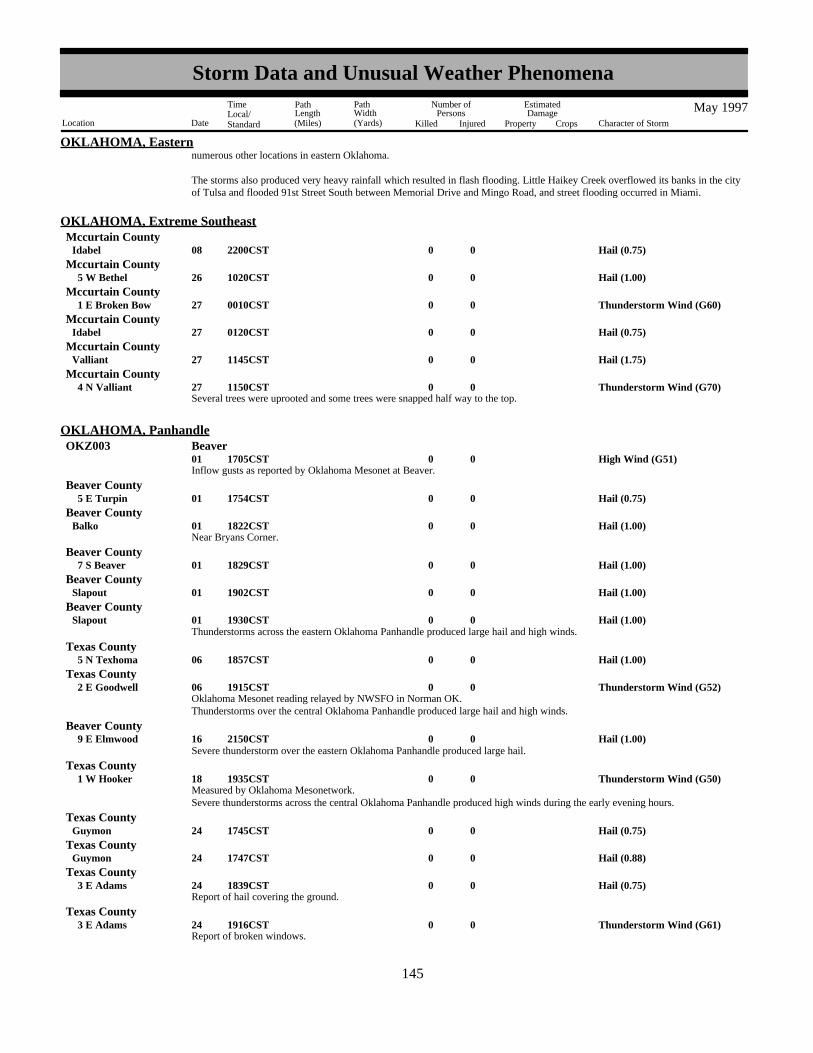
OKLAHOMA, Easternnumerous other locations in eastern Oklahoma.
The storms also produced very heavy rainfall which resulted in flash flooding. Little Haikey Creek overflowed its banks in the cityof Tulsa and flooded 91st Street South between Memorial Drive and Mingo Road, and street flooding occurred in Miami.
Hail (0.75)0008Idabel 2200CST
OKLAHOMA, Extreme SoutheastMccurtain County
Hail (1.00)0026 5 W Bethel 1020CSTMccurtain County
Thunderstorm Wind (G60)0027 1 E Broken Bow 0010CSTMccurtain County
Hail (0.75)0027Idabel 0120CSTMccurtain County
Hail (1.75)0027Valliant 1145CSTMccurtain County
Several trees were uprooted and some trees were snapped half way to the top.Thunderstorm Wind (G70)0027 4 N Valliant 1150CST
Mccurtain County
Inflow gusts as reported by Oklahoma Mesonet at Beaver.High Wind (G51)0001 1705CST
OKLAHOMA, PanhandleOKZ003 Beaver
Hail (0.75)0001 5 E Turpin 1754CSTBeaver County
Near Bryans Corner.Hail (1.00)0001Balko 1822CST
Beaver County
Hail (1.00)0001 7 S Beaver 1829CSTBeaver County
Hail (1.00)0001Slapout 1902CSTBeaver County
Hail (1.00)0001Slapout 1930CSTBeaver County
Thunderstorms across the eastern Oklahoma Panhandle produced large hail and high winds.
Hail (1.00)0006 5 N Texhoma 1857CSTTexas County
Oklahoma Mesonet reading relayed by NWSFO in Norman OK.Thunderstorm Wind (G52)0006 2 E Goodwell 1915CST
Texas County
Thunderstorms over the central Oklahoma Panhandle produced large hail and high winds.
Hail (1.00)0016 9 E Elmwood 2150CSTBeaver County
Severe thunderstorm over the eastern Oklahoma Panhandle produced large hail.
Measured by Oklahoma Mesonetwork.Thunderstorm Wind (G50)0018 1 W Hooker 1935CST
Texas County
Severe thunderstorms across the central Oklahoma Panhandle produced high winds during the early evening hours.
Hail (0.75)0024Guymon 1745CSTTexas County
Hail (0.88)0024Guymon 1747CSTTexas County
Report of hail covering the ground.Hail (0.75)0024 3 E Adams 1839CST
Texas County
Report of broken windows.Thunderstorm Wind (G61)0024 3 E Adams 1916CST
Texas County
137145
Storm Data and Unusual Weather Phenomena
Location Date Character of Storm
TimeLocal/Standard
PathLength(Miles)
PathWidth(Yards)
Number ofPersons
Killed Injured
EstimatedDamage
Property Crops
May 1997

OKLAHOMA, PanhandleTexas County
Hail was covering the ground.Hail (0.75)0024Baker 1920CST
Report of broken windows at 2 or 3 homes.Thunderstorm Wind (G65)0024Baker 1920CST
Texas County
Severe thunderstorms over the central Oklahoma Panhandle produced large hail and damaging winds.
Hail (0.75)0028 6 NW Eva 1550CSTTexas County
A severe thunderstorm over the central Oklahoma Panhandle produced some large hail.
Hail (0.75)0029Guymon 1813CSTTexas County
Hail (1.00)0029 1 N Guymon 1820CSTTexas County
Hail (0.75)0029Guymon 1847CSTTexas County
Severe thunderstorms moved through the central Oklahoma Panhandle producing large hail.
Hail (1.75)0001 2 W Madge 1628CST
OKLAHOMA, Western, Central and SoutheastHarmon County
Hail (0.88)0001 6 NW Mangum 1630CSTGreer County
Hail (2.00)0001 1 W Madge 1630CSTHarmon County
Quarter-sized hail stripped foliage from vegetation.Hail (1.00)0001 4 SW Vinson 1637CST
Harmon County
Hail (1.75)0001Madge 1640CSTHarmon County
Hail (2.25)0001 3 W Vinson 1641CSTHarmon County
Hail (1.00)0001 4 W Willow 1645CSTGreer County
Hail (0.75)0001 2 SW Durham 1710CSTRoger Mills County
Hail (0.88)0001Granite 1725CSTGreer County
Hail (1.00)0001 3 W Lone Wolf 1739CSTKiowa County
Hail (0.88)0001 3 W Lone Wolf 1747CSTKiowa County
Hail (0.88)0001Hobart 1808CSTKiowa County
Hail (1.00)0001Hobart 1811CSTKiowa County
Hail (0.88)0001 9 E Hobart 1821CSTKiowa County
A long, horizontal funnel cloud extended into the clear slot of the storm. No wall cloud was observed.
Funnel Cloud0001 7 S Gotebo 1839CST1841CST
Kiowa County
Hail (0.75)0001 2 W Rosston 1847CSTHarper County
Hail (0.75)0001 5 S Carnegie 1848CSTCaddo County
Hail (0.75)0001Carnegie 1853CSTCaddo County
138146
Storm Data and Unusual Weather Phenomena
Location Date Character of Storm
TimeLocal/Standard
PathLength(Miles)
PathWidth(Yards)
Number ofPersons
Killed Injured
EstimatedDamage
Property Crops
May 1997

OKLAHOMA, Western, Central and SoutheastHarper County
Hail (0.75)0001 2 N Laverne 1855CST
Hail (1.00)0001Sayre 1900CSTBeckham County
Severe thunderstorm winds downed tree limbs.Thunderstorm Wind0.01K0001Elk City 1915CST
Beckham County
Hail (1.50)0001Laverne 1917CSTHarper County
Hail (0.88)0001 5 SW Elk City 1930CSTBeckham County
A barn was damaged by severe thunderstorm winds.Thunderstorm Wind 1K0001 4 SW Elk City 1932CST
Beckham County
Hail (0.88)0001May 1935CSTHarper County
Hail (1.00)0001Canute 1940CSTWashita County
Hail (0.75)0001 6 W Burns Flat 1943CSTWashita County
Hail (0.75)0001 4 N Catesby 1945CSTEllis County
Hail (0.88)0001 15 NW Freedom 1950CSTWoods County
Hail (0.88)0001Ft Supply 1953CSTWoodward County
Hail (1.00)0001 8 N Gage 2007CSTEllis County
Hail (0.75)0001 1 SE Bessie 2007CSTWashita County
Hail (1.75)0001 5 N Gage 2010CSTEllis County
measured at the Oklahoma Mesonet siteThunderstorm Wind (G50)0001 4 WNW Bessie 2010CST
Washita County
Wind-driven hail as large as golf balls broke windows and dented 11 cars parked at the old Clinton-Sherman Air Base. Fences androofs of buildings were also damaged.
Hail (1.75) 20K0001Burns Flat 2010CSTWashita County
Hail (1.00)0001 10 N Woodward 2010CSTWoodward County
Hail (0.75)0001 13 N Mooreland 2028CSTWoodward County
Hail (0.88)0001 4 S Weatherford 2035CSTCuster County
Hail (0.75)0001Shattuck 2035CSTEllis County
Hail (0.88)0001Waynoka 2040CSTWoods County
Hail (1.00)0001 7 NW Woodward 2042CSTWoodward County
Hail (1.00)0001 4 W Corn 2045CSTWashita County
Hail (0.75)0001 2 W Mooreland 2048CSTWoodward County
Hail (0.88)0001Burlington 2056CSTAlfalfa County
139147
Storm Data and Unusual Weather Phenomena
Location Date Character of Storm
TimeLocal/Standard
PathLength(Miles)
PathWidth(Yards)
Number ofPersons
Killed Injured
EstimatedDamage
Property Crops
May 1997
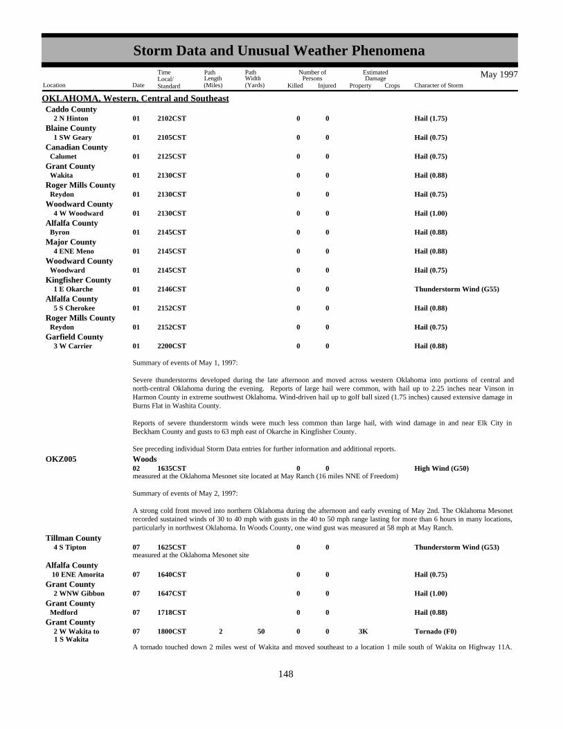
OKLAHOMA, Western, Central and SoutheastCaddo County
Hail (1.75)0001 2 N Hinton 2102CST
Hail (0.75)0001 1 SW Geary 2105CSTBlaine County
Hail (0.75)0001Calumet 2125CSTCanadian County
Hail (0.88)0001Wakita 2130CSTGrant County
Hail (0.75)0001Reydon 2130CSTRoger Mills County
Hail (1.00)0001 4 W Woodward 2130CSTWoodward County
Hail (0.88)0001Byron 2145CSTAlfalfa County
Hail (0.88)0001 4 ENE Meno 2145CSTMajor County
Hail (0.75)0001Woodward 2145CSTWoodward County
Thunderstorm Wind (G55)0001 1 E Okarche 2146CSTKingfisher County
Hail (0.88)0001 5 S Cherokee 2152CSTAlfalfa County
Hail (0.75)0001Reydon 2152CSTRoger Mills County
Hail (0.88)0001 3 W Carrier 2200CSTGarfield County
Summary of events of May 1, 1997:
Severe thunderstorms developed during the late afternoon and moved across western Oklahoma into portions of central andnorth-central Oklahoma during the evening. Reports of large hail were common, with hail up to 2.25 inches near Vinson inHarmon County in extreme southwest Oklahoma. Wind-driven hail up to golf ball sized (1.75 inches) caused extensive damage inBurns Flat in Washita County.
Reports of severe thunderstorm winds were much less common than large hail, with wind damage in and near Elk City inBeckham County and gusts to 63 mph east of Okarche in Kingfisher County.
See preceding individual Storm Data entries for further information and additional reports.
measured at the Oklahoma Mesonet site located at May Ranch (16 miles NNE of Freedom)High Wind (G50)0002 1635CST
OKZ005 Woods
Summary of events of May 2, 1997:
A strong cold front moved into northern Oklahoma during the afternoon and early evening of May 2nd. The Oklahoma Mesonetrecorded sustained winds of 30 to 40 mph with gusts in the 40 to 50 mph range lasting for more than 6 hours in many locations,particularly in northwest Oklahoma. In Woods County, one wind gust was measured at 58 mph at May Ranch.
measured at the Oklahoma Mesonet siteThunderstorm Wind (G53)0007 4 S Tipton 1625CST
Tillman County
Hail (0.75)0007 10 ENE Amorita 1640CSTAlfalfa County
Hail (1.00)0007 2 WNW Gibbon 1647CSTGrant County
Hail (0.88)0007Medford 1718CSTGrant County
A tornado touched down 2 miles west of Wakita and moved southeast to a location 1 mile south of Wakita on Highway 11A.
Tornado (F0) 3K0 50 2 007 1 S Wakita 2 W Wakita to 1800CST
Grant County
140148
Storm Data and Unusual Weather Phenomena
Location Date Character of Storm
TimeLocal/Standard
PathLength(Miles)
PathWidth(Yards)
Number ofPersons
Killed Injured
EstimatedDamage
Property Crops
May 1997
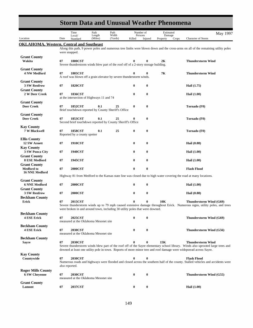
OKLAHOMA, Western, Central and SoutheastAlong this path, 9 power poles and numerous tree limbs were blown down and the cross-arms on all of the remaining utility poleswere snapped.
Severe thunderstorm winds blew part of the roof off of a 2-story storage building.Thunderstorm Wind 2K0007Wakita 1800CST
Grant County
A roof was blown off a grain elevator by severe thunderstorm winds.Thunderstorm Wind 7K0007 4 NW Medford 1805CST
Grant County
Hail (1.75)0007 3 SW Renfrow 1820CSTGrant County
at the intersection of Highways 11 and 74Hail (1.00)0007 2 W Deer Creek 1836CST
Grant County
Brief touchdown reported by County Sheriff's OfficeTornado (F0)0 25 0.1 007Deer Creek 1852CST
Grant County
Second brief touchdown reported by County Sheriff's OfficeTornado (F0)0 25 0.1 007Deer Creek 1853CST
Grant County
Reported by a county spotterTornado (F0)0 25 0.1 007 7 W Blackwell 1858CST
Kay County
Hail (0.88)0007 12 SW Arnett 1910CSTEllis County
Hail (1.00)0007 3 SW Ponca City 1940CSTKay County
Hail (1.00)0007 8 ESE Medford 1945CSTGrant County
Highway 81 from Medford to the Kansas state line was closed due to high water covering the road at many locations.
Flash Flood0007 16 NNE MedfordMedford to 2000CST
Grant County
Hail (1.00)0007 6 NNE Medford 2000CSTGrant County
Hail (0.88)0007 3 SW Renfrow 2000CSTGrant County
Severe thunderstorm winds up to 79 mph caused extensive damage throughout Erick. Numerous signs, utility poles, and treeswere broken in and around town, including 30 utility poles that were downed.
Thunderstorm Wind (G69) 10K0007Erick 2015CSTBeckham County
measured at the Oklahoma Mesonet siteThunderstorm Wind (G69)0007 4 ESE Erick 2025CST
Beckham County
measured at the Oklahoma Mesonet siteThunderstorm Wind (G56)0007 4 ESE Erick 2030CST
Beckham County
Severe thunderstorm winds blew part of the roof off of the Sayre elementary school library. Winds also uprooted large trees anddowned at least one utility pole in town. Reports of more minor tree and roof damage were widepsread across Sayre.
Thunderstorm Wind 15K0007Sayre 2030CSTBeckham County
Numerous roads and highways were flooded and closed across the southern half of the county. Stalled vehicles and accidents werealso reported.
Flash Flood0007Countywide 2030CSTKay County
measured at the Oklahoma Mesonet siteThunderstorm Wind (G55)0007 6 SW Cheyenne 2030CST
Roger Mills County
Hail (1.00)0007Lamont 2037CSTGrant County
141149
Storm Data and Unusual Weather Phenomena
Location Date Character of Storm
TimeLocal/Standard
PathLength(Miles)
PathWidth(Yards)
Number ofPersons
Killed Injured
EstimatedDamage
Property Crops
May 1997

OKLAHOMA, Western, Central and SoutheastBeckham County
Severe thunderstorm winds in Elk City blew the roof off of one business and blew eight overhead doors out of several otherbusinesses. On the edge of town an 11,000 pound tank trailer was blown onto its side and into a fence. Countless trees and limbswere snapped and signs were downed throughout town.
Thunderstorm Wind 35K0007Elk City 2045CST
Hail (0.88)0007 3 SW Hammon 2045CSTRoger Mills County
Severe thunderstorm winds estimated at 75 mph blew signs down in Canute.Thunderstorm Wind (G65) 4K0007Canute 2054CST
Washita County
Light and power poles were blown down by severe thunderstorm winds.Thunderstorm Wind 1K0007Arapaho 2100CST
Custer County
The 5-minute average wind speed (sustained wind) from 9:20 pm to 9:25 pm CST was measured at 52 mph at the OklahomaMesonet site, with a peak gust during this time of 81 mph.
Thunderstorm Wind (G70)0007 4 WSW Weatherford 2120CST2125CST
Custer County
measured at the Oklahoma Mesonet site.Thunderstorm Wind (G53)0007 4 SE Hobart 2120CST
Kiowa County
The 5-minute average wind speed (sustained wind) from 9:25 pm to 9:30 pm CST was measured at 61 mph at the OklahomaMesonet site, with a peak gust during this time of 77 mph.
Thunderstorm Wind (G67)0007 4 WSW Weatherford 2125CST2130CST
Custer County
Severe thunderstorm winds up to 96 mph (measured by a local firefighter) caused widespread and heavy damage in and aroundWeatherford. Extensive tree, sign, limb, fence, and window damage was reported. At least 7 power poles were snapped in theWeatherford vicinity.
Some of the most severe structural damage occurred at South Western Oklahoma State University, where the roof was blown offof the auditorium. Portions of the auditorium roof landed on and destroyed a police car. The roof was also blown off a campuselevator shaft. Pieces of this second roof landed on and crushed one car and damaged a second vehicle.
Elsewhere in town the roof was blown off of a building at an industrial park and the doors were blown in at a salvage yard. Theportable bleachers were flipped over a fence and the foul pole was bent 40 degrees at the high school baseball field. Some of thetin on the front of the school cafeteria was also damaged.
Just east of town, severe thunderstorm winds caused 4 tractor-trailer trucks to jack-knife and blew another semi-truck over on I-40.The interstate was completely closed for one and a half hours as the trucks were cleared from the highway.
Thunderstorm Wind (G83) 100K0007Weatherford 2130CSTCuster County
The 5-minute average wind speed (sustained wind) from 9:30 pm to 9:35 pm CST was measured at 50 mph at the OklahomaMesonet site, with a peak gust during this time of 63 mph.
Thunderstorm Wind (G55)0007 4 WSW Weatherford 2130CST2135CST
Custer County
Hail (1.00)0007 2 W Mc Knight 2140CSTHarmon County
Hail (1.00)0007 3 SW Ponca City 2140CSTKay County
measured at the Oklahoma Mesonet siteThunderstorm Wind (G56)0007 7 W Watonga 2150CST
Blaine County
Severe thunderstorm winds estimated at up to 90 mph caused widespread damage and one injury in Binger. One man was injuredwhen his mobile home was overturned, pinning him between a tree and some of the debris from the home. His family, including awife and 4 children, was also inside the house but escaped uninjured.
Elsewhere in the area a tree was blown over onto a pickup truck and several storefront windows were blown out in town. The roofwas blown off of the grandstand at the local fairgrounds and steel posts were pulled from concrete at a ranch. A farm implement
Thunderstorm Wind 60K 1 007Binger 2150CSTCaddo County
142150
Storm Data and Unusual Weather Phenomena
Location Date Character of Storm
TimeLocal/Standard
PathLength(Miles)
PathWidth(Yards)
Number ofPersons
Killed Injured
EstimatedDamage
Property Crops
May 1997
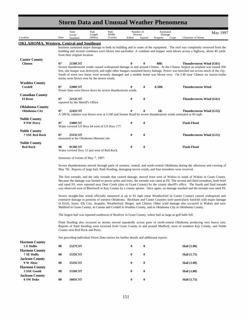
OKLAHOMA, Western, Central and Southeastbusiness sustained major damage to both its building and to some of the equipment. The roof was completely removed from thebuilding and several combines were blown into eachother. A combine and hopper were blown across a highway, about 40 yardsfrom their original location.
Severe thunderstorm winds caused widespread damage in and around Clinton. At the Clinton Airport an airplane was tossed 200feet, one hangar was destroyed, and eight other hangars sustained heavy damage. Power was knocked out across much of the city.South of town two barns were severely damaged and a mobile home was blown over. On I-40 near Clinton six tractor-trailertrucks were blown over by the severe winds.
Thunderstorm Wind (G61) 80K0007Clinton 2150CSTCuster County
Power lines were blown down by severe thunderstorm winds.Thunderstorm Wind0.50K0007Cordell 2200CST
Washita County
reported by the Sheriff's OfficeThunderstorm Wind (G61)0007El Reno 2212CST
Canadian County
A 500 lb. radiator was blown over at I-240 and Sooner Road by severe thunderstorm winds estimated at 60 mph.Thunderstorm Wind (G52) 1K0007Oklahoma City 2245CST
Oklahoma County
Water covered US Hwy 64 west of US Hwy 177.Flash Flood0007 9 NW Perry 2300CST
Noble County
measured at the Oklahoma Mesonet siteThunderstorm Wind (G51)0007 7 SSE Red Rock 2315CST
Noble County
Water covered Hwy 15 just west of Red Rock.Flash Flood0008Red Rock 0130CST
Noble County
Summary of events of May 7, 1997:
Severe thunderstorms moved through parts of western, central, and north-central Oklahoma during the afternoon and evening ofMay 7th. Reports of large hail, flash flooding, damaging severe winds, and four tornadoes were received.
The first tornado, and the only tornado that caused damage, moved from west of Wakita to south of Wakita in Grant County.Because the damage was limited to power poles and trees, the tornado was rated as F0. The second and third tornadoes, both briefand rated F0, were reported near Deer Creek (also in Grant County) by the county sheriff's office. The fourth and final tornadowas observed west of Blackwell in Kay County by a county spotter. Once again, no damage resulted and the tornado was rated F0.
Severe straight-line winds officially measured at up to 81 mph (near Weatherford in Custer County) caused widespread andextensive damage in portions of western Oklahoma. Beckham and Custer Counties were particularly hard-hit with major damagein Erick, Sayre, Elk City, Arapaho, Weatherford, Binger, and Clinton. Other wind damage also occurred in Wakita and nearMedford in Grant County, in Canute and Cordell in Washita County, and in Oklahoma City in Oklahoma County.
The largest hail was reported southwest of Renfrow in Grant County, where hail as large as golf balls fell.
Flash flooding also occurred as storms moved repeatedly across parts of north-central Oklahoma producing very heavy rain.Reports of flash flooding were received from Grant County in and around Medford, most of southern Kay County, and NobleCounty near Red Rock and Perry.
See preceding individual Storm Data entries for further details and additional reports.
Hail (1.00)0008 5 E Hollis 1527CSTHarmon County
Hail (1.75)0008 7 SE Hollis 1535CSTHarmon County
Hail (1.00)0008 9 W Altus 1535CSTJackson County
Hail (1.00)0008 3 SSE Gould 1550CSTHarmon County
Hail (1.75)0008 6 SW Duke 1605CSTJackson County
143151
Storm Data and Unusual Weather Phenomena
Location Date Character of Storm
TimeLocal/Standard
PathLength(Miles)
PathWidth(Yards)
Number ofPersons
Killed Injured
EstimatedDamage
Property Crops
May 1997

OKLAHOMA, Western, Central and SoutheastTillman County
measured at the Oklahoma Mesonet siteThunderstorm Wind (G53)0008 4 S Tipton 1625CST
Hail (1.75)0008Tipton 1631CSTTillman County
Hail (1.75)0008Frederick 1638CSTTillman County
Dime to quarter-sized hail covered the ground.Hail (1.00)0008Frederick 1645CST
Tillman County
Hail (0.75)0008 5 SE Elmer 1700CSTJackson County
Hail (0.75)0008 6 SE Elmer 1705CSTJackson County
Hail (0.88)0008 4 W Grandfield 1734CSTTillman County
Severe thunderstorm winds downed power lines in Healdton.Thunderstorm Wind0.50K0008Healdton 1930CST
Carter County
at the Xerox plant on I-40Hail (1.50)0008Yukon 2115CST
Canadian County
at SE 30th and I-35Hail (0.75)0008Oklahoma City 2207CST
Oklahoma County
Summary of events of May 8, 1997:
Severe thunderstorms moved from southwest Oklahoma into south-central and parts of central Oklahoma during the afternoon andearly evening of the 8th. Hail as large as golf balls was reported in Frederick and Tipton in Tillman County, southeast of Hollis inHarmon County, and southwest of Duke in Jackson County. Severe thunderstorm winds were measured at speeds up to 61 mphsouth of Tipton in Tillman County and wind damage occurred in Healdton in Carter County. See preceding individual Storm Dataentries for further details and additional reports.
measured at the Oklahoma Mesonet siteThunderstorm Wind (G56)0019 4 SSE Blackwell 0205CST
Kay County
Wind gusts to 58 mph were measured at the Ponca City Municipal Airport (KPNC). Limbs and trees were downed throughouttown by the severe winds.
Thunderstorm Wind (G50)0.10K0019Ponca City (Kpnc) 0216CSTKay County
Lightning struck a three-story brick building on the Phillips Unversity Campus, damaging the front and the roof.Lightning 5K0019Enid 0600CST
Garfield County
Large trees were downed in town by severe thunderstorm winds. (time estimated)Thunderstorm Wind0.10K0019Norman 0700CST
Cleveland County
Lightning struck and set fire to a house.Lightning 10K0019Norman 0705CST
Cleveland County
Numerous large tree limbs were downed in Seminole. (time estimated)Thunderstorm Wind0.01K0019Seminole 0800CST
Seminole County
Summary of events of May 19, 1997:
Late night and early morning thunderstorms produced severe straight-line winds that resulted in tree and limb damage in parts ofnorth-central and central Oklahoma. The highest measured wind speed was 64 mph at the Oklahoma Mesonet site near Blackwellin Kay County. Damage was reported in Ponca City in Kay County, in Norman in Cleveland County, and in Seminole in SeminoleCounty.
Lightning damage was also reported in Enid in Garfield County and in Norman in Cleveland County.
144152
Storm Data and Unusual Weather Phenomena
Location Date Character of Storm
TimeLocal/Standard
PathLength(Miles)
PathWidth(Yards)
Number ofPersons
Killed Injured
EstimatedDamage
Property Crops
May 1997

OKLAHOMA, Western, Central and Southeast
See preceding individual Storm Data entries for further details and additional reports.
Ellis CountyHail (0.75)0023 6 N Gage 1505CST
State Highway 46 was under water due to flash flooding.Flash Flood0023 8 N Gage 1506CST
Ellis County
Crops were under water after 3.3 inches of rain during the afternoon.Flash Flood0023 8 NE Shattuck 1520CST
Ellis County
Three feet of water covered State Highway 46. Flash Flood0023 7 N Gage 1605CST
Ellis County
Summary of events of May 23, 1997:
Several slow-moving thunderstorms moved across Ellis County during the afternoon of the 23rd. One report of 3/4 inch hail wasreceived; however, flash flooding was of greater impact after extended periods of heavy rain. Highway 46 was covered by asmuch as 3 feet of water and crops were completely flooded in some areas.
Hail (0.75)0024 12 N Erick 2016CSTBeckham County
Hail (0.88)0024 5 WNW Angora 2059CSTRoger Mills County
Lightning struck and set fire to a storage shed.Lightning 1.5K0024Ardmore 2130CST
Carter County
Hail (0.88)0024 5 S Taloga 2148CSTDewey County
Lightning struck and set fire to a vacant house. Damage was estimated at $8000.Lightning 8K0025Ardmore 0055CST
Carter County
Hail (0.88)0025Newcastle 0145CSTMcclain County
Nickel-sized hail fell on the northwest side of Norman.Hail (0.88)0025Norman 0155CST
Cleveland County
Summary of events of May 24, 1997 to early morning of May 25, 1997:
Thunderstorms moved into western Oklahoma late in the evening of the 24th, producing nickel-sized hail near Angora in RogerMills County and south of Taloga in Dewey County. As the storms moved into central Oklahoma overnight, nickel-sized hail alsofell in Norman in Cleveland County and in Newcastle in McClain County.
In Carter County in south-central Oklahoma lightning struck and set fire to a house and a shed in Ardmore.
See preceding individual Storm Data entries for further details and additional reports.
Hail (1.00)0025 1 W Amber 1452CSTGrady County
Hail (1.00)0025 2.5 E Middleberg 1512CSTGrady County
This description, with very minimal editing, was taken from a damage survey conducted by a National Weather Servicemeteorologist on Monday May 26th (Memorial Day), the day after the tornado occurred.
This tornado, rated F1, began 3 miles northeast of Tabler at 15:14 CST and tracked just south of due east for about 2.5 milesbefore dissipating 2.5 miles south-southwest of Middleberg at 15:24 CST. The maximum width of the damage path was 75 yards.Structural damage was confined to a dairy farm near the beginning of the track; otherwise, this tornado remained over mostly opencountry.
Tornado (F1) 24K0 75 2.5 025 2.5 SSW Middleberg 3 NE Tabler to 1514CST
1524CST
Grady County
145153
Storm Data and Unusual Weather Phenomena
Location Date Character of Storm
TimeLocal/Standard
PathLength(Miles)
PathWidth(Yards)
Number ofPersons
Killed Injured
EstimatedDamage
Property Crops
May 1997

OKLAHOMA, Western, Central and SoutheastSpotter observations and corresponding video confirm that the first tornado formed rapidly west of State Highway 9 at 15:14 CST,in mostly open country between Tabler and Middleberg. Survey results located the first signs of damage to trees just west of theMid-Am Dairy Farm (or R & S Dairy), located 3 miles northeast of Tabler. More than a dozen trees lost large branches near andwest of the dairy. At the dairy itself, a mobile home was destroyed, power lines were downed, and two metal outbuildings sufferedheavy damage to roofs and walls. Metal grain silos also were damaged. Considering the construction of the outbuildings and thelarge piles of hay bales near the mobile home that were relatively unaffected, damage in this area was rated F1. The maximum pathwidth of about 75 yards, based on visible damage and on video, was estimated to be in this area. Observations and video indicate that the tornado then proceeded eastward and eventually east-southeastward, narrowing to a thin,mostly vertical rope funnel that underwent several cycles of lifting and returning to ground contact. However, the circulation waslikely in contact with the ground the entire time. The funnel crossed Highway 9 around 15:22 CST 2.5 miles southwest ofMiddleberg, where several trees lost large branches and a road sign was damaged. Between the dairy and this point, the tornadotrack was inaccessible. Although the funnel lifted from the ground shortly after crossing the highway, video confirms that a tight,small circulation with ground condensation persisted, crossing an open field southeast of the road. This rotation at the groundlasted about another two minutes before dissipating at about 15:24 CST. Since the tornado passed over open country, no furtherdamage was found.
Hail (2.50)0025 2.5 E Middleberg 1515CSTGrady County
The roof was blown off a mobile home by severe thunderstorm winds.Thunderstorm Wind 10K0025 2.5 N Tabler 1517CST
Grady County
Hail (1.75)0025Blanchard 1520CSTMcclain County
Hail (1.00)0025 1 N Blanchard 1525CSTMcclain County
This description was taken almost entirely, and with minimal editing, from a damage survey conducted Monday May 26th(Memorial Day), the day after the tornado, by a National Weather Service meteorologist.
This tornado, rated F2, began 5 miles east of Criner, or 7 miles west-southwest of downtown Purcell, in southern McClain County.The beginning time of this tornado is not entirely certain but is believed to be near or just after 16:00 CST. This tornado trackedjust south of due east for 6 miles, ending about 4 miles northwest of Wayne or 4 miles south of downtown Purcell at around 16:24CST. At its widest, the damage path was estimated to be 3/4 mile wide. Numerous power lines were downed, prompting thetemporary closing of both Highways 24 and 74 for a time during the evening. At least 18 dwellings, including mobile homes andpermanent dwellings, were destroyed or suffered major damage. This probably was a multiple-vortex tornado, at least in its latterstages, based on eyewitness reports. No one was killed or seriously injured by this tornado, but two minor injuries were reported.
Damage began along a concentrated path from along Highway 24 around 3 miles south and 1 mile east of Woody Chapel (which islocated at the intersection of Highways 39 and 24 about 3 miles south of Washington). Details are described below, highlightingsix areas along the damage track.
Along Hwy 24, 5 miles east of Criner, sheet metal was scattered over about a 1/4 to 1/2 mile path, apparently the remnants of adestroyed outbuilding. Several large trees were toppled or heavily damaged in this area. Damage was F1. Tree damage also wasnoted over a larger area 1 mile west of this location (or 3 miles south of Woody Chapel on Highway 24), along with a few piecesof sheet metal debris. Since damage in this area was more minor (small to medium size branches broken) and notconcentrated, straight-line winds were considered the likely source.
Also along Hwy 24, from Hwy 112 southward for about a mile, power lines were downed along a 1/4 to 1/2 mile stretch of theroad. Considerable debris was found from fallen trees, metal outbuildings, etc. Damage was F1.
About 1 mile east of Hwy 24 and 1 mile south of Hwy 112, a home was unroofed. Widespread but mostly minor tree damage wasnoted, with trees uprooted and/or branches snapped off. Aside from the home with the damaged roof, there were few if any othermanmade structures in the area. Damage probably was F1, but an exact determination could not be made since the roof was beingrepaired at the time of the survey.
On Emu Road, 1/2 to 1 mile south of Hwy 112 and 2 miles east of Hwy 24, one permanent home was destroyed. Numerous largetrees were downed - some snapped off, and others uprooted. Several of the uprooted trees fell toward the northwest, others to thesouthwest. Damage was considered F2.
At Highway 74 and Horse Road, (3.5 to 4.5 miles east of Hwy 24 and 1 mile south of Hwy 112), the worst damage and widestdamage path (about 3/4 mile wide) were in this area. Power lines were downed along Hwy 74 for nearly a mile. Numerous large
Tornado (F2) 900K 2 1320 6 025 4 S Purcell 7 WSW Purcell to 1600CST
1624CST
Mcclain County
146154
Storm Data and Unusual Weather Phenomena
Location Date Character of Storm
TimeLocal/Standard
PathLength(Miles)
PathWidth(Yards)
Number ofPersons
Killed Injured
EstimatedDamage
Property Crops
May 1997

OKLAHOMA, Western, Central and Southeasttrees were snapped off or uprooted. In one area between the two roads, nearly every tree suffered some kind of significantdamage. Two mobile homes were destroyed along Horse Road. One was blown east and landed across the street near a church.The other rolled three times and landed 50 to 100 feet northeast of its original location. Two women, a mother and daughter, wereinside the second mobile home and were lucky to escape with only minor injuries. Metal outbuildings, satellite dishes, fences, andat least one pickup truck were destroyed - mostly by impacts from other blown objects. However, the church, which was brick,sustained only minor structural damage to the exterior, as the roof was intact and only a few shingles were missing. (Brokenwindows in the church led to more substantial damage on the interior as rain and wind entered the building.) Damage in this areawas considered F2, but the fact that the church escaped with such minor damage to its exterior suggests either a lower rating or thepossibility of a multiple-vortex tornado. At least one eyewitness indicated a second tornado. Although the entire damage trackappeared consistent and more-or-less continuous, suggesting only one tornado, the eyewitness account and the observed gradientsin damage intensity suggest that this probably was a multiple-vortex tornado, at least in its latter stages.
From 1/4 to 1/2 mile east of Horse Road, a large home suffered major damage, with most of the second floor destroyed. Downedtrees were widespread. Damage was rated F2. Another home immediately east of this location lost part of its roof. But farthereast, near Interstate 35, several homes were undamaged and no significant damage could be found - except for a lone uprooted treeimmediately west of the interstate.
Hail (1.00)0025Apache 1605CSTCaddo County
Hail (1.00)0025Purcell 1623CSTMcclain County
A tornado was reported by spotters southwest of Cyril near the Caddo/Comanche County line. (This is the same tornado as 1 NFletcher in Comanche County.) No reported damage.
Tornado (F0)0 25 0.1 025 4 SW Cyril 1627CSTCaddo County
A tornado was reported by spotters just north of Fletcher near the Caddo/Comanche County line. (This is the same tornado as 4SW Cyril in Caddo County.) No reported damage.
Tornado (F0)0 25 0.1 025 1 N Fletcher 1627CSTComanche County
Hail (1.00)0025Lexington 1630CSTCleveland County
This description was taken almost entirely from a damage survey conducted by a National Weather Service meteorologist. Anoutbuilding was damaged on a farm along a section of road 2 miles north and 1 mile east of Wayne, about 1 mile south of thesouth bank of the Canadian River. Sheet metal was dispersed across the area, and a few trees were damaged. Otherwise thistornado remained in open country. Initial development, based on video, was around 16:32 CST with a duration of less than 2minutes before it quickly dissipated. Maximum path width was 20 yards or less, path length was 1/4 mile or less, and damage wasrated F0.
Tornado (F0) 1K0 20 0.2 025 2 NNE Wayne 1632CSTMcclain County
Severe thunderstorm winds blew a roof off a barn, uprooted trees, blew siding off a house, and destroyed small metal storagebuildings.
Thunderstorm Wind 7K0025 5 SW Purcell 1640CSTMcclain County
Hail (1.00)0025Rush Spgs 1645CSTGrady County
Hail (1.00)0025Empire City 1655CSTStephens County
Hail (1.00)0025Duncan 1720CSTStephens County
Lightning struck and set fire to a mobile homeLightning 10K0025 3 S Duncan 1725CST
Stephens County
Brief tornado touchdown reported near Antioch (7 miles south of Maysville) by spotters. No reported damage.Tornado (F0)0 25 0.1 025 7 S Maysville 1728CST
Garvin County
Severe thunderstorm winds uprooted 2 large trees.Thunderstorm Wind0.10K0025Wynnewood 1730CST
Garvin County
A tornado was observed about 3 miles south of Duncan and 1 mile east of Highway 81 by storm spotters. At this location (on "Old
Tornado (F1) 50K0 50 0.5 025 3 S Duncan 1736CST1744CST
Stephens County
147155
Storm Data and Unusual Weather Phenomena
Location Date Character of Storm
TimeLocal/Standard
PathLength(Miles)
PathWidth(Yards)
Number ofPersons
Killed Injured
EstimatedDamage
Property Crops
May 1997

OKLAHOMA, Western, Central and Southeast"Old Highway 81"), a travel trailer was destroyed, a roof was blown off a large workshop, a brick home was damaged by a fallingtree, and a van was damaged. Nearby trees were uprooted, power lines were downed, and a mobile home was destroyed. A puppythat had been inside the damaged mobile home was found 1/4 mile north of the house in someone else's yard. In the same area, 8empty grain train cars were blown over off a side track.
Hail (1.00)0025 6 E Wynnewood 1805CSTGarvin County
Hail (1.75)0025 2.5 W Wynnewood 1805CSTGarvin County
A brief tornado was observed east of Joy. No reported damage.Tornado (F0)0 25 0.1 025 1 E Joy 1807CST
Murray County
A brief tornado was reported by an Oklahoma Highway Patrol officer. No reported damage.Tornado (F0)0 25 0.1 025 7 S Stratford 1813CST
Garvin County
Hail (3.00)0025 7 S Stratford 1815CSTGarvin County
Hail (1.00)0025Roff 1830CSTPontotoc County
Hail (1.00)0025Roff 1834CSTPontotoc County
Hail (1.75)0025 5 S Roff 1837CSTPontotoc County
Hail (1.00)0025Lone Grove 1847CSTCarter County
Funnel Cloud0025 3 NW Connerville 1850CSTJohnston County
Hail (1.75)0025 8 SW Fittstown 1853CSTPontotoc County
Estimated 70 to 80 mph windsThunderstorm Wind (G70)0025 8 SW Fittstown 1853CST
Pontotoc County
Severe thunderstorm winds estimated at 80 mph blew a roof off a barn and downed trees.Thunderstorm Wind (G70) 6K0025 6 SW Fittstown 1855CST
Pontotoc County
A tornado unroofed a barn and downed a swath of trees.Tornado (F0) 3K0 30 0.5 025 8 E Roff 1858CST
Pontotoc County
Funnel Cloud0025 1 E Connerville 1905CSTJohnston County
Reported by spotter. No reported damage.Tornado (F0)0 25 0.1 025 2.5 NE Mill Creek 1920CST
Johnston County
Reported by spotter. No reported damage.Tornado (F0)0 25 0.1 025 8 WNW Madill 1943CST
Marshall County
Reported by emergency manager. No reported damage.Tornado (F0)0 25 0.1 025 2 N Tupelo 1948CST
Coal County
Hail (1.00)0025Atoka 2020CSTAtoka County
Hail (0.75)0025 4 E Atoka 2020CSTAtoka County
Hail (1.75)0025 3 E Newkirk 2105CSTKay County
A tornado downed a swath of trees northwest of Newkirk. Tornado (F0)0.10K0 50 0.1 025 3 NW Newkirk 2110CST
Kay County
Severe thunderstorm winds downed trees.Thunderstorm Wind0.10K0025 5 W Hardy 2115CST
Kay County
148156
Storm Data and Unusual Weather Phenomena
Location Date Character of Storm
TimeLocal/Standard
PathLength(Miles)
PathWidth(Yards)
Number ofPersons
Killed Injured
EstimatedDamage
Property Crops
May 1997

OKLAHOMA, Western, Central and SoutheastBryan County
Thunderstorm Wind (G52)0025 3 SW Silo 2145CST
Severe thunderstorm winds downed power lines and trees.Thunderstorm Wind0.50K0025 1 W Antlers 2200CST
Pushmataha County
Hail (2.75)0025Darwin 2239CSTPushmataha County
Summary of events of the afternoon and evening of May 25, 1997:
Severe thunderstorms developed during the afternoon in central Oklahoma and spread into southern Oklahoma during the lateafternoon and evening. In all, thirteen tornadoes were confirmed, including an F2 tornado that tracked for 6 miles throughMcClain County southwest of Purcell. Some minor injuries were reported with one of the tornadoes, but no fatalities or seriousinjuries occurred. Reports of 3-inch hail, severe straight-line winds, and lightning damage were also received.
One particularly strong supercell storm tracked across central Oklahoma, reaching its maximum strength and producing 3tornadoes and extensive straight-line wind damage over Grady and McClain Counties. What follows here is an excerpt from adamage survey conducted by a National Weather Service meteorologist on May 26th, the day after the storm.
"A large severe thunderstorm moved through northern and central Grady County into central and southern McClain County duringthe late afternoon on Sunday, 25 May 1997. Several reports were received immediately after the storm indicating significant winddamage, especially in southern McClain County southwest of Purcell. There also were numerous confirmed tornado sightings bystorm spotters, chasers, local emergency management officials, and local residents.
Findings indicate that 3 tornadoes occurred in this area. Most of the damage, and all of the significant structural damage, resultedfrom the first two tornadoes. Widespread tree damage in some areas, especially in McClain County, was attributed to straight-linewinds.
The first tornado, rated F1, began 3 miles northeast of Tabler at 15:14 CST and tracked just south of due east for about 2.5 milesbefore dissipating 2.5 miles SSW of Middleberg at 15:24 CST. Structural damage was confined to a dairy farm near the beginningof the track; otherwise, this tornado remained over mostly open country.
The second and more significant tornado, rated F2, began 5 miles east of Criner, or 7 miles WSW of downtown Purcell, insouthern McClain County. The beginning time of this tornado is less certain but is believed to be near or just after 16:00 CST.This tornado also tracked just south of due east for 6 miles, ending about 4 miles NW of Wayne or 4 miles S of downtown Purcellat around 16:24 CST. Numerous power lines were downed, prompting the temporary closing of both Highways 24 and 74 for atime Sunday evening. At least 18 dwellings, including mobile homes and permanent dwellings, were destroyed or suffered majordamage. This probably was a multiple-vortex tornado, at least in its latter stages, based on eyewitness reports.
A third small tornado, rated F0, formed around 16:32 CST and lasted about one or two minutes. It damaged an outbuilding and afew trees 2 miles NNE of Wayne in Southern McClain County, about 4 miles east of where the second tornado ended.
No one was killed or seriously injured by any of the tornadoes, but several minor injuries were reported. "
The remaining 10 tornadoes were associated with other severe thunderstorms, mainly across central and southern Oklahoma. Thestrongest of these occurred south of Duncan in Stephens County at 17:36 CST. Spotter and damage reports rated this as an F1tornado. The remaining 9 tornadoes were all rated F0 and resulted in little or no damage. In chronological order, these tornadoesoccurred on the Caddo Comanche County line between Cyril and Fletcher (16:27CST), south of Maysville in Garvin County(17:28 CST), east of Joy in Murray County (18:07 CST), south of Stratford in Garvin County (18:13 CST), east of Roff inPontotoc County (18:53 CST), northeast of Mill Creek in Johnston County (19:20 CST), west-northwest of Madill in MarshallCounty, (19:43 CST), north of Tupelo in Coal County (19:48 CST), and northwest of Newkirk in Kay County (21:10 CST).
Severe straight-line winds were estimated at up to 80 mph (southwest of Fittstown in Pontotoc County). Wind damage fromthunderstorm winds occurred north of Tabler in Grady County, southwest of Purcell in McClain County, in Wynnewood in GarvinCounty, west of Hardy in Kay County, and west of Antlers in Pushmataha County.
Hail up to 3 inches in diameter fell south of Stratford in Garvin County, and lightning damage was reported south of Duncan inStephens County.
See preceding individual Storm Data entries for further details and additional reports.
Hail (0.75)0026Cromwell 1725CSTSeminole County
149157
Storm Data and Unusual Weather Phenomena
Location Date Character of Storm
TimeLocal/Standard
PathLength(Miles)
PathWidth(Yards)
Number ofPersons
Killed Injured
EstimatedDamage
Property Crops
May 1997
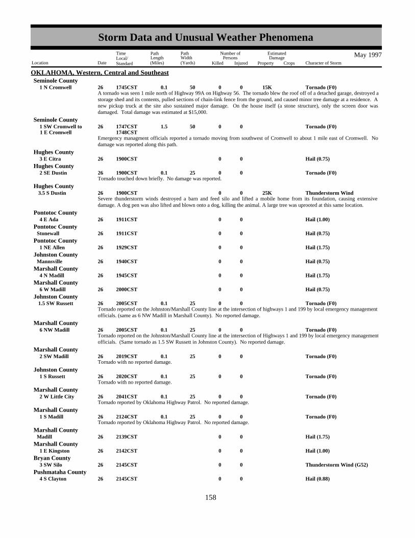
OKLAHOMA, Western, Central and SoutheastSeminole County
A tornado was seen 1 mile north of Highway 99A on Highway 56. The tornado blew the roof off of a detached garage, destroyed astorage shed and its contents, pulled sections of chain-link fence from the ground, and caused minor tree damage at a residence. Anew pickup truck at the site also sustained major damage. On the house itself (a stone structure), only the screen door wasdamaged. Total damage was estimated at $15,000.
Tornado (F0) 15K0 50 0.1 026 1 N Cromwell 1745CST
Emergency managment officials reported a tornado moving from southwest of Cromwell to about 1 mile east of Cromwell. Nodamage was reported along this path.
Tornado (F0)0 50 1.5 026 1 E Cromwell 1 SW Cromwell to 1747CST
1748CST
Seminole County
Hail (0.75)0026 3 E Citra 1900CSTHughes County
Tornado touched down briefly. No damage was reported.Tornado (F0)0 25 0.1 026 2 SE Dustin 1900CST
Hughes County
Severe thunderstorm winds destroyed a barn and feed silo and lifted a mobile home from its foundation, causing extensivedamage. A dog pen was also lifted and blown onto a dog, killing the animal. A large tree was uprooted at this same location.
Thunderstorm Wind 25K0026 3.5 S Dustin 1900CSTHughes County
Hail (1.00)0026 4 E Ada 1911CSTPontotoc County
Hail (0.75)0026Stonewall 1911CSTPontotoc County
Hail (1.75)0026 1 NE Allen 1929CSTPontotoc County
Hail (0.75)0026Mannsville 1940CSTJohnston County
Hail (1.75)0026 4 N Madill 1945CSTMarshall County
Hail (0.75)0026 6 W Madill 2000CSTMarshall County
Tornado reported on the Johnston/Marshall County line at the intersection of highways 1 and 199 by local emergency managementofficials. (same as 6 NW Madill in Marshall County). No reported damage.
Tornado (F0)0 25 0.1 026 1.5 SW Russett 2005CSTJohnston County
Tornado reported on the Johnston/Marshall County line at the intersection of Highways 1 and 199 by local emergency managementofficials. (Same tornado as 1.5 SW Russett in Johnston County). No reported damage.
Tornado (F0)0 25 0.1 026 6 NW Madill 2005CSTMarshall County
Tornado with no reported damage.Tornado (F0)0 25 0.1 026 2 SW Madill 2019CST
Marshall County
Tornado with no reported damage.Tornado (F0)0 25 0.1 026 1 S Russett 2020CST
Johnston County
Tornado reported by Oklahoma Highway Patrol. No reported damage.Tornado (F0)0 25 0.1 026 2 W Little City 2041CST
Marshall County
Tornado reported by Oklahoma Highway Patrol. No reported damage.Tornado (F0)0 25 0.1 026 1 S Madill 2124CST
Marshall County
Hail (1.75)0026Madill 2139CSTMarshall County
Hail (1.00)0026 1 E Kingston 2142CSTMarshall County
Thunderstorm Wind (G52)0026 3 SW Silo 2145CSTBryan County
Hail (0.88)0026 4 S Clayton 2145CSTPushmataha County
150158
Storm Data and Unusual Weather Phenomena
Location Date Character of Storm
TimeLocal/Standard
PathLength(Miles)
PathWidth(Yards)
Number ofPersons
Killed Injured
EstimatedDamage
Property Crops
May 1997

OKLAHOMA, Western, Central and SoutheastPushmataha County
Severe thunderstorm winds downed trees.Thunderstorm Wind0.10K0026Cloudy 2300CST
Hail (0.75)0026 3 E Cloudy 2305CSTPushmataha County
Five-inch limbs were blown off trees by severe thunderstorm winds.Thunderstorm Wind0.01K0026 3 E Cloudy 2305CST
Pushmataha County
Funnel Cloud0026 3 NE Rattan 2330CSTPushmataha County
Hail (1.00)0027 1 E Ord 0030CSTChoctaw County
Summary of events of May 26, 1997:
Severe thunderstorms moved through parts of central and southeastern Oklahoma during the evening of Memorial Day, May 26th,and lasted into the early morning hours of the 27th. In all, eight tornadoes, hail as large as golf balls, and damaging severethunderstorm winds were reported. No injuries or fatalities occurred as a result of the storms.
The only damage reported with any of the tornadoes occurred with the first tornado 1 mile north of Cromwell in Seminole County.At this location, damage was mainly limited to outbuildings and trees and the tornado was rated F0. Since the remaining seventornadoes resulted in no known damage, they were also rated F0. These tornadoes occurred in Seminole County southwest ofCromwell (17:47 CST), in Hughes County southeast of Dustin (19:00 CST), on the Johnston/Marshall County line betweenRussett and Madill (20:05 CST), and in Marshall County southwest of Madill (20:19 CST), south of Russett (20:20 CST), west ofLittle City (20:41 CST), and south of Madill (21:24 CST).
In addition to the tornadoes, hail up to 1.75 inches in diameter fell in Pontotoc County northeast of Allen and in Marshall Countyin and north of Madill.
Severe thunderstorm winds damaged trees east of Cloudy and in Cloudy in Pushmataha County. Significant structural damage wasalso attributed to thunderstorm winds south of Dustin in Hughes County.
See preceding individual Storm Data entries for further details and additional reports.
on Hwy 34 at the Oklahoma/Kansas borderThunderstorm Wind (G52)0029 5 NW Lookout 1755CST
Woods County
Hail (0.75)0029 2 N Laverne 1814CSTHarper County
Hail (1.00)0029 6 E Laverne 1830CSTHarper County
Hail (0.75)0029 17 N Gage 1850CSTEllis County
Hail (2.00)0029Fargo 1915CSTEllis County
Hail (1.75)0029 7 S Tangier 1925CSTWoodward County
Hail (2.50)0029 10 W Sharon 1933CSTWoodward County
Brief tornado touchdown. No reported damage.Tornado (F0)0 10 0.1 029 9 SW Sharon 1955CST
Woodward County
Hail (1.75)0029 6 E Harmon 2000CSTEllis County
Funnel Cloud0029 5 NW Leedey 2045CSTDewey County
Hail (0.75)0029 1 SE Harmon 2050CSTEllis County
Hail (0.75)0029 2 E Angora 2100CSTRoger Mills County
151159
Storm Data and Unusual Weather Phenomena
Location Date Character of Storm
TimeLocal/Standard
PathLength(Miles)
PathWidth(Yards)
Number ofPersons
Killed Injured
EstimatedDamage
Property Crops
May 1997

OKLAHOMA, Western, Central and SoutheastRoger Mills County
Two-inch limbs were blown off trees.Thunderstorm Wind0.01K0029 2 E Angora 2100CST
Severe thunderstorm wind gusts were estimated by a spotter to be 60 mph.Thunderstorm Wind (G52)0029 2 W Thomas 2107CST
Custer County
Hail as large as quarters covered the ground northeast of Frederick.Hail (1.00)0030 6 NE Frederick 0055CST
Tillman County
Hail (1.00)0030 1 S Hollister 0130CSTTillman County
Summary of events of May 29, 1997 to early morning of May 30, 1997:
Severe thunderstorms moved through western Oklahoma during the evening of the 29th, producing large hail, damagingthunderstorm winds, and one tornado.
The tornado was observed southwest of Sharon in Woodward County. No damage was reported and the tornado was rated F0.Elsewhere in Woodward County, hail as large as tennis balls fell west of Sharon.
Severe thunderstorm winds were estimated at speeds of 60 mph northwest of Lookout in Woods County and west of Thomas inCuster County. Tree damage was attributed to thunderstorm winds east of Angora in Roger Mills County.
See preceding individual Storm Data entries for further details and additional reports.
A thunderstorm sent a 2-foot wall of water through several homes and fields soaking carpet and scattering silt over severalhundered acres. The water also took out fences and caused damage to a road.
Flash Flood0012Powell Butte 1000PST1400PST
OREGON, Central and EastCrook County
A thunderstorm sent a 2-foot wall of water through several homes and fields soaking carpet and scattering silt over severalhundered acres. The water also took out fences and caused damage to a road.
Flash Flood0012Alfalfa 1030PST1400PST
Deschutes County
A flash flood sent water into Pilot Rock High School and Junior High School, covered parts of highway 395, flooded a fewbasements, and filled a house and yard with mud lifting it off its foundation.
Flash Flood0029Pilot Rock 1200PST1400PST
Umatilla County
A farmer reported severe damage to wheat crop. Hail dented three vehicles.
Hail (1.75)0031Ione 0130PST0200PST
Morrow County
Blowing dust caused a three-car accident on highway 82 between Island City and Imbler.
Dust Storm 3 031 1340PST1630PST
ORZ019 Northeast Oregon
A power pole cought fire and caused power and cable TV outages in southeast Pendleton.Lightning0031Pendleton 1515PST
Umatilla County
A man and the horse he was riding were killed when they were struck by lightning on May Ridge.Lightning0 1 14Spray 1730PST
Wheeler County
M59OU
A tornado touched down near Chemawa Road and Highway 99 near Keizer at 1010 AM. Several people reported seeing thetornado on the ground for about 2 minutes. Three 30-40 foot tall trees were uprooted and a barn was damaged.
Tornado (F0) 15K0 50 1.5 031 2.5 E Keizer 1 E Keizer to 1010PST
1012PST
OREGON, NorthwestMarion County
152160
Storm Data and Unusual Weather Phenomena
Location Date Character of Storm
TimeLocal/Standard
PathLength(Miles)
PathWidth(Yards)
Number ofPersons
Killed Injured
EstimatedDamage
Property Crops
May 1997

OREGON, Southeast
NONE REPORTED.
NONE REPORTED.
OREGON, Southwest
NOT RECEIVED.
PACIFIC
Thunderstorms dropped hail larger than a half dollar and winds took down powerlines in Pottsville.Hail (0.75)0001Pottsville 1515EST
PENNSYLVANIA, CentralSchuylkill County
Dime size hail fell in Wrightsville.Hail (0.75)0001Wrightsville 1515EST
York County
Dime size hail fell in Mountville.Hail (0.75)0001Mountville 1520EST
Lancaster County
Hail the size of lima beans was reported in Safe Harbor.Hail (0.88)0001Safe Harbor 1530EST
Lancaster County
Trees and powerlines were downed by thunderstorms in the York area.Thunderstorm Wind (G51)0001York 1530EST
York County
Powerlines were blown down in the area around Pottsville as thunderstorms crossed the county.Thunderstorm Wind (G50)0001Pottsville 1550EST
Schuylkill County
Winds gusted to 69 mph at Penn State's weather observatory.Thunderstorm Wind (G51)0003State College 1300EST
Centre County
High winds took down a tree and killed a woman while she was mowing her lawn on a riding lawn mower in Greencastle.High Wind (G50)0 1 03 1330EST
PAZ036 Franklin
F?OU
Thunderstorm winds took down trees and powerlines in Williamsport.Thunderstorm Wind (G51)0003Williamsport 1345EST
Lycoming County
Wind gusts to 67 mph were measured in St. Marys along with small hail.Thunderstorm Wind (G51)0003St Marys 1445EST
Elk County
Hail (0.75)0003Lilly 1458ESTCambria County
Winds gusted to 69 mph in Clearfield.Thunderstorm Wind (G51)0003Clearfield 1458EST
Clearfield County
Trees and wires were blown down in Mt. Pleasant Mills.Thunderstorm Wind (G51)0003Mt Pleasant Mills 1510EST
Snyder County
Utility poles were blown down on Route 36.Thunderstorm Wind (G51)0003Roaring Spg 1520EST
Blair County
Thunderstorms dropped dime size hail in Lilly and took down trees in Westmont and Johnstown.Thunderstorm Wind (G51)0003Johnstown 1530EST
Cambria County
Winds gusted to 72 mph at the university observatory and trees and some homes were damaged in State College.Thunderstorm Wind (G61)0003State College 1537EST
Centre County
A roof was blown off a garage in the township of Briar Creek. A tree was also reported blown over a house in Foundryville.Thunderstorm Wind (G51)0003Briar Creek 1545EST
Columbia County
153161
Storm Data and Unusual Weather Phenomena
Location Date Character of Storm
TimeLocal/Standard
PathLength(Miles)
PathWidth(Yards)
Number ofPersons
Killed Injured
EstimatedDamage
Property Crops
May 1997

PENNSYLVANIA, CentralTioga County
Thunderstorm winds took down trees in Wellsboro.Thunderstorm Wind (G51)0003Wellsboro 1545EST
Winds gusted to 80 mph and trees were down in Millheim and Ingleby.Thunderstorm Wind (G51)0003Millheim 1600EST
Centre County
A large tree was blown over and other trees were damaged in Lock Haven. A sign was also blown over.Thunderstorm Wind (G51)0003Lock Haven 1615EST
Clinton County
A barn was blown over in West Penn Township at 214 Winter Mountain Drive about 5 miles south of Tamaqua.Thunderstorm Wind (G51)0003West Penn 1645EST
Schuylkill County
Thunderstorm Wind (G51)0005Westmont 0259ESTCambria County
Winds damaged several homes and uprooted trees in Duboistown south of Williamsport. A business was damaged and fourwindows were blown out of a school.
Thunderstorm Wind (G51)0006Duboistown 0840ESTLycoming County
Winds gusted to 60 mph east of Hughesville and trees were blown over in the Hughesville area.Thunderstorm Wind (G51)0006Hughesville 0848EST
Lycoming County
Winds blew a chimney of a house over in Muncy Valley.Thunderstorm Wind (G51)0006Muncy Vly 0850EST
Sullivan County
Trees were blown across a road near Millville and marble size hail was reported.Thunderstorm Wind (G51)0006Millville 0905EST
Columbia County
Part of a roof was blown off a supermarket in Millerstown.Thunderstorm Wind (G51)0006Millerstown 0909EST
Perry County
Powerlines were blown down onto a mobile home just south of Sunbury.Thunderstorm Wind (G51)0006Sunbury 0915EST
NorthumberlandCounty
A tree was blown over and powerlines were down in the St. Clair area.Thunderstorm Wind (G51)0006St Clair 0950EST
Schuylkill County
A utility pole and several trees were blown down in the Lancaster area.Thunderstorm Wind (G51)0006Lancaster 1045EST
Lancaster County
Trees down.Thunderstorm Wind (G51)0019Wrightsville 1600EST
Warren County
Trees down on a mobile home.Thunderstorm Wind (G51)0019Sinnamahoning 1732EST
Cameron County
2W. Renovo to 3E. Renovo
An F1 tornado (73-112 mph) moved through the town of Renovo between 6:45 p.m. and 6:50 p.m. EDT on the evening ofMonday, May 19, 1997. Hundreds of trees were downed; the roofs of a hotel, a supermarket, a home and several other structureswere damaged. A tin roof was peeled off a railroad car maintenance building now being used as an industrial development center.Eyewitnesses reported seeing the funnel cloud and people talked of seeing rotation in the debris.
Sporadic damage associated with the storm extended along a path of nearly 15 miles beginning around Bitumen west of Renovo,continued through Renovo east to Farwell. width of the damage was up to 1/4 mile in spots, but the tornado damage was probablyconfined to only a small portion of the path. Damage was confined to the lower elevations of the river valley from the north facingslopes of the mountains into the valley floor.
Tornado (F1)0 50 5 019Renovo 1745EST1750EST
Clinton County
154162
Storm Data and Unusual Weather Phenomena
Location Date Character of Storm
TimeLocal/Standard
PathLength(Miles)
PathWidth(Yards)
Number ofPersons
Killed Injured
EstimatedDamage
Property Crops
May 1997

PENNSYLVANIA, CentralClearfield County
Thunderstorm Wind (G51)0019Lecontes Mills 1750EST
Trees were blown down in Nicktown.Thunderstorm Wind (G51)0019Nicktown 1819EST
Cambria County
Trees were blown down in Cresson.Thunderstorm Wind (G51)0019Cresson 1828EST
Cambria County
Winds gusted to 70 mph at the weather station at Penn State University.Thunderstorm Wind (G61)0019State College 1830EST
Centre County
Trees down.Thunderstorm Wind (G51)0019Holidaysburg 1831EST
Blair County
There were many reports of downed trees in the Williamsport area. Winds gusted to 67 mph at the Lycoming County Airport.Thunderstorm Wind (G51)0019Williamsport 1835EST
Lycoming County
Thunderstorms downed trees.Thunderstorm Wind (G51)0019Huntingdon 1850EST
Huntingdon County
High winds took down a tree on a car.Thunderstorm Wind (G51)0019Milton 1853EST
NorthumberlandCounty
A roof was blown off a barn.Thunderstorm Wind (G51)0019Shamokin Dam 1900EST
Snyder County
Winds as high as 70 mph took down trees in Danville and in other parts of the county.Thunderstorm Wind (G51)0019Danville 1910EST
Montour County
Winds took down trees in Mifflinburg and Mazeppa.Thunderstorm Wind (G51)0019Mifflinburg 1910EST
Union County
Winds took down trees in Bloomsburg and Berwick.Thunderstorm Wind (G51)0019Bloomsburg 1915EST
Columbia County
Winds took down trees in Worlds End State Park east of Forksville.Thunderstorm Wind (G51)0019Forksville 1915EST
Sullivan County
Limbs and powerlines were blown down.Thunderstorm Wind (G51)0019Mc Veytown 1916EST
Mifflin County
Winds took down trees and powerlines.Thunderstorm Wind (G51)0019Ashland 1939EST
Schuylkill County
Trees were blown down.Thunderstorm Wind (G51)0019Mc Alisterville 1940EST
Juniata County
Winds took down trees.Thunderstorm Wind (G51)0019Jonestown 2030EST
Lebanon County
Flash Flood0025Bakers Summit 1600EST2100EST
Bedford County
2 to 4 inches of rain fell across the four county area flooding small streams and poor drainage areas.
Flash Flood0025Roaring Spg 1600EST2100EST
Blair County
155163
Storm Data and Unusual Weather Phenomena
Location Date Character of Storm
TimeLocal/Standard
PathLength(Miles)
PathWidth(Yards)
Number ofPersons
Killed Injured
EstimatedDamage
Property Crops
May 1997

PENNSYLVANIA, CentralCambria County
Flash Flood0025Johnstown 1600EST2100EST
Flash Flood0025Windber 1600EST2100EST
Somerset County
Thunderstorm Wind0001Southern 01610EST1620EST
PENNSYLVANIA, EastBerks County
Severe thunderstorms pulled down several trees and wires across the southern part of Berks County.
Tstm Wind/Hail0001Central Portion 01620EST1650EST
Monroe County
A severe thunderstorm dropped large hail and caused some damaging winds in Central Monroe County. Trees were uprooted inPocono and Price Townships. The trees also took down power lines within Price Township. Nickel size hail fell in Scotrun andpenny size hail fell in Snydersville.
Hail (1.00)0001 1 N Quakertown 1635ESTBucks County
Hail (0.75)0001Cedarville 1635ESTChester County
Thunderstorm Wind0001Northern 01650ESTMontgomery County
A severe thunderstorm pulled down several trees and power lines throughout the northern part of Montgomery County.
Hail (0.75)0001Aston Mills 1705ESTDelaware County
Hail (1.00)0001Swarthmore 1710EST1715EST
Delaware County
Thunderstorm Wind (G52)0001Darby 1715ESTDelaware County
A severe thunderstorm produced large hail and damaging winds across the eastern half of Delaware County. Quarter size hail fellin Swarthmore. Penny to nickel size hail fell in Aston and Wallingford. In addition, wind gusts estimated as strong as 60 mphpulled down power lines and trees. About 15,000 homes and businesses lost power in Delaware County. This represented overhalf of the outages that occurred from this event in the Philadelphia Electric Company (PECO) southeastern Pennsylvania servicearea.
Hail (0.75)0001Philadelphia 1720ESTPhiladelphia County
Dime size hail fell at the Art Museum in Fairmount Park.
Hail (1.75)0001Hatfield 1725ESTMontgomery County
Thunderstorm Wind0001 3 SW Hatfield 01728ESTMontgomery County
A severe thunderstorm tore about half of the roof from a barn in Towamencin Township. The same storm dropped golf ball sizehail in Hatfield Township and uprooted one very large tree within the township.
Hail (1.00)0001 1730ESTPhiladelphia County
Thunderstorm Wind (G55)0001 1730ESTPhiladelphia County
Including the city of Philadelphia, about 27,000 Philadelphia Electric Company (PECO) homes and businesses lost power becauseof the severe thunderstorms.
Thunderstorm Wind (G52)0001 1732ESTPhiladelphia County
Thunderstorm Wind0001BristolPenndel to 01733EST
1745EST
Bucks County
Hail (0.75)0001Bristol 01745ESTBucks County
A severe thunderstorm caused wind damage and large hail across extreme southern Bucks County. Numerous trees and powerlines were reported down. About one-third of the 25,000 power outages within the Philadelphia Electric Company's service area
156164
Storm Data and Unusual Weather Phenomena
Location Date Character of Storm
TimeLocal/Standard
PathLength(Miles)
PathWidth(Yards)
Number ofPersons
Killed Injured
EstimatedDamage
Property Crops
May 1997
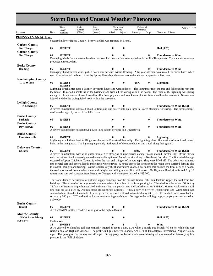
PENNSYLVANIA, Eastoccurred in lower Bucks County. Penny size hail was reported in Bristol.
Carbon CountyHail (0.75)0006Jim Thorpe 1025EST
Thunderstorm Wind0006Jim Thorpe 01025ESTCarbon County
Damaging winds from a severe thunderstorm knocked down a few trees and wires in the Jim Thorpe area. The thunderstorm alsoproduced dime size hail.
Thunderstorm Wind 1 006Reading 01045ESTBerks County
Damaging thunderstorm winds pulled down several wires within Reading. A 60-year-old man was treated for minor burns whenone of the wires fell on him. In nearby Spring Township, the same severe thunderstorm uprooted a few trees.
Lightning 20K0006 1 W Wilson 01115EST1130EST
Northampton County
Lightning struck a tree near a Palmer Township house and went indoors. The lightning struck the tree and followed its root intothe house. It started a small fire in the basement and fried all the wiring within the house. The force of the lightning was strongenough to blow a dresser down, force tiles off a floor, pop nails and knock over pictures from a wall in the basement. No one wasinjured and the fire extinguished itself within the basement.
Thunderstorm Wind (G50)0006 1 N Macungie 1130ESTLehigh County
A severe thunderstorm uprooted about 50 trees and one power pole on a farm in Lower Macungie Township. The farm's garageroof was damaged by some of the fallen trees.
Thunderstorm Wind0006Perkasie 01140ESTBucks County
Thunderstorm Wind0006Doylestown 01148ESTBucks County
A severe thunderstorm pulled down power lines in both Perkasie and Doylestown.
Lightning0006Plumsteadville 01145ESTBucks County
Lightning struck three Patriot's Ridge townhouses in Plumstead Township. The lightning blew off a section of a roof and burnedholes in the rain gutters. The lightning apparently hit the peak of the frame homes and travel along their gutters.
Thunderstorm Wind (G60) 200K0006Chester 01155ESTDelaware County
A severe thunderstorm with wind gusts estimated as strong as 70 mph caused damage in and around Chester City. Debris blownonto the railroad tracks severely caused a major disruption of Amtrak service along its Northeast Corridor. The first wind damageoccurred in Upper Chichester Township when the roof and shingles of an auto repair shop were lifted off. The debris was rammedinto several cars and several hoods and fenders were strewn. A house across the street from the repair shop suffered damage alsoto its deck, shingles and fencing. Within Chester City the thunderstorm knocked over a tree that crushed the front deck of a house,the roof was peeled from another house and shingles and sidings came off a third house. On Keystone Road, 8 roofs and 2 by 10rafters were torn and scattered from Pastuszek Garages with damage estimated at $35,000.
The worst damage occurred at a building supply company near the railroad tracks. The thunderstorm ripped the roof from twobuildings. The tar roof of its large warehouse was twisted into a heap in its front parking lot. The wind tore the second 50 foot by75 foot roof from an empty lumber shed and sent it into the power lines and landed intact on SEPTA's Marcus Hook regional railline that are also used by Amtrak along its Northeast Corridor. Amtrak service between Philadelphia and Wilmington wassuspended and stranded thousands of passengers. Service was restored to two tracks by 730 p.m. EDT and all tracks were back inservice by 930 p.m. EDT and in time for the next morning's rush hour. Damage to the building supply company was estimated at$100,000.
Thunderstorm Wind (G52)0006Bristol 1155ESTBucks County
A SKYWARN spotter recorded a wind gust of 60 mph in Bristol.
Hail (0.75)0009 5 NW Stroudsburg 1920ESTMonroe County
Wind0 1 016 02000ESTPAZ070 Delaware
A 10-year-old Wallingford girl was critically injured at about 5 p.m. EDT when a maple tree branch fell on her while she wasriding a bike on Highland Avenue. The peak wind gust between 4 and 5 p.m EDT at Philadelphia International Airport was 32mph. The peak gust for the day was 43 mph. Strong gusty northwest winds were blowing all day around an intensifying lowpressure in the Gulf of Maine.
157165
Storm Data and Unusual Weather Phenomena
Location Date Character of Storm
TimeLocal/Standard
PathLength(Miles)
PathWidth(Yards)
Number ofPersons
Killed Injured
EstimatedDamage
Property Crops
May 1997

PENNSYLVANIA, EastMonroe County
Thunderstorm Wind (G50)0019ReedersSkytop to 1950EST
2015ESTSevere thunderstorms produced wind damage throughout the northern two-thirds of Monroe County. Trees and wires werereported down. Wind gusts of 58 mph were recorded at both Tannersville and Mount Pocono.
Thunderstorm Wind0019TrachsvilleAlbrightsville to 01955EST
2010EST
Carbon County
Severe thunderstorms produced wind damage throughout eastern Carbon County. Trees and wires were reported down fromAlbrightsville south through Penn Forest and Towamensing Townships.
Thunderstorm Wind0019Bangor 02020ESTNorthampton County
A severe thunderstorm downed trees and wires in the northeastern part of Northampton County. Municipalities that reported winddamage included Bangor, Raubsville, Roseto, Stockertown, Wilson and Wind Gap. A couple of roads were closed in Stockertownbecause of downed trees. About 1,000 homes lost power during the height of the storm.
Heavy Rain0025Countywide 0600EST2100EST
Berks County
Heavy Rain0025Countywide 0600EST2100EST
Lehigh County
Heavy Rain0025Countywide 0600EST2100EST
Northampton County
Heavy Rain0025Countywide 0700EST2200EST
Bucks County
M40OU
Heavy Rain0 1 25Countywide 0700EST2200EST
Chester County
Heavy Rain0025Countywide 0700EST2200EST
Delaware County
Heavy Rain0025Countywide 0700EST2200EST
Montgomery County
Heavy Rain0025Countywide 0700EST2200EST
Philadelphia County
A series of low pressure systems traveling west to east along a nearly stationary frontal boundary produced some locally heavy rainacross Eastern Pennsylvania. The heaviest rain fell during the early afternoon in the Lehigh Valley and the late afternoon and earlyevening across the Greater Philadelphia Metropolitan Area. A 40-year-old man drowned in Nottingham while trying to cleardebris from a storm drain near the stables on his land. The rushing water knocked him into the storm drain. Storm totals averaged1 to 2 inches, with some locally higher amounts and caused the usual poor drainage flooding. Representative totals included 2.44inches in Doylestown (Bucks County), 2.31 inches in Perkasie (Bucks County), 2.05 inches at Northeast Philadelphia Airport,2.00 inches in Norristown (Montgomery County), 1.97 inches in Crum Creek (Delaware County), 1.92 inches in Phoenixville(Chester County), 1.88 inches in Palm (Montgomery County), 1.55 inches in Honey Brook (Chester County), 1.23 inches at theLehigh Valley International Airport and 1.10 inches at the Philadelphia International Airport. M40OU
Unseasonably Cool0031 2359EST
PAZ054>055-060>062-067>071
Carbon - Monroe - Berks - Lehigh - Northampton - Chester - Montgomery - Bucks - Delaware -Philadelphia
May 1997 was an unseasonably cool month. For most locations, it was the coolest May since 1967 with monthly departures thataveraged around 4 degrees below normal. At the Philadelphia International Airport, the monthly mean temperature 59.5 degreeswas 3.4 degrees below normal and was tied for the 8th coolest May on record. At the Lehigh Valley International Airport, themean temperature of 55.7 degrees was 4.6 degrees below normal and the 2nd coolest May on record.
A pulse type severe thunderstorm developed over extreme southern portions of Pike county shortly after 6 pm EDT. The cellbriefly intensified and produced dime sized hail just north of Bushkill around 615 pm.
Hail (0.75)0003 2 N Bushkill 1715EST
PENNSYLVANIA, NortheastPike County
158166
Storm Data and Unusual Weather Phenomena
Location Date Character of Storm
TimeLocal/Standard
PathLength(Miles)
PathWidth(Yards)
Number ofPersons
Killed Injured
EstimatedDamage
Property Crops
May 1997

PENNSYLVANIA, Northeast
A slow moving thunderstorm with vivid cloud to ground lightning had numerous ground strikes between 930 am EDT and 10am in north central Bradford county. In Athens township, three separate house fires resulted from the lightning strikes with roofdamage incurred in all three homes.
Lightning 20K0006Athens 0840EST0900EST
Bradford County
A line of severe thunderstorms rapidly developed over northern Pennsylvania with the northern end of the line moving acrossBradford county. Strong winds associated with these storms seriously damaged a barn in Silvara township around 1030 am EDT.
Thunderstorm Wind 40K0006Silvara 0930ESTBradford County
A different part of the squall line that was also responsible for wind damage in Bradford county caused isolated damage incentral Wyoming county. Trees and power lines were downed in Tunkhannock around 1030 am EDT.
Thunderstorm Wind 10K0006Tunkhannock 0930ESTWyoming County
A line of severe thunderstorms responsible for producing wind damage in Bradford and Wyoming counties ripped through thenorthern half of Luzerne county between 1030 and 1100 am EDT. Numerous large trees and wires were downed in East Berwickand Salem townships around 1040 am. In Forty Fort, a large tree was uprooted and fell on an occupied vehicle. No injuries werereported, but the car was heavily damaged.
Thunderstorm Wind 30K0006Forty FtEast Berwick to 0940EST
0950EST
Luzerne County
Thunderstorms intensified to severe levels over Pike county just after 12 noon EDT. Numerous large trees and power lineswere blown down in Milford around 1220 pm.
Thunderstorm Wind 10K0006Milford 1120ESTPike County
A bow echo type severe thunderstorm raced across northern sections of the county between 800 pm EDT and 900 pm.Widespread wind damage resulted, especially in the Wyoming Valley. West of Dallas township, numerous trees were uprooted and toppled around 820 pm. Four homes sustained damage fromfalling trees and several trailers were also blown over. At 825 pm, a large steeple was blown off the top of a church in Uniontownship, north of Shickshinny. From 830 to 835 pm, trees and wires were felled in Plymouth, causing damage to 2 homes and agarage. A roof was also torn off a house. At 835 pm, a tree was blown onto a roof top in Larksville. At 845 pm, an 8x8 footstorage shed was picked up and blown down the side of a hill in Wilkes-Barre. Around 850 pm, numerous large trees and powerlines were blown down in Duryea and Plains township. More than a dozen homes were damaged in these two localities and agrocery store also had their windows blown in. At 855 pm, the exterior wall of a trucking garage was damaged by the wind inPittston township.
Thunderstorm Wind 150K0019Pittston 8 W Dallas to 1920EST
1955EST
Luzerne County
The same line of severe storms that produced widespread damage in Luzerne county moved through Lackawanna countybetween 845 pm EDT and 930 pm, producing additional wind damage. At 845 pm, numerous trees and power lines were downed just east of Dalton. At 855 pm, more trees and power lines weretoppled in Taylor. From 900 to 905 pm, the storm moved through downtown Scranton, downing trees and power lines throughoutthe city. The most concentrated area of damage was on Adams street where large trees were blocking the road. At 905 pm, moretrees and power lines came down in Throop. At 915 pm, three homes sustained damage from falling trees in Scott township, justnorth of Montdale. One of the houses also had their chimney blown off.
Thunderstorm Wind 80K0019 3 N Montdale 4 E Dalton to 1945EST
2015EST
Lackawanna County
Severe thunderstorms that inflicted considerable wind damage on the Wilkes-Barre/Scranton vicinity moved through Waynecounty between 910 pm EDT and 945 pm.
Thunderstorm Wind 50K0019HawleyLake Ariel to 2010EST
2025EST
Wayne County
159167
Storm Data and Unusual Weather Phenomena
Location Date Character of Storm
TimeLocal/Standard
PathLength(Miles)
PathWidth(Yards)
Number ofPersons
Killed Injured
EstimatedDamage
Property Crops
May 1997
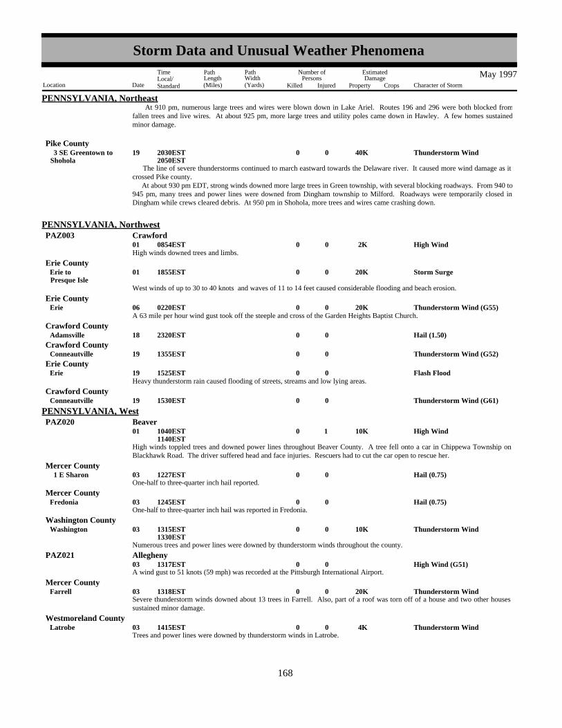
PENNSYLVANIA, Northeast At 910 pm, numerous large trees and wires were blown down in Lake Ariel. Routes 196 and 296 were both blocked fromfallen trees and live wires. At about 925 pm, more large trees and utility poles came down in Hawley. A few homes sustainedminor damage.
The line of severe thunderstorms continued to march eastward towards the Delaware river. It caused more wind damage as itcrossed Pike county. At about 930 pm EDT, strong winds downed more large trees in Green township, with several blocking roadways. From 940 to945 pm, many trees and power lines were downed from Dingham township to Milford. Roadways were temporarily closed inDingham while crews cleared debris. At 950 pm in Shohola, more trees and wires came crashing down.
Thunderstorm Wind 40K0019Shohola 3 SE Greentown to 2030EST
2050EST
Pike County
High Wind 2K0001 0854EST
PENNSYLVANIA, NorthwestPAZ003 Crawford
High winds downed trees and limbs.
Storm Surge 20K0001Presque IsleErie to 1855EST
Erie County
West winds of up to 30 to 40 knots and waves of 11 to 14 feet caused considerable flooding and beach erosion.
Thunderstorm Wind (G55) 20K0006Erie 0220ESTErie County
A 63 mile per hour wind gust took off the steeple and cross of the Garden Heights Baptist Church.
Hail (1.50)0018Adamsville 2320ESTCrawford County
Thunderstorm Wind (G52)0019Conneautville 1355ESTCrawford County
Flash Flood0019Erie 1525ESTErie County
Heavy thunderstorm rain caused flooding of streets, streams and low lying areas.
Thunderstorm Wind (G61)0019Conneautville 1530ESTCrawford County
High winds toppled trees and downed power lines throughout Beaver County. A tree fell onto a car in Chippewa Township onBlackhawk Road. The driver suffered head and face injuries. Rescuers had to cut the car open to rescue her.
High Wind 10K 1 001 1040EST1140EST
PENNSYLVANIA, WestPAZ020 Beaver
One-half to three-quarter inch hail reported.Hail (0.75)0003 1 E Sharon 1227EST
Mercer County
One-half to three-quarter inch hail was reported in Fredonia.Hail (0.75)0003Fredonia 1245EST
Mercer County
Numerous trees and power lines were downed by thunderstorm winds throughout the county.
Thunderstorm Wind 10K0003Washington 1315EST1330EST
Washington County
A wind gust to 51 knots (59 mph) was recorded at the Pittsburgh International Airport.High Wind (G51)0003 1317EST
PAZ021 Allegheny
Severe thunderstorm winds downed about 13 trees in Farrell. Also, part of a roof was torn off of a house and two other housessustained minor damage.
Thunderstorm Wind 20K0003Farrell 1318ESTMercer County
Trees and power lines were downed by thunderstorm winds in Latrobe.Thunderstorm Wind 4K0003Latrobe 1415EST
Westmoreland County
160168
Storm Data and Unusual Weather Phenomena
Location Date Character of Storm
TimeLocal/Standard
PathLength(Miles)
PathWidth(Yards)
Number ofPersons
Killed Injured
EstimatedDamage
Property Crops
May 1997

PENNSYLVANIA, WestBeaver County
Several trees were downed by thunderstorm winds throughout the county.
Thunderstorm Wind 8K0003Beaver 1420EST1430EST
Power lines and trees were downed by thunderstorm winds in Wheatland.Thunderstorm Wind 3K0003Wheatland 1425EST
Mercer County
Thunderstorm winds downed trees.Thunderstorm Wind 2K0003 2 SE New Castle 1430EST
Lawrence County
Thunderstorm winds downed trees and power lines throughout the county.
Thunderstorm Wind 5K0003Washington 1430EST1440EST
Washington County
Hail (0.75)0003 2 NE Washington 1440ESTWashington County
Trees and a few power lines were downed by thunderstorm winds. Thunderstorm Wind 3K0003Brownsville 1440EST
Fayette County
Trees and power lines were downed throughout the county.Thunderstorm Wind 8K0003Butler 1445EST
Butler County
Power lines and trees were downed by thunderstorm winds throughout the county.
Thunderstorm Wind 8K0003Mercer 1450EST1505EST
Mercer County
Several trees were downed in North Park.Thunderstorm Wind 3K0003 3 SE Wexford 1450EST
Allegheny County
A Skywarn Accruement Radio Operator reported three-quarter inch diameter hail.Hail (0.75)0003 2 SW Bridgeville 1455EST
Allegheny County
Trees and power lines were downed throughout the county.Thunderstorm Wind 5K0003Uniontown 1500EST
Fayette County
A Skywarn Amtrak Radio Operator reported a few small trees downed.Thunderstorm Wind 1K0003Verona 1500EST
Allegheny County
Trees and power lines were downed by thunderstorm winds throughout the county.Thunderstorm Wind 8K0003Mercer 1506EST
Mercer County
Trees and power lines were reported downed within the city of Pittsburgh.Thunderstorm Wind 3K0003Pittsburgh 1507EST
Allegheny County
Large branches were downed near Mt. Carmel CemeteryThunderstorm Wind 1K0003Penn Hills 1512EST
Allegheny County
Trees and power lines were downed by thunderstorm winds throughout the county.Thunderstorm Wind 8K0003Latrobe 1515EST
Westmoreland County
Trees and some power lines were downed in Oil City and across the northern part of the county.Thunderstorm Wind 4K0003Oil City 1515EST
Venango County
Several trees, power lines, and a couple of utility poles were downed by thunderstorm winds throughout the county.Thunderstorm Wind 10K0003Kittanning 1515EST
Armstrong County
A Skywarn severe weather spotter reported trees downed by thunderstorm winds.Thunderstorm Wind 4K0003Pleasantville 1535EST
Venango County
161169
Storm Data and Unusual Weather Phenomena
Location Date Character of Storm
TimeLocal/Standard
PathLength(Miles)
PathWidth(Yards)
Number ofPersons
Killed Injured
EstimatedDamage
Property Crops
May 1997

PENNSYLVANIA, WestVenango County
A large tree was downed across a road.Thunderstorm Wind 1K0003 3 WNW Pleasantville 1538EST
Trees were downed by thunderstorm winds.Thunderstorm Wind 2K0003Kittanning 1555EST
Armstrong County
A microburst, with wind speeds between 80 and 90 mph. Seven homes and a grocery store were damaged. A barn was destroyedand some of its debris was strewn several hundred yards. Some of the debris landed on the Pennsylvania Turnpike. A mobilehome was moved several hundred feet. The damage was confined to a 1500 foot by 2000 foot area. Much of the damage to thehomes were broken windows, roof damage, and porch canopies torn away. Numerous tree branches were downed and some treeswere uprooted.
Thunderstorm Wind (G78) 40K0014Acme 2200ESTWestmoreland County
Thunderstorm winds downed trees.Thunderstorm Wind 2K0018Clarksville 1634EST
Greene County
Thunderstorm winds downed power lines.Thunderstorm Wind 2K0018South Strabane 1650EST
Washington County
Trees were downed by thunderstorm winds across Route 88.Thunderstorm Wind 2K0018California 1650EST
Washington County
Trees were downed by thunderstorm winds across Davis School Road.Thunderstorm Wind 2K0018 3 NE Washington 1650EST
Washington County
Trees were downed by thunderstorm winds.Thunderstorm Wind 2K0018Charleroi 1655EST
Washington County
Thunderstorm winds fell trees across Route 30 near Idlewild Park.Thunderstorm Wind 2K0018 2 NW Ligonier 1730EST
Westmoreland County
Large branches were downed by thunderstorm winds.Thunderstorm Wind 1K0018 3 N Canonsburg 1935EST
Washington County
Thunderstorm winds tore part of a roof from a house. Large trees and power lines were also downed. A roof from a barn wasblown off.
Thunderstorm Wind 20K0018Washington 1940ESTWashington County
Large trees were downed in the East Liberty section of Pittsburgh.Thunderstorm Wind 2K0018Pittsburgh 1945EST
Allegheny County
Thunderstorm winds blew out windows at an automobile dealership. A section of a roof over the entrance of a supermarket wasblown off. Large trees were also downed.
Thunderstorm Wind 50K0018Morrisville 2030ESTGreene County
Large trees were downed by thunderstorm winds.Thunderstorm Wind 2K0018Fairchance 2040EST
Fayette County
Heavy thunderstorm rains led to a small creek leading to Little Mingo Creek to go out of its banks and flood Beagle Club Road.Water collected around a nearby horse barn. A 40 year-old man died when he was swept into a 24 inch wide sewer pipe that hewas trying to clear in the flooded horse barn.
Flash Flood0 1 19 1 NW Ginger Hill 1500ESTWashington County
M40IW
Numerous trees were downed by thunderstorm winds throughout the county, primarily in the southern sections.Thunderstorm Wind 5K0019Aliquippa 1625EST
Beaver County
Thunderstorm Wind (G57)0019Sewickley Hgts 1627ESTAllegheny County
Numerous trees and power lines were downed near Highland, North Park, along McKnight Road and other locations in the NorthThunderstorm Wind 12K0019Highland 1656EST
Allegheny County
162170
Storm Data and Unusual Weather Phenomena
Location Date Character of Storm
TimeLocal/Standard
PathLength(Miles)
PathWidth(Yards)
Number ofPersons
Killed Injured
EstimatedDamage
Property Crops
May 1997

PENNSYLVANIA, WestHills.
Numerous trees and power lines were downed by thunderstorm winds.Thunderstorm Wind 8K0019New Kensington 1659EST
Westmoreland County
Hail (0.75)0019Penn Hills 1700ESTAllegheny County
Hail (0.75)0019Oakmont 1706ESTAllegheny County
Thunderstorm winds downed trees.Thunderstorm Wind 2K0019Vandergrift 1720EST
Westmoreland County
Trees were downed by thunderstorm winds.Thunderstorm Wind 2K0019Arnold 1720EST
Westmoreland County
Thunderstorm winds downed power lines and about 30 large trees.Thunderstorm Wind 6K0019New Kensington 1730EST
Westmoreland County
Thunderstorm winds downed a tree and some large branches.Thunderstorm Wind 1K0019Homer City 1744EST
Indiana County
Numerous trees were downed by thunderstorm winds.Thunderstorm Wind 5K0019Washington 1745EST
Washington County
A tree and some large branches were downed by thunderstorm winds.Thunderstorm Wind 1K0019Nowrytown 1800EST
Indiana County
Thunderstorm winds downed a tree and some large limbs.Thunderstorm Wind 1K0019 2 N Connellsville 1815EST
Fayette County
Heavy thunderstorm rain and some wind weakened the roots of a large tree and the tree fell onto a pickup truck's windshieldtravelling on Route 66. A 13 year-old passenger was killed by the falling tree. The boy's father was seriously injured and themother was treated overnight and released.
Heavy Rain 2 1 19 2 ENE Kittanning 1825ESTArmstrong County
M13VE
Thunderstorm winds downed a tree onto Route 201. Some large branches were also downed. Thunderstorm Wind 1K0019Vanderbilt 1838EST
Fayette County
Roads were flooded after heavy thunderstorm rains.
Flash Flood0019Claysville 1930EST2000EST
Washington County
A few roads were closed after heavy thunderstorm rains led to rapid flooding.
Flash Flood0019East Finley 1930EST2000EST
Washington County
Heavy thunderstorm rains led to flash flooding of streets and a few basements.
Flash Flood 3K0019Washington 1930EST2000EST
Washington County
Widespread heavy thunderstorm rains covered southwest Pennsylvania. Hardest hit was Westmoreland County. Widespread 3-4inch rainfall totals were common across the county. Numerous roads were flooded and several basements were flooded. Route982 was closed north of Route 30. 60-70 people were evacuated in the Darlington area. Evacuations were also ordered in Wilpen.Major road flooding was reported between Darlington and Ligonier. Numerous small streams and creeks went out of their banks.A large amount of runoff led to the flooding of the Conemaugh River at Seward.
Flash Flood 200K002526
Wilpen 0940EST0200EST
Westmoreland County
Heavy thunderstorm rains led to widespread flooding across Butler County. The Little Buffalo Creek and small tributary streams
Flash Flood 100K002526
Butler 1025EST0200EST
Butler County
163171
Storm Data and Unusual Weather Phenomena
Location Date Character of Storm
TimeLocal/Standard
PathLength(Miles)
PathWidth(Yards)
Number ofPersons
Killed Injured
EstimatedDamage
Property Crops
May 1997

PENNSYLVANIA, Westof the Connoquenessing River went out of their banks. About 100 basements flooded throughout the county. Several roads werealso flooded.
Widespread heavy thunderstorm rains led to Buffalo Creek overflowing its banks.
Flash Flood 1K0025Iron Bridge 1200EST2000EST
Armstrong County
Widespread heavy thunderstorm rains led to Two Lick Creek overflowing its banks.
Flash Flood 1K0025Homer City 1200EST2000EST
Indiana County
Widespread heavy thunderstorm rains led to Little Chartiers Creek overflowing its banks, flooding part of nearby Route 519. Atotal of 3.6 inches of rain was reported in Eighty Four.
Flash Flood 1K0025Eighty Four 1200EST2000EST
Washington County
Widespread heavy thunderstorm rains led to basement flooding in Penn Hills.Flash Flood 10K0025Penn Hills 1300EST
Allegheny County
Widespread thunderstorm rains led to basement flooding in Republic. Jacobs and Indian Creeks went out of their banks.
Flash Flood 5K0025Republic 1618EST2000EST
Fayette County
Flood 7K002526
1700EST1700EST
PAZ023-030 Indiana - Westmoreland
Widespread heavy thunderstorm rains led to a rapid rise on the Conemaugh River at Seward. Rainfall amounts in the vicinity werebetween 3 and 4 inches. The river crested at 14.6 feet at 11 pm EST, 2.6 feet above the 12 foot flood stage. Nearby homes wereflooded along the River. The river fell below flood stage early on the morning of the 26th.
A pilot reported a waterspout 1 nautical mile north of Culebra.
Waterspout0003Culebra 1238AST1253AST
PUERTO RICOCulebra
Waterspout0003Culebra 1740AST1815AST
Culebra
Flight Service Station reported three waterspouts three miles west of Culebra.
Waterspout0003Culebra 1830AST1850AST
Culebra
An observer reported multiple waterspouts just north of Culebra.
Urban/Sml Stream Fld0007Loiza 1725AST1825AST
Carolina
Heavy rains produced several small streams out of their banks in the town of Loiza. In addition route 187 was flooded and closedto traffic.
Waterspout0008Guayama 1315AST1415AST
Guayama Salinas
A weather observer reported two waterspouts and a funnel cloud five miles offshore in the southeast coast of Puerto Rico betweenGuayama and Patillas.
Waterspout0018Fajardo 1845AST1915AST
Fajardo Rio Grande
A waterspout was reported by an observer five miles east of Fajardo.
Heavy Rain0024Toa Alta 1545AST1745AST
La Plato Dorado
Civil Defense reported minor flooding in the town of Toa Alta.
164172
Storm Data and Unusual Weather Phenomena
Location Date Character of Storm
TimeLocal/Standard
PathLength(Miles)
PathWidth(Yards)
Number ofPersons
Killed Injured
EstimatedDamage
Property Crops
May 1997

PUERTO RICOLa Plato Dorado
Heavy Rain0024Comerio 1545AST1745AST
Civil Defense reported minor flooding in the town of Comerio.
Heavy Rain0024San Sebastian 1545AST1745AST
Aguadilla
Civil Defense reported minor flooding in the town of San Sebastian.
A heavy downpour in The Guaynabo's Marina sector caused urban street flooding and forced pedestrians to wade thigh-high tocross one low lying street.
Urban/Sml Stream Fld0024Guaynabo 1545AST1745AST
Bayamon
Waterspout0024Fajardo 1600AST1630AST
Fajardo Rio Grande
A pilot reported a waterspout near Palomino island east of Fajardo.
Heavy Rain0024Fajardo 1705AST1905AST
Fajardo Rio Grande
Civil Defense reported minor flooding of roads, streets and streams across Fajardo.
Heavy Rain0024Ceiba 1705AST1905AST
Humacao
Civil Defense reported minor street and streams flooding in the town of Ceiba.
Waterspout0026Fajardo 1420AST1450AST
Fajardo Rio Grande
A small craft operators reported two waterspouts near Ramos island three miles east of Fajardo.
Urban/Sml Stream Fld0026San Juan 1500AST1600AST
Bayamon
Civil Defense reported Baldorioty expressway in Santurce was flooded.
Waterspout0026Fajardo 1631AST1700AST
Fajardo Rio Grande
A weather observer reported a waterspout between Fajardo and Margarita island.
Tstm Wind/Hail0028Aguadilla 1200AST1300AST
Aguadilla
A weather observer reported strong winds and hail at the Aguadilla airport. Numerous palm tree branches were scattered aroundand some mature palm trees were uprooted. A lightning stike fell on the runway and made a crater 18 inches deep and about 3 feetwide.
The cooperative observer at Barrio Botijas I in Orocovis reported two inches size hail.
Hail (2.00)0029Orocovis 1400AST1430AST
Vega Baja Manati
Thunderstorm Wind (G50)0029Manati 1620AST1650AST
Vega Baja Manati
Civil Defense reported that a roof top was detached by the strong winds in Manati.
Hail (0.75)0029Arecibo 1620AST1650AST
Arecibo
Civil Defense reported hail in the towns of Arecibo and Hatillo.
Waterspout0031Culebra 1734AST1800AST
Culebra
A waterspout was reported one mile northwest of Culebra.
165173
Storm Data and Unusual Weather Phenomena
Location Date Character of Storm
TimeLocal/Standard
PathLength(Miles)
PathWidth(Yards)
Number ofPersons
Killed Injured
EstimatedDamage
Property Crops
May 1997

PUERTO RICOArecibo
Heavy Rain0031Utuado 1940AST2040AST
Civil Defense reported mud slides in Utuado produced by heavy rains, also frequent lightning with strong and gusty winds wasreported about 40 minutes earlier.
NONE REPORTED.
RHODE ISLAND
Thunderstorm Wind (G55)0003 1 W Lugoff 0648EST
SOUTH CAROLINA, CentralKershaw County
Post Office reports trees down in Gettysburg, 1W of Lugoff.
Thunderstorm Wind (G55)0003Leesville 0700ESTLexington County
Sheriff reports trees and powerlines down in Leesville.
Thunderstorm Wind (G55)0003Chapin 0720ESTRichland County
Police report several trees down in Chapin.
Thunderstorm Wind (G55)0003Kline 1142ESTBarnwell County
Utility Company and EPD report trees and powerlines down in and around Kline.
Thunderstorm Wind (G50)0003Bamberg 1205ESTBamberg County
Police report a few trees down around Bamberg.
Thunderstorm Wind (G60)0009Lexington 1640ESTLexington County
A severe thunderstorm blew off portions of the Lexington Middle School roof.
Thunderstorm Wind (G50)0009St. Andrews 1645ESTLexington County
A severe thunderstorm took down large tree branches in St. Andrews.
Thunderstorm Wind (G65) 20K 1 009Columbia 1 NW Columbia to 01650EST
1655EST
Richland County
A severe thunderstorm took down trees and powerlines in northwest and west Columbia. One woman was trapped in her car andhad to be cut out. She had only minor injuries.
Thunderstorm Wind (G56)0009 15 SE Columbia 1702ESTRichland County
A severe thunderstorm took down several trees at McEntire Air National Guard Base.
Hail (1.00)0015 1 S Bamberg 1755ESTBamberg County
Sheriff reports a severe thunderstorm produced 1 inch hail just south of Bamberg.
Thunderstorm Wind (G50) 3K0026 15 SE Winnsboro 01810ESTFairfield County
Sheriff reports a severe thunderstorm knocked down trees and powerlines in Longtown.
Thunderstorm Wind (G50) 50K0026 8 N Sumter 01900ESTSumter County
EPD reports trees down just north of Sumter. A mobile home was also demolished and roofs were damaged on several homes andbarns.
Hail (1.75)0031Irmo 1744ESTLexington County
EPD reports golf ball size hail in Irmo.
Thunderstorm Wind (G50)0031Irmo 1745ESTLexington County
State Highway Patrol reports scattered trees down on Weed Drive near Highway 60.
Thunderstorm Wind (G50)0031Ballentine 1750ESTRichland County
State Highway Patrol reports scattered trees down on Highway 6 just south of Ballentine.
166174
Storm Data and Unusual Weather Phenomena
Location Date Character of Storm
TimeLocal/Standard
PathLength(Miles)
PathWidth(Yards)
Number ofPersons
Killed Injured
EstimatedDamage
Property Crops
May 1997

SOUTH CAROLINA, CentralLexington County
Flash Flood0031Irmo 1845EST2145EST
Two to six inches of rain fell over the Irmo area in a two hour period triggering flash flooding along Yost Creek. A couple of roadshad to be closed and a couple of homes had water make it into the lowest levels.
Thunderstorm Wind (G50)0031South Congaree 1848ESTLexington County
Utility company reports several trees down on powerlines in South Congaree.
Numerous trees uprooted, large limbs and power lines down. 1300 customers without power for more than an hour. Thunderstorm Wind (G60)0026Choppee 1420EST
SOUTH CAROLINA, North CoastalGeorgetown County
Reported by Skywarn Spotter
Hail (1.00)0026Murrells Inlet 1735EST1738EST
Georgetown County
Reported by Skywarn Spotter 4W of Surfside Beach
Hail (1.00)0026Surfside Beach 1745EST1748EST
Horry County
Reported by Fire Chief 1/2 mile north of Murrells Inlet
Hail (1.75)0026Murrells Inlet 1750EST1755EST
Georgetown County
Reported by City Police
Hail (0.75)0026Georgetown 1815EST1817EST
Georgetown County
Hail (0.75)0002Westminster 2222EST2232EST
SOUTH CAROLINA, NorthwestOconee County
A severe thunderstorm caused large hail near Westminster.
Thunderstorm Wind (G50)0003 6 N Greenville 0330ESTGreenville County
The wind from a severe thunderstorm downed some trees and power lines around Paris Mountain. A couple of trees were alsodowned in Eastside Greenville.
Gusty Winds 3K 6 013 1420EST1430EST
SCZ006 Southern Greenville
A cement block wall collapsed causing minor injuries to six workers. The damage was blamed on gusty winds which were wellbelow high wind criteria - reported in the area to as high as 30 to 35 mph.
Thunderstorm Wind (G55)0026 10 S Chester 1735EST1740EST
Chester County
The wind from a severe thunderstorm caused significant damage in the southern part of the county. Large trees were downed andblocked roads for several hours. Power lines were also downed. A little later, a single tree was downed in the town of Chester.
Thunderstorm Wind (G50)0003Allendale 1215EST1218EST
SOUTH CAROLINA, South CoastalAllendale County
Thunderstorm Wind (G50)0003Ruffin 1300EST1403EST
Colleton County
Hail (1.75)0003Grover 1305EST1308EST
Dorchester County
Hail (1.00)0003Moncks Corner 1325EST1327EST
Berkeley County
167175
Storm Data and Unusual Weather Phenomena
Location Date Character of Storm
TimeLocal/Standard
PathLength(Miles)
PathWidth(Yards)
Number ofPersons
Killed Injured
EstimatedDamage
Property Crops
May 1997

SOUTH CAROLINA, South CoastalColleton County
Thunderstorm Wind (G50)0003Islandton 1353EST1356EST
A house was damaged on Harbour Island and several trees down.
Thunderstorm Wind (G55) 25K0003 1 S Beaufort 1400EST1404EST
Beaufort County
Hail (1.75)0003Walterboro 1405EST1408EST
Colleton County
Hail (0.75)0003Charleston Afb 1414EST1417EST
Charleston County
Golfball sized hail covered the ground at the 18th green at Legends Oak golf course.
Hail (1.75)0003Charleston 1436EST1439EST
Charleston County
Thunderstorm Wind (G55)0003Ridgeland 1440EST1443EST
Jasper County
Hail (0.75)0003 3 SE Ladson 1450EST1453EST
Charleston County
A line of severe thunderstorms moved across the area and downed numerous trees and powerlines. Also, there were scatteredreports of hail (dime size to golfball size).
One inch hail observed and trees were blown down across U.S. Highway 17.
Tstm Wind/Hail0009Jacksonboro 1715EST1718EST
Colleton County
Trees down across Highway 63.
Thunderstorm Wind (G55)0009Walterboro 1730EST1733EST
Colleton County
Hail (0.88)0009Hampton 1730EST1734EST
Hampton County
Several large tree limbs down and nickel sized hail observed..
Tstm Wind/Hail0009Hampton 1740EST1744EST
Hampton County
Hail reports ranging from nickel size to quarter size obseved.
Hail (1.00)0009Walterboro 2 W Ruffin to 1745EST
1753EST
Colleton County
Trees and powerlines down several locations.
Thunderstorm Wind (G50)0009Charleston 5 W Charleston to 1750EST
1800EST
Charleston County
Nickel sized hail broke a weather service employee's automobile window.
Hail (0.88)0009Charleston 1752EST1755EST
Charleston County
Trees down.
Thunderstorm Wind (G50)0009 5 W Jacksonboro 1755EST1758EST
Colleton County
Trees and powerlines down.
Thunderstorm Wind (G55)0009Varnville 1800EST1803EST
Hampton County
168176
Storm Data and Unusual Weather Phenomena
Location Date Character of Storm
TimeLocal/Standard
PathLength(Miles)
PathWidth(Yards)
Number ofPersons
Killed Injured
EstimatedDamage
Property Crops
May 1997

SOUTH CAROLINA, South CoastalCharleston County
Three aircraft were overturned at the East Cooper Airport.
Thunderstorm Wind (G71)0009 5 NE Mt Pleasant 1810EST1813EST
Hail (0.75)0015Bonneau 2040EST2043EST
Berkeley County
Flood000131
0000CST2359CST
SOUTH DAKOTA, Central and NorthSDZ006-018 Brown - Spink
The record flooding on the James River in March and April continued a slow fall through the month of May. The James Riverbegan the month of May at 5 to 9 feet above flood stage and dropped to 3 to 5 feet above flood stage by the end of the month atmost locations. Three miles northeast of Redfield, the James River fell below flood stage on May 19th. Thousands of acres offarmland and pastureland remained flooded by the James through May. As a result, large ecomonic losses were incurred from theinability to plant the flooded acres. Also, many county and township roads remained flooded and damaged through May,continuing the travel problems and large detours.
Flood/Strong Wind000131
0000CST2359CST
SDZ022 Hamlin
Lake Poinsett remained four feet overfull through the end of May and continued to flood many homes and cabins. Nearly fifteenfamilies were still not able to get to their homes by the end of May. The high lake level combined with several days of strongwinds gusting to 40 mph resulted in four foot waves on the lake. The days with the strongest winds were the 5th, 8th, 11th, and13th. The high waves combined with floating debris, landscaping logs, railroad ties, timber, docks, etc., continued to causeconsiderable damage to cabins and homes around the lake. Broken windows and doors were the main things damaged.
Flood000102
1600CST2000CST
SDZ033>037-045-048-051
Stanley - Sully - Hughes - Hyde - Hand - Jones - Lyman - Buffalo
Heavy rains of 1.5 to 2.5 inches with isolated 4.5 inch amounts fell over central South Dakota and caused the flooding of severalcreeks, streams, low-lying areas, and roads. This early May rain only aggravated the areas flooded in March and April. Lymancounty experienced the most significant flooding where 4.5 inches of rain fell north of Vivian. Part of a golf course was flooded,some personal property was flooded along with the KOA campground near Kennebec.
Thunderstorm Wind (G52)0004 9 SE Morristown 1750CSTCorson County
Thunderstorm Wind (G54)0004Mobridge 1912CSTWalworth County
Thunderstorm Wind (G52)0004Pollock 1915CSTCampbell County
Thunderstorm Wind (G52)0004 1 N Hosmer 1945CSTEdmunds County
Thunderstorm winds gusting to 60 mph damaged a calf barn 1 mile north of Hosmer.
Hail (0.75)0017Kidder 1830CSTMarshall County
Hail (0.75)0017Britton 1850CSTMarshall County
Hail (1.75)0017 2 N Britton 1853CSTMarshall County
Hail (1.00)0017Lake City 1930CSTMarshall County
Hail (0.75)0017 4 E Eden 1940CSTMarshall County
Hail (0.75)0017 9 SW Sisseton 2011CSTRoberts County
Flood000131
0000CST2359CST
SOUTH DAKOTA, SoutheastSDZ038-053-059>060-065-069
Beadle - Sanborn - Davison - Hanson - Hutchinson - Yankton
Flooding from spring snowmelt continued along the James River throughout May. No new damage or problems were reported, but
169177
Storm Data and Unusual Weather Phenomena
Location Date Character of Storm
TimeLocal/Standard
PathLength(Miles)
PathWidth(Yards)
Number ofPersons
Killed Injured
EstimatedDamage
Property Crops
May 1997

SOUTH DAKOTA, Southeastfarmland and other lowlands along the river continued to be flooded despite the slow fall.
SDZ040-056-062-067-071
Brookings - Moody - Minnehaha - Lincoln - Union
Flood000117
0000CST0600CST
Flooding from spring snowmelt continued along the Big Sioux River at the beginning of May. Although secondary crests occurredearly in the month, flooding was still well down from early April. Farmland and other lowland flooding abated as the river fellbelow flood stage around the middle of May.
Hail (0.75)0007 2 SE Garretson 0601CSTMinnehaha County
Thunderstorm Wind (G75)0004Buffalo Arpt 1548MST1550MST
SOUTH DAKOTA, WestHarding County
Thunderstorm Wind (G62)0004(Y22)Lemmon Arpt 1648MST1650MST
Perkins County
Sheriff's office reported dime size hail in Manchester. Hail (0.75)0001Manchester 0048CST
TENNESSEE, CentralCoffee County
Sheriff's office reported power lines down.Thunderstorm Wind (G50)0.50K0002Chapel Hill 1630CST
Marshall County
Sheriff's office reported many power lines down.Thunderstorm Wind (G50) 5K0002Flat Creek 1649CST
Bedford County
Sheriff's office reported many power lines down.Thunderstorm Wind (G50) 5K0002Normandy 1649CST
Bedford County
Sheriff's office reported dime size hail.Hail (0.75)0002Wheel 1649CST
Bedford County
Local law enforcement reported a few trees blown down.Thunderstorm Wind (G50)0002Dellrose 1650CST
Lincoln County
Sheriff's office reported large tree limbs down.Thunderstorm Wind (G50)0002 5 N Lynchburg 1655CST
Moore County
Local law enforcement reported a telephone pole and power lines were down.Thunderstorm Wind 1K0002Decherd 1715CST
Franklin County
Local law enforcement reported a few trees and power lines down.Thunderstorm Wind (G50) 1K0002Manchester 1720CST
Coffee County
Local electric company reported power lines down.Thunderstorm Wind (G50)0002Pelham 1730CST
Grundy County
Local electric company reported power lines down.Thunderstorm Wind (G50)0002Viola 1730CST
Warren County
Electric company reported lightning damaged a transformer near the Baker Boyd Subdivsion in the Turkey Scratch area near Spencer.
Lightning 100K0001Spencer 0145CSTVan Buren County
A half dozen farm related buildings sustained damage. About 100 big trees were blown down in an apple orchard on White Gap
Tornado (F2) 60K0150 0.9 002 3.2 SSE Huntland 2.6 S Huntland to 100K1700CST
1702CST
Franklin County
170178
Storm Data and Unusual Weather Phenomena
Location Date Character of Storm
TimeLocal/Standard
PathLength(Miles)
PathWidth(Yards)
Number ofPersons
Killed Injured
EstimatedDamage
Property Crops
May 1997

TENNESSEE, CentralRoad. The trees were lying in different directions.
Sheriff's office reported trees down around Byrdstown.Thunderstorm Wind (G50)0014Byrdstown 1915CST
Pickett County
Highway department reported trees down in northeast part of the county.
Thunderstorm Wind (G50)0014Northeast Sections 2045CSTOverton County
Several stores suffered high water invasion.
Flash Flood 50K0019Fairview 1437CST1845CST
Williamson County
Highway department reported 4 trees blown down around the county.Thunderstorm Wind (G50)0019Countywide 1600CST
Hickman County
Trees and wires were down.Thunderstorm Wind 50K0019Fairview 1619CST
Williamson County
Highway department reported a tree blown down.Thunderstorm Wind (G50)0019Big Rock 1700CST
Stewart County
Many roads flooded in the Fairview area such as Chester Road, Old Cox Pike, and Pinewood Road.
Flash Flood0019Fairview 1700CST1845CST
Williamson County
Strong thundertstorm winds blew off part of a roof at the Elk's Lodge in Murfreesboro.Thunderstorm Wind 10K0019Murfreesboro 1715CST
Rutherford County
EMA director reported a few trees down.Thunderstorm Wind (G50)0019Taft 1800CST
Lincoln County
Highway department reported about 5 trees blown down.Thunderstorm Wind (G50)0019Countywide 1600CST
Hickman County
Sheriff's office reported a few trees blown down.Thunderstorm Wind (G50)0019Fairview 1630CST
Williamson County
High water on roads, especially Old Franklin Road. The water caused some damage to the road.
Flash Flood 50K0019Fairview 1700CST1900CST
Williamson County
SKYWARN Spotter reported trees and large tree limbs were blown down.Thunderstorm Wind (G50)0019Flintville 1900CST
Lincoln County
Metro Nashville EOC reported one tree was down on McCrory Lane in west Nashville.Thunderstorm Wind (G50)0019Nashville 1924CST
Davidson County
Large tree limbs and and a few power lines were down.Thunderstorm Wind 1K0026 2 W Dover 0840CST
Stewart County
A few trees were down in southern Montgomery county along HWY 48.Thunderstorm Wind (G50)0026 4 S Cunningham 0855CST
Montgomery County
Dime size hail reported at Camden.Hail (0.75)0026Camden 0900CST
Benton County
Large trees limbs and a few power lines were down.Thunderstorm Wind 1K0026Erin 0915CST
Houston County
171179
Storm Data and Unusual Weather Phenomena
Location Date Character of Storm
TimeLocal/Standard
PathLength(Miles)
PathWidth(Yards)
Number ofPersons
Killed Injured
EstimatedDamage
Property Crops
May 1997

TENNESSEE, CentralHumphreys County
Numerous trees were down and a few shingles came off a roof.Thunderstorm Wind 5K0026Waverly 0915CST
A few trees were blown down.Thunderstorm Wind (G50)0026 5 S Mc Ewen 0940CST
Humphreys County
A few power lines were down at Oak Grove.Thunderstorm Wind 1K0026Oak Grove 0950CST
Dickson County
A few power lines were down.Thunderstorm Wind 1K0026 3 N Pinewood 0955CST
Hickman County
A few power lines were down.Thunderstorm Wind 1K0026Pleasant View 1015CST
Cheatham County
A few trees were blown down.Thunderstorm Wind (G50)0026 2 SE Bellevue 1020CST
Davidson County
Several trees were blown down.Thunderstorm Wind (G50)0026Franklin 1030CST
Williamson County
2 trees were blown down.Thunderstorm Wind (G50)0026 8.6 E Columbia 1100CST
Maury County
2 trees were blown down.Thunderstorm Wind (G50)0026Chapel Hill 1110CST
Marshall County
A few power lines were blown down.Thunderstorm Wind 1K0026Eagleville 1130CST
Rutherford County
Numerous trees were blown down.Thunderstorm Wind (G50)0026 5.2 NE Wartrace 1400CST
Bedford County
Windows were blown out of homes and a barn was destroyed by strong thunderstorm winds.Thunderstorm Wind 20K0026Christiana 1400CST
Rutherford County
Trees were down in Beech GroveThunderstorm Wind (G50)0026Beech Grove 1410CST
Coffee County
SKYWARN Spotter reported dime size hail.Hail (0.75)0026Deerfield 1517CST
Lawrence County
A SKYWARN Spotter reported a tree was blown down in her back yard.Thunderstorm Wind (G50)0.50K0026 2 S Huntland 1625CST
Franklin County
Ping pong ball size hail reported at Parsons.Hail (1.50)0026Parsons 1830CST
Decatur County
Trees were blown down and blocking a road in Parsons.Thunderstorm Wind 10K0026Parsons 1830CST
Decatur County
Quarter size hail reported at I-40/440 junction.Hail (1.00)0026Nashville 2049CST
Davidson County
A few power lines were down.Thunderstorm Wind 1K0026Lascassas 2150CST
Rutherford County
Williamson county EMA reported several trees down around the county.Thunderstorm Wind (G50)0026Franklin 1030CST
Williamson County
172180
Storm Data and Unusual Weather Phenomena
Location Date Character of Storm
TimeLocal/Standard
PathLength(Miles)
PathWidth(Yards)
Number ofPersons
Killed Injured
EstimatedDamage
Property Crops
May 1997

TENNESSEE, EastBradley County
Thunderstorm Wind0002South End Of County 20K1930ESTSevere thunderstorm winds blew down many trees.
Thunderstorm Wind 20K0013Countywide 15K1620ESTHamblen County
Trees down and a few powerlines down throughout county.
Thunderstorm Wind 15K0013Countywide 23K1630ESTHawkins County
Thunderstorm Wind0013Countywide 20K1630ESTJefferson County
Trees down throughout both counties. Phone lines down in Rogersville in Hawkins county.
Thunderstorm Wind 15K0013Countywide 5K1645ESTCocke County
Thunderstorm Wind0013Countywide 2K1645ESTGreene County
Trees down across Highway 70 in Greene county. A few trees and powerlines down in Cocke county.
Thunderstorm Wind0013Erwin 8K1720ESTUnicoi County
Winds from a severe thunderstorm blew a large tent over during a tent revival meeting. A few trees were also blown down.
Flash Flood002627
Countywide 2150EST2345EST
Carter County
Flash Flood002627
Countywide 2245EST2345EST
Sullivan County
In Carter county roads were flooded around Unaka High School on Highway 91. Streets flooded in Elizabethton. In Sullivancounty, Bloomingdale Road blocked by high water. 8 to 10 inches of water on the road in north part of Kingsport.
Flash Flood 25K0027Countywide 0030EST0130EST
Johnson County
In the Cove Springs community, a trailer home was flooded near the hospital. In the Laurel Bloomery community, water wasreported in a few homes.
Flash Flood 5K0027Evensville 1700ESTRhea County
Roads flooded and some closed for a short time. Highway 27 passable in only one lane for a while between 6-6:45 pm. LittleRichland Creek out of its banks along Highway 27 near Evensville. Water up to the doors of homes in a mobile home park.
Urban/Sml Stream Fld0031Countywide 2315EST2359EST
Bradley County
Urban/Sml Stream Fld0031Countywide 2315EST2359EST
Mcminn County
Urban/Sml Stream Fld0031Countywide 2315EST2359EST
Rhea County
Minor street and highway flooding throughout the counties.
A drive-in restaurant lost part of its awning and winds blew a sign out of the ground and damaged speakers and fixtures. Anotherrestaurant had its sign knocked down.
Thunderstorm Wind 2K0019Lexington 1900CST1905CST
TENNESSEE, WestHenderson County
A large farm shed was demolished.
Thunderstorm Wind 30K0026Rives 1300CST1305CST
Obion County
Hail (0.75)0.01K0026Tiptonville 1620CST1625CST
Lake County
173181
Storm Data and Unusual Weather Phenomena
Location Date Character of Storm
TimeLocal/Standard
PathLength(Miles)
PathWidth(Yards)
Number ofPersons
Killed Injured
EstimatedDamage
Property Crops
May 1997

TENNESSEE, WestObion County
A satellite dish was destroyed. Two tool sheds and a chimney were damaged. Several trees and a power pole were blown down.Thunderstorm Wind 2.5K0026Obion 1635CST
The roof of a house was blown off.
Thunderstorm Wind 1K0026Kenton 1710CST1715CST
Gibson County
Hail (0.75)0.02K0026TrentonRutherford to 1710CST
1718CST
Gibson County
Several cars were rolled over trapping three persons. No injuries were reported.
Thunderstorm Wind 1K0026Parker Xrds 1818CST1823CST
Henderson County
Hail (0.75)0.01K0026Halls 1820CSTLauderdale County
Hail (1.75)0.76K0026 5 N Brownsville 1900CST1905CST
Haywood County
A tornado briefly touched down producing minimal damage.
Tornado (F0)0.01K0 25 0.5 026 5 N Brownsville 1915CST1920CST
Haywood County
Several trees were knocked down.
Thunderstorm Wind 1K0026Brownsville 1915CST1920CST
Haywood County
Hail (0.75)0.01K0026Henderson 2015CST2020CST
Chester County
Several trees and power lines were blown down.
Thunderstorm Wind 5K0026Mc Nairy 2030CST2035CST
Mcnairy County
Hail (1.25)0.35K0026Counce 2055CST2100CST
Hardin County
Numerous trees and power lines were knocked down.
Thunderstorm Wind 5K0027Brighton 0245CST0250CST
Tipton County
Hail (0.75)0.01K0027Memphis 0300CST0305CST
Shelby County
Hail (0.88)0.05K0027Collierville 0310CST0315CST
Shelby County
Hail (0.75)0.01K0027Somerville 0340CST0345CST
Fayette County
Hail (0.88)0.05K0027Whiteville 0400CST0405CST
Hardeman County
Heavy rain produced urban flooding in the Jackson area. Several roads accumulated 6 to 8 inches of water on them forcing them tobe closed for a few hours.
Urban/Sml Stream Fld0.10K0028Jackson 1730CST1915CST
Madison County
Hail (1.75)0.75K0030 4 W Covington 1703CST1708CST
Tipton County
174182
Storm Data and Unusual Weather Phenomena
Location Date Character of Storm
TimeLocal/Standard
PathLength(Miles)
PathWidth(Yards)
Number ofPersons
Killed Injured
EstimatedDamage
Property Crops
May 1997

TENNESSEE, WestMcnairy County
A house was badly damaged by a fire started by lightning. Three persons in the house were killed in the fire.
Lightning 30K0031Adamsville 0430CST0805CST
Thunderstorm Wind (G57)0008 5 W Rotan 1745CST
TEXAS, CentralFisher County
Hail (0.75)0008Sterling City 2145CSTSterling County
Thunderstorm Wind (G52)0008Water Vly 2215CSTTom Green County
Flash Flood000809
Roby 2240CST0040CST
Fisher County
On May 8-9, a slow moving cold front resulted in widespread 1 to 2 inch rainfall over the Big Country. along a 40 mile wide linefrom Roby in Fisher County to San Saba. Specific rainfall reports include 1.91 inches in Trent and 1.3 inches in Abilene.Flooding occurred on and around Interstate 20 between Trent and Abilene, in Taylor County. Road closures were reported inFisher County.
Flash Flood000809Abilene
Trent to 2315CST0145CST
Taylor County
Thunderstorm Wind (G52)0009Coleman 0112CSTColeman County
Downburst winds occurred over an area from Lake Brownwood State Park to the towns of Early and north Brownwood. A windgust to 67 mph was recorded at the Brownwood airport. Most of the damage was concentrated in Early and northeast Brownwood.Numerous trees were blown down and many fell on power lines. A warehouse was blown from its foundation near LakeBrownwood State Park.
Thunderstorm Wind (G58) 150K0009Early 12 NNW Brownwood to 0130CST
0145CST
Brown County
An off-duty weather observer witnessed a tornado which touched down on their house at Lake Brownwood. The tornado peeledthe roof off and caused other damage to their house. Fortunately there were no injuries.
Tornado (F1) 100K0 10 0.1 009 14 NW BrownwoodArpt
0130CSTBrown County
Hail (1.75) 50K0014 10 SW Westbrook 40K2222CSTMitchell County
Hail (1.75) 70K0014 4 S Colorado City 50K2240CSTMitchell County
Hail (1.75) 25K0014 6 W Maryneal 20K2325CSTNolan County
Hail up to golfball-size fell over the city of Abilene and surrounding areas.
Hail (1.75) 200K001415 2 N Abilene
5 S Abilene to 100K2327CST0001CST
Taylor County
Hail (0.75)0015Anson 0030CSTJones County
Hail (0.75)0015Blackwell 0100CSTNolan County
Heavy rainfall occurred overnight May 14-15. This rain resulted from an upper level low pressure system that moved across westcentral Texas and combined with numerous outflow boundaries from earlier thunderstorms. A large area of one to two inchrainfall occurred from a line from southwest Crockett County through San Angelo to Albany in Shackelford County. A few spotsreceived up to three inches of rain. Flash flood warnings were issued for several counties with street flooding rep orted in Abilene.Floodwaters entered some homes in Abilene.
Flash Flood 250K0015Abilene 0100CST0230CST
Taylor County
175183
Storm Data and Unusual Weather Phenomena
Location Date Character of Storm
TimeLocal/Standard
PathLength(Miles)
PathWidth(Yards)
Number ofPersons
Killed Injured
EstimatedDamage
Property Crops
May 1997

TEXAS, CentralJones County
Hail (0.75) 10K0015Anson 0122CST
As much as three inches of rain fell south of Anson and flooded county roads.
Flash Flood 25K0015 5 S Anson 0200CST0300CST
Jones County
Hail (0.75)0015 1 S Bronte 0203CSTCoke County
Hail (0.75)0015 3 W Norton 0211CSTRunnels County
Hail (0.88)0015 5 SE Brownwood 1420CSTBrown County
Brief tornado touchdown.Tornado (F0)0 20 0.1 015 5 E Eldorado 1455CST
Schleicher County
Brief tornado touchdown.Tornado (F0)0 25 0.1 015 18 NE Eldorado 1534CST
Schleicher County
Hail (0.75)0019Cross Plains 1353CSTCallahan County
A downpour of rain and hail lasted about 12 minutes, and left a narrow strip of ground completely covered with hail. While hailwas destroying the garden of this residence, a tornado touched down for a few seconds. The roof was ripped apart and thefireplace was destroyed. The suction damaged the home's ceiling. Mesquite trees in the yard were also ripped apart.
Tornado (F1) 50K0 10 0.1 019 8 W Cross Plains 5K1400CSTCallahan County
Hail (1.75)0019Cross Plains 1428CSTCallahan County
Hail (0.75)0019 1 W Eola 1432CSTConcho County
Large hail fell between Vancourt and Eola, along the Concho/Tom Green county line.Hail (0.75)0019 5 NE Vancourt 1432CST
Tom Green County
Golfball-size hail fell over Lake Brownwood.Hail (1.75)0019 9 NNW Brownwood 1505CST
Brown County
Sightings of this tornado were reported by residents of May and Comanche.
Tornado (F1)0 50 1 019 1 E OwensOwens to 1515CST
1530CST
Brown County
Tornado (F0)0 15 0.1 019 12 SSE Ozona 1540CSTCrockett County
Hail up to golfball-size fell over most of the city of Brownwood.
Hail (1.75) 50K0019Brownwood 20K1545CST1555CST
Brown County
Hail (0.75)0019Sonora 1655CSTSutton County
Tornado (F0)0 20 0.1 021 10 W Ozona 1818CSTCrockett County
Thunderstorm Wind (G58)0024Colorado City 1853CSTMitchell County
Nickel-size hail fell in Colorado City while 67 mph winds were recorded at the local radio station.Hail (0.88)0024Colorado City 1900CST
Mitchell County
Hail (0.75)0030Roby 0206CSTFisher County
Thunderstorm Wind (G52)0030Roby 0212CSTFisher County
Thunderstorm Wind (G52)0030Trent 0233CSTTaylor County
176184
Storm Data and Unusual Weather Phenomena
Location Date Character of Storm
TimeLocal/Standard
PathLength(Miles)
PathWidth(Yards)
Number ofPersons
Killed Injured
EstimatedDamage
Property Crops
May 1997
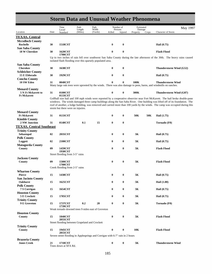
TEXAS, CentralMcculloch County
Hail (0.75)0030Rochelle 1518CST
Up to two inches of rain fell over southwest San Saba County during the late afternoon of the 30th. The heavy rains causedisolated flash flooding over this sparsely populated area.
Flash Flood0030 18 W Cherokee 1620CST1700CST
San Saba County
Thunderstorm Wind (G52)0030Cherokee 1638CSTSan Saba County
Hail (0.75)0030 15 E Eldorado 1929CSTSchleicher County
Many large oak trees were uprooted by the winds. There was also damage to pens, barns, and windmills on ranches.Thunderstorm Wind 100K0031 10 SW Eden 0040CST
Concho County
Golfball size hail and 100 mph winds were reported by a cooperative observier near Fort McKavett. The hail broke double-panewindows. The winds damaged three camp buildings along the San Saba River. One building was lifted off of its foundation. Theroof of another, a lodge building, was removed and carried more than 100 yards by the winds. The camp was occupied during thisstorm but there were no injuries.
Thunderstorm Wind (G87) 300K0031Ft Mckavett 5 N Ft Mckavett to 0100CST
0133CST
Menard County
Hail (1.75) 50K0031Ft Mckavett 50K0133CSTMenard County
Tornado (F0)0 15 0.1 031 2 NW Junction 0140CSTKimble County
Hail (0.75) 5K0002Sebastopol 2035CST
TEXAS, Central SoutheastTrinity County
Hail (0.75) 5K0002Leggett 2100CSTPolk County
Street flooding from 3-5" rains
Flash Flood 5K0009County 1459CST1930CST
Matagorda County
Creek flooding from 2-5" rains
Flash Flood 5K0009County 1500CST1700CST
Jackson County
Hail (0.75) 5K0015Pierce 1438CSTWharton County
Hail (1.00) 5K0015Oakhurst 1625CSTSan Jacinto County
Hail (0.75) 5K0015 7 S Corrigan 1654CSTPolk County
Hail (0.75) 5K0015 5 E Crockett 1705CSTHouston County
Weak tornado downed trees 9 miles east of Groveton
Tornado (F0) 5K0 20 0.2 015 9 E Groveton 1737CST1739CST
Trinity County
Street flooding between Grapeland and Crockett
Flash Flood 5K0015County 1840CST2055CST
Houston County
Severe street flooding in Applesprings and Corrigan with 6-7" rain in 2 hours
Flash Flood 10K0015County 1945CST2055CST
Trinity County
Trees down at SFA Rd.Thunderstorm Wind 5K0021Jones Creek 1710CST
Brazoria County
177185
Storm Data and Unusual Weather Phenomena
Location Date Character of Storm
TimeLocal/Standard
PathLength(Miles)
PathWidth(Yards)
Number ofPersons
Killed Injured
EstimatedDamage
Property Crops
May 1997

TEXAS, Central SoutheastColorado County
Tornado blew down powerlines, temporary buildings, and 12" diameter trees
Tornado (F0) 25K0 25 0.2 021Sheridan 1830CST1833CST
Hail (0.75) 5K0021Sheridan 1845CSTColorado County
Trees down on FM 3013Thunderstorm Wind 5K0021 3 SW Sealy 1957CST
Austin County
3 feet of water at intersection of HWY 36 & HWY 90
Flash Flood 10K0021Sealy 2033CST2215CST
Austin County
Street flooding in west Houston from 6-8" training rains. An elderly man drove into a flooded underpass (about 8 ft deep) wherehe drowned. M70VE
Flash Flood 50K0 1 21Houston 2033CST2215CST
Harris County
Lightning induced fire destroyed houseLightning 50K0022Galveston 1030CST
Galveston County
Spotter report of 60 mph gusts at HWY 290 & Tookey Rd.Thunderstorm Wind (G50)0023Cypress 1335CST
Harris County
Trees down on 16th-17th St.Thunderstorm Wind 5K0024Hempstead 1407CST
Waller County
Severe flooding in Houston. 50-75 homes had flood damage. Creeks and bayous out of banks at many locations. A cab driverand 12 year old boy had to be rescued after flood waters swept them away from White Oak Bayou. Both hung onto trees beforebeing rescued and had many ant bites. Many cars also flooded.
Flash Flood 250K 2 02425
Houston 1535CST0530CST
Harris County
Hail (1.25) 5K0027North Zulch 1854CSTMadison County
Hail (0.75) 5K0027 3 N Madisonville 1855CSTMadison County
Trees down at Tidwell & I-45Thunderstorm Wind 5K0028Houston 1000CST
Harris County
3/4" hail at FM 1488 & I-45Hail (0.75) 5K0028 5 S Conroe 1220CST
Montgomery County
Hail (0.75) 5K0028Brookshire 1350CSTWaller County
DPS amd EM reported tornado during the time period. No injuries or damages reported.
Tornado (F0)0 10 0.5 028 5 N Livingston 1459CST1510CST
Polk County
Hail (1.00) 5K0028La Ward 1704CSTJackson County
Hail (1.75) 10K0028Lolita 1704CSTJackson County
Hail (1.75) 10K0028Vanderbilt 1704CSTJackson County
Trees uprooted on FM 942Thunderstorm Wind 5K0030Corrigan 0957CST
Polk County
Trees blown downThunderstorm Wind 5K0030Ratcliff 2150CST
Houston County
178186
Storm Data and Unusual Weather Phenomena
Location Date Character of Storm
TimeLocal/Standard
PathLength(Miles)
PathWidth(Yards)
Number ofPersons
Killed Injured
EstimatedDamage
Property Crops
May 1997

TEXAS, Central SoutheastPolk County
Trees and powerlines blown downThunderstorm Wind 5K0030Corrigan 2203CST
Trees blown downThunderstorm Wind 5K0030Midway 2205CST
Madison County
Powerlines blown downThunderstorm Wind 5K0030 9 NW Groveton 2210CST
Trinity County
Hail (0.75) 5K0030Tomball 2222CSTHarris County
Trees blown down on Dobbin Huffsmith Rd.
Tornado (F1) 5K0 20 0.5 030 2 SSE Tomball 2222CST2224CST
Harris County
Trees blown down on Grant & Mill Rd.Thunderstorm Wind 5K0030 2 SE Tomball 2222CST
Harris County
Hail (0.75) 5K0030 2 S Tomball 3 S Tomball to 2227CST
Harris County
Trees down on HWY 30Thunderstorm Wind 5K0030 5 W Roans Prairie 2238CST
Grimes County
16 foot oak tree uprooted, pine tree snapped 20 feet up near Jones Rd and HWY 249Thunderstorm Wind 5K0030 5 E Cypress 2242CST
Harris County
Tree blown down on house at North Chappel and San Glen. Key map 329RThunderstorm Wind 20K0030Houston 2242CST
Harris County
90 foot tree uprooted and fell on a house at Thornhill and Benwick. Key map 329RThunderstorm Wind 25K0030Houston 2242CST
Harris County
Numerous trees down and signal lights damaged near HWY 249Thunderstorm Wind 10K0030Louetta 2242CST
Harris County
8 foot pine tree snapped and several large limbs blown down. Key map 329MThunderstorm Wind 5K0030 7 SE Tomball 2242CST
Harris County
Spotter reported 50 kt gusts in the Willowbrook areaThunderstorm Wind (G50)0030Houston 2256CST
Harris County
Trees blown down at FM 1960 & HWY 249Thunderstorm Wind 5K0030 9 ESE Cypress 2257CST
Harris County
Hail in the Willowbrook areaHail (0.88) 5K0030Houston 2303CST
Harris County
Trees blown downThunderstorm Wind 5K0030Willis 2311CST
Montgomery County
Street flooding due to 3-5 inch rains. Approximately 6 homes sustained water damage
Flash Flood 15K003031
Nrn County 2330CST0200CST
Harris County
Trees blown down onto a mobile homeThunderstorm Wind 15K0030Porter 2330CST
Montgomery County
Street flooding in the Woodlands from 3-5 inch rains. Bridge washed out at Dobbin-Huffsmith Rd. near Magnolia
Flash Flood 25K003031
Srn County 2330CST0200CST
Montgomery County
179187
Storm Data and Unusual Weather Phenomena
Location Date Character of Storm
TimeLocal/Standard
PathLength(Miles)
PathWidth(Yards)
Number ofPersons
Killed Injured
EstimatedDamage
Property Crops
May 1997

TEXAS, Central SoutheastAustin County
Hail (1.75) 10K0030Bellville 2335CST
Powerlines blown downThunderstorm Wind 5K0030Bellville 2335CST
Austin County
16 foot business sign blown down on Garth Rd. This sign was built to withstand 60 mph winds.Thunderstorm Wind 5K0031Baytown 0000CST
Harris County
Hail at Richmond & Loop 610Hail (0.75) 5K0031Houston 0006CST
Harris County
Trees blown down on FM 563Thunderstorm Wind 5K0031 5 W Hankamer 0020CST
Chambers County
Utility poles and trees blown downThunderstorm Wind (G60) 10K0031Ganado 0315CST
Jackson County
Hail (1.00)0028Salt Flat 1435MST1459MST
TEXAS, Extreme WestHudspeth County
NWS employee and numerous public reports of several roadways and surrounding fields flooded.Flash Flood0003Ricardo 1500CST
TEXAS, Mid - SouthKleberg County
Official weather observation of 50 knot wind gust generated from a thunderstorm outflow boundary.Thunderstorm Wind (G50)0009Laredo 0948CST
Webb County
Skywarn spotter report of several large trees uprooted by thunderstorm wind and torrential downpours.Thunderstorm Wind (G50)0009San Diego 1110CST
Duval County
Sheriff report of a tornado near highways 359 and 44.Tornado (F0)0 30 0.1 009 5 NE Alice 1123CST
Jim Wells County
Sheriff report of several large uprooted trees with numerous power lines downed.Thunderstorm Wind (G50)0009Alice 1130CST
Jim Wells County
Public report of several large trees downed resulting in damage to homes.Thunderstorm Wind (G50)0009Orange Grove 1135CST
Jim Wells County
Sheriff report of several large trees uprooted and structural damage to homes.Thunderstorm Wind (G50)0009Agua Dulce 1210CST
Nueces County
Sheriff report of several large trees uprooted.Thunderstorm Wind (G50)0009Robstown 1215CST
Nueces County
Emergency manager report of extensive damage to barns and farmhouses with several large trees uprooted.Thunderstorm Wind (G50)0009Kingsville 1300CST
Kleberg County
NWS spotter report of power poles downed with several large trees uprooted.Thunderstorm Wind (G50)0009Portland 1300CST
San Patricio County
Public report of dime sized hail.Hail (0.75)0009Corpus Christi 1320CST
Nueces County
NWS spotter report of flooded roadways with 4.9 inches of rain.Flash Flood0009Victoria 1330CST
Victoria County
Hail (0.75)0015 9 N Cotulla 1645CSTLa Salle County
180188
Storm Data and Unusual Weather Phenomena
Location Date Character of Storm
TimeLocal/Standard
PathLength(Miles)
PathWidth(Yards)
Number ofPersons
Killed Injured
EstimatedDamage
Property Crops
May 1997

TEXAS, Mid - SouthMcmullen County
Hail (0.75)0015Tilden 1820CST
Spotter report of golfball sized hail resulting in numerous windows being shattered across town.Hail (1.75)0015Tilden 1835CST
Mcmullen County
Sheriff report of several large trees downed by strong thunderstorm wind gusts.Thunderstorm Wind (G50)0015Tilden 1835CST
Mcmullen County
NWS skywarn spotter and sheriff report of a funnel cloud near Interstate highway 37.Funnel Cloud0015 4 E George West 1920CST
Live Oak County
Hail (0.75)0015Three Rivers 1922CSTLive Oak County
Reports of several large tree limbs downed by strong thunderstorm wind.Thunderstorm Wind (G50)0015Three Rivers 1922CST
Live Oak County
Reports of several large tree limbs downed along highway 59.Thunderstorm Wind (G50)0015 10 E George West 1950CST
Live Oak County
Spotter report of several branches downed across town due to strong thunderstorm wind.Thunderstorm Wind (G50)0015Laredo 1958CST
Webb County
Sheriff report of debris covering highway 181 resulting from strong thunderstorm wind gusts.Thunderstorm Wind (G55)0015 2 N Skidmore 2015CST
Bee County
NWS spotter report of dime sized hail.Hail (0.75)0015 5 E Mathis 2015CST
San Patricio County
Police report of a waterspout over Corpus Christi Bay.Waterspout0023Corpus Christi 0826CST
Nueces County
Numerous reports from various agencies and persons of widespread flooding across the area with several roadways flooded.
Flash Flood0023Corpus Christi 0930CST1000CST
Nueces County
Police report of several roadways flooded.Flash Flood0023Gregory 1015CST
San Patricio County
Sheriff report of several roadways flooded.Flash Flood0023Port Lavaca 1315CST
Calhoun County
Sheriff report of several weak funnel clouds across the area.Funnel Cloud0023Skidmore 1430CST
Bee County
Sheriff and spotter reports of several weak funnel clouds across the area.Funnel Cloud0023Lagarto 1430CST
Live Oak County
NWS spotter and public reports of several weak funnel clouds across the area.Funnel Cloud0023Mathis 1430CST
San Patricio County
NWS spotter report of three weak funnel clouds that frequently descended from the cloud base and reached the surface.
Tornado (F0)0 30 0.1 023Lagarto 1435CST1450CST
Live Oak County
Spotter report of dime sized hail.Hail (0.75)0024 7 N Skidmore 1915CST
Bee County
Sheriff report of golfball sized hail.
Hail (1.75)0027 9 N Cotulla 1945CST2010CST
La Salle County
181189
Storm Data and Unusual Weather Phenomena
Location Date Character of Storm
TimeLocal/Standard
PathLength(Miles)
PathWidth(Yards)
Number ofPersons
Killed Injured
EstimatedDamage
Property Crops
May 1997

TEXAS, Mid - SouthMcmullen County
Spotter report of numerous trees downed with several windows being shattered to local homes.Thunderstorm Wind (G50)0027Tilden 2030CST
Hail (0.75)0027Three Rivers 2040CSTLive Oak County
Sheriff report of numerous trees and power lines downed by strong thunderstorm wind.Thunderstorm Wind (G50)0027Beeville 2045CST
Bee County
Sheriff report of golfball sized hail.Hail (1.75)0027Artesia Wells 2050CST
La Salle County
Spotter report of numerous large trees downed by thunderstorm wind gusts.Thunderstorm Wind (G50)0027Ander 2100CST
Goliad County
Hail (1.00)0027Weesatche 2100CSTGoliad County
Border Patrol report of quarter sized hail.Hail (1.00)0027 25 N Laredo 2100CST
Webb County
Thunderstorm Wind (G55)0027Mathis 2120CSTSan Patricio County
Sheriff report of numerous power lines downed by thunderstorm wind.Thunderstorm Wind (G50)0027Realitos 2125CST
Duval County
Spotter report of large tree limbs downed by thunderstorm wind.Thunderstorm Wind (G50)0027Alice 2125CST
Jim Wells County
Hail (1.00)0027Oilton 2215CSTWebb County
Spotter report of golfball sized hail.Hail (1.75)0028 7 N Bayside 1540CST
Refugio County
Hail (0.75)0028Inez 1631CSTVictoria County
Spotter report of quarter sized hail.Hail (1.00)0028 5 NW Victoria 1635CST
Victoria County
Hail (0.75)0028Schroeder 1720CSTGoliad County
Spotter report of quarter sized hail.Hail (1.00)0028Goliad 1747CST
Goliad County
Hail (0.75)0008 12 N Jacksboro 1922CST
TEXAS, NorthJack County
Street flooding was reported in and around town.
Flash Flood0008Jacksboro 2107CST2300CST
Jack County
A brief tornado touchdown was reported by a DPS officer.
Tornado (F0)0 25 0.1 008 5 W Chico 2035CST2036CST
Wise County
Strong winds blew down power lines.Thunderstorm Wind 2K0008Bridgeport 2050CST
Wise County
Hail (0.88)0008 2 S Boonsville 2129CSTWise County
182190
Storm Data and Unusual Weather Phenomena
Location Date Character of Storm
TimeLocal/Standard
PathLength(Miles)
PathWidth(Yards)
Number ofPersons
Killed Injured
EstimatedDamage
Property Crops
May 1997

TEXAS, NorthWise County
Streets were closed due to high water in town.
Flash Flood000809
Boonsville 2248CST0100CST
Streets were closed due to high water in town.
Flash Flood000809
Cottondale 2248CST0100CST
Wise County
Over 3.90 inches of rain fell at Runaway Bay, resulting in street flooding.
Flash Flood000809
2 SW Lake Bridgeport 2330CST0130CST
Wise County
Hail (0.75)0008 5 W Paris 2125CSTLamar County
Hail (0.75)0008Weatherford 2149CSTParker County
Hail (1.00)0008 5 N Weatherford 2155CSTParker County
Low-lying areas were reported flooded.
Flash Flood000809
2 E Adell 2340CST0130CST
Parker County
Low-lying areas were flooded on Farm-to-Market Road 920.
Flash Flood000809
3 N Peaster 2340CST0130CST
Parker County
The intersection of Western Center Blvd. and Blue Mound Road was reported flooded.
Flash Flood000809
Saginaw 2235CST0100CST
Tarrant County
A car stalled in flood waters.
Flash Flood000809
Haslet 2320CST0130CST
Tarrant County
Streets were flooded in town due to 5.90 inches of rain that fell in the area.
Flash Flood000809
Gordon 2300CST0200CST
Palo Pinto County
The intersection of Farm-to-Market Road 156 at Highway 114 was reported under water.
Flash Flood000809
Justin 2330CST0200CST
Denton County
A car was washed off Farm-to-Market Road 2123.
Flash Flood0009Paradise 0023CST0200CST
Wise County
Roads were washed away and a bridge was washed out by flood waters.
Flash Flood 75K0009Cottondale 0200CST0400CST
Wise County
Farm-to-Market Road 2123 remained flooded and was closed due to high water.
Flash Flood0009Paradise 0300CST0430CST
Wise County
Several roads were reported flooded throughout the county.
Flash Flood0009Stephenville 0030CST0230CST
Erath County
Portions of Highway 377 were flooded and closed.
Flash Flood0009Granbury 0110CST0300CST
Hood County
183191
Storm Data and Unusual Weather Phenomena
Location Date Character of Storm
TimeLocal/Standard
PathLength(Miles)
PathWidth(Yards)
Number ofPersons
Killed Injured
EstimatedDamage
Property Crops
May 1997

TEXAS, NorthHood County
Low-lying areas were under water and streets were flooded.
Flash Flood0009Granbury 0242CST0400CST
Several roads were reported flooded in and around town.
Flash Flood0009Tolar 0400CST0600CST
Hood County
Several roads were reported flooded in and around town. Two feet of water entered a home.
Flash Flood 50K0009Granbury 0550CST0700CST
Hood County
Numerous roads were flooded throughout the county.
Flash Flood0009Granbury 0743CST0900CST
Hood County
Five inches of rain resulted in street flooding in town.
Flash Flood0009Cisco 0200CST0500CST
Eastland County
Highway 8 was reported flooded.
Flash Flood0009Gorman 0230CST0500CST
Eastland County
Highway 114 was reported flooded near the Texas Motor Speedway.
Flash Flood0009 2 N Roanoke 0300CST0500CST
Denton County
A few roads in and around town were reported flooded.
Flash Flood0009Gordon 0300CST0500CST
Palo Pinto County
Several roads were reported flooded and a few houses had flood waters in them.
Flash Flood 60K0009Haslet 0300CST0500CST
Tarrant County
Railroad tracks were washed out at Highway 287 and Hicks Road.
Flash Flood 10K0009Saginaw 0330CST0530CST
Tarrant County
Roads were closed due to high water.Flash Flood0009Haslet 0430CST
Tarrant County
Farm-to-Market Road 1189 was flooded.
Flash Flood0009 1 N Dennis 0330CST0530CST
Parker County
Lightning struck a home and caused a fire that engulfed much of the structure. An elderly man was caught in the home at thetime, suffered smoke inhalation and was taken to the hospital.
Lightning 120K 1 009Grand Prairie 0500CSTDallas County
Several low-water crossings throughout the county were flooded.
Flash Flood0009Glen Rose 0555CST0730CST
Somervell County
High water was reported over several roads throughout the county.
Flash Flood0009Cleburne 0800CST1000CST
Johnson County
Hail (1.00)0015 5 SW Breckenridge 0339CSTStephens County
184192
Storm Data and Unusual Weather Phenomena
Location Date Character of Storm
TimeLocal/Standard
PathLength(Miles)
PathWidth(Yards)
Number ofPersons
Killed Injured
EstimatedDamage
Property Crops
May 1997

TEXAS, NorthHopkins County
Hail (1.00)0015 8 N Sulphur Spgs 0753CST
Lightning struck a house and started a fire that resulted in extensive damage.Lightning 75K0015Hurst 0800CST
Tarrant County
A building was flooded by high water on the south side of town.
Flash Flood 20K0015Ft Worth 0845CST0945CST
Tarrant County
Lightning struck a house and caused a fire that resulted in considerable damage.Lightning 30K0015Grand Prairie 0915CST
Dallas County
Several roads were reported flooded by high water.
Flash Flood0015Haltom City 0925CST1100CST
Tarrant County
Hail (0.75)0015Mercers Gap 1445CSTComanche County
Several roads in and around town were flooded by high water.
Flash Flood0015Comanche 1557CST1730CST
Comanche County
Hail (1.00)0015 4 N Hamilton 1610CSTHamilton County
Over three inches of rain resulted in flooding of roads in and around town.
Flash Flood0015Newburg 1630CST1830CST
Comanche County
Hail (1.75)0015Temple 1840CSTBell County
Large limbs were blown down by strong winds.Thunderstorm Wind00015Temple 1840CST
Bell County
Thunderstorm Wind (G50)0019Desdemona 1620CSTEastland County
Lightning struck a home and started a fire that resulted in considerable damage.Lightning 50K0019Plano 1745CST
Collin County
Thunderstorm Wind (G57)0019Plano 1758CSTCollin County
Large limbs were blown down and roofs were damaged by strong winds.Thunderstorm Wind 25K0019Plano 1810CST
Collin County
Cars were stranded in flood waters.
Flash Flood0019Plano 1815CST2000CST
Collin County
Streets were flooded and a few homes received minor flooding from high water.
Flash Flood 10K0019Plano 1902CST2100CST
Collin County
Nearly 5.00 inches of rain fell in the area and caused flooding.
Flash Flood0019Plano 1930CST2130CST
Collin County
Several streets were reported impassable due to high water.
Flash Flood0019 4 E Lewisville 1808CST2000CST
Denton County
Streets were flooded in the northern portion of the city.Flash Flood0019Dallas 1905CST
Dallas County
185193
Storm Data and Unusual Weather Phenomena
Location Date Character of Storm
TimeLocal/Standard
PathLength(Miles)
PathWidth(Yards)
Number ofPersons
Killed Injured
EstimatedDamage
Property Crops
May 1997

TEXAS, NorthDenton County
Several roads were flooded in the southeastern portion of town.
Flash Flood0019Denton 1928CST2100CST
Lightning struck a house and caused a fire that resulted in considerable damage.Lightning 40K0019Rockwall 2000CST
Rockwall County
Street flooding was reported in town.
Flash Flood0019Kaufman 2009CST2200CST
Kaufman County
Street flooding was reported in town.Flash Flood0019Terrell 2009CST
Kaufman County
Several roads remained flooded and impassable in The Colony.
Flash Flood0019 4 E Lewisville 2018CST2200CST
Denton County
Water was reported over Highway 82 between Lindsay and Muenster.
Flash Flood0019 4 W Lindsay 2230CST2330CST
Cooke County
Hail (0.75)0023Sagerton 1525CSTHaskell County
Portions of Interstate 35 were reported flooded.
Flash Flood0023Troy 1727CST1930CST
Bell County
Strong winds removed the roof of a shed, and blew down trees and power lines.Thunderstorm Wind 10K0024 2 S Lott 1600CST
Falls County
Highway 77 was reported flooded between Lott and Travis.
Flash Flood0024 4 S Lott 1620CST1830CST
Falls County
Severe Thunderstorms0025 1700CST2300CST
TXZ091>095-101>107 Montague - Cooke - Grayson - Fannin - Lamar - Jack - Wise - Denton - Collin - Hunt - Delta - Hopkins
A well-defined dry line was positioned just west of northern Texas by late afternoon as a strong upper level disturbanceapproached from the southern Rockies. The air mass over North Texas was very unstable but strongly capped by a warm layer ofair from 5000 to 10000 feet above the surface. Low level wind shear was also strong as southeasterly surface winds veered to thesouthwest/west and increased with height. Severe thunderstorms developed rapidly along the dry line over south central Oklahomaduring the mid-afternoon. Development continued southward along the dry line into northwestern North Texas by early evening.The storms moved east, off the boundary, and affected mainly the north central counties along the Red River. The cap suppresseddevelopment south of a Jacksboro to Greenville line. Several supercell thunderstorms produced at least eight tornadoes, hail up totwo inches in diameter, convective wind gusts to 90 mph and minor flooding.
Trees were blown down by strong winds.Thunderstorm Wind00025 3 E Montague 1800CST
Montague County
A tornado destroyed two barns and a carport.
Tornado (F1) 15K0 30 0.5 025Dye Mound 1824CST1828CST
Montague County
Hail (1.75)0025Hardy 1828CSTMontague County
Hail (1.75)0025St Jo 1915CSTMontague County
Hail (1.75)0025St Jo 1931CSTMontague County
186194
Storm Data and Unusual Weather Phenomena
Location Date Character of Storm
TimeLocal/Standard
PathLength(Miles)
PathWidth(Yards)
Number ofPersons
Killed Injured
EstimatedDamage
Property Crops
May 1997

TEXAS, NorthMontague County
A brief tornado was reported south of town.
Tornado (F0)0 25 0.1 025 2 S St Jo 1934CST1935CST
The tornado south of town dissipated and another brief tornado developed southeast of town.
Tornado (F0)0 25 0.1 025 2 SE St Jo 1939CST1940CST
Montague County
A tornado blew over a 1500 lb pumpjack, snapped 25 power poles, destroyed several barns, damaged roofs, and damaged ordestroyed numerous trees.
Tornado (F2) 100K0 75 1 025 3 S Muenster 4 SW Muenster to 1936CST
1941CST
Cooke County
Hail (1.75)0025Muenster 1940CSTCooke County
A tornado was reported by spotters.
Tornado (F0)0 30 0.5 025Myra 2010CST2013CST
Cooke County
Hail (1.75)0025 5 NE Era 2025CSTCooke County
Hail (2.00)0025Valley View 2034CSTCooke County
Spotters reported a tornado northeast of Era. The tornado was on the ground for approximately 10 minutes and uprooted numerouslarge trees.
Tornado (F1)0 50 3 025 3 NW Valley View 3 NE Era to 2039CST
2049CST
Cooke County
A brief tornado was reported.
Tornado (F0)0 25 0.1 025Mountain Spgs 2041CST2043CST
Cooke County
Thunderstorm Wind (G61)0025 2 NW Era 2050CSTCooke County
Hail (1.75)0025 5 S Gainesville 2054CSTCooke County
Streets were reported flooded in and around town.
Flash Flood0025Gainesville 2100CST2300CST
Cooke County
Winds were estimated at 80 to 90 mph north of town.Thunderstorm Wind (G78)0025 2 N Valley View 2110CST
Cooke County
A tornado touched down just east of the high school. Spotters watched this weak tornado for about 8 minutes as it moved east.
Tornado (F0)0 40 2 025Gainesville 2111CST2119CST
Cooke County
Hail (1.75)0025Gainesville 2119CSTCooke County
Hail (1.75)0025Denison 2110CSTGrayson County
Hail (0.75)0025Gunter 2154CSTGrayson County
Hail (1.00)0025Celina 2204CSTCollin County
A cold front moved into southern Oklahoma by the evening hours. The air mass south of the boundary had become extremelyunstable with temperatures in the low to mid 90s and dewpoint temperatures in the upper 70s. A capping layer of warm air aloftsuppressed thunderstorm development through much of the day but convergence along the slow-moving front was able to break
Severe Thunderstorms002627
2230CST0300CST
TXZ091>095 Montague - Cooke - Grayson - Fannin - Lamar
187195
Storm Data and Unusual Weather Phenomena
Location Date Character of Storm
TimeLocal/Standard
PathLength(Miles)
PathWidth(Yards)
Number ofPersons
Killed Injured
EstimatedDamage
Property Crops
May 1997
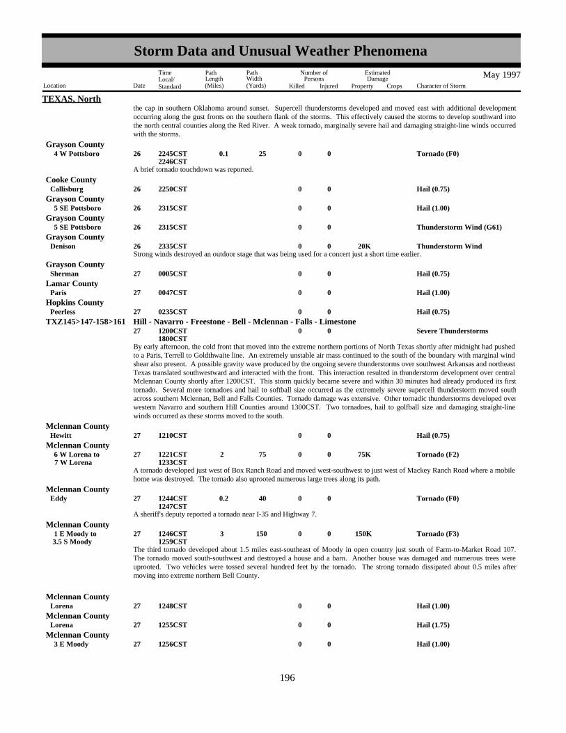
TEXAS, Norththe cap in southern Oklahoma around sunset. Supercell thunderstorms developed and moved east with additional developmentoccurring along the gust fronts on the southern flank of the storms. This effectively caused the storms to develop southward intothe north central counties along the Red River. A weak tornado, marginally severe hail and damaging straight-line winds occurredwith the storms.
A brief tornado touchdown was reported.
Tornado (F0)0 25 0.1 026 4 W Pottsboro 2245CST2246CST
Grayson County
Hail (0.75)0026Callisburg 2250CSTCooke County
Hail (1.00)0026 5 SE Pottsboro 2315CSTGrayson County
Thunderstorm Wind (G61)0026 5 SE Pottsboro 2315CSTGrayson County
Strong winds destroyed an outdoor stage that was being used for a concert just a short time earlier.Thunderstorm Wind 20K0026Denison 2335CST
Grayson County
Hail (0.75)0027Sherman 0005CSTGrayson County
Hail (1.00)0027Paris 0047CSTLamar County
Hail (0.75)0027Peerless 0235CSTHopkins County
By early afternoon, the cold front that moved into the extreme northern portions of North Texas shortly after midnight had pushedto a Paris, Terrell to Goldthwaite line. An extremely unstable air mass continued to the south of the boundary with marginal windshear also present. A possible gravity wave produced by the ongoing severe thunderstorms over southwest Arkansas and northeastTexas translated southwestward and interacted with the front. This interaction resulted in thunderstorm development over centralMclennan County shortly after 1200CST. This storm quickly became severe and within 30 minutes had already produced its firsttornado. Several more tornadoes and hail to softball size occurred as the extremely severe supercell thunderstorm moved southacross southern Mclennan, Bell and Falls Counties. Tornado damage was extensive. Other tornadic thunderstorms developed overwestern Navarro and southern Hill Counties around 1300CST. Two tornadoes, hail to golfball size and damaging straight-linewinds occurred as these storms moved to the south.
Severe Thunderstorms0027 1200CST1800CST
TXZ145>147-158>161 Hill - Navarro - Freestone - Bell - Mclennan - Falls - Limestone
Hail (0.75)0027Hewitt 1210CSTMclennan County
A tornado developed just west of Box Ranch Road and moved west-southwest to just west of Mackey Ranch Road where a mobilehome was destroyed. The tornado also uprooted numerous large trees along its path.
Tornado (F2) 75K0 75 2 027 7 W Lorena 6 W Lorena to 1221CST
1233CST
Mclennan County
A sheriff's deputy reported a tornado near I-35 and Highway 7.
Tornado (F0)0 40 0.2 027Eddy 1244CST1247CST
Mclennan County
The third tornado developed about 1.5 miles east-southeast of Moody in open country just south of Farm-to-Market Road 107.The tornado moved south-southwest and destroyed a house and a barn. Another house was damaged and numerous trees wereuprooted. Two vehicles were tossed several hundred feet by the tornado. The strong tornado dissipated about 0.5 miles aftermoving into extreme northern Bell County.
Tornado (F3) 150K0150 3 027 3.5 S Moody 1 E Moody to 1246CST
1259CST
Mclennan County
Hail (1.00)0027Lorena 1248CSTMclennan County
Hail (1.75)0027Lorena 1255CSTMclennan County
Hail (1.00)0027 3 E Moody 1256CSTMclennan County
188196
Storm Data and Unusual Weather Phenomena
Location Date Character of Storm
TimeLocal/Standard
PathLength(Miles)
PathWidth(Yards)
Number ofPersons
Killed Injured
EstimatedDamage
Property Crops
May 1997
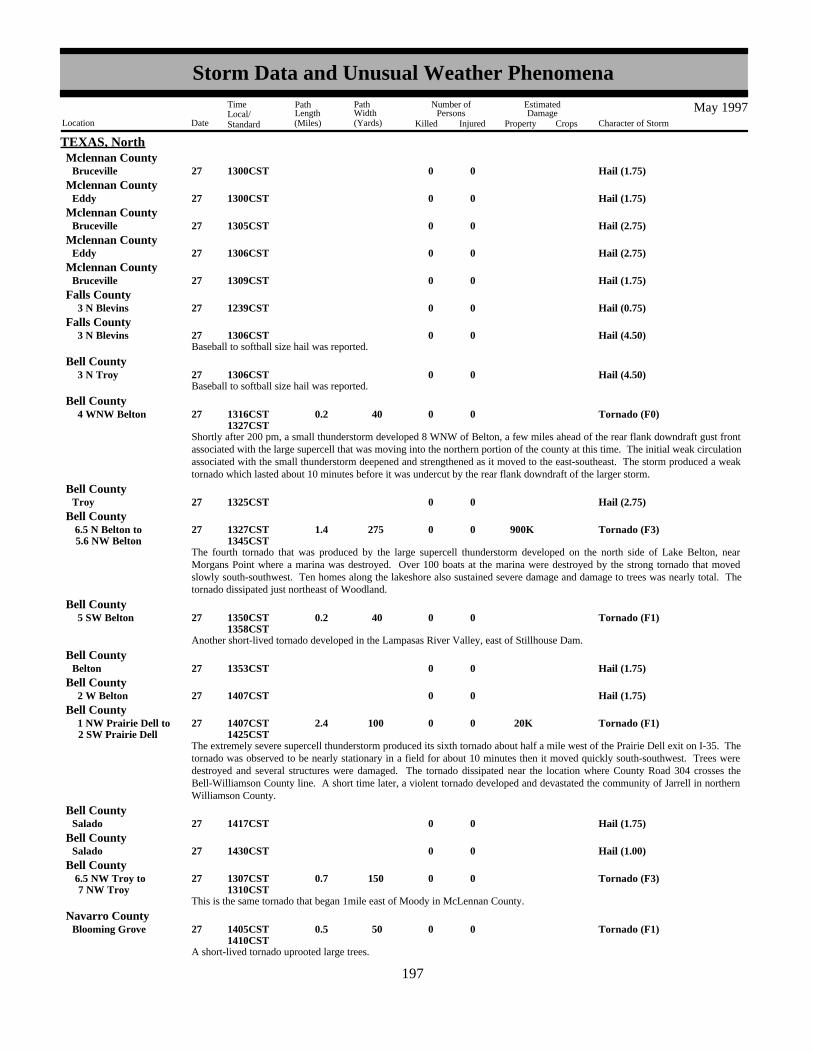
TEXAS, NorthMclennan County
Hail (1.75)0027Bruceville 1300CST
Hail (1.75)0027Eddy 1300CSTMclennan County
Hail (2.75)0027Bruceville 1305CSTMclennan County
Hail (2.75)0027Eddy 1306CSTMclennan County
Hail (1.75)0027Bruceville 1309CSTMclennan County
Hail (0.75)0027 3 N Blevins 1239CSTFalls County
Baseball to softball size hail was reported.Hail (4.50)0027 3 N Blevins 1306CST
Falls County
Baseball to softball size hail was reported.Hail (4.50)0027 3 N Troy 1306CST
Bell County
Shortly after 200 pm, a small thunderstorm developed 8 WNW of Belton, a few miles ahead of the rear flank downdraft gust frontassociated with the large supercell that was moving into the northern portion of the county at this time. The initial weak circulationassociated with the small thunderstorm deepened and strengthened as it moved to the east-southeast. The storm produced a weaktornado which lasted about 10 minutes before it was undercut by the rear flank downdraft of the larger storm.
Tornado (F0)0 40 0.2 027 4 WNW Belton 1316CST1327CST
Bell County
Hail (2.75)0027Troy 1325CSTBell County
The fourth tornado that was produced by the large supercell thunderstorm developed on the north side of Lake Belton, nearMorgans Point where a marina was destroyed. Over 100 boats at the marina were destroyed by the strong tornado that movedslowly south-southwest. Ten homes along the lakeshore also sustained severe damage and damage to trees was nearly total. Thetornado dissipated just northeast of Woodland.
Tornado (F3) 900K0275 1.4 027 5.6 NW Belton 6.5 N Belton to 1327CST
1345CST
Bell County
Another short-lived tornado developed in the Lampasas River Valley, east of Stillhouse Dam.
Tornado (F1)0 40 0.2 027 5 SW Belton 1350CST1358CST
Bell County
Hail (1.75)0027Belton 1353CSTBell County
Hail (1.75)0027 2 W Belton 1407CSTBell County
The extremely severe supercell thunderstorm produced its sixth tornado about half a mile west of the Prairie Dell exit on I-35. Thetornado was observed to be nearly stationary in a field for about 10 minutes then it moved quickly south-southwest. Trees weredestroyed and several structures were damaged. The tornado dissipated near the location where County Road 304 crosses theBell-Williamson County line. A short time later, a violent tornado developed and devastated the community of Jarrell in northernWilliamson County.
Tornado (F1) 20K0100 2.4 027 2 SW Prairie Dell 1 NW Prairie Dell to 1407CST
1425CST
Bell County
Hail (1.75)0027Salado 1417CSTBell County
Hail (1.00)0027Salado 1430CSTBell County
This is the same tornado that began 1mile east of Moody in McLennan County.
Tornado (F3)0150 0.7 027 7 NW Troy 6.5 NW Troy to 1307CST
1310CST
Bell County
A short-lived tornado uprooted large trees.
Tornado (F1)0 50 0.5 027Blooming Grove 1405CST1410CST
Navarro County
189197
Storm Data and Unusual Weather Phenomena
Location Date Character of Storm
TimeLocal/Standard
PathLength(Miles)
PathWidth(Yards)
Number ofPersons
Killed Injured
EstimatedDamage
Property Crops
May 1997

TEXAS, NorthNavarro County
Hail (1.75)0027Blooming Grove 1415CST
A storm spotter reported a tornado south of town. Large trees were uprooted by the tornado.
Tornado (F1)0 50 0.5 027 1 S Dawson 1436CST1440CST
Navarro County
Hail (1.75)0027Dawson 1446CSTNavarro County
Thunderstorm Wind (G65)0027Dawson 1446CSTNavarro County
A short-lived tornado was reported.
Tornado (F0)0 40 0.2 027 3 SW Hubbard 1450CST1453CST
Hill County
Hail (1.00)0027 4 NE Mt Calm 1455CSTHill County
Strong winds blew down power lines.Thunderstorm Wind 2K0027Coolidge 1529CST
Limestone County
Hail (1.75)0027Mexia 1553CSTLimestone County
Power lines were blown down by high winds.Thunderstorm Wind 2K0027 6 W Mexia 1620CST
Limestone County
Hail (0.75)0027Simboro 1625CSTFreestone County
Hail (1.75)0027Donie 1710CSTFreestone County
Hail (1.00)0028 6 W Van 0053CSTVan Zandt County
High water was reported over several roads in and around town.
Flash Flood0028Ben Wheeler 0340CST0500CST
Van Zandt County
Trees were blown down by strong winds.Thunderstorm Wind00030Antelope 0447CST
Jack County
Hail (0.75)0030Boyd 0624CSTWise County
Hail (1.00)0030 3 SW Keeter 0651CSTWise County
Several rural roads throughout the county were reported flooded.
Flash Flood0030Decatur 0732CST0900CST
Wise County
Hail (1.00)0030Garner 0628CSTParker County
Hail (1.00)0030 1 N Springtown 0651CSTParker County
Over three inches of rain in less than an hour resulted in flooding.
Flash Flood0030Springtown 0717CST0900CST
Parker County
A car was washed off a road and into a creek west of town. A weather observer reported over 5 inches of rain in less than twohours in the area.
Flash Flood0030 4 W Weatherford 0717CST0900CST
Parker County
Hail (0.75)0030 2 W Weatherford 0740CSTParker County
190198
Storm Data and Unusual Weather Phenomena
Location Date Character of Storm
TimeLocal/Standard
PathLength(Miles)
PathWidth(Yards)
Number ofPersons
Killed Injured
EstimatedDamage
Property Crops
May 1997

TEXAS, NorthParker County
Flood waters swept cars off a road and into a creek.
Flash Flood0030Reno 0800CST1000CST
Many streets were reported flooded downtown.
Flash Flood0030Ft Worth 0712CST0900CST
Tarrant County
An intersection was reported flooded.
Flash Flood0030Ft Worth 0720CST0900CST
Tarrant County
Tree limbs were downed by strong winds.Thunderstorm Wind00030Ft Worth 0810CST
Tarrant County
Hail (1.75)0030 6 W Bolivar 1355CSTDenton County
A tree was blown down by strong winds.Thunderstorm Wind00030Valley Mills 1430CST
Bosque County
Trees were blown down by strong winds.
Thunderstorm Wind00030Mc Gregor 3 W Mc Gregor to 1630CST
Mclennan County
Strong winds damaged an outbuilding and uprooted small trees.Thunderstorm Wind (G60) 2K0030 3 S Moody 1645CST
Mclennan County
Hail (1.75)0030Oglesby 1654CSTCoryell County
A tornado developed near Oglesby, moved south for 5 miles and dissipated near Mother Neff State Park. Along the tornado's patha home received major damage, siding was removed from a church, several barns and outbuildings were destroyed, numerouslarge trees were uprooted and a car with 5 occupants was lifted from the road and thrown onto a fence. Two of the occupantsreceived minor injuries.
Tornado (F1) 75K 2 50 5 030 5 S OglesbyOglesby to 1654CST
1710CST
Coryell County
Strong winds blew down trees.Thunderstorm Wind (G70)00030 1 SE Oglesby 1658CST
Coryell County
Strong winds damaged roofs, and blew down trees and power lines.Thunderstorm Wind 25K0030 3 E Nolanville 1730CST
Bell County
Thunderstorm Wind (G61)0030Belton 1740CSTBell County
Strong winds damaged a roof, blew down a carport and downed trees.Thunderstorm Wind (G61) 15K0030Emory 1740CST
Rains County
Strong winds damaged roofs and trees.Thunderstorm Wind 20K0030Rockwall 1749CST
Rockwall County
A large tree was blown down by strong winds.Thunderstorm Wind00030Van 1825CST
Van Zandt County
Numerous large trees were blown down throughout the county.Thunderstorm Wind00030Canton 1900CST
Van Zandt County
Thunderstorm Wind (G52)0030Chandler 1850CSTHenderson County
Trees were blown down by strong winds. One tree fell onto a mobile home south of Richland Creek Reservoir, effectively splittingThunderstorm Wind 70K0030 10 N Fairfield 1950CST
Freestone County
191199
Storm Data and Unusual Weather Phenomena
Location Date Character of Storm
TimeLocal/Standard
PathLength(Miles)
PathWidth(Yards)
Number ofPersons
Killed Injured
EstimatedDamage
Property Crops
May 1997

TEXAS, Northsplitting it into two.
Strong winds damaged the high school roof, and blew down trees and power lines.Thunderstorm Wind 50K0030Fairfield 2015CST
Freestone County
Strong winds blew down trees and power lines.Thunderstorm Wind 2K0030Dew 2030CST
Freestone County
Several trees were blown down by strong winds on Farm-to-Market Road 1511, 3 miles north of the Hopewell Community.Thunderstorm Wind00030 11 NE Centerville 2110CST
Leon County
Several trees were blown down by strong winds.Thunderstorm Wind00030 3 S Marquez 2130CST
Leon County
Hail (0.75)0001 3 E Wellington 1619CST
TEXAS, North PanhandleCollingsworth County
Hail (0.88)0001 5 E Wellington 1621CSTCollingsworth County
Hail (1.00)0001 7 E Wellington 1623CSTCollingsworth County
Hail (1.75)0001 11 E Wellington 1627CSTCollingsworth County
Hail (0.88)0001Briscoe 1632CSTWheeler County
Hail (1.00)0001 5 W Perryton 1846CST1851CST
Ochiltree County
Hail (1.75)0001Perryton 1853CST1855CST
Ochiltree County
Hail (1.00)0001Booker 1907CSTLipscomb County
Hail (0.88)0001 7 S Perryton 1908CSTOchiltree County
Hail (1.25)0001Booker 1920CSTLipscomb County
Hail (1.00)0001 20 S Perryton 1924CSTOchiltree County
Hail (0.75)0001 12 SE Perryton 1928CSTOchiltree County
Hail (0.75)0001Booker 1945CSTLipscomb County
Hail (0.75)0001Canadian 2026CSTHemphill County
Hail (1.75)0001Canadian 2028CSTHemphill County
Hail (0.75)0001Lipscomb 2045CSTLipscomb County
Hail (0.75)0001Ashtola 2130CSTDonley County
UPS truck overturned at mile marker 122 on Interstate 40 as reported by storm spotters.Thunderstorm Wind (G61)0001 10 W Alanreed 2139CST
Gray County
Hail (1.00)0001Wheeler 2140CSTWheeler County
Hail (0.75)0001Clarendon 2152CSTDonley County
Report of power lines down.Thunderstorm Wind (G61)0001Briscoe 2207CST
Wheeler County
192200
Storm Data and Unusual Weather Phenomena
Location Date Character of Storm
TimeLocal/Standard
PathLength(Miles)
PathWidth(Yards)
Number ofPersons
Killed Injured
EstimatedDamage
Property Crops
May 1997

TEXAS, North PanhandleThunderstorms across the eastern Texas Panhandle produced large hail along with high winds.
Deaf Smith CountyHail (1.75)0006 14 N Hereford 1818CST
Reported at Amarillo Blvd and Western St.Hail (0.75)0006Amarillo 1905CST
Potter County
Tornado remained over open country and track was estimated.
Tornado (F0)0 25 0.7 006 13 SSE Stratford 13 S Stratford to 1935CST
Sherman County
Reported on Highway 1573 near the county line.Hail (0.75)0006 30 E Stratford 1953CST
Sherman County
Thunderstorm Wind (G52)0006Sunray 2007CSTMoore County
Hail (0.75)0006Mc Lean 2050CSTGray County
Report of emergency vehicle windows blown out.Thunderstorm Wind (G69) 2K0006Pampa 2113CST
Gray County
Hail (1.00)0006 12 NW Miami 2142CSTRoberts County
Thunderstorms moved from the western sections of the Texas Panhandle and across the central sections producing large hail anddamaging winds. An isolated tornado was spawned by the storms over the northern Texas Panhandle, however this tornado did nodamage or injuries.
Hail (0.75)0006Perryton 2040CSTOchiltree County
Hail (0.88)0007Hartley 1645CSTHartley County
Hail (2.75)0007 6 NE Hartley 1702CSTHartley County
Hail (1.75)0007Dumas 1725CSTMoore County
Hail (2.75)0007 10 W Dumas 1733CSTMoore County
Hail (1.75)0007Dumas 1735CSTMoore County
Hail (0.75)0007Four Way 1750CSTMoore County
Thunderstorm Wind (G52)0007Four Way 1757CSTMoore County
Hail (1.75)0007White Deer 1803CSTCarson County
Hail (1.75)0007 10 N Panhandle 1820CSTCarson County
Hail (0.75)0007 8 W Mc Bride 1822CSTCarson County
Hail (2.75)0007 2 W Sanford 1825CSTHutchinson County
Hail (0.75)0007Miami 1830CSTRoberts County
Tornado (F0)0 25 0.2 007 8 SW Lefors 1839CST1841CST
Gray County
Hail (1.75)0007Skellytown 1845CSTCarson County
Tornado (F0)0 25 0.5 007 9.5 SE Panhandle 9 SE Panhandle to 1852CST
Carson County
193201
Storm Data and Unusual Weather Phenomena
Location Date Character of Storm
TimeLocal/Standard
PathLength(Miles)
PathWidth(Yards)
Number ofPersons
Killed Injured
EstimatedDamage
Property Crops
May 1997

TEXAS, North PanhandleCarson County
Hail (1.00)0007Groom 1906CST
Tornado (F0)0 50 1 007 5 NE Laketon 5 N Laketon to 1910CST
Gray County
Hail (1.00)0007Jericho 1930CSTDonley County
Hail (1.75)0007 8 W Clarendon 1940CSTDonley County
Hail (1.75)0007Clarendon 1950CSTDonley County
Thunderstorm Wind (G56)0007Wheeler 1950CSTWheeler County
52 knot winds also reported.Tstm Wind/Hail0007 7 W Shamrock 1956CST
Wheeler County
Hail (2.75)0007Clarendon 2000CSTDonley County
Report of one foot diameter trees down.Thunderstorm Wind (G61)0007 2 NW Mobeetie 2000CST
Wheeler County
Tornado reported in Pakan community.
Tornado (F0)0 25 0.1 007 7 W Shamrock 2005CST2007CST
Wheeler County
Hail (0.75)0007Giles 2040CSTDonley County
Severe thunderstorms which developed across the northwest Texas Panhandle moved east and southeast across the north centraland southeast sections of the Texas Panhandle. These storms produced large hail and high winds along with a few tornadoes. Allof the tornadoes remained over open country and their tracks were estimated.
Hail was 6 inches deep on the ground.Hail (0.75)0015Amarillo 0708CST
Potter County
Report at 34th Street and Georgia Street.Hail (0.75)0015Amarillo 0708CST
Randall County
Hail (0.88)0015Amarillo 0709CSTRandall County
Report at 34th Street and Georgia Street.Hail (1.00)0015Amarillo 0710CST
Randall County
Report at Wolflin Avenue and Georgia Street.Hail (1.00)0015Amarillo 0715CST
Potter County
Numerous cars damaged at car dealerships at 34th Street and Georgia Street.Hail (1.25) 2M0015Amarillo 0720CST
Randall County
Report at Claude Highway and Washington Street.Hail (0.75)0015 6 S Amarillo 0728CST
Randall County
An early morning severe thunderstorm raked the south central Texas Panhandle with large hail.
Hail (0.88)0018Stinnett 2001CSTHutchinson County
Severe thunderstorm over the north central Texas Panhandle produced a report of large hail.
Hail (0.88)0022Dumas 1450CSTMoore County
Report of hail on county line in Hansford and Hutchinson counties.Hail (0.75)0022 7 W Morse 1620CST
Hansford County
194202
Storm Data and Unusual Weather Phenomena
Location Date Character of Storm
TimeLocal/Standard
PathLength(Miles)
PathWidth(Yards)
Number ofPersons
Killed Injured
EstimatedDamage
Property Crops
May 1997

TEXAS, North Panhandle
Report of hail on county line in Hansford and Hutchinson counties.Hail (0.75)0022 7 W Morse Jct 1620CST
Hutchinson County
Severe thunderstorms produced large hail in the north central Texas Panhandle.
Hail (1.00)0023Hoover 1605CSTGray County
Hail (0.88)0023Miami 1845CSTRoberts County
A severe thunderstorm produced large hail over the eastern Texas Panhandle.
Hail (0.88)0024Masterson 1605CSTMoore County
Hail (0.88)0024 3 N Masterson 1625CSTMoore County
Hail (1.00)0024Morse 1702CSTHansford County
Hail (0.75)0024 10 S Dumas 1715CSTMoore County
Hail (1.00)0024 1 SE Conway 1742CSTCarson County
Hail (0.75)0024Conway 1750CSTCarson County
Hail (1.00)0024Fritch 1750CSTHutchinson County
Thunderstorm Wind (G50)0024 5 E Fritch 1752CSTHutchinson County
Hail (1.75)0024 5 E Fritch 1757CSTHutchinson County
Hail (1.25)0024Groom 1805CSTCarson County
Hail (0.75)0024 2 N Conway 1809CSTCarson County
Hail (1.00)0024 7 N Panhandle 1809CSTCarson County
Hail (1.00)0024 7 N Panhandle 1815CSTCarson County
Hail (0.75)0024White Deer 1815CSTCarson County
Hail (0.75)0024Clarendon 1817CSTDonley County
Hail (1.00)0024Skellytown 1825CSTCarson County
Hail (0.75)0024 3 NE White Deer 1834CSTCarson County
Hail (0.75)0024 4 SE Skellytown 1842CSTCarson County
Hail (0.75)0024Farnsworth 1900CSTOchiltree County
Hail (0.75)0024Shamrock 1933CSTWheeler County
Report of hail covering the ground.Hail (0.75)0024 2 W Higgins 2005CST
Lipscomb County
Thunderstorms over the north central and eastern Texas Panhandle produced large hail and high winds.
Brief tornado touchdown over open country. Tornado track was estimated.
Tornado (F0)0 25 0.1 028 20 NW Hereford 1607CST1608CST
Deaf Smith County
195203
Storm Data and Unusual Weather Phenomena
Location Date Character of Storm
TimeLocal/Standard
PathLength(Miles)
PathWidth(Yards)
Number ofPersons
Killed Injured
EstimatedDamage
Property Crops
May 1997

TEXAS, North PanhandleDeaf Smith County
Hail (1.75)0028 27 W Hereford 1610CST
Hail (0.88)0028 11 W Gruver 1720CSTHansford County
Hail (1.00)0028 20 WNW Spearman 1724CSTHansford County
Hail (1.00)0028 4 SW Gruver 1730CSTHansford County
Hail (1.00)0028 10 SE Stratford 1736CSTSherman County
Hail (1.75)0028 14 SE Stratford 1815CSTSherman County
Hail (0.88)0028 12 E Dumas 1842CSTMoore County
Thunderstorm Wind (G55)0028 1 N Dumas 1843CSTMoore County
Report of hail covering Highway 1913.Hail (1.00)0028 16 SE Dumas 1923CST
Moore County
Hail (1.00)0028 5 E Channing 1957CSTHartley County
Report at Bishop Hills.Hail (0.75)0028 10 NW Amarillo 2055CST
Potter County
Report 5 miles west on Boys Ranch Road.Hail (0.88)0028 15 NW Amarillo 2059CST
Potter County
Report at 9th Street and Soncy Road.Hail (1.00)0028 6 W Amarillo 2104CST
Potter County
Report at Washington Street and 58th Street.Hail (0.75)0028 6 SW Amarillo 2120CST
Randall County
Thunderstorms over the western and central Texas Panhandle produced mainly large hail along with some high winds and anisolated tornado.
Hail (1.00)0029 7 NE Gruver 1919CSTHansford County
Hail (0.88)0029 6 N Bushland 1959CSTPotter County
Report from Bishop Hills.Hail (0.75)0029Amarillo 2000CST
Potter County
As measured by ASOS weather observation.Thunderstorm Wind (G50)0029Borger 2003CST
Hutchinson County
Hail (1.00)0029 2 W Bushland 2005CSTPotter County
Hail (1.00)0029 8 W Amarillo 2019CSTPotter County
Report at Hollywood and Soncy Roads in southwest Amarillo.Hail (1.00)0029Amarillo 2025CST
Randall County
Hail (0.75)0029Borger 2027CSTHutchinson County
Hail (0.75)0029Panhandle 2252CSTCarson County
Report of a 900 pound object blown into yard. Possible tornado.Thunderstorm Wind (G80)0029 11 SW Amarillo 2033CST
Randall County
196204
Storm Data and Unusual Weather Phenomena
Location Date Character of Storm
TimeLocal/Standard
PathLength(Miles)
PathWidth(Yards)
Number ofPersons
Killed Injured
EstimatedDamage
Property Crops
May 1997

TEXAS, North PanhandleRandall County
Report along Hunsley Road on north side of Canyon.Hail (2.75)0029 1 N Canyon 2040CST
Report of a brief tornado touchdown between Amarillo and Canyon. Tornado remained over open country and the track wasestimated.
Tornado (F0)0 25 0.1 029 7 N Canyon 2055CST2057CST
Randall County
Tornado remained over open country and the track was estimated.
Tornado (F0)0 50 0.3 029 15 NE Panhandle 2104CST2106CST
Carson County
Report from along Interstate 27.Hail (2.75)0029 7.5 S Canyon 2110CST
Randall County
Tornado remained over open country and the track was estimated.
Tornado (F0)0 25 0.1 029 7.5 S Canyon 2112CST2114CST
Randall County
Hail (0.88)0030 5 E Clarendon 0125CSTDonley County
Severe thunderstorms moved southeast across the central and southern Texas Panhandle producing large hail and high winds alongwith a few tornadoes, especially over the south central sections.
Significant flooding developed on Caddo Lake in northeast Texas where several homes suffered flood damage. The flood waterswere most pronounced in the area of Caddo Lake below the confluences of the Big, Little, and Black Cypress Bayous. Thirtyhomes , several camps, and secondary roadways were flooded in and around Uncertain, Texas. The Caddo Lake flooding was thefifth highest crest of record on the Black Cypress Bayou.
Flood 100K000109
0000CST1500CST
TEXAS, NortheastTXZ126-138 Marion - Harrison
Lightning struck a home resulting in a small house fire.Lightning 5K0002Atlanta 0755CST
Cass County
Five inches of rain reported by Cooperative Observer in a two hour time span.
Heavy Rain0002 4 S Carthage 0915CST1115CST
Panola County
Excessive rainfall resulted in two feet of water across FM124 and closure of FM10.Flash Flood0002Fairplay 1000CST
Panola County
Flash Flood0002Gary 1000CSTPanola County
Hail (0.75)0002Aiken 1607CSTShelby County
Hail (0.75)0002 2 S Lufkin 1625CSTAngelina County
Hail (0.88)0002Lufkin 1629CSTAngelina County
Hail (1.00)0002Lufkin 1633CSTAngelina County
Hail (0.75)0002Joaquin 1910CSTShelby County
Trees were toppled and several homes were damaged from the toppled trees.Thunderstorm Wind (G80)0002Alto 1930CST
Cherokee County
Hail (1.75)0002San Augustine 2058CSTSan Augustine County
Hail (1.75)0002Bronson 2140CSTSabine County
197205
Storm Data and Unusual Weather Phenomena
Location Date Character of Storm
TimeLocal/Standard
PathLength(Miles)
PathWidth(Yards)
Number ofPersons
Killed Injured
EstimatedDamage
Property Crops
May 1997

TEXAS, NortheastSabine County
Hail (1.75)0002Pineland 2140CST
Hail (1.75)0002Hemphill 2144CSTSabine County
Hail (0.88)0014Gallatin 1755CSTCherokee County
Thunderstorm Wind (G60)0014 1 S Gallatin 1830CSTCherokee County
Hail (1.00)0014 1 S Gallatin 1840CSTCherokee County
Hail (1.75)0014Reese 1858CSTCherokee County
Thunderstorm Wind (G60)0027New Boston 0215CSTBowie County
Hail (0.75)0027Carthage 1133CSTPanola County
Hail (1.25)0027 3 NE Tatum 1330CSTPanola County
Hail (0.75)0027Douglassville 1410CSTCass County
Hail (2.75)0027Jefferson 1410CSTMarion County
Hail (1.75)0027Jefferson 1415CSTMarion County
Hail (1.75)0027Jefferson 1450CSTMarion County
Hail (1.00)0027Atlanta 1502CST1508CST
Cass County
Hail (1.75)0027Elysian Flds 1520CSTHarrison County
Slow moving thunderstorms caused flooding across most of the city. Severe flooding was reported in the areas of U.S. Hwy 59and U.S. Hwy 80. Several homes had up to two feet of water in them in the Pecan Ridge Subdivision. Several other homes onHarper, Warren and Country Club roads had water in them. Rain totals reached seven inches. The high water also led to manyroad closures including some roads and bridges being washed out.
Flash Flood0027Marshall 1530CST2215CST
Harrison County
Hail (1.00)0027 2 W Redwater 1620CSTBowie County
Hail (1.00)0027Maud 1627CSTBowie County
Hail (1.00)0027 10 NE Maud 1632CSTBowie County
Hail (1.75)0027Maud 1642CSTBowie County
Hail (1.75)0027Carthage 1850CSTPanola County
Hail (0.75)0027 2 N Lufkin 2205CSTAngelina County
Numerous reports of trees and powerlines down resulting in most of the city without power.Tstm Wind/Hail0027 2 N Lufkin 2205CST
Angelina County
Hail (2.75)0027 10 S Lufkin 2225CSTAngelina County
Numerous trees toppled across the area.Thunderstorm Wind (G60)0030Flint 1910CST
Smith County
198206
Storm Data and Unusual Weather Phenomena
Location Date Character of Storm
TimeLocal/Standard
PathLength(Miles)
PathWidth(Yards)
Number ofPersons
Killed Injured
EstimatedDamage
Property Crops
May 1997

TEXAS, NortheastCherokee County
Several reports of trees down in town. A couple of trees fell across powerlines resulting in power outages.Thunderstorm Wind (G60)0030Jacksonville 1925CST
Trees were toppled across the area. A two car accident occurred when cars slammed into one of the fallen trees.Thunderstorm Wind (G60) 2 030 2 W Douglass 2030CST
Nacogdoches County
Hail (1.00)0012 16 S Hebbronville 1928CST
TEXAS, SouthJim Hogg County
Hail (1.50)0012 30 S Hebbronville 2020CSTJim Hogg County
Hail (1.00)0012 10 SW La Gloria 2145CSTStarr County
Hail (0.75)0012Rincon 2215CSTStarr County
Hail (1.00)0012 2 NE Hebbronville 2315CSTJim Hogg County
EXTENSIVE TREE DAMAGE
Thunderstorm Wind (G80) 10K0012Hebbronville 2320CST2340CST
Jim Hogg County
Hail (0.75)0015La Casita 1715CSTStarr County
Hail (1.75)0015San Carlos 1839CSTStarr County
Hail (1.50)0015 10 W La Gloria 1855CSTStarr County
Hail (0.75)0015Mc Cook 1950CSTHidalgo County
Hail (0.75)0015 3 SSW Mc Cook 2320CST2345CST
Hidalgo County
Thunderstorm Wind 2K0027 16 WSW Hebbronville 2145CSTJim Hogg County
Thunderstorm Wind (G60) 5K0027Zapata 2145CSTZapata County
Thunderstorm Wind 2K0027San Carlos 2200CSTStarr County
Thunderstorm Wind (G70) 4K0027Guerra 2245CSTJim Hogg County
Tstm Wind/Hail 7K0027
12 NE Rio Grande City
16 NE Rio Grande Cityto
2300CST2315CST
Starr County
Thunderstorm Wind 2K0027Hebbronville 2315CSTJim Hogg County
Thunderstorm Wind 1K0027 4 E San Carlos 2315CSTStarr County
Thunderstorm Wind 1K0028Sullivan City 0000CSTHidalgo County
Drought 2M000131
6M0001CST2359CST
TEXAS, South CentralTXZ183>184-202>204-217>220-228
Val Verde - Edwards - Kinney - Uvalde - Medina - Maverick - Zavala - Frio - Atascosa - Dimmit
Scattered showers and thunderstorms again added moisture to soils across South Central Texas. As in the past several months, therain was mainly along and northeast of Kerrville to San Antonio to Karnes City line. Southwest of this area, drought conditionsimproved slightly during May. Monthly damages are based on the estimated annual loss to agriculture across all of Texas throughthis year. Property damages do not include business or commercial revenue losses.
199207
Storm Data and Unusual Weather Phenomena
Location Date Character of Storm
TimeLocal/Standard
PathLength(Miles)
PathWidth(Yards)
Number ofPersons
Killed Injured
EstimatedDamage
Property Crops
May 1997

TEXAS, South Central
Medina County
Severe winds blew down large tree limbs.
Thunderstorm Wind00012 1 N Lacoste 01600CST1610CST
Hail (1.00)00012 2 W Del Rio 01610CST1615CST
Val Verde County
Severe winds damaged a mobile home near Karnes City.
Thunderstorm Wind 10K0012 6 N Karnes City 01800CST1810CST
Karnes County
Hail (1.50)00015Bulverde 01510CST1515CST
Comal County
Hail (0.88)00015Carrizo Spgs 01550CST1555CST
Dimmit County
Hail (0.75)00015 2 S Carrizo Spgs 01555CST1600CST
Dimmit County
Hail (0.75)00015Pipecreek 01600CST1605CST
Bandera County
Hail (0.75)00015 16 SE Pearsall 01600CST1605CST
Frio County
Hail (1.00)00015San Antonio 01625CST1630CST
Bexar County
Hail (1.00)00015San Antonio 01645CST1650CST
Bexar County
Hail (1.50)00015Kelly Afb 01650CST1655CST
Bexar County
Hail (0.75)00015San Antonio 01709CST1720CST
Bexar County
Hail (0.75)00015 5 NE San Antonio 01715CST1720CST
Bexar County
Hail (0.75)00015 10 NW San Antonio 01715CST1720CST
Bexar County
Widespread reports received from St. Hedgwick of trees blown over by severe winds.
Thunderstorm Wind 5K0015St Hedwig 01800CST1803CST
Bexar County
Hail (1.00)00015Hindes 01635CST1640CST
Atascosa County
Sheriff's department reported utility poles blown over.Thunderstorm Wind 3K0015Llano 01825CST
Llano County
Hail (0.88)00015San Marcos 01835CST1840CST
Hays County
Wind damage was reported to trees in and around the NWS office. NWS equipment had been rendered inoperable by the severe
Thunderstorm Wind00015New Braunfels 01930CST1935CST
Guadalupe County
200208
Storm Data and Unusual Weather Phenomena
Location Date Character of Storm
TimeLocal/Standard
PathLength(Miles)
PathWidth(Yards)
Number ofPersons
Killed Injured
EstimatedDamage
Property Crops
May 1997

TEXAS, South Centralwinds.
Hail (0.75)00015Hobson 01930CST1935CST
Karnes County
Wind damage reported to outbuildings. Several trees uprooted by the severe winds.
Thunderstorm Wind 5K0015La Vernia 01945CST1950CST
Wilson County
Roads reported closed in and around Shiner due to high water.
Flash Flood00016Shiner 00001CST0030CST
Lavaca County
Hail (1.00)00019Pandale 01625CST1630CST
Val Verde County
Numerous large limbs blown out of trees and phone lines blown down by high winds.
Thunderstorm Wind 5K0019 7 S Eagle Pass 7 S El Indio to 01900CST
1905CST
Maverick County
Numerous cable and power lines were blown down by high winds.
Thunderstorm Wind 5K0019Brackettville 01945CST1950CST
Kinney County
Brief flash flooding in Eagle Pass forced the evacuation of one family from their home.
Flash Flood 10K0019Eagle Pass 02030CST2100CST
Maverick County
Hail (1.50)00019 1 SW Ingram 01950CST1955CST
Kerr County
Tree damage reported by the Sheriff's Department in downtown Fredericksburg.
Thunderstorm Wind00019Fredericksburg 02000CST2010CST
Gillespie County
Flash Flood 30K0019Countywide 02030CST2200CST
Gillespie County
Flash Flood 10K0019Countywide 02030CST2200CST
Kerr County
Flash Flood 20K0019Countywide 02100CST2230CST
Bandera County
Flash Flood 10K0019Countywide 02115CST2230CST
Blanco County
Flash Flood 3K0019Countywide 02130CST2230CST
Kendall County
Flash Flood 5K0019Countywide 02200CST2330CST
Medina County
General 3 inch rainfall in under 3 hours across the counties, with isolated totals in Gillespie County to near 5 inches producedwidespread flash flooding as reported by Amateur Radio Spotters. Widespread flash flooding forced roads closings across themulti-county area.
Department of Public Safety personnel reported power lines down in Pearsall.
Thunderstorm Wind 10K0019Pearsall 02230CST2240CST
Frio County
201209
Storm Data and Unusual Weather Phenomena
Location Date Character of Storm
TimeLocal/Standard
PathLength(Miles)
PathWidth(Yards)
Number ofPersons
Killed Injured
EstimatedDamage
Property Crops
May 1997

TEXAS, South CentralVal Verde County
Hail (1.00)00020 1 N Pandale 01605CST1620CST
Nearly 4 inches of rain countywide in less than 2 hours caused widespread road closures due to flash flooding, mostly betweenYoakum and Hallettsville.
Flash Flood 10K0021Countywide 01700CST1900CST
Lavaca County
Flash Flood 50K0023Countywide 01700CST1830CST
Travis County
Flash Flood 10K0023Countywide 01800CST1830CST
Hays County
General rainfall of 2 to 4 inches in under 3 hours produced widespread flash flood. The worst in Hays County was along thesouthwest part of the county, near the Comal County line. Numerous rescues were reported across Travis County.
Severe winds blew over trees and power lines in Schulenburg.
Thunderstorm Wind 5K0024Schulenburg 01300CST1310CST
Fayette County
Flash Flood 5K0024Countywide 01530CST2100CST
De Witt County
Flash Flood 5K0024Countywide 01530CST1900CST
Lavaca County
Widespread flash flooding was reported over Lavaca and DeWitt Counties as a result of rain totals nearing 3 inches countywide.The most severe flooding took place from Cuero to Hallettsville.
Tornado (F2)00200 2 027 1 NW Jarrell 3 N Jarrell to 01425CST
1433CST
Williamson County
Tornado (F2)00150 0.5 027 1 W Jarrell 1 NW Jarrell to 01435CST
1439CST
Williamson County
??PH, ??PH, ??PH, ??PH, ??PH, ??PH, ??PH, ??PH, ??PH, ??PH, ??PH, ??PH, ??MH, ??MH, ??MH, ??MH, ??MH, ??MH,??MH, ??MH, ??MH, ??MH, ??MH, ??MH, ??MH, ??MH, ??MH
Tornado (F5) 40M 12 650 5.1 27 27 5.5 SW Jarrell 1 W Jarrell to 100K1440CST
1453CST
Williamson County
Several eyewitnesses reported that the Jarrell tornado was preceded for a period of 8 to 10 minutes by a series of short-lived verysmall tornadoes that formed from the same supercell thunderstorm. These touched down, then dissipated in order.
The first tornado in Williamson County formed near 2:25 pm CST and built rapidly to F2 strength. It survived for approximately 8minutes, often returning briefly to a roped and tilted feature before it died. This tornado was followed by a second that formednear 2:35 pm CST. It built quickly into a multi-vortex tornado that appeared to be near F2 strength as well. This dissipated afteronly 4 minutes.
The final tornado from this same supercell, , the Jarrell Tornado, developed as a small...rope-shaped tornado, touching downaround 2:40 pm CST inside the Williamson County line northwest of Jarrell. From film and eyewitness accounts, it expandedquickly into a very large vortex nearly 1/2 mile in width. Observations recounted by eyewitnesses indicated that the damage pathmay not have been made strictly by one tornado. A number of eyewitnesses reported seeing several small, rope-like funnels beforethe character of the tornado changed drastically into the killer tornado. Ground damage patterns in the Double Creek Subdivisionalso suggested this possibility. The tornado crossed CR 308, CR 305, and then CR 307. Where the tornado crossed each of these county roads, approximately525 feet of asphalt was ripped off each of the roadways. This particular destruction was believed to be very close to the centerlineof the tornado circulation. As the tornado crossed the intersection of CR 305 and 307, a business on the corner was destroyed.The tornado moved into the Double Creek area at this point with total destruction. F5 destruction continued from shortly after itsformation until very close to the end of the damage path.
The tornado began a brief turn toward the southeast as it entered the Double Creek subdivision and the surrounding area, moving
202210
Storm Data and Unusual Weather Phenomena
Location Date Character of Storm
TimeLocal/Standard
PathLength(Miles)
PathWidth(Yards)
Number ofPersons
Killed Injured
EstimatedDamage
Property Crops
May 1997

TEXAS, South Centralvery slowly. It reached the subdivision at 3:48 pm. This time is based on a clock found at a destroyed residence in the extremenorthwest corner of the subdivision and the home believed to be the first struck by the tornado. Here, it widened to it maximumwidth of three-quarters of a mile. From the air, the ground appearance changed abruptly in the vicinity of CR 308 and continueduntil very near the end of the path. No definitive circulation patterns or suction spots were evident, but there was the notedobvious change in the appearance of the ground. In the Double Creek area, approximately 40 structures were totally destroyed.One of the most striking signs in approaching this area was the distinct lack of debris of any size. Closer inspection showed lots oflittle debris but no sign of large items. It was estimated that several dozen vehicles had been in the subdivision and removed by thetornado. Nearly 300 cattle grazing in a pasture near the subdivision were also killed, with many of them tossed and blown for over1/4 mile. At least half a dozen cars were identified from the air lying in the open areas, most of them flattened and encrusted withmud and grass. Trees in the subdivision were completely stripped of bark. Later ground survey revealed that most of the debristhat was left in the area was extremely small indicating the power of the tornadic wind. All 27 deaths associated with the Jarrelltornado occurred in the Double Creek area. Eyewitnesses reported that it appeared to have slowed down as it entered thesubdivision, and that may account for the nearly total destruction that took place.
After passing through the Double Creek area, the tornado shifted its track again slightly, moving toward the south-southwest acrossCR 309 and into a heavily wooded area of cedar trees. The total destruction of the tornado ends abruptly shortly after entering thewooded area. However, a small swath of tree damage on the north side of the main damage path suggested the possibility of amultiple vortex pattern. No other evidence of multiple vortices was observed.
The sequence of weather phenomenon reported with this tornado was exactly opposite of that often reported- the tornado firstappeared, followed by nearly calm conditions, then hail, followed by rain and finally brief, gusty winds. This is attributed to thefact that the parent supercell was moving toward the southwest for most of its life. The storm essentially "backed into" the area asit moved.
Edwards CountyHail (2.00)00027 8 E Carta Vly 01500CST
1505CST
Hail (0.75)00027 10 W Leakey 01510CST1515CST
Real County
Hail (0.75)00027Carta Vly 01515CST1520CST
Edwards County
Hail (1.50)00027 26 SW Rocks Spgs 01525CST1530CST
Edwards County
Heavy rain over the western part of the county caused brief road closings and flash flooding near Carta Valley.
Flash Flood00027Carta Vly 01600CST1700CST
Edwards County
Hail (1.50)00027 26 SW Rocks Spgs 01630CST1635CST
Edwards County
Hail (1.50)00027Comstock 01715CST1720CST
Val Verde County
Hail (1.50)00027Sabinal 01735CST1740CST
Uvalde County
Funnel Cloud00027 5 W Utopia 01745CST1746CST
Uvalde County
Amateur Radio spotters relayed a report of a tornado sighted by a Sheriff's Deputy.
Tornado (F0)00 20 0.2 027 7 S Utopia 01800CST1803CST
Uvalde County
Hail (0.75)00027Del Rio 01845CST1850CST
Val Verde County
Hail (0.88)00027Del Rio 01930CST1935CST
Val Verde County
203211
Storm Data and Unusual Weather Phenomena
Location Date Character of Storm
TimeLocal/Standard
PathLength(Miles)
PathWidth(Yards)
Number ofPersons
Killed Injured
EstimatedDamage
Property Crops
May 1997

TEXAS, South CentralVal Verde County
Thunderstorm Wind (G53)00027Laughlin Afb 01936CST1938CST
Hail (1.50)00027 6 E Comstock 02000CST2010CST
Val Verde County
Up to 3 inches of rain in under 2 hours produced flash flooding over the southern part of the county. Highway 90 was closed fromDel Rio to Comstock. Widespread flooding of streets was also reported in the city of Del Rio.
Flash Flood 15K0027Countywide 02000CST2030CST
Val Verde County
Tornado (F3) 70M 15 200 5.6 027 2 SW Cedar Park 3.5 N Cedar Park to 50K1505CST
1511CST
Williamson County
Tornado (F2) 50K0100 3.6 027 3.5 NW Four Pts 6.5 NW Four Pts to 10K1511CST
1515CST
Travis County
The Cedar Park tornado formed around 3:05 pm CST from a different supercell thunderstorm. It first touched down about 3.5miles north of Cedar Park at a location 0.6 miles south of CR 178 and 1.4 miles east of the intersection of US 183 and CR 178.The initial damage was to trees, however, the ground survey revealed damage nearby to a church and a trucking company. Theaerial survey did not reflect this damage as being in line with the damage path. It is quite possible this damage was caused bystrong wind near the tornado. The beginning point was in a relatively open area with damage primarily to a few trees and minorshingle damage to one house.
The tornado moved south-southwestward skirting a residential area before it crossed CR 180 immediately east of US 183. Ahistoric train located on the north side of CR 180 just to the east of US 183 was in the direct path of the tornado. While the engineremained on the track, a coal tender converted to hold diesel fuel and weighing approximately 65,000 pounds including the 1,000gallons of diesel fuel was flipped over and thrown a short distance.
Continuing across CR180, it entered a shopping center where it weakened and pushed inward slightly the north wall of a grocerystore. It also pushed large metal doors inward that were built to open toward the outside. Damage at this point had been generallyF2 with brief F3 as the tornado knocked the train tender off the track and damaged the wall and doors of the food store. It tore offmuch of a weakly supported roof of a grocery store. The manager of the store, who had been a victim of the Wichita FallsTornado of 1979, saw the approaching tornado, and made an announcement to all in the store to meet him in the middle of thestore. He then led everyone he could gather into the meat locker. This very quick and decisive action probably saved several lives.
The tornado crossed US 183 causing additional damage to a number of businesses. One business on the west side of US 183 lostnearly the entire roof. Most damage to other businesses was believed to be minor. After crossing US 183 the tornado movedacross Marquis Lane and North Park Circle moving through an area with widely scattered housing and a relative abundance oftrees. Again, most damage to structures in this area was minor.
From North Park Circle the tornado moved into the northwestern portion of Buttercup Creek, a subdivision of well constructedhomes. Damage to homes was irregular with one house losing a roof but the house next door losing only shingles. Two homes inthe area were nearly destroyed an one damaged when a pickup truck was lifted and tossed against its front wall. Eleven homeswere destroyed, with damage reported to over 100 homes. The damage level ranged from F0 to F2. At this point, the tornadotrack was taking a gentle right turn as the tornado track became more southwesterly. The tornado moved into a wooded areacrossing into Travis County before ending 1.1 miles from Lake Travis. Damage in the wooded area was irregular ranging fromnear total destruction of all trees to sections with about 10 percent of the trees down.
The tornado appeared briefly near the intersection of FM2222 and Anderson Mill in northwest Travis County.
Tornado (F1) 5K0 20 0.2 027 1 W Four Pts .5 NW Four Pts to 01515CST
Travis County
M25MH
Tornado (F4) 15M 5 440 5.6 1 27 3 NW Beecaves .5 W Lakeway to 01550CST
Travis County
The Pedernales Valley tornado began on the shore of Lake Travis destroying trees and a floating marina where nearly all of thewatercraft were destroyed. While numerous trees were twisted and uprooted in this area, several structures sustained only whatappeared to be minor damage that would be no more than F0. The tornado was initially moving westward as it moved into roughterrain. A number of structures sustained varying damage until the tornado reached Bee Creek Road. At that location, aSouthwest Bell building housing telephone switching equipment was destroyed. The building was well constructed and was one ofseveral buildings which indicated at F4 rating for this tornado. Bee Creek Road takes a bend close to the telephone building andacross the street a house was destroyed with walls knocked down.
204212
Storm Data and Unusual Weather Phenomena
Location Date Character of Storm
TimeLocal/Standard
PathLength(Miles)
PathWidth(Yards)
Number ofPersons
Killed Injured
EstimatedDamage
Property Crops
May 1997

TEXAS, South Central
Approximately 2.2 miles from the lake, the tornado path takes a distinct dog leg turn toward the southwest. The point at which thisdog-leg turn occurred also corresponds with a knoll. Trees and buildings at the top of the knoll were destroyed. After the dog-legturn, the tornado assumed a heading of 250 degrees and crossed a major power distribution line. One steel tower was destroyedbringing all lines to the ground. The tornado remained on the 250 degree heading moving through the area described as the HazyHills subdivision. Numerous houses and several mobile homes were totally destroyed. Several houses survived but sustainedmajor damage making them totally uninhabitable.
The only death associated with this tornado occurred here when one man was killed. He lived in a mobile home that wasdemolished and his vehicle was tossed several hundred feet. Other survey team members were unable to learn whether he was inthe mobile home or had left it to drive away.
The tornado continued west-southwest moving across State Road (SR) 71. A number of well built homes in the Hazy Hillssubdivision were heavily damaged or destroyed. Crossing SR 71, the tornado moved into another subdivision with widelyseparated houses in the Lick Creek valley, a steep walled creek that feeds into the Pedernales River. One stone-walled houselocated just north of Pedernales Drive and west of SR 71 was completely deroofed. Other structures in this subdivision sustainedroof damage in the F2 range. After following the terrain into the creek it climbed another rise in the land before ending shortlyafter passing the crest of the small hill. As the tornado ended, damage was minimal to trees.
Williamson CountyThunderstorm Wind (G52)00027Round Rock 01537CST
1540CST
Flash Flood 5K0027Austin 01600CST1700CST
Travis County
F38OTThunderstorm Wind (G56)00 1 27Austin 01615CST
Travis County
Heavy rainfall associated with the tornadic thunderstorms produced 2 inches of rain over Shoal Creek, with brief flash flooding.The body of a woman was later discovered in Shoal Creek. She apparently drowned during the heavy rain event, with her time ofdeath estimated at 1600CST. Severe wind gusts to 56 knots were observed at Robert Mueller Airport in Austin.
A small tornado knocked over trees and power lines in the area just north and west of Kyle.
Tornado (F1) 5K0 60 3.5 027 3 W Kyle 2 N Kyle to 01638CST
1645CST
Hays County
Hail (0.88)00027Elgin 01735CST1740CST
Bastrop County
Severe winds blew a plane over on its top at the Seguin airport.
Thunderstorm Wind 20K0027Seguin 01740CST1745CST
Guadalupe County
Hail (0.75)00027San Marcos 01745CST1750CST
Hays County
Amateur Radio spotters observed a small , short-lived tornado near Sisterdale.
Tornado (F0)00 30 0.7 027 1 W Sisterdale 1 NW Sisterdale to 01830CST
1832CST
Kendall County
Funnel Cloud00027Wrightsboro 01835CST1837CST
Gonzales County
Trees were blown down by severe winds.
Thunderstorm Wind00027Leesville 01845CST1855CST
Gonzales County
Hail (1.50)00027 2 N Nixon 01915CST1920CST
Gonzales County
Thunderstorm Wind (G106) 50K0027Kelly Afb 01903CST1905CST
Bexar County
205213
Storm Data and Unusual Weather Phenomena
Location Date Character of Storm
TimeLocal/Standard
PathLength(Miles)
PathWidth(Yards)
Number ofPersons
Killed Injured
EstimatedDamage
Property Crops
May 1997
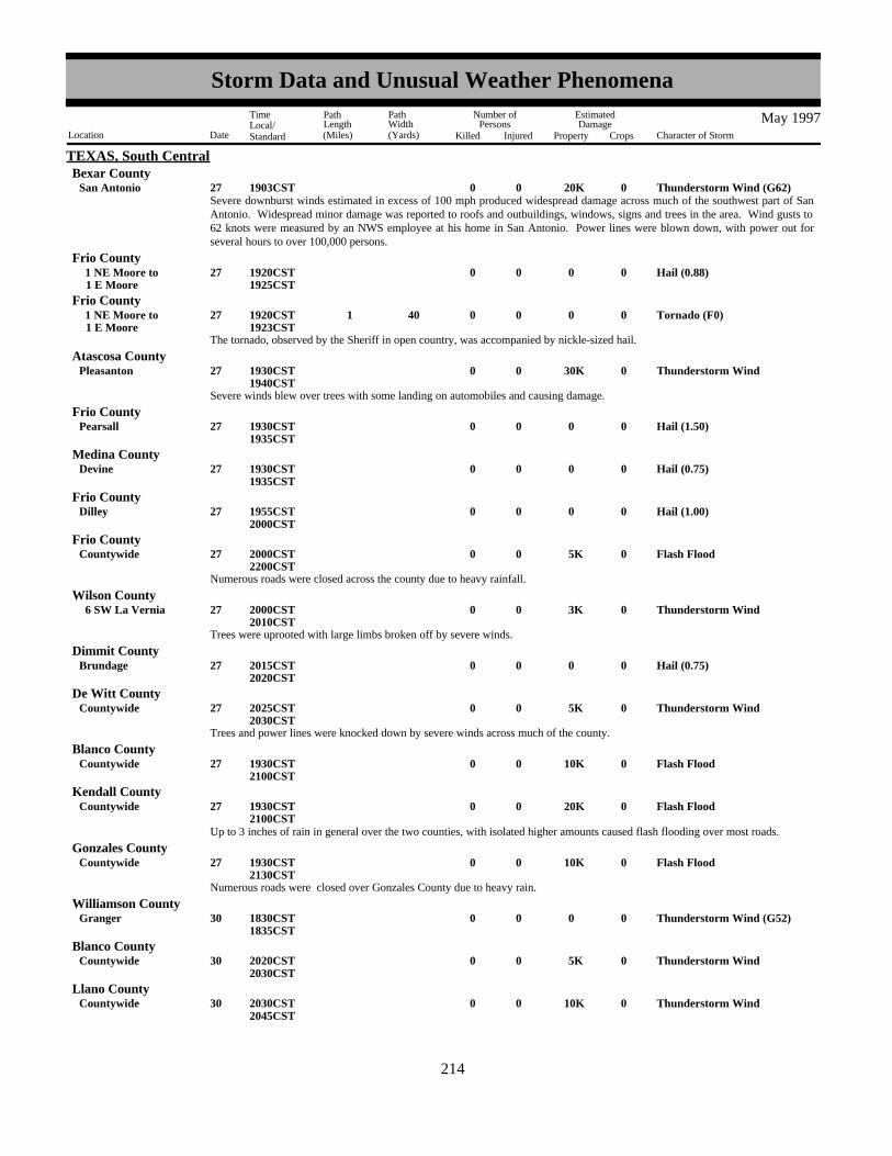
TEXAS, South CentralBexar County
Thunderstorm Wind (G62) 20K0027San Antonio 01903CSTSevere downburst winds estimated in excess of 100 mph produced widespread damage across much of the southwest part of SanAntonio. Widespread minor damage was reported to roofs and outbuildings, windows, signs and trees in the area. Wind gusts to62 knots were measured by an NWS employee at his home in San Antonio. Power lines were blown down, with power out forseveral hours to over 100,000 persons.
Hail (0.88)00027 1 E Moore 1 NE Moore to 01920CST
1925CST
Frio County
The tornado, observed by the Sheriff in open country, was accompanied by nickle-sized hail.
Tornado (F0)00 40 1 027 1 E Moore 1 NE Moore to 01920CST
1923CST
Frio County
Severe winds blew over trees with some landing on automobiles and causing damage.
Thunderstorm Wind 30K0027Pleasanton 01930CST1940CST
Atascosa County
Hail (1.50)00027Pearsall 01930CST1935CST
Frio County
Hail (0.75)00027Devine 01930CST1935CST
Medina County
Hail (1.00)00027Dilley 01955CST2000CST
Frio County
Numerous roads were closed across the county due to heavy rainfall.
Flash Flood 5K0027Countywide 02000CST2200CST
Frio County
Trees were uprooted with large limbs broken off by severe winds.
Thunderstorm Wind 3K0027 6 SW La Vernia 02000CST2010CST
Wilson County
Hail (0.75)00027Brundage 02015CST2020CST
Dimmit County
Trees and power lines were knocked down by severe winds across much of the county.
Thunderstorm Wind 5K0027Countywide 02025CST2030CST
De Witt County
Flash Flood 10K0027Countywide 01930CST2100CST
Blanco County
Flash Flood 20K0027Countywide 01930CST2100CST
Kendall County
Up to 3 inches of rain in general over the two counties, with isolated higher amounts caused flash flooding over most roads.
Numerous roads were closed over Gonzales County due to heavy rain.
Flash Flood 10K0027Countywide 01930CST2130CST
Gonzales County
Thunderstorm Wind (G52)00030Granger 01830CST1835CST
Williamson County
Thunderstorm Wind 5K0030Countywide 02020CST2030CST
Blanco County
Thunderstorm Wind 10K0030Countywide 02030CST2045CST
Llano County
206214
Storm Data and Unusual Weather Phenomena
Location Date Character of Storm
TimeLocal/Standard
PathLength(Miles)
PathWidth(Yards)
Number ofPersons
Killed Injured
EstimatedDamage
Property Crops
May 1997

TEXAS, South CentralGillespie County
Hail (0.75)00030Cherry Spg 02240CST2245CST
Widespread damage to trees and power lines was reported. Also, numerous small buildings were blown down in Blanco andLlano Counties.
Power lines were blown down by severe winds.
Thunderstorm Wind 10K0031Cuero 00300CST0335CST
De Witt County
Hail (1.75)00001 3 W Quitaque 02159CST
TEXAS, South PanhandleBriscoe County
Hail (1.00)00001 9 S Floydada 02234CSTFloyd County
Hail (0.88)00001Childress 02322CSTChildress County
Thunderstorms developed late on the 1st over the northeast South Plains along an advancing cold front. A few of the storms weresevere. The Quitaque Fire Department reported golfball-size hail west of town. The Floyd County Sheriff's Office reportedquarter-size hail south of Floydada. The public reported nickel-size hail in Childress.
Hail (1.00)00006 8 S Friona 1820CSTParmer County
Hail (0.75)00006 11 W Dimmitt 1845CSTCastro County
Tornado (F0)00 20 0.1 006 10 S Dimmitt 01907CSTCastro County
Hail (1.00)00006 7 W Hart 1955CSTCastro County
Hail (0.75)00006 9 SW Dimmitt 02013CSTCastro County
Hail (1.75)00006 11 S Dimmitt 25K2030CSTCastro County
Several severe storms affected Castro and Parmer Counties on the evening of the 6th. A weak, brief tornado was reported south ofDimmitt by an experienced storm chaser. The Castro County Sheriff's Office reported large hail at several locations within thecounty. Dime-size hail accumulated to 7 inches deep at Flagg (about 9 SW of Dimmitt).
Hail (1.00)00007 4 WNW Lockney 01823CSTFloyd County
Hail (0.88)00007 1.5 E Cotton Center 01824CSTHale County
Hail (1.00)00007Lockney 01830CSTFloyd County
Hail (1.50)00007 1 E Lockney 01848CSTFloyd County
Severe storms hit Floyd and Hale counties on the evening of the 7th. The Floyd County Sheriff's Office, the public, and tornadoresearchers reported large hail in and near Lockney. Also the public reported nickel-size hail near Cotton Center in Hale County.
Hail (1.75)00008 8 SSW Lakeview 01720CSTHall County
Hail (1.00)00008 11 W Estelline 01740CSTHall County
Hail (1.75)00008 14 WSW Plains 01800CSTYoakum County
Hail (1.00)00008Brownfield 01945CSTTerry County
Hail (1.00)00008Denver City 01950CSTYoakum County
Hail (1.75) 585K0008Slaton 02007CST2015CST
Lubbock County
207215
Storm Data and Unusual Weather Phenomena
Location Date Character of Storm
TimeLocal/Standard
PathLength(Miles)
PathWidth(Yards)
Number ofPersons
Killed Injured
EstimatedDamage
Property Crops
May 1997

TEXAS, South PanhandleLynn County
Hail (2.00) 5K0008 6 NE Wilson 02010CST2020CST
The evening of May 8, 1997 produced severe weather in several counties on the South Plains and over Hall County in the extremesouthern Texas Panhandle. Golfball-sized hail hit the town of Slaton in SE Lubbock County breaking 40 windows at a localchurch and causing extensive roof damage at an elementary school. Several car dealerships reported hail damage to numerousvehicles. Also, residential areas were extensively damaged. Golfball-sized hail also occurred in rural parts of Hall County and inwestern Yoakum County near the stateline.
Hail (2.00)00014 4 SSW Justiceburg 01825CSTGarza County
Hail (2.00)00014 4 SSW Justiceburg 02240CSTGarza County
Hail (2.75) 5K0015 10 S Aspermont 00100CSTStonewall County
Hail (0.75)00015Aspermont 00115CSTStonewall County
Severe thunderstorms developed over Garza and Stonewall Counties late at night on the 14th and early on the 15th. These stormsproduced large hail near Justiceburg and south of Aspermont though little damage was reported.
Hail (1.75)00018 7 NW Petersburg 01838CSTHale County
Hail (1.75)00018 6 WNW Petersburg 01905CSTHale County
The Hale County Sheriff's Office reported a severe thunderstorm produced golfball-sized hail near Petersburg.
Hail (0.75)00022 14 WSW Tulia 01910CSTSwisher County
Hail (1.00)00022 8 W Tulia 01925CSTSwisher County
Funnel Cloud0022 2 W Kress 1929CSTSwisher County
Tornado (F0)00 10 0.1 022 14 W Kress 01940CSTSwisher County
Hail (1.75)00022 7 SW Tulia 01955CSTSwisher County
Hail (1.00)00022 7 NW Kress 02005CSTSwisher County
Flash Flood00022 8 W Tulia 02015CST2115CST
Swisher County
Swisher County was affected by several severe thunderstorms on the evening of the 22nd. An brief, weak tornado was reported bya storm chaser west of Kress. The Tulia Police Department reported large hail northwest of Kress and west of Tulia. They alsoreported that FM road 1424 was flooded in the western part of the county. Also, the public reported golfball-sized hail 7milesSW of Tulia.
Hail (1.00)00023Quitaque 01604CSTBriscoe County
Hail (1.00)00023Quitaque 01615CSTBriscoe County
Hail (1.75)00023 15 E Silverton 01700CSTBriscoe County
Flash Flood00023 3 SE Quitaque 01745CST1900CST
Briscoe County
Severe thunderstorms occurred over Briscoe County during the evening of the 23th. The Quitaque Fire Department reportedquarter-sized hail in the city of Quitaque and FM road 599 was flooded southeast of Quitaque with 1-3 feet of water.Golfball-sized hail was reported at Caprock Canyons State Park by park officials.
Lightning struck a tree and caused a house fire that resulted in $5000 damage. Lightning 5K0023Lubbock 1745CST
Lubbock County
Hail (1.00)00024Ralls 01630CSTCrosby County
208216
Storm Data and Unusual Weather Phenomena
Location Date Character of Storm
TimeLocal/Standard
PathLength(Miles)
PathWidth(Yards)
Number ofPersons
Killed Injured
EstimatedDamage
Property Crops
May 1997

TEXAS, South PanhandleCrosby County
Hail (1.00)00024 7 S Ralls 01710CSTSevere thunderstorms developed over Crosby County during the early evening on the 24th. A storm chaser reported quarter-sizedhail 7 miles south of Ralls.
Hail (0.75)00028 1 SE Hart 01310CSTCastro County
Hail (0.75)00028 2 N Aiken 01430CSTFloyd County
Hail (1.00)00028 1 N Friona 01657CSTParmer County
Hail (1.75)00028Friona 01657CSTParmer County
Hail (2.00)00028Friona 01709CSTParmer County
Hail (0.88)00028 9 SE Friona 01715CSTParmer County
Hail (0.88)00028 3 N Lazbuddie 01730CSTParmer County
Hail (1.75)00028 6 WNW Earth 01814CSTLamb County
Hail (1.75)00028 7 N Amherst 01845CSTLamb County
Hail (1.75)00028Bovina 01913CSTParmer County
Hail (1.75)00028 10 NE Littlefield 01920CSTLamb County
Hail (1.00)00028 5 N Muleshoe 01950CSTBailey County
Hail (1.00)00028 2 S Muleshoe 02015CSTBailey County
Hail (1.00)00028 3 E Needmore 02042CSTBailey County
Hail (0.75)00028Levelland 02150CSTHockley County
Thunderstorm Wind (G55) 5K0028Brownfield 02300CSTTerry County
Severe thunderstorms occurred across the northwest portions of the South Plains and over the extreme southwest Texas Panhandle.Large hail fell over Parmer and Lamb Counties during the evening. The Friona Police Department reported up to 2" diameter hailin Friona. The Lamb County Sheriff's Office reported golfball-sized hail at several locations in the county. The thunderstormsmoved south southeast and weakened, but still produced dime-sized hail in Levelland (reported by the public) and 55 knot windsin Brownfield. The Brownfield emergency manager reported a barn was damaged by the high wind.
Hail (0.88)00029 2 S Plainview 00737CSTHale County
Hail (0.75)00029Odonnell 01907CSTLynn County
Hail (1.50)00029Happy 02117CSTSwisher County
Hail (0.88)00029Tulia 02200CSTSwisher County
Hail (1.00)00029 1 E Kaffir 02203CSTSwisher County
Hail (1.00)00029Tulia 02214CSTSwisher County
Hail (0.75)00029 5.5 W Dimmitt 02225CSTCastro County
Hail (0.75)00029Quitaque 02250CSTBriscoe County
209217
Storm Data and Unusual Weather Phenomena
Location Date Character of Storm
TimeLocal/Standard
PathLength(Miles)
PathWidth(Yards)
Number ofPersons
Killed Injured
EstimatedDamage
Property Crops
May 1997

TEXAS, South PanhandleLamb County
Hail (1.00)00029Earth 02305CST
Hail (1.00)00029 2 E Earth 02320CSTLamb County
Hail (1.00)00029Hart Camp 02346CSTLamb County
Hail (0.75)00030Tulia 00046CSTSwisher County
Hail (0.75)00030Tulia 00118CSTSwisher County
Hail (0.75)00030Petersburg 00230CSTHale County
Hail (0.88)00030 4 N Petersburg 00241CSTHale County
Hail (1.25)00030 5 W Mc Coy 00250CSTFloyd County
Tornado (F0)00 10 0.1 030 1 N Petersburg 00250CSTHale County
Hail (1.00)00030 2 N Ralls 00309CSTCrosby County
Hail (1.00)00030 1 NE Ralls 00322CSTCrosby County
The most widespread severe weather event of the month occurred on the 29th and into the morning of the 30th. Numerousreports of dime- to quarter-sized hail were received from O'Donnell, Happy, Tulia, Quitaque, Dimmitt, Earth, Petersburg, andRalls. A brief, weak tornado was reported just north of Petersburg by the Hale County Sheriff's Office.
A few trees fell down on power lines during a severe thunderstorm.Thunderstorm Wind 5K0027Jasper 2330CST
TEXAS, SoutheastJasper County
Severe thunderstorm winds blew trees down from Colmesnelle to Doucette and Hillister.Thunderstorm Wind 20K0030Colmesnelle 2259CST
Tyler County
Hail (0.75)0007Ft Stockton 1645CST
TEXAS, WestPecos County
This storm was one of a series of storms that formed along a cold front that was moving southward through the southern parts ofthe Texas South Plains. The storm first developed in the northwest corner of Gaines county and moved little as it intensified into amulticell cluster.
Hail (1.75)0008 3 NE Higginbotham 1726CSTGaines County
Another storm that formed along the cold front and moved southward into Scurry County.Hail (1.00)0008Snyder 1815CST
Scurry County
The Higginbotham storm began to move southward and dropped hail in the Paynes Corner area. Cotton in the area was heavilydamaged.
Hail (1.75)0008 9 W Seminole 1M1824CSTGaines County
Hail (1.00)0008 6 NW Snyder 1845CSTScurry County
Tornado formed about 4.5 miles west of the intersection of U.S. Highway 385 and FM 1967. Reported by SKYWARN spotter.This storm entered from Gaines County and became a supercell. The storm was moving to the right of the upper flow, partly dueto its dependence on the front for a low-level focus.
Tornado (F1)0100 0.8 008 10 NNW Andrews 1926CST1931CST
Andrews County
A strong storm moving over the frontal boundary to the northeast in rural Gaines County.Hail (2.75)0008 13 NE Seminole 300K2025CST
Gaines County
210218
Storm Data and Unusual Weather Phenomena
Location Date Character of Storm
TimeLocal/Standard
PathLength(Miles)
PathWidth(Yards)
Number ofPersons
Killed Injured
EstimatedDamage
Property Crops
May 1997

TEXAS, WestGaines County
Roof blown off a structure 1-2 miles east of State Highway 214 on State Highway 83. Strong outflow winds in a slightly bowingmulticell complex.
Thunderstorm Wind 6K0008 13 W Seagraves 2040CST
Baseball size hail and larger smashed the windshield of a Police cruiser and shattered windows in several homes. Power wasknocked out around town as well. Autos and roofs of houses were smashed by the large hail and accounted for much of thedamage total. A local insurance agent said the damage was the worst in 20 years in Seagraves.
Storms that were moving eastward into the Seagraves area had been a multicell cluster, but just before arriving at Seagraves onecell developed briefly into an HP Supercell.
Hail (3.00) 2.5M0008Seagraves 500K2044CSTGaines County
Hail (2.75) 10K0008 3 SW Odessa 2345CST2355CST
Ector County
Hail up to baseball size and very heavy rains and high winds combined to cause problems in the southwestern parts of Odessa. Amobile home had its roof blown off by high winds, and windows were knocked out in several houses. Also hail was carried intolow spots by running water and formed drifts that had to be scooped up by front-end loaders. Some street flooding was reported aswell.
The storm came from a multicell cluster of showers moving eastward into the Permian Basin. As the cluster entered Ector Countythere was rapid intensification as the cluster intersected the southward moving cold front. An HP Supercell structure was notedbriefly over southwestern Odessa that produced the large hail and high winds.
Thunderstorm Wind 20K0008 3 SW Odessa 2350CSTEctor County
A very active evening with a cold front sagging into the region and southeast surface winds flowing into the mountains to helpinitiate deep convection. Dew point temperatures were near 60 degrees with surface temperatures in the upper 80s to lower 90s.The observed MAF sounding from this evening using the best (mean) parcel showed a lifted index of -10 (-8) and a CAPE of 3420(2710) J/kg with no cap.
In Gaines County hail destroyed over 6000 acres of cotton.
Hail (2.75) 30K0014 3 SSE Midland 1553CST1610CST
Midland County
The triple point marking the intersection of the dry line and a cold front was located near Midland with a thunderstorm developingover the southern sections of the city. As indicated on radar two inflow areas were established--on the north and west sides of thestorm. Spotters were concentrating on the west side, but apparently the dominant updraft was on the north side as a wall cloud andpossible funnels were reported. The 88D reflectivity gradient was strongest on the north side as well. A mesocyclone was neverconfirmed with the storm, but the updraft was extremely strong with reports of tennis ball and baseball hail reported.
Hail (1.75)0014 5 SSE Midland 1610CST1628CST
Midland County
Four severe single cell storms were initiated along an outflow boundary in southern Gaines and Dawson Counties. The storm thatproduced this hail was second from the east in the line in rural areas.
Hail (2.75)0014 15 SE Seminole 1742CSTGaines County
This storm was the eastern-most in the line in rural Dawson Co.Hail (2.50)0014 5 E Patricia 1751CST
Dawson County
This storm was the western-most in the line near the New Mexico state line.Hail (1.50)0014 25 WNW Andrews 1923CST
Andrews County
The storms in Dawson and Gaines Counties weakened as they moved southward, then sent out an outflow boundary that served asthe focus for new development in Martin County. The character of these storms was much different as a cluster of very small cellsformed versus the well-organized single cell to the north.
Hail (0.75)0014Stanton 2022CSTMartin County
The cell that produced the hail in Luther was on the northern end of the cluster with the cell over Stanton.Hail (0.88)0014Luther 2106CST
Howard County
211219
Storm Data and Unusual Weather Phenomena
Location Date Character of Storm
TimeLocal/Standard
PathLength(Miles)
PathWidth(Yards)
Number ofPersons
Killed Injured
EstimatedDamage
Property Crops
May 1997

TEXAS, WestScurry County
A storm that developed in Garza County moved southward into northwestern Scurry County where the golfball size hail fell atFluvanna.
Hail (1.75)0014Fluvanna 1828CST
Hail (0.75)0014 13 E Gail 1940CSTBorden County
The Fluvanna storm moved southward along the Borden/Scurry County line into the Knapp community.Hail (1.75)0014 15 SW Snyder 1956CST
Scurry County
The dry line was located from west of Lubbock extending southward to west of Sanderson. Storms fired along this area of focus inthe late afternoon. Temperatures were in the lower to mid 90s with dew points in the mid to upper 50s.
Hail (1.75)0015 7 S Odessa 1832CSTEctor County
A fast moving cold front served as the focus for storms in Terrell County. The front had pushed through the Permian Basin duringthe morning and early afternoon and was proceeding through southern Terrell County at maximum heating. The storms werequickly swept out of the area that evening as the storm continued to press southward.
Hail (0.88)0019Dryden 1630CSTTerrell County
A northeasterly upslope flow into the mountains of northern Chihuahua formed storms in the mountainous terrain. These stormswere advected over the top of a frontal boundary and crossed the Rio Grande near Presidio where the hail fell. The storm appearedto continue with very strong intensity over open country while riding on the frontal boundary. The storm weakened as itapproached the city of Marfa, where it skimmed the city to the south.
Hail (0.75)0020Presidio 1955CSTPresidio County
A moist upslope flow into the mountains of southwest Texas developed thunderstorms in the afternoon that persisted into theevening. A slow-moving cluster of storms in the Marathon area rained 2-3 inches over the town and caused flooding. Water wasup to one foot deep in some locations.
Flash Flood0020Marathon 2140CST2330CST
Brewster County
The synoptic setting included a surface pre-frontal trough west of the dry line near the Texas/New Mexico border. Storms formedalong the trough in the middle of the afternoon and intensified after moving east of the dryline in the late afternoon.
Hail (0.75)0023 10 N Snyder 1725CSTScurry County
This storm developed near the Pecos River in southern Crane County, moved to the ENE and became a multicell severe storm as itcrossed Upton County. The hail fell out of a cell that had just passed maturity. This cell rapidly dissipated as the cluster continuedto the east.
Hail (1.00)0024 19 NNE Mc Camey 1658CSTUpton County
Hail (0.75)0024 12 E Garden City 1750CSTGlasscock County
An off-duty patrol officer reported dime size hail and 65-75 mph winds from a storm near the Sterling County line. The storm wasin a multicell cluster that had developed in southwestern Glasscock County along an outflow boundary from storms to the south.
Thunderstorm Wind (G61)0024 12 E Garden City 1750CSTGlasscock County
Hail (0.75)0024 6 W Snyder 1759CSTScurry County
Strong winds knocked down utility poles in Snyder. An outflow boundary moving eastward across the South Plains and northernPermian Basin exploded into a line of severe storms as the boundary moved into rich moisture. The line that affected Snyderdeveloped rapidly as it moved into Scurry County from Borden County.
Thunderstorm Wind 10K0024Snyder 1811CSTScurry County
Storms fired in the mountains of New Mexico and west Texas and moved eastward into better moisture. Dew points near the dryline (in the central Permian Basin) were too low to support severe convection, but farther east dew points were high enough tofurther intensify the storms to severe levels.
Multicell thunderstorms that developed over the higher terrain of the Davis Mountains moved to the southeast across Ft. Davis andproduced hail southeast of town.
Hail (1.00)0028 7 SSE Ft Davis 1428CSTJeff Davis County
212220
Storm Data and Unusual Weather Phenomena
Location Date Character of Storm
TimeLocal/Standard
PathLength(Miles)
PathWidth(Yards)
Number ofPersons
Killed Injured
EstimatedDamage
Property Crops
May 1997
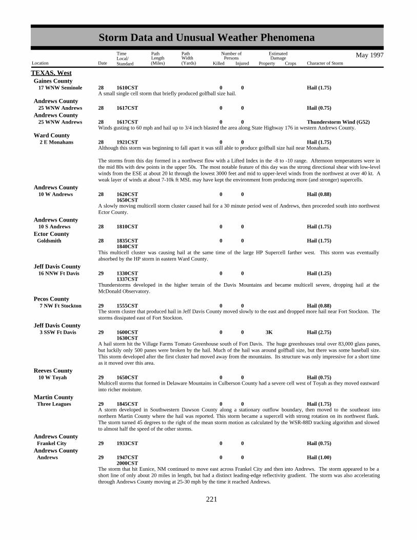
TEXAS, WestGaines County
A small single cell storm that briefly produced golfball size hail.Hail (1.75)0028 17 WNW Seminole 1610CST
Hail (0.75)0028 25 WNW Andrews 1617CSTAndrews County
Winds gusting to 60 mph and hail up to 3/4 inch blasted the area along State Highway 176 in western Andrews County. Thunderstorm Wind (G52)0028 25 WNW Andrews 1617CST
Andrews County
Although this storm was beginning to fall apart it was still able to produce golfball size hail near Monahans.Hail (1.75)0028 2 E Monahans 1921CST
Ward County
The storms from this day formed in a northwest flow with a Lifted Index in the -8 to -10 range. Afternoon temperatures were inthe mid 80s with dew points in the upper 50s. The most notable feature of this day was the strong directional shear with low-levelwinds from the ESE at about 20 kt through the lowest 3000 feet and mid to upper-level winds from the northwest at over 40 kt. Aweak layer of winds at about 7-10k ft MSL may have kept the environment from producing more (and stronger) supercells.
A slowly moving multicell storm cluster caused hail for a 30 minute period west of Andrews, then proceeded south into northwestEctor County.
Hail (0.88)0028 10 W Andrews 1620CST1650CST
Andrews County
Hail (1.75)0028 10 S Andrews 1810CSTAndrews County
Hail (1.75)0028Goldsmith 1835CST1840CST
Ector County
This multicell cluster was causing hail at the same time of the large HP Supercell farther west. This storm was eventuallyabsorbed by the HP storm in eastern Ward County.
Thunderstorms developed in the higher terrain of the Davis Mountains and became multicell severe, dropping hail at theMcDonald Observatory.
Hail (1.25)0029 16 NNW Ft Davis 1330CST1337CST
Jeff Davis County
The storm cluster that produced hail in Jeff Davis County moved slowly to the east and dropped more hail near Fort Stockton. Thestorms dissipated east of Fort Stockton.
Hail (0.88)0029 7 NW Ft Stockton 1555CSTPecos County
A hail storm hit the Village Farms Tomato Greenhouse south of Fort Davis. The huge greenhouses total over 83,000 glass panes,but luckily only 500 panes were broken by the hail. Much of the hail was around golfball size, but there was some baseball size.This storm developed after the first cluster had moved away from the mountains. Its structure was only impressive for a short timeas it moved over this area.
Hail (2.75) 3K0029 3 SSW Ft Davis 1600CST1630CST
Jeff Davis County
Multicell storms that formed in Delaware Mountains in Culberson County had a severe cell west of Toyah as they moved eastwardinto richer moisture.
Hail (0.75)0029 10 W Toyah 1650CSTReeves County
A storm developed in Southwestern Dawson County along a stationary outflow boundary, then moved to the southeast intonorthern Martin County where the hail was reported. This storm became a supercell with strong rotation on its northwest flank.The storm turned 45 degrees to the right of the mean storm motion as calculated by the WSR-88D tracking algorithm and slowedto almost half the speed of the other storms.
Hail (1.75)0029Three Leagues 1845CSTMartin County
Hail (0.75)0029Frankel City 1933CSTAndrews County
The storm that hit Eunice, NM continued to move east across Frankel City and then into Andrews. The storm appeared to be ashort line of only about 20 miles in length, but had a distinct leading-edge reflectivity gradient. The storm was also acceleratingthrough Andrews County moving at 25-30 mph by the time it reached Andrews.
Hail (1.00)0029Andrews 1947CST2000CST
Andrews County
213221
Storm Data and Unusual Weather Phenomena
Location Date Character of Storm
TimeLocal/Standard
PathLength(Miles)
PathWidth(Yards)
Number ofPersons
Killed Injured
EstimatedDamage
Property Crops
May 1997

TEXAS, WestBorden County
Quarter size hail was reported on the Dawson/Borden County line. This storm formed in southwestern Lynn County, movedsoutheast into Dawson County and became severe as it straddled the Dawson/Borden County line. The storm turned right for ashort time and travelled almost straight south along the county line. Then after only a few miles of this motion began to move tothe southeast again and weakened.
Hail (1.00)0029 14 W Gail 2022CST
Hail (1.00)0029 15 E Lamesa 2022CSTDawson County
Daily synopsis : This event was characterized by a northwest flow aloft and moisture farther west than typically found for thistime in the year. In the Davis Mountains dew point temperatures were in the mid to upper 50s. In the Permian Basin dew pointswere in the lower to mid 60s with temperatures in the lower 90s. An outflow boundary that had moved through the Lubbock areaearly the previous morning lay across the area from Central Lea County into Dawson County.
Hail (0.88)0001 1 W Quanah 2350CST
TEXAS, Western NorthHardeman County
Hail (0.75)0002Quanah 0010CSTHardeman County
Hail (0.88)0008 15 W Crowell 1550CSTFoard County
Hail (1.75)0008Goree 1603CSTKnox County
Severe thunderstorm winds broke 3-inch limbs off of trees.Thunderstorm Wind0.01K0008 1 E Red Spgs 1610CST
Baylor County
An old cotton gin was picked up and tossed 100 feet onto Highway 287.Thunderstorm Wind 1K0008Oklaunion 1635CST
Wilbarger County
Golf ball sized hail covered the ground.Hail (1.75)0008 2 E Gilliland 1655CST
Knox County
Hail (1.75)0008 12 N Vernon 1655CSTWilbarger County
Hail (1.75)0008Fargo 1700CSTWilbarger County
Hail (2.00)0008 2 E Vera 1730CSTKnox County
Severe thunderstorm winds estimated at over 70 mph caused widespread damage in and around Harrold. The winds blew anempty cattle trailer into the canopy at a truck stop. The canopy and part of the roof of the building were severely damaged. Lightpoles and signs were also blown down at the truck stop. Residential roofs were damaged, fences and trees were downed, andwindows were broken throughout town. Near the elementary school a garage and a barn were completely demolished, and a secondbarn was severely damaged. The roof of the elementary school also collapsed. On US Hwy 287 a tractor-trailer was blown off ofthe road.
Thunderstorm Wind (G61) 25K0008Harrold 1730CSTWilbarger County
Thunderstorm Wind (G52)0008Harrold 1733CSTWilbarger County
Hail (0.75)0008Harrold 1734CSTWilbarger County
Hail (1.75)0008Electra 1800CSTWichita County
Severe thunderstorm winds caused widespread structural and tree damage in and around Iowa Park. The most extensive damageoccurred on the south part of town, where a mobile home was completely destroyed on FM 367, a store lost one-quarter of its roof,and windows were blown out of a car dealership. Also in south Iowa Park, an auto repair garage suffered severe damage when its35-foot awning was torn off and blown across the street and sections of the building's roof were removed. Branches were downedand large trees were toppled across town, including at least one 60-foot tree. Power poles and lines were snapped, leavingresidents without power for as long as 13 hours.
Thunderstorm Wind (G65) 45K0008Iowa Park 1816CST1830CST
Wichita County
214222
Storm Data and Unusual Weather Phenomena
Location Date Character of Storm
TimeLocal/Standard
PathLength(Miles)
PathWidth(Yards)
Number ofPersons
Killed Injured
EstimatedDamage
Property Crops
May 1997

TEXAS, Western NorthWichita County
Winds of around 70 mph downed small trees and destroyed part of the fence at the stadium sports complex on the southwest sideof town.
Thunderstorm Wind (G65) 1K0008Wichita Falls 1828CST
Hail (0.75)0008Harrold 1833CSTWilbarger County
Thunderstorm Wind (G52)0008Harrold 1833CSTWilbarger County
measured at the ASOS site Thunderstorm Wind (G50)0008Wichita Falls (Ksps) 1838CST
Wichita County
Power poles were blown down in Archer City.Thunderstorm Wind0.50K0008Archer City 1845CST
Archer County
Hail (0.88)0008 4 NW Wichita Falls 1845CSTWichita County
Hail (0.88)0008Wichita Falls 1845CSTWichita County
Hail (1.00)0008Lake Arrowhead 1854CSTClay County
measured at the ASOS siteThunderstorm Wind (G66)0008Wichita Falls (Ksps) 1856CST
Wichita County
An 18-inch diameter tree was blown over by severe thunderstorm winds.Thunderstorm Wind0.10K0008Archer City 1900CST
Archer County
at the intersection of FM 2393 and FM 1954Hail (1.75)0008 11 W Henrietta 1900CST
Clay County
Hail (2.75)0008Lake Arrowhead 1900CST1910CST
Clay County
A citizen reported a brief tornado on the FM 172 bridge south of Lake Arrowhead. One picnic shelter in a park was destroyed.Tornado (F0)0.75K0 25 0.1 008 10 W Bluegrove 1915CST
Clay County
Severe thunderstorm winds blew windows out of a house.Thunderstorm Wind0.25K0008 1.5 S Deer Creek 1950CST
Clay County
A small tornado, probably a gustnado, blew part of the roof off a barn.Tornado (F0)0.50K0 25 0.1 008 5 S Deer Creek 1955CST
Clay County
Hail (1.75)0008Joy 2000CSTClay County
Highway 82 between Benjamin and Seymour was closed due to high water.
Flash Flood000809
Seymour 2030CST0030CST
Baylor County
Highway 82 between Benjamin and Seymour was closed due to high water.
Flash Flood000809
Benjamin 2030CST0030CST
Knox County
Highway 79 was closed due to high water.Flash Flood0008Archer City 2050CST
Archer County
The Clay County Sheriff's Office reported roads across most of the county were covered with water, causing numerous accidentsand stalled cars. Many roads were closed.
Flash Flood0008Countywide 2100CSTClay County
215223
Storm Data and Unusual Weather Phenomena
Location Date Character of Storm
TimeLocal/Standard
PathLength(Miles)
PathWidth(Yards)
Number ofPersons
Killed Injured
EstimatedDamage
Property Crops
May 1997

TEXAS, Western NorthClay County
Flash flood waters flowed 4 feet deep over the FM 172 bridge across Deer Creek (about 2.5 miles west of Bluegrove). Severalcars became stranded in high water on FM 172 between Bluegrove and Lake Arrowhead, and officials rescued at least 2 peoplefrom their flooded cars.
Flash Flood0008 2.5 W BluegroveBluegrove to 2200CST
2300CST
Portions of Wichita Falls received up to 5 inches of rain in less than one hour, resulting in widespread flash flooding throughoutthe city. As many as 100 homes in the Faith Village area and off of Jacksboro Highway in south Wichita Falls reported some sortof flooding. Numerous roads in and around Wichita Falls were closed due to high water, some for over 12 hours. With water up to6 feet deep, several cars became stranded and were washed away. In one instance an ambulance on its way to rescue awheelchair-confined man from his flooding house stalled in water that rose to the depth of the ambulance's windshield. (Thehandicapped man was helped safely from his house by his neighbors.)
Flash Flood 150K0008Wichita Falls 2200CSTWichita County
Several highways and streets across the county were covered with high water.Flash Flood0008Countywide 2230CST
Archer County
FM 1954, FM 883, FM 2606, and Highway 172 were closed due to high water.Flash Flood0008Countywide 2300CST
Clay County
Summary of events of May 8, 1997:
Severe thunderstorms moved repeatedly over western parts of north Texas during the late afternoon and through the evening of the8th. During the daylight hours, the storms produced numerous reports of large hail and strong and damaging winds. Twotornadoes were also reported. By the end of the evening, a widespread flash-flood event had evolved, affecting most or all of 5counties in the area.
The first tornado was reported west of Bluegrove (on the south side of Lake Arrowhead) in Clay County, and the second tornado,probably a gustnado, occurred south of Deer Creek (also in Clay County). Minor damage was reported with each tornado and bothwere rated F0.
The largest hail also fell near Lake Arrowhead, where baseball-sized hail fell for about 10 minutes. The strongest measured windspeeds reached 76 mph at the Wichita Falls Municipal Airport in Wichita County.
Widespread and severe wind damage occurred in Harrold in Wilbarger County and in Iowa Park in Wichita County. Other moreminor damage was reported east of Red Springs in Baylor County, in Oklaunion in Wilbarger County, in Archer City in ArcherCounty, and south of Deer Creek in Clay County.
Most of Clay and Archer Counties were affected by flash flooding. Portions of Wichita Falls in Wichita County also suffered frommajor flash flooding, including flooding of homes. More isolated incidents of flash flooding occurred near Benjamin in KnoxCounty and near Seymour in Baylor County.
See preceding individual Storm Data entries for further details and additional reports.
Hail (0.75)0030 3 NW Burkburnett 0220CSTWichita County
Hail (0.75)0030Wichita Falls 0256CSTWichita County
A small metal shed was blown about 75 feet and limbs were blown down.Thunderstorm Wind0.50K0030Wichita Falls 0300CST
Wichita County
Widespread street flooding was reported from Wichita Falls to Burkburnett.
Flash Flood0030BurkburnettWichita Falls to 0320CST
Wichita County
Hail (1.00)0030Scotland 0338CSTArcher County
A roof was blown off a two-story structure and one large tree was downed.Thunderstorm Wind 5K0030Scotland 0340CST
Archer County
216224
Storm Data and Unusual Weather Phenomena
Location Date Character of Storm
TimeLocal/Standard
PathLength(Miles)
PathWidth(Yards)
Number ofPersons
Killed Injured
EstimatedDamage
Property Crops
May 1997

TEXAS, Western NorthClay County
Up to eight inches of water covered some of the roads.Flash Flood0030 9 WSW Joy 0400CST
Hail (0.75)0030 10 W Joy 0400CST0410CST
Clay County
Hail (1.00)0030Bellevue 0439CSTClay County
Summary of events of May 30, 1997:
Early morning thunderstorms moved across Clay, Archer, and Wichita Counties, producing hail as large as quarters, damagingthunderstorm winds, and flash flooding. The one-inch hail fell in Scotland in Archer County and in Bellevue in Clay County.Wind damage occurred in Wichita Falls in Wichita County and in Scotland (in Archer County). Isolated flash flooding wasreported in Wichita County from Wichita Falls to Burkburnett and west-southwest of Joy in Clay County.
See preceding individual Storm Data entries for further details and additional reports.
Heavy Snow 15K0001 0000MST1800MST
UTAH, North, Central and SouthUTZ008>009 Wasatch Mountains South Of I80 - Western Unita Mountains
A winter storm system swept into northern Utah on this date. Rain occurred in the valleys and criteria snow fell in the mountains.The Alta ski resort received 13" while Snowbird had 11". Uintalands in eastern Summit county had 8" of snow.
Flash Flood 1.2M0015Draper 0630MST1130MST
Salt Lake County
During the early morning hours a canal broke in Draper. High waters due to the runoff of an above normal snow pack in themountains caused the break. 10 homes in the Victor's Pond subdivision were flooded with a combination of water, mud anddebris. One home's basement filled with 7' of water and mud. Fortunately no one was injured but the flood damage was quiteextensive.
Flood 120K001529
50K1400MST1400MST
UTZ001>002-006 Cache Valley/Utah Portion - Northern Wasatch Front/Brigham City/Ogden Bountiful - Wasatch MountainValleys/Huntsville/Park City/Heber
The runoff from the above normal snowpack in the northern Utah mountains caused flooding along several rivers during thesecond-half of May. Sandbagging efforts minimized what could have resulted in a costly spring runoff season. Flooding occurredduring this time along the Ogden, Logan, and Blacksmith Fork Rivers as well as on Spring Creek. In the Birch Glen, CountryMeadows and Country Manor subdivisions homes were flooded. Several campground areas, residential yards and agriculturallands were also impacted by this flooding.
Lightning 50K0020Bountiful 1800MST1810MST
Davis County
Lightning sparked a house fire in northwest Bountiful. Another newer home in the area also received damage from lightning onthis evening. A power outage occurred in the area. There were no injuries but the home that caught fire experienced extensivedamage.
Heavy Snow 10K002526
0000MST1300MST
UTZ008 Wasatch Mountains South Of I80
A weak storm system left criteria snow on the northern Utah mountains. The Alta ski resort measured a foot of snow with thisstorm.
Flash Flood 100K0019 2 SW Jensen 24 NW Vernal to 0000MST
2000MST
UTAH, NortheastUintah County
Snowmelt water overflowed a high elevation irrigation canal which was blocked with ice. The overflow caused rapid erosion ofloose soils on a forested mountainside 24 miles northwest of Vernal. This resulted in a 1000 yard long chasm up to 300 feet deepand 1000 feet wide. Over 2 million cubic yards of soil and rock were displaced. A debris dam in the chasm eventually breached,resulting in a wall of water moving down Dry Fork (creek) and into Ashley Creek. Some dirt roads were washed out and the watersupply for many residents in the Vernal area became clogged with sediment. The large volume of sediment also flowed intoirrigation canals near Vernal which forced an extended shutdown of irrigation water.
217225
Storm Data and Unusual Weather Phenomena
Location Date Character of Storm
TimeLocal/Standard
PathLength(Miles)
PathWidth(Yards)
Number ofPersons
Killed Injured
EstimatedDamage
Property Crops
May 1997

VERMONT, North and CentralOrleans County
Thunderstorm Wind (G52) 10K0001West Charleston 1845EST1850EST
A strong storm system in the northern Great Lakes Thursday morning (May 1, 1997) moved northeast up the St. Lawrence RiverValley Thursday night. Scattered thunderstorms developed during the late afternoon and evening with locally heavy rain and gustywinds.
A severe thunderstorm moved through West Charleston, VT (Orleans County) at approximately 645 PM EST. A mobile homesustained roof damage, two sheds were blown over and tree and utility pole damage was reported. Winds were estimated at 52knots with this thunderstorm.
Other reports of thunderstorm winds (with no damage) were:Chester, VT (Windsor County).....43 knots at 630 PM ESTSpringfield, VT (Windsor County).....43 knots at 640 PM ESTBrookfield, VT (Orange County)......31 knots at 650 PM EST.
High Wind (G77)0003 0930EST1330EST
VTZ006-009 Lamoille - Addison
A vigorous storm system moved from the eastern Great Lakes region Saturday morning (5/3/97) and headed up the St. LawrenceRiver Valley Saturday night. Gusty winds occurred across Vermont during the day.
While no damage was reported, the strongest winds reported were:
Cambridge, VT (Lamoille County)...77 knots...at 1130 AM ESTBristol, VT (Addison County)....49 knots...at 1000 AM ESTSouth Lincoln (Addison County)....35 knots...at 1030 AM EST
Mountain Snows0007 0000EST1800EST
VTZ003>004-006>007 Orleans - Essex - Lamoille - Caledonia
A complex storm system over northern New York and southern Canada Tuesday morning (May 6, 1997) moved across northernMaine Tuesday night and into the Canadian Maritimes during Wednesday (May 7, 1997).
The storm system deepened while over northern Maine and the Maritimes with locally 4 to 8 inches of snow over some of themountains of northern Vermont above 2500 feet on May 7, 1997. The highest amount of snow recorded was 8 inches on top of Mt.Mansfield (Lamoille County). Across Caledonia County, Essex County and southern Orleans County between 2 and 4 inches ofwet snow fell above 1500 feet.
A cold front crossed western New England during the afternoon of May 1. This front produced an isolated severe thunderstorm atBennington, where several trees were downed by the wind.
Thunderstorm Wind 4K0001Bennington 1750EST
VERMONT, SouthBennington County
Waterspout0003St. Thomas 1810AST1840AST
VIRGIN ISLANDSSt. Thomas County
The Virgin Islands Radio reported a waterspout north of St. Thomas.
Urban/Sml Stream Fld0023St. Croix 0915AST1415AST
St. Croix County
Street flooding was reported in Gallows Bay St. Croix.
Hail (2.00)0001Boydton 1345EST
VIRGINIA, EastMecklenburg County
Several trees down along Route 138. Power lines down also.Thunderstorm Wind 3K0001Kenbridge 1350EST
Lunenburg County
Several trees down on Route 58.Thunderstorm Wind 3K0001 3 W Lawrenceville 1415EST
Brunswick County
Numerous trees down across the county.Thunderstorm Wind 4K0001Dinwiddie 1430EST
Dinwiddie County
218226
Storm Data and Unusual Weather Phenomena
Location Date Character of Storm
TimeLocal/Standard
PathLength(Miles)
PathWidth(Yards)
Number ofPersons
Killed Injured
EstimatedDamage
Property Crops
May 1997

VIRGINIA, EastGreensville County
Hail (0.75)0001Purdy 1430EST
Roof caved in on residence. Outbuildings down. Siding stripped off mobile homes just south of Templeton.Thunderstorm Wind 100K0001Templeton 1430EST
Prince George County
Hail (0.75)0001Lawrenceville 1438ESTBrunswick County
Hail (0.75)0001Stony Creek 1438EST1440EST
Sussex County
Canopy ripped off of truck stop. Several 50-60 year old trees uprooted.Thunderstorm Wind (G61) 10K0001Stony Creek 1440EST
Sussex County
Golfball size hail collapsed a portion of the roof at the Brunswick Academy.Hail (1.75) 15K0001Lawrenceville 1445EST
Brunswick County
Hail (1.75)0001South Hill 1500ESTMecklenburg County
Hail (1.50)0001Wakefield 1501ESTSussex County
Hail (1.50)0001Surry 1505ESTSurry County
Several trees down. Silos blown down.Thunderstorm Wind 10K0001 4 S Surry 1505EST
Surry County
Downed tree broke windshield and peeled back roof of a car, and knocked out the windshield and side mirrors off of a tractortrailer.
Thunderstorm Wind 3K0001Lawrenceville 1510ESTBrunswick County
A 58 mph wind gust was measured at the Jamestown Island Ferry. Also, several trees were downed with one tree falling on avehicle near the town of Toano.
Thunderstorm Wind (G50) 2K0001ToanoJamestown to 1521EST
1525EST
James City County
Hail (0.75)0001Williamsburg 1525ESTWilliamsburg (C)
Several trees down throughout the city.Thunderstorm Wind 3K0001Williamsburg 1525EST
Williamsburg (C)
Numerous large trees down on Colonial Parkway.Thunderstorm Wind 4K0001Yorktown 1530EST
York County
Several trees down on power lines.Thunderstorm Wind 2K0001Johnson Corner 1535EST
Southampton County
Hail caused widespread damage to homes, businesses, and vehicles.Hail (1.75) 1M0001Newport News 1540EST
Newport News (C)
Hail (1.75)0001Grafton 1540ESTYork County
Hail (0.75)0001Achilles 1545ESTGloucester County
Tree down on house.Thunderstorm Wind 5K0001 5 N Isle Of Wight 1545EST
Isle Of Wight County
Hail (2.00)0001Poquoson 1545ESTYork County
Hail caused widespread damage to homes, businesses, and vehicles.Hail (2.75) 1M0001Hampton 1546EST
Hampton (C)
219227
Storm Data and Unusual Weather Phenomena
Location Date Character of Storm
TimeLocal/Standard
PathLength(Miles)
PathWidth(Yards)
Number ofPersons
Killed Injured
EstimatedDamage
Property Crops
May 1997

VIRGINIA, EastNorthampton County
Hail (1.75)0001Capeville 1555EST
Hail (1.25)0001Vicksville 1604ESTSouthampton County
Lightning strike caused damage to church.Lightning 5K0001Cape Charles 1605EST
Northampton County
Hail (1.50)0001 4 NNE Driver 1620ESTSuffolk (C)
Hail caused widespread damage to homes, businesses and vehicles.
Hail (1.75) 10M 2 001Norfolk 1630EST1635EST
Norfolk (C)
Hail caused widespread damage to homes, businesses, and vehicles.
Hail (1.75) 5M0001Virginia Beach 1630EST1635EST
Virginia Beach (C)
Hail destroyed about one-third of a farmer's pea crop. Also, some homes were damaged by hail.Hail (1.00) 25K0001Chesapeake 5K1633EST
Chesapeake (C)
Many homes were damaged by hail.Hail (1.75) 25K0001Portsmouth 1635EST
Portsmouth (C)
Tree down 3 miles west of Battlefield Boulevard.Thunderstorm Wind 1K0003Chesapeake 1050EST
Chesapeake (C)
Large tree down on Route 611.Thunderstorm Wind 1K0009Quinton 1500EST
New Kent County
Several large trees down along Route 603.Thunderstorm Wind 2K0009Mascot 1520EST
King And QueenCounty
Langley Air Force Base Weather Observer recorded a wind gust of 65 mph.Thunderstorm Wind (G56)0015Hampton 1800EST
Hampton (C)
Several crop fields were damaged.Hail (0.88)0015Townsend 3K1830EST
Northampton County
Few trees down between Cedar Grove and Cape Charles.
Thunderstorm Wind 2K0015Cape CharlesCedar Grove to 2120EST
Northampton County
Flash Flood002627
Yuma 2225EST0100EST
VIRGINIA, Extreme SouthwestScott County
Flash Flood002627
Countywide 2225EST0100EST
Washington County
In Washington county, Clear Creek Road was flooded. In Scott county, on Route 713, a car stalled in water up to the headlights.Driver had to be rescued.
One large oak tree and a large limb fell onto a line fuse and a circuit box, respectively, in Arlington. The two downed floraaccounted for brief electrical outages to 6500 Virginia Power customers.
Thunderstorm Wind 3K0006Arlington 1120EST
VIRGINIA, NorthArlington County
Tornado (F0) 100K0 75 1 025Shirlington 1652EST1655EST
Arlington County
220228
Storm Data and Unusual Weather Phenomena
Location Date Character of Storm
TimeLocal/Standard
PathLength(Miles)
PathWidth(Yards)
Number ofPersons
Killed Injured
EstimatedDamage
Property Crops
May 1997

VIRGINIA, NorthFairfax County
Urban/Small Strm Fldg0025E Portion 2100EST2259EST
A small, brief tornado, packing winds up to 70 mph, knocked down between 75 and 100 trees and limbs, some of which fell ontoresidences, vehicles, and other property in South Arlington. Scattered structural damage included aluminum siding, gutters,shingles, and plastic facia.
The tornado began near the fire house, where personnel reported a shed was moved and numerous plastic bags were sucked intothe air. At least one large silver maple tree was damaged. More serious damage ensued about 1/4 mile east, where the tornadotracked down a hillside. A large oak split in two, with one of the limbs crashing onto a home on Kenmore St, causing substantialdamage. One electrical wire was blown down. Much of the shingle, siding, and gutter damage occurred between Lowell St. andthe intersection of Shirlington Blvd. and Glebe Road.
Damage at the intersection included at least ten trees and large limbs that were snapped, with one shallow-rooted tree uprooted andleaning on a residence. That same home had two windows blown out. Two persons at this location witnessed the tornado; thefunnel cloud was also seen by the National Airport (DCA) tower, just 3 miles to the east. The storm continued across Glebe Road,knocking down several large poplar tree limbs. At a residence on Fillmore St., a home sustained minor damage from a portion of alarge pine tree which fell against its side wall and roof. Several nearby trees and large limbs were also felled.
The twister continued into the Army/Navy Country Club golf course, where it knocked down or snapped an estimated 50 to 60 treelimbs, some up to 2 feet in diameter. Estimated damages at the course were around $50,000. The funnel lifted moments later.
******************************************
Tropical moisture feeding along south-moving cold front produced training thunderstorms over portions of the WashingtonMetropolitan region during the late evening of the 25th. In general, between 3 and 4 inches of rain fell throughout the event, withat least 2 inches falling just prior to the frontal passage around midnight. One spotter in Vienna reported a grand total of 4.65inches of rain. The rapid accumulation of water swelled area creeks and streams, and closed several roads for a time. Numerousbasements were flooded, a result of broken lines or clogged pipes that were not quite ready to handle the first heavy rainfall of theseason.
Cold And Frost0011 0600EST
VIRGINIA, NorthwestVAZ003>004 Dickenson - Buchanan
Temperatures in the low to mid 30s, along with frost, were widespread. Grundy had 34 degrees, Birchleaf 31, while Clintwoodregistered 30 degrees.
Cold0022 0600ESTVAZ003>004 Dickenson - Buchanan
Dawn temperatures were in the 30s. Clintwood had 30 degrees, Birchleaf 33, while Grundy recorded 37 degrees.
Hail (0.75)0013 1 S Brookneal 1920EST1930EST
VIRGINIA, SouthwestCampbell County
Hail (0.75)0013 7.5 N Nathalie 1920EST1930EST
Halifax County
An isolated severe thunderstorm during the evening hours on the 13th produced hail up to dime size.
An isolated severe thunderstorm during the early morning hours on the 16th knocked down trees and power lines.Thunderstorm Wind0016Madison Hgts 0200EST
Amherst County
high winds and 1/2 inch hailTstm Wind/Hail00031Othello 1030PST
WASHINGTON, NortheastAdams County
47 mph gust from uncommissioned asosTstm Wind/Hail00031Moses Lake Arpt 1042PST
Grant County
mobile home knocked off foundationTstm Wind/Hail 15K0031Moses Lake 1043PST
Grant County
221229
Storm Data and Unusual Weather Phenomena
Location Date Character of Storm
TimeLocal/Standard
PathLength(Miles)
PathWidth(Yards)
Number ofPersons
Killed Injured
EstimatedDamage
Property Crops
May 1997

WASHINGTON, NortheastGrant County
6 inches of water on streets of ephrataHeavy Rain00031Ephrata 1110PST
power lines downTstm Wind/Hail00031Moses Lake 1112PST
Grant County
40 mph gust, very heavy rain, small hailTstm Wind/Hail00031Moses Lake 1113PST
Grant County
very heavy rain and small hailTstm Wind/Hail00031Moses Lake 1114PST
Grant County
3/4 inch hailHail (0.75)00031 15 E Ritzville 1120PST
Adams County
0.66 inches of rain in 1/2 hourHeavy Rain00031Wilson Creek 1140PST
Grant County
top of barn blown off and several outbuildings destroyed in wilbur. tree and irrigation system damage and major damage to largehorse barn in creston
Tornado (F1) 300K0 50 12 031Creston 8 S Wilbur to 1140PST
Lincoln County
3/4 inch hailHail (0.75)00031 6 S Wilbur 1145PST
Lincoln County
floodingTstm Wind/Hail00031Wilbur 1150PST
Lincoln County
1/2 inch hailTstm Wind/Hail00031 7 S Davenport 1155PST
Lincoln County
heavy rain and strong gusty windsTstm Wind/Hail00031Davenport 1200PST
Lincoln County
3/4 inch hailHail (0.75)00031 10 W Davenport 1201PST
Lincoln County
2 inch diameter hailHail (2.00)00031Pomeroy 1215PST
Garfield County
70 mph gustThunderstorm Wind (G70)00031Pomeroy 1215PST
Garfield County
50 mph gust, power lines down and considerable floodingTstm Wind/Hail00031Pomeroy 1220PST
Garfield County
49 mph gust at NWSO, 3/8 inch hail, 0.40 inches of rain in 5 minutesTstm Wind/Hail00031Airway Hgts 1226PST
Spokane County
3/4 inch hailHail (0.75)00031Cheney 1240PST
Spokane County
nws survey team concluded f1 tornado touched down and pulled up numerous times as it traveled from Pruffer and Wallbridge inse stevens county to near riverside in spokane county
Tornado (F1) 350K0 50 5 031 3 S Deer Park 7 SSW Deer Park to 1245PST
1252PST
Spokane County
65 mph gustThunderstorm Wind (G65)00031Spokane 1245PST
Spokane County
222230
Storm Data and Unusual Weather Phenomena
Location Date Character of Storm
TimeLocal/Standard
PathLength(Miles)
PathWidth(Yards)
Number ofPersons
Killed Injured
EstimatedDamage
Property Crops
May 1997
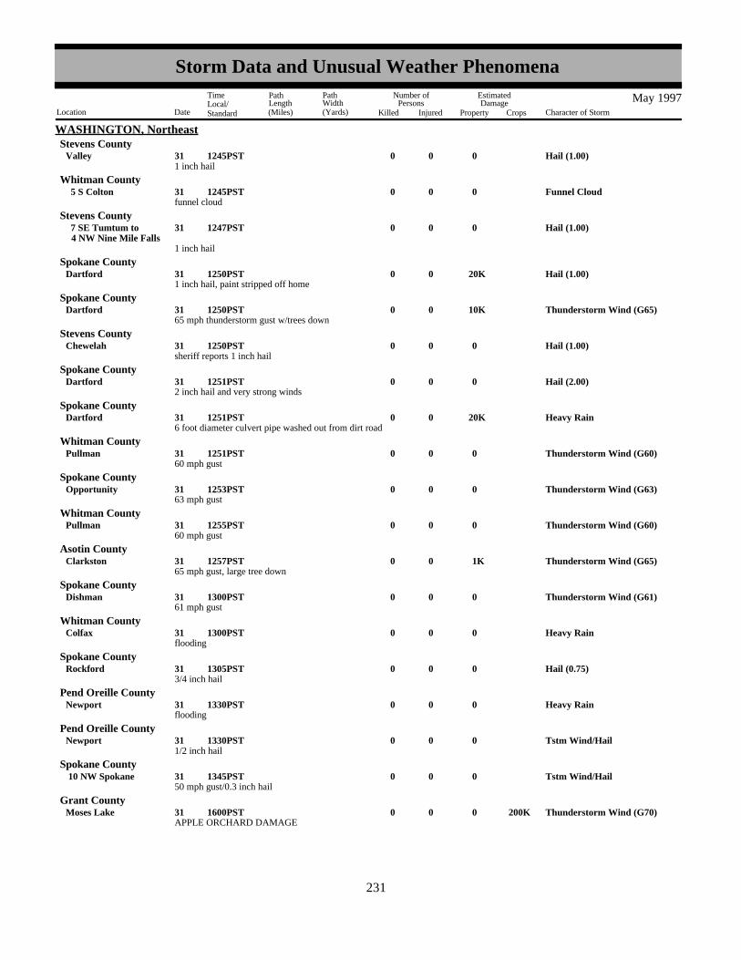
WASHINGTON, NortheastStevens County
1 inch hailHail (1.00)00031Valley 1245PST
funnel cloudFunnel Cloud00031 5 S Colton 1245PST
Whitman County
1 inch hail
Hail (1.00)00031 4 NW Nine Mile Falls 7 SE Tumtum to 1247PST
Stevens County
1 inch hail, paint stripped off homeHail (1.00) 20K0031Dartford 1250PST
Spokane County
65 mph thunderstorm gust w/trees downThunderstorm Wind (G65) 10K0031Dartford 1250PST
Spokane County
sheriff reports 1 inch hailHail (1.00)00031Chewelah 1250PST
Stevens County
2 inch hail and very strong windsHail (2.00)00031Dartford 1251PST
Spokane County
6 foot diameter culvert pipe washed out from dirt roadHeavy Rain 20K0031Dartford 1251PST
Spokane County
60 mph gustThunderstorm Wind (G60)00031Pullman 1251PST
Whitman County
63 mph gustThunderstorm Wind (G63)00031Opportunity 1253PST
Spokane County
60 mph gustThunderstorm Wind (G60)00031Pullman 1255PST
Whitman County
65 mph gust, large tree downThunderstorm Wind (G65) 1K0031Clarkston 1257PST
Asotin County
61 mph gustThunderstorm Wind (G61)00031Dishman 1300PST
Spokane County
floodingHeavy Rain00031Colfax 1300PST
Whitman County
3/4 inch hailHail (0.75)00031Rockford 1305PST
Spokane County
floodingHeavy Rain00031Newport 1330PST
Pend Oreille County
1/2 inch hailTstm Wind/Hail00031Newport 1330PST
Pend Oreille County
50 mph gust/0.3 inch hailTstm Wind/Hail00031 10 NW Spokane 1345PST
Spokane County
APPLE ORCHARD DAMAGEThunderstorm Wind (G70)00031Moses Lake 200K1600PST
Grant County
223231
Storm Data and Unusual Weather Phenomena
Location Date Character of Storm
TimeLocal/Standard
PathLength(Miles)
PathWidth(Yards)
Number ofPersons
Killed Injured
EstimatedDamage
Property Crops
May 1997

WASHINGTON, NorthwestWAZ035 Northeast Mountains
Lake Pend Oreille was nearly a foot above flood stage and in turn flooded the river. In Dalkena about 30 homes had water in themand in Tiger about 50 residents were cut off from their homes.
Flood002124
0000PST2359PST
Heavy, slow moving showers dropped between one and two inches of rain in a 5 hour period around Camano Island. Gardenswere washed out and there was flooding of garages and basements.
Urban/Sml Stream Fld 5K0031Stanwood 0600PST1100PST
Snohomish County
A weak tornado touched down in a south Tacoma neighborhood just east of I-5. A church suffered roof and beam damage andseveral trees were pushed over or snapped off. There were also some downed fences.
Tornado (F1) 150K0 .1 0.5 031Tacoma 1415PST1419PST
Pierce County
A funnel cloud was detected on radar and observed by a spotter northeast of Lake Stevens. Showers and thunderstorms dropped arecord 1.41 inches of rain at Seatac airport for 24 hours on this day.
Funnel Cloud0031Lake Stevens 1700PST1710PST
Snohomish County
High water from spring snow melt caused minor flooding along the Naches and Yakima rivers as well as area creeks. River sideparks...golf courses and road were closed. Sandbags were used to keep water flowing down streets out of yards. Somebasements...farm outbuildings and pasturelands were flooded.
Flood001119
1100PST1100PST
WASHINGTON, SoutheastWAZ025 East Slopes Southern Cascades
A weak tornado briefly touched down in the Walnut Grove area of Vancouver, near I-205 and 4th Plain. A car was damaged, theroofing of a house was damaged, and a small shed was blown over.
Tornado (F0) 10K0 20 0.5 031Vancouver 1645PST1647PST
WASHINGTON, SouthwestClark County
NONE REPORTED.
WEST VIRGINIA, East
Thunderstorm winds tore a roof off of a trailer near King's Creek and several large trees were downed.
Thunderstorm Wind 8K0003 1 N Weirton 1415EST1420EST
WEST VIRGINIA, NorthHancock County
Hail (0.75)0003Wheeling 1449ESTOhio County
A roof was torn off of a house by strong thunderstorm winds. Trees and power lines were also downed nearby and throughout thecounty.
Thunderstorm Wind 25K0003Moundsville 1452ESTMarshall County
Some trees and a couple of utility poles and lines were downed throughout the county by thunderstorm winds.Thunderstorm Wind 5K0003Wheeling 1526EST
Ohio County
Trees were downed by thunderstorm winds.Thunderstorm Wind 2K0018Lynn Camp 1605EST
Marshall County
Thunderstorm microburst winds, estimated between 100 and 120 mph, caused extensive damage near Weirton.
The greatest damage occurred at a slag plant near the Fort Steubenville Bridge. Two buildings were substantially damaged. A twostory metal building was blown in on one side and collapsed. The other, a block building, had the roof blown off and severalwindows were blown out. Sections of two large conveyor belts were destroyed. Two automobiles were damaged by flying debris.
Thunderstorm Wind (G105) 250K0018 2 S Weirton 1850EST1855EST
Brooke County
224232
Storm Data and Unusual Weather Phenomena
Location Date Character of Storm
TimeLocal/Standard
PathLength(Miles)
PathWidth(Yards)
Number ofPersons
Killed Injured
EstimatedDamage
Property Crops
May 1997

WEST VIRGINIA, North
Damage also occurred at a nearby sewage treatment plant. A two story block building had a crack along the second row of blockson the second floor. A roof from a small metal building was blown off. Trees were damaged.
Also during the storm, six barges along the Ohio River broke loose from their moorings just upstream of the damaged buildings.Some of the barges reportedly hit the bridge and the bridge was closed for several hours.
Several large trees were downed by thunderstorm winds. Thunderstorm Wind 4K0018 1 S Weirton 1850EST
Brooke County
Thunderstorm winds destroyed a greenhouse.Thunderstorm Wind 3K0019Elm Grove 1710EST
Ohio County
Trees were downed and windows blown out by thunderstorm winds.Thunderstorm Wind 5K0019Wheeling 1714EST
Ohio County
Thunderstorm winds downed trees and blew out windows.Thunderstorm Wind 5K0019Wheeling 1714EST
Ohio County
Thunderstorm winds fell a tree onto a house and caused damage to the roof.Thunderstorm Wind 3K0019 1 N Wheeling 1719EST
Ohio County
A tree and some branches were downed by thunderstorm winds.Thunderstorm Wind 1K0019 5 E Kingwood 1915EST
Preston County
Heavy thunderstorm rains led to flash flooding. Route 2 was closed due to flood waters and a mudslide.
Flash Flood0019Mc Mechen 1920EST1940EST
Marshall County
Creek flooding was reported along Elm Run and Waddles Run.
Flash Flood0019 1 NE Wheeling 1930EST2000EST
Ohio County
Flooding was reported along Buffalo Creek which was out of its banks along Route 67. Some basements were also flooded.Flash Flood 10K0025Weirton 1228EST
Brooke County
Small streams and a few basements were flooded.Flash Flood 4K0025Elm Grove 1750EST
Ohio County
NONE REPORTED.
WEST VIRGINIA, Southeast
Prolong Cold000131
0100EST2300EST
WEST VIRGINIA, WestWVZ024>026-032>034 Mingo - Logan - Boone - Taylor - Mcdowell - Wyoming
High Wind (G50)0003 1216ESTWVZ009 Wood
A wind gust of 58 mph was recorded at the Parkersburg airport.
Snow000304
2300EST0900EST
WVZ046 Pocahontas
Snow fell across elevations above 3000 feet to the depth of 1 to 2 inches. This included the Cranberry Glades and Snowshoe.Temperatures were in the upper 20s and lower 30s.
Cold And Frost 0007 0600EST
WVZ008>011-016>020-027>032-035>037-039-046>047
Jackson - Wood - Pleasants - Tyler - Roane - Wirt - Calhoun - Ritchie - Doddridge - Clay - Braxton - Gilmer- Lewis - Harrison - Taylor - Raleigh - Fayette - Nicholas - Upshur - Pocahontas - Randolph
Temperatures in the low to mid 30s, along with frost, were widespread across central counties of West Virginia. The coldest was27 degrees from Glady of Randolph County. Beckley and Sandyville of Jackson County were 32 degrees, while Belington had 33degrees.
225233
Storm Data and Unusual Weather Phenomena
Location Date Character of Storm
TimeLocal/Standard
PathLength(Miles)
PathWidth(Yards)
Number ofPersons
Killed Injured
EstimatedDamage
Property Crops
May 1997

WEST VIRGINIA, WestWVZ046 Pocahontas
Snow0010 0800EST1700EST
One to 4 inches of snow fell during this Saturday above 4000 feet between Snowshoe and the Cranberry Glades. This includedBlack Mountain and a portion of the scenic highway.
Cold And Frost0011 0600EST
WVZ024>026-032>034-036-038
Mingo - Logan - Boone - Taylor - Mcdowell - Wyoming - Fayette - Webster
Hail (0.75)0014Lavalette 1810ESTWayne County
Hail (1.00)0014Wayne 1825ESTWayne County
Hail (0.75)0014 3 S Melissa 1825ESTCabell County
Hail (0.88)0014Branchland 1830ESTLincoln County
Hail (0.75)0014Ft Gay 1855ESTWayne County
Thunderstorm Wind 3K0018 1 SE Maxwell 1500ESTPleasants County
Numerous trees were blown down in a gust estimated at 70 to 80 mph. A fallen tree damaged one mobile home.
Thunderstorm Wind0018Shawnee 1500ESTPleasants County
Fallen trees blocked roads in the vicinity.
Thunderstorm Wind0018Hebron 1500ESTPleasants County
Three oak trees were knocked down.
Thunderstorm Wind (G70) 8K0018Parkersburg Arpt 1504ESTWood County
A localized downburst hit the airport. The tower was briefly evacuated as the personnel thought the windows were going to beblown in. The anemometer indicated an 81 mph gust. Fourteen vehicles parked at the airport had windows broken. The weatherobserver said, "we thought we were having hail, but it wasn't hail. It was busted glass flying around." Large sliding hangar doorswere bowed or taken off their tracks. No damage occurred to aircraft.
Cold0022 0600EST
WVZ035>036-038>039-046>047
Raleigh - Fayette - Webster - Upshur - Pocahontas - Randolph
Temperatures were in the upper 20s and lower 30s. Elkins had 29 degrees, Beckley recorded 33 degrees. Both were records forthe date.
Cold And Frost0023 0600EST
WVZ008>011-016>020-028>031-038>040-046>047
Jackson - Wood - Pleasants - Tyler - Roane - Wirt - Calhoun - Ritchie - Doddridge - Braxton - Gilmer -Lewis - Harrison - Webster - Upshur - Barbour - Pocahontas - Randolph
Sunrise temperatures were in the 30s. The 35 degrees at Parkersburg and the 30 degrees at Elkins were records for the date. The30 degrees at Elkins was also the coldest in the lower 48 states for this particular morning. Scattered frost was noted in rural andmountainous areas.
Flash Flood 5K0025East View 2055EST2200EST
Harrison County
Rain rates of around a half inch per hour, and totals of 1.5 to 2 inches lead to minor flooding of small streams. Roads wereflooded. No evacuations were required.
NONE REPORTED.
WISCONSIN, Extreme Southwest
Lightning 10K0011Wausaukee 1030CST
WISCONSIN, NortheastMarinette County
A Wausaukee home was damaged when lightning struck a tree, which then sent fragments 150 feet into the home. A three footlong by six inch wide fragment landed in a bedroom,badly damaging it. Electrical sockets in the home blew out from the wall.
226234
Storm Data and Unusual Weather Phenomena
Location Date Character of Storm
TimeLocal/Standard
PathLength(Miles)
PathWidth(Yards)
Number ofPersons
Killed Injured
EstimatedDamage
Property Crops
May 1997

WISCONSIN, NorthwestWIZ002>004 Bayfield - Ashland - Iron
Heavy Snow001112
2100CST1300CST
Strong northwest winds produced heavy lake effect snow across northern portions of Bayfield, Ashland, and Iron Counties. Anobserver 6 miles north of the community of Bayfield reported 8.4 inches. Gurney received 6.5 and Hurley 6.0 inches.
Hail (0.75)0005Eagle 1240CST
WISCONSIN, SoutheastWaukesha County
Hail (1.75)0005 2 NW Sturtevant 1315CSTRacine County
High Wind 29K0005 1805CST1900CST
WIZ058>060-065>066 Dodge - Washington - Ozaukee - Waukesha - Milwaukee
Strong gradient winds raked parts of southeast Wisconsin. Peak gusts were in the 60-70 mph range. Trees were blown down inHartland (Waukesha), a construction trailer was blown over in eastern Dodge county, and trees were toppled in Richfield(Washington), pulling down a power pole and power lines. Uprooted trees were reported in BayView (Milwaukee), with one treefalling on and damaging two cars. Also in Milwaukee county, the high winds ripped off a sign from a business building inFranklin. In Ozaukee county, power lines were downed.
Lightning struck and killed 13 milk cowsLightning 17K0018 4 N Belmont 0930CST
Lafayette County
Hail (0.88)0018 1 W New Digging 1640CSTLafayette County
Hail (0.75)0018Genoa City 1810CSTWalworth County
Extreme Cold0020 0600CSTWIZ063 Dane
Madison (Dane co) reported a new record low temperature of 30 degrees, replacing the old rcord of 32. Scattered frost was notedin the areas around Madison.
Hail (0.75)0018Hazel Green 1625CST
WISCONSIN, SouthwestGrant County
Hail (0.75)0018Fairplay 1716CSTGrant County
Hail (0.75)0018Kieler 1758CSTGrant County
NONE REPORTED.
WISCONSIN, West
Flash flooding near and on Muddy Creek and Dry Cottonwood Creek northeast of Pavillion. Estimated 2 to 3 inches of rain in lessthan 2 hours. Damage to gravel road in several areas between Muddy and Dry Cottonwood Creeks.
Flash Flood002223
Pavillion 2200MST0015MST
WYOMING, Central and WestFremont County
Thunderstorm Wind (G57)0031Cody 1856MSTPark County
Thunderstorm gust to 65 mph reported 16 miles southwest of Cody.
NONE REPORTED.
WYOMING, Extreme Southwest
NONE REPORTED.
WYOMING, North Central
HAIL FELL AT JACOB'S RANCH MINE
Hail (0.75)0024 15 E Wright 1458MST1502MST
WYOMING, NortheastCampbell County
227235
Storm Data and Unusual Weather Phenomena
Location Date Character of Storm
TimeLocal/Standard
PathLength(Miles)
PathWidth(Yards)
Number ofPersons
Killed Injured
EstimatedDamage
Property Crops
May 1997

WYOMING, NortheastWYOMING, SoutheastPlatte County
3/4 inch hail was reported 3 miles northeast of Wheatland.
Hail (0.75)00024 3 NE Wheatland 01220MST1225MST
Hail an inch and three quarters in diameter was reported 6 miles southwest of Lingle.
Hail (1.75)00024 6 SW Lingle 01425MST1433MST
Goshen County
Several funnel clouds were spotted with the storm that produced golfball sized hail south-southwest of Lingle.
Funnel Cloud0024 7 S Lingle 1430MST1435MST
Goshen County
Hail three quarters of an inch in diameter fell one mile south of Albin, badly damaging 10 to 12 sections of cropland.
Hail (0.75)00024 1 S Albin 24K1525MST1530MST
Laramie County
Heavy rainfall totalling more than 3 inches fell from southwest of Yoder to around Torrington. Four feet of water was reportedover state highway 156 2 miles south of Torrington at 515 pm MST. The flooding continued throug the evening along highways156, 154 and 161 in the Torrington, Veteran and Yoder areas, where water continued to cover highway 161 at 827 pm MST. Thewater subsided by 930 pm MST.
Flash Flood 30K0024 2 SE Torrington 2 SW Yoder to 30K1715MST
2130MST
Goshen County
228236
Storm Data and Unusual Weather Phenomena
Location Date Character of Storm
TimeLocal/Standard
PathLength(Miles)
PathWidth(Yards)
Number ofPersons
Killed Injured
EstimatedDamage
Property Crops
May 1997

STORM DAMAGE CATEGORIES REFERENCE NOTES
1 Less than $50 0 / Blank None reported.2 $50 to $500 * Miles instead of yards.3 $500 to $5,000 ** Yards instead of miles.4 $5,000 to $50,000 @ Includes heavy sleet storm.5 $50,000 to $500,000 # Freezing drizzle and freezing6 $500,000 to $5 Million rain, commonly known as glaze.7 $5 Million to $50 Million = Report incomplete.8 $50 Million to $500 Million = = Report not received.9 $500 Million to $5 Billion o/c Indicates Crop Damage amount
is included in the value give forproperty damage.
When reports are not received or are incomplete, the Storm Summary National Deathand Injury totals may also be incomplete.
Definition of Fujita Tornado Scale ( F Scale )
(F0) Gale tornado (40-72 mph) : Light damage;Some damage to chimneys; break branches offtrees; push over shallow-rooted trees; signs andbillboards damaged.
(F1) Moderate tornado (73-112 mph): Moderatedamage; The lower limit (73 mph) is the beginningof hurricane wind speed; peel surface off roofs;mobile homes pushed off foundations or overturned;moving autos pushed off the roads.
(F2) Significant tornado (113-157 mph): Considerabledamage; Roofs torn from frame houses; mobilehomes demolished; boxcars pushed over; large treessnapped or uprooted; light-object missiles generated.
(F3) Severe tornado (158-206 mph): Severe damage;Roofs and some walls torn from well-constructedhouses; trains overturned; most trees in forestuprooted; heavy cars lifted off ground and thrown.
(F4) Devastating tornado (207-260 mph): Devastatingdamage; Well-constructed houses leveled; structure with weak foundations blown off some distance; carsthrown and large missiles generated.
(F5) Incredible tornado (261-318 mph): Incredibledamage; Strong frame houses lifted from foundationand carried considerable distance to disintegrate;automobile-sized missiles fly through the air in excessof 100 meters; trees debarked; incredible phenomenawill occur.
(F6-F12) (319 mph to Mach 1, the speed of sound):The maximum wind speeds of tornadoes are not expected to reach the F6 wind speeds.
(F0+F1) Weak Tornado(F2+F3) Strong Tornado(F4+F5) Violent Tornado
From J. Atmos. Sci., August 1981, p. 1517-1519


Inquiries/Comments Call: (704) 271-4800 (Voice)(704) 271-4010 (TDD)
(704) 271-4876 (Fax)
National Climatic Data CenterRoom 120151 Patton AvenueAsheville, NC 28801-5001
OFFICIAL BUSINESSPENALTY FOR PRIVATE USE $300ADDRESS CORRECTION REQUESTED
BULK RATEPOSTAGE & FEES PAID
United States Department of CommerceNOAA Permit No. G - 19
BOUND PRINTED MATTER
To change your address, please return a copy of the mailing label with your newaddress to: National Climatic Data Center (Subscription Services).