may 1998 to the mayor, members of the city council, and
TRANSCRIPT

May 1998
To the Mayor, Members of the City Council, and the Citizens of Kansas City,
As Co-Chairs of the Northland Work Team and on behalf of the NorthlandCommunity Advisory Team and others who have participated in this planningprocess, we are happy to submit the FOCUS Kansas City Northland Plan.This plan is one of seven components that make up the FOCUS Plan adoptedby the City Council in October of 1997.
The Northland Plan is designed to set a positive direction for the future ofKansas City north of the Missouri River. The plan targets investmentstrategies to maintain our existing neighborhoods, and encourage developmentwhere public infrastructure, such as water, sewer and streets, already exist.Protecting the natural environment and current character of the Northland arefundamental to the plan. Specific transportation improvements arerecommended to improve east-west traffic, extend the boulevard system northof the river, and create pedestrian and bicycle-friendly throughways.
Kansas City as one community – joined rather than separated by the MissouriRiver – is a fundamental aspiration of the Northland Plan. Towards this end,the plan advocates improved physical and human linkages between theNorthland and the rest of Kansas City to strengthen both areas and contributeto building a connected city for the 21st Century.
Much work must be done to implement the FOCUS Plan and the NorthlandPlan. Through a creative implementation strategy that leverages public andprivate sector resources and draws upon the energies and talents of all KansasCitians, we can build a pathway to a future in which the Northland realizes itsfull potential as a unique yet integral part of Kansas City.
Thank you for this opportunity to help shape the Northland and Kansas City’sfuture.
Very best wishes,
Stuart Hunt Linda WardCo-Chair Co-Chair

Table of Contents
Table of ContentsIntroduction to FOCUS .......................................................................... i
A. Focus Kansas City .................................................................. iB. Relationship to Building Blocks ......................................... viiC. Relationship to Other Component Plans ............................ ix
Northland Executive Summary ............................................................ 1Four Framing Themes .................................................................... 3Plan Recommendations .................................................................. 4Implementation Priorities ............................................................ 13
Chapter One:Building on Our Strengths -The Northland Today ........................... 23
A. The Role of the Northland in the Kansas City Region ...... 24B. Land Use and Development ................................................ 29C. Transportation and Infrastructure ..................................... 36D. Neighborhoods and Community Identity ........................... 41
Chapter Two:Aspirations .......................................................................................... 43
A. Aspirations ........................................................................... 43B. Initiatives and Actions ........................................................ 46
Chapter Three:Applications ......................................................................................... 65
A. Future Urban Form............................................................. 67B. Urban Structure .................................................................. 74C. Physical Pattern .................................................................. 90D. Development Standards ...................................................... 99
AppendicesA. Preliminary Transportation Improvement
Prioritization System ........................................................ A-1B. Glossary of Terms .............................................................. B-1C. Bibliography ...................................................................... C-1
Acknowledgements

NORTHLAND PLAN
����������
Following PageMap 1. Stream Corridors, Parks, and Greenways ........................... 6Map 2. Archaeological Resource Sensitivity
Areas in the Northland ....................................................... 24Map 3. Dual Role of the Northland ................................................. 26Map 4. Interjurisdictional Context ................................................. 28Map 5. Disjointed Arterial Network ............................................... 36Map 6. Vacant Ground Compared to Utilities ................................ 40Map 7. Old Briarcliff/Claymont Neighborhoods:
Lack of Pedestrian Connections ......................................... 42Map 8. Northland Urban Form ....................................................... 68Map 9. Stream Corridors, Parks, and Greenways ......................... 70Map 10. Potential Center Locations ................................................. 72Map 11. Missouri Department of Transportation
Priority Improvements ........................................................ 74Map 12. Northland Major Street Plan .............................................. 76Map 13. Northland Transit Plan ....................................................... 80Map 14. Northland Urban Design Concept ...................................... 88Map 15. Northland Planning Areas .................................................. 92
Photographs by Wallace Roberts & Todd, Kansas City Planning & DevelopmentDepartment, and Chuck Kneise.
All recommendations contained in the FOCUS Plan, and all of its parts, aresubject to legal review for compliance with law, including federal, state andlocal. If any of the recommendations conflict with law, the legal issues shall beresolved prior to implementation of the affected recommendation.

Introduction - i
Preface
Introduction to FOCUS
A. FOCUS KANSAS CITY
Kansas City, Missouri is facing the challenges of the 21st Century with anew set of tools, a new spirit of cooperation and a new commitment tofuture generations that our city will be a thriving, people-centered com-munity and a successful model for other American cities to follow in thefuture.
Thousands of Kansas City citizens have created this blueprint for ourcity’s future. Organized in teams to address critical issues, volunteersfrom all neighborhoods and walks-of-life donated their ideas and hardwork to FOCUS Kansas City. This important project is a unique part-nership between the City of Kansas City, Missouri and its citizens todevelop an action plan that our entire community can support as weenter the 21st Century.
FOCUS - Forging Our Comprehensive Urban Strategy - is Kansas City’s“to do” list for the next 25 years. It sets priorities and guides decisionsabout neighborhoods, jobs, taxes, capital improvements, public safety,education, downtown and much more. Millions of dollars are investedevery year by both the private and public sectors to make our commu-nity work. FOCUS helps us target those investments to work smarterwith the money we have. We are taking steps now to make sure KansasCity is not only a viable city in the year 2000 but also a successful modelof a new kind of American city.

Introduction - ii
NORTHLAND PLAN
The FOCUS Plan began in 1992 with 1,000 volunteers contributing over20,000 hours to design a clear vision for Kansas City. The Mayor andCity Council, in partnership with the FOCUS Kansas City Steering Com-mittee of 24 civic leaders guided an innovative citizen-participation pro-cess that resulted in a new Policy Plan for the City of Kansas City, Mis-souri. Adopted by the City Council in 1994, the FOCUS Policy Planoutlines a vision statement and 14 Principles for Policy.
FOCUS Vision StatementThe following statement is what Kansas City aspires to become in thefuture. It says that people are the priority in Kansas City and thattaking care of people will result in improvements in all areas of our city.The vision emerged as a powerful statement of inspiration from the citi-zen involvement process.
We, as Kansas Citians, envision our city as a people-centered com-munity. From economic development to the readability of streetsigns, we consider people first. Kansas City shapes and guaran-tees its future by examining first and foremost the impact of ev-ery decision on future generations.
We, as Kansas Citians, are full of hope. We demonstrate this hopethrough our investment in our families, our homes, our neigh-borhoods, our schools, our businesses and our city.
FOCUS Principles for PolicyThe following principles are the fourteen major themes and statementsof philosophy that are essential for the City to achieve its vision. Theseare the foundation of our City’s character. All City actions are measuredagainst these fourteen principles. They were derived from the wealth ofcitizen ideas generated in the Phase I Perspective Group process.
Reaffirm and Revitalize the Urban CoreCentral to the city’s vitality is the Urban Core, with its di-verse population, historic neighborhoods; cultural, recre-ational, and sports attractions; central business corridor, andits revival as a pleasant and sought-after place to live, work,do business and learn.
Advance and Encourage Quality Suburban Develop-mentThe health of our city depends on recognizing the interdepen-

Introduction - iii
Preface
dency of the city’s suburban areas and the Urban Core. Eachmust be healthy for the city to attract development and grow.Quality suburban development enables the city to competefor residents and jobs and is an important part of the city’sability to grow in the future.
Plan for a Well Designed City FrameworkThe design and maintenance of the city’s transportation andinfrastructure systems create a framework for sustainable de-velopment. Excellent planning systems create a frameworkfor sustainable development. Excellent planning and urbandesign create a unique city that is physically unified and beau-tiful.
Strengthen NeighborhoodsWell planned neighborhoods create identifiable communitiesin which to attain a sense of belonging, forge common goalsand work together.
Ensure Environmental StewardshipNatural resources and energy are valuable assets we shoulduse judiciously and manage wisely for the benefit of presentand future generations.
Create a Secure CityPersonal comfort, safety, security and peace of mind are es-sential to residents and businesses in a livable city.
Respect DiversitySocial, gender, cultural, ethnic, racial, economic and religiousdiversity bring richness to the city.
Advance Education, Culture and the ArtsLearning is fundamental to citizenship, self enrichment andemployment. A strong, vibrant cultural and arts environmenttakes citizens beyond everyday concerns, adds to their qual-ity of life and supports the city’s economic base.
Develop Jobs for the FutureThe far-reaching effects of technological change and a newglobal economy challenge Kansas City to identify its competi-tive role and provide employment opportunities for its citi-zens.
Create OpportunityCommunity and individual self esteem and growth flourishin the presence of equitable opportunities and resources.
Introduction - iv
NORTHLAND PLAN
Create a Better Future for Our Young PeoplePositive environments and attitudes that recognize and en-courage children to be productive and enable them to behealthy will prepare our youth for tomorrow’s world.
Target Financial Investments StrategicallyThe City must have a sustainable tax base and must helptarget financial investments where they will be most effec-tive and where they will achieve the city’s vision.
Build Government through a Strong Partnership withCitizensResponsive and creative governance connects and stimulatescooperation between government, citizens, and business andcommunity organizations.
Build Metropolitan Leadership and Regional Coopera-tionThe City of Kansas City is at the center of a metropolitancommunity where the challenges of building on the region’sstrengths and addressing its problems demand a collectiveresponse.
FOCUS Phase II - The Strategic and Comprehensive PlanBased upon the Phase I Policy Plan, work began in 1995 on the strategicand comprehensive plan. Utilizing the key concepts of balance, linkageand partnership, seven distinct, but interwoven component plans weredeveloped to detail the action steps needed to make the FOCUS visionand policy principles a reality.
An expanded Steering Committee, with the help of seven Work Teamsmade up of over 350 people and additional Community Advisory Teamsdeveloped the seven component FOCUS plans. They are outlined below:
The Citywide Physical Framework Plan provides strate-gic land use planning guidelines, addresses the future char-acter of growth, development and redevelopment as well ascapital needs of the City.
The Neighborhood Prototypes Plan recommends specificactions to improve Kansas City neighborhoods and encour-age resident partnerships in determining their future and de-livery of city services. A unique neighborhood assessment pro-cess helps citizens target city services and specific strategies
Introduction - v
Preface
to their distinct requirements.
The Preservation Plan highlights the importance of KansasCity’s rich legacy of landmark structures, historic neighbor-hoods, and archeological resources that make our city a spe-cial place. Strategies on transportation, urban design, capi-tal improvements, and tourism complete our vision of the fu-ture from a preservation perspective.
The Urban Core Plan includes inventive strategies for centralcity neighborhoods, downtown, the Central Business Corri-dor, and plans for economic development, jobs, capital improve-ments, public transit and neighborhood livability. Strategiesfor the location of cultural facilities, marketing the urban core,revitalizing and sustaining neighborhoods are outlined in thisplan.
The Northland Plan targets investment strategies to maintainour existing neighborhoods, and encourages developmentwhere public facilities (water, sewer, streets) already exist.Protecting the natural environment and current character ofthe Northland are fundamental to the plan. Specific trans-portation improvements are recommended to improve east-west traffic, extend the boulevard system north of the river,and create pedestrian and bicycle friendly throughways.
The Human Investment Plan outlines recommendations re-lated to life long education, retaining and encouraging diver-sity, equipping citizens for the changing work environment,job retention and expansion strategies, programming forstimulating interest in culture and the arts as well as practi-cal life skills for Kansas City’s youth, and enhancing KansasCity as a place of excellence, creativity, celebration and unity.
The Governance Plan sets out specific strategies for improv-ing city services, establishing and maintaining the financialhealth of the city, strengthening metropolitan cooperation andpolitical and organizational restructuring to insure implemen-tation of the FOCUS initiatives.
As the seven Work Teams refined their ideas, they consistently workedtogether toward bold solutions and overlapping, leveraged opportuni-ties. The result is a very interconnected plan that provides a new deci-sion-making framework for complex issues enabling all parts of the cityto work in concert toward the same goals.
Introduction - vi
NORTHLAND PLAN
Interwoven throughout the seven action plans are 12 key strategies called“Building Blocks." With these strategies, we will implement the FO-CUS Plan through programs and projects that will make Kansas City asuccessful model for a new American City. The specific initiative andaction steps outlined in each of the seven FOCUS Plan components re-lates to these Building Blocks. A more detailed description of the Build-ing Blocks can be found in the FOCUS Plan.
Making Connections For The 21st CenturyThe qualities in our heritage that have made us a great city will alsohelp us move into the 21st Century as the New American City. Kan-sas City has always had the willingness to take the bold step-from theconstruction of the Hannibal Bridge in 1869, that guaranteed us pre-eminence as the gateway to the west; to the 1960s vote on the publicaccommodations ordinance that guaranteed all Kansas Citians accessto public places regardless of race; to the passage of the Bi-State Cul-tural Tax in the 1990s. We have a history of innovation that will help usas we face our future challenges.
Current trends tell us that the American city of the 21st Century will bean eclectic place with a diverse population, a diverse economic base, andan array of lifestyle and job choices. Kansas City can uniquely positionitself to become a model for this new kind of city because we do not expe-rience the extreme problems of larger cities. It is our Midwestern sensi-bility and civility that will provide a foundation for the necessary movebeyond our agrarian and manufacturing roots into a new era of informa-tion technology and a global economy. To thrive, Kansas City must un-derstand its own strengths and begin to act as one connected city witha clear agenda for the future.FOCUS emphasizes connections - connecting people to places, people toeach other and our past to our future. If we can act as one connected citywith an optimistic vision, a unifying strategy and clear action steps, wecan build a city that works for people.
Kansas City has the natural, physical, and human resources necessaryfor success. We also recognize that failure occurs when our actions seekto divide, so we must continue to stress and improve our connections. Aconnected Kansas City favors solutions that, in their holistic and long-term emphasis, are also flexible and responsive to ever-changing tech-nology. This approach requires business, civic, educational, and social
Introduction - vii
Preface
orientations that embrace advancements in telecommunications and in-formation systems as ways of extending pathways into the future andmandates investments that keep Kansas City on the cutting edge of thesetechnologies and connected to the global economy.
As a prescription for unified success, the New American City is a newway of thinking and acting. The following pages represent KansasCitian’s commitment to our city, our children and our aspirations for thefuture.
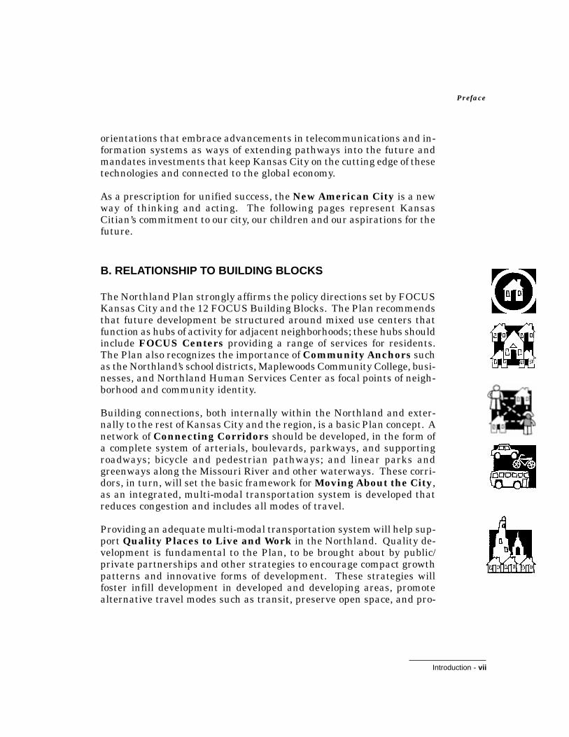
B. RELATIONSHIP TO BUILDING BLOCKS
The Northland Plan strongly affirms the policy directions set by FOCUSKansas City and the 12 FOCUS Building Blocks. The Plan recommendsthat future development be structured around mixed use centers thatfunction as hubs of activity for adjacent neighborhoods; these hubs shouldinclude FOCUS Centers providing a range of services for residents.The Plan also recognizes the importance of Community Anchors suchas the Northland’s school districts, Maplewoods Community College, busi-nesses, and Northland Human Services Center as focal points of neigh-borhood and community identity.
Building connections, both internally within the Northland and exter-nally to the rest of Kansas City and the region, is a basic Plan concept. Anetwork of Connecting Corridors should be developed, in the form ofa complete system of arterials, boulevards, parkways, and supportingroadways; bicycle and pedestrian pathways; and linear parks andgreenways along the Missouri River and other waterways. These corri-dors, in turn, will set the basic framework for Moving About the City,as an integrated, multi-modal transportation system is developed thatreduces congestion and includes all modes of travel.
Providing an adequate multi-modal transportation system will help sup-port Quality Places to Live and Work in the Northland. Quality de-velopment is fundamental to the Plan, to be brought about by public/private partnerships and other strategies to encourage compact growthpatterns and innovative forms of development. These strategies willfoster infill development in developed and developing areas, promotealternative travel modes such as transit, preserve open space, and pro-

Introduction - viii
NORTHLAND PLAN
mote a higher standard of quality in both public and private develop-ments.
Investing in Critical Resources - public safety, capital improvements,and the natural environment - is also key to ensuring the Northland’sfuture as a great place to live and work. Sensitive natural resourcesshould be preserved and integrated into the fabric of the Northland as itdevelops. The City’s capital investment policy should emphasize infra-structure improvements in developed and developing areas in order toserve existing residents and promote interconnected development. In-vestment in streets and other capital improvements should promote ex-cellence in the design of the public environment.
Neighborhood Livability is an important issue for the Northland.Public and private investment in infrastructure and housing is neededto maintain the health of some older neighborhoods in need of stabiliza-tion. Other neighborhoods in developing parts of the Northland havelesser physical improvement needs but would benefit from actions toenhance neighborhood identity. The Plan recommends that all Northlandneighborhoods be provided with the opportunity to take part in the neigh-borhood self-evaluation program, a grassroots process to define solutionsto local problems.
Citizen Access and Communication is inherent in such Plan recom-mendations as the need to enhance connections to the rest of KansasCity, enhance neighborhood and community identity, and improve thedevelopment process by more widely disseminating information on de-velopment proposals. Northland individuals and organizations shouldparticipate in City-wide programs to share information and resources,with the objective of building partnerships among neighborhoods.
As a home for workers who commute to the Urban Core and as an em-ployment center in its own right, the Northland has a strong role to playin ensuring that Kansas City has a Competitive Economy. The Planrecommends actions to support economic development in the Northland,improve mobility between the Northland and the Urban Core (includingreverse commuting), and strengthen the role of the KCI Airport as amulti-modal transportation center.
Implicit in the Plan’s endorsement of strong ties between the Northlandand the rest of Kansas City is support of cultural institutions locatedsouth of the Missouri River. The Plan also advocates an active City

Introduction - ix
Preface
Life in the Northland, including cultural opportunities and public ameni-ties such as public art and high quality landscapes and streetscapes.
Finally, the strategies described in the Healthy Community and Life-Long Learning Building Blocks are essential to Northland residentsachieving their full potential as contributing members of the Kansas Citycommunity. The Northland’s existing health and educational institu-tions provide a good foundation for implementing these strategies. Planrecommendations such as enhanced mobility for persons without accessto automobiles, improved citizen access to government, and worker train-ing and retraining programs will also contribute to meeting theNorthland’s health and education needs.
C. RELATIONSHIP TO OTHER COMPONENT PLANS
The Northland Plan is one of five components of the Physical Environ-ment Plan for Kansas City. The Physical Environment Plan is, in turn,one of the three major elements of the FOCUS Kansas City Phase IIPlan. Given its role within the overall FOCUS Kansas City planningeffort, the Northland Plan is designed to both stand on its own as a dis-crete action plan for Kansas City, MO north of the Missouri River and tocomplement the recommendations of the other Plan components. It ismost closely related to the City-Wide Physical Framework Plan,which sets the overall context within which future development of theNorthland will occur. The recommendations of these two plans havebeen closely coordinated.
The Neighborhood Prototypes Plan contains recommendations thatwill guide neighborhood planning and improvement activities in theNorthland. These recommendations include the “self-evaluation” pro-cess whereby individual neighborhoods will classify themselves as oneof four area types:
• Developing areas are characterized by expanses of undevel-oped land that are meeting strong market demand for newhousing.
• Conservation areas are established neighborhoods charac-terized by generally good physical conditions and healthy liv-ing environments.
• Stabilization areas are established neighborhoods that areexperiencing some declining trends ranging from mild to se-vere.
• Redevelopment areas are characterized by severe declinethat in most cases has resulted in loss of the original social

Introduction - x
NORTHLAND PLAN
and physical fabric, making them prime opportunities for re-investment.
These area types will provide the basis for development of strategies tomeet the needs of individual neighborhoods within the Northland.
The recommendations of the Preservation Plan regarding preserva-tion of Kansas City’s historic assets are also important to the future ofthe Northland. While it is generally believed that most historic resourcesare located south of the River, the Northland contains important his-toric neighborhoods and farmsteads and most of the City’s intact NativeAmerican archaeological sites.
In contrast to the City-Wide Physical Framework, Neighborhood Proto-type, and Preservation Plans, the Urban Core Plan addresses a spe-cific geographic area: the urban center of Kansas City, located south ofthe Missouri River. The Northland Plan recognizes the vital importanceof the Urban Core as the “heart of the City” and seeks to strengthenconnections between it and the Northland.
The non-physical components of FOCUS Kansas City - the Governanceand Human Investment Plans - are also critical to building the bestpossible future for the Northland. For example, realization of the aspi-rations for the Northland is dependent upon effective implementation ofGovernance Plan strategies regarding fiscal policies, incentives, services,and other issues related to City government, as well as the connectedcommunity-building strategies outlined for the entire City. The economicdevelopment strategies proposed in the Human Investment Plan are alsoessential to provide employment and expand the tax base.

Page - 1
Executive Summary
Kansas City’s Northland is a dynamic area ofgreat size, complexity, and diversity. Its 159square miles contain long-established neighbor-hoods, newer residential and commercial devel-opments, regional centers of employment and ac-tivity such as the Kansas City International(KCI) Airport and Metro North Mall, and vastexpanses of undeveloped land. Much of this landpossesses splendid natural beauty - rolling hillsand fields, wooded stream corridors, and tree-lined country roads. Although the scope of theNorthland Plan is technically limited to the partof Kansas City within Clay and Platte Counties,other communities such as Gladstone, Liberty,North Kansas City, Parkville, and Riverside arean essential part of the fabric and identity of theNorthland.
In recent years the rate of growth in theNorthland has accelerated with its emergence asthe “best kept secret” in the Kansas City region:closer to the downtown and with more affordablehousing than other suburban communities; of-fering good schools, open space, and other ameni-ties of suburban living. While the Plan recog-nizes growth as a positive force, there is a con-cern that the current pattern of public and pri-
The Northland'sdiverse landscape
Northland Executive Summary

Page - 2
NORTHLAND PLAN
vate development will, if continued, prevent the Northland from achiev-ing its full potential. In the worst case scenario, this pattern will resultin a future of congestion, deteriorated older neighborhoods, increasedcosts for public services and infrastructure, and a diminished naturaland visual environment.
An alternative future for the Northland is possible, one that can beachieved through proactive efforts by government and private citizens.In this future, the Northland is characterized by its:
• Close ties to the Urban Core and the Kansas City metropoli-tan region as a whole
• A compact development pattern, structured around vibrant,mixed use centers that provide focal points of activity for theNorthland’s neighborhoods
• An interconnected framework of parks, greenways, and openspaces that preserve the Northland’s special natural resourceswithin the fabric of development
• A multi-modal transportation system that supports publictransit, pedestrians, and bicyclists, as well as the automobile
• Diverse, healthy neighborhoods with a strong sense of com-munity, whose needs for basic infrastructure have been met.
The culmination of many months of effort by the Northland Work Team,the Northland Plan is designed to set a positive direction for KansasCity north of the Missouri River. Achieving the best possible future forthe Northland will require surmounting numerous challenges. Growthpatterns that reinforce existing development, minimize congestion, andpreserve the natural amenities that help make the area a great place tolive and work will need to be encouraged. Providing adequate infra-structure, particularly an interconnected system of roadways, parkways,and boulevards, is a continuing priority. Other important issues need tobe addressed as well: for example, enhancing connections to the rest ofKansas City, building stronger neighborhoods, improving the quality ofboth public and private development, and creating a friendly environ-ment for pedestrians and bicyclists.

Page - 3
Executive Summary
FOUR FRAMING THEMES
Early in the process of preparing the Plan, the Work Team articulatedfour “framing themes” that capture the major issues facing the Northland.These themes are:
• The Role of the Northland in the Kansas City Region• Land Use and Development• Transportation and
Infrastructure• Neighborhoods and
Community Develop-ment
The Role of the Northland inthe Kansas City Region
While the Northland is specialand has its own unique iden-tity, its future is closely linkedto the future of the rest of Kan-sas City. The Northland servesa dual role in the Kansas City re-gion, both as a home for residentswho commute to the Urban Coreand other parts of the metropoli-tan region, and as a center of em-ployment in its own right. Thisdual role should be strengthenedin the future.
Land Use and Development
The quality of life in the Northland largely depends on the pat-tern and quality of development that occurs in the future. Ap-proximately two-thirds of the Northland is still undeveloped - about 109square miles or 75 percent of vacant land in all of Kansas City, enough toaccommodate projected growth rates far into the future. However, therate of development has accelerated in recent years, with its most vis-ible effects in the burgeoning growth corridors of I-29, US-169, ShoalCreek Valley, and Barry Road. Growth should be encouraged in devel-oped and developing areas with existing infrastructure.
View of downtown Kansas City from the Northland

Page - 4
NORTHLAND PLAN
and multi-modal transportation are served.
Transportation and Infrastructure
The Northland has historically lacked the complete roadway andutility systems needed to fully support existing and new develop-ment. Older neighborhoods are in need of renewed investment in infra-structure. Although the freeway system is complete, the area’s topogra-phy of north-south ravines and ridges has hampered the development ofeast-west roadways. The need for cost-effective public facilities and ser-vices is increasing as the Northland grows. In particular, the Northlandneeds a mechanism to build, improve, and maintain arterial roadways,parkways, and boulevards.
Neighborhoods and Community Identity
The newer parts of the Northland lack the sense of local commu-nity identity typical of neighborhoods south of the River. This is inpart due to a fragmented pattern of development, which tends to isolatesubdivisions from each other and from community-serving uses such asschools, other public facilities, and shopping areas.
PLAN RECOMMENDATIONS
The four framing themes - the Northland’s role in Kansas City, land useand development, transportation and infrastructure, and neighborhoodsand community identity - were used by the Work Team as a frameworkfor developing recommendations for the future of the Northland. Theserecommendations are summarized below and described in more detailin Chapters III (Aspirations) and IV (Applications) of the full NorthlandPlan. The recommendations emphasize:
• Quality development that respects the natural environmentand is visually attractive
• Efficient infrastructure that supports existing neighbor-hoods and fosters cost-effective public facilities and services
• Social, economic, and physical diversity promoted by a vari-ety of housing types and prices, land uses, and developmentpatterns

Page - 5
Executive Summary
The Missouri River could become arecreational greenway helping tie
together Kansas City North and South.
• Community identity built upon neighborhood-based orga-nizations, institutions, and activity centers
• Connections between the Northland, Kansas City south ofthe River, and the region as a whole
• Multi-modal linkages for vehicles, bicyclists, and pedestri-ans between neighborhoods, activity centers, places of em-ployment, and community facilities
1. Affirming the Northland’s Role in the Kansas CityRegion
Enhance connections between Kansas City, North and SouthKansas City as one community - joined rather than separated by theMissouri River - is a fundamental aspiration of the Northland Plan. Tohelp turn this aspiration into reality, stronger connections should be es-tablished across the River. These connections include both physical link-ages (e.g., adequate multi-modal crossings of the River and extension ofthe parkway and boulevard system into the Northland) and enhancedcommunications and programs to bring together residents of Kansas City,North and South.
Implement the Northland’s share of the Metro Green systemThe Northland’s portion of the Kansas City Metropolitan Greenway Sys-tem (Metro Green), proposed by the 1991 Community Assistance TeamProject of the American Society of Landscape Architects, Prairie Gate-way Chapter, should be implemented through development of a systemof greenway trails, parkways, and boulevards (Map 1). This system willenhance internal connections within the Northlandand help link it to the larger region.
Develop a shared greenway along both sides ofthe Missouri RiverThe land bordering the Missouri River should berecognized as a major recreational opportunity, onethat can bring together residents of Kansas City,north and south, as well as other communities alongthe River. A master plan for riverfront greenwaysalong both sides of the River should be completedand implemented through the development of pathsystems, recreational facilities, and pedestrian/bi-

Page - 6
NORTHLAND PLAN
cycle connections across the River.
Promote development of the KCI Airport area and BirminghamBottoms as employment centers to complement Kansas City’s UrbanCoreMaintaining and supporting high quality job growth in the KCI Airportand Birmingham Bottoms areas is critical to creating a vital, strong,and healthy local and regional economy, as well as to expanding the em-ployment base of Kansas City. Also, the availability of high quality, well-paying jobs in these employment centers supports residential develop-ment in the Northland.
Provide a range of quality housing choices in the NorthlandThe Northland has a vital role to play in accommodating quality subur-ban development in Kansas City. The availability of quality housingshould be promoted at all levels, from larger lot, estate housing toaffordably priced homes. The Northland’s large tracts of undevelopedland provide a unique opportunity for an innovative new residential“product” - one that offers a mix of housing styles and price ranges withinindividual developments while conserving open space.
Coordinate with other Northland jurisdictions in implementingFOCUS Kansas City and the Northland PlanIncorporated Kansas City within Clay and Platte Counties is insepa-rable from the many other jurisdictions (Gladstone, Liberty, North Kan-sas City, Parkville, etc.) that are also part of a vital subregion within thegreater Kansas City metropolitan area. To implement the NorthlandPlan, Kansas City will need to work closely with the counties and othermunicipalities on initiatives and actions that span jurisdictional bound-aries, such as building a complete system of arterials and boulevards.
2. Land Use and Development: Shaping Quality Places toLive, Work, and Play
Encourage a more compact, interconnected development patternstructured around existing development and defined centersThe current growth pattern in the Northland is one of isolated residen-tial subdivisions and single-use commercial developments, resulting ina fragmented land use pattern that promotes congestion on major road-ways. Public investment policies and incentives should be used to en-courage infill in developed and developing areas, promote connections

N
Stream Corridors
Existing Parks
Proposed Parks
Existing /Committed Parkways
Existing Streets/Proposed Parkways
Proposed Parkways
Proposed Greenways (Metro Green)
Map 1.Stream Corridors, Parks,and Greenways
Source: Parks and Boulevard Plan, Metro Green
0 1/2 1 2 miles
Page - 7
Executive Summary
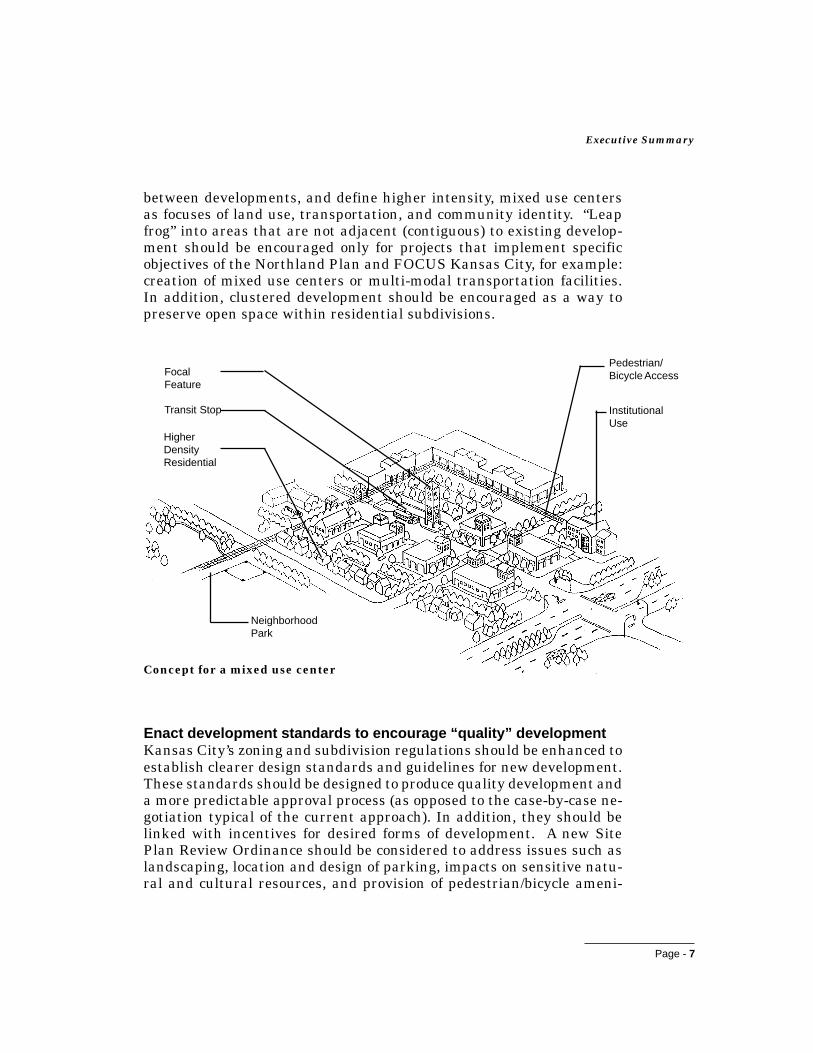
between developments, and define higher intensity, mixed use centersas focuses of land use, transportation, and community identity. “Leapfrog” into areas that are not adjacent (contiguous) to existing develop-ment should be encouraged only for projects that implement specificobjectives of the Northland Plan and FOCUS Kansas City, for example:creation of mixed use centers or multi-modal transportation facilities.In addition, clustered development should be encouraged as a way topreserve open space within residential subdivisions.
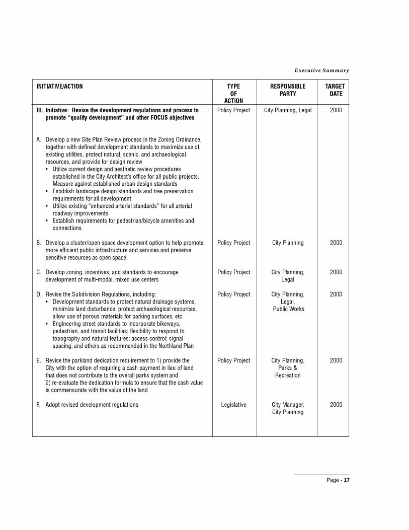
Enact development standards to encourage “quality” developmentKansas City’s zoning and subdivision regulations should be enhanced toestablish clearer design standards and guidelines for new development.These standards should be designed to produce quality development anda more predictable approval process (as opposed to the case-by-case ne-gotiation typical of the current approach). In addition, they should belinked with incentives for desired forms of development. A new SitePlan Review Ordinance should be considered to address issues such aslandscaping, location and design of parking, impacts on sensitive natu-ral and cultural resources, and provision of pedestrian/bicycle ameni-
NeighborhoodPark
InstitutionalUse
HigherDensityResidential
Transit Stop
Pedestrian/Bicycle Access
Concept for a mixed use center
FocalFeature

Page - 8
NORTHLAND PLAN
ties.
Improve the development review and approval process to: 1)enhance local awareness and input and 2) create a “user friendly”climate that promotes quality developmentTo achieve a higher standard of quality in Northland development, part-nerships will be needed between the City and the development commu-nity. Developers will need to be willing to test new ideas and implementinnovative forms of development, while the City will need to provideincentives, enhance customer service, and seek ways to facilitate devel-opment proposals that meet the objectives of FOCUS Kansas City andthe Northland Plan. At the same time, citizens should be more fullyinformed of development proposals in order to make the City and thedeveloper aware of the concerns of local residents.
Protect sensitive natural resources such as stream corridors,floodplains, woodlands, and steep slopesHighly valued by Northlanders, natural resources contribute greatly tothe character of the Northland and are critical to environmental func-tions such as flood control, water quality, and wildlife habitat. Theseresources should be fully inventoried to inform future decision-makingregarding land use, development, and preservation. Actions should betaken to ensure that natural resources are integrated into the fabric ofthe Northland as it develops, both at the macro scale (by maintaining aframework of greenway corridors and special viewsheds) and at the sitelevel (by improving zoning and subdivision standards and providing flex-ible development options to encourage preservation of sensitive resourceswithin individual developments).
Implement a comprehensive parks and open space system,structured around parks and recreational facilities; greenways; andenvironmentally sensitive resourcesEstablishment of an interconnected system of parks, greenways, andother open spaces, implemented through coordinated public and privateaction, will help provide an organizing framework for the future devel-opment of the Northland. The basic structure for such a system is set bythe Parks and Recreation Department’s 1993 Plan for Parks, Recreation,

Page - 9
Executive Summary
Boulevards, and Greenways and the 1991Metro Green study.
Implement an overall urban designconcept establishing aesthetic standardsfor public elements such as gateways,major roadways, signage, and publicfacilities and spacesA higher standard of quality in the design ofpublic facilities and spaces will both improvethe Northland’s physical environment and setan example for private development to follow.Within the context of a City-wide urban de-sign plan, an urban design concept should bedeveloped for the Northland as a focus for action to enhance the qualityof the public landscape. This concept should identify guidelines andactions for the physical improvement of gateway entrances to theNorthland, particularly the Airport entrance road and the “gateway tothe downtown” along the Broadway Extension to the Broadway Bridge;major roadway corridors such as Barry Road, Vivion Road, and M-152;public facilities and spaces, including landmarks as visual focal pointsand sources of community identity; and signage. In addition, scenic viewsof the downtown Kansas City skyline should be preserved where pos-sible and made available for the enjoyment of the public.
3. Building a Transportation and Infrastructure System thatWorks
Implement a complete vehicular movement system, with anemphasis on serving existing developed/developing areas in theNorthlandThe Northland generally has excellent freeways but lacks a completesystem of arterial roadways and collector streets. Major priorities in-clude development of: 1) a complete system of primary (four-lane) arte-rials, particularly to accommodate east-west movement; and 2) a sup-porting network of secondary (two-lane) arterials and collector streets,to facilitate local traffic and permit diversion of local trips from the free-ways and primary arterials. Because of limited funds, improvementsshould be targeted primarily to serve developed and developing ratherthan future development areas. Regulatory policies and incentives should
The Children'sFountain is one oftwo fountains that
are importantNorthland
landmarks.

Page - 10
NORTHLAND PLAN
be used to shape development patterns and control access in order topreserve the capacity of arterial roadways.
Implement the parkway and boulevard plan as part of the Northlandvehicular movement systemSouth of the Missouri River, the system of parkways and boulevards ispart of the basic framework for movement and contributes greatly to theCity’s character. Although a similar system has been planned for theNorthland for many years, only six of 125 miles of proposed parkwaysand boulevards have been implemented to date. The parkway and bou-levard system proposed for the Northland should be completed and linkedto the larger Kansas City network.
Provide choice through multi-modal transportation in the NorthlandA transportation system incorporating all modes of travel - pedestrian,bicycling, transit, air, train, and automobile - should be provided in theNorthland. The current transit system should be improved to increasemobility to jobs, health care, and meet other travel needs for residentswho do not drive. These improvements should address both regionaland collector bus service and the movement of people from their homesto the bus system. In addition, light rail should be extended north of theMissouri River as soon as possible. A dedicated transit corridor to theKCI Airport should be secured to accommodate light rail or other form oftechnology in the long term. Transportation and land use policies should
be coordinated to promote the devel-opment of higher density, mixed usecenters as focal points for transit ser-vice.
The Mid-America Regional Council’smajor bikeway plan, supplementedby a secondary system of bike facili-ties along parkways, boulevards,and local streets, should be imple-mented to provide an effectivebikeway system in the Northland.Street standards should be updatedto safely accommodate bicyclists andpedestrians as new roads are con-structed. Sidewalks and pedestrian
6" Curb& Gutter
6" Painted Stripe
5'-0"Sidewalk
Standards for roadway withbicycle lane and sidewalk
6'-0"Planting
Area
5'-0"BicycleLane
Roadway

Page - 11
Executive Summary
paths should be provided as connections from homes and neighborhoodsto transit stops, schools, shopping areas, and other destinations.
Establish land use policies, regulations, and incentives thatencourage compact development patterns and higher densitycenters accommodating alternative travel modes in order to reducedependence on private vehiclesBy promoting centralized destinations and providing travel choices, theCity can empower citizens to select alternative modes that conserve en-ergy and reduce air pollution from private vehicles reliant on fossil fuel.Well designed centers with travel options allow citizens to make reason-able tradeoffs between the convenience of different travel modes andtheir costs in terms of time and money. Policies and incentives thatreduce vehicular traffic will help maximize the efficiency of public in-vestment in a more complete arterial street system to serve vehicles,pedestrians, and bicycles. Policies that would positively affect the re-duction of vehicular traffic include:
• Encouraging compact development patterns and mixed usecenters
• Providing convenient public transit facilities• Requiring pedestrian and bicycle friendly design with special
attention to safety• Constructing roadways that accommodate alternative modes
and shorter travel distances through infill or logical exten-sions of existing development
Concentrate utility capital investments in areas that are currently oreasily served by existing utilitiesUpgrading of utility systems serving existing development that haveinadequate capacity or are not in compliance with codes is to be the firstpriority. The priority for provision of new infrastructure capacity shouldbe areas of infill development or areas adjacent to existing development.The goal should be to provide utilities concurrent with contiguous newdevelopment. Investment of City funds should be avoided where devel-opment is remote from existing capacity, unless there is significant de-veloper financing or significant public benefit.
Plan and construct infrastructure projects to harmonize with naturalsystemsRoadways, stormwater management facilities, and other infrastructuresystems should be planned to respect topography and other natural re-sources in the Northland. A system of greenways, including the flood-plains of the Missouri River and other significant waterways, should be

Page - 12
NORTHLAND PLAN
preserved for their role in flood control and maintenance of environmen-tal quality.
Broaden and enhance stormwater managementA comprehensive strategy for managing stormwater generated by devel-opment in the Northland should be implemented. This strategy shouldencourage environmentally sound management practices, based uponplanning for the major drainage basins in the Northland.
4. Enhancing Neighborhood and Community Identity
Promote neighborhood identity in the NorthlandWith some exceptions, particularly in the older First Annexation area,the Northland lacks the strong sense of neighborhood identity typical ofKansas City south of the River. Actions should be taken to strengthenNorthland neighborhoods, through targeted physical improvements, bysupporting neighborhood-serving institutions, and by encouraginggrassroots efforts to address neighborhood issues.
Develop public-serving facilities such as schools, parks, andlibraries as centers of community activityPublic-serving facilities can be important focal points of neighborhoodand community identity. The role of existing public facilities as centersof community activity should be reinforced and physical linkages estab-
lished to adjacent neighborhoods. (Fu-ture facilities should be located to-gether and made accessible to neigh-borhoods to provide community activ-ity centers and opportunities for thesharing of facilities.)
Enhance physical connections forNorthland neighborhoodsMany Northland neighborhoods are inneed of physical linkages that are cur-rently lacking due to discontinuousstreets and sidewalks. Wherever pos-sible, physical connections should bedeveloped between neighborhoods andThis Northland school lacks sidewalks to
connect it to the surrounding neighborhood.

Page - 13
Executive Summary
public-serving facilities, mixed use centers, shopping areas, other focusesof community activity, and neighboring residential areas.
IMPLEMENTATION PRIORITIES
The actions recommended to bring about the desired future for theNorthland are broad and far-reaching in scope. Implementing them willrequire a major, coordinated effort and commitment of resources by alllevels of City government as well as active partnerships with other pub-lic entities and the private sector. They also must be considered in thecontext of the limited fiscal resources available to meet the many physi-cal and human investment needs of Kansas City as a whole. Neverthe-less, the Work Team firmly believes that, through a creative implemen-tation strategy that leverages public and private sector resources anddraws upon the energies and talents of all Kansas Citians, it will bepossible to build a pathway to a future in which the Northland realizesits full potential as a unique yet integral part of Kansas City.
As the highest priority, comprehensive, non-traditional sources of fund-ing for capital initiatives need to be identified. These sources must ad-dress both maintenance and upgrading of existing infrastructure, as wellas capital improvement needs relative to water, sanitary sewer, drain-age, fire protection, arterial roadways, parkways, and boulevards. It isclear that existing financing mechanismsalone will not support the level of investmentneeded to implement the Plan recommenda-tions. New techniques must be found to maxi-mize City resources, create public/privatepartnerships, target private investment to-wards FOCUS goals, and develop cooperativeprojects with surrounding jurisdictions.
Economic development is also a high priorityhighlighted in The Northland Plan. The Planidentifies two major employment centers: theKCI Airport area along I-29 and I-435 and theBirmingham Bottoms area along Highway210. These important employment areasshould be targeted for infrastructure improve-ments as a means to implementing thebroader recommendations of the Plan. Fur-ther, the goal of economic development in theNorthland is to create and expand the tax base in addition to providing
KCI AirportEmployment Area

Page - 14
NORTHLAND PLAN
employment in the region. Development proposals that demonstratesignificant potential for a long-term, positive impact on the City’s taxbase should be most favorably considered if they are otherwise consis-tent with FOCUS objectives.
As a guide for plan implementation, the Work Team has identified prior-ity initiatives and actions that should be implemented or begun to beimplemented by the years 2000 and 2005. These initiatives and actionsare listed in Table 1 along with the city departments that will be respon-sible for their implementation. The actions are divided into two generalcategories:
• Legislative Actions: Actions requiring legislation by theState of Missouri or Kansas City to realize plan objectives
• Projects: Actions requiring significant investment of fundsfor capital improvements (capital projects) or operations andmaintenance (operating projects), or involving developmentand implementation of policy programs (policy projects). Whilepolicy projects may involve low or minimal cost, they will likelyrequire public and private political will and significant timecommitment for implementation.
The actions are not shown in priority order in the matrix, which is in-tended as an “opportunity list” for plan implementation. It is recog-nized that the ability to take on one project over another is dependent ona number of factors and that it is imperative that the list remain flexibleto take advantage of circumstances as they change over time. There isconsiderable current development activity in the Northland. The initia-tives and actions listed are those that are most important to keep publicand private dollars directed towards the goals of the Plan.

Page - 15
Executive Summary
�������������� � ������ ���
������������ ���� ���������� ��� ���! ����� "���
������ �� �� �#�$��� �����%����&���'��(�����) ��*����*'���'��&)
'��+*'����*��)�)+('��)������� ��*����) ��*�)�� �(�),) �)-�&&��))��*�) ���&�����*����&�� '�����.��) �+( +������&)-��&����#�&��*�.������ ����(���.����&/�,)
�� ������������ �� ��������� ���� ���������������������� ��������� ��������� ����� � ������������ ��������� ����� ��������������� � � ����� !�������
"� #������������������� ������ �������$ ���� � ������ � ����� !������ ����� ��������������� ����� � �%���
�� &������� ������������������ �������� �%���������� ����� � ����� !������ �������� ���� �������������������� �� ��� �� �� ������ � �%���������'���������� �����
(� &����������������� � � �'��� �������� ����� �%���� ����� � ����� !������ �������� ������$ ������� ���� ������)��������������� � �%���
#� *� ���� ������������������ ������������ ����� ��� +�� ������� � ����� !������ � ����� �������������������� �� ��� �� �� ������� ������� �%��������'���������� �����
,� #������ �������������� �������������������)���� ��������� ��������� � ���� ������������� � ����� !�
-� &��������������������������� �� ���� �)���� +�� ���� � ����� !� ���� ������������� � �%���
.� #���� �� /� ������������������������ ���������� ����� ��������� ��������� ������������������������������� ��� ����� ������ ������ �������� �%����
&� "������0����� ��������������� ����� ������ �%��� 0����� ����1 �������� ���2� �����
0� ������0����� ������&���
3� � �������������������� ������������ �������� ������ �%��� 0����� ����1 ���������'���������� �������� ������ �� ��������� � ���� ���� ���2� �����
0� ������0����� ������&���
4� � ������������ �� ���� ��������������� ������������ ������ �%��� ���������������� ��������� ����������������� �����

Page - 16
NORTHLAND PLAN
������������ ���� ���������� ��� ���! ����� "���
������ �� �� �#�$����#�)����� '���&����������)���&������� ���%����*
��(��.���/� '���/����&�+)������)�0)�����)���-��-��1
�� (��������� !����� ���� ��������0� ������� �������� ������ �%��� ��������������� � ����0� ����������� ���� ���2��� ���������� !����5�� ����� �� !�15�� ��������������������� �������������������������������� ���� ����� ��� ��� ���� ������ ����
"� 5����0� ������� �������������������,+�62����� ������ �%��� ���������� ����7�������8�)�� ��������������� ������ �� ������9
�� &����� ������� ��������� ������������������������ ������ �%��� ���������� ����� ��/�������)�� ������� �
(� &����� ������� ��������� ��������������������� ���� ������ �%��� ����������� ������������ �� ������ �������� �� ����� �������������� � ����� !�� �������������%� 2� �������
#� �����5������ ������� ��������� ��������� � ��������������
,� 5����� ���'������ ����������������������� ������ �%��� ���������� ��������6������������������� ������ ��������(������� �'���������� ������������
-� &�������� �'����������� ��� ��� ����������� ����� ��������� ��������� � ���:�����������������6������� ����������
.� 2��!���������������� ����� ��� �������� ��������� �� ��������� ��������� � ����� �/�)��������/����� ���'�������������������� ����� �������������� ������ ������� �����
&� (�������������� ����)������������ � �������������� ������ �%��� ���������� �������������������������� � ��(����������� �����������������0� ������6 ���,� ����7���;<9
Page - 17
Executive Summary
������������ ���� ���������� ��� ���! ����� "���
�����
� �� �� �#�$����#�)�� '��&�#������ ���*+�� ���)���&����(�))� � ������ �%��� ���������������� �������� ��23+��� ,�&�#������ 4���&�� '���!��5����6�( �#�)
�� (����������2������5����� ���������=����+ �������������� �������������������������� ������)�'� �����)���� ������� �������� ������������� ����������� ��� �������� ������ ����� ����> 6��'�� ������������������� ����� ���� ��
������������������ ������?�������� ���� ���� �%��������� ����������������� �������������� ��
> #��������������������������� ������ ��� ��� ����� �$ �������� ��������������
> 6��'��)����@��������� �� �������� ��A�� ���� �� �� �������� ��������
> #������� �$ �������� ������ ��8��������������������������
"� (��������� ��� 8�������������������������������� ����� ������ �%��� ���������� ������ ��������� ����� ��� �� ������ �������� ��� ��������� ��� ��������������
�� (������'����������������������� �������� ��� ������ �%��� ����������� ������������������ ��/�������)�� ������� � �����
(� 5�������2 ������5�� ���������� ���B ������ �%��� ����������� ����> (���������������� ����� �������� ��� ������������� ������
���'�������� ������� ������ ����������� ��� ���� � ����� !������ ������ � ����� ����� �� !��� ���������
> #����� ���� ��������� ������� �� ����!������������ ������� �����������C���)������ ������������� ���������� ������ ��C���������� ��C������������������� ��� ��������������0� ����������
#� 5��������� !������������ �$ �������D9� ������� ������ �%��� ����������� �������������������� �$ ����������������� ������ �� !�1��������������� � ���������� ����� !���������� 5�� ������9 �/���� ���������������� � ������� ��������������� ��������� ������������ ����������
,� ����� ���������������� �� ������ ��������� ��������� � ��������������

Page - 18
NORTHLAND PLAN
������������ ���� ���������� ��� ���! ����� "���
�����
-� ��!����������/��!��� ������� ���������������� ��� ������ �%��� ����������� ����7�����������������������������������9 �������
��������
.� ��������� ��� ����� ���� ����� �� ���� � �$ ������ ������ �%��� ���������������� ��������!������ �� �������� �����������$ ����8�������������������
&� ����� �� ���� �������������� ������������������� ��������� ��������� � ����7������� ��� ����������������������� �������9���� ��� ������������� ���������������� �� ������
�� �� �� �#�$��"���( ��+���(���.��) �+( +�������(,���&���(�� �#�)� ���(�+��*����.������&�(�� �*+�+)�&�#������
�� 5�����)������������� ��� ������������������ � ����� ������ �%��� � ����� !������ ���� ����������������� ������������� ��� ���
"� (����������������� �� ���� ������������ ������������ ������ �%��� � ����� !������ � ��������� � ������������ ����������������
�� #������������ �� ���� ������������ ������������ ��������� ��������� � ��������� � �����������������% ��������������� ������� ���������� ��������������������� �� ������
�� �� �� �#�$�����#�&�������*���.�3+��� ,�'�+)��*('��(�)���� '����� '���&
�� ��� ������� ���������� ������� ������������ ������ �%��� ����������� ����� ��� ������� ���������� ���������������� �� ������ ���� ���
(����������
"� &��� ����������� �� ���������� �������� �������� ��������� ��������� � ������ ������� ���������������������� ���������� ���� ��� ���������������� �� ������ (����������
�� �� !������� ��������� ����������������������� ������ �%��� 0����� ����1 ����� �� ����� ��� �������������)������ �������! ���� ���2� �����
0� ������0����� ������&���

Page - 19
Executive Summary
������������ ���� ���������� ��� ���! ����� "���
������� �� �� �#�$������� ������ ��(����( �&�),) ���.����7)
��&�*����/�,)�0)�����)��-�1
�� ���������������� ������ ���� ��� �������������� ������ �%��� �� !�15�� ����� �������� 5��
"� ��$ �������� �� ��� ��������������������� ���� ������� �%��� �� !�15�� ����� ���:
�� 6������DEEF��������������� �� ����������� ��������� ������ �%��� �� !�15�� ����� ������ ���������� ������������������ � �'�� �����$ ����� �%����
(� &����������$ ������� ��� ������ �%��������������� ������� �%��� �� !�15�� ����� ���:
#� �� !�����%�����% ���������� ������ ���� ������ �%��� ��������� ���5� ���:��� ���������� �������������� � ��� ������� �������� ��
,� �� !������������ !����.��� �* ���� �� ������� ������ �%��� �� !�15�� ������ �������� ����� ������ ����� ������������ ������������� 0��� ���� �� ���� ���������� ��� �������� ������������ �
���� �� �#�$�����)��#��)��)� �#���� +������)�+�(�)�0)�����)��-�1
�� &������ ������������������ ���������� ��� ��� ������ �%��� #�� ������������� ��������0� ������ �����������
�� !�15���
"� &���� ���� ��� ����������������� ���������� ��� ��� ������ �%��� #�� ������������� �������� ������� ������������������������� ����� ���������������������� �� ������ �� !�15���
�� ����������� ����� ����������������� ���0� ������?� ������ �%��� ���� ������%� � ����������
(� &����������� ����� ����������������� � ��� ��� ������1����� ���� � ���:�� ��� �� �� �%������� ������� ���������������� � �%��� �����������

Page - 20
NORTHLAND PLAN
������������ ���� ���������� ��� ���! ����� "���
������� �� �� �#�$��"�#�������),) ���.���7�/�,)�0)�����)��-�1
�� ������������� ��5�������� ���?�"!����������� ��������� ��������� � ������� �� �������� ����� ��� �� �������������� #�� ������������������������ ���������� ����� ����� �� !�15�� �����
"� &������ �����)������ �����������������@������� �����A ������ �%��� � ����� !�� ���� � ����������������������)�������������� �� !�15�� �����
�� @5�� ���A�)���������� ��������������8������ �� ������� �%��� � ����� !�� ���:���������� �� !�15�� ������
#�� �������������0����� �����
(� 5�$ �������8������ �������������������������� ������ �%��� ����������� ���������������� � ����� !�
#� ��� ������ ��� ����$ ������������ �������!�������� ������ �%��� ����������� �������� � ����� �������� �%������������������� ����� � ���� �� ����� !�� �������� ������� �� �
8� �� �� �#�$������� ���'�*'���3+��� ,��.�+�����&�)�*���� '���+���(����&)(���
�� 2��!���� � ������ ������� ���������������� �%���� ������ �%��� ����������������������������������� !��������� � ������� � ����� !��0� ������?������� �� !�
"� � ��� ������ ���������� ����������� ������������� ������ �%��� � ����� !� ���������� ���0� ������
�� &����������������������� ����������� ������� ������� �%��� � ����� !� ��������������
(� (������� ���� ������������� �����������0� �������� ������� �%��� � ����� !� ����@-�������A���@4��&��� �������A����������� �������������������� �������
#� ���� ��� � ����������������� ���������� �������� ������� �%��� � ����� !� ���������" ������" ���8" �������)�������������
,� &�������� ���������� �������������" ������ ������� �%��� � ����� !� ���:" ���8" �������)�������������
-� �� !���������� (��� �������* ����� ������������� ������ �%��� ��������� � ����� ���� ��������$ ������������������ ������� � ����� !��� �%��������0� ��������� ������� � ������������ 2����5�����(+*������ ��� ����

Page - 21
Executive Summary
������������ ���� ���������� ��� ���! ����� "���
�����.� (��������� ��������� ������������������������"� � ������� �%��� � ����� !� ����
5������� ������������������ �������������� ��������������� ����� �%���
&� &�����������"� �5����� �������������������� �%��� ������� �%��� � ����� !� ���:
8� �� �� �#�$�����#��#�'�(+������&� ���)� �(��(+�� ������ '����� '���&
�� &����������������� � � �'��� ����� ������� �������� ������ �%��� � ����� !�� ��������0� ������ �(+*���5��
4��*�
"� &������� �%�������������������� ��������������� ������� �%��� 4��*�� ������������������������������/������������ ���� �� �� � ����� !��������� ����"� �5����&��� ������)��������� ������������@� ������ �� �A��� ��������������������������4��*�?�������������������������������������
�� &��������� �%�����������������������������/���� ������� �%��� � ����� !� ���:�������� ���� �� ���������� ����"� �5���
(� &�� ���� ������������ � ��� ��/������������ ������� �%��� �(+*� ���:�� �������������@���������� ����� �����������A ��5��
� ����� !�
#� &�� ������� �� � � ������ ������������������ ������� �%��� �(+*� ���:" �������.�� ������ �����������" �������!������ ��5����� ������������6 ����� �������0� ������ � ����� !�
,� &�����������4��������� ��* ����� ��� ��74��*�9?� ������� �%��� 4��*���(+* ���:������������������������������������������������� ������������� ��������* ��������� ����,���� 5� ���
-� #)�������� ������ ����������� 5�� �����!�� ������� �%��� 4��*���(+* ���:G ����������������� � ��� ������ ����� !/���/ ��+�� ��������� ���)�������� ��� ���� �� ������������������4�&� �� �

Page - 23
Chapter One:Building on OurStrengths -The Northland Today
The Northland is a dynamic area of great size,complexity, and diversity. Existing developmentranges from older, established neighborhoods andindustries near the Missouri River to newer sub-divisions, shopping centers, and office complexesalong freeways and arterial highways. Regionalactivity centers such as the Kansas City Interna-tional (KCI) and Downtown Airports, Metro NorthMall, and Worlds of Fun Amusement Park are lo-cated in the Northland. Expanses of undevelopedland, largely in agricultural use, provide a sharpcontrast to the urbanized areas. Much of this landpossesses great natural beauty - rolling hills andfields, wooded stream corridors, and tree-lined country roads. Althoughthe scope of the Northland Plan is technically limited to Kansas City, MOnorth of the Missouri River within Clay and Platte Counties, other com-munities such as Gladstone, Liberty, North Kansas City, Parkville, andRiverside are an essential part of the fabric of the Northland and must beconsidered in the planning process.
The Northland has adiverse landscape.

Page - 24
NORTHLAND PLAN
The Northland is socially, economically and physically diverse. Its peoplerepresent all age groups and walks of life and have a wide range of in-comes. The Northland’s varied housing stock ranges from apartmentbuildings and modestly priced single-family homes to more expensivehouses in newer subdivisions. In 1990, the median household incomewas $36,238 while the median value of housing was $69,534. (This com-pares to $26,700 and $56,100, respectively, for Kansas City, MO as awhole.)
In considering the future of the Northland, a dynamic area of growth andchange within a major metropolitan region, the Northland Work Teamaddressed a wide range of challenging issues. To provide context for therecommendations presented in later chapters of the Plan, this sectionsummarizes some of the key existing conditions, trends, and issues thatcharacterize the Northland today. These conditions are evaluated in thecontext of the four framing themes established early in the planningprocess:
• The Role of the Northland in the Kansas City Region• Land Use and Development• Transportation and Infrastructure• Neighborhoods and Community Identity
A. THE ROLE OF THE NORTHLAND IN THE KANSAS CITYREGION
The Northland is truly a unique area in Kansas City and the metropoli-tan region. It has a rich history dating back to the Native Americanpeople, who occupied temporary hunting campsites in the uplands alongthe Missouri River as early as 12,000 to 5,000 B.C. Archaeological evi-dence indicates the emergence of horticulture and permanent villagesduring the period 1,000 B.C. to 1 A.D., with a succession of Native Ameri-can cultures maintaining an active presence in the region until Euro-American settlement. Map 2 delineates major archaeological resourceareas in the Northland. Clay County was first settled by white pioneersin 1818, while the area that would become Platte County remained asNative American territory until the Platte Purchase of 1837.
1 Also shown on this map are the locations of major greenway corridors proposed by Metro Green, demon-strating the importance of this initiative to archaeological resource preservation.

NMap 2.Archaeological Resource SensitivityAreas in the Northland
Note: For more detailed locations of archaeological resourcesensitivity areas in the Northland, including the locations of knownarchaeological or historical sites, refer to the Cultural ResourceSensitivity map in the FOCUS Preservation Plan.
0 1/2 1 2 miles
High Probability for CulturalResources within Two Miles of theMissouri River
High Probability for CulturalResources within 200 Meters ofWater Source
Moderate Probability for CulturalResources within 201-400 Metersof Water Source
Proposed Greenways (Metro Green)
Page - 25
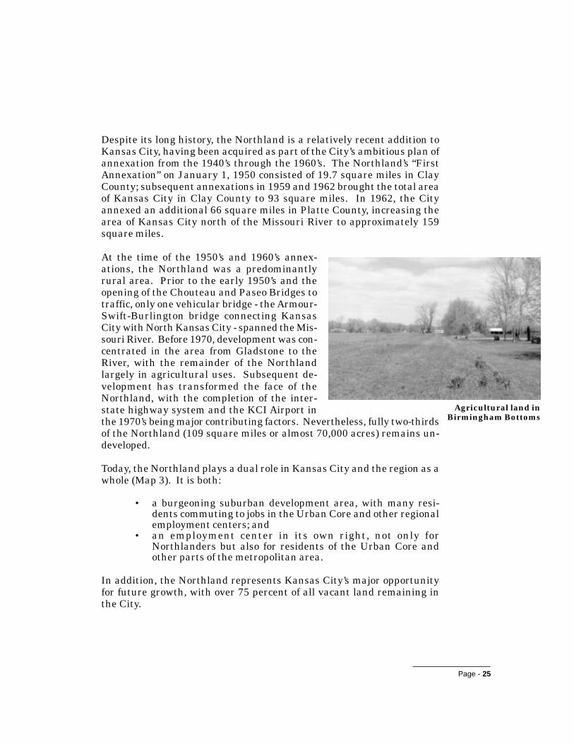
Despite its long history, the Northland is a relatively recent addition toKansas City, having been acquired as part of the City’s ambitious plan ofannexation from the 1940’s through the 1960’s. The Northland’s “FirstAnnexation” on January 1, 1950 consisted of 19.7 square miles in ClayCounty; subsequent annexations in 1959 and 1962 brought the total areaof Kansas City in Clay County to 93 square miles. In 1962, the Cityannexed an additional 66 square miles in Platte County, increasing thearea of Kansas City north of the Missouri River to approximately 159square miles.
At the time of the 1950’s and 1960’s annex-ations, the Northland was a predominantlyrural area. Prior to the early 1950’s and theopening of the Chouteau and Paseo Bridges totraffic, only one vehicular bridge - the Armour-Swift-Burlington bridge connecting KansasCity with North Kansas City - spanned the Mis-souri River. Before 1970, development was con-centrated in the area from Gladstone to theRiver, with the remainder of the Northlandlargely in agricultural uses. Subsequent de-velopment has transformed the face of theNorthland, with the completion of the inter-state highway system and the KCI Airport inthe 1970’s being major contributing factors. Nevertheless, fully two-thirdsof the Northland (109 square miles or almost 70,000 acres) remains un-developed.
Today, the Northland plays a dual role in Kansas City and the region as awhole (Map 3). It is both:
• a burgeoning suburban development area, with many resi-dents commuting to jobs in the Urban Core and other regionalemployment centers; and
• an employment center in its own right, not only forNorthlanders but also for residents of the Urban Core andother parts of the metropolitan area.
In addition, the Northland represents Kansas City’s major opportunityfor future growth, with over 75 percent of all vacant land remaining inthe City.
Agricultural land inBirmingham Bottoms
Page - 26
NORTHLAND PLAN
Key Issue: How can the Northland’s connections to the rest ofKansas City be reinforced?
With respect to the rest of Kansas City, the Northland has a tradition ofindependent living derived from its past as part of rural Clay and PlatteCounties, the residual effects of the annexations, and the historic barrierformed by the Missouri River. An important issue for Northlanders is theconcern that the area does not receive a proportionate return on its tax dollarsin terms of City investment in infrastructure and services north of the River.Nevertheless, most Northlanders recognize - and this Plan affirms as afundamental principle - that the future of the Northland is inextricably linkedto the future of the rest of Kansas City. Improving physical and human linkagesbetween North and South will strengthen both areas and contribute to buildingan interconnected Kansas City for the twenty-first century.
Economic DevelopmentAlthough it is sometimes perceived as a “bedroom community,” theNorthland’s role in the Kansas City region is also derived from its grow-ing employment centers. In his 1991 book Edge City: Life on the NewFrontier, Joel Garreau identified the KCI Airport area as an emerging“edge city.” His definition of an edge city is an area that:
• has 5 million square feet of leasable office space;• has 600,000 square feet of retail space;• has more jobs than bedrooms;• is perceived by the population as one place; and• was nothing like a “city” as recently as 35 years ago.
Garreau identified the College Boulevard/Overland Park area in JohnsonCounty, Kansas as the Kansas City metropolitan region’s only establishededge city. With 2.3 million square feet of leasable office space in thegreater Northland area (1.5 million square feet within the Kansas Citymunicipal limits); more than one million square feet of retail space; morethan 5,000 office jobs in the KCI Airport/I-29 corridor alone and morethan 17,000 industrial jobs within the City limits north of the River; adistinct identity as “the Northland,” and a history of recent development,the Northland is clearly close to meeting Garreau’s criteria.

C
2
1B
43
A
Map 3.Dual Role of the Northland
N
Employment Areas:A Central Business CorridorB Claycomo/Birmingham BottomsC KCI Airport/I-29
Housing Areas:1 First Annexation2 Line Creek/Parkville/Riverside/Lakes3 North Oak/Gladstone4 Shoal Creek/Liberty
Commuter Patterns of Northland Residents
0 1/2 1 2 miles

Page - 27
Employment centers in the Northland include establishedindustrial areas along the Missouri River, both inside andoutside Kansas City, and the emerging KCI Airport/I-29corridor, the major center of office activity. The office mar-ket along I-29 near the Airport has boomed in the 1990’sas 20 new firms have located in the area, improving froma 50 percent vacancy rate in 1990 to a 5 percent vacancyrate in 1995. The Airport itself is a major source of em-ployment, with approximately 6,900 direct, 3,100 indi-rect, and 8,800 induced employees, generating an esti-mated $3.3 billion in economic activity.1
The Birmingham Bottoms area is the primary industrialarea within Kansas City limits north of the River, with substantial ca-pacity for development and employment growth. The Northland Park isthe area’s largest industrial park. Only about 200 of the approximately2,200 acres within this development are occupied; another 180 acres areserved by roads and utilities, of which 148 acres are currently available.
According to City data and maps, approximately one-half of the totalland in the Northland Park is currently capable of being served withutilities. Using typical industrial Floor Area Ratios (FARs) and squarefootage per employee standards, 1,000 acres could accommodate approxi-mately 8.7 million square feet of development and 20,000 employees.
The casino industry is another contributor to employment growth in theNorthland. In 1997, regional casinos are estimated to employ approxi-mately 7,000 persons, with average wages of approximately $20,000.
2 Direct employees are employed at the KCI Airport. Indirect employees are employed in hotels andmotels in the vicinity of the Airport. Induced employees work in the Airport vicinity for businesses thatsupport direct and indirect operations. The number of induced employees was calculated using a standardindustry multiplier.
The KCI Airport is amajor economic
asset for theNorthland and the
Kansas City metro-politan region as a
whole.

Page - 28
NORTHLAND PLAN
Key Issue: How much employment should the Northland supportin the future, and in what locations?
It is clear that the KCI Airport/I-29 corridor will continue to develop as animportant employment center in the Northland. The relatively undevelopedBirmingham Bottoms area has the potential to augment established industrialcenters such as Claycomo, North Kansas City, and Riverside. Retail/commercial areas such as Liberty, Northtown, Metro North, Antioch, andParkville will continue to provide local centers of employment. Nevertheless,the question arises as to how much and what types of employment should bepromoted elsewhere in the Northland. This question raises issues such aseffects on residential areas, balancing jobs and housing as part of a regionalland use and transportation strategy, and the relationship to employment inthe Urban Core. Another issue of concern is the long-term viability of thegaming industry and its effect on the Northland economy.
Inter-Jurisdictional ContextKansas City north of the River is only part of thegreater Northland area. This area includes Clayand Platte Counties and over 20 separate, incorpo-rated municipalities, some of which are entirely sur-rounded by Kansas City proper (Map 4). Incorpo-rated municipalities in the Northland include oldercities formed in the nineteenth and early twentiethcenturies, such as Liberty and North Kansas City,and 14 entities (including Gladstone) that incorpo-rated between 1950 and 1960, presumably in re-sponse to Kansas City annexations north of the
Missouri River. The Northland’s identity is partially linked to incorpo-rated cities such as Liberty, Parkville, and North Kansas City, whosetraditional downtowns provide attractive centers of activity for theNorthland community. In some cases, parts of Kansas City are perceivedto be within these smaller communities. This perception is further rein-forced by school district boundaries that do not coincide with municipallimits.
Downtown NorthKansas City

PLAT
TE C
OUNT
YCL
AY C
OUNT
Y
JOHN
SON
COUN
TY, K
SJA
CKSO
N CO
UNTY
, MO
I ndependence
Birmingham
PlatteWoods
Gladstone
RiversideAvondale
NorthKansasCity
Liberty
Parkville
WeatherbyLake
Lake Waukomis
Randolph
Claycomo
PleasantValley
HoustonLake
Northmoor
Smithville
Oaks
Ferrelview
Map 4.Interjurisdictional Context
N
County Boundary
Municipal Boundary
Kansas City, MO Municipal Limits
Other Jurisdictions
0 1/2 1 2 miles

Page - 29
Key Issue: How can Kansas City work with other incorporatedmunicipalities to achieve the aspirations for theNorthland?
Many potential Plan initiatives, such as transportation improvements,enactment of consistent development standards, and implementation of aregional greenway system, span jurisdictional boundaries. Active coordinationwith Kansas City’s neighbors in the Northland will be needed to successfullyimplement these initiatives.
B. LAND USE AND DEVELOPMENT
Rate of GrowthGrowth is a fact of life in the Northland. During the ten-year period from1986 to 1995, the area averaged 1,200 residential building permits peryear (Table 2 on page 30). Although Table 2 shows that the overall rateof residential development has been lower in the 1990’s than the 1980’sdue to the abrupt end of the 1980’s multi-family housing boom in 1988,single-family housing starts are at record levels. This reflects theNorthland’s emergence as the “best kept secret” in the Kansas City re-gion: closer to the downtown and with more affordable housing thanmany other suburban areas; offering good schools, open space, and otheramenities of suburban living. Increased commercial activity, includingmajor development projects underway in the Barry Road corridor, is fur-ther evidence of the momentum of growth in the Northland. The multi-family housing market is also starting to reemerge, with two large devel-opments breaking ground in 1996.
New residentialdevelopment inthe Northland

Page - 30
NORTHLAND PLAN
“Vital statistics” related to the rate of growth in the Northland include:
• From the mid-1980’s to the mid-1990’s, the Northland’s an-nual share of residential building permits issued in KansasCity, MO ranged from approximately 45 to 80 percent. Dur-ing the same 10-year period, the Northland’s annual share ofresidential permits issued in the metropolitan Kansas Cityregion was between about 10 and 20 percent. In 1995, morepermits were issued in the Northland than in traditional mar-ket leaders such as Overland Park, Lee’s Summit, and Olathe.
• The population of the Northland was 93,913 in 1990. TheMid-America Regional Council (MARC) has developed futurepopulation and household projections for the Northland re-gion as a whole. These figures suggest that roughly 24,000 to27,000 households might reasonably be expected to be addedto Kansas City North between 1990 and 2020.2 Assuming an
Table 2. Northland Building Permit Trends, 1980-1985
���� ��������� �������� ������
���� ��� �� �
���� ��� �� ��
��� ��� �� ��
���� ��� �� ���
���� �� ����� ���
��� �� �� ���
���� ��� ���� ����
���� ��� ����� ��
���� ��� ����� ���
���� ��� �� ��
���� ��� ��� ���
���� ��� �� ��
��� ��� � ���
���� �� �� ��
���� �� ��� �����
��� ����� �� ����
������ ����� ������ ���� �� �!��
������ ����� ������ ���� �� ���

Page - 31
average size of 2.48 persons per household, this increase wouldresult in a population of between approximately 150,500 and158,000 in 2020 (60 to 68 percent greater than in 1990).
• The majority of residentially zoned land outside of agricul-tural districts is zoned either R-1a (7,500 square foot mini-mum lots) or R-1b (6,000 square foot minimum lots), allowingmaximum densities of five to six lots per acre discounting streetrights-of-way. Assuming an average density of four units peracre for future development, 6,000 to 6,750 acres will be re-quired to accommodate the projected increase in householdsin the Northland by 2020.
• Approximately 20,000 to 25,000 of the 70,000 acres of vacantland in the Northland are 1) located within 3,000 feet (slightlyover one-half mile) of an 8-inch or larger water main and 2)located within a watershed served by interceptor sewer.
Key Issue: The Northland has an ample supply of vacant land toaccommodate projected growth demand for the foreseeable future.
Even if MARC’s growth projections are doubled, residential development bythe year 2020 would consume at most 20 percent of vacant land in theNorthland. (There is expected to be much less acreage developed forcommercial and industrial uses because these uses consume less land thanresidential development in the Northland.) As demonstrated by the abovestatistics, the projected development could easily be accommodated on vacantland with access to public water and sewer at this time.
Key Issue: The quality of growth is more important than the rate ofgrowth.
While the opinions of individual members of the Northland Work Teamregarding a desirable rate of growth for the Northland vary from much slowerto much faster than the current rate, there is strong consensus that “howgrowth happens” is more important than “how much growth occurs.”
3 The actual number could vary based upon future market conditions, City policies regarding infilldevelopment, sewer and water provision, etc., and other currently unforeseen factors that could affectdevelopment patterns.

Page - 32
NORTHLAND PLAN
Pattern of GrowthSince 1980, growth in the Northland has been concentrated in two majorcorridors: northwest along I-29 between Riverside and M-152 and northalong US-169/North Oak Trafficway between Gladstone and I-435. Be-tween 1980 and 1990, these two areas experienced 46 and 48 percent ofthe growth in the Northland, although they represented only 24 and 25percent, respectively, of the area’s population in 1990. By contrast, theoldest developed area in the Northland (generally between Vivion Roadand the Missouri River or North Kansas City) experienced a significantpopulation decline of 15 percent during the same period, although it still
represented 47 percent of the Northland’s popu-lation in 1990.
The implications of this trend are clear: a shiftin investment from the established neighbor-hoods of the First Annexation northward intohistorically more rural parts of the Northland.This trend continues as development activityincreases along I-29 from M-152 to the KCI Air-port and in the I-35/I-435 corridor. In addition,commercial and residential development hasbeen increasing in the northeastern corner ofthe Northland, immediately adjacent to Liberty.
± 70,000 acres vacant land (1990)
± 25,000 acres vacant land withaccess to water and sewer*
± 6,750 acres MARC-projectedresidential developmentdemand through 2020
*within 3,000' of a water main and located within awatershed served by interceptor sewer
I-435
US
-169
I-29
M-152
I-35
24% of people46% of growth
25% of people48% of growth
Major growthcorridors in theNorthland

Page - 33
Key Issue: The current pattern of new development is afragmented one.
Although new development is concentrated in growth corridors and in nodesat major intersections and along major arterials within these corridors, itspattern tends to be fragmented and disconnected. In other words, individualdevelopments and land uses are typically isolated from each other.
Natural Resources, Parks, and Open SpaceNatural resources, parks, and open spaces are important elements in thepattern of land use and development in the Northland. The area’s natu-ral resources have been shaped by the interaction of landform and water.Running from northeast to southwest through the Northland is a broadridge of comparatively flat terrain separating the drainage basins of theMissouri and Platte Rivers. From this ridge, incised stream valleys, suchas Shoal and Line Creeks, flow south to cut through the steep bluffsbordering the alluvial floodplain of the Missouri River. Spectacular viewsof the Kansas City skyline are available from these bluffs and other highpoints in the Northland, for example traveling south along US-169 and I-29. North of the ridge, less steeply cut stream valleys flow in a generallynorthward direction to the Platte River. The streams and drainagewaysthat feed into them largely define the distinctive, rolling topography ofthe Northland.
The native vegetation of the Northland is a tran-sition between tallgrass prairie and upland oak/hickory forest, with floodplain forest dominatedby cottonwoods, silver maple, elm, and mulberryfound in stream and river bottomlands. Becauseof the area’s long history of agricultural and ur-ban use, only remnants of natural vegetation re-main. Together with steep slopes and floodplains,areas of natural vegetation in the Northland arelargely concentrated along stream corridors. Thesecorridors provide a host of environmental benefits,such as attenuation of flooding, water quality pro-tection, habitat for wildlife, and scenic quality. Road crossing at Line Creek

Page - 34
NORTHLAND PLAN
The Northland’s recreational resourcesinclude a system of parks and greenwaysserving the First Annexation area be-tween Gladstone and North Kansas City,two regional parks (Hodge and TiffanySprings), and various other communityand neighborhood facilities. With the ex-ception of some of the parks and greenwaysof the First Annexation, the Northland’srecreational resources are isolated fromeach other. Although Kansas City has aparkland dedication ordinance in place,
the land that is dedicated for recreation and open space in new subdivi-sions typically has no true public access or use, serving primarily as aphysical or visual buffer. In many cases, this land is characterized bysteep slopes or other constraints that limit its use and can cause mainte-nance problems for the Parks Department (e.g., erosion/stormwater con-trol). Moreover, the ordinance allows the developer rather than the Cityto decide whether land or a cash payment will be used to fulfill the dedi-cation requirement.
Several studies, dating back to the Kansas City Parks and RecreationDepartment’s 1964 Plan for Parks, Boulevards, and Parkways, have rec-ommended development of an interconnected system of parks and openspace in the Northland. This concept was reinforced by a 1979 plan pre-pared by the American Institute of Architect’s Kansas City Regional/Ur-ban Design Assistance Team and by updates to the Parks Plan preparedin 1983 and 1993. Metro Green, a 1991 Community Assistance TeamProject of the American Society of Landscape Architects, developed a con-cept for parks and open space in the Northland as part of a regionalgreenway system serving the entire Kansas City metropolitan area.
The Parks Plan proposes development of a looped parkway system as themajor organizing element for open space. Only six of 125 miles of park-ways and boulevards proposed for the Northland have been completed orare under construction.
Existingpark in theFirst Annex-ation area

Page - 35
Key Issue: How can land be set aside for parks and open spaceas the Northland develops?
Open land - rolling hills and wooded valleys - is highly valued by Northlandersfor its contribution to the Northland’s character. Establishing a system ofopen space and greenways is essential to maintaining something of thatcharacter as the Northland grows. In addition, there is a need for sensitivedevelopment that conserves and integrates the best features of the landscapeinto the pattern of land use.
Design of the Public RealmParks and recreational facilities are part of the public landscape, anotherimportant component of the pattern of land use and development in theNorthland. The physical design of parks, schools, major roadways, andother public facilities helps to define community character as it is per-ceived by residents and visitors to the Northland. Kansas City has atradition of extraordinary urban design: the visionary parkway and bou-levard system laid out by George Kessler, the graceful neighborhoodsdeveloped by J.C. Nichols, and the elegant Country Club Plaza are primeexamples. However, this legacy is mostly lacking in the Northland, whichas it develops resembles typical suburban communities throughout theUnited States.
Key Issue: A higher standard of design should be applied to thepublic environment.
With a few exceptions, the public landscape of the Northland has not beendesigned to a high standard of quality. An opportunity exists for the publicsector to set an example for private development in establishing a higherquality human environment in the Northland. Parkways and boulevards,landscaped arterials, fountains, and works of art are examples of designelements that could reinforce the Northland’s visual identity and help tie it tothe rest of Kansas City.

Page - 36
NORTHLAND PLAN
C. TRANSPORTATION AND INFRASTRUCTURE
TransportationThe Northland’s roadway system has beenshaped by the predominantly rolling terrain dis-sected by often steeply sloping stream valleys.In contrast to the flatter terrain of JohnsonCounty, which facilitated development of a morecomplete section line road network prior to ur-banization, the north-south grain of theNorthland’s landscape has hampered the devel-opment of east-west roadways. Developing anadequate roadway system that keeps pace withdevelopment is key to minimizing congestionand maintaining quality of life as the Northlandgrows. Specific issues include:
• The limited access freeway system serving the Northland isexcellent. However, the diamond design typical of the exist-ing freeway interchanges, often in close proximity to rapidlydeveloping frontage roads, is causing congestion problems insome locations.
• Currently, over 250,000 cars per day cross one of the five bridgesover the Missouri River. The Broadway, Heart of America,Paseo, and Chouteau bridges are currently at or above trafficvolume design capacities. Because of the lack of signage, it isalso difficult to locate bridges to access the Northland fromthe Urban Core.
• The arterial system is less well developed than the freewaysystem, in particular lacking east-west connectors. TheNorthland has only 2.6 miles of arterials per 10,000 residentsplus employees, compared to 4.3 arterial miles south of theRiver (Map 5).
• The Northland lacks a continuous system of north-south andeast-west secondary arterials and collector streets in supportof primary arterials such as Barry Road. The developing pat-tern of residential subdivisions intersecting directly with pri-mary arterials creates interruptions in traffic flow, thus caus-ing congestion. The lack of connections between individualdevelopments further contributes to congestion by increasingtraffic on arterial roadways.
This unimproved east-west roadway is typicalof the Northland's existing roadway system.

1
2
3
4
5 6 7
8
Map 5.Disjointed Arterial Network
N
Parkway
Four Lane Arterial
AirworldExecutive HillsI-29 & Barry RoadI-29 & 64th StreetMetro North Shopping CenterMaple Woods Community College/Human Services CenterI-35 & Barry Road/LibertyAntioch Shopping Center
123456
78
0 1/2 1 2 miles

Page - 37
• Arterials such as North Oak Traf-ficway, Antioch Road, and BarryRoad support or are developing apattern of strip commercial devel-opment with numerous traffic sig-nals, conflict points, and increasedcongestion. Major shopping centers,such as Metro North, located atfreeway to arterial interchanges orarterial to arterial intersectionscompound this problem by requir-ing the interchange or intersectionto serve both major through andconcentrated local traffic.
• Prior to 1996, Kansas City was the country’s largest met-ropolitan region in compliance with air quality standards setby the Environmental Protection Agency. In the summer of1996, regional air quality exceeded federal standards for thefirst time. With the current trend in development patterns inthe Northland, vehicle miles traveled will increase and fur-ther contribute to air emissions in the Kansas City region.
• The relative lack of public transit service limits mobility forthe young, old, and those that cannot afford an automobile.Public transit within Kansas City is provided by the KansasCity Area Transportation Authority (ATA). The ATA has atotal of 10 routes serving the Northland. These routes providea traditional radial or spoke-type design, focusing on the cen-ter of Kansas City. East-west service is inadequate. Becauseof relatively inexpensive parking downtown and low conges-tion levels, park-and-ride has experienced mixed success inthe Northland. Reverse transit commuting to the Northlandhas also been relatively unsuccessful because there is no dis-tribution service once the transit riders reach their destina-tions. Even though there are an increased number of serviceworker jobs in the casinos and other Northland businesses,current density levels are such that transit service is difficultto provide.
Commercial developmentalong North Oak Traf-
ficway

Page - 38
NORTHLAND PLAN
Key Issue: Large sums of money will be requiredto fund the level of roadwayimprovements necessary toadequately support existing and newdevelopment.
The obvious question is: where will the money come from?The slow pace of implementation of programmedimprovements such as M-152 and the City’s arterial systemunderscores the need to identify new funding mechanismsfor construction of major roadways.
Key Issue: Few alternatives to automobile useexist for Northland residents.
The Northland is an overwhelmingly automobile-orientedcommunity. Almost all trips are by car; few people havethe opportunity to walk or ride bikes to school, a park, ora local store. Public transit provides limited options forNorthland residents commuting to the downtown (whomust rely on increasingly congested bridge crossings) orfor Urban Core residents who wish to commute to jobs inthe Northland.
In March 1997, the ATA and Northland TransportationCommittee completed the Northland Public TransportationPlanning Study. This study proposes a framework for anenhanced bus and paratransit system to serve the socialservice, employment/economic development, education,health care, and recreation needs of Northland residents.
Pedestrian and bicycle travel is difficult in the Northland due to the limitedfacilities available. There is no formal bicycle system and only somerecreational paths. In the early 1990's, Kansas City participated indevelopment of a regional bicycle plan by the Mid-America Regional Councilbut currently lacks an approved bicycle plan. Current street standards do notsafely accommodate the bicyclist as new roads are constructed. Basicpedestrian facilities along arterials and local streets in the Northland are
68th Street near US-169 is anexample of developmentoccurring prior to construc-tion of the road improve-ments needed to support it.Road projects in developedareas are more expensivedue to the need for utilityrelocations, regrading, etc.

Page - 39
either totally lacking or are provided as narrow attached sidewalks adjacentto high volume/high speed traffic lanes. Connections between home andtransit, schools, or shops are also nonexistent in newer neighborhoods.
Key Issue: The Northland’s multi-modal transportation systemsare essential to sustain its employment centers.
The airport’s location in the vicinity of I-29, I-435, and M-152 is a majoreconomic asset, supporting multi-modal transfer of goods between airplanesand trucks. The convergence of I-435, M-210, M-291, and an extensive railnetwork provides a similar advantage for Birmingham Bottoms. An improvedarterial road network will be needed to support continued economic growth.In addition, rail access would enhance multi-modal operations at the airport.
Public UtilitiesThe major public utility systems of the Northland - water, sewer, andstormwater drainage - are managed by the City’s Water Services Depart-ment. Like the roadway system, public sewer and water lines are un-evenly developed in the Northland. Although most of the Northland hasaccess to sewer trunk lines and water distribution mains, significant ar-eas remain without service, particularly in undeveloped locations out-side of the major growth corridors (Map 6). Moreover, some older neigh-borhoods lack public sewer or adequate water lines. Currently about2,300 residences (more than six percent of the households in the Northland)rely on on-site septic systems.
Adequate storm drainage facilities, ranging from storm sewers to chan-nel and floodplain improvements, also need to be provided for establishedand developing areas. These facilities should be planned so as to comple-ment the roles of natural resources (e.g., stream corridors and floodplainareas) in flood control and water quality attenuation. The stormwatermanagement functions of the Water Services Department include basinplanning, flood mapping, control of non-point source runoff, and construc-tion and maintenance of local drainage improvements. Preparation of astorm drainage study is required for each new development, along withmeasures to accommodate stormwater flows generated by the develop-ment. However, some older Northland neighborhoods are served by in-adequate storm drainage systems.

Page - 40
NORTHLAND PLAN
Key Issue: To what extent should public infrastructure investmentbe concentrated in areas of existing versus futuredevelopment?
The Northland’s incomplete roadwayand public utility systems, steeptopography, and fragmented ownershiphave contributed to a piecemeal landuse pattern in which large tracts ofvacant land exist side-by-side withdevelopment in growth corridors like theLine Creek Valley. These areas havesignificant capacity to absorb projectedgrowth in the Northland for theforeseeable future. Nevertheless,pressure is increasing to extend publicinfrastructure into undeveloped areasoutside of the major growth corridors.This issue is highlighted by: 1) the 1996
Water Bond Election, which approved capital funding to both improve waterservice for existing development and extend transmission lines intoundeveloped areas; and 2) the extension of sewer lines through Hodge Parkinto undeveloped parts of the Shoal Creek Valley, potentially creatingopportunities for “leap frog” development.
Key Issue: Funding is needed not only for new infrastructure, butalso to maintain and upgrade existing infrastructure inolder parts of the Northland.
Maintenance is needed to ensure that older utility infrastructure continues tofunction properly, a task that can require expenditures near the levels ofthose required for new infrastructure. Further, as development occurs inareas served by older infrastructure, substantial upgrading may be necessary.An example is provided by areas currently served by rural water systemswhich, without increases in capacity, will not be able to provide adequate fireflows to support increased development.
Vacant land inLine CreekValley

Map 6.Vacant Ground Comparedto Utilities
N
Area Urbanized or Unavailablefor Development
Water Lines Beyond 3000 Feet
Interceptor Sewer Trunk Linesnot Completed
Vacant Ground Served by CityWater & Sewer
0 1/2 1 2 miles

Page - 41
D. NEIGHBORHOODS AND COMMUNITY IDENTITY
With a few exceptions, existing neighborhoods in the Northland are mostlyresidential subdivisions that lack the strong sense of identity found southof the Missouri River. In Kansas City south of the River, strong neighbor-hood identity reinforced by active organizations has been a positive forcefor change. Existing neighborhood organizations in the Northland includeNorthland Neighborhoods Inc., a community development corporation, andthe Northland Leadership Group (an informal coalition of neighborhoodgroups).
Newer Northland subdivisions are inwardly focused and lack physical link-ages to centers of community activity such as schools, parks, and neighbor-hood shopping centers (Map 7). Although the Northland as a whole con-tains activity centers with distinctive character - the downtowns of Lib-erty, North Kansas City, and Parkville are good examples - these centersare mostly located outside of City boundaries.
Schools and religious institutions are importantfocuses of community life in the Northland butare generally not associated with specific neigh-borhoods. Valued for the quality of educationthey provide, the region’s school districts helpto attract many families to the Northland. Sixdifferent school districts serve the Northland;of these, North Kansas City, Park Hill, andPlatte City have schools located within KansasCity municipal boundaries. Seventeen of theschools are situated next to parks, suggestingthe potential for concentrating public uses tocreate centers of community activity.
The Maplewoods Community College and adja-cent Northland Human Services Center onBarry Road are significant resources for theNorthland community. However, this notabledestination is not served by public transit.
Northland HumanServices Center

Page - 42
NORTHLAND PLAN
Key Issue: Public and private investment will be required tomaintain the health of the Northland’s olderneighborhoods.
Many of the Northland’s older neighborhoods are characterized by inadequateinfrastructure, older housing, and a declining population. Yet theseneighborhoods have great potential: the Northland’s most complete park andgreenway system, carefully planned and implemented in the 1950’s, is locatedbetween North Kansas City and Gladstone. (This system does, however, needadditional recreational facilities.) Significantly, the most active neighborhoodorganizations have developed in neighborhoods such as Gracemor wherespecific problems (drainage, need for code enforcement, etc.) have providedthe impetus for action.
Key Issue: How can the Northland build a greater sense ofneighborhood identity?
Approximately half of Northlanders live in areas developed since 1970. Recentlydeveloped suburban areas typically have less cohesive neighborhoods thanestablished cities, and the Northland is no exception to this rule. While it isrecognized that one of the Northland’s strengths is its tradition of independentliving, steps should be taken to foster a greater sense of neighborhood andcommunity identity above the subdivision level.
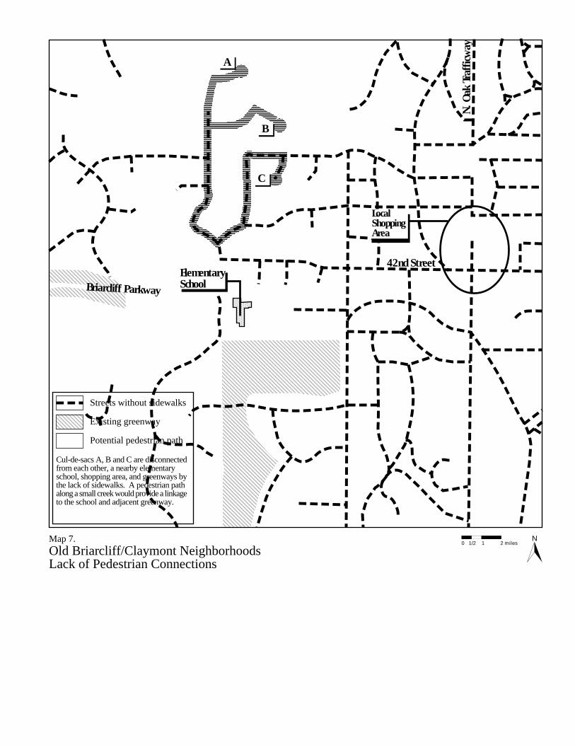
42nd Street
N. O
ak Tr
affic
way
ElementarySchoolBriarcliff Parkway
LocalShoppingArea
A
B
C
Map 7.Old Briarcliff/Claymont NeighborhoodsLack of Pedestrian Connections
N
Streets without sidewalks
Existing greenway
Potential pedestrian path
Cul-de-sacs A, B and C are disconnectedfrom each other, a nearby elementaryschool, shopping area, and greenways bythe lack of sidewalks. A pedestrian pathalong a small creek would provide a linkageto the school and adjacent greenway.
0 1/2 1 2 miles

Page - 43
Aspirations
Chapter Two:Aspirations
As described in Chapter One, the Northland has many assets that willserve it well as it continues to grow in the future. Nevertheless, thecurrent pattern of public and private development will not result in theNorthland achieving its full potential as a great place to live, work, andplay in the Kansas City region. In the worst case scenario, this patternwill result in a future of congestion, deteriorated older neighborhoods,increased costs for public services and infrastructure, and a diminishednatural and visual environment.
An alternative future for the Northland is possible, one that can beachieved through proactive efforts by government and private citizens.The aspirations for this future have been crafted in terms of the fourframing themes that have guided the planning process.
A. ASPIRATIONS
The Role of the Northland in the Kansas City RegionThe Northland plays a dual role in the Kansas City region. It enjoys aunique local identity with a balance of neighborhoods, employment cen-ters, and places for shopping, entertainment, and community activities.The Northland also maintains strong ties to and contributes to the vital-ity of the Urban Core.

Page - 44
NORTHLAND PLAN
Many of the Northland’s residents work,shop, and take advantage of cultural op-portunities south of the Missouri River.The Northland’s ties to the Urban Core arereinforced by physical connections: land-scaped boulevards, an active transit sys-tem, and the sharing of a greenway alongboth banks of the River. The riverfront andother Northland greenways along creeks,parkways, rail rights-of-way, etc. are partof a network of “green corridors” with rec-reational trails that connect the communi-ties of the Kansas City metropolitan region.
Land Use and DevelopmentThe Northland’s growth pattern is structured around clearly definedneighborhoods connected to each other and to a hierarchy of centers rang-ing from local shopping areas to regional commercial and employmenthubs. Open space, greenways, and well-designed public facilities pro-vide an organizing framework for development. A diversity of livingchoices is available to Northland residents, including thriving older neigh-borhoods and newer developments ranging from quality affordable hous-ing to estate homes. The built environment is attractive and conservesscenic vistas and sensitive natural resources. The key elements of thelandscape so revered by Northlanders - rolling topography, wooded streamcorridors, and other scenic features - have been preserved within thefabric of development.
The development pattern has been realized by working to achieve a de-fined standard of quality rather than a particular rate of growth. Thepublic and private sectors have formed partnerships to achieve the de-sired pattern.
Transportation and InfrastructureThe Northland has a multi-modal transportation system that supportspublic transit, pedestrians, and bicyclists as well as the automobile. Acontinuous, interconnected system of freeways, parkways and boulevards,arterials, and collector streets has been developed to serve existing andnew development. This system has been financed through a blend offederal, state, county, road district, city, and private developer funds.The system is coordinated with the overall pattern of land use and em-
The Missouri Rivercould become arecreationalgreenway helpingtie together KansasCity North andSouth.

Page - 45
Aspirations
ployment so as to minimize traffic congestion and is integrally connectedto the southern part of Kansas City.
Older neighborhoods have been stabilized by having their needs for ba-sic infrastructure such as public water and sewer met. Logical exten-sions of existing roads, sewer, and other infrastructure are available toserve contiguous new development as it comes on line. Infrastructureimprovements are funded through innovative mechanisms that equita-bly distribute costs between present and future residents and businesses.
Neighborhoods and Community IdentityThe Northland has a strong sense of community with residents who areactively involved in neighborhood issues. Public and private facilitiesand organizations such as schools, parks, libraries, churches, and localshopping areas are focuses of community activity at the neighborhoodlevel. Streets, sidewalks, and pedestrian/bicycle paths provide linkageswithin and between residential neighborhoods and community-servinguses.
Pedestrian connection in a Northland neighborhood

Page - 46
NORTHLAND PLAN
B. INITIATIVES AND ACTIONS
A comprehensive series of initiatives and actions are proposed to bringabout the desired future for the Northland. Implementing these initia-tives and actions will require a coordinated effort and commitment ofresources by all levels of City government as well as active partnershipswith both public and private sector entities. The following types of ac-tions will be needed:
• Integration of the FOCUS Kansas City and Northland Planpolicies into the long-range planning and day-to-day opera-tions of all City departments and political bodies
• Revisions to the City’s development regulations• Investment of City resources in a range of projects, including
transportation, infrastructure, parks, and urban design• Development of new funding sources, plus creative partner-
ships with other governmental agencies and the private sec-tor to leverage the City’s fiscal resources
• Coordination with other governmental entities, including lo-cal jurisdictions and state agencies, to achieve the policy ob-jectives for the Northland
• Partnerships with developers to bring about creative newforms of development
To ensure effective implementation, strategic priorities need to be set inorder to focus the City’s resources on the actions that yield the greatestbenefits in terms of achieving the plan aspirations. Appendix A containsadditional detail regarding the prioritization of individual transporta-tion improvement projects in the Northland.
The following text organizes the initiatives and actions proposed for theNorthland according to the four overriding aspirations for the future:
1. Affirming the Northland’s Role in Kansas City and the Re-gion
2. Land Use and Development: Shaping Quality Places to Live,Work, and Play
3. Building a Transportation and Infrastructure System thatWorks
4. Enhancing Neighborhood and Community Identity
Because these four aspirations are so closely interconnected, there isinevitably some overlap in the initiatives and actions presented for each

Page - 47
Aspirations
one. Where appropriate, cross references are provided between indi-vidual actions. For further information regarding many of the proposedinitiatives and actions, refer to Chapter IV (Applications).
1. Affirming the Northland’s Role in the Kansas City Region
Initiative: Enhance connections between Kansas City, North andSouth
Kansas City as one community - joined rather than separated bythe Missouri River - is a fundamental aspiration of the NorthlandPlan. To help turn this aspiration into reality, stronger connec-tions should be established across the River. These connectionsinclude both physical linkages (e.g., adequate multi-modal cross-ings of the River and extension of the parkway and boulevardsystem into the Northland) and enhanced communications andprograms to bring together residents of Kansas City, North andSouth.
Initiative: Implement the Northland’s share of the “Metro Green”system
The Northland’s portion of the Kansas City Metropolitan Greenway Sys-tem (Metro Green), proposed by the 1991 Community Assistance TeamProject of the American Society of Landscape Architects, Prairie Gate-way Chapter, should be implemented through development of a systemof greenway trails, parkways, and boulevards. This system will enhanceinternal connections within the Northland and help link it to the largerregion. Bringing the system into reality will require a range of strate-gies, such as public acquisition, easement programs, and alternative de-velopment forms, implemented through coordinated public and privatesector action.
Initiative: Promote development of the KCI Airport area andBirmingham Bottoms as employment centers tocomplement the Urban Core
The KCI Airport area and Birmingham Bottoms are important employ-ment anchors, both for Northland residents and for employees residingin the larger region. Continued development of these areas should bepromoted for their contribution to the employment strategies of the Hu-man Investment Plan. Maintaining and supporting high quality jobgrowth in these areas is critical to creating a vital, strong, and healthylocal and regional economy, as well as to expanding the employment baseof Kansas City. Also, the availability of high quality, well-paying jobs inNorthland employment centers supports residential development.
Connections

Page - 48
NORTHLAND PLAN
Initiative: Recognize that the gaming industry will continue to havean impact on the Northland and the greater Kansas Cityarea as the industry matures
Public civic opinion on the gaming industry continues to be mixed.Growth in the industry has had both positive and negative impacts.Gaming will continue to be a source of jobs and revenues to local juris-dictions over the short term. Long-term prospects are difficult to pre-dict, however, as the industry has a tendency to be volatile and marketshare may decrease with additional competition. Other impacts includechanges in employment patterns.
Initiative: Provide a range of quality housing choices in theNorthland
The Northland has a vital role to play in accommodating quality subur-ban development in Kansas City. The availability of quality housingshould be promoted at all levels, from estate housing to affordably pricedhomes. The Northland’s large tracts of undeveloped land provide a uniqueopportunity for an innovative new residential “product” - one that offersa mix of housing styles and price ranges within individual developmentswhile conserving open space.
Initiative: Coordinate with other Northland jurisdictions inimplementing FOCUS Kansas City and the Northland Plan
Incorporated Kansas City within Clay and Platte Counties is insepa-rable from the many other jurisdictions (Gladstone, Liberty, North Kan-sas City, Parkville, etc.) that are also part of a vital subregion within thegreater Kansas City metropolitan area. To implement the NorthlandPlan, Kansas City will need to work closely with the counties and othermunicipalities on initiatives and actions that span jurisdictional bound-aries (e.g., the proposed greenway along the Missouri River).
Actions: Connection• Improve bridge capacity through multi-modal physical im-
provements and an “intelligent transit system” (ITS) (see“Building a Transportation and Infrastructure System thatWorks”)
• Improve vehicular circulation from the downtown to the Broad-

Page - 49
Aspirations
way, Heart of America, and Paseo Bridges to make it easier todrive between the Urban Core and the Northland (e.g., throughimproved directional signage)
• Improve transit connections between the Kansas City Northand South (see “Building a Transportation and Infrastruc-ture System that Works”)
• Actively involve Northlanders in the “Kansas City Spirit” pro-gram proposed by the Citizen Access and CommunicationBuilding Block
• Complete and implement the master plan for a sharedgreenway along both sides of the Missouri River, with pathsystems, recreational facilities, and bicycle/pedestrian rivercrossings
• In accordance with the Metro Green Plan, develop greenwaytrails along Line Creek, Shoal Creek, and other major streamcorridors in and connecting to the Northland; are proposedby Metro Green, develop the greenway system to be intercon-nected through parkways and linkages across major drainagedivides
Actions: Economic Development• Build coalitions with Clay and Platte County economic devel-
opment agencies and Chambers of Commerce to support eco-nomic development activities in the Northland. Support theneeds of small as well as large businesses
• With economic development agencies and Chambers of Com-merce, market the Northland as an affordable, desirable placeto locate businesses and provide quality housing for all typesof employees
• Work to retain existing businesses in the KCI Airport and Bir-mingham Bottoms areas, and support the development ofcomplementary and supplier businesses
• In accordance with the Human Investment Plan strategies to“prepare the workforce for 21st century careers,” take the fol-
Page - 50
NORTHLAND PLAN
lowing actions to maintain and improve the Northland’sworkforce:
- Work with Maplewoods Community College to provideworker training and retraining that meets the needs of ex-isting and anticipated Northland businesses
- Work with local school districts and economic developmentagencies to develop programs providing “school-to-career”readiness in support of a skilled workforce for businessesin the Northland
- Establish a system of job-readiness training in FOCUSCenters
• Target public infrastructure investment to support economicdevelopment projects that provide jobs and expand the City’stax base
• Maintain and improve intermodal transportation - air, high-way, river, and rail - to support economic activity
• Promote “reverse commuter” programs to make it easier forUrban Core residents to work in the Northland
Actions: Gaming Industry• Recognize the impacts of gaming and address the gaming in-
dustry in future planning for the Northland
Actions: Housing• Through zoning and other regulatory processes, provide op-
portunities for construction of a variety of household types inthe Northland to shelter an economically and socially diversepopulation
• Work with the private sector to develop low-cost financing pro-grams for the rehabilitation of existing housing stock in theNorthland
• Target public infrastructure improvements to support estab-lished neighborhoods, particularly those with substandard ser-vice (see “Building a Transportation and Infrastructure Sys-tem that Works”)
Actions: Inter-Jurisdictional Coordination• As part of the City management structure and financial man-
agement strategies recommended by the Governance Plan, de-velop a process for continuing coordination with Clay County,

Page - 51
Aspirations
Platte County, and incorporated municipalities such asGladstone, Liberty, North Kansas City, and Parkville to ad-dress issues of common concern, such as:
- Roadway, greenway, and other projects that connect Kan-sas City with other jurisdictions
- Clay and Platte County’s share of funding roadway im-provements in Kansas City
- New development at the interface between Kansas City andother jurisdictions
- Joint promotion of economic development opportunities
2. Land Use and Development: Shaping Quality Places to Live,Work, and Play
Initiative: Encourage a more compact, interconnected developmentpattern structured around existing development anddefined centers
The current growth pattern in the Northland is one of isolated residen-tial subdivisions and single-use commercial developments, resulting ina fragmented land use pattern that promotes congestion on major road-ways. Public investment policies and incentives should be used to en-courage infill in developed and developing areas, promote connectionsbetween developments, and define higher intensity, mixed use centersas focuses of land use, transportation, and community identity. “Leapfrog” into areas that are not adjacent (contiguous) to existing develop-ment should be encouraged only for projects that implement specificobjectives of the Northland Plan and FOCUS Kansas City, for example:creation of mixed use centers or multi-modal transportation facilities.
Initiative: Enact development standards to encourage “quality”development
The zoning and subdivision regulations should be enhanced to establish
Quality Development

Page - 52
NORTHLAND PLAN
clearer design standards and guidelines for new development. Thesestandards should be designed to produce quality development and a morepredictable approval process (as opposed to the case-by-case negotiationtypical of the current approach). In addition, they should be linked withincentives for desired forms of development.
Initiative: Improve the development review and approval process to:1) enhance local awareness and input and 2) create a“user friendly” climate that promotes quality development
Ways should be sought to more fully inform citizens of development pro-posals in order to make the City and the developer aware of the concernsof local residents. At the same time, City staff should develop a serviceorientation and seek ways to facilitate development proposals that meetthe objectives of FOCUS Kansas City and the Northland Plan.
Initiative: Protect sensitive natural resources such as streamcorridors, floodplains, woodlands, and steep slopes
Highly valued by Northlanders, natural resources contribute greatly tothe character of the Northland and are critical to environmental func-tions such as flood control, water quality, and wildlife habitat. Thereare few remaining pristine hardwood forests, riparian habitats, prairieremnants, and other natural features left in the City. Special emphasisshould be placed on maintaining and enhancing these special naturalenvironments. Natural resources should be integrated into the fabric ofthe Northland as it develops, both at the macro scale (by maintaining aframework of greenway corridors) and at the site level (by encouragingpreservation of sensitive resources within individual developments).
Initiative: Implement a comprehensive parks and open spacesystem, structured around parks and recreationalfacilities; greenways; parkways, boulevards, and otherlandscaped roadways; and environmentally sensitiveresources
Establishment of an interconnected system of parks, greenways, andother open spaces, implemented through coordinated public and privateaction, will help provide an organizing framework for future develop-ment in the Northland. The basic structure for such a system is set bythe Parks and Recreation Department’s 1993 Plan for Parks, Recreation,Boulevards, and Greenways and the 1991 Metro Green study.
Initiative: Implement an overall urban design concept establishing

Page - 53
Aspirations
aesthetic standards for public elements such asgateways, major roadways, signage, and public facilitiesand spaces.
The 1992 study, A City Plan for Urban Design, establishes an urbandesign concept for Kansas City as a whole. Application of this conceptto the Northland should focus on reinforcing its identity as a uniquepart of Kansas City and on setting a standard of quality in design ofthe public realm for private development to follow.
Actions: Development Pattern• Provide fiscal and regulatory incentives to: 1) encourage re-
investment in older, established neighborhoods (e.g., the FirstAnnexation) and 2) promote infill and contiguous develop-ment
• Develop and implement a cluster/open space developmentoption to help promote more efficient public infrastructureand services and preserve sensitive resources as open space
• Identify locations for multi-modal, mixed use centers andimplement regulatory mechanisms and incentives to encour-age their development
• Through the area planning process, revise the NorthlandPlan’s Future Land Use Plan to reflect a compact develop-ment pattern (i.e., higher density centers surroundedby lower density development in contrast tothe “strip development” pattern typical ofsuburban areas). Ensure that futurerezonings conform with the Future LandUse Plan
• Evaluate current zoning for conformancewith the revised area plans. Consider re-zoning where necessary to bring propertiesinto conformance, combined with“sunsetting” provisions that phase the newzoning in over time
• Make future developments subject tosunsetting provisions that require a new re-view and approval process if an approveddevelopment is not implemented within a
"Live-end" StreetConcept: These threecul-de-sacs in a KingCounty, Washington
subdivision areconnected by a
wooded triangle thatfacilitates pedestrianaccess and increased
social interactionamong neighbors.
����������� ����������������������
�������

Page - 54
NORTHLAND PLAN
certain time period
Actions: Development Standards• Adopt design standards for new development in the zoning/
subdivision regulations, together with a new site plan reviewprocess
• Provide flexibility in the application of engineering standardsfor subdivision roads and other site improvements where nec-essary to preserve natural topography and vegetation in thesiting of new developments
Actions: Development Process• Make the public decision-making process more accessibleto citizens, especially as it relates to development issues
• Work to improve management of development by the CityPlanning & Development Department through an enhancedservice orientation, establishment of mechanisms to improveand streamline the development review and approval process,and improved enforcement
Actions: Natural Resources• Implement regulatory mechanisms and incentives to mini-
mize impacts by development on environmentally sensi-tive resources, such as floodplains, stream corridors, steepslope areas, woodlands, scenic views, and historic sites
• Complete a comprehensive inventory of significant natu-ral, scenic, historic, and archaeological resources in theNorthland. This inventory will be used as the basis for aland conservation program to protect identified resourcesand provide a framework for open space dedication
Actions: Parks and Open Space• Using the 1993 Plan for Parks, Recreation, Boulevards, and
Greenways as a starting point, work with the Parks and Rec-reation Department to identify and prioritize park and openspace acquisition projects
• Work with adjacent jurisdictions to develop an interconnectedgreenway system (see “Affirming the Northland’s Role in Kan-sas City and the Region”)
• Improve development regulations to encourage private dedi-cation of land that contributes to the overall parks and open
The Northland'snatural andscenic resourcesshould beinventoried.

Page - 55
Aspirations
space system, including incentives for cluster development andimprovement to the parkland dedication requirement for sub-division platting
• Develop a coordinated, public/private strategy to fund acqui-sition and development of the parks and open space system,including parkways
• Work with the Landmarks Historic Trust Corporation to usethe conservation easement program to promote open space pres-ervation by private landowners
Actions: Public Urban Design• Develop important roadways leading to the Northland (Mis-
souri River approaches and bridge crossings, the airport en-trance drive) as “gateway entrances” with special design im-provements
• Develop and implement aesthetic standards for roadways,bridges, government buildings, other public improvementprojects, and private projects in the public view. Develop, imple-ment, and enforce maintenance standards to ensure contin-ued project integrity
• Communicate Kansas City’s concerns regarding the aestheticimpact of federal/state highway projects to the Missouri De-

Page - 56
NORTHLAND PLAN
partment of Transportation and work to achieve a higher de-gree of quality in state highway improvements in the Northland
• Building on the examples of the Northland Fountain andChildren’s Fountain, seek opportunities to establish distinc-tive, accessible landmarks that contribute to the Northland’sidentity
• Develop a coordinated, attractive, informational and direc-tional signage system throughout the Northland
3. Building a Transportation and Infrastructure System thatWorks
Initiative: Implement a complete vehicular movement system, withan emphasis on serving existing developed/developingareas in the Northland
The Northland generally has excellent freeways but lacks a completesystem of arterial roadways and collector streets. Major priorities in-clude development of: 1) a complete system of primary (four-lane) arte-rials, particularly to accommodate east-west movement; and 2) a sup-porting network of secondary (two-lane) arterials and collector streets,to facilitate local traffic and permit diversion of local trips from the free-ways and primary arterials. Because of limited funds, improvementsshould be targeted primarily to serve developed and developing ratherthan future development areas.
Access control is and will continue to be a major issue in the Northland.There needs to be a balance between providing traffic flow along thestreet system with adequate access to development. Arterial accessshould be at logical one-half mile spacing between signals to permit traffic
Multi-Modal Transportation

Page - 57
Aspirations
progression and continuous flow.
Initiative: Provide choice through multi-modal transportation in theNorthland
A transportation system incorporating all modes of travel should be pro-vided for the Northland: pedestrian, bicycling, transit, air, train, andautomobile.
Transit: In accordance with the Northland Public Transportation Plan-ning Study, enhanced transit service should be provided to increase mo-bility to jobs, health care, and meet other travel needs for residents whodo not drive. Intensification of multiple activity centers as focal pointswould assist in the development of an overall transit system. Transitservice south of the river needs to be cost competitive with automobileand parking costs.
Pedestrian/Bicycles: The Mid-America Re-gional Council has recently completed a planfor major bikeways in the Northland and theregion as a whole. Implementation of this plan,supplemented by a secondary system of bikefacilities along parkways, boulevards, and lo-cal streets, will result in an effective bikewaysystem in the Northland. Street standardsshould be updated to accommodate the bicyclistas new roads are constructed. Some existingroads could be re-striped. Retrofitting otherstreets and arterials will need to occur over timeas roads are improved and resurfaced. Detachedsidewalks along arterials and local streets inthe Northland need to be provided as connec-tions from homes and neighborhoods to transit,schools, or shopping areas.
Initiative: Complete the parkway and boulevard plan as part of theNorthland vehicular movement system
South of the Missouri River, the system of parkways and boulevards ispart of the basic framework for movement and contributes greatly to the
Only 6 of 125 miles of parkways andboulevards planned for the Northland havebeen constructed to date.
Page - 58
NORTHLAND PLAN
City’s character. Although a similar system has been planned for theNorthland for many years, only six of 125 miles of proposed parkwaysand boulevards have been implemented to date. The parkway and bou-levard system proposed for the Northland should be completed and linkedto the larger Kansas City network.
Initiative: Provide adequate multi-modal crossings to connectKansas City, North and South
The capacity of the Missouri River bridges should be increased, includ-ing multi-modal options such as extending light rail or express bus ser-vice across the River. Adding bike lanes would also help reduce peak-hour traffic loads and lessen congestion on the bridges.
Initiative: Establish land use policies, regulations, and incentivesthat encourage compact development patterns and higherdensity centers accommodating alternative travel modesin order to reduce dependence on private vehicles
By promoting centralized destinations and providing travel choices, theCity can empower citizens to select alternative modes that conserve en-ergy and reduce air pollution from private vehicles reliant on fossil fuel.Well designed centers with travel options allow citizens to make reason-able tradeoffs between the convenience of different modes and their costsin terms of time and money. Policies and incentives that reduce vehicu-lar traffic will help maximize the efficiency of public investment in amore complete arterial street system to serve vehicles, pedestrians, andbicycles. Policies that would positively affect the reduction of vehiculartraffic include:
• Encouraging compact development patterns and mixed usecenters
• Providing convenient public transit facilities• Requiring pedestrian and bicycle friendly design with special
attention to safety• Constructing roadways that accommodate alternative modes
and shorter travel distances through infill or logical exten-sions of existing development
Initiative: Preserve and expand existing infrastructure to maximizethe value of the investment
Striking a balance between construction of new and maintenance of ex-isting utility systems is important to maximize the value of utility in-vestments. Intrinsic to any infrastructure system is the ongoing need tomaintain old or outdated systems. Existing, inadequate public utilities

Page - 59
Aspirations
in the Northland, including sewer, water, and stormwater drainage fa-cilities, need to be upgraded to appropriate standards.
Initiative: Concentrate utility capital investments in areas that arecurrently or easily served by existing utilities
Upgrading of utility systems serving existing development that haveinadequate capacity or are not in compliance with codes is to be the firstpriority. The priority for provision of new infrastructure capacity shouldbe areas of infill development or areas adjacent to existing development.The goal should be to provide utilities concurrent with contiguous newdevelopment. Investment of City funds should be avoided where devel-opment is remote from existing capacity, unless there is significant de-veloper financing or significant public benefit.Initiative: Broaden and enhance stormwater managementA comprehensive strategy for managing stormwater generated by devel-opment in the Northland is needed. This strategy should encourageenvironmentally sound management practices, based upon planning forthe major drainage basins within the Northland. Stormwater detentionand conveyance facilities should enhance the natural environment andbe integrated with recreational facilities, to the extent possible.Stormwater facilities provided by developers should reinforce those con-structed by the City, with stormwater detained or retained at upstreamlocations.
Initiative: Plan and construct infrastructure systems to harmonizewith natural systems
Roadways, stormwater management facilities, and other infrastructuresystems should be planned to respect topography and other natural re-sources in the Northland. A system of greenways, including the flood-plains of the Missouri River and other significant waterways, should bepreserved for their role in flood control and maintenance of environmen-tal quality.
Initiative: Integrate water quality enhancement and the preservationof natural habitats
Existing natural areas in the Northland should be preserved to the great-est extent possible for the multiple environmental benefits they provide,including their role in water quality enhancement and flood control. Wet-lands and riparian habitats should be maintained as part of the patternof new development and integrated into greenway, open space, and wild-life habitat planning. Wetlands can also be constructed and maintainedto enhance water quality.
Actions: Transportation
Page - 60
NORTHLAND PLAN
• Through the area planning process, supplement the MajorStreet Plan by identifying secondary and collector streets thatparallel primary and freeway facilities
• Prioritize needed capital projects for implementation by thepublic and/or private sector, e.g.:- Arterials- Secondary streets- Interchange improvements- Parkways and boulevards- Bridge crossings- Bicycle/pedestrian paths connecting neighborhoods to
schools- Transit/HOV lanes- Light rail
• Develop and implement a program to 1) upgrade streets thatare unsafe to current standards and 2) address the generalmaintenance of the Northland’s circulation infrastructure
• In accordance with the financial management strategies rec-ommended by the Governance Plan, identify fiscal mechanismsand incentives to fund maintenance and capital improvementprojects. The funding system should identify criteria for de-termining the public and private share of the cost of majorroadway and parkway projects, as well as long-term mainte-nance, as proposed by the Community Infrastructure Commit-tee.
• Implement an “intelligent transportation system” (ITS) to maxi-mize capacity of the freeway and arterial street system and toalleviate congestion on bridge crossings of the Missouri River
• Establish street standards for items such as access control,spacing of signalized intersections, pedestrian safety, and de-sign of bikeways
• Inventory the existing street system to identify “bicycle friendly”routes and those that can be inexpensively made so
• Develop access control plans for major existing and emergingcorridors
• Develop policies or regulations that require protection of the

Page - 61
Aspirations
designated rights-of-way of arterials, boulevards, and park-ways
• Modify the City’s subdivision regulations and design standardsto incorporate transit and pedestrian friendly design, adaptedto local topographic conditions, with appropriate street crosssections, lot orientation, and width of sidewalks
• Increase density permitted within 1/4 mile of transit stops inmulti-modal centers and reduce required/permitted parkingto promote transit ridership
• Expand the Traffic Impact Analysis required as part of devel-opment review to 1) more carefully consider traffic impacts onexisting development and required mitigation and 2) addressall travel modes and connectivity to adjacent neighborhoods
• Work with ATA to increase the coverage area, frequency, andservice hours of bus service to employment centers and otherdestinations in the Northland. Coordinate service with exist-ing “feeder” providers and establish additional feeder routesas necessary
• Extend Light Rail north of the Missouri River as soon as pos-sible and provide regional and collector bus service, includingpark-and-ride, for the Northland. Secure a dedicated transitcorridor to the KCI Airport to accommodate light rail or otherform of technology over the long term
• Implement the KCI Airport Master Plan completed in 1995,including recommendations regarding compatible land useand zoning
Actions: Utility Infrastructure• Implement a system for prioritizing public sector utility projects
(e.g., the water improvements bond passed in August 1996)and those private-sector projects for which there is public sec-tor involvement. This system should favor providing sewerand other utilities to inadequately served areas of existing de-velopment over extensions to undeveloped areas.
• Develop policies that encourage infill development in areaswhich are largely developed, through preferential allocationof the public and private shares of infrastructure costs

Page - 62
NORTHLAND PLAN
• Work to connect all properties served by on-site septic systemto public sewer through programs such as low-cost financingand the formation of improvement districts to provide sewercollection facilities for areas served by septic systems
• Strengthen subdivision regulations to better protect naturaldrainage systems, floodplains, and associated open space ar-eas (see “Land Use and Development: Developing QualityPlaces to Live, Work, and Play”)
• Supplement existing enterprise funding mechanisms for wa-ter, wastewater, and stormwater, to increase their effectivenessin providing for necessary utility extensions and maintenance.The allocation of costs in a way affordable to homeowners,regardless of income, should be a primary objective. The pro-vision of adequate funding to support the construction andmaintenance of stormwater facilities is a particular concern.
• Evaluate future development proposals from thestandpoint of maximizing the use of existing utilityinfrastructure
• Encourage the completion of basin-wide stormwatermanagement plans for all Northland watersheds bythe Water Services Department. Multi-jurisdictionalagreements should be completed, as necessary, to al-low basin-wide planning.
• Through revisions to storm drainage design crite-ria and subdivision regulations, encourage the use of
new site drainage technologies and designs that minimizestormwater runoff. Porous surface materials should be usedand impervious surfaces should be minimized.
4. Enhancing Neighborhood and Community Identity
Initiative: Promote neighborhood identity inthe Northland
With some exceptions, particularly in the older First Annexation area,the Northland lacks the strong sense of neighborhood identity typical ofKansas City south of the River. Actions should be taken to strengthenNorthland neighborhoods, through targeted physical improvements, by
NeighborhoodIdentity
School

Page - 63
Aspirations
supporting neighborhood-serving institutions, and by encouraginggrassroots efforts to address neighborhood issues.
Initiative: Develop public-serving facilities such asschools, parks, and libraries as centers ofcommunity activity
Public-serving facilities can be important focuses of neigh-borhood and community identity. The role of existing pub-lic facilities as centers of community activity should bereinforced and physical linkages established to adjacentneighborhoods. Future facilities should be located togetherand made accessible to neighborhoods to provide commu-nity activity centers and opportunities for the sharing of facilities.
Actions: Neighborhood and Community Identity• Participate in city wide initiatives to support neighborhoods,
such as the Clearinghouse for Neighborhood Information
• Implement the neighborhood improvement process proposedby the Neighborhood Prototypes Plan, to provide Northlandneighborhoods with a grassroots vehicle for addressing localproblems and issues
• Identify appropriate candidates for FOCUS Centers and workwith service providers to improve programmatic and physicalconnections to surrounding neighborhoods. These should in-clude both an expanded center or centers (e.g., the NorthlandHuman Services Center and adjacent Maplewoods Commu-nity College) and neighborhood-based centers oriented towardscommunity facilities such as schools.
• Implement public/private partnerships to establish neighbor-hood centers in developing parts of the Northland, for examplethough incentives for community-serving facilities such as daycare centers, parks, and local retail in new developments
• Develop bicycle/pedestrian connections to link neighborhoodsto each other and to schools, neighborhood retail, and othercommunity-serving facilities. This action should be imple-mented both through the design of new developments and by“retrofitting” existing neighborhoods.
• Target public maintenance and improvement projects to ad-dress drainage, sewage, and other infrastructure problems inneighborhoods in need of stabilization (see “Building a Trans-portation and Infrastructure System that Works”)

• Provide effective code enforcement in conservation andstabilization neighborhoods
• In accordance with the neighborhood livability strategyrecommended by the Neighborhood Prototype Plan,identify design standards that can be applied at theneighborhood level to maintain and enhance local identityand the quality of the physical environment.

Page - 65
Applications
Chapter Three:Applications
Chapter Two presents the aspirations for the future of the Northland anda series of initiatives and actions proposed to be taken by the City and itspartners to turn those aspirations into reality. This chapter elaboratesupon and provides additional detail regarding the application of specificinitiatives and actions identified in Chapter Two to the Northland. Thisinformation is presented in the context of a conceptual framework con-sisting of four general elements:
• Future Urban Form • Urban Structure • Physical Pattern • Development Standards
Future Urban FormSimply stated, thiselement means:“What will theNorthland look likewhen it grows up?”In other words, whatshould the overallform of developmentin the Northland be?
Urban Form
PredominantlyUndeveloped
50%Developed
Near 100%Developed
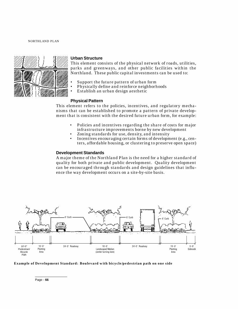
Page - 66
NORTHLAND PLAN
Urban StructureThis element consists of the physical network of roads, utilities,parks and greenways, and other public facilities within theNorthland. These public capital investments can be used to:
• Support the future pattern of urban form• Physically define and reinforce neighborhoods• Establish an urban design aesthetic
Physical PatternThis element refers to the policies, incentives, and regulatory mecha-nisms that can be established to promote a pattern of private develop-ment that is consistent with the desired future urban form, for example:
• Policies and incentives regarding the share of costs for majorinfrastructure improvements borne by new development
• Zoning standards for use, density, and intensity• Incentives encouraging certain forms of development (e.g., cen-
ters, affordable housing, or clustering to preserve open space)
Development StandardsA major theme of the Northland Plan is the need for a higher standard ofquality for both private and public development. Quality developmentcan be encouraged through standards and design guidelines that influ-ence the way development occurs on a site-by-site basis.
10'-0"Pedestrian/
BicyclePath
�����������
���
��������������� �����������������������������������
��������������� !����"������#
�!���������
���
���$��%���$��%���$��%
Example of Development Standard: Boulevard with bicycle/pedestrian path on one side
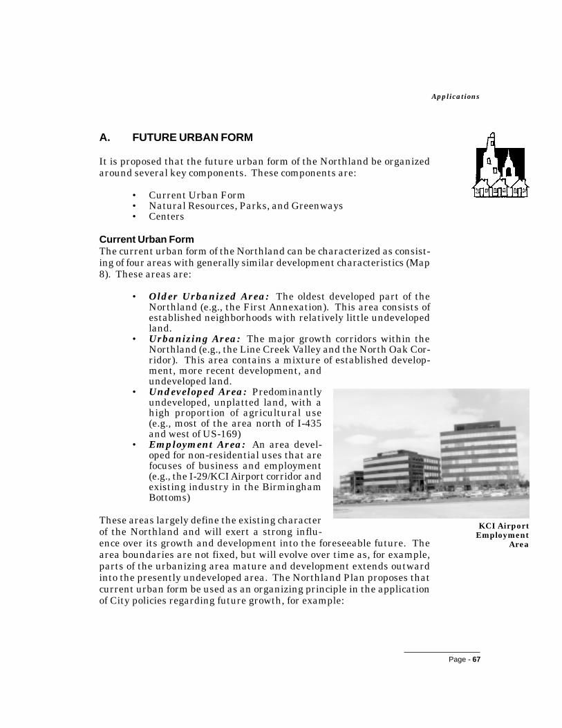
Page - 67
Applications
A. FUTURE URBAN FORM
It is proposed that the future urban form of the Northland be organizedaround several key components. These components are:
• Current Urban Form• Natural Resources, Parks, and Greenways• Centers
Current Urban FormThe current urban form of the Northland can be characterized as consist-ing of four areas with generally similar development characteristics (Map8). These areas are:
• Older Urbanized Area: The oldest developed part of theNorthland (e.g., the First Annexation). This area consists ofestablished neighborhoods with relatively little undevelopedland.
• Urbanizing Area: The major growth corridors within theNorthland (e.g., the Line Creek Valley and the North Oak Cor-ridor). This area contains a mixture of established develop-ment, more recent development, andundeveloped land.
• Undeveloped Area: Predominantlyundeveloped, unplatted land, with ahigh proportion of agricultural use(e.g., most of the area north of I-435and west of US-169)
• Employment Area: An area devel-oped for non-residential uses that arefocuses of business and employment(e.g., the I-29/KCI Airport corridor andexisting industry in the BirminghamBottoms)
These areas largely define the existing characterof the Northland and will exert a strong influ-ence over its growth and development into the foreseeable future. Thearea boundaries are not fixed, but will evolve over time as, for example,parts of the urbanizing area mature and development extends outwardinto the presently undeveloped area. The Northland Plan proposes thatcurrent urban form be used as an organizing principle in the applicationof City policies regarding future growth, for example:
KCI AirportEmployment
Area

Page - 68
NORTHLAND PLAN
• Setting of priorities for public investment in infrastructureimprovements (e.g., roads, water, and sewer) to serve existingor contiguous rather than noncontiguous development
• Use of fiscal or regulatory incentives to encourage infill devel-opment
Natural Resources, Parks, and Open SpaceThe Northland’s abundant natural resources - its woodedstreams, steep topography, and expansive open spaces -contribute greatly to its character and desirability as aplace to live while performing important environmen-tal functions, such as flood control. These resourcestend to be concentrated along the Northland’s streamcorridors. Nevertheless, upland areas, including scenicvistas across rolling, rural landscapes, have value aswell.
Closely related to the Northland’s natural resources is its system of parksand greenways, proposed for significant expansion by the 1991 Plan for aKansas City Metropolitan Greenway System (Metro Green) and the 1993Plan for Parks, Recreation, Boulevards, and Greenways. A well-devel-oped system of parks and greenways yields multiple benefits, including:
• Recreation: Provides opportunities for walking, biking, andother leisure and recreational opportunities, thus contribut-ing to the health of the community as a whole
• Aesthetic Preservation: Helps to conserve the visual qualityof the landscape
• Preservation of Natural Resources: Sustains natural diver-sity and healthy ecosystems
• Education: Provides opportunities to learn about the naturalenvironment, thus instilling natural values in future genera-tions
• Organization: Helps to structure the pattern of private de-velopment and public facilities
• Flood Control: Through regional stormwater detention ba-sins, eliminates the need for individual detention ponds andprovides recreational opportunities associated with multi-pur-pose lakes
• Pollution Attenuation: Maintains the quality of natural wa-tercourses
• Cost Savings: Reduces the need for expensive infrastructureimprovements to address drainage and water quality prob-lems
Large expanses of theNorthland remain inagricultural use.

Undeveloped Area
UrbanizingArea
OlderUrbanizedArea
EmploymentArea
EmploymentArea
Map 8.
Northland Urban Form0 1/2 1 2 miles
N
Urbanized Land
Priority Development Areas

Page - 69
Applications
• Connection: Links together existing and new amenities andfacilities, and unites communities and municipalities
• Transportation: Provides routes for alternative modes ofmovement such as walking and biking, thus easing traffic con-gestion
• Tourism: Preserves the natural, cultural, and historic re-sources that draw visitors to a region
• Economic Development: Increases property values and pro-vides an amenity attractive to prospective businesses
• Social Life: Creates opportunities for people to interact anddevelop a sense of community
Natural resources, parks, and greenways are proposed as the second keycomponent around which the future urban form of the Northland will bestructured (Map 9). This will be accomplished by establishing an inter-connected network of stream corridors, parks and open spaces, andgreenway corridors as the basic framework within which developmentoccurs. Realization of this concept will be dependent upon: 1) aggressiveimplementation of Metro Green and the Plan for Parks, Recreation, Bou-levards, and Greenways; and 2) preservation of stream corridors and otheropen space areas in individual developments through use of clusteringand other innovative development options. A comprehensive inventoryof key natural and visual resources should be conducted to help furtherdefine the desired form of the Northland’s future open space system.
Implementing a continuous network of parks and greenways within theNorthland as part of a regional Metro Green system will require a multi-jurisdictional response. Open space acquisition and development shouldbe financed through a combination of public and private funds. Publicfinancing mechanisms that could be pursued in the context of the finan-cial management strategies recommended by the Governance Plan in-clude, among others, revenue or general obligation bonds and specialbenefit districts. Additional work is needed to identify the form of publicfinancing that makes sense for Kansas City and the region. Private do-nations have traditionally been an important source of revenue for parkacquisition and development in Kansas City and should continue to playan important role, perhaps through a coordinated public/private partner-ship. In many communities, private land conservation trusts have beenformed to work with landowners to protect key holdings, either throughoutright acquisition or through the dedication of conservation easementsto protect the land as open space.

Page - 70
NORTHLAND PLAN
CentersCurrent growth trends in the Northland are resulting in a land-consump-tive, undifferentiated pattern of single-use, residential and commercialdevelopments typical of suburban areas throughout the country. As analternative to the current trend, future development in the Northlandshould be structured around a hierarchy of defined centers. The benefitsof this policy include:
• The more compact development pattern promoted by centerscan be less costly and more efficient to serve with public infra-structure and services than commercial and residential sprawl.
• Focusing commercial development in nodes rather than in lin-ear strips reduces curb cuts and congestion along arterial road-ways.
• Centers can provide the “critical mass” needed to make tran-sit options viable.
• Centers can lead to a reduction in dependence on private ve-hicles for travel by: 1) bringing home, work, and shopping intocloser proximity through mixing of uses and 2) providing op-portunities for pedestrian/bicycle linkages to surrounding resi-dential areas.
• Centers can be a source of community and neighborhood iden-tity.
Integrated Open Spaceand Pedestrian Access
Connection to Parksand Greenway System
NeighborhoodConnection(s)
RoadwayConnection(s)
Integrated Uses:- Commercial- High Density Residential- Institutional- OfficeTransit
ConnectionComponents of aMixed Use Center

N
Stream Corridors
Existing Parks
Proposed Parks
Existing /Committed Parkways
Existing Streets/Proposed Parkways
Proposed Parkways
Proposed Greenways (Metro Green)
Map 9.Stream Corridors, Parks,and Greenways
Source: Parks and Boulevard Plan, Metro Green
0 1/2 1 2 miles

Page - 71
Applications
Two general types of centers are proposed: Mixed Use and Transporta-tion.1 Potential Northland locations for these types of centers are shownon Map 10.
Mixed Use Centers are higher intensity nodes of development and ac-tivity for the surrounding area. In addition to commercial and residen-tial development, they should incorporate community-serving facilitiessuch as recreational centers and playgrounds, meeting spaces, and tran-sit connections. Pedestrian and bicycle facilities should be provided thatconnect to adjacent neighborhoods and to the larger network of bike paths,greenways, and open spaces.
Mixed Use Centers are divided into Regional, Community, and Neigh-borhood categories depending upon their size and intensity of develop-ment:
• Mixed Use Centers (Regional) are primary concentrationsof commercial development and other land uses serving anentire region. These centers typically include major land useattractions such as hotels, regional shopping, residential den-sities greater than 20 dwelling units an acre, cultural facili-ties, major office developments, hospitals, and colleges/univer-sities.
One existing regional mixed use center -Metro North at the intersection of US 169and Barry Road - has been identified in theNorthland. (It should be noted that thisdevelopment is an automobile-oriented,single-use shopping mall that does not in-clude all the facets of a fully functioningregional center.) Kansas City’s Urban Corealso functions as a regional center for theNorthland.
���������������������� �� �������� ������������ ����������������� ��������� � �� ��������������������������������������������������������������������������� �������������� ���������������!� ��� ��������� ��������� �� ������������������������� ��������������� ���������������� ���� ���"#� �����������$
% ������������ ����� ���� � � �� ��� ������� �� ��������� ��� ��� ������������ �������������� ����� �� � � �� �������&� ��������� ������� �� ����&������ ���� ������� ��������������������� �������������� ��� ���� �����������'��� ���������&��������� ��(���������� ����� ���������������������������� �������������������������� ��� �� ��� ������������� )��������������������&�������������� ������ ���#��������������������#�������*�����������������������&+���������������������������&!����������������������������
% � ��������������������� ���� ����� �������������������������� ����������&������� ��� ������ ������ ��� �,���!���-���� ���������������� ��. ����������������&��������/�������� ���0�� ������������������ ���������������� � ����� ����� ������� ��"#� ���������������������������� ��
Metro North is anautomobile-oriented
regional center.

Page - 72
NORTHLAND PLAN
• Mixed Use Centers (Community) are subregional nodes ofcommercial and other community-serving activities. Less in-tense than regional centers, these centers typically includecommunity or regional shopping, densities greater than 14dwelling units an acre, cultural facilities, medical and profes-sional offices, and financial institutions.
Five existing and three potential community mixed usecenters have been identified in the Northland. Existingcenters include the Antioch Shopping Center at Antiochand Vivion Road, the developing commercial/multi-fam-ily area (Barrybrook/Barry Crossing) at I-29 and BarryRoad, Tremont/Picture Hills (commercial/residential de-velopment at I-29 and 64th Street), and the downtownsof Liberty, North Kansas City, and Parkville. Potentialfuture centers include Line Creek (in the vicinity ofWaukomis Drive, 64th Street, and the future Line CreekParkway); Nashua (in the vicinity of North Oak Traf-ficway, 108th Street, and the future Shoal Creek Park-way); and Shoal Creek (east of I-435, in the vicinity of76th Street and the Shoal Creek Parkway).
The existing community mixed use centers vary widelyin character. Like Metro North, Antioch is an automo-bile-oriented, single-use shopping center. Barrybrook/Barry Crossing is characterized by a linear, automobile-oriented development pattern, but includes multi-family housing and a major institution (Saint Lukes Hos-pital) in addition to commercial uses. Liberty, North Kan-sas City, and Parkville are traditional downtown activ-ity centers that are a strong source of identity forNorthland residents.
• Mixed Use Centers (Neighborhood) are smallerscale centers that provide focal points of activity for surround-ing neighborhoods. Possible components of these centers in-clude schools, parks, and other community facilities; local-serv-ing stores and professional offices; and higher density residen-tial development than the surrounding area.
Neighborhood mixed use centers will be located through thearea and neighborhood planning process in response to localopportunities and issues.
Antioch Center
DowntownLiberty
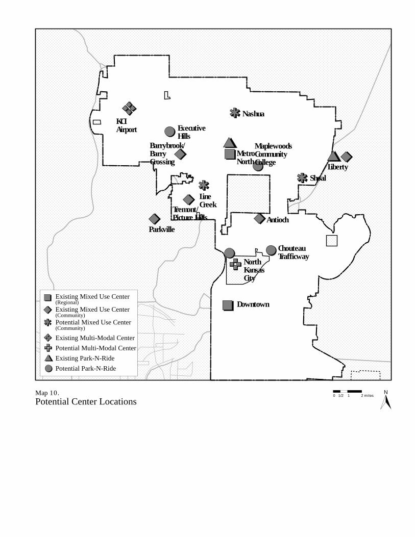
Shoal
Downtown
KCIAirport
ChouteauTrafficway
ExecutiveHills
Barrybrook/BarryCrossing
Nashua
MetroNorth
MaplewoodsCommunityCollege
LineCreek
Antioch
NorthKansasCity
Liberty
Parkville
Tremont/Picture Hills
Map 10.Potential Center Locations
N
Existing Mixed Use Center(Regional)Existing Mixed Use Center(Community)Potential Mixed Use Center(Community)
Existing Multi-Modal Center
Potential Multi-Modal Center
Existing Park-N-Ride
Potential Park-N-Ride
0 1/2 1 2 miles

Page - 73
Applications
Transportation Centers are locations that support the linking of au-tomobile traffic to other travel modes, such as transit. TransportationCenters are divided into Multi-Modal and Park-N-Ride Centers:
• Multi-Modal Centers are locations that support the comingtogether and linking of many transportation modes includingair travel, Amtrak, commuter rail, light rail, and major busroutes.
Two potential multi-modal centers have been identified inNorthland. The first is the KCI Airport, which provides anopportunity for enhanced linkages between air travel and otherforms of transportation. The second is in the vicinity ofBurlington Street and Oak Trafficway adjacent to North Kan-sas City, a logical location for a transit hub connecting theNorthland to the Urban Core.
• Park-N-Ride is a unique type of center, typically located inoutlying suburban areas along dedicated transit corridors andmajor express bus routes. Suburban residents can drive topark-n-ride facilities to access express service to the multi-modal, regional, and community centers.
Two existing and four potential Park-N-Ride locations havebeen identified in the Northland. Existing Park-N-Ride fa-cilities include Metro North and Liberty (at the intersection ofI-35 and M-152). Potential Park-N-Ride locations includeBurlington Street and Oak Trafficway (in conjunction withthe multi-modal center), I-29 and Executive Hills Boulevard,M-210 and Chouteau Trafficway, and Maplewoods CommunityCollege.
The potential Transportation Center locations have been coordinated withthe location of “Transfer Centers” proposed in the Northland Public Trans-portation Planning Study.

Page - 74
NORTHLAND PLAN
B. URBAN STRUCTURE
Public facilities and infrastructure - transportationsystems, utilities, public parks, and other community-serving facilities - form the framework within whichprivate development occurs. Public investment inthese facilities is a powerful tool that can be used tohelp define the future pattern of growth in theNorthland. The role of City parks - as part of anoverall system of natural resources, greenways, and
open spaces - in shaping the future urban form of the Northland hasalready been described. Other important components of the Northland’s“Urban Structure” include transportation, utilities, and the design of pub-lic facilities and spaces.
TransportationA broad range of actions, implemented over a number of years, will beneeded to provide the Northland with the transportation systems neededto adequately serve existing and future development in the Northland.These actions include:
• Major highway and arterial improvements• Development of a supporting system of secondary arterials and
collector streets• Maintenance and reconstruction of existing substandard road-
ways• Access control and transportation demand management pro-
grams• Increased “people carrying” capacity of the bridges over the
Missouri River• Enhanced transit service• Development of a pedestrian and bicycle path network• Regulatory changes (traffic impact analysis) to address the
multi-modal transportation impacts of new developments
Highway ImprovementsImprovements to the Northland’s freeways and highways should be di-rected toward east-west movement, problem interchanges, and providingthrough access for pedestrians and bicycles. Furthermore, additionalcapacity to the Missouri River crossings is critical to the Northland’sfuture and maintaining strong connections with the Urban Core. Inter-state, U.S. Highway and State Highway improvements that are priori-ties for implementation by the Missouri Department of Transportationare as follows (Map 11):
Line CreekCommunityCenter
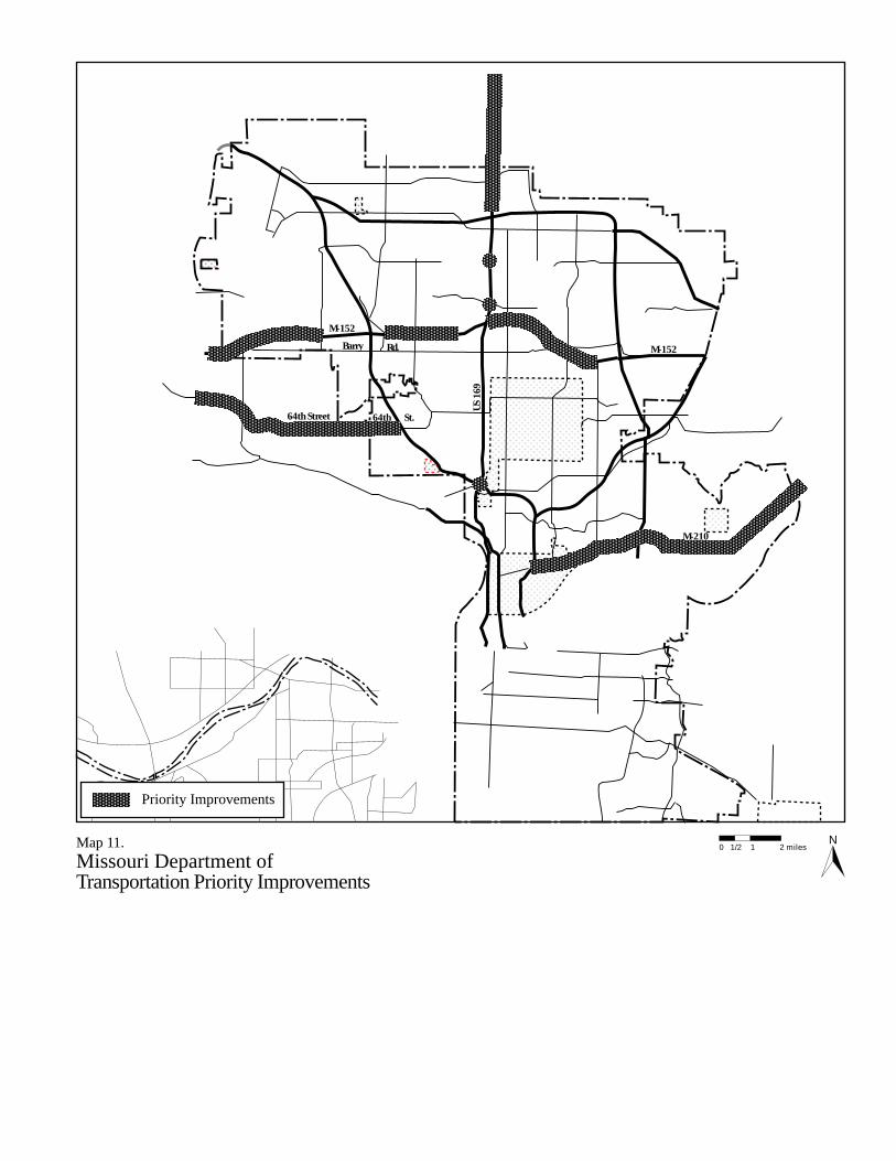
Map 11.Missouri Department ofTransportation Priority Improvements
N
Priority Improvements
64th St.
Barry Rd.
0 1/2 1 2 miles
M-152
M-152
M-210
64th Street
US 1
69

Page - 75
Applications
M-152: Interchanges at Maplewoods Parkway and Green Hills RoadCompletion between US 169 and Brighton RoadIncrease capacity, 2 to 4 lanes, Executive HillsBoulevard to Baughamm RoadIncrease capacity, 2 to 4 lanes, I-435 to Amity
M-45: Increase capacity, 2 to 4 lanes, M-9 to I-29Increase capacity, 2 to 4 lanes, I-435 to M-9
M-210: Improve turning movement capacity at key intersections (I-35 and I-435)Increase capacity, 2 to 4 lanes, I-435 to east of Eldon RoadIncrease capacity, 2 to 4 lanes, east of Eldon Road to M-291
US-169: Increase capacity, 2 to 4 lanes, I-435 to M-92Construct Interchanges at 96th Street and 108th Street
US-169/I-29 Interchange:Safety improvement of south bound I-29 off-ramp to US 169Capacity improvements of merge between I-29 off-ramp andUS 169
I-35/M-210 Interchange:Capacity improvement from north bound I-35 to east boundM-210
Major Street PlanImproving the City’s arterial systemis a major priority for infrastructureinvestment in the Northland. Kan-sas City’s Major Street Plan for theNorthland is shown on Map 12.This plan presents proposed park-ways/boulevards, primary arterials,secondary arterials, and the systemof freeways, interstates and express-ways. Arterial improvementsshould be directed to priority devel-opment areas (i.e., the older urban-ized, urbanizing, and employmentareas). Arterial improvementswithin and serving undeveloped areas, particularlythose areas that do not have other utilities, should begiven a lesser priority.
Waukomis Drive isidentified as a future
parkway on the MajorStreet Plan.
Page - 76
NORTHLAND PLAN
Based on a preliminary cost analysis using linear cost estimates for road-way type and segment length, it is estimated that the total cost to com-plete the arterial street system in the Northland is approximately $1.5billion. Included in this figure are approximately $700 million in im-provements within priority development areas and $800 million withinnon-priority development areas.
Because of the magnitude of the arterial improvements required to sup-port the full development of the Northland, individual improvementprojects were prioritized into three categories (Phase 1, Phase 2, andPhase 3) using the Preliminary Transportation ImprovementPrioritization methodology described in Appendix A. The prioritizationwas based upon the effects of the projects on system continuity, conges-tion mitigation, safety enhancement, the environment, and economic ben-efit. Table 2 presents the three tiers of improvement projects, each total-ling approximately $100 million in estimated costs, along with the cu-mulative costs of the projects.
The three phases of arterial improvements are shown on Map 12. Thisphasing plan is intended only as a guide and should be regularly updatedto reflect current development trends.

M-152
M-210
Englewood Rd
Vivian Rd
108 th St
Barry Rd
72nd St
Tiffany Springs Prkwy US
169
Oak
Trf
wy
Bri
gh
ton
Rd
I-435
M-152
KCI
M-152
112 th St
NW 128 th St
64th St
I-435
I-435
Parvin Rd
Independence Av
M-210
I-35
I-35
I-70
I-35
Map 12.Northland Major Street Plan
N
Primary Arterials
Parkways/Boulevards
Freeways/Interstates
Expressways
Phase 1 Priority
Phase 2 Priority
Phase 3 Priority
Brig
hton
Ave.
VivionRd.
Traf
ficw
ayOa
k
64th St.
Barry Rd.
Tiffany Springs Pkwy.
Shoal Creek Pkwy.
Map
lewoo
ds
Pkw
y.
Chou
teau
I-435
M-152
M-152
I-29
US 1
69
Pkw
y.
I-35
M-210
Line
Cree
kPk
wy.
0 1/2 1 2 miles

Page - 77
Applications
Table 3. Northland Priority Arterial and Boulevard Improvements
Phase 1 Arterial and Boulevard Improvements (0 to $100 million)
����������� ������� ������ ������������� ����� ��� ��������
���������� �� ���� �������� ����������������� ���� ����� ��������� ���������
��� ������ ��!��� ���������� �"���#����� $�����%&���� ���� '���� ��������� �(��������
��������)*��%� �+��� ��*������ ����������������� ���� ����� "�������� ����������
"���,"(��,'����#����� -$�$���.��� ������� ����������������� ���� ��"�� ��"������ �'��������
���������� )��� /+�� ����������������� ���� '���� ��������� 0"��������
$��%���%�1����&��� �+��� /+0� ����������������� ���� (�'�� ���'������ ����������
"���,"(��,'����#����� ������� /+�0� $�����%&���� ���� "�"�� ���(����� �"��'�����
'����#����� 2*�� ��� ��%!����3�*� $�����%&��������� ���� 0���� 0�'������ "��0������
'����#����� ��������� 2*�� ����3�*� ����������������� ���� ����� ��������� "��(������
�������4� ������� 5 ��������$���.��� 6�������������� ����������������� ���� ����� ��������� '��(������
4*���#������&��� 2�!�1����&��� 4*������� $%�7���#���� ! �"���� ���(����� '���������
68�&%�*�� ��� *�� 9������������������ 1������#����� $�����%&���� ���� ������ ���������� (���������
2�!�#������&��� 0����#����� 4*������� $%�7���#���� ! ����� '������ (��(������
��������)*��%� ����4� ������� '����#����� ����������������� ���� 0���� ��������� ((�(������
.���$���!� ��!��� "(���#����� ���������� $�����%&���� ���� ���"�� (��(����� �'�0������
"���,"(��,'����#����� 5�����3�*� ��%!����3�*� ����������������� ���� ����� ��������� ����0������
Phase 2 Arterial and Boulevard Improvements ($100 to 200 million)
����������� ������� ������ ������������� ����� ��� ��������
9������������ 4*������� ����4� ������� ����������������� ���� ��'�� �'��"����� ��(�'"�����
��� ������ ��!��� ��������)*��%� ���������� $�����%&���� ��� ������ ���������� �0���"�����
.���$���!� ��!��� 6�� ���������� "(���#����� ����������������� ���� (���� (�������� �0��""�����
��� ������ ��!��� �"���#����� ��(���#����� $�����%&���� ��� (���� ���������� ����""�����
��������)*��%� '����#����� ���������� :�����*�������� ���� '���� "�������� ����""�����
��%!����3�*� �+��� '"���#����� ����������������� ���� (���� (�������� �"0�""�����
6�� ���������� ��%!����3�*� :#+�"� ����������������� ���� ����� "�������� �"��""�����
�"���#����� 2*�� ����3�*� /+�� ����������������� ���� "���� '�������� �''��"�����
6�� ���������� /+�� ��%!����3�*� $�����%&���� ��� ����� ��������� �(���"�����
����& ��� ��!��� ����& ������� 9�����2�! $�����%&��0������ ���� ����� '�������� �("��"�����
��(���#����� :#+�"� 2�!�1����&��� ����������������� ���� ��(�� ��(������ �((��"�����
�"���#����� 2�!�1����&��� ���� ��� ����������������� ���� ��0�� ��0������ �����"�����
2�!�1����&��� ��(���#����� �+��� ����������������� ���� ����� ��������� ��0��"�����

Page - 78
NORTHLAND PLAN
Phase 3 Arterial and Boulevard Improvements ($200 to 300 million)
����������� ������� ������ ������������� ����� ��� ��������
#!�*���3�*� /+�� ��(���#����� :�����*�������� ���� ������ ���������� �����"�����
5����� ������ '"���#����� "(���#����� ����������������� ���� ����� "�������� �����"�����
��(���#����� 2�!�1����&��� ���� ��� $�����%&���� ���� ��0�� "�0"����� ��'�"������
�"���#����� $���.�� 2*�� ����3�*� :�����*�������� ���� "���� "�������� �00�"������
5����� ������ �+��� 1������#����� ����������������� ���� "���� "�������� �0��"������
.���$���!� ��!��� 1������#����� ��(���#����� $�����%&���� ���� '���� (�������� ��(��������
#��� �$���!� ��!��� .7���� �������4� �� $�����%&���� ���� '���� ���������� �"���������
#��� �$���!� ��!��� ��*� .7���� $�����%&���� ���� ������ ���������� �'"��������
�������4� ������� ������� �4��$���.��� :�����*�������� ���� ����� ��������� �(���������
1������#������ ��!��� /+�� 5����� ������ $�����%&���� ���� (���� (�������� �((��������
����& ��� ��!��� 9�����2�!�1����&��� ��*� $�����%&��0������ ���� ����� '�������� ��"��������
.���$���!� ��!��� "(���#����� ���������� ����������������� ���� ���"�� ��0������ 0���'������
Secondary Arterials and Collector StreetsA system of secondary arterials and collector streets is necessary to sup-port the freeways and primary arterial system. Ideally, the system ofnorth/south and east/west secondaries and collectors should be spaced atapproximately one-half mile increments to the freeway and primary ar-terial streets. Area traffic studies should be conducted to determine de-velopment access to the secondary and collector street system.
Maintenance and ReconstructionA significant number of major and secondary arterials in the Northlandare below current design standards and are in need of maintenance. Inorder to safely serve the existing Northland population, a ten and 20-year improvement program should be developed to address the most criticalmaintenance needs. Maintenance and reconstruction resources shouldbe allocated to upgrade to acceptable condition the roadways identifiedas most in need of improvement. Maintenance of newer and yet to beconstructed facilities is also critical to long-range transportation plan-ning for the Northland. Without ongoing maintenance, major additionalimprovement costs will occur in the future.
Page - 79
Applications
Access ControlAccess control plans should be developed for all arterials identified in theMajor Street Plan. Locations for proposed signalized intersections shouldbe based on both signal warrants and strategic locations which will main-tain design progression speeds. Locations which are not identified aslocations for signalized intersections should not be permitted full move-ment access. Traffic studies for all proposed developments requestinglocations for non-signalized left turn in, right turn in and out movementsshould be prepared to address level of service, traffic flow, weaving, andqueue analysis. Consolidation of access between developments should beconsidered as part of development approval.
Transportation Demand ManagementThe Missouri Department of Transportation, City of Kansas City, theMid America Regional Council, and the Kansas City Area TransportationAuthority should enter into an agreement to develop and promote Trans-portation Demand Management support services for businesses and resi-dents in the Northland. This would include management assistance forbusinesses to develop Transportation Management Organizations (TMO),car pool matching, and van pool programs.
'��;
PREFERRED PATTERN FOR MAJOR ARTERIALS: 1/2 mile spacing between signals at major intersections (signals can be added 700' on either side of intersection).
DEVELOPING TRAFFIC SIGNAL PATTERN: Existing Required for Approved Projects
/+�� 9�2�!�1����&���:#+�"�
The developing traffic signal pattern along Barry Road from I-29 to North Oak Trafficwaywill lead to increased congestion.

Page - 80
NORTHLAND PLAN
Bridge CapacityActions should be taken to increase the people carrying capacity of thebridges connecting the Northland and the Urban Core. Increased capac-ity may include adding additional general purpose and high occupancyvehicle lanes, extension of light rail, and/or bike lanes. Management ofexisting demand through promotion of staggered work hours or flextimeshould be promoted. Intelligent transportation systems (ITS) should beimplemented to reduce congestion through electronic management ofbridge traffic, providing motorists with real time information regardingcongested bridges and alternative routes with available capacity. Re-versible lanes during the morning and evening peaks should be consid-ered as part of this system.
TransitTransit provides a critical service for the Northland’s young, old, andtransit dependent. A proposed transit plan for the Northland, based uponthe March 1997 Northland Public Transportation Study, is illustrated onMap 13. The plan calls for a series of express routes, trunk routes, andfeeder routes to serve the Northland. In addition to the bus service, Map13 identifies the preliminary alignment for a dedicated transit corridorfrom south of the River to the KCI Airport.
Transit utilization is a function of coverage, accessibility, frequency, hoursof service, and route structure. Coverage is defined as the number ofstops and development intensity within one-quarter mile of each stop.Adding routes and stops is very costly to increase coverage, particularlyat lower densities. Therefore, higher density infill development shouldbe promoted to increase potential residential and business ridership. Thiswould require changes in zoning to permit higher densities within one-quarter mile of a mixed use center/transit stop. This change in densityand development patterns will not yield rapid increases in ridership, butshould result in a sustainable level of service over the long term.
Accessibility is critical to the success of transit. Regardless of the den-sity, number of routes and service provided, transit patronage will notreach fruition if the potential user cannot access the system. This lack ofaccess may be because there are no safe sidewalks, walls and barriersseparating residential and commercial developments from the stop, orthe design of the development creates large parking areas between thetransit stop and building destinations. It is therefore proposed that all

Map 13.Northland Transit Plan
N
Express Route
Trunk Route
Feeder Route/Metroflex
Future Light Rail
Future Transit Corridor
Existing Mixed Use Center(Regional)Existing Mixed Use Center(Community)Potential Mixed Use Center(Community)
Existing Multi-Modal Center
Potential Multi-Modal Center
Existing Park-N-Ride
Potential Park-N-Ride
0 1/2 1 2 miles

Page - 81
Applications
development proposals be reviewed and analyzed as to pedestrian con-nections between the existing and potential future transit stop and desti-nation.
Park-N-Ride lots and connecting express bus or light rail transit serviceto south of the River should be promoted. As previously noted, two exist-ing and four potential Park-N-Ride locations have been identified for theNorthland. The success of linking Park-N-Ride to transit in the Northlandis closely tied to the overall City transportation strategy. To promotetransit usage to and from the Northland, capacity could be added to Mis-souri River crossings through light rail extensions or high occupancyvehicle lanes instead of general purpose lanes, to improve the travel timebenefit of transit compared to the automobile. Also, the amount of newparking within the Urban Core should be limited and the price of park-ing structured to allow transit to be competitive.
Reverse transit from south of the River to the Northland would increasethe utilization of transit and benefit the Northland. These services havetypically failed because Northland destinations do not currently providethe local density needed to support transit. Fur-ther promotion of mixed use centers or local des-tination shuttle service should be a part of anyfuture reverse transit proposal.
Pedestrian and Bicycle PathsPedestrian sidewalks and bicycle paths shouldbe developed to link neighborhoods to each otherand to transit, schools, parks, shopping and othercommunity services. Area plans should be pre-pared that refine the Mid-America RegionalCouncil (MARC) bikeway plan. Street standardsshould be revised to require bike lanes and side-walks for all new roads. Existing streets shouldbe examined for the lack of safe, continuous bi-cycle and pedestrian facilities, particularly within one-quarter mile of allcommercial areas, transit routes, schools, parks, and other high activityareas.
Traffic Impact AnalysisAll developments of significant size should be required to conduct a traf-fic impact analysis addressing automobile, transit, pedestrian, and bi-cycle circulation. The objective of these studies is to identify necessary
Roadway with bicyclelane, sidewalk, and
planting area
�������������
��������������
�����������
����������������������
������� � �!��

Page - 82
NORTHLAND PLAN
on-site and off-site improvements to offset project impacts. The City mayrequire the developer to make any required improvements; the cost ofoff-site improvements could be deducted from development fees if a traf-fic impact fee system were implemented. If a development requires sig-nificant off-site improvements because the phasing of the project doesnot follow a logical development pattern, the developer could be requiredto pay a higher fee, to be reimbursed when subsequent fees are collectedfrom future development requiring the same improvements. Key ele-ments of the traffic impact study should be as follows:
• Introduction: Proposed development and the extent of studyarea should be described.
• Existing Conditions: a.m. and p.m. peak hour turn movementsand level of service analysis within the study area should beconducted to determine whether existing traffic volumes ex-ceed standards. This analysis would also be required to ad-dress existing pedestrian, bicycle, and transit circulation withinthe study area.
• Cumulative Conditions: Previously approved or anticipateddevelopments that may affect the study area’s circulation sys-tem should be identified and projected traffic assigned to theexisting roadway network. Annual growth rates should beestimated for a ten and 20-year plan horizon and mitigationmeasures identified to offset cumulative conditions if level ofservice exceeds standards. Pedestrian and bicycle improve-ments should be provided to serve adjacent developments,schools, parks, transit, and activity areas within one-quartermile of the proposed development.
• Trip Generation/Distribution/Assignment: Using establishedrates identified in the Institute of Transportation EngineersTrip Generation Manual or as agreed to with City staff, dailya.m. and p.m. peak hour trip generation for the proposed de-velopment should be determined. The anticipated trip distri-bution patterns for the proposed development should be de-scribed and the projected traffic assigned to the intersectionsand streets within the study area.
• Future Condition Plus Project Analysis: Project a.m. and p.m.peak hour and daily traffic volumes should be added to exist-ing plus committed traffic volumes. Intersection level of ser-vice analysis should be conducted to determine whether traf-fic volumes exceed street standard thresholds.

Page - 83
Applications
• Signal Warrant/Progression and Access Analysis: A determi-nation should be made as to whether proposed full access in-tersections can be accommodated within acceptable signal pro-gression guidelines and that volumes exceed signal warrants.Projects involving access to the arterial street system shouldindicate appropriate conformance with City’s access require-ments.
• Mitigation Measures: On and off site automobile, pedestrian,and bicycle project mitigation to offset project impacts shouldbe determined.
Transportation Project FundingGiven the major scope of new circulation improvements plus safety andcapacity upgrades to existing facilities needed in the Northland, a cre-ative and comprehensive program for funding transportation projects willbe needed as part of the financial management strategies proposed bythe Governance Plan. Tools to be considered in implementing this pro-gram include the following:
• Right-of-Way Dedication: All future developments would berequired to dedicate their share of the needed right-of-way forroads, consistent with the Major Street Plan and right-of-waystandards.
• Developer Exactions: Developers would be required to con-struct a fair share of road improvements abutting their prop-erty, or off-site improvements that are required to mitigatedevelopment impact. “Their share” may include curb, gutter,sidewalk, landscape parkway, street lights, and one travel lane.Off-site improvements would be based upon a traffic impactanalysis.
• Local or Special Improvement Districts: Some local govern-ments make extensive use of local or special improvement dis-tricts to finance construction of arterials in growing areas.Typically, property owners within the district pay for the ma-jority of the improvements with some level of contribution fromlocal government. Proposed Missouri state legislation wouldallow Community Improvement Districts (CIDs) to be estab-lished in the Northland and is further discussed later in thissection.
• District Financing: Special district financing for infrastruc-ture improvements, such as roads and bridges, is fundedthrough property tax or sales tax collected within a defined

Page - 84
NORTHLAND PLAN
district. Special districts have been established within ClayCounty; however, current State of Missouri statutes do notpermit districts within the City of Kansas City portion of ClayCounty. Clay County has a sales tax to fund road and bridgeprojects, but the return on the tax collected is significantlylower in Kansas City (which is not in a district) compared tothe portion of the County within road districts. Three specialdistricts exist within Platte County, two of which have por-tions of Kansas City within them. In order for special roaddistrict financing to be effective within the Northland, therewill need to be a change in state statutes to permit the cre-ation of new districts or the expansion of existing districts anda more equitable distribution of the revenues collected. Asrecommended by the Governance Plan, the City should coop-erate with other jurisdictions to promote this and other legis-lative initiatives that provide more funds for priority local pro-grams.
• Oversizing: It may be appropriate in some instances to re-quire developers to oversize road or intersection improvementsto serve future development. This would be coupled with areimbursement program from subsequent developments thatalso benefit from the oversized improvements.
• Impact Fees: Road impact fees may finance new road con-struction including lanes in addition to the single lane requiredby adjacent developments, medians, special intersection treat-ments, drainage improvements, bridges, and bikeways. Thesefees would only be used for the improvements required to servefuture development and could not be applied to improvementsnecessary to mitigate existing problems or deficiencies.
• Transportation Maintenance Fees: In order to maintain theexisting transportation infrastructure, some jurisdictions col-lect a transportation maintenance fee, based upon propertytax, vehicle registration fees, or sales tax.
• Tax Increment Financing: Commonly used to fund local trans-portation improvements in the Northland, this mechanisminvolves use of a percentage of the revenues generated by aproject to pay back construction of public infrastructure im-provements that benefit the development. Tax increment fi-nancing should be carefully evaluated for its effect on futuretax revenues available for other necessary services, such asschools.

Page - 85
Applications
A preliminary system for prioritizing Northland transportation projectsis presented in Appendix A. This system needs to be coordinated with on-going City and regional efforts at prioritization.
Utilities
Water ServiceWith the passage of the 1996 water system capital improvement pro-gram, the Northland is in a relatively favorable position regarding pub-lic water supply. Various system improvements are either underway orplanned, including mandated improvements in water treatment facili-ties and water quality monitoring and analysis capabilities. Various othersystem improvements are needed, such as elevated storage to assist inthe maintenance of system pressures in the Northland and distributionsystem capacity improvements. The latter will provide enhanced fireprotection and improved service to established areas.
A major water supply issue is the extent to which public investment shouldbe directed towards new service extensions. In general, maintenance ofthe existing water supply system and selective upgrading of inadequatesegments in developed areas should have a higher priority than extend-ing water service into undeveloped areas. This concept should be ap-plied in setting priorities for projects to be implemented through the wa-ter system capital improvement program. (It should be noted, however,that some of the improvements planned for areas currently without ser-vice are needed to provide adequate service to existing neighborhoodsand/or allow infill development on existing lots.) System expansions shouldonly be done in concert with established land use plans and policies.
As a related matter, Kansas City currently supplies treated water to sev-eral surrounding jurisdictions. Consistent with the financial manage-ment and intergovernmental relations strategies recommended by theGovernance Plan, this practice should be continued, as it optimizes theuse of existing infrastructure and provides revenue to support facilitiesthat would otherwise represent stranded investment.
Sewer ServiceAs with water service, priority should be given to maintenance of theexisting sewer system and selective upgrades to improve service to devel-oped areas. Development that is remote from existing sewer service should

Page - 86
NORTHLAND PLAN
be expected to pay most of the cost for connection to the public sewersystem. The City may wish to consider options to improve the flexibilityof providing sewer to areas that are currently without service. One is toexpand the definition of Bond Sewers to include any oversize required toaccommodate future development beyond the 8-inch line needed to servean individual project. This would be similar to current water servicepractice. In addition, other options for remote development need to beexplored, such as pumping to existing treatment plants and the use ofcommunity waste treatment systems. In the latter category are commoncollection systems, waste treatment lagoons or similar facilities, and pack-age treatment plants. If such local treatment facilities are used, thesystems need to be designed to facilitate ultimate connection to the pub-lic sewer system. Any sewage collection and treatment arrangementsthat do not involve connection to the public system should be carefullyevaluated as a part of the subdivision review process.
The approximately 2,300 residences in the Northland currently servedby on-site septic systems should be connected to public sewers. The pri-ority for these connections should be established on the basis of health orenvironmental hazards resulting from continued use of the septic sys-tems and the financial feasibility of connections. The City should con-sider implementing financial assistance mechanisms, including the for-mation of improvement districts and provision of low-cost financing.
Stormwater ManagementOverall stormwater master planning in theNorthland is only partially accomplished. Com-prehensive planning for the various drainagebasins in the Northland needs to be implementedon a multi-jurisdictional basis. Updated flood-plain mapping also needs to be completed. Fromthese efforts, funding requirements and priori-ties can be established for both new constructionand maintenance. Current funding mechanismsand the sufficiency of revenues should also bereviewed.
The surface elements of stormwater conveyance lend themselves to inte-gration with natural features, such as swales, channels, and open space.Natural drainage patterns and floodplain areas should be preserved tothe greatest extent possible to prevent flooding problems. This policywould also help to preserve the natural character of the landscape so
Stream corridors andfloodplain areasshould be preservedfor their naturaldrainage functions.
Page - 87
Applications
highly valued by Northlanders. Wherever possible, stormwater runoffshould be accommodated using swales and other natural drainage fea-tures rather than storm sewers.
Public Urban DesignA high standard of quality in the design of public facilities and spaceswill both improve the Northland’s physical environment and set an ex-ample for private development to follow. The 1992 City Plan for UrbanDesign lays out an urban design concept for all of Kansas City, encom-passing both public and private development. Within the framework setby the city-wide plan, it is recommended that a coordinated urban designconcept be implemented for the Northland, as a focus for action to en-hance the quality of the public landscape (Map 14). The basic compo-nents of this concept are:
• Gateways• Corridors• Public facilities and spaces• Landmarks• Scenic views• Signage
Gateways are important roadway entrances to and from the Northland.They establish the initial visual image of the Northland as well as itsrelationship to Kansas City South and the rest of the metropolitan re-gion. Key gateways include the Broadway, Heart of America, Paseo,Chouteau, and I-435 bridges; the KCI Airport; and entrances into theNorthland from neighboring jurisdictions along interstates and arterialroadways such as I-35, M-152, and I-635.
Identified gateways should be developed with landscaping, signage, pub-lic art, and other improvements to establish a positive visual image sig-nalling entry into a special part of Kansas City. Priorities for these im-provements include the bridges and the KCI Airport entrance roadway(Cookingham Drive). The current landscape improvements onCookingham Drive should be continued and enhanced with signage andpublic art (e.g., fountains, sculpture). The bridges are particularly im-portant due to their high traffic volumes and role in connecting KansasCity North and South. Potential visual improvements to the bridgesinclude special lighting to transform them into visual landmarks at nightand opening up views of the River for users. Aesthetic standards shouldbe developed for future bridge improvement projects, to address designconsiderations such as lighting, views to and from the bridge, railings,

Page - 88
NORTHLAND PLAN
pedestrian access, and the overall structural form of the bridge. Theprogrammed Chouteau Bridge improvement is an example of a projectthat should incorporate urban design elements.
The “gateway to the downtown” from the KCI Airport along the Broad-way Extension to the Broadway Bridge has been identified as a priorityfor visual improvement. This roadway should be developed with land-scaping and other design improvements to establish a more attractiveapproach to the Urban Core. These improvements could be coordinatedwith development of the proposed North Kansas City multi-modal trans-portation center.
Corridors include the major freeways, arterials, parkways, and boule-vards that define the visual experience of travelling through theNorthland. The City has in place aesthetic standards for parkways andboulevards. "Enhanced" arterial standards have also been adopted butare generally not used. These standards should be reviewed for applica-tion to arterial roadways such as Barry Road, to improve their attrac-tiveness and emphasize their role in linking centers of activity. Thesestandards should address street tree planting and other landscaping, light-ing, pedestrian amenities, and the provision of medians, wherever pos-sible. The standards should also address roadway design with respect toexisting topography, other sensitive natural features, and significant views,such as of the downtown skyline. Examples of current projects that shouldincorporate urban design improvements include the Barry Towne projectat US-169 and Barry Road, the widening of M-45 Highway west of I-29,and the bridge widening at Englewood Road and US-169. A “percent forstreetscape” program, similar to the current “one percent for art,” shouldbe considered as a way of integrating urban design improvements intoroadway projects.
Freeways and many major arterials in the Northland are, of course, notconstructed or maintained by Kansas City. The design of M-152, for ex-ample, will help shape the visual character of the Northland as the high-way is completed. The City’s visual standards should be communicatedto the Missouri Department of Transportation so that the objectives ofthe Northland community with respect to roadway design are under-stood, existing Missouri highway projects can be revised to meet them,and proposed projects can be designed to include them.

Map 14.Northland Urban DesignConcept
N
Gateway
Drainage Divide
Missouri River Bluffs
Missouri River
Major Transportation Corridors:
Primary Arterials
Parkways/Boulevards
Freeways/Interstates
Expressways
*
0 1/2 1 2 miles
** *
Q
** **
***
**
**
*
KCI AirportEntrance
Broadway "Gatewayto the Downtown"

Page - 89
Applications
Public facilities and spaces are important to both civic life and thevisual identity of the community. To reinforce the important role of thesefacilities, design guidelines should be established for government build-ings, schools, parks, and other public spaces. These standards shouldaddress elements such as architectural design, landscaping, pedestrian/bicycle facilities, transit access, and parking. Where possible, existingfacilities should be improved in accordance with the guidelines. A flex-ible “one percent for art” policy should be continued for all public facili-ties to the extent that it enhances quality of life for residents.
Landmarks serve as visual focalpoints and sources of community iden-tity. The Children’s Fountain andNorthland Fountain are two existingpublic landmarks in the Northland.Opportunities should be sought to de-velop new landmarks that enhance theNorthland’s image and identity in pub-lic (as well as private) developmentprojects. Such landmarks could in-clude additional fountains, sculpture,or creative designs of buildings or land-scapes. The landmarks should be lo-cated in visually prominent locations,such as well traveled roadways, and should be accessible to pedestriansas well as to passing vehicles. The “one percent for art” program is onepossible mechanism for funding such landmarks.
Scenic views of the natural and built landscape are provided in parts ofthe Northland by its distinctive topography. Particularly spectacular areviews of the downtown Kansas City skyline from high points on the southface of the ridge that defines the two major drainage basins of theNorthland. Major views and view corridors should be protected fromencroachment and, where possible, made available for the enjoyment ofthe public (e.g., through the provision of pulloffs on roadways with scenicvistas).
Signage is another important urban design element in the Northlandlandscape. As part of a larger effort for all of Kansas City, a coordinated,attractive, informational and directional signage system should be de-veloped throughout the Northland. The purpose of this system would beto 1) direct residents and visitors to important destinations such as activ-
The Children'sFountain is
one of twofountains thatare important
Northlandlandmarks.
Page - 90
NORTHLAND PLAN
ity centers, attractions, and the bridges to the downtown and 2) reinforcethe visual identity of the Northland and its neighborhoods. The systemshould incorporate larger, more attractive, and more readable signing ofmajor streets.
In addition to improved public signage, enhanced regulation of privatesignage is needed to reduce the number of confusing or unattractive signsin the Northland. The existing signage ordinance should be more ag-gressively enforced. The ordinance should be reviewed for changes toimprove regulations regarding signage size, appearance, location, andquantity. There should be a policy change with respect to billboards,discouraging them to the extent feasible and attempting to remove themwherever possible.
C. PHYSICAL PATTERN
Public policies, incentives, and regulatory mechanisms should be used toencourage a more integrated land use pattern than the current one con-sisting of isolated residential subdivisions with commercial uses concen-trated along arterials and at major intersections. These policies can pro-mote:
• Infill of developed and developing areas rather than “leapfrog”development into fringe areas lacking urban infrastructureand services
• A more compact, interconnected pattern of development struc-tured around defined centers
• A variety of lifestyle choices made available through a varieddevelopment pattern
• Preservation of open space through clustering
This section elaborates upon several mechanisms proposed to help shapethe future physical pattern of the Northland. These mechanisms are:
• Area planning• Infrastructure funding policy• Compact development options: centers, cluster or open space
development• Housing choice: to shelter an economically and socially diverse
population• Sunsetting provisions

Page - 91
Applications
Area PlanningFor planning purposes, the City Planning & Development Departmenthas divided the Northland into nine areas (Map 15):
• KCI Airport General Planned Development District• Line Creek Valley• Gashland• Nashua-New Mark• Briarcliff-Davidson-Antioch• Winwood• Birmingham• Harlem• Shoal Creek Valley
The area plans developed for these planning areas constitute a primarytool for shaping the physical development pattern of the Northland. Theydefine desired future land use throughout the Northland in terms of resi-dential, commercial, industrial, and public uses. Most of the currentlyadopted area plans are relatively old and do not take into account recentland use changes or the FOCUS Kansas City comprehensive planningprocess. Updating the area plans will provide the City with the opportu-nity for detailed application of the principles, policies, and actions recom-mended by FOCUS Kansas City and the Northland Plan.
Infrastructure Funding PolicyThe City’s policy regarding the private share of the costs of constructingarterial roadways, sewers, and other infrastructure needed to supportnew development exerts a strong influence over the physical pattern ofthe Northland. As previously described, public investment in infrastruc-ture improvements should be directed to encourage infill development inpredominantly developed areas and in developing areas such as the LineCreek Valley that are characterized by fragmented uses. In undevelopedareas that are not contiguous with existing development, developers shouldbe responsible for the full cost of infrastructure improvements unless theproject meets specific objectives of the Northland Plan and FOCUS Kan-sas City. Even with this policy, the City’s funding ability is constrainedby the limited resources available compared to the need for deferred main-tenance and new improvements. Accordingly, creative private fundingmechanisms are needed if adequate infrastructure is to be provided toinfill and developing areas.

Page - 92
NORTHLAND PLAN
Under the current system, only owners and developers adjacent to arte-rial streets or parkways are assessed for major roadway improvements.Persons owning property that is not contiguous with arterials are notassessed a share of the costs, although they benefit from and contributeto the need for these improvements. Special benefit districts are one wayto equitably distribute infrastructure costs in developing areas. Thistechnique has been effectively applied in Kansas, and would become avail-able in Missouri through new Missouri state legislation authorizing theestablishment of Community Improvement Districts (CIDs). This legis-lation allows private parties, by vote of a majority of landowners by as-sessed value and per capita within the CID, to assess or tax themselvesfor improvements and services that benefit the entire community.
Compact Development OptionsOne of the key recommendations of the Northland Plan is that the futuredevelopment pattern of the Northland should be structured around de-fined centers ranging from low intensity (neighborhood) to high inten-sity (regional). The “centers” concept is discussed at length above. Avariety of regulatory and policy changes will be required to implementthis concept:
• The area plans should be revised to delineate the locations ofcenters.
• The Zoning Ordinance should be revised to permit higher den-sity, mixed use developments in designated center locations.This change should be coupled with site design and architec-tural standards to encourage a pedestrian and transit-friendlyenvironment. Incentives could be provided for the provisionof community-serving uses such as day care.
• Public/private partnerships and incentives should be used toencourage retrofitting of existing automobile-oriented centers(e.g., Metro North and Antioch) with the characteristics of amixed use center.
• New community-serving facilities should be sited within des-ignated centers.
• The roles of public schools and other community facilities asfocuses of community activity should be reinforced throughcenter designations (where appropriate) and through coordi-nation with the school districts and other agencies. Schoolsprovide logical anchors for the smaller scale neighborhood cen-ters.
• Transit service provided by ATA should be coordinated withcenter locations.

A DI
C
B
E FG
H
Map 15.Northland Planning Areas
N
A KCI Airport General Planned Development District
B Line Creek Valley
C Gashland
D Nashua-New Mark
E Briarcliff-Davidson-Antioch
F Winwood
G Birmingham
H Harlem
I Shoal Creek Valley
0 1/2 1 2 miles

Page - 93
Applications
• City infrastructure investments, including arterial roadwaysand pedestrian/bicycle paths, should be targeted to supportcenters.
• The role of traditional centers such as Liberty should be sus-tained through inter-jurisdictional coordination.
Centers should be relatively compact in size to promote pedestrian/tran-sit use and discourage linear development along arterial roadways. As ageneral rule, areas within 1/4 mile of a major transit stop should supportincreased density and mixed uses, including higher density residentialdevelopment. The greatest density should be permitted and encouragedwithin 600 feet of the transit stop. Automobile-oriented uses should notbe permitted within this area. The required number of parking spacesshould be reduced on a “sliding scale” based upon the availability of tran-sit and other modes of travel. In addition, shared parking between usesthat have parking demands at different times should be encouraged. Thesemeasures could also be applied to existing shopping centers to promotethe partial redevelopment of expansive parking lots (largely underutilizedexcept for a few days during the year) for mixed uses configured to pro-mote pedestrian traffic.
Pedestrian/Bicycle Access
InstitutionalUse
NeighborhoodPark
Focal Feature
Higher DensityResidential
Transit Stop
Concept for a Mixed Use Center retrofitted from existing shopping center

Page - 94
NORTHLAND PLAN
An orderly transition of uses should be provided from the higher densitycore of the center to surrounding lower density residential neighborhoods.Local street, bicycle, and pedestrian connections should be provided be-tween the center and the neighborhoods. The center should be served bysecondary as well as arterial roads to provide multiple points of access,separate local from through traffic, and minimize congestion on the pri-mary roadway system.
Cluster or open space development is another technique that has po-tential to encourage a more compact pattern of development in theNorthland. With the exception of the provisions of Section 80-270 re-garding community unit projects (residential developments with a mix ofdwelling types), the City’s Zoning Ordinance does not currently providean option allowing the lots in a subdivision to be reduced in size in orderto preserve the remainder of the tract as permanent open space. Thisoption would appear to be particularly well suited for the R-A zone, wherethe three-acre minimum lot size provides an excellent opportunity topreserve meaningful open space through clustering. (As an example,clustering on one-acre lots would theoretically preserve two-thirds of thesite as open space). In order to make clustering a more attractive option,some communities provide incentives in the form of higher permitteddensities for open space developments. For example, the density permit-ted in the R-A zone could be increased to one unit per two acres for clus-ter developments. This would still allow 50 percent of the site to bepreserved as open space if the units were clustered on one-acre lots.
Subdivision TrailConnection
Greenway Trail
Creek
Open Space Buffer
Common OpenSpace
Creek
ConventionalSubdivision
Open SpaceCluster/Subdivision

Page - 95
Applications
The advantages of open space compared to conventional development in-clude the following:
• It guides development to the most suitable portions of the tractwhile allowing key environmental resources to be protected(e.g., woodlands, wetlands, and steep slopes).
• By facilitating setbacks from roads and preservation of keynatural features, it preserves the visual quality of the land-scape as viewed from public rights-of-way.
• It can reduce site improvement costs by up to 30 to 50 percentdue to lower infrastructure expenses (roadways, sewer andwater, etc.) resulting from decreased lot size, frontage, androad length requirements.
• It promotes more compact development patterns with reduc-tions in the amount of streets and utilities, lowering long-termcosts for maintenance and services.
• It preserves open space for the community at little or no ex-pense to the taxpayer. With proper planning and design, theopen space can form part of an integrated, community-widesystem of parks, open space, and greenways.
• If units are properly clustered, it allows maintenance of natu-ral drainage patterns on the site, reducing the need for struc-tural solutions to stormwater runoff.
• It provides open space and recreational amenities to residentswhile lowering initial housing prices if the reduction in devel-opment costs is passed on to purchasers. Studies have foundthat homes in open space developments typically have a higherresale value than those in conventional subdivisions.
Cluster development should be encouraged not only in the R-A zone andother lower density areas of the Northland, but also on infill sites indeveloped and developing areas. Allowing clustered attached housing(townhouses) should be considered as one way of preserving significantopen space in zones with relatively small minimum lot sizes (e.g., 7,500square feet in the R-1a zone). The proposed inventory of natural andscenic resources in the Northland should be used to define areas that arebest suited for open space development.
The following measures should be considered to promote open space de-velopment:
• Provision of density incentives• Relaxation of selected development standards for required pub-
lic improvements such as road construction. The standards

Page - 96
NORTHLAND PLAN
could be relaxed on a sliding scale related to the density of thedevelopment, with the greatest reduction granted to the low-est density developments in outlying fringe areas, providedthat they preserve significant open space.
• Expedited review procedures compared to the current system,which subjects conventional subdivisions to lesser amounts ofscrutiny than innovative forms of development
Housing ChoiceThe regulatory and fiscal policies of the City should be designed to pro-mote a range of quality housing choices available in the Northland, in-cluding both higher-priced homes and affordable housing to increase di-versity and provide persons with low and moderate wage service jobs theopportunity to live in the Northland. The benefits to be derived from thisstrategy include:
• A more diverse community with a variety ofhousing densities and types is healthier than ahomogenous one, supporting different householdtypes and life phases.
• It will reinforce Kansas City’s competitive posi-tion in the metropolitan region by offering avariety of lifestyle choices to complement theurban core.
• Higher-priced homes enhance the City’s tax baseand strengthen the Northland’s developingmiddle and upper income job base.
• Affordable housing provides Northland busi-nesses with access to a larger pool of local work-ers in a tight job market.
The Northland has a relatively diverse housing stock, including newersuburban development, a number of multi-family projects constructedduring the last decade, and neighborhoods with significantly older homes.Programs to promote rehabilitation and improvement of existing homesand neighborhoods should be implemented as a cost-effective way to en-sure a supply of quality affordable housing. In addition, incentives andpublic/private partnerships should be used to promote the construction ofaffordable housing. Potential mechanisms include:
• Fiscal incentives for rehabilitation of existing or constructionof new affordable housing. These could include tax abatementsor deferrals, or waiving of fees if an impact fee system wereimplemented by the City.
The attractivenessof this newsubdivision wasenhanced bypreserving existingtrees.

Page - 97
Applications
• Regulatory incentives (e.g., increased density) for the construc-tion of affordable housing. Infill sites may be particularlyattractive for higher density housing, including the empty-nester/move-down market.
• Modifying zoning to allow the mixing of unit types (single-family detached, townhouses, and multi-family) in the samedevelopment
• Targeting of public investments and low-cost financing pro-grams to address deferred maintenance and/or substandardinfrastructure in older neighborhoods
Wherever possible, new affordable units should be integrated with mar-ket rate housing to promote a more balanced and healthy community.For example, studio apartments in single-family areas would accommo-date elderly residents who could make significant contributions to neigh-borhood life.
One issue related to housing choice in the Northland is large lot or “mini-estate” development. Until recently, Kansas City’s development regula-tions allowed creation of large residential lots in the R-A zone withoutsubdivision review. However, the City has taken the position that suchdevelopment is undesirable because of its effect on future growth in theNorthland. Specifically, large lot development can impede the extensionof sewer and water lines and result in higher costs or lower levels ofurban services such as road maintenance, schools, police, and fire. Ac-cordingly, the regulations have been changed to require subdivision re-view of any proposal to divide land zoned R-A into two or more lots whichare less than 20 acres in size. This change requires developments withless than 20-acre minimum lots to comply with subdivision standardswith regard to roadway construction, stormwater drainage, etc. The fol-lowing additional regulatory changes should be considered by the City:
• Further increase the minimum lot size in the R-A zone subjectto subdivision review to 40 acres (the same as in the GP-7zone in Platte County), coupled with incentives for open spacedevelopment as previously discussed. Use of this developmentoption in lower density areas will provide alternative housingand lifestyle choices while preserving open space and promot-ing an orderly development pattern.
• Establish subdivision design standards to discourage the cre-ation of multiple lots along existing section line roads. In-stead, development access roads should be limited to existingaccess points where possible, with open space buffers main-tained along the existing roadway.

Page - 98
NORTHLAND PLAN
Sunsetting ProvisionsA major issue for the future physical pattern of the Northland is the largeamount of vacant land zoned for residential or commercial use, much ofwhich has been has been platted into subdivisions. Approved residentialand commercial developments have sufficient capacity to accommodatemany years of growth at current rates. Some of these developments wereapproved many years ago and may not promote the future pattern ofgrowth desired by the Northland Plan. Existing undeveloped areas withzoning that is inconsistent with Plan aspirations and policies will beidentified through the area planning process. Rezoning these areas tobring them into conformance with the revised area plans should be con-sidered. The new zoning should be phased in over time to allow owners areasonable length of time to develop their properties in accordance withthe zoning that existed prior to the change. In addition, future projectsshould be subject to “sunsetting” provisions. These provisions would trig-ger new review and approval of projects if they have not been imple-mented within a specified number of years, with the requirement thatthey comply with current regulations. Time limits should also be set onCity commitments to support approved developments.

Page - 99
Applications
D. DEVELOPMENT STANDARDS
To achieve the aspirations for the future of the Northland, a higher stan-dard of quality in private as well as public development at the site levelwill be required. This should be linked to an improved developmentreview and approval process that is more “user friendly,” increases cer-tainty, and streamlines good development proposals. One way to pro-mote higher quality is through the establishment of clearer design stan-dards and guidelines for new development. These standards should bedesigned to produce a more predictable approval process (as opposed tothe case-by-case negotiation typical of the current approach), and shouldbe linked with incentives for the desired forms of development and aservice orientation by City staff in order to improve the overall develop-ment process. The standards would be applied through:
Tree Preservation
Grade Change
Landscape and Berms
Screening of parking areas

Page - 100
NORTHLAND PLAN
• A new Site Plan Review Ordinance with defined standards forthe review of development proposals.
• Strengthening of the standards contained in the SubdivisionRegulations to promote quality development.
Site Plan ReviewCurrently, requests for rezoning require site plan review by the City Plan-ning & Development Department and the City Plan Commission. Devel-opments that do not require rezoning or subdivision approval are notsubject to site plan review. Problems with the current process include:
• Although most major developments in the Northland involverezoning, not all significant non-residential developments aresubject to site plan review.
• The lack of explicit development standards can increase un-certainty, the work required by both City staff and the appli-cant, and the length of the development review process.
• The linking of rezoning approval to a specific site plan cancreate problems in the future if the proposed development isnot built in a timely fashion.
Many smaller communities in the Kan-sas City region - for example, Lee’s Sum-mit, Liberty, and Overland Park - havesite plan review procedures with designstandards for new development in place.Kansas City should similarly implementa Site Plan Review Ordinance applicableto commercial, industrial, multi-family,and mixed use developments. The siteplan procedures would need to be coordi-nated with the rezoning process to avoidincreasing the time and level of effortrequired for review and approval. To easethe burden on applicants, size thresholdscould be established to allow minor de-velopments to receive a streamlined, ad-ministrative review.
Road
Building
Parking
Locating parking behind building definesstreet "edge," increases visibility, and fosterspedestrian environment.

Page - 101
Applications
The following are the types of standards that could be applied through aSite Plan Review Ordinance:
• Landscaping, including the use of vegetation and landform tobuffer non-residential uses from boulevards, other arterial road-ways, and adjacent residential areas
• Location and design of parking (e.g., siting parking lots be-hind rather than in front of buildings)
• Minimization of impacts on critical natural and cultural re-sources (floodplains, stream corridors, steep slope areas, wood-lands, historic sites). A tree preservation ordinance could beenacted with requirements for replacing mature trees removedfor development.
• Pedestrian/bicycle amenities and connections (e.g., betweencommercial/mixed use developments and adjacent residentialareas)
• Location and design of signage• Location and design of buildings
Not all of the standards would need to be applied to all developmentproposals. For example, architectural guidelines (reduced building set-backs, front porches, rear garages facing on alleys, etc.) might be appliedto “urban village” developments to encourage pedestrian orientation andcommunication among neighbors. These standards could be linked todevelopment incentives, such as increased density.
Subdivision ReviewThe current standards contained in the Subdivision Regulations shouldbe strengthened to promote better quality development. Potential changesinclude:
• Allow flexibility in the application of subdivision engineeringstandards where necessary to preserve sensitive natural re-sources
Standards such as road width, horizontal curve radius, andthe requirement for sidewalks on minor streets could be re-laxed where appropriate to encourage sensitive design withrespect to topography, vegetation, and natural features. Ingeneral, the Subdivision Regulations could more clearly ad-dress the preservation of natural resources by requiring thedelineation of steep slopes, existing woodlands, and other sig-nificant resource areas on the plat and setting standards tominimize impacts.

Page - 102
NORTHLAND PLAN
• Enhance the requirements for dedication of parks, playgrounds,and open space areas
The current acreage required to be dedicated for parkland pur-poses (.006 acres per person expected to live in the subdivi-sion) is relatively progressive by national standards. How-ever, the parkland dedication requirements could be improvedby giving the City rather than the developer the option toaccept money in lieu of land, and by increasing the requiredmonetary contribution to more adequately reflect the value ofthe land not donated.
• Make street tree planting a required rather than a recom-mended improvement for residential subdivisions
Perhaps more than any other single element, mature treescan define a “great” residential street. Requiring planting ofstreet trees would enhance the character and livability of theNorthland’s future neighborhoods while contributing to envi-ronmental quality.
• Introduce standards to promote connectivity for vehicles, pe-destrians, and bicycles
The conventional subdivisions being built in the Northland,with winding street patterns, cul-de-sacs, unbroken privatelot lines, and limited connectivity to adjacent neighborhoodsand the larger street system, are not conducive to transit, bi-cycling, and pedestrian modes of movement. Standards shouldbe introduced into the subdivision regulations to promote thedevelopment of interconnected streets, sidewalks, and pathsystems through roadway layoutand relationship to adjacentproperties, lot orientation, and the provision of pathway ease-ments.
���%&�����*���������������� ���������������������������
Flexible engineeringstandards can be
applied to localstreets to minimizeimpacts on natural
resources.
#���� !�������������� �

Page - 103
Applications
�������������� ���������� ��������������������� ����
1. Connected streets allow convenient auto, pedestrian, andbicycle circulation within the neighborhood and to adjacentactivities.
2. Alleys reduce congestion, take parking/utilities off the street.3. Bus stop has direct pedestrian access.4. Neighborhood park has direct pedestrian access.5. System of arterials and local streets provides most direct
routes between origins and destinations.
������������
��� ����
����
��
���
���
��
Str
eet
���
�
�����
�
��������� ������
Loca
l
�
����
�� �
�����
�
�����
��
�
�
���������
�
"Interconnected" Subdivision
�%��#���
����
�� �
�����
��������
����
��
5
31
2
4
�����
�
1. Lack of connecting streets isolates neighborhoods, creates long traveldistances, and forces all autos onto the arterial street.
2. Cul-de-sac layout discourages walking and encourages more driving.3. A family living 200 feet from a bus stop must walk 2,640 feet to catch a
bus.4. "Dog-leg" intersections create unsafe traffic movements.5. There is no safe pedestrian crossing to the bus stop.
���� ������
���� ������
Conventional Subdivision

Page - 104
NORTHLAND PLAN
Development Review and Approval ProcessIn order to realize the aspirations for the future of the Northland, a part-nership will be needed between the City and the development commu-nity. Developers will need to be willing to test new ideas and implementinnovative forms of development. The City will need to 1) set an examplefor the private sector by holding to a high standard of quality in publicdevelopment; 2) provide incentives that make it worthwhile for develop-ers to test new forms of development; and 3) improve the developmentreview and approval process to enhance customer service, increase cer-tainty, and minimize the amount of time it takes to receive a permit,while providing for neighborhood input. Specific ways in which the de-velopment review and approval process can be approved include:
• Provide technical assistance by City planning staff to appli-cants interested in pursuing innovative forms of development
• As part of the new City management structure recommendedby the Governance Plan, establish “one-stop shopping”; i.e., asingle point of contact for all questions and issues related tothe development process
• Specify maximum time periods to be met in reviewing andapproving development proposals
• Improve the review and approval process to make the Cityand developer more aware of community attitudes regardingthe effects of the development on the local neighborhood. Pos-sible ways to improve the current process include disseminat-ing information on public meetings/development proposalsthrough the City’s cable access channel and web site, expand-ing notification requirements to more fully inform neighbors,and scheduling meetings to make them more accessible to citi-zens.

A-1
Appendix A
Appendix APRELIMINARY TRANSPORTATION IMPROVEMENTPRIORITIZATION SYSTEM
Funding of the multi-modal transportation system needed in the Northlandis a complex issue. Not only is there competition between transportationcapital improvements needed in the Northland, but funds must also beallocated between Northland improvements and capital and maintenanceprojects throughout the City. Also, funding categories in part are setoutside the authority of the City at the federal and state levels. Some ofthese allocations can and should be challenged, particularly where it isthe opinion of Northland residents that the allocations are not in theirbest interest.
It is assumed that future transportation improvements for noncontigu-ous development projects in undeveloped areas will be the responsibilityof the new developments. Programs such as right-of-way designation, developer exactions, user fees, registration and vehicu-lar sales taxes, local or special improvement districts, developer impactfees, and tax increment financing all should be considered for fundingfuture transportation improvements. Maintenance of existing and fu-ture components of the City’s transportation system must also be consid-ered and strategically planned for.
Nevertheless, funding of the Northland transportation improvementsnecessary to serve existing and infill development is an important prior-ity. Regardless of future transportation budgets, funding will be inad-equate to accommodate all the transportation improvements needed and

A-2
NORTHLAND PLAN
proposed. Because the needs will likely exceed the available funding,steps should be taken to allocate existing resources in the most cost effec-tive manner possible. Therefore, a prioritization process needs to be es-tablished for ranking the benefit or importance of one improvement overanother.
Not only is there a need to determine on a comparative basis which trans-portation improvement category is of greatest benefit to the Northland,but, given limited fiscal resources, decisions must also be made on whichprojects within a transportation improvement category should receivepriority over the others.
A potential system for prioritizing transportation projects in the Northlandhas been identified. This system involves a two-step process. First, re-sources are allocated to each transportation category. Second, prioritiesare established between projects within a project category.
Prioritization between funding categories for the Northland should be inpart based upon needs identified by Northland residents. It should benoted that the allocation of resources may be limited by what the fundscan be used for. As an example, Federal transit funds can only be usedfor transit projects. The prioritization process should be largely a techni-cal comparison of the need for and the merits of identified projects and,therefore, can and should be conducted by a technical approach. Projectswith value added through state/federal matching funds or developer par-ticipation would be a desired objective of the ultimate selection process.
Five project categories have been defined for prioritization in the MovingAbout the City Building Block. These include:
• Highway• Transit/HOV• Light Rail• Bike/Pedestrian• Mobility Strategies
In order to assess projects within these five categories, five evaluationcriteria are proposed. The importance of one measurement over anotheris reflected through an evaluation weighting consensus developed by theNorthland Work Team. Projects are prioritized based on a ranking oftheir total score which is the sum of the products of measurement weight-ing and score. Measurement weighting, general measurement criteria,definitions, and scoring definitions for roads and highways are as fol-lows:

A-3
Appendix A
System Continuity (Weight 25)Projects should complete gaps or improve incomplete or inadequate seg-ments of the Northland transportation system. Emphasis should be placeon projects located within existing development areas and those that willserve the Northland’s Priority Development Areas. In addition, empha-sis should be placed on Northland connections (major origins to majordestinations) rather than local connections.
3 Project will complete a segment which helps to provide a con-tinuous link between two points of regional or Northland sig-nificance within or to the Northland’s Priority DevelopmentAreas (i.e., developed or developing areas).
2 Project will bring to standards an existing roadway segmentwhich is significant to existing development areas within theNorthland or will serve existing and future development withinthe Northland’s Priority Development Areas.
1 Project will complete or bring to standards a segment whichenhances continuity of a local system.
0 Project is on a segment which does not enhance continuitywithin the Northland’s Priority Development Areas or exist-ing local development.
Congestion Mitigation (Weight 25)Projects should reduce congestion by capacity or operational improve-ments, or by reducing demand through trip reduction or shifts to alterna-tive modes. It should be noted that congestion improvements are notjust widening of existing arterials, but also include transportation sys-tem management solutions such as signal system improvements, storagelane requirements or consolidation of access points.
3 Congestion is frequently experienced and the project will mea-surably improve capacity and/or travel time.
2 Congestion is experienced primarily at peak hours and projectwill measurably improve capacity and/or travel time.
1 Congestion is not currently experienced but would occur withfuture in-fill development.
0 Project would not measurable improve any congestion prob-lems.

A-4
NORTHLAND PLAN
Safety Enhancement (Weight 25)Projects should enhance safety by addressing an existing hazardous situ-ation, a potentially unsafe situation, or a facility of substandard design.Safety is not just for the automobile, but would include safety improve-ments for pedestrians and bicyclists.
3 Facility is a “high hazard” situation or substandard designand the improvement will clearly improve the problem.
2 Facility is of a substandard design and has a higher than av-erage accident rate. The improvement would bring the facil-ity to standards and help avoid hazard conditions.
1 Improvement is a high hazard but the project is expected tohave only limited success at reducing accidents or the locationis of moderate hazard and the improvement would bring thefacility to current standards.
0 Project would not provide any beneficial effects on safety.
Environment (Weight 5)Projects should improve the quality of the environment in the Northland.This would include both improved air quality and amenities such as park-way enhancements.
3 Project will clearly improve air quality through reduction inVehicle Miles Traveled or improved traffic flow, will enhancethe Northland’s Parkway System, or will significantly improvethe quality of other environmental objectives such as avoid-ance of any environmentally sensitive areas.
2 Project may improve air quality and would enhance the Park-way System or avoid environmentally sensitivity areas.
1 Project would not improve, but would have no adverse im-pacts on air quality or other environmental objectives.
0 Project could have adverse impacts on air quality or other en-vironmental objectives that would difficult to mitigate.

A-5
Appendix A
Economic Benefit (Weight 20)Projects should be economically sound and provide a good value to theexisting and future residents of the Northland. The Economic Benefitrating is calculated based on the sum of the points from the system conti-nuity, congestion mitigation, safety enhancement and environmental cat-egories divided by the projected improvement costs. The scoring for theeconomic impact measurement is as follows:
More than 100 points per $1 million = 350 to 100 points per $1 million = 225 to 50 points per $1 million = 1Less than 25 points per $1 million = 0

B-1
Appendix B
Appendix BGLOSSARY OF TERMS
Activity Centers:Areas of the city with a concentration of attractions and activi-ties, which may include any combination of offices, manufactur-ing facilities, retail stores, residences, institutions, entertainmentand recreation. Also referred to as “Hubs”.
Adaptive Re-use:The renovation of a building to serve a use other than the one forwhich the building was originally constructed, e.g., the conver-sion of a school to apartments or a warehouse to offices.
Affordable Housing:Housing where the occupant pays no more than 30 percent ofgross income for gross housing expenses, including utilities.
Area Plan:Plan prepared as a guide for public policy regarding land use anddevelopment in a specific planning area of the City. There arenine planning areas in the Northland.
Area Transportation Authority (ATA):Metropolitan organization in the Kansas City area responsiblefor providing public transportation.

B-2
NORTHLAND PLAN
Arterial Street:Roadway designed for large traffic volumes and moderate- to high-speed travel, providing access through and around cities and re-gions and/or linking major activity centers within the city. Arte-rials are classified as primary or secondary according to the vol-ume of traffic conveyed. See “Primary Arterial” and “SecondaryArterial.”
Blight:Portions of the city which the City Council determines that, byreason of age, obsolescence, inadequate or outmoded design orphysical deterioration, have become economic and social liabili-ties and where the conditions are conducive to ill health, trans-mission of disease, crime or inability to pay reasonable taxes.
Boulevard:As defined by Kansas City’s Plan for Major Parks, Boulevards,Parkways, and Greenways, “A boulevard is conceived as a wideformally designed street of distinguished character with a broadright-of-way, often with a substantial median, and with formallandscape effects. It is normally bordered by residences and makesconnections with most intersecting streets.”
Brownfields:A piece of property, usually industrial, that is unused or underuseddue to real or perceived environmental problems, such as soil orgroundwater contamination.
Building Blocks:The FOCUS Building Blocks are Kansas City’s twelve strategiesto develop a successful model for a new American City by build-ing a connected city. Connections are physical, social, economic,technical and people-oriented. These strategies provide the foun-dation for all the specific recommendations in the seven compo-nent plans that comprise FOCUS.
Capital Improvements:A permanent addition to the city’s physical assets including struc-tures, infrastructure (sewer and water lines, streets), and otherfacilities, e.g., parks and playgrounds. May include new construc-tion, reconstruction or renovation that extends the useful life.The cost of land acquisition, design, construction, renovation,demolition, and equipment are all included when calculating capi-tal expenditures.

B-3
Appendix B
Chapter 353 or “353”:Missouri State redevelopment law which allows cities to estab-lish incentives to improve blighted areas. Incentives, which aimto stimulate private investment, may include tax abatement andgranting of the power of eminent domain to a developer to ac-quire properties and carry out activities according to a develop-ment plan approved by the City.
Citizen Access and Communication Building Block:One of twelve interconnected strategies to make Kansas City asuccessful model for a new American City. This Building Blockincludes initiatives that will make information available and ac-cessible to citizens, thus increasing communication between citi-zens, businesses and government.
City:The government of the City of Kansas City, Missouri. Includesany of the various boards, agencies, commissions, and official bod-ies.
City Life Building Block:One of twelve interconnected strategies to make Kansas City asuccessful model for a new American City. This Building Blockrecognizes the importance of culture and entertainment, whichenrich the quality of life and make Kansas City a unique andurbane community.
City Plan Commission:An eight-member commission appointed by the Mayor to overseethe planning and development of the city. The Commission’s roleand function is to make recommendations to the City Councilplanning and zoning matters. On rezoning cases, subdivisions,area or neighborhood plans, and most planning activities, theCommission must hold public hearings and submit a recommen-dation to the City Council on development cases.
Citywide Physical Framework Plan:One of the seven Focus component plans developed during PhaseII. This plan addresses the character of future growth, develop-ment and redevelopment, along with capital and infrastructureneeds for the city. It also provides strategic land use planningguidelines.
Clean Sweep:City Program for delivering certain City services in the priorityand manner determined by the community. Clean Sweep is donein a partnership between citizens, businesses, institutions, andthe City.

B-4
NORTHLAND PLAN
Cluster Development:A residential development designed to preserve open space byclustering homes on a portion of the property, leaving the remain-der as open space.
Collector Street:Roadway designed to carry moderate volumes of traffic and “col-lect” vehicles, funneling them to arterial streets. Collector streetsprovide connections between arterial streets.
Community Anchors:Important organizations within a neighborhood or the city whichcontribute significantly to the quality of life and economy in thatarea. They may be organizations, businesses or institutions thatprovide a strong presence in the community.
Community Anchors Building Block:One of twelve interconnected strategies to make Kansas City asuccessful model for a new American City. This Building Blockincludes initiatives that enable businesses, institutions, organi-zations and neighborhoods to work in a cooperative manner toensure their individual well-being and success and to implementFOCUS.
Community Development Block Grant (CDBG):A Federal funding program that provides annual funding to eli-gible local governments for housing, community revitalization,development programs and social services, particularly in low-and moderate- income areas.
Community Development Corporations (CDCs):Not-for-profit development organizations established to redevelopand revitalize housing and commerce that provide services in aparticular area of the city.
Community Infrastructure Committee (CIC):Committee established in 1995 by Greater Kansas City Chamberof Commerce and charged with the responsibility of assessinghow Kansas City, Missouri can better address its infrastructureneeds with particular attention given to developing strategies andmechanisms for resolving the City’s deferred maintenance back-log. The committee developed a framework of policies, procedures,systems, and mechanisms aimed at improving the overall admin-istration of the Capital Improvement Program including its plan-ning, decision making, funding, and monitoring processes. TheCIC worked closely with the Citywide Physical Framework WorkTeam and their recommendations are included in the FOCUSCitywide Physical Framework Plan and the Governance Plan.

B-5
Appendix B
Community Impact Statement:A process designed to evaluate major expenditures and invest-ments by the City. This process is proposed in the FOCUS Gov-ernance Plan.
Community Improvement District (CID):A district established to allow private parties, by vote of a major-ity of property owners within the district, to assess a special taxon themselves for improvements and services that benefit theentire community.
Community Policing:Program linking police with neighborhoods and social serviceagencies in an effort to increase positive and preventive citizen-police contact and interaction, reduce crime and increase visibil-ity and service.
Compact Development:Pattern of development in which structures and uses are locatedin close proximity to one another. In areas of the city that aredeveloping, compact development refers to development that iscontiguous or adjacent to existing development. See “Contigu-ous Development.”
Competitive Economy Building Block:One of twelve interconnected strategies to make Kansas City asuccessful model for a new American City. This Building Blockoutlines strategies for providing Kansas Citians with the oppor-tunity to thrive and succeed in a rapidly evolving and highly com-petitive economic system. Employment training, education, trans-portation, incentives for businesses, business retention, and busi-ness assistance activities are some of the components of our eco-nomic strategy.
Connecting Corridors Building Block:One of twelve interconnected strategies to make Kansas City asuccessful model for a new American City. This Building Blockincludes recommendations to strengthen and create a variety ofcorridors in Kansas City. Cultural, entertainment, employment,transit and environmental corridors, among others, are addressedin this Building Block.
B-6
NORTHLAND PLAN
Conservation Areas or Neighborhoods:One of four neighborhood types developed in the FOCUS plan.This term describes neighborhoods that contain any age and typeof development that is in good condition and of good quality witha strong market. The actions needed are to keep these areasstable, and to predict and address any emerging negative trendsin order to avoid potential problems.
Contiguous Development:Development of tracts of land in areas immediately adjacent toexisting development.
Cul-de-sac:A local street with only one outlet and having an enlarged areafor the safe and convenient reversal of traffic movement.
Density:Term used to describe the amount or intensity of development ona tract of land. Density is generally measured in two ways: asthe ratio of housing units to total land area (e.g., dwelling unitsper acre) or as the ratio of total building floor area to total landarea or Floor Area Ratio (FAR) (e.g., a FAR of 2:1 indicates thatthe total square feet of building area is twice the total square feetof land area.)
Design Guidelines:A set of policy statements used to direct or guide the externalfeatures of a development, as well as the relationships within thedevelopment site and between the development and adjacent uses,in order to promote quality places.
Developing Areas or Neighborhoods:One of four neighborhood types developed in the FOCUS plan.This term describes areas located throughout the city where thereare major expanses of land that have never developed, areas wheredevelopment is imminent, and where some new development hasoccurred in recent years. The actions needed in these areas arerelated to planning considerations for new development and tothe construction of new/adequate infrastructure.
Development Pattern:Configuration or organization of the built environment.
Diversity:Differences among groups in terms of age, gender, culture, race,ethnicity, income, religion or disability.
B-7
Appendix B
Down Zoning:Rezoning of a property to a lower density or intensity, i.e. from acommercial to a residential, or from a multifamily to a single-family zoning district.
Downtown Loop:Area of the Urban Core that is defined and contained within theI-35/I-70 highways. Its distinguishable skyline and the agglom-eration of commerce, civic and other activities make the Down-town Loop an essential component of Kansas City.
Environmental Stewardship:Responsible use and management of natural resources and en-ergy.
FOCUS:“Forging Our Comprehensive Urban Strategy” or FOCUS, is thename of Kansas City, Missouri Strategic and Comprehensive Plan.
FOCUS Center:A neighborhood-based facility providing a range of services to lo-cal residents. See “FOCUS Centers Building Block.”
FOCUS Centers Building Block:One of twelve interconnected strategies to make Kansas City asuccessful model for a new American City. This Building Blockproposes the creation of neighborhood-based facilities to providecitizens with information and services. FOCUS Centers wouldbe created through partnerships between the City, businesses,community anchors, neighborhoods and community groups.
FOCUS, Phase I: The Policy Plan:Completed in 1994, Phase I of FOCUS provides a vision state-ment for Kansas City and fourteen supporting Principles forPolicy. The vision statement emphasizes putting people first inall decisions.
FOCUS, Phase II: The Strategic and Comprehensive Plan:Completed in 1997, Phase II of FOCUS consists of seven techni-cal component plans. These are: Citywide Physical FrameworkPlan, Neighborhood Prototypes Plan, Preservation Plan, UrbanCore Plan, Northland Plan, Human Investment Plan, and theGovernance Plan.

B-8
NORTHLAND PLAN
Gateway:Major point of arrival into the city, or a particular part of the city,such as a neighborhood or business district. A gateway can ei-ther mark the physical entrance to the area, or it can mark thelocation where most people would feel they have entered an area,such as the first point along a major roadway where a person cansee the downtown skyline of Kansas City.
Governance Plan:One of the seven FOCUS component plans developed during PhaseII. The plan sets out specific strategies for improving city ser-vices, establishing and maintaining the financial health of thecity, strengthening citizenship and metropolitan cooperation. Theplan also provides a framework to ensure the implementation ofinitiatives in the other FOCUS component plans.
Great Streets:A concept that promotes the concentration of new developmentand/or rehabilitation activity along specific corridors linking keyactivity centers across the community.
Greenspace:Land not available for construction and designated for conserva-tion, preservation, recreation or landscaping.
Greenway:A continuous corridor of open (green) space that is preserved andnot developed. Greenways offer a variety of benefits, such asrecreation, bicycle/pedestrian movement, and preservation of wild-life habitat along with other natural resources.
Healthy Community Building Block:One of twelve interconnected strategies to make Kansas City asuccessful model for a new American City. This Building Blockincorporates “partnership” and ”prevention” as strategies to helppeople achieve their full potential and addresses health issues,homelessness, racial intolerance, and other barriers.
Heart of the City: See “Urban Core.”
High Density Housing:Generally includes apartment buildings over six stories in height,with more than 75 dwelling units on an acre of ground.

B-9
Appendix B
Housing Choice:Refers to the availability of a variety of types and locations ofhousing. Housing can vary according to size (e.g., number of roomsor stories), style (e.g., bungalow, construction frame, two story,ranch), type (e.g., single family versus multi-family or duplex),location (e.g., urban versus suburban), price and other character-istics.
HOV:Typically refers to highway lanes dedicated for use by vehicleswith multiple riders (carpools, vanpools, and buses) during rushhour.
Human Investment Plan:One of the seven FOCUS component plans developed during PhaseII. The plan outlines recommendations related to life-long edu-cation, retaining and encouraging diversity, equipping citizensfor the changing work environment, job retention and expansionstrategies, programming for stimulating interest in culture andthe arts as well as practical life skills for Kansas City’s youth,and enhancing Kansas City as a place of excellence, creativity,celebration and unity.
Identity:The distinguishing character or elements of a place, neighbor-hood, commercial area or any other part of the city. See also “Senseof Place.”
Impact Fee:Fees charged to a developer to cover the costs that a developmentimposes on the community.
Incentive:Inducement provided by government to encourage developmentof a certain type or in a certain area. Examples include tax abate-ment, tax reduction, power to condemn and acquire property, den-sity bonuses, etc. The term “highest incentive” is used in theFOCUS Plan to indicate the most significant incentives, to beoffered businesses or developers who meet a specific list of crite-ria.
Infill Development:Development of vacant or underutilized properties within pre-dominantly built up neighborhoods and commercial areas.

B-10
NORTHLAND PLAN
Infrastructure:The basic facilities and equipment necessary for the effective func-tioning of a city, such as the means of providing water service,sewage disposal, telephone service, electric and gas connections,and the street network.
Intelligent Transportation System:A transportation system employing technology designed to in-crease the carrying capacity of existing roadways (e.g., actuatedtraffic signals based upon real time traffic flow).
Intermodal Transportation:Multi-modal transportation, with an emphasis on the transfer ofpeople and goods from one mode of transportation to another.
Investing in Critical Resources Building Block:One of twelve interconnected strategies to make Kansas City asuccessful model for a new American City. This Building Blockoutlines the city’s fundamental responsibilities: to protect the livesand property of Kansas Citians, to be responsible stewards of thepublic’s capital assets, and to safeguard the natural environment.Commitment of resources and investments in these basic and es-sential services is one of the highest priorities for Kansas City.
Kansas City Register of Historic Places:The list of buildings, structures, sites and objects in Kansas Citythat have been recognized by the City Council for their architec-tural, historical, cultural or aesthetic significance. See ”Land-marks Ordinance.”
Land Use:A description and classification of how land is occupied or uti-lized, e.g., residential, office, parks, industrial, commercial, etc.
Land Use Regulations:Ordinances and resolutions which govern and direct developmentof land in a city. Examples include Zoning and Subdivision Regu-lations.
Landmark:Urban design feature serving as a visual focal point and source ofcommunity identity.
Landmarks Ordinance:The section of City Code that defines and establishes the KansasCity Register of Historic Places, the Landmarks Commission andthe powers of the Landmarks Commission.
B-11
Appendix B
Leapfrogging:Development of a tract of land located beyond previously devel-oped areas, leaving undeveloped land in between. Utilities, in-frastructure, police and fire protection and other public servicesmust be provided to these “leapfrog” developments, making themcostly to the City and to other taxpayers.
Life Long Learning Building Block:One of twelve interconnected strategies to make Kansas City asuccessful model for a new American City. This Building Blockdescribes strategies providing people with learning opportuni-ties throughout their lives. By focusing on people at all stages oftheir lives, life long learning ensures that Kansas City will be-come known for “Citizens Involved in Learning.”
Light Rail:Transit technology which runs at grade or street level at approxi-mately the same speed as adjacent vehicular traffic. The trainsare typically two cars in length and run quietly. Light rail sta-tions can be as close as a few blocks apart.
Low Density Housing:Generally one to three story single family and duplex housing,with no more than 14 dwelling units allowed on one acre of land.
Low-Income Housing:Housing which is affordable to households with incomes from 51%to 80% of the median income of a given area, as determined bythe Department of Housing and Urban Development (HUD). Ad-justments exist for smaller and larger families and for areas withunusually high or low incomes or where needed because of pre-vailing levels of construction costs or market rents. Two addi-tional categories have been created by HUD: very low income hous-ing - 31% to 50% of median income, and extremely low income -0% to 30% of median income.
Major Street Plan:Official public document outlining the network of existing andproposed freeways, interstate highways, expressways, primaryand secondary arterials, parkways and boulevards required tosupport the current and future development of Kansas City. Thefirst Major Street Plan was adopted by the City Council in 1971.The current Plan was adopted by the City Council in 1996.
Medium Density Housing:Generally includes apartment buildings up to six stories in height,with generally no more than 75 dwelling units on an acre of land.

B-12
NORTHLAND PLAN
Metro Green Plan:Study conducted by the Prairie Gateway Chapter of the Ameri-can Society of Landscape Architects’ Community Advisory Team(1992) that defines a concept for developing two concentricgreenway corridors in the region. The Mid-America RegionalCouncil is currently administering the concept’s implementation,and many cities in the region have adopted it.
Metropolitan (Metro) Area:The five-county metropolitan area used by the City Planning andDevelopment Department to define and describe greater KansasCity in FOCUS background reports. The counties included are:Jackson, Clay and Platte in Missouri and Johnson and Wyan-dotte in Kansas.
Metropolitan Statistical Area (MSA):The eleven-county metropolitan statistical area defined by theU.S. Census Bureau to describe a broader metropolitan area foranalyses and reporting. The Kansas City MSA includes Jackson,Clay, Platte, Cass, Ray, Clinton and Lafayette in Missouri andJohnson, Leavenworth, Wyandotte, and Miami in Kansas.
Mid-America Regional Council (MARC):The Mid-America Regional Council (MARC) serves as the asso-ciation of city and county governments and the Metropolitan Plan-ning Organization (MPO) for the bistate Kansas City Region.MARC functions as an ongoing forum for area jurisdictions anddiverse community interests to address mutual problems; con-ducts long-range planning and coordinates public policy to sup-port the economic, social and environmental health of metro area;provides important services to the community and promotes theeffectiveness of local governments through technical assistance,independent research and cooperative programs.
Mixed Income Housing:A multi-family housing development which includes a range ofincome groups. This mix is determined by the type of projectfinancing. For example, a 100 unit development financed withlow income housing tax credits, CDBG funds and private financ-ing might have 60 units restricted for households with incomesbelow 60% of the median area income, 25 units for householdsbelow 80% of the median area income, and 15 units at marketrate with no maximum income cap.

B-13
Appendix B
Mixed Use:A land use type which recognizes that many land uses and activi-ties are compatible and can be co-mingled to promote physicaldevelopment at a human scale. Mixed use allows the integrationof commercial, retail, office, medium to high density housing, andsome light industrial land uses. These various land uses can beintegrated either horizontally or vertically in a single building orstructure, or on a parcel or parcels of land.
Mixed Use Center:A node of development and activity that provides a focal point forthe surrounding area. This node incorporates mixed uses suchas commercial, office, residential, and community serving facili-ties. The transportation/circulation system in a mixed use cen-ter is designed to accommodate a variety of modes, including pe-destrian, transit, bicycle and the automobile. Mixed use centersare divided according to function and scale into regional, commu-nity and neighborhood centers.
Mixed Use Center - Community:A type of mixed use center designed to serve multiple neighbor-hoods which includes major retail, shopping, light industry, me-dium to high density housing, and low to mid-rise office build-ings.
Mixed Use Center - Neighborhood:A type of mixed use center designed to serve adjacent neighbor-hoods which provides services such as a grocery store, pharma-cies, small to medium size office spaces, banks, low to mediumdensity housing and other low-rise office buildings.
Mixed Use Center - Regional:A type of mixed use center designed to serve the entire metro-politan area, providing specialty shops, discount stores, majorretail and entertainment venues, hotels, high density housingand mid to high-rise office buildings.
Mixed Use Center - Small Neighborhood:A type of mixed use center designed to serve a neighborhood andwhich provides small scale services, such as an ice cream parlor,coffee shop, small sit-down restaurant, a hair salon and othersmall businesses. These centers are located close to low densityhousing areas.
Mode:See Transportation Modes.
B-14
NORTHLAND PLAN
Moving About the City Building Block:One of twelve interconnected strategies to make Kansas City asuccessful model for a new American City. This Building Blockrepresents our transportation strategy and addresses the needto move people and goods throughout the city. Our transporta-tion strategy emphasizes reliability, efficiency and choice whichare best achieved through a multi-modal transportation systemproviding a wide range of transportation choices in an intercon-nected system. These choices include transit, automobiles, pe-destrians, bicycles and other modes.
Multi-Modal Center:Locations which support the coming together and linking of mul-tiple transportation modes, such as air travel, automobile, pe-destrian, rail, commuter rail, light rail and/or major bus routes.
Multi-Modal Transportation:A transportation system using a variety of travel modes to trans-port people and goods. Components of this system include ve-hicular roadways, transit (bus, rail), bikeways, pedestrian paths(sidewalks), freight railways and airplanes.
Municipal Art Commission:A six member board appointed by the Mayor with two advisorscharged with oversight of projects including: the One-Percent-For-Art program, an annual photography contest and bi-annualurban design awards.
National Register of Historic Places:The list of buildings, structures sites and objects that have beenrecognized by the National Park Service for their architectural,historical, cultural or aesthetic significance.
Neighborhood Assessment:A process for neighborhoods to identify priorities and improve-ment strategies according to their neighborhood type. The fourneighborhood types, as defined in the Neighborhood PrototypesPlan, are conservation, stabilization, redevelopment, and devel-oping.
Neighborhood Improvement District:A district established to allow private parties, by vote of a major-ity of landowners within the district, to assess a special tax onthemselves for improvements and services that benefit the en-tire community.

B-15
Appendix B
Neighborhood Livability Building Block:One of twelve interconnected strategies to make Kansas City asuccessful model for a new American City. This Building Blockincludes strategies to make Kansas City’s neighborhoods livableand enjoyable.
Neighborhood Prototypes Plan:One of the seven FOCUS component plans developed during PhaseII. This plan recommends specific actions to improve Kansas Cityneighborhoods and encourage resident partnerships in determin-ing their future and delivery of City services. A unique neighbor-hood assessment process helps citizens identify neighborhood im-provement strategies.
Nodal Development:Pattern of development in which the most intense uses are lo-cated at the intersection of major streets, roadways and transitcorridors and also in areas surrounding a transit station or tran-sit stop. See also “Activity Centers.”
Northland:Area within the limits of Kansas City, Missouri, located north ofthe Missouri River. This area, measuring 159 square miles, ismostly undeveloped and contains some of the region’s major ac-tivity centers, such as KCI airport, Executive Hills, and MetroNorth Shopping Center.
Northland Plan:One of the seven FOCUS component plans developed during PhaseII. This plan was developed specifically for the Northland. Thisplan targets investment strategies to maintain our existing neigh-borhoods, and encourages development where public facilities (wa-ter, sewer, streets) already exist. Protecting the natural environ-ment and current character of the Northland are fundamental tothe plan. Specific transportation improvements are recommendedto improve east-west traffic, extend the boulevard system northof the river and create pedestrian and bicycle-friendly arterials.
Older Urbanized Area:The oldest developed part of the Northland (e.g., the First An-nexation). This area consists of established neighborhoods withrelatively little undeveloped land.
Open Space Development:See Cluster Development.

B-16
NORTHLAND PLAN
Oversizing:The practice of requiring sewer, water, and other infrastructureimprovements to be larger than necessary to serve an individualdevelopment so that the improvement can accommodate the area’sultimate capacity at build-out.
Park-and-Ride Centers:Centers located in the outlying suburban areas along transit cor-ridors which allow suburban residents to drive to the center, parktheir cars, and use the transit service to reach the city or majoractivity centers.
Parks and Boulevard Plan:Plan prepared by the Parks, Recreation and Boulevards Depart-ment addressing the city’s needs and priorities for new parks,community centers, recreation areas, parkways and boulevards.The current plan was adopted in 1993.
Parkway:See “Boulevard.”
Pedestrian-Oriented Development:Development which provides facilities for walking and encour-ages pedestrian use, designed to make movement on foot attrac-tive and comfortable and to reduce the dependence on motorizedvehicles for short trips.
Physical Environment Plans:Term that describes the five (out of seven) component plans ofFOCUS, Phase II, that are “physical” in nature. These “physi-cal” plans are the Citywide Physical Framework Plan, the Neigh-borhood Prototypes Plan, the Preservation Plan, the Urban CorePlan, and the Northland plan.
Plans, Zoning and Economic Development Committee:One of four standing City Council committees. The Committee’sresponsibilities include holding public hearings to review all plan-ning and development proposals and making recommendationsfor action to the full Council.
Policy Statements:Specific directives outlined in the FOCUS Policy Plan that indi-cate criteria for making decisions as well as priorities and issuesof importance for the city.
Preservation Plan:One of seven FOCUS component plans developed during PhaseII. This plan highlights the importance of Kansas City’s rich

B-17
Appendix B
legacy of landmark structures, historic neighborhoods, and ar-cheological resources that make our city a special place. Strate-gies on transportation, urban design, capital improvements, andtourism complete our vision of the future from a preservationperspective.
Primary Arterial:Street designed to move through traffic. These streets can alsoaccommodate major access points from abutting properties.Where traffic is heavy or movements may become congested, ac-cess to abutting land is often restricted to traffic moving in onedirection.
Principles for Policy:The fourteen major themes and statements of philosophy devel-oped during Phase I that are essential for the city to achieve Kan-sas City’s vision. All City actions are measured against these four-teen principles.
Priority Development Areas:Concept developed in the FOCUS Citywide Physical FrameworkPlan which is designed to help in guiding land use and develop-ment policies. Each Development Priority Area represents anarea which is currently developed, which is contiguous or adja-cent to existing development, and where public facilities and in-frastructure are already in place. Development outside of theseareas should only be encouraged when it meets a larger FOCUSobjective.
Property Maintenance Code:Part of the City’s Code of General Ordinances that set standardsfor the maintenance and rehabilitation of properties to insurepublic health, safety and welfare and to upgrade neighborhoods.
Public Housing:Housing for persons with incomes generally below 50% of the me-dian income level which are owned by the local public housingauthority.
Quality Places to Live and Work Building Block:One of twelve interconnected strategies to make Kansas City asuccessful model for a new American City. This Building Blockprovides guidelines to ensure that development in the city willestablish a good relationship between people and the variousphysical elements of the city, including residential and commer-cial areas, focal points, activity centers, landmarks, corridors, wa-terways, and others.
B-18
NORTHLAND PLAN
Rezoning:Process by which the authorized uses of a property are changedor modified. The City Council, upon recommendation from theCity Plan Commission, is authorized to change the zoning of anyproperty within the city as long as the action is justified by publicnecessity, convenience or general welfare.
Redeveloping Areas:A FOCUS concept describing areas in which severe problems ex-ist — the existing fabric of the area is generally gone and signifi-cant public and private investment is necessary. Redevelopmentof these areas can meet market needs for residential and com-mercial development in older parts of the city. The actions neededare preserving structures that are sound or that may be histori-cally significant, demolishing structures which are in poor condi-tion, building new structures and creating a new fabric for thearea.
Recycling:Process of separating, collecting, processing, marketing, and ul-timately using material that would have been otherwise thrownaway. For example, a newspaper can be “recycled” for otherprinted matter or other paper products. Cans and bottles can becrafted for other uses.
Red-lining:A practice among businesses, financial institutions, insurancecompanies and other organizations of refusing to provide servicesto certain supposedly high-risk geographical areas, regardless ofthe merits of the individual applicants; derived from the red linethat the institutions may draw around the area on a map.
Right-of-way:Property designated to be used for streets, highways, transit cor-ridors, and other transportation related needs.
Road District:A district established to allow property tax or sales tax to be col-lected to finance road and bridge improvements.
Secondary Arterial:Street designed to provide access for one or more neighborhoodsto various activity centers, community shopping centers, stripcommercial areas, employment centers and community and re-gional recreation areas. Secondary arterials pick up traffic formcollector streets and preserve the integrity of residential neigh-borhoods by keeping traffic out of them.
B-19
Appendix B
Sense of Place:The sum of attributes of a locality, neighborhood or property thatgive it a unique and distinctive character.
Septic System:An on-site system designed to treat and dispose of domestic sew-age. A typical septic system consists of a tank (septic tank) and asystem of tile lines or a pit for disposal of the liquid effluent(sludge) that remains after decomposition of the solids by bacte-ria in the tank. A septic system must be pumped out periodically.
Signage:Display boards or surfaces used for directions, identification, in-structions, or advertising; usually consists of lettering, pictures,diagrams, decoration, etc., often in combination, on a contrastingbackground surface.
Solid Waste:Refers to garbage, refuse, sludges and other discarded materials.Even though the word “solid” appears in the name, solid wastecan be a solid, liquid, semi- solid, or contained gaseous material.
Stabilization Areas or Neighborhoods:One of four neighborhood types developed in FOCUS. The termdescribes areas that contain any age and type of developmentthat is having problems — with building renovation, stagnantproperty values, increasing vacancies and/or a weakening mar-ket. These problems can range from relatively minor to severe.These areas contribute a variety of housing, commercial and in-dustrial space at a variety of cost levels. The actions needed in-volve addressing the problems that exist — stabilizing where fea-sible and maintaining and upgrading where necessary.
Streetscape:The environment along a street in an urbanized area. Streetscapeelements include the roadway, including medians and associatedlandscaping, fountains, sculptures, sidewalks, on-street parking,street lighting, pedestrian lighting, traffic signals, signage,benches, trash containers, newspaper and other vending ma-chines, bus shelters and other features within the area of theright-of-way.
Strip Commercial Development:Development pattern that consists of long stretches of uninter-rupted commercial development. This type of development pat-tern is generally oriented to shoppers in automobiles and is notfriendly to pedestrian usage.

B-20
NORTHLAND PLAN
Subdivision:Land, vacant or improved, which is divided or proposed to be di-vided into two or more lots, parcels, sites, units, plots or interestsfor the purpose of offer, sale, lease or development.
Subdivision Regulations:Ordinance regulating the subdivision of land within the city.
Sunsetting:Elimination of preexisting zoning and development approvals onproperties affected by changes in regulations.
Sustainability:An approach to design, development and management of com-munity, which does not compromise the environment or the abil-ity of future generations to meet their needs.
Tax Incentives:Tools and mechanisms that convey one or several financial ad-vantages to a particular employer, developer, or homeowner for aspecific period of time. Incentive programs include Tax IncrementFinancing and Tax Abatement, the forgiving of a portion or alltaxes due.
Tax Increment Financing (TIF):A state legislated incentive mechanism whereby certain redevel-opment project expenses are financed by Payments in Lieu ofTaxes (PILOTS) and a portion of Economic Activity Taxes (EATS)that result from the redevelopment project. PILOTS are equal tothe tax revenue that would accrue from the increase in assessedproperty valuation in the project area. EATS are composed of taxesgenerated by economic activities within the project area, includ-ing sales taxes, utility taxes, earnings taxes and others. Theproject must be located in a blighted area, a conservation area, oran economic development area, and it must be determined thatwithout TIF assistance redevelopment would not occur. A TIFplan must comply with the general development plan of the mu-nicipality.
Transit:Term used in reference to public transportation, including buses,light rail, commuter rail, and others.
Transit Corridor:Corridor which is served by public transit and which supportsthe development pattern of the surrounding areas. Developmentalong transit corridors is generally pedestrian friendly. Higher

B-21
Appendix B
development densities are generally allowed at the intersectionof transit corridors or at transit stops.
Transit Impact Zones:Areas surrounding transit stations where higher density devel-opment should be permitted to provide support for transit usage.The zones are divided as primary impact zones, which extend toa radius of 600 feet around the transit station, and secondaryimpact zones, which extend from 600 feet up to a quarter- mileradius around the transit station.
Transit-Oriented Development:Development and land uses which support and encourage publictransportation. Buildings may provide minimum areas for park-ing; ancillary support uses for transit, such as a waiting area orticket purchase station; pedestrian friendly streetscape and streetfurniture; and multiple uses within a building.
Transportation Demand Management (TDM):Refers to developing policies plus public and private programs tomanage the demand placed on transportation supply. Actions mayinclude increasing the use of public transit and carpools, stag-gered work hours, etc.
Transportation Management Organization:Organization whose mission is to promote transportation demandmanagement. Transportation Management Organizations canbe comprised of public sector agencies and/or private sector busi-nesses.
Transportation Modes:Term used in reference to the various mechanisms that movepeople or goods. Transportation modes include automobiles, bi-cycles, transit, rail, barges, airplanes, pedestrian and others.
Undeveloped Area:Predominantly undeveloped, unplatted land, with a high propor-tion of agricultural use (e.g., most of the area north of I-435 andwest of US-169).
Urban Core:Area of dense development and activity in Kansas City, Missouri.The area generally from the Missouri River on the north, 75th
Street on the South, the Kansas-Missouri state line on the westand the Blue River on the east.

B-22
NORTHLAND PLAN
Urban Core Plan:One of seven FOCUS component plans developed during PhaseII. The plan includes inventive strategies for central city neigh-borhoods, downtown, the Central Business Corridor, and plansfor economic development, jobs, capital improvements, public tran-sit and neighborhood livability. Strategies for the location of cul-tural facilities, marketing the urban core, revitalizing and sus-taining neighborhoods are outlined in this plan.
Urban Form:The large-scale organization and design of the city, including themassing and organization of buildings and the space and rela-tionship between them.
Urbanizing Area:The major growth corridors within the Northland (e.g., the LineCreek Valley and the North Oak corridor). This area contains amixture of established development, more recent development,and undeveloped land.
Urban Villages:Communities within the city with many locally available ameni-ties and services and a pedestrian-friendly environment. An ur-ban village is characterized typically by residential, commercial,educational, religious and recreational activities that recognizeand reinforce the unique character of a specific neighborhood andinclude a village center which is within walking distance for neigh-borhood residents.
Zoning:Mechanism through which cities regulate the location, size anduse of properties and buildings. These regulations are designedto promote the health, safety, morals or general welfare of thecommunity; to lessen congestion in streets; to prevent the over-crowding of land; to avoid undue concentration of population; andto facilitate the adequate provision of transportation, water, sew-age, schools, parks and other public requirements.
Zoning Ordinance:Chapter 80 of Kansas City's Code of Ordinances implementingzoning as a tool for regulating land use.

Acknowledgements
AcknowledgementsMayor and City CouncilThe Honorable Emanuel Cleaver IIMayor
The Honorable Ed Ford The Honorable Ronald Finley The Honorable Ken BacchusFirst District-at-Large Third District-at-Large Fifth District-at-Large
The Honorable Teresa Loar The Honorable Mary C. Williams-Neal The Honorable Kelvin SimmonsFirst District Third District Fifth District
The Honorable Jim Glover The Honorable Evert Asjes III The Honorable George BlackwoodSecond District-at-Large Fourth District-at-Large Sixth District-at-Large
The Honorable Paul Danaher The Honorable Aggie Stackhaus The Honorable Judith SwopeSecond District Fourth District Sixth District
City Plan CommissionChair: Members:Mr. Whitney E. Kerr Sr. Ms. Eloise Allen
Mr. Al Caudle Mr. Cris MedinaVice-Chair: Mr. Charles F. Myers Mr. Frank Zilm, FAIAMr. Phil Klawuhn
FOCUS Steering CommitteeCo-Chairs:Father Thom J. Savage, S.J.
Mr. Leonard J. Graham, P.E.
Members:Ms. A. Lee Alexander Mr. Arthur Diaz Mr. Charles F. MyersRev. Stan Archie Mr. Peter Dreyfuss Mr. Kelley M. MartinMs. Edie Ballweg Mr. Alex Ellison Mr. Clyde McQueenMs. Angela Bennett Mr. Richard L. Farnan, FAIA Ms. Pauline RiosMs. Janet Blauvelt Mr. David Fenley Mr. Steve RolingMr. Jim Bergfalk Mrs. Frances Foerschler Mr. Thomas M. RuleMr. Alvin Brooks Mr. Charles A. Garney Mrs. Dorothy StroudMr. Ben Bryan Mrs. Ellen Holmes Ms. Ana Valdez
Dr. Brenda Kelly Mr. Turner White
Ex-Officio Members:Mr. Whitney E. Kerr Sr. Mr. Frank Zilm, FAIAChair, City Plan City Plan CommissionCommission
NORTHLAND PLAN
Northland Work TeamCo-Chairs:Mr. Stuart HuntMs. Linda Ward
Members:Ms. Carol T. Adams Mr. Jeff Hancock Ms. Kathy PotterMr. Raymond R. Brock Ms. Beth Harmon-Vaughn Mr. John StufflebeanMs. Cindy Brown Mr. Stan Harris Ms. Marilyn SchweitzerMr. Ken Burkhead Ms. Deborah L. Hermann Mr. Tom SteadmanMr. Burt Canfield Mr. Doug Hintzman Mr. Bill TrickeyDr. David Crockett Mr. Richard Holwick Mr. Ron YaffeMr. Jay B. Dillingham Mr. Wesley B. Jennings Mr. Hugh J. ZimmerMr. F. D. Galloway Mr. Mark L. McHenryMrs. Roberta Galloway Mr. Charles MillerMs. Anne Garney Mr. Gary MooreMr. George Goodale Mr. Ed MulcahyMr. Myron Haith Ms. Margaret MurphyMr. Steven D. Hamilton Mr. Frank Pogge
Northland Community Advisory TeamStaff Leaders: Volunteer Project Leaders:Ms. Patty Elbert Noll Mr. Jon NiemuthMr. Steve Abbott Mr. Steve NobleMr. Jim Hedstrom
Members:Mr. Mark Long Ms. Meg Harding Mr. David PeironnetMs. Sally Berkley Ms. Deborah L. Hermann Mr. John PoehlmanMs. Jennifer Blake Mr. Mike Hull Ms. Kathy PotterMr. Stuart Borders Mr. Wesley B. Jennings Mr. Larry SmithMr. Michael Burke Mr. Rob Kinder Mr. Curtis StockMr. Randy Condit Mr. Wayde S. Kindiger Mr. John StufflebeanMr. Brad Crosser Mr. Tim Kristl Mrs. Kathy StumpMr. Brad Culver Mr. Mark Long Ms. Sheila TracyMs. Linda Daily Ms. Corrinne McCall Ms. Carolyn VellarMr. J. B. Dillingham Mr. David K. Miller Mr. Shad VermeeschMr. John Fairfield Ms. Brenda Morehead Mr. Chuck Weber Jr.Mr. Margaret Doty Mr. Gary Moore Mr. Chuck Weber Sr.Ms. Kathy Fausset-Brock Mr. David K. Nelson Mr. Roger YarberryMr. Pete Fullerton Mr. Jerry Nelson Ms. Bernice YarberryMr. Bill Grotts Mr. Dewey NewtonMr. Brian Hall Ms. Mary Ode

Acknowledgements
Consultant TeamWallace Roberts Todd Balloffet & Associates Community Futures Inc.Philadelphia, PA Fort Collins, CO Denver, COMr. Richard Huffman, FAIA Mr. Ray Moe Ms. Shawne AhleniusMr. David Rouse Mr. Robert KitchellMr. Paul Rookwood
Abend Singleton Associates, Inc.Kansas City, MOMr. E. Crichton Singleton, FAIA
Management TeamMs. Vicki L. Noteis, AIA, Director Mr. Robert L. CollinsCity Planning & Development City ManagerFOCUS Kansas City
Ms. Therese BrekkeAssistant Director of FOCUS
Ms. Patti BanksProject Manager,Northland Plan
Ms. Lynnis JamesonManager, Physical Environment Plan
Additional Staff SupportMr. Joe Perry Ms. Judy HansenMr. Bob Hurst Mr. Mario VasquezMs. Katherine LinderMr. Thad Biggerstaff
Special ThanksNorth Kansas City School DistrictFarmland IndustriesPlatte Brooke North Neighborhood andPark Hill School District for providing meeting facilities.
We sincerely regret any inadvertent spelling errors or omissions.