may 1988 - defense technical information center ad-a222 654 the persian gulf region a climatological...
TRANSCRIPT

USAFETAC/TN-88/002
AD-A222 654
THE PERSIAN GULF REGION
A CLIMATOLOGICAL STUDY
BY
KENNETH R. WALTERS, Sr.and
CAPT WILLIAM F. SJOBERG
C
MAY 1988
APPROVED FOR PUBLIC RELEASE; DISTRIBUTION IS UNLIMITED.
USAFENVIRONMENTAL TECHNICAL
APPLICATIONS CENTER
Scott Air Force Bass, Illinois, 62225-5438
90 05 24 080

REVIEW AND APPROVAL STATEMENT
USAFETAC/PR-88/002, The Persir tuff Region, A Climatological Study, May 1988,has been reviewed and is approved for public release. There is no objection to unlim-ited distribution of this document to the public at large, or by the Defense TechnicalInformation Center (DTIC) to the National Techiical Information Service (NTIS).
PATRICK-REITLINGChief Scientist
FOR THE COMMANDER
ALTER S. BURGM"NScientific and Technical InformationProgram Manager15 May 1989
ii

UNCLASSIFIED REPORT DOCUIENTATION PAGE
la. Report Security Classification: UNCLASSIFIED. 3. istribution/Availability of Report: Approved for public release; distribution is unlimited.
4. Performing Organization Report Number: USAFETAC/TN-881002
6a. Name of Performing Organization: USAFETAC
6b. Office Symbol: ECR
6c. Address: Scott AFB, IL 62225-5438
11. Title: The Persian Gulf Region--A Climatological Study
12. Personal Authors: Mr Kenneth R. Walters, Sr., and Capt William F. Sjoberg
13a. Type of Report: Technical Note
r 14. Date of Report: May 1988
15. Page Count: 71
17. COSATI Codes: Field--04, Group--02
18. Subject Terms: *CLIMATOLOGY, *METEOROLOGY, *WEATHER, *GEOGRAPHY, SEA SURFACE CONDITIONS,*MIDDLE EAST, PERSIAN GULF, ARABIAN GULF, GULF OF OMAN, STRAIT OF HORMUZ, ARABIAN SEA, IRAN, IRAQ,
KUWAIT, BAHRAIN, UNITED ARAB EMIRATES, OMAN.
19. Abstract: A climatological study of the Persian (or Arabian) Gulf, the Strait of Hormuz, theGulf of Oman, and their adjacent land areas, including Iraq, Iran, Kuwait, Bahrain, the United ArabEmirates, and Oman. Describes general geography of the area. Discusses "semipermanent climaticcontrols" and "transitory synoptic features" for each of four climatological regimes or seasons: theNortheast Monsoon (December-March), the Spring Transition (April-May), the Southwest Monsoon (June-
* September), and the Fall Transition (October-November). Discusses "mesoscale synoptic features,""typical weather," and "sea surface conditions" for each of these seasons as they affect each of fourclimatologically similar subregions of the Persian Gulf.
20. Distribution/Availability of Abstract: Same as report.
21. Abstract Security Classification: Unclassified Acrsslon For
22a. Name of Responsible Individual: Capt William F. Sjoberg "
22b. Telephone: 618 256-3465 A576-3465 EIJ
22c. Office Symbol: USAFETAC/ECR
203
DO FORM 1473
UNCLASSIFIEDiti
PREFACE
This technical note documents and consolidates work done to complete USAFETACProject Number 703-30 for 5WW/DNC, Langley AFB, VA 23665-5000. The projectleader was Capt William F. Sjoberg, USAFETAC/ECR. Lead researcher and writer wasMr Kenneth R. Walters, Sr., USAFETAC/ECR. USAFETAC's Operating Location A atAsheville, NC made a major contribution in providing special data summaries. Theauthors are indebted to Mr Keith Grant of the British Meteorological Office for his out-standing cooperation and many contributions of data. Companion documents to thiswork provide detailed electrooptical transmittance climatology and refractivity data forthe Persian Gulf region; see USAFETAC/TN-88/003, Persian Gulf TransmittanceStudy, and USAFETAC/TN-88/004, Persian Gulf Refractivity Study.
0
iv

CONTENTS
PageChapter 1 INTRODUCTION ......................... .................. ........................1I
Area of Interest ............................................................... 1Study Content.......................................................... I........ 1Climatological Regimes.......................................................... IConventions .................................................................... IData Sources ................................................................... 1IRelated References ............................................................. I
Chapter 2 PHYSICAL GEOGRAPHY ................................................................ 3Maps and Charts ................................................................ 3The Persian Gulf ............................................................... 3
The Iranian Shore............................................................ 3The Northwestern Shore ....................................................... 3The Southern Shore........................................................... 3
The Strait of Hormuz............................................................ 3*The Gulf of Oman ............................................................... 3
T'he Iranian Coast............................................................ 3The Omani Coast.............................................................. 3The Olmani Arabian Sea Coast .................................................. 3
Chapter 3 THE MONSOON CLIMATE ............................................................... 5The Monsoon Defined............................................................. 5Seasons of the Southern Asia Monsoon............................................. 5
The Northeast Monsoon ........................................................ 5The Spring Transition ........................................................ 5The Southwest Monsoon........................................................ 5The Fall Transition.......................................................... 5
Tropical Storm Formation........................................................ 5Causes of the Monsoon...........................................................S
Chapter 4 THE NORTHEAST MONSOON ............................................................. 6Semipermanent Climatic Controls ................................................. 6
The Mediterranean Storm Track................................................. 60The Persian Gulf Trough ...................................................... 6The Saudi Arabian High ....................................................... 6Northerly Airflow Component .................................................. 7The Siberian High............................................................ 7Arabian Peninsula/Iran Upper-Air Ridge ........................................ 7The Polar Jet Stream......................................................... 7The Subtropical Jet Stream ................................................... 7Warm Persian Gulf Waters ..................................................... 7
Transitory Synoptic Features ................................................... 13The Omani Convergence Zone (OCZ)............................................. 13Surface Cold Front/Strong Upper-Level Troughs in the Westerlies................ 13Surface Cyclogenesis ........................................................ 13
The Persian Gulf Proper and Adjacent Land Areas.................................. 15Mesoscale Synoptic Features.................................................. 15Typical Weather............................................................. 15Sea Surface Conditions ...................................................... 21
The Strait of Hormuz........................................................... 22Mesoscale Synoptic Features ................................................. 22Typical Weather............................................................. 22Sea Surface Conditions ...................................................... 22
The Gulf of Oman and Adjacent Land Areas ........................................ 23Mesoscale Synoptic Features ................................................. 23Typical Weather............................................................. 23Sea Surface Conditions ...................................................... 23
The Omiani Arabian Sea Coast .................................................... 24Mesoscale Synoptic Features.................................................. 24Typical Weather........................................................ ..... 24Sea Surface Conditions ...................................................... 24
0v

Chapter 5 THE SPRING TRANSITION .................................................................. 25Major Climatic Controls ............................................................. 25
Flow Pattern Reversal ........................................................... 25Strengthening Continental Low Pressure Centers ................................... 25The Upper-Level (Above 300mb) Subtropical Ridge .................................. 25Interaction Between the Polar and Subtropical Jets ............................... ?Mean May Flow ...................................................................
Transitory Synoptic Features ...... ................................. .Tropical Cyclone Frequency ........................................................ 1Tropical Storms................................................................oTh'e Onset Vo,'tex............................................................ l
The Desert Front ................................................................. QThe Omani @n.,,re,Ice Z ,, 0Ci7 .. '
Land-Sea e...ps .........................................................The Persian Gulf and Adjacent Land Areas .................................... ..
Mec..n rai . Synop' in Feat Ifi ............... ............................... ...
Typiral Wea -e1 1.... .................................. ...................... )A, S,!rt r .A r, i~ io r ........................................................... ...
lhe Stra it o f Horm uz .................................................... ...........ai. a Ic ! Syr p'p ic Feati t -es .................................................... .Typ ira ] W ear er .............. .......... ....................... ...... ..... .......Tea S.rfac nd i i,n .. ... .. .. .. ... ... .. . . .. .. .. . .. .. .. . .. .. .. . .. .. .. .. ....
The Gulf of Oman and Adjacent Land Areas ............................................ ..M Io. c Sy~ ¢ l,,n Iit~ ns ........................................... ....
T y')v ] P t P ,. . . . . . . . . . . . . . . . . . . . . . . . . .. . .. . ... . .. .. 7
S l iti . .. .. ... ... ..... ... ... .. .... . ... .. .. ... .. .. ... ... ... .. .. .Thp Omani Arabian Sea Coast ........................................ ..... ............
Mesisale Syiptir 'ondit inrs ........ ................................... ....
i l a W<Vatc . ... .. ... .... .... ... .. .. .. .. .. .. .. .. .. .. .... .. .. .. .... ... .. .. ... ...Spe Surtce Conditions........................................... ........
Chapter- 6 [HE SOUTHWEST MONSOON REGIME ........................................... ..........Major Climatic Controls ...........................................................
, I si ye Tn-er-a: L w-Pre ss&, Trcuf h ............................................An uvpper-Air Ri P ,
T Snn t ' , . . . . . . . . . . . . .. ........ . . . . . . . . ....Tb o S,,w rwe s' !o .SO~ n .. ................ ......................... ........ ......... .Stfro ng ! w t' ing ........ ... .... ..... ..... .. ..................... .. . .... .. .. .. .....
The Tro0iCa Easter Jet ( .) .................................................T. , r nt Air fl o Fp iture ..............................................
tpis i f M i d -L v pc l f.ou e ........ ............... ..... . .
Extreme'y Worm Persian Glf Waters .............................................1 ,- 3r, !;J l y' F ',)Vl ............. .... .... .. ...... .. ...... .. .. .. .. .. .... ... .. .. .. .. .. . -
[ransitory Synoptic Features ......................................................../ I " e L",. Tr h in th ..West.e les............. ........... ............ .
N,,thw' - do,r~ , if the 9unsoun Tr... ;...............................Th se ................ ... ................ 1
r- 1, I in , S 'n-js '(lones ........................................ I
The Persian Gulf and Adjacent Land Areas ...............................................,al. e nyp 1 it Coridit ion,....................................................
l iK a l Weat h ," ...............Se curface rand lions ......................................... r
The Strait of Hormuz ................................................................ 16Mes.)scdle Synoptic Conditions ......................................................
Typ ical Weathe r ............................................................. .... 46Sea Surface Conditions ........................................................... 46
The Gulf of Oman and Adjacent Land Areas ............................................ 17Mesoscale Synoptic Conditions ..................................................... 17Typical Weather .................................................................. 47Sea Surface Conditions ........................................................... 48
The Omani Arabian Sea Coast ......................................................... 49Mesoscale Synoptic Conditions .................................................... 49Typical Weather ............................................................... 49Sea Surface Conditions ........................................................... 49
vi

Chapter 7 THE FALL TRANSITION .............................................................. 50Major Climatic Controls........................................................ 50
Flow Pattern Reversal ....................................................... 50Weak Low-Level Continental Anticyclones ...................................... 50Strong Upper-Level Westerlies................................................ 50Mediterranean Cyclones ...................................................... 50A Weak Mid-Level Trough ..................................................... 50The Monsoon Trough/Intertropical Convergence Zone (ITCZ)....................... 50Tropical Cyclones........................................................... 50Semipermanent Sudan Low........................................... .......... 50Mean October Flow........................................................... 50
Transitory Synoptic Features ................................................... 54Weak Upper-Level Troughs .................................................... 54"Winter Shamals ............................................................. 54
The Persian Gulf and Adjacent Land Areas ........................................ 55Mesoscale Synoptic Conditions................................................ 55Typical Weather............................................................. 55Sea Surface Conditions ...................................................... 55
The Strait of Hormuz........................................................... 57Mesoscale Synoptic Conditions................................................ 57Typical Weather............................................................. 57Sea Surface Conditions ...................................................... 57
The Gulf of Omian and Adjacent Land Areas ........................................ 58Mesoscale Synoptic Conditions................................................ 58Typical Weather.............................58Sea Surface Cniin.................. .........58
The Omnani Arabian Sea Coast .................................................... 59Mesoscale Synoptic Conditions................................................ 59Typical Weather............................................................. 59Sea Surface Conditions ...................................................... 59
BIBLIOGRAPHY ................................................................................. 60
0 vii

FIGJRES
Figure 1. Topography of the Persian Gulf Region................................................ 2
Figure 2. Del ineation of the "Monsooqi Region'................................................... 4
Figure 3. Mean Winter Storm Tracks............................................................ 6Figure 4. Typical Northeast Monsoon Surface Analysis........................................... 8Figure 5. Typical Northeast Monsoon 500mb Analysis.............................................g9
Figure 6. Mean January 850mb Flow ................ I....... I............. I........... .......... 1Figure 7. Me.on 2anuary 700mb Flow .............. I............................................. 10
Figure 8. Mean January 500mb Flow.......................... .... ............. ......... ... 17
Figure 9. Mean January 300mb Flow............................................................ 11
Figure 10. Mean January 200mb Flow .......... .......... ... ......... ......... I.... I........ I....12Figure 11. Mean January Position of the OCZ ................................................... 13Figure 12. Representative Surface Chart for 24-36 Hour Sharnal (12007 24 January 1973) .............. 16Figure 13. Representative 500mb Chart for, 24-36 Hour Shamal (12001 24 January 197........1
Figure 14. Representative Surface Chart for 3-5 Day Shama] Surface Chart (00001 17 January 1973) ...1
Figure 15. Representative 500mb Chart for 3-5 Day Shamal (00007 17 January 1973) ..................19
Figure 16. Areas of Stronger Shamal Winds ..................................................... 2C
Figure 17 Mean May 850mb Flow ............................................................ ... 26
Figure 18. Mean May 700mb Flow ............................................................... 26
Figure 19. Mean May 500mb Flow............................ ................................. 1
Figure 20. Mean May 300mb Flow.................................................1. ........ 7
Figure 21. Mean May 200mb Flow ............................................................... 28
Figure 22. Mean Tropical Storm Tracks--April and May Combined ................................... 29
Figure 23. Mean Position of the Desert Front .................................................. 30
Figure 24. Mcan April Position of the OCZ ..................................................... 30
Figure 25. Mean July Surface Position of the Monsoon Trough/liCZ................................ 36
Figure 26. Mean Winds, Temperatures, and Geopotentials--Salalah, 1?007, July 1980................ 37
Figure 27. Mean July 850mb Flow ............ .... ...... I...............................318
Figure 28. Mean July 700mb Flow............................................................... 38
Figure 29. Mean July 500mb Flow............................................................... 39
Figure 30. Mean July 300mb Flow............................................................... 39
Figure 31. Mean July 200mb Flow............................................................... 40
Figure 3?. M'Ar, Tronpical Storm Tracks--June ................................................... 41
Figure 33. Low-Levol Wind Profile over Bahrain................................................. 42
Figure 34. Percen;.i'p- Frequencies of Visibilities_ 3NM, Bahrain................................ 43
Figure 35. Percentage Frequencies of Visibilities_ 1,100 Y,3rds, Bahrain ........................ 44
Figure 36 Mean Tropical Storm Tracks--October and November Combined ............................ 50
Figure 37. Mea3n October 850mb Flow .............................. ...... ............... ....... 51Fiqure 38. Mean October 700mb Flow ..... 11...................................................... 51
Figure 39. Mean October 500mb Flow............................................................ 52Figure 40. Mean 0fl ober 300mb Flow............................................................52?Figure 41. Mean October 200mb Flow............................................................ 53
viii

Chapter 1
INTRODUCTION
AREA OF INTEREST. -lhis study describes the DATA SOURCES. The authors used a number of Unitedclimatology of the Persian Gulf, the Strait of States and foreign climatological and meteoro-Hormuz, the Gulf of Oman, and their adjacent logical studies from the collections of the Airland areas for a radius of 150NM. Land areas Weather Service Technical Library (AWSTL) asinclude portions of Iran, Iraq, Kuwait, Bahrain, well as summarized data from the Air Weatherthe United Arab Emirates, and Oman. Service Worldwide Climatic Database. An
extensive bibliography is provided. As theSTUDY CONTENT. Chapter 2 describes geography in reader will note, there are many other excellentthe areas of interest. Chapter 3 discusses the studies on the climatology of the Persian Gulfphenomena of the monsoon climate as it affects region--notably the AWS 100-series Forecasterthe Persian Gulf region. Subsequent chapters Memos (FMs) and at least one "Follow-On(one for each of the four "seasons" or clima- Training" slide/tape module. Forecasterstological regimes listed below) describe the interested in this region should acquire and"semipermanent climatic controls" and "transi- become familiar with ct least the following:tory synoptic features" common to each of thefour seasons. "Mesoscale synoptic features," * NEPRF Contractor Report 83-06, Forecasters'"typical weather," and "sea surface conditions" Handbook for the Middle East/Arabian Sea, AD-are then discussed for each season in each of A134312.four major geographical subdivisions (thePersian Gulf proper, the Strait of Hormuz, the 0 NEPRF Technical Report 83-03, Nfavy TacticalGulf of Oman, and the Omani Arabian Sea Coast) Applications Guide, Volume 5, Part 1: "Indianthat make up the entire Persian Gulf region. Ocean Red Sea/Persian Gulf Weather Analysis
and Forecast Applications," AD-A134412.CLINATOLOGICAL REGIMES. The four climatologicalregimes (or "seasons") described here are the * NEPRF Technical Report 79-06, Winter Shamal insame as those used in the "Forecasters' Handbook the Persian Gulf, AD-A077727.for the Middle East/Arabian Sea" and are furtherdiscussed in Chaoter 3. They are: 0 "Terminal Forecast Reference Notebook,"
USCENTAF ELF One.*The Northeast Monsoon (December-March)
RELATED REFERENCES. Station Climatic Summaries--" The Spring Transition (April-May) Asia (USAFETAC/DS-XX/035), published by the USAF
Environmental Technical Applications Center* The Southwest Monsoon (June-September) (USAFETAC), gives standard weather station
summaries for specific locations in the Persian*The Fall Transition (October-November) Gulf area; the latest version of this document
is available from the Defense TechnicalInformation Center (OTIC). DoD users may order
CONVENTIONS. The spellings of place names and through AWS staff weather officers or directgeographical features are those used by the from: AWSTL, FL4414, Scott AFB IL 62225-5458.United States Defense Mapping Agency Aerospace Detailed electrooptical and refractivity dataCenter (DMAAC). Distances are in nautical for the Persian Gulf region are available in twomiles. Elevations are in feet with a meter (m) companion works to this study:or kilometer (km) value immediately following.Temperatures are in degrees Fahrenheit with a * USAFETAC/TN-88/003, Persian Gulf TransmittanceCelsius conversion ("C) following. Wind speeds Study in the 8-12 Micron Bandare in knots. Precipitation amounts are ininches, with a millimeter (mm) conversion 0 USAFETAC/TN-88/004, Persian Gulf Refractivityfollowing. Study.
-I
* 1 "

... ... . . . . .
.........
dm=4
-.. .... ..
21

Chapter 2
PERSIAN GULF EOGRAPHY
MAPS AND CHARTS. Figure 1 shows the general the middle of the mouth of the Gulf ofgeography and topography of the Persian Gulf Bahrain. Terrain in Saudi Arabia inland of theregion. For more detail, readers are urged to shorelire is a mixture of sand dunes, wadis (dryacquire and use DMAAC navigation charts. The washes), and low gravel ridges. Sand duneTactical Pilotage Chart (TPC) and Operational fields are concentrated within 50NM of the coastNavigation Chart (ONC) series are recommended, from Kuwait to Dhahran; south of Dhahran theseNote that weather stations in Iran and Iraq have fields extend inland from 75 to 200NM.transmitted virtually no weather data since the Elevations rise slowly inland to about 1,700start of the Iran-Iraq war in 1980. Readers feet (520m). South of Abu Dhabi, and extendingshould consult the current version of the "AWS southwest to the mountains of extreme easternMaster station Catalog" for the most recent Yemen, is the "Empty Quarter." There are almostweather station information, no permanent human inhabitants here in the sand
dunes and ridges.In the Oman Peninsula the sandTHE PERSIAN GULF itself extends in a great 530 dune fields become mixed with sand ridges.
nautical mile concave curve from the Shatt These extend south and eastward to within 50 toal'Arab (Euphrates River) delta to the Strait of 75NM of the mountain range along the Gulf ofHormuz. Widths from the Shatt al'Arab to Abu Oman-Arabian Sea coast. Salt flats are commonDhabi average between 130NM to a little over within 15NM of the coast along the entire150NM. East of Abu Dhabi, the gulf narrows southern gulf shore.rapidly to 70NM just east of Dubai. Gulf watersare relatively shallow--average depth varies THE STRAIT OF HORMUZ. At Dubai, the Persian Gulffrom 65 to 200 feet (20 to 60m) . Deeper waters begins its rapid narrowing into the Strait ofoccur only on the immediate western side of the Hormuz. Although the strait averages 50NM inStrait of Hormuz where depths reach 300 feet width, the narrowest part is slightly under(90m). 30NM. Depth averages from 130 to 260 feet (40
to 80m).The Iranian Shore. Terrain on the Iranian, ornorthern, shore of the Persian Gulf is in sharp THE GULF OF OMAN extends south and thencontrast to the rest of the region. Numerous southeastward from the Strait of Hormuz into themountain ranges, oriented parallel to the Arabian Sea. The generally accepted boundaryPersian Gulf-Gulf of Oman, front a narrow (20 to between the Gulf of Oman and the Arabian Sea is40NM) coastal plain from the Tigris-Ehprates an imaginary line drawn from Jiwani on the Iran-delta southeastward for 105NM or to just under Pakistan frontier south-southwestward to Ras al20NM southeast of Bushehr. Southeast and east Hadd--the easternmost point of Oman. Widthsof this point to the Strait of Hormuz, the major rapidly increase from 30NM at the eastern end ofranges rise almost immediately inland from the the Strait of Hormuz to 130NM wide at Muscat andcoast. The highest mountains are inland of the finally to 200NM where it joins the Arabiar Sea.northwestern half of the gulf; here, numerouspeaks range from 11,000 feet (3,355m) to more The Iranian Coast. From the Strait of Hormuz tothan 14,000 feet (4,270m). The highest peak the Iran-Pakistan border, mountain ranges formreaches 14,465 feet (4,410m) in the Kuh-E Dinar the coast and rise rapidly. Narrow (10-15NM)range near 30°57'N, 51°26'E. plains are located around the mouths of the
rivers flowing into the Gulf. Elevations withinThe Northwestern Shore. Salt marshes at the 40NM of the coast exceed 5,000 feet (1,525m);northwestern end of the Persian Gulf extend from within 90NM, peaks exceed 10,000 feet (3,048m).Kuwait to the Iranian coast near 30'N, 50'09'E,and inland from 15 to 70NM. The greatest inland The Omani Coast. A range of mountains runs thesalt marsh penetration is between Kuwait and length of Oman from Jazireh-al Ghanam in theBandar-E Mahshahr, where they reach almost to Strait of Hormuz to 20NM west of Ras al Hadd.Basrah. Except for immediate river banks, Elevations range from 5,000 to 9,000 feet (1,525desert lies beyond the salt marshes. Most of to 2,745m). The highest known elevation isthese deserts are covered with a top layer of 9,777 feet (2,980m) in the Jabal Akhdar rangefine, powdery soil that serves as the source for near 23'14'N, 57°17'E. There is a narrow (15 tomajor dust and sand storms. 30NM) coastal plain between Shinas and Muscat.
To the west of this mountainous spine,The Southern Shore is nearly flat from the Shaft elevations are less than !,700 feet (520m).al'Arab southeastward to the Omani Peninsul.,The shoreline itself is smooth, the only The Omani Arabian Sea Coast. A narrow (10-20exception being the Qatar Peninsula on 'he east mile) coastal plain is backed by hilly, some-shore of the Gulf of Bahrain. Al Khubar times mountainous, terrain along the entire(Khobar), the site of Dhahran Tnternational coast. Maximum elevations reach 2,500 feetAirport, marks the west side of this narrow, (760m).elongated indentation. Bahrain Isiand lies in
03

160* 140 120* 100' 80. 60* 40* 20*W WE 20' 40' 60 ° 80 " 100 " 120) 140* 160 180O
Figure 2. Delieat ion of the Mnsoon RegionM (from Ramage, 1971).Khromov (1957) defined a "monsoonal" area as one with opposing seasonalwind flow. In this simplistic definition, Khromov ignored therequirement that monsoon winds blow steadily from a seasonaldirection. The hatched areas in Figure 2 indicate the "monsoonal area"according to Khromov's definition. Klein (1957) postulated that"monsoonal areas" must show low frequencies of surface cyclone-anticyclone alternations in summer and winter. The heavy line withsouthward shading indicates the northern edge of the "monsoonal area"according to Klein. The rectangle encloses (also simplistically) whatis generally accepted as the monsoon region of the world. Ramage,however, qualifies this neatly rectangular expression; those quali-fications are discussed in Chapter 3. Note in the enlarged inset thatKhromov's dividing line arcs across the Strait of Hor'muz and separatesthe Persian Gulf itself from the Gulf of Oman and the Arabian Sea.
40

Chapter 3
THE MONSOON CLIMATE
THE MONSOON DEFINED. "Monsoon" is the English period of 7 to 15 days from the time of theadaptation of the Arabian (and Indian) word first sustained cross-equater flow. It follows"Mausum," the literal translation for which is either the development of a mid-tropospheric"season." The term is generally applied to vortex in the Bay of Bengal or an "onset vortex"areas where there is a seasonal reversal of the in the extreme northern Arabia, Sea. The latterprevailing winds. Unfortunately, some meteoro- moves westward to affect Oman.logical schools of thought have applied thisidea too loosely. For example, the Russians and The Southwest Monsoon. The onset surge at thethe Germans have implied that the Russian Arctic end of the Spring Transition marks the start ofand Berlin have "monsoon climates." A similar the Southwest Monsoon that lasts from Junedesignation, but with more justification, has through September. Southwesterly flow has abeen given the United States Southwest by some direct affect on the Arabiat, Sea coast of Oman,American meteorologists. The generally accepted the Gulf of Oman, the Arabian Sea coast of Iran,definition of a "monsoon climate" is one by southern Pakistan, and India. Low-level flow isProfessor Colin Ramage of the University of sustained southwesterly. Upper-level flow isHawaii, who provides these four criteria: sustained easterly; the Tropical Easterly Jet
(TEJ) flows across India into East Africa at(1) Prevailing seasonal wind directions 150mb.between summer and winter must change by atleast 120 degrees. The Fall Transition. In October and November,
the Pakistani heat low collapses as day. become(2) Both summer and winter mean wind speeds shorter. Cooling over Siberian Russiamust equal or exceed 10 knots (3 meters/sec). reestablishes the Asiatic High pressure centers
and the ITCZ migrates southward once again.(3) Wind directions and speeds must exhibit Low-level northeasterly flow is reestablishedhigh degrees of steadiness, over southern Asia and the cycle repeats itself.
(4) No more than one cyclone/anticyclone TROPICAL STORM FORMATION. Tropical stormscouplet occurs during January or July in any affecting the northern Arabian Sea are confined2-year period within any 5-degree latitude/ to the spring and fall transitions. These arelongitude rectangle, the only times when the ITCZ is over the Arabian
Sea between 15' and 25°N and strong verticalApplying these criteria to the Persian Gulf shears are absent--both of which are necessaryregion, we find that the area south of July's for tropical storm formation.Monsoon Trough (or Intertropical ConvergenceZone, ITCZ) position definitely has a monsoon CAUSES OF THE MONSOON. The massive circulationclimate (See Figure 25, page 36). Areas north reversal referred to as the monsoon is still notof the ITCZ, although influenced by monsoonal completely understood. Its ultimate cause--thecirculation, do not have monsoon climates, seasonal variation in incoming solar radiation--
is obvious, Solar radiation results in the fallSEASONS OF THE SOUTHERN ASIA MONSOON. The formation and spring decay of the Asiatic High,
southern Asia monsoon in the Persian Gulf region as well as the spring formation and fall decayis characterized by two distinct seasons of the south Asian Low. What is still nknownseparated by two short (30 to 45 day) transition are the threshold gradients that trigger theseperiods. transitions, The latest research suggests that
the late springtime combination of latent heatThe Northeast Monsoon (December through March) released by pre-monsoonal thunderstorms overis dominated by northeasterly low-level flow southern India, aicng with late springtimecontrolled by a deep Australian thermal low heating over the Tibetan Plateau, rapidly formscenter and an Asiatic high-pressure region an upper-level high pressure area over extremecentered over Siberian Russia. Upper-level flow northern India and the Himalayas. The strongis sustained westerly, with the subtropical jet winter westerly circulation is replaced byover southern Arabia eastward into India. strong summer mid- and upper-level tropospheric
easterly circulation, This circulation providesThe Spring Transition. In April an6 May the the sustained outflow necessary for extendednortheasterly circulation rapidly breaks down precipitation over southern Asia. In the fall,and is replaced by the Pakistani Low pressure diminishing heavy convection over northerncenter and its associated secondary lows in India, combined with cooling over the TibetanSaudi Arabia and Saharan Africa, The ITCZ moves Plateau, has the opposite effect. Low-lcvelrapidly north into the intensifying heat lows. circulation characteristic of the approachingSouthern hemisphere southeasterly trade winds monsoon season precedes the reversal in upper-cross the Equator, recurve to become level flow. However, the monsoon has notsouthwesterly, and flow across the Arabian Sea officially begun until the characteristic upper-into India. The initial surge occurs within a level circulation has been astablished.
5

Chapter 4
THE NORTHEAST MONSOON
(December - March)
SENIPERVMANENT CLIMATIC CONTROLS
THE MEDITERRANEAN STORM TRACK. This is the main THE PERSIAN GULF TROUGH. This relatively weaksource of low pressure systems and cool air semipermanent feature results from a combinationduring this season. Extensive thunderstorms of heating over the Persian Gulf and an inducedand heavy rains accompany the movement of a "lee-side trough" resulting from the highsecondary low across the Saudi Arabian pressure centerc over Iran and northwesternpeninsula. Figure 3 shows mean January storm Saudi Arabia. It forms a natural pathway fortracks representative o the Northeast low pressure centers moving out of southernMonsoon. Track A, which moves northeastward Iraq. Intensification and movement onto thethrough Turkey into the Caucasus mountains, is Arabian Persian Gulf coast as a transientthe primary track for secondary low formation in feature often occurs as the result of anorthern Saudi Arabia-Iraq. Track B, across combination of the following three factors:Lebanon-Israel-Syria into the Persian Gulf, is (1) the passage of a cold front down the Gulf,normally associated with the "winter shamals" (2) increased ridging over Iran, and (3)that will be discussed later. Track C runs temporary weakening of the Saudi Arabian highacross southern Egypt and the northern Red Sea pressure area, See further discussions in theinto central Saudi Arabia, It is associated section titled "The Persian Gulf Proper andwith a mean jet stream position over the Adjacent Land Masses."southern Mediterranean or northern Africa andoften results in formation of a secondary wave THE SAUDI ARABIAN HIGH is centered overover the central Red Sea. This, the least northwestern Saudi Arabia as an eastwardactive of the three tracks, occurs 4n late extension of the Saharan high pressure ridge.winter and early in the spring transitiuo.
* I.I
', \;33
Figure 3. Mean Winter Storm Tracks.
06

NORTHERLY AIRFLOW COMPONENT. The prevailing mean THE POLAR JET STREAM is located near 300 N.airflow component, as discussed in Chapter 3, is December core speeds are 90 knots. In Januarynortherly over the entire region. This it dips to latitudes between 27 and 290 N withnortherly flow, however, is interrupted by the speeds of 110 knots, then shifts back northwardpassage of upper air troughs and their to just above 30*N with maximum speeds of 80associated surface low pressure areas and knots in March. Actual positions varysurface fronts/shear lines. See Figures 4 and 5 considerably; in January, flow around thefor typical surface and 500mb analyses. Mean bottom of a deep 500mb low may reach as farJanuary flow at 850, 700, 500, 300, and 200mb south as 200 N. Under these conditions, it(5,000, 10,000, 18,000, 30,000, and 39,000 feet) merges with the subtropical jet stream.is shown in Figures 6 through 10.
THE SUBTROPICAL JET STREAM. During this season,THE SIBERIAN HIGH has its primary axis across the Subtropical Jet flows from west to east over
central Russia and a mean center over eastern the Arabian Peninsula. Mean position is betweenSiberia. Since direct northerly flow around the 25 and 28°N; at 200mb, core speeds exceed 110south side of this ridge is blocked by the knots over the Peninsula. Deep upper air lowsCaucasus., Northern Iranian, Hindu Kush, and may displace the jet south to near 200 N.Himalaya mountain systems, the cold Siberian airis forced to spill southwestward through Iran WARM PERSIAN GULF WATERS. By mid-January, surfaceand eastern Turkey into Iraq and the northern water temperatures average 70°F (21°C).portion of the Persian Gulf. Snow cover over Although considerably cooler than during thethe Zagros mountains maintains (and even Southwest Monsoon, they are about 3°F (1.6'C)intensifies) this cold air, with consequent warmer than that of the air passing over them.strengthening of downslope winds off the Zagros By April, however, Gulf water temperaturesinto the northeastern side of the Gulf, average 74°F (220 C)--only 1°F (0.6oC) more than
the air temperature. Higher evaporation ratesARABIAN PENINSULA/IRAN UPPER AIR RIDGE. 500mb high from the Persian Gulf result in a steady
pressures centers are located over extreme northwestward flow of surface water through thewestern Arabia and over the Zagros mountains in Strait of Hormuz into the Gulf; the currentsouthwestern Iran. At 300mb, this ridge is just west of the Strait reaches 2 to 4 knots. Adisplaced southward to between 20 and 220 N. counter-current flows southeastward along the
bottom down the Persian Gulf and out into theGulf of Oman.
7

0
THIS PAGE INTENTIONALLY LEFT BLANK
0

0,

08-
LL.
u,
409

25 0 E 400 E 60 1E 80 E
30 0 N
20 0N
Figure 6. Mean January 700mb flow.
1010

30 0 N
20 ON
10ON
0a-Figure 8. Mean January 500mb Flow.
10 0
Figure 9. Mean January 300mb Flow.

25 0 0 0E81
00
20-
Figure 10. Mean January 200mb Flow.
120

TRANSITORY SYNOPTIC FEATURES
.THE OANI CONVERGENCE ZONE (OCZ). During normal Northwestern Arabian Sea Highs form in responsenortheast monsoon conditions, there is a to surface lows that move into northern Saudiconvergence zone over Oman south of the Hajar Arabia. Essentially, these highs are the "cut-mountains. It lies parallel to, and about 100 off" southeast portions of the normal Arabianto 150 miles inland of, the coast of the Arabian Peninsula ridge. As the low tracks eastward orSea. Figure 11 shows its mean January southeastward, high pressure spilling southwardposition. Low-level northwesterly flow coming behind the cold front absorbs the independentout of southeastern and southern Saudi Arabia southwestern Arabian Sea pressure center.meets the northeasterly monsoonal flow that hasbeen deflected inland due to strong sea breeze "Aziab" is the Arabic name for the hot and drycirculation. This zone does not exist when low-level southerly winds that blow occasionallythere is southwesterly flow ahead of cold over Saudi Arabia in March. These winds occurfronts, or northwesterly flow behind, ahead of a secondary low that often results from50 5S*E the northeastward extension of the Sudan low
that moves eastward towards the Persian Gulf asa wavce on a slow-moving cold front (Track C inFigure 5). These wirds cause temperatures torise dramatically; Riyadh has reached 90 F(32%S ) during very strng Aziab conditions.
hKaus is the local name for the southerly or
2e' southwesterly winds that blow over Oman, theUnited Arab Emirates, and the Persian Gulf inadvance of a surface low pressure center. Thesewinds cause the most extensive low cloud andp .. favorecipitation areas found during this season.
Is% Strong Prefrontal and Frontal Thunderstorms formin and near the Persian Gulf. Satellite imageryhas shown conclusively that thunderstorms
A0 associated with cold front passage down the Gulf20 are similar to those found in the United States
Middle West. The favored formation area forprefrontal squall lines is the central andsouthern Gulf.
Vortex Phenomena in the form of waterspouts havebeen observed in the southwestern Persian Gulfduring December. Although no known reports of
- this phenomenon were made prior to 1970, localArabic words and tradition indicate that suchphenomena have in fact occurred in the past.The recorded cases occurred in areas of
Figure 11. Mean January Position of the OC . localized convergence and resultant heavycumulus activity behind cold fronts or shearlines.
SURFACE COLD FRONT/STRONG UPPER-LEVEL TROUGHS INTHE WESTERLIES, From mid-December through mid- SURFACE CYCLOGENESIS. Three favored locations forMarch these fronts (with their associated upper- cyclogenesis in this area, in order of mostair troughs and often accompanied by closed frequent occurrence, are:500mb low centers) cross the region routinely.Occurrence is most common when a blocking high Southeastern Iraq-Northern Persian Gulf.over northern Europe results in a high speed Secondary lows form in these regions in responsecore in the westerlies across the Mediterranean to cold air advection, warm water, and airflowinto Iraq. The characteristic middle and high channeling through the Iraqui and Iranianclouds associated with these troughs show up mountains, notably the Zagros.well on both visual and IR satellite imagery,These systems are accompanied by the following The Western Gulf of yan. Secondary lows formphenomena: here for the same reasons as in southeastern
!raq and the Northern Persian Gulf. TheTransitory Saudi Arabian Highs form in response "channeling" here, however, is through theto the subsiding air beneath upper air ridges Zagros Mountains of Iran along the northern Gulfmoving across the area from the west, These of Oman coast and through the Omani Peninsulacells break off from the quasi-permanent Saudi Mountains along the southwest side off the GulfArabian ridgp and move eastward and of Oman, This combination of airflowsoutheastward across the Peninsula following modification induces cyclonic flow if a strongcold fronts. east-west ridge lies over Iran.
0 13

Northeastern Sudan-Northern Red Sea-Western potent but localized moisture source forSaudi Arabia. A weak, inverted low-pressure cyclogenesis here. The low then moves eastwardtrough stretches northward into Sudan from East as a wave on the front. Under proper 0Africa during most of the Northeast Monsoon conditions, this center will become the primaryseason. Passage of a cold front southeastward surface low affecting Saudi Arabia and theacross Saudi Arabia, combined with its southern Persian Gulf. This location is mostassociated upper-level trough approaching Sudan active during late winter (primarily March) andfrom the west, often triggers the formation of a during the spring transition as the strength ofsecondary low on the front over northeastern cold air outbreaks diminishes.Sudan and the Red Sea. The Red Sea serves as a
0
140

THE PERSIAN GULF PROPER AND ADJACENT LAND AREAS--I0RTHEAST MONSOON
NESOSCALE SYNOPTIC FEATURES. The following Persistent dust and sandstorms on the scale offeatures are common to the Persian Gulf proper the Southwest Monsoon normally occur onlyand its immmediately adjacent land areas: during these events. A oetailed explanation
of this phenomenon, including forecastingGulf Cyclogenesis. Cold frontal stagnation in the technique, is given in NEPRF Technical Report
southern Gulf results in cyclogenesis northwest 79-06, Winter Shamal in the Persian Gulf.of the Omani Peninsula-United Arab Emirates, Figures 14 and 15 are representative surfaceThis occurs when the associated upper-air trough and 500mb analyses of the 3-5 day shamal.slows sharply or becomes stationary in thisarea. Formation of a cutoff low at the base of The Persian Gulf Trough intensifies in or justthe upper-air trough enhances it. Development northeast of the Persian Gulf after a low andis rapid over the warm Gulf water. Under such its associated frontal system passes the Straitconditions, strong low-level winds build of Hormuz, resulting in high pressure buildingrapidly. Wind directions shift from south to over Iran. These troughs maintain stronger thansoutheast to northeast, and finally to normal winds over the Saudi Arabian shore andnorthwest, as the low moves through the Strait downslope winds on the Iranian coast thatof Hormuz into the Gulf of Oman. Precipitation, reinforce normal nocturnal downslope landalong with extensive low, middle, and high cloud breezes, If the Iranian high pressure cell islayers, occur on both sides of the Gulf. The extremely well developed, conditions similar togreatest extent and precipitation intensity the "Bora" of the Yugoslav Adriatic coast canoccurs on the Iranian side. Moderate turbulence develop, Data on maximum downslope wind speedsand icing are found over both the Omani is not available, but dynamic and topographicPeninsula and the Iranian shore, considerations indicate that speeds better than
50 knots over and just offshore of the immediateThe Winter Shamal. "Shamal" is an Arabic word for Iranian coast are possible. Recent ALPEX
"north." It refers to the strong northerly and research suggests that only a shallow layernorthwesterly winds that occur in the Persian immediately above the ridges accelerates; airGulf and over its immediate land areas following between the top of this shallow acceleratedpassage of cold fronts southeastward. The layer and the undisturbed higher level windShamal produces the most widespread hazardous field is slow moving and extremely turbulent.weather known to this region. Its causes are Under the synoptic circumstances describedsimilar to those for the strong northerly winter above, conditions similar to those found inwinds at Travis, McClellan, Mather, Beale, and ALPEX research might occur over andCastle AFBs, and NAS Lemoore in California's southwestward of the Zagros into the PersianCentral Valley. Large pressure gradients Gulf northeast of the Persian Gulf Trough.develop behind cold frontal passages due to Weakening of the Iranian High and/or the Persianupper-level subsidence rapidly building surface Gulf Trough ends the severe downslope wind, orhigh pressure over western Saudi Arabia and "Bora. Persian Gulf Trough strength normallyIraq. The strong northwesterly low-level winds decreases rapidly within 24 to 48 hours afterare then quickly reinforced by northwesterly frontal passage through the Strait of Hormuz andupper level winds behind the middle level marks the end of the "Shamal."trough. Shamals here are of two types:
The 24-36 Hour Shamal. These begin with the TYPICAL WEATHER. The following weather conditionspassage of the front. When the associated may be expected in the immediate Persian Gulfupper air troughs are rapidly moving short area during the Northeast Monsoon:waves, winds die after 24 to 36 hours; hencethe name. Such cases are relatively common, General Sensible Weather. With no uoper-airoccurring two or three times a month during troughs and associated fronts over this region,the Northeast Monsoon season. Winds typically the only sensible weather consists of highreach 30 to 40 knots. Figures 12 and 13 are clouds over the Persian Gulf and the Arabianrepresentative surface and 500mb analyses of Peninsula. Skies are often clear, but fog canthe phenomenon. reduce visibilities in coastal regions.
Radiational cooling in the relatively moist airThe 3-5 Day Shamal. Occuring one to three near the water will cause fog to develop aftertimes a winter, this phenomenon produces the sunrise; visibilities remain between 2 and 3strongest winds and highest seas found in the miles well into the morning. Patchy stratus isGulf, Over exposed Gulf waters, sustained found during the late night and early morningwinds reach 50 knots and produce 12- to 15- hours along and just inland of coasts. Favoredfoot waves. This shamal arises from the locations are shallow marshy areas--mostly attemporary stagnation of a 500mb short wave the head of the Gulf around the Shatt Al'Arab--ovpr or just cast of the Strait of Hormuz, or and along the United Arab Emirate coastline infrom the establishment of a mean long wave the extreme southern Gulf. Except in thisposition in the same area. In either case, coastal fog, visibilities are normally good.the result is a strong northwesterly surfacewind that continues for 3 to 5 days.
15

-
-0 ch
01..
NN
L
160

in--
to cm
000C',-
CML0V
t0.
N 17

Vi I j
-JJ
18

C4
C,4
009
0 0
in
ccC4 cmin
ooo*
C4Lwn) .00 U3
in in oo44cl,in C?
-WC.)in
.01.00
0 00, .0
IF LnLn N 11 6 1NC14W)
cmIn
C4 0 C4 cc10 wl LS (D
cm A vW) In in in
19

Sky Cover. Well-developed high and middle cloud _O__N
decks are associated with upper air troughs. NORTH
Light to occasionally moderate icing occurs inthese decks above the 7,000 to 9,000 foot (2.1 0to 2.7 km) freezing level. Low clouds with 3O'N1,000 to 1,500 foot (30u to 450 m) ceilings 30
occur in the immediate area of the PersianGulf. These low clouds advect westward around "the north side of low pressure cells moving downthe Persian Gulf. They can extend inland overSaudi Arabia as far as Riyadh. Low clouds AREAOFSTRONGERSPRINGTIME NORTHWEST
normally clear within 4 to 6 hours after frontal WINDSANDHIGHERSEAS
passage. However, when appreciable rain has ISLAND
fallen, cold air stratocumulus will form for 1to 2 days after frontal passage. In the absence WRNOSTNHGER SHAM
of strong post-frontal surface winds, fog NEAR OATAR PENINSULAforming in those coastal areas near the head of QATAR PENINSULArthe Gulf will persist throughout for the 25'N
daylight hours for the first 24 to 48 hoursafter frontal/trough passage.
Dust. Widespread dust that restricts visibilityto less than 3 miles normally occurs with thefirst frontal passage of the season, Light . F Sprecipitation during the winter binds soilparticles together; winds above 25 knots areneeded to raise dust. Visibility fluctuations Figure 16. Areas of Stronger Shanal Minds.occur as a function of low-level wind speed--thestronger the winds, the lower the visibility.Visibilities can go as low as 50 meters Gulf due to the channeling effects of the Zagrosimmediately after the first frontal passage, at Mountains. There is no data that providesthe height of a very strong "Shamal," or with an vertical profiles, but dynamic considerations"Aziab," described below. Dust with indicate that core speeds may approach 50 knotsnorthwesterly or northerly winds is initially 1,000 to 2,000 feet (305 to 610 m) above thepicked up from the Iraqi deserts to the surface along and just offshore of the Iraniansouthwest and west of Basrah. During March, an coast. Sustained strong northwesterly winds--30"Aziab" (a hot and dry southerly wind) precedes to 50 knots--occur with th- "winter shamals"a secondary low moving eastward into central that will be discussed later,Saudi Arabia. uJst associated with an "Aziab"comes from the "Empty Quarter," or extreme Thunderstorms--often severe--occur along cold
southern Saudi Arabia. By March, almost no fronts as well as in prefrontal squall linesprecipitation has fallen over these areas, and that form over, the northern Gulf from latemost of the area is dry sand once again. December through early March; satellite imagery
is extremely useful for locating them. CloudWinds are generally northwesterly at 10 to 15 bases are relatively high, averaging 4,000 to
knots over the northern half of the Gulf. Winds 5.000 feet (1,200 to 1,500 m) except over theover the southeastern half reflect the west-to- Persian Gulf. Tops often exceed 40,000 feeteast orientation of the mountains on the Iranian (12.2 km) and tops of 50,000 feet (15.2 km) haveshore, The south-to-north alignment of the been reported. Surface hail and gusty windsmountains on the Omani Peninsula of the Arabian near 50 knots have also been reported. As incoast combine with these other features to the United States, severe icing and turbulence"turn" the prevailing winds--first westerly, are associatcd with these storms.then southwesterly, finally southerly--as oneipproaches the Strait of Hormuz from the west. Precipitation on the Arabian side of the GulfSpeeds decrease to 5 to 10 knots, Land and sea averages 2 to 3 inches (50 to 75mm) a year;breeze circulations, of course, modify this almost all during this season and almost dalpattern. There are two areas with winds from thunderstorms. There is considerablesignificantly higher than those observed along precipitation variability; some winter monthsthe Arabian Peninsula coast (See Figure 16). may receive more rainfall than the mean yearlyDuring December and January, the area just totals. "Kaus" winds ahead of the storm systemsnortheast of the Qatar Peninsula sees speeds 10 mentioned above result in extended periods ofto 15 knots higher than at Dhahran or Bharain. low jloud and drizzle over the middle andIn late Februdry and March, the area just off southern Persian Gulf, the Ifaniac Oost, andthe Iranian coast near Lavan Island east- the southern Zagros Mountains. Such flownortheast of Qatar has winds 10 knots higher usually occurs ahead of a low center moving downthan the rest of the area. Southwesterly or the Gulf. Higher elevations see thunderstormssoutherly low-level high speed wind maximums, or and steady rain resulting from forced lift up"low level jets" (LLJs), occur ahead of low thc mountain slopes. Increased icing as well ascenters throughout the area. LLJs are moderate mechanical turbulence are found alongreinforced over the eastern side of the Persian the Iranian shore and over the mountains. The
20

effects of these winds can be seen in the west side of the Omani Peninsula to join freshprecipitation totals--4 to 5 inches (100 to Gulf of Oman water entering through the Strait125m) a year, or 60% higher than on the Arabian of Hormuz. Mean speeds are less than 1 knot.side of the Gulf. The area around Bushehr Maximum calculated speed for a 100-year worstreceives almost 13 inches annually--5 inches in case of combined wind and tidal currents, was 8
December alone. As on the Arabian coast, there knots at Jubail. As water increases in density,is large variability; some winter months it sinks, moves southeastward, and flows backreceive more precipitation in a month than the into the Gulf of Oman as a bottom currentmean yearly totals. through the Strait of Hormuz. 85% of all wave
heights average less than 6 feet in the westernAir Temperature. Daytime maximum temperatures Persian Gulf. Predominant directions along the
along the immediate coast average between 65 and Arabian coast are, as might be expected, from75°F (19 and 230C). Inland, temperatures rise 330 through 360 degrees. However, under theto 70 to 85°F (21 to 29'C). Minimum tempera- influence of a "24 to 36 Hour Shamal," wavestures along the coast fall to 45 to 650F (7 to routinely reach 8 to 10 feet; for a "3 to 5 Day19°C). Despite the warm Persian Gulf waters, Shamal," heights reach 12 to 15 feet. The usualdew points along even the immediate northern "decay time" to reach the normal 6 foot heightscoastline range from 30°F (-10 C) to 40°F after the ending of a "Shamal" varies from 6 to(30C). The southern Arabian coast has higher 18 hours, depending on the duration and strengthdewpoints--55 to 60°F (130 to 16°C)--due to of the "Shamal." "Kaus" winds will establish awinds coming directly off the water. Dew points 6 to 8 foot southwesterly wave; greatest heightsdrop rapidly as one moves inland from the are found along the Iranian shore. Note thatimmediate coast. Riyadh averages a 30°F (-1-C) these are "open water" waves; oil companiesdew point through the winter. Minimum operating in the Gulf have reported higher wavestemperatures drop accordingly. Beyond 20 to 30 immediately offshore during favorablemiles inland, minimum temperatures drop to 35 to conditions.45°F (3 to 7°C). Dew points, however, riserapidly when a "Kaus" wind is blowing. Riyadhhas reported rises to 59 or 61°F (15 to 160 C) Water Temperatures. In the shallow waters of thejust before passage of a cold front. Gulf, temperatures cool rapidly during late fall
and early winter. Surface water temperatureranges from 72-76°F (21-240 C) in December to 66-
SEA SURFACE CONDITIONS, Persian Gulf. 72°F (18-220C) in February before rising to 68-740 F (20-231C) in March. Temperatures in
Water currentsin the Persian Gulf have a general extremely shallow coastal waters reach 60°Fcounter-clockwise circulation. A steady flow of (150 C) in January. Available temperaturesurface water enters the Gulf through the Strait soundings in the western Persian Gulf show aof Hormuz. This surface current flows toward bottom temperature of 61°F (160C) at 60the west and then northwest as it hugs the meters. Temperatures show a steady and gradualIranian shore, At the northern end of the Gulf, decrease in temperature between the surface andit turns southeasterly to parallel the Arabian the bottom of about 5F (3°C). Thermoclines arecoast. Finally, it turns northerly along the not evident.
* 21

THE STRAIT OF HOf4UZ--tRTHEASr MONSOON
IESOSCALE SYNOPTIC FEATURES. The features that the Omani shore, gusts reach 30 to 35 knots. As 0affect the Persian Gulf proper and its adjacent the "Persian Gulf Trough" forms and movesland masses also affect the Strait of Hormuz. southwestward across the Gulf, downslope winds
blow off the Iranian coast. Strong winds arerare and normally confined to the strongest
TYPICAL WEATHER. The following weather conditions stages of a "3 to 5 Day Shamal."may be expected in the Strait of Hormuz and itsimmediately adjacent land areas: Dust. Almost always advected from Saudi Arabia or
Iraq, dust is normally confined to the firstGeneral Sensible Weather. Sensible weather over cold front passages of the season. However,
the Strait during the northeast monsoon season southwesterly flow late in the season ahead ofnormally consists of patchy low stratus and developing low pressure areas, either in thestratocumulus, occurring most frequently during Persian Gulf or in central Saudi Arabia, maylate evening and early morning. Onshore bring blowing dust or sand into the Strait ofcloudiness occurs only along the Iranian coast Hormuz from the Saudi Arabian "Empty Quarter."as a function of land-sea breeze circulation. Such occurrences rarely last longer than 12
hours.Sky Cover. Well-developed high and middle cloud
decks are associated with upper-air troughs. Thunderstorms occur over the mountains on bothCeilings range from 7,000 to 9,000 feet (2.1 to sides of the Strait, but are confined to areas2.4 km). Lower ceilings--1,000 to 1,500 feet immediately preceding, and with the passage of,(300 to 425 m)--normally only occur just cold fronts or upper troughs, Some may bepreceding or in the immediate area of low severe. Tops often exceed 40,000 feet (12.2pressure centers. Light or occasionally km); severe thunderstorm tops have beenmoderate icing and turbulence occur above 8,000 reported above 50,000 feet (15,2 km).to 10,000 feet just ahead of and with the Prefrontal squall line thunderstorms tend to bepassage of upper troughs or surface low pressure strongest over the Omani Peninsula; embeddedsystems and their associated fronts, Icing and pre-warm front thunderstorms are strongest overturbulence are stronger over the Omani Peninsula the Zagros Mountains on the Iranian shore. Mostand Iranian mountains, embedded thunderstorms are associated with
southern Persian Gulf cyclogenesis.Winds. Low-level airflow reflects a combination
of: (1) weak outflow from the Persian Gulf, Precipitation. Light rain, rainshowers, and(2) pronounced land-sea breezes (especially occasional thundershowers occur with lowalong the Iranian shore), and (3) a general pressure areas, cold fronts, and upper troughs.northerly to northeasterly flow off the Iranian The greatest amounts fall on the Iranian side.( t. Complicating this pattern is the As with the rest of the region, precipitation isLeain-induced venturi effect. Although extremely variable. While Bandar Abbas averagesprecise data for the Strait itself is not 4.7 inche- (120mm) during the winter, some yearsavailable, it appears that in the absence of a see no rain at all and others have seen as muchdynamic surface low or "Shamal," wind speeds are as 13.2 inches (335m).determined by local land-sea breeze relation-ships and terrain peculiarities. Air Temperature. Maximum temperatures average
from 70 to 85°F (21 to 290C); minimums from 55Winds along the north shore of the Strait are to 65°F (13 to 18'C). Temperatures inland arenortheasterly to easterly during the night and modified by increased elevation and the seaearly morning, and southerly to westerly during breeze.late morning and afternoon, Along the southernshore and under similar conditions, winds aresouthwesterly to westerly east of the Strait SEA SURFACE CONDITIONS, Strait of Hormuz.during the night and early morning, andsoutheasterly to southerly west of the Strait. Water Currents. Flow through the Strait consistsSpeeds average 3 to 7 knots. Late mornings and of tidal ebb and flood. During ebb conditions,afternoons have pronounced sea breezes that are currents of less than 1 knot flow predominantlysouthwesterly to west-northwesterly west of the from the Persian Gulf through the Strait intostrait and northerly to northeasterly east of the Gulf of Oman. During flood tide, currentsthe strait. Sea breeze speeds reach 12 to 20 of less than 1 knot flow in the oppositeknots. direction, from the Gulf of Oman through the
Strait into the Persian Gulf. 85% of all waveDuring "Shamal" conditions, low-level winds turn heights average less than 4 feet (1.2 meters).westerly to west-northwesterly approaching theStrait, Windspeeds over the Strait and along Water temperatures are similar to those found inthe Iranian shore reach 25 to 30 knots (in the Persian Gulf. They decrease from 75-76*Fgusts) during sustained Shamal conditions; on (24°C) in December to 730F (220C) in January,
but increase to 740F (230C) in March.
22

THE GULF OF 0MN AND ADJACENT LAND AREAS--NDRTHEAST MONSOON
NESOSCALE SYNOPTIC FEATURES. Low pressure waves immediately southeast of the Strait of Hormuzmay form in the Gulf of Oman on slow-moving result i. weak east-northeast to northeastfronts that are oriented northeast-southwest, circulation. Added to this is the effect of aExtensive low cloudiness with rain or drizzle terrain-induced low-level cyclonic eddy east ofoccurs on the east side of these waves. Under the Strait of Hormuz. Winds near coastlines"Shamal" conditions, the Strait of Hormuz acts show a pronounced land-sea breeze effect becauseas a venturi; winds increase markedly to the of markedly higher terrain and temperaturesimmediate south and southeast of the Strait inlana. Although mean surface winds (as shownproper. Once a "Persian Gulf Trough" has moved in climatic summaries) are northeasterly andsouth off the Iranian coast, a bow-shaped cloud relatively light, nighttime land breezes areline--with the apex of the bow pointing toward southwesterly to west-southwesterly (downslope)the Strait of Hormuz--forms in the middle of the at 4 to 8 knots. The sea breeze establishesGulf of Oman. This cloud line marks convergence shortly after 0900L and persists through 1900Lbetween the west-northwesterly winds flowing as north-easterly to easterly onshore flow thatover the Omani peninsula and the northerly to reaches 15 to 20 knots in late afternoon,northeasterly winds flowing off the Iraniancoast. The cloud line's dissipation marks the Ahead of an approaching Persian Gulf cold frontend of a "Shamal" episode, winds turn southeasterly, increasing to 15 to 25
knots. With cold frontal passage, winds veer tobecome northwesterly at 20 to 30 knots. As the
TYPICAL WEATHER. The following weather is typical "Shamal" builds, winds increase to 25 to 40of the Strait of Hormuz and its shores during knots. Speeds decreasing to less than 25 knotsthe Northeast Monsoon: signal the ending of a "Shamal."
General Sensible Weather. Only high clouds--often Thunderstorms. Isolated thunderstorms form overjet stream associated--are normally observed the Gulf of Oman and along the Iranian coasthere during the Northeast Monsoon. Visibilities immediately ahead of an upper trough and itsremain excellent, except along the Iranian shore associated surface cold front. The strongestnear dawn, when visibilities often fall into the thunderstorms are found over the Omani mountains3 to 5 mile range, probably caused by very light with cold frontal passage. Tops range fromwind conditions that allow the moist sea air, 40,000 to 50,000 feet (12.2 to 15.2km).advected inland by the prior afternoon's seabreeze, to condense. Morning land breezes, Precipitation. Normal precipitation for thereinforced by heating and the synoptic northerly season is between 3 and 5 inches (75 to 125mm),flow, dissipate the haze and fog. but isolated thundershowers may bring much
more. Jask, on the Iranian shore, has reportedSky Cover. Extensive middle and high cloud layers 5.6 inches (140mm) in January; Jiwani, Paki-
occur only in advance of upper troughs and the stan, 8.7 inches (220mm). Seeb Internationaloccasional surface low that moves eastward into Airport, on the Omani coast about 25 mi esPakistan and India. Ceilings range from 7,000 northwest of Ras al'Hadd, has also reported 5.6to 8,000 feet (2,100 to 2,400m). Low cloud inches (140mm) in January.ceilings of 1,000 to 1,500 feet (300 to 450m)are normally confined to the Iranian shore ahead Air Temperatures. Maximum temperatures in Januaryof developing low pressure waves on slow-moving range from 70oF (21°C) to 80OF (26"C) along thecold fronts. Patchy low cloud ceilings form Iranian coast. Open water temperatures reachover the Gulf of Oman and the Omani coast, but 70-75"F (21-23°C). Omani coastal temperaturesclear within 6 to 12 hours after the surface low average 750F (230C). Minimums range from 45 tomoves eastward. Middle clouds break with the 550 F (7 to 130C) depending on exposure.passage of the upper trough.
Dust. Widespread dust that restricts visibility SEA SURFACE CONDITIONS, Gulf of Oman.is confined to the coasts and immediate offshoreGulf areas during a strong "Shamal," Dust Water currents are easterly at 0.4 to 0.6 knots inraised by northerly winds on the back side of a January, but by late February an anticyclonic"Persian Gulf Trough" following a Shamal have gyre establishes itself near 20°N 65°E; currentbeen observed in satellite imagery. Visibility flow west of 65*E ranges from easterly at 15Ndrops as low as 3 to 5 miles. Worst conditions to south-southwesterly at 20*N to westerly atare found at the mouth of rivers or canyons. 24°N. Speeds average 0.5 knots. Wave heightsDust settles rapidly once winds drop below 25 increase to 2 to 4 feet during normal northeastknots. Protected locations, such as Seeb monsoon conditions. Average wind speedsInternational Airport on the Omani coast, rarely increase from less than 6 knots just east of theexperience visibility restrictions due to dust Strait of Hormuz to 10-11 knots as the Arabianduring the Northeast Monsoon. Sea is reached.
Winds. Winds over the entire Gulf area are Water temperatures decrease from 79"F (250C) innormally light and northeasterly, reflecting the December to 73'F (21'C) in February, then risemonsoonal flow. Synoptic scale gradients to 75°F (230C) in March.
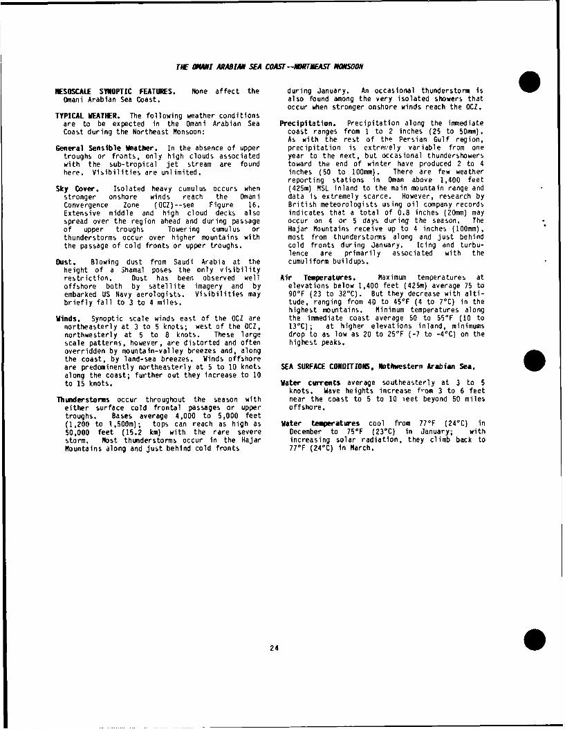
TIE OWNI ARABIAN SEA COAST--IIRTMEAST MONSOON
NESOSCALE SYNOPTIC FEATURES. None affect the during January. An occasional thunderstorm isOmani Arabian Sea Coast. also found among the very isolated showers that
occur when stronger onshore winds reach the OCZ.TYPICAL WEATHER. The following weather conditions
are to be expected in the Omani Arabian Sea Precipitation. Precipitation along the immediateCoast during the Northeast Monsoon: coast ranges from I to 2 inches (25 to 50mm).
As with the rest of tthe Persian Gulf region.General Sensible Weather. In the absence of upper precipitation is extret'ely variable from one
troughs or fronts, only high clouds associated year to the next, but occasional thundershowerswith the sub-tropical jet stream are found toward the end of winter have produced 2 to 4here. Visibilities are unlimited. inches (50 to 100mm). There are few weather
reporting stations in Oman above 1,400 feetSky Cover. Isolated heavy cumulus occurs when (425m) MSL inland to the main mountain range and
stronger onshore winds reach the Omani data is extremely scarce. However, research byConvergence Zone (OCZ)--see Figure 16. British meteorologists using oil company recordsExtensive middle and high cloud decks also indicates that a total of 0.8 inches (20mm) mayspread over the region ahead and during passage occur on 4 or 5 days during the season. Theof upper troughs Towering cumulus or Hajar Mountains receive up to 4 inches (100mm),thunderstorms occur over higher mountains with most from thunderstorms along and just behindthe passage of cold fronts or upper troughs. cold fronts during January. Icing and turbu-
lence are primarily associated with theDust. Blowing dust from Saudi Arabia at the cumuliform buildups.
height of a Shamal poses the only visibilityrestriction. Dust has been observed well Air Temperatures. Maximum temperatures atoffshore both by satellite imagery and by elevations below 1,400 feet (425m) average 75 toembarked US Navy aerologists. Visibilities may 90°F (23 to 32°C). But they decrease with alti-briefly fall to 3 to 4 miles. tude, ranging from 40 to 450F (4 to 70C) in the
highest mountains. Minimum temperatures alongWinds. Synoptic scale winds east of the OCZ are the immediate coast average 50 to 55°F (10 to
northeasterly at 3 to 5 knots; west of the OCZ, 130C); at higher elevations inland, minimumsnorthwesterly at 5 to 8 knots. These large drop to as low as 20 to 250F (-7 to -4°C) on thescale patterns, however, are distorted and often highest peaks.overridden by mountain-valley breezes and, alongthe coast, by land-sea breezes, Winds offshore
along the coast; further out they increase to 10aren preoanet;y nrtheasutey atcea5 to 10 os SASRAECNiiINtwsenAainSa
to 15 knots. Water currents average southeasterly at 3 to 5knots. Wave heights increase from 3 to 6 feet
Thunderstorms occur throughout the season with near the coast to 5 to 10 ieet beyond 50 mileseither surface cold frontal passages or upper offshore.troughs. Bases average 4,000 to 5,000 feet(1,200 to 1,500m); tops can reach as high as Water temperatures cool from 770F (240C) in50,000 feet (15.2 km) with the rare severe December to 750F (23°C) in January; withstorm. Most thunderstorms occur in the Hajar increasing solar radiation, they climb back toMountains along and just behind cold fronts 770F (24°C) in March.
24

Chapter 5
THE SPRING TRANSITION
(Aprl --May)
MAJOR CLIMATIC CONTROLS
FLOW PATERN REVERSAL. The Spring Transition sees Arabia, and central Iran. Northeast Monsoonthe reversal of synoptic scale flow patterns; pressure gradients weaken early in thecompletion of this reversal marks the end of the transition. By the middle of May, however,Spring Transition and the start of the Southwest strengthening gradients associated withMonsoon. The actual onset of the Southwest extensive thermal low-pressure areas effectivelyMonsoon is apparently triggered by a mid- block the effects of the weakening Siberiantropospheric cyclone over either the northern Anticyclone and restrict cold air outbreaks toArabian Sea (see "Onset Vortex") or the Bay of early April.Bengal. Incoming solar radiation increasesdramatically. Changes in circulation occur at THE UPPER-LEVEL (ABOVE 300MB) SUBTROPICAL RIDGE.low levels first. The Northeast Monsoon This ridge, which was oriented east-west betweencirculation gradually loosens its grip on the 5 and 1O0 N during the Northeast Monsoon,region as low-level anticyclonic flow over the strengthens and moves northward. This movementArabian Sea is replaced by cyclonic circu- is directly related to the northward shift oflation. Although the complete transition the Monsoon Trough/Intertropical Convergenceaverages 30 to 45 days, actual onsets and Zone (ITCZ) and rising upper-level pressureendings vary by station location and from one above the shallow continental thermal lows. Byyear to the next. The change can be rapid. The the end of the Spring Transition, the ridge isend of the transition season is signaled by anchored by the upper-level high over Tibet.southerly cross-equatorial flow from theSouthern Hemisphere moving northward along the INTERACTION BETWEEN THE POLAR AND SUBTROPICAL JETSeast coast of Africa, then turning south- is greatly reduced. As the mean position of thewesterly, and finally reaching the Indian Polar Jet moves northward, winter short-wavecoast. Once this moist southwesterly flow upper-air troughs all but disappear, Occasionalreaches western India, numerous pre-monsoonal strong upper-level northwesterly winds arethunderstorms occur over northern and western possible early in the period. Weak upper-levelIndia. Latent heat of condensation from these flow patterns are common over the Arabian Seathunderstorms, combined with the increasing during the transition. The Subtropical Ridgeeffectiveness of Tibet as a high-level (500mb) separates the easterly flow aloft south of 15'Nheat source, builds a high-level anticyclone from the westerly flow between 15 and 350N. Asover the Himalayas and Tibet. The result is the ridge moves northward, strong upper-levelthat high-level westerlies are replaced by high- easterly flow becomes established over thelevel easterlies essential to the maintenance of entire region.the Southwest Monsoon.
MEAN MAY FLOW at 850, 700, 500, 300 mb, and 200mbSTRENGTHENING CONTINENTAL LOW PRESSURE CENTERS. (5,000, 10,000, 18,000, 30,000 and 40,000 feet)
These centers are connected by a thermal trough is shown in Figures 17, 18, 19, 20, and 21.that builds through northeast Africa, Saudi
* 25

25'E 400 E 600E BO0E
30' N
200'N
100 N
00
Figure 17. Mean May 850mb flow.
30' N
200 N
Figure 18. Mean May 700mb Flow.
26

10ON
0a-Figure 19. Mean May 500mb Flow.
Figure 20. Mean May 300mb flow.
27

10O0
0
Figure 21. Mean May 200mb Flow.
285

TRANSITORY SYNOPTIC FEATURES--SPRING TRANSITION
TROPICAL CYCLONE FREQIJENCY is highest during TROPICAL STORMS. The meteorological satellite hastransition seasons, for these reasons: provided for more accurate location and tracking
of Arabian Sea storms; reported frequencies are" Weak cross-equatorial flow into the Southern naturally higher since the early 1970s, but
Hemisphere provides upper-level divergence storms in this area are still relativelyfavorable for cyclone development, infrequent, Between 1890 and 1950, only 14 were
recorded in the Arabian Sea during April and" Vertical shear is weak. May, Between 1891 and 1969, only eight storms
reached the Omani Coast; favored landfall was* Low-level convergence increases due to rapid near Salalah. Storms usually form in the
strengthening of the low-level thermal "heat eastern Arabian Sea between 10 and 15'N, andlows" in Pakistan, Afghanistan, Iran, and between 70 and 75°E. The strongest haveSaudi Arabia. extensive layered clouds, low ceilings, heavy
rain, and high winds out to 300 miles of the" The Monsoon Trough/ITCZ migrates northward to center. Flash floods are common. Mean
locations between 15 and 250 N. April/May storm tracks are shown in Figure 22.
Figure 22, Mean Tropical Ston Tracks--April and Nay Combined.
29

TIE ONSET VORTEX. The tropical "onset" vortex, LAND-SEA BREEZES become the dominant feature alongresembling a tropical storm, occurs only at the coastlines during "undisturbed" (normal) condi-end of the Spring Transition and marks the start tions. Sea breezes are considerably strongerof the Southwest Monsoon (hence the name), than land breezes because of strong daytimeStatistically, it occurs about about I year in 2 temperature gradients. The land-sea breezein the Arabian Sea. In other years, a similar effect can cause abrupt changes in temperature,vortex forms in the Bay of Bengal. Occurrence relative humidity, and wind direction.ranges from mid-May to mid-June and isapparently the "trigger" for the deep lower- - .level southwesterly flow that marks theSouthwest Monsoon. These cyclonic systems format mid-tropospheric levels over the surface -4Monsoon Trough ( ITCZ) just north of the nose of.Ithe Southwest Monsoon current. Movement isgenerally westward toward the Omani Peninsula,southeastern Saudi Arabia, or the Gulf of ".Oman. Initial movement, however, is northwardto about 20'N, then westward or west-southwestward into the Arabian Peninsula.Layered clouds form over the entire regionwithin 300 miles either side of the track.There are heavy cumuliform buildups andrainshowers within 50 miles of the center, -
Convective clouds and precipitation are greatlyintensified over the Omani Mountains even whenthe vortex does not actually reach them.
THE DESERT FRONT. Actually a mean polar frontal ,. ....position over the northern Red Sea, the desertfront is not active every year. It does, however,represent a relatively rare storm track that lies ______
across southern Egypt and the northern Red Seainto central Saudi Arabia, This storm track often Figure 23. Mean Position of the Desert Front.results in the formation of a secondary wave overthe central Red Sea as the mean jet streamposition is displaced southward over the southernMediterranean or northern Africa, Extensive W0 S5E 6G"thunderstorms and heavy rains accompany the ....... :....mnvement of the secondary low across the Saudi .......... .. . ....".Arabian peninsula. This track is only present in . .late winter (March) and during the springtransition, In May 1972, Riyadh, Saudi Arabia,twice experienced passage of a desert front,Although variations in temperature and wind may 25-help identify the surface frontal position, thereare times when this disturbance loses its surfacecharacteristics; when it does, the only indi-cations are in its associated weather and upper-level trough, These fast-moving fronts/troughscan affect a station's weather for 2-3 hours;they are often restricted to the area west of theStrait of Hormuz, Mean position of the desert 20*N .
front is shown in Figure 23,
THE OMANI CONVERGENCE ZONE (OCZ). The OCZ marksthe boundary at which the predominant low-levelnorthwesterly flow meets the intensifyingsouthwesterly flow ahead of the SouthwestMonsoon, Although the OCZ is mainly delineatedby wind shear across it, occasional convectiveactivity can be found over higher terrain. Bythe end of the Spring Transition, the MonsoonTrough/ITCZ has moved into the OCZ. Figure 24gives the mean April location of the OCZ. Figure 24. Mean April Position of the OCZ.
300

THE PERSIAN GULF PROPER AND ADJACENT LAND AREAS--SPRING TRANSITION
MESOSCALE SYNOPTIC FEATURES. As the Spring with severe thunderstorms. When strong windsTransition progresses, the Omani Convergence are not sustained, dust settles rapidly.Zone (OCZ) moves northwestward into the extremesouthern Persian Gulf. This movement is due to Thunderstorms. Tops often exceed 40,000 feetthe strengthening thermal lows over Saudi Arabia (12.2 km); bases average between 4,000 andcombined with increasing southwesterly flow over 6,000 feet (1,200 and 1,800 meters.) The usualsoutheastern Arabia and the Arabian Sea. severe icing and turbulence can be expected.
Hail should be assumed when the classic MillerTYPICAL WEATHER. The following weather conditions AWSTR-200 wet bulb zero heights above terrain
are typical of the Persian Gulf proper during are met. Thunderstorms during the Springthe Spring Transition: Transition have several causes:
General Sensible Weather. Cloud cover is nearly e Fronts. An occasional Mediterranean frontalnonexistent save for the rare thunderstorm. The system reaches the region early in the trans-few instances of jet stream cirrus are almost ition season. Although considerably weakertotally restricted to upper-level westerlies than fronts that occur during the Northeastearly in the period. Fog can occasionally occur Monsoon, these can be strong enough to triggerearly in the period, but only in early morning, thunderstorms.Flooding in the Tigris-Euphrates River Plain iscommon, and caused by melting snow from the * Intense heating over coastlines allowsmountains of Iran and Iraq. Flooding has become convection to penetrate low-level inversions,more of a problem since 1980 when flood controllevees were destroyed during the Iraq-Iran war. 0 Strong sea breezes lift moist air orographi-
cally over nearby coastal mountain ranges.Sky Cover. Middle and high cloud decks occur only
with those few upper-air troughs that penetrate * Mid-level unstable air associated with anthe area early in the Transition. Ceilings upper-level trough (or with a weak Mediterra-range from 10,000 to 14,000 feet (3.1 to 4.3 nean front) is lifted orographically over thekm). Lower ceilings are associated with Zagros mountains.thunderstorms, which see. Light icing andturbulence occur in middle cloud decks near the Late in the transition, but very rarely,trough axis. thunderstorms may also form over mountains along
and southeast of the OCZ.Winds. Weak low-level winds reflect the
macroscale pattern reversal. Late in the Precipitation. Rainfall decreases steadily duringperiod, wind speeds increase to reflect the the trarsition. Its convective nature results
development of strong continental thermal in high variability from one location to anotherlows. April speeds average 5-7 knots, and from one year to another. Mean values ofincreasing to 10-12 knots in May. Directions 0.50 to 1.00 inches (13 to 25mm) early ;n thecontinue to be northwesterly in the northern transition decrease to less than 0.50 inchPersian Gulf, westerly in the southern Gulf, and (13mm) by early May, then to near zero by theturning southerly as one approaches the Strait start of the Southwest Monsoon. Much more mayof Hormuz. On the immediate coast, winds show fall over the Zagros during isolatedlarge diurnal changes due to land-sea breezes, thunderstorms; flash floods have occurred.
Dust and Sand. The most significant weather is Air Temperatures. Temperatures rise significantlythe increasing frequency of blowing dust and during the Spring Transition. Daytime maximumssand. Late season frontal zones (desert fronts) in coastal regions climb to between 95 and 97°Fcan advect dust or sand across the entire (35 and 36°C), Mean May temperatures on thenorthern part of the Arabian Peninsula. Late in north shore of the Persian Gulf are even higher;the Spring Transition, strengthening north- for example, 101'F (38°C) at Abadan, Iran, andwesterly winds cause lower visibilities, with 1020 F (390C) at Kuwait, Inland temperatures inhighest frequencies in the northern part of the Saudi Arabia stay within a few degrees ofPersian Gulf. Visibilities drop to less than 6 coastal temperatures. Zagros Mountain tempera-miles during the day; in the afternoon, with tures are nearly 50 F (2,8°C) cooler than coastalhigher wind speeds, visibilities drop to less regions. Minimum April temperatures at mostthan 3 miles. Basrah, Iraq, and Kuwait, Kuwait, locations range from 62 to 65°F (16 to 19°C),both average nearly 10 days a month with blowing warming rapidly to 73 to 75°F (22 to 230 C) insand or dust. Blowing dust or sand also occurs May. Iranian mountain locations are nearly IO°Fwith the rare thunderstorm--most of which occur (5°C) cooler in both months. Dewpoints inearly in the Transition. Visibilities in coastal regions range from 50 to 53°F (10 tostronger thunderstorms may drop to as low as a 110 C). Dewpoints drop dramatically inland.half mile; near-zero visibilities are possible
0 31

SEA SURFACE CONDITIONS, Persian Gulf.
Water currents in the Persian Gulf circulate Water temperatures rise rapidly during the Sprirngcounterclockwise. A steady flow of surface Transition. Surface water temperatures rangewater enters the Persian Gulf through the Strait from 73 to 76'F (22 to 23%C) in April to 80-82*Fof Hormuz. The surface current flows toward the (26-27o) in May. Temperatures in extremelywest, then northwest as it hugs the Iranian shallow coastal waters may get 5 to 7'F l2.8' toshore. At the northern end of the Gulf, it 3.8'C) warmer. With the warming surfdce waters,turns southeasterly to parallel the Arabian there tends to be an increasing temperaturpcoast. Finally, it turns northerly along the difference between the surface and the bottomwest side of the Omani Peninsula to join fresh (about 195 feet or 60m); by May the bottom IsGulf of Oman water entering through the Strait about 10F (5.6'C) cooler. There is no evidcnceof Hormuz. Speed is less than I knot, Maximum of thermoclines. Wave heights are less than 4calculated speed for the 100-year worst case of feet (1.2m) more than 80% of the time.both wind and tidal currents was 8 knots atJubail. As water increases in density, itsinks, turns southeastward, and flows back intothe Gulf of Oman as a bottom current through theStrait of Hormuz.
32

TIE STRAIT OF HORfUZ--SPRING TRANSITION
NESOSCALE SYNOPTIC FEATURES. None apply Dust is confined to rare cases of advection fromspecifically to the Strait of Hormuz. the northern Persian Gulf or central Saudi
Arabia following frontal passages. Visibilitiesnormally remain above 6 miles, but visibilities
TYPICAL WEATHER. The following weather conditions as low as 3 miles are possible if the sourceare typical of the Strait of Hormuz during the region is central Saudi Arabia. Lower visi-Spring Transition: bilities are possible only with an active desert
front.General Sensible Weather. Cloud cover decreases
from near 3 eighths in April to 1 eighth in Thunderstorms. Although rare, thunderstorms canMay. This is the only season of the year in occur over the mountains on either side of thewhich the usual late evening and early morning Strait. Storms are stronger over the Zagrospatchy low stratus and stratocumulus are mountains. Causes and characteristics are muchabsent. Visibilities are excellent, the same as for those in the Persian Gulf
proper, which see.Sky Cover. Middle and high clouds are found onlywith the infrequent late winter front or Precipitation occurs only with the raretrough. Ceilings average 12,000 to 14,000 feet thunderstorm and is confined to mountainous(3.7 to 4.3 km). Light mixed icing and light to areas without reporting stations. Nomoderate turbulence--especially over the Zagros measurements are available, but crude estimatesmountains on the Iranian shore--are associated derived from similar situations in Arizona givewith these layers. Convective clouds may form values of 0.25 to 0.75 inches (6 to 19mm).in late afternoon, especially along the Strait'sIranian shore. These clouds are caused by a Air Temperatures. Maximum temperatures averagecombination of strong land-sea breeze from 97 to 990 F (36 to 37°C). Minimums riseinteraction and mechanical lifting over nearby from the lower 70s (about 22°C) on the Iranianhigher terrain. They have relatively high bases shore in April to the upper 70s (about 24°C) byat 5,000 to 7,000 feet (1,500 to 2,100 m). May. On the Arabian shore, temperatures are
slightly lower, warming from the upper 60s (nearWinds. General flow is southwesterly to west- 200 C) in April to the low 70s (near 220 C) in
northwesterly west of the Strait and northerly May. Temperatures farther inland are cooler dueto northeasterly east of the Strait. Low-level to increased elevation and the diminishing seaflow reflects a combination of the weak inflow breeze effect.from the Gulf of Oman, pronounced land-seabreezes (especially along the Iranian shore),and a general easterly to southeasterly flow SEA SURFACE CONDITIONS, Strait of Hormuz.around the southern end of the terrain-inducedleeside Gulf low. Bandar Abbass (on the Iranian Water currents through the Strait are mainly tidalshore) maintains the mean southerly flow found ebb and flood. During ebb conditions, currentsin the other seasons while Dubai, United Arab of less than I knot flow predominantly from theEmirates, finds its mean wind direction changing Persian Gulf through the Strait into the Gulf offrom westerly to southerly. The absence of Oman. Flood tide currents (also less than 1disturbances leaves the flow pattern of the knot) reverse to flow from the Gulf of Oman intosouthern shore of the Strait to the local the Persian Gulf. Waves heights are less than 4patterns of the leeside low and land-sea breeze feet (1.2m).circulation. Complicating these patterns is thepronounced venturi effect through the narrowest Water temperatures warm from near 770 F (240 C) inpart of the Strait. Sea breezes strengthen in April to 82-83°F (27-280 C) in May.May as thermal lows build over the continents.
0 33

THE GULF OF (VAN AND ADJACENT LAND AREAS--SPRING TRANSFTION
NESOSCALE SYNOPTIC FEATURES. Iranian shore turn east-northeasterly andincrease in speed during daylight hours as one
Tropical Cyclones. Tropical cyclones that approaches the Strait of Hormuz. This is due tooriginate in the Arabian Sea only reach the Gulf the strengthening sea breeze influence as wellof Oman about once every 4 years. They produce as the Omani Gulf Low described earlier, Towardlayered clouds, low ceilings, heavy rains, and the end of the season weak southwesterly flow,high winds. In the rare cases of landfall, often masked by local effects, appears along theexpect flash floods in and near mountains on Omani coast. Speeds average 3 to 5 knots,either coast. Moderate icing and moderate tosevere turbulence are common, but turbulence and Dust is almost unknown. Blowing dust or sand mayicing are heavier over the mountains on either occur with the rare thunderstorm over highershore, Ceilings can be as low as 1,000 to 1,500 mountains on either side of the Gulf Of Oman,feet (300 to 460m) with layers through 40,000feet (12.2km). Visibilities can be as low as Thunderstorms. A very rare thunderstorm may occurhalf a mile, and winds can be of hurricane over higher mountains on both the Iranian andforce. There are no records of maximum wind Omani shores of the Gulf. The most common causespeeds; not many of these storms pas- d over is locally induced convection resulting from thereporting stations, and those that did destroyed lifting of moist Gulf air over nearby coastalthe anemometers, Although more than 10 inches mountain ranges, Although infreouent, the most(250mm) of rain were recorded in a storm that common location is in Oman's Jabal Akhdarmade landfall near a reporting station, there range. Thunderstorm tops often exceed 40,000have undoubtedly been higher amoun's, feet (12.2 km); bases average between 4,000 and
6,000 feet (l,200 and 1,800 meters.) The usualOmani Gulf Low. This mesoscale low is located in severe icing and turbulence should be
the western Gulf of Oman; it dominates during expected. Hail should be assumed when thethe early part of the transition season. It is classic Miller AWSTR-200 wet bulb zero heightscaused by a combination of a Zagros Mountain lee above terrain are met.side effect and the mountainous terrain alongthe Omani coast, As the Northeast Monsoon Precipitation. Except for that from the rareweakens, so does the low. Establishment of the tropical cyclone, precipitation is thunderstorm-Southwest Monsoon destroys this mesoscale associated, almost always fall ing in mountainsfeature, See "Winds." where there are no reporting stations, Crude
estimates based on similar situations in Arizonaindicate amounts to be 0.25 to 0.75 inches (6 to
TYPICAL WEATHER. 2 9mm).
General Sensible Weather. This is perhaps the Air temperatures increase rapidly due to themost settled season of the year in and around combination of decreased cloud cover andthe Gulf of Oman. Skies are normally clear undisturbed (normal) weather conditions. Max-with excellent visibilities. Mid-latitude imum temperatures on both shores of the Gulf ofdisturbances from the Mediterranean rarely have Oman warm from between 87o and 89°F (30 to 31C)the support to reach this far south. The OCZ in April to between 94 and 96°F (34 to 35°C) inmoves into the extreme southern Persian Gulf; May, Minimum temperatures on the southern coastthe Monsoon Trough/ITCZ has yet to appear, rise from near 80°F (26'C) in April to 85°F
(29°C) in May. Maximum temperatures on theSky Cover. Late in the Transition season, cirrus northern coast are nearly 5'F (2.8'C) cooler,layers are sometimes advected westward fromtropical disturbances in the eastern ArabianSea. These layers reach the area only when the SEA SURFACE CONDITIONS, Gulf of Oman.upper-level easterlies have set up south of thesubtropical ridge. The cirrus dissipates near Water currents become southwesterly, averagingthe eastern portion of the Gulf of Oman due to only half a knot throughout the Gulf of Oman andstrong mid-tropospheric subsidence, northern Arabian Sea. Wave heights are less
than 4 feet (1.2m) nearly 90% of the time.Winds. The light and shifting synoptic gradient
during the first part of this season leaves Water temperatures range from 780 to 79°F (nearwinds over land at the mercy of local effects 25°C) in April to 83 to 85°F (near 29°C) insuch as land-sea breezes and/or mountain-valley May.breezes. Low-level winds along the immediate
340

ONNAI ARABIAN SEA COAST--SPRING TRANSITION
NESOSCALE SYNOPTIC FEATURES. Masirah become southwesterly by May. Winds atSalalah move from the southeast to southwest.
Tropical cyclones originating in the Arabian Sea Wind speeds are near their annual minimum.may affect the Omani Coast, but incidence is not Early morning light winds increase throughouthigh. On the average, one of these storms may the day to 7-9 knots by mid-afternoon. Windsmake landfall on the Omani coast in only I year over the northwest Arabian Sea becomeout of 4. For characteristic conditions, see southwesterly by mid-April at 4 to 7 knots."Mesoscale Synoptic Features" for the Gulf of Directions stay constant through May, withOman and Adjacent Coasts. speeds increasing to 10 to 15 knots just before
the onset of the Southwest Monsoon.Onset Vortex. The onset vortices that mark theend of this transition season and the start of Thunderstorms. Although none have actually beenthe Southwest Monsoon (see "Transitory Synoptic recorded here, they probably do occur. BritishFeatures") reach the Omani Arabian Sea coast meteorologists working with oil explorationless than 25 percent of the time. Layered companies in the interior have observed rareclouds occur from 1,000 to 3,000 feet (300 to cumulonimbus over the mountains to the south-1.000m) up to 35,000 to 40,000 feet (10.7 to west.12.2km) over the entire region within 300NM ofthe vortex center. There are heavy cumuliform Precipitation occurs only with tropical storms,buildups and rainshowers within 50 miles of the thunderstorms, or the passage of an onsetcenter, and moderate icing and turbulence within vortex. Amounts in excess of 10 inches (255mm)150 miles of the center. Flash floods in and have been recorded.near the Omani mountains are common even whenthe vortex does not actually make landfall. Temperature. This is the warmest season of the
year. Maximum and minimum temperatures are attheir highest annual mean at both Salalah and
TYPICAL WEATHER. Masirah. Maximums average from 90 to 96°F (32to 35°C); minimums from 77 to 78°F (near
General Sensible Weather is excellent. This is 24-C).the most cloud-free season of the year here;isibilities are excellent.
SEA SURFACE CONDITIONS, Northwest Arabian Sea.Sky Cover. Multilayered cloud decks are confined
to those associated with the very rare tropical Water currents begin to establish themselves ascyclone (see "Mesoscale Synoptic Features"). southwesterly at I to 2 knots by the end of the
season.Dust. As wind speeds rise late in the season with
increasing southwesterly flow, and the ground Water temperatures climb to their highest valuesbecomes baked by high temperatures, the number of the year, reaching between 79 and 81°F (26of days a month with blowing dust or sand and 270C). The fact that water temperatures areincreases. By season's end, blowing dust or at their warmest now, rather than later in theblowing sand occurs on 4 or 5 days a month, summer, is a result of the low cloud cover and
extensive upwelling that establishes almostWinds. Winds switch to southwesterly in late May coincidentally with the onset of the Southwest
or early June to herald the end of the Monsoon.Transition Season, Northeasterly winds at
0 35

Chapter 6
THE SOUTHWEST MONSOOE
(June--September)
MAJOR CLIMATIC CONTROLS
A MASSIVE THERMAL LOW-PRESSURE TROUGH dominates the Strait of Hormuz. After crossing thethis season. This trough has its primary axis Strait of Hormuz it lies at or near the 1,640along the Persian Gulf, with a secondary center foot (500m) contour line of the Zagrosover south central Saudi Arabia. It is a Mountains--or about 25 to 30 miles inland of thewestward extension of the summer thermal low Iranian coast. Upon reaching extreme westerncentered in extreme western Pakistan. The Pakistan near Jiwani, the Monsoon Trough/ITCZentire system is anchored by a combination of turns north-northeastward. Unlike in otherterrain (the Zagros mountains along the Iranian tropical regions, the Monsoon Trough/ITCZ herePersian Gulf shore) and the extremely hot and marks the boundary between moist tropical air at
* dry air over the Arabian Peninsula. low levels and hot, subsiding air above. It is,therefore, normally inactive. It slopes gradu-
AN UPPER-AIR RIDGE has formed over the Arabian ally upward towards the southeast, and is thepeninsula and Iran. 500mb high pressure centers cause of the extremely strong elevated inversionare located over extreme western Arabia and over south and east of its surface position. Inthe Zagros mountains in southwestern Iran. southeastern Saudi Arabia and Oman, the Monsoon
Trough/ITCZ absorbs the Omani Convergence ZoneTHE MONSOON TROUGH/INTERTROPICAL CONVERGENCE ZONE found during the Northeast Monsoon and the
(ITCZ) enters the study area about 200NM inland Spring Transition. Figure 25 shows the meanof Salalah on the southwestern Omani Arabian Sea July surface position of the Monsooncoast and follows the Omani mountain crest to Trough/ITCZ.
Figure 25. Mea, July Surface Positio3n of the Monsoon Trough/TTCZ,
* 36?

Figure 26 is a mean July 1200Z sounding for the high-speed winds of the Southwest Monsoon.Salalah, on the Arabian Sea Omani coast. It also results in a stratocumulus deck offshoreAlthough the sounding is based on limited data, that turns onshore in the lee of peninsulas.the inversion profile shown is believed to be This deck behaves like California coastalrepresentative of the southeastern Arabian stratus,Peninsula and immediately offshore that lie inthe "Southwest Monsoon," discussed next, THE TROPICAL EASTERLY JET (TEJ). The northern
edge of the TEJ crosses the southern ArabianPeninsula and the northern Arabian Sea from eastto west, Maximum speeds (in the area of thisstudy) are 50 to 75 knots between 40 and 45,000feet (12.1 and 13.6km).
05018 5006,," TWO IMPORTANT AIRFLOW FEATURES.I //
040,10 * 9~ A northwesterly current at all levels over the/Arabian Peninsula. Extremely dry, this flow is30/ ,0 the primary atmospheric cause for the prevailing
"S VS dust layer found throughout the region." / Embedded in this current is the Summer Shamal38o that occurs over and just west of the Persian
. 02, Gulf, This enhancement of the prevailing
,36. northwesterly and northerly flow is normally360/6 / strongest during June and July.
30 4, 2562 *Mid-level easterly to southeasterly flow at 700r °/ , " "/ I! through 500mb over Iran and at 600 through 500mb3003 , Bo 2 989 over the Omani Peninsula. It originates with
/ in, the mid- and high-level anticyclone centered-201 143 //o ,,.,...ver Central Iran and western Pakistan.
939M ID-LEVEL MOISTURE over the Irani coast of the
230/6 *36'Gulf of Oman, the Zagros Mountains and westward6 ,,' over the Omani Peninsula. During periods ofK230 / o. 000 20"" stronger flow, isolated thunderstorms develop
,0 " 0' 300 over all three areas.
A PERSISTENT MID-LEVEL TROUGH at 600 and 500mbover the southern portion of the eastern Arabian
Figure 26. Mean Winds, Temperatures, and Peninsula separates the northwesterly andGeopotentials--Salalah, 1200Z, July 1980. southerly flows. Experienced British meteoro-
logists think this relatively weak trough is thecause of the occasionally thick altocumulus
THE SOUTHWEST MONSOON, for which this season is layers found here.named, is a deep and strong sustained flow ofsouthwesterly to westerly winds over the entire EXTREMELY WARM PERSIAN GULF WATERS. The shallowIndian Ocean north of the Equator. Flow depth waters of the Gulf heat rapidly and remain hotover the Central Arabian Sea and the Indian throughout the summer. Surface waterOcean extends from the surface to above 500mb. temperatures by mid-July are above 90'FThis flow lies on the equatorward side of the (32°C). High evaporation rates result in aMonsoon Trough/ITCZ, Strongest speeds are over steady northwestward flow of surface watereastern Africa and immediately offshore of through the Strait of Hormuz into the Gulf; theArabia. The core current of this high-speed air current just west of the Strait reaches 2 to 4is known as the "Somali Jet." Normal maximum knots, A counter-current flows southeastwarddepth of the moist tropical air in this airflow along the bottom down the Persian Gulf and outalong the Arabian Coast and in the Gulf of Oman into the Gulf of Oman. Note that the surfaceis 2,000 to 3,000 feet (0.6 to 0.9km). It is current into the Persian Gulf flows against thecapped by a strong inversion that rises toward prevailing northwesterly winds.the southeast over the Arabian Sea. Thisinversion marks the Monsoon Trough/ITCZ. MEAN JULY FLOW at 850, 700, 500, 300, and 200mb
(5,000, 10,000, 18,000, 30,000, and 40,000 feet)STRONG UPWELLING along and just off the Omani are shown in Figures 27 through 31.Arabian Sea coast assists in the maintenance of
370

25°E 4060°E 80*E
300 N-
:20 N- IL
0
Figure 28. Mean July 700mb Flow.
O 38

2 0O
100
Figure 29. Mean July 500mb Flow.
20 E 0E60 0 1 801E
0
Figure 30. Mean July 300mb Flow.
390

25O0E 40'E 60°'E 80°E
10ON
Figure 31. Mean July 200mb Flow.
0

TR4NITORY SYNOPTIC FEATUfRES--SOI.TIEST MONSOON
WEAK UPPER-LEVEL TROUGHS IN THE WESTERLIES. In Tropical storm occurrence drops off markedlyJune and early July these troughs may penetrate with the onset of summer as the monsoonsouthward into the Arabian Peninsula when a trough/ITCZ moves northwestward to a lineblocking high over northern Europe results in a through the southeast Arabian Peninsula acrosshigh-speed wind core in the westerlies across the Strait of Hormuz and eastward along thethe Mediterranean into Iraq. The characteristic Iranian Gulf of Oman coast into extreme westernmiddle and high clouds associated with these Pakistan. Eleven storms were recorded duringtroughs show up well on visual and IR satellite the month of June between 1890 and 1950.imagery. Between 1891 and 1969, five made landfall on the
Omani coast. Occurrences in July throughNORTHWESTWARD MOVEMENT OF THE MONSOON TROUGH/ITCZ September are rare; only seven were observed
into the southern Persian Gulf and Arabian over the Arabian Sea between 1890 and 1950.Peninsula. The Monsoon Trough/ITCZ normally Storms that do form and survive the influence oflies over southeastern Arabia and the Strait of colder water found in the extreme eastern GulfHormuz, and along the Iranian Gulf of Oman of Oman and along the northeastern Arabian coastshore, but under certain conditions, it will make landfall near Salalah on the central Omanimove further northwestward into the southern coast.part of the Persian Gulf. This movement resultsfrom pulses in the Southwest Monsoon that are One storm is known to have crossed the northernmost prevalent in July, August, and early Arabian Sea during August; it made landfall atSeptember. Pulse origins are: Masirah. Winds of 47 knots and a total storm
rainfall of 1.77 inches (45.0mm) wereEasterly troughs moving westward over the Indian recorded. The surface pressure gradientOcean in the southern hemisphere trades. These tightened rapidly in the southern Persian Gulftrade winds, recurving toward the east after at the same time; Abu Dhabai and Dubai recordedcrossing the equator, become the "southwest easterly winds gusting to 37 knots withmonsoon." Increased mass transport behind the visibility 5/16 mile (500m) in blowing sand.troughs reinforces the Somali Jet and results in Masirah has recorded much higher stormhigher wind speeds. rainfall; for example, 17 inches (430mm) fell
during the June 1977 storm, Although there areShear lines moving northeastward up the no observing records for the Omani mountains,Mozambique Channel between Africa and precipitation amounts are doubtless higherMadagascar. These shear lines originate as there.southern hemisphere cold fronts. The ridgesfollowing them provide the additional mass that,after merging with the ex-southern hemisphere "" .trade winds over eastern Kenya and Tanzania, -, .,72results in increased wind speeds of the Somalijet.
THE ONSET VORTEX has been thoroughly discussedunder the Spring Transition in Chapter 5. I '- 14 AHowever, readers should remember that thisfeature actually straddles the end of the Spring ITransition and the start of the Southwest", -
Monsoon, It is an Arabian Sea tropical vortexassociated with the onset of the SouthwestMonsoon. It occurs in 1 out of 2 years. Eitherthis vortex, or a similar one in the Bay of Il LBengal , seems to he a necessary condition forestablishment of the upper-level anticycloneover Tibet and the Himalayas. This anticyclone,which acts as the monsoon outflow, in turn isnecessary for formation and maintenance of tne '_upper-level tropical easterlies. For furtherdetails, see "Transitory Synoptic Features" -under "The Spring Transition."
TROPICAL CYCLONIC STORMS/CYCLONES are late spring-early summer phenomena, almost always theremains of Bay of Bengal cyclones that cross Figure 32. Mean Tropical Storm Tracks, June.India, regenerate in the Monsoon Trough-ITCZover the extreme northern Arabian Sea, and thenmove toward the west. June storm tracks areshown in figure 32.
41

TIE PERSIAN GULF PROPER AND ADJACENT LAND AREAS--SOUTHYEST MONSOON
NESOSCALE SYNOPTIC FEATURES. The following low causes the tightened gradient that isfeatures are common to the Persian Gulf proper and partially responsible for the low-level jetits immediately adjacent land areas: described below.
The Summer Shama] describes the prevailing The Low-Level Jet. From the combination ofnorthwesterly winds that occur throughout the terrain and synoptic features already described,Southwest Monsoon season but are strongest from a high-speed, low-altitude wind maximum, orearly June through mid- to late July. The "low-level jet" (LLJ), persists for most of theSummer Shamal winds result from a combination of southwest monsoon season along the Arabian Coastflow around the Pakistani semipermanent low from about 75 miles southeast of Kuwait to 100pressure area, the Saudi Arabian heat low, the miles southeast of Doha. The changing terrain"valley" of the Persian Gulf, and the barrier orientation between Doha and Abu Dhabi resultseffect of the Zagros Mountains that induces a in relaxation of conditions favorable for LLJmesoscale low pressure area over the gulf near formation. Speeds within the LLJ can exceed 50the Iranian shore. knots; altitudes of the strongest wind speed
cores are between 800 and 1,500 feet (245 andA Nesoscale Lee-side Induced Surface Low lies over 460m) MSL. As with all LLJs, altitudes and core
" the southeastern Persian Gulf, anchored against speeds are subject to diurnal variations; thethe Iranian coast. Caused by complex lowest altitude of the wind maximum, and theinteractions between terrain features (the highest speeds, occur just before dawn. FigureZagros and Oman i mountains) and the Summer 33 shows a representative case. In lateShamal winds, the low results in low-level afternoon, speeds drop to those of the gradient
Iranian coast is far nwthwest is Busheir. The
WINO DIRECTION WIND SPEED (KTS)
FEET 320 340 360
3000
I.
2000 - , I
1000
0 _10 20 30 40 50 KTS
Figure 33. Low-Level Mind Profile Over Bahrain.
* 42

Extremely dry soil. Winds above 15 knots pick up Oust. The major Southwest Monsoon weather hazarddry soil particles to form the ever-present throughout the Persian Gulf region is thesuspended dust that is a characteristic feature suspended dust and sand raised by the strongof this region during the entire Southwest northwesterly low-level winds of the "SummerMonsoon. Winds above 25 knots pick up the Shamal." Suspended dust in the atmosphere hereheavier sand particles. restricts visibility to 3 to 5 miles. The tops
of this persistent dust layer are between 13,000Dust Devils. These vortex phenomena occur over feet (3.9km) and 16,500 feet (5.1km) MSL.
land areas throughout the Persian Gulf region. Visibility in the dust varies as a function ofThe strongest occur along coast lines in the low-level wind speed: the stronger the wind,vicinity of sea breeze "fronts." During late the lower the visibility. Much of the dust hasmorning and afternoon, rising thermals in the been picked up from the Iraqi deserts to thehot air just inland of advancing sea breezes are southwest and west of Basrah. Critical windreinforced and twisted by the moist, cooler air speed for lifting the dust into the atmosphereof sea breezes. The resulting dust devils rise is about 15 knots--a condition that is nearlyto heights of over 330 feet (100 meters). They constant during June and July. The criticalcan be advected inland several miles along the speed is raised to 20 knots after showers, butsea breeze front" before dissipating, heavy vehicular traffic lowers it to 10 knots.Extensive damage has been reported.
Considerably lower visibilities--sometimes nearzero--can occur throughout the season as a
TYPICAL WEATHER. The following weather conditions result of stronger sustained winds caused bymay be expected in the immediate Persian Gulf shear lines embedded in the westerlies thatarea during the Southwest Monsoon: penetrate into southern Iraq and/or extreme
northern Saudi Arabia. These conditions areGeneral Sensible Weather over the Persian Gulf and most common in June and early July and are
the Arabian Poninsul normally consists of high surface reflections of the weak upper-levelci-Juas. Patchy low stratus will form along and troughs that produce the rare thundprstorms tojust west of the Arabian coast from Dhahran be discussed later. Winds behind these shearsoutheastward in late evening. Stratus forms lines can exceed 30 knots; peak winds of 35 todue to a complex combination of land breeze, sea 45 knots have been recorded as far west asbreeze, and summer Shamal strength. The Riyadh and as far south as Dubai. Such winds"Terminal Forecast Reference Notebook for generate a "haboob" type wall of dust. Tops ofDhahran, Saudi Arabia," contains an excellent the dust wall have been reported as high asdiscussion of the subject. Similar conditions 19,000 to 20,000 feet MSL. In suc cases,have been noted by forecasters at Doha, Dubai, "clearing" can be said to have occurred onceand Abu Dhabi. Visibilities throughout the winds drop below 15 knots and visibility returnsregion during June and early July average from 3 to the "normal" 3 to 5 miles.to 5 miles in suspended dust. Visibilitiesafter mid-July normally improve to 3 to 7 miles, Sustained occurrences of very low visibility arestill in suspended dust. tied to the existence of an Omega block over
northern Europe, and the resulting depression ofSky Cover. Upper-air troughs early in the season the westerlies to the latitude of the southernproduce patchy layered middle and high clouds in Mediterranean. Bahrain visibility distributionswhich light icing is found. Bases average from (shown in Figures 34 and 35) are representative14,000 to 16,000 feet (4.3 to 4.9 km) . Very of normal conditions along the Arabi3n Persianrare thunderstorms may form along the trough Gulf coast.axis; tops may reach 45,000 feet (13.7 km).
00 ov4 Pcn 0reqe ",00 s300 500 " 0 geo 2<00 23x S
Figure 34. Percentage Frequencies of Vsibilities 1 W, 8ahra in.
430

M | -- I I l I I ] I I I | I I | I I I I I I
I~~ r.2 Z3
050 0700 0900 F1O0 1300 '50C 1700 1900 21CI 2300 G
Figure 35. Percentage Frequencies of Visibilities :5 1100 Yards, Bahrain.
Minds over the northwestern half of the Gulf are an increase in low-level moisture from either ofsustained northwesterly at 10 to 20 knots with several rare sources. These sources include:much higher gusts, all reflecting the "Summer enhancement of the persistent easterly andShamal." A low-level jet (LLJ) along the southeasterly mid-level flow around the upperArabian Persian Gulf shore from about 75 miles air Iranian anticyclone; a Bay of Bengal monsoonsoutheast of Kuwait to 100 miles southeast of depression that maintains itself westward intoDoha is a common occurrence. The changing the northwestern Arabian Sea; and aterrain orientation between Doha and Abu Dhabi northwestward movement of the Monsoonresults in weakening of conditions favorable for Trough/ITCZ. The latter allows southwestLLJ formation, Wind speeds within the LLJ can monsoon moisture to feed northward (or evenexceed 50 knots; altitudes of the strongest northwestward) into the Zagros. Intense summerwind speed cores are between 800 and 1,500 feet heating provides the necessary trigger in all(245 and 460m) MSL. Average surface speeds are these cases.15 to 20 knots. Winds in the southeastern halfof the Persian Gulf reflect both the circulation Precipitation reaching the ground, except fromaround the southern end of the leeside-induced very isolated showers over the Zagros Mountains,mesolow and the west-to-east orientation of the is nil. Even with the rare thunderstorm, much,mountains on the Iranian shore. The south-to- if not all, precipitation evaporates beforenorth alignment of the mountains on the Omani reaching the ground.Peninsula of the Arabian coast combine withthese other features to "turn" the prevailing Air Temperature. Daytime maximum temperatureswinds--first westerly, then southwesterly, along the immediate coast average between 105finally southerly--as one approaches the Strait and IIIOF (40 to 44°C). Inland, temperaturesof Hormuz from the west. Land and sea breeze rise to 115 to 120'F (45 to 50C). Minimumcirculations , of course, modify this pattern, temperatures along the coast fall to 75 to 79°Fwhich can only be overcome by a strong (23-26-C). Despite high Persian Gulf water"Shamal." Even under these conditions, winds temperatures, dew points along even theover water and along the Persian Gulf coast of immediate northern coastline range from 560 Fthe Omani Peninsula will back only as far as (130C) in June to 66°F (180 C) in September. Thewesterly. Average speeds over the Iranian side southern Arabian coast has marginally higherrange from 10 to 15 knots, or 5 to 15 knots dewpoints because of flow off the water, butlower than on the Saudi Arabian shore, The they drop rapidly as one moves inland. Riyadhhigher speeds on the Arabian-Omani side are not averages a 35°F (3°C) dew point through thesurprising; this is the region of tighter summer, with correspondingly lower minimummesoscale gradient in phase with the prevailing temperatures. Beyond 20 to 30 miles inland,macroscale northwesterly flow. minimum temperatures drop to 75 to 85°F (24 to
Thunderstorms, The extreme northern portions of 29C).
the Persian Gulf (including Riyadh, Kuwait, andBasrah, as well as the area of the Zagros SEA SURFACE CONDITIONS, Persian Gulf.mountains southward to Bushehr) will experiencea rare mid-level thunderstorm associated with Water currents generally circulate counter-weak troughs in the westerlies. These are most clockwise. As mentioned earlier, shallow watercommon during June and July; all are associated in the gulf is due to evaporation and an almostwith troughs in an enhanced and southward- total lack of water flowing off the land. Sincedepressed high-speed current in the mid-latitude the water level is lower than the Gulf of Oman,westerlies. These thunderstorms are similar to a steady flow of surface water enters thethose in the southwestern United States; bases Persian Gulf through the Strait of Hormuz. Thisare high (above 8,000 feet--2,500 meters), with surface current flows west, then northwest, asvirga and associated downburst phenomena, it hugs the Iranian shore. At the northern end
of the Gulf, it turns to the southeast andIsolated thunderstorms can form over the parallels the Arabian coast. Finally, it turnssouthern Zagros Mountains along and inland of north along the Omani Peninsula to join freshthe Iranian coast, This activity results from Gulf of Oman water entering through the Strait
* 44

of Hormuz. Speeds are less than 1 knot. late spring and early summer. Surface waterMaximum calculated speed for a 100-year worst temperature ranges from 82-85°F (27-290 C) incase of both wind and tidal currents, was 8 June to 90-92°F (42-430 C) in August beforeknots at Jubail. As water increases in density, dropping to 84-87°F (29-31°C) in September.it sinks, turns southeastward, and flows back Temperatures in extremely shallow coastal watersinto the Gulf of Oman as a bottom current reach 104°F (400 C) on July and Augustthrough the Strait of Hormuz. 85% of all wave afternoons. Available temperature soundings inheights average less than 6 feet, Predominant the western Persian Gulf show a bottomdirection along the Arabian coast is, as might temperature of 73°F (23°C) at 195 feet (60be expected, from 330 through 360 degrees. meters). Temperatures show a steady and gradual
decrease between the surface and the bottom ofWater Temperatures, The temperature of the about 13°F t70C). There is w evi' , ofshallow Gulf water here increases rapidly during thermoclines.
0

THE STRAIT OF HOAfUZ--SOLUTHWEST MONSOON
NESOSCALE SYNOPTIC FEATURES. The mesoscale Shamal, winds along the north shore of the
features that affect the Persian Gulf proper and Strait are northeasterly to easterly during thethe Gulf of Oman also affect the Strait of night and early morning, and southerly toHormuz; there are no known mesoscale features westerly during late morning and afternoon.peculiar to the Strait itself. Along the southern shore, "normal" winds are
southwesterly to westerly east of the StraitTYPICAL WEATHER. The following weather conditions during the night and early morning, andmay be expected in the Strait of Hormuz during southeasterly to southerly west of the Strait.the Southwest Monsoon: In late mornings and afternoons, strong south-
westerly to west-northwesterly sea breezes blowGeneral Sensible Weather cver the strait during along the Omani shore west of the Strait and
the Southwest Monsoon season consists of patchy northerly to northeasterly east of the Strait.low stratus and stratocumulus occurring mostfrequently in late evening and early morning. Thunderstorms. Isolated thunderstorms occur overOnshore cloud occurs only along the Iranian the interior Zagros mountains; they are verycoast in the very shallow Southwest Monsoon rarely found in late afternoor over the higherair. Visibilities average 5 to 7 miles in dust Omani ranges. None have actually occurred over
, and salt haze, weather reporting stations. Bases are estimatedat 4,000 to 5,000 feet (1,200 to 1,500m) MSL;
Sky Cover. During incursions ("pulses") of tops at 40,000 to 45,000 feet (12.2 to 13.7 km).Southwest Monsoon air into the southern PersianGulf, thunderstorms occur along the mountains on Precipitation is confined to the rare thunder-both the Iranian and Omani shores. Bases range storm. No statistics are available, but rain-from 2,000 to 3,000 feet (610 to 915 m); tops fall amounts of 0.5 to 1 inch (12 to 25mm) inreach above 45,000 feet (13.7 km). British the higher mountains are probable. Heaviermeteorologists stationed at Abu Dhabi and Dubai amounts have caused flash floods.have reported seeing these thunderstorms overthe Omani mountains, Unconfirmed reports have Air Temperatures. Maximum temperatures along thebeen received of mountain flash floods during immediate shore on either side of the Straitsuch "pulses." average from 90 to 95'F (32 to 35°C). Minimums
average from 80 to 82°F (26 to 27°C). Tempera-Dust is advected into the Strait of Hormuz from tures inland are modified by increased elevation
the Persian Gulf. During strong "Summer and the diminishing sea breeze.Shamals" in the Gulf, visibilities may drop toless than 3 miles in the Strait, Visibilitiesbelow I mile--though rare--have occurred, almost SEA SURFACE CONDITIONS, Strait of Hormuz,always associated with near zero visibilities in
the southern Persian Gulf caused by extremely Water currents through the Strait consists of astrong "Summer Shamals." tidal ebb and flood. During ebb conditions,
currents of less than I knot flow from theWinds reflect a combination of weak inflow from Persian Gulf through the Strait into the Gulf of
the Gulf of Oman, pronounced land-sea breezes Oman. During flood tide, currents of less than(especially along the Iranian shore) , and a I knot flow from the Gulf of Oman through thegeneral easterly to southeasterly flow around Strait into the Persian Gulf. Wave neightsthe southern end of the induced leeside Gulf average less than 2 feet (0.6m).low. Complicating this pattern is the venturieffect through the narrowest pa,'t of the Water temperatures are similar to those found inStrait, Precise data 'or the Strait itself is the Persian Gulf, They increase fron 85-86'Fnot available, but it -)pears that wind speeds (29-30'C) in June to 90-91°F (32-33°C) in Julyhere are directly related to "Summer Shamal" and August. Temperatures fall to 86-87'F (30-strength over t;e central and northern Persian 31'C) in September.Gulf. In the absence of a well-developed
* I46

THE GULF OF OM4N AND ADJACENT LAND AREAS--SOUTIMST M SOON
IESOSCALE SYNOPTIC FEATURES. August. The normal land breeze is reinforced bythe "fall wind" effect of the high mountains
The Gulf of Oman low is a result of: that back the immediate coast. Winds on thecoast closer to the Strait of Hormuz show a
Terrain features and coastline orientation of marked land-sea breeze circulation. Macroscaleboth the Iranian and the Omani shores gradients immediately southeast of the Strait of
Hormuz are extremely weak. As a result, nightThe position of the Monsoon Trough/ITCZ along and early morning winds are southwesterly tothe Omani mountains-Strait of Hormuz westerly at 4 to 6 knots; late morning,
afternoon, and early evening winds are east-The cyclonic eddy from the main Southwest northeasterly to easterly at 8 to 12 knots.Monsoon current, This eddy effect is similar to Ove;" the Gulf of Oman itself, winds turnthe one found in summer along the California southeasterly and increase in speed markedlycoast from Santa Barbara west to Point during daylight hours as the Strait of Hormuz isConception. approached. Night winds along the Iranian shore
east of the Strait and over the northern Gulf ofOman tend to be variable due to the opposing
TYPICAL WEATHER. Typical weather conditions in influences of the land (mountain) breeze and theand near the Gulf of Oman during the Southwest gradient winds, Average wind speeds increaseMonsoon are: from less than 8 knots just east of the Strait
of Hormuz to 13-14 knots as the Arabian Sea isGeneral Sensible Weather over the Iranian coast reached. Surface winds over the southern half
and the open waters of the Gulf consists of of the Gulf of Oman and on the Omani coast arepatchy low clouds with bases from 1,000 to 1,500 westerly to west-southwesterly (downslope) at 4feet (305 to 460 m) and tops of 2,500 to 3,500 to 8 knots at night. The sea breeze establishesfeet (760 to 1,070 m). From early through late shortly after 0900L and persists throughmorning, ceilings of 800-1,200 feet are common 1900L. This onshore flow is northeasterly toalong the immediate coast and just inland, easterly and reaches peak speeds of 15-20 knotsVisibilities along the shore range from 5 to 7 in late afternoon.miles, but over open water, from 7 to 10miles. Salt haze and dust are the main Thunderstorms are normally only found in therestrictions. The Omani Coast normally has higher mountains on both the Iranian and theclear skies, with visibilities ranging from 6 to Omani coasts; these very isolated storms have10 miles in dust and suspended salt haze. the usual high bases, On rare occasions, therePatchy low clouds form over the immediate coasts is widespread thunderstorm activity (with lowjust after dawn about a third of the time, but cloud bases and heavy rainshowers) over theskies clear rapidly with morning heating, northern Omani mountains and the Zagros ranges
inmmediately north of the Iranian coast as farSky Cover. Under the effects of a Southwest northwest as Bandar-e-Lengeh. This activity is
Monsoon "onset vortex" or tropical storm, the caused by a rare strong pulse in the southwestusual multilayered low, middle, and high clouds monsoon that combines with the approach of aare found over an area within 300 miles of the weak upper-air trough over the Persian Gulf.storm track or landfall. But, as has already This combination advects low-level monsoon airbeen discussed under "Transitory Synoptic from over the Gulf of Oman and the Strait ofFeatures," these storms rarely enter the Gulf of Hormuz into the extreme southeastern PersianOman or make landfall on either shore. The rare Gulf.occurrence here is in June or early July, butone was observed in August. Precipitation. The only precipitation of any
significance is from the rare tropical3ust. Dust and salt haze are normally present disturbance strong enough to make it to the
here, restricting visibility to 5 to 10 miles, coast. The precipitation can be heavy--a bitLower visibilities are only found during a less than 15 inches (380rm) was recorded in onestrong "Summer Shamal." Dust raised by the storm that made landfall. Extensive flashShamal has been observed on satellite imagery as flooding has also been reported.far east as the central Gulf of Oman. Lowestknown visibilities (in extreme cases) were Air Temperatures. Along the Iranian coast andobserved as less than 3 miles, but then only over the Gulf of Oman, maximum temperaturesbriefly, range from 92F (33°C) in June to 88°F (31C) in
September. Dew points drop from 78°F (250C) inWinds. A complex wind pattern results from the June to 73°F (22°C) in September. Along the
interaction of the Gulf of Oman low and the Omani coast, maximum temperatures in July andpronounced land-sea breeze. Iranian shore winds August are 95 and 91°F (35 and 330C); dew pointsare east-southeasterly at 9 knots in July and average 70 to 750 F (21 to 23%).
470

SEA SURFACE CONDITIONS, Gulf of Oman.
Water currents in the Gulf of Oman maintain a Water temperatures decrease from 86°F to 90°F (30cyclonic gyre, reflecting the low-level wind to 320 C) at the Strait of Hormuz to 82-84°F (27-pattern. Speed averages 1 knot. Wave heights 290C) at the eastern end of the Gulf of Oman.average 4 to 6 feet.
*48

THE ItEANI ARABIAN SEA COAST--SUIIMEST MONSOON
NESOSCALE SYNOPTIC FEATURES. None have a direct gusts. After clearing, speeds increase to 15 toand specific affect on the Omani Arabian Sea 25 knots, with higher gusts. Overwater windscoast, beyond 25 to 30 miles offshore average 20 to 30
knots, with some gusts above 30 knots
TYPICAL WEATHER. The following conditions are to Thunderstorms occur over the interior Omanibe expected in the Omani Arabian Sea Coast mountain ranges in the northeast and theduring the Southwest Monsoon: southwest, but they are primarily confined to
those rare occasions when pulses in theGeneral Sensible Weather. Extensive night and southwest monsoon current are strong enough tomorning low clouds (bases from 600 to 1,500 force moist tropical air inland to thefeet, tops between 3,000 and 4,500 feet) mountains.increase rapidly after mid-June along the coastand inland about 50 miles. Seaward extent is Precipitation along the coast and offshore isbeyond 100 miles from the shore. These clouds confined to drizzle underneath stratocumulusoccur after the full onset of the Southwest decks. Amounts are less than 0.05 inchesMonsoon and establishment of the Monsoon (1mm) Weather records for the interior are notTrough/ITCZ inland of the Omani Arabian Sea available, but reports of rare flash floodscoast. Low cloud occurrence decreases rapidly suggest that precipitation there can be heavy,after mid-September as the Southwest Monsoonweakins and the Monsoon Trough/ITCZ shifts Air Temperatures. There is a distinct moderationsouth. The greatest occurrence of low cloud is in temperature, The highest temperatures occuron the southwestern part of the Omani coast in May and June before the onset of the stratusproper during July and August nearest those season (July through early September) . Althoughregions of the Arabian Sea with the strongest Salalah (170 N, 54°E) is outside the area of thisupwelling, or approximately abeam Salalah. study, its temperatures are representative ofHere, stratus ceilings lift from 600 to 1,000 those in the Omani-Arabian seacoast's "stratusfeet (180 to 300m) before dawn to become 2,000 area." Salalah's maximum temperatures in Julyto 3,000 feet (610 to 915m) by mid-afternoon, and August average 81-820 F (27°C); minimumsLow ceilings persist over the coldest water off- average 74-75°F (230 C). Masirah (20041'N,shore for a distance of 50 to 75 miles from the 58°53'E), 100 miles southwest of Ras al Hadd,coast. Drizzle in the predawn hours occurs has a much lower low cloud frequency, withnearly half the time. Low cloud ceilings resulting higher temperatures; maximumdecrease rapidly the closer one gets to Ras temperatures average 86-88°F (30-31°C) in Julyal'Hadd, due to decreased upwelling; low clouds and August. Thumrait (17'40'N, 54°0 2'E) can bedissipate onshore after 0900L. Skies are nearly considered representative of inland areas evencloudless beyond 50 miles inland, though it is southwest of the study region.
Maximum temperatures here average between 104°FSky Cover. Pulses in the southwest monsoon (370 C) in June and 95°F (33°C) in July.
temporarily deepen the maritime moist layer.Under these conditions, maritime air forcedonshore can result in isolated thunderstorms, SEA SURFACE CONDITIONS, Northwestern Arabian Sea.layered clouds, and low ceilings over the mainOmani mountain range that leads toward the Water currents are southwesterly at 5 to 10Strait of Hormuz. These late afternoon and knots. Highest current speeds are about 60early evening summer thunderstorms over the miles offshore.mountains southwest of Abu Dabi and Dubai havebeen observed by British meteorologists at both Water temperatures in June, before full onset ofstations and are not unusual, the Southwest Monsoon, average between 80 to
82-F (27°C). By late June, upwelling inDust. Blowing dust is ;ommon along the north- response to the Southwest Monsoon has dropped
eastern coast. Strong Southwest Monsoon winds temperatures markedly. During July and August,pick up enough dust and sand to reduce visibili- surface water temperatures average 77 to 78°Fties to less than 3 miles on 1 day out of 3. (24 to 25°C) at Ras 'al Hadd. They decreaseWeather observations over the interior of this dramatically to 68 to 70°F (20 to 21C) at theregion are not available, but suspended dust intersection of the coast and 200 N. Waterthat restricts visibility to 7 to 10 miles has temperatures at Salalah are even lower--aboutbeen reported by oil company exploratory teams, 65°F (near 18C). The coldest water throughout
this portion of the Arabian Sea is immediatelyWinds beneath coastal stratus and stratocumulus offshore.
decks average 10 to 15 knots, with higher
49

Chapter 7
THE FALL TRANSITION
(October--November)
MAJOR CLIMATIC CONTROLS
FLOW PATTERN REVERSAL. Like spring, The Fall and immediate coastlines. These storms bringTransition is a period of major synoptic pattern multilayered clouds, poor visibilities, heavyreversal. Although the complete transition rain, and embedded thunderstorms, Turbulenceaverages 30 to 45 days, actual onset and ending over coastal mountains is intensified. Flashvary by station location and from one year to floods are possible. Figure 36 shows meanthe next. The change can be very rapid. See tropical storm tracks for October and Movember.Chapter 3.
WEAK LOW-LEVEL CONTINENTAL ANTICYCLONES replacethe massive heat lows of the Southwest .'- 'tiy .Monsoon. Surfa, high pressure centers aretypically located in southern Saudi Arabia, "central Iran and northern Africa, ' Z,, . "
STRONG UPPER-LEVEL WESTERLIES delineate thenorthern extent of the Subtropical Ridgecentered near 15°N. Core speeds between 30,000and 40,000 feet range from 60 to 75 knots. Thesubtropical jet is now centered just south of ,the Himalayas over India. Variation in thisupper-level flow comes from the inrqet -
appearance of the Polar Jet. Jet maxima of 40to 60 knots will move southeastward with acyclonic disturbance from the Mediterranean.
MEDITERRANEAN CYCLONES and their associated coldfronts begin to penetrate into the Persian Gulfby mid-November as the Mediterranean storm trackbegins to reestablish itself.
A WEAK MID-LEVEL TROUGH in the northern Red Seaarea acts as a steering mechanism and helps to Figure 36. Mean Tropical Storm Tracks--Octobershift Mediterranean cyclones into the Persian and November Combined.Gulf. The trough becomes a persistent mid-levelfeature throughout the winter months.
SEMIPERMANENT SUDAN LOW. Late in the FallTHE MONSOON TROUGH/INTERTROPICAL CONVERGENCE ZONE Transition, this low acts as a source region for
(ITCZ) retreats southward from the extreme cyclogenesis associated with upper-level troughssoutheastern part of the Arabian peninsula and in the westerlies. As these troughs movethe Arabian Sea coast of Iran and becomes southeastward from the Mediterranean, they mayoriented east-northeast to west-southwest near trigger a transient low center that moves east-the equator. northeastward into the northern Arabian
Peninsula,TROPICAL CYCLONES can form in the Monsoon
Trough/ITCZ while it is still north of 10'N. MEAN OCTOBER FLOW at 850, 700, 500, 300, and 200These rarely effect the Persian Gulf region, mb, (5,000, 10,000, 18,000, 30,000, and 39,000averaging only one occurrence every 10 years. feet) are shown in Figures 37, 38, 39, 40, andThe primary area affected is the Gulf of Oman 41.
* 50

30' N
200'N
Figure 37. Mean October 850mb Flow.
3f0" N
20' N
0
Figure 38. Mean October 100mb Flow.
51

S25E 40 E 600 E 800 E
0'
0N
Figure 39. Mean October 500mb Flow.
25 E 40 E 60 DE 80 E
30' N
200N
100N
Figure 40. Mean October 300mb Flow.
* 52

30' N
20'0N
100 N
Figure 41. Mean October 200mb Flow.
53

TRANSITORY SYNOPTIC FEATURES--FALL TRANSITION
WEAK UPPER-LEVEL TROUGHS in the westerlies trigger a secondary transient low in Sudan,normally begin penetrating southward through the This combination often results in cyclogenesisPersian Gulf Region by mid-November, often and frontogenesis in the Arabian Peninsula. Theaccompanied by typical surface pressure and secondary low becomes the dominant pressurefrontal systems. Associated weather includes center and tightens the pressure gradient in thesand and dust storms, squall lines, and Persian Gulf. Cold air advection over thethunderstorms throughout most of the region. At mountains of Turkey and Iran can drive the coldleast one severe squall line can be expected to front as far south as the northern Arabianmove southeastward down the Persian Gulf during Sea. The rate of progress of the Winter Shamalthis period. is directly dependent on the movement of the
upper-level trough. Typically these early*WINTER SHAMALS" are strong northerly or Shamals last 24 to 36 hours. However, if thenorthwesterly winds that can begin in mid- upper-level trough stalls near the Strait ofNovember, This phenomenon is often the result Hormuz (due to a strengthening ridge east orof intensification of a cyclone (or "low") another low forming to the west), the Shamal maymoving east-southeastward out of the eastern last from 3 to 5 days. For a more detailedMediterranean into Syria. As the upper-level discussion, see Chapter 4, The Northeasttrough moves into the Arabian Peninsula it may Monsoon.
54

THE PERSIAN GULF AND ADJACENT LAND AREAS--FALL TRANSiTION
IESOSCALE SYNOPTIC FEATURES. Land-sea breezes Arabia and Iraq. The strong northwesterly low- Sbecome increasingly important as they become the level winds are then quickly reinforced bypredominant feature along coastlines during northwesterly upper-level winds behind theundisturbed ("normal") conditions. Gradient upper-level trough. The associated upper-airwind direction and speed are often greatly troughs are almost always rapidly moving shortmodified by land-sea breezes. The effects are waves during this transition; surface winds diegreatest near coastlines with steep terrain after 24 to 36 hours, Speeds in such casesgradients. typically reach 30 to 40 knots. For a more
detailed discussion, see "Winter Shamals" inTYPICAL WEATHER. The following weather conditions Chapter 4, "The Northeast Monsoon."
may be expected in the Persian Gulf and itsadjacent land areas: Thunderstorms. Thunderstorms occur along and
ahead of cold fronts moving southeastward downGeneral Sensible Weather. Patchy high clouds the Gulf. Severe thunderstorms occasionally
(mean coverage 1/8) and unrestricted visibilties occur with cold fronts or squall lines. The mainbecome the rule. area affected is the central and southern Gulf
and its immediate coastlines. ThunderstormSky Cover. The only cloud cover of significance winds above 50 knots have been recorded in the
is that caused by low pressure systems or the United Arab Emirates, Although surface hail hasinteraction of Subtropical and Polar jet not been reported over the Gulf or along itsstreams. The lows move into the area from immediate coasts, it has been reported with sucheastern Europe or the Mediterranean. Clouds are storms over the Omani and Zagros Mountains.usually middle and high; scattered areas of2,000-3,00Oft (610-915m) ceilings and rain- Precipitation shows a dramatic increase in thisshowers occur in the southwesterly flow ahead of area as the season progresses. The Siberianthe low. Isolated 1,500ft (460m) ceilings occur High strengthens as the upper-level westerlieswith rain squalls and thunderstorms in the build; this combination shifts a storm trackimmediate vicinity of the low and its cold southward into the Persian Gulf. Averagefront. Such systems are relatively weak, amounts of less than 0.25 inch (6mm) increase toaffecting area weather for 24-36 hours. The between 0.75 and 1.00 inches (19 and 25mm) bySubtropical and Polar jet streams interaction November. Most of the increased precipitationover the Arabian Peninsula often results in two falls over the Zagros Mountains.distinct cirrus bands that are easily discern-ible on satellite imagery. One band curves Air Temperatures drop significantly. Daytimecyclonically with the Polar Jet; the other maximum temperatures along the immediate coast 0turns slightly anticyclonically with the cool to between 85 and 950 F (29 and 350 C).Subtropical Jet. Strong wind shear near the jet Inland, temperatures decrease even more due tomaxima are likely to produce complicated the significant loss of solar insolation and thevertical and horizontal turbulence patterns, strengthening of continental anticyclones, TheTerrain features can further compound turbulence Zagros Mountains bear the brunt of thesepatterns, changes; maximum temperatures there fall to
less than 80°F (270 C) near Shiraz and Jahram.Dust. Blowing dust and sand frequencies decrease Minimum coastline temperatures average 55 to
sharply as the season progresses. Average 65°F (13 and 180 C) Inland temperatures can fallvisibilities rise dramatically to above 7 to below 45*F (7°C), again at Shiraz andmiles. The northwestern shore of the Persian Jahram. Dewpoints on both coasts of the PersianGulf maintains a higher incidence of blowing Gulf drop to between 45 and 550 F (7 and 13*C)dust and sand until the first significant rain during this period. Inland, dewpoints fall tobecause of the extreme dryness of its very fine between 35 and 45°F (2 and 7°C).soil. The occurrence of blowing dust and sandis tied to strong convective activity associatedwith increasing numbers of cold fronts passing SEA SURFACE CONDITINS, Persian Gulf.through the area.
Water currents show a general counter-clockwiseWinds remain northwesterly, but speeds decrease, circulation. Shallow water levels are due to
Winds back from the northwest to the southwest evaporation and an almost total lack of waterahead of troughs or cold fronts moving into the flowing off the land into the Persian Gulf,region from Iraq. Winds turn westerly, then which is lower than the Gulf of Oman.southerly, as one approaches the Strait of Consequently, a steady flow of surface waterHormuz. Speeds are stronger on the Arabian side enters the Persian Gulf through the Strait ofof the Gulf (10-15 knots); the Iranian coast Hormuz, This surface current flows toward theaverages 5-10 knots. The 24- to 36-hour west and then northwest as it hugs the Iraniansustained high surface winds characteristic of shore, At the northern end of the Gulf, it"Winter Shamals" begin in November. Large turns southeasterly to parallel the Arabianpressure gradients develop behind cold fronts coast, Finally, it turns northerly along thedue to upper-level subsidence that rapidly Omani Peninsula to join fresh Gulf of Oman waterbuilds surface high pressure over western Saudi entering through the Strait of Hormuz. Speed is
550

less than 1 knot. Maximum calculated speed for Water Temperatures. By November, watera 100-year worst case of both wind and tidal temperatures range from 80 to 82
0F (27 and
currents was 8 knots at Jubail. As water 28°C). They are actually a few degrees higherincreases in density, it sinks, turns south- than the mean air temperature. Water temp-eastward, and flows back into the Gulf of Oman erature soundings show a temperature decrease ofas a bottom current through the Strait of 10 to 150 F (6 to 90 C) in the upper 195 feet (60Hormuz. m) of the Gulf.
056

THE STRAIT OF HOWIUZ--FALL TRANSITION
NESOSCALE SYNOPTIC CONTROLS. Land-sea breezes are point. Strongest winds continue to be on theincreasingly important here as they become the southern coast with speeds of 10-12 knots frompredominant feature along coastlines during the northwest. Winds on the Iranian coast, asundisturbed ("normal") conditions. Gradient reflected by Bandar Abbass observations,wind direction and speed are often greatly continue from the south at 7-8 knots.modified by the addition of land-sea breezes.These effects are greatest near coastlines with Thunderstorms occur with squall lines ahead ofsteep terrain gradients, cold fronts or with cold frontal passages.
Although still rare, thunderstorm frequencyincreases towards the end of November as the
TYPICAL WEATHER. The following weather conditions Mediterranean storm track becomes established.are to be expected in the Strait of Hormuz Bases are between 2,000 and 3,500 feet (610 toduring the Fall Transition: 1,070 m); tops can reach 45,000 feet (13.8
km). Isolated thunderstorms--usually associatedGeneral Sensible Weather during normal conditions with squall lines--may approach, or even exceedis similar to that of the Southwest Monsoon. severe limits.Patchy early morning low stratus and strato-cumulus ceilings decrease on the southern Precipitation increases dramatically. Averagecoast; percent frequencies drop from 15-20% in amounts of less than 0.25 inch (6mm) increase toAugust to less than 5% by late October. The between 0.75 and 1.00 inches (19 and 25mm) bynorthern coast still sees upslope conditions due November. Higher amounts (up to 3 inches--75mm)to the mountains immediately inland; frequen- occur over the Zagros Mountains, almost allcies decrease more slowly. For example, at associated with prefrontal and frontal showersBandar Abbass, Iran, ceiling frequency continues and thunderstorms.to average 15-20% during October, but drops tonear 10% in November. Visibilities, except with Air Temperatures along the immediate shore onthunderstorms and precipitation, are excellent, either side of the strait average 85 to 90°F (29
and 320 C). Minimums drop to between 65 and 70°FSky Cover. Middle and high cloud ceilings occur (18 and 21°C). Temperatures inland are cooler
ahead of and during the passage of low pressure because of increased elevation,centers. Ceilings of 2-3,000 feet (610 to 915m)and visibilities of 3-5 miles (5-8km) in rainshowers are confined to the immediate vicinity SEA SURFACE CONDITIONS, Strait of Hormuz.of the low.
Water currents through the Strait consist of tidalDust. Blowing dust or sand virtually disappears ebb and flood. During ebb conditions, currents
after the first rains of the season. The rare of less than 1 knot flow predominantly from theblowing dust that is seen has been advected from Persian Gulf through the Strait into the Gulf ofthe Persian Gulf. Oman. During flood tide, currents of less than
1 knot flow from the Gulf of Oman through theWinds, except during low pressure center passages, Strait into the Persian Gulf.
resemble those found in the Southwest Monsoon.This flow results from a combination of weak Water temperatures are similar to those found ininflow from the Gulf of Oman and pronounced the Persian Gulf. Sea temperatures cool fromland-sea breezes, especially along the Iranian between 85 and 870 F (29 and 310C) in October toshore. The venturi effect through the narrow between 81 and 82°F (27 and 28C) in November.part of the Strait increases wind speeds at that
57

THE GULF OF OAN AND ADJACENT LAND AREAS--FALL TRANSITION
NESOSCALE SYNOPTIC FEATURES. Land-sea breezes are higher Zagros and Omani Mountains. Isolatedincreasingly important as they become the severe thunderstorms are possible over thepredominant feature along coastlines during latter.normal conditions. Gradient wind direction andspeed are often greatly modified by the addition Precipitation shows a dramatic increase in thisof land-sea breezes, These effects are greatest area as the season progresses. Average amountsnear coastlines with steep terrain gradients, increase to between 0.75 and 1.00 inches (19-
25mm) by November. Precipitation from the raretropical storm is enhanced over the mountains
TYPICAL WEATHER. The following weather conditions inland of the coasts. Exact rainfall recordsare to be expected in the Strait of Hormuz are not available, but 10 to 15 inches (255 toduring the Fall Transition: 380mm) has been reported with spring and summer
tropical storms. Rainfall over the higherGeneral Sensible Weather in this area is nearly mountains could be in excess of 20 inchesalways good. Except for wispy cirrus, skies are (510mm).clear and visibilities excellent.
Air Temperatures cool gradually, but not asSky Cover. Patchy middle and high cloud decks rapidly as along the shores of the Persian Gulf
occur with the infrequent but increasing numbers and inland over the Arabian Peninsula andof low pressure centers and associated fronts Iran. Diurnal ranges, on the other hand,that move through the Persian Gulf to the Gulf increase markedly. These go from 5 to 10OF (3of Oman near the end of November. These rare to 6C) at the end of September to 10 to 150 F (6lows originate in Eastern Europe or the to 9C) by November. Temperatures on theMediterranean. Multilayered low, middle, and Iranian coast are cooler than those on thehigh clouds occur with the rare tropical cyclone Arabian side of the Gulf of Oman due to theas it moves westward out of the Arabian Sea. effects of the Zagros Mountains. MaximumOccurrence of tropical cyclones in this area is temperatures are between 80 and 85°F (27 andless than 1% in any given year. The usual 290 C) north and between 85 and 90'F (29 andweather conditions (low ceilings and visi- 32C) south. Minimum temperatures range from 70bilities, heavy rain, and, in very rare cases, to 750 F (21 and 240 C) north and from 75 to 80°Fhuricane force winds) may occur with these (24 and 27°C) south.systems.
Dust is almost nonexistent until the first "Winter SEA SURFACE CONDITIONS, Gulf of Oman.Shamal," in late November, Even then, visi-bilities normally remain above 3 miles. Water currents slowly reverse (from the
southwesterly and westerly flow of lateWinds are predominantly land-sea breezes. The September to easterly by late November) andmountains that rise immediately inland of the reflect the change in monsoonal flow. Speedcoa . on the western side of the Gulf of Oman averages 0.4 to 0.7 knot.give such winds increased strength. Mean windspeeds drop throughout the area, averaging 5 to Water temperatures cool slowly. However, as in8 knots east of the Strait of Hormuz. Stronger the Persian Gulf, mean sea surface temperatureswinds are associated with increased pressure become 1 to 20 F (0.6 to 1.2°C) warmer than meangradients south of a low pressure center in the air temperatures. Average sea temperatures coolPersian Gulf. from between 82 and 85°F (28 and 29C) in
October to between 80 and 81°F (270 C) inThunderstorms are confined to passages of November.
prefrontal squall lines and cold fronts over the
* 58

THE OIANI ARABIAN SEA COAST--FALL TRANSITION
NESOSCALE SYNOPTIC CONTROLS. Land-sea breezes are southwesterlies end with the retreat of theincreasingly important as they become the Monsoon Trough/ITCZ southward. Behind it, windspredominant feature along coastlines during switch to and steady at north-northeast. Speedsnormal conditions. Gradient wind direction and decrease to between 7 and 10 knots.speed are often greatly modified by the additionof land-sea breezes. These effects are greatest Thunderstorms are very rare, occurring only in thenear coastlines with steep terrain gradients. high Omani mountains in late November, and only
with the passage of Mediterranean cold fronts.
TYPICAL WEATHER. The following weather conditions Precipitation is found only in the high mountainsare to be expected on the Omani Arabian Sea in late November with the rare frontalCoast during the Fall Transition: thunderstorm. No rainfall data is available.
General Sensible Weather improves dramatically. Air Temperature. With virtually clear skies, meanThere are normally only patchy high clouds; maximum temperatures in October rise I to 2°Fvisibilities are unrestricted. (0.6 to 1.2°C) to 87-88°F (31°C). Conversely,
October minimum temperatures cool to between 68Sky Cover rapidly becomes I to 2/8 cirrus and and 72°F (20 and 22°C) . November temperaturescirrostratus. Flow from the northeast causes a cool still more. Maximum temperatures rangedramatic reduction in the upwelling of cooler from 78 to 820 F (26 and 28°C) while nights coolwaters along the Omani Coast and eliminates the to 63-67°F (17-19°C).stratus and stratocumulus decks characteristicof the Southwest Monsoon.
SEA SURFACE CONDITIONS, Northwestern Arabian Sea.Dust ceases to be a problem as winds become
northeasterly and speeds drop drastically from Water currents remain southwesterly until onset ofthose of the Southwest Monsoon. The change in the full northeast monsoon. Speeds, however,wind direction during this period shuts off the decrease to 3 to 5 knots by late November. Wavesource of the blowing dust or sand. Occurrences heights average 3 to 5 feet.at Masirah, for example, decrease from 8-12 daysduring September to zero by late October. Water temperatures rise rapidly as upwelling
ceases. Mean temperatures are 81°F (270 C) byWinds along the coast and offshore reflect the early October and remain warm through the
strengthening of the Northeast Monsoon behind season.the Monsoon Trough/ITCZ. The sustained, strong
590

BIBLIOGRAPHY
Ackerman, S.A., and Cox, S.K., "The Saudi Arabian Heat Low: Aerosol Distributions and ThermodynamicStructure," Journal of Geophysical Research, Vol. 87, No. cll, pp. 8991-9002, 1982.
Al-Jerash, M.A., "Climatic Subdivisions in Saudi Arabia: An Application of Principal ComponentAnalysis," Journal of Climatology, Vol 5, pp. 307-323, 1985.
Al-Shalash, A.H., Rainfall Maps of the Kingdom of Saudi Arabia, 1973.
Al-Zaheri, M.S., and B.N. Charles, "A Cloud-Like Feature in Satellite Imagery of Saudi Arabia," TheMeteorological Magazine, Vol. 112,No. 1326, pp. 65-68, 1983
Black and Vetch, Geological, Meteorological, and Locational Reference Data for Use in the SaudiArabian Design and Construction Program, Special Study, 1976.
Clark, D.J., "Pressure Jump Lines in the Persian Gulf," The Meteorological Magazine, 1968.
Climate and Weather of the Arabian Peninsula, AWS/FM-100/09, HQ Air Weather Service, Scott AFB, IL,1980.
Climate and Weather of Iraq, Iran, Afghanistan, AWS/FM-100/12, HQ Air Weather Service, Scott AFB,IL, 1980.
Climatic Atlas of Iran, Iran Meteorological Department, 1968.
Climatic Study of the Persian Gulf and Gulf of Oman, Naval Oceanographic Command, Near Coastal Zone,. , i98A. . . * . . . . . . a * . a • " *
Climatological Atlas of Iraq, Iraq Meteorological Department, 1960.
Climatological [sic] Summaries, Kuwait International Airport, 1962-1982, Kuwait MeteorologicalDepartment, 1983.
Condray, Patrick M., and Roger T. Edson, Persian Gulf Transmittance Study in the 8-12 Micron Band,USAFETAC/TN-88/003, 1988.
Crutcher, H.L., and R.G. Quayle, "Mariners Worldwide Climatic Guide to Tropical Storms at Sea," NAVAIR50-1C-61, 1974.
Djavadi, C., "Climates of Iran," Monographies de 7a Meteorologie Nationale, Nr, 54, 1966, AD-BO94432L.
Dodd, AV., "Some Aspects of the Climate of South-West Asia," The Meteorological Magazine, Vol. 94,No. ilt1, pp. 38-47, 1965.
Dust Forecasting--Southwest Asia, AWS Follow-On Training Program, 52674-DF, HQ Air Weather Service,Scott AFB, IL, 1981.
Farrell, Robert J., Jr., Refractivity Climatology in the Persian Gulf, unpublished study, 1988.
Fett, R.W., and Bohan, W.A,, Navy Tactical Applications Guide. Volume 5, Part 1. Indian Ocean. RedSea/Persian Gulf. Weather Analysis and Forecast Applications. Meteorological Satellite Systems,NEPRF TR 83-02, AD-A134412.
Fett, R.W. and Bohan, W.A., Navy Tactical Applications Guide. Volume 6, Part 1. Tropics. WeatherAnalysis and Forecast Applications, Meteorological Satellite Systems, NEPRF TR 86-02.
Flohn, H., "Synoptic Analysis of the ITC During Summer," Studies on the Meteorology of TropicalAfrica, Meteorological Institute of the University of Bonn, 1965.
Grant, K., "A September Monsoon Depression at Masirah, Oman," The Meteorological Magazine, Vol. 107,No. 1272, pp. 205-2092 1978.
Grant, K., Vector Mean Winds in the Lower Troposphere over Arabia and Environs in July, SpecialInvestigations Memorandum No. III, British Meteorological Office, Bracknell, UK, 1983.
Houseman, J., "Dust Haze at Bahrain," Meteorological Magazine, Vol. 90, No. 1063, pp. 50-52, 1961.
0 60

Hubert, W.E., Hull, A.N., Morford, D.R., and Englebretson, R.E., Forecasters Handbook for the MiddleEast/Arabian Sea, NEPRF CR 83-06, AD-A134312.
IMCOS Marine Ltd., Handbook of the Weather in the Gulf Between Iran and the Arabian Peninsula.General Climate Data, 1976.
IMCOS Marine Ltd., Handbook of the Weather in the Gulf Between Iran and the Arabian Peninsula.Surface Wind Data, 1974.
Investigations Division Climatological Report No 104, Iraq, U.K. Meteorological Office, 1960.
Investigations Division Climatological Report No 108, Persian Gulf States (Bahrain, Qatar, lrucialStates, Oman, and Muscat), Parts I and II, U.K. Meteorological Office, 1962.
Jackson, CCE., "Vortex Phenomena in the United Arab Emirates," Weather, Vol. 42, No. 10, pp. 302-308.
Kuo, W.S., A Study of Weather Over the Arabian Peninsula, 1965.
Lighthill, M,J., Sir, Monsoon Dynamics, 1981.
Local Forecast Study for Dhahran, Saudi Arabia, 2d Weather Wing, USAF Air Weather Service, 1957.
Local Forecasting Studies, Habbaniyah, Iraq, 19th Weather Region, USAAF Air Weather Service, 1945.
Local Forecasting Studies, Masirah Island, Oman, Arabia, 19th Weather Region, USAAF Air WeatherService, 1945.
Local Forecasting Studies, Muharraq Island, Persian Gulf, 19th Weather Region, USAAF Air Weather, erv.ie, 1944. . . . .. . . . . . .
Local Forecasting Studies, Salala, Oman, Arabia, 19th Weather Region, USAAF Air Weather Service, 1944.
Local Forecasting Studies, Sharjah, Trucial Oman, Arabia, 19th Weather Region, USAAF Air WeatherService, 1945.
Marcal , G., Meteorology of the Persian Gulf and of Several Airports on the Arabian Gulf, Air France,1980, AD-A157441.
Memberry, D.A.,, "A Documented Case of Strong Wind Shear," Weather , Vol . 37 , No,. 1 , pp . 19-23 , 1982,
Memberry, D.A., "Low Level Wind Profiles During the Gulf Shamal ," Weather, Vol. 38, No. 1, pp. 18-24,1983.
Memberry, D.A, "A Unique August Cyclonic Storm Crosses Arabia," Weather, Vol, 40, No. 4, pp. 108-114,
1985.
Meteorological Memoirs, Vol I., Iraq Meteorological Department, 1962.
Middleton, N.J., "Dust Storms in the Middle East," Journal of Arid Environments, 10-2, pp, 83-97,1986.
Middleton, N.J., "A Geography of Dust Storms in South-West Asia," Journal of Climatology, Vol. 6, pp.183-196, 1986.
Murray, R. and Coultard, GA, "A Thunderstorm at Sharjah, Persian Gulf, on 23 November 1957," TheMeteorological Magazine, Vol. 88, No. 1043, pp. 176-178.
National Intelligence Survey, Section 23, Weather and Climate, Iraq, Arabian Peninsula, 1970, AD-
8052180.
National Intelligence Survey, Section 23, Weather and Climate, Iran, Afghanistan, 1970.
Pedgley, D.E., "The Climate of Interior Oman," Meteorological Magazine, Vol. 99, No, 1171, pp. 29-37,1970,
Pedgley, D,E., "Cyclones Along the Arabian Coast," Weather, Vol. 24, No. 11, pp. 456-470, 1969.
Perrone, T.J., Winter Shamal in the Persian Gulf, NEPRF Technical Report 79-06, AD A 077 727.
61

Ramage, C, "Fifth Meteorology Training Seminar. Subtropical Cyclones I, General Characteristics,"
May 1980.
Ramage, C., Monsoon Meteorology, Academic Press, NY, 1971.
Route Climatology: Route 3, Adana-Karachi-Peshawar-Adana, Sumer Season (June - July - August), 19thWeather Region, USAAF Air Weather Service, 1944.
Route Climatology: Route 4, Adana-Teheran-Beirut-Dhahran-Adana, Sumer Season (June - July - August),19th Weather Region, USAAF Air Weather Service, 1944.
Shehadeh, N.A., "Discomfort in Sharjah," Meteorological Magazine, Vol. 113, No. 1342, pp. 114-120,1984.
Smith, R.B., "ALPEX: Some Current Issues," Seminar/Workshop 1986: Observation, Theory, and Modellingof Orographic Effects. 15-19 September 1986, Volume 1, European Centre for Medium Range WeatherForecasts, 1987.
Snead, R.E., "Weather Patterns in Southern West Pakistan," Arch. Met. Geooh. Biokl., Ser. B, 16, pp.316-346, 1968.
Soliman, K.H., Air Masses and Quasi-Stationary Fronts in Spring and Sumer over the Middle East, 1951.
Station Climatic Summaries, Asia, USAFETAC/DS-87/035, USAF Environmental Technical ApplicationsCenter, Scott AFB, IL, 1987.
Stewart, D.A. , Essenwanger, O.M., and Levitt, L.J., Atmospheric Conditions in the Middle East, USAMCTR RR-85-3, 1985, AD-A165795.
Takahashi , K. and Arakawa, H., "Climates of Southern and Western Asia," World Survey of Climatology
Volume 9, 1981.
Terminal Forecast Reference Notebook, USCENTAF ELF ONE COMAND, USCENTAF/WE, 1987.
Walker, J.M., "Some Ideas on Winter Atmospheric Processes Over South-West Asia," MeteorologicalMagazine, Vol. 96, No. 1139, pp. 161-167.
Watt, G.A., "A Comparison of Effective Temperatures in Bahrain and Sharjah," Meteorological Magazine,Vol. 97, No. 1155, pp. 310-314, 1963,
Watt, G.A., "An Index of Comfort for Bahrain," Meteorological Magazine, Vol 96, No. 1144, pp. 321-327,1967.
Watts, D., "Severe Cyclone in the Arabian Gulf-June 1977," Weather, Vol. 33, No. 3, pp. 95-97, 1977.
Weather and Its Effects: Arabian Peninsula Area, AWS Follow-On Training Program, 52517-OF, HQ AirWeather Service, Scott AFB, IL, 1980.
Wheather, H.S., and N.C. Bell, "Northern Oman Flood Study," Proc. Istn. Civ. Engrs, Part 2, 75, pp.453-473, 1983.
Williams, R.O., ARAMCO Meteorologic and Oceanographic Data Book for the Eastern Province of SaudiArabia, 1979.
Wolfson, N., and Matson, M., "Satellite Observations of a Phantom in the Desert," Weather, Vol. 41,No. 2, pp. 57-61, 1986.
0 62

ERRATA--MAY 1989
USAFETAC/TN-88/002
THE PERSIAN GULF -REGIONA CLIMATOLOGICAL STUDY
This document has been delimited to "Approved for public release; distributionis unlimited." Remove and replace the first two pages (cover through Iv) toindicate that delimitation.
APPROVED FOR PUBLIC RELEASE; DISTRIBUTION IS UNLIMITED.
USAFENVIRONMENTAL TECHNICAL
APPLICATIONS CENTER
Scott Air Force Base, Illinois 62225-5438

DISTRIBUTION
AWSICS, Scott AFB, IL 62225-5008 ............................................................... IAWS/ON, Scott AFB, IL 62225-5008................................................................ 5AWS/DO, Scott AFB, IL 62225-5008................................................................ 301 A, HO AWS, Buckley ANG Base, Aurora, CO 80011-9599............................................1IOL-B, HQ AWS, Langley AFB, VA 23665-5000 ........................................................ 1I
123 Wea Flt, Portland IAP, Portland, OR 97218-2797 ............................................ 1126 Wea Flt, 1919 E Grange Aye, Milwaukee, WI 53207-6199 ...................................... 1156 Wea Fit, 5225 Morris Fld Dr, Charlotte, NC 28208-5797......................................1I
AFOTEC/WE, Kirtland AFB, NM 87117-7001 .......................................................... ICACDA, OL-E, HO AWS, ATZL-CAW, Ft Leavenworth, KS 66027-5300 ..................................... ISD/CWDA, P0 Box 92960, Worldway Postal Ctr, Los Angeles, CA 90009-2960 ............................ 1I01-C, HO AWS, Gables One Tower Rm 631, 1320 S Dixie Hwy, Coral Gables, FL 33146-2976 ................I01-H, HO AWS (ATSL-CD-CS-SWO), Ft Huachuca, AZ 85613-7000 ........................................ I0L1, HO AWS (ATOO-WE), Ft Monroe, VA 23651-5000 ................................................ I01-1, HO AWS, Keesler AFB, MS 39534-5000 ........................................................ IDet 1, HO AWS, Pentagon, Washington, DC 20330-6560............................................... 3Det 2, HO AWS, Pentagon, Washington, DC 20330-5054............................................... 2CSTLIWE, P0 Box 3430, Onizuka AFS, CA 94088-3430 ................................................ IDet 8, HO AWS, P0 Box 4239, N Las Vegas, NV 89030................................................1IDet 9, HO AWS, PO Box 12297, Las Vegas, NV 89112-0297............................................1I1WW/DN, Hickam AFB, HI 96853-5000............................................................... 3
20WS/DN, APO San Francisco 96328-5000 ........................................................ 330WS/DN, APO San Francisco 96301-0420 ........................................................ 3
2WW/DN, APO New York 09012-5000................................................................. 57WS/DN, APO New York 09403-5000 ............................................................. 528WS/DN, APO New York 09127-5000............................................................. 531W5/DN, APO New York 09130-5000............................................................. 5
3WW/ON, Offutt AFB, NE 68113-5000............................................................... 39WS/DN, March AFB, CA 92518-5000............................................................. 711WS/DN, Elmendorf AFB, AK 99506-5000 ........................................................ 224WS/DN, Randolph AFB, TX 78150-5000 ......................................................... 226WS/DN, Barksdale AFB, LA 71110-5002 ........................................................ 6
4WW/DN, Peterson AFB, CO 80914-5000............................................................ 122W5/DN, Andrews AFB, MD 20334-5000.......................................................... 19
5WW/DN, Langley AFB, VA 23665-5000............................................................. 10IWS, MacDill AFB, FL 33608-5000............................................................. 123WS/DN, Shaw AFB, SC 29152-5000............................................................. 155WS/DN, Ft McPherson, GA 30330-5000 ......................................................... 2025W5/ON, Bergstrom AFB, TX 78743-5000 ....................................................... 10
AFGWC/SDSL, Offutt AFB, NE 68113-5000.......................................................... 10USAFETAC, Scott AFB, IL 62225-5438........................................................... 6
7WW/DN, Scott AFB, IL 62225-5008................................................................ 36W5, Hurlburt Field, FL 32544-5000........................................................... 315WS/DN, McGuire AFB, NJ 98641-5002 .......................................................... 917WS/DN, Travis AFB, CA 94535-5000...........................................................9
JSOC/Weather, P.O. Box 70239, Fort Bragg, NC 28307-5000 .......................................... 13350 TECH TG/TTGU-W, Stop 62, Chanute AFB, IL 61868-5000 ......................................... 2AFIT/CIR, Wright-Patterson AFB, OH 45433-6583....................................................1IAFCSA/SAGW, Washington, DC 20330-5000...........................................................1INAVOCEANCOMOET, Federal Building, Asheville, NC 28801-2723 ....................................... 1INAVOCEANCOMOET, Patuxent River NAS, MD 20670-5103................................................ INAVOCEANCOMFAC, NSTL, Bay St Louis, MS 39529-5002................................................ 2COMNAVOCEAN, NSTL, Bay St Louis, MS 39529-5000 .................................................. 2NAVOCEANO, ATTN: Code 9220 (Tony Ortolano), Bay St Louis, MS, NSTL 39522-5001.....................1INEPRF, Monterey, CA 93943-5006................................................................ 100Naval Research Laboratory, Code 4323, Washington, DC 20375 ....................................... INaval Postgraduate School, Chmn, Dept of Meteorology, Code 63, Monterey, CA 93943-5000 ..............2Naval Postgraduate School, Henry Knox Library, Monterey, CA 93943-5000 ............................ 1INaVal Eastern Oceanography Ctr, U117 McCAdy Bldg, Attn: Clin Section, NAS Norfolk, VA 23511-5000 .. INaval Western Oceanography Ctr, Box 113, Attn: Tech Library, Pearl Harbor, HI 96860-5000 ........... INaval Oceanography Comumand Ctr, COMNAVMAR Box 12, FPO San Francisco, CA 96630-5000................. IAFGL Library, Attn: SULLR, Stop 29, Hanscomn AFB, MA 01731-5000....................................1IAtmospheric Sciences Laboratory, White Sands Missile Range, NM 88002-5501 ......................... IU.S. Army Missile Command, ATTN: AMSMI-RD-TE-T, Redstone Arsenal, AL 35898-5250 ................... ITechnical Library, Ougway Proving Ground, Dugway, UT 84022-5000 .................................. INCDC Library (D54?X2), Federal Building, Asheville, NC 28801-2723.................................1IOTIC-FOAB, Cameron Station, Alexandria, VA 22304-6145............................................ 275th Ranger Btn (Attn: Lt David Musick), Ft Benning GA 31905-5000................................IAUL/LS,, Maxwell AFB, AL 36112-5564.............................................................1IAWSTI Scott AFB, IL 62225-5438............................................................... 200