may 19, 1984 geological
TRANSCRIPT

Prospecting Report on the
DAWN #I00 CLAIMS (12 UNITS)
Record No. 1517
Wilson Landing Area - Vernon Mining Division Kelowna, B.C.
For
Tillicum Gold Mines Ltd. (Owner-Operator)
#319-470 Granville Street,
Vancouver, B.C. V6C 1V5
Jonathan W. George (B.Sc. Geol.)
With
George P. Krueckl, P.Eng. (Consultant)
May 19, 1984 " G E O L O G I C A L I)RcLWCR A SSEYC2,&1%; W T vt """ YYP '';i tf'

Introduction . 1,
Location and Access
Topography and Vegetation
Ownership
History
Geology
Propsecting - description. of obseruat2ons Results
Interpretation
Discussion
Conclusion
Itemized Cost Statement
Author's Qualifications
Fig. 1 Location Map
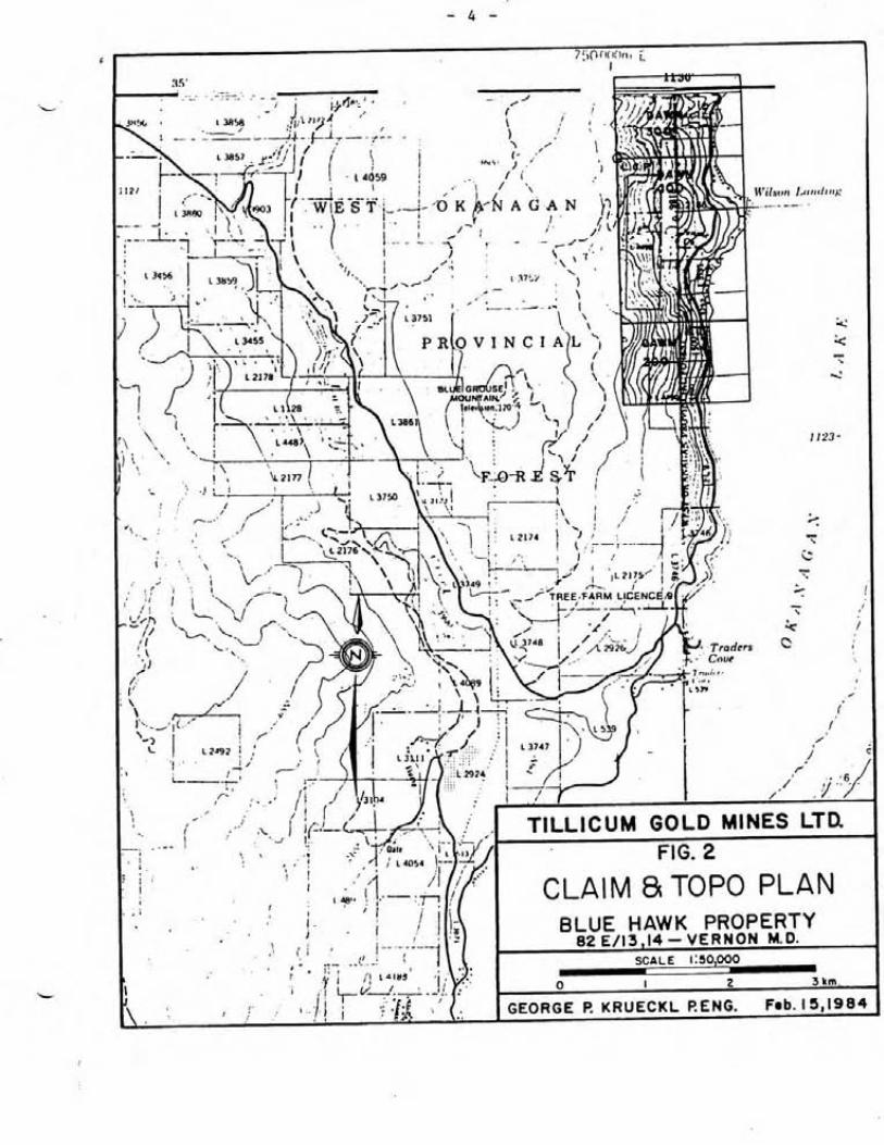
Fig. 2 Topographic and claim plan
Fig. 3 Underground working and surface trenches with sample locations 6
Appendix I
- Assay Certificates Appendix I1
- Laboratory Methodology

L Introduction
This report is an eyaluation of prospecting work carried out on the
Dawn #lo0 mineral claims between June 20, 1983 and April 16, 1984.
Location and Access
The property is located 10 kilometres northwest of KePowna, B.C.
immediately west of Wilson's Landing on the west shore of
Okanagan Lake (Fig. 1). Logging roads which parallel the shore of
the Lake are about elevation 1100 meters connect with Highway 97
and the Blue Grouse mountain T.V. road to provide access to the
property. Figure 2 shows the approximate location of these roads.
Topography and Vegetation
The topography of the area is mountainous, relief ranging between
350 meters and 1,300 meters above sea level. The Blue Hawk Adit
and trenches on the claim are located at an elevation of approximately
900 metres above sea level. Typical of the Okanagan Valley, tree
cover ranges from light to heavy depending on elevation, the lower
slopes having lighter tree cover. Figure 2 shows the topography
of the ore.
Ownership
The Dawn #lo0 claim is wholly owned and operated by Tillicum Gold
Mines Ltd. and are locates in the Vernon Mining Division in NTS
82E/13 and 14.
Information on file with the British Columbia Ministry of Energy,
Mines and Petroleum Resources at Vernon, British Columbia is as Ic-r
follows:

LOCATION MAP

Recorded Claim Name Units Record No. Expiry Date Holder
L
Dawn 100 4 x 3 =12 1517(6) June 1,1984 C. Graham
100% interest in the Dawn #lo0 claims has been acquired by
Tillicum Gold Mines Ltd. via bill of sale.
History - Previous Development and Mineralization
The Prospect covers old trenches and underground workings of the
Old Blue Hawk mine reported in the B.C. Minister of Mines Report
for 1933, 1935 and 1938, and represents work carried out by the
former Blue Hawk Syndicate of Kelowna. This early work consisted
of exploring several quartz veins ranging from narrow fracture
fillings to veins 4 feet thick. Some of this work also involved
sinking shallow shafts up to 10' deep. In 1932 one of these,
believed to be adjacent to the old work shop, assayed up to
$32.25 in gold and silver and in 1935, 5 tons was presumably shipped
from this shaft.
Also in 1932, several trenches were dug and the Blue Hawk adit was
advanced to 8 meters. The Blue Hawk was extended to 150 metres
(its present length) in 1938.
No additional exploration woek has been recorded since then until
the late 1960's when several geological reports were prepared on
the property and between 1969 and 1972 Dawood Mines Ltd. of Merritt,
B.C. carried out 425 lineal meters of trenching, 17.7 kilometers of
line cutting and grid preparation, magnetometer surveys, geological
mapping and geochemical soil sampling.
Tillicum gold optioned the ground in 1983 and carried out some
preliminary sampling in old trenches to confirm gold values. One
of these samples ran .24 oz per ton gold.

Regional Geology
The Dawn #lo0 mineral claims are situated on the western edge of
the Sluswap metamorphic complex - a broad terrain underlain by multiphase granitic plutons which enclose narrow bets of
sedimentary rocks. Near Okanagan Lake, the sediments probably
belong to the Cache Creek Group (Permians), and the plutons to
large batholiths formed during the Jurassic Cretaceous.
Numerous precious meral, copper, lead and zinc prospects occur
in altered Cache Creek sediments west of Vernon and south along
the shores of Okanagan Lake to Kelowna. All of these prospects
have received development work in past years, some have recorded
work in past years, some have recorded past gold production but
none are currently operating. All of the deposits are vein and
ypes and in addition to their gold and silver content, contain
chalcopyrite, pyrite, pyrrhotite, arsenopyrite, galena and
sphalerite.
Prospecting - Description of Observations
The author made numerous cisits to the property between June, 1983
and April, 1984, accompanied by consultant George Krueckl, P. Eng.
The following observations are based on these visits:
Prospecting and sampling was limited to the area shown in Fig. 3.
Adits and trenches developed by previous workers were systematically
sampled to determine the precious metal content of the exposed
structures.

Prospecting - Description of Observations (contd.) The veins exposed on the property occur along shear or fracture
zones in hornblende diorite and more rarely in Cache Creek
sediments close to diorite contacts. The veins are mainly
milky quartz with minor disseminated pyrite, and rarely, galena.
Most are one to two feet thick but vary considerably in thickness
over a strike length of a few feet. Northeast striking faults are
common, and these appear to offset and trancate the veins at some
localities.
Earlier workers have selectively extracted pyrite-rich zones within
the veins, suggesting that gold and pyrite are associated. Pyrite
forms small disseminated grains, crystal aggregates and thin fracture
fillings within the veins.
Preyious underground work done on the Blue Hawk adit exposed two
0 veins having azimuth directions 305 and 335O (Fig. 3). Each of
these may have been faulted in the northeast direction and in one
case may have dissipated into the wall rock. The surface vein
showings however, appeared to be much more continuous than the
underground vein showings. At surface, two of the vein directions
(305' and 335O) were identified in the trenches directly above the
Blue Hawk adit.
Sampling of mineral showings in underground workings and trenches
was carried out. The results have been plotted on Fig. 3.

ASSAYS ILL CtQ %)
Trench No.
Ag Sample Au PPm No. Adit oz/T
Distance (M) & Sample No.
.5 9615D Blue Hawk .001
.l' B9 .001
.Ol (oz/t) 87055 .001
. 4 9612D Lower adit ,001
. 4 9611D .001
.06 (oz/t) AB-3 Tailings
.Ol (oz/t) 87056 .001

Assays (contd. C
Trench Au ei No. oz/T
Ag Sample AU Ag Distance (M) PPm N4. Adit oz/T ppm & Sample No.

Results
Analyses performed by Acme Analytical Laboratories are listed
in Appendix I. Appendix I1 includes analytical methods used
by Acme,
Chip samples were assayed for gold and silver content. A total
of 38 samples were submitted. Six of these were re-assayed for
gold content.
Sampling of mineral showings in trenches and adits carried out
by the writer indicate highly erratic gold values. Values
ranged from trace to .243 oz/ton gold and silver from trace to
.67 oz/ton.
Interpretation
Gald values have been shown to he erratically distributed
throughout the vein structures over a fairly large area.
Trenching carried out in the past exposed quartz veins containing
gold mineralization. Initial prospecting indicates that a
detailed geological. survey is required to better understand the
significance of the mineralization and geological structures
found on the property.
Conclusion
Prospecting carried out on the Dawn #a00 claims, indicates the
presence of significant but erratic gold values in quartz veins.
Detailed geological mapping and surveying are required to further
understand the extent and nature of mineralization on the property.

Itemized Cost Statement
Includes costs attributable to bill received to date
Personnel
6 working days 2 men
4 working days 1 geologist
Accommodation and Board
Meals
Rooms
Equipment
Topo line
Flagging
Transportation
Gas
Vehicle (4 x 4)
Analysis
53 Rock samples a t 12.00 per sample
Report Preparation
Flay 19, 1984
Author's Qualifications
I, Jonathan W. George certify to the following:
1. I am a geologist with Tillicum Gold Mines Ltd. 319-470
Granville Street, Vancouver, B.C. V6C 1V5
2. My academic qualifications are:
B.Sc. (Geol) . Western Washington University, Bellingham, Washington, U.S.A.
3. I have been engaged in geological work for the past five
years
4. I am a director and shareholder of Tillicum Gold Mines Ltd.
5. Tillicum Gold Mines Ltd. has the sole right to the use of
this report in any activities pertaining to the property
herein described.
May 19, 1984

Appendix I

T 0 : ~ i l l i c u m Gold Mines L t d . , G:.?.snd Floor - 470 Granville S t . , Vancouver, B.C. V 6 C 1V5
ACME ANALYTICAL LABORATORIES LTD. Assayir~g & Trace Analysis
852 E. H a s t ~ n g s S t , V a n c o u v e r , 0 . C. V6A 1R6
Telephone:253 - 31 58
83-0952 File No. - ---------------
Rock Q p e o f Samples - ---------
June 29, 1983 DATE REP0m-S MAILED ---,---------------
ASSAYER ...................................... ...................................... -I- DEAN TOYE. B S C
CHIEF CHEMIST CEFTICIED II C A S S A V E R
- -- I
ND. NO.
1
2
3
4
5
6
7 -
Sample
I
-
I AU
! -t-
A B - 4 .67 .243
I -
-- - 12
OZ/ ton
.01
.05
.06
2
3 --
I ' , 9 -- -
i 4
15 -
16
17
18
19
20
OZ/ ton
.002 --
.OU7
,908
2
3
--
-
1
AU reports are tfie confidential property of clients.
-
DATE SAMPLES K E ~ - E I V E D - - - ~ ~ ? D ~ - ~ ~ A - ] _ ? , ~ ~ ~
--
L-
i 10 -
1 1
12
13
14
15
16
17
18
19
20

L ACME ANALYTICAL LABORATORIES LTD. DATE RECEIVED NOV 15 1983 852 E. HASTINGS, VANCOUVER B.C.
up PH: 253-3158 TELEX : 04-53 124 DATE REPORTS MOILED AI/_2!@
CSSSAY CERTIFICATE
SAHPLE T Y P E : HOCK - CRUSHED AND PRULVERIZED T O -100 HESH.
A S S A Y E R -- DEAN T O Y E , CERTIFIED B-C. ASSAYER

ACME ANALYTICAL LABORCITORIES LTD. 852 E. HASTINGS, VANCOUVER B.C. PH:253-3158 TELEX:04-53124
ASSAY CERTIFICATE
EOCHD(1CAL ICP : 1 .W W SAMPLE IS DI6ESTED WITH 38 OF 3:1:3: MX TO ant13 TO HZ0 BT 90 M6.C. FOR 1 HOVR .THW DILUTED TO 10 I(LS WITH YRTER. THIS LEAM IS PMTlAL FOR. Ca,P,~,RI,Ti,La,&,K,Y,B~,Si,Sr,Cr IY(D 8. k DETECTIOW 3 ppr. Mt BY REWLAR ASSAY. WlPLE TYPE - ROCK MIPS
DhTE RECEIVED NDV 10 1983 DATE REPORTS PlAILED-&d-&&& A S S A Y E R - A * DEAN T O I E , C E R T I F I E D 8. C. 1SSAIER
TILLICUM GOLD MINES FILE # 83-2902 PAGE # I
W L E I Ho Cu Fb In Ag Ni Co Hn Fe As U I)u Th Sr U Sb Bi V b P La Cr Ng Ba Ti 8 11 Na K Y ht P P I P P I PPI P P I P P I PP@ PPa PP@ 1 P P I P P I P P I w a P P I P P I P P I P P I PP@ 1 1 P P I PP@ 1 P P I I P P I 2 1 PW olt
.001
.001
.OO!
.MI . OO!


ACME ANALYTICAL LABORATORIES LTD. DATE RECEIVED MAR 19 1 9 8 4 852 E. HASTINGS, VANCOUVER B. C. pH: 253-3158 TELEX : 04-53124 DATE REPORTS MAILED ,&Y
L ASSAY CERTIFICATE
SAHPLE TYPE : ROCK - CRUSHED AND PRULVERIZED TO -100 HESH. AU BY FIRE ASSAYS
A s s f i Y E R -- d!-"i"yDE.N T O Y E , = E m I i= I E D B . c . A s s A Y E R
T I L L I C l J M GOLD MINES FILE # €34-0381 & PAGE# 1

Appendix 11.
9 r hd
1 I I I I b
I I
I
ACME ANALYTICAL LABORATORIES LTD. Assaying & Trace Analysis
852 E. Hestings St., Vancouver, B.C. V6A 1R6
Telephone : 253 - 3158
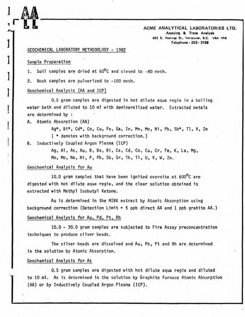
GEOCHEMICAL LABORATORY METHODOLOGY - 1982
Sample Prepara t ion
1. S o i l samples are d r i e d a t 6 0 ' ~ and s ieved t o -80 mesh.
2. Rock samples are pu l ve r i zed t o -100 mesh.
Geochemical Analys is (AA and I C P )
0.5 gram samples a re d iges ted i n h o t d i l u t e aqua r e g i a i n a- b o i l i n g
water ba th and d i l u t e d t o 10 m l w i t h demineral ized water. Ex t rac ted metals
a re determined by :
A. Atomic Absorpt ion (AA)
Ag*, Bi*, Cd*, Co, Cu, Fe, Ga, In , Mn, Mo, N i , Pb, Sb*, T I , V, Zn
( * demotes w i t h background c o r r e c t i o n . )
B. I n d u c t i v e l y Coup1 ed Argon Plasma (ICP)
Ag, Al , As, Au, By Ba, B i , Ca, Cd, Co, Cu, C r , Fe, K, La, Mg,
Mn, Mo, Na, Ni, P, Pb, Sb, S r , Th, T i , U, V , W , Zn.
Geochemi ca l Anal ys i s f o r Au
10.0 gram samples t h a t have been i g n i t e d ove rn i t e a t 6 0 0 ' ~ are
d iges ted w i t h h o t d i l u t e aqua reg ia , and the c l e a r s o l u t i o n ob ta ined i s
e x t r a c t e d w i t h Methyl I s o b u t y l Ketone.
Au i s determined i n the MIBK e x t r a c t by Atomic Absorpt ion us ing
background c o r r e c t i o n (Detec t ion L i m i t = 5 ppb d i r e c t AA and 1 ppb g r a h i t e AA. )
Geochemical Ana lys is f o r Au, Pd, P t , Rh
10.0 - 30.0 gram samples a re sub jec ted t o F i r e Assay preconcent ra t ion
techniques t o produce s i l v e r beads.
The s i l v e r beads are d isso lved and Au, Pb, P t and Rh a re determined
i n the s o l u t i o n by Atomic Absorption.
Geochemical Analys is f o r As
0.5 gram samples are d iges ted w i t h h o t d i l u t e aqua r e g i a and d i l u t e d
t o 10 m1. As i s determined i n the s o l u t i o n by Graph i te Furnace Atomic Absorpt ion
(AA) o r by I n d u c t i v e l y Coupl ed Argon Plasma (ICP).

r
r ACME ANALYTICAL LABORATORIES LTD. Asraying & Tram Analysis
852 E. Hastings St., Vancouver, B.C. V6A 1R6
Telephone : 253 - 3158 1 Geochemical Ana lys ts f o r Barium
I 0.1 gram samples a re d igested w i t h h o t NaOH and EDTA so lu t i on .
I Ba i s determined i n the s o l u t i o n by Atomic Absorpt ion.
I Geochemi ca1 Ana lys is f o r " ran i um
0.5 gram samples are d igested w i t h h o t aqua r e g i a and d i l u ted
t o 10 ml.
A l i q u o t s of the a c i d e x t r a c t a r e so l ven t e x t r a c t e d us ing a
s a l t i n g agent and a l i q u o t s of- the so l ven t e x t r a c t a re fused w i t h NaF,
K2C03 and Na2C03 f l u x i n a p la t inum dish.
I The f luorescence o f t he p e l l e t i s determined on the J a r r e l Ash
F l uorometer.
I Geochemi c a l Ana lys is f o r Tungsten
1.0 gram samples a re fused w i t h K C l , KN03 and Na2C03 f l u s i n
a t e s t tube, and the fusions are leached w i t h 10 m l water . W i n the
s o l u t i o n determined by ICP w i t h a de tec t i on o f 1 ppm.
( Geochemical Analys 1 s f o r F l u o r i ne
I 0.25 gram samples a re fused w i t h sodium hydroxide and leached
w i t h 10 ml water. The s o l u t i o n i s neut ra l i zed , bu f fe red , ad jus ted t o
pH 7.8 and d i l u t e d t o 100 m l .
F l u o r i n e i s determined by S p e c i f i c I o n E lec t rode us ing an
Or ion Model 404 meter.
Geochemical Ana lys is f o r Tin
1.0 gram samples a re fused w i t h amnonium i o d i d e i n a t e s t tube.
The subl imed i o d i n e I s leached w i t h d i l u t e hyd roch lo r i c ac id .
The s o l u t i o n i s ex t rac ted w i t h MIBK and t i n i s determined i n
the e x t r a c t by Atomic Absorpt ion.
