mauritius - asclmeasclme.org/meda/mu/mauritius_meda_final-electronic.pdfthe contributions of the...
TRANSCRIPT

National Marine Ecosystem Diagnostic Analysis (MEDA)
Agulhas and Somali Current Large Marine Ecosystems (ASCLME) Project
ASCLME Agulhas and Somali Current
Large Marine Ecosystems Project
M a u r i t i u s

The GEF unites 182 countries in partnership with international institutions, non-governmental organizations (NGOs), and the private sector to address global environmental issues while supporting national sustainable development initiatives. Today the GEF is the largest public funder of projects to improve the global environment. An independently operating financial organization, the GEF provides grants for projects related to biodiversity, climate change, international waters, land degradation, the ozone layer, and persistent organic pollutants. Since 1991, GEF has achieved a strong track record with developing countries and countries with economies in transition, providing $9.2 billion in grants and leveraging $40 billion in co-financing for over 2,700 projects in over 168 countries. www.thegef.org
UNDP partners with people at all levels of society to help build nations that can withstand crisis, and drive and sustain the kind of growth that improves the quality of life for everyone. On the ground in 177 countries and territories, we offer global perspective and local insight to help empower lives and build resilient nations. www.undp.org
This document may be cited as: ASCLME 2012. National Marine Ecosystem Diagnostic Analysis. Mauritus. Contribution to the Agulhas and Somali Current Large Marine Ecosystems Project (supported by UNDP with GEF grant financing).
The contributions of the Western Indian Ocean Marine Science Association (WIOMSA) in supporting this publication are gratefully acknowledged.
The contributions of the Ocean Data Information Network of Africa (ODINAFRICA) in supporting this publication are gratefully acknowledged.
The views expressed in this publication may not necessarily reflect those of the GEF, UNDP, or other UN agencies or project partner institutions/organisations. Neither does it imply any opinion whatsoever as to the legal status of any country, territory, city or area, of its authorities, or of the delineation of its territories or boundaries.
tseW
htr
oN
revi
R
dn
arG
a
se
ss
abela
C
Du
Du
de
La
du
du
du
Cap
Cit
Eau
des
Bee
St.
des
Baie
rons
R du
Deep
East
Moka
Bain
River
River
River
Tabac
River
River
River
Poste
River
South
River
Grand
Bleue
River
River
Chaux
River
Amand
River
River
River
River
Noire
PosteRiver
River
River
M o k
RougeTerre
River
River
River
RiverDragon
Galets
R des
Tombeau
Jacotet
Riviere
Riviere
Creoles
Manique
Rivier e
Patates
Riviere
Riviere
Papayes
Rempart
Wilhems
Cascade
Rem
part
Riviere
R. Seche
Francoise
Champagne
R i v e r
River Seche
Fla
cq
des Negresses
River Tamarin
River Tamarin
River Plaines
Labourdonnais
River Du Poste
River Savanne
River Boucan
de s An gui l les
Grand Riviere Noire
Bitte
Île Malno
Îlot Chat
Îlot Calmi
Île Vacoas
Île Matapan
Île D'Ambre
Îlot Fourmi
Îlot Vacoas
Îlot Lafond
Ilot Sancho
Îlot Brocus
Îlot Malais
Îlot Maunick
Îlot Du Mort
Îlot Lievres
Île Flamants
Île aux Fous
Île Marianne
Île Camisard
Île de L'est
Île Florency
Le Souffleur
Île Trou Viré
Île aux Cerfs
Îlot Mangenie
Île aux Chats
Ilot Fourneau
Île aux Phales
Îlot Aigrettes
Îlot Levrettes
Île des Roches
Île aux Singes
Mouchoir Rouge
Île du Hangard
Lerique Island
Île de la Passe
Île aux Lubines
Île aux Fouquets
Île aux Aigrettes
Île aux Bénitiers
Île de la Batterie
Rocher des Oiseaux
Îlot Des Deux Cocos
Valetta
La Ferme
Eau Bleue
Mare Longue
Midlands Dam
La Nicolière
Bassin Blanc
Grand Bassin
Kanaka Crater
Tamarind Falls
Piton du Milieu
Mare aux Vacoas
Trou Aux Cerfs
Moka
Mapou
Piton
Cluny
Verdun
Amaury
Albion
SoeursQuatre
Olivia
Triolet Cottage
Arsenal
Pailles
Tamarin
Bananes
Melrose
Bambous
Surinam
Benares
The Vale
Congomah
Lalmatie
Dubreuil
Chamarel
Souillac
Chamouny
Le Morne
Dagotiere
L' Avenir
Esperance
Goodlands
D' Epinay
Laventure
Le Hochet
Clemencia
MahebourgNew Grove
Britannia
St. AubinBel Ombre
Ripailles
St. Pierre
Grand Baie
Calebasses
Ecroignard
Providence
Notre Dame
Cascavelle
St. Hubert
Union Park
Sebastopol
Rose Belle
Mare Tabac
Grand BoisBois Chéri
Roche Terre
Fond du Sac
Grand Gaube
Camp Ithier
Ville Bague
Bon Accueil
Camp Thorel
Creve Coeur
Grand Sable
La Gaulette
L' Escalier
Camp Diable
Baie du Cap
Terre Rouge
Poudre d' Or
Quatre Cocos
Mare Chicose
Flic en FLac
Beau Vallon
Petit Raffray
Pamplemousses
Long Mountain
Gros Cailloux
Roches Noires
Grand Bel Air
Petit Bel Air
Mare La Chaux
Poste de Flacq
Queen Victoria
Camp de Masque
Mare D' Albert
Plaine Magnien
Chemin Grenier
PetiteRivière
Baie du Tombeau
Centre de Flacq
Brisée Verdière
Trois Boutiques
Nouvelle France
La Laura Malenga
Bambous Virieux
Montagne Blanche
Vieux Grand Port
Trou D' Eau Douce
Plaine des Roches
Rivière du Poste
Petite case Noyale
Quartier Militaire
Plaine des Papayes
St. Julien Village
Rivière du Rempart
Cap Malheureux
Esperance Trebuchet
Poudre d' Or Hamlet
Camp de Masque Pavé
Rivière des Creoles
St. Julien d' Hotman
Grande Rivière Noire
Bois des Amourettes
Rivière des Anguilles
Medine Camp de Masque Bel Air Rivière Sèche
Grand RiverSouth East
Morcellement St. André
V A C O A SV A C O A S
P H O E N I XP H O E N I X
C U R E P I P EC U R E P I P E
R O S E H I L LR O S E H I L L
P O R T L O U I SP O R T L O U I S
B E A U B A S S I NB E A U B A S S I N
Q U A T R E B O R N E SQ U A T R E B O R N E S
Trio
Argy
Ilôt
GRNW
Anna
Cité
Unité
Ebène
Canot
GaleaPalma
Yemen
Lesur
Palma
Combo
TyackStaub
Barkly
Chebel
Gowsal
Palmar
Choisy
Barlow
Valton
Reduit
Soreze
Cassis
Amitié
Xavier
Diolle
MesnilCastel
Wooton
Casela
Carlos
Wolmar
Le Val
Candos
Sodnac
Médine
Ferney
Clavet
Gébert
Pointe
Luchon
Choisy
Trefles
Stanley
Germain
Belmont
Forbach
Bon Air
Sottise
Chimère
Latapie
Melotte
Minissy
Telfair
Ka Hine
GokoolaLa Paix
St Jean
Reunion
Sadally
Floreal
Palmyre
Magenta
La Pipe
Magenta
Trianon
La Rosa
Baramia
Accacia
d' Esny
Savinia
Carreau
Bel Air
Riambel
Midlands
The Vale
Melville
Solitude
Pavillon
La Laura
Victoria
St. Rémy
Montaigu
Lenferna
La Gaité
Mont Ida
La Roche
Robinson
Gentilly
Le Ravin
Mon Gout
Souvenir
Macchabe
Tatamaka
La Lucie
La Marie
St. Paul
Holyrood
Robinson
Clarence
Balisson
Vaudagne
Quartier
Bois Sec
La Flora
Cachette
La Crête La Chaux
Virginia
Malakoff
Blue Bay
Savannah
Valruche
Rouillard
Callodine
Esperance
Hermitage
Beau Plan
Camp Moti
Balaclava
Pereybère
La Louisa
Mon Choix
Camp Pavé
Thomassin
Richelieu
Beau Bois
Bramsthan
Hermitage
La Source
Constance
Gibraltar
Ripailles
Mon songe
Belvedère
Belvédère
Bel Etang
Rich Fund
Baillache
Bagatelle Camp Samy
Mount Ory
Le Bocage
Belle Vue
La Mecque
Le Goulet
The Mount
Khoyratty
L' Espoir
Beau Site
Bon Asile
Glen Park
Henrietta
Solferino
Riverside
La Mairée
Malherbes
La Mivoie
Belle Vue
Mon Désir
Hermitage
Le Vallon
Pellegrin
La LouiseLa Source
Bagatelle
HermitageHighlands
Valentina
Eau Bonne
L' Etoile
Beau Bois
Le Pétrin
MongelardDeux Bras
Souffleur
Plaisance
Joli Bois Gros Bois
St. AubinValentina
St. Felix
Gris Gris
Terracine
St. Avold
Frederica
Coromandel
Mon Loisir
Mare Seche Petit Camp
Bon Espoir
Bois Rouge
Schoenfeld
Sans Souci
Bois Rouge
Camp Lilas
Camp Sadah
Aussailles
Mon Choisy
Mon Rocher
Petit Bois
Providence
Riche Mare
Pont Blanc
Belle Mare
Bois Jacot
Mare Jacot
Camp Sonah
Boulingrin
Bois Cheri
Martindale
Montebello
Tranquebar
Abercombie
Belle Rose
La Rosière
St. Martin
Antoinette
Mon Loisir
Haute Rive
Sinatambou
St. Joseph
L'Harmonie
Belle Rive
Camp Mapou
La Caverne
Camp Caval
Eau Coulée
Mon Vallon
Bois Puant
Belle Rose
Beemanique
Sans Souci
Petit Camp
Belle Isle
Providence
Deep River
Mon Tresor
Union Vale
Sauveterre
La Cambuse
Mon Desert
Plein Bois
Le Bouchon
Le Chaland
Camp Carol
Pomponette
Martinière Senneville
Riche Bois
Batimarais
Fontenelle
Mont Blanc
La Prairie
Ste. MarieBeau Champ
St. Martin
BarLe Duc
CampRanoo
Bonne Mère
Roche Bois
Mont Roches
Bonne Terre
Rouge Terre
Mont Mascal
Madame Azor
St. Antoine
Camp Bestel
Ville Valio
La Caroline
Bras d' Eau
Mare CarréeCoquinbourg
Union Flacq
Les Guibies
Les Salines
Beau Sejour
Beau Séjour
La Clémence
Coquinbourg
Riche Terre
Petit Gamin
Vallonbruse
Les Salines
Camp Bellin
Camp Roches
St. Antoine
Forest Side
Pierrefonds
La Preneuse
Trois Ilots
Beau Rivage
Camp Jardin
Madame Lolo
Camp Ramdin St. Hilaire
Pavé Citron
Belle Terre
Petit Sable
Deux FrèresLa Nourrice Trois Ilots
Kewal Nagar
Beau Climat
Gros Billot
La Barraque
La Sourdine
Camp Diable
Camp Creole
Camp Raphia
Camp Acacia
Camp Poorun
Tour Koenig
Camp Benoit
VilleNoire
La Brasserie
Camp Scipion
Union Daruty
L' Esperance
Petit Paquet
Anse La Raie
St. François
Camp Levieux
La Chaumière
Isodore Rose
Camp La Boue
Petite Julie
Pont Praslin
Camp crèoles
Cité La Cure
Plaine Verte
Camp Créoles
Petit Verger
Bois Rouge
Les Casernes
Beaux Songes
Camp Créoles
Ilot Fortier
Riche En Eau
Petit Paquet
Cinq Arpents
Anse Jonchée
Marie Jeanne
Grand Bassin
Mont Fertile
Union Ducray
L' Embrasure
Bois Mangues
La Cocoterie
Camp Garreau
Boulet Blanc
CarreauLalo
Vallee Pitot
Camp Yoloff
Canton Nancy
PontLardier
Baudot Estate
Camp La Serpe
Moulin à Vent
Labourdonnais
Camp Marcelin
Mare du PuitsHappy VillageHaut de Flacq
Les Mariannes
Camp La Serpe
Pont Bon Dieu
Petite Cabane
Bois Pignolet
Bois Marchand
Pont Colville
Petit Bel Air
La Chartreuse
Marie Jeannie
Pointe Jérome
Coteau Raffin
Camp Bouillon
Belle Etoile
Plaine Lauzun
Sainte Croix
Bell Village
Ruisseau Rose
CiteL'Oiseau
Camp Malgache
Reunion Maurel
Mapou Leclezio
Maison Blanche
Grande Rosalie
Grand Retraite
Petite Rosalie
Camp Badamiers
Union Park S.E
Cent Gaulettes
Rivière Dubois
Seizième Mille
Quinze Cantons
Engrais Cathan
Ste. Philomene
Ste. Madeleine
Cent Gaulettes
Treize Cantons
Grandes Gorges
Bois D'Oiseaux
Carreau Esnouf
Mare Anguilles
Rivière Dragon
Camp Domaingue
Camp BonneMère
Bain des Dames
Camp Chapelon
Madame Cayeux
ErnestFlorent
Mamzelle Jeanne
Moulin à Poudre
Trou aux Biches
Petite Retraite
Bois d' Oiseaux
Grand dans Fond
Piton du Milieu
Bois D' Oiseaux
Château Benares
Belle Vue Pitot
Belle Vue Harel
CampLa Savanne
Trou aux Cerfs
Camp La Vanille
Bonneval Hillock
Carreau La Liane
Camp Fouquereaux
Ruisseau Copeau
Bois d' Oiseaux
Poste Lafayette
Rivière Baptiste
Belle VueMaurel
Canton Belle Eau
Eau BleueTostée
Eau Bleue(Rama)
BarachoisEstate
N i c o l i è r e Mare d' Australia
La Rampe Le Moirt
Carreau La Paille
Rivère des Galets
Belle Vue Allendy
Mare auxFougeres
Pointe du Diable
Camp de Pêcheurs
Pointe des Lascars
Pointes aux SablesVallee des Prêtres
Black River Gorges
Pointe aux Roches
Petite Case Noyale
Pointe aux Roches
Grande Case Noyale
Le Morne Brabant
Pointe aux Feuilles
Isidore Rose(Pavé)
Camp des Embrevades
Camp des Embrevades
AstroeaRochecouste
Mon Loisir Rouillard
PetiteRivièreNoire
Tamarin Sugar Estate
PointeauxCanonniers
Butte aux Papayes
La Lucie Roy(Platform)
Bois Clair(Indian Camp)
Petite Pointe aux Piments
Grande Pointe aux Piments
Rué
îlot
Exil
Moka
Merlo
Rafin
GowerLaing
Caroe
Labury
Arnaud
Colmar
Kanaka
Lapeyre
Monvert
Verdale
Pradier
Ferrette
Mare Ory
St Felix
Maingard
Lavilléon
Les Mares
Les Marres
Gouly Père Gouly Fils
Plaine Noel
Trou Beloute
Borne Carrée
Plaine Sophie
La Terre Rouge
La Terre Rouge
Parc aux Cerfs
Trou Chenilles
Plaine Bonnefin
Trou de Madame Bouchet
Dayot Mangin Coutanceau Talbot
Cem
Cem
Cem
Mon
Cem
Cem
Cem
Dam
Cem
Cem
Cem
Cem
Cem
CemCem
Cem
Cem
Cem
Cem
Cem
Cem
Cem
Tomb
Tomb
Tomb
Tombs
Aviary
Stadium
Stadium
Stadium
Stadium
Stadium
Cemetery
Hatchery
Causeway
Cemetery
Cemetery
Laboratory
Playground
Playground
Playground
Playground
Playground
CWA Filter
Golf Course
Fort Albert
Race Course
Fort George
Magenta Dam
NATURE PARK
Golf Course
Fort William
Fort Victoria
Sports Ground
Power Station
Sports Ground
Traffic Centre
GrazingGround
Grazing Ground
FootbalGround
Grazing Ground
Housing Estate
Balfour Garden
Grazing Ground
Grazing Ground
Grazing Ground
Grazing Ground
Grazing Ground
Housing Estate
Housing Estate
Football Ground
FootballGround
Football Ground
Grazing Grounds
Football Ground
Football Ground
Football Ground
Bel OmbreWharf
Football Ground
Football Ground
Football Ground
Cremation Ground
Football Ground
Football Ground
Football Ground
Cremation GroundCremation Ground
Football Ground
Football Ground
Football Ground
Football Ground
Cremation Ground
Industrial Estate
Industrial Estate
Botanical Gardens
Botanical Gardens
Georges VStadium
Gorges View Point
BC POST FORT GEORGE
State Land Belle Vue
La Marie Filter Beds
Fish Landing Station
Filao Grazing Ground
Robert E. Hart Garden
Sewage Disposal Plant
Chamarel Coloured Earth
State Land Powder Mills
Reunion Industrial Estate
La Vanille Crocodile Park
STATE LAND PALMAR RESERVES
Civil Aviation R.X Station
Radio Telescope Installation
Coromandel Industrial Estate
Montagne Blanche Housing Estate
S T A T E L A N D L' A S I L E
S T A T E L A N D B E L L E V U E
NIANUMSECEYA
SNI
AT
NU
OM
ERÈILO
CI
N
SL
EAXUDTM
B
M
O
U
NT
U
SN
I
A
OBMAB
NIATNUOMUOB
MA
DRALIVUA'DTM
NIATNUOM
NI
RA
MA
T
NIATNUOM
EHCNALB
S
N
I
A
T
N
U
O
M
E
N
N
A
VAS
R O C KS N A I L
P I T O N
C A N O N
P I T O N
M A R R O N
A G A P I T
W I L L I A M
M T C H A T
M O N T A G N E
N O U V E L L E
L E P O U C E
M T É B È N E
M T R A V A T
M T C O U V E
J U R A N Ç O N
M O N T A G N E
T h e M o u n t
E A S T P E A K
A L M A H I L L
G O A T R O C K
G I N G E M B R E
F A N T A I S I E
M t J a c q u o t
M o n t P i t o n
D É C O U V E R T EC A L E B A S S E S
G U I B Y P E A K
T H E W I N D O W
G R A N D P E A K
M T V I L L A R S
M T P A U L I N E
M T L A G R A V EM T L A S E L L E
M T C O C O T T E
M T S U R I N A M
M T B O N A M O U R
Q U O I N B L U F F
P R I E S T P E A K
P I E T E R B O T H
C R E V E C O E U R
P I T O N R O U G E
M T C A M I Z A R D
M T P E R R U C H E
M T L A T E R R E
C A N D O S H I L L
P I T O NP O U L E
M T L A P O R T E
P I T O N D E L A
F o r b a c h H i l l
S É N È Q U E P E A K
C A N T I N S P E A K
V I R G I N S P E A K
G R A N D G L A C I S
B R I S E F E R M T
P I T O NC A P O T E
M T B A R L E D U C
L O N G
J U N C T I 0 N P E A K
L I O N M O U N T A I N
M T B E A U C H A M P
M T D U R E M P A R T
M O N T S U R M O N T
B E R T H E L O T P E A K
M O N N E R O N H I L L
L ' É C H E L L E R O C K
M T C I T R O N N I E R S
M T D E S C R É O L E S
C U R E P I P E P O I N T
T R O I S M A M E L L E S
P I T O N S A V A N N E
P I T O N D U C A N O T
S I G N A L M O U N T A I N
P I C G R A N D F O N D
S P E A R G R A S S P E A K
L a F e n ê t r e H i l l
L E M O R N E B R A B A N T
M T B R I S E O U F E N D U
M O N T A G N E M A U R I C E
M T T A B L E A P E R R O T
( R I P A I L L E S H I L L )
G R A N D M A L A B A R M T S
L E C H E V A L D E P I E R R ET O U R E L L E D U T A M A R I N
P E T I T E R I V I È R E N O I R E
M T S T P I E R R E
C O R P S D E G A R D E
M O U N T A I N
Blue Bay
Anse Cunat
AnseColas
Grand Baie
Anse Bambou
Baie du Cap
Jacotet Bay
Anse Jonchee
Bassin Paquet
Bassin Humbert
Bassin Goemons
Bassin Bernard
Poste Lafayette
Anse Bonserjent
Grande Barachois
Anse St. Martin
Anse des Courants
Baie de la Riviere
Anse du Petit Sable
Anse du Grand Sable
Bras de Mer Belcourt
Bras de Mer des Fregates
HARBOUR
Leboeuf
Maconde
Pte d'Esny
Pte Bambou
Pte Corail
Pte Radeau
Pte Brocus
Pte Chaour
Pte Vacoas
Pte D'Esny
Pte Madras
Pte D'Azur
Pte Marron
Tombeau Bay
Pte Oscorne
Pte Bernard
Pte Riambel
Troud'Esny
Pte Moyenne
Pte Tamarin
Pte Sud-Est
Pte St. Lain
Pte Bonhomme
Trou Beloute
Pont Naturel
Pte Bernache
Pte L'Hortal
Le Gris Gris
Le Petit Cap
Pte Pecheurs
Pte des Puits
Pte du Diable
Pte Lafayette
Pte Orientale
Petite Pointe
Grande Pointe
Pte aux Caves
Pte du Hangard
Pte aux Boeufs
Pte aux Roches
Treize Cantons
Pte aux Roches
Pte aux Roches
Pte aux Sables
Pte des Régates
Garnd River Bay
Baie du Tamarin
Pte des Lascars
Pte Masulipatan
Butte a L'Herbe
Pte Citronniers
Pte Roche Noire
Pte Quatre Cocos
Pte aux Feuilles
Butte aux Sables
Canonniers Point
Pte de la Colonie
Petite RiviereBay
Pte de la Batterie
Pte de Roche Noire
Pte Corps de Garde
Pte des Deux Cocos
Pte Petite Riviere
Pte de L'Embarcadere
Pte Butte aux Sables
Pte Sud Flic en Flac
Pte Eglise Paresseuse
Grande RiviereNoire Bay
Petite Riviere Noire Bay
Pte Corail dela Prairie
Pte du Puits des Hollandais
Baie aux tortuesou de L'Arsenal
980000.000000
980000.000000
990000.000000
990000.000000
1000000.000000
1000000.000000
1010000.000000
1010000.000000
1020000.000000
1020000.000000
1030000.000000
1030000.000000
970000
.000
000
970000
.000
000
980000
.000
000
980000
.000
000
990000
.000
000
990000
.000
000
1000000.0
0000
0
1000000.0
0000
0
1010000.0
0000
0
1010000.0
0000
0
1020000.0
0000
0
1020000.0
0000
0
©
LegendMOTORWAY
ROAD-A
ROAD-B
ROAD-C
Rivers
District Boundary
Public Building
Built-up Areas
RESERVOIRS
COAST
0 - 120m
120-240m
240-360m
360-480m
480m >
Grid : MauritiusProjection : Lambert Conical OrthomorphicSpheroid : Clarke 1880Unit Of Measurement : MetreLongitude of origin : 57°31'18.58" East of GreenwichLatitude of Origin : 20°11'42.25" SouthScale Factor at Origin : UnityFalse Co-ordinates of origin : 1,000,000m Easting 1,000,000m Northing
MAURITIUS
PUBLISHED BY THE CARTOGRAPHIC SECTION - MINISTRY OF HOUSING AND LANDS
0 2 4 6 81Kilometers
101010010101010101010101010101010100101010010101001010101011010101010101
1010100
1010
1010
101010101010101010100101010010101001010101011010101010101
101010010101010101010101010101010100101010010101001010101011010101010101
1010100
1010
1010
101010101010101010100101010010101001010101011010101010101
ODINAFRICA

tseW
htr
oN
revi
R
dn
arG
a
se
ss
abela
C
Du
Du
de
La
du
du
du
Cap
Cit
Eau
des
Bee
St.
des
Baie
rons
R du
Deep
East
Moka
Bain
River
River
RiverTabac
River
River
River
Poste
River
South
River
Grand
Bleue
River
River
Chaux
River
Amand
River
River
River
River
Noire
PosteRiver
River
River
M o k
RougeTerre
River
River
River
RiverDragon
Galets
R des
Tombeau
Jacotet
Riviere
Riviere
Creoles
Manique
Rivier e
Patates
Riviere
Riviere
Papayes
Rempart
Wilhems
Cascade
Rem
part
Riviere
R. Seche
Francoise
Champagne
R i v e r
River Seche
Fla
cq
des Negresses
River Tamarin
River Tamarin
River Plaines
Labourdonnais
River Du Poste
River Savanne
River Boucan
de s An gui l les
Grand Riviere Noire
Bitte
Île Malno
Îlot Chat
Îlot Calmi
Île Vacoas
Île Matapan
Île D'Ambre
Îlot Fourmi
Îlot Vacoas
Îlot Lafond
Ilot Sancho
Îlot Brocus
Îlot Malais
Îlot Maunick
Îlot Du Mort
Îlot Lievres
Île Flamants
Île aux Fous
Île Marianne
Île Camisard
Île de L'est
Île Florency
Le Souffleur
Île Trou Viré
Île aux Cerfs
Îlot Mangenie
Île aux Chats
Ilot Fourneau
Île aux Phales
Îlot Aigrettes
Îlot Levrettes
Île des Roches
Île aux Singes
Mouchoir Rouge
Île du Hangard
Lerique Island
Île de la Passe
Île aux Lubines
Île aux Fouquets
Île aux Aigrettes
Île aux Bénitiers
Île de la Batterie
Rocher des Oiseaux
Îlot Des Deux Cocos
Valetta
La Ferme
Eau Bleue
Mare Longue
Midlands Dam
La Nicolière
Bassin Blanc
Grand Bassin
Kanaka Crater
Tamarind Falls
Piton du Milieu
Mare aux Vacoas
Trou Aux Cerfs
Moka
Mapou
Piton
Cluny
Verdun
Amaury
Albion
SoeursQuatre
Olivia
Triolet Cottage
Arsenal
Pailles
Tamarin
Bananes
Melrose
Bambous
Surinam
Benares
The Vale
Congomah
Lalmatie
Dubreuil
Chamarel
Souillac
Chamouny
Le Morne
Dagotiere
L' Avenir
Esperance
Goodlands
D' Epinay
Laventure
Le Hochet
Clemencia
MahebourgNew Grove
Britannia
St. AubinBel Ombre
Ripailles
St. Pierre
Grand Baie
Calebasses
Ecroignard
Providence
Notre Dame
Cascavelle
St. Hubert
Union Park
Sebastopol
Rose Belle
Mare Tabac
Grand BoisBois Chéri
Roche Terre
Fond du Sac
Grand Gaube
Camp Ithier
Ville Bague
Bon Accueil
Camp Thorel
Creve Coeur
Grand Sable
La Gaulette
L' Escalier
Camp Diable
Baie du Cap
Terre Rouge
Poudre d' Or
Quatre Cocos
Mare Chicose
Flic en FLac
Beau Vallon
Petit Raffray
Pamplemousses
Long Mountain
Gros Cailloux
Roches Noires
Grand Bel Air
Petit Bel Air
Mare La Chaux
Poste de Flacq
Queen Victoria
Camp de Masque
Mare D' Albert
Plaine Magnien
Chemin Grenier
PetiteRivière
Baie du Tombeau
Centre de Flacq
Brisée Verdière
Trois Boutiques
Nouvelle France
La Laura Malenga
Bambous Virieux
Montagne Blanche
Vieux Grand Port
Trou D' Eau Douce
Plaine des Roches
Rivière du Poste
Petite case Noyale
Quartier Militaire
Plaine des Papayes
St. Julien Village
Rivière du Rempart
Cap Malheureux
Esperance Trebuchet
Poudre d' Or Hamlet
Camp de Masque Pavé
Rivière des Creoles
St. Julien d' Hotman
Grande Rivière Noire
Bois des Amourettes
Rivière des Anguilles
Medine Camp de Masque Bel Air Rivière Sèche
Grand RiverSouth East
Morcellement St. André
V A C O A SV A C O A S
P H O E N I XP H O E N I X
C U R E P I P EC U R E P I P E
R O S E H I L LR O S E H I L L
P O R T L O U I SP O R T L O U I S
B E A U B A S S I NB E A U B A S S I N
Q U A T R E B O R N E SQ U A T R E B O R N E S
Trio
Argy
Ilôt
GRNW
Anna
Cité
Unité
Ebène
Canot
GaleaPalma
Yemen
Lesur
Palma
Combo
TyackStaub
Barkly
Chebel
Gowsal
Palmar
Choisy
Barlow
Valton
Reduit
Soreze
Cassis
Amitié
Xavier
Diolle
MesnilCastel
Wooton
Casela
Carlos
Wolmar
Le Val
Candos
Sodnac
Médine
Ferney
Clavet
Gébert
Pointe
Luchon
Choisy
Trefles
Stanley
Germain
Belmont
Forbach
Bon Air
Sottise
Chimère
Latapie
Melotte
Minissy
Telfair
Ka Hine
GokoolaLa Paix
St Jean
Reunion
Sadally
Floreal
Palmyre
Magenta
La Pipe
Magenta
Trianon
La Rosa
Baramia
Accacia
d' Esny
Savinia
Carreau
Bel Air
Riambel
Midlands
The Vale
Melville
Solitude
Pavillon
La Laura
Victoria
St. Rémy
Montaigu
Lenferna
La Gaité
Mont Ida
La Roche
Robinson
Gentilly
Le Ravin
Mon Gout
Souvenir
Macchabe
Tatamaka
La Lucie
La Marie
St. Paul
Holyrood
Robinson
Clarence
Balisson
Vaudagne
Quartier
Bois Sec
La Flora
Cachette
La Crête La Chaux
Virginia
Malakoff
Blue Bay
Savannah
Valruche
Rouillard
Callodine
Esperance
Hermitage
Beau Plan
Camp Moti
Balaclava
Pereybère
La Louisa
Mon Choix
Camp Pavé
Thomassin
Richelieu
Beau Bois
Bramsthan
Hermitage
La Source
Constance
Gibraltar
Ripailles
Mon songe
Belvedère
Belvédère
Bel Etang
Rich Fund
Baillache
Bagatelle Camp Samy
Mount Ory
Le Bocage
Belle Vue
La Mecque
Le Goulet
The Mount
Khoyratty
L' Espoir
Beau Site
Bon Asile
Glen Park
Henrietta
Solferino
Riverside
La Mairée
Malherbes
La Mivoie
Belle Vue
Mon Désir
Hermitage
Le Vallon
Pellegrin
La LouiseLa Source
Bagatelle
HermitageHighlands
Valentina
Eau Bonne
L' Etoile
Beau Bois
Le Pétrin
MongelardDeux Bras
Souffleur
Plaisance
Joli Bois Gros Bois
St. AubinValentina
St. Felix
Gris Gris
Terracine
St. Avold
Frederica
Coromandel
Mon Loisir
Mare Seche Petit Camp
Bon Espoir
Bois Rouge
Schoenfeld
Sans Souci
Bois Rouge
Camp Lilas
Camp Sadah
Aussailles
Mon Choisy
Mon Rocher
Petit Bois
Providence
Riche Mare
Pont Blanc
Belle Mare
Bois Jacot
Mare Jacot
Camp Sonah
Boulingrin
Bois Cheri
Martindale
Montebello
Tranquebar
Abercombie
Belle Rose
La Rosière
St. Martin
Antoinette
Mon Loisir
Haute Rive
Sinatambou
St. Joseph
L'Harmonie
Belle Rive
Camp Mapou
La Caverne
Camp Caval
Eau Coulée
Mon Vallon
Bois Puant
Belle Rose
Beemanique
Sans Souci
Petit Camp
Belle Isle
Providence
Deep River
Mon Tresor
Union Vale
Sauveterre
La Cambuse
Mon Desert
Plein Bois
Le Bouchon
Le Chaland
Camp Carol
Pomponette
Martinière Senneville
Riche Bois
Batimarais
Fontenelle
Mont Blanc
La Prairie
Ste. MarieBeau Champ
St. Martin
BarLe Duc
CampRanoo
Bonne Mère
Roche Bois
Mont Roches
Bonne Terre
Rouge Terre
Mont Mascal
Madame Azor
St. Antoine
Camp Bestel
Ville Valio
La Caroline
Bras d' Eau
Mare CarréeCoquinbourg
Union Flacq
Les Guibies
Les Salines
Beau Sejour
Beau Séjour
La Clémence
Coquinbourg
Riche Terre
Petit Gamin
Vallonbruse
Les Salines
Camp Bellin
Camp Roches
St. Antoine
Forest Side
Pierrefonds
La Preneuse
Trois Ilots
Beau Rivage
Camp Jardin
Madame Lolo
Camp Ramdin St. Hilaire
Pavé Citron
Belle Terre
Petit Sable
Deux FrèresLa Nourrice Trois Ilots
Kewal Nagar
Beau Climat
Gros Billot
La Barraque
La Sourdine
Camp Diable
Camp Creole
Camp Raphia
Camp Acacia
Camp Poorun
Tour Koenig
Camp Benoit
VilleNoire
La Brasserie
Camp Scipion
Union Daruty
L' Esperance
Petit Paquet
Anse La Raie
St. François
Camp Levieux
La Chaumière
Isodore Rose
Camp La Boue
Petite Julie
Pont Praslin
Camp crèoles
Cité La Cure
Plaine Verte
Camp Créoles
Petit Verger
Bois Rouge
Les Casernes
Beaux Songes
Camp Créoles
Ilot Fortier
Riche En Eau
Petit Paquet
Cinq Arpents
Anse Jonchée
Marie Jeanne
Grand Bassin
Mont Fertile
Union Ducray
L' Embrasure
Bois Mangues
La Cocoterie
Camp Garreau
Boulet Blanc
CarreauLalo
Vallee Pitot
Camp Yoloff
Canton Nancy
PontLardier
Baudot Estate
Camp La Serpe
Moulin à Vent
Labourdonnais
Camp Marcelin
Mare du PuitsHappy VillageHaut de Flacq
Les Mariannes
Camp La Serpe
Pont Bon Dieu
Petite Cabane
Bois Pignolet
Bois Marchand
Pont Colville
Petit Bel Air
La Chartreuse
Marie Jeannie
Pointe Jérome
Coteau Raffin
Camp Bouillon
Belle Etoile
Plaine Lauzun
Sainte Croix
Bell Village
Ruisseau Rose
CiteL'Oiseau
Camp Malgache
Reunion Maurel
Mapou Leclezio
Maison Blanche
Grande Rosalie
Grand Retraite
Petite Rosalie
Camp Badamiers
Union Park S.E
Cent Gaulettes
Rivière Dubois
Seizième Mille
Quinze Cantons
Engrais Cathan
Ste. Philomene
Ste. Madeleine
Cent Gaulettes
Treize Cantons
Grandes Gorges
Bois D'Oiseaux
Carreau Esnouf
Mare Anguilles
Rivière Dragon
Camp Domaingue
Camp BonneMère
Bain des Dames
Camp Chapelon
Madame Cayeux
ErnestFlorent
Mamzelle Jeanne
Moulin à Poudre
Trou aux Biches
Petite Retraite
Bois d' Oiseaux
Grand dans Fond
Piton du Milieu
Bois D' Oiseaux
Château Benares
Belle Vue Pitot
Belle Vue Harel
CampLa Savanne
Trou aux Cerfs
Camp La Vanille
Bonneval Hillock
Carreau La Liane
Camp Fouquereaux
Ruisseau Copeau
Bois d' Oiseaux
Poste Lafayette
Rivière Baptiste
Belle VueMaurel
Canton Belle Eau
Eau BleueTostée
Eau Bleue(Rama)
BarachoisEstate
N i c o l i è r e Mare d' Australia
La Rampe Le Moirt
Carreau La Paille
Rivère des Galets
Belle Vue Allendy
Mare auxFougeres
Pointe du Diable
Camp de Pêcheurs
Pointe des Lascars
Pointes aux SablesVallee des Prêtres
Black River Gorges
Pointe aux Roches
Petite Case Noyale
Pointe aux Roches
Grande Case Noyale
Le Morne Brabant
Pointe aux Feuilles
Isidore Rose(Pavé)
Camp des Embrevades
Camp des Embrevades
AstroeaRochecouste
Mon Loisir Rouillard
PetiteRivièreNoire
Tamarin Sugar Estate
PointeauxCanonniers
Butte aux Papayes
La Lucie Roy(Platform)
Bois Clair(Indian Camp)
Petite Pointe aux Piments
Grande Pointe aux Piments
Rué
îlot
Exil
Moka
Merlo
Rafin
GowerLaing
Caroe
Labury
Arnaud
Colmar
Kanaka
Lapeyre
Monvert
Verdale
Pradier
Ferrette
Mare Ory
St Felix
Maingard
Lavilléon
Les Mares
Les Marres
Gouly Père Gouly Fils
Plaine Noel
Trou Beloute
Borne Carrée
Plaine Sophie
La Terre Rouge
La Terre Rouge
Parc aux Cerfs
Trou Chenilles
Plaine Bonnefin
Trou de Madame Bouchet
Dayot Mangin Coutanceau Talbot
Cem
Cem
Cem
Mon
Cem
Cem
Cem
Dam
Cem
Cem
Cem
Cem
Cem
CemCem
Cem
Cem
Cem
Cem
Cem
Cem
Cem
Tomb
Tomb
Tomb
Tombs
Aviary
Stadium
Stadium
Stadium
Stadium
Stadium
Cemetery
Hatchery
Causeway
Cemetery
Cemetery
Laboratory
Playground
Playground
Playground
Playground
Playground
CWA Filter
Golf Course
Fort Albert
Race Course
Fort George
Magenta Dam
NATURE PARK
Golf Course
Fort William
Fort Victoria
Sports Ground
Power Station
Sports Ground
Traffic Centre
GrazingGround
Grazing Ground
FootbalGround
Grazing Ground
Housing Estate
Balfour Garden
Grazing Ground
Grazing Ground
Grazing Ground
Grazing Ground
Grazing Ground
Housing Estate
Housing Estate
Football Ground
FootballGround
Football Ground
Grazing Grounds
Football Ground
Football Ground
Football Ground
Bel OmbreWharf
Football Ground
Football Ground
Football Ground
Cremation Ground
Football Ground
Football Ground
Football Ground
Cremation GroundCremation Ground
Football Ground
Football Ground
Football Ground
Football Ground
Cremation Ground
Industrial Estate
Industrial Estate
Botanical Gardens
Botanical Gardens
Georges VStadium
Gorges View Point
BC POST FORT GEORGE
State Land Belle Vue
La Marie Filter Beds
Fish Landing Station
Filao Grazing Ground
Robert E. Hart Garden
Sewage Disposal Plant
Chamarel Coloured Earth
State Land Powder Mills
Reunion Industrial Estate
La Vanille Crocodile Park
STATE LAND PALMAR RESERVES
Civil Aviation R.X Station
Radio Telescope Installation
Coromandel Industrial Estate
Montagne Blanche Housing Estate
S T A T E L A N D L' A S I L E
S T A T E L A N D B E L L E V U E
NIANUMSECEYA
SNI
AT
NU
OM
ERÈILO
CI
N
SL
EAXUDTM
B
M
O
U
NT
U
SN
I
A
OBMAB
NIATNUOMUOB
MA
DRALIVUA'DTM
NIATNUOM
NI
RA
MA
T
NIATNUOM
EHCNALB
S
N
I
A
T
N
U
O
M
E
N
N
A
VAS
R O C KS N A I L
P I T O N
C A N O N
P I T O N
M A R R O N
A G A P I T
W I L L I A M
M T C H A T
M O N T A G N E
N O U V E L L E
L E P O U C E
M T É B È N E
M T R A V A T
M T C O U V E
J U R A N Ç O N
M O N T A G N E
T h e M o u n t
E A S T P E A K
A L M A H I L L
G O A T R O C K
G I N G E M B R E
F A N T A I S I E
M t J a c q u o t
M o n t P i t o n
D É C O U V E R T EC A L E B A S S E S
G U I B Y P E A K
T H E W I N D O W
G R A N D P E A K
M T V I L L A R S
M T P A U L I N E
M T L A G R A V EM T L A S E L L E
M T C O C O T T E
M T S U R I N A M
M T B O N A M O U R
Q U O I N B L U F F
P R I E S T P E A K
P I E T E R B O T H
C R E V E C O E U R
P I T O N R O U G E
M T C A M I Z A R D
M T P E R R U C H E
M T L A T E R R E
C A N D O S H I L L
P I T O NP O U L E
M T L A P O R T E
P I T O N D E L A
F o r b a c h H i l l
S É N È Q U E P E A K
C A N T I N S P E A K
V I R G I N S P E A K
G R A N D G L A C I S
B R I S E F E R M T
P I T O NC A P O T E
M T B A R L E D U C
L O N G
J U N C T I 0 N P E A K
L I O N M O U N T A I N
M T B E A U C H A M P
M T D U R E M P A R T
M O N T S U R M O N T
B E R T H E L O T P E A K
M O N N E R O N H I L L
L ' É C H E L L E R O C K
M T C I T R O N N I E R S
M T D E S C R É O L E S
C U R E P I P E P O I N T
T R O I S M A M E L L E S
P I T O N S A V A N N E
P I T O N D U C A N O T
S I G N A L M O U N T A I N
P I C G R A N D F O N D
S P E A R G R A S S P E A K
L a F e n ê t r e H i l l
L E M O R N E B R A B A N T
M T B R I S E O U F E N D U
M O N T A G N E M A U R I C E
M T T A B L E A P E R R O T
( R I P A I L L E S H I L L )
G R A N D M A L A B A R M T S
L E C H E V A L D E P I E R R ET O U R E L L E D U T A M A R I N
P E T I T E R I V I È R E N O I R E
M T S T P I E R R E
C O R P S D E G A R D E
M O U N T A I N
Blue Bay
Anse Cunat
AnseColas
Grand Baie
Anse Bambou
Baie du Cap
Jacotet Bay
Anse Jonchee
Bassin Paquet
Bassin Humbert
Bassin Goemons
Bassin Bernard
Poste Lafayette
Anse Bonserjent
Grande Barachois
Anse St. Martin
Anse des Courants
Baie de la Riviere
Anse du Petit Sable
Anse du Grand Sable
Bras de Mer Belcourt
Bras de Mer des Fregates
HARBOUR
Leboeuf
Maconde
Pte d'Esny
Pte Bambou
Pte Corail
Pte Radeau
Pte Brocus
Pte Chaour
Pte Vacoas
Pte D'Esny
Pte Madras
Pte D'Azur
Pte Marron
Tombeau Bay
Pte Oscorne
Pte Bernard
Pte Riambel
Troud'Esny
Pte Moyenne
Pte Tamarin
Pte Sud-Est
Pte St. Lain
Pte Bonhomme
Trou Beloute
Pont Naturel
Pte Bernache
Pte L'Hortal
Le Gris Gris
Le Petit Cap
Pte Pecheurs
Pte des Puits
Pte du Diable
Pte Lafayette
Pte Orientale
Petite Pointe
Grande Pointe
Pte aux Caves
Pte du Hangard
Pte aux Boeufs
Pte aux Roches
Treize Cantons
Pte aux Roches
Pte aux Roches
Pte aux Sables
Pte des Régates
Garnd River Bay
Baie du Tamarin
Pte des Lascars
Pte Masulipatan
Butte a L'Herbe
Pte Citronniers
Pte Roche Noire
Pte Quatre Cocos
Pte aux Feuilles
Butte aux Sables
Canonniers Point
Pte de la Colonie
Petite RiviereBay
Pte de la Batterie
Pte de Roche Noire
Pte Corps de Garde
Pte des Deux Cocos
Pte Petite Riviere
Pte de L'Embarcadere
Pte Butte aux Sables
Pte Sud Flic en Flac
Pte Eglise Paresseuse
Grande RiviereNoire Bay
Petite Riviere Noire Bay
Pte Corail dela Prairie
Pte du Puits des Hollandais
Baie aux tortuesou de L'Arsenal
980000.000000
980000.000000
990000.000000
990000.000000
1000000.000000
1000000.000000
1010000.000000
1010000.000000
1020000.000000
1020000.000000
1030000.000000
1030000.000000
970000
.000
000
970000
.000
000
980000
.000
000
980000
.000
000
990000
.000
000
990000
.000
000
1000000.0
0000
0
1000000.0
0000
0
1010000.0
0000
0
1010000.0
0000
0
1020000.0
0000
0
1020000.0
0000
0
©
LegendMOTORWAY
ROAD-A
ROAD-B
ROAD-C
Rivers
District Boundary
Public Building
Built-up Areas
RESERVOIRS
COAST
0 - 120m
120-240m
240-360m
360-480m
480m >
Grid : MauritiusProjection : Lambert Conical OrthomorphicSpheroid : Clarke 1880Unit Of Measurement : MetreLongitude of origin : 57°31'18.58" East of GreenwichLatitude of Origin : 20°11'42.25" SouthScale Factor at Origin : UnityFalse Co-ordinates of origin : 1,000,000m Easting 1,000,000m Northing
MAURITIUS
PUBLISHED BY THE CARTOGRAPHIC SECTION - MINISTRY OF HOUSING AND LANDS
0 2 4 6 81Kilometers

4
Table of Contents
Table of ContentsExecutive Summary . . . . . . . . . . . . . . . . . . . . . . . . . . . . . . . . . . . . . . . . . . . . . . . . . . . . . . . . . . . . . . . . . . . i
Acknowledgements . . . . . . . . . . . . . . . . . . . . . . . . . . . . . . . . . . . . . . . . . . . . . . . . . . . . . . . . . . . . . . . . . iv
Contributing Institutions . . . . . . . . . . . . . . . . . . . . . . . . . . . . . . . . . . . . . . . . . . . . . . . . . . . . . . . . . . . . . .v
Acronyms . . . . . . . . . . . . . . . . . . . . . . . . . . . . . . . . . . . . . . . . . . . . . . . . . . . . . . . . . . . . . . . . . . . . . . . . . . . vi
1 . Country Overview . . . . . . . . . . . . . . . . . . . . . . . . . . . . . . . . . . . . . . . . . . . . . . . . . . . . . . . . . . . . . . . . . .1Main Island Mauritius .......................................................................................................................................................1Rodrigues ........................................................................................................................................................................3Agalega ...........................................................................................................................................................................4St Brandon .......................................................................................................................................................................4History of Mauritius ..........................................................................................................................................................5
The Dutch period (1598-1710) ............................................................................................................................................................................................... 5The French period (1715-1810) .............................................................................................................................................................................................. 6The British period (1810-1968) .............................................................................................................................................................................................. 6
Constitutional development .............................................................................................................................................7Culture ............................................................................................................................................................................8Mauritian Economy ...........................................................................................................................................................8
2 . Biophysical Environment . . . . . . . . . . . . . . . . . . . . . . . . . . . . . . . . . . . . . . . . . . . . . . . . . . . . . . . . . 10Description of the coast and distinctive features .............................................................................................................. 10General description of the climate ................................................................................................................................... 11Marine and coastal geology and geomorphology .............................................................................................................. 11Freshwater resources and drainage, including rivers, estuaries, delta and coastal lakes ...................................................... 13Groundwater aquifers of Mauritius .................................................................................................................................. 14Physical Oceanography ................................................................................................................................................... 16
Currents (Coastal hydrodynamics and offshore current systems) ........................................................................................................................................... 16Tide regime and waves .......................................................................................................................................................................................................... 16Sea level change ................................................................................................................................................................................................................... 17Ocean Temperature ............................................................................................................................................................................................................... 20Ocean-atmosphere interaction .............................................................................................................................................................................................. 21
Chemical and Biological Oceanography ............................................................................................................................ 22Primary production ............................................................................................................................................................................................................... 22Secondary production ........................................................................................................................................................................................................... 22
Coastal zone and continental shelf .................................................................................................................................. 23Description and extent of coastal and marine habitats .......................................................................................................................................................... 23Productivity of the coastal zone (corals, mangroves and seagrass beds) ............................................................................................................................... 24Microfauna and Meiofauna ................................................................................................................................................................................................... 25Macrofauna .......................................................................................................................................................................................................................... 26Fish and fishery resources...................................................................................................................................................................................................... 26Mammals .............................................................................................................................................................................................................................. 27Reptiles ................................................................................................................................................................................................................................. 27Birds ...................................................................................................................................................................................................................................... 27Exotic and invasive species .................................................................................................................................................................................................... 28Long-term predicted atmospheric changes and vulnerability of Mauritius ........................................................................................................................... 28
3 . Human Environment . . . . . . . . . . . . . . . . . . . . . . . . . . . . . . . . . . . . . . . . . . . . . . . . . . . . . . . . . . . . . 29Coastal and island populations – current status and trends ........................................................................................... 29Sites of religious or cultural significance .......................................................................................................................... 30Human health ................................................................................................................................................................ 31
Infrastructure ........................................................................................................................................................................................................................ 32
4 . Coastal Livelihoods . . . . . . . . . . . . . . . . . . . . . . . . . . . . . . . . . . . . . . . . . . . . . . . . . . . . . . . . . . . . . . . 34

5
Table of Contents
Small-Scale Fisheries ...................................................................................................................................................... 35Tourism.......................................................................................................................................................................... 36Mariculture .................................................................................................................................................................... 37Agriculture and Forestry ................................................................................................................................................. 37Energy ........................................................................................................................................................................... 38Ports and Coastal Transport ............................................................................................................................................. 39Coastal Mining ............................................................................................................................................................... 40Conclusion ..................................................................................................................................................................... 40
5 . Policy and Governance . . . . . . . . . . . . . . . . . . . . . . . . . . . . . . . . . . . . . . . . . . . . . . . . . . . . . . . . . . . 42
6 . Planning and Management . . . . . . . . . . . . . . . . . . . . . . . . . . . . . . . . . . . . . . . . . . . . . . . . . . . . . . . 44National Disaster Management Plans .............................................................................................................................. 44Environmental sensitivity mapping ................................................................................................................................. 45Coastal management and development planning ............................................................................................................ 45
Integrated Coastal Zone Management Plan (ICZM) .............................................................................................................................................................. 45Areas under special management ........................................................................................................................................................................................ 47
7 . Cost-Benefit Analysis . . . . . . . . . . . . . . . . . . . . . . . . . . . . . . . . . . . . . . . . . . . . . . . . . . . . . . . . . . . . . 50Economic valuation of provisioning services ..................................................................................................................... 50
a) Food production ................................................................................................................................................................................................................ 50b) Raw materials ................................................................................................................................................................................................................... 50c) Ornamental resources ........................................................................................................................................................................................................ 50d) Total economic value of provisioning services .................................................................................................................................................................. 50
Economic valuation of regulation services ........................................................................................................................ 50a) Shoreline protection ......................................................................................................................................................................................................... 50b) Disturbance regulation ...................................................................................................................................................................................................... 50c) Climate regulation ............................................................................................................................................................................................................. 51d) Total economic value of regulation services ...................................................................................................................................................................... 51
Economic valuation of cultural services ............................................................................................................................ 51Economic valuation of supporting services ....................................................................................................................... 51
a) Maintenance of genetic diversity ...................................................................................................................................................................................... 51b) Nutrient cycling ................................................................................................................................................................................................................ 51c) Total economic value of supporting services ...................................................................................................................................................................... 51
Total economic value ...................................................................................................................................................... 51
8 . References . . . . . . . . . . . . . . . . . . . . . . . . . . . . . . . . . . . . . . . . . . . . . . . . . . . . . . . . . . . . . . . . . . . . . . 53
ANNEXES
I Extended bibliographyII. Metadata recordsIII. Capacity building and training review and work programmeIV. Areas of Concern (extracted from each of the MEDA chapters)V. Policy and Governance ReportVI. Inshore Monitoring PlanVII. National projects recently undertaken or currently underway which are relevant to the ASCLME MEDA, TDA or SAP. VIII. Coastal Livelihoods Assessment ReportIX. National Data and Information Management PlanX. DLIST summary report
XI. National Local Economic Development Plan (DLIST)

i
Executive Summary
EXECuTIvE SuMMARy
The Republic of Mauritius consists of the main island of Mauritius and several outlying islands namely, Rodrigues, Agalega, St. Brandon, Tromelin and Chagos Archipelago. The total land area of Mauritius is 2040 km2 the while the Exclusive Economic Zone (EEZ) is about 2 million km2. Mauritius has at different periods been a colony of the Dutch, French and British. Effective Dutch Colonisation of the island started in 1598 and ended in 1710. The French occupation started in 1721until 1810 when the island was captured by the British. The country attained independence in 1960. Mauritius has inherited a socio-econo-political system based on the Westminster model with a multi-party democracy and mixed economy based on sugar, textiles and apparel, tourism, freeport, financial sector, sea food hub and information and communication technology.
In 2010, the population of Mauritius was 1,283,415 with a population density of around 629 inhabitants per square kilometres. The country has an ageing population with the proportion of youth declining. Mauritius is a mosaic of diverse cultures and religions with the original population having originated from the three continents namely Africa, Europe, and Asia. In terms of health situation, the population suffering from non-communicable diseases is high with 24% of persons aged 30 years and above having Diabetes. With climate change and its related effects, the outbreak of epidemics such as chikungunya, dengue fever, malaria and influenza can be expected to be more frequent.
Mauritius is one of the Western Indian Ocean states being impacted by global climate change. Mauritius has experienced a very slow fall in sea level (- 0.10 mm/yr) from 1986 to 2003. In Rodrigues, sea level has declined at a rate of - 0.32 mm/yr during the same period. However, during the last few years an accelerated sea level rise at a rate of between 1.2 and 3mm/yr has been observed. This is a matter of serious concern since it has led to the intensification of coastal erosion leading to destruction of coastal infrastructure and settlement. The continuing sea level rise is expected to worsen the problem of coastal erosion which is being accelerated due to ill-planned and ill-designed coastal development. Hard engineering approaches (e.g. construction of sea walls and groynes) for controlling coastal erosion have not been successful in Mauritius.
Mauritius experiences semi diurnal tides with an average tidal range of 0.50 m during spring tides and 0.20m during neap tides. However, during annual spring tides (March and September) the tidal range is as high as 0.85 m. The wave climate is determined by the prevailing South East trade winds which generate waves of different magnitude and frequency all year round. Deep low pressure systems in the high latitudes travel regularly towards the southern part of Mauritius generating high waves. The main ocean current influencing Mauritius is the South Equatorial Current that brings warm nutrient poor water from the east.
The Island of Mauritius is divided into 25 major river basins and 21 minor ones with catchment areas varying from 3.9 to 173 km2 . Almost all major rivers are perennial with most of the streams having their sources in the central plateau. Flows in streams and rivers vary from a few litres per second to more than 500 m3/s during floods.
Except in the vicinity of Agalega Island where the enhancement of phytoplankton biomass is associated with an upwelling process, most of the regions in the EEZ of Mauritius have a low productivity. The productivity of the oceanic water is estimated to be 5 tc/Km2/year. 38 species of phytoplankton belonging to 4 different classes such as Bascillariophyceae, Cyanophyceae and Pyrrophyceae have been identified. The photosynthetic rates are in general low over most of the region ranging between 0.01 and 0.57mgC-3h-1. Nutrient levels in the water column over a large area in the EEZ of Mauritius is generally low. As a result, the levels of primary productivity (5tc/Km2/year) and secondary production are also not very significant, except in some areas on the shallow banks found on the Mascarene Plateau. Important protozoan zooplankton group identified in the waters of Mauritius include the foraminiferas and the dinoflagellates while the metazoans zooplankton group comprise inter-alia the copepods, chaetognaths (arrow worms) and cnidarians such as jellyfish.
The main critical ecosystems include mangroves, seagrass beds and coral reefs. Two species of mangrove, Rhizophora mucronata and Bruguiera gymnorhiza grow around Mauritius. Over the years, the extent of mangrove cover around the islands has significantly decreased from 20 km2 in 1987 to only 14 km2 in 1994 due to harvesting for firewood, construction purposes and clearing to provide for boat passage. The coral reefs consist

ii
Executive Summary
of a total 159 species of Scleractinian corals (hard corals) and 1,656 species and 290 families of marine species. The algal flora is rich with over 160 genera of marine algae. Over 36 species of seaweeds have been identified in Mauritian waters, including Enteromorpha, Ulva, Sargassum, Caulerpa sp. Padina and Halimeda. Macrofauna consists of 10 major faunal groups consisting of polychaetes 52%, pelecypods 13.8%, isopods 12.3%, ohiuroids 5.8%, tanaidaceans 5.2%, amphipods 4.9%, gatropods 2.3%, branchiopods 1.5%, echiurid worms 1.2%, and sipunculids 0.7%. Polychaetes are the most important macrobenthic group with 100% prevalence, followed by peracarid crustaceans and mollusks. Among crustaceans, the isopods are more frequent than either amphipods or tanaidaceans.
The distribution of benthic fauna in waters around Mauritius has not been extensively studied. However, several species of crabs, shrimps, lobsters, mollusks, octopus and sea cucumbers are abundant and are of commercial value. Four species of crabs and five species of Penaeid shrimps as well as two species of deepwater shrimps have been identified in Mauritius and are currently being fished. Two species of lobsters are fished around Mauritius and St. Brandon. Other marine invertebrates comprise polychaetes (52%), bivalves (13.7%) and isopods (12.3%). Among other groups, amphipods are important. Among crustaceans, the isopods are more frequent than either amphipods or tanaidaceans.
Fishery resources have been traditionally exploited in lagoons and offshore areas around Mauritius, Rodrigues, St. Brandon, Chagos Archipelago and other outer islands. There are four main types of fisheries in Mauritius namely; (i) artisanal fishery; (ii) sport fishery; (iii) banks fishery: and (iv) tuna fisheries. Artisanal fishing provides employment and livelihood to some 2,200 fishermen and their families. Total production in 2009 amounted to 820 tonnes. Main families of fish that are caught are Lethrinids, Sigganids, mullets, Scarids and groupers. Reef and demersal fish stocks are over-exploited and no substantial increase in fish production in these areas is expected in future. The total catch of this fishery is estimated at 400 tonnes per year, consisting mainly of bill-fishes and tunas. The banks fishery consisting of mainly Lethrinids (90%) catches around 3,000 tonnes annually. The tuna fishery is split into the coastal tuna fishery and the offshore industrial tuna fishery. Tuna and tuna-like species are caught by local fishermen near the coast and around Fish Aggregation Devices (FADs). The total landings from FADs and sport fishermen are estimated at around 650 tonnes annually. Species caught are big eye tuna, skipjack, yellow fin tuna, dorado, wahoo and sharks. Industrial tuna fishing is carried out mainly by long-liners and purse-seiners- mostly licensed foreign fishing vessels that catch about 10,000 tonnes yearly in the EEZ of Mauritius. The species caught are mainly the skipjack tuna and yellow fin tunas. Other fisheries resources include the deep water shrimp with an estimated Mean Sustainable Yield (MSY) of 200 tonnes. The potential for aquaculture is estimated to be 29,000 tonnes of fish in the medium term and about 39,000 tonnes of fish in the long term, on annual basis.
The entire fisheries sector in Mauritius employs an estimated 11,000 people and contributes 1.5% to GDP. The main constraints in the sector include weaknesses in capacity, lack of finance, weak law enforcement, unsustainable fishing, poor level of education, low earnings and revenue, as well as difficulties of accessing capital. In addition several interacting factors such as over-exploitation of resources, use of destructive fishing techniques, coastal development and environmental degradation contribute in making the livelihood of fishermen complex. However, new fishing policies and new institutions have been developed in order to mainstream the fishing sector in the economy.
Mauritius, as an archipelagic State has two ports- the main commercial one is located in Port-Louis on the main island, Mauritius, and a second one in Port Mathurin on the island of Rodrigues for the handling of services between Rodrigues and Mauritius. The Port-Louis harbour has been transformed into a world class shipping facility. The current international airport is being upgraded in order to respond to the new business opportunities and satisfy the need of stakeholders. The development of telecommunications and Information Communication Technology represents a very promising sector for the future. Tourism is also a strong sector of the Mauritius economy having grown at a rate of 9% annually between 1985 and 2005. While tourism development has been less steady since 2005, growth is still apparent, with investment in hotel and restaurant sector increasing. Agriculture is an important sector in Mauritius. However, between 1995 and 2005, the land area occupied by agriculture dropped from a total of 86,500 hectares to 80, 674 hectares. From 2001 to 2009, the cumulative loss amounted to 12,355 hectares. In the case of food crop production, the area harvested reduced by 9% while

iii
Executive Summary
the dependency on imports to meet the food requirements is increasing. The Government has developed a three-year (2008-2011) strategy and implementation plan on how to increase food production both locally and within the countries of the region such as Mozambique and Madagascar. The country does have a significant amount of renewable energy resources, including hydroelectricity, bagasse from the sugarcane industry, as well as woody biomass, wind energy and solar energy. The primary energy needs of the country increased in 2010 by 1.5%. Since 2007 the government has developed new policy frameworks in order to address the issue of energy. The Government vision ‘Maurice Ile Durable’ (MID) developed in 2008 aims at realising 65% of energy autonomy by 2028. The energy autonomy is based on a mixed renewable energy package including among others, wind, solar, ethanol and biogas. However, the success of the energy strategy lies on the political will and capacity to implement the ‘MID Strategy and Plan of Action’. There is little mining activity in Mauritius. Coral sand mining was traditionally practiced in lagoon areas in the coastal region. However, due to the destruction of adjacent marine habitats as well as coastal erosion, the government banned sand mining in 2002. Strong coastal zone protection regulations are also prevalent in the Integrated Coastal Zone Management (ICZM) Framework and the Ministry of Environment and Sustainable Development has set up an ICZM division, which guarantees the institutional sustainability and highlights the government’s commitment to protecting the country’s coastal environment. However, the management of coastal resources and protection of the marine ecosystem faced a challenge of weak inter-institutional coordination amongst the governmental institutions. In addition, the local authorities suffer from lack of capacity for integrated coastal management. Mauritius is frequently subjected to natural disasters associated with tropical cyclones, torrential rains, storm surges, flash floods, wave surges, landslides, tsunamis, oil spills, and health-related issues, among others. National disasters management is under the responsibility of the National Disaster Committee set-up under the aegis of the Prime Minister’s Office. The Ministry of Health and Quality of Life and the Ministry of Environment and Sustainable Development plays different roles related to the mitigation of disasters, in addition to other government agencies.
Although the coastline of Mauritius is rich and diverse panoply of activities which are economic engines of the country, the absence of proper coastal development planning and inadequate enforcement have resulted in uncontrolled construction of buildings and other structures such as seawalls, jetties and groynes along the coast. These structures have accelerated the problem of coastal erosion. However, the Government of Mauritius is taking initiatives of properly managing the coastal zone through an Integrated Coastal Zone Management (ICZM) Plan and an ICZM Framework. In addition, a new policy of conservation is being established with specific demonstration projects focused on the areas of special natural beauty. A major step to safeguard marine ecosystem has been the proclamation of two marine parks at Balaclava and Blue Bay in 1997. Zoning of the Marine Parks has been undertaken to control specific activities within the declared areas. Environment Impact Assessment (EIA) and Coastal guidelines are other management tools that are being used to preserve the natural characteristics of the Mauritius seascapes. However, a certain number of issues remained to be addressed. Some of these issues include the issue of coastal erosion due to unplanned development, lack of coordination between government agencies, weak enforcement of environmental regulations, lack of control of urbanisation process along the coastal zone, lack of application of the provisions of various international conventions and lack of application of adaptation measures related to climate change on the whole of the Mauritian territory.

iv
Acknowledgements
ACkNOwLEdGEMENTS
As the focal point for the Agulhas and Somali Current Large Marine Ecosystems Project in Mauritius, coordinating the running of the local aspects of the ASCLME project, it is with immense pleasure that I will start by thanking the former Director of the Mauritius Oceanography Institute, Dr. M. Bhikajee, who was the focal point for the ASCLME project at the beginning, for his effort in starting the necessary processes toward the development of the MEDA. I sincerely thank Mr. R. Badal, the previous Officer in Charge of the Mauritius Oceanography Institute (MOI), and all the MOI staff for their support during the development process of this MEDA document.
I would like to thank all the MEDA consultants namely Dr. B. Pathack, Mr. V. Soondroon, Mr. J. Seewoobaduth, Mr. S. Pokhun, Mr. R. Ragoonaden, Mr. F. Nathire, Mr. A. Sookhun, and Mr. V. Ganessen, for their constant effort in preparing and correcting the MEDA chapters.
I would like to express special appreciation and thanks to all participants of the stakeholders meeting who provided important input and critical appraisal of drafts of MEDA report. I would specially like to thank Dr. M. Ngoile who was also present at the stakeholders meeting. My thanks to the local ASCLME coordinating team, Dr. C. Appadoo and Mr. M. Beebeejaun for their input in stakeholders meeting and comments on earlier drafts.
I would like to sincerely thank Mr. S. Seebaluck, Chairman of the MOI, for his constant support throughout the project.
Special thanks also goes to Lucy Scott for regional coordinating, reviewing, editing and proofreading of the MEDA document, R. Bhagooli, J. Kitheka and R. Thornycroft for reviewing and formatting the final version of the MEDA report.
Dr. Daniel .E.P. Marie(Focal Point & Cruise Coordinator for the ASCLME Project)

v
Contributing Institutions
CONTRIBuTING INSTITuTIONS
Mauritius Oceanography InstituteMauritius Research CouncilMinistry of FisheriesMinistry of Housing and LandsWater Resources UnitCentral Statistics OfficeUniversity of MauritiusMauritius Institute of EducationRajiv Gandhi Science CentreOuter Islands and Development CorporationMinistry of Environment and Sustainable DevelopmentBeach AuthorityAssociation of Hotels and Restaurants of Mauritius National Coast GuardsUNDPWHOMinistry of Public Infrastructure, NDU, Land Transport and ShippingSolid Waste Water SectionMauritius Ports AuthorityMinistry of Finance and Economic Development

vi
Acronyms
Acronyms
ASCLME: Agulhas and Somali Current Large Marine EcosystemCPUE: Catch Per Unit EffortDoE: Department of EnvironmentEEZ: Exclusive Economic ZoneEIA: Environmental Impact AssessmentENSO: El Nino Southern Oscillation GCM: Global Circulation ModelHABs: Harmful Algal BloomsICZM: Integrated Coastal Zone ManagementIOD: Indian Ocean Dipole IOTC: Indian Ocean Tuna CommissionIPCC: Inter-Governmental Panel on Climate ChangeIUCN: World Conservation UnionMEDA: Marine Ecosystem Diagnostic AnalysisMPA: Marine Protected AreasMSY: Maximum Sustainable YieldNODC: National Oceanographic Data Centre NGO: Non-Governmental OrganizationPOPs: Persistent organic pollutantsPSMSL: Permanent Station for Monitoring Sea LevelTDA: Transboundary Diagnostic AnalysisSETIO: South East Tropical Indian OceanSST: Sea Surface TemperatureSWIOFP: South Western Indian Ocean Fisheries ProjectSWOT: Strengths, Weaknesses, Opportunities and ThreatsUHSLC: University of Hawaii Sea Level Centre UNFCCC: United Nations Framework Convention on Climate ChangeWIO: Western Indian OceanWIO-LaB: UNEP-GEF Project Addressing Land-Based Sources and ActivitiesWTIO: West Tropical Indian Ocean

1
1. Country Overview
1 . COuNTRy OvERvIEw
The Republic of Mauritius consists of the main island Mauritius and several outlying islands (Republic of Mauritius 2005). Mainland Mauritius, the second largest and most populated of the Mascarene islands, is situated in the tropical belt of the Indian Ocean, lying between Latitudes 190 50’ and 20032’ South and Longitudes 57018’and 57046’ East, about 2000 km off the East coast of Africa (Figure 1). The Republic has several outer islands namely Rodrigues, Agalega, St.Brandon (Cargados Carajos Archipelago), Tromelin and the Chagos Archipelago which includes the Diego Garcia atoll. The total land area of the republic is 2,040 km2 with mainland Mauritius covering a surface area of 1,865 km2. The Exclusive Economic Zone (EEZ) is about 1.9 million km2, extending from latitudes 100 to 200 South and longitudes 550 to 750750 East (UNFCC 1999). Although English is the official language, French is used extensively and Creole is widely spoken and is considered the national language. As of the end of 2009, the population of Mauritius was 1,277,853 people, with 630,477 males and 647,376 females (Republic of Mauritius 2005).
Figure 1: Location of the Republic of Mauritius (in red) in the western Indian Ocean
Main Island MauritiusThe main island, Mauritius, is approximately 61 km long and 46 km wide (Figure 2). It has a total land area of about 1,865 km2 and is volcanic in nature with some sedimentary formations along the coasts. There are also several minor islands in the lagoons and offshore regions ranging in size from 0.25 km2 to 2.53 km2. Mauritius, which is separated from the other islands by a 4,000 m deep trench, emerged from the abysses 8 million years as a result of gigantic underwater volcanic eruptions that happened thousands of kilometres to the east of the continental block made up by Africa and Madagascar. The island is made up of a central plateau gradually rising towards the south west where it reaches an elevation of 828 m above sea level at Piton de la Rivière Noire. This plateau is still surrounded by remains of the primary crater in the form of a chain of mountains (Moka, Corps de Garde and Pieter Both) and some isolated peaks (Piton du Milieu, Motte à Thérèse) (Republic of Mauritius 2005).
Mauritius enjoys a mild tropical maritime climate throughout the year. The country has two seasons: a warm humid summer extending from November to April and a relatively cool dry winter from June to September. October and May are commonly known as the transition months (Mauritius Meteorological Services 2011). The mean summer temperature is 24.70C and the mean winter temperature is 20.40C. The seasonal temperature differences are of the order 4.30C. Long term mean annual rainfall (from 1971-2000) over the island is 2,010 mm. The wettest months are February and March and the driest month is October. The Island receives 6.5 to above 8 hours of sunshine daily (Mauritius Meteorological Services 2010).

2
1. Country Overview
Figure 2: Map of Mauritius (http://www .gov .mu/portal/goc/file/Mauritius_web .pdf)
tseW
htr
oN
revi
R
dn
arG
a
se
ss
abela
C
Du
Du
de
La
du
du
du
Cap
Cit
Eau
des
Bee
St.
des
Baie
rons
R du
Deep
East
Moka
Bain
River
River
River
Tabac
River
River
River
Poste
River
South
River
Grand
Bleue
River
River
Chaux
River
Amand
River
River
River
River
Noire
PosteRiver
River
River
M o k
RougeTerre
River
River
River
RiverDragon
Galets
R des
Tombeau
Jacotet
Riviere
Riviere
Creoles
Manique
Rivier e
Patates
Riviere
Riviere
Papayes
Rempart
Wilhems
Cascade
Rem
part
Riviere
R. Seche
Francoise
Champagne
R i v e r
River Seche
Fla
cq
des Negresses
River Tamarin
River Tamarin
River Plaines
Labourdonnais
River Du Poste
River Savanne
River Boucan
de s An gui l les
Grand Riviere Noire
Bitte
Île Malno
Îlot Chat
Îlot Calmi
Île Vacoas
Île Matapan
Île D'Ambre
Îlot Fourmi
Îlot Vacoas
Îlot Lafond
Ilot Sancho
Îlot Brocus
Îlot Malais
Îlot Maunick
Îlot Du Mort
Îlot Lievres
Île Flamants
Île aux Fous
Île Marianne
Île Camisard
Île de L'est
Île Florency
Le Souffleur
Île Trou Viré
Île aux Cerfs
Îlot Mangenie
Île aux Chats
Ilot Fourneau
Île aux Phales
Îlot Aigrettes
Îlot Levrettes
Île des Roches
Île aux Singes
Mouchoir Rouge
Île du Hangard
Lerique Island
Île de la Passe
Île aux Lubines
Île aux Fouquets
Île aux Aigrettes
Île aux Bénitiers
Île de la Batterie
Rocher des Oiseaux
Îlot Des Deux Cocos
Valetta
La Ferme
Eau Bleue
Mare Longue
Midlands Dam
La Nicolière
Bassin Blanc
Grand Bassin
Kanaka Crater
Tamarind Falls
Piton du Milieu
Mare aux Vacoas
Trou Aux Cerfs
Moka
Mapou
Piton
Cluny
Verdun
Amaury
Albion
SoeursQuatre
Olivia
Triolet Cottage
Arsenal
Pailles
Tamarin
Bananes
Melrose
Bambous
Surinam
Benares
The Vale
Congomah
Lalmatie
Dubreuil
Chamarel
Souillac
Chamouny
Le Morne
Dagotiere
L' Avenir
Esperance
Goodlands
D' Epinay
Laventure
Le Hochet
Clemencia
MahebourgNew Grove
Britannia
St. AubinBel Ombre
Ripailles
St. Pierre
Grand Baie
Calebasses
Ecroignard
Providence
Notre Dame
Cascavelle
St. Hubert
Union Park
Sebastopol
Rose Belle
Mare Tabac
Grand BoisBois Chéri
Roche Terre
Fond du Sac
Grand Gaube
Camp Ithier
Ville Bague
Bon Accueil
Camp Thorel
Creve Coeur
Grand Sable
La Gaulette
L' Escalier
Camp Diable
Baie du Cap
Terre Rouge
Poudre d' Or
Quatre Cocos
Mare Chicose
Flic en FLac
Beau Vallon
Petit Raffray
Pamplemousses
Long Mountain
Gros Cailloux
Roches Noires
Grand Bel Air
Petit Bel Air
Mare La Chaux
Poste de Flacq
Queen Victoria
Camp de Masque
Mare D' Albert
Plaine Magnien
Chemin Grenier
PetiteRivière
Baie du Tombeau
Centre de Flacq
Brisée Verdière
Trois Boutiques
Nouvelle France
La Laura Malenga
Bambous Virieux
Montagne Blanche
Vieux Grand Port
Trou D' Eau Douce
Plaine des Roches
Rivière du Poste
Petite case Noyale
Quartier Militaire
Plaine des Papayes
St. Julien Village
Rivière du Rempart
Cap Malheureux
Esperance Trebuchet
Poudre d' Or Hamlet
Camp de Masque Pavé
Rivière des Creoles
St. Julien d' Hotman
Grande Rivière Noire
Bois des Amourettes
Rivière des Anguilles
Medine Camp de Masque Bel Air Rivière Sèche
Grand RiverSouth East
Morcellement St. André
V A C O A SV A C O A S
P H O E N I XP H O E N I X
C U R E P I P EC U R E P I P E
R O S E H I L LR O S E H I L L
P O R T L O U I SP O R T L O U I S
B E A U B A S S I NB E A U B A S S I N
Q U A T R E B O R N E SQ U A T R E B O R N E S
Trio
Argy
Ilôt
GRNW
Anna
Cité
Unité
Ebène
Canot
GaleaPalma
Yemen
Lesur
Palma
Combo
TyackStaub
Barkly
Chebel
Gowsal
Palmar
Choisy
Barlow
Valton
Reduit
Soreze
Cassis
Amitié
Xavier
Diolle
MesnilCastel
Wooton
Casela
Carlos
Wolmar
Le Val
Candos
Sodnac
Médine
Ferney
Clavet
Gébert
Pointe
Luchon
Choisy
Trefles
Stanley
Germain
Belmont
Forbach
Bon Air
Sottise
Chimère
Latapie
Melotte
Minissy
Telfair
Ka Hine
GokoolaLa Paix
St Jean
Reunion
Sadally
Floreal
Palmyre
Magenta
La Pipe
Magenta
Trianon
La Rosa
Baramia
Accacia
d' Esny
Savinia
Carreau
Bel Air
Riambel
Midlands
The Vale
Melville
Solitude
Pavillon
La Laura
Victoria
St. Rémy
Montaigu
Lenferna
La Gaité
Mont Ida
La Roche
Robinson
Gentilly
Le Ravin
Mon Gout
Souvenir
Macchabe
Tatamaka
La Lucie
La Marie
St. Paul
Holyrood
Robinson
Clarence
Balisson
Vaudagne
Quartier
Bois Sec
La Flora
Cachette
La Crête La Chaux
Virginia
Malakoff
Blue Bay
Savannah
Valruche
Rouillard
Callodine
Esperance
Hermitage
Beau Plan
Camp Moti
Balaclava
Pereybère
La Louisa
Mon Choix
Camp Pavé
Thomassin
Richelieu
Beau Bois
Bramsthan
Hermitage
La Source
Constance
Gibraltar
Ripailles
Mon songe
Belvedère
Belvédère
Bel Etang
Rich Fund
Baillache
Bagatelle Camp Samy
Mount Ory
Le Bocage
Belle Vue
La Mecque
Le Goulet
The Mount
Khoyratty
L' Espoir
Beau Site
Bon Asile
Glen Park
Henrietta
Solferino
Riverside
La Mairée
Malherbes
La Mivoie
Belle Vue
Mon Désir
Hermitage
Le Vallon
Pellegrin
La LouiseLa Source
Bagatelle
HermitageHighlands
Valentina
Eau Bonne
L' Etoile
Beau Bois
Le Pétrin
MongelardDeux Bras
Souffleur
Plaisance
Joli Bois Gros Bois
St. AubinValentina
St. Felix
Gris Gris
Terracine
St. Avold
Frederica
Coromandel
Mon Loisir
Mare Seche Petit Camp
Bon Espoir
Bois Rouge
Schoenfeld
Sans Souci
Bois Rouge
Camp Lilas
Camp Sadah
Aussailles
Mon Choisy
Mon Rocher
Petit Bois
Providence
Riche Mare
Pont Blanc
Belle Mare
Bois Jacot
Mare Jacot
Camp Sonah
Boulingrin
Bois Cheri
Martindale
Montebello
Tranquebar
Abercombie
Belle Rose
La Rosière
St. Martin
Antoinette
Mon Loisir
Haute Rive
Sinatambou
St. Joseph
L'Harmonie
Belle Rive
Camp Mapou
La Caverne
Camp Caval
Eau Coulée
Mon Vallon
Bois Puant
Belle Rose
Beemanique
Sans Souci
Petit Camp
Belle Isle
Providence
Deep River
Mon Tresor
Union Vale
Sauveterre
La Cambuse
Mon Desert
Plein Bois
Le Bouchon
Le Chaland
Camp Carol
Pomponette
Martinière Senneville
Riche Bois
Batimarais
Fontenelle
Mont Blanc
La Prairie
Ste. MarieBeau Champ
St. Martin
BarLe Duc
CampRanoo
Bonne Mère
Roche Bois
Mont Roches
Bonne Terre
Rouge Terre
Mont Mascal
Madame Azor
St. Antoine
Camp Bestel
Ville Valio
La Caroline
Bras d' Eau
Mare CarréeCoquinbourg
Union Flacq
Les Guibies
Les Salines
Beau Sejour
Beau Séjour
La Clémence
Coquinbourg
Riche Terre
Petit Gamin
Vallonbruse
Les Salines
Camp Bellin
Camp Roches
St. Antoine
Forest Side
Pierrefonds
La Preneuse
Trois Ilots
Beau Rivage
Camp Jardin
Madame Lolo
Camp Ramdin St. Hilaire
Pavé Citron
Belle Terre
Petit Sable
Deux FrèresLa Nourrice Trois Ilots
Kewal Nagar
Beau Climat
Gros Billot
La Barraque
La Sourdine
Camp Diable
Camp Creole
Camp Raphia
Camp Acacia
Camp Poorun
Tour Koenig
Camp Benoit
VilleNoire
La Brasserie
Camp Scipion
Union Daruty
L' Esperance
Petit Paquet
Anse La Raie
St. François
Camp Levieux
La Chaumière
Isodore Rose
Camp La Boue
Petite Julie
Pont Praslin
Camp crèoles
Cité La Cure
Plaine Verte
Camp Créoles
Petit Verger
Bois Rouge
Les Casernes
Beaux Songes
Camp Créoles
Ilot Fortier
Riche En Eau
Petit Paquet
Cinq Arpents
Anse Jonchée
Marie Jeanne
Grand Bassin
Mont Fertile
Union Ducray
L' Embrasure
Bois Mangues
La Cocoterie
Camp Garreau
Boulet Blanc
CarreauLalo
Vallee Pitot
Camp Yoloff
Canton Nancy
PontLardier
Baudot Estate
Camp La Serpe
Moulin à Vent
Labourdonnais
Camp Marcelin
Mare du PuitsHappy VillageHaut de Flacq
Les Mariannes
Camp La Serpe
Pont Bon Dieu
Petite Cabane
Bois Pignolet
Bois Marchand
Pont Colville
Petit Bel Air
La Chartreuse
Marie Jeannie
Pointe Jérome
Coteau Raffin
Camp Bouillon
Belle Etoile
Plaine Lauzun
Sainte Croix
Bell Village
Ruisseau Rose
CiteL'Oiseau
Camp Malgache
Reunion Maurel
Mapou Leclezio
Maison Blanche
Grande Rosalie
Grand Retraite
Petite Rosalie
Camp Badamiers
Union Park S.E
Cent Gaulettes
Rivière Dubois
Seizième Mille
Quinze Cantons
Engrais Cathan
Ste. Philomene
Ste. Madeleine
Cent Gaulettes
Treize Cantons
Grandes Gorges
Bois D'Oiseaux
Carreau Esnouf
Mare Anguilles
Rivière Dragon
Camp Domaingue
Camp BonneMère
Bain des Dames
Camp Chapelon
Madame Cayeux
ErnestFlorent
Mamzelle Jeanne
Moulin à Poudre
Trou aux Biches
Petite Retraite
Bois d' Oiseaux
Grand dans Fond
Piton du Milieu
Bois D' Oiseaux
Château Benares
Belle Vue Pitot
Belle Vue Harel
CampLa Savanne
Trou aux Cerfs
Camp La Vanille
Bonneval Hillock
Carreau La Liane
Camp Fouquereaux
Ruisseau Copeau
Bois d' Oiseaux
Poste Lafayette
Rivière Baptiste
Belle VueMaurel
Canton Belle Eau
Eau BleueTostée
Eau Bleue(Rama)
BarachoisEstate
N i c o l i è r e Mare d' Australia
La Rampe Le Moirt
Carreau La Paille
Rivère des Galets
Belle Vue Allendy
Mare auxFougeres
Pointe du Diable
Camp de Pêcheurs
Pointe des Lascars
Pointes aux SablesVallee des Prêtres
Black River Gorges
Pointe aux Roches
Petite Case Noyale
Pointe aux Roches
Grande Case Noyale
Le Morne Brabant
Pointe aux Feuilles
Isidore Rose(Pavé)
Camp des Embrevades
Camp des Embrevades
AstroeaRochecouste
Mon Loisir Rouillard
PetiteRivièreNoire
Tamarin Sugar Estate
PointeauxCanonniers
Butte aux Papayes
La Lucie Roy(Platform)
Bois Clair(Indian Camp)
Petite Pointe aux Piments
Grande Pointe aux Piments
Rué
îlot
Exil
Moka
Merlo
Rafin
GowerLaing
Caroe
Labury
Arnaud
Colmar
Kanaka
Lapeyre
Monvert
Verdale
Pradier
Ferrette
Mare Ory
St Felix
Maingard
Lavilléon
Les Mares
Les Marres
Gouly Père Gouly Fils
Plaine Noel
Trou Beloute
Borne Carrée
Plaine Sophie
La Terre Rouge
La Terre Rouge
Parc aux Cerfs
Trou Chenilles
Plaine Bonnefin
Trou de Madame Bouchet
Dayot Mangin Coutanceau Talbot
Cem
Cem
Cem
Mon
Cem
Cem
Cem
Dam
Cem
Cem
Cem
Cem
Cem
CemCem
Cem
Cem
Cem
Cem
Cem
Cem
Cem
Tomb
Tomb
Tomb
Tombs
Aviary
Stadium
Stadium
Stadium
Stadium
Stadium
Cemetery
Hatchery
Causeway
Cemetery
Cemetery
Laboratory
Playground
Playground
Playground
Playground
Playground
CWA Filter
Golf Course
Fort Albert
Race Course
Fort George
Magenta Dam
NATURE PARK
Golf Course
Fort William
Fort Victoria
Sports Ground
Power Station
Sports Ground
Traffic Centre
GrazingGround
Grazing Ground
FootbalGround
Grazing Ground
Housing Estate
Balfour Garden
Grazing Ground
Grazing Ground
Grazing Ground
Grazing Ground
Grazing Ground
Housing Estate
Housing Estate
Football Ground
FootballGround
Football Ground
Grazing Grounds
Football Ground
Football Ground
Football Ground
Bel OmbreWharf
Football Ground
Football Ground
Football Ground
Cremation Ground
Football Ground
Football Ground
Football Ground
Cremation GroundCremation Ground
Football Ground
Football Ground
Football Ground
Football Ground
Cremation Ground
Industrial Estate
Industrial Estate
Botanical Gardens
Botanical Gardens
Georges VStadium
Gorges View Point
BC POST FORT GEORGE
State Land Belle Vue
La Marie Filter Beds
Fish Landing Station
Filao Grazing Ground
Robert E. Hart Garden
Sewage Disposal Plant
Chamarel Coloured Earth
State Land Powder Mills
Reunion Industrial Estate
La Vanille Crocodile Park
STATE LAND PALMAR RESERVES
Civil Aviation R.X Station
Radio Telescope Installation
Coromandel Industrial Estate
Montagne Blanche Housing Estate
S T A T E L A N D L' A S I L E
S T A T E L A N D B E L L E V U E
NIANUMSECEYA
SNI
AT
NU
OM
ERÈILO
CI
N
SL
EAXUDTM
B
M
O
U
NT
U
SN
I
A
OBMAB
NIATNUOMUOB
MA
DRALIVUA'DTM
NIATNUOM
NI
RA
MA
T
NIATNUOM
EHCNALB
S
N
I
A
T
N
U
O
M
E
N
N
A
VAS
R O C KS N A I L
P I T O N
C A N O N
P I T O N
M A R R O N
A G A P I T
W I L L I A M
M T C H A T
M O N T A G N E
N O U V E L L E
L E P O U C E
M T É B È N E
M T R A V A T
M T C O U V E
J U R A N Ç O N
M O N T A G N E
T h e M o u n t
E A S T P E A K
A L M A H I L L
G O A T R O C K
G I N G E M B R E
F A N T A I S I E
M t J a c q u o t
M o n t P i t o n
D É C O U V E R T EC A L E B A S S E S
G U I B Y P E A K
T H E W I N D O W
G R A N D P E A K
M T V I L L A R S
M T P A U L I N E
M T L A G R A V EM T L A S E L L E
M T C O C O T T E
M T S U R I N A M
M T B O N A M O U R
Q U O I N B L U F F
P R I E S T P E A K
P I E T E R B O T H
C R E V E C O E U R
P I T O N R O U G E
M T C A M I Z A R D
M T P E R R U C H E
M T L A T E R R E
C A N D O S H I L L
P I T O NP O U L E
M T L A P O R T E
P I T O N D E L A
F o r b a c h H i l l
S É N È Q U E P E A K
C A N T I N S P E A K
V I R G I N S P E A K
G R A N D G L A C I S
B R I S E F E R M T
P I T O NC A P O T E
M T B A R L E D U C
L O N G
J U N C T I 0 N P E A K
L I O N M O U N T A I N
M T B E A U C H A M P
M T D U R E M P A R T
M O N T S U R M O N T
B E R T H E L O T P E A K
M O N N E R O N H I L L
L ' É C H E L L E R O C K
M T C I T R O N N I E R S
M T D E S C R É O L E S
C U R E P I P E P O I N T
T R O I S M A M E L L E S
P I T O N S A V A N N E
P I T O N D U C A N O T
S I G N A L M O U N T A I N
P I C G R A N D F O N D
S P E A R G R A S S P E A K
L a F e n ê t r e H i l l
L E M O R N E B R A B A N T
M T B R I S E O U F E N D U
M O N T A G N E M A U R I C E
M T T A B L E A P E R R O T
( R I P A I L L E S H I L L )
G R A N D M A L A B A R M T S
L E C H E V A L D E P I E R R ET O U R E L L E D U T A M A R I N
P E T I T E R I V I È R E N O I R E
M T S T P I E R R E
C O R P S D E G A R D E
M O U N T A I N
Blue Bay
Anse Cunat
AnseColas
Grand Baie
Anse Bambou
Baie du Cap
Jacotet Bay
Anse Jonchee
Bassin Paquet
Bassin Humbert
Bassin Goemons
Bassin Bernard
Poste Lafayette
Anse Bonserjent
Grande Barachois
Anse St. Martin
Anse des Courants
Baie de la Riviere
Anse du Petit Sable
Anse du Grand Sable
Bras de Mer Belcourt
Bras de Mer des Fregates
HARBOUR
Leboeuf
Maconde
Pte d'Esny
Pte Bambou
Pte Corail
Pte Radeau
Pte Brocus
Pte Chaour
Pte Vacoas
Pte D'Esny
Pte Madras
Pte D'Azur
Pte Marron
Tombeau Bay
Pte Oscorne
Pte Bernard
Pte Riambel
Troud'Esny
Pte Moyenne
Pte Tamarin
Pte Sud-Est
Pte St. Lain
Pte Bonhomme
Trou Beloute
Pont Naturel
Pte Bernache
Pte L'Hortal
Le Gris Gris
Le Petit Cap
Pte Pecheurs
Pte des Puits
Pte du Diable
Pte Lafayette
Pte Orientale
Petite Pointe
Grande Pointe
Pte aux Caves
Pte du Hangard
Pte aux Boeufs
Pte aux Roches
Treize Cantons
Pte aux Roches
Pte aux Roches
Pte aux Sables
Pte des Régates
Garnd River Bay
Baie du Tamarin
Pte des Lascars
Pte Masulipatan
Butte a L'Herbe
Pte Citronniers
Pte Roche Noire
Pte Quatre Cocos
Pte aux Feuilles
Butte aux Sables
Canonniers Point
Pte de la Colonie
Petite RiviereBay
Pte de la Batterie
Pte de Roche Noire
Pte Corps de Garde
Pte des Deux Cocos
Pte Petite Riviere
Pte de L'Embarcadere
Pte Butte aux Sables
Pte Sud Flic en Flac
Pte Eglise Paresseuse
Grande RiviereNoire Bay
Petite Riviere Noire Bay
Pte Corail dela Prairie
Pte du Puits des Hollandais
Baie aux tortuesou de L'Arsenal
980000.000000
980000.000000
990000.000000
990000.000000
1000000.000000
1000000.000000
1010000.000000
1010000.000000
1020000.000000
1020000.000000
1030000.000000
1030000.000000
970000
.000
000
970000
.000
000
980000
.000
000
980000
.000
000
990000
.000
000
990000
.000
000
1000000.0
0000
0
1000000.0
0000
0
1010000.0
0000
0
1010000.0
0000
0
1020000.0
0000
0
1020000.0
0000
0
©
LegendMOTORWAY
ROAD-A
ROAD-B
ROAD-C
Rivers
District Boundary
Public Building
Built-up Areas
RESERVOIRS
COAST
0 - 120m
120-240m
240-360m
360-480m
480m >
Grid : MauritiusProjection : Lambert Conical OrthomorphicSpheroid : Clarke 1880Unit Of Measurement : MetreLongitude of origin : 57°31'18.58" East of GreenwichLatitude of Origin : 20°11'42.25" SouthScale Factor at Origin : UnityFalse Co-ordinates of origin : 1,000,000m Easting 1,000,000m Northing
MAURITIUS
PUBLISHED BY THE CARTOGRAPHIC SECTION - MINISTRY OF HOUSING AND LANDS
0 2 4 6 81Kilometers

3
1. Country Overview
RodriguesRodrigues is the main outer island of the Republic of Mauritius (Republic of Mauritius 2005) with a surface area of 108 km2 and a population of about 37,774. It is situated at approximately 560 km to the north east of Mauritius, lying between latitudes 190 40’ and 190 46’ South and longitudes 63020’ and 63030’ East (Figure 3). It is the youngest of the Mascarene Islands with the highest peak rising to about 398 m above sea level. The island is made up of basaltic lava but is also covered by volcanic ashes in some areas (UNFCC 1999). Since 12 March 1968, Rodrigues became an integral part of the Republic of Mauritius. However, in 2002 the island obtained its autonomy. Rodrigues’ population originated from people who came from Africa and Madagascar in the 18th and 19th centuries and the French who settled there in the very early days of colonization. With the arrival of Asians during the 20th century, especially from China, the intermixed population has increased significantly in the recent past (Rodrigues Tourist Office 2006).
Figure 3: Map of Rodrigues (http://www .gov .mu/portal/sites/rra_portal/officetourism/french/map .htm)
The Rodriguan economy is based on subsistence agriculture, cattle rearing and fishing. Agriculture is characterized by the production of staple food crops such as maize, sweet potato, cassava, onion and garlic. The major livestock reared are cattle, sheep, pigs, goats and poultry. Total livestock production not only meets the subsistence requirements of the island but also generates surplus for export to Mauritius. However, the major sector that generates jobs in Rodrigues is the public sector and parastatals. Tourism is an emerging sector that has suffered severely during the past years from the economic crisis. The manufacturing sector is limited to a few enterprises such as stone crushing, baking, metal works, woodwork, garment making, shoe making and small agro-industries. There is also a flourishing informal sector focussing on the artisanal transformation of some vegetables and fruits. The industries produce primarily for the local market.
Rodrigues enjoys a mild tropical maritime climate with persistent trade winds blowing throughout the year. Mean summer temperature is 25.90C and mean winter temperature is around 22.30C. The temperature difference between summer and winter is 3.6 0C. January to March are the hottest months and August is the coolest month. The long term annual mean rainfall (from 1961-2007) over the island is 1,116 mm. The

4
1. Country Overview
mean summer rainfall is 729 mm which is equivalent to 65 % of the annual total rainfall. Winter rainfall is only 392 mm. The wettest month is February and September and October are the driest months. The island receives about 8.9 hours of sunshine daily and the average wind speed on any day is 18.1 km/h at Pointe Canon (Mauritius Meteorological Services 2010).
AgalegaAgalega is made up of two islands north and south Islands (Figure 4). The North Island is about 12.5 km long and 1.5 km wide, located between 100 20’ and 100 25’ South and 560 34’ and 560 38’ East. It has an elongated island extending along a northwest – southeast axis. South Island is a pear shaped located between latitudes 100 26’ and 100 28’ South and longitudes 560 39’ and 560 42’ East and is 7 km long and 4.5 km wide. Mangrove swamps cover both islands. In contrast to the rich marine life, few inland animals inhabit the islands. The Ibis is a unique bird that is found there (Government of Mauritius 2005). The two islands are separated by a strip of shallow water about 1 km wide, which is possible to walk across at low tide (UNFCC 1999).
Figure 4: Map of Agalega (http://www .mauritiusencyclopedia .com/Nature/Geography/Islets/Agalega/)
Agalega Island has a hot, torrid and humid tropical climate. Mean summer temperature is 27.40C and mean winter temperature is 25.60C. Thus, there is little temperature difference between the seasons. The long term mean annual rainfall is 1,710 mm. Mean summer rainfall is 1,170 mm, which is equivalent to 68% of the annual rainfall total. The mean winter rainfall is around 540 mm per annum. January is the wettest month, though a significant amount of rainfall is also received in February. September is the driest month. Although Agalega is almost at sea level, it receives rainfall throughout the year (Mauritius Meteorological Services 2010).
St BrandonSt. Brandon is an archipelago forming part of the Cargados Carajos shoals (Figure 5). It is comprised of a number of sand-banks, shoals and islets. It is situated some 430 km to the north-east of Mauritius and is mostly used as a fishing base. The main islet, Raphael Island lies about 160 27’ South and 590 36’ East (UNFCC 1999). The Cargados Carajos Shoals, including St Brandon experiences a rather windy tropical maritime climate throughout the year with mean wind speed of 24 km/h. The winter months are the windiest with mean wind speed of 30 km/h. Average summer temperature is 27.40C and average winter temperature is 23.60C. The temperature difference between the seasons is 3.80C. Long term mean annual rainfall at Raphael Island is 974 mm. Summer rainfall is 694 mm which is equivalent to 71% of the total annual rainfall. Mean winter rainfall is only 276 mm. September, October and November are the driest months (Mauritus Meterological Services 2010).
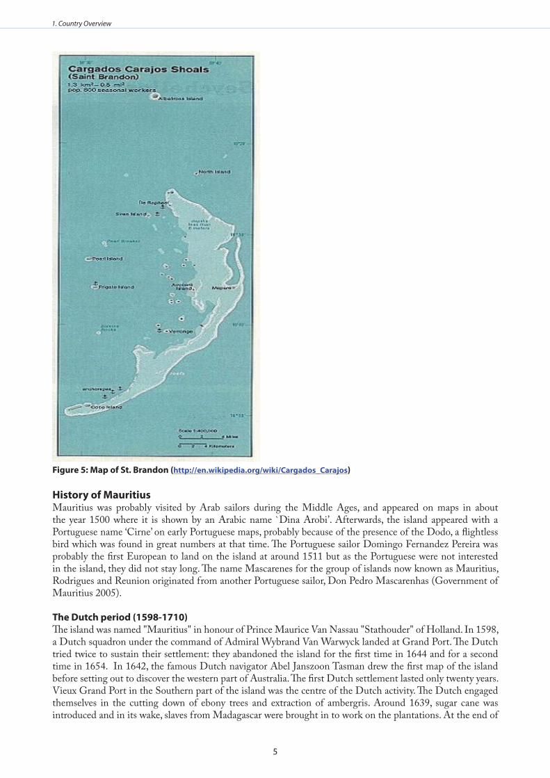
5
1. Country Overview
Figure 5: Map of St . Brandon (http://en .wikipedia .org/wiki/Cargados_Carajos)
History of MauritiusMauritius was probably visited by Arab sailors during the Middle Ages, and appeared on maps in about the year 1500 where it is shown by an Arabic name `Dina Arobi’. Afterwards, the island appeared with a Portuguese name ‘Cirne’ on early Portuguese maps, probably because of the presence of the Dodo, a flightless bird which was found in great numbers at that time. The Portuguese sailor Domingo Fernandez Pereira was probably the first European to land on the island at around 1511 but as the Portuguese were not interested in the island, they did not stay long. The name Mascarenes for the group of islands now known as Mauritius, Rodrigues and Reunion originated from another Portuguese sailor, Don Pedro Mascarenhas (Government of Mauritius 2005).
The dutch period (1598-1710) The island was named "Mauritius" in honour of Prince Maurice Van Nassau "Stathouder" of Holland. In 1598, a Dutch squadron under the command of Admiral Wybrand Van Warwyck landed at Grand Port. The Dutch tried twice to sustain their settlement: they abandoned the island for the first time in 1644 and for a second time in 1654. In 1642, the famous Dutch navigator Abel Janszoon Tasman drew the first map of the island before setting out to discover the western part of Australia. The first Dutch settlement lasted only twenty years. Vieux Grand Port in the Southern part of the island was the centre of the Dutch activity. The Dutch engaged themselves in the cutting down of ebony trees and extraction of ambergris. Around 1639, sugar cane was introduced and in its wake, slaves from Madagascar were brought in to work on the plantations. At the end of

6
1. Country Overview
the Dutch colonisation, Mauritius had about 10 acres under sugar plantation and a population of 236 people. It was under the Dutch rule that Mauritius experienced its first revolt slave revolt in 1677. The free slaves that were left behind at the end of the Dutch colonisation are believed by certain historian to be the origin of the Mauritian people. Other Dutch colonial legacies are buildings erected during that period, domestic animals and introduction of deer in Mauritius. However, the Dutch are also remembered for having exterminated the famous Mauritian bird, the Dodo. The Dutch colonisation ended in 1710 (Government of Mauritius 2005).
The French period (1715-1810) In September 1715 the island became a French colony when Guillaume Dufresne D'Arsel landed and took possession of this precious port of call on the route to India. The island was then named "Isle de France", but the French occupation was started in 1721 through what is known today as Bourbon Island. With the arrival of the most illustrious of French governor, Mahé de La Bourdonnai, from 1735, the "Isle de France" started developing effectively. He established Port Louis as a naval base and a ship-building centre and numerous buildings were built. Among the buildings, there are a number of which are still standing today - part of Government House, the Chateau de Mon Plaisir at Pamplemousses and the Line Barracks. From 1767 to 1810, the island was administered by the French East India Company. Afterwards, officials appointed by the French Government took charge of the island except for a brief period during the French revolution. The shortage of labour on the island paved the way for the East India Company to populate Isle de France in an organised manner. This process which started in 1728 set the basis for a plantation colony. The colony witnessed several influxes of white people from France, slaves from Senegal and Madagascar and free labour from Pondichery in India and Canton in China (Government of Mauritius 2005).
Twenty years after the beginning of the French colonisation and 14 years since its effective occupation, Mahé de La Bourdonnais who was appointed Governor General in 1735, restructured the Isle de France administratively and economically. Based on his past experiences in India especially on the trading potential of the sub-continent, he transformed Port-Louis into a port of call for the islands of the sub-region by developing a naval base and a ship-building centre with numerous buildings, roads and hospital. This transformation encouraged the colonists to stay on permanently. It was also under his leadership that the sugar cane plantation received a new boost. Labourdonnais’ achievements through the entrepot trade, development of infrastructure and agricultural activities, made Isle de France an effective ‘Star and key of the Indian Ocean’. In 1766, Isle de France became a Crown Colony. The society of Isle de France stabilised itself in the XIX century with a white ruling class, a huge slave population and an intermediary franchised slaves.
Intense maritime traffic in the Indian Ocean and the Anglo-French rivalry contributed to the economic success of Isle de France. This situation attracted the corsairs in the Indian Ocean. French corsairs used «Isle de France» as a base to organize raids on British commercial ships during the Napoleonic wars until 1810 when a strong British expedition captured the island. By the Treaty of Paris in 1814, the «Isle de France» which regained its former name `Mauritius’ was ceded definitely to Great Britain, together with its dependencies which included Rodrigues, Chagos Archipelago, Agalega, Saint Brandon and the Seychelles. In the act of capitulation, the British guaranteed that they would respect the language, the customs, the laws and the traditions of the inhabitants (Government of Mauritius 2005).
The British period (1810-1968) British rule lasted from 1810 until Mauritius attained independence in 1968. By signing the Treaty of Paris, the British agreed ‘to preserve all existing rights and institutions’ which existed in Isle de France. Consequently, the French plutocracy’s privileges were preserved and the control of the island’s economy remained in their hands. This is a legacy that still persists in modern times. The British rule in Mauritius was dominated by three major events: (i) the abolition of slavery, (ii) the importation of indentured labour from India and (iii) the transformation of the Mauritian economy from one based on maritime trade to sugarcane plantations and export of sugar (Government of Mauritius 2005). The first governor for Mauritius under the British administration was Robert Farquhar who made rapid social and economic changes. The abolition of slavery in 1835 was one of the most important events and the plantation owners received a compensation of two million pounds sterling for the loss of their slaves. This event induced important changes on the socio-economic and demographic fields. After the abolition of slavery, the plantation

7
1. Country Overview
owners needed a new source of cheap labour. Most of them turned towards India. Between 1836 and 1907, 450,000 indentured Indian labourers were brought to the island to work in the sugarcane fields. The working conditions were very harsh and the laws to protect the indentured labour were limited and rarely enforced. The indentured system which provided the plantations with three generations of cheap Indian labour ended in 1917 after a long struggle of the Indian workers. The Indian immigrants of both Hindu and Muslim faith, later together with a small number of Chinese traders, changed the fabric of the society (Government of Mauritius 2005). The British transformed the economy of Mauritius by shifting from maritime trade to the production of sugar for export. The potential access to the British market for sugar exports was an opportunity that the colony of Mauritius took advantage of. By 1830 sugarcane plantation grew from 10,221 to 50,998 arpents. This marked the beginning of King Sugar in the Mauritian economic landscape and this went on to shape the economic and commercial strategies of contemporary Mauritius. The production of sugar as a commercial strategy also shaped the Mauritian society through importation of cheap indentured labour from India. Sugar production and exports occupied such a pivotal position in the Mauritian economy in the sense that it drastically transformed the economic and political diplomacy of independent Mauritius during the last three decades and conditioned the daily lives of Mauritian (Government of Mauritius 2005).
Constitutional developmentAlthough the British had formal control of the island, the Mauritian society remained stratified through the domination of the Franco-Mauritians. In the mid-twentieth century, the demand for constitutional reform by the Creole and the Indian community respectively emerged. From 1810 to 1948, the Mauritian society was based on the French ‘ancien regime’ values (Government of Mauritius 2005). On the constitutional plane, the Council of Government which was first established in 1825 was enlarged in 1886 to make room for elected representatives. The new council included 10 members elected on a restricted franchise. It was not until 1933 that the Constitution was again amended. The proportion of nominated members of the Council not holding public office was raised to two-thirds. However, franchise was still restricted to persons within a certain income group and to proprietors. A major breakthrough occurred in 1948, when after years of protracted negotiations for a more liberal constitution; franchise was extended to all adults over 21 years who could pass a simple literacy test in any of the languages used on the island (Government of Mauritius 2005).
The Council of Government was replaced by a Legislative Council composed of 19 elected members, 12 members nominated by the Governor and three ex-officio members. General elections were held in August 1948 and the first Legislative Council met on 1st September 1948. The constitution changed the power relationship whereby the Franco-Mauritian lost control of the new Legislative Council. This reform enabled the Indians to vote and to influence the majority that control the new Legislative Council. The 1948 constitutional reform led to a complete realignment in Mauritian politics. The Franco-Mauritians looked for other means than election to continue to exert their influence: land ownership and the consolidation of the sugar industry became the strategy that shaped the economic development and ensured their control of economic power up to contemporary Mauritius. The Indians and their descendants, who were in majority, seized this opportunity to start a long struggle up to 1968 to accede to political power through the independence of the country.
Following constitutional conferences held in London in1955 and 1957, the ministerial system was introduced and general elections were held on 9th March 1959. Voting took place for the first time on the basis of universal adult suffrage and the number of electors rose to 208,684. In that period, Mauritius made much progress on the path to responsible government and independence. The British system of government was the natural model that Mauritius adopted. However, the competition of influence among political parties was organised on ethnic lines than on a class basis. In 1961, a Constitutional Review Conference was held in London and a programme of further constitutional advance was established. It was followed in 1965 when the last constitutional conference paved way for Mauritius independence. At these successive constitutional conferences, it emerged clearly that Mauritius was divided on the issue of independence with S. Ramgoolam as leader of the Labour Party, representing mostly the Mauritian of Indian origin, was the champion while Gaetan Duval, leader of the Parti Mauricien representing the minorities specially the Creole community was in favour of association with Britain. Capitalising on this division among other concerns, Britain exerted political pressure to force the Labour Party and its allies to agree to the excision of the Chagos Archipelago (including

8
1. Country Overview
Diego Garcia) against Independence. After general elections in 1967, Mauritius adopted a new constitution and independence was proclaimed on 12 March 1968. Mauritius achieved the status of Republic 24 years later on 12 March 1992.
CultureMauritius has a cosmopolitan culture. Co-existence among Mauritians of Indian, African, European and Chinese ancestry has led to a sharing of cultures and values. The various population movements of the 18th, 19th and early 20th centuries have made Mauritius a unique mosaic of different races, cultures and religions. People of European, African, Indian and Chinese origins have created a multiracial society where the various cultures and traditions flourish in peace and harmony (Government of Mauritius 2005).
The population started to grow under French rule in the 18th century. In 1735, the population had grown to almost 1,000 and reached nearly 20,000 in 1767 (15,000 of them were slaves). When the British abolished slavery in 1835, the population stood at 100,000. It increased rapidly with the coming of Indian labourers. Between 1835 and 1865, some 200,000 labourers were brought in from India. By the turn of the century, the population grew to 371,000 and in 1944 it stood at 419,000. After the Second World War, the increase was more rapid, particularly because of the baby-boom, improved free health care and reduction in the infant mortality (Government of Mauritius 2005).
The rate of natural increase, which was about 3% per annum in the 1960s, has dropped considerably due to family planning campaigns and greater awareness as a result of better education. During the last ten years, the population has grown at an average rate of 1.1% annually. As at end of 2009, the population of the Republic of Mauritius stood at 1,277,853 comprising 630,477 males and 647,376 females. By 1983, Mauritius had reached a gross reproduction rate below replacement level with its adverse economic, financial and social consequences for the country (Government of Mauritius 2005).
Mauritian EconomyThe economic history of Mauritius is characterised by two eras: Sugar and Textiles. Since the Dutch colonisation up to 2006/2007, the production of sugar shaped the economic, social and environmental landscape. The peak years were 1974/1975 which was the sugar boom for the Sugar Industry. The textile era which started in 1983 superseded sugar within a couple of years to reach its peak in 1988 in terms of employment creation and its subsequent multiplier effect on the economy. Textiles, just as sugar, had its share in the transformation of the socio-economic life of the Mauritians with the creation of about 80,000 jobs for women in the textile factories.
The success story of the two pillars of the Mauritian economy is explained primarily by the market preferences offered to the Mauritian products under the ACP-EU agreement. The guaranteed price of sugar and the duty free access of Mauritian textiles and apparel generated enough profits for new investment in the then new sectors of the economy such as tourism and other services sector. The end of the EU preferences under the Cotonou Agreement due to its incompatibility with the provisions of the World Trade Organisation (WTO) has been a turning point in the development strategy of the country. This has required a complete restructuring of the Mauritian economy for both sugar and textiles with adverse consequences of laying off workers. The share of agriculture in the economy was reduced from 3.2% in 2005 to 1.7% in 2009 and textile from 6.7% to 5.3%.
The new strategy is to restructure the sugar industry through centralisation and transformation of the sugar industry into a cane industry. This requires a paradigm shift from sugar production to that of electricity, ethanol, refined sugar, agricultural rhum and other by-products. The restructuring of the sugar industry has been the subject of an agreement with the EU for financial support (in 2012) against reform which is contained in policy document known as the Multi Annual Adaptation Strategy (MASS 2006-2010). Consequently the surface area under cultivation is decreasing. To-day only 30% (58,700 hectares) of the total surface area is under cultivation. Over the past five years the country registered an annual average real growth rate of 5.1%, balance of payments surpluses leading to a comfortable external reserves position, and single digit inflation. With a per capita

9
1. Country Overview
income of USD 5,078 (2004), Mauritius is now classified as a middle income country and ranks, on the basis of the recent Human Development Index, 67th globally, 40th among developing countries and second in Africa. Sustaining the growth momentum well into the future is a major challenge because of international pressures such as globalization and liberalization. Furthermore, reforms are required domestically to arrest fiscal decline, achieve growth in labour and total factor productivity and address the issues of poverty pockets and ageing population.
Mauritius has the ambition to become a regional services centre based on banking services, real estate and tourism. Diversification of the economy remains a priority. Emphasis is now being laid on the following:
Developing the Information and Communication Technology (ICT) sector, Framing the right policy mix to consolidate public finances, Creating an enabling environment,Enhancing export competitiveness and modernizing the welfare state while favoring a participatory approach of all stakeholders.
Mauritius has embarked on a comprehensive reform programme to move to the next phase of development capitalizing on human resources, Information Technology and higher value-adding activities. This is best achieved by the building on its existing strengths of openness, high standards and best practices in the financial sector, an advanced physical and telecommunication infrastructure and an active capital market. The island’s membership of several regional groupings such as the Common Market for Eastern and Southern Africa (COMESA), Southern African Development Community (SADC), Indian Ocean Rim-Association for Regional Cooperation (IOR-ARC) and the Indian Ocean Commission (IOC), positions Mauritius as a key interface between Asia and Southern and Eastern Africa. However, certain constraints must be addressed if Mauritius is to improve its economic growth rate and maintain its role in the Western Indian Ocean region.

10
2. Biophysical Environment
2 . BIOPHySICAL ENvIRONMENT
description of the coast and distinctive features The Island of Mauritius is of volcanic origin with a total land area of 1,865 km2. The coastal zone is defined in the Environment Protection Act (EPA) 2002 as any area which is situated within 1 km from the high water mark, extending either sides into the sea or inland. The coastal zone is mostly surrounded by fringing coral reef enclosing a lagoon area of 243 km2. Coral reefs are not present at mouths of rivers and estuaries. The topography of the coast consists mostly of low lying areas, flat plains in the north and minor cliffs in the western and southern part of the island where coral reefs are absent. The coastline is composed of different shore types whose landforms are related to the coastal geomorphologic features. These are categorized as sandy shores, rocky shores, muddy shores, mixed shores, calcareous limestone shores, cliffs and coastal wetlands. In the last decades, the coastal landscape has significantly been altered due to unplanned development. The coastline is still under constant threat from human activities.
i) IssuesThere are several regulations and management plans for the preservation of the pristine coastline including •control of land-based activities such as fishing, water sports, dredging, construction of buildings, and control of discharge of agricultural wastes, sewage, and industrial effluents in rivers. The pressure from these activities is however increasing. Most of the pristine coastal areas have been fully exploited and hotel planners are now searching for the few areas that are less degraded. Regulations such as Environment Protection Act (EPA) require that all coastal development must be subjected to Environmental Impact Assessment (EIA). Set back lines have been established however, capacity for enforcement is weak.
ii) Gaps Lack of monitoring of coastal degradation due to removal of coastal rocks to create artificial beaches. •Lack of bathymetric maps of the lagoons to assess the impacts of siltation. •

11
2. Biophysical Environment
General description of the climateAll Mauritian islands are free from direct continental influences. Agalega and Diego Garcia experience mostly equatorial maritime climate while the others experience tropical maritime climate. During winter months, the climate of the region is generally dominated by subtropical anticyclones travelling across the south Indian Ocean. Summer months are also influenced by subtropical anticyclones, but during these periods, they are weaker and pass along higher latitudes. Thus, during winter, the low-level easterly to south-easterly winds are stronger and more persistent while in summer the winds tend to be relatively weaker. Tropical cyclones and storms do regularly affect the area during the summer season. On average, in a particular season, a total of around 10 tropical storms develop in the basin and reach mature stage. However, the inter-annual variability in the total number of cyclone formations is high. The islands of the south-west Indian Ocean are at times significantly affected by tropical storms. However, Agalega and Diego Garcia are rarely directly affected by these storms. However, in summer, these islands are often influenced by the Inter-Tropical Convergence Zone (ITCZ).
i) IssuesHuman activities are known to have impacts on the environment. Policies and strategies designed to •sustain ecosystem goods and services should be based on knowledge of ecosystem responses which can be uncovered by carrying pout studies on the past climatic variability (Alverson et al. 2001). Paleo-archives document ecosystem responses to changes in mean climate as well as in the magnitude and frequency of extreme events. Plans for sustainability should be designed taking into consideration the full range of regional climatic •and hydrological variability, including that revealed in paleoclimatic records. Present trends indicate that the vulnerability of societies to environmental changes is rapidly increasing. Areas with high population densities and limited resources (including fresh water), and regions with sensitive ecosystems are under threat from both environmental degradation and climatic changes (Alverson et al. 2001). A recent study by Love et al. (2009) indicates that environmental variability affects distributions of seasonally recruiting fishes. In coastal areas, fluctuations in salinity resulting from variation in stream discharge were found to be negatively correlated with intra-annual stability of fish assemblages. Similar variations could be expected in the ASCLME region pointing to the need for regional studies.
ii) GapsAnalysis of past climate for Mauritius has not been performed comprehensively. This is due to the fact that •very few studies that have been carried out in this area. This gap needs to be filled. There is also lack of large scale data on chemical, biological, and physical oceanographic processes, especially in regions surrounding the outer islands. There is also lack of a system for archival and retrieval of data. An automatic data backup system is therefore required. A database existing at the meteorological services and other institutions needs to be automated so that access to different climate parameters is made more efficient. More than 50 years of data of some key climatological parameters exists for some meteorological stations in Mauritius. These data need to be analysed and published. Other gaps include lack of data on the subtropical systems, and lack of coordination among relevant institutions in data archival and retrieval. There is also a need to build capacity in climatological and meteorological research.
Marine and coastal geology and geomorphologyMauritius was formed by three distinct episodes of volcanic activity related to the faulting of the oceanic plate (Saddul 1995). These series are (i) the ancient series (10-2 mya) which caused the emergence of the island, (ii) the early volcanic series (3.5 -1.7 mya) which is exposed only to the south west of the island, and (iii) the recent series (0.7-0.2 mya). The latter episode is the most important and extensive one in terms of aerial average and has shaped the coastal plains (Perroud 1982).
Sea level has been changing over geological time and there have been at least four sea level fluctuations which have left their marks on coastal landforms especially in the south and south eastern sectors of the island. The last ice age occurred about 20, 000 years ago and the sea level at that time was 120 m below its present level (Dean and Dalrymple 2002). Gradually with global warming, the sea level rose and reached its present level around 6,000 years ago. The existence of a shallow continental shelf has given rise to a remarkably well developed coral reef system. With time, the destruction of the coral reefs and abrasion of sea shells gave rise to the formation

12
2. Biophysical Environment
of white sandy beaches around the island. However, black sandy beaches of terrestrial origin (from weathering of basalt rocks) exist in the North West at the mouth of the Grand Riviere North West. Winds, waves and cyclones have gradually shaped the coastline (McIntyre 1961). The most frequently observed types of beach in Mauritius are sandy beaches made of carbonate sediments originating from coral reefs and shells deposited along the low-lying coastlines of the recent series lavas. Sand dunes are present on the backshore. Estuaries are conspicuous features along the shorelines and deltas are observed in a few places mainly at Grand River North West, Grande Riviére Noire in the west and Baie du Cap in the south.
A lagoon surrounds the island except in the two regions where coral reefs are absent. The width of lagoons varies from place to place. It generally lies between a few tens of metres and a few hundred metres along the west, north and south with almost no lagoon in places where coral reefs are absent. In the east, it extends over more than 2 km. Its depth is less than 1 m at low spring tides and may reach more than 20 m where channels are present in the fringing and barrier reefs. The lagoon is mostly filled with sand and in some places with broken corals.
i) IssuesThe geomorphology of the shoreline around Mauritius is changing as a consequence of natural forces and •human interference. It will continue to evolve due to accelerated sea level rise (IPCC 2007a, 2007b). Coastal erosion - • Sea level rise will worsen the problem of coastal erosion. A sea level rise of 59 cm as predicted by IPCC will cause the loss of an average of 59m of beach according to the Bruun rule (Dean and Dalrymple 2002). However, the immediate concern is weak coastal development planning. Enhanced coastal erosion due to human activities started a few decades ago. Hard erosion control structures constructed near the shoreline gave rise initially to localized erosion, but this has increased rapidly in the recent past due to haphazard construction and location of seawalls. Legislation dictates that construction be undertaken at least 30 m from the high water mark. However, enforcement of this legislation has been ineffective. A ban on sand mining to address the issue of coastal erosion came into force in October 2003. An increase in setback lines, mainstreaming climate change and sea level rise consideration in coastal development plans and more stringent enforcement of coastal regulations and legislation should be given urgent attention.Accelerated Sea Level Rise -• Mauritius experienced a very slow fall in sea level (- 0.10 mm/yr) from 1986 to 2003. In Rodrigues, sea level declined at a rate of - 0.32 mm/yr during the same period (Ragoonaden 2006a, 2006b). However, during the last few years an accelerated sea level rise has been observed. The same pattern has been noted in Rodrigues and other islands in the West Indian Ocean. This is a matter of serious concern since sea level rise could cause flooding of lowlying areas and increase the current high rates of coastal erosion and its impacts on coastal development and infrastructure.Marine pollution - • Pollution of the lagoons is becoming a matter of concern in Mauritius. The main sources of pollution are land based. These include domestic, industrial and agricultural sources of pollution. Ocean Acidification - • The increased emission of carbon dioxide in the atmosphere is expected to lead to a decrease in pH value of the sea water. It is expected that the pH which was 8.104 in the 1990s will decrease to 7.949 by 2050. The increased acidity of the ocean represents a threat to coral reef growth around the island including the supply of sand to the lagoons and beaches.
ii) GapsMany studies have been done on geology (Montaggioni and Nativel 1988), geomorphology (Monton •1976) and coral reefs (MonTagaggio and Faure 1980) of Mauritius as part of student research thesis. However, no in-depth professional studies have been done in the recent past. There is therefore a need for further research into geology and geomorphology of Mauritius. Long term data on the rates of coastal erosion is critical for coastal development planning and management. •However, this data is lacking in the country. The Ministry of Environment and Sustainable Development initiated a project on coastal erosion monitoring in 2003. Data derived from this programme should be archived in a reliable database and used for coastal development planning.

13
2. Biophysical Environment
Freshwater resources and drainage, including rivers, estuaries, delta and coastal lakes
Surface runoffThe Island of Mauritius is divided into 25 major river basins and 21 minor ones (Figure 6). The catchment areas vary from 3.9 km2 to 172.7 km2. Almost all the major rivers are perennial and flows in most of the major basins are gauged (Ministry of Energy and Public Utilities 2010). Most of the rivers in Mauritius have their source in the central plateau and flow radially to the sea. The relief of the country, the size and shape of the watersheds are such that the heavy rainfall results in flash floods with very sharp peaks. Flows in streams and rivers vary from a few litres per second to over 500 m3/s during floods (Sharma 2000).
There are 106 river gauging stations in Mauritius out of which 59 are equipped with continuous water level recorders. Daily or twice weekly water level readings are available for the remaining 47 stations. Given the high number of river diversions, most of the river gauging stations actually measure residual (Ministry of Energy and Public Utilities 2010). There were 379 river abstraction points as of June 2011.
Figure 6: drainage basins of Mauritius (Ministry of Energy and Public utilities 2010)
The Island of Rodrigues has been divided into 20 major river basins and 10 minor ones. The catchment areas vary between 1.08 km2 and 6.73 km2. The deep valleys with steep gradients and the absence of impounding reservoirs in Rodrigues results in most of the rainfall over the island being lost to the sea as high velocity runoff. Due to negligible infiltration to groundwater, base flow of rivers is very low. The flows range from 1.4 l/s in River Grenade to 56.9 l/s in River Baie aux Huitres (Ministry of Energy and Public Utilities 2010).

14
2. Biophysical Environment
Groundwater aquifers of MauritiusThere are five main groundwater basins in Mauritius which accounts for most of the groundwater resources of the country (Figure 7). The coastal aquifers constitute the terminal part of the aquifers downstream of the ancient topographic units. These aquifers have a width of the order of one kilometre with the water table normally corresponding to the sea level. The coastal groundwater is normally brackish due to sea water intrusion. The extent of seawater intrusion depends on the structural context of coastal aquifers (Giorgi et al. 1999). To monitor coastal aquifers, conductivity and salinity profiles are observed in 29 locations in the coastal regions (Ministry of Energy and Public Utilities 2010).
Figure 7: Main groundwater aquifers of Mauritius (Ministry of Energy and Public utilities 2010)
The cases of fresh groundwater discharges into the sea have been reported but no in-depth study has been undertaken. However, a project entitled “Assessment of groundwater contamination using isotopes techniques-phase II” has a component which focuses on submarine groundwater discharge in the western coast of Mauritius. The estimated water balance for Mauritius based on 1971 -2000 isohyets is shown in Table 1 (Ministry of Energy and Public Utilities 2010).
Table 1: water balance of Mauritius
volume (mm3)
Precipitation 3700
Surface Runoff 2220
Evapotranspiration 1110
Groundwater recharge 370
The estimated utilisable potential of fresh water resources is about 1233 mm3. Table 2 below gives the annual volume used in the different sectors in Mauritius (Ministry of Energy and Public Utilities 2010).

15
2. Biophysical Environment
Table 2: water utilization (mm3) in Mauritius in 2010
Use Surface Water Groundwater Total
River-Run off-takes StorageDomestic, industrial & tourism
361 74 113 223
Industrial 5 - 5 10
Agricultural 320 78 6 399
Hydropower 147 151 - 368
Overall utilisation 508 303 124 1000
Total 488 238 124 899
It should be observed that the present water utilization in Mauritius amounts to 23% of the total precipitation. Groundwater provides about 50 % of the potable water requirements and about 13% of the water utilisation.
In Rodrigues, the aquifers of the central caldera, alluvial valleys and the relatively small western caldera account for most of the groundwater resources. The sources of water in Rodrigues are shallow dug wells and rainwater harvesting (Ministry of Energy and Public Utilities 2010).
i) Issues Pollution: • Industrialisation started in the second half of the 1970s, and today there are few industries that are operating, mainly only in the sugar and textile field. However, in Mauritius, the main crop, sugarcane, does not use any pesticides and the use of fertilizers is well regulated. Therefore, not much pesticides and fertilizers are used to the extent that they can cause pollution of coastal waters. Pollution is mainly caused as a result of discharge of domestic wastewater and sewage. Sediment load:• Reservoir sedimentation is becoming a matter of concern in Mauritius. This is due to loss of reservoir capacity with resultant impact on the volume of water that can be stored. The Ministry of Local Government and Public Utilities commissioned in May 2006 hydrographic survey and sedimentation study in 4 reservoirs, namely Mare Aux Vacoas, La Ferme, La Nicoliere and Piton du Milieu. The study revealed that the reservoirs have lost their capacities at a rate ranging from 2.2 to 9.0% due to sedimentation (Table 3).
Table 3: Sedimentation in reservoirs (in mm3) of Mauritius
Reservoir Capacity before 1996 survey(mm3)
Capacity as determined by 1996 survey(mm3)
Loss of capacity
(mm3)
% loss of capacity
Mare aux Vacoas 27.61 25.89 1.72 6.2
La Ferme 11.78 11.52 0.26 2.2
La Nicoliere 5.78 5.26 0.52 9.0
Piton du Milieu 3.27 2.99 0.28 8.6
ii) GapsThere is lack of comprehensive hydrological data on sediment load in rivers. Data on submarine groundwater •discharge is also lacking. Most of the river gauging stations are inadequate. There is a need to fill these gaps by initiating studies on sediment erosion and transport dynamics including groundwater flow to the sea. The capacity for monitoring river discharges also needs to be strengthened. A detailed study needs to be carried out to assess submarine groundwater discharge. In this context the Mauritius Oceanography Institute, in collaboration with the Water Resources Unit and the National Environmental Laboratory, have submitted a project proposal to the IAEA for the assessment of the quantity and quality of submarine groundwater discharges at selected sites. This project is scheduled to start by January 2012. In order to determine most accurately surface runoff to the sea, additional river gauging stations need to be located at the outlets of main river basins. The present hydrometric network is mainly for assessment of inland water

16
2. Biophysical Environment
resources.
Physical Oceanography
Currents (Coastal hydrodynamics and offshore current systems)Mauritius is located in a region that is dominated by the wind driven South Equatorial Current (SEC) which flows almost all year round from west to east. It usually extends from 80S to between 15 and 200E. As it is driven by the trade winds from anticyclones of the south Indian Ocean which moves from east to west, it exhibits a significant seasonal variation in strength. The current is relatively stronger in winter months when strong South Easterly trades prevail over the south Indian Ocean. The current speeds increase as it passes through the channels located within the Mascarene Plateau and strong gyres are formed on the leeward side. When it reaches Madagascar, part of the current flows to the north to feed the Agulhas current in the Mozambique Channel and the East African current. The southern part flows southward along the Madagascan coast forming an anticyclone gyre further south. During the South west monsoon, the component of the South Equatorial Current (SEC) which turns north, feeds into the Somali current along the East Coast of Africa. It is also important to note that the coastal hydrodynamics around Mauritius island are also greatly influenced by the lagoon bathymetry, presence or absence of coral reefs, shape of the shoreline, tidal regime and extreme events such as cyclones and storm surges. In most regions, waves break at an angle to the shoreline thus generating long shore current which transports sediments along the coast.
Tide regime and wavesThe tidal regime for the coast of Mauritius is broadly representative of natural open-ocean as a consequence of the islands limited continental shelf width. Tides are semi diurnal with a tidal range of 0.50 m during spring tides and much smaller amplitude of the order of 0.20 during neap tides. However, during annual king spring tides (March and September) the tidal range could be as much as 0.85 m. Very low water level also occurs in exceptional cases and water can drop by more than 1 m below mean or what sea level.
The wave climate in Mauritius is determined by three dominant weather systems. The prevailing SE trade winds generate a range of waves of different magnitude and frequency all year round. Typically wind waves in open sea are between 0.5 m during the summer and 3 m during the winter with a period of between 3 to 11 seconds. Deep low pressure systems in the high latitudes travel regularly towards the southern part of Mauritius generating high waves. These waves travel long distances and reach Mauritius as swells with little loss in energy. They typically approach Mauritius from the southern sector, 3 to 5 m in height with a wave period of 12 to 20 seconds. They are more persistent during the transition and winter months leading to Raz de mare and flooding on the southern and western coasts.
Tropical cyclones which develop in the SW Indian Ocean between November and May usually approach Mauritius from the north east. These winds blow clockwise around the centre and generate very high waves with peak significant wave height in excess of 15 m. The strength, duration and path of the cyclone determine the wave height, period and swell which approach Mauritius. Wave statistics from ships observations remain the major source of wave data (CSIR 1992). These data indicate that the average (50% exceedance) height for sea (local wind waves) is less than one meter and for swell it is close to two meters. The more extreme wave height is as high as 3.5 m for sea waves and 5.4 for swell. Over 80% of all waves come from the sectors ENE to SSE. Waves from the NW (mostly cyclonic) occur less than 2% of the time. Southerly swell arriving from the S to SW occurs some 14% of the time with height in excess of 3 m.
A COSMOS numerical model has been used to simulate the near shore wave transformation processes at Flic en Flac and Belle Mare. It was found that there was a dramatic drop in the significant wave height across most of the reef front and to a lesser degree on the reef flat. This drop was from 14 m to about 1.5 m for the 5 year cyclone approaching 30 degree from off the shore normal and from under 12 m to a little over 1.0 m for the 5 year peak cyclone condition approaching 30 degrees off normal. This emphasises the importance of coral reefs in reducing the strengths of waves approaching the coast.
i) IssuesSignificant storm surges can be expected from long swells generated far to the south of Mauritius. These •

17
2. Biophysical Environment
events have become an annual occurrence. Extreme storm surges occurred in May 1976 and on 31 May and 01 June 1987 where swells of around 3 to 4 m caused damage along the coast. Cyclones cause immense flooding and damage and loss of valuable infrastructure in many low lying areas along the coast.
ii) Gaps The main purpose of maintaining the tide gauges at Port Louis and Rodrigues are to monitor sea level •changes. However, to obtain a long series of data which is required for the purpose, it is important that these stations are maintained regularly. There is also a need for periodic surveys to be conducted at least every six months to monitor any movement of the platform on which the instrument is fixed. Maintenance of the sea level stations is done by the University of Hawaii within the framework of the •Global Sea Level Observation System (GLOSS). A technician from Hawaii has to travel from Hawaii to attend to the sea level network in the Indian Ocean region. Also, maintenance of the stations is challenging due to lack of spare parts and funding. There is a need for building of capacity for maintenance of tide gauges in the WIO Region. To obtain a good network to monitor sea level changes at local and regional level, it would be ideal if one station could be established at St Brandon. A wave rider buoy has been deployed off the south east coast of Mauritius at Mahebourg by the Mauritius •Meteorological Services at a depth of 57 m. Useful data was obtained from this station until June 2001 when the buoy broke its anchorage and was lost to the open sea. A new wave rider buoy was redeployed in 2009. Wave measurements are also carried out in Reunion where three wave buoys are located at strategic positions to monitor waves entering the harbour. However, there are large data gaps elsewhere in the Western Indian Ocean.
Sea level changeSea level in the region of the Mascarenes has been changing over geological time scale. The last ice age occurred about 20 000 years ago. The sea level then was about 120 m below its present. As the glaciers retreated and released vast quantities of water to the ocean, sea level rose quickly until about 6000 years ago, when the rate of sea level decreased dramatically. Since that time sea level has increased only slowly (Dean and Dalrymple 2002). In contrast to global sea level change, there are also local changes mainly to land movement and warming of the sea water and its subsequent expansion.
Studies on past sea level changes are limited in the Western Indian Ocean (WIO) mainly due to lack of long series of sea level data. However, Mauritius is one of the few islands which have a long history of sea level records. Early sea level measurements were initiated in 1929 but only for a limited period. Some measurements were also made at the end of 1960s by HMS Owen to calculate the mean sea level and establish a datum for Mauritius. This datum is still used as reference. Based on tide gauge station data, Emery and Aubrey (1989) calculated a relative sea-level rise of approximately 3 mm/yr. Another study indicated that since 1965 sea level has risen about 1.2 mm/yr, which is comparable to the global sea level rise during the last century (Ragoonaden 1997).
Continuous sea level monitoring in the region of the WIO started in 1986. Two floating type sea level stations were established at Port Louis and Rodrigues within the framework of the Tropical Ocean Global Atmosphere (TOGA). The stations have been maintained regularly and upgraded recently to form part of the Tsunami monitoring network. Using data from the two stations, it was shown that from 1986 to 2003, not much change in sea level has taken place (Ragoonaden 2006a, 2006b). However, in the last five years, data from the University of Hawaii Sea Level Centre shows indications that sea level rise has been accelerating with a marked upward trend as shown below in Figures 8 and 9. As sea level station has recently been installed at Agalega within the framework of the Tsunami Monitoring Network.

18
2. Biophysical Environment
Figure 8: Sea level trend at Port Louis, Mauritius
Figure 9: Sea level trend at Port Mathurin, Rodrigues
The Intergovernmental Panel on Climate Change (IPCC) in its Fourth Assessment Report (AR4) stated that the global sea-level rise between the late 20th century (1980-1999) and the end of this century (2090-2099) are of the range 0.18 to 0.59 m. For the region of the Mascarenes, no model results are available for sea the level rise. However, a 1 m sea level rise should be considered for coastal development projects, which is the case with many countries and island states.
i) IssuesSea level rise is a matter of serious concern for Mauritius. It is expected that coastal erosion will accelerate •due to an increase in sea level. Taking into consideration the IPCC projection of 59 cm by the end of this century, the shoreline retreat in Mauritius could be in the range of between 29 and 59 m. Accelerated sea level rise will impact economic development of the country. As shown in Figures 10 and 11, sea level rise has accelerated in the last few years (Ragoonaden 2006a, 2006b).

19
2. Biophysical Environment
Figure 10: Sea level variation trend from altimetry data (1993 – 2003)
Figure 11: Sea level variation trend from altimetry data (1993 – 2008)

20
2. Biophysical Environment
ii) GapsSea level observations in Mauritius and Rodrigues producing reliable data for various research and •operational purposes started in 1986. At present 96% of hourly data over that period is easily accessible through national and international databases. However, to identify the rate of sea level rise as a consequence of climate change, long-term series of reliable data of more than 20 years is needed. The IPCC has recommended 50 years of continuous data for this purpose. The sea level observing instruments in Mauritius and Rodrigues are of the floating type fixed on the sea •wharf. The sea level observations are therefore relative to the height of the sea wharf. Sinking of sea wharfs is a common occurrence which should be taken into account and allowance made in order to obtain reliable data. There is a need for regular surveys at six months intervals in order to identify any wharf movement. Observations from satellites are providing a wealth of valuable data at regional scale at regular intervals •which is not possible with in-situ methods. The data is in public domain and is freely available. However, capacity for retrieving, archiving and analysis is very limited. Assistance through capacity building in terms of provision of equipment, training and institutional enhancement should be a matter of priority.The National Oceanographic Data Centre (NODC) is an appropriate platform to make available sea level •data to the scientific communities in Mauritius. For research purposes, research quality data is available at the University of Hawaii Sea level web site. However, it is not regularly up-dated. For Mauritius, data is available until February 2008 whereas for Rodrigues, it is only up to 2003. A one stop shop to obtain tide gauge and satellite data of high quality for research purposes should be established. The NODC should provide this facility for users. The mean sea level (MSL) which is currently used as national reference was calculated in the 1960s •using two years of tide gauge data. More than 20 years of accurate instrument data are now available to enable accurate determination of MSL. There is also a need for a more appropriate determination of “Pas Geometric”.
Ocean TemperatureOcean temperature in the region of Mauritius is typical of the tropical region. There are no large upwelling areas in the Mauritius region. The warmest period is the first half of March where temperature are around 290C and the coldest period is the beginning of September where sea surface temperatures average 230C. However, during the summer months, temperature can rise up to 310C. When this occurs it causes fish mortality and coral bleaching. The annual temperature range is 60C. The diurnal range particularly in the open sea around the island is quite small. However, in the lagoons the diurnal range can be as high as 30C during the summer months particularly in calm days.
The isothermal layer is 50m thick. Between the mixed layer and underlying cold water, there is the thermocline in which temperature falls sharply with depth. The thermocline is usually located at about 100 m below the surface of the ocean and is much deeper during the winter months.
i) IssuesCoral bleaching: • Coral bleaching has become quite common in recent years. Besides 1998, some bleaching was also observed in 2002, 2005 and 2009. Mass coral bleaching events are clearly correlated with the rise in Sea Surface Temperature (SST) above the summer maxima (IPCC 2001). During the 1998 El Nino episode, about 50% of the corals were bleached in Mauritius (CORDIO 1999). Global warming poses a threat to coral reefs. Global climate model results show that thermal thresholds will be exceeded more frequently with the consequence that bleaching will recur more often. Studies also show that widespread coral bleaching will occur when SST exceeds the usual seasonal maximum threshold by around 10C and mortality will occur once the maximum threshold is exceeded by around 20C. It is therefore likely that more frequent coral bleaching events will recur reducing further both coral cover and diversity over the next few decades (IPCC 2007b). Fish kills: • Fish mortality has become quite common in recent years. This has been attributed to the discharge of untreated effluents mainly from industries and sewage plants. Frequent discharge of wastewater leads occasionally to algae blooms and red tides that cause massive fish mortality. Turbidity due to sedimentation: • The sea water around Mauritius is usually crystal clear. However, during heavy rain rivers carry large amount of debris and soil into the lagoons leading to increased turbidity of sea water and siltation. Control of soil erosion in the watersheds is therefore recommended.

21
2. Biophysical Environment
ii) GapsThere is no regular seawater temperature monitoring programme by either Albion Fisheries Research Centre (AFRC) or Mauritius Oceanographic Institute (MOI). Temperature is only periodically measured and methodologies for measuring temperature differ between institutions. It is fundamental that the methods for measurement of temperature are standardized in order to facilitate comparison and monitoring of changes. Monitoring stations should also be established at St. Brandon, Agalega and Rodrigues where meteorological personnel are present on a permanent basis. It is also important that research quality oceanographic data are archived at the NODC and made accessible to researchers.
Salinity patternsOpen ocean surface salinity in Mauritius is generally in the range of 32 to 37 PSU (NASA 2010). Sea surface salinity is usually reduced during rainy season. Near shore, salinity is generally reduced by inflow of fresh water from rivers and via runoff from land. In generally, data on salinity distribution is limited in Mauritius.
i) Issues
There is very limited information on the ocean salinity and temperature distribution in waters around •Mauritius. Also, the influence of discharge of freshwater on salinity is not well understood in Mauritius. •
ii) GapsThere is a lack of data on salinity in Mauritius. There is a need for research on salinity distribution around •Mauritius waters. This should be supplemented by measurement of other related parameters such as temperature and current velocities.
Ocean-atmosphere interactionA number of studies on ocean-atmosphere interaction have been undertaken in the Indian Ocean in the recent past. Hermes and Reason (2009) used a regional ocean model to investigate the effect of remote forcing and to study the sensitivity of the Seychelles–Chagos Thermocline Ridge to changes in the large-scale winds over the South Indian Ocean, with a particular focus on the events of the 2006/2007 austral summer. Xie et al. (2002) established links between south Indian Ocean Sea Surface Temperature, the El Nino-Southern Oscillation, tropical cyclone activity, and regional precipitation. Du and Xie (2008) studied the tropical Indian Ocean warming in relation to heat flux, net balance, and adjustment issues. There is however a need for more research in order to understand the characteristics and functioning of the Indian Ocean, including the link between ENSO and the Indian Ocean Dipole (Saji et al. 1999, Webster et al. 1999, Annamalai et al. 2005).

22
2. Biophysical Environment
Chemical and Biological Oceanography
Primary productionStudies carried out in Mauritius showed that both inorganic salts of nitrogen and phosphates are limiting for the production of phytoplankton in the surface waters. Except in the vicinity of Agalega Island where the enhancement of phytoplankton biomass is associated with an upwelling process, most of the EEZ of Mauritius is characterised by generally low productivity. The productivity of the oceanic water is estimated to be 5 tc/km2/year, which is low compared to the waters surrounding the Seychelles group of islands which range between 200 and 300 tc/km2/year (SOE 1991).
Devassy and Goes (1991) identified 38 species of phytoplankton belonging to 4 different classes in the Mauritius waters. Bascillariophyceae, Cyanophyceae and Pyrrophyceae were the most abundant. However, their photosynthetic rates are in general low ranging between 0.01 and 0.57mgC-3h-1. This is attributed to low nutrients level in the EEZ of Mauritius.
i) IssuesThe main issues are low primary productivity that leads to low fisheries production in waters around •Mauritius. However, once in a while phytoplankton blooms occurs causing fish mortality. There is a need for research on phytoplankton production since it is one of the main forces regulating global climate as it absorbs carbon dioxide from the atmosphere and therefore plays an important role in the regulation of global warming.
ii) GapsOnly few comprehensive studies have been carried out on the primary production in the waters of •Mauritius. Identification of key species is difficult in the absence of experts trained in taxonomy of marine phytoplankton. There is also a need for long-term research and monitoring programme focussed on phytoplankton production in Mauritius.
Secondary productionDue to the low primary productivity of the oceanic water around Mauritius (5 tc/km2/year), the secondary production is also not high, except in some areas on the shallow water banks found within the Mascarene Plateau. Important protozoan zooplankton group identified in the waters of Mauritius include the foraminiferas and the dinoflagellates while the metazoans zooplankton group comprise inter-alia the copepods, chaetognaths (arrow worms) and cnidarians such as jellyfish.
i) IssuesThe low productivity affects the demersal fish catches as the absolute amount of organic matter reaching •the seafloor depends on the level of primary and secondary production in the surface waters. Several fish species feed directly on zooplankton (mackerels and some tuna-like species). A decrease in the zooplankton production therefore affects the fish production. The transfer of alien species of zooplankton in ballast water is a potential threat.
ii) Gaps Very few studies have been conducted on the distribution and abundance of zooplankton in the waters of •Mauritius. The available information comes from research surveys carried out occasionally in the Indian Ocean. There is therefore no specific programme for the collection and analysis of zooplankton in the EEZ of Mauritius. Identification of species is difficult due to lack of taxonomists. There is a need for a long-term monitoring programme in order to improve understanding of productivity within Mauritius waters.

23
2. Biophysical Environment
Coastal zone and continental shelf
description and extent of coastal and marine habitats
The coastline of the island of Mauritius is approximately 322 km long. It is surrounded by 150 km of coral reefs with a lagoon area of approximately 243 km2. The coastal and marine habitat consist of sandy beaches, rocky shores, near shore wetlands and mangroves, lagoon corals, fringing coral reefs and all their associated marine life. All these marine ecosystem components are interconnected. Mangrove wetlands provide a natural buffer controlling surface water runoff to the lagoon by neutralizing pollutants, nutrients and sediments which might damage the lagoon ecosystem. Mangroves also provide a habitat for juvenile fish and invertebrates and the fringing coral reef (Figure 12) protects the coastline from the waves coming from the open ocean. The south from Souillac to Blue Bay as well as the region between Albion and Flic en Flac and the west has high to low cliffs. Reefs and lagoons are absent or are poorly developed and oceanic waves are generally attenuated by natural rock at the base of the cliff.
Figure 12: Coral reefs (yellow arrows) forming a fringe along the island’s shores with shallow lagoons (uNEP 2008)
IssuesMarine and coastal habitats are yet to be mapped comprehensively for the entire island of Mauritius. There is therefore a need for capacity building for carrying out comprehensive mapping of marine and coastal habitats using the latest technology available in the market. There have been several efforts in this regard as detailed below.
Geo-spatial Information system for Habitat Mapping of South Eastern coast of MauritiusMauritius Oceanography Institute (MOI) has conducted a survey of the coastal marine habitats in the south eastern part of the island. The survey extended from latitudes 20.17o S to 20.28 S and longitudes 57.42 E to 57.50 E. The study involved both actual field surveys together with geo-referenced aerial photography of the south eastern coast of Mauritius. The survey mapped outer reef slope, reef flat, lagoonal depression with channel, inner reef slope, morphological discontinuities, lagoonal coral heads and littoral formations. In terms of the ecological community the following cover types were demarcated: coral cover, seagrass beds, sandy patches and rubble and algal cover.
Bathymetric survey of the shallow lagoons of Mauritius The primary objective of this survey was to prepare detailed bathymetric and bottom sediment profile of the lagoons of the islands of the Republic of Mauritius (Figure 13). This work will eventually be extended to cover Agalega and St Brandon. Measurements of the depth profile of the lagoons may be useful for modeling of inundation and may also be useful in navigation within the lagoons. The bathymetric data will also help in investigating the marine flora and fauna in the lagoon and to understand beach erosion and other coastal processes.

24
2. Biophysical Environment
Figure 13: Map depicting areas where marine habitats and bathymetric surveys have been conducted
Management Plan for a Tropical Reef-Lagoon SystemMapping of the coastal lagoons and coral reef areas of Mauritius has also been undertaken as part of the marine environment management planning. The Compact Airborne Imaging Spectrometer [CASI] was used to acquire 11 spectral bands of digital imagery at 4 m ground resolution, on over 115 flight lines averaging 5 km in length.
ii) GapsThe major gaps include:
Lack of bathymetric data for coastal regions of Mauritius. •Lack of high resolution bathymetric data for the continental shelf.•Lack of capacity for comprehensive mapping.•Lack of resources for study marine species.•
Productivity of the coastal zone (corals, mangroves and seagrass beds)The productivity of the oceanic water around Mauritius is estimated to be 5tc/km2/year. This is low compared to the water surrounding the Seychelles group of islands which registered productivity in the range 200-300 tc/km2/year (SOE 1991). However, Mauritius has an extremely rich coastal zone consisting of near shore wetlands and mangroves, lagoon coral, fringing coral reef and all their associated marine life. The fishermen residing in the coastal area get their daily livelihoods from fishing activities. All these marine ecosystem components are interrelated.
MangrovesMauritius has two species of mangrove, namely Rhizopora mucronata and Bruguiera gymnorhiza. Over the years the extent of mangrove cover around the islands has significantly decreased (20 km2 in 1987 to 14 km2 in 1994) thus affecting fisheries productivity. The total mangrove cover in Mauritius is estimated at around 23ha. The Fisheries and Marine Resources Act of 1998 makes provision for the protection and the conservation of mangroves. A Mangrove Propagation Programme was initiated in 1995, with the objective of restoring denuded areas with mangroves. Since 1995, a total of 214,800 mangrove seedlings were planted in an area of 129,500 m2. The overall survival rate was estimated to be around 78%.
Coral reefsThere are five types of reef around Mauritius: fringing reefs, patch reefs, atolls, reef flats and barrier reefs. Fringing reefs occur in shallow waters near to land, extending to depths of 15-45 m. The fringing coral reefs

25
2. Biophysical Environment
encircle Mauritius and protect it from the sea. Patch reefs are found in relatively shallow waters around Mauritius where the underlying seabed has been close enough to the surface for corals to grow. Atolls start as fringing reefs around volcanic islands, forming atolls as the island gradually submerges. The Mauritian offshore islands of the St. Brandon archipelago include a group of 22 atolls. Reef flats are formed as the fringing reef pushes steadily seaward leaving behind limestone areas that are eroded almost flat by the sea. Reef flats do not occur around the island of Mauritius but are significant around Rodrigues. Barrier reefs are developed typically on the edge of a continental shelf. There are usually found far from the main shoreline and are separated from the shore by broad and deep waters. These occur in the south east of the island.
A total of 159 species of scleractinian corals (hard corals) have so far been recorded in the waters of Mauritius (Pillay 2002), and 1,656 species and 290 families of marine species have been recorded. Out of 340 species of fish which have been identified in the waters of Mauritius, 42 are of economic importance within the inshore area, with a different composition and relative abundance in the near shore waters of each island within the Republic. The effect of over-fishing of Lethrinids is apparent on the fringing reefs of Mauritius with a population explosion of sea urchins Diapena sp. and Echinometra spp.
Algae, sea grass beds and sediment-bottom habitatsMauritius has a rich algal flora. Over 160 genera of marine algae have so far been identified in coastal waters. The marine floristic records of Mauritius date back to 1875. The Mauritius herbarium has a collection of more than three hundred marine algae. Some species of seaweeds commonly found in Mauritius are Enteromorpha, Ulva, Sargassum, Caulerpa sp. Padina and Halimeda. Rodrigues has 493 fish species, 175 gastropod species, 104 species of algae, 109 bivalve species, 138 coral species, 74 species of echinoderms and 41 bryozoan species. For many of the taxa considered, Rodrigues appears to be less diverse than other locations in the region, with the notable absence of certain species common elsewhere in the area. Factors responsible include the small size of the island and the limited number of habitat types. In particular, only two species of Halophila seagrass are found in Rodrigues, while the larger species which form extensive beds (such as Thalassia and Enhalus) are entirely absent from the lagoon. The absence of live-coral bearing molluscs was also noted and may be due to the limited numbers of the massive Porites colonies with which the borers usually associate (Oliver and Holmes 2001).
Microfauna and MeiofaunaMarine microalgae are important constituents of the marine food web. By converting carbon dioxide and water into organic matter by photosynthesis, these organisms form the base for the higher levels of the foodweb. The quantity of primary production of microalgae determines the production of consumable fish, prawns and other seafoods. Sometimes certain microalgae form blooms which may result in the change of the colour of the water but are harmless to human beings. However, at times the blooms are so dense that they may cause fish mortality. It has been reported that around 2% of the world flora may be harmful as they can produce toxins which may result in intoxication. In Mauritius, ciguatera causes fish toxicity and its presence is attributed to benthic dinoflagellates belonging to the genera Gambierdiscus, Promocentrum, and Ostreopsis that are active the year round. i) Issues
The island of Mauritius is an endemic region of fish toxicity, especially ciguatera. There are several •species of potentially toxic benthic dinoflagellates in the waters of Mauritius. Also there is a potential for euthrophication. Introduction of new toxic species from ballast water is also a potential threat. Industrial development has a potential of disturbing the ecosystem stability and may trigger toxic algal blooms. The fishing and tourism industries may suffer in the event of an outbreak of ciguatera fish poisoning. Global warming is also an issue since it is causing an increase in coral bleaching and mortality.
ii) GapsThe major gaps include: limited data on invasive and exotic marine species, limited capacity for identification •of species and lack of information on the ecology of several key species. These gaps need to be filled through comprehensive research programmes.

26
2. Biophysical Environment
Macrofauna Polychaetes are the most important macrobenthic group followed by peracarid crustaceans and molluscs. Among crustaceans, isopods are more common than either amphipods or tanaidaceans. The abyssal benthic fauna of Mauritius is quite rich and its abundance and distribution follows similar pattern reported earlier from the central Indian Ocean and other seas. Polychaetes show continuous distribution and are recorded at all depths.
InvertebratesThe distribution of benthic fauna in waters around Mauritius has not been extensively studied. However, several species of crabs, shrimps, lobsters, mollusks, octopus and sea cucumbers are abundant. Four species of crabs and five species of Penaeid shrimps as well as two species of deepwater shrimps have been identified. Other marine invertebrates comprise polychaetes (52%), bivalves (13.7%) and isopods (12.3%). Among other groups, amphipods are important. Over 60% of the macrofauna is concentrated in the top 4 cm depth of the sediment. Among crustaceans, the isopods are more frequent than either amphipods or tanaidaceans. Agglutinating rhizopod protozoans are also encountered.
i) IssuesThe main issues are limited data and information on biodiversity and genetic composition of key species. •There is also the issue of over-exploitation of commercial species.
ii) GapsThe main gaps are limited data on marine invertebrates, lack of capacity for identification of species and •lack of information on the behaviour and ecology of several key species.
Fish and fishery resourcesFish are an important source of protein for the Mauritian population. They are consumed by almost all sections of the Mauritian society. Fishery resources which have been traditionally exploited are found in lagoons and offshore areas around Mauritius, Rodrigues, St. Brandon, Chagos Archipelago and other outer islands. There are four main types of fisheries in Mauritius namely (i) artisanal fishery, (ii) sport fishery, (iii) banks fishery and (iv) tuna fishery.
Artisanal fishing is limited to lagoons and off lagoon areas. It provides employment and livelihood for some 2,200 registered fishermen and their families. Total production in 2009 amounted to 820 tonnes. The main families caught are Lethrinids, Siganids, mullets, Scarids and groupers. Reef and demersal fish stocks are exploited to the maximum such that no substantial increase in fish production in these areas is possible. Efforts are being made to target off lagoon pelagic fishes to reduce pressure in the lagoons. Fish Aggregating Devices (FADs) have been installed in some areas around which artisanal fishermen concentrate their fishing efforts. Sport fishing is an important tourist attraction in Mauritius. The total catch of this fishery is estimated at 400 tons per year and consist mainly of bill-fishes and tunas. Sharks are also caught by sport fishermen.
The banks fishery supplies a substantial quantity of fish consumed in Mauritius. The major banks are located between 400 and 800 km north of Mauritius. Twelve fishing vessels are in operation and their total catch which comprises mainly Lethrinids (90%) amounts to around 3,000 tonnes annually. The tuna fishery is split into the coastal tuna fishery and the offshore industrial tuna fishery. Tuna and tuna-like species are caught by local fishermen near the coast and mainly around Fish Aggregation Devices (FADs). The total landings from FADs and sport fishermen are estimated at around 650 tonnes annually. Species caught are big eye tuna, skipjack, yellow fin tuna, dorado, wahoo and sharks. Industrial tuna fishing is carried out mainly by long-liners and purse-seiners. These are mostly licensed foreign fishing vessels that catch about 10,000 tonnes yearly in the EEZ of Mauritius. The species caught are mainly the skipjack tuna and yellow fin tunas.
Other fisheries resources include the deep water shrimp with an estimated Mean Sustainable Yield (MSY) of 200 tonnes. The potential yield of the small pelagic horse mackerel and the lizard fish is estimated in the region of 13,000 to 26,000 tonnes per annum.

27
2. Biophysical Environment
i) IssuesThe major issues include lack of enforcement of appropriate legislation, inappropriate regulations that •enable fishing of species during their breeding periods and illegal fishing by foreign vessels. Other issues include lack of information on biodiversity, genetic compositions, over-exploitation of commercial species, pollution, destructive fishing methods, habitat destruction and conflict with the tourism industry.
ii) GapsThe main gaps include lack of data on the biology of most species, lack of capacity for identification of •species, lack of data and information on behaviour and ecology of several species, inaccurate estimation of abundance and limited data on the stock status of the fisheries.
MammalsMarine mammals found in Mauritius EEZ include dolphins, whales, seals, sea lions and dugongs. Dugongs (sea cows), once common in the lagoons of Mauritius are extinct due to intense hunting pressure and predation. Seventeen marine mammal species have been recorded in Mauritian waters, mostly as they migrate to and from Antartica to warm tropical waters for calving. Dolphins are encountered more frequently than whales, although the breeding and nursery grounds of the dolphins have not yet been located. Whale watching is becoming a very popular tourist attraction in Mauritius.
i) IssuesThe major issues include lack of enforcement of legislation, inappropriate regulations that enable fishing •of species during their breeding periods and illegal fishing by foreign vessels. Other issues include lack of information on biodiversity, genetic compositions, over-exploitation of commercial species, pollution, destructive fishing methods, habitat destruction and conflict with tourism industry.
ii) GapsThe main gaps includes lack of data on the biology of most species, lack of capacity for identification of •species, lack of information on behaviour and ecology of several species, inaccurate estimation of abundance and limited data on the stock status of the fisheries.
ReptilesThere are two species of marine turtles in Mauritius which are commonly encountered in shallow coastal waters. These are the hawksbill Eretmochelys imbricate and the green Chelonia mydas. The population trends on both the species are not known but they are believed to be declining. The nesting beaches for green and hawksbill turtles are found around St. Brandon, Agalega and the Mascarene. The peak nesting period is in summer. The foraging and feeding areas take place in seagrass beds and coral reefs around Mauritius, Agalega and St Brandon. The sea turtles are migratory species foraging in one area and nesting in another. The hawksbill has traditionally been exploited for its shell and eggs and the green turtle is exploited for meat, eggs, fat and leather.
BirdsInformation on seabirds and shoreline birds of Mauritius is very limited. The Rivulet Terre Rouge Bird Sanctuary located in the North East of the islands, near the Port Louis Harbour is a tidal mudflat that is used as wintering areas by migrating shorebirds. Around 100-1000 migratory birds visit this site each year representing 11 regular species and 4-5 vagrant species (Bird survey count 1997, NPCS unpublished). The islets found in the north of Mauritius, namely Flat Island and Round Island are bird sites and several species of birds have been identified in these islands.
i) IssuesThe main issues are biodiversity conservation, predation and fishing, pollution, habitat destruction and •introduced animals destroying nesting sites of ground breeding birds.
ii) GapsThe key gaps include limited data on the bird species found on the outer islands, lack of capacity for •identification of bird species, and lack of information on behaviour and ecology of several key species.

28
2. Biophysical Environment
Exotic and invasive species
In the Mauritius EEZ, no marine invasive species have been recorded in the Global Invasive Species Database. However, Caulerpa taxifolia which is known to occur at some sites in the lagoon of Mauritius is an invasive marine algae that forms dense monoculture that prevents the establishment of native seaweeds and excludes almost all marine life. This affects the livelihoods of the fishermen. It is usually introduced via wastewater effluents.
i) IssuesThe main issues are threats of ballast water discharge, biodiversity preservation, pollution and invasive •organisms destroying habitats and affecting the ecosystems.
ii) GapsThe main gaps include limited data on the invasive species found in Mauritius, lack of capacity for •identification of invasive species, and lack of data and information on the ecology of several key species and lack of data on abundance. There is a need for studies in these areas.
Long-term predicted atmospheric changes and vulnerability of Mauritius
Mauritius is vulnerable to the impacts of climate change due to its small physical size and the fact that it is surrounded by large expanses of ocean. Other factors increasing vulnerability are limited natural resources, vulnerability to natural disasters and extreme events, relative isolation, extreme openness of its economy, which is highly sensitive to external shocks, large population with high growth rates and densities, and limited funds. The most significant and immediate consequences of climate change for Mauritius are likely to be related to sea level rise, changes in rainfall regimes, and extreme hydrologic events (droughts and floods). Since most the economic activities are generally concentrated along coastal areas, the country is likely to be highly vulnerable to the impacts of sea-level rise, with the tourism sector, fishing sector and infrastructure being particularly affected. Predicted changes include the following (Nurse et al. 2001, Mimura et al. 2007):
Future changes in extreme temperatures will generally follow changes in average temperature. •Abnormally hot days and nights, and heat waves are expected to become more frequent. •Cooler days and cooler nights are expected to become less frequent. •Droughts are expected to become more frequent and severe in some regions as higher air temperatures •increase the potential for evaporation. Over most regions, precipitation is expected to be less frequent, but more intense. •It is likely that tropical cyclone wind speeds and core rainfall rates will increase in response to anthropogenic •warming of the ocean surface
•It should be emphasized that the frequency, intensity, and spatial and temporal distributions of the changes will not be uniform throughout the island (Nurse et al. 2001, Mimura et al. 2007).
i) IssuesThe main issues of concern include unplanned development along the coast that increases vulnerability •to climate change. Other issues are sustainability, and equity issues, cost of mitigation of sea-level rise and its impacts on the various sectors of the economy, biological systems, water resources, agriculture, and fisheries.
ii) GapsLack of capacity for development of coupled ocean-atmosphere models for predicting patterns of sea •level rise. There is a need for technology transfer and capacity building especially in modelling of general circulation.Lack of specific sea level rise and climate change prediction models for the Western Indian Ocean (WIO) •region. Lack of high quality data that is necessary for modelling climate change and sea level rise. •Lack of capacity for maintenance of automatic weather stations especially for remote areas.•

29
3. Human Environment
3 . HuMAN ENvIRONMENT
Coastal and island populations – current status and trends
The population of the Republic of Mauritius in 2010 was 1,283,415 with an average population growth rate of 1% per annum. Mauritius is one of the most densely populated countries in the world with 629 inhabitants per km2. Approximately 27% of its total population or 50% of its rural population live within the coastal zone. Rodrigues and Agalega have population of 37,837 and 289, respectively. 52% of the total population comprises mainly of Indo-Mauritians of which 35% are of Hindu faith and 17% of Muslim faith. Others consist of Afro-Mauritians and Franco-Mauritians which form 13% and Sino-Mauritians which consist of 15% of the total population (Ministry of Environment and NDU 1999, Census 2000, CSO 2004). The island has an ageing population with a declining proportion of youth (Figure 14). It is projected that the elderly will account for approximately 24% of the total population by 2050. The gender structure consists of 49.3% male and 50.7% female. The literacy rate is 55% among the old persons (above 60 years) compared to 89% among those aged 12 – 59 (Ministry of Environment and NDU 2005). Some international migration has been noted in the last decade, mainly to the UK, France, Canada and Australia. Internal migration has also been occurring towards the coastal areas as shown in Figure 15.
Figure 14: Population pyramids 1999/2009 and 2008/2033 (CSO 2008)
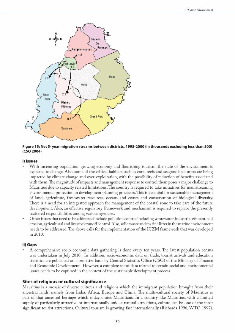
30
3. Human Environment
Figure 15: Net 5- year migration streams between districts, 1995-2000 (in thousands excluding less than 500) (CSO 2004)
i) IssuesWith increasing population, growing economy and flourishing tourism, the state of the environment is •expected to change. Also, some of the critical habitats such as coral reefs and seagrass beds areas are being impacted by climate change and over-exploitation, with the possibility of reduction of benefits associated with them. The magnitude of impacts and management response to control them poses a major challenge to Mauritius due to capacity related limitations. The country is required to take initiatives for mainstreaming environmental protection in development planning processes. This is essential for sustainable management of land, agriculture, freshwater resources, oceans and coasts and conservation of biological diversity. There is a need for an integrated approach for management of the coastal zone to take care of the future development. Also, an effective regulatory framework and mechanism is required to replace the presently scattered responsibilities among various agencies. Other issues that need to be addressed include pollution control including wastewater, industrial effluent, soil •erosion, agricultural and livestock runoff control. Also, solid waste and marine litter in the marine environment needs to be addressed. The above calls for the implementation of the ICZM framework that was developed in 2010.
ii) GapsA comprehensive socio-economic data gathering is done every ten years. The latest population census •was undertaken in July 2010. In addition, socio-economic data on trade, tourist arrivals and education statistics are published on a semester basis by Central Statistics Office (CSO) of the Ministry of Finance and Economic Development. However, a complete set of data related to certain social and environmental issues needs to be captured in the context of the sustainable development process.
Sites of religious or cultural significanceMauritius is a mosaic of diverse cultures and religions which the immigrant population brought from their ancestral lands, namely from India, Africa, Europe and China. The multi-cultural society of Mauritius is part of that ancestral heritage which today unites Mauritians. In a country like Mauritius, with a limited supply of particularly attractive or internationally unique natural attractions, culture can be one of the most significant tourist attractions. Cultural tourism is growing fast internationally (Richards 1996, WTO 1997).

31
3. Human Environment
This trend seems to be reflected in the development of Mauritian tourism because more and more tourists may be attracted to the country by cultural events. Attractions are classified according to the following major categories: natural attractions as climate, water and landscape resources, cultural/heritage attractions such as architecture, traditions, culture, religious events and minority culture and traditions, and so-called special attractions such as gastronomy, wine, sports services and facilities, conferences, entertainment and leisure activities. In more details, the category of cultural and heritage attractions include, among others folklore art, folk customs, traditional dance and music, and handicrafts. There is a wide range of these cultural products in Mauritius and the promotion of the same is a major policy issue of the government of Mauritius.
Cultural Heritage Structures and Sites in Mauritius have been grouped into the following:Settlement Sites such as Vieux Grand Port and Apraavasi Ghat - stepping stone of immigrants. Forts such as Citadel, Ile de la Passe, Batterie de l’Harmonie, Donjon St Louis, Fort Port-Louis, Batterie Dumas, Fort George and Martello Towers.Industrial Buildings such as Sugar factory Chimneys, Sugar Factories, Flour Mills (Port Louis, Vieux Grand Port) and Water Mills (Balaclava)
i) IssuesThere is a concern on the accessibility and management of heritage sites. The public must have access to •heritage sites. The pitiful state of abandon of many structures which have great heritage value suggests that their present management is inadequate. The Government need to play a major role in protecting such heritage. But the absence of an enabling environment at national level for the protection and maintenance of historical and cultural sites, and budgetary constraints constitute a serious handicap for a sound policy in the sector. World over, private organizations are given the role of managing certain heritage structures and in most cases there are very successfully. This model certainly has application for Mauritius but requires a framework for public and private partnership. There is a list of Sites and Monuments which are declared National Monuments and which are protected •under the National Monuments Act. In early 1999, the National Heritage Trust Fund (NHTF) Board launched a public appeal in the local press calling for propositions for sites or buildings believed to constitute heritage. From this appeal, a large number of buildings have been inventoried.
ii) GapsThe information on cultural issues are scattered in various reports. It remains to be captured in a central •information data base. The same exercise should be done in the case of cultural sites which need also to be properly inventoried and archived. All studies carried out needs to be archived at some centralised institution at the Ministry of Arts and Culture. In this context, Mauritius Archives need to be completely restructured and housed in an appropriate building fully equipped in order to respond to the needs of the country. There is also a need to develop a coherent policy for the promotion of ’culture’ in all its forms and to consolidate and restructure the existing institutions as may be necessary.
Human healthThe Mauritian population has access to free healthcare facilities in public health institutions and this is the most important aspect of the Welfare State. The public health services employ over 700 doctors, 2,800 nurses, 50 dentists and 17 pharmacists. The number of doctors per 10,000 people is about 11.7. The health sector absorbs a substantial amount of public funds representing 9.1 % of the total government expenditures (Ministry of Environment and NDU 1999).
The population suffering from non-communicable diseases is high. For instance, 24% of persons aged 30 years and above suffer from Diabetes. Also, there are other diseases such as high blood pressure, obesity, and cardiac problems. Concerns are also high for communicable diseases such as HIV AIDS whose prevalence is estimated to be about 1.8% (UNAIDS 1997). The outbreaks of occasional epidemics such as chikungunya, dengue fever, malaria and influenza pose a major challenge. The Avian flu (H1N1) raised serious concerns in the country following several deaths. However, it is important to note that Mauritius has an effective system of monitoring arrivals at its international airport and seaport and this has helped in controlling communicable diseases especially Chikunguya and the Avian flu (H1N1). The status with regard to some selected diseases is shown in Figures 16 and 17 below (CSO 2008).

32
3. Human Environment
Figure 16: Trend in respiratory diseases in Mauritius in the period 1990 – 2008
Figure 17: Trends in water borne diseases in Mauritius in the period 1990 – 2008
InfrastructureInfrastructure in Mauritius is well-developed and contributes to supporting the economic development of the country. The Port Louis is the main gateway to the world. However, there are no regular maritime connections with the other islands of the South West Indian Ocean. This is due to low level of cargo at inter-island level. Mauritius has one international airport, Sir Seewoosagur (SSR) International Airport, which dates back as far as 1945. A secondary airport is found on the island of Rodrigues. In 1999-2000, the SSR airport went through a number of infrastructural upgrading in order to capitalise on existing business opportunities and to provide additional facilities to stakeholders and passengers. In 2010, the airport handled about 2,588,265 international and 102,613 domestic passengers.
In terms of telecommunication, the telephone network covers the Mauritian territory. In 2010, the number of fixed telephone lines increased from 375,000 to 405, 200. In the case of mobile cellular phone, 99.0% of the population was covered in 2010 and subscribers increased from 1,086,700 in 2009 to 1,190, 900 in 2010. In addition, Mauritius is well endowed in terms of internet connection. ICT is a fast expanding industry in Mauritius. In 2010, the sector contributed 6.4% of GDP. The rate of growth of the ICT sector is 13% per annum. Consequently, the ICT Development Index which measures the progress of a given country towards becoming an information society is 4.03 (CSO 2010). Mauritius, as a Small Island Developing State has 2,066 km of roads of which 48.5% are main roads, 28.7% are secondary roads, 3.6% are motorways and the remaining 19.2% are made up of other types of roads. At the end of 2010, there were 384, 115 motor vehicles with an annual increase of 4.8% (CSO 2009). Moreover, the bus network covers the whole island and is the cheapest form of transport in Mauritius. However, the road system is not sufficient to hold the country’s rapidly increasing traffic volume. According to a survey organized by the Mauritian Employers Federation (MEF) in 2010, the big firms estimated that traffic jams affect the

33
3. Human Environment
productivity of their employees, costing Mauritius around USD 100 million per year as workers are trapped for hours in traffic congestion every day. Consequently, successive governments have been trying to propose alternative solution such as developing new road transport infrastructure and a dedicated bus way. But the most promising solution is the introduction of the Light Rail Transit (LRT) system.

34
4. Coastal Livelihoods
4 . COASTAL LIvELIHOOdS
A comprehensive coastal livelihoods assessment has been carried out. Chapter summaries are presented below, and the full Coastal Livelihoods Assessment may be found in Annex VIII for further information.
In the past, the Mauritian economy was mainly driven mainly by the agricultural sector focussed on sugar production and export (UNEP 1999). At present, manufacturing, tourism and financial services are the major sectors of the economy in addition to the agricultural sector. Emerging activities include a land-based oceanic industry, marine industry (sea food and aquaculture), pharmaceutical village, and knowledge and medical hubs. There are plans to establish tourism as the leading growth sector of the economy with an ambitious target of attracting 2.0 million tourists by 2015 from the current level of 900,000.
Figure 18: Changes in Mauritius GdP in the period 1990-2008
Figure 19: Changes in human development index in the period 1990-2007
The average economic growth rate has been 4.6% over the past few years. This has considerably exceeded the population growth (on average 1% per year) resulting in a 3.3% annual growth in the per capita GDP (Figure 18 and 19). Mauritius income per capita is now ranked in the category of upper middle income countries. This rise in income levels has led to a significant improvement in the standard of living and development. Income per capita at market prices in 2009 was USD 9,234. The inflation rate was 2.5% in 2009 and unemployment rate was 8.1 % in 2009.
The role of the agricultural sector is declining. In the period between 1999 and 2009, the share of agriculture in the economy dropped from 6.1% to 4.3%. In the same period, textiles’ share declined from 20.1% to 19.6%,

35
4. Coastal Livelihoods
while the share of financial services sector increased from 8.4% to 11.7%. The large manufacturing sector employed most of the active population in 2008 with 122,000 employees or 22.5%. It was followed by wholesale and retail sector, 14.9% and construction sector, 9.7%.
Mauritius relies heavily on imports on account of its small size and remoteness from the main trade markets. The net import bill more than trebled between 1999 and 2009, rising from Rs 55,174 million to Rs 118,303 million. Exports provide revenues from food products, mainly sugar, and textiles. In 2009 exports amounted to MUR 61,784 million.
Despite the unfavourable international environment characterised by economic sluggishness in major source markets, wars, terrorist attacks and outbreak of diseases, the Mauritius tourism sector has shown continued resilience by maintaining positive growth rate in the past decade. Tourist arrival reached 871,356 tourists in 2009. Gross receipts were Rs 35,693 million (US$ 1,117.5). Economic activities in the coastal zone contributed 8.7% of GDP from tourism and 1.3% from fisheries (CSO 2010).
The sole port of the country handles 99% of the imports and exports. The number of vessels entering and leaving Port Louis has been increasing by over 4% every year. By weight goods unloaded are increasing at a rate of 7% per year and goods loaded are increasing at a rate of 11% every year. Total goods unloaded were 5,140,000 tonnes in 2008 while those loaded were 1,155,000 tonnes.
i) IssuesForeign Investments for Integrated Resorts Schemes (IRS) are promoted where large scale land parcels are •allocated for establishment of multi-functional activities catering for up-market investors to develop golf courses, villas and hotel complexes and commercial centres. These changing economic priorities have been necessitated by driving forces at national, regional and global levels. As such, an integrated environmental management approach by all sectors is required in order to avoid adverse impact on the environment.
Small-Scale FisheriesThe Fisheries sector in Mauritius employs an estimated 11,000 people and contributes 1.5% to GDP. Artisanal fishers have an income level of around Rs 300 per day, while monthly consumption expenditures for all fishers are on average above Rs 4,000. Total domestic production in the sector is valued at Rs 1 billion. However, production in the artisanal sector dropped by nearly 360 tonnes between 2004 and 2008, which correlates to the declines in total catch during the same period. In Rodrigues, the fisheries sector employs an estimated 2,000 people, 78% of which are between the ages of twenty and forty five. The number of fishermen increased between 2005 and 2008. The production in the sector, unlike Mauritius, increased during the same period. The artisanal sub-sector supplies the majority of fish produced domestically. However 60% of all domestic fish consumption is imported. It is estimated that the artisanal fishing contributes about 1,500 tonnes annually out of an estimated annual total fish production of 9,000 tonnes.
Many constraints have been identified in the sector, including weaknesses in capacity, lack of finance and overall sustainability. For example, poor infrastructure and weak law enforcement both emphasise the challenges of limited capacity in the sector. Low earnings and revenue, as well as difficulties in accessing capital, also highlight the extensive financial constraints prevalent in the sector. Very often, lack of information, capacity and the absence of collaterals prevent fishers in accessing existing financial opportunities whether in terms of loans or funding for fishing projects.
Several interacting factors such as over-exploitation of resources in the lagoon fishery, use of destructive fishing techniques, coastal development and environmental degradation, have has also been highlighted as prevalent environmental issues. Catch rates and overall resources are also quite limited, which further aggravates user conflicts with recreational/amateur fishers and, potentially, the marine aquaculture sector.
There are, however, strengths and opportunities in the sector that can be taken advantage of. For example, the provision of soft term loans, safety equipment and duty concessions by the government should provide an incentive in the sector, particularly when considering low capital investment required in harnessing the sector. Fisheries resources are also mainly exploited by registered fishers, which highlight some degree of management

36
4. Coastal Livelihoods
in the sector. The availability of demersal fish stocks on the shallow water banks further from the islands, as well as pelagic resources in the open ocean, also highlight the potential for catch increases, while the potential for new types of boats and new fishing techniques and expansion of the programme of deploying Fish Aggregation Devices (FADs) outside of the lagoon areas, are evidence of the scope for improvements in the sector. New institutions such as the Fishermen Training and Extension School, the Fishermen Welfare Fund and the Fishermen Investment Trust have been set up to consolidate the sector and especially to build the capacity of the artisanal fishermen and enhance their socio-economic condition. Major developments are being planned such as a modern fish auction market to be completed in 2012. However, there is a strong need for greater synergy among institutions and institutional arrangements in order to have the best mixed policies for the consolidation of the sector and the protection of the coastal and marine resources (see http://www.gov.mu/portal/site/fisheries). The potential for value addition, as well product development, is also promising for export growth. Thus, while resources, to this point, appear somewhat strained, there are clearly attainable opportunities to sustainably expand the sector. Table 4 presents SWOT analysis for the sector.
TourismTourism is a strong sector in the Mauritius economy, and has grown at a rate of 9% annually between 1985 and 2005. While the development of the sector has been less steady since 2005, growth is still apparent with investment in the hotel and restaurant sector increasing from Rs 4.2 billion to Rs 12.2 billion between 2005 and 2009, and total arrivals increasing from 761,063 to 871,356 during the same period. The sector also employed 26,922 people in 2009, a majority of who came from large urban centres. Due to the global economic slowdown, the tourism sector did however contract by 6.4% in real terms in 2009. The hotel and restaurant sub-sector also saw a decline in the period between 2007 and 2009. A SWOT analysis is presented in Table 4.
Several constraints have been identified in the sector, despite the relatively strong performance over the last twenty-five years. Between 2007 and 2011, the hotel park witnessed a growth rate of 21% (i.e. 2,500 additional rooms). These additional developments bring the number of rooms to about 22,000. But there is disequilibrium between the number of available seats in airlines and the number of rooms available. The current economic crisis is making the situation worst. For example, the sector is highly dependent on the European market, with 31.6% of all arrivals coming from France alone in 2009. Likewise, despite the fact that 89 out 102 hotels are located on the coast, the majority of those employed in the sector actually come from urban areas, which further entrenches the socio-economic disparities prevalent in some coastal areas. Numerous environmental issues have also been raised around the sector, including coastal erosion and coral reef depletion, both of which threaten the very natural base that drives the sector. Poorly regulated land development and inadequate wastewater management have also been highlighted as significant environmental issues in the sector. The country’s up-market tourism brand is also being threatened by a mass-tourism image, a weakness that is further accentuated by the focus on beach tourism products. The limitations of coastal land, water scarcity, tropical diseases, as well as high population density, have also been identified as challenges.
A great number of strengths and opportunities have however been identified in the sector that could be utilized to mitigate some of the aforementioned challenges. For example, the country’s outstanding natural landscapes, unique cultural heritage and strong up-market brand have all been highlighted as strengths in the sector. Likewise, good vocational training facilities, competitive tourism products, strong management capacity, as well as direct airline connections to source markets, could all be utilized to further grow the sector. There are also opportunities for ecotourism, which could facilitate a tourism-conservation nexus and produce greater asset protection on the coast. The government has also announced plans to both reduce the sector’s dependence on the European market by tapping into markets in China and India, as well as professionally empower local communities to participate in the sector. However, the Chinese and Indian market is very different from the European ones. Up to now, the challenge of the Mauritian hotels is to respond to the specific needs of Asian markets. Numerous environmental programs have also been established, including reef conservation programs and projects to reduce coastal erosion, both of which should aid in the mitigation of the environmental strains highlighted in the report. Thus, if the sector can sustainably harness the growth it has seen in the past, it has the potential to continue as a dominant facet of the country’s economy.
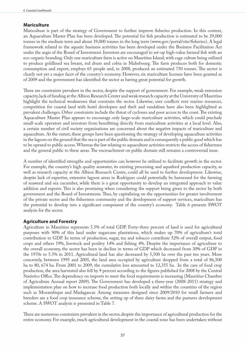
37
4. Coastal Livelihoods
MaricultureMariculture is part of the strategy of Government to further improve fisheries production. In this context, an Aquaculture Master Plan has been developed. The potential for fish production is estimated to be 29,000 tonnes in the medium term and about 39,000 tonnes in the long term (www.gov./portal/site/fisheries). A legal framework related to the aquatic business activities has been developed under the Business Facilitation Act under the aegis of the Board of Investment. Investors are encouraged to set-up high-value farmed fish with an eco-organic branding. Only one mariculture farm is active on Mauritius Island, with cage culture being utilized to produce goldlined sea bream, red drum and cobia in Mahebourg. The farm produces both for domestic consumption and export, employs 65 people and, in 2008, produced an estimated 750 tonnes. The sector is clearly not yet a major facet of the country’s economy. However, six mariculture licenses have been granted as of 2009 and the government has identified the sector as having great potential for growth.
There are constraints prevalent in the sector, despite the support of government. For example, weak extension capacity, lack of funding at the Albion Research Center and weak research capacity at the University of Mauritius highlight the technical weaknesses that constrain the sector. Likewise, user conflicts over marine resources, competition for coastal land with hotel developers and theft and vandalism have also been highlighted as prevalent challenges. Other constraints include the threat of cyclones and poor access to the coast. The existing Aquaculture Master Plan appears to encourage only large-scale mariculture activities, which could preclude small-scale operators and investors from benefitting directly from mariculture activities at a local level. Also, a certain number of civil society organisations are concerned about the negative impacts of mariculture and aquaculture. At the outset, these groups have been questioning the strategy of developing aquaculture activities in the lagoon on the ground that the sea is part of the public domain and is consequently a public good which has to be opened to public access. Whereas the law relating to aquaculture activities restricts the access of fishermen and the general public to these areas. The encroachment on public domain still remains a controversial issue.
A number of identified strengths and opportunities can however be utilized to facilitate growth in the sector. For example, the country’s high quality seawater, its existing processing and aquafeed production capacity, as well as research capacity at the Albion Research Centre, could all be used to further development. Likewise, despite lack of expertise, extensive lagoon areas in Rodrigues could potentially be harnessed for the farming of seaweed and sea cucumber, while there is a great opportunity to develop an integrated approach to value addition and exports. This is also promising when considering the support being given to the sector by both government and the Board of Investments. Thus, by capitalizing on the opportunities for greater involvement of the private sector and the fishermen community and the development of support services, mariculture has the potential to develop into a significant component of the country’s economy. Table 6 presents SWOT analysis for the sector.
Agriculture and Forestry Agriculture in Mauritius represents 5.5% of total GDP. Forty-three percent of land is used for agricultural purposes with 90% of this land under sugarcane plantations, which makes up 70% of agriculture’s total contribution to GDP. In terms of production, sugar, tea and tobacco contribute 52% of overall output, food crops and others 19%, livestock and poultry 14% and fishing 4%. Despite the importance of agriculture to the overall economy, the sector has been in decline in terms of GDP which decreased from 30% of GDP in the 1970s to 5.5% in 2011. Agricultural land has also decreased by 5,500 ha over the past ten years. More concretely, between 1995 and 2005, the land area occupied by agriculture dropped from a total of 86,500 ha to 80, 674 ha. From 2001 to 2009, the cumulative loss amounted to 12,355 ha. In the case of food crop production, the area harvested also fell by 9 percent according to the figures published for 2008 by the Central Statistics Office. The dependency on imports to meet the food requirements is increasing (Mauritius Chamber of Agriculture Annual report 2009). The Government has developed a three-year (2008-2011) strategy and implementation plan on how to increase food production both locally and within the countries of the region such as Mozambique and Madagascar. Among measures designed since 2009/2010 for small farmers and breeders are a food crop insurance scheme, the setting up of three dairy farms and the pastures development scheme. A SWOT analysis is presented in Table 7.
There are numerous constraints prevalent in the sector, despite the importance of agricultural production for the entire economy. For example, much agricultural development in the coastal zone has been undertaken without

38
4. Coastal Livelihoods
adequate planning, which has led to significant coastal erosion and pollution, while degradation of lagoon water quality has become highly problematic in Grand Bay. Increased mass tourist activity is also expected to place further strains on coastal land, which could be deleterious to coastal management plans. Poverty is also very high in the coastal zone, which not only reduces employment options for coastal populations, but encourages harmful agriculture practices that are detrimental to coastal resources.
A significant number of strengths and opportunities have, however, been identified in the sector. For example, the majority of the coastal population is involved in agriculture to some degree. Thus, there is an incentive for government to strengthen and support the sector. The Ministry of Environment completed a study on coastal erosion in 2002 with the aim of promoting sustainable development along the coast. In addition a new Integrated Coastal Zone Management Framework (2010) has been endorsed by the Government and is currently being implemented. Similarly, a Mangrove Propagation Programme was initiated in 1995. This programme has been highly effective in countering mangrove depletion. The potential for eco-tourism has also been highlighted, particularly as a means of developing alternative livelihood opportunities amongst coastal farmers. Thus, while rapid coastal development especially through real estate projects could become problematic, there are clearly strengths and opportunities through which the sector could sustainably develop in the future.
EnergyMauritius has no proven oil and gas reserves. Thus, there are no upstream activities in the country. However, the country does have a significant amount of renewable energy resources, including hydroelectricity, bagasse from the sugarcane industry, as well as woody biomass, wind energy and solar energy. According to the Central Statistics Office, the primary energy needs of the country increased in 2010 by 1.5 percent. In other words, the primary energy needs rose from 1,404 million tonnes in 2009 to 1, 425 million tonnes in 2010. The government has developed new policy frameworks in order to address the issue of energy. In 2008, the Government adopted the ‘The Energy Policy 2007-2025’. Based on this policy document, the long term strategy and Action Plan has been developed with emphasis on the following: (i) the development of renewable energy, (ii) reduction of the dependence of the country on imported fossil fuel and, (iii) the promotion of energy efficiency (www.gov.mu/portal/site/mpusite). These objectives are in line with the Government vision ‘Maurice Ile Durable’ (MID) developed in 2008 (www.gov.mu.portal/sites/mid/about.htm). The objective of MID in terms of energy is to realise 65% of energy autonomy by 2028. The energy autonomy is based on a mixed renewable energy package including, among others, wind, solar, ethanol and biogas. A MID Fund has been set-up to support efforts of both the private and public sector to promote more efficient use of energy and increase use of renewable energy. Part of the funds have been used for various initiatives such as domestic solar water scheme, energy saving lamps for about 100,000 households at concessionary rates, and a wind farm project. The development of a mixed strategy of renewable energy with solar, wind, bio-fuels, bagasse and ethanol production is thus a central pillar of the country’s energy plan for the future. While only 8 million litres of hydrous ethanol was produced between 2004 and 2008, the country is aiming to produce 30 million litres annually in the future. Mauritius will start shortly the use of E10 which is a mixture of petrol and ethanol in motor vehicles. This will help to reduce the petroleum bill which is about M Rs 22 billion. Currently, Independent Power Producers (IPP), the sugar factories, produce 42% of electricity used in Mauritius, using mainly bagasse and imported coal. The Central Electricity Board produces 58% of electricity using imported fuel oil and coal. The IPP have the potential to produce more than 60% of the national energy demand. In this perspective, the government has consolidated its legal and policy frameworks through the approval of the Utility Regulations Act (2008) and the Energy Efficiency Act (2010). This will be complemented by a new Building Control Act in order to improve building design and choice of building plant and equipment to attain high efficiency in terms of energy use.
Constraints have been identified in the sector, many of which are interrelated. Utilizing sugarcane to meet growing energy demand is also problematic, as it could have a negative impact on food security in the country. However, an appropriate balance between the production of biofuels and food production to ensure food security is a necessity. Also a reliance on coal as a source of energy has also been identified as a weakness. While bio-fuels development is a positive attribute of the energy sector moving forward, its ability to reduce the country’s dependence on fuel oil and coal imports is limited. However, the success of the energy strategy lies on the political will and capacity to implement the MID Strategy and Plan of Action which is still under preparation. MID is in fact at the heart of the sustainable development agenda of Mauritius and covers an extremely wide variety of social, environmental, economic and cultural issues. A SWOT analysis for the energy

39
4. Coastal Livelihoods
sector is presented in Table 5.
Numerous strengths and opportunities have been identified in the sector. For example, the government has made numerous commitments to develop clean energy as evident in the 2005 National Development Strategy and the 2006 Multi-Annual Adaptation Strategy and other policy frameworks discussed above. These energy policy frameworks have the potential to make Mauritius a regional leader in green energy. The country also has strong new ICZM Framework as well as strong environmental regulations, which should not only ensure that any development in the sector is conducted in a sustainable manner, but also facilitate and sustain growth in sectors, such as tourism, where success is directly dependent on the country’s natural environment. The government also continues to encourage competiveness in the energy sector, which should facilitate efficiency in the sector moving forward. A memorandum of understanding for cooperation was also signed with India in relation to oil and gas exploration, which could be fruitful in terms in future. Thus, while Mauritius is clearly transforming its sugar industry into a cane industry, the commitment to the biofuels and other green energy development should allow the country to realize its clean energy strategy and subsequently reduce its reliance on imported coal and fuel oil as primary sources of energy.
Ports and Coastal TransportMauritius, as an archipelagic state has two ports. The main commercial one is located in Port-Louis on the main island, Mauritius, and a second one in Port Mathurin on the island of Rodrigues for the handling of services between Rodrigues and Mauritius. The Port-Louis harbour has been transformed into a world class shipping facility and is the second largest container-handling facility in the Indian Ocean (www.mauport.com). It also has a fishing port which is gradually making a name especially with the development of the Sea Food Hub. Since 2002, a new vision and a new strategic plan have been formulated which has transformed gradually the port’s infrastructures and facilities in order to have, on the one hand, additional capacity to meet the demands of the maritime trade and on the other hand, to be able to accommodate the requirements of a fifth generation of super large container ships. Other recent infrastructural development includes the launching of new radio station (with the latest radars, vessel tracking system and communication equipments), a new oil jetty having a throughput capacity of about four million tonnes per annum and in 2010 a dedicated cruise jetty. A SWOT analysis is presented in Table 6.
In 2008, the port received 2000 vessel calls and handled 6.3 million tonnes of cargo comprised of 5.1 million tonnes of imports and 1.2 million tonnes of exports. Moreover, in 2010, 22 passenger vessels called in the port. The port is owned and operated by the Mauritius Ports Authority (MPA) which plays a pivotal role in the national economy. A second institution of great importance in the Port is the Cargo Handling Corporation (CHC) which is a parastatal body with state shareholding. CHC manages port handling operations for general cargo, dry bulk and container handling in Port-Louis. Last but not least is the Mauritius Freeport Authority (MFA) is a duty-free logistics, distribution and marketing hub for the region. The MFA offers logistic and warehouse facilities which are readily available for the transhipment, consolidation, storage and minor processing of goods. In 2010, the freeport operators amounted to 255 companies with a total trade volume of 323, 200 tonnes.The newly won world class status for the port requires continuous work. An auction market for fish is being completed while a major waterfront development project is being planned at the southern part of the port. This project will include a marina, high class hotels and a wide variety of tourism and leisure. Numerous strengths and opportunities have been identified in the sector, all of which could be utilized to facilitate growth. For example, not only is Port Louis Africa’s second largest financial centre, but the country is politically and financially stable, all strengths which are highly conducive to private-sector confidence. The government’s promotion of economic development has also been highly positive, which, in conjunction with established agriculture and a growing manufacturing sector could be very beneficial in terms of port activity. There are also new opportunities in the sector, particularly for port expansion, as well as increased investments in well-designed tourist facilities, coastal property and manufacturing. Manufacturing, agriculture and services activities via the Freeport, in particular, are important as both stimulate port activity through exports and international trade and strengthen the link between the Small Island State and the global economy. Thus, any increased activity in manufacturing, agriculture and trade services will not only benefit the port, but it will also be very positive for coastal communities.
There are, however, several unavoidable constraints ingexist in the sector which need to be recognized when
40
4. Coastal Livelihoods
planning for the future. For example, high transport costs, cyclone activity, climate change and the presence of Somali pirates in the West Indian Ocean, already negatively impacts the shipping sector, while competition in manufacturing, particularly from Asia, is a potential threat to economic development in Port Louis. Regional competition in both tourism and port activities from Madagascar and South Africa also needs to be taken into account and strategies need to be designed to make the ports and shipping sector more competitive. In general, the country’s strong investment climate, along with the potential for increased investment in supporting sectors, highlights the opportunities for development not only in the country’s ports, but also in the connected coastal communities.
Coastal MiningThere is little mining activity in Mauritius. For example, only 1 million tonnes of stone, 300,000 tonnes of sand, 7,000 tonnes of lime and 6,000 tonnes of salt were produced in 2000. Coral sand mining was in the past practiced in lagoon areas in the coastal region. However, due to the destruction of adjacent marine habitats, as well as coastal erosion, the government banned sand extraction in 2002. As a result, substitute technologies are now being used for crushing rock, which is subsequently utilized for construction purposes. Table 7 presents SWOT analysis for the sector.
The banning of sand mining is an example of the strong environmental regulations in Mauritius. Strong coastal zone protection regulations are also prevalent in the Integrated Coastal Zone Management Framework. The Ministry of Environment and Sustainable Development has set up an ICZM division, which guarantees the institutional sustainability and highlights the government’s commitment to protecting the country’s coastal environment. There is also a national ICZM Committee that oversees and monitors activities in the coastal zone. ICZM ad-hoc sub-committees have been established in Flic-en-Flac and La Morne /La Gaulette in order to initiate grass roots activities in a participatory mode, while a plan for Rodrigues is currently being prepared. All ICZM projects are largely aimed at addressing beach erosion, the creation of marine protected areas and the protection of wetlands, all of which is very promising in terms of the sustainable management of coastal resources. The Indian Ocean Commission (IOC), EU and UNEP are also currently operating programs aimed at sustainable coastal resource management, which should support the current projects being implemented by the government. Since 2009, the Government has also been participating with other islands in, and African coastal states bordering, the Western Indian Ocean in the preparation of an ‘ICZM Protocol’ under the Nairobi Convention with the aim of promoting national and regional cooperation for sustainable development in the Western Indian Ocean.
Overall, with little potential for future mineral production and special regulations for coastal mining already in place, the sector will not likely play an important role in coastal livelihoods in Mauritius in the future. But given the aforementioned dedication to sustainable development in the coastal zone, through the development of a national ICZM Framework and eventually a Regional ICZM protocol in the region, terrestrial and marine degradation should not arise from the sector in the future.
Conclusion There are numerous opportunities for sustainable development in the Mauritius coastal zone, many of which could be utilized to reduce the environmental challenges highlighted across the sectors. There are at the same time, numerous constraints prevalent in the country many of which require immediate action if development is to be sustained. One clear challenge highlighted in all sectors is the pressure being placed on the country’s coastal resources. In the small-scale fishery, the over-exploitation of lagoon resources, as well as the use of deleterious fishing techniques, have been highlighted as substantial environmental concerns in the sector. However, the livelihood of small scale fishers has to be taken into consideration. In agriculture and forestry, poverty has been highlighted as a motivating factor in perpetuating the use of poor farming practices, which places further strain on the limited land resources on the coast. Coastal erosion, coral reef destruction and poor wastewater management have also been highlighted in the tourism sector. These cases of environmental degradation undoubtedly require immediate attention, as much of the socio-economic activity outlined in the report, particularly in the small-scale fishery, tourism, and agriculture sectors, relies heavily on the goods and services provided by sea and coast. Environmental degradation is also a particularly serious problem for tourism, as most activity in the sector is directly dependent on the country’s natural landscape, which means any significant deterioration in the country’s natural habitat will likely result in negative spin-offs. But in the

41
4. Coastal Livelihoods
context of sustainable development and especially the vision “Maurice Ile Durable’, due attention must be paid, in all these sectors to social development and the adverse impact on people.
The government has taken steps to reduce some of this damage. For example, the promotion of mariculture not only has the potential to create an alternative form of income generation for coastal communities, but, in doing so, has the potential to reduce the strain being placed on the country’s natural resources. Similarly, numerous projects and programs have been designed by the government to deal with some of the environmental issues raised in the report. For example, the Mangrove Propagation Programme has been highly successful in offsetting past mangrove depletion, while the moratorium on lagoon sand mining has largely prevented coastal erosion that was caused by deleterious mining activity. Reef conservation projects were also identified in the tourism sector, which again highlights the government’s awareness of both the environmental and socio-economic importance of sustaining the country’s coastal resources. There is also potential for the development of eco-friendly products and services in the tourism sector, which could also be helpful in mitigating some of the aforementioned environmental problems.
Weak capacity has also been highlighted as a constraint across sectors. For example, weak law enforcement has been highlighted as a challenge in the small-scale fishery, while poor extension and research capacity has been highlighted as a technical constraint in mariculture development. In tourism, poorly regulated land development has been identified as a problem, particularly in terms of its environmental impact, while similar problems in planning capacity have been documented in agriculture. Thus, it is likely that increases in capacity will be required, particularly if enforcement in the small-scale fishery is to be improved, and mariculture is to meet its full potential.
Opportunities highlighted in the report include potential for further development in exports, evident in mariculture, where there is a great opportunity to develop an integrated approach to value addition and exports, as well as the small-scale fishery, where value addition and product development has the potential to facilitate further export growth. Growth in exports could also be beneficial for the ports and coastal transport sector, as it could not only stimulate activity, but it could further strengthen the country’s links to the global economy. Nevertheless, the food security dimension should be given more consideration in the light of the strategy for Mauritius to reduce its dependency on food imports.
There are also opportunities for further expansion, particularly in mariculture, the small-scale fishery and biofuels. For example, extensive lagoon areas in Rodrigues could potentially be harnessed for the farming of seaweed and sea cucumber, while the availability of demersal fish stocks on the shallow water banks further from the islands, as well as pelagic resources in the open ocean, also highlight the potential for catch increases in the small-scale fishery. The government has also been highly proactive in both sectors, particularly evident in the small-scale fishery where duty concessions and the provision of soft-terms loans have been utilized to support the sector. A commitment to biofuels expansion also has the potential to not only decrease the country’s reliance on coal imports, but it could also allow Mauritius to become a regional leader in clean energy. Overall, the country’s strong investment climate and its political stability are both attributes that could be conducive to realizing the above opportunities. The country’s outstanding natural landscape and bountiful coastal resources are also attributes that in conjunction with this stability could continue to perpetuate the development that has been seen to date. It is also promising to note that there is a clear recognition of the importance of facilitating development in a sustainable manner, which could be fruitful not only in terms of sustaining coastal resources for generations to come, but in terms of allowing sectors, such as tourism and mariculture, to provide employment and livelihood opportunities into the future. Thus, while environmental degradation does remain problematic in the present, the push to create alternative streams of income and provide coastal communities with employment opportunities highlights the potential for sustainable and inclusive socio-economic development in the Mauritius coastal zone.

42
5. Policy and Governance
5 . POLICy ANd GOvERNANCE
A Policy and Governance assessment has been carried out. Chapter summaries are presented below, and the full P&G Assessment may be found in Annex V for further information.
The British colonial system has shaped the Mauritian civil service structure and political system to a great extent. The independence of the country in 1968 transformed the Civil Service which until then was operating under the control of British administrators. The challenge was to pass from a colonialist system to a new structure that can ensure certain provisions of a ‘Welfare State’ based on certain key free services such as education, health, public transport for the school children and elderly. In addition, a certain number of social aids support to the poor and vulnerable is available.
The political system is based on the Westminster model with a National Assembly headed by a speaker. The General Election which is organised every five years is based on a multi-party-system and ‘First-Past-the Post’. The National Assembly is made up of 62 Members of Parliament coming from 21 constituencies, each with three MPs. The Government is an emanation of the National Assembly and all the ministers forming the Cabinet are elected members. The exception is the Minister of Justice who must be a lawyer by training and consequently can be co-opted. The Cabinet is headed by the Prime Minister. The minority party constitutes the official opposition in parliament and its leader is recognised as the official Leader of the Opposition which is a constitutional post. Consequently, the Mauritian system of government is based on the three traditional pillars of power: the Legislative (the National Assembly), the Executive (Cabinet), and the Judiciary.
Mauritius has organised its general election every five years with the exception of the period 1969-1973 when elections were postponed. Since then, the Mauritian constitution has been amended to make it mandatory for the government to organise General Election every five years. The General Election has become a regular feature of the Mauritian democracy and various coalitions of political parties had the opportunity to govern the country without any serious political instability and in a smooth political transition. In fact, coalition government is a common feature of Mauritian politics.
However, the accountability process of parliament requires improvement and new parliamentary practices should be introduced. In spite of the publication of the National Audit Report and that of the Public Accounts Committee, there is no debate on the two reports and no guidelines are given by parliament for corrective measures. Consequently, the recommendations of these reports are never implemented. In addition, Mauritius has a vibrant media which plays a vital role in raising all sorts of issues of public interest. For example, illegal practices on the coastal zone such as pollution in the lagoon, non respect of land and building permit and destruction of mangroves, make headlines on a regular basis and the press act as a pressure group towards policy makers. Very often, the print media and the private radio are successful in influencing policies or in revealing corrupt practices or other forms of abuse of power.
In spite of the existence of local authorities through district councils, municipalities and village councils which are elected local structures, Mauritius has moved, during the past three decades, towards more centralisation than devolution. Currently, the Village Council of the coastal villages which is the closest decentralisation structure at local level does not have any power at all in the management of the coastal zone. The responsibilities rest with the following ministries/parastatal bodies: (i) Ministry of Environment and Sustainable Development as the overarching ministry in the field of coastal zone; (ii) the Ministry of Local Government for waste collection behind the beaches; (iii) the Beach Authority for the management of the beaches, and (iv) the Ministry of fisheries for the state of the lagoons. The district councils have limited powers such as acting as regulators in terms of Land and Building Permits. It is within this institutional landscape that the ICZM framework is being implemented. From the point of view of the management of coastal resources and protection of the marine ecosystem, there is a problem of inter-institutional coordination amongst the governmental institutions. In addition, the local authorities suffer from serious lack of capacity on the part of councillors and personnel. It will not be enough to set-up local ICZM committees at village and district level, there is also the need to develop the capacity of the councillors in understanding issues relating to coastal management, climate change, ecosystem management etc. if these committees are to be effective.

43
5. Policy and Governance
Policy dialogue and the participation of the stakeholders at both national level and local level are weak or are done on an ad-hoc basis. The only exception is the private sector which has structured dialogue with government on a regular basis. The lack of participation of stakeholders is due to the top-bottom approach which is the regular practice by government and other national institutions. Consequently, there is a wide spread attitude in society to leave the responsibility of implementation to government only. It must also be recognised that the civil society organisations are relatively weak. There is in fact no NGO policy and enabling framework to favour policy dialogue and participation. In addition, civil society stakeholders have difficulty in accessing information such as policy document, reports and other information that can enable them to engage themselves in policy dialogue and eventually in evidence-based advocacy in the context of sustainable development.
Although Mauritius has the required setting for policy formulation and implementation, there is room for improvement in terms participation of stakeholders in policy dialogue. New mechanisms have to be put in place and new practices have to be promoted for Mauritius to move ahead from a representative democracy to a participatory democracy. This is the challenge in the decade to come.

44
6. Planning and Management
6 . PLANNING ANd MANAGEMENT
National disaster Management PlansThe aim of disaster management is to reduce disasters and to reduce the impact of those that cannot be prevented. Events considered to cause disasters in the Mauritius region are in general related to tropical cyclones, torrential rains, storm surges, flash floods, wave surges, landslides, tsunamis, oil spills, and health-related issues, among others. National disaster management is under the responsibility of the National Disaster Committee set-up under the aegis of the Prime Minister’s Office with responsibilities for hazard mapping and risk assessment; forecasting, early warning and information dissemination and preparedness to respond to disasters.
In as far as tropical cyclones, storm surges, torrential rains, landslides, wave surges and tsunamis are concerned, the National Meteorological Services takes the lead and alerts the government and the general public according to established rules and regulations set out in the Cyclone and Other Natural Disasters Scheme (Prime Minister’s Office 2009). The scheme is well-documented and is revised in October of every year. The cyclone warning system includes details on what actions have to be taken and at what stage, as well as the actions to be taken by the various relevant institutions. The class system of warning is based on the risk of occurrence of cyclonic winds, which are related to a threshold of 120 km/h surface wind in gusts. A class I warning is issued 36-48 hours before the region concerned is likely to be affected by cyclonic winds. Class II warning is issued to allow, as far as practicable, 12 hours of daylight before the advent of cyclonic winds, class III is issued to allow, as far as practicable, 6 hours of daylight before the advent of cyclonic winds. Class IV means that cyclonic winds have been recorded and are expected to continue to occur. A termination bulletin is issued when there is no longer any risk of gusts exceeding 120 km/h. The cyclone warning bulletins are disseminated to all parties concerned via phone, email, fax, and all the media. The dissemination pattern follows an established priority list.
Storm surges and torrential rains in the region are usually associated with tropical cyclones. The cyclone warning bulletins include information on these issues and precautions to be taken. However, even in the absence of tropical storms in the area, there are situations when special warnings have to be issued for torrential rains and/or landslides. This is due to extreme-climatic conditions caused by climate change. Landslides usually occur as a result of heavy rains, and landslide-prone areas have been mapped.
A Tsunami Emergency Scheme is still being improved in the Republic of Mauritius. The scheme comprises several components: General preparedness, occurrence and potential threat, actions during such events, and actions in the aftermath. Relevant institutions and stakeholders have been listed for respective actions in the event of a tsunami. As soon as a major earthquake occurs in the Indian Ocean, a Tsunami Watch Bulletin is issued to request the public to keep out of sea and off beaches. When a destructive tsunami is detected, a Tsunami Warning Bulletin is issued with request to evacuate vulnerable areas. A Tsunami Cancellation Bulletin ends the warning when there is no more threat.
The health-related domain is included because of possible interaction with the oceans and transboundary issues. The Ministry of Health and Quality of Life (2010) has established dedicated units to alert the relevant authorities in case of impending health-related issues, including diseases such as Asian Avian flu (Centers for Disease Control and Prevention 2008, Division of Veterinary Services 2006), Chikungunya (WHO 2008, Centers for Disease Control and Prevention 2008, Wikipedia 2010), and Dengue (WHO 2010, Wikipedia 2010). The Ministry of Health through its sanitary division has an effective permanent team posted at the port and airport to monitor incoming passengers travelling from overseas risk areas.
The Ministry of Environment and Sustainable Development is responsible for ocean-related (non-natural) disasters, including oil spills. In case of such incidents, the ministry alerts all the relevant authorities and actions are taken according to established rules and regulations. In particular, the National Oil Spill Contingency Planning (NOSCP) provides the framework for oil spill response and is activated in the event of a spill occurring in the territorial zone of the Republic of Mauritius (Ministry of Environment and Sustainable Development 2006). This NOSCP document is regularly updated by the Ministry of Environment and Sustainable Development. The Department of Environment (DOE) of the parent Ministry is responsible for oil pollution preparedness and response. Being the focal point for receipt and transmission of oil pollution reports, the DOE is entitled to act on behalf of the state to request or provide assistance as required, following

45
6. Planning and Management
approval by the Prime Minister’s Office. A National Coordination Committee at the Ministry of Environment and Sustainable Development is responsible for the development, implementation, review and update of the NOSCP. The Committee, chaired by the Permanent Secretary of the Ministry of Environment and Sustainable Development, comprises representatives from various Ministries, the Mauritius Ports Authority, as well as oil/petroleum companies.
The Oil Spill Pocket Book for Mauritius summarizes all necessary operational information from the national and regional oil spill contingency plan. The national plan integrates local plans, such as Port-Louis and Rodrigues and petroleum companies’ contingency plans, and is integrated in the regional oil spill contingency plan (Indian Ocean Commission 2006).
i) IssuesThe main issues include lack of coordination, lack of awareness and communication of plans that are in •place, weak implementation of the plan (when the event happens, institutions are not prepared to implement measures) and weak alert networks for tsunami early warning.
ii) GapsThe main gaps include non-availability of meteorological radar data which is required for the prediction •of a broad spectrum of meteorological phenomena, especially those capable of causing damage. There is also lack of good hydrodynamic models for tracking transport of oil spills, lack of data on tsunami run-up, including reflection of energy and resonance effects and lack of high resolution inundation maps to better estimate vulnerability against disaster-related events. Regularly-updated high resolution sensitivity and venerability maps are needed.
The above gaps can be addressing by encouraging and developing integrated approaches, including strengthening inter-sectoral co-ordination in disaster management, developing models that could be adapted for the different areas and for broad spectra of events, promote more use of space technology for more efficient communication, and establishing a central communication unit. With regard to monitoring of tsunamis, there is a need for more training of personnel in geology, seismology and hydrodynamics. Also, digital maps for tsunamis, storm surges, and coastal flooding should be developed.
Environmental sensitivity mappingThe Ministry of Environment and Sustainable Development commissioned a study of Environmentally Sensitive Areas in Mauritius and Rodrigues in January 2008 and this was completed in April 2009. The study identified, classified and demarcated all the environmentally sensitive areas in Mauritius and Rodrigues, and prioritised ESAs for protection. The project also created a database for all ESAs to support and enhance decision making. In addition to above, the project also prepared a comprehensive management plan for ESAs.
Coastal management and development planning During the past years the absence of proper coastal development planning and inadequate enforcement in Mauritius have resulted in uncontrolled construction of buildings and other structures such as seawalls, jetties and groynes along the coast (Bairds Report). The Government of Mauritius is taking initiatives to properly manage the coastal zone through implementation of Integrated Coastal Zone Management (ICZM) Plan. The coastal zone management considers both the marine and terrestrial portions of the coastal zone, as well as the river basins draining into it because they are interrelated. The erosion abatement plan is being implemented to meet the objectives of the Planning Policy Guidance (Revision 2006) for residential coastal development (Ministry of Housing and Lands 2006). The revised guidance allows a greater flexibility for development in the coastal lands while safeguarding the visual image of the coastal zone and the future tourism industry.
Integrated Coastal Zone Management Plan (ICZM) Since 1996, the Ministry of Environment has being implementing several projects on coastal protection using gabions. However, this hard engineering technique has been found to be ineffective. Consequently, the Ministry of Environment conducted a study on coastal erosion in Mauritius in November 2002 which was completed in September 2003 known as the Bairds ‘Report on the Study on coastal erosion in Mauritius, 2003’. A blueprint for an Integrated Coastal Zone Management Plan for Mauritius was recommended in order to manage future

46
6. Planning and Management
development of the coastal zone in an integrated and holistic manner. The Ministry of Environment has recently, in accordance with the recommendation of the National Environment Strategy 2000-2010 (NES), set up an Integrated Coastal Zone Management Division within the Department of Environment. It is expected that this body will play a key role in coordinating the various stakeholders in coastal zone planning and management. To reinforce this division and to enhance the participation of stakeholders at all levels, an ICZM Framework has been developed and endorsed by the Government. The ICZM Framework comprises a national strategy, a national policy, legal instruments, institutional mechanisms, area and action plans and monitoring and evaluation. The ICZM framework is thus an essential tool for the sustainable management and development of the coastal zone which is vital to the tourism industry and fisheries activities, and for the protection of the marine ecosystems. Following the creation of the ICZM Division, the ICZM Committee has been set up as per the section 50 of the EPA 2002. A local committee has also been set-up in Rodrigues for the same purpose. The committee reports to the National ICZM Committee. This committee involve all the governmental institutions as well as NGOs, parastatals and private organisations which are important stakeholders of the coastal zone.
The ICZM Division has also been following the National Oil Spill Contingency Planning Project. The need for a more comprehensive approach to coastal zone planning in Mauritius is required in order to address the increasing incidence of coastal degradation, resource use conflicts and the increased understanding of the intricate nature of the coastal environment.
Conservation Zone and National ParkProvisions have been made in the National Development Strategy (NDS)1 and the Outline Schemes2 to designate conservation zones. The Ministry of Environment and Sustainable Development is of the view that it a conservation project on the coast should be started so as to preserve the natural scenery. A new policy of conservation is being established with the demonstration projects focused on the areas of special natural beauty. A development strategy plan for 16 islets isolated in the lagoon and offshore, was developed by the Islets National Park Task Force 2002, for the protection and conservation of the remnant native animal and plant populations that still exist. They are extremely varied in size, geological composition, remoteness, accessibility, conservation value and rehabilitation potential. Management plans are being developed for all of these islets by the National Parks and Conservation Service.
Proclamation of Marine ParksA major step to safeguard the marine ecosystem has been the proclamation of two marine parks at Balaclava and Blue Bay in 1997, Proclamation no. 14 of 1997 and proclamation no. 15 of 1997, respectively. As part of the Environment Investment projects, a long term monitoring program is under way for their management. Zoning of the Marine Park has been undertaken to control specific activities within the declared areas. Dedicated staffs are present within the Marine Park on a 24 hrs basis for control and enforcement. Monitoring of the water quality and the ecology of the park is undertaken on a regular basis, and annual reports are published on the state of the ecosystem. Moreover, fishing using nets and cages is prohibited within the marine park and professional fishermen have been compensated for not fishing within the area.
Environment Impact AssessmentEnvironment Impact Assessments (EIAs) encourages developers to take into consideration environmental issues at the stage of conception and planning in the coastal zone. They also stimulate developers to compare alternative technologies and adopt pollution prevention and control strategies. Many coastal activities such as hotels, dredging, building of walls and other hard structures are now regulated through the EIA mechanism as per the EPA 2002 (amended 2007).
Coastal GuidelinesThe Planning Policy Guidance (PPG) for coastal development provides strict measures to preserve the natural and pristine characteristics of Mauritius seascapes. The revised PPG (1) is more flexible for development within
1The NDS was developed in 2003 in replacement of the 1993/1994 National Physical Development Plan (NPDP), Ministry of Hous-ing and Lands2Zoning Plan, prepared by the Town and Country Planning Board under section 11 of the Town and Country Planning Act, Ministry of Housing and Lands

47
6. Planning and Management
coastal lands while ensuring that the visual image of the coastal zone and the future of the tourism industry are safeguarded. It also provides guidelines for setback, height and plot coverage which developers have to adhere to with a view of protecting the general landscape and seascape characteristics of the area. The built-up structures are recommended to be designed in such a way as to minimize the harmful visual effects by combining judicious land use principles with environment-friendly development.
i) IssuesThe ICZM Project is constrained by the lack of a Geographic Information System (GIS). A greater •emphasis should be placed on spatially-referencing data collection and provision of island-wide mapping of coastal ecosystems. There is no data repository of all EIAs and Building and Land Use Permits to enable tracking of the development of the coastal zone. The GIS is an essential management tool to assist in the decision making process.The supporting infrastructure for the tourism industry has developed constraints in the form of • inter alia inadequate effluent treatment leading to deterioration in water quality in some of the lagoons. It is necessary to place a ceiling on the number of tourists in order to protect the environment and, indeed, the future of the tourism industry itself. The implementation of solutions for addressing coastal erosion problems takes a long time due to lack of •adequate knowledge. Commercial, recreational and everyday users of the coast expect the Government to make them aware of environmental concerns in the coastal zone and to highlight where progress is being made towards environmental improvement. The time to consolidate the awareness and sensitize visitors about the need for protection of the existing species is very opportune.There is also a lack of coordination between government agencies managing the coastal zone and enforcing •legislation that is in place. A monitoring plan to improve coordination amongst institutions that conduct environmental monitoring activities should be integrated.The rapid coastal population growth is faster than the pace of preparation of management plans.•Although legislation is in place to regulate or prohibit destructive fishing practices and removal of corals, •further guidelines need to be developed. Overfishing of lagoons has to be prevented and fishing practices such as using large nets, which cause physical damage to lagoon corals, and basket trap fishing, have to be reviewed.Land Estate Development in the coastal zone is contributing in the acceleration of the urbanisation process. •Strict enforcement of laws and regulations is necessary. In this context, there is also need to ensure the capacity is developed among the stakeholders such as village councillors, staff of District Council, Beach Authority and civil society organisations.The Beach Authority which is responsible for the management of the public beaches in Mauritius should give •priority to the respect of environmental norms on the beaches and consequently refuse location of restaurants and other food outlets on the beaches in the interest of the terrestrial and marine environment.
ii) GapsThe ICZM Framework study has recommended several amendments to the existing legislation to fill in •existing gaps. The amendments are in process but may take a long time.Sea level change has yet to be modeled and monitoring of the shoreline change trends using GIS technology •is recommended.Lack of adequate data on waves to generate relevant management products.•Mitigation measures for coastal flooding might be difficult to implement due to development pressure. •Cost of relocation may be very high. Data on the loss of coastal land per year or decade is not available for future referencing.•High resolution satellite data for shoreline changes and coastal monitoring is lacking.•
Areas under special management
Marine ParksIn 1997, the Balaclava Marine park was proclaimed by Government as per proclamation no. 14 of 1997, together with the Blue Bay Marine Park as per proclamation no. 15of 1997. These two marine parks Mauritius cover an area of 485 hectares and 353 hectares respectively. Balaclava National Marine Park is situated in the North West coast. The Blue Bay marine park is situated in the South East of Mauritius and is enclosed by

48
6. Planning and Management
coral reefs protecting it from oceanic waves. The Fisheries Protection Service (Ministry of Agro Industry, Food Production and Security (Fisheries Division) is responsible for the enforcement of the Marine Protected Areas (MPA) regulations. Permanent mooring buoys have been installed in specific zones to delimit swimming and mooring zones and to remedy conflict between various users. Patrols are carried out along the coast and in the lagoon on a daily basis.
Ramsar Site and Bird SanctuaryThe Government of Mauritius is signatory to the Conventions on Wetlands of International Importance Especially as Waterfowl Habitat (RAMSAR Convention). Rivulet Terre Rouge is the first proclaimed RAMSAR site for Mauritius on September 2001 (Ministry of Agro Industry, Food Production and Security 2011). This site is the largest estuarine delta covering about 26 hectares and is an important wintering ground and refuge for migratory birds escaping the rigorous winter months of the northern hemisphere. The Blue Bay Marine Park is the second RAMSAR site nominated in September 2008.
Offshore IsletsThere are 49 islets surrounding Mauritius, 7 of which have been proclaimed as Nature Reserves and 8 as National Parks. As these islets form part of the coastal and marine ecosystem, their protection, management and development are ensured by the National Parks and Conservation Service (NPCS) under the Islets National Park Strategic Plan (Ministry of Agro Industry, Food Production and Security 2011).
Le Morne Cultural Landscape (Buffer Zone management)AapravasiGhat and Le Morne were designated as UNESCO World Heritage Site in 2006 and 2008, respectively. AapravasiGhat is found in Port Louis and its Buffer Zone of 28.9 Ha covers part of Port Louis Harbour. Le Morne is a peninsula at the extreme south-western tip of Mauritius and is surrounded by a lagoon which is a famous tourist attraction.
A Planning Policy Guidance related to the management and control of development in the Core Zone and Buffer Zone of Le Morne Cultural Landscape was issued in 2007. The Core Zone and Buffer Zone are protected as a National Heritage Site and World Heritage Site (UNESCO 2011). The current Management Plan is a good framework document with detailed sub-plans for addressing marine environment within a buffer zone of 2407 ha. The Planning Policy Guidance for the Aapravasi Ghat is under preparation.
The Action Plan for the Le Morne pressure zone (1km inland and 1km seaward) provides more detail on implementation of the recommendations proposed in the Area Plan. The document complements the Area Plan in which the development of the Coastal Resource Inventory, identification of issues and formulation of recommendations is reported.
i) Issues In spite of pressure from tourism development and urbanization, poaching activities and uncontrolled •fishing endanger the coral beds that are still in good health. Conflict over increasing the area under protection.•According to the Fisheries Division, there is a need for a coral bleaching programme for regular monitoring •of coral bleaching events in Mauritius.The current Management Plan for Le Morne is a good framework document, but needs to be supported •with detailed sub-plans and extended to address the marine environment within the buffer zone. It is important to develop a marine habitat map for the whole of the Le Morne area and to identify marine resources found therein.
ii) GapsLack of stakeholder participation in planning process, leading to conflicts among stakeholders. •Lack of education and awareness on the value of managed areas. A more vigorous awareness campaign is •necessary to sensitize the public and different users of the marine parks. Emphasis has to be put on the need for the conservation and the sustainable use of the park.Lack of aggressive awareness creation campaigns.•Lack of scientific classification of all existing corals and their evolution.•
49
6. Planning and Management
Lack of monitoring of coastal ecosystems and infrastructure development.•Lack of capacity for integrated ecosystem management.•

50
7. Cost-Benefit Analysis
7 . COST-BENEFIT ANALySIS
The life expectancy in Mauritius is 69 (the same as for Seychelles), and the GNI is the higher among the island states (8.1 billion US$). The adult literacy is 87%, and the HDI is 0.804 (Ministry of Environment and NDU, 2007). Mauritius is often cited as an example of island state development.
Economic valuation of provisioning services
a) Food productionFisheries in Mauritius have two components: inshore fisheries, and off shore fisheries. Inshore fisheries are undertaken within the territorial sea by local fisherman, in artisanal way. Offshore fisheries are undertaken by international seiners or longliners within the economical exclusive zone. The total production of artisanal fisheries is 3,577 tons/yr and offshore fisheries production is 7,966 tons/yr (Soondron, 2010). Then the total production is about 11, 5422.8 tons/yr.
The fisheries contribution to GDP is 1.5% and the Mauritian GDP is 6,362Mus$. The annual gross income from fisheries is 95.43 Mus$. Direct employment for the sector is 5,000, and indirect employment is 6,000. A total of 11,000 people depend on fisheries sector. Annual salary for employees is 7,000 us$ per person, and the annual cost of salaries for all the people depending to the sector is 77 Mus$ (Soondron, 2010). It is assumed that operating costs are at 10% of gross income. The compensation for offshore fishing is 0.487 Mus$/yr.
Given these parameters, the annual net value for the fisheries sector 9.374 Mus$ and the net present value for a thirty-year period, with a 3% discount rate is 183.73 Mus$.
b) Raw materialsBenefit transfer is used for the valuation of raw material extraction from mangroves, with reference to the Costanza value (162 us$/ha/yr). The transfer rate is 0.65 and the Mauritian mangrove area is 14 km2. From these data, we can calculate the annual benefit from raw material extraction: 0.147Mus$ and the net present value for a thirty year period with a 3% discount rate is 2.882Mus$.
c) Ornamental resourcesBenefit transfer will be used for this valuation. Referring to Sukhdev (2009), the standard value is 264 us$/ha/yr and the benefit transfer rate is 0.65. Mauritius has an 870 km2 area of coral reefs. Taking in account these data, the annual benefit from ornamental resources harvesting is 14.886 Mus$, and the net present value for a thirty year period, with a 3% discount rate is 291.76 Mus$.
d) Total economic value of provisioning services The total economic value of provisioning services is the sum of fisheries, raw material extraction, and ornamental harvesting values. Then, it is about 478.38 Mus$.
Economic valuation of regulation services
a) Shoreline protection Cesar’s values were used as reference for benefit transfer for shoreline protection valuation. The benefit transfer rate is 0.65 and it is assumed that agricultural use of coast is from 30% to 40%, and the human settlement use is from 30% to 50%. The length of Mauritian coral reefs is 496 km. Based on these data, the benefit value for agriculture protection is from 0.388 Mus$ to 0.518 Mus$, and the benefit value for settlement protection is from 23.690 Mus$ to 39.483 Mus$. Then the total value for shoreline protection is from 24.078 Mus$ to 40 Mus$.
b) disturbance regulationFor disturbance regulation, we will again refer to Costanza’s value for benefit reference (1,839 us$/yr/ha) and the transfer rate is 0.65. The mangrove area for Mauritius is about 14 km2. Based on these data, the value of annual benefit for disturbance regulation is 1.668 Mus$ and the net present value for thirty years at 3%

51
7. Cost-Benefit Analysis
discount rate is 32.71 Mus$.
c) Climate regulationAs for other islands states, two ecosystems produce climate regulation services: mangroves and coral reefs. Climate regulation by coral reefs have a 648 us$/ha/yr value (Sukhdev, 2009). This value may be transferred without adjustment, given the global scale of benefit. Mauritius has an 870 km2 area of coral reefs. Based on these data, the total amount of annual benefits for climate regulation is 56.38 Mus$, and the net present value for a thirty year period at 3% of discount rate is about 1,081.77 Mus$.
For carbon sequestration by avoiding mangrove deforestation, it is assumed that the loss of 2.8 km2 of mangroves is avoided, and the biomass rate is 291.8 t/ha. The total volume of not emitted CO2 is 0.15 MteCO2. The market price is 10 us$/teCO2, and the cost for avoided deforestation is 2.51 us$/teCO2. Based on these data, the net value for climate regulation by mangroves (carbon sequestration) is about 1.12 Mus$.
d) Total economic value of regulation servicesThe total economic value of regulating services is obtained by summing the value of shoreline protection, disturbance regulation and climate regulation benefits. Its value is about 1,139.67 Mus$ to 1,155.60 Mus$.
Economic valuation of cultural services
As for other island states, the economic value of cultural services is based on tourism contribution to Mauritian GDP (6,362 Mus$). The mean arrivals during the past few years is 851,600 and the contribution of the tourism sector to the GDP is 8.32%. 22,840 people are working in the tourism sector, at 7,000 us$/yr/pers (Picard, 2010), and it is assumed that operating costs are at 40% of the gross sectoral income. The net annual value of the tourism sector calculated from these data is about 157.71Mus$/yr. The net present value for thirty years using a 3% discount rate is about 3,091Mus$.
Economic valuation of supporting services
a) Maintenance of genetic diversityAs for other island states, maintenance of global diversity is a global service produced by coral reefs, so we can use benefit transfer without adjustment (13,541us$/ha/yr, Sukhdev). Mauritius has an 870 km2 coral reefs area, so the annual benefit value is about 1,178.07 Mus$. In that case, the net present value for thirty years, with a 3% discount rate is 22,605. Mus$.
b) Nutrient cyclingAs for Madagascar and The Comoros, nutrient cycling by oceans is another global service. The reference value is Costanza’s (118 us$/ha/year). Mauritius has 16,840 km2 territorial sea. Consequently, the annual value for nutrient cycling service is 198.71Mus$, and the net present value for a thirty year period at 3% discount rate is 3,895Mus$.
c) Total economic value of supporting servicesThe total economic value for supporting service is given by the sum of maintenance of genetic diversity and nutrient cycling. Its value is about 26,500Mus$.
Total economic value
The total economic value for goods and services produced by ecosystems for Mauritius is obtained by summing the values of provisioning services, regulating services, cultural services, and supporting services. This value is estimated from 31,209 Mus$ to 31,225 us$.

52
7. Cost-Benefit Analysis
Table X: The total economic value for goods and services produced by ecosystems for Mauritius (Mus$)
Direct use value (Mus$) Indirect use value (Mus$) Total (Mus$)
Provisioning services
Food production:184 Raw material production: 3 Ornamental resources: 292
479
Regulating services
Climate regulation:1,083Disturbance regulation: 33
Shoreline protection: 24-40Mus$1,140-1,156
Cultural services Tourism & recreation:3,091 3,091
Supporting services
Nutrient cycling: 3,895 Maintenance of genetic diversity:22,605 26,500
Total 3,570 26,500 31,209-31,225
53
8. References
8 . REFERENCES Annamalai H, Xie SP, McCreary JP and Murtugudde R (2005) Impact of Indian Ocean Sea Surface Temperature
on Developing El Niño. Climate 18: 302–319Central Statistics Office (2004), “2000 Housing and Population Census, Analysis Report VOLUME IV - Population
distribution and migration”, Republic of Mauritius.Central Statistics Office (2008) Mauritius in Figures, Ministry of Finance and Economic Development. The
National Heritage Fund: Available at: http://www.gov.mu/portal/site/nheritage/menuitem.1baffaaeb20cb91a43732f0248a521ca
Central Statistical Office, Mauritius (2010).CORDIO (1999). Coral Reef Degradation in the Indian Ocean (1999). Available at http://www.iucn.
org/about/work/programmes/marine/marine_resources/?2967/CORDIO-1999Constanza et al ,The value of the world’s ecosystem services and natural capital - 1997. CSO (2004) 2000 Housing and Population Census, Analysis Report VOLUME IV - Population distribution
and migration. Central Statistics Office, Republic of MauritiusCSO (2008) Mauritius in Figures, Ministry of Finance and Economic Development. Available at: http://www.
gov.mu/portal/site/nheritage/menuitem.1baffaaeb20cb91a43732f0248a521ca [accessed 8 April 2012]Dean RA and Dalrymple RA (2002) Coastal Processes with engineering applications. Cambridge University
Press, London. 488ppDean R. G. and Mauremeyer E. M. (1983). Handbook of Coastal Processes and Erosion (Models for beach
response) Komar PD ed. Boca Raton CRC press.Devassy VP and Goes JI (1991) Phytoplancton assemblages and pigments in the exclusive economic zone of
Mauritius (Indian Ocean). Indian Journal of Marine Sciences 20: 163-168Du Y and Xie S-P (2008) Role of atmospheric adjustments in the tropical Indian Ocean warming during the
20th century in climate models. Geophysics Research Letters 35: doi:10.1029/2008GL033631.Emery KO and Aubrey DG (1989) Tide gauges of India. Journal of Coastal Research 5: 489-501Giorgi L, Borchiellini S and Deluchi L (1999) Notes on the geologic map of Mauritius at 1:50,000:
Hydrogeologic schema. Geolab-Burgeap, Mauritius [in French]Hermes, J.C. and Reason, C.J.C. (2009). Variability in sea-surface temperature and winds in the tropical south-
east Atlantic Ocean and regional rainfall relationships. Int. J. Climatol., 29, 11-21.Hermes J and Reason CJC (2009) The sensitivity of the Seychelles-Chagos Thermocline Ridge to large scale
wind anomalies. ICES Journal of Marine Science Special Issue: proceedings of the International Symposium on Effects of Climate Change on the World’s Oceans 66: 1455-1466
IPCC (2007a) Working Group II, Fourth Assessment Report. Cambridge Press, UK Intergovernmental Panel for Climate Change (IPCC) (2007b). Climate change 2007: Impacts, Adaptation and
vulnerability. Working Group II contribution to the Fourth Assessment report of the IPCC, Cambridge University Press, Cambridge, UK, 976pp
Love GD, Grosjean E, Stalvies C, Fike DA, Grotzinger JP, Bradley AS, Kelly AE, Bhatia M, Meredith W, Snape CE, Bowring SA, Condon DJ and Summons RE (2009) Fossil steroids record the appearance of Demospongiae during the Cryogenian period. Nature 457: 718–721
Mauritius Chamber of Commerce (2009). Annual Report for Mauritius.Maurice Ile Durable. Available at http://www.gov.mu/portal/sites/mid/about.htm.Mauritius Meteorological Services (2010) Climate of Rodrigues & other outer islands. Available at http://
metservice.intnet.mu/?cat=44 [accessed Jan 2012]Mauritius Meteorological Services (2011) Climate of Mauritius. Available at: http://metservice.intnet.
mu/?page_id=644 [accessed March 2012]Mauritius Port Authority. Available at http://www.mauport.comMcIntyre WA (1961) Mauritius – River mouth terraces and present eustatic sea stand. Zeitsch. Geomorph.
Suppl. 3: 39-47

54
8. References
Ministry of Energy and Public Utilities. Hydrology Data Book 2000-2005. Chapter 3: Flow data on rivers and canals. Available at http://www.gov.mu/portal/site/mpusite [Accessed 29 March 2010]
Ministry of Environment and NDU (1999). National Environmental Strategies for the Republic of Mauritius/National Environmental Action Plan for the next decade.
Ministry of Environment and NDU (1999). National Environmental Strategies for the Republic of Mauritius/National Environmental Action Plan by Environment Resource Management – UK.
Ministry of Energy and public Utilities Hydrology data Book 2000-2005 Chapter 1: Physiography. Available at http://www.gov.mu/portal/site/mpusite [accessed 29 March 2010]
Ministry of Energy and public Utilities Hydrology data Book 2000-2005 Chapter 4 Data on groundwater . Available at http://www.gov.mu/portal/site/mpusite [accessed 29 March 2010]
Ministry of Environment and NDU (1999) National Environmental Strategies for the Republic of Mauritius/National Environmental Action Plan. Environment Resource Management, UK
Mogane-Ramahotswa, B and Still, D. (1992). Community-based management of water supply services. CSIR Division of Water Technology, Scientia Publishers. Pretoria, pp 13Montagaggio L and Faure F (1980) Les recifs coralliens des Mascareignes. Collection des Travaux du Centre
Universitaire de La Reunion. No 2Monaggioni L and Nativel,P (1988) Guide Geologiques Regionaux: La Reunion , Ile Maurice. Geologieet
Apercus Biologiques. MassonMonton JM (1976) Contribution a la Geomorphologie et Sedimentologies de recifs Coralliens de Ile Maurice.
These presente a L,Universitédaix Marseille IIOliver, P. G. and Holmes, A. M. 2004. Cryptic Bivalves with descriptions of new species from the Rodrigues
lagoon. Journal of Natural History. 38: 3175-3227Perroud, B. (1982). Etude vocanic structural de l,Ile Maurice et Rodrigues – Ocean Indien Occidental –
origine de volcanisme. These de Doctorat de specialite. Universite de Grenoble.Picard, D, 2010. Tourism in Coastal Livelihoods. In The Republic of Mauritius. Pillay RM (2002) Field Guide to Corals of Mauritius. Albion Fisheries Research Centre, Ministry of Fisheries,
AlbionRagoonaden S (1997) Impact of sea level rise on Mauritius. Journal of Coastal Research 24: 205-224 Ragoonaden S (2006a) Sea Level Activities and Changes in the Western Indian Ocean, Western Indian Ocean
Journal of Marine Science 5:163-178Ragoonaden S (2006b) Sea Level Activities and Changes on the islands of the Western Indian Ocean, Western
Indian Ocean Journal of Marine Science 5: 179 – 194Republic of Mauritius (2005) The Republic of Mauritius Web Portal. Available at: http://www.gov.mu/portal/
site/abtmtius/menuitem.9eb76f322dcc02984d57241079b521ca/ [accessed Jan 2012]Richards G (1996) Cultural Tourism in Europe. CAB International, Wallinford, UK. 347 ppRichards M, Coˆrte-Real H, Forster P, Macaulay V,Wilkinson-Herbots H, Demaine A, Papiha S, Hedges R,
Bandelt H-J, Sykes B. (1996) Paleolithic and neolithic lineages in the European mitochondrial gene pool. Am. J. Hum. Genet. 59:185–203
Rodrigues Tourist Office (2006) Rodrigues Island. Available at: http://www.gov.mu/portal/sites/rra_portal/officetourism/english/peuple.htm [accessed Jan 2012]
Saji NH, Goswami BN, Vinayachandran PN and Yamagata T (1999) A dipole mode in the tropical Indian Ocean. Nature 401: 360-363
Sharma, H.R. (2000). Water in the 21st century with specific reference to Mauritius International Conference on sustainable Development of water Resources, 27-30 November, 2000 New Delhi.
United Nations Environment Programme (UNEP) (2008). “Africa: Atlas of Our Changing Environment.” Division of Early Warning and Assessment (DEWA), United Nations Environment Programme (UNEP), Nairobi, Kenya.
United Nations Framework Convention on Climate Change (UNFCCC) (1999), Initial National Communication

55
8. References
of the Republic of Mauritius under UNFCC.UNFCC (1999) Initial National Communication of the Republic of Mauritius under UNFCC, April 1999Webster PJ, Moore A, Loschnigg J and Leban M (1999) Coupled ocean dynamics in the Indian Ocean during
the 1997-1998. Nature 401: 356-360World Trade Organization (WTO) (2010), World Trade Report 2010: Trade in natural resources, Geneva:
WTO.World Health Organisation report (WHO) (2010), World Health Organisation Report 2012: Buikding and
strengthening partnerships, Geneva: WHOWorld Trade Organization (WTO) (1997), World Trade Report 1997, Geneva: WTO.Xie S-P, Annamalai H, Schott FA and McCreary JP (2002) Structure and mechanisms of south Indian Ocean
climate variability, Journal of Climate 15: 864 – 878Xie, S., K.-M. Xu, R.T. Cederwall, P. Bechtold, A.D. Del Genio, S.A. Klein, D.G. Cripe, S.J. Ghan,
D. Gregory, S.F. Iacobellis, S.K. Krueger, U. Lohmann, J.C. Petch, D.A. Randall, L.D. Rotstayn, R.C.J. Somerville, Y.C. Sud, K. von Salzen, G.K. Walker, A. Wolf, J.J. Yio, G.J. Zhang, and M. Zhang, 2002: Intercomparison and evaluation of cumulus parameterizations under summertime midlatitude continental conditions. Q. J. Royal Meteorol. Soc., 128, 1095-1136,

