mass wasting events associated with a l …€¦ · page 1 mass wasting events associated with a...
TRANSCRIPT

Page 1
MASS WASTING EVENTS ASSOCIATED WITH A LARGE MAGNITUDE RAIN-ON-SNOW EVENT,NOVEMBER 1999, COLUMBIA AND ROCKY MOUNTAINS, SOUTHEASTERN B.C.
Joe Alcock, P.Geo.,District Earth Scientist, Columbia Forest District
Box 1380, Golden, B.C., V0A 1H0 [email protected]
ABSTRACT
In November 1999, a large magnitude rain-on-snow event occurred in the Kootenay Region of B.C. In the ColumbiaForest District, tens of debris flow, water erosion and other mass wasting events occurred. Many of the in-blockdebris flows, water events on pre-and post-code roads, and natural events were investigated and site-specific causesdetermined. Generally, the mass wasting and water erosion events generated by the rain-on-snow were different thantypical spring snowmelt-caused events. Surface and subsurface drainage volumes were often beyond ditch andculvert flow capacity. Surface water flow occurred in new, untested locations. Debris flows occurred in the uphillportions of cut blocks and in reactivated gully wall failures. Ice and slush avalanches were observed in alpine areas.This major precipitation event served to pinpoint the locations of inadequate drainage structures and unstablesidecast and road gully fills. The adequacy of drainage structures in new and disused forestry roads is evaluated. Theeffects of snowpack distribution, cutblock boundaries in relationship to terrain stability polygons and other factorsare discussed.
INTRODUCTION
This paper is a compilation of material originally presented as a poster at the Terrain Stabilityand Forest Management In The Interior of B.C. Workshop, Nelson, B.C., May 23-25, 2001.
The Columbia Forest District is located in southeastern B.C. and includes about 14,000 km2
between Golden and Revelstoke, extending north to the Mica Dam area and south to UpperArrow Lake. The area is accessed by the Trans Canada Highway, Highway 95, Highway 23North and South, and forestry roads (Figures 1 and 2).
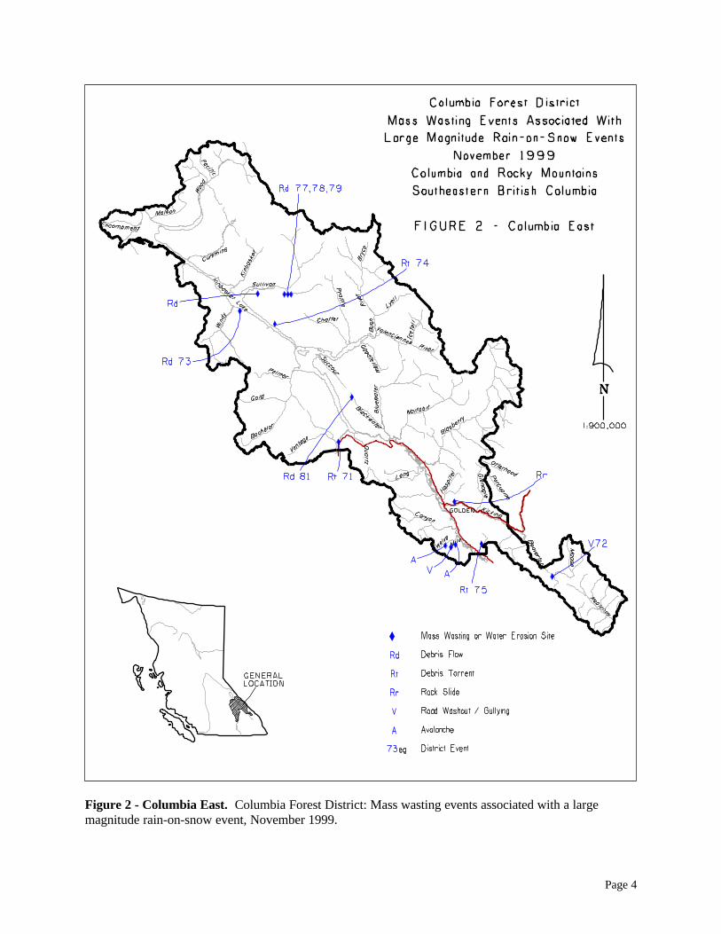
On Nov. 9 through 14, 1999, a large magnitude rain-on-snow event impacted the Columbia andRocky Mountains of southeastern B.C. In the Columbia Forest District, numerous debris flow,water erosion and other mass wasting events occurred (Figures 1 and 2).
The Forest District Engineering staff and the Forest Licensees began assessment and mitigationof erosion problems as soon as possible, accessing by road and helicopter, and directing machinework to restore drainage, clear roads and stabilize slopes. The Ministry of Environment, Landsand Parks was notified of events that impacted watercourses and lakes. District staff conductedhelicopter assessments on Nov. 16 north of Revelstoke in the Columbia River and side valleys,and on Nov. 18 north of Golden, where breaks in the cloud cover allowed surface observations.
Many of the erosion sites were field investigated in November and December 1999, and also in2000, to assess the size, volume, and contributing geologic, hydrologic and land-use factors.Rehabilitation is ongoing at some sites through grass seeding, live branch planting, brushlayering, and erosion mat installation.
Page 2
PHYSIOGRAPHY, SURFICIAL DEPOSITS AND GEOMORPHOLOGICAL PROCESSES
The District includes, from west to east, portions of the Monashee Range, the Purcell Range, andthe Selkirk Range, of the Columbia Mountains; the Rocky Mountain Trench; and the RockyMountains. Maximum relief is about 2000 m between the peaks and the Columbia River.
The main and tributary valleys are generally U-shaped having been strongly eroded by the FraserGlaciation valley glaciers. The valley floors are blanketed by till and glaciofluvial/alluvialdeposits. The valley sides have till, colluviated till, talus and bedrock outcrops, while alpineareas have large expanses of bare rock and colluviated overburden.
Modern geomorphological processes include debris flows, debris torrents; rockslides, snowavalanches, and stream fluvial processes.
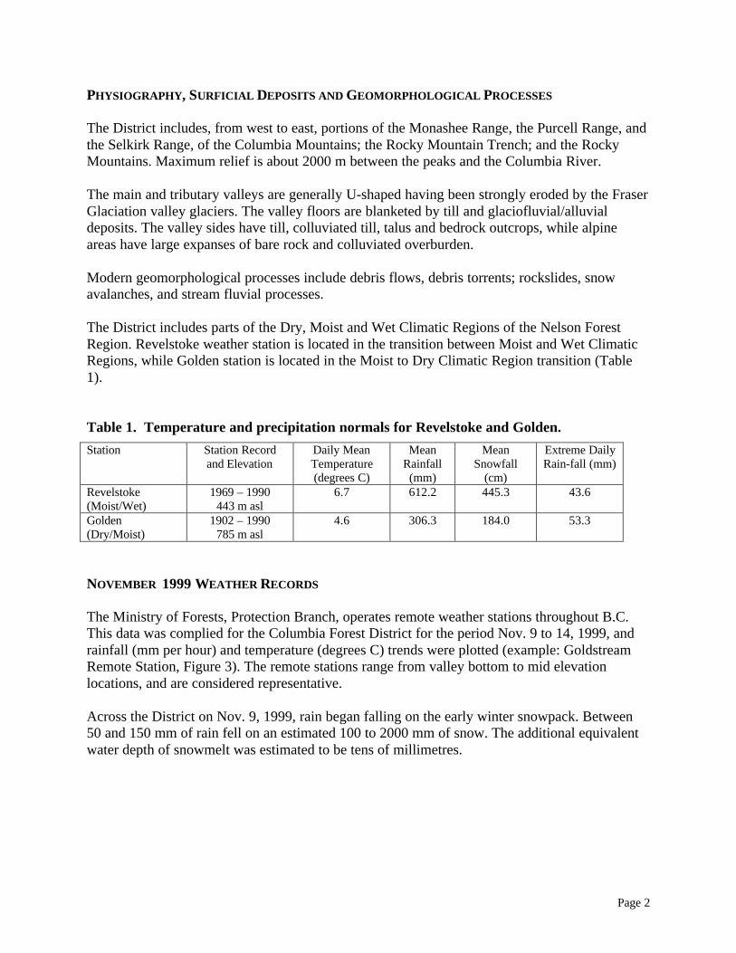
The District includes parts of the Dry, Moist and Wet Climatic Regions of the Nelson ForestRegion. Revelstoke weather station is located in the transition between Moist and Wet ClimaticRegions, while Golden station is located in the Moist to Dry Climatic Region transition (Table1).
Table 1. Temperature and precipitation normals for Revelstoke and Golden.Station Station Record
and ElevationDaily MeanTemperature(degrees C)
MeanRainfall
(mm)
MeanSnowfall
(cm)
Extreme DailyRain-fall (mm)
Revelstoke(Moist/Wet)
1969 – 1990443 m asl
6.7 612.2 445.3 43.6
Golden(Dry/Moist)
1902 – 1990785 m asl
4.6 306.3 184.0 53.3
NOVEMBER 1999 WEATHER RECORDS
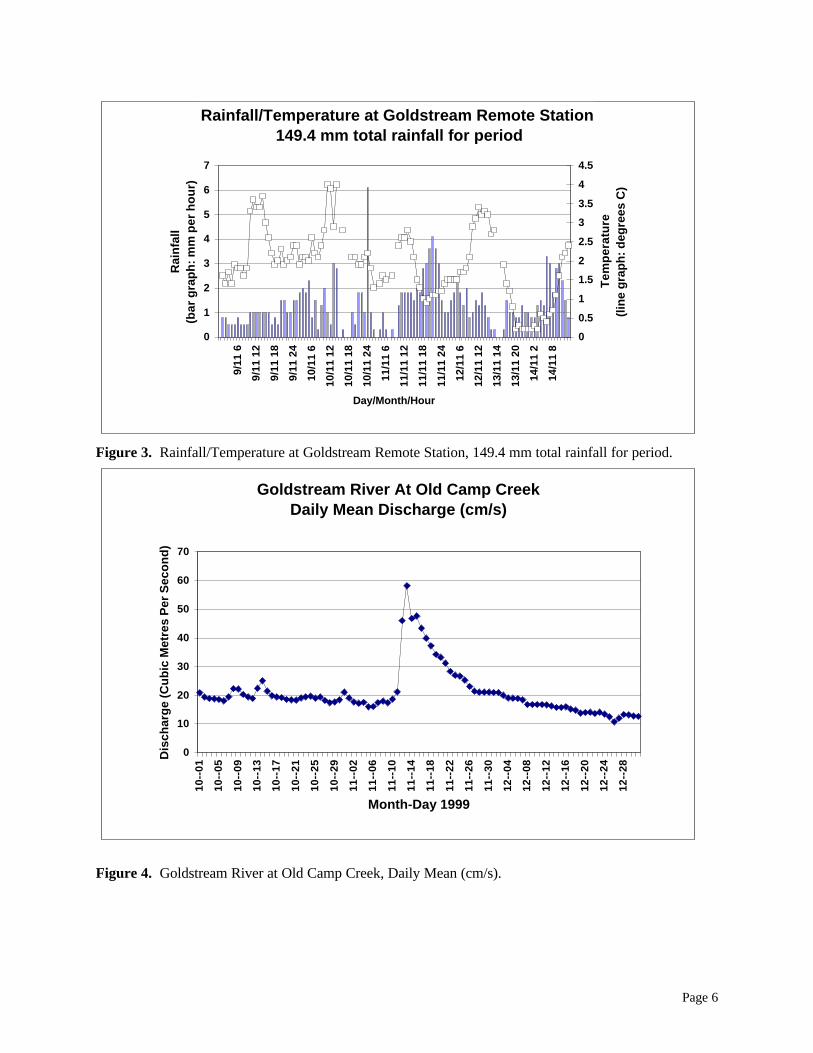
The Ministry of Forests, Protection Branch, operates remote weather stations throughout B.C.This data was complied for the Columbia Forest District for the period Nov. 9 to 14, 1999, andrainfall (mm per hour) and temperature (degrees C) trends were plotted (example: GoldstreamRemote Station, Figure 3). The remote stations range from valley bottom to mid elevationlocations, and are considered representative.
Across the District on Nov. 9, 1999, rain began falling on the early winter snowpack. Between50 and 150 mm of rain fell on an estimated 100 to 2000 mm of snow. The additional equivalentwater depth of snowmelt was estimated to be tens of millimetres.

Page 3
Figure 1 - Columbia West. Columbia Forest District: Mass wasting events associated with a largemagnitude rain-on-snow event, November 1999.
Page 4
Figure 2 - Columbia East. Columbia Forest District: Mass wasting events associated with a largemagnitude rain-on-snow event, November 1999.
Page 5
The specific cyclonic weather system was informally described as a tropical storm thatcombined with a north Pacific low pressure system over the ocean and moved inland over B.C.,producing heavy precipitation. The rainfall arrived in intense episodes over about 96 hours,accompanied by 10 to 25 kph southeast to southwest winds. The irregular distribution ofprecipitation appeared to reflect the variable intensity and size of weather cells embedded in theoverall system (Figure 3).
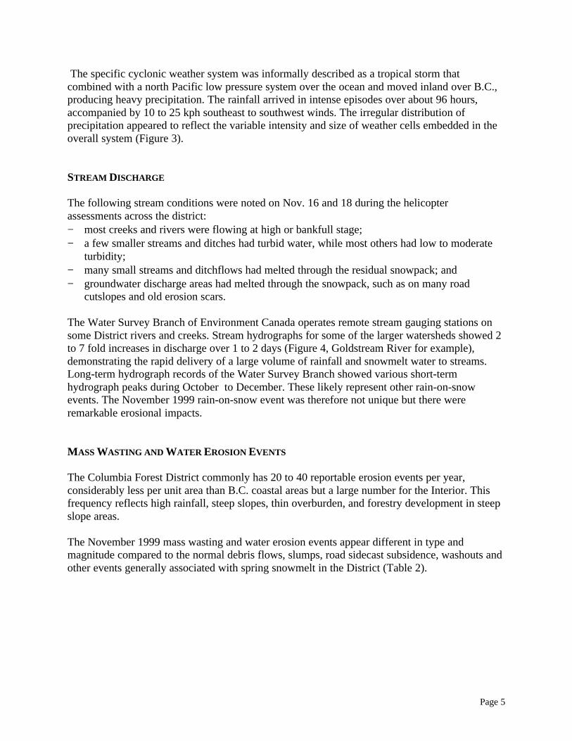
STREAM DISCHARGE
The following stream conditions were noted on Nov. 16 and 18 during the helicopterassessments across the district:− most creeks and rivers were flowing at high or bankfull stage;− a few smaller streams and ditches had turbid water, while most others had low to moderate
turbidity;− many small streams and ditchflows had melted through the residual snowpack; and− groundwater discharge areas had melted through the snowpack, such as on many road
cutslopes and old erosion scars.
The Water Survey Branch of Environment Canada operates remote stream gauging stations onsome District rivers and creeks. Stream hydrographs for some of the larger watersheds showed 2to 7 fold increases in discharge over 1 to 2 days (Figure 4, Goldstream River for example),demonstrating the rapid delivery of a large volume of rainfall and snowmelt water to streams.Long-term hydrograph records of the Water Survey Branch showed various short-termhydrograph peaks during October to December. These likely represent other rain-on-snowevents. The November 1999 rain-on-snow event was therefore not unique but there wereremarkable erosional impacts.
MASS WASTING AND WATER EROSION EVENTS
The Columbia Forest District commonly has 20 to 40 reportable erosion events per year,considerably less per unit area than B.C. coastal areas but a large number for the Interior. Thisfrequency reflects high rainfall, steep slopes, thin overburden, and forestry development in steepslope areas.
The November 1999 mass wasting and water erosion events appear different in type andmagnitude compared to the normal debris flows, slumps, road sidecast subsidence, washouts andother events generally associated with spring snowmelt in the District (Table 2).
Page 6
Rainfall/Temperature at Goldstream Remote Station 149.4 mm total rainfall for period
0
1
2
3
4
5
6
7
9/11
6
9/11
12
9/11
18
9/11
24
10/1
1 6
10/1
1 12
10/1
1 18
10/1
1 24
11/1
1 6
11/1
1 12
11/1
1 18
11/1
1 24
12/1
1 6
12/1
1 12
13/1
1 14
13/1
1 20
14/1
1 2
14/1
1 8
Day/Month/Hour
Rai
nfa
ll
(b
ar g
rap
h: m
m p
er h
ou
r)
0
0.5
1
1.5
2
2.5
3
3.5
4
4.5
Tem
per
atu
re
(l
ine
gra
ph
: deg
rees
C)
Goldstream River At Old Camp Creek Daily Mean Discharge (cm/s)
0
10
20
30
40
50
60
70
10--
01
10--
05
10--
09
10--
13
10--
17
10--
21
10--
25
10--
29
11--
02
11--
06
11--
10
11--
14
11--
18
11--
22
11--
26
11--
30
12--
04
12--
08
12--
12
12--
16
12--
20
12--
24
12--
28
Month-Day 1999
Dis
char
ge
(Cu
bic
Met
res
Per
Sec
on
d)
Figure 3. Rainfall/Temperature at Goldstream Remote Station, 149.4 mm total rainfall for period.
Figure 4. Goldstream River at Old Camp Creek, Daily Mean (cm/s).
Page 7
Table 2. Columbia Forest District, compilation of mass wasting and water erosion events.Year Debris Flow
EventsDebris Torrent
EventsWater Erosion
EventsOtherEvents
Comments
1996 16 1 11 13 Very high snowpack year.1997 22 7 15 16 High snowpack and summer
convectional rainfall activity.1998 6 5 2 6 Low snowpack year.1999April-Oct.
36 4 11 1 Many small events related to highsummer convectional rainfall activity.
1999Nov.
26 7 7 6 Regional rain-on-snow event (Nov. 9– 14))
2000 10 3 1 4 Average snowpack year.2001 6 1 4 1 Dry spring and summer.Numbers are approximate due to changing criteria/thresholds for reporting over time, and changing administrativeareas.
The rain-on-snow event resulted in:− shallow, inblock debris flows;− road sidecast and gully wall failures into streams, which initiated debris torrents;− high volume, erosive surface water flows over land, in ditches, on roads, and in streams;− drainage capacity problems where high flow overwhelmed the snow and ice-filled ditches,
and culverts and roads were overtopped; and− temporary perched water tables and high soil moisture content produced by excessive surface
water flow and in-situ snowmelt on slopes.
Debris Flows
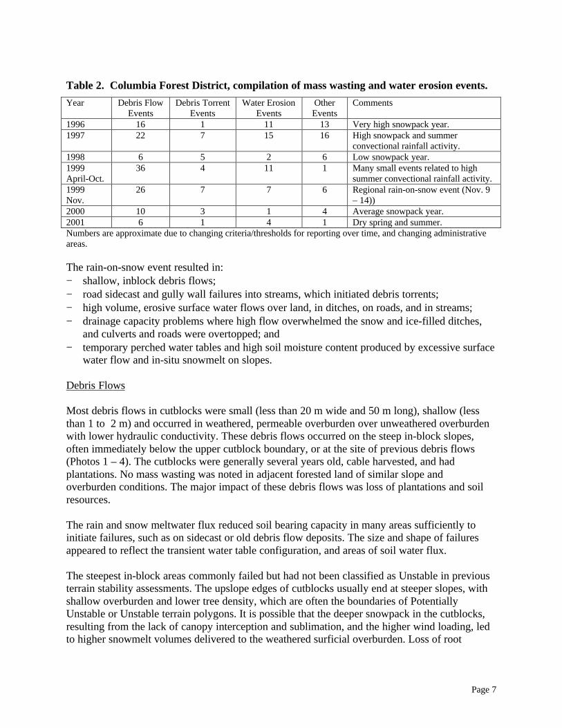
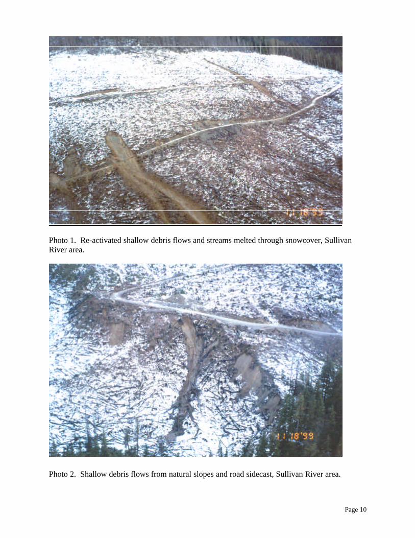
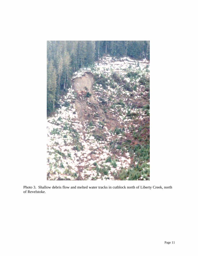
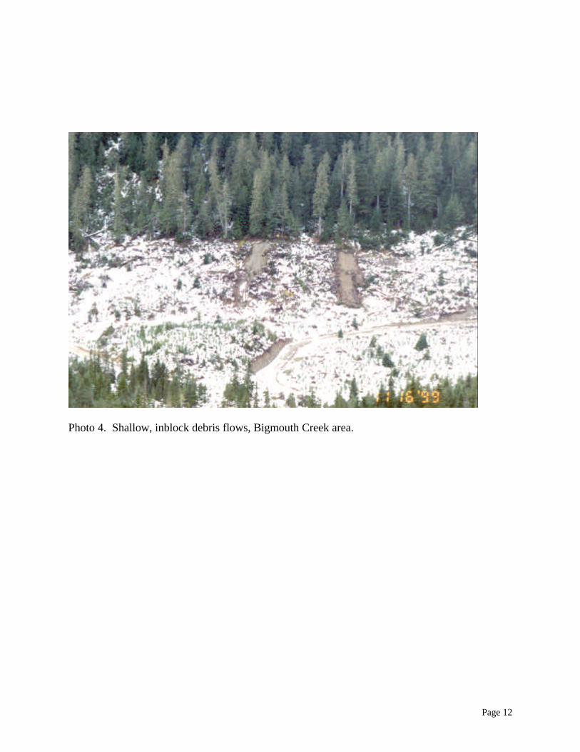
Most debris flows in cutblocks were small (less than 20 m wide and 50 m long), shallow (lessthan 1 to 2 m) and occurred in weathered, permeable overburden over unweathered overburdenwith lower hydraulic conductivity. These debris flows occurred on the steep in-block slopes,often immediately below the upper cutblock boundary, or at the site of previous debris flows(Photos 1 – 4). The cutblocks were generally several years old, cable harvested, and hadplantations. No mass wasting was noted in adjacent forested land of similar slope andoverburden conditions. The major impact of these debris flows was loss of plantations and soilresources.
The rain and snow meltwater flux reduced soil bearing capacity in many areas sufficiently toinitiate failures, such as on sidecast or old debris flow deposits. The size and shape of failuresappeared to reflect the transient water table configuration, and areas of soil water flux.
The steepest in-block areas commonly failed but had not been classified as Unstable in previousterrain stability assessments. The upslope edges of cutblocks usually end at steeper slopes, withshallow overburden and lower tree density, which are often the boundaries of PotentiallyUnstable or Unstable terrain polygons. It is possible that the deeper snowpack in the cutblocks,resulting from the lack of canopy interception and sublimation, and the higher wind loading, ledto higher snowmelt volumes delivered to the weathered surficial overburden. Loss of root

Page 8
strength with rot in the several year old cutblocks may also have reduced overall soil strengthand therefore the slope stability.
Debris flows also occurred where gully walls or road sidecast failed, depositing on gentler slopesor into streams below.
Debris Torrents
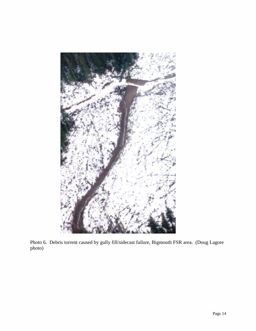
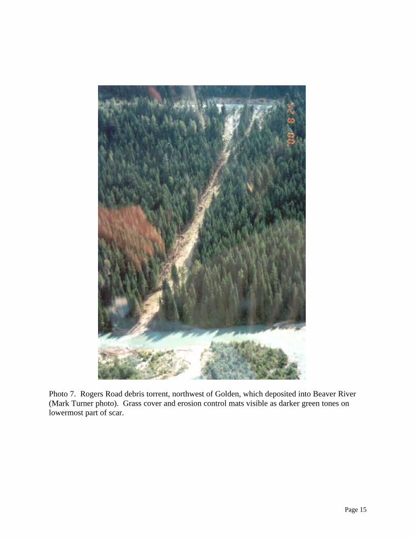
At least 7 debris torrents occurred during the rain-on-snow event, more than the typical numberfor spring or summer conditions. The Watask FSR (Rt 23, Figure 1) and Bush-Sullivan FSR (Rt74, Figure 2; Photo 5) events may have started as snow or slush avalanches that eroded gullybottoms and road prisms such that debris torrents were generated. The Bigmouth FSR (Rt 22,Figure 1; Photo 6), and Rogers Road (Rt 71, Figure 2; Photo 7) events started from ditch androad surface water which caused road sidecast failure, and in turn entered steep, flowing streamsand torrented. The torrent near Liberty Creek (Photo 8), the Campbell Road torrent (Rt 75,Figure 2) and the Bannock Creek torrent near Shelter Bay (Figure 1) appear to have started fromnatural gully wall failures entering streams.
Avalanches
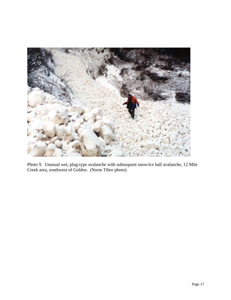
The avalanches noted were in established chutes and consisted of slush flows and ice and snowfalls carrying some soil (Photo 9). These were more frequent than usual in early winter. Rainlikely fell at the highest elevations, affecting a considerable vertical range of snowpack.
Water Erosion Events
On some older forestry road systems, discharge overwhelmed ditches and culverts and resultedin water flow over and down the road or onto slopes with no alluvial tracks, sometimes resultingin further mass wasting. Examples include Upper Begbie FSR south of Revelstoke (Figure 1)and Beaverfoot FSR (V72, Figure 2) events.
Early winter snow and ice filled most forestry road ditches and culvert inlets, reducing flowcapacity. Roads which had snow plowed into the ditches were also affected. On some olderroads, inadequately-sized culverts, and culverts which received many inflow streams, causedwater erosion events.
DISCUSSION AND CONCLUSIONS
During the November 1999 rain-on-snow event, debris flows and torrents, avalanches and watererosion events were more frequent than during normal spring snowmelt and runoff, or duringsummer convectional rainfall events. The distribution of the mass wasting and water erosionevents appeared to reflect the intensity and duration of rainfall and snowmelt, generated by theweather cells of variable intensity and size embedded in the cyclonic system. The erosion eventswere generally gully-forming and extension processes.

Page 9
The rain-on-snow event was an extreme test of the road drainage system capacity, and thestability of constructed slopes. In many places, older road drainage systems appeared inadequate,and will need to be improved as road redevelopment occurs. Most newer, engineered slopesremained stable however some older road sidecast slopes failed. Most deactivated roadsremained stable and had adequate drainage, indicating that the engineering prescriptions wereappropriate.
Compared to typical spring snowmelt conditions, there were fewer slumps, and sidecastsubsidence features, suggesting there was no deep penetration of the wetting front from rainfalland snowmelt, but possibly the formation of temporary perched water tables, that may have beenatop frozen soil layers. These temporary perched water tables may have initiated shallow debrisflows.
It is interesting to note that the rain-on-snow conditions generated mass wasting and watererosion events in gullies and on slopes. These gullies and slopes were generally old, relictlandforms. These relict landforms may have been originally eroded when rain-on-snow eventswere more common in the postglacial climatological regime.
ACKNOWLEDGEMENTS
The contributions and assistance of Brian Mallett, Doug Lagore, Ken Minty, Val Beard, SteveMitchell, Norm Koerber, Peter Jordan and Laura Richardson of the Ministry of Forests, andLynne Campo of Water Survey Branch, are gratefully acknowledged. Phil Kor and Donna Birdprovided editorial comments.
Page 10
Photo 1. Re-activated shallow debris flows and streams melted through snowcover, SullivanRiver area.
Photo 2. Shallow debris flows from natural slopes and road sidecast, Sullivan River area.
Page 11
Photo 3. Shallow debris flow and melted water tracks in cutblock north of Liberty Creek, northof Revelstoke.
Page 12
Photo 4. Shallow, inblock debris flows, Bigmouth Creek area.

Page 13
Photo 5. Gully with evidence of water erosion and vegetation press (slush flow?), Bush-SullivanFSR area. A torrent occurred further down this gully.
Page 14
Photo 6. Debris torrent caused by gully fill/sidecast failure, Bigmouth FSR area. (Doug Lagorephoto)
Page 15
Photo 7. Rogers Road debris torrent, northwest of Golden, which deposited into Beaver River(Mark Turner photo). Grass cover and erosion control mats visible as darker green tones onlowermost part of scar.

Page 16
Photo 8. Creek north of Liberty Creek which had gully wall failure and torrented, depositingonto road and into Lake Revelstoke.
Page 17
Photo 9. Unusual wet, plug-type avalanche with subsequent snow/ice ball avalanche, 12 MileCreek area, southwest of Golden. (Norm Tihor photo).