mark scheme f761 managing physical environments … cambridge and rsa examinations gce geography...
TRANSCRIPT

Oxford Cambridge and RSA Examinations
GCE
Geography
Unit F761: Managing Physical Environments
Advanced Subsidiary GCE
Mark Scheme for June 2014

OCR (Oxford Cambridge and RSA) is a leading UK awarding body, providing a wide range of qualifications to meet the needs of candidates of all ages and abilities. OCR qualifications include AS/A Levels, Diplomas, GCSEs, Cambridge Nationals, Cambridge Technicals, Functional Skills, Key Skills, Entry Level qualifications, NVQs and vocational qualifications in areas such as IT, business, languages, teaching/training, administration and secretarial skills. It is also responsible for developing new specifications to meet national requirements and the needs of students and teachers. OCR is a not-for-profit organisation; any surplus made is invested back into the establishment to help towards the development of qualifications and support, which keep pace with the changing needs of today’s society. This mark scheme is published as an aid to teachers and students, to indicate the requirements of the examination. It shows the basis on which marks were awarded by examiners. It does not indicate the details of the discussions which took place at an examiners’ meeting before marking commenced. All examiners are instructed that alternative correct answers and unexpected approaches in candidates’ scripts must be given marks that fairly reflect the relevant knowledge and skills demonstrated. Mark schemes should be read in conjunction with the published question papers and the report on the examination. OCR will not enter into any discussion or correspondence in connection with this mark scheme. © OCR 2014

F761 Mark Scheme June 2014
1
These are the annotations, (including abbreviations), including those used in scoris, which are used when marking
Annotation Meaning of annotation
Blank Page – this annotation must be used on all blank pages within an answer booklet (structured or unstructured) and on each page of an additional object where there is no candidate response.
Correct point (only to be used in the Standardisation sample and on point-marked questions)
Omission mark. Further development needed, missing point or link between points.
Level one – to be used on the final, 9 mark part of Section A questions only.
Level two – to be used on the final, 9 mark part of Section A questions only.
Level three – to be used on the final, 9 mark part of Section A questions only.
Unclear, inaccurate, dubious validity.
Irrelevant, a significant amount of material that does not answer the question
No example(s) used or provided.
Rubric Error (place at start of Question not being counted)
Highlighting an issue eg irrelevant paragraph. Use in conjunction with another stamp eg or
Point has been seen and noted
Examiners must include annotations on each response in Section A questions unless it receives full marks.
In Section B, each page of writing must have some annotation. In 9 mark questions, the Level awarded annotation should be positioned in left margin adjacent to the evidence for the award of that level. The wavy line or highlighting annotations may be used as well if the evidence covers more than one line of text.
F761 Mark Scheme June 2014
2
MARK SCHEME
Question Answer/Indicative Content Marks Guidance
Content Levels of response
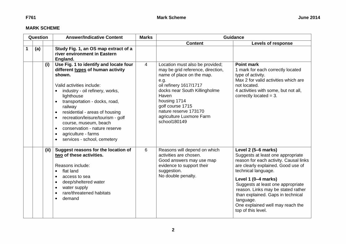
1 (a) Study Fig. 1, an OS map extract of a river environment in Eastern England.
(i) Use Fig. 1 to identify and locate four different types of human activity shown. Valid activities include:
industry - oil refinery, works, lighthouse
transportation - docks, road, railway
residential - areas of housing
recreation/leisure/tourism - golf course, museum, beach
conservation - nature reserve
agriculture - farms
services - school, cemetery
4 Location must also be provided; may be grid reference, direction, name of place on the map. e.g. oil refinery 1617/1717 docks near South Killingholme Haven housing 1714 golf course 1715 nature reserve 173170 agriculture Luxmore Farm school180149
Point mark 1 mark for each correctly located type of activity. Max 2 for valid activities which are not located. 4 activities with some, but not all, correctly located = 3.
(ii) Suggest reasons for the location of two of these activities. Reasons include:
flat land
access to sea
deep/sheltered water
water supply
rare/threatened habitats
demand
6 Reasons will depend on which activities are chosen. Good answers may use map evidence to support their suggestion. No double penalty.
Level 2 (5–6 marks) Suggests at least one appropriate reason for each activity. Causal links are clearly explained. Good use of technical language.
Level 1 (0–4 marks) Suggests at least one appropriate reason. Links may be stated rather than explained. Gaps in technical language. One explained well may reach the top of this level.

F761 Mark Scheme June 2014
3
Question Answer/Indicative Content Marks Guidance
Content Levels of response
(b) Show how slope processes influence the formation of fluvial landforms. Slope processes may include:
soil creep
landslides
slumping
rockfall
weathering
rainsplash Landforms may be directly affected, for example the steepness of valley sides, retreat of waterfalls. Supply of sediment to the channel is also relevant, linked to depositional landforms such as deltas, as well as sediment being an abrasive tool in erosional landforms such as the river channel.
6 No credit for simply naming process(es)
Level 2 (5–6 marks) Shows the influence of slope processes on at least two landforms. Cause-effect links are stated and clearly shown with specific process mechanisms applied. Good use of technical language. Level 1 (0–4 marks) Shows the influence of slope process(es) on at least one landform. Cause-effect links may be implied. Likely to refer to generic process(es). One shown well may reach the top of this level.

F761 Mark Scheme June 2014
4
Question Answer/Indicative Content Marks Guidance
Content Levels of response
(c) With reference to one or more located river basins, explain how they can be protected from the effects of flooding. Methods include:
channel modification – widening, deepening, straightening, diversions, concreting
catchment management – land use zoning, afforestation
education – early warning systems, evacuation drills
relief - aid, insurance
9 One method of protection explained well can achieve the top of L3.
Level 3 (8–9 marks) Uses clearly identified example(s) to explain how protection is achieved. Causal links between method and flooding are clearly explained. Answer is well structured with accurate grammar and spelling. Good use of appropriate geographical terminology. Level 2 (5–7 marks) Gives clearly identified example(s) to explain how protection is achieved. Cause-effect links are stated but explanation may not be clearly linked to effects. Answer has sound structure but may have some errors in grammar and spelling. Some use of appropriate geographical terminology. Level 1 (0–4 marks) Limited or no example. Mainly descriptive of method(s) used with cause-effect links limited or absent. Answer has little structure and has some errors in grammar and spelling. Little use of appropriate geographical terminology. If no located example then top of Level 1 Max.
F761 Mark Scheme June 2014
5
Question Answer/Indicative Content Marks Guidance
Content Levels of response
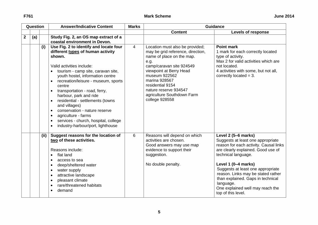
2 (a) Study Fig. 2, an OS map extract of a coastal environment in Devon.
(i) Use Fig. 2 to identify and locate four different types of human activity shown. Valid activities include:
tourism - camp site, caravan site, youth hostel, information centre
recreation/leisure - museum, sports centre
transportation - road, ferry, harbour, park and ride
residential - settlements (towns and villages)
conservation - nature reserve
agriculture - farms
services - church, hospital, college
industry-harbour/port, lighthouse
4 Location must also be provided; may be grid reference, direction, name of place on the map. e.g. camp/caravan site 924549 viewpoint at Berry Head museum 922562 marina 928567 residential 9154 nature reserve 934547 agriculture Southdown Farm college 928558
Point mark 1 mark for each correctly located type of activity. Max 2 for valid activities which are not located. 4 activities with some, but not all, correctly located = 3.
(ii) Suggest reasons for the location of two of these activities. Reasons include:
flat land
access to sea
deep/sheltered water
water supply
attractive landscape
pleasant climate
rare/threatened habitats
demand
6 Reasons will depend on which activities are chosen. Good answers may use map evidence to support their suggestion. No double penalty.
Level 2 (5–6 marks) Suggests at least one appropriate reason for each activity. Causal links are clearly explained. Good use of technical language. Level 1 (0–4 marks) Suggests at least one appropriate reason. Links may be stated rather than explained. Gaps in technical language. One explained well may reach the top of this level.

F761 Mark Scheme June 2014
6
Question Answer/Indicative Content Marks Guidance
Content Levels of response
(b) Show how weathering processes influence the formation of coastal landforms. Weathering may contribute to initial formation or landforms or modify them subsequently. May also provide sediment to the coastal system. Processes include freeze-thaw, salt crystallisation, biological, slaking, oxidation, carbonation/solution. Landforms include cliffs, shore platforms, arch, stack, stump, beach, spit, bar.
6 No credit for simply naming process(es)
Level 2 (5–6 marks) Shows the influence of weathering on at least two landforms. Cause-effect links are stated and clearly shown with specific process mechanisms applied. Good use of technical language. Level 1 (0–4 marks) Shows good understanding of the process(es) but without clear links to the landform(s) OR explains the formation of the landform(s) but without applying detail of the process(es.) One shown well may reach the top of this level.
F761 Mark Scheme June 2014
7
Question Answer/Indicative Content Marks Guidance
Content Levels of response
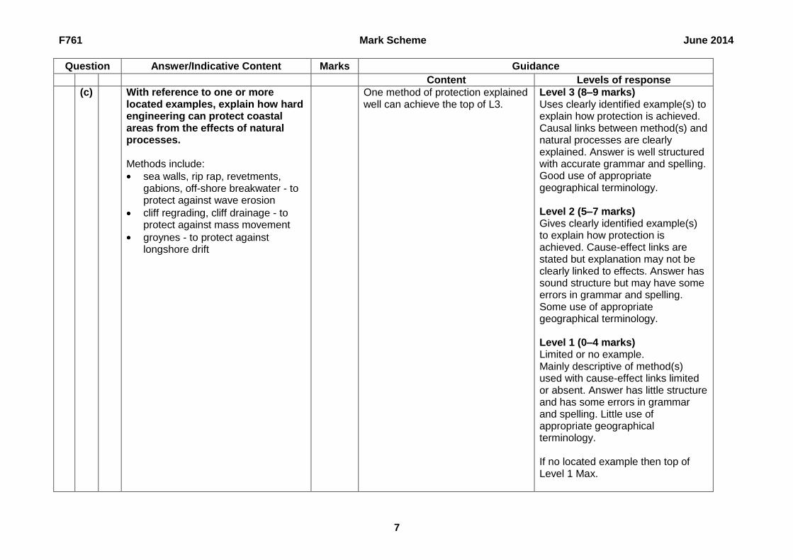
(c) With reference to one or more located examples, explain how hard engineering can protect coastal areas from the effects of natural processes. Methods include:
sea walls, rip rap, revetments, gabions, off-shore breakwater - to protect against wave erosion
cliff regrading, cliff drainage - to protect against mass movement
groynes - to protect against longshore drift
One method of protection explained well can achieve the top of L3.
Level 3 (8–9 marks) Uses clearly identified example(s) to explain how protection is achieved. Causal links between method(s) and natural processes are clearly explained. Answer is well structured with accurate grammar and spelling. Good use of appropriate geographical terminology. Level 2 (5–7 marks) Gives clearly identified example(s) to explain how protection is achieved. Cause-effect links are stated but explanation may not be clearly linked to effects. Answer has sound structure but may have some errors in grammar and spelling. Some use of appropriate geographical terminology. Level 1 (0–4 marks) Limited or no example. Mainly descriptive of method(s) used with cause-effect links limited or absent. Answer has little structure and has some errors in grammar and spelling. Little use of appropriate geographical terminology. If no located example then top of Level 1 Max.
F761 Mark Scheme June 2014
8
Question Answer/Indicative Content Marks Guidance
Content Levels of response
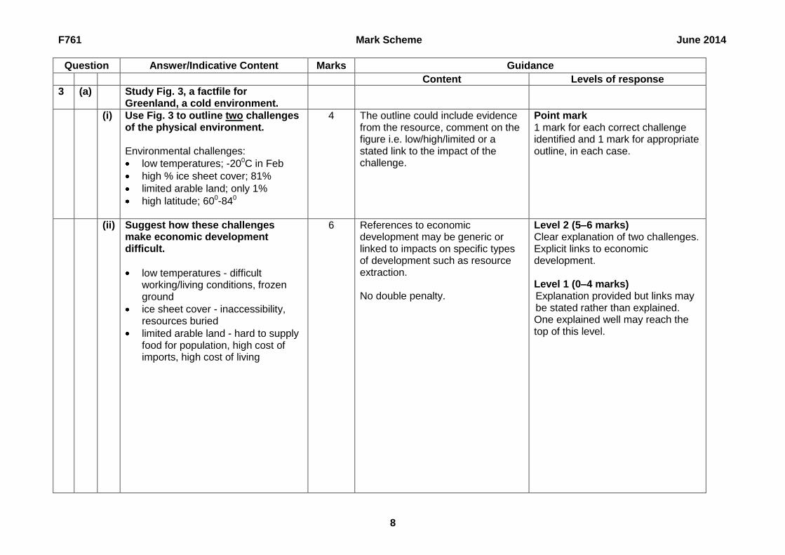
3 (a) Study Fig. 3, a factfile for Greenland, a cold environment.
(i) Use Fig. 3 to outline two challenges of the physical environment. Environmental challenges:
low temperatures; -200C in Feb
high % ice sheet cover; 81%
limited arable land; only 1%
high latitude; 600-840
4 The outline could include evidence from the resource, comment on the figure i.e. low/high/limited or a stated link to the impact of the challenge.
Point mark 1 mark for each correct challenge identified and 1 mark for appropriate outline, in each case.
(ii) Suggest how these challenges make economic development difficult.
low temperatures - difficult working/living conditions, frozen ground
ice sheet cover - inaccessibility, resources buried
limited arable land - hard to supply food for population, high cost of imports, high cost of living
6 References to economic development may be generic or linked to impacts on specific types of development such as resource extraction. No double penalty.
Level 2 (5–6 marks) Clear explanation of two challenges. Explicit links to economic development. Level 1 (0–4 marks) Explanation provided but links may be stated rather than explained. One explained well may reach the top of this level.
F761 Mark Scheme June 2014
9
Question Answer/Indicative Content Marks Guidance
Content Levels of response
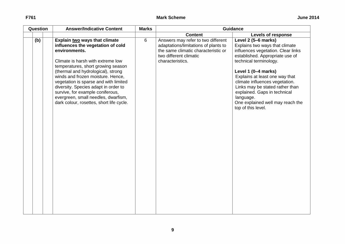
(b) Explain two ways that climate influences the vegetation of cold environments. Climate is harsh with extreme low temperatures, short growing season (thermal and hydrological), strong winds and frozen moisture. Hence, vegetation is sparse and with limited diversity. Species adapt in order to survive, for example coniferous, evergreen, small needles, dwarfism, dark colour, rosettes, short life cycle.
6 Answers may refer to two different adaptations/limitations of plants to the same climatic characteristic or two different climatic characteristics.
Level 2 (5–6 marks) Explains two ways that climate influences vegetation. Clear links established. Appropriate use of technical terminology. Level 1 (0–4 marks) Explains at least one way that climate influences vegetation. Links may be stated rather than explained. Gaps in technical language. One explained well may reach the top of this level.

F761 Mark Scheme June 2014
10
Question Answer/Indicative Content Marks Guidance
Content Levels of response
(c) With reference to one or more located examples, explain how meltwater can shape landforms in cold environments. Landforms include: Waterfalls, overspill channels, outwash plain, kames, eskers, kettles, braided channels i.e. erosion and deposition by meltwater. Role of meltwater in freeze-thaw, plucking, mass movement and nivation also relevant.
9 Answers using only one type of process may still reach the top of Level 3. Answers with only one landform, but which meet all the other Level 3 criteria, can be awarded 8.
Level 3 (8–9 marks) Uses clearly identified example(s) to explain the influence of meltwater on at least two landforms. Cause-effect links are stated and clearly explained. Answer is well structured with accurate grammar and spelling. Good use of appropriate geographical terminology. Level 2 (5–7 marks) Gives clearly identified example(s) to explain the influence of meltwater on at least one landform. Cause-effect links are stated but explanation may not be clear. Answer has sound structure but may have some errors in grammar and spelling. Some use of appropriate geographical terminology. Level 1 (0–4 marks) Limited or no example. Descriptive observations of landforms. Cause-effect links are limited or absent. Answer has little structure and has some errors in grammar and spelling. Little use of appropriate geographical terminology. If no located example then top of Level 1 Max.
F761 Mark Scheme June 2014
11
Question Answer/Indicative Content Marks Guidance
Content Levels of response
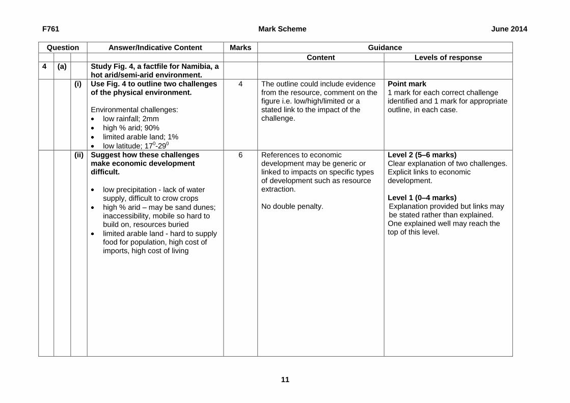
4 (a) Study Fig. 4, a factfile for Namibia, a hot arid/semi-arid environment.
(i) Use Fig. 4 to outline two challenges of the physical environment. Environmental challenges:
low rainfall; 2mm
high % arid; 90%
limited arable land; 1%
low latitude; 170-290
4 The outline could include evidence from the resource, comment on the figure i.e. low/high/limited or a stated link to the impact of the challenge.
Point mark 1 mark for each correct challenge identified and 1 mark for appropriate outline, in each case.
(ii) Suggest how these challenges make economic development difficult.
low precipitation - lack of water supply, difficult to crow crops
high % arid – may be sand dunes; inaccessibility, mobile so hard to build on, resources buried
limited arable land - hard to supply food for population, high cost of imports, high cost of living
6 References to economic development may be generic or linked to impacts on specific types of development such as resource extraction. No double penalty.
Level 2 (5–6 marks) Clear explanation of two challenges. Explicit links to economic development. Level 1 (0–4 marks) Explanation provided but links may be stated rather than explained. One explained well may reach the top of this level.

F761 Mark Scheme June 2014
12
Question Answer/Indicative Content Marks Guidance
Content Levels of response
(b) Explain two ways that climate influences the vegetation of hot arid/semi-arid environments. Climate is harsh with high temperatures, high evaporation rates and low/unreliable rainfall, strong abrasive winds/sand storms. Hence, vegetation is sparse and with limited diversity. Species adapt in order to survive, for example succulents, long tap roots, sunken/closed stomata, halophytes.
6 Answers may refer to two different adaptations/limitations of plants to the same climatic characteristic or two different climatic characteristics.
Level 2 (5–6 marks) Explains two ways that climate influences vegetation. Clear links established. Appropriate use of technical terminology. Level 1 (0–4 marks) Explains at least one way that climate influences vegetation. Links may be stated rather than explained. Gaps in technical language. One explained well may reach the top of this level.

F761 Mark Scheme June 2014
13
Question Answer/Indicative Content Marks Guidance
Content Levels of response
(c) With reference to one or more located examples, explain how wind can shape landforms in hot arid/semi-arid environments. Landforms include: Sand dunes of various types, ventifacts, desert pavements, deflation hollows, yardangs, zeugens, and pedestal rocks i.e. deposition and erosion by wind. Wind can also contribute to shaping of other landforms such as in canyon landscapes, arches.
9 Answers using only one type of process may still reach the top of the Level. Answers with only one landform, but which meet all the other Level 3 criteria, can be awarded 8.
Level 3 (8–9 marks) Uses clearly identified example(s) to explain the influence of wind on at least two landforms. Cause-effect links are stated and clearly explained. Answer is well structured with accurate grammar and spelling. Good use of appropriate geographical terminology. Level 2 (5–7 marks) Gives clearly identified example(s) to explain the influence of wind on at least one landform. Cause-effect links are stated but explanation may not be clear. Answer has sound structure but may have some errors in grammar and spelling. Some use of appropriate geographical terminology. Level 1 (0–4 marks) Limited or no example. Descriptive observations of landforms. Cause-effect links are limited or absent. Answer has little structure and has some errors in grammar and spelling. Little use of appropriate geographical terminology. If no located example then top of Level 1 Max.

F761 Mark Scheme June 2014
14
Question Answer/Indicative Content Marks Guidance
Content Levels of response
5 With reference to one or more located river basins, examine the varied impacts of flooding. Impacts include:
social - disruption to life, evacuation, homelessness, disease, political unrest, death, injury
economic - damage to buildings, loss of trade for businesses, disruption to transport, insurance costs, cost of defences/long term management
environmental - channel modification, soil erosion, loss of habitats
Scale of impacts will also vary. Impacts may also be positive, for example deposition of nutrients on floodplains. Impacts may also be primary or secondary. Impacts are often different between LEDCs and MEDCs.
25 Variety may come from within categories as well as between. Explicit about the role of excess water. The role of water is implied.
AO1 Knowledge and understanding Level 3 (11–13 marks) Detailed knowledge and understanding of the varied impacts of flooding. Cause-effect links are clearly explained. There is effective use of detailed exemplification with impacts being explicitly linked to flooding. Level 2 (7–10 marks) Some knowledge and understanding of the impacts of flooding. Cause-effect links are stated but not clearly explained. There is use of exemplification with some linkages made between impacts and flooding. Level 1 (0–6 marks) Limited knowledge and understanding of impacts of flooding. Cause-effect links are limited or absent. There is limited exemplification of impact-flooding linkages. If no located example then top of Level 1 Max.

F761 Mark Scheme June 2014
15
Question Answer/Indicative Content Marks Guidance
Content Levels of response
Several explicit comments made about variation, including in the body of the answer. Some references to variations, possibly just in the introduction and/or conclusion. Limited or no explicit comments, although variation may be implied by the content.
AO2 Analysis and application Level 3 (5 marks) Clear analysis and application of knowledge and understanding of the varied impacts of flooding. Level 2 (3–4 marks) Some analysis and application of knowledge and understanding of the varied impacts of flooding. Level 1 (0–2 marks) Limited analysis and application of knowledge and understanding of the varied impacts of flooding.

F761 Mark Scheme June 2014
16
Question Answer/Indicative Content Marks Guidance
Content Levels of response
AO3 Skills and communication Level 3 (6–7 marks) Answer is well structured with accurate grammar and spelling. Good use of appropriate geographical terminology. Clear conclusion(s) are drawn. Level 2 (4–5 marks) Answer has sound structure but may have some errors in grammar and spelling. Some use of appropriate geographical terminology. Conclusion(s) are attempted. Level 1 (0–3 marks) Answer has little structure and has some errors in grammar and spelling. Little use of appropriate geographical terminology. No conclusion(s) are attempted.

F761 Mark Scheme June 2014
17
Question Answer/Indicative Content Marks Guidance
Content Levels of response
6 With reference to one or more located coastlines, examine the varied need for protection from natural processes. The need for protection includes:
economic - high value of land and property, density of human activities, important transport links
social - threat to life, feelings of vulnerability, long occupation
environmental - high wave energy, vulnerable geology, rare habitats/species
Processes include:
erosion
deposition
longshore drift
mass movement
weathering
25 Variety may come from within categories as well as between.
AO1 Knowledge and understanding Level 3 (11–13 marks) Detailed knowledge and understanding of the varied need for protection. Cause-effect links are clearly explained. There is effective use of detailed exemplification with need being explicitly linked to reasons. Level 2 (7–10 marks) Some knowledge and understanding of the need for protection. Cause-effect links are stated but not clearly explained. There is use of exemplification with some linkages made between need and reasons. Level 1 (0–6 marks) Limited knowledge and understanding of the need for protection. Cause-effect links are limited or absent. There is limited exemplification of need-reason linkages. If no located example then top of Level 1 Max.

F761 Mark Scheme June 2014
18
Question Answer/Indicative Content Marks Guidance
Content Levels of response
Several explicit comments made about variation, including in the body of the answer. Some references to variations, possibly just in the introduction and/or conclusion. Limited or no explicit comments, although variation may be implied by the content.
AO2 Analysis and application Level 3 (5 marks) Clear analysis and application of knowledge and understanding of the varied need for protection. Level 2 (3–4 marks) Some analysis and application of knowledge and understanding of the varied need for protection. Level 1 (0–2 marks) Limited analysis and application of knowledge and understanding of the varied need for protection.

F761 Mark Scheme June 2014
19
Question Answer/Indicative Content Marks Guidance
Content Levels of response
AO3 Skills and communication Level 3 (6–7 marks) Answer is well structured with accurate grammar and spelling. Good use of appropriate geographical terminology. Clear conclusion(s) are drawn. Level 2 (4–5 marks) Answer has sound structure but may have some errors in grammar and spelling. Some use of appropriate geographical terminology. Conclusion(s) are attempted. Level 1 (0–3 marks) Answer has little structure and has some errors in grammar and spelling. Little use of appropriate geographical terminology. No conclusion(s) are attempted.

F761 Mark Scheme June 2014
20
Question Answer/Indicative Content Marks Guidance
Content Levels of response
7 With reference to one or more located examples, describe and explain the exploitation of cold environments for short-term gain. Short-term gain typically involves economic needs being focused upon at the expense of social and environmental needs i.e. it is unsustainable. The finite nature of some resources may also make their extraction short-term. Exploitation may include raw material extraction, over-development of tourism, construction. This is likely to cause environmental damage, perhaps by pollution, and have negative social impacts, such as conflicts with the indigenous population.
25
AO1 Knowledge and understanding Level 3 (11–13 marks) Detailed knowledge and understanding of exploitation. Cause-effect links are clearly explained. There is effective use of detailed exemplification with human uses being explicitly linked to negative impacts. Level 2 (7–10 marks) Some knowledge and understanding of exploitation. Cause-effect links are stated but not clearly explained. There is use of exemplification with human uses being explicitly linked to negative impacts. Level 1 (0–6 marks) Limited knowledge and understanding of exploitation. Cause-effect links are limited or absent. There is limited exemplification of human uses being explicitly linked to negative impacts. If no located example then top of Level 1 Max.

F761 Mark Scheme June 2014
21
Question Answer/Indicative Content Marks Guidance
Content Levels of response
Several explicit comments made about the short-term/unsustainable nature of the gain, including in the body of the answer. Some references to the short-term/unsustainable nature of the gain, possibly just in the introduction and/or conclusion. Limited or no explicit comments, although the short-term/unsustainable nature of the gain may be implied by the content.
AO2 Analysis and application Level 3 (5 marks) Clear analysis and application of knowledge and understanding of the short-term nature of the gain. Level 2 (3–4 marks) Some analysis and application of knowledge and understanding of the short-term nature of the gain. Level 1 (0–2 marks) Limited analysis and application of knowledge and understanding of the short-term nature of the gain.

F761 Mark Scheme June 2014
22
Question Answer/Indicative Content Marks Guidance
Content Levels of response
AO3 Skills and communication Level 3 (6–7 marks) Answer is well structured with accurate grammar and spelling. Good use of appropriate geographical terminology. Clear conclusion(s) are drawn. Level 2 (4–5 marks) Answer has sound structure but may have some errors in grammar and spelling. Some use of appropriate geographical terminology. Conclusion(s) are attempted. Level 1 (0–3 marks) Answer has little structure and has some errors in grammar and spelling. Little use of appropriate geographical terminology. No conclusion(s) are attempted.
F761 Mark Scheme June 2014
23
Question Answer/Indicative Content Marks Guidance
Content Levels of response
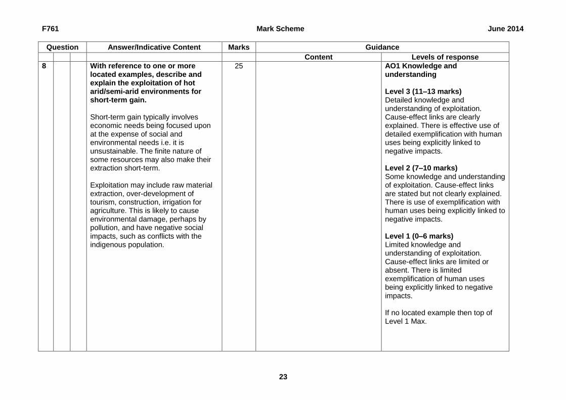
8 With reference to one or more located examples, describe and explain the exploitation of hot arid/semi-arid environments for short-term gain. Short-term gain typically involves economic needs being focused upon at the expense of social and environmental needs i.e. it is unsustainable. The finite nature of some resources may also make their extraction short-term. Exploitation may include raw material extraction, over-development of tourism, construction, irrigation for agriculture. This is likely to cause environmental damage, perhaps by pollution, and have negative social impacts, such as conflicts with the indigenous population.
25
AO1 Knowledge and understanding Level 3 (11–13 marks) Detailed knowledge and understanding of exploitation. Cause-effect links are clearly explained. There is effective use of detailed exemplification with human uses being explicitly linked to negative impacts. Level 2 (7–10 marks) Some knowledge and understanding of exploitation. Cause-effect links are stated but not clearly explained. There is use of exemplification with human uses being explicitly linked to negative impacts. Level 1 (0–6 marks) Limited knowledge and understanding of exploitation. Cause-effect links are limited or absent. There is limited exemplification of human uses being explicitly linked to negative impacts. If no located example then top of Level 1 Max.

F761 Mark Scheme June 2014
24
Question Answer/Indicative Content Marks Guidance
Content Levels of response
Several explicit comments made about the short-term/unsustainable nature of the gain, including in the body of the answer. Some references to the short-term/unsustainable nature of the gain, possibly just in the introduction and/or conclusion. Limited or no explicit comments, although the short-term/unsustainable nature of the gain may be implied by the content.
AO2 Analysis and application Level 3 (5 marks) Clear analysis and application of knowledge and understanding of the short-term nature of the gain. Level 2 (3–4 marks) Some analysis and application of knowledge and understanding of the short-term nature of the gain. Level 1 (0–2 marks) Limited analysis and application of knowledge and understanding of the short-term nature of the gain.

F761 Mark Scheme June 2014
25
Question Answer/Indicative Content Marks Guidance
Content Levels of response
AO3 Skills and communication Level 3 (6–7 marks) Answer is well structured with accurate grammar and spelling. Good use of appropriate geographical terminology. Clear conclusion(s) are drawn. Level 2 (4–5 marks) Answer has sound structure but may have some errors in grammar and spelling. Some use of appropriate geographical terminology. Conclusion(s) are attempted. Level 1 (0–3 marks) Answer has little structure and has some errors in grammar and spelling. Little use of appropriate geographical terminology. No conclusion(s) are attempted.

Oxford Cambridge and RSA Examinations is a Company Limited by Guarantee Registered in England Registered Office; 1 Hills Road, Cambridge, CB1 2EU Registered Company Number: 3484466 OCR is an exempt Charity OCR (Oxford Cambridge and RSA Examinations) Head office Telephone: 01223 552552 Facsimile: 01223 552553 © OCR 2014
OCR (Oxford Cambridge and RSA Examinations)
1 Hills Road
Cambridge
CB1 2EU OCR Customer Contact Centre
Education and Learning
Telephone: 01223 553998
Facsimile: 01223 552627
Email: [email protected] www.ocr.org.uk For staff training purposes and as part of our quality assurance programme your call may be recorded or monitored