marine notice port of dampier - pilbara · marine notice port of dampier all current local marine...
TRANSCRIPT
MARINE NOTICE PORT OF DAMPIER
All current local Marine Notices are available on our website: http://www.pilbaraports.com.au/#marine-notices
Dampier Vessel Traffic Service | Phone: (08) 9159 6556 | FAX: (08) 9159 6557 | [email protected] Mariners and other port users are requested to notify the Harbour Master on the discovery of new dangers or suspected dangers to navigation within the Port.
Number: D9/2016 Date: 1/04/2016
This Marine Notice advises recommended routes for navigation within Dampier.
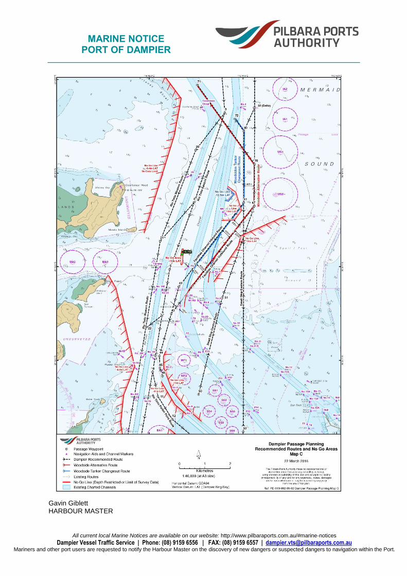
This Marine Notice contains three maps: Map A describes the recommended routes. Map B describes the No Go limits associated with each recommended route. Map C describes the routes used by Woodside vessels in relation to the Facilities Channel inbound and outbound routes. The recommended routes are: Rio Tinto Eastern Route, Rio Tinto Parker Point Route, Rio Tinto Western Route, All inbound Rio Tinto vessels navigate via the Eastern route initially, and then cross to the Western route or the Parker Point route. Route to Pilot Station D, Facilities Channel Inbound Route, Facilities Channel Outbound Route, Mermaid Strait Route, Small Ship Central Route, Small Ship Eastern Route, Woodside Alternative Route, Woodside Tanker Change out Route,
Date of Effect: 1/04/2016
Details: Recommended Routes in Dampier
Former Notice: Nil
Charts & Publications: AUS 57, AUS58, AUS 59, AUS 60 and AUS 741
Further Notice: Nil
Attachments: Nil

MARINE NOTICE PORT OF DAMPIER
All current local Marine Notices are available on our website: http://www.pilbaraports.com.au/#marine-notices
Dampier Vessel Traffic Service | Phone: (08) 9159 6556 | FAX: (08) 9159 6557 | [email protected] Mariners and other port users are requested to notify the Harbour Master on the discovery of new dangers or suspected dangers to navigation within the Port.
These Woodside routes correspond with the Facilities Channel inbound and outbound routes.
Rio Tinto Eastern Route
WAYPOINT LAT LONG COURSE
1 20° 23.700' S 116° 42.000' E 143°-323°
2 20° 25.400' S 116° 43.350' E 175°-355°
3 20° 28.708' S 116° 43.614' E 020°-200°
4 20° 30.624' S 116° 42.961' E 020°-200°
5 20° 32.000' S 116° 42.500' E 010°-190°
6 20° 33.019' S 116° 42.302' E 010°-190°
7 20° 33.895' S 116° 42.132' E 010°-190°
8 20° 34.248' S 116° 42.073' E
9 20° 36.860' S 116° 41.610' E 025°-205°
10 20° 37.250' S 116° 41.430' E 043°-223°
No Go Area, 9.4m, east of Mid-ground
LAT LONG
20° 37.190' S 116° 41.569' E
20° 36.406' S 116° 41.932' E
20° 36.652' S 116° 41.829' E
20° 37.107' S 116° 41.600' E
Rio Tinto Parker Point Route
WAYPOINT LAT LONG COURSE
11 20° 34.772' S 116° 42.186' E 148°-328°
12 20° 35.257' S 116° 42.491' E 130°-310°
13 20° 35.973' S 116° 43.331' E 143°-323°
14 20° 36.340' S 116° 43.611' E 171°-351°
15 20° 37.026' S 116° 43.720' E 000°-180°
16 20° 37.700' S 116° 43.719' E 053°-233°
17 20° 38.058' S 116° 43.241' E
No Go Area, 8.0m, defining Parker point approach channel
LAT LONG
LAT LONG
20° 37.987' S 116° 42.610' E 20° 38.148' S 116° 43.541' E
20° 37.989' S 116° 43.093' E 20° 37.877' S 116° 43.742' E
20° 37.716' S 116° 43.536' E 20° 37.653' S 116° 43.807' E
20° 37.393' S 116° 43.624' E
20° 36.127' S 116° 43.817' E
20° 37.266' S 116° 43.619' E
20° 36.142' S 116° 43.186' E
20° 35.478' S 116° 42.446' E

MARINE NOTICE PORT OF DAMPIER
All current local Marine Notices are available on our website: http://www.pilbaraports.com.au/#marine-notices
Dampier Vessel Traffic Service | Phone: (08) 9159 6556 | FAX: (08) 9159 6557 | [email protected] Mariners and other port users are requested to notify the Harbour Master on the discovery of new dangers or suspected dangers to navigation within the Port.
Rio Tinto Western Route
WAYPOINT LAT LONG COURSE
20 20° 29.507' S 116° 42.994' E 021°-201°
21 20° 31.452' S 116° 42.235' E 010°-190°
22 20° 33.313' S 116° 41.924' E 010°-190°
23 20° 36.830' S 116° 41.336' E 017°-197°
24 20° 37.600' S 116° 41.100' E 70°-250°
25 20° 38.000' S 116° 40.000' E
26 20° 38.444' S 116° 39.545' E 171°-351°
27 20° 38.491' S 116° 39.830' E 129°-309°
28 20° 39.100' S 116° 39.650' E
29 20° 38.950' S 116° 40.400' E
No Go Area, 9.4m, west of route
LAT LONG LAT LONG
20° 37.700' S 116° 40.450' E 20° 31.277' S 116° 41.893' E
20° 37.450' S 116° 41.000' E 20° 29.214' S 116° 42.528' E
20° 35.994' S 116° 41.402' E 20° 28.406' S 116° 42.681' E
20° 35.630' S 116° 41.436' E 20° 27.412' S 116° 41.945' E
20° 35.350' S 116° 41.390' E 20° 27.243' S 116° 41.962' E
20° 34.740' S 116° 41.454' E 20° 25.407' S 116° 41.946' E
20° 34.129' S 116° 41.691' E
20° 32.461' S 116° 41.291' E
20° 32.193' S 116° 41.135' E
Route to Pilot Station D
WAYPOINT LAT LONG COURSE
30 20° 19.240' S 116° 41.334' E 133°-313°
31 20° 22.000' S 116° 44.250' E 000°-180°
32 (Delta) 20° 28.603' S 116° 44.250' E
No Go Area, 11.0m, east of Route
LAT LONG
20° 27.711' S 116° 45.215' E
20° 27.305' S 116° 45.108' E
20° 27.359' S 116° 44.497' E
20° 27.282' S 116° 44.497' E
20° 26.993' S 116° 45.426' E

MARINE NOTICE PORT OF DAMPIER
All current local Marine Notices are available on our website: http://www.pilbaraports.com.au/#marine-notices
Dampier Vessel Traffic Service | Phone: (08) 9159 6556 | FAX: (08) 9159 6557 | [email protected] Mariners and other port users are requested to notify the Harbour Master on the discovery of new dangers or suspected dangers to navigation within the Port.
Facilities Channel Inbound Route
WAYPOINT LAT LONG COURSE
32 (Delta) 20° 28.603' S 116° 44.250' E 025°-205°
40 20° 29.105' S 116° 44.019' E 000°-180°
41 20° 30.633' S 116° 44.017' E 038°- 218°
42 20° 32.424' S 116° 42.634' E 016°-196°
43 20° 33.002' S 116° 42.471' E 016°-196°
44 20° 33.907' S 116° 42.218' E 177°-357°
45 20° 34.170' S 116° 42.229' E 162°-342°
46 20° 34.335' S 116° 42.283' E
No Go Area, 11.0m, at the entrance to Facilities Channel
LAT LONG LAT LONG
20° 35.152' S 116° 42.793' E 20° 35.298' S 116° 43.109' E
20° 34.945' S 116° 42.548' E 20° 35.033' S 116° 42.807' E
20° 34.592' S 116° 42.339' E 20° 34.621' S 116° 42.484' E
20° 34.171' S 116° 42.314' E
20° 33.921' S 116° 42.302' E
20° 33.803' S 116° 42.356' E
No Go Area, 11.0m, between channels, east of Fairway
LAT LONG
20° 31.957' S 116° 42.698' E
20° 31.902' S 116° 42.715' E
20° 31.623' S 116° 42.728' E
20° 31.957' S 116° 42.679' E
20° 31.795' S 116° 42.667' E
20° 31.621' S 116° 42.706' E
Facilities Channel Outbound Route
WAYPOINT LAT LONG COURSE
43 20° 33.002' S 116° 42.471' E 038°- 218°
47 20° 30.703' S 116° 44.247' E 000°-180°
MARINE NOTICE PORT OF DAMPIER
All current local Marine Notices are available on our website: http://www.pilbaraports.com.au/#marine-notices
Dampier Vessel Traffic Service | Phone: (08) 9159 6556 | FAX: (08) 9159 6557 | [email protected] Mariners and other port users are requested to notify the Harbour Master on the discovery of new dangers or suspected dangers to navigation within the Port.
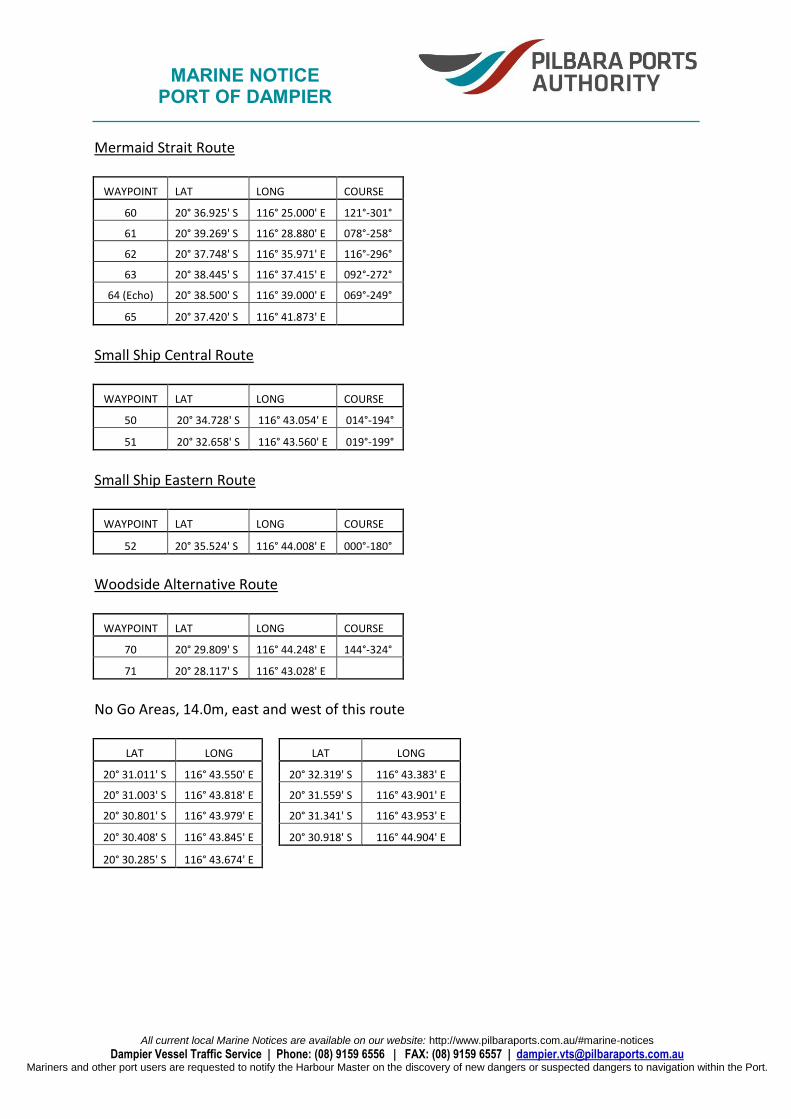
Mermaid Strait Route
WAYPOINT LAT LONG COURSE
60 20° 36.925' S 116° 25.000' E 121°-301°
61 20° 39.269' S 116° 28.880' E 078°-258°
62 20° 37.748' S 116° 35.971' E 116°-296°
63 20° 38.445' S 116° 37.415' E 092°-272°
64 (Echo) 20° 38.500' S 116° 39.000' E 069°-249°
65 20° 37.420' S 116° 41.873' E
Small Ship Central Route
WAYPOINT LAT LONG COURSE
50 20° 34.728' S 116° 43.054' E 014°-194°
51 20° 32.658' S 116° 43.560' E 019°-199°
Small Ship Eastern Route
WAYPOINT LAT LONG COURSE
52 20° 35.524' S 116° 44.008' E 000°-180°
Woodside Alternative Route
WAYPOINT LAT LONG COURSE
70 20° 29.809' S 116° 44.248' E 144°-324°
71 20° 28.117' S 116° 43.028' E
No Go Areas, 14.0m, east and west of this route
LAT LONG LAT LONG
20° 31.011' S 116° 43.550' E 20° 32.319' S 116° 43.383' E
20° 31.003' S 116° 43.818' E 20° 31.559' S 116° 43.901' E
20° 30.801' S 116° 43.979' E 20° 31.341' S 116° 43.953' E
20° 30.408' S 116° 43.845' E 20° 30.918' S 116° 44.904' E
20° 30.285' S 116° 43.674' E
MARINE NOTICE PORT OF DAMPIER
All current local Marine Notices are available on our website: http://www.pilbaraports.com.au/#marine-notices
Dampier Vessel Traffic Service | Phone: (08) 9159 6556 | FAX: (08) 9159 6557 | [email protected] Mariners and other port users are requested to notify the Harbour Master on the discovery of new dangers or suspected dangers to navigation within the Port.
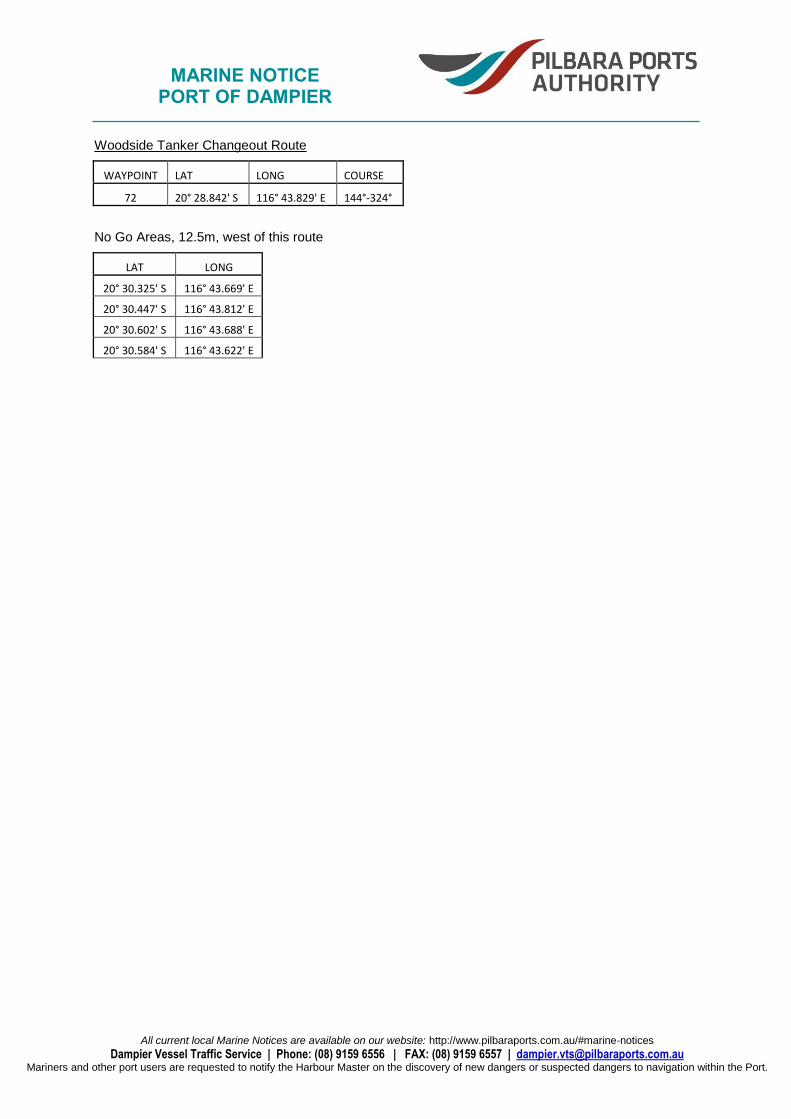
Woodside Tanker Changeout Route
WAYPOINT LAT LONG COURSE
72 20° 28.842' S 116° 43.829' E 144°-324°
No Go Areas, 12.5m, west of this route
LAT LONG
20° 30.325' S 116° 43.669' E
20° 30.447' S 116° 43.812' E
20° 30.602' S 116° 43.688' E
20° 30.584' S 116° 43.622' E

MARINE NOTICE PORT OF DAMPIER
All current local Marine Notices are available on our website: http://www.pilbaraports.com.au/#marine-notices
Dampier Vessel Traffic Service | Phone: (08) 9159 6556 | FAX: (08) 9159 6557 | [email protected] Mariners and other port users are requested to notify the Harbour Master on the discovery of new dangers or suspected dangers to navigation within the Port.
Gavin Giblett HARBOUR MASTER