march 12, 2014 planning commission agenda
TRANSCRIPT
City of San Antonio Cliff Morton Development and Business Services Center
1901 South Alamo Street San Antonio, Texas 78204
PLANNING COMMISSION AGENDA March 12, 2014
2:00 P.M. Roberto R. Rodriguez, Chair
Marcello Diego Martinez, Vice Chair Andrea Rodriguez, Chair Pro Tem
Jody R. Sherrill Kevin Love George Peck Zachary Harris Michael Garcia Jr. Angela Rinehart
Citizens may appear before the Planning Commission to speak for or against any item on this agenda, in accordance with procedural rules governing Planning Commission meetings. Questions relating to these rules may
be directed to the Development Services Department at (210) 207-1111. Please note that citizen comments are limited up to three (3) minutes per person and may change as needed. Please plan to attend the meeting fifteen (15)
minutes prior to the scheduled time.
For additional information on any item on this agenda, please call (210) 207-1111.
1. 1:30 P.M. - Work Session, Tobin RoomA. Agenda items may be discussed (Development Services Department)
At any time during the meeting, the Planning Commission may meet in executive session for consultation concerning attorney-client matters under Chapter 551 of the Texas Government Code
2. 2:00 P.M. - Call to Order, Board Room
3. Roll Call
4. Citizens to be heard
DISABILITY ACCESS STATEMENT - This meeting site is accessible to persons with disabilities. Parking is available. Auxiliary aids and services, including Deaf interpreters, must be requested forty-eight (48) hours prior to the meeting. For
assistance, please call (210) 207-1111 or 711 (Texas Relay Service for the Deaf).
DECLARACIÓN DE ACCESIBILIDAD - El lugar de reunión cuenta con el acceso disponible y estacionamiento para personas discapacitadas. También incluye servicios especiales e interpretes para personas con problemas auditivos. Este servicio debe ser solicitado cuarenta y ocho (48) horas antes del día programado para la reunión. Para más información
favor comunicarse al (210) 207-1111 o al 711 (Servicio para personas con problemas auditivos Texas Relay)

City of San Antonio Planning Commission Agenda March 12, 2014 THE FOLLOWING ITEMS MAY BE CONSIDERED AT ANY TIME DURING THE REGULAR PLANNING COMMISSION MEETING: Public Hearing and Consideration of the following Plats, Variances, Planned Unit Development (PUD) plans, Street Rename, Appeals, Land Transactions, Adoption and Amendments of the Neighborhood, Community and Sector Plans as Components of the Master Plan, and other items as identified below. Plats
5. 130160: Request by Valencia Enclave, LLC, for approval of a major plat to subdivide a 13.293-acre tract of land to establish the Valencia Hills Enclave Phase III Subdivision, generally located south of Gold Canyon Road and east of Bulverde Road. Staff recommends Approval. (Larry Odis, Planner, (210) 207-0210, [email protected], Development Services Department).
6. 130314: Request by S.R. Holdings, L.P., for approval of a major plat to subdivide a 12.980-acre tract of land to establish the Bella Vista Unit 3 Section 4 PH-1 Subdivision, generally located near the intersection of Volante and Benedetta. Staff recommends Approval. (Luz M. Gonzales, Planner, (210) 207-7898, [email protected], Development Services Department).
7. 130576: Request by M2G Stone Oak, Ltd., for approval of a major plat to replat and subdivide a 6.171-acre tract of land to establish the HW-4.7 Subdivision, generally located southeast of the intersection of Wilderness Oak and Hardy Oak Boulevard. Staff recommends Approval. (Larry Odis, Planner, (210) 207-0210, [email protected], Development Services Department).
8. 140081: Request by Laredo S. Ltd., for approval of a major plat to subdivide a 9.38-acre tract of land to establish the Westwinds Commercial, Unit-3B Subdivision, generally located on the northwest corner of Wild Pine and Westwood Loop. Staff recommends Approval. (Richard Carrizales, Planner, (210) 207-8050, [email protected], Development Services Department).
9. 140082: Request by Laredo S. Ltd., for approval of a major plat to subdivide a 7.76-acre tract of land to establish the Westwinds Commercial, Unit-5 Subdivision, generally located at the intersection of Culebra Road (FM 471) and Lone Star Parkway. Staff recommends Approval. (Chris McCollin, Planner, (210) 207-5014, [email protected], Development Services Department).
10. 140115: Request by Raul and Evelyn Lopez, for approval of a minor plat to replat a 1.07-acre tract of
land to establish the La Poderoza Subdivision, generally located east of the intersection of Durham and Anacacho Road. Staff recommends Approval. (Ian Benavidez, Planner, (210) 207-8268, [email protected], Development Services Department).
11. 140123: *Request by Continental Homes of Texas, L.P., for approval of a minor plat to replat and subdivide a 1.911-acre tract of land to establish the Fallbrook Unit 1A Enclave Subdivision, generally located near the intersection of Millstone Cove and Oleander Chase. Staff recommends Approval. (Richard Carrizales, Planner, (210) 207-8050, [email protected], Development Services Department).
12. 140129: Request by Lennar Homes of Texas Land and Construction, L.T.D., for approval of a major plat to replat a 0.696-acre tract of land to establish the Alamo Ranch Unit 41D Phase 1 PUD Subdivision, generally located near the intersection of Desert Palm and Suncatcher. Staff recommends Approval. (Luz M. Gonzales, Planner, (210) 207-7898, [email protected], Development Services Department).
*Military Notification 2
City of San Antonio Planning Commission Agenda March 12, 2014
Time Extension 13. 090277: Request by McMillin Homes, for a three (3) year time extension in accordance with Section
35-430(f)(2) of the City of San Antonio’s Unified Development Code (UDC), for the North Pointe Subdivision, Unit 2B Planned Unit Development, generally located west of the intersection of Oak Cliff Bend and Winter George. Staff recommends Approval. (Luz M. Gonzales, Planner, (210) 207-7898, [email protected], Development Services Department).
Certificate of Determination Appeal 14. 14-IV-001: Request by Samuel Asvestas to appeal the Development Services Department Director’s
decision to deny the Certificate of Determination for a Plat Exception in accordance with Section 35-430(c) of the of San Antonio Unified Development Code (UDC), Article IV, Procedures; Division 4, and, Texas Statues, Local Government Code, Section 212.0115, Certification Regarding Compliance with Plat Requirements, for the property located at 355 E. Kings Highway. Staff recommends Approval. (Richard Carrizales, Planner (210) 207-8050, [email protected], Development Services Department).
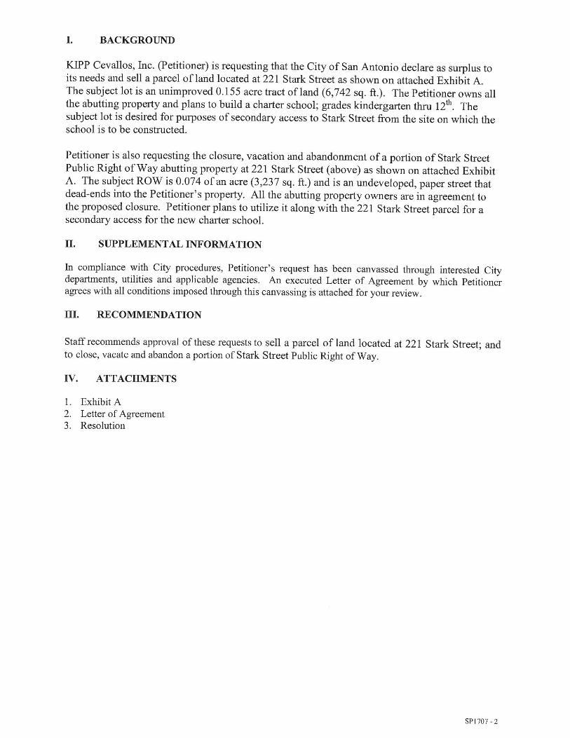
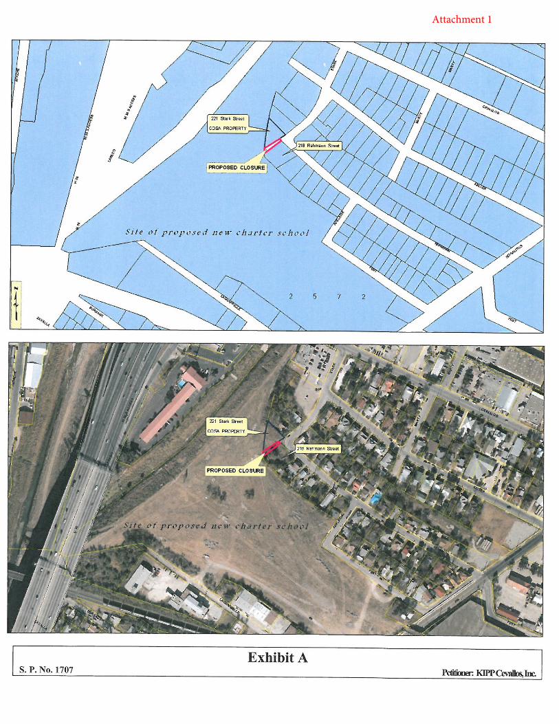
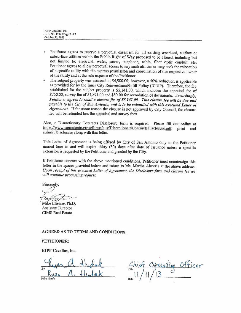
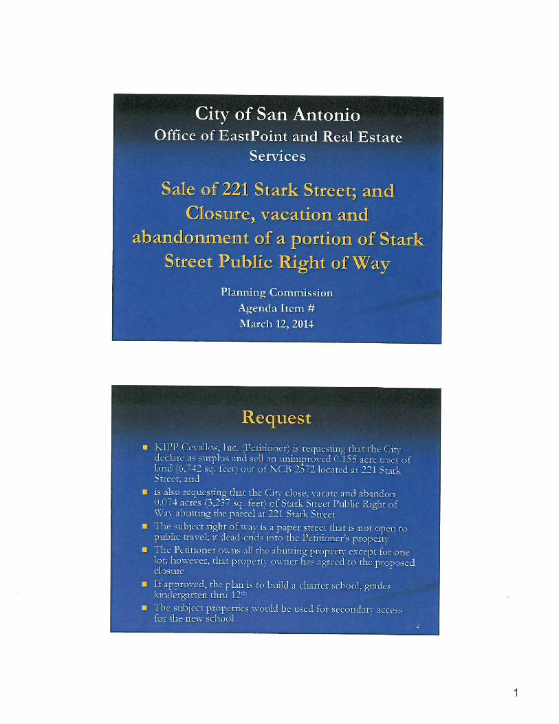
Land Transactions 15. S.P. 1707: Consideration of a Resolution supporting and recommending City Council approval of the
declaration as surplus and sale of an unimproved 0.155 acre tract of City-owned property located at 221 Stark Street; and the closure, vacation and abandonment of 0.074 acres of Stark Street Public Right of Way located adjacent to NCB 2572, as requested by KIPP Cevallos, Inc. (Martha Almeria, (210) 207-6970, [email protected], Office of EastPoint and Real Estate Services).
Comprehensive Master Plan Amendments
16. PA 14027: A request by Intrepid Equity Investments LLC, for approval of a resolution to amend the future land use plan contained in the Lone Star Community Plan, a component of the Comprehensive Master Plan of the City, by changing the future land use of approximately 0.54 of an acre of land out of Lot 1, NCB 15 and Lot 6, NCB 16, located at 302 Clay Street, from “Medium Density Residential” to “Low Density Mixed Use”. Staff recommends Approval. (Robert C. Acosta, Planner, (210) 207-0157, [email protected], Development Services Department).
17. PA 14028: A request by Langley & Banack, Inc., for approval of a resolution to amend the future
land use plan contained in the Northeast Inner Loop Neighborhood Plan, a component of the Comprehensive Master Plan of the City, by changing the future land use of approximately 1.3124 acres of land out of Lot 5, NCB 11898, located at 1779 Nacogdoches Road, from “Neighborhood Commercial” to “High Density Residential”. Staff recommends Approval. (Robert C. Acosta, Planner, (210) 207-0157, [email protected], Development Services Department).
18. PA 14029: A request by Kaufman & Killen, Inc for approval of a resolution to amend the future
land use plan contained in the San Antonio International Airport Vicinity Land Use Plan, a component of the Comprehensive Master Plan of the City, by changing the future land use of approximately 14.597 acres of land out of Parcel 12 and Parcel 15B, NCB 15009, located on the east side of Bitters Road between Loop 1604 and Ashton Village Drive, from “Public Institutional” to “Community Commercial”, in City Council District 9. Staff recommends Approval. (Robert C. Acosta, Planner, (210) 207-0157, [email protected], Development Services Department).
*Military Notification 3

City of San Antonio Planning Commission Agenda March 12, 2014 19. Public hearing and consideration of a resolution recommending approval of a Municipal Boundary
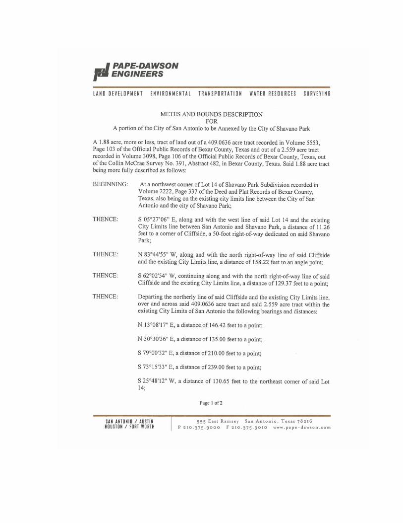
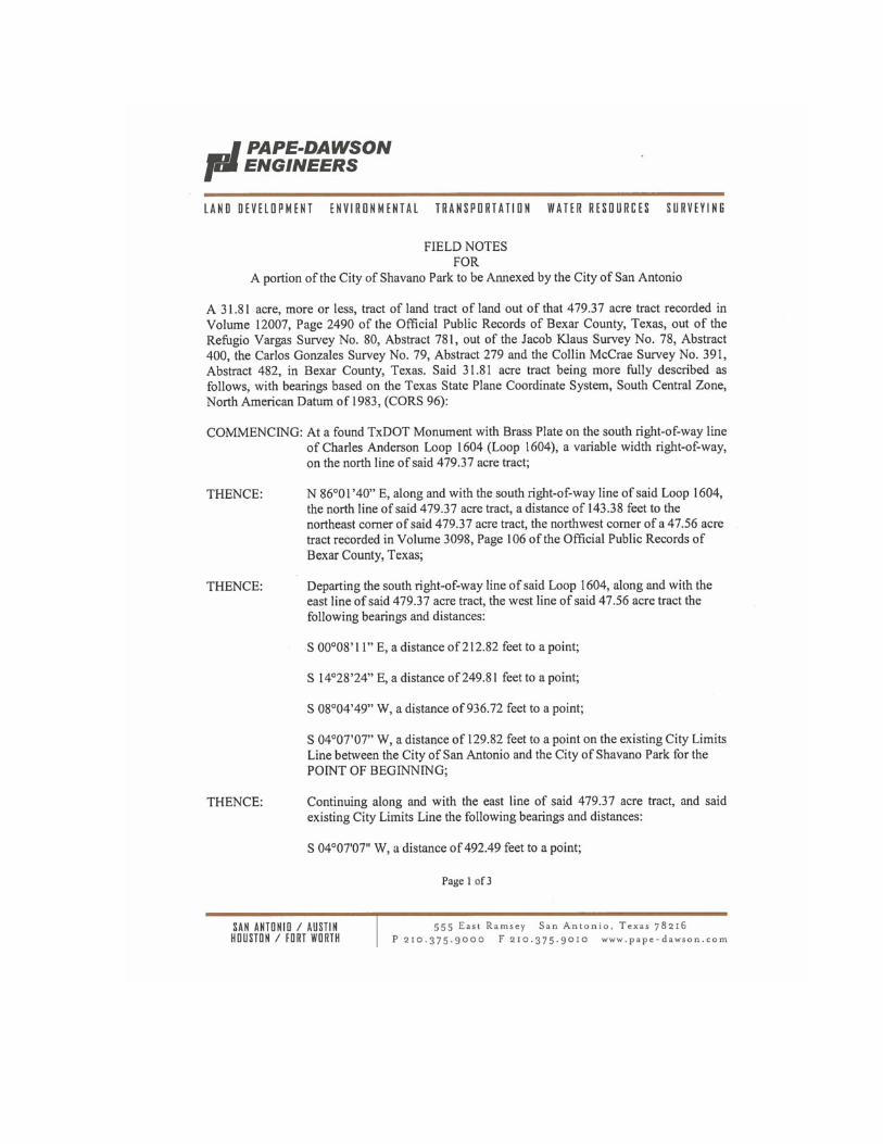
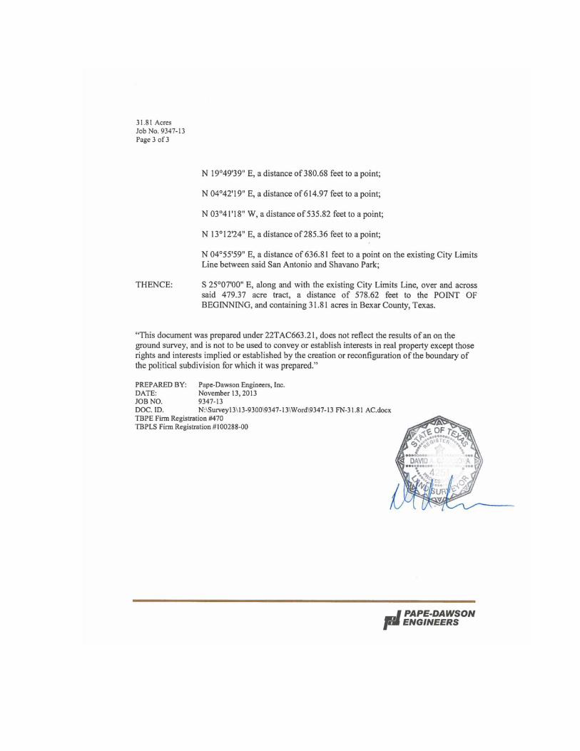
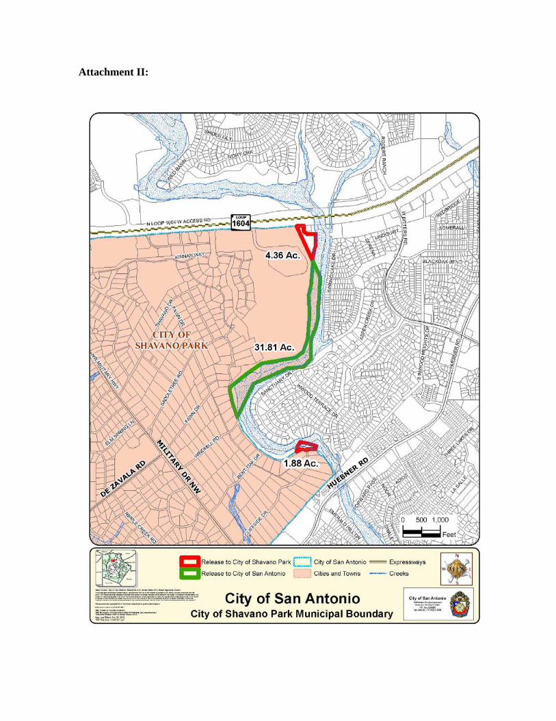
Adjustment with the City of Shavano Park for an exchange of territory, with the City of San Antonio receiving 31.81 acres and the City of Shavano Park receiving 4.36 acres and 1.88 acres, adjacent to Salado Creek. The subject area is generally located to the south of North Loop 1604, to the east of the City of Shavano Park, and to the west of Bitters Road in north San Antonio. Staff recommends Approval. (Sidra Maldonado, Senior Planner, (210) 207-8187, [email protected], Department of Planning & Community Development).
20. Public hearing and consideration of a resolution recommending approval of a Municipal Boundary
Adjustment of approximately 1.14 acres of land from the City of Live Oak to the City of San Antonio. The subject area is generally located along O’Conner Road, to the east of I-35 North, in the northeast of San Antonio. Staff recommends Approval. (Sidra Maldonado, Senior Planner, (210) 207-8187, [email protected], Department of Planning & Community Development)
Other Items 21. Approval of the minutes for the February 26, 2014 Planning Commission meeting. 22. Director’s report - City Council Action Update (Planning Commission items sent to Council).
23. Adjournment.
*Military Notification 4

130160- 1
Public Hearing: Planning Commission March 12, 2014
Application/Case Number: 130160
Project Name: Valencia Hills Enclave Phase III
Applicant: Gil Berkovich
Representative: Coursen-Koehler Engineering & Associates c/o Garth E. Coursen P.E.
Owner: Valencia Enclave, LLC
Staff Coordinator: Larry Odis, Planner (210) 207-0210 [email protected]
Property Address/Location: South of Gold Canyon Road, east of Bulverde Road
MAPSCO Map Grid (Ferguson): 518 B-2
Tract Size: 13.293 acres
Council District: 10
Notification: Internet Agenda posting March 7, 2014
CITY OF SAN ANTONIO DEVELOPMENT SERVICES DEPARTMENT LAND ENTITLEMENTS SECTION STAFF REPORT AGENDA ITEM NO. 5
REQUEST Approval of a major plat to subdivide a 13.293-acre tract of land to establish Valencia Hills Enclave Phase III Subdivision
APPLICATION TYPE Subdivision
RECOMMENDED ACTION Approval
DATE FILED WITH PLANNING COMMISSION February 27, 2014
130160- 2
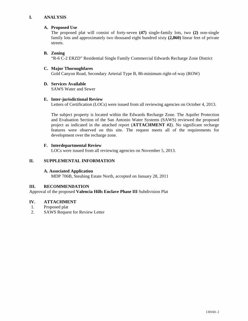
I. ANALYSIS
A. Proposed Use The proposed plat will consist of forty-seven (47) single-family lots, two (2) non-single family lots and approximately two thousand eight hundred sixty (2,860) linear feet of private streets.
B. Zoning “R-6 C-2 ERZD” Residential Single Family Commercial Edwards Recharge Zone District
C. Major Thoroughfares Gold Canyon Road, Secondary Arterial Type B, 86-minimum right-of-way (ROW)
D. Services Available SAWS Water and Sewer
E. Inter-jurisdictional Review Letters of Certification (LOCs) were issued from all reviewing agencies on October 4, 2013.
The subject property is located within the Edwards Recharge Zone. The Aquifer Protection and Evaluation Section of the San Antonio Water Systems (SAWS) reviewed the proposed project as indicated in the attached report (ATTACHMENT #2). No significant recharge features were observed on this site. The request meets all of the requirements for development over the recharge zone.
F. Interdepartmental Review LOCs were issued from all reviewing agencies on November 5, 2013.
II. SUPPLEMENTAL INFORMATION
A. Associated ApplicationMDP 706B, Steubing Estate North, accepted on January 28, 2011
III. RECOMMENDATIONApproval of the proposed Valencia Hills Enclave Phase III Subdivision Plat
IV. ATTACHMENT1. Proposed plat2. SAWS Request for Review Letter

Attachment 1

Attachment 2


130314 - 1
Public Hearing: Planning Commission March 12, 2014
Application/Case Number: 130314
Project Name: Bella Vista Unit 3 Section 4 Ph-1
Applicant: John E. Cork
Representative: Pape-Dawson Engineers, Inc., c/o Shauna L. Weaver, P.E.
Owner: S.R. Holdings, L.P.
Staff Coordinator: Luz M. Gonzales, Planner (210) 207-7898 [email protected]
Property Address/Location: Generally located near the intersection of Volante and Benedetta.
MAPSCO Map Grid (Ferguson): 610 F-5
Tract Size: 12.980 acres
Council District(s): ETJ
Notification: Internet Agenda Posting March 7, 2014
CITY OF SAN ANTONIO DEVELOPMENT SERVICES DEPARTMENT LAND ENTITLEMENTS SECTION STAFF REPORT AGENDA ITEM NO. 6
REQUEST Approval of a major plat to subdivide a 12.980-acre tract of land to establish Bella Vista Unit 3 Section 4 PH-1 Subdivision
APPLICATION TYPE Subdivision
RECOMMENDED ACTION Approval
DATE FILED WITH PLANNING COMMISSION February 27, 2014
130314 - 2
I. ANALYSIS
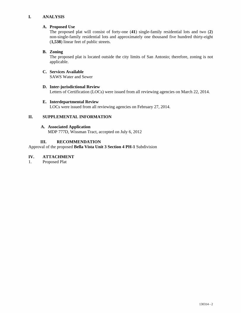
A. Proposed Use The proposed plat will consist of forty-one (41) single-family residential lots and two (2) non-single-family residential lots and approximately one thousand five hundred thirty-eight (1,538) linear feet of public streets.
B. Zoning The proposed plat is located outside the city limits of San Antonio; therefore, zoning is not applicable.
C. Services Available SAWS Water and Sewer
D. Inter-jurisdictional Review Letters of Certification (LOCs) were issued from all reviewing agencies on March 22, 2014.
E. Interdepartmental Review LOCs were issued from all reviewing agencies on February 27, 2014.
II. SUPPLEMENTAL INFORMATION
A. Associated Application MDP 777D, Wissman Tract, accepted on July 6, 2012
III. RECOMMENDATIONApproval of the proposed Bella Vista Unit 3 Section 4 PH-1 Subdivision
IV. ATTACHMENT1. Proposed Plat

Attachment 1


130576- 1
Public Hearing: Planning Commission March 12, 2014
Application/Case Number: 130576
Project Name: HW-4.7
Applicant: Ty Thaggard
Representative: KFW Engineers c/o Billy K. Classen, P.E.
Owner: M2G Stone Oak, Ltd.
Staff Coordinator: Larry Odis, Planner (210) 207-0210 [email protected]
Property Address/Location: Southeast of the intersection of Wilderness Oak and Hardy Oak
MAPSCO Map Grid (Ferguson): 482 D-3
Tract Size: 6.171
Council District: 9
Notification: Internet Agenda posting March 7, 2014
CITY OF SAN ANTONIO DEVELOPMENT SERVICES DEPARTMENT LAND ENTITLEMENTS SECTION STAFF REPORT AGENDA ITEM NO.
REQUEST Approval of a major plat to replat and subdivide a 6.171-acre tract of land to establish HW-4.7 Subdivision
APPLICATION TYPE Subdivision
RECOMMENDED ACTION Approval
DATE FILED WITH PLANNING COMMISSION February 14, 2014
CASE HISTORY The area being replatted are Lot 11 and Lot 14, Block 43, NCB 19215; out of the HW-10 Subdivision plat, recorded in Volume 9639, Pages 81-82, of the Deed and Plat records of Bexar County, Texas.
7

130576- 2
I. ANALYSIS
A. Proposed Use The proposed plat will consist of five (5) non-single family lots.
B. Zoning “C-2 ERZD MLOD” Commercial Edwards Recharge Zone Military Lighting Overlay District
C. Major Thoroughfares Wilderness Oak, Secondary Arterial Type B, 86-minimum right-of-way (ROW) Hardy Oak, Secondary Arterial Type B, 86-minimum right-of-way (ROW)
D. Services Available SAWS Water and Sewer
E. Inter-jurisdictional Review Letters of Certification (LOCs) were issued from all reviewing agencies on January 6, 2014.
The subject property is located within the Edwards Recharge Zone. The Aquifer Protection and Evaluation Section of the San Antonio Water Systems (SAWS) reviewed the proposed project as indicated in the attached report (ATTACHMENT #2). No significant recharge features were observed on this site. The request meets all of the requirements for development over the recharge zone.
Furthermore, this plan lies within the Camp Bullis 5-Mile Awareness Zone, the tract is less than ten (10) acres, and does not immediately abut the Camp Bullis or Camp Stanley installations. Therefore, the Military Installation’s review was not applicable in accordance with the executed Memorandum of Understanding (MOU).
F. Interdepartmental Review LOCs were issued from all reviewing agencies on January 10, 2014.
II. SUPPLEMENTAL INFORMATION
A. Associated ApplicationMDP 358-C, the Heights at Stone Oak, accepted on April 27, 1998
III. RECOMMENDATIONApproval of the proposed HW-4.7 Subdivision Plat
IV. ATTACHMENT1. Proposed plat2. SAWS Request for Review Letter

Attachment 1


Attachment 2
140081 - 1
Public Hearing: Planning Commission March 12, 2014
Application/Case Number: 140081
Project Name: Westwinds Commercial, Unit -3B
Applicant: A. Bradford Galo
Representative: Pape-Dawson Engineers, Inc. c/o Cara C. Tackett, P.E.
Owner: Laredo S. Ltd.
Staff Coordinator: Richard Carrizales, Planner (210) 207-8050 [email protected]
Property Address/Location: Generally located on the northwest corner of Wild Pine and Westwood Loop
MAPSCO Map Grid (Ferguson): 578-A3
Tract Size: 9.38-acres
Council District: ETJ
Notification: Internet Agenda Posting March 7, 2014
CITY OF SAN ANTONIO DEVELOPMENT SERVICES DEPARTMENT LAND ENTITLEMENTS SECTION STAFF REPORT AGENDA ITEM NO. 8
REQUEST Approval of a major plat to subdivide a 9.38-acre tract of land to establish the Westwinds Commercial, Unit – 3B Subdivision
APPLICATION TYPE Subdivision
RECOMMENDED ACTION Approval
DATE FILED WITH PLANNING COMMISSION February 25, 2014

140081 - 2
I. ANALYSIS
A. Proposed Use(s) The proposed plat will consist of eight (8) non-single family residential lots.
B. Zoning The proposed plat is located outside the city limits of San Antonio, therefore zoning is not applicable.
C. Services Available SAWS Water and Sewer
D. Inter-jurisdictional Review Letters of Certification (LOCs) were issued from all reviewing agencies on February 20, 2014.
E. Interdepartmental Review LOCs were issued from all reviewing agencies on February 24, 2014.
II. SUPPLEMENTAL INFORMATION
A. Associated ApplicationsMDP-13-00006, Westwinds, accepted on August 5, 2013
III. RECOMMENDATIONApproval of the proposed Westwinds Commercial, Unit – 3B Subdivision Replat.
IV. ATTACHMENTS1. Proposed Plat

Attachment 1

140082- 1
Public Hearing: Planning Commission March 12, 2014
Application/Case Number: 140082
Project Name: Westwinds Commercial, Unit-5
Applicant: A. Bradford Galo
Representative: Pape Dawson Engineers, Inc. c/o Cara C. Tackett
Owners: Laredo S. Ltd.
Staff Coordinator: Chris McCollin, Planner (210) 207-5014 [email protected]
Property Address/Location: Generally at the intersection of Culebra Road (F.M. 471) and Lone Star Parkway
MAPSCO Map Grid (Ferguson): 578 A-3
Tract Size: 7.76 acres
Council District: ETJ
Notification: Internet Agenda posting March 7, 2014
CITY OF SAN ANTONIO DEVELOPMENT SERVICES DEPARTMENT LAND ENTITLEMENTS SECTION STAFF REPORT AGENDA ITEM NO. 9
REQUEST Approval of a major plat to subdivide a 7.76-acre tract of land to establish Westwinds Commercial, Unit-5 Subdivision
APPLICATION TYPE Subdivision
RECOMMENDED ACTION Approval
DATE FILED WITH PLANNING COMMISSION March 3, 2014

140082- 2
I. ANALYSIS
A. Proposed Use The proposed plat will consist of four (4) non-single family lots.
B. Zoning The proposed plat is located outside the city limits of San Antonio; therefore, zoning is not applicable.
C. Major Thoroughfare Culebra Road (FM 471), Primary Arterial Type A, 120-foot minimum right-of-way
D. Services Available SAWS Water and Sewer
E. Inter-jurisdictional Review Letters of Certification (LOCs) were issued from all reviewing agencies on February 19, 2014.
F. Interdepartmental Review LOCs were issued from all reviewing agencies on March 3, 2014.
II. SUPPLEMENTAL INFORMATION
A. Associated Application MDP-13-00006, Westwinds, accepted on August 5, 2013
II. RECOMMENDATIONApproval of the proposed Westwinds Commercial, Unit-5 Subdivision.
III. ATTACHMENT1. Proposed plat

Attachment 1
140115 -1
Public Hearing: Planning Commission March 12, 2014
Application/Case Number: 140115
Project Name: La Poderoza
Applicant: Raul & Evelyn Lopez
Representative: Rivera Engineering c/o Alane Alvarez De Rivera, P.E.
Owner: Raul & Evelyn Lopez
Staff Coordinator: Ian Benavidez, Planner (210)207-8268 [email protected]
Property Address/Location: Generally located east of the intersection of Durham and Anacacho Road
MAPSCO Map Grid (Ferguson): 518 F-7
Tract Size: 1.07 acres
Council District: 10
Notification: Published in Daily Commercial Recorder February 21, 2014
Notices mailed February 21, 2014 • to 21 property owners within
200 feet
Internet Agenda posting March 7, 2014
CITY OF SAN ANTONIO DEVELOPMENT SERVICES DEPARTMENT LAND ENTITLEMENTS SECTION STAFF REPORT AGENDA ITEM NO. 10
REQUEST Approval of a minor plat to replat a 1.07-acre tract of land to establish La Poderoza Subdivision
APPLICATION TYPE Replat
RECOMMENDED ACTION Approval
DATE FILED WITH PLANNING COMMISSION February 17, 2014
CASE HISTORY Area being replatted was previously platted as a portion of lots 1 and 2, block D, NCB 15707, out of the Fertile Valley Farms Subdivision, recorded in Volume 3377, Pages 76-78, being out of the Deed and Plat Records of Bexar County, Texas.

140115 -2
I. ANALYSIS
A. Proposed Use The proposed plat will consist of one (1) single family residential lot.
B. Zoning “R-6” Single-family Residential District
C. Services Available SAWS Water and Sewer
D. Inter-jurisdictional Review Letters of Certification (LOCs) were issued from all reviewing agencies on February 6, 2014.
E. Interdepartmental Review LOCs were issued from all reviewing agencies on January 21, 2014.
II. RECOMMENDATIONApproval of the proposed La Poderoza Subdivision
III. ATTACHMENT1. Proposed plat

Attachment 1

140123 - 1
Public Hearing: Planning Commission March 12, 2014
Application/Case Number: 140123
Project Name: Fallbrook Unit 1A Enclave
Applicant: Ian Cude
Representative: Pape-Dawson Engineers, Inc. c/o Shauna L. Weaver, P.E.
Owner: Continental Homes of Texas, L.P.
Staff Coordinator: Richard Carrizales, Planner (210) 207-8050 [email protected]
Property Address/Location: Generally located near the intersection of Millstone Cove and Oleander Chase
MAPSCO Map Grid (Ferguson): 477-D5
Tract Size: 1.911-acres
Council District: ETJ
Notification: Published in Daily Commercial Recorder February 20, 2014 Notices mailed February 21, 2014 • to 3 (three) property owners
within 200 feet within the subdivision
• No registered neighborhoodassociation within 200 feet.
Internet Agenda Posting March 7, 2014
CITY OF SAN ANTONIO DEVELOPMENT SERVICES DEPARTMENT LAND ENTITLEMENTS SECTION STAFF REPORT AGENDA ITEM NO. 11
REQUEST Approval of a minor plat to replat a 1.911-acre tract of land to establish the Fallbrook Unit 1A Enclave Subdivision
APPLICATION TYPE Replat
RECOMMENDED ACTION Approval
DATE FILED WITH PLANNING COMMISSION February 18, 2014
CASE HISTORY Area being replatted was previously platted as Lot 901, Block 13 and Lot 1, Block 14, CB 4710 of the Fallbrook Unit 1 Enclave Subdivision, recorded in Volume 9657, Pages 175 to 178, of the Deed and Plat Records of Bexar County, Texas.

140123 - 2
I. ANALYSIS
A. Proposed Use(s) The proposed plat will consist of three (3) single-family residential lots and one (1) non-single family residential lot.
B. Zoning The proposed plat is located outside the city limits of San Antonio, therefore zoning is not applicable.
C. Services Available SAWS Water and Sewer
D. Inter-jurisdictional Review Letters of Certification (LOCs) were issued from all reviewing agencies on February 13, 2014.
This plan lies within the Camp Bullis 5-Mile Awareness Zone, the tract is less than ten (10) acres, and does not immediately abut the Camp Bullis or Camp Stanley installations. Therefore, the Military Installation’s review was not applicable in accordance with the executed Memorandum of Understanding (MOU).
The proposed project will comply with the dark sky lighting measures (July 22, 2008 Bexar County Court Order) or the UDC’s Military Lighting Overlay Zoning District (MLOD-1) regulations, whichever is applicable.
E. Interdepartmental Review LOCs were issued from all reviewing agencies on February 17, 2014.
The dedicatory instrument(s) (Legal Instrument) must be approved by the City Attorney as to legal form prior to any plat recordation and shall be recorded at the same time as the plat in accordance with Section 35-344(i) of the UDC.
II. SUPPLEMENTAL INFORMATION
A. Associated ApplicationsMDP 002-12, Fallbrook, accepted on May 22, 2012
B. Notices To the present, staff has not received any written responses in opposition from the surrounding property owners.
III. RECOMMENDATIONApproval of the proposed Fallbrook Unit 1A Enclave Subdivision Replat.
IV. ATTACHMENTS1. Proposed Plat
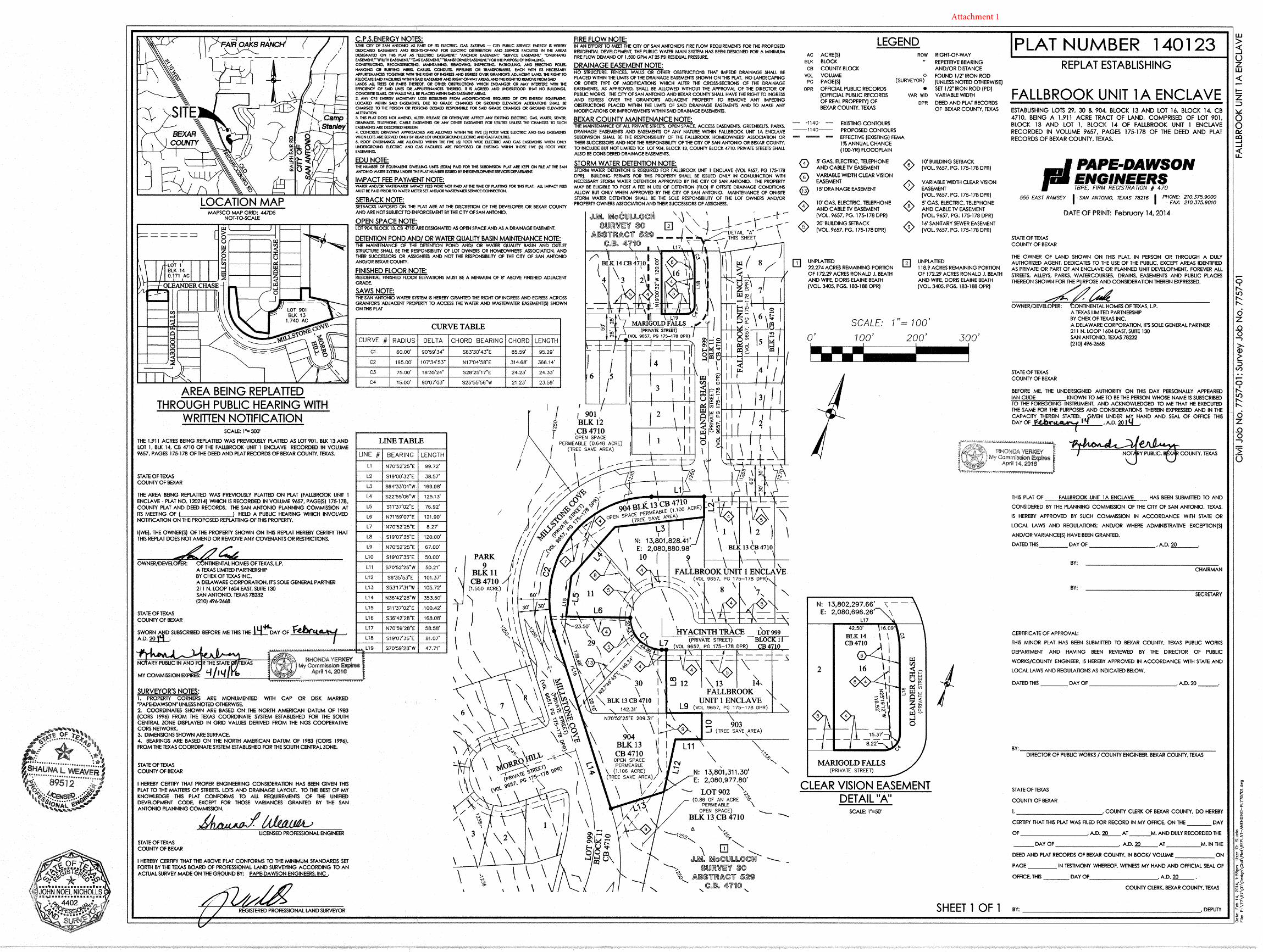
Attachment 1
140129 - 1
Public Hearing: Planning Commission March 12, 2014
Application/Case Number: 140129
Project Name: Alamo Ranch Unit 41D Phase 1 PUD
Applicant: David Grove, V.P.
Representative: Pape-Dawson Engineers, Inc., c/o Shauna L. Weaver, P.E.
Owner: Lennar Homes of Texas Land and Construction, L.T.D.
Staff Coordinator: Luz M. Gonzales, Planner (210) 207-7898 [email protected]
Property Address/Location: Generally located near the intersection of Desert Palm and Suncatcher
MAPSCO Map Grid (Ferguson): 577 D-5
Tract Size: 0.696 acres
Council District(s): ETJ
Notification: Published in Daily Commercial Recorder February 21, 2014 Notices mailed February 20, 2014 • to twelve (12) property owners
within 200 feet within the subdivision
Internet Agenda Posting March 7, 2014
CITY OF SAN ANTONIO DEVELOPMENT SERVICES DEPARTMENT LAND ENTITLEMENTS SECTION STAFF REPORT AGENDA ITEM NO. 12
REQUEST Approval of a major plat to replat a 0.696-acre tract of land to establish Alamo Ranch Unit 41D Phase 1 PUD Subdivision
APPLICATION TYPE Replat
RECOMMENDED ACTION Approval
DATE FILED WITH PLANNING COMMISSION February 19, 2014
CASE HISTORY Area being replatted was previously platted as Lot 9, Block 47, Lot 59 and 86, Block 48, Lot 27, Block 54, CB 4400, out of the Alamo Ranch Unit 41D Phase 1 PUD Subdivision, recorded in Volume 9654, Pages 127-128, of the Deed and Plat Records of Bexar County

140129 - 2
I. ANALYSIS
A. Proposed Use The proposed plat will consist of four (4) single-family residential lots and four (4) non-single-family lots.
B. Zoning The proposed plat is located outside the city limits of San Antonio; therefore, zoning is not applicable.
C. Services Available SAWS Water and Sewer
D. Inter-jurisdictional Review Letters of Certification (LOCs) were issued from all reviewing agencies on February 12, 2014.
E. Interdepartmental Review LOCs were issued from all reviewing agencies on February 17, 2014.
II. SUPPLEMENTAL INFORMATION
A. Associated Application MDP 808D, Alamo Ranch, accepted on May 26, 2006 PUD 06-023, Alamo Ranch-Del Webb Phase 2, accepted on November 8, 2006
B. Notices To the present, staff has not received any written responses in opposition from the surrounding property owners.
III. RECOMMENDATIONApproval of the proposed Alamo Ranch Unit 41D Phase 1 PUD Replat.
IV. ATTACHMENT1. Proposed Plat

Attachment 1
090277 - 1
Public Hearing: Planning Commission March 12, 2014
Application/Case Number: 090277
Project Name: North Pointe Subdivision, Unit 2B Planned Unit Development
Applicant: Drake Thompson
Representative: AECOM, Technical Services, Inc., c/o Tracy Lindsey
Owner: McMillin Homes
Staff Coordinator: Luz M. Gonzales, Planner (210) 207-7898 [email protected]
Location: Generally located west of the intersection of Oak Cliff Bend and Winter George
MAPSCO Map Grid (Ferguson): 483 E-3
Tract Size: 8.833 acres
Council District: 9
Notification: Internet Agenda Posting March 7, 2014
CITY OF SAN ANTONIO DEVELOPMENT SERVICES DEPARTMENT LAND ENTITLEMENTS SECTION STAFF REPORT AGENDA ITEM NO. 13
REQUEST A request for a three (3) year site improvement time extension in accordance with Section 35-430(f)(2) of the City of San Antonio’s Unified Development Code (UDC) for the North Pointe Subdivision, Unit 2B Planned Unit Development
APPLICATION TYPE Site Improvement Time Extension
RECOMMENDED ACTION Approval
DISCUSSION Due to the economic downturn, lack of financing, and existing land inventory has delayed development of this unit.
The percentages of improvements remain are as follows:
• Streets - 0%• Drainage - 0%• Sidewalks - 0%• Water - 0%• Sanitary Sewer - 0%
CASE HISTORY The Planning Commission approved this plat on April 27, 2011
ATTACHMENTS 1. Proposed Plat2. Applicant’s Letter of Request
Attachment 1

Attachment 2

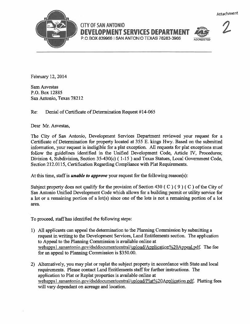
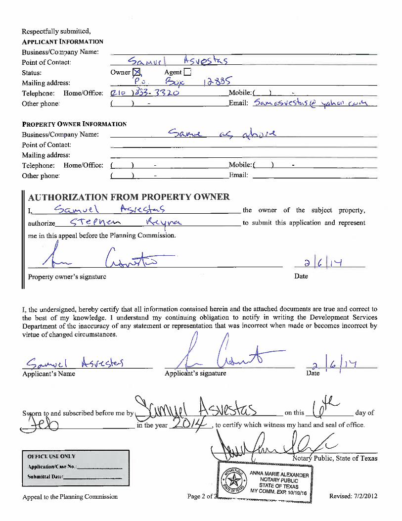
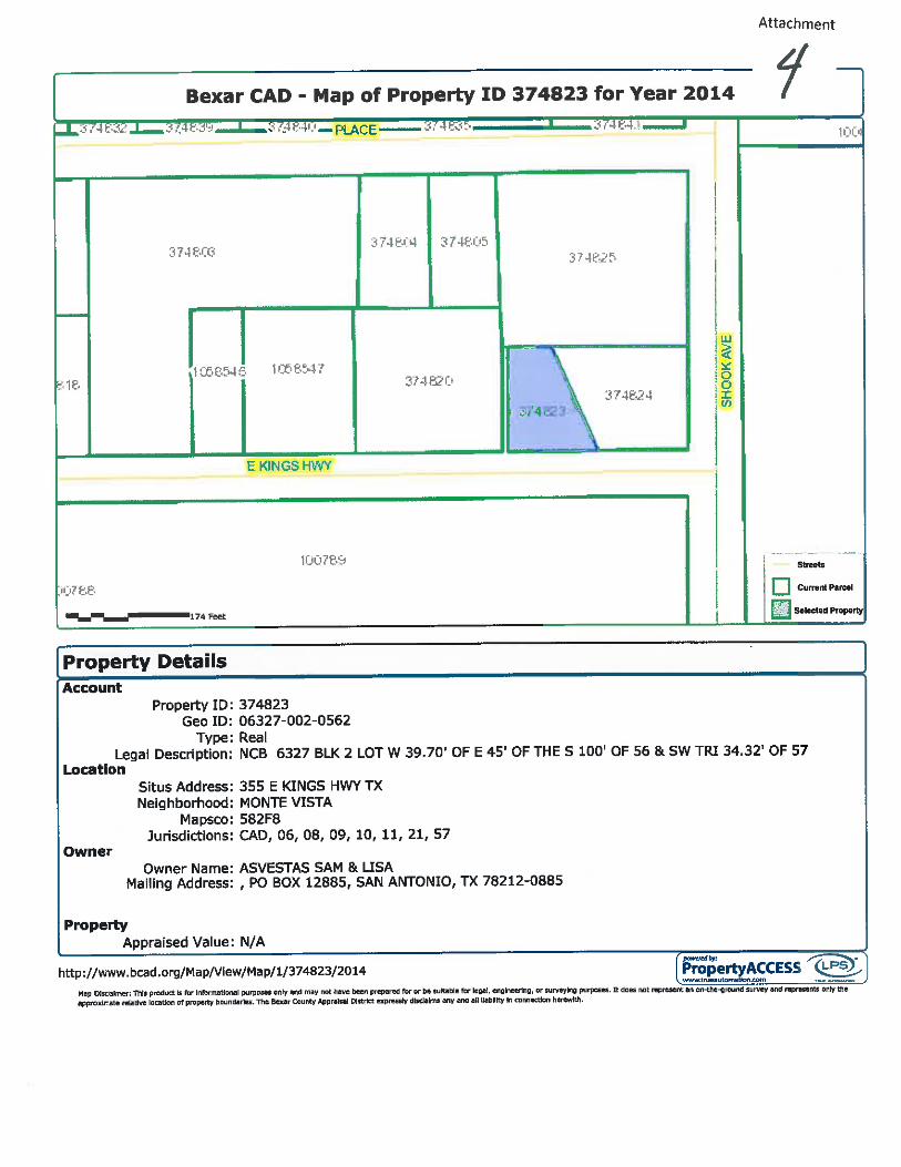
14-IV-001 - 1
Public Hearing: Planning Commission March 12, 2014
Application/Case Number: 14-IV-001
Applicant: Samuel Asvestas
Staff Coordinator: Richard Carrizales, Planner (210) 207-8050 [email protected]
Property Address/Location: 355 E. Kings Highway
MAPSCO Map Grid (Ferguson): 582 F-8
Tract Size: 0.137-acres
Council District(s): 1
Notification: Internet Agenda posting March 7, 2014
CITY OF SAN ANTONIO DEVELOPMENT SERVICES DEPARTMENT LAND ENTITLEMENTS SECTION STAFF REPORT AGENDA ITEM NO. 14
REQUEST An appeal of the Development Services Department Director’s decision to deny the certificate of determination on a 0.137-acre tract of land.
RECOMMENDED ACTION Approval
ALTERNATIVE ACTIONS 1. Approve as presented2. Denial of request3. Alternate recommendation by Planning Commission4. Continuance of Item
I. ANALYSIS
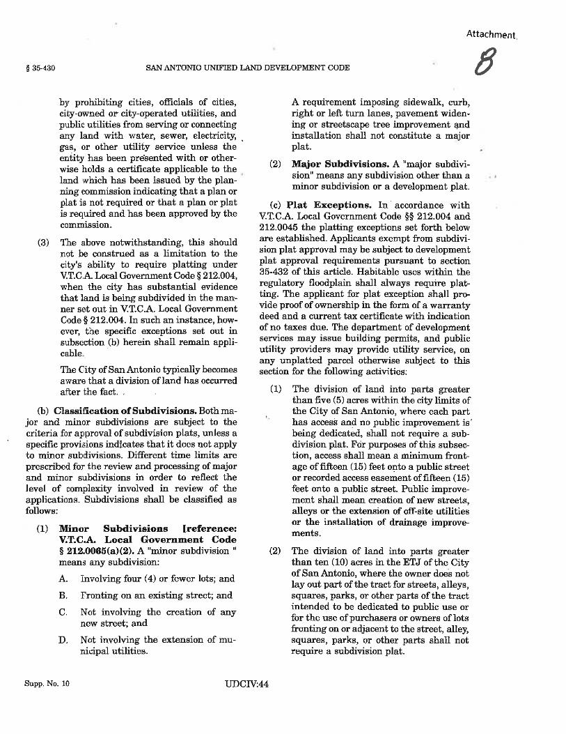
On January 28, 2014, the applicant submitted an application for a certificate of determination for 355 E. Kings Hwy (attachment 1). Staff reviewed the application and found the request was ineligible for a plat exception and notified the applicant that the project did not meet any of the plat exceptions. The applicant submitted an appeal on February 6, 2014 (attachment 3) prior to the issuance of the denial letter on February 12, 2014 (attachment 2). The appeal was submitted by the applicant prior to the issuance of the denial letter because staff had already communicated to the applicant that the denial was forthcoming. The Certificate of Determination was denied in accordance with Section 35-430(c) of the City of San Antonio’s UDC, Article IV, Procedures; Division 4, and, Texas Statues, Local Government Code, Section 212.0115, Certification Regarding Compliance with Plat Requirements.

14-IV-001 - 2
II. RECOMMENDATION
Approval of the Certificate of Determination Appeal for the following reasons:
1. The applicant has provided additional information not presented at the time of application for aCertificate of Determination. The additional information identified below has proven the situationto be unique to this property.
2. Although the applicant does not meet any of the Plat Exceptions as outlined in UnifiedDevelopment Code (UDC) Section 35-430(c) 1 through 15 (attachment 8), staff isrecommending approval based on an associated antiquated plat recorded in May 8, 1923 asLaurel Heights Addition (Volume 642, Page 104), in the deed and plat records of Bexar County,Texas. Since the plat was recorded on May 8, 1923 it is considered an unrecorded plat as statedwithin UDC Section 35-442 (a) Platting of Antiquated Plats. “any subdivision platted prior toJune 14, 1927, the effective date of V.T.C.A. Local Government Code Ch. 212, shall not beconsidered a plat under that chapter and a replat of such a subdivision shall be considered anoriginal plat”.
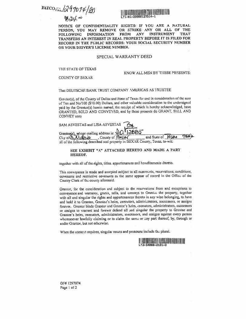
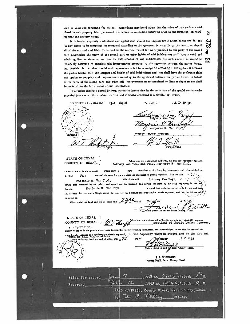
3. The current property configuration (attachment 4) can be traced back in deed records to January9, 1953, Volume 373, Page 49, and has not changed to date (attachment 5).
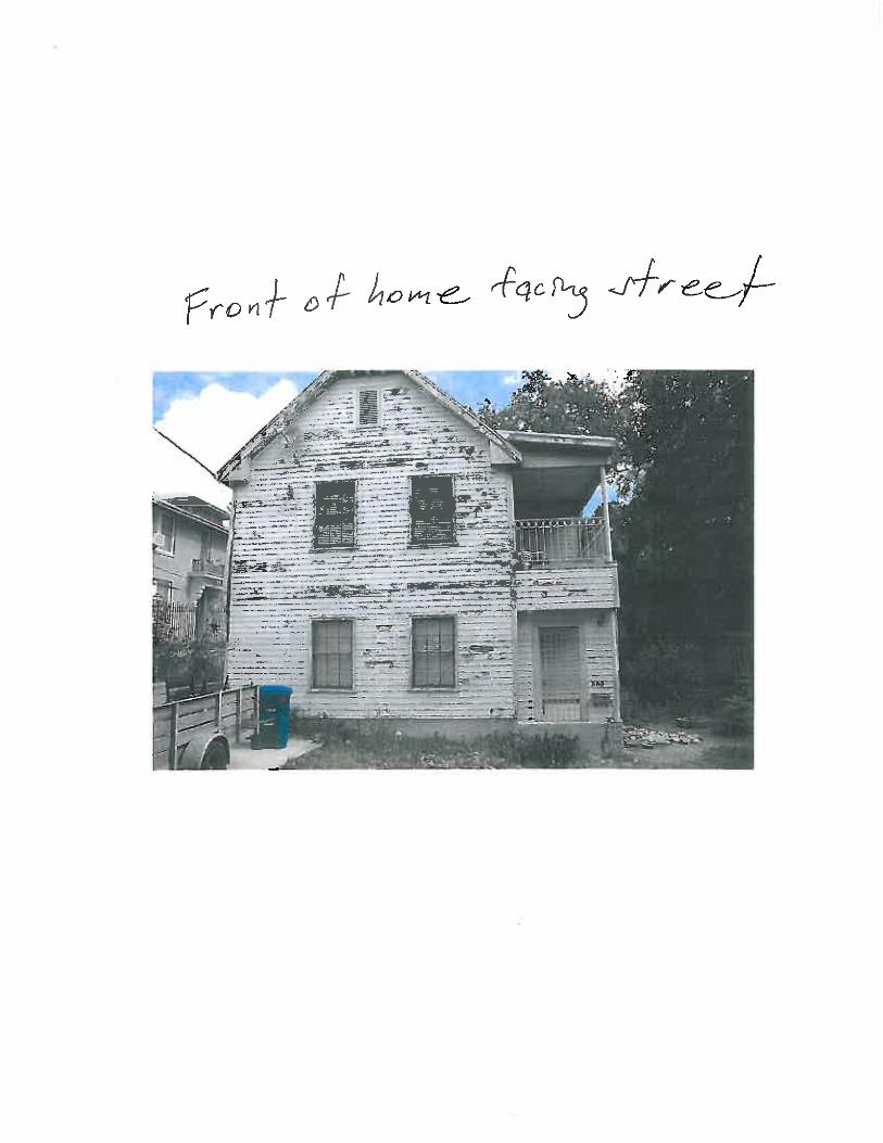
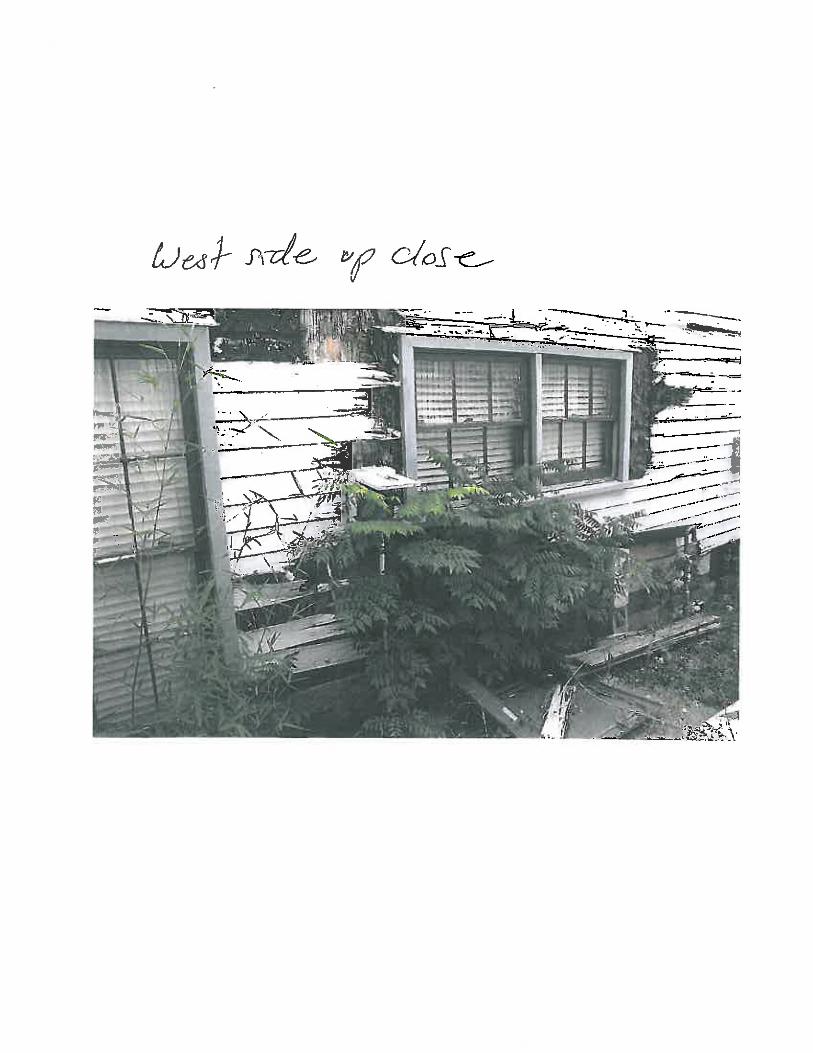
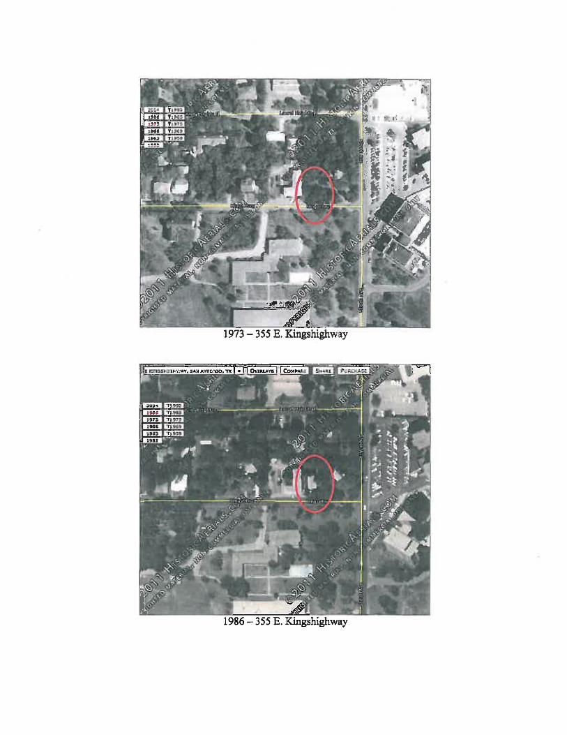
4. On June 26, 2012, a demolition application was approved by the Office of Historic Preservation(attachment 6). The applicant stated that the structure was “beyond repair” and suffered from“massive structural defects”. A demolition permit was issued on October 26, 2012, A.P. #1840498. The applicant is proposing to build a new residential building at the site and has statedthat there were “flooding issues with the property”. According to the applicant’s letter the City ofSan Antonio upgraded the drainage system and Transportation and Capital ImprovementsDepartment (TCI) confirmed a five foot concrete lined drainage channel along the west side ofthe property was built according to their records. TCI has targeted this area for a future drainageproject.
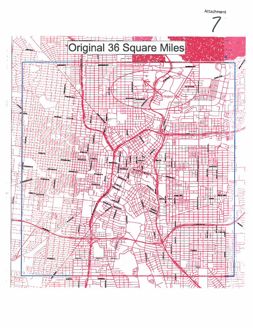
5. The applicant is seeking to build over the lot line for a residential building which is permittedwithin the original (36) thirty-six square miles (attachment 7) of San Antonio according toinformational bulletin (IB) 506 Building Over Lot Lines (1) All lots must be under ownership of asingle person, partnership, corporation, or other recognized legal entity. (3) The lots must beplatted unless the property is located in the original 36-square mile area of San Antonio, and theboundaries of the lots were recorded in the Deed and Property Records of Bexar County prior toJune 14, 1927. It shall be the obligation of the applicant to provide documentation of the lots’platting or recording prior to June 14, 1927.
6. In summary, the site is located within the original 36 square miles and within a subdivisiondeveloped between 1890-1930. The proposed new residential construction will not require publicimprovements and will not affect the public health, safety, and general welfare of the city. Theproposed residential use is consistent with the minimum standards for development.
III. ATTACHMENTS1. Certificate of Determination Application2. Denial Letter From Development Services3. Appeal application and letter to the Planning Commission4. Bexar CAD exhibit of the property5. Recorded deed Filed January 9, 19536. Demolition Permit Application7. Exhibit of the Original 36 mile boundary8. UDC Section 35-430(c)


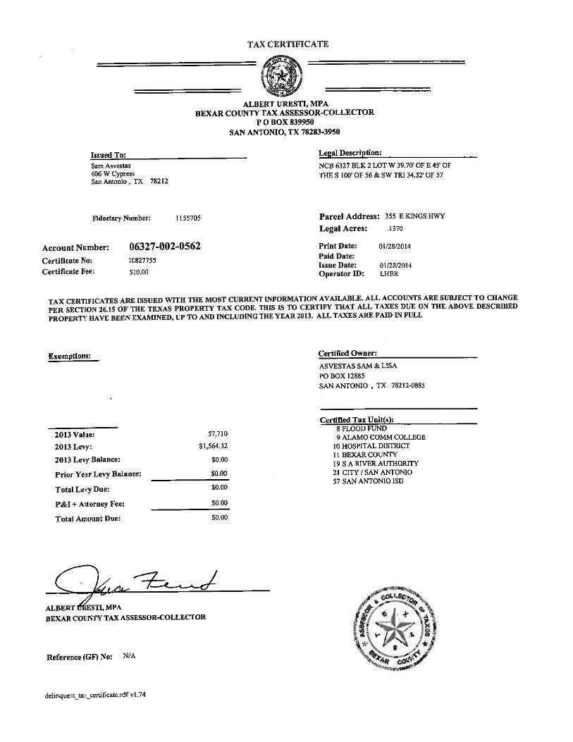


Attachment 1

Attachment 2


Attachment 3


CITY OF SAN ANTONIO DEVELOPMENT SERVICES DEPARTMENT LAND DEVELOPMENT DIVISION
STAFF REPORT AGENDA ITEM NO
REQUEST Public Hearing: Planning Commission March 12, 2014
Case Number: PA 14027
Applicant: Intrepid Equity Investments LLC
Representative: Intrepid Equity Investments LLC
Owner: Robert Cruz
Staff Coordinator: Robert C. Acosta, Planner (210) 207-0157 [email protected]
Property Address/Location: Approximately 0.54 of an acre of land out of Lot 1, NCB 15 and Lot 6, NCB 16, located at 302 Clay Street
Legal Description: Approximately 0.54 of an acre of land out of Lot 1, NCB 15 and Lot 6, NCB 16, located at 302 Clay Street
Tract Size: 0.54 acres
Council District(s): District 5
Notification: Published in Daily Commercial Recorder 2/21/2014 Notices Mailed 2/27/2014 31 to property owners within 200
feet 2 registered neighborhood
association within 200 feet 1 to applicant
Internet Agenda Posting 3/7/2014
The Applicant requests a Comprehensive Master Plan Amendment to change the Lone Star Community Plan future land use classification from Medium Density Residential to Low Density Mixed Use.
RECOMMENDED ACTION Approval of the proposed amendment to the Lone Star Community Plan to change the future land use classification of the subject property from Medium Density Residential to Low Density Mixed Use.
ALTERNATIVE ACTIONS 1. Recommend denial of the proposed amendment to the Lone
Star Community Plan, as presented above.2. Make an alternate recommendation.3. Continue to a future date.
SYNOPSIS OF ANALYSIS Land Use: The Low Density Mixed Use land use classification support the goals of the Lone Star Community Plan of improving the quality, appearance, and variety of existing and new housing while increasing home ownership and investment in the area.
Transportation: The requested land use change will generate more traffic and impact the existing transportation infrastructure; however, the traffic impact analysis will be evaluated further during the permitting process.
Community Facilities: The requested land use change could create an additional demand for community facilities.
CASE HISTORY This is the first public hearing of this case.
PA14027- 1

I. ANALYSIS
Comprehensive Plan Comprehensive Plan Component: Lone Star Community Plan Plan Adoption Date: March 21, 2013 Update History: None Goal LU-6: Establish policies that provide for a range of housing types that are affordable to people at most income levels Strategy LU-6.1: Rezone to provide for a range of housing types including single-family detached, townhouses, senior housing, live/ work units, and apartments. Strategy LU-6.4: Support SAHA, private, and non-profit developer efforts to preserve and renovate affordable housing that already exists in the Plan area.
Comprehensive Land Use Categories Example Zoning Districts
Medium Density Residential: Medium Density Residential includes duplexes, triplexes, fourplexes, and low-rise apartments. Cottage homes and small lot single-family houses are also appropriate within this land use category. Pre-existing commercial buildings less than 3,000 square feet on higher capacity local streets may be used for Neighborhood Commercial purposes. This form of development should be located along collectors or residential roads, and may serve as a buffer between low density residential and more intense land uses such as commercial.
R-3, R-4, R-5, R-6, RM-4, RM-5, RM-6, MF-18
Low Density Mixed Use: Low Density Mixed Use includes a mix of low intensity residential and commercial uses integrated into one structure, or found on the same lot or block. The mix of uses promotes walkability, therefore all mixed use developments should be designed for the pedestrian. This form of development is typically located along or near major arterials or collectors and may serve as a transition from High Density Mixed Use to lower intensity land uses such as Low Density Residential.
RM-4, MF-18, MF-25, MF-33, O-1, NC, C-1, C-2P, IDZ, TOD, MXD, FBZD, AE-2, AE-4
Land Use Overview Future Land Use Classification Current Use
Subject Property
Medium Density Residential Vacant single-family residence on a large lot
North High Density Mixed Use and Low Density Mixed Use
Commercial uses, Vacant lot, Single and Multi-family homes
East Medium Density Residential and Low Density Mixed Use
Single and Multi-Family Homes and Industrial uses
South Low Density Mixed Use and Low Density Residential
Industrial uses and Single and Multi-Family Homes
West Medium Density Residential and High Density Mixed Use
Single and Multi- Family Homes and Commercial uses
Land Use: The subject property is located on the south side of Clay Street between South Flores Street and Peters Street within the Lone Star Community Plan. The subject property consists of a vacant single-family residence on a large lot and has commercial uses, a vacant lot and single and multi- family homes to the north, single and multi-family and industrial uses to the east, industrial uses and single and multi-family homes to the south, and single and multi-family homes and commercial uses to the west. The
PA14027- 2
Lone Star Community Plan classifies the area to the north as High Density Mixed use and Low Density Mixed Use, the area to the east as Medium Density Residential and Low Density Mixed Use, the area to the south as Low Density Mixed Use and Low Density Residential and the area to the west as Medium Density Residential and High Density Mixed Use.
The applicant requests this plan amendment and zoning change in order construct 10 single-family residences, each on a 1,700 square foot lot. In order to accommodate this development the applicant requires the IDZ zoning district which provides some design flexibility, to include setback and parking requirements. The purposed development meets the intent of the IDZ which is to encourage and facilitate development on vacant, bypassed lands, or the redevelopment of underutilized buildings or structures within existing built-up areas. However, while the Medium Density Residential land use classification allows for the construction of single-family homes by right; the associated zoning district required to implement the proposed development on the subject property requires a higher intensity land use classification and thus the need to request a change in the land use plan.
The subject property is located in an area that has seen extensive development for commercial, mixed use and higher density residential uses. Its location coupled with the mix of commercial and multi-family uses to the north and west and multi-family uses to the east and south and its close proximity to varied Mixed Use uses along Cevallos Street to the north and South Flores to the west make it appropriate for the Low Density Mixed Use classification. The Low Density Mixed Use land use classification support the goals of the Lone Star Community Plan of improving the quality, appearance, and variety of existing and new housing while increasing home ownership and investment in the area.
Transportation: : The City’s Major Thoroughfare Plan identified South Flores as a Secondary Arterial Type B and Probandt Street as a Secondary Arterial Type A. Clay, Simon and Peter Streets are local and Cevallos Street is a collector. The neighboring area includes sidewalks which allow for pedestrian access to and from adjacent residential and commercial areas. There is a VIA bus stop one block west on South Flores and Clay Street. The requested land use change will generate more traffic and impact the existing transportation infrastructure; however, the traffic impact analysis will be evaluated further during the permitting process.
Community Facilities: Briscoe Elementary School and St. Henry’s Catholic Church are within walking distance. Harris Middle School, Collins Garden Public Library and San Antonio Fire Station No. 16 are in close proximity. The requested land use change could create an additional demand for community facilities.
II. SUPPLEMENTAL INFORMATION
Current Zoning: "R-6 AHOD" Residential Single-Family Airport Hazard Overlay District Proposed Zoning: "IDZ AHOD" Infill Development Zone Airport Hazard Overlay District with Single-Family Residential Uses not to exceed 25 units per acre Corresponding Zoning Case: Z2014097 Zoning Commission Public Hearing Date: March 18, 2014
III. RECOMMENDATION
The subject property is located in an area that has seen extensive development for commercial, mixed use and higher density residential uses. Its location coupled with the mix of commercial and multi-family uses to the north and west and multi-family uses to the east and south and its close proximity to varied Mixed Use uses along Cevallos Street to the north and South Flores to the west make it appropriate for the Low Density Mixed Use classification. The Low Density Mixed Use land use classification support
PA14027- 3

PA14027- 4
the goals of the Lone Star Community Plan of improving the quality, appearance, and variety of existing and new housing while increasing home ownership and investment in the area.
IV. ATTACHMENTS
A. Plan Amendment MapsB. Aerial Map
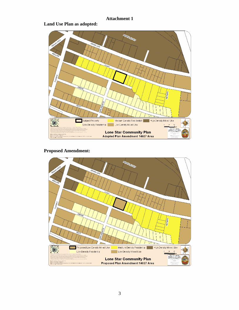
Attachment 1 Land Use Plan as adopted:
Proposed Amendment:
3

Attachment 2

RESOLUTION NO.
RECOMMENDING TO APPROVE THE AMENDMENT OF THE LAND USE PLAN CONTAINED IN THE LONE STAR COMMUNITY PLAN, A COMPONENT OF THE COMPREHENSIVE MASTER PLAN OF THE CITY, BY CHANGING THE USE FROM MEDIUM DENSITY RESIDENTIAL TO LOW DENSITY MIXED USE FOR AN AREA OF APPROXIMATELY 0.54 ACRES OF LAND OUT OF LOT 1, NCB 15 AND LOT 6, NCB 16 LOCATED AT 302 CLAY STREET.
WHEREAS, City Council approved the Lone Star Community Plan as an addendum to the Comprehensive Master Plan on March 21, 2013; and
WHEREAS, the May 3, 2001 Unified Development Code requires consistency between zoning and the Comprehensive Master Plan as specified in Sections 35-105, 35-420 (h), and 35-421 (d) (3); and
WHEREAS, Chapter 213.003 of the Texas Local Government Code provides that the Master Plan may be amended by ordinance following a public hearing and review by the Planning Commission; and
WHEREAS, the San Antonio Planning Commission held a public hearing on March 12, 2014 and APPROVED the amendment on March 12, 2014; and
WHEREAS, the San Antonio Planning Commission has considered the effect of this amendment to the Comprehensive Master Plan as it pertains to land use intensity, compatibility, community facilities, and the transportation network and found the amended plan to be CONSISTENT with City policies, plans and regulations and in conformance with the Unified Development Code, Section 35-420, therefore meeting all requirements; and
NOW, THEREFORE, BE IT RESOLVED BY THE PLANNING COMMISSION OF THE CITY OF SAN ANTONIO:
SECTION 1: The amendment to the Lone Star Community Plan attached hereto and incorporated herein by reference is recommended to the City Council with this Commission’s recommendation for APPROVAL as an amendment to the City’s Comprehensive Master Plan.
PASSED AND APPROVED ON THIS 12th DAY OF MARCH 2014.
Attest: Approved:
___________________________ ____________________________ Executive Secretary Roberto R. Rodriguez, Chair San Antonio Planning Commission San Antonio Planning Commission

CITY OF SAN ANTONIO DEVELOPMENT SERVICES DEPARTMENT LAND DEVELOPMENT DIVISION
STAFF REPORT AGENDA ITEM NO
REQUEST Public Hearing: Planning Commission March 12, 2014
Case Number: PA 14028
Applicant: Langley & Banack, Inc.
Representative: Langley & Banack, Inc.
Owner: Linden Tara, LLC
Staff Coordinator: Robert C. Acosta, Planner (210) 207-0157 [email protected]
Property Address/Location: Approximately 1.3124 acres of land out of Lot 5, NCB 11898 located at 1779 Nacogdoches Road
Legal Description: Approximately 1.3124 acres of land out of Lot 5, NCB 11898 located at 1779 Nacogdoches Road
Tract Size: 1.3124 acres
Council District(s): District 10
Notification: Published in Daily Commercial Recorder 2/21/2014 Notices Mailed 2/27/2014
24 to property owners within 200 feet 1 to registered neighborhood
association within 200 feet 1 to applicant 34 to planning team members
Internet Agenda Posting 3/7/2014
The Applicant requests a Comprehensive Master Plan Amendment to change the Northeast Inner Loop Neighborhood Plan future land use classification from Neighborhood Commercial to High Density Residential.
RECOMMENDED ACTION Approval of the proposed amendment to the Northeast Inner Loop Neighborhood Plan to change the future land use classification of the subject property from Neighborhood Commercial to High Density Residential.
ALTERNATIVE ACTIONS 1. Recommend denial of the proposed amendment to the
Northeast Inner Loop Neighborhood Plan, as presentedabove.
2. Make an alternate recommendation.3. Continue to a future date.
SYNOPSIS OF ANALYSIS Land Use: The High Density Residential land use classification supports the goals of the Northeast Inner Loop Neighborhood Plan of preserving the housing and distinctive character of the Northeast Inner Loop neighborhoods. The proposed change will have minimal impact on adjacent properties.
Transportation: The existing transportation infrastructure could support any additional demand generated by the requested future land use change.
Community Facilities: The existing community facilities could support any additional demand generated by the requested land use change.
CASE HISTORY This is the first public hearing of this case.
PA14028 - 1
I. ANALYSIS
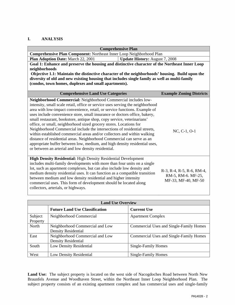
Comprehensive Plan Comprehensive Plan Component: Northeast Inner Loop Neighborhood Plan Plan Adoption Date: March 22, 2001 Update History: August 7, 2008 Goal 1: Enhance and preserve the housing and distinctive character of the Northeast Inner Loop neighborhoods Objective 1.1: Maintain the distinctive character of the neighborhoods’ housing. Build upon the diversity of old and new existing housing that includes single family as well as multi-family (condos, town homes, duplexes and small apartments).
Comprehensive Land Use Categories Example Zoning DistrictsNeighborhood Commercial: Neighborhood Commercial includes low-intensity, small scale retail, office or service uses serving the neighborhood area with low-impact convenience, retail, or service functions. Example of uses include convenience store, small insurance or doctors office, bakery, small restaurant, bookstore, antique shop, copy service, veterinarians’ office, or small, neighborhood sized grocery stores. Locations for Neighborhood Commercial include the intersections of residential streets, within established commercial areas and/or collectors and within walking distance of residential areas. Neighborhood Commercial can serve as an appropriate buffer between low, medium, and high density residential uses, or between an arterial and low density residential.
NC, C-1, O-1
High Density Residential: High Density Residential Development includes multi-family developments with more than four units on a single lot, such as apartment complexes, but can also include low density and medium density residential uses. It can function as a compatible transition between medium and low density residential and higher intensity commercial uses. This form of development should be located along collectors, arterials, or highways.
R-3, R-4, R-5, R-6, RM-4, RM-5, RM-6. MF-25,
MF-33, MF-40, MF-50
Land Use Overview Future Land Use Classification Current Use
Subject Property
Neighborhood Commercial Apartment Complex
North Neighborhood Commercial and Low Density Residential
Commercial Uses and Single-Family Homes
East Neighborhood Commercial and Low Density Residential
Commercial Uses and Single-Family Homes
South Low Density Residential Single-Family Homes
West Low Density Residential Single-Family Homes
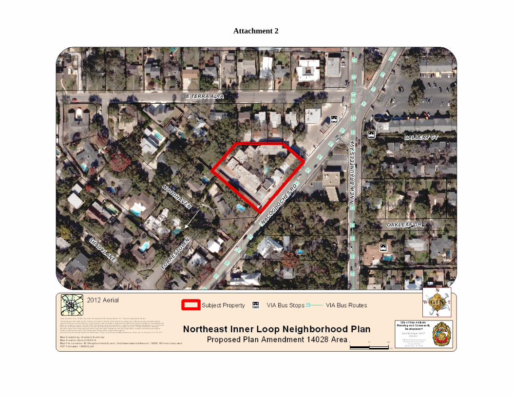
Land Use: The subject property is located on the west side of Nacogdoches Road between North New Braunfels Avenue and Woodhaven Street, within the Northeast Inner Loop Neighborhood Plan. The subject property consists of an existing apartment complex and has commercial uses and single-family
PA14028 - 2

PA14028 - 3
homes to the north and east and single-family homes to the south and west. The Northeast Inner Loop Neighborhood Plan classifies the area to the north and east as Neighborhood Commercial and Low Density Residential, and the area to the south and west as Low Density Residential. The applicant requests to change the future land use from Neighborhood Commercial to High Density Residential.
The applicant requests this plan amendment and associated zoning change in order bring this existing apartment complex into conformance with applicable zoning regulations. According to Bexar County tax records the apartment was constructed in 1970 and has continually operated as a multi-family residential complex. However, the subject property is currently zoned “O-2” Office District and multi-family uses of this intensity are not allowed by right under this zoning designation.
The Neighborhood Commercial land use classification allows low intense commercial uses by right; however, the associated zoning district required to bring subject property into conformance requires a higher intensity land use classification and thus the need to request a change in the land use plan. The proposed amendment to High Density Residential will provide consistency with the existing use and allow the applicant to seek an appropriate zoning classification from the current “O-2” Office District. The High Density Residential land use classification supports the goals of the Northeast Inner Loop Neighborhood Plan of preserving the housing and distinctive character of the Northeast Inner Loop neighborhoods. The proposed change will have minimal impact on adjacent properties.
Transportation: The City’s Major Thoroughfare Plan identified Nacogdoches Road and New Braunfels Avenue as Secondary Arterial Type B. Terra Alta Street is a collector and Woodhaven Street as a local street. The neighboring area includes sidewalks which allow for pedestrian access to and from adjacent residential and commercial areas. There is a VIA bus stop at the corner of New Braunfels Avenue and Nacogdoches Road. The existing transportation infrastructure could support any additional demand generated by the requested future land use change.
Community Facilities: Alamo Heights Middle School, Howard Early Childhood Center and Woodridge Elementary School are in close proximity. The existing community facilities could support any additional demand generated by the requested land use change.
II. SUPPLEMENTAL INFORMATION
Current Zoning: “O-2 AHOD" High-Rise Office Airport Hazard Overlay District Proposed Zoning: “MF-50 AHOD" Multi-Family Airport Hazard Overlay District Corresponding Zoning Case: Z2014107 Zoning Commission Public Hearing Date: March 18, 2014
III. RECOMMENDATION
The proposed amendment to High Density Residential will provide consistency with the existing use and allow the applicant to seek an appropriate zoning classification from the current “O-2” Office District. The High Density Residential land use classification supports the goals of the Northeast Inner Loop Neighborhood Plan of preserving the housing and distinctive character of the Northeast Inner Loop neighborhoods. The proposed change will have minimal impact on adjacent properties.
IV. ATTACHMENTS
A. Plan Amendment MapsB. Aerial Map

Attachment 1 Land Use Plan as adopted:
Proposed Amendment:
3
Attachment 2

RESOLUTION NO.
RECOMMENDING TO APPROVE THE AMENDMENT OF THE LAND USE PLAN CONTAINED IN THE NORTHEAST INNER LOOP NEIGHBORHOOD PLAN, A COMPONENT OF THE COMPREHENSIVE MASTER PLAN OF THE CITY, BY CHANGING THE USE FROM NEIGHBORHOOD COMMERCIAL TO HIGH DENSITY RESIDENTIAL FOR AN AREA OF APPROXIMATELY 1.3124 ACRES OF LAND OUT OF LOT 5, NCB 11898 LOCATED AT 1779 NACOGDOCHES ROAD
WHEREAS, City Council approved the Northeast Inner Loop Neighborhood Plan as an addendum to the Comprehensive Master Plan on March 22, 2001 and updated on August 7, 2008; and
WHEREAS, the May 3, 2001 Unified Development Code requires consistency between zoning and the Comprehensive Master Plan as specified in Sections 35-105, 35-420 (h), and 35-421 (d) (3); and
WHEREAS, Chapter 213.003 of the Texas Local Government Code provides that the Master Plan may be amended by ordinance following a public hearing and review by the Planning Commission; and
WHEREAS, the San Antonio Planning Commission held a public hearing on March 12, 2014 and APPROVED the amendment on March 12, 2014; and
WHEREAS, the San Antonio Planning Commission has considered the effect of this amendment to the Comprehensive Master Plan as it pertains to land use intensity, compatibility, community facilities, and the transportation network and found the amended plan to be CONSISTENT with City policies, plans and regulations and in conformance with the Unified Development Code, Section 35-420, therefore meeting all requirements; and
NOW, THEREFORE, BE IT RESOLVED BY THE PLANNING COMMISSION OF THE CITY OF SAN ANTONIO:
SECTION 1: The amendment to the Northeast Inner Loop Neighborhood Plan attached hereto and incorporated herein by reference is recommended to the City Council with this Commission’s recommendation for APPROVAL as an amendment to the City’s Comprehensive Master Plan.
PASSED AND APPROVED ON THIS 12th DAY OF MARCH 2014.
Attest: Approved:
___________________________ ____________________________ Executive Secretary Roberto R. Rodriguez, Chair San Antonio Planning Commission San Antonio Planning Commission

CITY OF SAN ANTONIO DEVELOPMENT SERVICES DEPARTMENT LAND DEVELOPMENT DIVISION
STAFF REPORT AGENDA ITEM NO
REQUEST Public Hearing: Planning Commission March 12, 2014
Case Number: PA 14029
Applicant: Kaufman and Killen, Inc.
Representative: Kaufman and Killen, Inc.
Owner: First Presbyterian Church of San Antonio
Staff Coordinator: Robert C. Acosta, Planner (210) 207-0157 [email protected]
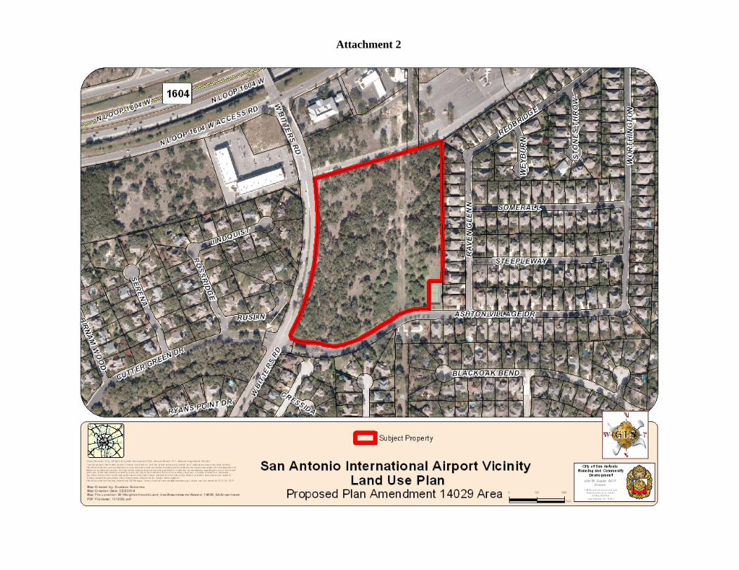
Property Address/Location: Approximately 14.597 acres of land out of Parcel 12 and Parcel 15B, NCB 15009, located on the east side of Bitters Road between Loop 1604 and Ashton Village drive
Legal Description/Location: Approximately 14.597 acres of land out of Parcel 12 and Parcel 15B, NCB 15009, located on the east side of Bitters Road between Loop 1604 and Ashton Village drive
Tract Size: 14.597 acres
Council District(s): District 9
Notification: Published in Daily Commercial Recorder 2/21/2014 Notices Mailed 2/27/2014 54 to property owners within 200
feet 1 to registered neighborhood
association within 200 feet 1 to Applicant 26 to planning team members
Internet Agenda Posting 3/7/2014
The Applicant requests a Comprehensive Master Plan Amendment to change the San Antonio International Airport Vicinity Land Use Plan future land use classification from Public Institutional to Community Commercial.
RECOMMENDED ACTION Approval of the proposed amendment to the San Antonio International Airport Vicinity Land Use Plan to change the future land use classification of the subject property from Public Institutional to Community Commercial.
ALTERNATIVE ACTIONS 1. Recommend denial of the proposed amendment to the San
Antonio Airport Vicinity Land Use, as presented above. 2. Make an alternate recommendation.3. Continue to a future date.
SYNOPSIS OF ANALYSIS Land Use: The proposed amendment to Community Commercial land use classification will provide consistency with the adjacent Community Commercial land use classification, thus, providing support to the goals of the San Antonio International Airport Vicinity Land Use Plan goal of promoting compatibility and appropriateness between uses. It also supports the Plan’s goal of promoting economic growth in the area along arterials and in established commercial areas. The proposed use will have minimal impact on adjacent properties. Transportation: The existing transportation infrastructure could support any additional demand generated by the requested future land use change.
Community Facilities: The existing community facilities could support any additional demand generated by the requested land use change.
CASE HISTORY This is the first public hearing of this case.
PA12052 - 1
I. ANALYSIS
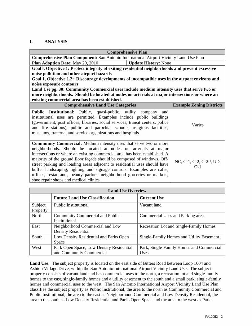
Comprehensive Plan Comprehensive Plan Component: San Antonio International Airport Vicinity Land Use Plan Plan Adoption Date: May 20, 2010 Update History: None Goal l, Objective 1: Protect integrity of exiting residential neighborhoods and prevent excessive noise pollution and other airport hazards Goal 1, Objective 1.2: Discourage developments of incompatible uses in the airport environs and noise exposure contours Land Use pg. 30: Community Commercial uses include medium intensity uses that serve two or more neighborhoods. Should be located at nodes on arterials at major intersections or where an existing commercial area has been established.
Comprehensive Land Use Categories Example Zoning DistrictsPublic Institutional: Public, quasi-public, utility company and institutional uses are permitted. Examples include public buildings (government, post offices, libraries, social services, transit centers, police and fire stations), public and parochial schools, religious facilities, museums, fraternal and service organizations and hospitals.
Varies
Community Commercial: Medium intensity uses that serve two or more neighborhoods. Should be located at nodes on arterials at major intersections or where an existing commercial area has been established. A majority of the ground floor façade should be composed of windows. Off-street parking and loading areas adjacent to residential uses should have buffer landscaping, lighting and signage controls. Examples are cafes, offices, restaurants, beauty parlors, neighborhood groceries or markets, shoe repair shops and medical clinics.
NC, C-1, C-2, C-2P, UD, O-1
Land Use Overview Future Land Use Classification Current Use
Subject Property
Public Institutional Vacant land
North Community Commercial and Public Institutional
Commercial Uses and Parking area
East Neighborhood Commercial and Low Density Residential
Recreation Lot and Single-Family Homes
South Low Density Residential and Parks Open Space
Single-Family Homes and Utility Easement
West Park Open Space, Low Density Residential and Community Commercial
Park, Single-Family Homes and Commercial Uses
Land Use: The subject property is located on the east side of Bitters Road between Loop 1604 and Ashton Village Drive, within the San Antonio International Airport Vicinity Land Use. The subject property consists of vacant land and has commercial uses to the north, a recreation lot and single-family homes to the east, single-family homes and a utility easement to the south and a small park, single-family homes and commercial uses to the west. The San Antonio International Airport Vicinity Land Use Plan classifies the subject property as Public Institutional, the area to the north as Community Commercial and Public Institutional, the area to the east as Neighborhood Commercial and Low Density Residential, the area to the south as Low Density Residential and Parks Open Space and the area to the west as Parks
PA12052 - 2
PA12052 - 3
Open Space, Low Density Residential and Community Commercial. The applicant requests to change the future land use from Public Institutional to Community Commercial.
The applicant requests this plan amendment and associated zoning case in order to allow the construction of a commercial development that is compatible with the already-existing surrounding area. The subject property is located along a major roadway and has existing commercial uses abutting it to the north and a significant number of commercial uses to the west. Additionally, the general surrounding conditions which include a utility easement that provides ample buffering to the residential area to the east and its close proximity to the varied community scale uses along Loop 1604 make it appropriate for the Community Commercial land use classification. The proposed amendment to Community Commercial land use classification will provide consistency with the adjacent Community Commercial land use classification, thus, providing support to the goals of the San Antonio International Airport Vicinity Land Use Plan goal of promoting compatibility and appropriateness between uses. It also supports the Plan’s goal of promoting economic growth in the area along arterials and in established commercial areas. The proposed use will have minimal impact on adjacent properties.
Transportation: The City’s Major Thoroughfare Plan classifies Bitters Road as a Secondary Arterial Type A and Loop 1604 as a Freeway. Aston Village and Raven Glenn and Cutter Green Drive are local Streets. The neighboring area includes sidewalks which allow for pedestrian access to and from adjacent residential and commercial areas. The existing transportation infrastructure could support any additional demand generated by the requested future land use change.
Community Facilities: Judson Montessori School, Concordia Lutheran Church School, Huebner Elementary School and Blattman Elementary School are in close proximity. The existing community facilities could support any additional demand generated by the requested land use change.
II. SUPPLEMENTAL INFORMATION
Current Zoning: “MF-33 PUD ERZD MLOD-1 AHOD" Multi Family Planned Unit Development Edwards Recharge Zone Camp Bullis Military Lighting Overlay Airport Hazard Overlay District Proposed Zoning: "C-2 ERZD MLOD-1 AHOD" Commercial Edwards Recharge Zone Camp Bullis Military Lighting Overlay Airport Hazard Overlay District and "O-1 ERZD MLOD-1 AHOD "Office Edwards Recharge Zone Camp Bullis Military Lighting Overlay Airport Hazard Overlay District Corresponding Zoning Case: Z2014103 ERZD Zoning Commission Public Hearing Date: April 1, 2014
III. RECOMMENDATION
The subject property is located along a major roadway and has existing commercial uses abutting it to the north and a significant number of commercial uses to the west. Additionally, the general surrounding conditions which include a utility easement that provides ample buffering to the residential area to the east and its close proximity to the varied community scale uses along Loop 1604 make it appropriate for the Community Commercial land use classification. The proposed amendment to Community Commercial land use classification will provide consistency with the adjacent Community Commercial land use classification, thus, providing support to the goals of the San Antonio International Airport Vicinity Land Use Plan goal of promoting compatibility and appropriateness between uses. It also supports the Plan’s goal of promoting economic growth in the area along arterials and in established commercial areas. The proposed use will have minimal impact on adjacent properties.
IV. ATTACHMENTSA. Plan Amendment MapsB. Aerial Map
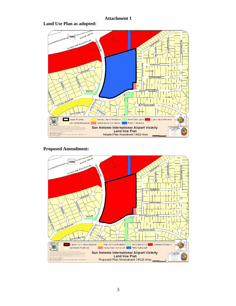
Attachment 1 Land Use Plan as adopted:
Proposed Amendment:
3
Attachment 2

RESOLUTION NO.
RECOMMENDING TO APPROVE THE AMENDMENT OF THE LAND USE PLAN CONTAINED IN THE SAN ANTONIO INTERNATIONAL AIRPORT VICINITY LAND USE PLAN, A COMPONENT OF THE COMPREHENSIVE MASTER PLAN OF THE CITY, BY CHANGING THE USE FROM PUBLIC INSTITUTIONAL TO COMMUNITY COMMERCIAL FOR AN AREA OF APPROXIMATELY 14.594 ACRES OF LAND OUT OF PARCEL 12 AND PARCEL 15B, NCB 15009, LOCATED ON THE EAST SIDE OF BITTERS ROAD BETWEEN LOOP 1604 AND ASHTON VILLAGE DRIVE.
WHEREAS, City Council approved the San Antonio International Airport Vicinity Land Use Plan as an addendum to the Comprehensive Master Plan on May 20, 2010; and
WHEREAS, the May 3, 2001 Unified Development Code requires consistency between zoning and the Comprehensive Master Plan as specified in Sections 35-105, 35-420 (h), and 35-421 (d) (3); and
WHEREAS, Chapter 213.003 of the Texas Local Government Code provides that the Master Plan may be amended by ordinance following a public hearing and review by the Planning Commission; and
WHEREAS, the San Antonio Planning Commission held a public hearing on March 12, 2014 and APPROVED the amendment on March 12, 2014; and
WHEREAS, the San Antonio Planning Commission has considered the effect of this amendment to the Comprehensive Master Plan as it pertains to land use intensity, compatibility, community facilities, and the transportation network and found the amended plan to be CONSISTENT with City policies, plans and regulations and in conformance with the Unified Development Code, Section 35-420, therefore meeting all requirements; and
NOW, THEREFORE, BE IT RESOLVED BY THE PLANNING COMMISSION OF THE CITY OF SAN ANTONIO:
SECTION 1: The amendment to the San Antonio International Airport Vicinity Land Use Plan attached hereto and incorporated herein by reference is recommended to the City Council with this Commission’s recommendation for APPROVAL as an amendment to the City’s Comprehensive Master Plan.
PASSED AND APPROVED ON THIS 12th DAY OF MARCH 2014.
Attest: Approved:
___________________________ ____________________________ Executive Secretary Roberto R. Rodriguez, Chair San Antonio Planning Commission San Antonio Planning Commission

1
Public Hearing: Planning Commission March 12, 2014
Applicant/Representative: Mary M. Dennis, Mayor City of Shavano Park
Staff Coordinator: Sidra Maldonado Senior Planner (210) 207-8187 [email protected]
Property Address/Location: subject area is generally located to the south of North Loop 1604, to the east of the City of Shavano Park, and to the west of Bitters Road in north San Antonio
Tract Size: City of San Antonio receiving 31.81 acres
City of Shavano Park receiving 1.88 acres and 4.36 acres
Council District(s): A portion is within the City of San Antonio Council District 9 and the other portion is within the City of Shavano Park.
Attachments: A. Map B. City of Shavano Park Resolution
CITY OF SAN ANTONIO DEPARTMENT OF PLANNING AND COMMUNITY DEVELOPMENT STRATEGIC PLANNING DIVISION STAFF REPORT
SUMMARY The City of Shavano Park requests a Municipal Boundary Adjustment with the City of Shavano Park for an exchange of territory, with the City of San Antonio receiving 31.81 acres and the City of Shavano Park receiving 6.24 acres, adjacent to Salado Creek. The subject area is generally located to the south of North Loop 1604, to the east of the City of Shavano Park, and to the west of Bitters Road in north San Antonio (Please see attached map). Staff recommends approval.
RECOMMENDED ACTION Approval of the request by the City of Shavano Park.
ALTERNATIVE ACTIONS Denial of the request or an alternative with the City of Shavano Park.
SYNOPSIS OF ANALYSIS The request was evaluated based on the City’s adopted Annexation Policy and criteria found in the Texas Local Government Code, with input from other City Departments and agencies.
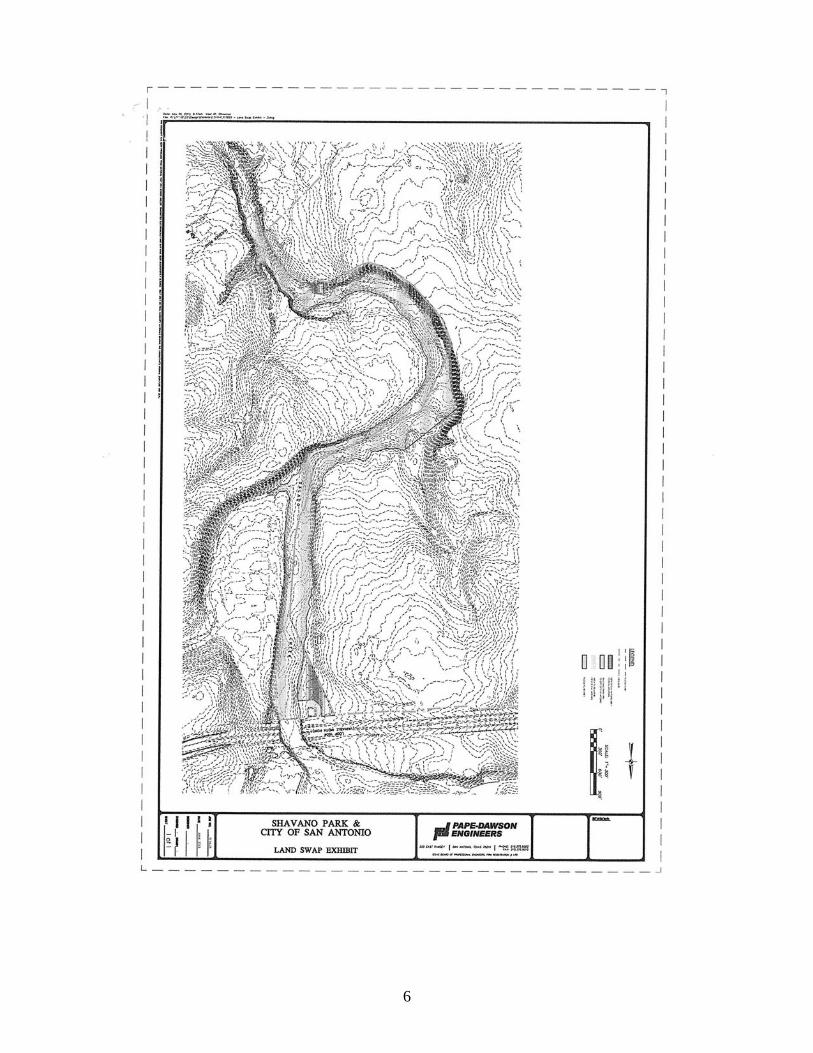
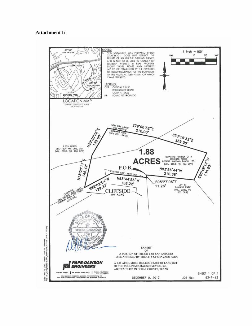
I. BACKGROUND On July 22, 2013 the City of Shavano Park Council, by resolution, requested a municipal boundary adjustment along a portion of the Salado Creek. The City of Shavano Park ceding 31.81 acres of floodplain located along Salado Creek to the City of San Antonio for the purpose of continuing and building the Salado Creek Greenway trail project. The City of San Antonio will adjust its city limits by transferring 1.88 acres and 4.36 acres to the City of Shavano Park for a trail head and garden office lots.
Under State law, Sec.43.031 of the Texas Local Government Code provides authority for adjacent municipalities to make mutually agreeable changes in their boundaries of areas that are less than 1,000 feet in width.

2
The request was evaluated based on the City’s adopted Annexation Policies and criteria provided in the Texas Local Government Code, with feedback incorporated from other City Departments and agencies.
II. ISSUES AND ANALYSISThe City of San Antonio’s Annexation Policies provide guidance and rationale for consideration of areas for annexation and issues within the ETJ. The subject request was evaluated based on criteria provided in the policies and on the feedback received from other CoSA departments and outside agencies including Fire, Police, Development Services, the Office of Historic Preservation, Capital Improvement Management Systems (CIMS), the City Attorney’s Office, CPS Energy, Bexar County, SAWS, etc.
Land use The 31.81 acres will be donated to the City of San Antonio by the LEE-1604 NO ONE LTD and the City of Shavano Park will cede its territory to the City of San Antonio. The 1.88 acres the City of San Antonio will cede to the City of Shavano Park is planned for Parks/Open Space. The City of Shavano Park plans to create a trailhead on this parcel with access to the creek way. The 4.36 acres the City of San Antonio will cede to the City of Shavano Park is zoned C-2 ERZD and garden offices are planned for this property.
Loop 1604 North is located to the north of the subject properties and two single family residential neighborhoods are located to the east and west of Salado Creek.
CPS Energy provides electrical utility services in the subject area. The City of San Antonio provides police protection/law enforcement to the areas within the city limits and the City of Shavano Park provides police protection/law enforcement to the areas within the City of Shavano Park. The City of San Antonio Park Police will provide services along the Salado Creek Greenway trail project.
• Clear and Logical Planning BoundariesThe area is contiguous to the City of San Antonio city limits. The land exchange will consolidate the trail ways ownership and allow for emergency services to efficiently serve the area. The greenway construction permitting process will be expedited with all of the trail area being located in the City of San Antonio.
• Fiscal ImpactThe City of San Antonio will not monetarily profit from the boundary exchange due to the 31.81 acres being in the floodplain, however, the City is gaining the 31.81 acres through donation by LEE-1604 NO ONE LTD and will be able to expand its hike and bike trails.
• Protection of environmental resourcesThe City of San Antonio will be in charge of maintaining the sensitive Salado Creek greenway trail and will protect the sensitive riparian environment along the trail.

3
• Community of InterestThe community close to the greenway trail and citizens who commute to the trail will experience the most benefits. The trail way will allow for connectivity to the City’s other hike and bike trails and will promote increased activity and a healthy lifestyle. There will be two trail heads for easy access located along Loop 1604 and Cliffside Drive.
III. RECOMMENDATIONThe Department of Planning and Community Development recommends Approval of the City of Shavano Park request for a Municipal Boundary Adjustment of approximately 31.81 acres to be ceded to the City of San Antonio for the City of San Antonio to cede 1.88 acres and 4.36 acres to the City of Shavano Park as depicted on the attached map.

4
Attachment A:

5
Attachment B:
6

RESOLUTION NO.
RECOMMENDING APPROVAL OF A MUNICIPAL BOUNDARY ADJUSTMENT BETWEEN THE CITY OF SAN ANTONIO AND THE CITY OF SHAVANO PARK FOR AN EXCHANGE OF TERRITORY, WITH THE CITY OF SAN ANTONIO RECEIVING APPROXIMATELY 31.81 ACRES OF LAND FROM THE CITY OF SHAVANO PARK AND THE CITY OF SHAVANO PARK RECEIVING 1.88 ACRES AND 4.36 ACRES FROM THE CITY OF SAN ANTONIO. THE SUBJECT AREA BEING GENERALLY LOCATED TO THE SOUTH OF NORTH LOOP 1604, TO THE EAST OF THE CITY OF SHAVANO PARK, AND TO THE WEST OF BITTERS ROAD IN NORTH SAN ANTONIO.
WHEREAS, the City of Shavano Park has requested a municipal boundary adjustment ceding 31.81 acres to the City of San Antonio and the City of San Antonio ceding 1.88 acres and 4.36 acres to the City of Shavano Park; and,
WHEREAS, the Texas Local Government Code provides authority for adjacent municipalities to make mutually agreeable changes in their boundaries of areas that are less than 1,000 feet in width; and,
WHEREAS, the transfer of territory to the City of San Antonio does not conflict with the City of San Antonio’s Annexation Policy, adopted on February 14, 2013; and,
WHEREAS, if subject area is released into the City of San Antonio, the City of San Antonio Parks Department will continue the connectivity and construction of the Salado Creek Greenway Trail; and,
WHEREAS, the City of San Antonio recognizes the need for increased greenway connectivity; and,
WHEREAS, the Planning Commission has considered the request from the City of Shavano Park to allow approximately 1.88 and 4.36 acres currently within the City of San Antonio city limits to lie within the municipal boundaries of the City of Shavano Park; and to allow approximately 31.81 acres to be adjusted from the City of Shavano Park city limits to lie within the City of San Antonio city limits as Attachment I, and as depicted on the map in Attachment II, to the City Council for adoption
NOW, THEREFORE, BE IT RESOLVED BY THE PLANNING COMMISSION OF THE CITY OF SAN ANTONIO

SECTION 1: The Planning Commission recommends approval of a Municipal Boundary Adjustment of approximately of 31.81 acres of land from the City of Shavano Park to the City of San Antonio and 1.33 and 4.36 acres from the City of San Antonio to the City of Shavano Park as particularly described in Attachment I, and depicted on the map in Attachment II, to the City Council for adoption.
PASSED AND APPROVED ON THIS 12th DAY OF MARCH 2014.
____________________________ Attest: Roberto R. Rodriguez, Chair
San Antonio Planning Commission
___________________________ Executive Secretary San Antonio Planning Commission
Attachment I:


Attachment II:

1
Public Hearing: Planning Commission March 12, 2014
Applicant/Representative: Mary M. Dennis, Mayor City of Live Oak
Staff Coordinator: Sidra Maldonado Senior Planner (210) 207-8187 [email protected]
Property Address/Location: located along O’Connor Road, to the east of I-35 North, in the northeast of San Antonio
Tract Size: Approximately 1.14 acres
Council District(s): Subject Property is located in the City of Live Oak
Attachments: A. Map B. City of Live Oak Resolution
CITY OF SAN ANTONIO DEPARTMENT OF PLANNING AND COMMUNITY DEVELOPMENT STRATEGIC PLANNING DIVISION STAFF REPORT
SUMMARY The City of Live Oak requests a Municipal Boundary Adjustment of approximately 1.14 acres of right-of-way from the City of Live Oak to the City of San Antonio. The subject area is generally located along O’Connor Road, to the east of I-35 North, in the northeast of San Antonio. (Please see attached map). Staff recommends approval.
RECOMMENDED ACTION Approval of the request by the City of Live Oak.
ALTERNATIVE ACTIONS Denial of the request or an alternative with the City of Live Oak.
SYNOPSIS OF ANALYSIS The request was evaluated based on the City’s adopted Annexation Policies and criteria found in the Texas Local Government Code, with input from other City Departments and agencies.
I. BACKGROUND On June 25, 2013 the City of Live Oak Council, by ordinance, requested that an agreement between the City of Live Oak and the City of San Antonio which authorizes the City of Live Oak to cede certain portions of O’Connor Road and right-of-way within its city boundary to the City of San Antonio.
There are safety and location concerns regarding the VIA bus stop along this section of O’Connor Road. Currently VIA Metropolitan Transit Authority does not provide services to the City of Live Oak therefore the location of the bus stop is on the eastbound side of O’Connor Road which is in the City of San Antonio. The location of the bus stop requires pedestrians to cross into the street to avoid crossing a drainage area. By ceding the roadway to the City of San Antonio, this will allow for VIA Metropolitan Transit Authority to provide a bus stop along the westbound lane of O’Connor road thus increasing the safety of pedestrians and VIA bus riders. Upon release
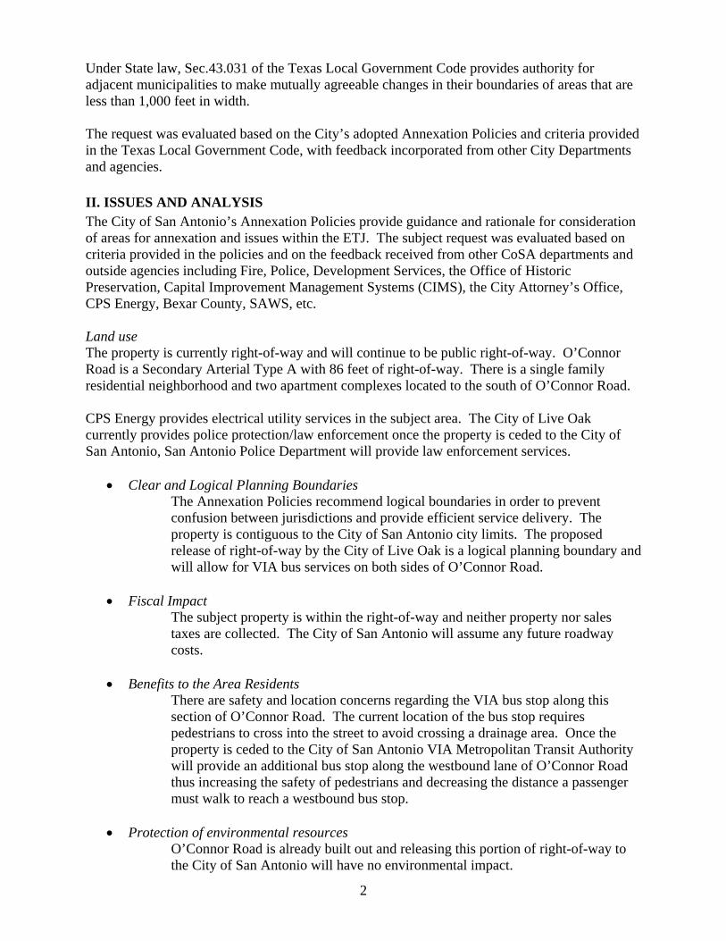
2
Under State law, Sec.43.031 of the Texas Local Government Code provides authority for adjacent municipalities to make mutually agreeable changes in their boundaries of areas that are less than 1,000 feet in width.
The request was evaluated based on the City’s adopted Annexation Policies and criteria provided in the Texas Local Government Code, with feedback incorporated from other City Departments and agencies.
II. ISSUES AND ANALYSISThe City of San Antonio’s Annexation Policies provide guidance and rationale for consideration of areas for annexation and issues within the ETJ. The subject request was evaluated based on criteria provided in the policies and on the feedback received from other CoSA departments and outside agencies including Fire, Police, Development Services, the Office of Historic Preservation, Capital Improvement Management Systems (CIMS), the City Attorney’s Office, CPS Energy, Bexar County, SAWS, etc.
Land use The property is currently right-of-way and will continue to be public right-of-way. O’Connor Road is a Secondary Arterial Type A with 86 feet of right-of-way. There is a single family residential neighborhood and two apartment complexes located to the south of O’Connor Road.
CPS Energy provides electrical utility services in the subject area. The City of Live Oak currently provides police protection/law enforcement once the property is ceded to the City of San Antonio, San Antonio Police Department will provide law enforcement services.
• Clear and Logical Planning BoundariesThe Annexation Policies recommend logical boundaries in order to prevent confusion between jurisdictions and provide efficient service delivery. The property is contiguous to the City of San Antonio city limits. The proposed release of right-of-way by the City of Live Oak is a logical planning boundary and will allow for VIA bus services on both sides of O’Connor Road.
• Fiscal ImpactThe subject property is within the right-of-way and neither property nor sales taxes are collected. The City of San Antonio will assume any future roadway costs.
• Benefits to the Area ResidentsThere are safety and location concerns regarding the VIA bus stop along this section of O’Connor Road. The current location of the bus stop requires pedestrians to cross into the street to avoid crossing a drainage area. Once the property is ceded to the City of San Antonio VIA Metropolitan Transit Authority will provide an additional bus stop along the westbound lane of O’Connor Road thus increasing the safety of pedestrians and decreasing the distance a passenger must walk to reach a westbound bus stop.
• Protection of environmental resourcesO’Connor Road is already built out and releasing this portion of right-of-way to the City of San Antonio will have no environmental impact.

3
III. RECOMMENDATIONThe Department of Planning and Community Development recommends Approval of the City of Live Oak request for a Municipal Boundary Adjustment of approximately 1.14 acres of right-of-way from the City of Live Oak to the City of San Antonio as depicted on the attached map.
4
Attachment A:
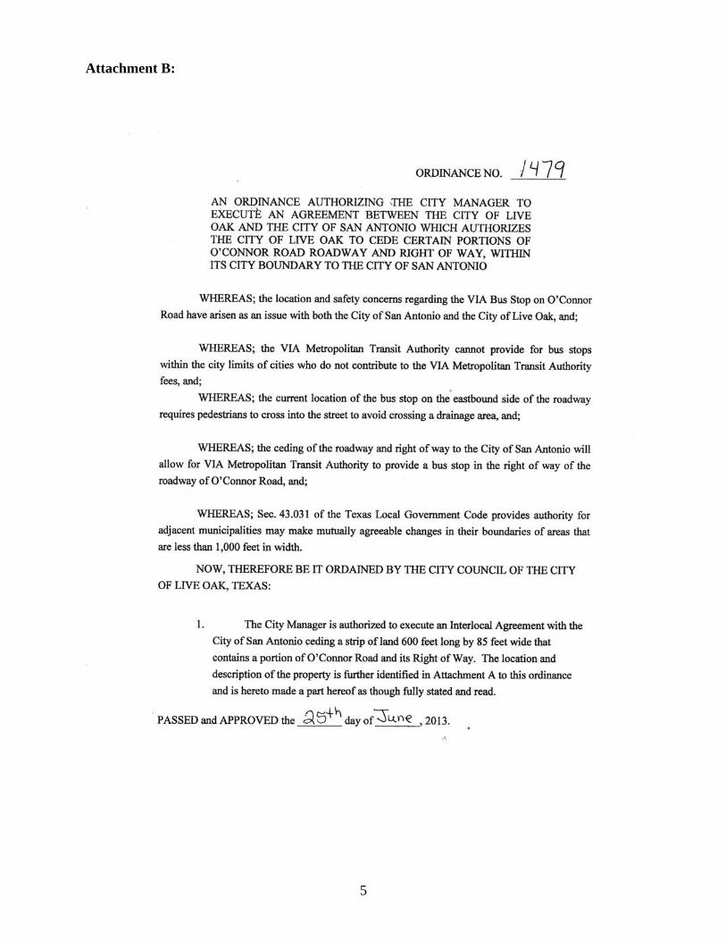
5
Attachment B:
6

7

RESOLUTION NO.
RECOMMENDING APPROVAL OF A MUNICIPAL BOUNDARY ADJUSTMENT OF APPROXIMATELY 1.14 ACRES OF LAND FROM THE CITY OF LIVE OAK TO THE CITY OF SAN ANTONIO. THE SUBJECT AREA BEING GENERALLY LOCATED ALONG O’CONNOR ROAD, TO THE EAST OF I-35 NORTH, IN THE NORTHEAST OF SAN ANTONIO.
WHEREAS, the City of Live Oak has requested the transfer of approximately 1.14 acres from its city limits to the City of San Antonio; and,
WHEREAS, the Texas Local Government Code provides authority for adjacent municipalities to make mutually agreeable changes in their boundaries of areas that are less than 1,000 feet in width; and,
WHEREAS, the transfer of territory to the City of San Antonio does not conflict with the City of San Antonio’s Annexation Policy, adopted on February 14, 2013; and,
WHEREAS, if subject area is released into the City of San Antonio, VIA Metropolitan Transit would voluntarily add another bus stop along the westbound lane of O’Connor Road; and,
WHEREAS, the City of San Antonio recognizes the need for increased pedestrian and bus patron safety; and,
WHEREAS, the Planning Commission has considered the request from the City of Live Oak to release approximately 1.14 acres from their city limits to the City of San Antonio as described in Attachment I, and as depicted on the map in Attachment II, to the City Council for adoption.
NOW, THEREFORE, BE IT RESOLVED BY THE PLANNING COMMISSION OF THE CITY OF SAN ANTONIO

SECTION 1: The Planning Commission recommends approval of a Municipal Boundary Adjustment of approximately 1.14 acres of land from the City of Live Oak to the City of San Antonio as particularly described in Attachment I, and depicted on the map in Attachment II, to the City Council for adoption.
PASSED AND APPROVED ON THIS 12th DAY OF MARCH 2014.
____________________________ Attest: Roberto R. Rodriguez, Chair
San Antonio Planning Commission
___________________________ Executive Secretary San Antonio Planning Commission

Attachment I:
Survey is currently in progress. Survey will be completed prior to City Council consideration.
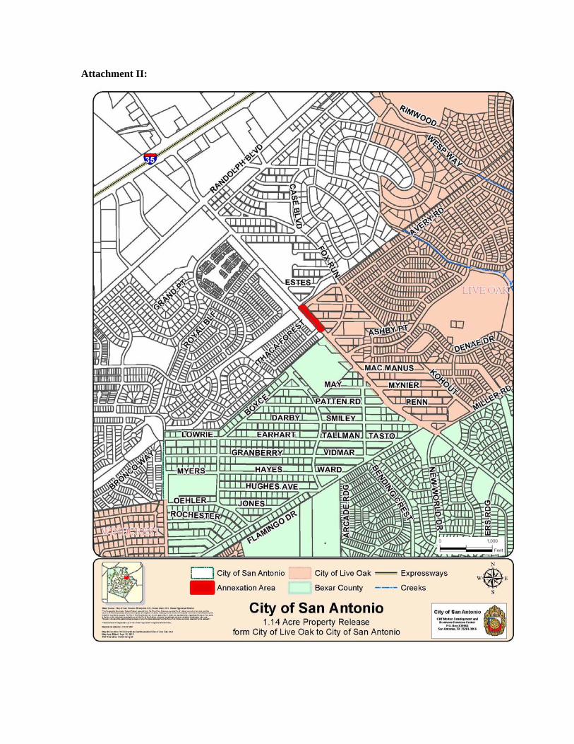
Attachment II: