mapsit and a roadmap for lunar and planetary spatial data ... · pdf filelaser retroreflector...
TRANSCRIPT
MAPSIT and a Roadmap for Lunar and Planetary Spatial Data Infrastructure
B. Archinalfor the MAPSIT Steering Committee
LEAGColumbia, MD
2017 October 10
Outline
• Who are we again?
• What is Planetary Spatial Data Infrastructure?
• A path forward – a PSDI roadmap

MAPSIT – Mapping and Planetary Spatial Infrastructure Team
• The planetary community and NASA recognized the need for community input on how to help missions obtain data, and how to help users access and use data
• This team is the result• To some extent, follows on to past organizations
such as the Planetary Cartography & Geologic Mapping Working Group
• An Analysis/Assessment Group (AG) like LEAGetc., but independent of location in Solar System– Point of Contact at NASA HQ is Sarah Noble

MAPSIT – Mapping and Planetary Spatial Infrastructure Team
Steering Committee• Jani Radebaugh, Brigham Young
University [Chair]• Samuel Lawrence, Arizona State
University [Chair Emeritus]• Brad Thomson, University of
Tennessee Knoxville [Vice Chair]• Brent Archinal, United States
Geological Survey• Daniella DellaGiustina, University of
Arizona• Caleb Fassett, NASA Marshall
Spaceflight Center• Lisa Gaddis, United States Geological
Survey• Justin Hagerty, United States
Geological Survey
• Trent Hare, United States Geological Survey
• Jay Laura, United States Geological Survey
• Erwan Mazarico, NASA Goddard Space Flight Center
• Andrea Naß, German Aerospace Center DLR
• Alex Patthoff, Planetary Science Institute
• James Skinner, United States Geological Survey
• Sarah Sutton, University of Arizona• David Williams, Arizona State
University
Website: http://www.lpi.usra.edu/mapsit

Reason for MAPSIT
• Mosaics, geologic maps, derived regional and global data products and associated geospatial infrastructure are integral to the success of the planetary science enterprise
• Influence all phases of the mission lifecycle for science investigations and operations
• Strategic needs must be anticipated and prioritized by the community

Role of MAPSIT
• Self-tasked with aiding in creation of Planetary Spatial Data Infrastructure(s) or PSDIs.
• The vast volumes of terrestrial remote sensing data have generated similar discussions, needs, and Spatial Data Infrastructure (SDI) frameworks.
• Extending this concept to lunar and planetary data • Need strategies for obtaining, processing and storing
data, developing and supporting various technologies, aiding user community to easily access and use data.
• See terms of reference on websitehttps://www.lpi.usra.edu/mapsit/terms-of-reference.pdf
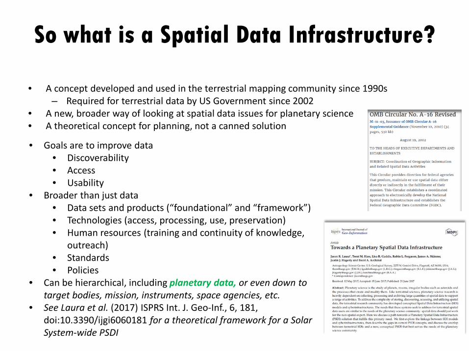
So what is a Spatial Data Infrastructure?
• A concept developed and used in the terrestrial mapping community since 1990s– Required for terrestrial data by US Government since 2002
• A new, broader way of looking at spatial data issues for planetary science• A theoretical concept for planning, not a canned solution
• Goals are to improve data• Discoverability• Access• Usability
• Broader than just data• Data sets and products (“foundational” and “framework”)• Technologies (access, processing, use, preservation)• Human resources (training and continuity of knowledge,
outreach)• Standards• Policies
• Can be hierarchical, including planetary data, or even down to target bodies, mission, instruments, space agencies, etc.
• See Laura et al. (2017) ISPRS Int. J. Geo-Inf., 6, 181, doi:10.3390/ijgi6060181 for a theoretical framework for a Solar System-wide PSDI

Elements of a SDI
DataPeople
Data Access
Standards
Policy
Develop critical skillsEngage stakeholdersConnect with new/non-expert users
S/w to process low to high level
data
DYNAMICCUMULATIVE
Technology
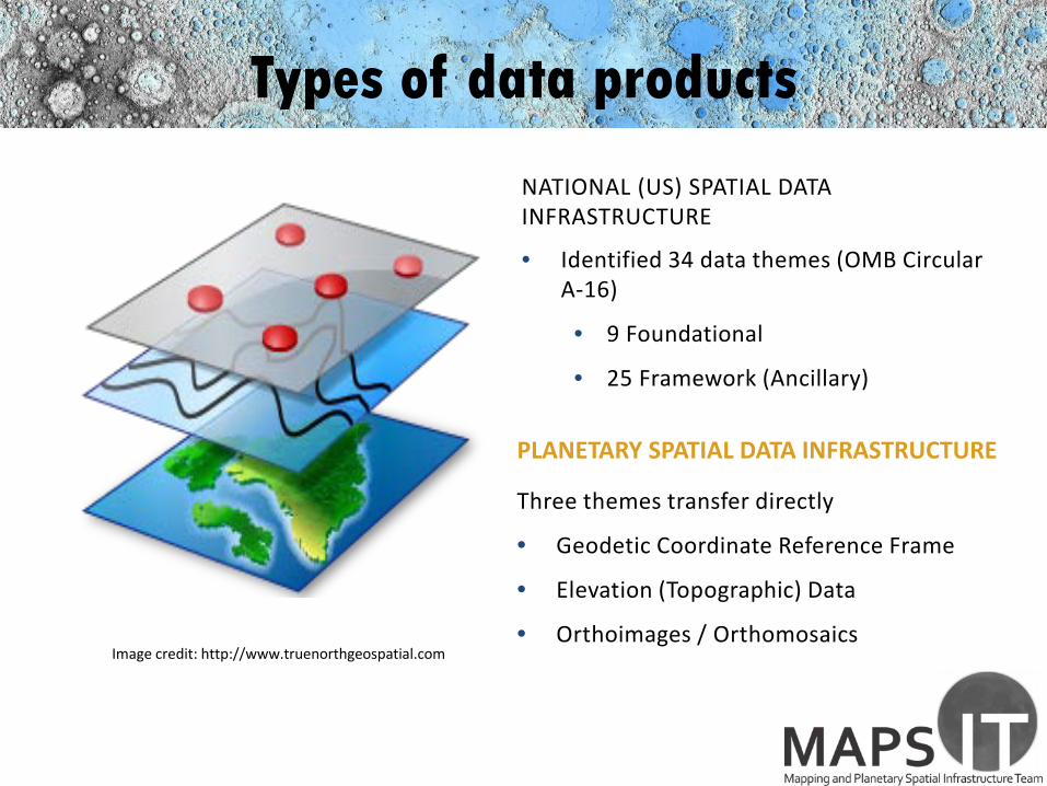
Types of data products
NATIONAL (US) SPATIAL DATA INFRASTRUCTURE
• Identified 34 data themes (OMB Circular A-16)
• 9 Foundational
• 25 Framework (Ancillary)
PLANETARY SPATIAL DATA INFRASTRUCTURE
Three themes transfer directly
• Geodetic Coordinate Reference Frame
• Elevation (Topographic) Data
• Orthoimages / OrthomosaicsImage credit: http://www.truenorthgeospatial.com

Lunar ExamplesGeodetic Coordinate Reference Frame
• IAU defined lat/lon and ephemeris• Planetary is special: geodetic coordinate
reference frames are iteratively defined as data improves. (laser altimetry (e.g. LOLA) for the Moon)
• As a non spatial expert - these should just work
Elevation Data• Many options: LRO LOLA, LRO WAC Stereo,
Kaguya Stereo, Apollo Metric and Panoramic Stereo, Chandrayaan-1 Stereo, LROC NAC Stereo
• Highlight the importance of a geodetic coordinate reference frame to support integration
• As a non spatial expert - these should just work
Laser Retroreflector – A14https://inspirehep.net/record/1194067/plots
SELENOGRAPHIC Coordinateshttps://en.wikipedia.org/wiki/Selenographic_coordinates
Background: Global LOLA Topographic Modelhttps://astropedia.astrogeology.usgs.gov

Lunar Examples
Orthorectified Data / Orthomosaics• Many options:
– Aligned to LOLA: LROC WAC, Apollo Metric and Pan, LROC NAC, Chandrayaan-1, LRO Mini-RF
– Not aligned to LOLA: Lunar Orbiter, Clementine, Kaguya TC• See a triad of self-supporting, foundational data• As a non spatial expert - these should just workError• How good are my data?• Error in the foundation propagates• As a non spatial expert - this is what you should be worried
about once it all works
Background: Global LROC WAC Orthomosaichttps://astropedia.astrogeology.usgs.gov
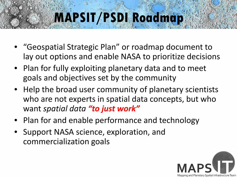
MAPSIT/PSDI Roadmap
• “Geospatial Strategic Plan” or roadmap document to lay out options and enable NASA to prioritize decisions
• Plan for fully exploiting planetary data and to meet goals and objectives set by the community
• Help the broad user community of planetary scientists who are not experts in spatial data concepts, but who want spatial data “to just work”
• Plan for and enable performance and technology• Support NASA science, exploration, and
commercialization goals

Roadmap Themes and Goals
A. Ensure planetary data just work!• Develop a clearinghouse for planetary data• Help make science-ready data available
B. Strategize for needed expertise, tools, and capability• Advocate for availability and development of tools• Ensure key expertise for PSDI is maintained• Propel technology forward
C. Enable future NASA science, exploration, and commercial development goals
• Provide input on foundational data products needed for mission success
• Recommend standards for data infrastructure for future missions

Need to Consider Previous Lunar (and other) Planning Documents
• Lunar Exploration Roadmap
• Lunar SKGs• Lunar Capabilities
Roadmap • etc.
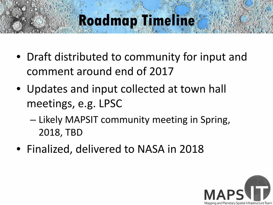
Roadmap Timeline
• Draft distributed to community for input and comment around end of 2017
• Updates and input collected at town hall meetings, e.g. LPSC– Likely MAPSIT community meeting in Spring,
2018, TBD
• Finalized, delivered to NASA in 2018

Conclusions
• MAPSIT is working with NASA to determine how best to encourage creation of Planetary Spatial Data Infrastructures for better generation, access and use of planetary data.
• Input from the planetary community, both U.S. and international, is necessary for the success of this endeavor
Website: http://www.lpi.usra.edu/mapsit

Backup

What PSDI is Not...
• PSDI ≠ PSD (NASA Planetary Science Division)• PSDI ≠ DPS (Division of Planetary Science of AAS
and its conferences)• PSDI ≠ PDS (NASA Planetary Data System)
– PDS focuses on• Data formatting standards• Documentation of data• Archiving and preservation• Lower level data as a higher priority than derived data
– These are an important subset of the goals of PSDI

Planetary SDIs can be Hierarchical
Instrument
Mission
Target body
National
Global

MAPSIT, PSDI and the PDS
• The Planetary Data System (PDS) is tasked with stability, security and long-term preservation of data
• A Planetary Spatial Data Infrastructure (PSDI) must address data usability and straightforward data access
• MAPSIT is concerned with user needs and the evolution of the human/technology interface
• Data needs to be accessible and useable
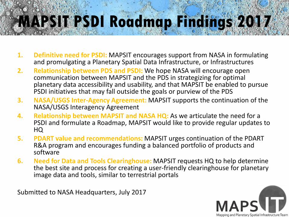
MAPSIT PSDI Roadmap Findings 2017
1. Definitive need for PSDI: MAPSIT encourages support from NASA in formulating and promulgating a Planetary Spatial Data Infrastructure, or Infrastructures
2. Relationship between PDS and PSDI: We hope NASA will encourage open communication between MAPSIT and the PDS in strategizing for optimal planetary data accessibility and usability, and that MAPSIT be enabled to pursue PSDI initiatives that may fall outside the goals or purview of the PDS
3. NASA/USGS Inter-Agency Agreement: MAPSIT supports the continuation of the NASA/USGS Interagency Agreement
4. Relationship between MAPSIT and NASA HQ: As we articulate the need for a PSDI and formulate a Roadmap, MAPSIT would like to provide regular updates to HQ
5. PDART value and recommendations: MAPSIT urges continuation of the PDART R&A program and encourages funding a balanced portfolio of products and software
6. Need for Data and Tools Clearinghouse: MAPSIT requests HQ to help determine the best site and process for creating a user-friendly clearinghouse for planetary image data and tools, similar to terrestrial portals
Submitted to NASA Headquarters, July 2017

End