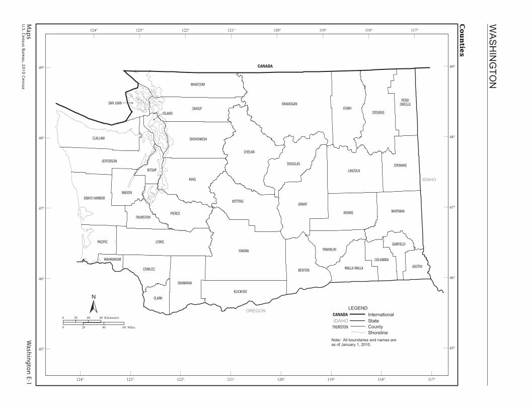
maps - census w ashington e-1 u.s. census bureau, ... soap lake warden waterville wenatchee wilson...
TRANSCRIPT
Map
s W
ashin
gto
n E-1
U.S. C
ensu
s Bureau
, 20
10
Cen
sus
WASHINGTO
N
CANADA
ADAMS
ASOTINBENTON
CHELAN
CLALLAM
CLARK
COLUMBIA
COWLITZ
DOUGLAS
FERRY
FRANKLIN
GRANTGRAYS HARBOR
ISLAND
JEFFERSON
KING
KITSAP
LEWIS
LINCOLN
OKANOGAN
PACIFIC
PIERCE
SAN JUANSKAGIT
SNOHOMISH
STEVENS
THURSTON
WALLA WALLA
WHATCOM
WHITMAN
YAKIMA
GARFIELD
KLICKITAT
MASON
PENDOREILLE
SKAMANIA
SPOKANE
WAHKIAKUM
KITTITAS
IDAHO
OREGON
Countie
s
Note: All boundaries and names are as of January 1, 2010.
LEGENDCANADA InternationalIDAHO State
THURSTON CountyShoreline
117°
117°
118°
118°
119°
119°
120°
120°
121°
121°
122°
122°
123°
123°
124°
124°
49° 49°
48° 48°
47° 47°
46° 46°
45° 45°
0 20 40 60 Kilometers
0 20 40 60 Miles
E-2 Washington MapsU.S. Census Bureau, 2010 Census
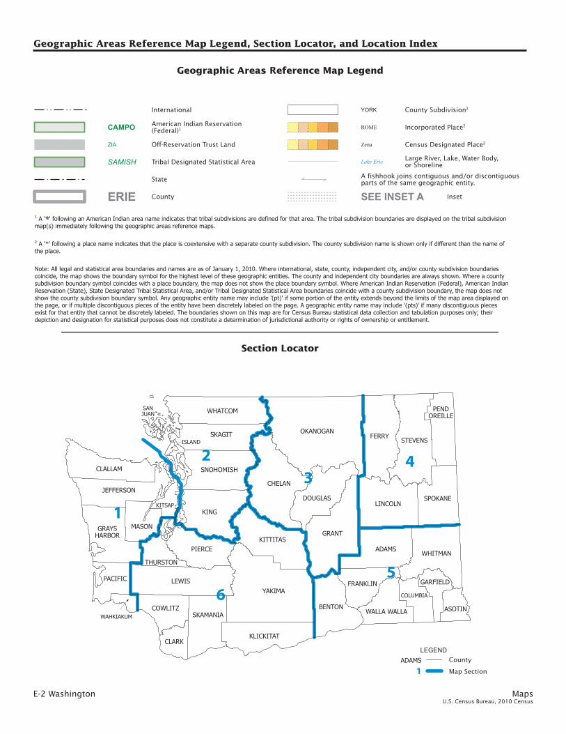
Geographic Areas Reference Map Legend, Section Locator, and Location Index
YAKIMA
OKANOGAN
KING
GRANT
LEWIS
CHELAN
FERRYSTEVENS
ADAMS
LINCOLN
KITTITAS
SKAGIT
PIERCEWHITMAN
BENTON
WHATCOM
CLALLAM
DOUGLAS SPOKANE
KLICKITAT
SNOHOMISH
JEFFERSON
SKAMANIA
MASON
FRANKLIN
COWLITZ
PACIFIC
CLARK
WALLA WALLA ASOTIN
THURSTON
GRAYSHARBOR
PENDOREILLE
COLUMBIA
GARFIELD
KITSAP
ISLAND
WAHKIAKUM
SANJUAN
6
3
5
4
1
2
Geographic Areas Reference Map Legend
Census Designated Place2
Large River, Lake, Water Body,or Shoreline
Zena
Lake Erie
American Indian Reservation(Federal)1CAMPO
Off-Reservation Trust LandZIA
Inset
A fishhook joins contiguous and/or discontiguousparts of the same geographic entity.
SEE INSET A
LEGENDADAMS County
1 Map Section
State
Incorporated Place2ROME
YORK County Subdivision2
CountyERIE
Tribal Designated Statistical Area
International
SAMISH
Note: All legal and statistical area boundaries and names are as of January 1, 2010. Where international, state, county, independent city, and/or county subdivision boundariescoincide, the map shows the boundary symbol for the highest level of these geographic entities. The county and independent city boundaries are always shown. Where a countysubdivision boundary symbol coincides with a place boundary, the map does not show the place boundary symbol. Where American Indian Reservation (Federal), American IndianReservation (State), State Designated Tribal Statistical Area, and/or Tribal Designated Statistical Area boundaries coincide with a county subdivision boundary, the map does notshow the county subdivision boundary symbol. Any geographic entity name may include ’(pt)’ if some portion of the entity extends beyond the limits of the map area displayed onthe page, or if multiple discontiguous pieces of the entity have been discretely labeled on the page. A geographic entity name may include ’(pts)’ if many discontiguous piecesexist for that entity that cannot be discretely labeled. The boundaries shown on this map are for Census Bureau statistical data collection and tabulation purposes only; theirdepiction and designation for statistical purposes does not constitute a determination of jurisdictional authority or rights of ownership or entitlement.
1 A ’ ’ following an American Indian area name indicates that tribal subdivisions are defined for that area. The tribal subdivision boundaries are displayed on the tribal subdivisionmap(s) immediately following the geographic areas reference maps.
**
2 A ’*’ following a place name indicates that the place is coextensive with a separate county subdivision. The county subdivision name is shown only if different than the name ofthe place.
Section Locator

Maps Washington E-3U.S. Census Bureau, 2010 Census
COUNTY MAPSEC
Adams 5Asotin 5Benton 5Chelan 3Clallam 1Clark 6Columbia 5Cowlitz 6Douglas 3Ferry 4Franklin 5Garfield 5Grant 3Grays Harbor 1Island 2Jefferson 1King 2Kitsap 1Kittitas 6Klickitat 6Lewis 6Lincoln 4Mason 1Okanogan 3Pacific 1Pend Oreille 4Pierce 6San Juan 2Skagit 2Skamania 6Snohomish 2Spokane 4Stevens 4Thurston 6Wahkiakum 1Walla Walla 5Whatcom 2Whitman 5Yakima 6
Map section numbers refer to the geographic areas reference maps only.This list presents the map section numbers for each county in the state.
County Location Index
Geographic Areas Reference Map Legend, Section Locator, and Location Index

E-4 Washington MapsU.S. Census Bureau, 2010 Census
CLALLAM
GRAYSHARBOR
JEFFERSONKITSAP
MASON
PACIFIC
WAHKIAKUM
1
22
1
1 2
2
3
45
1
KEY
1 JAMESTOWN S’KLALLAM2 JAMESTOWN S’KLALLAM (pts)
GRAYS HARBOR12345
HOQUIAMABERDEEN (pt)COSMOPOLISJunction CityABERDEEN-HOQUIAM
PACIFIC1 SQUAXIN ISLAND (pts)
CLALLAM
MASON
1 SHOALWATER BAY
SEE INSET B
CATHLAMET
ELMA
FORKS
ILWACO
OAKVILLE
LONG BEACH
McCLEARYMONTE-
SANO
OCEAN SHORES
PORTANGELES
PORT TOWNSEND
RAY-MOND
SEQUIM
SHELTON
SOUTHBEND
WESTPORT
BayCenter
Belfair
BellHill
Blyn
Brady
Brinnon
Cohassett Beach
CopalisBeach
Carls-borg
CentralPark
Chinook
ClallamBay
AberdeenGardens
Allyn
Altoona
AmandaPark
Deep River
East Cathlamet
Grapeview
Grayland
GraysRiver
Hogans Corner
Hoodsport
Humptulips
James-town
Lebam
Lower Elochoman
Markham
Marrowstone
Malone
Oyehut
Pacific BeachMoclips
Naselle
Neah Bay
Neilton
Ocean City
Ocean Park
Sekiu
Skamo-kawaValley
Skokomish
PortAngeles
East
Porter
Port Hadlock-Irondale
PortLudlow
Puget Island
Queets
Quilcene
Qui-nai-elt Village
RiverRoad
Rosburg
Santiago
Satsop
Willapa
Taholah
Tokeland
Union
Upper Elochoman
SQUAXINISLAND (pts)
QUILEUTE
QUINAULT
CHEHALIS (pt)
LOWERELWHA (pt)
MAKAH
HOH
SHOALWATERBAY
SKOKOMISH
CHEHALIS (pts)
SQUAXINISLAND (pts)
LOWERELWHA (pts)
CATHLAMET
GRAYS RIVER
PUGET ISLAND
SKAMOKAWA
AGNEW-
CARLSBORG
CLALLAM BAY-NEAH BAY
CRESCENT
FORKS
PORTANGELES
SEQUIM
ELMA
HUMP-TULIPS
McCLEARY
MALONE-PORTER
MONTE-SANO
NEILTON
NORTH RIVER
OAKVILLE
OCEANSHORES
QUINAULTRESERVATION
WESTPORT
WISHKAH
DISCOVERY BAY-PORT TOWNSEND
OAK BAY-PORT LUDLOW
QUILCENE BAY-BRINNONWEST END
BELFAIR-TAHUYA
KAMIL-CHE
SHELTON
SKOKOMISHRESERVATION TIMBER LAKE-
HARSTINE ISLAND
UNION-GRAPEVIEW
WEST MASON
LONG BEACH-NORTHBEACH PENINSULA
NASELLE
RAYMOND
WILLAPA VALLEY
SEESECTION 2
SEESECTION 6
Columbia River
PacificOcean
PugetSound
Straight of Juan De Fuca
American Indian Areas, Counties, County Subdivisions, and Places - Section 1
0 8 16 24 Kilometers
0 8 16 24 Miles
122°122°30’
122°30’
123°
123°
123°30’
123°30’
124°
124°
124°30’
124°30’125°
48°3
0’
48°3
0’
48°
48°
47°3
0’
47°3
0’
47°
47°
46°3
0’
46°3
0’
46°
46°

Maps Washington E-5U.S. Census Bureau, 2010 Census
ISLAND
KING
SAN JUAN
SKAGIT
SNOHOMISH
WHATCOM
NOOKSACK (pts)
21
34
5
7 6
BLACKDIAMOND (pts)12
3
41
5
6
7
KEY
1 MUCKLESHOOT (pt)2 Lake Holm (pt)34567
Lake Morton-Berrydale (pt)AUBURN (pt)KENT (pt)MAPLE VALLEY (pt)SNOQUALMIE
1 LUMMI RESERVATION2 LUMMI34567
GenevaMarietta-AlderwoodBELLINGHAMNOOKSACKEVERSON
KING WHATCOM
SEE INSET A
SEE INSET B
BLAINE
DARRINGTON
DUVALL
CARNATION (pts)
CONCRETE
ENUMCLAW (pts)
EVERETT (pt)
FERN-DALE
FRIDAYHARBOR
GOLDBAR
INDEX
NORTH BEND
LYNDEN
SKYKOMISH
SNOQUALMIE
SULTAN
SUMAS
BirchBay
Acme
Baring
Fall City
Custer
Deming
Lake Marcel-Stillwater
GlacierKendall
Marblemount
May Creek
Maple Falls
Peaceful Valley
NorthSultan
PointRoberts
Ravensdale
Riverbend
Rockport
Wilderness Rim
Startup
Sudden Valley
SwedeHeaven
Tanner
SAUK-SUIATTLE
MUCKLESHOOT (pt)
NOOK-SACK(pts)
NOOKSACK (pts)
SAMISH (pt)LOPEZ
ORCAS
SAN JUANISLAND
EAST SKAGIT
DARRINGTON
SULTAN
BELLINGHAM
BLAINE
EAST WHATCOM
FERNDALELUMMI
ISLAND
LYNDEN
POINTROBERTS
SUMAS
ENUMCLAW PLATEAU
SNOQUALMIE VALLEY
SEESECTION 1
SEESECTION 3
SEESECTION 6
PugetSound
American Indian Areas, Counties, County Subdivisions, and Places - Section 2
0 8 16 24 Kilometers
0 8 16 24 Miles
120°30’
120°30’
121°
121°
121°30’
121°30’
122°
122°
122°30’
122°30’
123°
123°123°30’
49°
49°
48°3
0’
48°3
0’
48°
48°
47°3
0’
47°3
0’
47°
47°

E-6 Washington MapsU.S. Census Bureau, 2010 Census
CHELAN
DOUGLAS
GRANT
OKANOGAN
BREWSTER
BRIDGE-PORT
EAST WENATCHEE
CASHMERE
CHELAN
CONCONULLY
COULEECITY
COULEE DAM
KRUPP
LEAVENWORTH
ELECTRIC CITY
ELMER CITY
ENTIAT
EPHRATA
GEORGE
GRAND COULEE
HARTLINE
NES-PELEM
MANSFIELD
MATTAWA
MOSESLAKE
OKANOGAN
OMAK
OROVILLE
PATEROS
RIVERSIDE
ROCKISLAND
QUINCY
TONASKET
TWISP
ROYAL CITY
SOAPLAKE
WARDEN
WATERVILLE
WENATCHEE
WILSONCREEK
WINTHROP
CascadeValley
ChelanFalls
Banks LakeSouth
Desert Aire
Disautel
Lake-view
Loomis
Malott
Manson
Methow
Moses LakeNorth
NespelemCommunity
North Omak
SouthWenatchee
Sunnyslope
COLVILLE (pt)
COLVILLE
CASHMERE
CHELAN
ENTIATLEAVENWORTH-
LAKE WENATCHEE
MALAGA
MANSON
STEHEKIN
WENAT-CHEE
BRIDGEPORT
EAST WENATCHEE
WATERVILLE
COULEE CITY
EPHRATA-SOAP LAKE
GEORGE
GLOYD
GRANDCOULEE
MATTAWA-ROYAL CITY
MOSESLAKE
QUINCY
WARDEN
WILSONCREEK
BREWSTER-WAKEFIELD
COLVILLERESERVATION
CONCONULLY-RIVERSIDE
EARLY WINTERS
METHOW VALLEY
OKANOGAN
OMAK
OROVILLE
TONASKET
SEESECTION 2 SEE
SECTION 4
SEESECTION 5
SEESECTION 6
BanksLake
Columbia RiverColum
bia River
LakeChelan
PotholesReservoir
118°30’
118°30’
119°
119°
119°30’
119°30’
120°
120°
120°30’
120°30’
121°
121°
121°30’
121°30’
49° 49
°
48°3
0’
48°3
0’
48° 48
°
47°3
0’
47°3
0’
47° 47
°
46°3
0’
46°3
0’
American Indian Areas, Counties, County Subdivisions, and Places - Section 3
0 8 16 24 Kilometers
0 8 16 24 Miles

Maps Washington E-7U.S. Census Bureau, 2010 Census
FERRY
LINCOLN
PENDOREILLE
SPOKANE
STEVENS
12
3
4
5 6
7
KEY
1 KALISPEL (pt)2 KALISPEL (pt)34567
SPOKANE (pt)Country HomesTown and CountryMILLWOODSPOKANE
SPOKANE
CRESTON
CUSICK
DAVENPORT
DEERPARK
CHENEY
CHEWELAH
COLVILLE
AIRWAYHEIGHTS
ALMIRA
LATAH
FAIRFIELD
HARRINGTON
IONE
KETTLEFALLS
NEWPORT
NORTHPORT
LIBERTY LAKE
MARCUS
MEDICALLAKE
METALINE
METALINE FALLS
ODESSA
ROCKFORD
REARDAN
REPUBLIC
SPANGLE
SPOKANESPOKANEVALLEY
SPRAGUE
SPRINGDALE
WAVERLY
WILBUR
Boyds
Curlew
Curlew Lake
Clayton
Addy
Barney’sJunction
Barstow
FairchildAFB
Fairwood
FourLakes
Danville Laurier
Green Bluff
Inchelium
Keller
Loon Lake
Mead
Malo
Otis Orchards-East Farms
PineGrove
Orient
Torboy
Twin Lakes
ValleyCOLVILLE (pt)
KALISPEL (pt)
SPOKANE
KALI-SPEL (pt)
SPOKANE
IONE-METALINE FALLS
NEWPORT
AIRWAYHEIGHTS
AMBER-CHENEYSOUTH
CHENEY-MEDICAL LAKE
COLBERTDEERPARK
LIBERTY LAKE
MOUNTSPOKANE
ROCKFORD
SPOKANESOUTH VALLEYFORD
CHEWELAH
COLVILLE
HUNTERS-GIFFORD
KETTLE FALLS
LOON LAKESPOKANE RESERVATION
SPRINGDALECOLVILLERESERVATION
CURLEW
EAST FERRY
REPUBLIC
DAVENPORT
ODESSA
WILBUR
SEESECTION 3
SEESECTION 5
Columbia River
SpokaneRiver
116°30’
117°
117°
117°30’
117°30’
118°
118°
118°30’
118°30’
119°
119°
119°30’
119°30’
49°
49°
48°3
0’
48°3
0’
48°
48°
47°3
0’
47°3
0’
47°
47°
American Indian Areas, Counties, County Subdivisions, and Places - Section 4
0 8 16 24 Kilometers
0 8 16 24 Miles

E-8 W
ashin
gto
n
Map
sU
.S. Cen
sus Bu
reau, 2
01
0 C
ensu
s
ADAMS
ASOTIN
BENTON
COLUMBIAFRANKLIN
GARFIELD
WALLA WALLA
WHITMAN
BENTONCITY
DAYTON
CLARKSTON
COLFAX
COLLEGEPLACE
COLTON
CONNELL
ALBION
ASOTIN
LaCROSSE
LAMONT
ENDICOTT
FARMINGTON
GARFIELD
HATTON
KAHLOTUS
KENNE-WICK
OAKESDALE
LIND
MALDEN
MESA
OTHELLO
PALOUSE
PASCO
RITZVILLE
ROSALIA
POMEROY
PRESCOTT
PROSSER
PULLMAN
RICHLAND
UNION-TOWN
WAITSBURG
WALLA WALLA
ST. JOHN
STARBUCK
TEKOA
WASHTUCNA
WESTRICHLAND
Bur-bank
Clarkston Heights-Vineland
BasinCity
Finley
Garrett
Dixie
West Clarkston-Highland
WestPasco
Steptoe
Touchet
Walla WallaEast
Wallula
BURBANK
EUREKA FLAT
TOUCHET
WAITSBURG
WALLA WALLA-COLLEGE PLACE
COLFAX-PALOUSE
GARFIELD-OAKESDALE
LaCROSSE PULLMAN
ROCK LAKE
ROSALIA TEKOA
UNIONTOWN
LIND-WASHTUCNA
OTHELLO
RITZVILLE
ASOTIN
CLARKSTON
BENTONCITY
HANFORD SITE
NORTHWESTBENTON
RICHLAND-KENNEWICK
SOUTH BENTON
DAYTON
STARBUCK
CONNELL
KAHLOTUS
PASCO
PASCONORTH
POMEROY
SNAKERIVER
SEESECTION 3
SEESECTION 4
SEESECTION 6
ColumbiaRiver
Snak
e Rive
r
Am
eric
an
Ind
ian
Are
as, C
ou
ntie
s, C
ou
nty
Su
bd
ivis
ion
s, a
nd
Pla
ces - S
ectio
n 5
0 8 16 24 Kilometers
0 8 16 24 Miles
116°30’
117°
117°
117°30’
117°30’
118°
118°
118°30’
118°30’
119°
119°
119°30’
119°30’
120°
120°
47°30’47°
47°
46°30’
46°30’
46°
46°
45°30’
45°30’

Map
s W
ashin
gto
n E-9
U.S. C
ensu
s Bureau
, 20
10
Cen
sus
CLARK
COWLITZ
KITTITAS
KLICKITAT
LEWIS
PIERCE
SKAMANIA
THURSTON
YAKIMA1
2
YAKAMANATION (pts)
YAKAMANATION (pts)
1
2
34 5
6
Ronald
KEY
1 NEWAUKUM PRAIRIE2 NAPAVINE
YAKIMA123456
NACHESTIETONCowicheEschbachGleedSELAH
LEWIS
WOODLAND
DALLESPORT-KLICKITAT
SEEINSET C
SEE INSET DBINGEN
CARBONADO (pt)
CASTLEROCK
CENTRALIACHEHALIS
CLE ELUM
KITTITAS
LACENTER
ELLENSBURG
GOLDENDALE
GRAND-VIEW
GRANGER
HARRAH
KALAMA
KELSO
NORTHBONNEVILLE
LONGVIEW
MABTON
MORTON
MOSSY-ROCK
MOXEENAPA-VINE
PE ELL
TOLEDO
TOPPENISH
UNION GAP
VADERWAPATO
ROSLYN
SOUTHCLE ELUM
STEVENSON
SUNNY-SIDE
WHITESALMON
WILKESON (pt)
WINLOCK
WOODLANDYACOLT
YAKIMA
ZILLAH
Bickleton
Crocker
Buena
CarsonCenterville
Cliffdell
Ahtanum
Amboy
FordsPrairie
Dallesport
Donald
Easton
Klickitat
Green-water
Longview Heights
Lyle
Maryhill
Outlook
Packwood
Parker
Mineral
Nile
Onalaska
SnoqualmiePass
Roosevelt
Ryderwood
West SideHighway
White Swan
Summit-view
Tampico
TerraceHeights
Thorp
TroutLake
Vantage
Wishram
YAKAMANATION (pts)
YAKAMA NATION (pt)
YAKAMANATION (pts)
MOUNT RAINIER
CARSON-UNDERWOOD
NORTHBONNEVILLE
NORTH SKAMANIA
STEVENSON
MABTON
NORTHEAST YAKIMA
NORTHWEST YAKIMA
SOUTH YAKIMA
SUNNYSIDE
TOPPENISH-WAPATO
YAKIM
A
LA CENTER YACOLT
CASTLE ROCK
KALAMA
LONGVIEW-KELSO
NORTHEAST COWLITZ
ROSEVALLEY
CLE ELUM
ELLENSBURG
KITTITAS
MANASTASH RIDGE
NORTHEAST KITTITAS
GOLDENDALE
HORSE HEAVEN HILLS PLATEAU
WHITE SALMON
YAKAMA NATION RESERVATION
BIG BOTTOM
BUNKER
CENTRALIA-CHEHALIS
ETHEL
LOGANHILL MINERAL
MORTON
MOSSYROCKTOLEDO-VADER
WINLOCK-PE ELL
SEESECTION 1
SEESECTION 2
SEESECTION 3
SEE SECTIO
N 5
Columbia River
ColumbiaRiver
ColumbiaRiver
Am
eric
an
Ind
ian
Are
as, C
ou
ntie
s, C
ou
nty
Su
bd
ivis
ion
s, a
nd
Pla
ces - S
ectio
n 6
0 8 16 24 Kilometers
0 8 16 24 Miles
120°
120°
120°30’
120°30’
121°
121°
121°30’
121°30’
122°
122°
122°30’
122°30’
123°
123°
123°30’
123°30’
47°30’
47°30’
47° 47°
46°30’
46°30’
46° 46°
45°30’

E-10
Wash
ingto
n
Map
sU
.S. Cen
sus Bu
reau, 2
01
0 C
ensu
s
ISLAND
SKAGIT (pt)
SNOHOMISH (pt)
1
23
4
5
76
8109
14
1112
13
15
MARYS-VILLE (pt)
16
17
18
KEY
1 BRIER2 Bothell West3456789
Alderwood ManorMILL CREEKMill Creek EastLarch WayMartha LakeNorth LynnwoodLake Stickney
10 Meadowdale1112131415161718
MachiasCavaleroBunk FossSNOHOMISHLAKE STEVENSSTILLAGUAMISH (pts)STILLAGUAMISHNorth Marysville
SNOHOMISH
BOTHELL (pt)
BURLING-TON
COUPEVILLE
EDMONDS
ANACORTES
ARLING-TON
LA CONNER
LANGLEY
EVERETT(pt)
EVERETT(pt)
GRANITEFALLS
HAMILTON
OAKHARBOR
LYMAN
LYNN-WOOD
MARYS-VILLE (pt)
MONROE
MOUNTLAKETERRACE
MOUNTVERNON
MUKILTEO
SEDRO-WOOLLEY
STANWOOD
WOOD-WAY
Bay View
Big Lake
Bothell East
Clinton
Conway
Bryant
CanyonCreek
Cath
cart
Chain Lake
ClearLake
Clea
rvie
w
Alger
ArlingtonHeights
FobesHill
Freeland
East-mont
Edison
Esperance
LakeBosworth
LakeCassidy
Lake Cavanaugh
LakeKetchum
Lake McMurray
Lake Roesiger
Hat Island
HighBridge
Lochsloy
Maltby
PicnicPoint
MonroeNorth
NorthwestStanwood
Oso
Silvana
SilverFirs
SiscoHeights
WhidbeyIslandStation
Sunday Lake
ThreeLakes
Verlot
WarmBeach
WoodsCreek
SWINOMISH
UPPERSKAGIT (pts)
TULALIP*
SWINOMISH
TULALIP
SAMISH (pt)
ANACORTES
BAYVIEW
BOW
BURLING-
TON
CLEARLAKE
CONWAY
LA CONNER
LAKE CAVANAUGH
LYMAN-HAMILTON
MOUNT VERNON
SEDRO-WOOLLEY
SWIN
OM
ISH
RESER
VATION
UPPER SAMISHRIVER
ARLINGTON
EDMONDS
EVERETT
GRANITE FALLSLAKESTEVENS
MALTBY
MARYSVILLE
MONROE
SNOHO-MISH
STANWOOD
TULALIPRESERVATION
CAMANOISLAND
CENTRALWHIDBEYISLAND
NORTHWHIDBEYISLAND
SOUTHWHIDBEYISLAND
PugetSound
Straight ofJuan De Fuca
Am
eric
an
Ind
ian
Are
as, C
ou
ntie
s, C
ou
nty
Su
bd
ivis
ion
s, a
nd
Pla
ces - In
set A
0 3 6 9 Kilometers
0 3 6 9 Miles
121°30’
121°30’
122°
122°
122°30’
122°30’
48°30’
48°30’
48° 48°

Map
s W
ashin
gto
n E-1
1U
.S. Cen
sus Bu
reau, 2
01
0 C
ensu
s
KING (pt)
KITSAP
POULSBO (pt)
12
3
4
5
6
1
2
34
5
7 6
8
ALGONA
POULSBO(pt)
KEY
1 YARROW POINT2 HUNTS POINT345678
CLYDE HILLMEDINABEAUX ARTS VILLAGEBryn Mawr-SkywayRivertonMaple Heights-Lake Desire
KITSAP123456
BREMERTON (pt)GorstEast Port OrchardNavy Yard CityPORT ORCHARDRocky Point
KING
BELLEVUE
BOTHELL (pt)
BREMERTON (pt)
BURIEN
COVINGTONDESMOINES
AUBURN(pt)
BAINBRIDGEISLAND*
LAKE FOREST PARK
FEDERALWAY
ISSAQUAH
KEN-MORE
KENT (pt)
KENT (pt)
KENT (pt)
KIRK-LAND
NEW-CASTLE
NOR-MANDY
PARK
MAPLE VALLEY (pt)
MERCERISLAND
MILTON (pt) PACIFIC (pt)
REDMOND(pt)
REDMOND(pt)
RENTONTUK-WILA
SAMMAMISH
SEATAC
SEATTLE
SHORELINE
WOODINVILLE
Bethel
BoulevardPark
Cottage Lake
Burley
ChicoAmesLake
BangorBase
Fairwood
Eastgate
East Hill-Meridian
East RentonHighlands
Enetai
Erlands Point-Kitsap Lake
Lake Holm (pt)
LakelandNorth
LakelandSouth
Lake Morton-Berrydale (pt)
Hansville
Hobart
Indianola
Inglewood-Finn Hill
KeyportKingsgate
Kingston
Klahanie
Lofall
Man-chester
Parkwood
Mirrormont
ShadowLake
Silver-dale
PortGambleTribal
Comunity
Seabeck
WhiteCenter
Southworth
Suquamish
Tracyton
Union Hill-Novelty Hill
Vashon*
PORT GAMBLE
PORTMADISON
PUYALLUP (pt) MUCKLESHOOT (pt)
PUYALLUP (pt)
MUCKLESHOOT (pt)
FEDERALWAY-AUBURN
ISSAQUAHPLATEAU
SEATTLE
SEATTLEEAST
TAHOMA-MAPLEVALLEY
VASHONISLAND
BREMERTON
KINGSTON
PORT ORCHARD
POULSBO
LakeWashington
PugetSound
Am
eric
an
Ind
ian
Are
as, C
ou
ntie
s, C
ou
nty
Su
bd
ivis
ion
s, a
nd
Pla
ces - In
set B
0 3 6 9 Kilometers
0 3 6 9 Miles
121°45’
121°45’
122°
122°
122°15’
122°15’
122°30’
122°30’
122°45’
122°45’
123°
123°
47°45’ 47°45’
47°30’ 47°30’
47°15’ 47°15’

E-12
Wash
ingto
n
Map
sU
.S. Cen
sus Bu
reau, 2
01
0 C
ensu
s
PIERCE (pt)
THURSTON
TACOMA (pt)
2
1
1
KEY
1 SUMNER (pt)2 North Puyallup
PIERCE
BONNEYLAKE (pt)
BONNEYLAKE (pt)
BUCK-LEY
BUCODA
CARBONADO (pt)
DuPONT
EATONVILLE
EDGE-WOOD
AUBURN (pt)
LACEY
LAKEWOOD
ENUMCLAW (pt)
FIFE
FIRCREST
GIG HARBOR
MILTON (pt)
OLYMPIA
ORTING
PACIFIC (pt)
PUYALLUP
RAINIER
TUMWATER
UNIVERSITYPLACE
ROY
RUSTON
SOUTH PRAIRIE
STEILA-COOM
SUM-NER (pt)
TACOMA (pt)
TENINO
WILKESON (pt)
YELM
CloverCreek
Browns Point
Canter-wood
ClearLake
Alder
Alder-ton
AndersonIsland
Artondale
Ashford
FifeHeights
FortLewis
FoxIsland
Frederick-son
Dash Point
Elbe
Elk Plain
La Grande
LakeTapps
Graham
GrandMound
Herron IslandHome
Kapow
sin
KetronIsland
KeyCenter
Longbranch
McChordAFB
Maple-wood
McKenna
McMillin
Parkland
Midland
NisquallyIndian
Community
NorthFort
Lewis
North Yelm South Creek
South Hill
PrairieHeightsPrairie
Ridge
Purdy
RaftIsland
Rochester
Rosedale
Wauna
Spanaway
StansberryLake
Summit
SummitView
Tanglewilde
Vaughn
Waller
Wollochet
CHEHALIS (pt)
PUYAL-LUP (pt)
MUCKLESHOOT (pt)
NISQUALLY
PUYAL-LUP (pt)
PUYALLUP (pt)
PUYAL-LUP (pt)
PUYALLUP (pt)
CHEHALIS (pt)CHEHALIS (pt)
CHEHALIS (pt)
BUCKLEY
EATONVILLE
FORT LEWIS-DUPONT
GIG HARBORPENINSULA
GRAHAM-THRIFT
KEY PENINSULA-ANDERSON ISLAND
PUYAL-LUP
ROY
TACOMA
OLYMPIA
OLYMPIA EAST
OLYMPIA WEST
THURSTON SOUTH
PugetSound
Am
eric
an
Ind
ian
Are
as, C
ou
ntie
s, C
ou
nty
Su
bd
ivis
ion
s, a
nd
Pla
ces - In
set C
0 2 4 6 Kilometers
0 2 4 6 Miles
122°
122°
122°15’
122°15’
122°30’
122°30’
122°45’
122°45’
123°
123°
47°15’ 47°15’
47°
47°
46°45’ 46°45’
Map
s W
ashin
gto
n E-1
3U
.S. Cen
sus Bu
reau, 2
01
0 C
ensu
s
PIERCE (pt)
THURSTON
TACOMA (pt)
2
1
1
KEY
1 SUMNER (pt)2 North Puyallup
PIERCE
BONNEYLAKE (pt)
BONNEYLAKE (pt)
BUCK-LEY
BUCODA
CARBONADO (pt)
DuPONT
EATONVILLE
EDGE-WOOD
AUBURN (pt)
LACEY
LAKEWOOD
ENUMCLAW (pt)
FIFE
FIRCREST
GIG HARBOR
MILTON (pt)
OLYMPIA
ORTING
PACIFIC (pt)
PUYALLUP
RAINIER
TUMWATER
UNIVERSITYPLACE
ROY
RUSTON
SOUTH PRAIRIE
STEILA-COOM
SUM-NER (pt)
TACOMA (pt)
TENINO
WILKESON (pt)
YELM
CloverCreek
Browns Point
Canter-wood
ClearLake
Alder
Alder-ton
AndersonIsland
Artondale
Ashford
FifeHeights
FortLewis
FoxIsland
Frederick-son
Dash Point
Elbe
Elk Plain
La Grande
LakeTapps
Graham
GrandMound
Herron IslandHome
Kapow
sin
KetronIsland
KeyCenter
Longbranch
McChordAFB
Maple-wood
McKenna
McMillin
Parkland
Midland
NisquallyIndian
Community
NorthFort
Lewis
North Yelm South Creek
South Hill
PrairieHeightsPrairie
Ridge
Purdy
RaftIsland
Rochester
Rosedale
Wauna
Spanaway
StansberryLake
Summit
SummitView
Tanglewilde
Vaughn
Waller
Wollochet
CHEHALIS (pt)
PUYAL-LUP (pt)
MUCKLESHOOT (pt)
NISQUALLY
PUYAL-LUP (pt)
PUYALLUP (pt)
PUYAL-LUP (pt)
PUYALLUP (pt)
CHEHALIS (pt)CHEHALIS (pt)
CHEHALIS (pt)
BUCKLEY
EATONVILLE
FORT LEWIS-DUPONT
GIG HARBORPENINSULA
GRAHAM-THRIFT
KEY PENINSULA-ANDERSON ISLAND
PUYAL-LUP
ROY
TACOMA
OLYMPIA
OLYMPIA EAST
OLYMPIA WEST
THURSTON SOUTH
PugetSound
Am
eric
an
Ind
ian
Are
as, C
ou
ntie
s, C
ou
nty
Su
bd
ivis
ion
s, a
nd
Pla
ces - In
set C
0 2 4 6 Kilometers
0 2 4 6 Miles
122°
122°
122°15’
122°15’
122°30’
122°30’
122°45’
122°45’
123°
123°
47°15’ 47°15’
47°
47°
46°45’ 46°45’
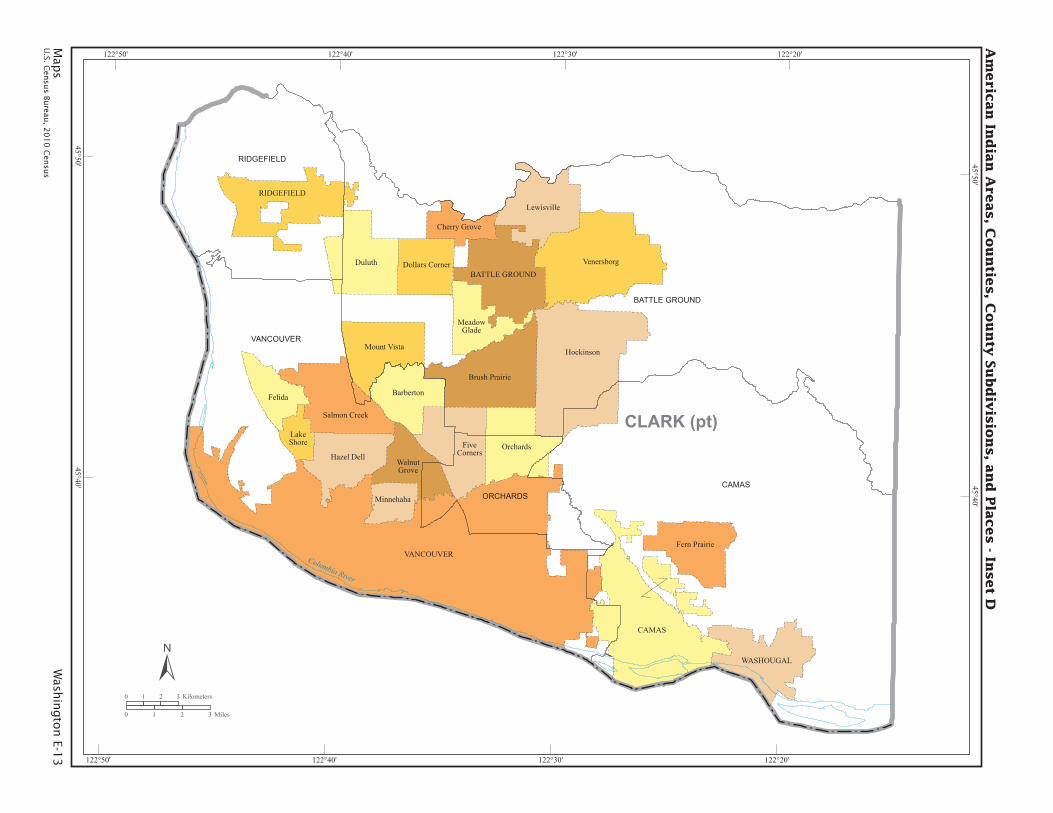
CLARK (pt)
CAMAS
BATTLE GROUND
RIDGEFIELD
VANCOUVER
WASHOUGAL
Brush Prairie
Cherry Grove
BarbertonFelida
Fern Prairie
FiveCorners
Dollars CornerDuluth
LakeShore
Hazel Dell
Hockinson
Lewisville
MeadowGlade
Minnehaha
Mount Vista
Orchards
Salmon Creek
Venersborg
WalnutGrove
BATTLE GROUND
CAMASORCHARDS
RIDGEFIELD
VANCOUVER
Columbia River
Am
eric
an
Ind
ian
Are
as, C
ou
ntie
s, C
ou
nty
Su
bd
ivis
ion
s, a
nd
Pla
ces - In
set D
0 1 2 3 Kilometers
0 1 2 3 Miles
122°20’
122°20’
122°30’
122°30’
122°40’
122°40’
122°50’
122°50’
45°50’ 45°50’
45°40’ 45°40’
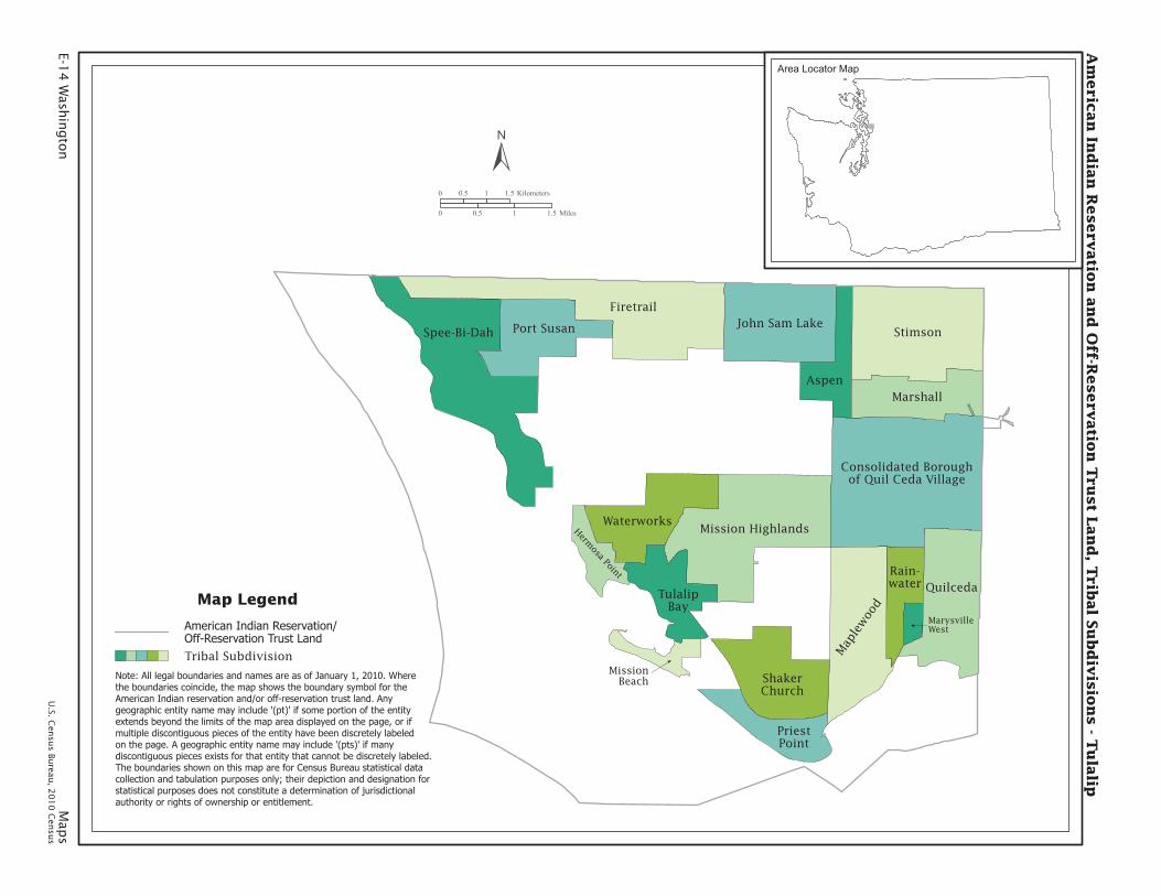
E-14
Wash
ingto
n
Map
sU
.S. Cen
sus Bu
reau, 2
01
0 C
ensu
s
Firetrail
StimsonSpee-Bi-Dah
Quilceda
Mission Highlands
Marshall
John Sam LakePort Susan
Aspen
Waterworks
ShakerChurch
PriestPoint
Map
lew
ood
Consolidated Boroughof Quil Ceda Village
TulalipBay
Rain-water
Hermosa Point
MissionBeach
MarysvilleWest
Am
eric
an
Ind
ian
Reserv
atio
n a
nd
Off-R
eserv
atio
n T
rust L
an
d, T
ribal S
ub
div
isio
ns - T
ula
lip
0 0.5 1 1.5 Kilometers
0 0.5 1 1.5 Miles
Area Locator Map
Map Legend
Tribal Subdivision
American Indian Reservation/Off-Reservation Trust Land
Note: All legal boundaries and names are as of January 1, 2010. Wherethe boundaries coincide, the map shows the boundary symbol for theAmerican Indian reservation and/or off-reservation trust land. Anygeographic entity name may include ’(pt)’ if some portion of the entityextends beyond the limits of the map area displayed on the page, or ifmultiple discontiguous pieces of the entity have been discretely labeledon the page. A geographic entity name may include ’(pts)’ if many discontiguous pieces exists for that entity that cannot be discretely labeled.The boundaries shown on this map are for Census Bureau statistical datacollection and tabulation purposes only; their depiction and designation forstatistical purposes does not constitute a determination of jurisdictionalauthority or rights of ownership or entitlement.