mapping of pastoral corridors: practices and politics in
TRANSCRIPT

Kitchell et al. Pastoralism: Research, Policy and Practice 2014, 4:17http://www.pastoralismjournal.com/content/4/1/17
RESEARCH ARTICLE Open Access
Mapping of pastoral corridors: practices andpolitics in eastern SenegalErin Kitchell1*, Matthew D Turner1 and John G McPeak2
Abstract
The delineation and protection of transhumance corridors are increasingly seen as critical to maintaining livestockmobility in agropastoral areas of West Africa by allowing passage through areas of increasing cropping pressure.Understanding the local politics surrounding the mapping and protection of transhumance corridors is importantfor policy formulation. This study reports the findings of group meetings in nine local districts (communautésrurales) in eastern Senegal about recently mapped corridors. The focus of our observations include local perceptionsof 1) the benefits and costs of corridors, 2) the effect of the recognition of corridors on competing land uses(particularly farming), 3) the need for and means to recognize and protect corridors, and 4) the appropriate level ofauthority to recognize and protect corridors. Our findings show significant geographical variation within the studyarea as to the perceived benefits and costs of corridors, with a major distinction between groups who view thefunction of corridors as protecting local farms from livestock passing through and those that understand corridorsas critical for facilitating access to pastures. Given the significant overlap among multiple formal and informal polesof authority, the politics surrounding corridor delineation and protection are shaped less by the perceived costs tocompeting land uses than by contestation over the authority that designation and protection would require. Policyimplications of findings for land use planning around corridors are discussed.
Keywords: Transhumance corridors; Land use planning; Mapping; Local politics; Formalization
BackgroundThe need to promote and facilitate livestock mobility insemi-arid West Africa has not only been recognized bysocial and biophysical scientists (e.g. Ellis and Swift 1988;Niamir-Fuller 1999; Scoones 1994) but is also increas-ingly recognized by national governments in the region(Bonnet and Hérault 2011; Dongmo et al. 2012; Touré2004; Wabnitz 2006). This recognition, in the form ofbroad statements in support of mobility and the rightsof pastoral peoples, has unfortunately not translatedinto an increase or even the maintenance of livestockmobility (Fernandez-Gimenez and Le Febre 2006; Galvin2009; Niamir-Fuller 1999). Pastoral mobility is shaped notonly by tenure rights but by a whole host of factors includ-ing livestock wealth, labour availability, herding contracts,social insecurity, and social networks (De Bruijn and VanDjik 1995; Galvin 2009; Niamir-Fuller 1999; Turner et al.
* Correspondence: [email protected] of Geography, 160 Science Hall, University ofWisconsin-Madison, 550 N Park St, Madison, WI 53706, USAFull list of author information is available at the end of the article
© 2014 Kitchell et al.; licensee Springer. This isAttribution License (http://creativecommons.orin any medium, provided the original work is p
2014). Nonetheless, regional movements of livestock do re-quire, at a minimum, the ability to move through agropas-toral areas (feeding and watering livestock along the way)on a seasonal basis. Livestock in the region have historicallymoved seasonally along a north-south bioclimatic gradient(12° to 17° north latitude). As a result, most of the region'slivestock are located at the northern end of this gradientduring the rainy season and the southern half of the gradientduring the dry season. These seasonal movements,called transhumance, allow pastoralists to make use ofpredictable variations in pasture quality and availability.Mobility thereby optimizes use of a resource base thatvaries in space and time, with demonstrated benefits tolivestock productivity and rangelands (Diallo 1978;Niamir-Fuller 1999; Penning de Vries and Djitèye 1982;Wagenaar et al. 1986). Corridors play a vital function inareas of mixed land use, particularly in the middle lati-tudes (13.5° to 15° north) where mobility is increasinglyconstrained due to land use competition with cropagriculture. By providing points of passage, corridorshelp maintain access to dispersed pastoral resources in
an Open Access article distributed under the terms of the Creative Commonsg/licenses/by/4.0), which permits unrestricted use, distribution, and reproductionroperly credited.

Kitchell et al. Pastoralism: Research, Policy and Practice 2014, 4:17 Page 2 of 14http://www.pastoralismjournal.com/content/4/1/17
the face of cropping pressure. They are thus central tomaintaining the complementarity and integrity of pas-toral resource systems.A major limitation of current policy and development
efforts to promote livestock mobility is the abstract em-brace of livestock mobility. Just as early French geogra-phers often mapped transhumance movements withbroad arrows covering tens to hundreds of kilometres(e.g. Benoit 1979; Beauvilain 1977; Gallais 1975),a therehas been limited attention to the materiality of transhu-mance corridors at the national level - leaving the workof the recognition and designation of transhumancecorridors to local jurisdictions. As rural peoples in agro-pastoral West Africa recognize, livestock corridors arephysical paths of 5 to 25 m in width worn by repeatedlivestock passage. Important features of these corridorsare pastoral encampment points, often near water, wherecalves and milking cows are separated from each otherand from which livestock disperse to graze. The health ofa corridor system is often less about the presence of a pathof sufficient width to allow livestock to move betweenpoints A and B and more about the quality of pasture andwater accessible from each resting point. A decline in suchaccessibility at locations along the corridor can erode thehealth of the livestock that depend on the corridor andincrease the potential for social conflict between trans-humance herders and local farmers (Brottem 2013;Niamir-Fuller 1999; Painter et al. 1994; Thébaud andBatterbury 2001; Turner et al. 2014).In the context of decentralization, limited capacities of
central governments, and limited understanding by gov-ernment authorities of transhumance corridor networks,decisions about livestock corridors, if made at all, aremade at the local level (Brottem 2013; Kitchell 2013).Given the fact that these regional corridor networksextend well beyond local jurisdictions, decision-making atthis level lacks the administrative coordination required tomaintain uninterrupted pathways; unless there is strongpastoral organization at the local level (often lacking), keypastoral resources (paths, encampments, water points)are likely to be compromised due to the common com-bination of bias of local authorities toward agriculturalinterests and insider-outsider politics (Brottem 2013;Moritz 2010; Niamir-Fuller 1999). There are multipleinterests surrounding the location, recognition, anduse of transhumance corridors working at differentspatial and social organizational scales. The livestockare owned not only by pastoralists themselves but byfarmers, merchants, and government officials livingfar from the corridor stretch in question (Habou andDanguioua 1991; Turner 2009). As such, these corridorshave a public good character requiring some state in-volvement at broader administrative levels to representextra-local interests.
Study areaLivestock husbandry in eastern Senegal has historicallybeen dominated by seasonal movements around theSenegal River Valley (Fuuta Toro) with dispersal northinto Mauritania and south into the Ferlo (Figure 1) duringthe rainy/flood seasons (June to November) and return tothe floodplain during the dry season (December to May)(Ba 1986; Santoir 1983; Schmitz 1986). Expansion ofirrigated cultivation, operation of the Manantali Dam(built in 1988), and recurrent drought have drasticallyreduced floodplain pastures (Schmitz 1993; Santoir 1983).This has increased the importance of more classic pat-terns of transhumance. Along the north-south axis, herdsin the West African region will generally move north dur-ing the rainy season and south during the dry season. Thelatitudes to the north or south reached by transhumanceherders vary based on the latitude of their home base andthe level of mobility to which they are committed. Herdswith bases in eastern Senegal may move up to severalhundreds of kilometres north of the Senegal River Valley(16.5° to 17° north latitude) and as far south as Kédougouin southeastern Senegal and Kéniéba in Mali (12° to 12.5°north latitude). Levels of mobility vary significantly amongherds with some herds managed in semi-sedentary fashion(moving within a 40-km radius during the year) and otherstravelling across the full latitudinal range described above.As elsewhere in the Sudano-Sahelian zone (Bassett
and Turner 2007; Bernardet 1999; Blench 1994; Diopet al. 2012; Dongmo et al. 2012; Tonah 2006), there arereports over the past two decades of a southerly exten-sion of transhumance corridors and an increase in theamount of time spent in the south with an increasingfraction of transhumance livestock remaining late inthe dry season to catch the earlier rains to the southbefore moving north (Diop et al. 2012). A more recentfeature of this trend has been the increased movementof livestock during the dry season toward the southeastinto Mali (Kayes Region). These shifts in the timing ofmovements have an effect on the presence of the live-stock in the more heavily cultivated areas in the middlelatitudes (Figure 1).The region's population is composed of multiple ethnic
groups (Fulani or Toukouleur, Soninke, Maures, Wolof,Serer, and Bambara). All ethnicities own livestock but theFulani and Maures are seen as livestock specialists. In thenorthern portion of the study area (Figure 1), cultivationpressure is very high along the historic floodplain of theSenegal River but drops off significantly moving south inthe western portion of the study area and west in the east-ern portion (as the Senegal River curves south and theFaleme tributary forms the border with Mali). Given thelong-standing importance of livestock husbandry, cus-tomary organization of pastoralists has historicallybeen important with particular Fulani clans acting as
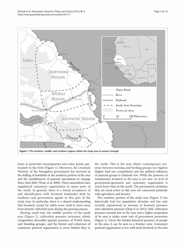
Figure 1 The northern, middle, and southern regions within the study area in eastern Senegal.
Kitchell et al. Pastoralism: Research, Policy and Practice 2014, 4:17 Page 3 of 14http://www.pastoralismjournal.com/content/4/1/17
hosts at particular encampments and water points par-ticularly in the Ferlo (Figure 1). Moreover, the LivestockMinistry of the Senegalese government has invested inthe drilling of boreholes in the southern portion of the areaand the establishment of pastoral associations to managethese (Juul 2001; Wane et al. 2009). These associations havesupplanted customary organization in many parts ofthe north. In general, there is a broad acceptance ofand identification with livestock husbandry both byresidents and government agents in this part of thestudy area. In particular, there is a shared understandingthat livestock, except for milch cows, need to move awayfrom densely cultivated areas during the growing season.Moving south into the middle portion of the study
area (Figure 1), cultivation pressure increases, ethniccomposition diversifies (greater presence of Wolof, Serer,and Manding groups), and the history and coherence ofcustomary pastoral organization is more limited than to
the north. This is the area where contemporary ten-sions between farming and herding groups run highest(higher land use competition) and the political influenceof pastoral groups is relatively low. While the presence oftranshumant livestock in the area is not new, its level ofgovernment-sponsored and customary organization ismuch lower than in the north. The government ministriesthat are most active in this area are concerned primarilywith agriculture and forestry.The southern portion of the study area (Figure 1) has
historically had low population densities and has onlyrecently experienced an increase in livestock presenceand cultivation pressure (Diop et al. 2012). Still, cultivationpressure remains low in the area and a higher proportionof its area is under some sort of government protection(Figure 1). Given the limited historical presence of peoplein the area, it can be seen as a frontier zone. Customarypastoral organization is low with most livestock in the area

Kitchell et al. Pastoralism: Research, Policy and Practice 2014, 4:17 Page 4 of 14http://www.pastoralismjournal.com/content/4/1/17
present seasonally and managed by transhumant herders.Government presence is most felt through the activitiesand policies of Eaux et Forêts, the forestry agency, whichgenerally has a negative posture toward livestock husbandry(Benjaminsen 1997).
Institutional and administrative governanceThe history of decentralization of natural resource man-agement in the study zone has important implicationsfor efforts to formalize recognition of corridors. Govern-ment administration in Senegal is subdivided into fouradministrative levels. At the top of the administrativehierarchy, regions are governed by the Conseil Regional,an elected body. Each region is subdivided into depart-ments, which in turn are divided into arrondissements.Both departments and arrondissements are purely admin-istrative entities with no independent political bodies.They are respectively headed by préfets and sous-préfets,appointed by the central government. Finally, at thelowest level, each arrondissement is composed of communes(cities) and communautés rurales (rural districts composedof multiple villages, hereafter CR) administered by directlyelected local governments. There are currently more than370 CRs in Senegal. New CRs have been establishedover time through successive subdivisions within the stateterritorial administration; the most recently establishedCRs in the study region (e.g. Bala, one of our study sites)were created in 2009.The current institutional structure is the result of an
administrative decentralization process, initiated in 1972and reformed in 1996. A 1972 reform of territorial admin-istration (Loi 72-25) established communes and CRs withlegal and financial autonomy. However, communes andCRs continued to be under the budgetary control of thesous-préfet until the transfer of administrative manage-ment to the president of rural councils and city mayors in1990. The decentralization reform of 1996 (Loi 96-06)further empowered local elected councils by transfer-ring a number of administrative responsibilities to thecommune and CR levels (notably land use planningand natural resource management). However, the de-volution of administrative authority to local levels wasnot accompanied by an equivalent transfer of necessaryfinancial resources (O'Bannon 2006). In addition, ul-timate authority over resource management remainsambiguous due to the continued power of sector agenciesin decision-making over natural resources. Further, by es-tablishing a new pole of authority in an already complexinstitutional landscape, the establishment of CR councilscomplicates rather than resolves institutional pluralism atthe local level. Devolution of powers to new artificiallycreated units failed to build from existing tenure institu-tions, bringing the CR's administrative authority into com-petition with the customary authority of pre-existing local
management institutions (Hesse et al. 2000). Institutionalchanges under decentralization have thus altered the alloca-tion of powers and responsibilities for resource manage-ment and reshaped the legitimacy of particular forms ofresource governance. As these resulting shifts in power arecontested, processes of decentralization become enmeshedin the production and reproduction of hierarchy at the locallevel (Gray 2006; Poteete and Ribot 2011).
MethodsThe mapping of transhumance corridors could provideinformation needed to support the development of co-management systems as well as to communicate infor-mation to local authorities about the placement of alocal corridor within a broader corridor system. Thispaper reports on an ongoing research project focusedon developing and using this information to supportmanagement decisions in eastern Senegal. The generaldata collection procedure followed by this project in-volves three basic steps:
1. Meetings with pastoral and other community leadersto identify major corridors on which their livestockdepend during the year;
2. Collection of GPS coordinates and basic informationfor these corridors as well as for associatedencampments and water points with the help ofpastoralist guides;
3. Presentation and discussion of provisional maps ofthese corridor features with representatives of majorinterest groups at the level of each CR traversed bymapped corridors. A major focus of thesediscussions is the recognition of these corridorfeatures at the local level.
This paper focuses on our experience with the thirdstep of this procedure which has been completed in nineCRs in eastern Senegal. We orient our observations toaddress the following four questions concerning localresource users' varied perspectives on corridors:
1. What are the benefits and costs of corridors and dothey require protection?
2. How does the mapping of corridors and encampmentsaffect competing land uses (particularly farming)?
3. How should corridors and encampments berecognized and protected?
4. Under what authority should corridors andencampments be recognized and protected?
These questions lie at the heart of the politics that sur-round land use planning and locally brokered agreementsto support livestock mobility. At a more abstract level, whatis the purpose of corridors in peoples' minds and do these
Kitchell et al. Pastoralism: Research, Policy and Practice 2014, 4:17 Page 5 of 14http://www.pastoralismjournal.com/content/4/1/17
purposes warrant particular forms of protection againstcompeting land uses? If corridors need to be protected,how should they be protected and under whose authority?Finally, what additional issues arise with respect to compet-ing claims to land when particular locations of corridorsand encampments are presented? After addressing thesequestions, the paper concludes with a discussion of thepolicy implications of these findings.
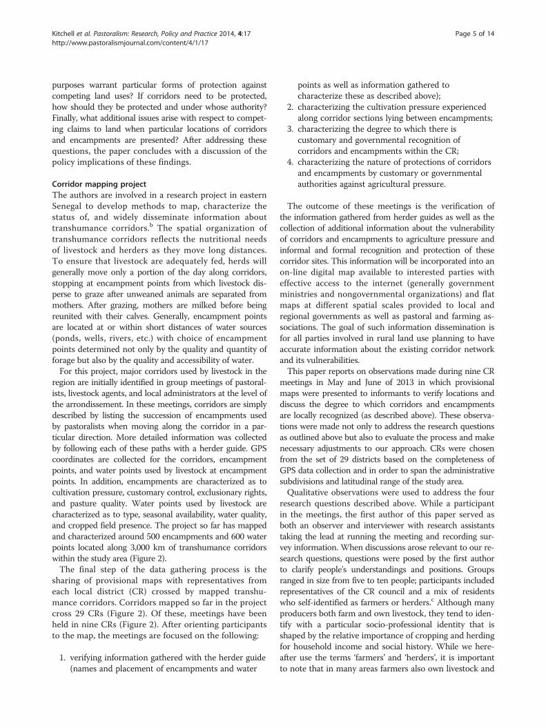
Corridor mapping projectThe authors are involved in a research project in easternSenegal to develop methods to map, characterize thestatus of, and widely disseminate information abouttranshumance corridors.b The spatial organization oftranshumance corridors reflects the nutritional needsof livestock and herders as they move long distances.To ensure that livestock are adequately fed, herds willgenerally move only a portion of the day along corridors,stopping at encampment points from which livestock dis-perse to graze after unweaned animals are separated frommothers. After grazing, mothers are milked before beingreunited with their calves. Generally, encampment pointsare located at or within short distances of water sources(ponds, wells, rivers, etc.) with choice of encampmentpoints determined not only by the quality and quantity offorage but also by the quality and accessibility of water.For this project, major corridors used by livestock in the
region are initially identified in group meetings of pastoral-ists, livestock agents, and local administrators at the level ofthe arrondissement. In these meetings, corridors are simplydescribed by listing the succession of encampments usedby pastoralists when moving along the corridor in a par-ticular direction. More detailed information was collectedby following each of these paths with a herder guide. GPScoordinates are collected for the corridors, encampmentpoints, and water points used by livestock at encampmentpoints. In addition, encampments are characterized as tocultivation pressure, customary control, exclusionary rights,and pasture quality. Water points used by livestock arecharacterized as to type, seasonal availability, water quality,and cropped field presence. The project so far has mappedand characterized around 500 encampments and 600 waterpoints located along 3,000 km of transhumance corridorswithin the study area (Figure 2).The final step of the data gathering process is the
sharing of provisional maps with representatives fromeach local district (CR) crossed by mapped transhu-mance corridors. Corridors mapped so far in the projectcross 29 CRs (Figure 2). Of these, meetings have beenheld in nine CRs (Figure 2). After orienting participantsto the map, the meetings are focused on the following:
1. verifying information gathered with the herder guide(names and placement of encampments and water
points as well as information gathered tocharacterize these as described above);
2. characterizing the cultivation pressure experiencedalong corridor sections lying between encampments;
3. characterizing the degree to which there iscustomary and governmental recognition ofcorridors and encampments within the CR;
4. characterizing the nature of protections of corridorsand encampments by customary or governmentalauthorities against agricultural pressure.
The outcome of these meetings is the verification ofthe information gathered from herder guides as well as thecollection of additional information about the vulnerabilityof corridors and encampments to agriculture pressure andinformal and formal recognition and protection of thesecorridor sites. This information will be incorporated into anon-line digital map available to interested parties witheffective access to the internet (generally governmentministries and nongovernmental organizations) and flatmaps at different spatial scales provided to local andregional governments as well as pastoral and farming as-sociations. The goal of such information dissemination isfor all parties involved in rural land use planning to haveaccurate information about the existing corridor networkand its vulnerabilities.This paper reports on observations made during nine CR
meetings in May and June of 2013 in which provisionalmaps were presented to informants to verify locations anddiscuss the degree to which corridors and encampmentsare locally recognized (as described above). These observa-tions were made not only to address the research questionsas outlined above but also to evaluate the process and makenecessary adjustments to our approach. CRs were chosenfrom the set of 29 districts based on the completeness ofGPS data collection and in order to span the administrativesubdivisions and latitudinal range of the study area.Qualitative observations were used to address the four
research questions described above. While a participantin the meetings, the first author of this paper served asboth an observer and interviewer with research assistantstaking the lead at running the meeting and recording sur-vey information. When discussions arose relevant to our re-search questions, questions were posed by the first authorto clarify people's understandings and positions. Groupsranged in size from five to ten people; participants includedrepresentatives of the CR council and a mix of residentswho self-identified as farmers or herders.c Although manyproducers both farm and own livestock, they tend to iden-tify with a particular socio-professional identity that isshaped by the relative importance of cropping and herdingfor household income and social history. While we here-after use the terms ‘farmers’ and ‘herders’, it is importantto note that in many areas farmers also own livestock and

Figure 2 Location of the sampled communautés rurales in relationship to mapped corridors within the study area.
Kitchell et al. Pastoralism: Research, Policy and Practice 2014, 4:17 Page 6 of 14http://www.pastoralismjournal.com/content/4/1/17
may use corridors. After the initial description of ourproject, its methods, and goals for the meeting, reac-tions from participants often gravitated to perspectiveson the benefits and costs of corridors and whether theyshould be recognized or protected (questions 1 and 3).Verification of the names and locations of corridorsand encampments as outlined on provisional mapsoften led to discussions about the degree to which thesepastoral sites were seen as competing against alternativeland uses (question 2). Through a series of questions aboutlocal recognition, participants were asked about politicaland social contestation over corridor segments and restingpoints, formal and informal recognition by the CR, and thedegree to which each segment and resting point were takeninto account in decisions to permit or prohibit croppingand payments for crop damage. These questions also ledto discussions related to the politics of fixing corridors(question 2) as well as the issue of authority to recognizeand protect corridors in particular ways (questions 3 and 4).
The pre-defined set of survey questions thus led to un-structured discussions of the meaning of recognition,the roles played by different actors and institutions, andthe factors affecting local decision-making about specificcases of encroachment and crop damage. Conversationswere guided by open-ended questions by the first authorto clarify divergent perspectives among participants in agiven group as well as to explore variation among CRs.
ResultsPerspectives on the purpose and benefits of corridorsIn all nine CRs in which meetings were held, corridorsenjoyed some level of recognition by residents and districtofficials. Degree of recognition was assessed in terms ofinformal acceptance of corridor use, overt contestationof corridor sections by the CR or a given social group,and whether the corridor was taken into account in CRdecision-making about land allocation, land use plan-ning, and conflict resolution. Most often, recognition

Kitchell et al. Pastoralism: Research, Policy and Practice 2014, 4:17 Page 7 of 14http://www.pastoralismjournal.com/content/4/1/17
was informal, consisting of the acknowledgement thatcorridors existed and were subject to some degree ofcustomary regulation. Corridors were largely acceptedas a long-standing feature of local production systems thatplay an important role in facilitating the accommodation ofcropping and livestock husbandry.d While accommodationbetween different production systems was central to partici-pants' views of corridors, four distinct functions, variablystressed by different social groups, can be identified: toavoid conflict, reduce crop damage, ensure access, andprevent agricultural encroachment.Participants most frequently spoke of the purpose of
corridors as landscape features to manage or preventconflict. People usually referred to conflict betweenfarmers and herders resulting from crop damage, butcorridors were also sometimes discussed in terms of theirpotential role in mitigating tensions between herdinggroups. Farmers, herders, and agropastoralists from acrossthe three zones all emphasized this as one of the primarypurposes of locally recognized corridors. Under prevailingconditions of overlapping land uses with multiple claimantsholding different use rights, corridors provide a meansof clarifying access and channelling livestock pressurethrough known routes. They also serve the function ofpinpointing the local individual(s) responsible for managingtranshumance movements by associating transhumantencampments with particular settlements where a hostresides. Of course, the degree of responsibility and au-thority over management varies widely and extra-localherders may choose not to contact local hosts. Variousactors interpret the role of corridors in reducing con-flict in quite different ways; one perspective views cor-ridors as a means to keep livestock away from fields,while another emphasizes the role of corridors in enab-ling access to a broader ensemble of pastoral resources.Not surprisingly, farmers often spoke of the regulationof corridors not only in terms of their geographic de-limitation but also in terms of specifying the temporaldimensions of their use. This can be seen as an ex-ample of the degree to which corridors' perceived rolesin managing conflict and preventing crop damage aresometimes interwoven. As will be discussed below,when corridors are used as a means to manage con-flicts between competing land uses with a strong focuson crop damage, corridor delineation and regulationcan become primarily a means of constraining ratherthan enhancing mobility.While a range of social groups across the study sites
stressed the management of conflict and crop damage asamong the principle purposes of corridors, many herdersalso emphasized corridors as a means for ensuringpositive rights of access. Local recognition of corridorswas viewed as a validation of pastoral claims to par-ticular paths and areas of pasture. In a basic sense, it
represented a commitment to the persistence of an ex-tensive livestock production system by allowing transitthrough agricultural areas. However, this clarificationof a right of transit and access to pasture did not alwaysextend to a sense that corridors also connoted protectionagainst future cultivation. Herders perceived agriculturalencroachment as a pressing problem for livestock produc-tion, but did not always view it as an infringement onestablished pastoral rights. Understandings of corridorrecognition as serving a strong positive right to maintain-ing corridors and pasture sites free from cultivation weregenerally expressed in areas that either had politicallyactive pastoral associations or that had recently beeninvolved in processes of land use planning facilitatedby outside agencies and focused on corridor protection.In discussions with participants, the political organizationof pastoralists and education campaigns about legislationon mobility seemed to increase the likelihood that herdersview corridors as inherently providing protection fromfuture agricultural pressure. By providing a representa-tive body, pastoral associations play an important rolein articulating pastoral interests and enhancing theirpolitical clout.
Politics surrounding the ‘fixing’ of corridors onprovisional mapsIn preparing for meetings at the CR, we expected the ques-tion of corridor and encampment placement on provisionalmaps to be highly sensitive. As a visual representationdelineating current land use, maps of corridors could beinterpreted as fixing boundaries around accepted socialuses of resources. Surprisingly, discussions focusing spe-cifically on corridor placement were much less conten-tious than anticipated. There were two principal reasonsfor this. First, corridors were often considered to alreadybe relatively fixed in practice, particularly in zones withhigher cropping pressure. As a result, the placement onthe map was approached in a matter-of-fact manner;there was little implication that mapping corridors sub-stantially altered shared understandings of boundaries.Second, the delineation of corridor location was not as-sociated with strong commitments to protect corridorsas a land use. In particular, recognition was not taken tomean consistent enforcement of prohibitions on croppingalong corridors and near encampments and water points.In effect, residents did not immediately perceive corridorrecognition as strengthening pastoral land rights.A significant degree of consensus existed on areas
understood to be important for transhumant herds,and the idea that the CR may recognize corridors andencampments as legitimate land uses was not perceived asimmediately threatening to competing land uses. Whilethe geographic siting of areas used by transhumant herdselicited little dispute, the politics surrounding questions of
Kitchell et al. Pastoralism: Research, Policy and Practice 2014, 4:17 Page 8 of 14http://www.pastoralismjournal.com/content/4/1/17
access within this schema came to dominate discussions.Related issues included the timing of access, how herdersgain authorization for use, how penalties for crop damageare defined, social expectations of both residents andextra-local herders, and the regulation of related resources(tree browse in forests, water supplies at village wellsand boreholes). It was when these issues become thefocus of discussion that questions about competingland uses came to the fore. To the extent that corridorrecognition was understood as an acknowledgement oflong-used livestock paths, contention was diminished.However, the dimensions of access and the degree to whichquality pasture and water points should carry restrictionsagainst agricultural expansion generated much greaterdebate. In the context of corridor formalization, theextent to which these politics are explicitly addressedwill depend on divergent conceptions of corridors as 1)points of transit out of an area or 2) as features of pastoralgeographies with associated requirements for adequateaccess to forage and water.In addition, in discussions of whether the provisional
maps accurately reflected current practice, differentialknowledge of the geographic realities of transhumancebecame evident, with important implications for the scaleof organization of resource management. Residents fromone area of the CR often had limited knowledge of livestockpaths in another area. Participants from the same districtalso held divergent viewpoints of the importance of corri-dors depending on the characteristics of different locationswithin the CR (cropping pressure, density and duration oflivestock presence). Further, of those present at meetings,CR officials tended to be the least knowledgeable about thegeographic location of corridors. This reflects the import-ance of the village level in ongoing corridor management.Similarly, participants from a given CR were some-times unaware of paths in their district that had beenidentified as important by residents of other CRs.There was little perception of corridor protection as across-boundary issue that required coordination withneighbouring districts. Reviewing the provisional mapsin multiple CRs thus highlighted both a higher degree ofresistance to protecting access to pasture around encamp-ments than to the delineation of corridors themselves andlow levels of coordination among local entities and acrossdistricts. These two issues represent critical obstacles thatmust be addressed in order to maintain the viability of abroader corridor system (Moutari and Girault 2013).
Perceptions of the need for formal recognition of corridorsWhether or not special forms of protection, notablythrough the formal recognition of corridors by the CR,were viewed as necessary depended on several factors:1) the degree to which customary systems of regulationand accommodation were perceived as still functioning,
2) social relations between user groups within a district,and 3) the level of land use pressure in the area. Thus,significant differences existed among groups in termsof the perceived need to formalize corridors and how thebenefits associated with formalization were understood.Formal recognition and protection of corridors tended tobe most frequently viewed as necessary in areas with highagricultural pressure and in areas where there was a morelimited history of social interaction between transhumantherders and local residents.Practices of accommodation between cropping and
herding have a long history in the region. The historicalintegration of livestock paths into customary systems ofland management was often referenced in discussions ofdecision-making about corridors, particularly in areas tothe east and north of the railroad (Figure 1). The degreeto which customary agreements were still functioninghad an important effect on attitudes toward the need forformal protection. When customary systems were viewedas effectively managing land use and related disputes,residents saw intervention by local elected officials asunnecessary and sometimes as inappropriate. In Bala, itwas stated that when arbitrating crop damage, the CR sim-ply followed agreements made by elders several generationsearlier, referred to by participants as ‘village law’. Both resi-dents and CR officials felt that the CR lacked the authorityto infringe upon customary arrangements. In some cases,the precedence of customary arrangements protected mo-bility by restricting the ability of CR officials to alter existingland use agreements; however, since land use planning andallocation for cultivation take place at the CR level, its di-minished role in regulating corridors could also indirectlypromote agricultural encroachment.In addition to the functioning of customary arrange-
ments, the nature of social relations among user groupsalso influenced the perceived need for protection of corri-dors. This was particularly evident in the northern zone.Populated mainly by Fulani who share a socio-professionalidentity rooted in livestock ownership, corridors in this areawere seen as an unquestioned aspect of local productionsystems. However, corridors were rarely viewed as a formalfeature of land use planning nor did they receive protectionat the CR level. On the one hand, widespread social accept-ance of livestock paths created a stronger sense of a right tomobility than elsewhere, while on the other, the perceptionof corridors as part of the social fabric of local communitiesled to a reliance on mutual accommodation and reducedthe perceived need to formalize protection at the districtlevel. The intensity of conflict when crop damage did occurwas reported to be relatively low. One participant explainedthat a shared socio-professional identity defused conflict,emphasizing ‘we're all Fulbe’. In addition, participants innorthern districts explicitly placed responsibility for pre-venting crop damage on both farmers and herders. Further,

Kitchell et al. Pastoralism: Research, Policy and Practice 2014, 4:17 Page 9 of 14http://www.pastoralismjournal.com/content/4/1/17
most farmers in this zone own a significant number oflivestock and also make use of corridors. Unlike in otherareas, conflict in the northern zone did not rise to thelevel of outright or latent social confrontation betweendifferent groups, but was instead expressed as isolatedflare-ups between particular individuals. However, thereis evidence that more persistent social divisions in atti-tudes toward livestock mobility may be developing, par-ticularly in reference to irrigated areas along the river.In areas where relationships between transhumant
herders and residents were established enough to fa-cilitate informal negotiation of access, perceptions thatcorridors required formal protection were weaker. Thistended to be the case in localities where transhumantherders pass a significant portion of the year and return insuccessive years, leading to closer relationships amonggroups and diluting strict definitions of ‘insider’ and‘outsider’. In one case, a CR official referred to theherders who had been coming to his district regularlyfor more than 10 years as ‘living there’, noting that theyspend more time annually in his district than in theirhome territories. In situations such as these, transhumantherders may even pay taxes and vote in local CR elections.These social dynamics existed in districts located at thesouthern end point of a corridor that had relatively exten-sive areas of pasture (e.g. Madina Foulbe).This contrasted sharply with dynamics in transit zones
located in the middle zone of the study area. Transhumantpastoralists spent much shorter periods of time in theseareas and were likely to use different series of encamp-ment sites in successive years. In addition, cropping pres-sure is higher in this zone and the timing of livestockmovements results in higher numbers of livestock beingpresent during the planting season. Residents of areas withhigher land use pressure expressed greater interest andeven a sense of urgency about the formalization of corri-dors and access rights. This dynamic was heightened inareas that had also experienced recent changes in the tim-ing of livestock movements. Increased potential for cropdamage resulted in corridors being perceived as a neces-sary means to avoid conflict. However, this conjunction ofinterests between farmers and herders emerged from verydifferent understandings of the implications of definingcorridors. In many CRs, the focus was on preventingconflict. Given the dominance of agricultural interestsat the local and district levels, conflict prevention wasoften couched in terms of reducing crop damage byregulating and constraining the movement of livestockin and around fields.For example, the CR of Koulour attempted to institute
a management system in 2008 designed to control thelocation and timing of livestock movement. Each groupof herders was required to present themselves to villagechiefs, declare the number of days they would be spending
in nearby encampments, and pay a user fee of 10,000 CFAfrancs to every village in which they stopped overnight. Inaddition, December 31 was set as the date of the earliestpossible entry into the CR. While restrictions on livestockaccess were elaborated, little emphasis was placed on pro-tecting corridors from agricultural encroachment. In thiscase, formalization of corridors clearly represented abroader claim to control and restrict the access of outsidegroups. However, the system quickly collapsed with out-sider herders simply refusing to participate or abide by thenew restrictions. As in this failed attempt to curtail cropdamage, in most districts of the middle zone, a reciprocalcommitment to maintain corridors to facilitate livestockmovements into and through cropped areas was missing.This was evidenced by the very rare occurrence of pro-hibitions of cropping on corridors and near waterpoints. Although land use pressure creates incentives onboth sides to formalize protection of corridors, diver-gent perceptions of ‘protection’ can undermine consen-sus and may lead to mixed results in terms of enhancinglivestock mobility.
Divergent views of authority: institutional politicssurrounding corridor protectionAs we have seen, a continuum exists in perceptions ofwhether or not corridors require special forms of pro-tection beyond extant arrangements at the local level.However, of even greater importance for efforts to enhancemobility, divergent views of the appropriate authority forprotecting corridors reveal a distinct institutional politicsassociated with formalizing corridors. A variety of insti-tutions are involved formally and informally in the regu-lation of livestock movement. Relations among thesevarious institutions are typified by both cooperation andcontention over the right to manage resources. Buildinginstitutions to support livestock mobility is political notonly because of the act of inscribing physical boundariesbut also because recognition requires a negotiation amongcompeting authorities. The levels at which farming andherding interests are represented differ. As representativesof local settlements, village chiefs and the CR are likelyto favour cultivation interests. Herders lack formal rep-resentation in decision-making over land use in thedistricts outside their home territory, despite their ex-tended presence locally and the regional importance oflivestock production. Instead, herders exercise politicalauthority through clan or family heads, pastoral associa-tions, and by appealing to the regional livestock service(ministry). Across the study districts, there was consid-erable variation in the prominence of customary leaders,locally elected CR officials, state-sponsored pastoral asso-ciations, and sector agencies in decision-making aboutlivestock mobility. In different local contexts, effective au-thority over livestock mobility is shaped by the shifting

Kitchell et al. Pastoralism: Research, Policy and Practice 2014, 4:17 Page 10 of 14http://www.pastoralismjournal.com/content/4/1/17
power of these institutions resulting from several factors,notably the level of political organization among pasto-ralists, village density, the prevalence of protected areas,and the history of livestock movements in the area. Theallocation of responsibilities for protecting corridorswithin formalization processes has two implications.First, different institutions are likely to embody vestedinterests in a particular land use. Second, when under-stood as an issue of precedent among competing polesof authority, contestation over the specific issue of cor-ridors becomes a symbol in broader social struggles forcontrol over resources.The roles played by various administrative bodies and
informal institutions differed from one CR to the next.Nonetheless, some broad trends were apparent acrossdistricts. First, village chiefs are often the primary levelat which questions of access are negotiated. This is thecase not only due to their customary authority to allo-cate cropland and arbitrate conflict but also because oftheir geographic proximity to the resources in question.In some cases, this authority was delegated to villagecommittees, of which the village chief or a representativeof his choice was a member. In general, both farmersand herders viewed the village chief as a legitimate inter-locutor. However, this does not mean that herders alwaysinform them of their actions nor respect their decisions.Differing perceptions of the responsibilities of herders andthe level of control exercised by village chiefs led to frus-tration on both sides. In particular, herders' unwillingnessto make their presence in the area known to the villagechief and to camp near villages was a growing source oftension between groups.The CR is also widely acknowledged as an important
source of authority over livestock mobility, particularlythrough upholding and legitimizing the decisions of vil-lage chiefs. In addition, CR officials played a central rolein addressing conflicts that were unable to be success-fully resolved among the two parties at the village level.They often determined whether or not the gendarmerieshould become involved and formal judicial proceduresinitiated. Before the addition of the CR into Senegal's ad-ministrative structure, the arrondissement governmentwas too far removed to impinge much on local affairs.Although the district government of the CR is muchcloser to the local level at which management questionsarise and are resolved, it also has a limited enforcementcapacity and continues to rely on village chiefs as themechanism for implementing its decisions. A relationshipof interdependence exists between the CR and villagechiefs. Nonetheless, the relationship is also character-ized by contestation and competing interests. The am-biguity between customary authority and the electedofficials of the CR government is particularly strong inareas where new CRs had only recently been created
(e.g. Bala established by decree in 2009). Residents' at-titudes toward regulation by the CR were generallypositive, but in the absence of outright conflict, its efficacywas considered low because of a limited ability to performoversight. Some participants stated that formal recognitionof corridors at the CR level made little difference because ithad little effect on cultivation in practice and was frequentlynot taken into account when resolving crop damagedisputes. The CR becomes more prominent in decision-making about livestock mobility when external bodiesimplement programming in the district explicitly targetingthe issue. This is due to the preponderant focus withindevelopment projects on the district government as themain actor in local governance, though many projects alsoengage village chiefs or village committees.Given the prominence of agricultural interests at the
village and CR levels, the activity of pastoral associationsis also important in the context of authority over corri-dors. Herders who participated in the meetings sawthese associations as a means of redressing their politicalmarginalization at the CR level. District officials them-selves often view pastoral associations or committees asa necessary mechanism for regulating livestock move-ment. Following the failed attempt to initiate a formalsystem of regulating corridors in Koulour noted above,CR officials expressed interest in trying a similar schemeagain, but this time with the involvement of a committeeof herders from the Fouta. The inability of both villagechiefs and the CR to enforce unilateral decisions aboutcorridor use leads to their realization that it is necessaryto implicate herders themselves in the elaboration andenforcement of rules. However, for this to occur, externalherders need an organized form of local representation. Insome areas, negotiations have happened with family headsor an informal leader chosen from among herders. Pastoralassociations can serve as a counterpart to territorially basedmanagement institutions (village chiefs, the CR). Further,the rarity with which herders voiced claims to positiverights indicates the need to increase mobilization aroundthe issue of land rights and pastoral tenure security;pastoral associations appeared to significantly increaseawareness of existing rights.Finally, the activities of sectoral agencies are impli-
cated in the interactions between different institutionsat the local level. As has been discussed elsewhere, am-biguity exists in the allocation responsibilities for landmanagement between the CR and sectoral ministries(notably the forestry and livestock ministries) (Poteete andRibot 2011; Ribot 2009). The tensions between them withrespect to decision-making about land use can be exploitedby residents and extra-local herders alike, with each partyseeking intervention from the authority it perceives as mostlikely to support its own interests (what has been termed‘forum shopping’, see Ribot and Peluso (2003)). Geographic

Kitchell et al. Pastoralism: Research, Policy and Practice 2014, 4:17 Page 11 of 14http://www.pastoralismjournal.com/content/4/1/17
differences in ministry activities are also importantfor shaping attitudes toward corridors (‘Background’section above). The livestock ministry has historicallyfocused its interventions on the northern zone andhas been an important source of development financingthere. In northern and eastern districts, it was invoked asplaying a very active role in local resource management,both through the distribution of resources and infrastruc-ture and through active intervention in processes of landuse planning. Pastoral associations often targeted the live-stock ministry and the regional livestock service as theirprimary ally in the state administration. In agropastoralzones just south of the Ferlo, this dynamic leads totensions between the livestock ministry and residents;some residents in these areas viewed grazing permits(autorisations d'entrée) distributed by the regionallivestock service as the state backing herders and forcingresidents to deal with depredations associated with mobility(mainly cutting of trees). Permits were viewed as awardingoutsiders rights which had not been properly negotiatedwith residents, thus infringing on their authority. Interest-ingly, however, villages were able to use noncompliance toincrease local control by placing tighter restrictions onherders without the required papers.In contrast, the prominence of protected areas and
forestry agents in the southern zone has decidedly differ-ent effects. In these districts, the dialogue on transhu-mance and corridors is dominated by concerns aboutforest cutting. This has been exacerbated by a speciesshift in use of corridors from grazers to browsers and anew push to the southeast by corridor users. The for-estry agency's perception of livestock herding as a sourceof forest degradation has contributed to shaping bothlocal officials' and residents' attitudes toward corridors.Due to the low level of agricultural pressure in this zone,contention over livestock mobility centres not on cropdamage but instead on the impacts on forest cover andhealth. In Medina Foulbe, comités de vigilance were estab-lished at the village level and charged with supervision offorest use. The emphasis was on reducing cutting of cer-tain species including Acacia seyal, an important sourceof tree browse. Backed by the forestry service, this effortto enhance local control over resources collapsed when analtercation between one village committee and extra-localherders led to several committee members being jailed.The lack of formal legal status for the committees and theresultant ambiguity in their authority were noted as a sig-nificant obstacle to effective resource management.Despite the tensions sparked between divergent socio-
professional groups, a study undertaken as part of theProject for Livestock Development in Senegal and theCasamance (PDESOC, a regional project under the direc-tion of the livestock ministry) recommended the resurrec-tion and reorganization of these committees as a primary
means to achieving ongoing implementation and monitor-ing of corridor protection (Diop et al. 2013). Although thisrecommendation represents an attempt to enhance coord-ination among villages, the CR, and relevant ministries, ex-plicit attention to the politics that typify interactions amongthese administrative levels and development of means forthe incorporation of herders in decision-making is requiredto build enduring institutions for managing mobility.
Conclusion: implications for land use planning effortsConflicts between farmers and herders are inherentto the mosaic of land use typical of Sudano-SahelianWest Africa. Local cases of conflict have historicallybeen negotiated through complex, multi-stranded so-cial relations that connect different user groups(Turner 1999; Turner 2006). However, the dominantfocus on the village scale in land policy and developmentprojects has historically privileged agricultural interests anddiscounted pastoralists, effectively resulting in enclosures(Marty 1993; Painter et al. 1994). Further, the local andregional administrations responsible for land use planningare dominated by agricultural constituencies in manyareas. The ‘paradox of pastoral tenure’ has been describedas providing both flexibility in resource use and security ofaccess (Fernandez-Gimenez 2002; Moritz et. al. 2013).Although informal negotiation at local sites has consider-able benefits in terms of flexibility, given the expansion ofagriculture and the increasing political dominance andmaterial control of certain zones by farming interests, itis inadequate for securing access to pastoral resources.Intervention of higher-level state authorities is necessaryto protect the livelihood security of herders and ensurecoordination with respect to transhumance corridorsthat cross multiple jurisdictions (Bassett 2009; Moutariand Girault 2013; van Driel 1997). The governance ofpastoral mobility involves a multitude of institutionsand actors operating at a variety of scales. Maintainingtranshumance as a regional resource use system thusrequires both some form of co-management and a pro-active role for state authorities.Scholars have raised concerns that the formalization of
livestock corridors under state authority will result in a lossof flexibility for pastoralists due to the reliance on delimit-ing a fixed pastoral infrastructure and the reduced ability oflocal user groups to develop their own negotiated solutions(Dafinger and Pelican 2006; Mortiz et al. 2013). Althoughflexibility is an essential aspect of pastoral resource systems,the expansion of cropping in agropastoral areas necessitatesa hybrid approach to management that embraces flexibilityamong pastoral groups but operates within negotiated, mu-tually acceptable boundaries that protect pastoral resourcesfrom agricultural encroachment. Recent research usingspatial analysis has shown that the nature of resource vari-ability (notably inter-annual variability in forage phenology

Kitchell et al. Pastoralism: Research, Policy and Practice 2014, 4:17 Page 12 of 14http://www.pastoralismjournal.com/content/4/1/17
and the existence of key forage patches) has seasonalregularities that are compatible with the territorial protec-tion of movement corridors and key pastoral resources(Brottem et al. 2014). Within these regional corridor net-works, flexibility can be maintained through flexible pas-toral tenure arrangements to access forage and water forlivestock. In fact, clear ownership rights to pasture andwater among pastoralists in eastern Senegal are rare alongour mapped transhumance corridors. Therefore, if corri-dor mapping is approached as part of an ongoing processof negotiated land use planning rather than as an end initself, it can be an important step in enabling coordinationacross competing institutions.Careful attention to the nature of institutional politics
around corridors is necessary to facilitate this. Our analysisexamined divergences in local perceptions of the functionof corridors and the authorities involved in managementin order to understand the politics of corridor protection.In the course of meetings, discussions inevitably focusedless on the placement of corridors and more on corridorrecognition. Debates about recognition were equally af-fected by questions about 1) what protections should beaccorded and 2) who has the authority to recognize corri-dors. Depending on their understanding of the purpose ofcorridors, resource users hold two related but competingperspectives on corridor protection. The first is control-oriented, emphasizing the prevention of crop damage andreduction of conflict; the second is access-oriented empha-sizing corridors as a means to ensure access to pastures.While these can be complimentary, creating opportunitiesfor negotiation between groups motivated by differentends, it is important to note that regulations on corri-dors are alternately used to claim access rights and toexclude certain users or uses. Without a clear under-standing of the functions of corridors in pastoral mo-bility (i.e. requirements of water and pasture associatedwith stopping points along corridors), formalizationcan result in corridors acting as restrictive spaces forlivestock. Maintaining the possibility of mobility inonly this narrow sense will have a significantly negativeeffect on livestock production. Given the dominance ofagricultural interests at the CR level in many districts, it isnecessary to ensure that formalized recognition of corridorsis coupled with protection of pastoral sites from competingland uses if livestock mobility is to be enhanced.Moreover, in the context of overlapping institutions for
resource management, authority over corridor recognitionis highly contested. Variations in the relative authority ofdifferent institutions mean that the management of pastoralmobility is effectively in different institutional hands atdifferent points along the corridor. Attempts to formallydelineate and protect livestock corridors will inevitably beconfronted by the institutional politics surrounding controlover management. Greater coordination is required across
administrative levels to effectively implement regulationsprotecting corridors. However, the development of possiblesolutions is hindered when debates about corridors becomeproxies for struggles over authority in resource manage-ment, with the dominant discourse favouring the interestsof settled cultivators. Outside facilitators of land use plan-ning processes should take a process-oriented approach thatemphasizes institution building rather than the one-timeproduction of a land use map; such an approach requiresongoing support and a longer time horizon. In particular, atthe CR level, more training is needed on extant nationalpolicy as well as support in formulating, implementing, andmaintaining land use agreements around mobility. Sincevillages are where implementation inevitably occurs,village-level authorities need to be included in planningprocesses in meaningful ways. Likewise, transhumantgroups need to be represented in decision-making inorder to enhance legitimacy and increase the durabilityof land use agreements. The ability to effectively involveherding groups is complicated by the timing of theirpresence and their level of internal organization. Infor-mal institutions may offer an important starting pointfor defining shared norms among transhumant herdersand CR residents. These include understandings of custom-ary rights and responsibilities in which mutual obligationsamong user groups are emphasized. In some areas, closesocial relations between groups can facilitate negotiation.Finally, generating consensus on the application of rulesprotecting mobility is intertwined with the resolution oftangential problems. In particular, these include whetheror not herders announce themselves to local bodies, estab-lishment of social ties that might diminish incidences ofaggression, acceptance of local rules on tree cutting, andreduction of livestock theft.There is a fundamental disconnect between the scale
at which corridors operate and the management institutionof a village or CR. Corridors cross multiple CRs andeven international borders, but the need for coordi-nated governance has yet to be integrated into the logicof decentralization and local management of naturalresources. Ensuring that agricultural expansion does nothave strong detrimental effects on livestock mobility re-quires regional scale, coordinated efforts that take intoaccount both the materiality of corridors and the localinstitutional politics surrounding corridor protection.
EndnotesaThe older of these depictions most likely reflect the
reality of the geography of livestock movements in thepast since corridors are in part a creation of agriculturalpressure. Without agricultural pressure, livestock pathsare best described as movement zones composed of aseries of intersecting, braided paths with the sameorientation within a broad band of land.

Kitchell et al. Pastoralism: Research, Policy and Practice 2014, 4:17 Page 13 of 14http://www.pastoralismjournal.com/content/4/1/17
bThis geospatial information will not only assist inconflict management and land use planning but also beused by the research project to estimate the benefits andcosts of alternative land uses where herding and cropping(especially irrigated cropping) co-exist.
cAlthough corridors may have been identified by herdinginformants residing outside of the communauté rurale,local ‘herders’ as well as ‘farmers’ were generally quite famil-iar with these corridors and associated resting and waterpoints with many, especially herders, using these for theirown livestock.
dNonetheless, this customary function of corridors iscomplicated by changes in the intensity and timing of use.In particular, contention has increased around the inter-national corridor that follows the river from Matam to areassouth of Kidira as it has become more heavily travelled andthe frequency of tree coppicing for browse has increased.
Competing interestsThe authors declare that they have no competing interests.
Authors’ contributionsEK collected and analysed the qualitative data from focus group meetings.EK wrote an initial draft of the ‘Results’ and ‘Conclusions’ sections, and MDTwrote an initial draft of the ‘Introduction’ and ‘Methods’ sections. MDTdesigned the overall corridor mapping study with the assistance of JM. MDTprocessed and analysed the geospatial data to produce the provisional mapsused at focus group meetings. All authors were involved in editing andapproved the final manuscript.
Authors’ informationEK is a PhD student in geography at the University of Wisconsin-Madisonfocusing on the intersections between land use change, governanceinstitutions, and climate change vulnerability in agropastoral communities inSenegal and Mali. MDT is a Professor in the Department of Geography whoseresearch is concerned with environmental dynamics and the institutions andpolitics that surround resource management in Sahelian West Africa. JM isan Associate Professor in the Department of Public Administration andInternational Affairs at Syracuse University who works on the economicsof pastoral systems and is the Principal Investigator of the project thatconducted this research, La Gestion des Systèmes Fluviaux pour l'Avenir.
AcknowledgementsMame Astou Diagne, Mouhamed Mandiang, Pathé Thiongane, and MamadouThioube contributed to this work as research assistants. This work wassupported by the Bureau for Economic Growth, Agriculture and Trade of theUnited States Agency for International Development under the terms of grantno. EEM-A-00-10-00001. This grant is managed by the Feed the Future InnovationLab for Collaborative Research on Adapting Livestock Systems to Climate Change.The opinions expressed herein are those of the authors and do not necessarilyreflect the views of the United States Agency for International Development,the US Government, or the Feed the Future Innovation Lab.
Author details1Department of Geography, 160 Science Hall, University ofWisconsin-Madison, 550 N Park St, Madison, WI 53706, USA. 2Maxwell School,Department of Public Administration and International Affairs, 333 EggersHall, Syracuse University, Syracuse, NY 13244-1020, USA.
Received: 17 June 2014 Accepted: 9 September 2014
ReferencesBa, C. 1986. Les Peul du Senegal. Étude géographique. Dakar: Les nouvelles
éditions africaines.
Bassett, TJ. 2009. Mobile pastoralism on the brink of land privatization inNorthern Côte d'Ivoire. Geoforum 40: 756–766. doi:10.1016/j.geoforum.2009.04.005.
Bassett, TM, and MD Turner. 2007. Sudden shift or migratory drift? Fulbe herdmovements to the Sudano-Guinean region of West Africa. Human Ecology35: 33–49.
Beauvilain, A. 1977. Les Peul du Dallol Bosso, Etudes Nigeriennes 42. Niamey,Niger: Institut de Recherche en Sciences Humaines.
Benjaminsen, TA. 1997. Natural resource management, paradigm shifts, and thedecentralization reform in Mali. Human Ecology 25(1): 121–143.
Benoit, M. 1979. Le chemin des Peuls du Boobola: Contribution à l'écologie dupastoralisme en Afrique des savanes. Paris: O.R.S.T.O.M.
Bernardet, P. 1999. Peuls en mouvement, Peuls en conflits en moyenne et hauteCôte d'Ivoire, de 1950 à 1990. In Figures peules, ed. R Botte, J Boutrais, and JSchmitz, 407–444. Paris: Karthala.
Blench, RM. 1994. The expansion and adaptation of Fulbe pastoralism to subhumidand humid conditions in Nigeria. Cahiers d'Etudes Africaines 133–135: 197–212.
Bonnet, B, and D Hérault. 2011. Gouvernance du foncier pastorale etchangement climatique au Sahel. Revue des questions foncières (LandTenure Journal) 2: 157–187.
Brottem, L. 2013. The place of the Fula: Intersections of political andenvironmental change in western Mali. Madison: University of Wisconsin.
Brottem, L, MD Turner, B Butt, and A Singh. 2014. Biophysical variability andpastoral rights to resources: West African transhumance revisited. HumanEcology 42: 351–365. doi:10.1007/s10745-014-9640-1.
Dafinger, A, and M Pelican. 2006. Sharing or Dividing the Land? Land Rights andFarmer-Herder relations in Burkina Faso and Northwest Cameroon. CanadianJournal of African Studies 40(1): 127–151.
De Bruijn, M, and H Van Djik. 1995. Arid ways: Cultural understandings ofinsecurity in Fulbe society, central Mali. Amsterdam: Thela Publishers.
Diallo, A. 1978. Transhumance: Comportement, nutrition et productivite d'untroupeau zebus de Diafarabé, Thèse. Bamako, Mali: Centre PédagogiqueSupérieure.
Diop, AT, JD Cesaro, A Touré, A Ickowicz, and B Toutain. 2012. Évolution destranshumances. In Atlas des evolutions des systemes pastoraux au Sahel1970–2012. SIPSA Report to FAO, ed. I Touré, A Ickowicz, A Wane, I Garba,and P Gerber, 14–15. Rome: Food and Agriculture Organization.
Diop, AT, A Mbengue, MJ Senghor, and M Diene. 2013. La gestion de latranshumance et la mise en place de cadre de concertation au niveau del'arrondisement de Kenieba. Dakar: Projet de Developpement de l'Elevage auSenegal Orientale et en Casamance (PDESOC).
Dongmo, A-L, E Vall, MA Diallo, P Dugué, A Njoya, and J Lossouarn. 2012.Herding territories in Northern Cameroon and Western Burkina Faso: Spatialarrangements and herd management. Pastoralism: Research, Policy, andPractice 2: 26. doi:10.1186/2041-7136-2-26.
Ellis, JE, and DM Swift. 1988. Stability of African pastoral ecosystems: Alternateparadigms and implications for development. Journal of Range Management41: 450–459.
Fernandez-Gimenez, ME. 2002. Spatial and Social Boundaries and the Paradox ofPastoral Land Tenure: A Case Study from Postsocialist Mongolia. HumanEcology 30(1): 49–78.
Fernandez-Gimenez, ME, and S Le Febre. 2006. Mobility in pastoral systems:Dynamic flux or downward trend? International Journal of SustainableDevelopment and World Ecology 13: 341–362.
Gallais, J. 1975. Paysans et pasteurs du Gourma. La condition sahélienne. Paris: CNRS.Galvin, KA. 2009. Transitions: Pastoralists living with change. Annual Review of
Anthropology 38: 185–198.Gray, LC. 2006. Decentralization, land policy, and the politics of scale in Burkina
Faso. In Globalization and new geographies of conservation, ed. K Zimmerer,277–295. Chicago: University of Chicago Press.
Habou, A, and A Danguioua. 1991. Transfert du capital—betail au Niger (despasteurs aux autres catégories socio-professionelles). Niamey, Niger:Secretariat Permanent du Comite National du Code Rural.
Hesse, C, P Trench, and Pippa. 2000. Decentralisation and institutional survival ofthe fittest in the Sahel: What hope for CPRM? London: IIED.
Juul, K. 2001. Power, pastures, and politics: Boreholes and decentralization oflocal resources management in Northern Senegal. In Power, politics, andproduction in the West African Sahel, ed. T Benjaminsen and C Lund, 57–74.Stockholm: Elanders Gotab.
Kitchell, E. 2013. The social dimensions of livestock mobility: Climate risk,information networks, and resource governance in Central Senegal. Madison:
Kitchell et al. Pastoralism: Research, Policy and Practice 2014, 4:17 Page 14 of 14http://www.pastoralismjournal.com/content/4/1/17
University of Wisconsin-Madison. http://minds.wisconsin.edu/handle/1793/67937.
Marty, A. 1993. La gestion des terroirs et les éleveurs: Un outil d'exclusion ou denégociation? Revue Tiers Monde 34: 329–344.
Moritz, M. 2010. Understanding herder-farmer conflicts in West Africa: Outline ofa processual approach. Human Organization 69(2): 138–148.
Moritz, M, LB Catherine, AK Drent, S Kari, A Mouhaman, and P Scholte. 2013.Rangeland governance in an open system: Protecting transhumancecorridors in the far north region of Cameroon. Pastoralism: Research, Policyand Practice 3: 26. doi:10.1186/2041-7136-3-26.
Moutari, EM, and F Girault. 2013. Le corridor de transhumance au Sahel: Unarchétype de territoire multisitué ? L'Espace Géographique 42: 306–323.
Niamir-Fuller, M. 1999. Managing mobility in African rangelands. London:Intermediate Technology Publications.
O'Bannon, B. 2006. Receiving an “empty envelope”: Governance reforms and themanagement of farmer-herder conflict in Senegal. Canadian Journal ofAfrican Studies 40(1): 76–100.
Painter, T, J Sumberg, and T Price. 1994. Your terroir and my 'action space':Implications of differentiation, mobility and diversification for the approcheterroir in Sahelian West Africa. Africa 64(4): 447–463.
Penning de Vries, FWT, and MA Djitèye. 1982. La productivite des paturagesSaheliens: Une etude des soils, des vegetations et de l'exploitation de cetteressource naturelle. Wageningen, The Netherlands: Centre for AgriculturalPublishing and Documentation.
Poteete, AR, and JC Ribot. 2011. Repetoires of domination: Decentralization asprocess in Botswana and Senegal. World Development 39(3): 439–449.
Ribot, J. 2009. Authority over forests: Empowerment and subordination inSenegal's democratic decentralization. Development and Change40(1): 105–129.
Ribot, J, and NL Peluso. 2003. A theory of access. Rural Sociology 68(2): 153–181.doi:10.1111/j.1549-0831.2003.tb00133.
Santoir, C. 1983. Raison pastorale et politique de développement. Les PeulsSénégalais face aux amenagements, Travaux et Documents de l'ORSTOM.No. 166. Paris: ORSTOM.
Schmitz, J. 1986. L'État géomètre: Les leydi des Peul du Fuuta Tooro (Sénégal) etdu Maasina (Mali). Cahiers d'Etudes Africaines 26(3): 349–394.
Schmitz, J. 1993. Anthropologie des conflits fonciers et hydropolitique du fleuveSénégal (1975–1991). Cahiers des Sciences Humaines 29(4): 591–623.
Scoones, I. 1994. Living with uncertainty. New directions in pastoral developmentin Africa. London: Intermediate Technology Publications Ltd.
Thébaud, B, and S Batterbury. 2001. Sahel pastoralists: Opportunism, struggle,conflict and negotiation. Global Environmental Change 11: 69–78.
Tonah, S. 2006. Migration and farmer-herder conflicts in Ghana's Volta Basin.Canadian Journal of African Studies 40(1): 162–178.
Touré, O. 2004. The impact of pastoral legislation on equitable and sustainablenatural resource management in Guinea. London: International Institute forEnvironment and Development. Issue paper no. 126.
Turner, MD. 1999. The role of social networks, indefinite boundaries and politicalbargaining in maintaining the ecological and economic resiliency of thetranshumance systems of Sudano-Sahelian West Africa. In Managing mobilityin African rangelands: The legitimization of transhumance, ed. M Niamir-Fuller, 97–123. London: Intermediate Technology Publications.
Turner, MD. 2006. The Micropolitics of Common Property Management on theMaasina Floodplains of Central Mali. Canadian Journal of African Studies40(1): 41–75.
Turner, MD. 2009. Capital on the move: The changing relation between livestockand labor in Mali, West Africa. Geoforum 40: 746–755.
Turner, MD, J McPeak, and AA Ayantunde. 2014. The role of livestock mobility inthe livelihood strategies of rural peoples in semi-arid West Africa. HumanEcology 42(2): 231–247. doi:10.1007/s10745-013-9636-2.
van Driel, A. 1997. Relations entre agriculteurs et éleveurs: Cohabitation etproblèmes majeurs. In Agriculteurs et éleveurs au Nord-Bénin, ed. LJ DeHaan, 127–148. Paris: Karthala.
Wabnitz, H-W. 2006. Le code pastoral de la République Islamique de laMauritanie: Un exemple parfait de législation traditionnelle. In Les frontièresde la question foncière: Enchassement social des droits et politiquespubliques. Montepellier, France: Institut de Recherche pour leDéveloppement.
Wagenaar, KT, A Diallo, and AR Sayers. 1986. Productivity of Transhumant FulaniCattle in the Inner Niger Delta of Mali. Addis Ababa: International LivestockCentre for Africa.
Wane, Abdrahmane, Véronique Ancey, and Basile Grosdidier. 2006. Les unitéspastorales du Sahel sénégalais, outils de gestion de l’élevage et des espacespastoraux. Projet durable ou projet de développement durable?Développement durable et territoires. Économie, géographie, politique, droit,sociologie Dossier 8.
doi:10.1186/s13570-014-0017-2Cite this article as: Kitchell et al.: Mapping of pastoral corridors: practicesand politics in eastern Senegal. Pastoralism: Research, Policy and Practice2014 4:17.
Submit your manuscript to a journal and benefi t from:
7 Convenient online submission
7 Rigorous peer review
7 Immediate publication on acceptance
7 Open access: articles freely available online
7 High visibility within the fi eld
7 Retaining the copyright to your article
Submit your next manuscript at 7 springeropen.com