mapping concepts to locate learning opportunities
TRANSCRIPT
Mapping Concepts to Locate Learning Opportunities: Aligning the
ACRL Framework to the GIS&T Body of Knowledge
Joshua Sadvari
University Libraries, The Ohio State University, Columbus, Ohio, United States
Address correspondence to Joshua Sadvari, University Libraries, The Ohio State
University, Columbus, OH 43210, USA. E-mail: [email protected]
ORCID iD: https://orcid.org/0000-0003-3842-9905
Twitter: @GISjsadvari (https://twitter.com/GISjsadvari)
This is an Accepted Manuscript of an article published by Taylor & Francis in the
Journal of Map & Geography Libraries on 24 February 2020, available online:
https://www.tandfonline.com/10.1080/15420353.2020.1719270.
Mapping Concepts to Locate Learning Opportunities: Aligning the
ACRL Framework to the GIS&T Body of Knowledge
The adoption of the Association of College and Research Libraries (ACRL)
Framework for Information Literacy for Higher Education in 2016 coincided
with the launch of the digital edition of the Geographic Information Science and
Technology (GIS&T) Body of Knowledge. The GIS&T Body of Knowledge and
the ACRL Framework share a common goal of providing a flexible, community-
driven, living document to support teaching and learning in higher education. The
Body of Knowledge serves as a representation of the GIS&T knowledge domain,
while the ACRL Framework aids librarians in integrating core information
literacy concepts into instruction in their respective knowledge domains. Despite
this connection, no attempt to evaluate how these guiding documents can be
aligned to one another to inform instructional practice has yet been reported. This
study uses a relative crosswalk approach to map connections between the
knowledge practices and dispositions in the ACRL Framework and the learning
objectives in the GIS&T Body of Knowledge. This analysis highlights alignment
between these documents and can serve as a conceptual foundation to make it
easier for map, geospatial, and subject librarians to identify practical
opportunities for integrating information literacy instruction into GIS&T
education, both independently and in collaboration with disciplinary faculty.
Keywords: information literacy, ACRL Framework, GIS, Body of Knowledge,
geospatial education

Introduction
Academic libraries across institutions of various types and sizes are increasingly
recognizing the demand for, and engaging in, the delivery of services and support
related to geographic information systems (GIS) and mapping. Over the last two
decades, the geospatial services offered by libraries have increased in both breadth and
depth, though variation exists across this landscape based on factors such as institutional
context and organizational capacities (Holstein 2015; March and Scarletto 2017).
Recent studies of the geospatial services landscape in academic libraries have focused
on topics including the evolution of services over time (March and Scarletto 2017),
service models and offerings (Holstein 2015; March 2011), assessing user needs for
specific areas (Scarletto 2013), and addressing challenges associated with maintaining a
relevant suite of resources and services in the continually changing environment of
geospatial technologies (LaLonde and Piekielek 2018).
While education and training activities are often noted as one component of a
broader suite of geospatial support in academic libraries, much of this discussion has
focused on instructional concerns such as topics and technologies of interest, coverage
level (i.e., basic vs. in-depth), target audience (i.e., broad vs. discipline-specific), and
modes of delivery. There are relatively few examples in the library and information
science literature discussing the potential for directly integrating information literacy
concepts into libraries’ geospatial education offerings (e.g., Dodsworth and Laliberté
2016; Jablonski 2004; Kong et al. 2017). Despite this gap, librarians may be particularly
well-suited to advance learning in a domain that spans the many different sources,
types, uses, communication modes, and cross-disciplinary applications of geographic
information.

The main goals of the present study are to illustrate the natural connections
between information literacy and geographic information science and technology
(GIS&T), and to advance conversations around strategies for integrating information
literacy concepts into the geospatial education activities offered by academic libraries,
both independently and in collaboration with disciplinary faculty. This study will be
particularly useful to librarians seeking to develop learning objectives that bridge
information literacy and geospatial concepts, as well as those engaging in conversations
with disciplinary faculty around integrating information literacy instruction into the
curriculum. I approach the goals articulated above through the examination and
alignment of two guiding documents in the domains of librarianship and GIS&T,
respectively, the Association of College and Research Libraries (ACRL) Framework for
Information Literacy for Higher Education (ACRL 2015) and the Geographic
Information Science and Technology Body of Knowledge (DiBiase et al. 2006; UCGIS
n.d.). After a brief review of the literature regarding information literacy and geospatial
education, I will discuss each of these guiding documents in more detail.
Information Literacy and Geospatial Education
As defined in the ACRL Framework for Information Literacy for Higher Education
(hereafter the Framework),
“information literacy is the set of integrated abilities encompassing the reflective
discovery of information, the understanding of how information is produced and
valued, and the use of information in creating new knowledge and participating
ethically in communities of learning” (ACRL 2015, 8).
There are a number of discussions of information literacy concepts in geospatial
education that pre-date the publication of the Framework, including several that call
attention to successful collaborations between geography faculty and librarians. Krygier
and Peoples (2003) offer an inspiring example of a faculty/librarian collaboration to
enhance an introductory course (“The Power of Maps and GIS”) at Ohio Wesleyan
University. The authors note how the integration of geographic information literacy
with information literacy education more broadly not only benefits students, but
disciplinary faculty and librarians as well. Geospatial educators can draw from the latest
ideas and best practices for information literacy education articulated by librarians,
while also increasing the attention paid toward maps and geographic information as a
special subset of information literacy (ibid.). Kimsey and Cameron (2005) detail an
example of collaboratively integrating information literacy instruction into the
geography curriculum at James Madison University, including the development of
information literacy learning objectives for geography majors and the process for
assessing achievement of those learning objectives.
Elsewhere in the library and information science literature, Jablonski (2004)
outlines a “train the trainer” model for incorporating information literacy concepts more
explicitly into the teaching of GIS, specifically in the area of training students how to
find and prepare geospatial data for use in course projects. Nazari (2011; 2016) details a
contextual model for uncovering and understanding the information literacy needs of
students in an online distance learning geographic information science/systems
program, discussing the process through which the students experience information
literacy, and highlighting key characteristics and requirements of university GIS
assignments and their relationship to information literacy needs.
Following the publication of the Framework, Dodsworth and Laliberté (2016)
discuss examples of how spatial literacy, in particular the concepts of location, distance,
and scale, can be approached through each of the six frames that comprise the
Framework. Specific examples of connections between information and spatial literacy

concepts are discussed in the context of one-shot classroom instruction opportunities,
while guidance on the objectives and structure for a semester-long introductory GIS
course for library and information science students is also provided (ibid.). In another
recent example, Kong et al. (2017) demonstrate how the integration of information
literacy, spatial literacy, and the digital humanities characterized the instructional design
process for a National Endowment for the Humanities (NEH)-funded summer institute.
The authors conclude with a discussion of how the Framework served as a flexible
guide for collaborative instructional design for the summer institute, and they highlight
broader opportunities for the Framework to influence instruction for GIS and the digital
humanities (ibid).
Information literacy has also been a topic of conversation in the geography and
GIS&T education literature, often with reference to information literacy as a key
component of the general education curriculum. DiBiase (1996, 62) provides a detailed
overview of the rationale for, and development of, an introductory course (“Mapping
Our Changing World”) at Pennsylvania State University focused on “students’
understanding of, and ability to articulate, the unique properties of geographic
information and the social contexts in which it is produced and used,” a scope which
emphasizes the importance of information literacy for geospatial education. More
recently, Hamerlinck (2015) discusses a course redesign experience at the University of
Wyoming with the goal of creating an introductory GIS&T course that maintains a
focus on map use concepts and skills, while also serving as an information literacy
general education option and a gateway for more advanced coursework in GIS and
remote sensing. Many of us may recognize courses with a similar goal and scope, but
varied titles (e.g., “Mapping Our World,” “Mapping a Changing World,” “Digital
Mapping,” “Maps, Geospatial Technology, and Spatial Reasoning”), at our own
institutions (ibid).
This brief review highlights prior studies focused on the potential integration of
information literacy concepts into geospatial education from a variety of perspectives in
both the library and information science and geography education literature. While
introductory general education courses are an essential area in which academic
librarians and disciplinary faculty can (and do) collaborate to integrate information
literacy instruction into GIS&T curricular learning objectives, the results of this study
will illustrate that numerous other opportunities for integration exist elsewhere in the
curriculum, across disciplines, and in the creation of library-based educational content.
These opportunities emerge from aligning guiding documents aimed at both librarians
and GIS&T educators and practitioners, namely the Framework and the GIS&T Body of
Knowledge.
ACRL Framework for Information Literacy for Higher Education
The Framework (ACRL 2015) was officially adopted by the ACRL Board in 2016,
replacing the Information Literacy Competency Standards for Higher Education
(hereafter the Standards, ACRL 2000), which were rescinded later that year. Through
the Framework, information literacy is envisioned as “an overarching set of abilities in
which students are consumers and creators of information who can participate
successfully in collaborative spaces” (ACRL 2015, 8). Under this conceptualization,
focus shifts away from the defined information literacy competencies and skills-based
approach of the Standards to more flexible and practice-oriented frames, knowledge
practices, and dispositions (Foasberg 2015).

Informed by scholarship around threshold concepts (Meyer and Land 2006;
Meyer, Land, and Baillie 2010), the Framework is organized into six frames, each
anchored by a concept central to information literacy:
• Authority is Constructed and Contextual (AC)
• Information Creation as a Process (IC)
• Information Has Value (IV)
• Research as Inquiry (RI)
• Scholarship as Conversation (SC)
• Searching as Strategic Exploration (SE)
Each frame also consists of a set of knowledge practices, or “demonstrations of ways in
which learners can increase their understanding of these information literacy concepts,”
and dispositions, which “describe ways in which to address the affective, attitudinal, or
valuing dimension of learning” (ACRL 2015, 8). Rather than being considered
prescriptive or exhaustive, the Framework is meant to offer librarians the flexibility to
create information literacy learning outcomes and implementation strategies most
appropriate for their institutional contexts, allowing for an ongoing process of design,
development, and assessment of information literacy pedagogy (Foasberg 2015;
Jacobson and Gibson 2015; Oakleaf 2014).
Since the adoption of the Framework, a number of studies have been published
in which librarians have mapped its threshold concepts, knowledge practices, and
dispositions to other relevant guiding documents as a means to inform and adapt
information literacy pedagogy and to assess alignment between instructional
approaches. For example, Willson and Angell (2017) mapped professional standards of
the American Nurses Association onto related concepts in the Framework as part of the

creation of an assessment rubric for student research papers. Burns, Gross, and Latham
(2019) created crosswalks between the Framework and the domains and competencies
of the American Association for School Libraries (AASL) National School Library
Standards for Learners to assess alignment between instructional approaches in PK-12
and higher education settings. Dubicki (2019) performed a syllabus study at Monmouth
University by mapping faculty-defined learning outcomes to the Framework to explore
a tiered approach to information literacy instruction. In seeking to map the concepts of
the Framework to the contents of other kinds of guiding documentation, the present
study is broadly similar to those referenced above and numerous other examples across
the library and information science literature, though it represents the first to focus on
connections between the Framework and articulated GIS&T learning objectives.
Geographic Information Science and Technology Body of Knowledge
The first edition of the Geographic Information Science and Technology Body of
Knowledge (hereafter the BoK) was published in 2006 (DiBiase et al. 2006) as part of
the Model Curricula initiative of the University Consortium for Geographic Information
Science (UCGIS). The original BoK was conceived as the first edition of a dynamic
work that would be updated and improved upon as the domain of GIS&T continued to
evolve. Much like the Framework, the BoK was not intended as a prescriptive or
exhaustive document. Instead the authors put forth the “modest goal of helping bridge
the gap between the GIS&T higher education community and the practitioners,
employers, and clients who populate the various GIS&T professions” (DiBiase et al.
2006, 2). The BoK was organized hierarchically with 10 knowledge areas comprised of
73 units, which contained a total of 329 topics and 1,660 learning objectives. Included
among the intended uses of the BoK were fundamental responsibilities commonly
undertaken by geospatial educators and academic librarians alike, such as curriculum

planning, program evaluation and assessment, and curriculum revision (ibid.).
A variety of studies related to these responsibilities have been conducted using
the BoK (DiBiase et al. 2006) as a foundation for analysis. Prager and Plewe (2009)
provide a detailed methodology for using the BoK as a tool for curriculum evaluation,
assessing the similarities, differences, and alignments between desired course and
curricular outcomes in introductory GIS courses at their respective institutions. DeMers
(2009) compares the action verbs in the BoK learning objectives to those in Bloom’s
taxonomy (1956) to assess the extent to which the BoK objectives are geared towards
learning across different cognitive domains. Prager (2012) discusses using the BoK as
part of the integrated course design process (Fink 2003), offering valuable examples of
how BoK learning objectives can be adapted for use in different educational contexts.
More recently, Frazier, Wikle, and Kedron (2018) performed an in-depth comparison of
the content of textbooks commonly used in introductory GIS courses, coding the
content to match the original BoK units. The authors found disparities in the coverage
of content from different BoK knowledge areas, with Analytical Methods and
Geospatial Data receiving the most coverage and GIS&T and Society receiving the least
(ibid.).
In 2016, a primary goal of the BoK to be updated as a living document
representing the GIS&T domain began to be realized as the UCGIS published an online
digital version, often referred to as the BoK 2.0 (Sinton 2017; UCGIS n.d.). The first
online version (2016 Quarter 02) contained the same 329 topics as in the print edition of
the BoK (DiBiase et al. 2006) and their associated learning objectives under the same
10 knowledge areas. Since then, a new editorial team has been working to add new
topics, revise existing topics, restructure the knowledge areas, and expand content to
include descriptive overviews of the topics, new and updated learning objectives,
instructional assessment questions, and reference lists, all in a more easily searchable
digital format (Sinton 2017). As quarterly updates are published, archival versions of
existing and expanded topics are curated with permanent URLs, an important factor
allowing for changes to the online version to be tracked over time and an asset when
conducting studies like this one.
Research Design
Materials
At the time of this analysis, the most recent archival version of the BoK 2.0 published
was 2019 Quarter 02 (UCGIS 2019). The 2019 Quarter 02 archival version contains a
total of 290 topics and 1,556 learning objectives organized into 10 revised knowledge
areas:
• Analytics and Modeling (AM)
• Computing Platforms (CP)
• Cartography and Visualization (CV)
• Domain Applications (DA)
• Data Capture (DC)
• Data Management (DM)
• Foundational Concepts (FC)
• GIS&T and Society (GS)
• Knowledge Economy (KE)
• Programming and Development (PD)
The 2019 Quarter 02 archive is a mix of topics published in the original BoK containing
only learning objectives (DiBiase et al. 2006), and topics created and/or expanded as

part of the evolving BoK 2.0 digital edition containing learning objectives and newly
developed content. For this project, only the learning objectives associated with each
topic were included in the qualitative analysis. The number of learning objectives per
topic ranged from one to fifteen, with a median of five. The following analysis was
performed utilizing the BoK 2.0 2019 Quarter 02 archive (UCGIS 2019) and the
Framework (ACRL 2015).
Methods
The complete web page for each BoK 2.0 2019 Quarter 02 topic was captured using the
NCapture web browser extension and imported into NVivo 12 (QSR International 2018)
as a PDF for qualitative analysis. The Framework effectively served as the data coding
protocol for this study, with the six frames and their 83 associated knowledge practices
and dispositions represented as unique codes in NVivo. For the purposes of coding, the
same numbering scheme employed in the study by Burns, Gross, and Latham (2019)
was adopted, in which each frame is assigned a Roman numeral based on alphabetical
order (I. Authority is Constructed and Contextual, II. Information Creation as a Process,
etc.). Knowledge practices are identified with the letter A and dispositions with the
letter B, with the individual items under each numbered sequentially (1, 2, 3, etc.).
Individual learning objectives were examined for each BoK 2.0 topic, and two
rounds of coding were performed. In the first round of structural coding (Saldaña 2016),
BoK 2.0 learning objectives were coded to one or more of the six frames based on their
alignment to the concepts underlying each frame, as interpreted by the author from the
narrative description of the frames and my own understanding of those concepts at the
time of analysis. Structural coding serves “as a labeling and indexing device, allowing
researchers to quickly access data likely to be relevant to a particular analysis from a
larger data set” (Namey et al. 2008, 141).

During the second round of analysis, the BoK 2.0 learning objectives coded to
each frame in round one were subcoded to the more detailed knowledge practices and
dispositions based on conceptual similarities, rendering the frames as “parent” codes
and the knowledge practices and dispositions as their “children” (Saldaña 2016). An
overarching goal of this coding process was the creation of a relative crosswalk, in
which each knowledge practice and disposition in the Framework was mapped to at
least one learning objective in the BoK 2.0 (Chan and Zeng 2006). Rather than
establishing direct semantic equivalency between the elements of the Framework and
the BoK 2.0, the crosswalk in this case is meant to identify a degree of conceptual
similarity that highlights the potential for integrating information literacy and GIS&T
topics in the instructional design process (Table 1).
[INSERT TABLE 1 HERE]
Appendix 1 provides a more detailed look into the relative crosswalk process for
the six frames, with 1-3 example learning objectives included for each of the knowledge
practices and dispositions in the Framework. Readers are encouraged to review this
appendix both as a reference to the methods employed in this study, and to see the wide
array of BoK 2.0 topics that can be aligned in some way to the Framework. This
appendix can be a useful starting point for considering how existing GIS&T learning
objectives could be adapted or built upon to more explicitly address desired information
literacy learning goals.
Results
A total of 375 learning objectives from 182 topics were coded to one or more
knowledge practices and dispositions at the end of the two rounds of qualitative
analysis. Table 2 depicts the ratio of aligned BoK 2.0 topics (i.e., those with at least one
learning objective coded to the Framework) to the total number of topics within each of

the 10 knowledge areas. The three knowledge areas with the highest degree of
alignment to the Framework based on this calculation are Domain Applications (DA),
Cartography and Visualization (CV), and GIS&T and Society (GS), while the
Programming and Development (PD) knowledge area has the lowest alignment ratio. In
all of the knowledge areas save for Data Management (DM) and Programming and
Development, at least half of the topics could be aligned in some way to the knowledge
practices and dispositions of the Framework.
[INSERT TABLE 2 HERE]
Table 3 shows a matrix of the alignments between the 10 knowledge areas and
the six frames, with the numbers in each cell representing the number of learning
objectives from each knowledge area coded to the different frames. Each learning
objective is associated with only one knowledge area but may have been coded to more
than one of the frames. While nearly all of the cells have at least one associated learning
objective, this table can be used to quickly visualize intersections between the
knowledge areas and the frames and to identify where such connections may offer the
highest potential for integrating information literacy concepts into geospatial education.
[INSERT TABLE 3 HERE]
Appendix 2 provides additional details regarding the results of the qualitative
analysis. The 182 topics with at least one learning objective aligned to the Framework
are listed, and the frame(s) to which those learning objectives were coded are specified.
While readers are encouraged to explore the BoK 2.0 for themselves, this appendix can
serve as a quick reference to help librarians identify the topics that may be most relevant
if they are seeking to design instructional content or engage in faculty collaborations to
integrate particular information literacy concepts into the GIS&T curriculum.

Discussion and Outlook
Examples of Conceptual Alignment
There are learning objectives associated with a wide variety of BoK 2.0 topics that
touch on the Framework’s conceptualization of information literate learners as critical
evaluators, consumers, and creators of information in a collaborative and continually
changing information environment. For example, the Authority is Constructed and
Contextual frame is focused on core concepts such as defining and evaluating types of
authority and understanding the contexts in which information is produced and used.
Connections to concepts in the BoK 2.0 may be apparent through learning goals
associated with (1) evaluating the role of particular government agencies in the
development of geospatial data, (2) assessing the source and appropriateness of a
geospatial data set for a given mapping or spatial analysis task, and (3) recognizing the
impact that web-based technologies have had on expanding the production of
geographic information by both geospatial professionals and nonprofessionals. An
example of an integrated learning objective for this frame could read: Evaluate the
suitability of a given data set for a particular geospatial application, in terms of the
properties of the data set (e.g., resolution, currency) and your confidence in its source.
The Information Creation as a Process frame emphasizes concepts such as the
iterative nature of information creation and the unique capabilities and constraints of the
resulting information products. Learners may explore these concepts through aligned
topics in the BoK 2.0, including (1) the advantages and limitations of various geospatial
technologies for analyzing and visualizing information, (2) the distortion patterns
inherent in map projections and the effect that this choice can have on the interpretation
and understanding of geographic information, and (3) the ways that data acquired from
primary sources can influence, and differ from, that found in secondary sources. An

example of a revised learning objective for this frame could read: Describe a use case
where the creation of an interactive web map would be the preferred format for
conveying information to your audience.
The Information Has Value frame is focused on the various dimensions of value
characteristic of information, as they relate to rights and responsibilities, access and
sharing practices, and impactful uses in scholarly and other contexts. Alignment with
BoK 2.0 topics may be evident when learners consider (1) ideas about how perspectives
around the production of, and access to, geospatial data may differ between the data
creators and a variety of prospective users, (2) issues around copyright and open access
in relation to the use of geospatial content created by others, along with their own rights
as creators of maps and other outputs, (3) ways that metadata increases the value of, and
enables use of, geospatial data, and (4) privacy implications of using geographic
information derived from activities like location tracking, crowdsourcing, and social
media, and sharing such information themselves. An example of an enhanced learning
objective for this frame could read: For a series of three open geospatial data sets
provided to you, list the questions you would want answered before using them based
on the metadata (or lack of metadata) included with each.
The Research as Inquiry frame examines the iterative process of identifying and
addressing gaps in disciplinary knowledge and the range of investigative methods that
may be employed in research. Drawing on the BoK 2.0, these concepts may be apparent
when learners are tasked with (1) articulating research questions with a geospatial
component that may be of interest to scholars in their own discipline and across other
domains, (2) appreciating the potential ethical challenges associated with a given use of
geospatial information and posing multiple possible solutions, and (3) determining the
scope of a project in the context of geospatial data needs, analysis workflows, and

output required. An example of a revised learning objective for this frame could read:
Discuss at least two ways that a geospatial approach can be utilized to address
research questions in a current area of interest within your discipline.
The Scholarship as Conversation frame considers ideas around the discursive
practices of scholarly communities, the diversity of perspectives, and the advancement
of knowledge over time. Connections to concepts in the BoK 2.0 may be evident as
learners are asked to (1) critically examine maps made through different approaches or
presented through different media to inform the creation of their own geographic
information products, (2) identify relevant conferences or other venues through which
they can participate in the exchange of geospatial knowledge, (3) differentiate between
how they might communicate the design, methods, and results of a project to GIS and
non-GIS audiences, and (4) evaluate notable critiques in the history of the GIS&T
domain, responses to those critiques, and how such discussions influenced the further
development of the field. An example of an adapted learning objective for this frame
could read: Prepare two maps using the same data set, one formatted for a conference
poster presented to a scholarly audience and another formatted as a web map for the
general public.
Finally, the Searching as Strategic Exploration frame is focused on the process
of finding, accessing, and evaluating information sources and their applicability for a
given information need. Alignments with concepts in the BoK 2.0 may be apparent
through learning objectives such as (1) describing and accessing the leading academic
journals and trade publications serving the GIS&T community, (2) creating a
bibliography of scholarly and professional articles relevant to a specific GIS&T project,
(3) locating historical maps in both print and digital formats and preparing them for
georeferencing, and (4) identifying, acquiring, and preparing data from multiple sources

to carry out a spatial analysis project. An example of an integrated learning objective for
this frame could read: For your chosen research topic, retrieve relevant articles from at
least one academic journal and one trade publication serving the GIS&T community.
The connections described above are just some of those uncovered through an
examination of the alignment between the Framework and the BoK 2.0, and they offer
opportunities for librarians to purposefully integrate information literacy instruction into
geospatial education in the GIS&T curriculum and across other disciplinary contexts.
Opportunities for Curricular Engagement
In relation to the GIS&T curriculum, it is interesting to note that in this study, topics in
the BoK 2.0 knowledge area of GIS&T and Society (GS) ranked third highest in terms
of alignment ratio with the Framework (see Table 2), while Frazier, Wikle, and Kedron
(2018) found in their study of common introductory GIS&T textbooks that it was the
knowledge area to receive the least amount of coverage. The GIS&T and Society
knowledge area covers broad topics including the evolving landscape of geospatial
technologies, participatory practices in GIS&T, and how political, economic, legal, and
cultural factors influence access to, and use of, geospatial technologies. Approaching
these topics through an information literacy lens can offer both librarians and
disciplinary faculty an avenue for addressing important topics that may otherwise be
underrepresented in introductory GIS&T courses.
The value of metadata is another important but underrepresented topic that could
benefit from an integration with information literacy concepts and faculty/librarian
collaborations, especially in today’s dynamic information landscape where myriad
sources of geospatial data are seemingly accessible with the push of a button, and with
many of today’s GIS&T students becoming geospatial data creators themselves. In an
analysis of nearly 1,700 GIS course syllabi from 126 research universities, Kedron et al.

(2016) found that less than 5% of all courses, ranging from the introductory
undergraduate level to the advanced graduate level, indicated coverage of metadata
standards and infrastructure, making it the lowest or second lowest ranking topic
covered (out of 17) across each instructional level. Learning objectives related to the
importance of geospatial metadata are represented across multiple topics and knowledge
areas in the BoK 2.0 and align with multiple concepts in the Framework.
In regards to other disciplinary contexts, the Domain Applications (DA)
knowledge area, which addresses links between foundational GIS&T concepts and their
potential impacts across a broad range of application areas, ranked first in terms of
alignment ratio with the Framework. Many of the BoK 2.0 learning objectives noted
above and detailed further in Appendix 1 may be fundamental, though not necessarily
unique, to the GIS&T domain and could be adapted to integrate relevant information
literacy and geospatial concepts into instruction in other disciplines. For this reason,
subject librarians working with faculty and students across various disciplines may also
be able to use maps and geographic information as a lens through which the information
literacy concepts of the Framework can be addressed in their respective knowledge
areas, and may find willing and able collaborators in their map and geospatial librarian
colleagues (and vice versa). Indeed, the development of services for, and outreach to,
potential GIS users outside of the traditional GIS&T disciplines is an area of ongoing
interest among geospatial librarians (Fish and Piekielek 2016; Kong, Fosmire, and
Branch 2017).
Considerations for Integrated Instruction
There are several key concepts related to information literacy instruction that served as
inspiration for the present study, and that are worth briefly discussing in the context of
its results. First, the wide variety of BoK 2.0 topics and learning objectives with some

degree of alignment to the Framework illustrates the potential for integrating
information literacy into GIS&T instruction in a way that connects these core concepts
to topics where students may have previous knowledge and be personally invested,
increasing the chances for knowledge transfer and retention (Kuglitsch 2015). Second,
all of the core concepts underlying the Framework cannot be, and are not meant to be,
taught during a single information literacy session in a student’s academic career
(ACRL 2015). The alignments between the Framework and BoK 2.0 noted in this study,
and particularly the connections between the frames and a range of foundational and
more advanced geospatial topics likely to be encountered at different stages of a
student’s career, will hopefully be of use to librarians engaging in curriculum mapping
efforts and seeking opportunities to integrate the frames at appropriate times and in
appropriate venues to benefit their students (and see Appendix 2).
Finally, a notable challenge in GIS instruction is striking the right balance
between time spent on hands-on skills training and time spent on teaching conceptual
foundations (Powell and Kong 2017), especially in the short time frames often
characteristic of library-based instruction (Gross, Latham, and Julien 2018). Because of
this, there can sometimes be a tendency towards emphasizing “buttonology” (i.e.,
introductory training focused on the interface and use of particular software programs)
or utilizing a “cookbook” method (i.e., following step-by-step instructions to complete
particular tasks without requiring a deeper understanding), approaches discussed, and
cautioned against, in both the library and information science (Jablonski 2004; Russell
and Hensley 2017) and geospatial education literature (Bearman et al. 2016; Kedron et
al. 2016). The connections between information literacy and geospatial education
highlighted through this study will hopefully aid instructors in resisting this tendency

and provide support for building learning opportunities that pair relevant information
literacy concepts with the acquisition and application of GIS&T skills.
Limitations of the Study
Although the qualitative analysis methods used in this study may be replicated, it is
important to note that the resulting crosswalks relating the Framework and BoK 2.0
reflect the author’s interpretations of the concepts articulated in both documents and are
likely not directly reproducible (see Appendix 1). Others undertaking a similar analysis
of these documents may see connections I have missed or question connections I have
made based on their own interpretations of these concepts. For that reason, the results of
this study are not meant to be prescriptive or exhaustive, but to encourage further
exploration of the connections between the Framework and BoK 2.0 in ways that best
suit the instructional design needs of those with responsibilities related to information
literacy and/or geospatial education. Furthermore, the BoK 2.0 is updated quarterly, and
new or expanded topics with additional connections to the Framework are likely to be
published over time.
While an overarching goal at the outset of the qualitative analysis was the
creation of a relative crosswalk (Chan and Zeng 2006) between the knowledge practices
and dispositions of the Framework and the learning objectives of the BoK 2.0 based on
conceptual similarity, the results may be better characterized as a many-to-many
relationship between the documents. In this case, individual knowledge practices and
dispositions in the Framework could be connected to many BoK 2.0 learning objectives,
while the same BoK 2.0 learning objective could also be connected to multiple
knowledge practices and dispositions. In addition, nine of the 83 knowledge practices
and dispositions considered were not directly associated with any BoK 2.0 learning

objectives, with these particular knowledge practices and dispositions being less
specific than others in the Framework (see Appendix 1).
What Comes Next
The results of the present study highlight the connections between information literacy
concepts in the Framework and many GIS&T topics and learning objectives in the BoK
2.0. Rather than preclude further analysis, these results are meant to encourage
exploration of how the connections may be best addressed in local institutional contexts,
through efforts such as curriculum mapping and instructional design, with the hope that
these efforts will be shared out to the wider community of map, geospatial, and subject
librarians, and the disciplinary faculty with whom we may collaborate. An analogy may
be drawn to the early steps of Oakleaf’s (2014) roadmap, where these results may serve
as inspiration and call attention to adaptable learning outcomes, but where much of the
hard but rewarding work of identifying potential collaborations and designing,
implementing, assessing, and sharing instructional content is yet to be done.
At the time of writing, the ACRL Framework for Information Literacy Sandbox
(hereafter the Sandbox, ACRL n.d.) contains approximately 200 shared resources to aid
librarians in implementing the Framework in their instructional practices. However,
there are no resources related to geospatial education in the Sandbox, and Geography is
currently absent from the list of disciplines to be browsed for content. The same is true
for a variety of other recently published volumes focused on disciplinary applications of
the Framework and providing lesson plans for librarians (Bravender, McClure, and
Schaub 2015; Burkhardt 2016; Godbey, Wainscott, and Goodman 2017), with the
notable absence of any content associated with GIS&T topics. The results of this study
demonstrate that the integration of information literacy concepts into geospatial
education can be a fruitful line of inquiry, and one in need of further consideration and
resource sharing to address such absences. There is much potential for map and
geospatial librarians to draw on the knowledge of, and contribute back to, active
scholarly communities in the areas of information literacy instruction, GIS&T
pedagogy, and the scholarship of teaching and learning, with significant benefits for our
students, faculty collaborators, and librarian colleagues alike.
Acknowledgements
I wish to thank the University Consortium for Geographic Information Science and Diana
Sinton, in particular, for granting permission to capture and store the complete web pages for
the BoK 2.0 to facilitate qualitative analysis. Thanks also to Diana for taking the time to provide
me with additional context regarding the development of the BoK and the process for ongoing
revisions to the BoK 2.0. Thanks to Sharon Sadvari and Meris Longmeier for their feedback on
an early draft of this paper, and to the two anonymous reviewers whose valuable suggestions
have improved the quality of this manuscript.

References
ACRL. n.d. ACRL framework for information literacy sandbox. Accessed August 25,
2019. https://sandbox.acrl.org/.
ACRL. 2000. Information literacy competency standards for higher education.
Accessed June 5, 2019. https://alair.ala.org/handle/11213/7668.
ACRL. 2015. Framework for information literacy for higher education. Accessed June
5, 2019. http://www.ala.org/acrl/files/issues/infolit/framework.pdf.
Battersby, S. 2017. Map projections. In The geographic information science &
technology body of knowledge, ed. J. P. Wilson, 2nd quarter 2017 edition. doi:
10.22224/gistbok/2017.2.7.
Bearman, N., N. Jones, I. André, H. A. Cachinho, and M. DeMers. 2016. The future
role of GIS education in creating critical spatial thinkers. Journal of geography
in higher education 40(3): 394–408. doi: 10.1080/03098265.2016.1144729.
Bloom, B. S., ed. 1956. Taxonomy of educational objectives: The classification of
educational goals. Handbook 1: Cognitive domain. New York: Longmans,
Green & Co.
Bolstad, P. 2018. GIS&T and forestry. In The geographic information science &
technology body of knowledge, ed. J. P. Wilson, 1st quarter 2018 edition. doi:
10.22224/gistbok/2018.1.6.
Bravender, P., H. McClure, and G. Schaub, eds. 2015. Teaching information literacy
threshold concepts: Lesson plans for librarians. Chicago: Association of
College and Research Libraries.
Burkhardt, J. M. 2016. Teaching information literacy reframed: 50+ framework-based
exercises for creating information-literate learners. Chicago: ALA Neal-
Schuman.
Burns, E., M. Gross, and D. Latham. 2019. The information literacy continuum:
Mapping the ACRL framework to the AASL school library standards. School
libraries worldwide 25(1): 1–20. doi: 10.14265.25.1.001.
Castagneri, J. 2019. United States census data. In The geographic information science
& technology body of knowledge, ed. J. P. Wilson, 1st quarter 2019 edition. doi:
10.22224/gistbok/2019.1.8.

Chan, L. M., and M. L. Zeng. 2006. Metadata interoperability and standardization - a
study of methodology part I: Achieving interoperability at the schema level. D-
Lib magazine 12(6). Online publication. doi: 10.1045/june2006-chan.
Clarke, K. 2017. Cellular automata. In The geographic information science &
technology body of knowledge, ed. J. P. Wilson, 3rd quarter 2017 edition. doi:
10.22224/gistbok/2017.3.9.
Çöltekin, A., H. Janetzko, and S. I. Fabrikant. 2018. Geovisualization. In The
geographic information science & technology body of knowledge, ed. J. P.
Wilson, 2nd quarter 2018 edition. doi: 10.22224/gistbok/2018.2.6.
DeMers, M. N. 2009. Using intended learning objectives to assess curriculum materials:
The UCGIS body of knowledge. Journal of geography in higher education
33(sup1): S70–S77. doi: 10.1080/03098260903033980.
DiBiase, D. 1996. Rethinking laboratory education for an introductory course on
geographic information. Cartographica 33(4): 61–72.
DiBiase, D. 2017. Professional and practical ethics of GIS&T. In The geographic
information science & technology body of knowledge, ed. J. P. Wilson, 2nd
quarter 2017 edition. doi: 10.22224/gistbok/2017.2.2.
DiBiase, D. 2018. Competence in GIS&T knowledge work. In The geographic
information science & technology body of knowledge, ed. J. P. Wilson, 3rd
quarter 2018 edition. doi: 10.22224/gistbok/2018.3.10.
DiBiase, D., M. N. DeMers, A. Johnson, K. Kemp, A. T. Luck, B. Plewe, and E. Wentz.
2006. Geographic information science & technology body of knowledge.
Washington, D.C.: Association of American Geographers and University
Consortium for Geographic Information Science.
Dodsworth, E., and L. Laliberté. 2016. Teaching spatial literacy: Location, distance, and
scale. In The new information literacy instruction, ed. P. Ragains and M. S.
Wood, 173–188. Lanham, MD: Rowman & Littlefield.
Dubicki, E. 2019. Mapping curriculum learning outcomes to ACRL’s framework
threshold concepts: A syllabus study. The journal of academic librarianship
45(3): 288–298. doi: 10.1016/j.acalib.2019.04.003.
Field, K. 2017. Cartograms. In The geographic information science & technology body
of knowledge, ed. J. P. Wilson, 3rd quarter 2017 edition. doi:
10.22224/gistbok/2017.3.8.

Fink, L. D. 2003. Creating significant learning experiences: An integrated approach to
designing college courses. San Francisco: Jossey-Bass.
Fish, C. 2018. Spatiotemporal representation. In The geographic information science &
technology body of knowledge, ed. J. P. Wilson, 4th quarter 2018 edition. doi:
10.22224/gistbok/2018.4.6.
Fish, C. S., and N. B. Piekielek. 2016. Targeting disciplines for GIS outreach using
bibliometric analysis. Journal of map & geography libraries 12(3): 258–280.
doi: 10.1080/15420353.2016.1221870.
Foasberg, N. M. 2015. From standards to frameworks for IL: How the ACRL
framework addresses critiques of the standards. portal: Libraries and the
academy 15(4): 699–717. doi: 10.1353/pla.2015.0045.
Frazier, A. E., T. Wikle, and P. Kedron. 2018. Exploring the anatomy of geographic
information systems and technology (GIS&T) textbooks. Transactions in GIS
22(1): 165–182. doi: 10.1111/tgis.12301.
Giordano, A. 2019. GIS&T and the digital humanities. In The geographic information
science & technology body of knowledge, ed. J. P. Wilson, 2nd quarter 2019
edition. doi: 10.22224/gistbok/2019.2.8.
Godbey, S., S. B. Wainscott, and X. Goodman, eds. 2017. Disciplinary applications of
information literacy threshold concepts. Chicago: Association of College and
Research Libraries.
Goodspeed, R., and J. Grengs. 2017. GIS&T in urban and regional planning. In The
geographic information science & technology body of knowledge, ed. J. P.
Wilson, 4th quarter 2017 edition. doi: 10.22224/gistbok/2017.4.2.
Griffith, D. 2017. Spatial autocorrelation. In The geographic information science &
technology body of knowledge, ed. J. P. Wilson, 4th quarter 2017 edition. doi:
10.22224/gistbok/2017.4.13.
Gross, M., D. Latham, and H. Julien. 2018. What the framework means to me: Attitudes
of academic librarians toward the ACRL framework for information literacy for
higher education. Library & information science research 40(3–4): 262–268.
doi: 10.1016/j.lisr.2018.09.008.
Hamerlinck, J. D. 2015. Whither goes the “maps” course? Maintaining map-use
concepts, skills, and appreciation in GIS&T curricula. Cartography and
geographic information science 42(sup1): 11–17. doi:
10.1080/15230406.2015.1059140.
Holstein, A. L. 2015. Geographic information and technologies in academic libraries:
An ARL survey of services and support. Information technology and libraries
34(1): 38–51. doi: 10.6017/ital.v34i1.5699.
Hu, Y., and W. Li. 2017. Spatial data infrastructures. In The geographic information
science & technology body of knowledge, ed. J. P. Wilson, 2nd quarter 2017
edition. doi: 10.22224/gistbok/2017.2.1.
Huang, Q. 2018. Social media analytics. In The geographic information science &
technology body of knowledge, ed. J. P. Wilson, 1st quarter 2018 edition. doi:
10.22224/gistbok/2018.1.10.
Jablonski, J. 2004. Information literacy for GIS curricula: An instructional model for
faculty. Journal of map & geography libraries 1(1): 41–58. doi:
10.1300/J230v01n01_03.
Jacobson, T. E., and C. Gibson. 2015. First thoughts on implementing the framework
for information literacy. Communications in information literacy 9(2): 102–110.
Kedron, P., A. Frazier, C. Greene, and D. Mitchell. 2016. Curriculum design for upper-
and advanced-level GIS classes: Are new skills being taught and integrated?
GI_Forum 4(1): 324–335. doi: 10.1553/giscience2016_01_s324.
Kerski, J. 2016. Location privacy. In The geographic information science & technology
body of knowledge, ed. J. P. Wilson, 3rd quarter 2016 edition. doi:
10.22224/gistbok/2016.3.2.
Kimsey, M. B., and S. L. Cameron. 2005. Teaching and assessing information literacy
in a geography program. Journal of geography 104(1): 17–23. doi:
10.1080/00221340508978918.
Kinkeldey, C., and H. Senaratne. 2018. Representing uncertainty. In The geographic
information science & technology body of knowledge, ed. J. P. Wilson, 2nd
quarter 2018 edition. doi: 10.22224/gistbok/2018.2.3.
Kong, N., M. Fosmire, and B. D. Branch. 2017. Developing library GIS services for
humanities and social science: An action research approach. College & research
libraries 78(4): 413–427. doi: 10.5860/crl.78.4.413.
Kong, N. N., C. Bynum, C. Johnson, J. Sdunzik, and X. Qin. 2017. Spatial information
literacy for digital humanities: The case study of leveraging geospatial
information for African American history education. College & undergraduate
libraries 24(2–4): 376–392. doi: 10.1080/10691316.2017.1329044.

Krygier, J., and D. C. Peoples. 2003. Geographic information literacy and the world
wide web. In Maps and the internet, ed. M. P. Peterson, 17–33. Oxford, UK:
Elsevier Science Ltd.
Kuglitsch, R. Z. 2015. Teaching for transfer: Reconciling the framework with
disciplinary information literacy. portal: Libraries and the academy 15(3): 457–
470. doi: 10.1353/pla.2015.0040.
LaLonde, T., and N. Piekielek. 2018. Planning for change: A maps and geospatial
information services survey. Issues in science & technology librarianship
90(Summer). Online publication. doi: 10.5062/f43f4mw4.
Lam, N. 2019. Resolution. In The geographic information science & technology body of
knowledge, ed. J.P. Wilson, 2nd quarter 2019 edition. doi:
10.22224/gistbok/2019.2.11.
Laube, P. 2017. Computational movement analysis. In The geographic information
science & technology body of knowledge, ed. J. P. Wilson, 2nd quarter 2017
edition. doi: 10.22224/gistbok/2017.2.6.
Le Noc, M. 2019. Feminist critiques of GIS. In The geographic information science &
technology body of knowledge, ed. J. P. Wilson, 2nd quarter 2019 edition. doi:
10.22224/gistbok/2019.2.12.
Leszczynski, A. 2017. Epistemological critiques. In The geographic information science
& technology body of knowledge, ed. J. P. Wilson, 4th quarter 2017 edition. doi:
10.22224/gistbok/2017.4.1.
March, G. 2011. Surveying campus GIS and GPS users to determine role and level of
library services. Journal of map & geography libraries 7(2): 154–183. doi:
10.1080/15420353.2011.566838.
March, G., and E. Scarletto. 2017. The evolution of GIS services within North
American academic libraries: Documenting change through the decades (1995–
2016). Journal of map & geography libraries 13(2): 222–245. doi:
10.1080/15420353.2017.1313803.
Mathews, A. J., and A. E. Frazier. 2017. Unmanned aerial systems. In The geographic
information science & technology body of knowledge, ed. J. P. Wilson, 2nd
quarter 2017 edition. doi: 10.22224/gistbok/2017.2.4.
Meyer, J. H. F., and R. Land, eds. 2006. Overcoming barriers to student understanding:
Threshold concepts and troublesome knowledge. London: Routledge.

Meyer, J. H. F., R. Land, and C. Baillie, eds. 2010. Threshold concepts and
transformational learning. Rotterdam, Netherlands: Sense Publishers.
Miller, F. 2018. GIS&T and marketing. In The geographic information science &
technology body of knowledge, ed. J. P. Wilson, 2nd quarter 2018 edition. doi:
10.22224/gistbok/2018.2.2.
Moreno-Sanchez, R. 2018. Openness. In The geographic information science &
technology body of knowledge, ed. J. P. Wilson, 1st quarter 2018 edition. doi:
10.22224/gistbok/2018.1.5.
Morgan, J. D., and J. Evans. 2018. Aggregation of spatial entities and legislative
redistricting. In The geographic information science & technology body of
knowledge, ed. J. P. Wilson, 3rd quarter 2018 edition. doi:
10.22224/gistbok/2018.3.6.
Mu, L., and S. Holloway. 2019. Neighborhoods. In The geographic information science
& technology body of knowledge, ed. J. P. Wilson, 1st quarter 2019 edition. doi:
10.22224/gistbok/2019.1.11.
Namey, E., G. Guest, L. Thairu, and L. Johnson. 2008. Data reduction techniques for
large qualitative data sets. In Handbook for team-based qualitative research, ed.
G. Guest and K. M. MacQueen, 137–161. Lanham, MD: AltaMira Press.
Nazari, M. 2011. A contextual model of information literacy. Journal of information
science 37(4): 345–359. doi: 10.1177/0165551511403544.
Nazari, M. 2016. The actuality of determining information need in geographic
information systems and science (GIS): A context-to-concept approach. Library
& information science research 38(2): 133–147. doi: 10.1016/j.lisr.2016.04.005.
Oakleaf, M. 2014. A roadmap for assessing student learning using the new framework
for information literacy for higher education. The journal of academic
librarianship 40(5): 510–514. doi: 10.1016/j.acalib.2014.08.001.
Ooms, K., and A. Skarlatidou. 2018. Usability engineering and evaluation. In The
geographic information science & technology body of knowledge, ed. J. P.
Wilson, 1st quarter 2018 edition. doi: 10.22224/gistbok/2018.1.9.
Piovan, S. 2019. Historical maps in GIS. In The geographic information science &
technology body of knowledge, ed. J. P. Wilson, 1st quarter 2019 edition. doi:
10.22224/gistbok/2019.1.4.

Poorthuis, A. 2018. Big data visualization. In The geographic information science &
technology body of knowledge, ed. J. P. Wilson, 3rd quarter 2018 edition. doi:
10.22224/gistbok/2018.3.5.
Powell, S., and N. N. Kong. 2017. Beyond the one-shot: Intensive workshops as a
platform for engaging the library in digital humanities. College &
undergraduate libraries 24(2–4): 516–531. doi:
10.1080/10691316.2017.1336955.
Prager, S. D. 2012. Using the GIS&T body of knowledge for curriculum design:
Different design for different contexts. In Teaching geographic information
science and technology in higher education, ed. D. J. Unwin, K. E. Foote, N. J.
Tate, and D. DiBiase, 63–80. Chichester, UK: Wiley-Blackwell.
Prager, S. D., and B. Plewe. 2009. Assessment and evaluation of GIScience curriculum
using the geographic information science and technology body of knowledge.
Journal of geography in higher education 33(sup1): S46–S69. doi:
10.1080/03098260903034012.
QSR International. 2018. NVivo qualitative data analysis software (version 12).
Quinn, S. 2018. Web GIS. In The geographic information science & technology body of
knowledge, ed. J. P. Wilson, 1st quarter 2018 edition. doi:
10.22224/gistbok/2018.1.11.
Ricker, B., and R. E. Roth. 2018. Mobile maps and responsive design. In The
geographic information science & technology body of knowledge, ed. J. P.
Wilson, 2nd quarter 2018 edition. doi: 10.22224/gistbok/2018.2.5.
Rickles, P., M. Haklay, C. Ellul, and A. Skarlatidou. 2017. Citizen science with GIS&T.
In The geographic information science & technology body of knowledge, ed. J.
P. Wilson, 3rd quarter 2017 edition. doi: 10.22224/gistbok/2017.3.5.
Rinner, C. 2018. Spatial decision support. In The geographic information science &
technology body of knowledge, ed. J. P. Wilson, 2nd quarter 2018 edition. doi:
10.22224/gistbok/2018.2.1.
Robinson, A. 2017. Geovisual analytics. In The geographic information science &
technology body of knowledge, ed. J. P. Wilson, 3rd quarter 2017 edition. doi:
10.22224/gistbok/2017.3.6.
Ruddell, D., and K. Foster. 2018. GIS&T and geodesign. In The geographic
information science & technology body of knowledge, ed. J. P. Wilson, 3rd
quarter 2018 edition. doi: 10.22224/gistbok/2018.3.3.

Russell, J. E., and M. K. Hensley. 2017. Beyond buttonology: Digital humanities,
digital pedagogy, and the ACRL framework. College & research libraries news
78(11): 588–591. doi: 10.5860/crln.78.11.588.
Saldaña, J. 2016. The coding manual for qualitative researchers. 3rd edition. Los
Angeles: SAGE.
Scarletto, E. 2013. Data driven program planning for GIS instruction. Issues in science
and technology librarianship 73(Summer). Online publication. doi:
10.5062/f4r49nrf.
Sinton, D. S. 2017. The GIS&T BoK: Where is it now, and where will you take it
tomorrow? Accessed July 7, 2019. https://www.directionsmag.com/article/1066.
Tait, A. 2018. Visual hierarchy and layout. In The geographic information science &
technology body of knowledge, ed. J. P. Wilson, 2nd quarter 2018 edition. doi:
10.22224/gistbok/2018.2.4.
Thatcher, J. 2018. Cartography and power. In The geographic information science &
technology body of knowledge, ed. J. P. Wilson, 1st quarter 2018 edition. doi:
10.22224/gistbok/2018.1.7.
UCGIS. n.d. GIS&T body of knowledge. Accessed June 5, 2019.
https://gistbok.ucgis.org/.
UCGIS. 2019. GIS&T body of knowledge: 2019 quarter 02. Accessed July 5, 2019.
https://gistbok.ucgis.org/archives/2019-quarter-02.
Usery, E. L. 2019. Problems of large spatial databases. In The geographic information
science & technology body of knowledge, ed. J. P. Wilson, 2nd quarter 2019
edition. doi: 10.22224/gistbok/2019.2.13.
White, T. 2017. Symbolization and the visual variables. In The geographic information
science & technology body of knowledge, ed. J. P. Wilson, 2nd quarter 2017
edition. doi: 10.22224/gistbok/2017.2.3.
Willson, G., and K. Angell. 2017. Mapping the Association of College and Research
Libraries information literacy framework and nursing professional standards
onto an assessment rubric. Journal of the medical library association 105(2):
150–154. doi: 10.5195/JMLA.2017.39.
Wright, D. J. 2017. GIS&T and marine science. In The geographic information science
& technology body of knowledge, ed. J. P. Wilson, 3rd quarter 2017 edition. doi:
10.22224/gistbok/2017.3.3.

Appendix 1. Crosswalks between ACRL Framework knowledge practices and
dispositions and GIS&T Body of Knowledge learning objectives.
Note: In-text citations provided for specific GIS&T Body of Knowledge learning objectives
indicate that they derive from new or expanded topics in the digital edition and credit the
appropriate BoK 2.0 authors. All other learning objectives derive from topics that have not been
substantially revised from the first edition of the BoK and are attributed to DiBiase et al. (2006).
I. Authority is Constructed and Contextual
ACRL Framework GIS&T Body of Knowledge A. Knowledge Practices Learners who are developing their information literate abilities
1. define different types of authority, such as subject expertise (e.g., scholarship), societal position (e.g., public office or title), or special experience (e.g., participating in a historic event)
DC-22: Discuss the mission, history, constituencies, and activities of governmental entities such as the Bureau of Land Management (BLM), United States Geological Survey (USGS) and the Environmental Protection Agency (EPA) as they relate to support of professionals and organizations involved in GIS&T. FC-06: Evaluate the differences in how various parties think or feel differently about a place being modeled.
2. use research tools and indicators of authority to determine the credibility of sources, understanding the elements that might temper this credibility
DA-33: Describe traditional and big data sources of spatial information about cities, and describe their strengths and weaknesses. (Goodspeed and Grengs 2017) FC-28: Explain the distinction between primary and secondary data sources in terms of census data, cartographic data, and remotely sensed data.
3. understand that many disciplines have acknowledged authorities in the sense of well-known scholars and publications that are widely considered “standard,” and yet, even in those situations, some scholars would challenge the authority of those sources
FC-29: Discuss the role of the U.S. Census Bureau in contributing to the development of the U.S. geospatial industry. GS-15: Discuss the potential role of agency (individual action) in resisting dominant practices and in using GIS&T in ways that are consistent with feminist epistemologies and politics. (Le Noc 2019)
4. recognize that authoritative content may be packaged formally or informally and may include sources of all media types
AM-40: Explain how a leading World Wide Web-based routing system works (e.g., MapQuest, Yahoo Maps, Google). CV-03: Assess the data quality of a source dataset for appropriateness for a given mapping task, including an evaluation of the data resolution, extent, currency or date of compilation, and level of generalization in the attribute classification.
5. acknowledge they are developing their own authoritative voices in a particular area and recognize the responsibilities this entails, including seeking accuracy and reliability, respecting intellectual property, and participating in communities of practice
DC-28: Explain why making comparisons of Census data across geographies or across time can be problematic. (Castagneri 2019) KE-32: Self-assess your competencies relative to the Geospatial Technology Competency Model. (DiBiase 2018)
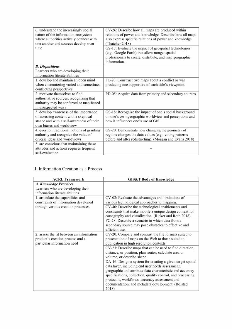
6. understand the increasingly social nature of the information ecosystem where authorities actively connect with one another and sources develop over time
CV-26: Describe how all maps are produced within relations of power and knowledge. Describe how all maps also express specific relations of power and knowledge. (Thatcher 2018) GS-17: Evaluate the impact of geospatial technologies (e.g., Google Earth) that allow nongeospatial professionals to create, distribute, and map geographic information.
B. Dispositions Learners who are developing their information literate abilities
1. develop and maintain an open mind when encountering varied and sometimes conflicting perspectives
FC-20: Construct two maps about a conflict or war producing one supportive of each side’s viewpoint.
2. motivate themselves to find authoritative sources, recognizing that authority may be conferred or manifested in unexpected ways
PD-05: Acquire data from primary and secondary sources.
3. develop awareness of the importance of assessing content with a skeptical stance and with a self-awareness of their own biases and worldview
GS-18: Recognize the impact of one’s social background on one’s own geographic worldview and perceptions and how it influences one’s use of GIS.
4. question traditional notions of granting authority and recognize the value of diverse ideas and worldviews
GS-20: Demonstrate how changing the geometry of regions changes the data values (e.g., voting patterns before and after redistricting). (Morgan and Evans 2018)
5. are conscious that maintaining these attitudes and actions requires frequent self-evaluation
--
II. Information Creation as a Process
ACRL Framework GIS&T Body of Knowledge A. Knowledge Practices Learners who are developing their information literate abilities
1. articulate the capabilities and constraints of information developed through various creation processes
CV-02: Evaluate the advantages and limitations of various technological approaches to mapping. CV-40: Describe the technological enablements and constraints that make mobile a unique design context for cartography and visualization. (Ricker and Roth 2018) FC-28: Describe a scenario in which data from a secondary source may pose obstacles to effective and efficient use.
2. assess the fit between an information product’s creation process and a particular information need
CV-20: Compare and contrast the file formats suited to presentation of maps on the Web to those suited to publication in high resolution contexts. CV-23: Describe maps that can be used to find direction, distance, or position, plan routes, calculate area or volume, or describe shape. DA-16: Design a system for creating a given target spatial data layer, including end user needs assessment, geographic and attribute data characteristic and accuracy specifications, collection, quality control, and processing protocols, workflows, accuracy assessment and documentation, and metadata development. (Bolstad 2018)

3. articulate the traditional and emerging processes of information creation and dissemination in a particular discipline
CV-01: Describe how compilation, production, and distribution methods used in map-making have evolved. CV-02: Explain how emerging technologies in related fields (e.g., the stereoplotter, aerial and satellite imagery, GPS and LiDAR, the World Wide Web, immersive and virtual environments) have advanced cartography and visualization methods. DC-36: Describe the georeferencing process including the techniques and transformations necessary for the use of historical maps. (Piovan 2019)
4. recognize that information may be perceived differently based on the format in which it is packaged
AM-59: Illustrate the impact of vector/raster/vector conversions on the quality of a dataset. CV-06: Compare multiple map projections to explain the difference in distortion patterns, and how the maps would be suited for different analysis or visualization purposes. (Battersby 2017) CV-12: Differentiate the interpretation of a series of three maps and a single multivariate map, each representing the same three related variables.
5. recognize the implications of information formats that contain static or dynamic information
AM-90: Name key visual analytics approaches for analyzing movement data, and list their properties and limitations. (Laube 2017) CV-17: Compare and contrast the relative advantages and limitations of four ways to represent spatiotemporal information: single static maps, multiple static maps, single dynamic maps, and multiple dynamic maps. (Fish 2018) CV-18: Compare and contrast different techniques for representing uncertainty in maps (e.g., the use of static vs. dynamic approaches). (Kinkeldey and Senaratne 2018)
6. monitor the value that is placed upon different types of information products in varying contexts
DM-57: Formulate metadata for a graphic output that would be distributed to the general public. FC-14: Outline the implications of differences in distance calculations on real world applications of GIS, such as routing and determining boundary lengths and service areas. FC-21: Describe how resolution can affect study findings and interpretations in environmental health risk assessment. (Lam 2019)
7. transfer knowledge of capabilities and constraints to new types of information products
AM-02: Explain what is special (i.e., difficult) about geospatial data analysis and why some traditional statistical analysis techniques are not suited to geographic problems. CV-03: Explain how data acquired from primary sources, such as satellite imagery and GPS, differ from data compiled from maps, such as DLGs. FC-25: Describe the causes of at least five different types of errors (e.g., positional, attribute, temporal, logical inconsistency, and incompleteness).
8. develop, in their own creation processes, an understanding that their choices impact the purposes for which the information product will be used and the message it conveys
CV-07: Prepare different maps using the same map components to produce maps with different purposes and distinctive intellectual and visual hierarchies. (Tait 2018) CV-08: Evaluate the effectiveness of a map’s symbology based on the underlying nature of the data and the visual variables used to represent those data. (White 2017) CV-26: Understand how decisions in the design of a map, and the underlying data from which a map draws, affect what users can know from the map. (Thatcher 2018)

B. Dispositions Learners who are developing their information literate abilities
1. are inclined to seek out characteristics of information products that indicate the underlying creation process
AM-87: Describe the problem of conflation associated with aggregation of data collected at different times, from different sources, and to different scales and accuracy requirements. DM-57: Interpret the elements of an existing metadata document.
2. value the process of matching an information need with an appropriate product
AM-60: Resample raster data sets (e.g., terrain, satellite imagery) to a resolution appropriate for a map of a particular scale. AM-62: Explain the pitfalls of using data generalized for small scale display in a large scale application.
3. accept that the creation of information may begin initially through communicating in a range of formats or modes
FC-05: Describe the limitations of various information stores for representing geographic information, including the mind, computers, graphics, and text. PD-05: Transfer data from primary and secondary sources into the database.
4. accept the ambiguity surrounding the potential value of information creation expressed in emerging formats or modes
AM-38: Explain the outcome of an artificial intelligence analysis (e.g., edge recognition), including a discussion of what the human did not see that the computer identified and vice versa. CV-16: Evaluate the extent to which a GeoWall or CAVE does or does not enhance understanding of spatial data.
5. resist the tendency to equate format with the underlying creation process
AM-56: Create a flowchart showing the sequence of transformations on a data set (e.g., geometric and radiometric correction and mosaicking of remotely sensed data). FC-20: Demonstrate how different methods of data classification for a single dataset can produce maps that will be interpreted very differently by the user.
6. understand that different methods of information dissemination with different purposes are available for their use
CV-32: Describe the different purposes that cartograms serve in relation to other thematic mapping techniques. (Field 2017) DA-16: Demonstrate basic skills in digital cartography, via the production of hardcopy and digital maps with appropriate layout and information. (Bolstad 2018)
III. Information Has Value
ACRL Framework GIS&T Body of Knowledge A. Knowledge Practices Learners who are developing their information literate abilities
1. give credit to the original ideas of others through proper attribution and citation
AM-12: Discuss the origins of cartographic modeling with reference to the work of Ian McHarg. CV-01: Explain how Bertin has influenced trends in cartographic symbolization.
2. understand that intellectual property is a legal and social construct that varies by culture
GS-07: Compare and contrast the consequences of different national policies about rights to geospatial data in terms of the real costs of spatial data, their coverage, accuracy, uncertainty, reliability, validity, and maintenance. GS-16: Discuss the production, maintenance, and use of geospatial data by a government agency or private firm from the perspectives of a taxpayer, a community organization, and a member of a minority group.

3. articulate the purpose and distinguishing characteristics of copyright, fair use, open access, and the public domain
CV-03: Describe the copyright issues involved in various cartographic source materials. GS-09: Explain the concept of “fair use” with regard to geospatial information.
4. understand how and why some individuals or groups of individuals may be underrepresented or systematically marginalized within the systems that produce and disseminate information
DC-22: Discuss the political, cultural, economic, and geographic characteristics of various countries that influence their adoption and use of GIS&T. GS-05: Describe an example of “local knowledge” that is unlikely to be represented in the geospatial data maintained routinely by government agencies.
5. recognize issues of access or lack of access to information sources
FC-35: Explain the importance and implications in GIS&T of at least 3 benefits of Openness in the following areas: Open Data; Free and Open Source Software; and Open Standards. (Moreno-Sanchez 2018) GS-22: Describe how inter-organization GIS portals may impact or influence issues related to social equity, privacy and data access.
6. decide where and how their information is published
GS-04: Use activity based on individuals’ location information, such as adding data to a crowdsourced map or using a map showing social media postings on specific topics. (Kerski 2016) GS-24: Discuss different types of Citizen Science activities (passive sensing, volunteer computing, volunteer thinking, environmental and ecological observation, participatory sensing, community/civic science) and potential motivations (intrinsic and extrinsic motives) participants may have to engage with projects. (Rickles et al. 2017)
7. understand how the commodification of their personal information and online interactions affects the information they receive and the information they produce or disseminate online
DA-24: Describe how big data, continuous data tracking and streaming, the Internet of things (IoT) and SoLoMo marketing have enhanced enterprise knowledge of current and potential customers. Explain how location analytics tools have contributed to these technologies. (Miller 2018) GS-04: Discuss how spatial data, GPS-enabled devices such as smartphones, the Internet of Things (geolocated objects that provide their location), and the Software as a Service (SaaS) GIS model have combined to bring society to its current high concern about location privacy. (Kerski 2016)
8. make informed choices regarding their online actions in full awareness of issues related to privacy and the commodification of personal information
CP-10: Discuss common geovisualization methods (e.g., graphs and maps) and tools for mapping and visualizing different components of social media data (e.g., geo-tags, temporal information, and users). (Huang 2018) GS-04: Discuss societal benefits and potential societal harm from the use of individuals’ location information. (Kerski 2016)
B. Dispositions Learners who are developing their information literate abilities
1. respect the original ideas of others GS-08: Distinguish among the various intellectual property rights, including copyright, patent, trademark, business methods, and other rights.
2. value the skills, time, and effort needed to produce knowledge
DC-21: Explain the ways in which metadata increases the value of geospatial data.
3. see themselves as contributors to the information marketplace rather than only consumers of it
DM-57: Use a metadata utility to create a geospatial metadata document for a digital database you created.

4. are inclined to examine their own information privilege
KE-06: Compare and contrast the needs, constraints, and opportunities of different types of institutions, such as corporations, non-profit organizations, government agencies, and educational institutions.
IV. Research as Inquiry
ACRL Framework GIS&T Body of Knowledge A. Knowledge Practices Learners who are developing their information literate abilities
1. formulate questions for research based on information gaps or on reexamination of existing, possibly conflicting, information
CV-35: Use a geovisualization application to explore a geospatial dataset. Note the geographic insights you find and hypotheses worth pursuing with additional analysis and visualization. (Çöltekin, Janetzko, and Fabrikant 2018) DA-23: Develop recommendations and practical solutions to help bridge the gap between ocean science/management and GIS, including increased integration of ocean data and improved analytical tools. (Wright 2017)
2. determine an appropriate scope of investigation
CV-03: List the data required to explore a specified problem. KE-05: Create requirements reports for individual potential applications in terms of the data, procedures, and output needed.
3. deal with complex research by breaking complex questions into simple ones, limiting the scope of investigations
AM-02: Outline the sequence of tasks required to complete the analytical process for a given spatial problem. FC-13: State questions that can be solved by selecting features based on location or spatial relationships.
4. use various research methods, based on need, circumstance, and type of inquiry
GS-25: Differentiate decision problems by their complexity, scope, nature of decision-makers, and spatiality. (Rinner 2018) KE-30: Describe three applications of geospatial technology for different workforce domains (e.g., first responders, forestry, water resource management, facilities management).
5. monitor gathered information and assess for gaps or weaknesses
DM-70: Explain how to recognize contaminated data in large datasets. (Usery 2019) KE-02: Identify geographic tasks for which particular geospatial technologies are not adequate or sufficient.
6. organize information in meaningful ways
CV-19: Develop a visualization for the exploration and analysis of big data. (Poorthuis 2018) DM-18: Identify whether it is important to represent temporal change in a particular GIS application.
7. synthesize ideas gathered from multiple sources
CV-38: Schedule a user-centered design process for acquiring feedback from target users throughout design and development. (Ooms and Skarlatidou 2018) KE-05: Evaluate how external spatial data sources can be incorporated into the business process.
8. draw reasonable conclusions based on the analysis and interpretation of information
AM-19: Select the appropriate statistical methods for the analysis of given spatial datasets by first exploring them using graphic methods. GS-11: Demonstrate the ability to reason about an ethical challenge in the professional practice of GIS by methodically analyzing an ethics case study. (DiBiase 2017)

B. Dispositions Learners who are developing their information literate abilities
1. consider research as open-ended exploration and engagement with information
AM-37: Explain how visual data exploration can be combined with data mining techniques as a means of discovering research hypotheses in large spatial datasets.
2. appreciate that a question may appear to be simple but still disruptive and important to research
--
3. value intellectual curiosity in developing questions and learning new investigative methods
AM-02: Discuss situations when it is desirable to adopt a spatial approach to the analysis of data.
4. maintain an open mind and a critical stance
GS-17: Differentiate applications that can make use of common-sense principles of geography from those that should not.
5. value persistence, adaptability, and flexibility and recognize that ambiguity can benefit the research process
GS-11: Demonstrate ethical creativity by posing multiple possible solutions to an ethical challenge. Resist the temptation to reduce such challenges to simplistic dilemmas. (DiBiase 2017)
6. seek multiple perspectives during information gathering and assessment
DA-09: Describe the four essential groups of people that are needed for a collaborative geodesign project. (Ruddell and Foster 2018)
7. seek appropriate help when needed -- 8. follow ethical and legal guidelines in gathering and using information
DC-24: Understand the requirements for legal operation of UAS for data collection purposes. (Mathews and Frazier 2017)
9. demonstrate intellectual humility (i.e., recognize their own intellectual or experiential limitations)
--
V. Scholarship as Conversation
ACRL Framework GIS&T Body of Knowledge A. Knowledge Practices Learners who are developing their information literate abilities
1. cite the contributing work of others in their own information production
AM-32: Explain Anselin’s typology of spatial autoregressive models. CV-02: Explain how MacEachren’s Cartography-cubed (C3) concept can be used to understand the evolving role of cartography and visualization.
2. contribute to scholarly conversation at an appropriate level, such as local online community, guided discussion, undergraduate research journal, conference presentation/poster session
--
3. identify barriers to entering scholarly conversation via various venues
DA-11: Discuss the epistemological and ontological barriers to the use of GIS&T in the humanities, and possible solutions. (Giordano 2019) DA-23: Identify, understand, and help overcome the barriers to use of scientific oceanographic data by GIS users, as well as increase the use of GIS tools by ocean science and resource management users. (Wright 2017)

4. critically evaluate contributions made by others in participatory information environments
CV-19: Critique a big data visualization by how well it overcame computational, visual, and ethical challenges. (Poorthuis 2018) CV-26: Identify and critique a map created through surveillant approaches to map making. Identify and critique a map created through sousveillant or participatory approaches. (Thatcher 2018)
5. identify the contribution that particular articles, books, and other scholarly pieces make to disciplinary knowledge
DA-11: Discuss the precursors to the spatial turn in the humanities, and specifically the ideas of chronotope and geohistoire, and Hägerstrand’s time-geography. (Giordano 2019) FC-30: Describe the contributions of McHarg and other practitioners in developing geographic analysis methods later incorporated into GIS.
6. summarize the changes in scholarly perspective over time on a particular topic within a specific discipline
CV-36: Describe the evolution of geovisual analytics as a sub-field in GIScience and its linkages to fields outside of Geography. (Robinson 2017) FC-31: Describe the major research foci in GIS and related fields in the 1970s, 1980s, 1990s, and 2000s.
7. recognize that a given scholarly work may not represent the only or even the majority perspective on the issue
AM-05: Describe the complexity and uncertainty in neighborhood definition, incorporating the idea of no consensus definition to fit all contexts. (Mu and Holloway 2019) GS-13: Present GIScience scholars’ and theorists’ responses to external critiques of GIS. (Leszczynski 2017)
B. Dispositions Learners who are developing their information literate abilities
1. recognize they are often entering into an ongoing scholarly conversation and not a finished conversation
FC-37: Enumerate past, contemporary, and still-to-be-researched properties of spatial autocorrelation. (Griffith 2017)
2. seek out conversations taking place in their research area
KE-29: Discuss the value or effect of participation in societies, conferences, and informal communities to entities managing enterprise GIS.
3. see themselves as contributors to scholarship rather than only consumers of it
FC-35: Research and present a benefit of Openness in GIS&T that is debated, questioned, or that has been highlighted as requiring more research. (Moreno-Sanchez 2018)
4. recognize that scholarly conversations take place in various venues
CP-05: Explain how an understanding of use of current and proposed technology in other organizations can aid in implementing a GIS.
5. suspend judgment on the value of a particular piece of scholarship until the larger context for the scholarly conversation is better understood
FC-07: Discuss the contributions that different perspectives on the nature of space bring to an understanding of geographic phenomenon.
6. understand the responsibility that comes with entering the conversation through participatory channels
CP-14: Critically discuss some societal effects stemming from the web-enabled shift of spatial data production from experts to laypersons (i.e., the rise of “neogeography”). (Quinn 2018)
7. value user-generated content and evaluate contributions made by others
CV-24: Evaluate the effectiveness of a map for its audience and purpose.
8. recognize that systems privilege authorities and that not having a fluency in the language and process of a discipline disempowers their ability to participate and engage
GS-17: Effectively communicate the design, procedures, and results of GIS projects to non-GIS audiences (clients, managers, general public).

VI. Searching as Strategic Exploration
ACRL Framework GIS&T Body of Knowledge A. Knowledge Practices Learners who are developing their information literate abilities
1. determine the initial scope of the task required to meet their information needs
CV-03: Compile a map using at least three data sources. DC-36: Obtain historical maps in digital form and prepare them for georeferencing. (Piovan 2019)
2. identify interested parties, such as scholars, organizations, governments, and industries, who might produce information about a topic and then determine how to access that information
DA-05: List and describe the types of data maintained by local governments. KE-28: Select and describe the leading trade journals serving the GIS&T community.
3. utilize divergent (e.g., brainstorming) and convergent (e.g., selecting the best source) thinking when searching
AM-69: Demonstrate how to examine the CA research literature. (Clarke 2017) KE-08: Identify potential sources of data (free or commercial) needed for a particular application or enterprise.
4. match information needs and search strategies to appropriate search tools
DC-28: Link Census demographic data to the appropriate TIGER geography within GIS. (Castagneri 2019) KE-28: Describe the leading academic journals serving the GIS&T community.
5. design and refine needs and search strategies as necessary, based on search results
DA-16: Identify, download, prepare, and interpret public data sources relevant to forestry, including USDA Agricultural Research Service National Aerial Imagery Program aerial photographs, NRCS SSURGO soils data, USGS digital elevation data, USDA National Agricultural Service Crop Data Layer data, USFWS National Wetlands Inventory data, and USGS National Hydrography Dataset streams, rivers, and lakes data. (Bolstad 2018)
6. understand how information systems (i.e., collections of recorded information) are organized in order to access relevant information
DC-28: Retrieve relevant census data from the Census website. (Castagneri 2019) DM-60: Differentiate text-based search and map-based search. (Hu and Li 2017)
7. use different types of searching language (e.g., controlled vocabulary, keywords, natural language) appropriately
DM-58: Describe a domain ontology or vocabulary (i.e., land use classification systems, surveyor codes, data dictionaries, place names, or benthic habitat classification system).
8. manage searching processes and results effectively
KE-28: Develop a bibliography of scholarly and professional articles and/or books that are relevant to a particular GIS&T project.
B. Dispositions Learners who are developing their information literate abilities
1. exhibit mental flexibility and creativity -- 2. understand that first attempts at searching do not always produce adequate results
--
3. realize that information sources vary greatly in content and format and have varying relevance and value, depending on the needs and nature of the search
KE-25: Find or create training resources appropriate for GIS&T workforce in a local government organization.
4. seek guidance from experts, such as librarians, researchers, and professionals
DC-36: Plan the acquisition of historical maps both online and in archives, libraries and other repositories. (Piovan 2019)

5. recognize the value of browsing and other serendipitous methods of information gathering
--
6. persist in the face of search challenges, and know when they have enough information to complete the information task
--
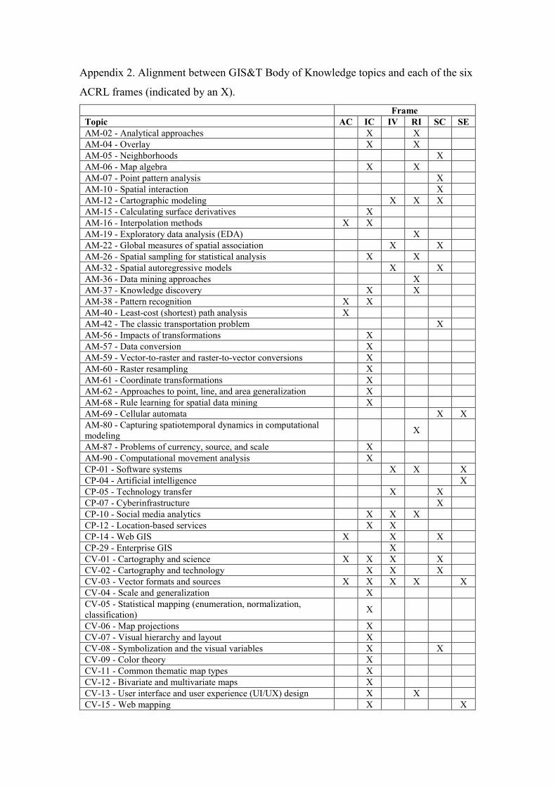
Appendix 2. Alignment between GIS&T Body of Knowledge topics and each of the six
ACRL frames (indicated by an X). Frame Topic AC IC IV RI SC SE AM-02 - Analytical approaches X X AM-04 - Overlay X X AM-05 - Neighborhoods X AM-06 - Map algebra X X AM-07 - Point pattern analysis X AM-10 - Spatial interaction X AM-12 - Cartographic modeling X X X AM-15 - Calculating surface derivatives X AM-16 - Interpolation methods X X AM-19 - Exploratory data analysis (EDA) X AM-22 - Global measures of spatial association X X AM-26 - Spatial sampling for statistical analysis X X AM-32 - Spatial autoregressive models X X AM-36 - Data mining approaches X AM-37 - Knowledge discovery X X AM-38 - Pattern recognition X X AM-40 - Least-cost (shortest) path analysis X AM-42 - The classic transportation problem X AM-56 - Impacts of transformations X AM-57 - Data conversion X AM-59 - Vector-to-raster and raster-to-vector conversions X AM-60 - Raster resampling X AM-61 - Coordinate transformations X AM-62 - Approaches to point, line, and area generalization X AM-68 - Rule learning for spatial data mining X AM-69 - Cellular automata X X AM-80 - Capturing spatiotemporal dynamics in computational modeling
X
AM-87 - Problems of currency, source, and scale X AM-90 - Computational movement analysis X CP-01 - Software systems X X X CP-04 - Artificial intelligence X CP-05 - Technology transfer X X CP-07 - Cyberinfrastructure X CP-10 - Social media analytics X X X CP-12 - Location-based services X X CP-14 - Web GIS X X X CP-29 - Enterprise GIS X CV-01 - Cartography and science X X X X CV-02 - Cartography and technology X X X CV-03 - Vector formats and sources X X X X X CV-04 - Scale and generalization X CV-05 - Statistical mapping (enumeration, normalization, classification)
X
CV-06 - Map projections X CV-07 - Visual hierarchy and layout X CV-08 - Symbolization and the visual variables X X CV-09 - Color theory X CV-11 - Common thematic map types X CV-12 - Bivariate and multivariate maps X CV-13 - User interface and user experience (UI/UX) design X X CV-15 - Web mapping X X

Frame Topic AC IC IV RI SC SE CV-16 - Virtual and immersive environments X CV-17 - Spatiotemporal representation X CV-18 - Representing uncertainty X CV-19 - Big data visualization X X X X CV-20 - Raster formats and sources X CV-21 - Map reading X CV-23 - Map analysis X CV-24 - User-centered design and evaluation X X CV-25 - Metadata, quality, and uncertainty X X X CV-26 - Cartography and power X X X CV-27 - Cartography and art X X CV-32 - Cartograms X X CV-35 - Geovisualization X X CV-36 - Geovisual analytics X X X CV-38 - Usability engineering & evaluation X X CV-40 - Mobile maps and responsive design X DA-01 - GIS&T and agriculture X X DA-04 - GIS&T and civil engineering X DA-05 - Applications in local government X X X DA-06 - Applications in state government X X X DA-07 - Applications in federal government X X X DA-08 - GIS&T and archaeology X DA-09 - GIS&T and geodesign X X DA-10 - GIS&T and real estate X DA-11 - GIS&T and the digital humanities X X DA-16 - GIS&T and forestry X X X X DA-23 - GIS&T and marine science X X X DA-24 - GIS&T and marketing X X X DA-25 - Geospatial intelligence and national security X DA-33 - GIS&T in urban and regional planning X X X DA-37 - GIS&T and epidemiology X X X X X DA-38 - GIS&T and retail business X X X DC-03 - Global Positioning System X X DC-09 - Field data technologies X DC-10 - Aerial photography: History and georeferencing X X DC-13 - Stereoscopy and orthoimagery X DC-14 - Vector data extraction X DC-16 - Nature of multispectral image data X DC-18 - Algorithms and processing X DC-21 - Spatial data sharing among organizations X DC-22 - Federal agencies and national and international organizations and programs X X
DC-24 - Unmanned aerial systems (UAS) X X X X DC-26 - Remote sensing platforms X X DC-28 - United States census data X X X DC-36 - Historical maps in GIS X X DM-07 - The raster data model X DM-18 - Spatio-temporal GIS X X DM-19 - Modeling uncertainty X X DM-20 - Discrete entities X X DM-21 - Modeling three-dimensional (3D) entities X DM-28 - Topological relationships X DM-30 - Vagueness X DM-32 - Error-based uncertainty X DM-34 - Conceptual data models X X DM-44 - Approximating the Earth's shape with geoids X
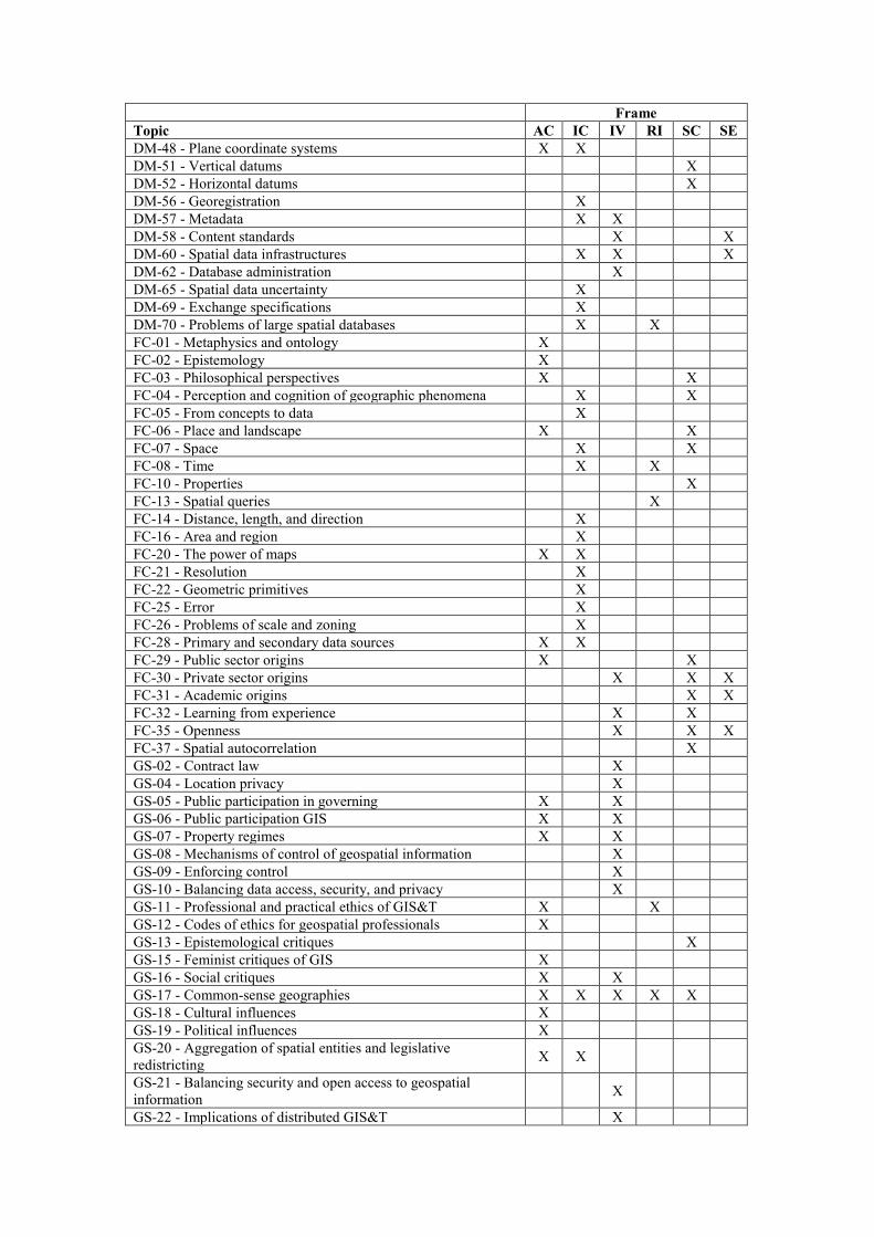
Frame Topic AC IC IV RI SC SE DM-48 - Plane coordinate systems X X DM-51 - Vertical datums X DM-52 - Horizontal datums X DM-56 - Georegistration X DM-57 - Metadata X X DM-58 - Content standards X X DM-60 - Spatial data infrastructures X X X DM-62 - Database administration X DM-65 - Spatial data uncertainty X DM-69 - Exchange specifications X DM-70 - Problems of large spatial databases X X FC-01 - Metaphysics and ontology X FC-02 - Epistemology X FC-03 - Philosophical perspectives X X FC-04 - Perception and cognition of geographic phenomena X X FC-05 - From concepts to data X FC-06 - Place and landscape X X FC-07 - Space X X FC-08 - Time X X FC-10 - Properties X FC-13 - Spatial queries X FC-14 - Distance, length, and direction X FC-16 - Area and region X FC-20 - The power of maps X X FC-21 - Resolution X FC-22 - Geometric primitives X FC-25 - Error X FC-26 - Problems of scale and zoning X FC-28 - Primary and secondary data sources X X FC-29 - Public sector origins X X FC-30 - Private sector origins X X X FC-31 - Academic origins X X FC-32 - Learning from experience X X FC-35 - Openness X X X FC-37 - Spatial autocorrelation X GS-02 - Contract law X GS-04 - Location privacy X GS-05 - Public participation in governing X X GS-06 - Public participation GIS X X GS-07 - Property regimes X X GS-08 - Mechanisms of control of geospatial information X GS-09 - Enforcing control X GS-10 - Balancing data access, security, and privacy X GS-11 - Professional and practical ethics of GIS&T X X GS-12 - Codes of ethics for geospatial professionals X GS-13 - Epistemological critiques X GS-15 - Feminist critiques of GIS X GS-16 - Social critiques X X GS-17 - Common-sense geographies X X X X X GS-18 - Cultural influences X GS-19 - Political influences X GS-20 - Aggregation of spatial entities and legislative redistricting X X
GS-21 - Balancing security and open access to geospatial information
X
GS-22 - Implications of distributed GIS&T X

Frame Topic AC IC IV RI SC SE GS-23 - Legal mechanisms for sharing geospatial information X GS-24 - Citizen science with GIS&T X X GS-25 - Spatial decision support X KE-02 - Problem definition X KE-05 - Requirements analysis X X X KE-06 - Social, political, and cultural issues X X KE-07 - Feasibility analysis X X KE-08 - Data costs X X X KE-11 - Funding X KE-14 - Valuing and measuring benefits X KE-16 - Agency, organizational, and individual perspectives X KE-17 - Measuring costs X X KE-18 - Data sharing among public and private agencies, organizations, and individuals
X
KE-25 - GIS&T training and education X KE-27 - Professional organizations X X X KE-28 - Publications X X X KE-29 - The geospatial community X X X KE-30 - The geospatial industry X KE-31 - Professional certification X KE-32 - Competence in GIS&T knowledge work X PD-05 - Implementation tasks X X X PD-12 - Commercialization of GIS applications X PD-19 - GIS APIs X X X Total 44 96 50 40 50 34

Table 1. Snapshot of Appendix 1 included to illustrate the coding scheme employed
during qualitative analysis and representative examples from the crosswalk process. ACRL Framework GIS&T Body of Knowledge
I. Authority is Constructed and Contextual A. Knowledge Practices 6. understand the increasingly social nature of the information ecosystem where authorities actively connect with one another and sources develop over time
GS-17: Evaluate the impact of geospatial technologies (e.g., Google Earth) that allow nongeospatial professionals to create, distribute, and map geographic information.
II. Information Creation as a Process B. Dispositions 5. resist the tendency to equate format with the underlying creation process
FC-20: Demonstrate how different methods of data classification for a single dataset can produce maps that will be interpreted very differently by the user.
III. Information Has Value B. Dispositions 2. value the skills, time, and effort needed to produce knowledge
DC-21: Explain the ways in which metadata increases the value of geospatial data.
IV. Research as Inquiry A. Knowledge Practices 3. deal with complex research by breaking complex questions into simple ones, limiting the scope of investigations
AM-02: Outline the sequence of tasks required to complete the analytical process for a given spatial problem.
V. Scholarship as Conversation B. Dispositions 7. value user-generated content and evaluate contributions made by others
CV-24: Evaluate the effectiveness of a map for its audience and purpose.
VI. Searching as Strategic Exploration A. Knowledge Practices 3. utilize divergent (e.g., brainstorming) and convergent (e.g., selecting the best source) thinking when searching
KE-08: Identify potential sources of data (free or commercial) needed for a particular application or enterprise.

Table 2. Ratio comparing the number of topics aligned to the Framework to the total
number of topics in each BoK 2.0 knowledge area (ranked highest to lowest). Knowledge
Area Aligned Topics
Total Topics
Alignment Ratio
DA 16 16 1.00 CV 29 32 0.91 GS 22 25 0.88 FC 24 34 0.71 DC 13 20 0.65 CP 8 13 0.62 KE 17 33 0.52 AM 29 58 0.50 DM 21 43 0.49 PD 3 16 0.19
Total 182 290 0.63

Table 3. Matrix depicting the number of learning objectives aligned to the Framework
for each unique pairing of BoK 2.0 knowledge areas and ACRL frames. Frame Knowledge
Area AC IC IV RI SC SE
AM 3 24 3 11 9 1 CP 1 2 8 2 4 2 CV 11 62 9 9 18 2 DA 9 11 7 6 7 12 DC 6 15 5 1 2 8 DM 2 23 7 5 4 3 FC 12 19 6 2 15 5 GS 16 5 28 4 4 0 KE 7 3 6 7 8 11 PD 1 3 1 1 0 2