mapme mapping application programming language made for everyone mapme coms w4115 programming...
Post on 19-Dec-2015
224 views
TRANSCRIPT
Mapping Application Programming language Made for everyone
MAPMe
COMS W4115 Programming Languages and Translators
Professor Stephen Edwards
Group Members:
Changyu Liu – cl2997Eric Ellis – ede2106
Denelle Baptiste – dgb2122Jonecia Keels – jtk2128

MAPMe
A simply created, object-applicative, imperative style language that allows for manipulation of real
geographical data.
Designed to allow users the ability to easily computerize geographical data and apply algorithms to solve a number
of different problems

MAPMe
easily learn-able for beginners
quickly adaptable for programmers coming from any language
focuses on applying functions on user created objects to solve problems or build applications
object creation is the basis of this language

MAPMe
Example 1: College Students can create a representative map of their campus and determine how long it takes to get from their campus dorm or from class to class.
Example 2: A user can model their neighborhood and the location of their favorite fast food restaurant and can calculate the shortest distance from their home to a restaurant. The user can build mode of transportation objects which has the potential to calculate estimate time of arrival.
Example 3: A cyclist training for a marathon can generate multiple paths of some distance he could travel from his home as part of his regime.
Example 4: When road disturbances occur (i.e. construction, accidents, etc.), the Department of Transportation can use MAPMe to generate all alternate paths to route destinations to find detours.

MAPMe
Algorithms
HASH MAP TO CREATE TAGS FOR BUILDINGS/LANDMARKS create a type for modes of transportation (car, walking, bike, etc) calculate all paths from a to b (detour paths also included) Shortest Path
dijkstra's algorithm Determining all intersections on the map find nearest points of interest specify path types (road, walkway, interstate) to give more
accurate directions Calculate estimated time of arrival (eta)

Geographical Area for Demonstration
Between Broadway and Amsterdam from W 110th St to W 120th St

Demo XML File
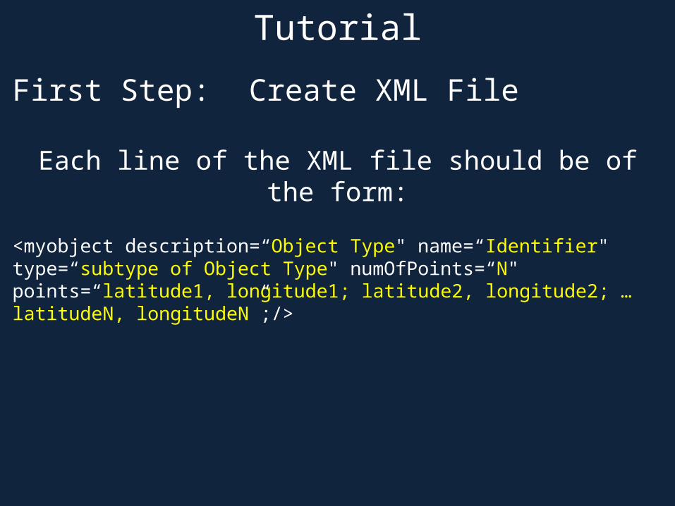
Tutorial
First Step: Create XML File
Each line of the XML file should be of the form:
<myobject description=“Object Type" name=“Identifier" type=“subtype of Object Type" numOfPoints=“N" points=“latitude1, longitude1; latitude2, longitude2; … latitudeN, longitudeN”;/>
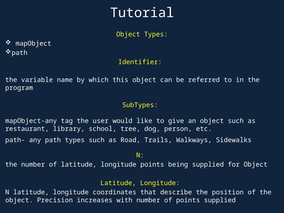
Tutorial
Object Types: mapObject path
Identifier:
the variable name by which this object can be referred to in the program
SubTypes:
mapObject-any tag the user would like to give an object such as restaurant, library, school, tree, dog, person, etc.
path- any path types such as Road, Trails, Walkways, Sidewalks
N:
the number of latitude, longitude points being supplied for Object
Latitude, Longitude:
N latitude, longitude coordinates that describe the position of the object. Precision increases with number of points supplied

Tutorial
Second Step: Create MAPMe File
~Comments are written like this~
~Stream command loads xml file and create all the objects defined~
stream(“ColumbiaU.xml”);
~Variable Declaration~int x;
Float y;
String text;
StringList slist;
SlistHash hashlist;

Tutorial
~Use of Variables~
x = 10;x = (x +1);
Slisthash hashlist;
StringList slist;
hashlist.add “car” {“BMW”, “Volkswagon”};
slist = hashlist.find “car”
print(slist);
~Conditionals~int i;
string error;
i=0;
if ((i<5))
{ print(i);}
else
{ error = “i is not less than 5”; print (error);}
Second Step: Create MAPMe File
Tutorial
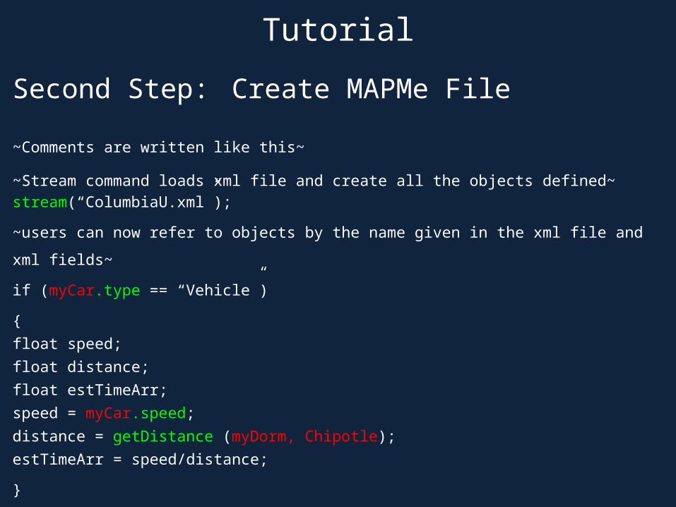
Second Step: Create MAPMe File
~Comments are written like this~
~Stream command loads xml file and create all the objects defined~
stream(“ColumbiaU.xml”);
~users can now refer to objects by the name given in the xml file and xml fields~
if (myCar.type == “Vehicle”)
{
float speed;
float distance;
float estTimeArr;
speed = myCar.speed;
distance = getDistance (myDorm, Chipotle);
estTimeArr = speed/distance;
}
Implementation of MAPMe

Lessons Learned