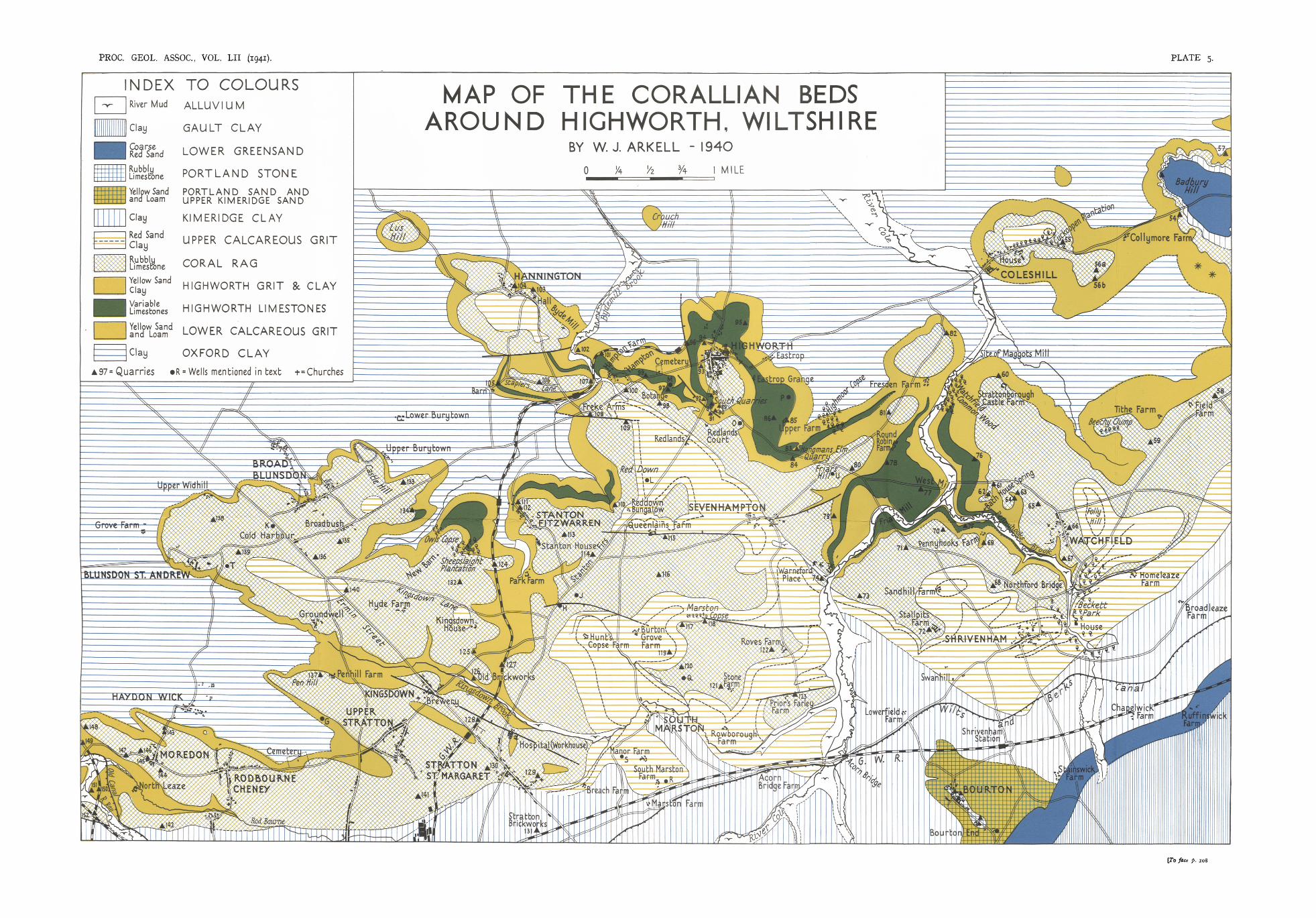
map of the corallian beds around highworth, wiltshire
TRANSCRIPT
79
MAP OF THE CORALLIAN BEDS AROUNDHIGHWORTH, WILTSHIRE.
By W. J. ARKELL, M.A., D.Se., F.G.S.
[Reeciz'ed aznd June, 1940.J
CONTENTS.
I.
II.
III.
IV.
V.VI.
VII.
VIII.
IX.X.
INTRODUCTION
BADBURY HILL AND COLESHILL
THE FULL SEQUENCE IN THE HIGHWORTH DISTRICT
THE \VEDGING-OUT OF THE HIGHWORTH BEDS
THE BLUNSDON PLATEAU, PEN HILL, AND RODBOURNE •..
THE UPPER CALCAREOUS GRIT
STRUCTURE
THE RELATION OF DRAINAGE TO STRUCTURE
REFERENCES
ApPENDIX: RECENT BORINGS ...
PAGE
79
80
81
86
91
92
951°4
1°7
1°7
I. INTRODUCTION.THE map now presented is a westward continuation of that
published in 1939, which showed the Corallian Beds between Marcham and Faringdon, Berkshire. The two areas arevery different topographically. East of Faringdon the CorallianBeds form a plateau (the Faringdon Ridge), 12 miles long and3 miles broad, which is drained by small streams running fromthe northern edge obliquely down dip, through broad shallowvalleys, to a strike stream on the Kimeridge Clay, the RiverOck. West of Faringdon, beyond the Ock-Cole watershed, thestreams from the chalk downs run northward into the Thames,carving through the Corallian outcrop contrary to the dip ofthe rocks. Consequently the Corallian plateau is cut up intotabular hills, often separated by steep-sided valleys, some ofwhich, especially those of the Cole and Pennyhooks Brook, areminiature gorges of considerable charm.
The present map (PI. 5) comprises 9 sheets of the six-inchOrdnance Survey, eight of which had not been mapped geologicallyon the six-inch scale. The only existing map was the Old Seriesone-inch survey by Hull (1857). On this the most importantstructured feature of the area, the Redlands Syncline (see below,p. 95), floored with Upper Calcareous Grit and Kimeridge Clay,is shown as an erosion valley floored with Lower Calcareous Gritand Oxford Clay. Accordingly, over the central part of the districtthe strike lines and boundaries run in general at right-anglesto those shown on Hull's map. Between 1923 and 1925, whenan undergraduate, I attempted to re-map sheet Wilts. XI N.W.
PROC. GEOL. Assoc., VOL. LII, PART 2, 1941. 6
80 W. J. ARKELL,
on the six-inch scale (see Arkell, 1927). I was able to introducea corrected stratigraphy and interprete d the Redlands valleyas a st ructural va lley instead of one of erosion; but I was stilltoo much under the influence of Hull 's mapping and was tackling problems which were insoluble without the aid of an augerand experience gained lat er in mapping neighbourin g sheets .
As before, qu arries and oth er permanent sections (roo innumber) are marked by numbered black triangles, and someimportant wells mentioned in the text by lettered black dots.The numbering and lettering follow on from the map to theeast (Arkell, 1939) and run in general from east to west .
II. BADBURY HILL AND COLESHILL.The Corallian beds ente r t he district as the reduced succes
sion described at the west end of the Marcham-Faringdon map .About 50-60 ft. of Lower Calcareous Grit are overlain by theOsmington Oolite Series, consisting of 4 to 12 ft. of white oolite(H Farin gdon Facies") which passes up into the Coral Rag ofvariable thickness up to 12 ft.
The Lower Calcareous Grit is a clean yellow sand becomingloamy towards the base. It appears to be indivisible. Notrace was detected of limestones which might correspond withth e Trigonia beds and Pusey Flags. On two spurs marked byaster isks on the south side of Badbury Hill there are deposits ofoolitic limestone with many Serpulae and Exogyrae and Gryphaeadilaiata, which are suggest ive of an outcrop of those beds, butinvestigation with an auger leads to the conclusion that theyare a superficial accumulation connect ed wit h an ear lier stagein the excavation of the va lley which now separates BadburyHill from the main outcrop. A nearly complete sect ion of theLower Calcareous Grit is afforded by the road-cutting at theascent of Coleshill from the east, and here as elsewhere no tracesof limestone can be found.
The best exposure of the Osmington Oolite Series is Cuckoopen Plantation Quarry, Coleshill (55), which was excavated bythe writer down to the Lower Calcareous Grit. Here the whiteH Faringdon " oolite is 12 ft . thick and is overlain by 2! ft. ofCoral Rag (Arkell, 1927, p. 106). There are remains of extensive old quarries S.E. of this (s6a & b). On Badbury Hill anold quarry (54) shows about 3 ft . of oolite and 3 ft. of Coral Ragwith pebbles of oolit e along the junction. This is nearly thefull thickness of the Coral Rag, for Kimeridge Clay followsimmediately: the greater part therefore is probably representedby the white oolit e.
From the outskirts of Faringdon, past Badbury Hill , theUpper Corallian is horizont al and its edge keeps just above the
MAP OF CORALLIAN BEDS AROUND HIGHWORTH. 81
400 foot contour. Then at the "waist" of Coleshill Hill itsuddenly begins to fall westward, bringing in an outlier of UpperCalcareous Grit (chiefly clay), one-third of a mile long. Most ofthe steep village street, down to the green, is on the Coral Rag,the base of which sinks to about 340 ft. O.D., a drop of some60 feet in half a mile. The base of the Lower Calcareous Gritsinks also, but not so much, and at the same time the brightclean sands disappear. At the west end of Coleshill the Calcareous Grit is loamy as in the Faringdon Syncline and appearsto be much less than the normal thickness. Indeed, althoughthere are warrens E. and S.E. of the house, a few hundred yardsfarther W., along the western edge of the park, it is difficult todetect any sand at all, even with an auger. Half a mile to theS.W., on the Fresden spur, the Coral Rag is still lower and theCalcareous Grit still thinner (see below, p. 87).
III. THE FULL SEQUENCE IN THE HIGHWORTHDISTRICT.
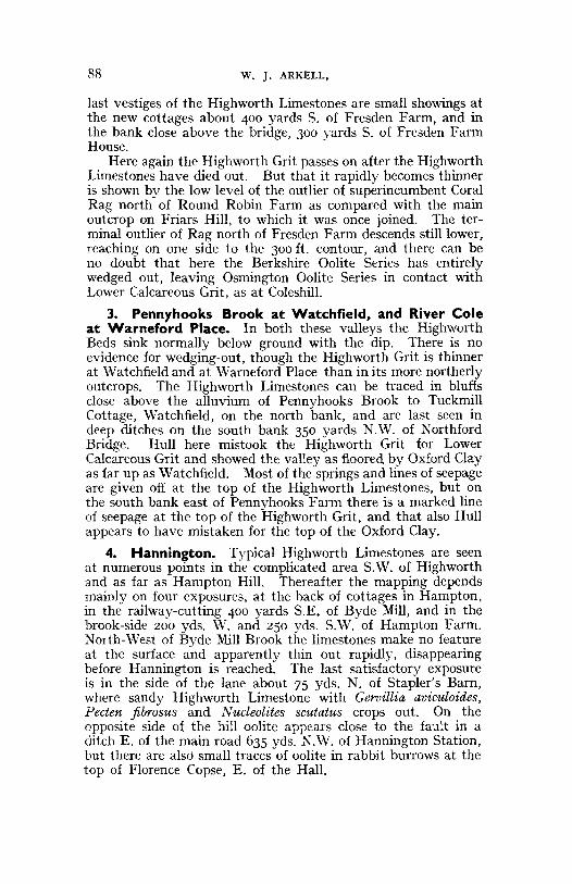
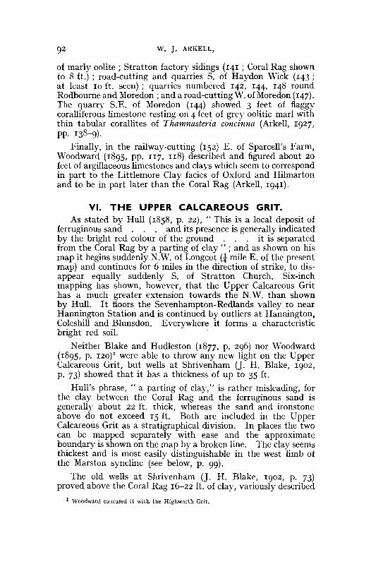
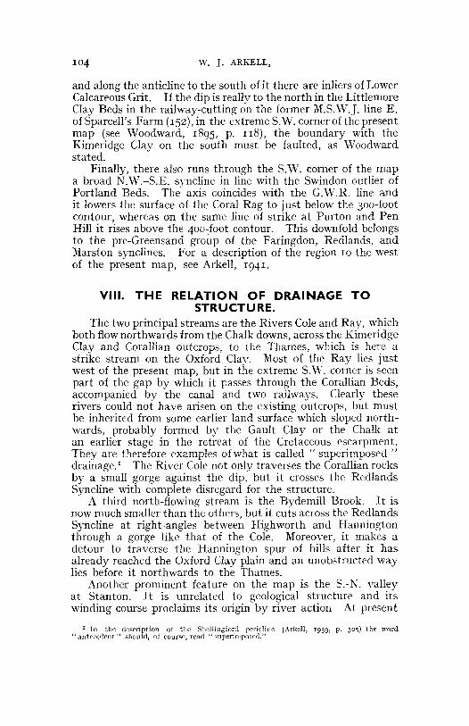
In an area about five miles long from east to west, north of aline from Watchfield to Stanton Fitzwarren, and two milesbroad from south to north, the Corallian Beds are much morefully developed than elsewhere, and comprise the five divisionsenumerated below. This is the Highworth district, well knownto stratigraphers for exhibiting three calcareous grits separatedby two coral rags, as described by Lonsdale (1832) and Blakeand Hudleston (1877). Since the stratigraphy and palaeontologyof the district have been described in detail (Arkell, 1927 and1927a), it is only necessary to give a brief summary here and tonote corrections to the correlations and thence to the stratalnames resulting from subsequent work. The following notesare an amplification of Fig. 4 and a necessary preliminary towhat follows in Section IV.
I. Lower Calcareous Grit. The thickness is difficult todetermine owing to downward gradation of the sand into clayand to the variable amount of sand present in different places.Well records usually give thicknesses of 20-30 ft.: for instanceat Red Down boring (L) 20 ft., at Upper Farm (P) 22 ft., atBotany Farm (M) 23 ft., at Sheep Street (N), east of the church,26-30 ft. (see Arkell, 1927a). But in the escarpment west ofthe town at Hampton Hill and the cemetery, and also at CrouchHill, the thickness of sand and loam can be seen to be at leastSo ft. Moreover, samples from the Red Down boring containedsand mixed with the clay to the bottom. It is therefore considered now more probable that, in spite of the label Oxford Clayalways affixed to the lowest 20 ft. of beds encountered in thatboring (and at the bottom of other wells in the district), the true
82 w. J. ARKELL,
Oxford Clay was never reached. Accordingly the lowest 40 ft.are now assigned to the Lower Calcareous Grit instead of only20 ft. (See Fig. 4.)
At Fresden, Hull mapped the Coral Rag as resting directlyon Oxford Clay, but sands are present though more loamythan at Highworth and perhaps not more than 20 ft. thick.'As in the Faringdon Syncline at Faringdon, the dark and loamycondition of the Lower Calcareous Grit may be due to its tectonicposition. Where the position is high and well-drained (as atHampton Hill) the sand has been washed clean; in low-lyingsituations in synclines it has not, or may even have had mudwashed into it.
2. Highworth Limestones (with Lower Coral Rag).These beds, comprising the lower half of the BerkshireOolite Series, were formerly called the Trigonia perlata Limestones and Urchin Marls. But the Trigonia is not T. perlata Ag.,but T. hudlestoni Lycett (see Arkell, 1930, p. 73); and thecorrelation with the Urchin Marls of Berkshire was incorrect,for those belong to the Osmington Oolite Series (see Arkell,1939, p. 502). Accordingly a new name is needed for thesebeds and Highworth Limestones is now used. They can onlybe mapped as a single block, and the two subdivisions areunimportant, even locally. The Highworth Limestones correlatewith the Pisolite, Lower Trigonia Bed, and Pusey Flags of theFaringdon Ridge (Arkell, 1939).
The Highworth Limestones are up to 15 feet thick andconsist essentially of shelly oolites with thin beds of corals inthe lower part. They are best seen in their typical developmentat South Quarries (87), at North-East Quarry (95), at Hangman'sElm (83), and on arable fields north and west of the town.From this facies comes the wealth of ammonites at present beingmonographed (Arkell, 1938-1940).
Near Upper Farm, south of Eastrop Grange, old quarries(86) show a lateral passage from normal bedded HighworthLimestones into typical coral rag; and at Hangman's ElmQuarry (83), while the upper part of the limestones is normallybedded and has yielded many of the best ammonites, the lowest2 feet 8 inches consists of a marly coral rag with Thecosmiliaand Thamnasteria (Arkell, 1927, pp. III-II4).
On the opposite side of Friar's Hill, half a mile to thesouth-east, the whole of this division re-emerges as coral rag.At two quarries (77, 78) some 4 feet of true fossil coral reef are
1 Fresden Farm was formerly called Maggots Mill Farm, and" Meggots "Millnear Coleshill"was a locality from which William Smith obtained Gryphaea dilatata ; but the site of the mill washalf-a mile north-east of the farm and on the Upper Oxford Clay according to present-mapping,so this record provides no evidence of Oxford Clay tongueing up the Cole Valley past Fresdenas shown on Hull's map, The oyster shells are also found in the bottom of Coleshill Park, asJam informed by Miss Pleydell-Bouvene.

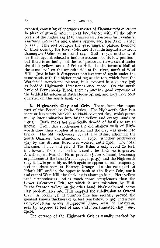
FEET
HIGHWORTHLIMESTONES
HIGHWOR.T HGR.IT .A.NDCLAY
9115
0 :":-.->: .:-::: :- :-:.':: Red loam 3'. .. . . . .. . - ..Clay 3'Ironstone I'
10
Clay 19', brick redtowards top-
2.0
I I li mestone. hard com~ct.> ~elj
30 I I I and white (Wheatley facIesI I with 3 bands of marl 8' .2."
-IL.. ~ -l<.. ....fk--l<. oIL ole. ok
40 -IL. -II.. .... -.LCoral Rag 15'10"-II.. -II.. .... i- t.
~ -II.. .... oL~ oL t. -II.. ~
50 ~ ot. ~ ~Soft sandu oolite 1'-2.'.. ... .. . . . . .Sand 3'.. .. . . . . . . .. .. . . . . . , . .._.
"/ / / / Hard ironj:l sandstone with: ...... ...... ............ oollths 110"
60 ::.:.: :.::.::":.~:.: ::.:.::.~.> :: Sand 4'~" passing down into_ interlaminated sand and c1alj,
and clay, together 6'-8 '
70 ;::;':...--_.:_-~:;-: Oolitic marls in soft al)d ~ard-:=-:::.= ~_: ~- bands(=Pusey Aags) 4--6
Shl!lly oolitic limestones with
80marl part ings (/-10'
1-2.'Gn tstone<: r: : .. .. ..r: r: Sand l' 9"..... ....... .........90 . . . . . . " . .. . . Gritstone l '
0" '" , " , ": :, ' , ' ,': : Sand 4 ' 3". . . . . . . . . . ... . .....Grit stone 2'"/ / / "//
: : rrrr:': :: : .' .
100.. . . . . . .. ...
Sand 8'.: : : :: : : r:»: .. . , .. . . . . . . .. . . .. . ' . . .............r: ........-Base of Wel l...... . . . .. .... .
. -r""'P" . • •
110 ... .. . .. .. . . . ' "
. . .. .. . ... . . . Sand!J d ar 2.0' 5"... . . . ... . ..(Traces 0 sand to bottom)
... .... . . . .. . .12.0 .. . . . .. .. .. . .
...... .. . . . . ...- - Base of Borin.. . ....
LOWERCALCAREOUSGRIT (40')
OSM INGTONOOLITESE~IES (2.5')
UPPERCALCAREOUSGRIT (261
)
BERKSHIREOOLITESERIES (?l3')
F IG. 4.-FuLL SUCCESSION OF CoRALLIAN BEDS proved in the Red DownBoring, Highworth, with details filled in from sa mples examined, and someboundari es in te rpolate d from neighbouring quarries . (Based on Arkell,
1927a. with corrections to t he classificat ion.)
w. J. ARKELL,
exposed, consisting of enormous masses of Thamnasteria concinnain place of growth and in great luxuriance, with all the othercorals of the higher rag (Th. arachnoides, Thecosmilia annular is,Isastraea explanata) and Cidaris spines, etc. (see Arkell, 1927,p. II3). This reef occupies the quadrangular plateau boundedon three sides by the River Cole, and it is indistinguishable fromOsmington Oolite Series coral rag. Hull (1857), mistaking itfor that rag, introduced a fault to account for its low position;but there is no fault, and the reef passes north-westward underthe thick yellow sands of Friar's Hill. It also forms a bluff atthe same level on the opposite side of the river, north of WestMill. Just before it disappears north-eastward again under thesame sands with the higher coral rag at the top, which form theWatchfield Aerodrome plateau, it is exposed in a quarry (76)as bedded Highworth Limestones once more. On the northbank of Pennyhooks Brook there is another good exposure ofthe bedded limestones at Bath House Spring, and they have beenquarried on the south bank (75).
3. Highworth Clay and Grit. These form the upperpart of the Berkshire Oolite Series. The Highworth Clay is amore or less sandy blackish to khaki-coloured clay, which passesup by interlamination into bright yellow and orange sands or" grit." Both rocks are practically devoid of fossils so far asknown. From this subdivision the old shallow wells of Highworth drew their supplies of water, and the clay was made intobricks. The old brickworks (88) at The Kilns, adjoining theSouth Quarries, was abandoned in 1890. Another brickworks(94) by the Station Road was worked until 1902. The totalthickness of clay and grit at The Kilns is only about 10 feet,but towards the east, north and south the thickness is greater.A well (0) at Fennel's Farm proved 8-1 feet of sand, becomingargillaceous at the base (Arkell, 1927a, p. 47), and the HighworthClay below is probably as thick again.as appeared from temporarysections since seen at Eastrop Grange. In the east part ofFriar's Hill and in the opposite bank of the River Cole, northand east of West Mill, the thickness is about 30 feet. Here yellowsand predominates and is much more conspicuous than theLower Calcareous Grit, for which it was mistaken by Hull.In the Stanton valley, on the other hand, khaki-coloured loamyclay predominates and Hull mapped the subdivision as OxfordClay. A boring (J) at Stanton Firs has recently proved thegreatest known thickness of 34 feet (see below, p. 90)' and a newrailway-cutting across Kingsdown Lane, west of Catsbrain,near by, exposed 12 feet of sand and interlaminated clay (June,1940 ) .
The outcrop of the Highworth Grit is usually marked by
MAP OF CORALLIAN BEDS AROUND HIGHWORTH. 8S
many rabbit warrens, but sections in either grit or clay are scarce.The base of the clay can be seen at South Quarries (87) andnear Hangman's Elm (84). The upper part of the grit and thejunction with the overlying oolite and rag are exposed in pits200 yds. N.E. of Redlands Court (90), ISO yds. W.N.W. ofReddown Bungalow (lIO), ISO yds. S. of Pennyhooks Farm (69),soo yds. E. of West Mill (61), and 800 yds, E. 8° S. of West Mill(63 and 64). Near Fresden in the N.E., Hannington in theN.W., and Blunsdon in the W., the Highworth Clay and Gritdisappear or become inseparable from the Lower CalcareousGrit. Since in the absence of Highworth Limestones there isno means of distinguishing between the two grits, they have tobe shown by one colour on the map. The question is morefully discussed below (pp. 86-91).
4. Osmington Oolite Series (Upper Coral Rag andOolite.) In the districts to the east and west the OsmingtonOolite Series is the Coral Rag, but at Highworth it becomeslocally the Upper Coral Rag, owing to the local development ofidentical rag at a lower horizon. The Upper Coral Rag ofHighworth, with its associated oolite, has now been mapped intothe district continuously from Oxford, leaving no doubt as toits identity. In the Highworth district oolite is subordinate andusually underlies the Coral Rag to a thickness of a few feet. Itcan be seen in quarries 61-64, 69, 90, lIO, mentioned above asshowing the junction with the Highworth Grit. At No. 61 thethickness of oolite is 3 feet, and it is rubbly and flaggy; atNo. 69, near Pennyhooks Farm, the thickness is S feet, and it ispisolitic and contains some stronger bands; at No. 90 it is only2 feet thick and flaggy, sandy and current-bedded, and waswrongly correlated tentatively with the Pusey Flags (Arkell, 1927,p. ra8) ; at No. lIO near Reddown Bungalow it is still only 2 feetthick and pisolitic as well as oolitic, fossiliferous, and currentbedded (Arkell, 1927, p. lIS). No pebble bed has been observedin the Highworth district at this horizon, as so commonly foundfarther east (Arkell, 1939, pp. 502-3).
In the Red Down boring (Fig. 4) the Coral Rag was 15 ft. rains.thick, inclusive of any oolite at the base, and was overlain by8 ft. 2 ins. of Wheatley Limestones in three thick bands. TheWheatley Limestone facies becomes much more conspicuous inthe Blunsdon and Purton areas. The total thickness of theOsmington Oolite Series in the Highworth district is generally20 to 25 feet, by far the greater part developed as Coral Rag.The rag is not restricted in its distribution to reef-like patchesas in the Oxford district.
The Upper Coral Rag forms typically the plateaux south ofQueenlain's Farm and on the summits of Highworth and Friar's
86 W. J. ARKELL,
Hills and at Watchfield aerodrome. The best exposures arein the following quarries :-350 yds, E. ro'N. of Stanton Church(II3; shows coral cavities filled by green calcareous mudstone:see Arkell, 1927, p. 134); Stanton Firs (II4; here a test ofHemicidaris intermedia was found) ; 500 yds. S. of Queenlain'sFarm (II6) ; ISO yds. W. of Roves Farm (122) ; Priors FarleyFarm (123) ; 200 yds. E. of the cross-roads on Friars Hill (80) ;Stonefield Bam Quarry, 600 yds. S.E. of Friarsmill Bridge (71see Arkell, 1927, p. 133) ; and at Watchfield (65, 67).
5. Upper Calcareous Grit. This division is discussed inSection VI, p. 92.
IV. THE WEDGING-OUT OF THE HIGHWORTHBEDS.
In a few miles in every direction from Highworth the Highworth Beds disappear. The precise nature of the disappearanceis an interesting problem in stratigraphy which it was one ofthe chief objects of the mapping to investigate. Four possibilities may be envisaged :-(1) The Berkshire Oolite Series mightbe overlapped or overstepped by the Osmington Oolite Series.The presence of a pebble bed at the base of the higher divisionin most of the exposures in Berkshire favours this possibility.(2) The Highworth Limestones might be lenticular, and bytheir wedging-out they might allow the Highworth Grit andLower Calcareous Grit to come together in such a way as to beindistinguishable. (3) The Highworth Grit and Clay might belenticular and by their wedging-out allow the Lower and UpperCoral Rags and associated oolites to come together and so beindistinguishable. The virtual identity of faunas in the twolimestone divisions is consonant with this view. (4) Both theHighworth Limestones and the Highworth Grit and Clay mightbe lenticular and wedge out either simultaneously or successively.
In 1927 I favoured the first possibility and on the sketchmap published then I represented the Berkshire Oolite Series asoverstepped more or less suddenly by the Osmington OoliteSeries in four places. This interpretation involved the leastdeparture from Hull's mapping, which represented the CoralRag as overlapping the Lower Calcareous Grit on to OxfordClay at Sevenhampton and Stanton. But remapping with moreexperience and an auger has shown that the supposed LowerCalcareous Grit and Oxford Clay at Sevenhampton are reallyUpper Calcareous Grit, above which the Coral Rag is faultedin some places and beneath which it dips in others, while atStanton they are Highworth Grit and Clay. Thus are discountedwhat appeared to be the clearest cases of overstep. Severalnew critical places have been discovered, mainly outside the area
MAP OF CORALLIAN BEDS AROUND HIGHWORTH. 87
of the earlier map, and these will be examined in turn fromeast to west.
I. East bank of River Cole, north of West Mill.Three hundred yards N. of West Mill Bridge the Lower CoralRag forms a well-marked bluff between the 300 ft. contourand the river. The feature is soon lost towards the N.W., butin I939 I was lucky in finding nine open pits about 5 ft. deepwhich had been dug in an E.-W. line across the outcrop of theHighworth Limestones some 500 ft. S. of Watchfield CommonWood. They all showed shelly oolitic and pisolitic marly limestones, with some hard bands and scattered corals (Thecosmilia,Thamnasteria, Isastraea) , divided by marly and sandy bands.Surface indications on arable allow the outcrop to be traced tothe southern edge of the wood, in which all is lost for half a mile.Where the wood ends and arable land begins again, belowStrattonborough Castle, no traces of the limestones could befound and only an indivisible sand separates the Oxford Clayfrom the Osmington Oolite Series, which at the northern extremity of the plateau slopes down far below its normal position.
The evidence here, therefore, favours the view that theHighworth Limestones thin northwards and wedge out inWatchfield Common Wood, while the Highworth Grit passeson perhaps a few hundred yards farther and thins rapidly towards Strattonborough Castle. To what extent the sands eastof that point may consist of Highworth Grit in contact withLower Calcareous Grit, it seems impossible to say. The onlypracticable course is to regard as Highworth Grit only suchsands as overlie Highworth Limestones. The Lower CalcareousGrit east of Watchfield and Coleshill is thicker than in theHighworth district, but that does not justify considering itsupper part to consist of Highworth Grit, for it must be remembered that at and east of Faringdon the Lower Calcareous Gritis up to 65 ft. thick, although the Berkshire Oolite limestonesand Highworth Grit are developed above.
2. Fresden spur. On the west bank of the Cole the spurof high ground running from Friars Hill to Fresden Bam providesthe clearest evidence in the district, and of its two sides thenorthern is the clearer owing to its being mainly arable. FromHangman's Elm Quarry (83) the Highworth Limestones canbe traced north-eastwards with a rapidly diminishing outcropuntil they die out in the arable fields 600 yards S.W. of FresdenFarm. Where last seen they are a thin band of hard shellylimestone with some well-preserved corals. and a line of seepageclose beneath. The south flank of the spur is more difficult,owing to its being grass-covered. North-west of Round RobinFarm there is an even more rapid diminution of outcrop. The
88 w. J. ARKELL,
last vestiges of the Highworth Limestones are small showings atthe new cottages about 400 yards S. of Fresden Farm, and inthe bank close above the bridge, 300 yards S. of Fresden FarmHouse.
Here again the Highworth Grit passes on after the HighworthLimestones have died out. But that it rapidly becomes thinneris shown by the low level of the outlier of superincumbent CoralRag north of Round Robin Farm as compared with the mainoutcrop on Friars Hill, to which it was once joined. The terminal outlier of Rag north of Fresden Farm descends still lower,reaching on one side to the 300 ft. contour, and there can beno doubt that here the Berkshire Oolite Series has entirelywedged out, leaving Osmington Oolite Series in contact withLower Calcareous Grit, as at Coleshill.
3. Pennyhooks Brook at Watchfield, and River Coleat Warneford Place. In both these valleys the HighworthBeds sink normally below ground with the dip. There is noevidence for wedging-out, though the Highworth Grit is thinnerat Watchfield and at Warneford Place than in its more northerlyoutcrops. The Highworth Limestones can be traced in bluffsclose above the alluvium of Pennyhooks Brook to TuckmillCottage, Watchfield, on the north bank, and are last seen indeep ditches on the south bank 350 yards N.W. of NorthfordBridge. Hull here mistook the Highworth Grit for LowerCalcareous Grit and showed the valley as floored by Oxford Clayas far up as Watchfield. Most of the springs and lines of seepageare given off at the top of the Highworth Limestones, but onthe south bank east of Pennyhooks Farm there is a marked lineof seepage at the top of the Highworth Grit, and that also Hullappears to have mistaken for the top of the Oxford Clay.
4. Hannington. Typical Highworth Limestones are seenat numerous points in the complicated area S.W. of Highworthand as far as Hampton Hill. Thereafter the mapping dependsmainly on four exposures, at the back of cottages in Hampton,in the railway-cutting 400 yards S.E. of Byde Mill, and in thebrook-side 200 yds. W. and 250 yds. S.W. of Hampton Farm.North-West of Byde Mill Brook the limestones make no featureat the surface and apparently thin out rapidly, disappearingbefore Hannington is reached. The last satisfactory exposureis in the side of the lane about 75 yds. N. of Stapler's Barn,where sandy Highworth Limestone with Gervillia aviculoides,Pecten fibrosus and Nucleolites scutatus crops out. On theopposite side of the hill oolite appears close to the fault in aditch E. of the main road 635 yds. ~.W. of Hannington Station,but there are also small traces of oolite in rabbit burrows at thetop of Florence Copse, E. of the Hall.
MAP OF CORALLIAN BEDS AROUND HlGHWORTH. 89
At Lus Hill the Highworth Beds have disappeared and thecapping of Coral Rag rests directly on dirty (Lower ?) CalcareousGrit perhaps 20 feet thick and producing no showings of theusual yellow sand. The transformation in the Corallian successionbelow the. Coral Rag in the 2 miles from Hampton Hill is remarkable. Lus Hill is similar to the Fresden spur.
5. Stanton. In the direction of Stanton the HighworthLimestones make a feature round the coombe S.W. of Red Down,where they crop out as a shelf half way down the slope. Thesuccession is clearly seen on arable land, and pieces ofPerisphinctids may be collected on the fields. At intervals toStanton the Highworth Grit is marked by yellow warrens onthe hillside above. The outcrop of the limestones can be tracedby means of the feature, and by ditches and the auger, to within75 yds. of the road at the north end of Stanton, after which itbecomes so thin that its course is difficult to establish.
On the opposite side of the valley, however, S.W. of thestation, there is a thick lenticular development in the form of acoral reef, reminiscent of that by the Cole W. of West Mill.Here again it would be mapped as Upper Coral Rag, but for thefact that the Highworth Grit is clearly traceable above it, bybadgers' earths in Sheepslaight Plantation and E. of Owls'Copse, and across the intervening arable. The lenticle of LowerCoral Rag dies out abruptly in both coverts and the HighworthGrit and Upper Coral Rag arch up over it. On the opposite(south) side of Sheepslaight Plantation, on the contrary, theUpper Coral Rag sweeps down continuously from the top ofthe plateau by New Barn to the railway-cutting about 50 feetbelow. The corresponding continuous descent of Upper CoralRag can be traced towards the S.W. on the opposite side of theStanton valley, where it sinks from above the 400-foot contourthrough the allotments and the park to the round plantationon the edge of the lake.
With regard to the order of wedging out of the HighworthBeds at Stanton: it is clear that on the E. side of the valleythe Limestones wedge out first and the Grit passes on ; in Sheepslaight Plantation the evidence is obscured; at Owls' Copse theLimestones again seem to wedge out first; on the opposite sideof the valley N.W. of Owls' Copse it appears that a part of thelenticle of Lower Coral Rag (detached from the main mass bymodern erosion) runs up into contact with the Upper Coral Rag,the edge of which closely follows the 400-foot contour. Inview of this last occurrence it is possible to regard the lowlying Coral Rag in the railway-cutting (124) as Lower Coral Rag,as I did in 1927 (lac. cit., map) ; but since it also seems to have
W. J. ARKELL,
been a direct continuation of the descending sheet of Upper CoralRag on the east side of the lake it is now mapped with theUpper Coral Ra g, with which alone it is seen to be in directcontact on the west side.
Hull's map shows Coral Rag resting on Oxford Clay allthrough the Stanton valley and along Kingsdown Brook.While this is manifestly incorrect , since there are innumerableshowings of sand, yet it is noticeable that the sands are khakicoloured and loamy, and grade down into clay towards the bottomof the valley. At Kin gsdown brickyard (126) the clay wasworked under 6 or 8 feet of loamy sand. But a completely newlight was thrown on the st ratigraphy of thi s region by a boringmade in 1940 at Stanton Firs (J) , which proved the followingsequ ence' ;-
BORING AT STA NTON FIRS, 1940.
Thickness (Fee t) Depth.1. Coral Rag... 16 162. Highworth Grit aad Clay 34 503. Highworth Limestones 14 644. Lower Calcareous Grit II 75
Beds 2 and 4 were" clay " from the point of view of the driller ,but a sample of bed 2 when treat ed with dilute hydrochloricacid and washed was found to consist largel y of fine whitequartz sand. Bed 4 was similar. Bed 3 was a shelly oolite,unmistakably Highworth Limestones in their Highworth facies;among the samples were identified man y fragments of Pectenfibrosus, Pecten splendens, P. demissus ?, Lima rigida, Velataanglica, Tr igonia, oysters, and serpulae.
Thi s boring pro ves that Hull 's" Oxford Clay" in the Stantonvalley is Highworth Grit and Clay, and that in all probabilitythe bricks at Kin gsdown were made from the same clay as atHighworth.
Conclusion. The evidence shows that both the HighworthLimestones and the Highworth Grit are lenticular and at th eiroutcrop wedge out in all directions from Highworth (proposition4, above, p. 86). In most cases the Limestones disappear first(proposition 2), and to what extent , if any, the Highworth Gritmay be represented where the sands thicken again farther away,in the absence of any fresh development of Highworth Limestones,it seems impossible to say. For this reason only one colour isused on the map for both grits. In one place it appears that theGrit wedges out first, allowing the Lower Coral Rag to run upinto contact with the Upper Coral Rag (proposition 3). Thisis abnormal, however, and in most places it is noticeable thatthe Upper Coral Rag arches up to make a dome over the High-
I I am inde bted to Messrs. Gu thrie Allsebrook & Co. of Readi ng , for information and samples.The boring was by the percussion method..
MAP OF CORALLIAN BEDS AROUND HIGHWORTH. 91
worth Beds. This is undoubtedly an original structure andindicates that the Highworth Beds did not fill a depression inthe sea floor, but were built up as shoals with convex surface.
v. THE BLUNSDON PLATEAU, PEN HILL,RODBOURNE, and MOREDON.
Lower Calcareous Grit and Highworth Beds. Hullmapped Lower Calcareous Grit as present on the Blunsdonplateau, but absent everywhere south of Pen Hill, from Strattonto Purton. In reality there is a continuous strip of loams, whichgive off a line of springs from 25 to 40 feet below the Coral Rag.Here and there exposures show bright yellow or white sands withinterlaminated clay, as in the cemetery between Rodbourneand Upper Stratton. In suitable circumstances springs may begiven off at any level up to the Coral Rag (as in the head of thevalley t a mile S.E. of Cold Harbour), but between Groundwelland Pen Hill there is a marked development of clay in the upperpart of the grit. This clay holds up ponds on top of the escarpment only a few yards from the edge at Groundwell and floorsthe valley of Kingsdown Brook, where it runs into the clay ofKingsdown brickyard (126). It is probably a continuation ofthe Highworth Clay. Loams are developed beneath and forma dry plateau N.W. of Penhill Farm. No surface indication ofHighworth Limestones has anywhere been found, but a headingin a well (G) at the south foot of Pen Hill in 1921 produceda greenish marl with Upper Corallian fossils (Perisphinctids,Cardiocerates, Nucleolites scutatus, Pecten fibrosus, Velata anglica,with Gryphaea dilatata and many Myacea) at a level said tobe some 50 ft. below the line of springs given off by the clayjust referred to. (See p. !O3.)
Coral Rag. On the Blunsdon plateau good exposures of theCoral Rag may be seen at the quarries numbered 132-139.They show up to 10 ft. of rock, of which the lower 5 ft., both atBlunsdon St. Andrew (139) and at Sheepslaight Plantation (132),consists of Wheatley Limestones (Arkell, 1927, pp. 135-6).The upper part of the quarries is typical Coral Rag, in whichthe rare cor-al genus Stylina occurs. A well (K) at Cold Harbour,however, proved 22 feet of Coral Rag with only a single WheatleyLimestone band 2 feet thick. At the base a coralliferous pebblebed of tough grey marl, I ft. 6 ins. thick, rested on yellow andwhite sands (seen to 6 ft.). r
Of the numerous other sections of Coral Rag the best areKingsdown brickworks (126), where the rag rests on 2 or 3 feet
r Well descended by the writer on completion of digging. The pebble bed is of interest; itwould now be correlated with the basal pebble bed of the Osmington Oolite Series at Shellingford and Stanford in tbe Vale, not with the Berkshire Oolite Series.
92 w. J. ARKELL,
of marly oolite; Stratton factory sidings (141 ; Coral Rag shownto 8 ft.) ; road-cutting and quarries S. of Haydon Wick (143 ;at least 10 ft. seen); quarries numbered 142, 144, 148 roundRodbourne and Moredon ; and a road-cutting W. of Moredon (147).The quarry S.E. of Moredon (144) showed 3 feet of flaggycoralliferous limestone resting on 4 feet of grey oolitic marl withthin tabular corallites of Thamnasteria concinna (Arkell, 1927,pp. 138-9).
Finally, in the railway-cutting (152) E. of Sparcell's Farm,Woodward (1895, pp. II7, II8) described and figured about 20feet of argillaceous limestones and clays which seem to correspondin part to the Littlemore Clay facies of Oxford and Hilmartonand to be in part later than the Coral Rag (Arkell, 1941).
VI. THE UPPER CALCAREOUS GRIT.As stated by Hull (1858, p. 22), " This is a local deposit of
ferruginous sand. . and its presence is generally indicatedby the bright red colour of the ground. . it is separatedfrom the Coral Rag by a parting of clay" ; and as shown on hismap it begins suddenly N.W. of Longcot (! mile E. of the presentmap) and continues for 6 miles in the direction of strike, to disappear equally suddenly S. of Stratton Church. Six-inchmapping has shown, however, that the Upper Calcareous Grithas a much greater extension towards the N.W. than shownby Hull. It floors the Sevenhampton-Redlands valley to nearHannington Station and is continued by outliers at Hannington,Coleshill and Blunsdon. Everywhere it forms a characteristicbright red soil.
Neither Blake and Hudleston (1877, p. 296) nor Woodward(1895, p. 120)1 were able to throw any new light on the UpperCalcareous Grit, but wells at Shrivenham (]. H. Blake, 1902,p. 73) showed that it has a thickness of up to 35 ft.
Hull's phrase, " a parting of clay," is rather misleading, forthe clay between the Coral Rag and the ferruginous sand isgenerally about 22 ft. thick, whereas the sand and ironstoneabove do not exceed IS ft. Both are included in the UpperCalcareous Grit as a stratigraphical division. In places the twocan be mapped separately with ease and the approximateboundary is shown on the map by a broken line. The clay seemsthickest and is most easily distinguishable in the west limb ofthe Marston syncline (see below, p. 99).
The old wells at Shrivenham (J. H. Blake, 1902, p. 73)proved above the Coral Rag 16-22 ft. of clay, variously described
I Woodward confused it with the Highwortb Grit.
MAP OF CORALLI AN BEDS ARO UND HIGHWORTH. 93
as blue, brown and mottled, overlain by 7-1 2 ft . of ferru ginoussand and loam " with occasional bands of ironstone."
During February, 1940, man y temporary sections were seenin these beds in and round Beckett Park, Shrivenham, but noidentifiable fossils were found, except Ostrea delta rarely in theclay. The best sections were in the reservoir excavation about500 yds. N.E. of the House, which showed 5 ft. of red sand on5 ft. of blue clay, and another in Wellington Wood , which showed4 ft. of red sand on 8 ft . of blue clay. On th e brow of the hillS. of Wa tchfield Folly, at the back of new houses, 4 ft . of red sandwere seen on brown and grey clay, and a trench showed brownclay from there down to the Coral Rag at Watchfield. At oneplace at least in the park a band of tough green sandy limestonewas excavated. It appears to have been about I ft . thick. Itwas not oolitic and conta ined no identifiable fossils.
The boring (L) made at Red Down, Highworth, in 1904(Arkell, 1927a) proved that the summit of the down consistsof 3 ft. of red loam resting on 23 ft. of clay, which overlies theCoral Rag; and th at just over 2 ft. from the top of the clay is athin band of oolitic ironstone like that at Westbury and containingOstrea sp. and Chlamys midas (Dollfus), a characte ristic fossilof the Sandsfoot Grit of Weymouth . The upper part of the clayis brick red (see Fig. 4, p. 83).
The sands and ironstone attain their maximum developmentaround South Marston. Wells at South Marston Farm, closeto the railway signal box, passed through 6 ft. of red loamy sand,3 ft . of iron ore, 6 ft. of green sand, and 22 ft . of clay, belowwhich lies the Coral Rag. The land near this farm" is dry inthe wettest weather and is pitted by old workings, probably toget th e iron ore, though their purpose is now forgotten. Theiron ore found in the wells was described to me as pebbly andfull of shells. Probably it was from t he east end of the neighbouring railway-cutting, at Marston Farm, th at Buckland andothers a century ago obtained the splendid specimens of ammonites in ironshot oolite matrix, now in Oxford UniversityMuseum , Taunton Castle Museum , and the collections of theBritish Museum and Geological Surve y. They are usuall ylabelled .. Marston near Swindon." These ammonites compriseseveral species of Ringsteadia (R. marstonense Salfeld and others)and of Amoeboceras (A . marstonense Spath and others), andcorrelat e with the iron are of Westbury, Wilt s, and with theSandsfoot Grit and Ringstead Coral Bed of Dorset. Theirpalaeontological and stratigraphical significance have been
I The second versio n of the bor ing at Shr lvenbam House (Bla ke, ' 902, p. 73) ag rees wit h allother known facts, whereas t he first version evidently contains a mistake in the 6th bed, whichshould read It Clay 3 It . • on rock 7 ft .," ins tead of "'Cla y with shells 10 t t ,"
2 All mapped as Kimeridge Clay by H ull .
94 w. J. ARKELL,
discussed elsewhere (Arkell, 1937, p. 73). Another interestingfossil is a huge Pecten, Camptonectes sandsfootensis Arkell,found elsewhere only in the Sandsfoot Grit of Wevmouth.The fossils from Marston and Red Down prove that the UpperCalcareous Grit of this area is equivalent to the SandsfootGrit and Ringstead Coral Bed of Dorset, and so it may be inferredthat the underlying clay represents the Sandsfoot Clay. Theoverlying Pictonia Zone at the base of the Kimeridge Clay isworked at Stratton brickworks (131), where Ermine Streetcrosses the G.W.R. (see Arkell, 1937, p. 73).
During the mapping the only fossils found in the UpperCalcareous Grit have been fragments of Amoeboceras in a ditchN. of South Marston Church and Ostrea delta in a ditch t mileW. of Warneford Place, Seven hampton (where Hull's map showsOxford Clay). The supposed Cardioceras excavatum found! mileW. of Sevenhampton (Arkell, 1927, p. 180, F8) must have beenan Amoeboceras (Prionodoceras). The Upper Calcareous Grit isthere faulted down most deceptively to form the lower slopeof the hill, below the Coral Rag scarp.
The outliers at Hannington and Coleshill consist mainly ofchocolate-coloured clay, with the curious result that the tops ofthe hills are the wettest land and are permanent pasture. Theclay at Coleshill has been dug opposite the gate of the House foruse by Miss K. Pleydell-Bouverie in making art pottery.It is mixed with Cornish kaolin. The highest point of the hill,at the northern edge of Cuckoopen Plantation, is occupied bya small outlier of red sand which from the field evidence mightbe either Upper Calcareous Grit or Lower Greensand. A samplewas kindly analysed by Mr. R. V. Melville and compared withsamples from Badbury Hill and Beckett Park, and he reportedthat it agreed with the Upper Calcareous Grit from BeckettPark in containing large quantities of limonite.
Of the outliers at Blunsdon the smaller is grassed, but thelarger is partly arable and shows chocolate-coloured clay andloam with many flints on the surface.
There can be little doubt that the clay below the UpperCalcareous Grit sands continues westward past Swindon, forin the Swindon G.W.R. boring an ironshot oolite band, only6 inches thick but yielding "Ammonites serratus, rotundus,varicostatus," was met with 21! ft. from the base of what wasClassed as Kimeridge Clay (see Woodward, 1895, p. 165). Hereand there, too, as S. of Rodbourne Cheney, sections show theclay 20-30 feet above the Coral Rag to be chocolate brown andslightly loamy. I It has, however, been found impossible to
I The first element in the name Radbourne does not indicate red soil as in some otherplaces (e.g., Rodden), but derives from" bread," reed. The meaningis" reedy stream."
MAP OF CORALLI AN BED S AROUN D HIGHWORTH. 95
map any boundary between Upper Corallian and LowerKimeridge clays when true san ds are absent, and a choice hadto be made between sketching in a purely arbitrary line andmapping the whole as Kimeridge Clay.
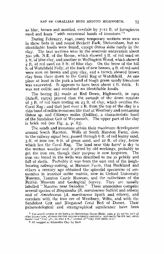
VII. STRUCTURE.The Redlands Syncline.
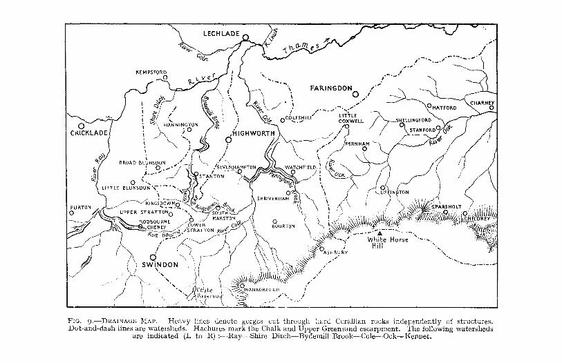
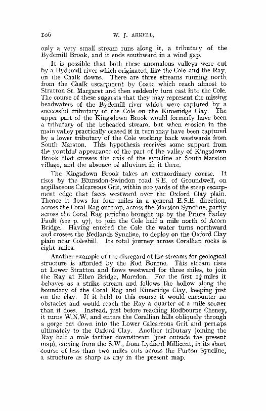
To th e geological eye th e most interesting ph ysical featurein the area is the S.E .-N. W. valley , which runs from theKimeridge Clay lowland between Shrivenham and the road-railriv er-canal crossing at Acorn Bridge, straight th rough theCorallian outcrop, past Sevenhampton and Redlands, almostto the Oxford Clay plain near Hannington Station. There areseve ral peculiar features about this valley. In th e first placeno st ream runs along it ; on the contrary , both the River Coleand th e Byde Mill Bro ok run across it almost a t right angles,and th ere are no signs that a stream or river ever did run throughit. Secondly, the spur of Corallian hills at H annington andLus Hill , which juts out 2 miles into th e Oxford Clay plain, isin line with the axis of the valley. Thirdly, opposite the middleof th e wide southern mouth sta nds the solitary outlier ofPortland Beds at Bourton, the only out crop of those bedsbetween Swindon and Oxford.
On Hull's map this valley is represented as an erosion feature,floored mainly by Oxford Clay and Lower Calcareous Grit . In1927 (loc. cit.) I int erpreted it as of tectonic origin, due to aN.W.-S.E. fault , downthrowing N.E., which had brought downCoral Rag against Oxford Clay. I found that about Highworthand Sevenhampton the Coral Rag on the N.E. side everywheredips sharply S.W. and runs down into contact with the clayin the valley bottom. On th e S.W. side of the valley, however,no indications of th e succession could be found ; but seeing thatthe boring on the summit of Red Down passed through the wholeof th e Corallian Beds, which could easily be mapped on the S.W.side of the down, it was concluded that th e uniforml y red soil ofthe N.E. side was due to surface down-wash from the UpperCalcareous Grit on the summit (Arkell, 192 7a, p. 45).
It was only when a wider area was mapp ed th at the trueexplana tion was discovered. When the Kimeridge Clay andred Upp er Calcareous Grit sand and clay had been fallowedalong the sides and floor of the valley from Shrivenham andAcorn Bridge north-westward, and Ostrea delta had been foundin a dit ch in the bottom of th e valley 600 yards S. of Sevenhampton Church, it became evident th at th e valley wassynclinal. By thi s t ime, too, enough experience of mappingCora llian rocks had been gained for it to be certain that the
PROC. GEOL . Ass oc., VOL . LII. P A RT 2, 1941. 7
-c0'
50004000
ii,HI!lIl1qtor1Hair,,
3000LOOO
Ld,n~,
1000FEET
~.g'''''I''ii!''~III''IIIIIII''i''''''~:·'·'''='-- J........:: : ~
c:::::::J Oxford Clay § ~~t';;.ml< r.rjt 631Coral Rag _ gCI~~~eous Grit
flOD.,
400
?JOO
7..00100
o I Io I" I
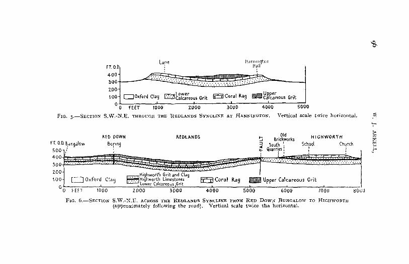
FIG. 5.-SECTION S.W.-N.E. THROUGH THE REDLANDS SYNCLINE AT HANNINGTON. Vertical scale twice horizontal. .<':-;l>::c:>':~
.r
BOliO70006UUO500U40UO1000
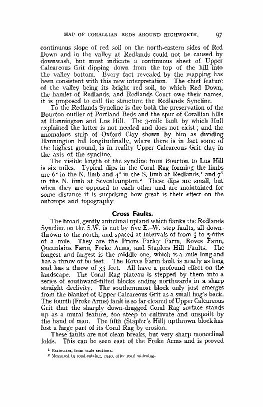
I\.ED DOWN REDLANDS ~ 5ri~~~orks HIGHWORTH
Bonng ~ Soutn \ School Church: L+- Q,uarr~es:: i
I I I I I
;;trn'.?t';~mH¥?t!lt£§±Sr·········:···:·····m ..~.:.:.:. : .: !. :. : . !. :/. : : ::: :.~~;H,ghworth Grrtand Clay
II Oxford Clau f::::IH,qhworth Limestones EE5:I Coral Rag _ Upper Calcareous GritI ....'"' .... ~, "u...dre~:HJS IGrlt
2000 3000
n 0.0. B,ungalow
"O~400 W. -.\ ..:.i.:.:J.d:.:fm_m:&;;gt'1',:iiii'1':::(EM300 ..... : .......
ZOO
100 ~ ~'~;"h_ c.I, .• 1 ~- I
o0 FEFT
FIG. 6.-SECTlON S.W.-N.E. ACROSS THE REDLANDS SYNCLINE FROM RED DOWN BUNGALOW TO HIGHWORTH(approximately following the road). Vertical scale twice the horizontal.
MAP OF CORALLIAN BEDS AROUND HIGHWORTH. 97
continuous slope of red soil on the north-eastern sides of RedDown and in the valley at Redlands could not be caused bydownwash, but must indicate a continuous sheet of UpperCalcareous Grit dipping down from the top of the hill intothe valley bottom. Every fact revealed by the mapping hasbeen consistent with this new interpretation. The chief featureof the valley being its bright red soil, to which Red Down,the hamlet of Redlands, and Redlands Court owe their names,it is proposed to call the structure the Redlands Syncline.
To the Redlands Syncline is due both the preservation of theBourton outlier of Portland Beds and the spur of Corallian hillsat Hannington and Lus Hill. The 3-mile fault by which Hullexplained the latter is not needed and does not exist; and theanomalous strip of Oxford Clay shown by him as dividingHannington hill longitudinally, where there is in fact some ofthe highest ground, is in reality Upper Calcareous Grit clay inthe axis of the syncline.
The visible length of the syncline from Bourton to Lus Hillis six miles. Typical dips in the Coral Rag forming the limbsare 6° in the N. limb and 4° in the S. limb at Redlands,' and 7°in the N. limb at Sevenhampton." These dips are small, butwhen they are opposed to each other and are maintained forsome distance it is surprising how great is their effect on theoutcrops and topography.
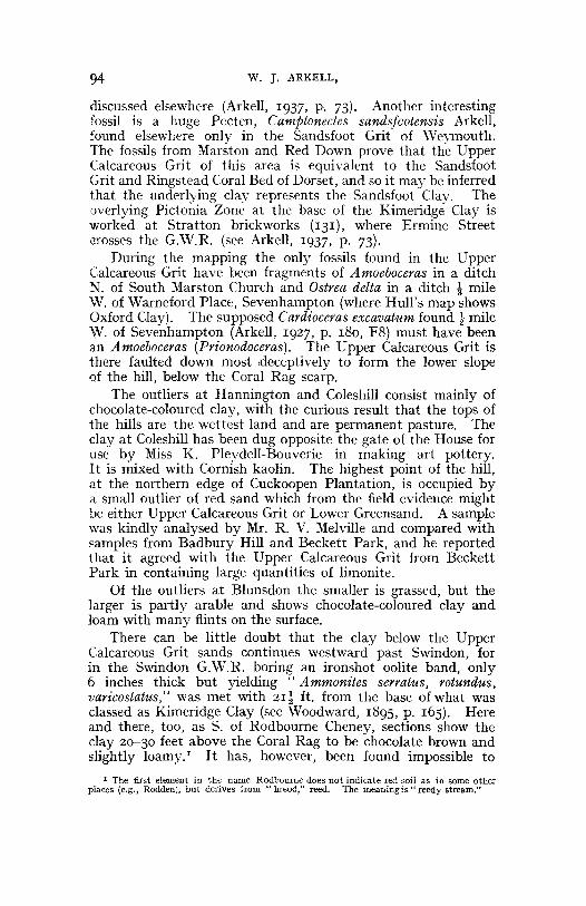
Cross Faults.The broad, gently anticlinal upland which flanks the Redlands
Syncline on the S.W. is cut by five E.-W. step faults, all downthrown to the north, and spaced at intervals of from t to 5-6thsof a mile. They are the Priors Farley Farm, Roves Farm,Queenlains Farm, Freke Arms, and Staplers Hill Faults. Thelongest and largest is the middle one, which is a mile long andhas a throw of 60 feet. The Roves Farm fault is nearly as longand has a throw of 35 feet. All have a profound effect on thelandscape. The Coral Rag plateau is stepped by them into aseries of southward-tilted blocks ending northwards in a sharpstraight declivity. The southernmost block only just emergesfrom the blanket of Upper Calcareous Grit as a small hog's back.The fourth (Freke Arms) fault is so far cleared of Upper CalcareousGrit that the sharply down-dragged Coral Rag surface standsup as a mural feature, too steep to cultivate and unspoilt bythe hand of man. The fifth (Stapler's Hill) upthrown block haslost a large part of its Coral Rag by erosion.
These faults are not clean breaks, but very sharp monoclinalfolds. This can be seen east of the Freke Arms and is proved
I Estimates, from scale sections.2 Measured in road-cutting, 1940, after road widening.
. . . . . '. : ... . .
o~
.•,1' , ,
\000
~
':""'
>::d:>:t%1l'"'!"'
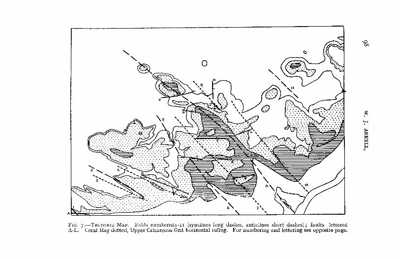
F IG. 7 .-TECTON IC M AP . Folds numbercd r-r r (synclines long dashes, anticlines short dash es) ; faults letteredA-L. Cora l Rag dotted, Upper Calcareous Grit horizontal rul ing . For numberin g and lettering see opposite page.
:\IAP OF CORALUAN BEDS AROUND HIGHWORTH. 99
also at Queenlain's Farm. There the configuration of theground is such that were the fault a clean fracture, at least 25feet of Kimeridge Clay would be brought in on the downthrowside; instead of which there is only Upper Calcareous Grit flushwith the Coral Rag on the upthrow side, although the totalvertical displacement of the Coral Rag is 60 feet.
On the N.E. side of the Redlands Syncline one cross-faultruns rather north of E. through the park at Warneford Place,and there is believed to be another under the Cole, half a milefarther S. Both throw down to the S. A third, throwing downthe same way relative to the main syncline, has swung roundS.-N. and may be seen in the sandpit (96) at Highworth Station.
The Marston Syncline.A second parallel but shorter syncline, with its axis It miles
S.W. of the Redlands Syncline, passes through the middle ofSouth Marston village and north-westwards to Broadmoor Copse,near Hunts Copse Farm. The S.W. limb is again the moregently-dipped and forms a long dip-slope covered with red sand,as at Red Down.
The Marston Syncline ends against a peculiar curved E.-W.fault, marked by an almost artificial-looking fault scarp, fromwhich springs issue. Two borings (H and J) made in I940on opposite sides of this fault proved I6 ft. of Coral Rag onthe upthrow side (J) and 20 ft. on the downthrow side (H).The throw is about 35 feet.
A continuation of the Marston Syncline to the N.W. maypartly account for the synclinal arrangement of the Coral Ragin the valley at Stanton. On the other hand, this does notseem to be directly continuous with the Marston Syncline, whichdies out before it reaches the Swindon-Highworth road. TheStanton syncline is discussed above, on p. 89, because its maininterest is stratigraphic.
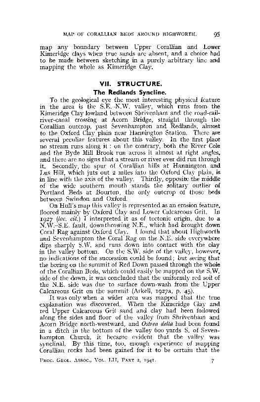
Date of the foregoing structures: the Bourton outlier.For determining the date of the foregoing structures the
relation of the S.E. end of the Redlands Syncline to the LowerGreensand is of vital importance.------------------------------
Explanation of Fig. 7.-1, Swindon syncline; 2, 3, Pen Hillanticline and syncline; 4, Kingsdown anticline; 5, Stantonsyncline; 6, Marston syncline; 7, Acorn Bridge anticline(generalised); 8, Redlands syncline; 9, Hampton Hill anticline;10, Friars Hill anticline; II, Fresden syncline.
Faults :-A, Woodward's; B, Kingsdown; C, Catsbrain ;D, Priors Farley Farm; E, Roves Farm; F, Queenlains FarmG, Freke Arms; H, Stapler's Hill; J. Redlands Court; K, Highworth Station; L, Sevenhampton,
100 w. J. ARKELL,
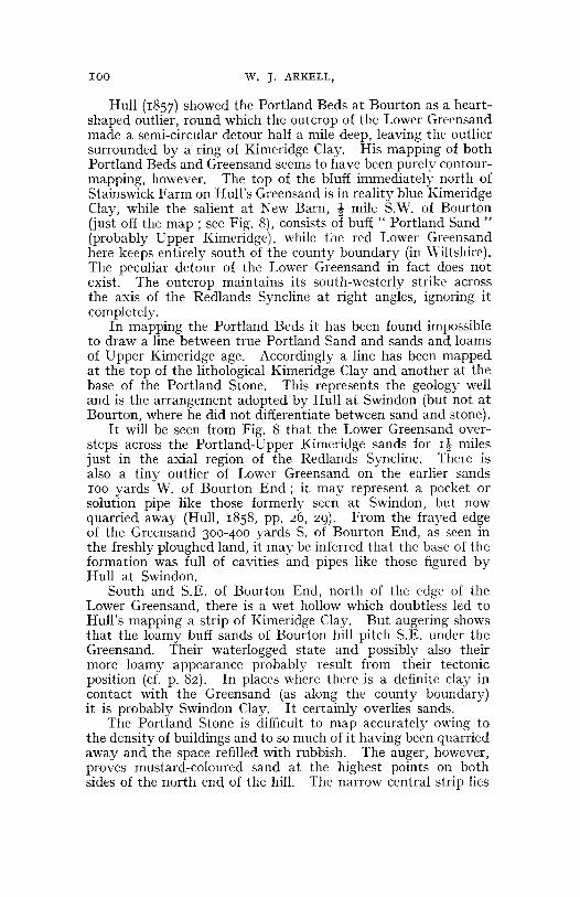
Hull (1857) showed the Portland Beds at Bourton as a heartshaped outlier, round which the outcrop of the Lower Greensandmade a semi-circular detour half a mile deep, leaving the outliersurrounded by a ring of Kimeridge Clay. His mapping of bothPortland Beds and Greensand seems to have been purely contourmapping, however. The top of the bluff immediately north ofStainswick Farm on Hull's Greensand is in reality blue KimeridgeClay, while the salient at New Barn, t mile S.W. of Bourton(just off the map; see Fig. 8), consists of buff" Portland Sand"(probably Upper Kimeridge), while the red Lower Greensandhere keeps entirely south of the county boundary (in Wiltshire).The peculiar detour of the Lower Greensand in fact does notexist. The outcrop maintains its south-westerly strike acrossthe axis of the Redlands Syncline at right angles, ignoring itcompletely.
In mapping the Portland Beds it has been found impossibleto draw a line between true Portland Sand and sands and loamsof Upper Kimeridge age. Accordingly a line has been mappedat the top of the lithological Kimeridge Clay and another at thebase of the Portland Stone. This represents the geology welland is the arrangement adopted by Hull at Swindon (but not atBourton, where he did not differentiate between sand and stone).
It will be seen from Fig. 8 that the Lower Greensand oversteps across the Portland-Upper Kimeridge sands for 1~ milesjust in the axial region of the Redlands Syncline. There isalso a tiny outlier of Lower Greensand on the earlier sands100 yards W. of Bourton End; it may represent a pocket orsolution pipe like those formerly seen at Swindon, but nowquarried away (Hull, 1858, pp. 26, 29). From the frayed edgeof the Greensand 300-4°0 yards S. of Bourton End, as seen inthe freshly ploughed land, it may be inferred that the base of theformation was full of cavities and pipes like those figured byHull at Swindon.
South and S.E. of Bourton End, north of the edge of theLower Greensand, there is a wet hollow which doubtless led toHull's mapping a strip of Kimeridge Clay. But augering showsthat the loamy buff sands of Bourton hill pitch S.E. under theGreensand. Their waterlogged state and possibly also theirmore loamy appearance probably result from their tectonicposition (d. p. 82). In places where there is a definite clay incontact with the Greensand (as along the county boundary)it is probably Swindon Clay. It certainly overlies sands.
The Portland Stone is difficult to map accurately owing tothe density of buildings and to so much of it having been quarriedaway and the space refilled with rubbish. The auger, however,proves mustard-coloured sand at the highest points on bothsides of the north end of the hill. The narrow central strip lies
MAP OF CORALLIAN BEDS AROUND HlGHWORTH. 101
either along a subsidiary synclinal keel or along a fault. Inthe S.W. face of the big quarry at Bourton End the PortlandStone can be seen to be faulted down against yellow sand.
During widening of the railway-cutting 300 yards \V. ofShrivenham Station in 1931 about 45 ft. of Kimeridge Clay wereexposed, and recent drainage trenches in the cutting show thatclay extends to W. of the bridge under Steppingstone Lane.According to a well record (Blake, 1902, p. 27), the thicknessof the Kimeridge Clay is about 200 ft. The overlying loams andsands seem to be at least 35 ft. thick inclusive of the SwindonClay.
FIG. S.-GEOLOGICAL MAP OF THE BOURTON OUTLIER, showing the Cretaceousoverstep across the Redlands Syncline. QQ, old quarries in the PortlandStone. Explanations of stipples :-Kimeridge Clay. white (top left); UpperKimeridge and Portland Sands. c10Ee ruled; Portland Stone. regu.ar dots (atBourton) ; Lower Greensand, irregular stipple (including a darker patch westof Bourton End) : Gault, white (bottom right).
102 W. J. ARKELL,
The Redlands and Marston Synclines are strictly analogouswith the Faringdon Syncline, which likewise strikes N.W.-S.E.and is accompanied by cross-faults which throw down N. onthe W. side and S. on the E. side of the syncline (see Arkell,I939). It was shown that the Faringdon structures are preLower Greensand, on the following evidence: (1) the N.E. limbof the syncline passes under the L.G.S. without affecting it,the L.G.S. at that point overstepping from Coral Rag on toKimeridge Clay; (2) one of the cross-faults disappears underthe L.G.S. at right. angles to the boundary of the latter andwithout affecting it; (3) there is no L.G.S. folded down intothe syncline; the surviving outliers of L.G.S. stand upon theedges of the undisturbed plateau on each side of the syncline.
These folds may be correlated with the series of N.W.-S.E.folds of pre-Lower Greensand date which affect the Portland andPurbeck Beds of the Vale of Wardour.!
The Blundsdon Plateau.Along the N. and N.W. edges of the plateau, especially
between Blunsdon St. Andrew and Upper Widhill and betweenBroad Blunsdon and Castle Hill, the Coral Rag slopes down fromover 480 ft. a.D. on the top of the plateau to just below the400-ft. contour. After subtracting 22 feet for the thickness ofthe Coral Rag, we are left with a descent of at least 60 feet inhalf a mile at the N.W. end of the plateau and probably 40 feetat Castle Hill on the N.E. end. Since the Coral Rag also descendssharply eastward into the Stanton valley and southward atPen Hill, the Blunsdon plateau is the remains of a fiat-toppeddome. Its highest point, 484 ft. a.D., is the highest elevationreached by the Coral Rag in this area.
Stratton, Kingsdown, Pen Hill, Rodbourne, and Moredon.The arrangement of outcrops in the S.W. corner of the map
suggests that the country has been rippled in a W.N.W. direction.Four long spurs of Coral Rag point W.N.W., at Blunsdon St.Andrew, Pen Hill, S. of Haydon Wick, and W. of Moredon,and four valleys point E.s.E. between them. There is alsothe inlier at Stratton Station and Kingsdown, elongated in thesame direction and devoid of any stream running through it,and continued by that at Stratton Church. These ripples maybe related to those similarly orientated between Faringdon andMarcham (Arkell, 1939).
At least one W.N.W. fault, throwing down N., runs underStratton Workhouse (now hospital) and Kingsdown Brewery,and accounts for the difference in the two brewery wells, referred
I W. R. Andrews and A. J. jukes-Browne, The Purbeck Beds of the Vale of Wardour, Quart.[ourn. Geol. Soc., 1894, vol. I, pp. 46-7.
~IAP OF CORA L LIAN BEDS ARO UND HIGHWORTH. 103
to by Woodward (1 8 9 5 , pp. 336-7) . The well on the N. sidewas sunk into 16 feet of Corallian Beds and gave a good supplyof water : tha t on the S. (upthrown) side, 12 feet away to theS.W.,encountered thinner Corallian Beds and gave a poor supply,although sunk to a depth of 53 feet , into Oxford Clay.I Thetheory of a N.- S. fault downth rown E. (Woodward, 1895 , p . 337)is disproved by th e mapping. The Kings down fault noticeablysteps th e Coral Rag S. of Kingsdown Brook and brings up th einl iers of Lower Calcareous Grit at St ratton Church, in thegardens S. of the workhouse, and between Stratton Sta tion andKingsdown. The first and th ird are parall el to the fault, butnot in contact with it. 2 It is possible that a continua tion of thesame fault determined th e boundary of the plat eau betweenGroundwell and Blunsdon St. Andrew.
Pen Hill has some pu zzling features. The straight S.W. edge,a mile long, suggests a fault scarp . But the Coral Ra g of thehill top turns sharply down towards the S.W., descendin g about5 0 feet in two or three hundred yards. When viewed from thedirecti on of Groundwell the spur at Penhill Copse looks like theN.E. limb of a sharp syncline ; yet the low ground to the S.W.,with its other end between ( rowdy 's Hill and Upper Stratton,maps as gently anticlinal. A well (G) at the foot of the hill wasdug in 19 0 2 and is 45 feet deep. The wat er level is 16 feet down.Under test in 19 02 it is said to ha ve yielded 60,000 gallons a day,bu t the yield now probably would not exceed 14,0 0 0 gallons aday. A heading made at or near the bottom in 19 21 produceda rock believed to be a thin marly representative of the HighworthLimestones (see above, p. 9 1), an d a line of springs is given offa short distance above well-head by a clay which is probablyan argillaceous facies of the Highworth Grit.
The most probable explanation is that the present boundaryof the Corallian rocks coincides with th e axis of a sharp syncline,which was the fore-syncline of a small asymmetric anticlineremoved by erosion. The underground wat er probably comesfrom the Blunsdon plat eau . The anticline (and its foresyncline) die out at Upper Stratton.
A comparable sharp syncline, with a W.N.W. trend whichgradually swings round to due W., runs from the S.W. cornerof the map for 3 miles th rough Common Platt and along thestream by Purton Church to the escarpment edge betweenRestrop and Dogridge (where Hull's map shows a faultedanticline). From this syncline Purton obtains its water supply,
I T he tw o wen s referred to ca nnot now be id enti fied. There are 3 deep well s (60 t o So f t .},a Jl close toget her and con nected by a t unnel , and some 6 shallow wells, all wit hin t he confinesof t he brewer y. No records of st ra ta appear t o have been kept, but from recen t excavations inann a round th e brewe ry i t is. cer ta in t ha t a ll of them st ar ted in Coral Rag.
2 Th e work house complete ly covers th e north en d of t he middle inlier, obs curing t he geo logy.
104 w. j. ARKELL ,
and along th e anticline to th e south of it there are inliers of LowerCalcareous Grit. If th e dip is really to the north in th e Littl emoreClay Beds in the ra ilway-cutting on the former :M.S.W.]. line E .of Sparcell's Farm (152), in th e extreme S.W. corner of th e presentmap (see Woodward, 1895, p. lI8), the boundary with theKimeridge Clay on th e south must be faulted, as Woodwardsta ted.
Fina lly, there also run s through the S.W. corner of th e mapa broad N.W.- S.E . syncline in line with the Swindon outlier ofPortland Beds. The axi s coincides with th e G.W.R. line andit lowers the surface of th e Coral Rag to just below th e 300-footcontour, whereas on the same line of strike at Purton and PenHill it rises above th e 400~foot contour. Th is downfold belongsto th e pre-Greensand group of the Faringdon, Redlands, andMarston synclines. For a description of the region to the westof the present map , see Arkell , 1941.
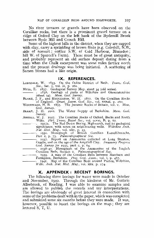
VIII. THE RELATION OF DRAINAGE TOSTRUCTURE.
The two principal streams are th e Rivers Cole and Ray, whichboth flow northwards from the Chalk downs , across the Kim eridgeClay and Corallian outcrops, to the Thames, which is here astrike stream on th e Oxford Clay . Most of th e Ray lies justwest of th e present map, but in th e extreme S.W. corner is seenpart of th e gap by which it passes through the Corallian Beds,accompanied by the canal and two rai lways. Clearly th eserivers could not ha ve arisen on th e existing out crops, but mustbe inh erited from some earlier land sur face which sloped northwards, probably formed by th e Gault Clay or th e Chalk atan earlier stage in th e retreat of the Cretaceous escarpment .They are therefore examples of what is called" superimposed"drainage. I The River Cole not only t raverses th e Corallian rocksby a small gorge aga inst th e dip, but it crosses th e RedlandsSyncline with complete disregard for the structure.
A third north-flowing stream is the Bydemill Brook . It isnow much sma ller than th e ot hers, but it cuts across th e RedlandsSyncline at right-angles between Highworth and Hanningtonthrough a gorge like that of the Cole. Moreover , it makes adetour to traverse th e Hann ington spur of hills after it hasalready reach ed the Oxford Clay plain and an unobstructed waylies before it northwards to th e Thames.
Another prominent feature on t he map is the S.-N. valleyat Stanton. It is unrelated to geological structure and itswinding cours e proclaims its origin by river action At present
I In the descript ion of t he Sh ellfu gford peri clmc (Ark ell, 1939, p. 505) t he word.. a ntece dent." should, of course, read .. superimposed. "
,-'.'<c:>: '-'-, -,~'
,.,,.r-:FARINGDON
O/",
,,..".
LITTLE BLUNSDON','-" '. _/,r, " SHRIVENHA;~~l\~ /O~ ~~~ /V ,,/ . rtL""c.'
,.__ ; I)" I ?"'}2
eC." " .... .. 2",,"" \; / '. . ) ~IM ,,.~""
SWIND \ r ~ <:« Ji. -" ifiJ1"i"I.LDREY"
L
" -. ON J \ .s:» WHhi1t1e Horse-·'·_· '-~ifl~"1'\\~'') -, ' "'~ ""'"" , <. -~" •, ' \ '" @ ./ -. ,"'-
I ,"_, _, I "",,111/.,,\1\\\11111/ §,I,I,. ,/ "'. ';;1\___ I " M',"",0, '" ./ '-, .
.r "j'''"'I'''4~'",",""'" -' ""\' \:::;; /,.'..::=§c. <-_ ../ . .' ___ I
FIG. g.-DRAINAGE MAP. Heavy lines denote gorges cut through hard Corallian rocks independently of structures.Dot-and-dash lines are watersheds. Hachures mark the Chalk and Upper Greensand escarpment. The following watersheds
are indicated (L to R) :-Ray-Shire Ditch-s-Bydemill Brook-Cole-Ock-Kennet.
I06 W. J. ARKELL,
only a very small stream runs along it, a tributary of theBydemill Brook, and it ends southward in a wind gap.
I t is possible that both these anomalous valleys were cutby a Bydemill river which originated, like the Cole and the Ray,on the Chalk downs. There are three streams running northfrom the Chalk escarpment by Coate which reach almost toStratton St. Margaret and then suddenly turn east into the Cole.The course of these suggests that they may represent the missingheadwaters of the Bydemill river which were captured by asuccessful tributary of the Cole on the Kimeridge Clay. Theupper part of the Kingsdown Brook would formerly have beena tributary of the beheaded stream, but when erosion in themain valley practically ceased it in turn may have been capturedby a lower tributary of the Cole working back westwards fromSouth Marston. This hypothesis receives some support fromthe youthful appearance of the part of the valley of KingsdownBrook that crosses the axis of the syncline at South Marstonvillage, and the absence of alluvium in it there.
The Kingsdown Brook takes an extraordinary course. Itrises by the Blunsdon-Swindon road S.E. of Groundwell, onargillaceous Calcareous Grit, within 200 yards of the steep escarpment edge that faces westward over the Oxford Clay plain.Thence it flows for four miles in a general E.s.E. direction,across the Coral Rag outcrop, across the Marston Syncline, partlyacross the Coral Rag pericline brought up by the Priors FarleyFault (see p. 97), to join the Cole half a mile north of AcornBridge. Having entered the Cole the water turns northwardand crosses the Redlands Syncline, to deploy on the Oxford Clayplain near ColeshilI. Its total journey across Corallian rocks iseight miles.
Another example of the disregard of the streams for geologicalstructure is afforded by the Rod Bourne. This stream risesat Lower Stratton and flows westward for three miles, to jointhe Ray at Elbro Bridge, Moredon. For the first Ii miles itbehaves as a strike stream and follows the hollow along theboundary of the Coral Rag and Kimeridge Clay, keeping juston the clay. If it held to this course it would encounter noobstacles and would reach the Ray a quarter of a mile soonerthan it does. Instead, just before reaching Rodbourne Cheney,it turns W.N.W. and enters the Corallian hills obliquely througha gorge cut down into the Lower Calcareous Grit and perr.apsultimately to the Oxford Clay. Another tributary joining theRay half a mile farther downstream (just outside the presentmap), coming from the S.W., from Lydiard Millicent, in its short-course of less than two miles cuts across the Purton Syncline,a structure as sharp as any in the present map.
MAP OF CORALLIAN BEDS AROUND HIGHWORTH. 107
No river terraces or gravels have been observed on theCorallian rocks, but there is a prominent gravel terrace on aridge of Oxford Clay on the left bank of the Bydemill Brookbetween Byde Mill and' Crouch Hill.
Some of the highest hills in the district, when they are cappedwith clay, carry a sprinkling of brown flints (e.g. Coleshill, N.W.side of summit; outlier S.W. of Cold Harbour, Blunsdon;hill W. of Sparcell's Farm). These must be of great antiquity,and probably represent an old surface deposit dating from atime when the Chalk escarpment was some miles farther northand the present drainage was being initiated. A .scattering ofSarsen Stones had a like origin.
IX. REFERENCES.LONSDALE, W. 1835. On the Oolite District of Bath. Trans. Geol:
Soc., Ser. 2, vol. iii, p. 26r.HULL, E. 1857. Geological Survey Map, sheet 34 (old series).
1858. Geology of parts of Wiltshire and Gloucestershire(sheet 34). Mem, Geol, Survey.
BLAKE, J. F., and HUDLESTON, W. H. 1877. On the Corallian Rocksof England. Quart. Journ. Geol, Soc., vol. xxxiii, p. 260.
WOODWARD, H. B. 1895. The Jurassic Rocks of Britain, vol. v. Mem;Ceol. Survey.
BLAKE, J. H. 1902. The Water Supply of Berkshire. Mem. Geol,Survey.
ARKELL, W. J. 1927. The Corallian Rocks of Oxford, Berks and KorthWilts. Phil. Trans. Royal Soc., vol. ccxvi, B, p. 67.
---- 1927a. The Red Down Boring, Highworth, and its geologicalsignificance, with notes on neighbouring wells. Wiitshire Arch.Nat. Hist. Mag., vol. xliv, p. 43.
---- 1930. Monograph of British Corallian Lamellibranchs..Part 2, p. 73. Palaeontographical Soc.
---- 1937. Report on Ammonites collected at Long Stanton,Cambs, and on the age of the Ampthill Clay. Summary ProgressGeol, Survey for 1935, part 2, p. 64.
---- 1938-40. Monograph of the Ammonites of the EnglishCorallian Beds, Section 2. Palaeontographical Soc.
---- 1939. A map of the Corallian Beds between Marcharn andFaringdon, Berkshire. Proc, Geol, Assoc., vol. 1, p. 487.
----. 1941. Map of the Corallian Beds around Purton, Wiltshire.Wilts. Arch. Nat. Hist. Mag., vol, xlix, p. 274.
X. APPENDIX: RECENT BORINGS.The following three borings for water were made in October
and November, 1940. Through the kindness of Mr. GuthrieAllsebrook, of Reading, I was able to examine samples andam allowed to publish the records and my interpretations.The borings are obviously of great interest in connection withsome of the problems dealt with in the paper, which was completedand submitted some six months before they were made. It was,however, possible to insert the borings on the map; they arelettered S, T, U.
Io8 w. J. ARKELL,
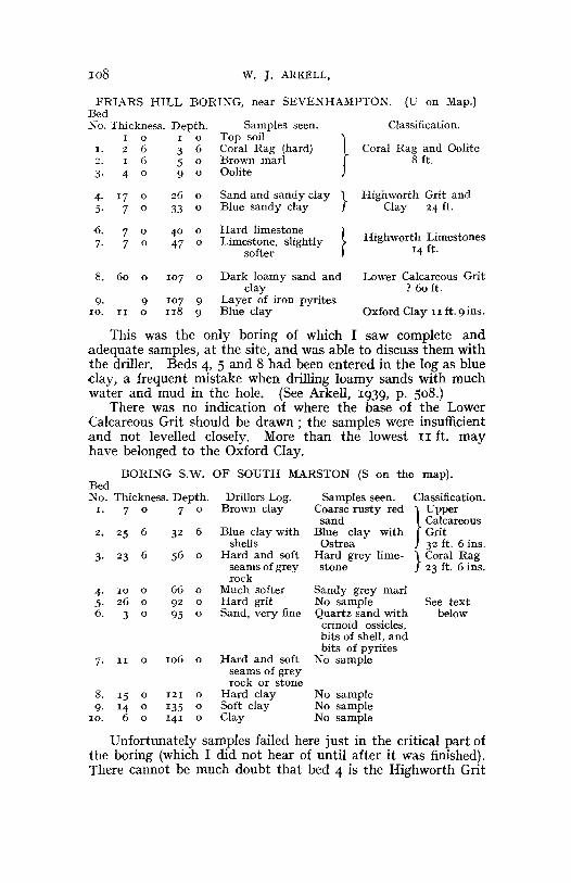
FRIARS HILL BORING, near SEVENHAMPTON. (U on Map.)BedXo. Thickness. Depth. Samples seen. Classification.
I 0 I 0 Top soil
}1. 2 6 3 6 Coral Rag (hard) Coral Rag and Oolite2. I 6 5 0 Brown marl 8 ft.3· 4 0 9 0 Oolite
4· 17 0 26 0 Sand and sandy clay } Highworth Grit and5· 7 0 33 0 Blue sandy clay Clay 24 ft.
6. 7 0 40 0 Hard limestone } Highworth Limestones7· 7 0 47 0 Limestone, slightly
softer 14 ft.
8. 60 0 107 0 Dark loamy sand and Lower Calcareous Gritclay ? 60 ft.
9· 9 107 9 Layer of iron pyrites10. II 0 118 9 Blue clay Oxford Clay II ft. 9 ins.
This was the only boring of which I saw complete andadequate samples, at the site, and was able to discuss them withthe driller. Beds 4, 5 and 8 had been entered in the log as blueday, a frequent mistake when drilling loamy sands with muchwater and mud in the hole. (See Arkell, 1939, p. 508.)
There was no indication of where the base of the LowerCalcareous Grit should be drawn; the samples were insufficientand not levelled closely. More than the lowest II ft. mayhave belonged to the Oxford Clay.
BORING S.W. OF SOUTH MARSTON (S on the map).BedNo. Thickness. Depth. Drillers Log. Samples seen. Classification.
1. 7 0 7 0 Brown clay Coarse rusty red } Uppersand Calcareous
2. 25 6 32 6 Blue clay with Blue clay with Gritshells Ostrea 32 ft. 6 ins.
3· 23 6 56 0 Hard and soft Hard grey lime- } Coral Ragseams of grey stone 23 ft. 6 ins.rock
4· 10 0 66 0 Much softer Sandy grey marl5· 26 0 92 0 Hard grit No sample See text6. 3 0 95 0 Sand, very fine Quartz sand with below
crinoid ossicles,bits of shell, andbits of pyrites
7· II 0 106 0 Hard and soft No sampleseams of greyrock or stone
8. 15 0 121 0 Hard clay No sample9· 14 0 135 0 Soft clay No sample
10. 6 0 141 0 Clay No sample
Unfortunately samples failed here just in the critical part ofthe boring (which I did not hear of until after it was finished).There cannot be much doubt that bed 4 is the Highworth Grit
PROC. GEOL. ASSOC., VOL. LII (1941). PLATE 5.
CoQrseRed Sand
8±BBE Ru bbly8±H:H±J Limestone
ftH±HE Yellow SandttmHE and Loam
ITIIIIJ CIa!:I
t-u--I~~~~and1~I Ru bb\ y,,~~ Limestone
D Yellow SandClay
VariableLimestones
v v',," , ...
. AN
PORTLAND STONE
PORTLAN D SAN D AN DUPPER KIMER IDGE SAND
KIMER IDGE CLAY
UPPER CALCAREOUS GRIT
CORAL RAG
HIGHWORT H GRIT & CLAY
HIGHWORTH LIMESTONES
OXFORD CLAY
II
MAP OFAROUND
\IIIII
TH E CORALLIAN BEDSHIGHWORTH . WILTSHIRE
BY W. J. ARK ELL - 1940
o
1--- - - - - - - - - - - - - - - - - "----.....,,.--·'-=- -1r: ~~~~================~:============~-7/ ' w..~1- -1' " "....-- - - - - -1/ I I I
.~
I II,
[To face p. J08
MAP OF CORALLI AN BEDS ARO UND HlGIIWORTH. 109
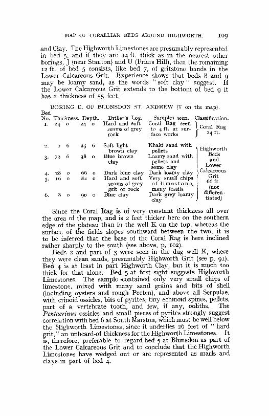
Samples seen . Classification.Cora l Rag seen }to 4 ft . a t sur- Cora l Ragface works 24 ft.
Driller 's Log.Hard and soft
seams of greyrock
and Clay. The Highworth Limestones are presumably representedin bed 5. and if they are 14 ft. thick as in the nearest otherborings . ] (near Stan~on) a?d U (Friars Hill). then the remaining1 2 ft. of bed 5 consists, like bed 7, of gn ts tone bands in theLower Calcareous Grit . Experience shows that beds 8 and 9may be loamy sand, as the words " soft clay" suggest. Ifthe Lower Calcareous Grit extends to the bottom of bed 9 ithas a th ickness of S5 feet.
BORING E. OF BLUNSDON ST . ANDR E W (T on the map).BedNo . Thickn ess. Depth.
1. 24 0 24 0
Soft lightbrown clay
Blue bro wnclay
Dark blu e clayHard a nd soft
seams of greygri t or rock
Blue clay
66 0
82 0
25 6
90 0
2 . I 6
4- 2 8 05 . 16 0
6. 8 0
3. 1 2 6
Khaki sand withpellets IH ighworth
Loamy sand with Bedspellets an d andsome clay \ Lo wer
Dark loamy clay }Calcar~ous
Very small chips J' Gn tof lim e st one. 66 ft .many fossils .(not
Dark grey loamy differen-clay ti ated)
Since the Coral Rag is of very constant thickness all overthe area of the map, and is 2 feet thicker here on the southernedge of the plateau than in the well K on the top, whereas thesurface of the fields slopes southward betw een the two, it isto be inferred that the base of the Coral Rag is here inclinedrather sharply to the south (see above, p. IOZ).
Beds 2 and part of 3 were seen in the dug well K, wherethey were clean sands, presumably Highworth Grit (see p. 91).Bed 4 is at least in part Highworth Clay, but it is much toothick for that alone. Bed S at first sight suggests HighworthLimestones. The sample -contained only very small chips oflimestone, mixed with many sand grains and bits of shell(including oyst ers and rough Pecten), and abov e all Serpulae,with crinoid ossicles, bits of pyrites, tiny echinoid spines, pellets,part of a vertebrate tooth , and few, if any, oolith s. TheP entacrinus ossicles and small pieces of pyrites st rongly suggestcorrelation with bed 6 at South Marston, which must be well belowthe Highworth Limestones, since it underlies 26 feet of " hardgrit," an unheard-of thickness for the Highworth Limestones. Itis, therefore, preferable to regard bed S at Blunsdon as part ofthe Lower Calcareous Grit and to conclude that the HighworthLimestones have wedged out or are represent ed as marls andciays in part of bed 4.