map modernization state business plan for ohio attachment ... · federal emergency management...
TRANSCRIPT

Map Modernization State Business Plan for Ohio January 2004 Attachment #2
FEDERAL EMERGENCY MANAGEMENT AGENCY
COOPERATING TECHNICAL PARTNERS MEMORANDUM OF AGREEMENT
AGREEMENT is made on April 22, 2003, by these parties: The ODNR (ODNR) and the Federal Emergency Management Agency (FEMA). WHEREAS, the National Flood Insurance Program (NFIP) established by the National Flood Insurance Act of 1968 has several purposes, the most significant being • To better indemnify individuals from losses through the availability of flood insurance; • To reduce future flood damages through community floodplain management regulations; • To reduce costs for disaster assistance and flood control; and WHEREAS, a critical component of this program is the identification and mapping of the nation’s floodplains to create a broad-based awareness of the flood hazard and to provide the data necessary for community floodplain management programs and to actuarially rate flood insurance; and WHEREAS, FEMA administers the NFIP and is authorized by §1360 of the National Flood Insurance Act of 1968, as amended (42 U.S.C. 4101), to establish and update flood-risk zone data in floodplain areas. Further, in the identification of floodprone areas, FEMA is authorized to consult with, receive information from, and enter into agreements or other arrangements with the head of any State, regional, or local agency; and WHEREAS, FEMA encourages strong Federal, State, regional, and local partnerships for the purposes of reducing flood losses and disaster assistance; and FEMA and its State, regional, and local partners have determined that it is advantageous to encourage and formalize greater cooperation in the flood hazard identification and mapping processes; and many communities and the agencies that serve them have developed considerable technical capabilities and resources that provide the opportunity to improve and expand the collection, development, and evaluation of flood hazard data; WHEREAS, The ODNR shares flood protection and/or floodplain management responsibilities with communities that participate in the NFIP; and WHEREAS, The ODNR has expressed a desire to perform certain functions in the flood hazard identification process and has provided evidence that it has sufficient technical capability and will dedicate the resources necessary to perform those functions; and
NOW THEREFORE, it is mutually agreed that the parties enter into this Agreement to work together to create and maintain accurate, up-to-date flood hazard data for the State of Ohio subject to the terms and conditions recited below.

1. CONSULTATIONS
The parties shall collaborate on flood hazard identification activities and shall consult with each other to fully integrate each other’s contributions into flood hazard identification efforts. The parties agree to coordinate with all affected municipalities within areas served by the ODNR. The parties also agree to participate and help coordinate any public meetings conducted as a result of the map revisions implemented through this agreement. Planning and coordination regarding the execution of the agreement will be conducted through an executive committee consisting of FEMA representatives and representatives of the ODNR. If this committee is unable to resolve technical issues the resolution may be accomplished through alternative dispute resolution procedures.
2. EVALUATION AND REPORTING The parties shall annually review the partnership created by the agreement to determine and document the activities undertaken to maintain accurate flood hazard data, and to revise the Agreement as necessary.
3. RESOURCE COMMITMENT The parties agree to commit the appropriate human, technical, and financial resources sufficient to coordinate effectively with all entities impacted by flood hazard identification efforts to implement this Agreement as agreed upon in the appropriate appendices.
4. STANDARDS Unless otherwise agreed to by the parties, all flood hazard identification activities will be accomplished in accordance with the standards documented in Guidelines and Specifications for Flood Hazard Mapping Partners, dated February 2002, and all subsequent revisions.
5. SPECIFIC INITIATIVES Specific initiatives or projects to be performed are attached to this Agreement in the form of appendices. The parties will be obligated to perform as described in these appendices upon written acceptance of the specific initiatives or projects by each party. The parties may amend the appendices to this Agreement to include additional initiatives or projects.
6. SEVERABILITY In the event any provision of this Agreement is held to be unenforceable for any reason, the enforceability thereof shall not affect the remainder of the Agreement which will remain in full force, and effect and enforceability in accordance with its terms.
7. TERM The respective duties, responsibilities and commitments of the parties in this agreement shall begin on the date this Agreement is signed by the parties and may be periodically renewed, revised, or terminated at the option of any of the parties. The parties agree that a 60-day notice shall be given prior to the termination of this agreement.

THEREFORE, each party has caused this Agreement to be executed by its duly authorized representatives on the date mentioned above. _________________________________ ________________ CTP Authorized Representative Date _________________________________ _________________________________ CTP Authorized Representative (Printed) Title ________________________________ ________________ FEMA Authorized Representative Date ________________________________ _________________________________ FEMA Authorized Representative (Printed) Title ________________________________ ________________ State Authorized Representative Date ________________________________ _________________________________ State Authorized Representative (Printed) Title (In states where statutory and/or regulatory requirements require State review and/or approval of new flood hazard data, a State representative will be a signatory to this Agreement.)

Map Modernization State Business Plan for Ohio Attachment #3
January 2004
Ohio Department of Natural Resources Cooperating Technical Partners Mapping Activity Statement
Statement 3 –Digital Flood Insurance Rate Map (DFIRM) In accordance with the Cooperating Technical Partners (CTP) Memorandum of Agreement dated X, 2003, between the Ohio Department of Natural Resources (ODNR) and the Federal Emergency Management Agency (FEMA), Mapping Activity Statement 3 is as follows: 1. Statement Objective and Scope: The primary objective of this Mapping Activity for ODNR is to develop a
new or updated Digital Flood Insurance Rate Map (DFIRM) and Flood Insurance Study (FIS) report for Portage County, Ohio. The FIS and DFIRM will be produced in countywide DFIRM format. The secondary objective of this Mapping Activity for ODNR will be to use FEMA’s IDIQ Contractor to act as a Temporary Mapping Coordinator (TMC) for Ohio in the development of the Portage County DFIRM. The TMC will also develop a position description for the permanent Mapping Coordinator (MC) position in Ohio and a series of Technical Memoranda detailing the administrative and technical procedures for the MC.
This project will be completed by the Mapping Partners listed below: Ohio Department of Natural Resources FEMA MCC FEMA IDIQ Contractor Federal Emergency Management Agency. The activities, and who will complete them, are summarized in the table below. The following sections describe the specific mapping activities associated with this mapping project. Each activity description identifies the responsible Mapping Partners, the Standards that must be met, and resultant map component.
Activity CTP
(ODNR) MCC
SC
(IDIQ) Activity 1 – Field Surveys and Reconnaissance Previously completed by USGS Activity 2 – Topographic Data Development Previously completed by USGS Activity 3 – Independent QA/QC of Topographic Data Previously completed by USGS Activity 4 –Hydrology Previously completed by USGS Activity 4A – Coastal Hazard Analyses Previously completed by USGS Activity 5–Independent QA/QC of Hydrology Previously completed by USGS Activity 5A–Independent QA/QC of Coastal Hazard Analyses Previously completed by USGS
Activity 6 – Hydraulics Previously completed by USGS Activity 7 – Independent QA/QC of Hydraulics Previously completed by USGS Activity 8 – Floodplain Mapping (Detailed Riverine or Coastal Analysis) Previously completed by USGS
Activity 8A – Floodplain Mapping (Redelineation Using Effective Profiles) Previously completed by USGS
Activity 8B – Floodplain Mapping (Refine/Establish Zone A) Previously completed by USGS Activity 9 – Independent QA/QC of Floodplain Mapping Previously completed by USGS
{Insert date Statement is written} Agreement {Insert Statement #}
(Template Version 5.2, 3/25/02) 4

Activity 10 – Base Map Acquisition and Preparation X X Activity 11 – DFIRM Production (Non-Revised Areas) X X Activity 11A – Independent QA/QC of DFIRM Production (Non-Revised Areas) X X
Activity 12 – Merge Effective and Revised Information X X Activity 12A – Apply DFIRM Graphic Specifications X X Activity 12B – Independent QA/QC of DFIRM Graphics X X Activity 13 – Issue Preliminary FIS and FIRM X Activity 14 – Post-Preliminary Processing X Activity 15 – Development of MC position description and technical memoranda X X
Activities 1 through 9
These activities were previously completed by Portage County and USGS under the Cooperating Technical Community Memorandum of Agreement, Mapping Activity Statement Agreement 3 dated August 24, 2000 between Portage County and FEMA.
Activity 10 - Base Map Acquisition and Preparation Responsible Entity: IDIQ/ODNR – The IDIQ will be responsible for completing the tasks of this activity, and will coordinate with ODNR in order to facilitate ODNR’s understanding of the process. Scope: This activity consists of obtaining the digital base map {specify which one} for the project. The IDIQ/ODNR shall:
• Obtain digital files (raster or vector) of the base map;
• Secure necessary permissions from the map source to allow FEMA’s use and distribution of hardcopy and digital map products using the digital base map, free of charge;
• Certify that the digital data meet the minimum standards and specifications that FEMA requires for DFIRM production; and
• Populate the DFIRM database for base map features and applicable data. Standards: All work conducted under this Activity shall conform to the standards specified for this Activity in Section 5 of this Mapping Activity Statement.
Products: In accordance with the TSDN format described in Section 2, IDIQ/ODNR shall make the following products available to FEMA.
• Written certification that the digital data meet the minimum FEMA standards and specifications; and
• Documentation that FEMA can use the digital base map.
Activity 11 - DFIRM Production (Non-Revised Areas) Responsible Entity: IDIQ/ODNR – The IDIQ will be responsible for completing the tasks of this activity, and will coordinate with ODNR in order to facilitate ODNR’s understanding of the process. Scope: For all flooding sources except those specified in Section 1 of this Mapping Activity Statement (that will have updated flood data developed under Activities 1 through 9), the IDIQ/ODNR will convert the effective FIRM/FBFM panels to digital format in conformance with FEMA’s DFIRM specifications. The IDIQ/ODNR will use the base map acquired under Activity 10 of this Mapping Activity Statement for the conversion. The scope of this Activity covers the digitization of {insert number of panels} FIRM panels and {insert number of panels} FBFM panels. The IDIQ/ODNR also will incorporate LOMCs issued by FEMA since the current effective FIRM for each affected community. The digital flood theme for the flooding sources specified in Section
{Insert date Statement is written}
Agreement {Insert Statement #} (Template Version 5.2, 3/25/02) 5

1 will not be digitized as part of this Activity; rather, the IDIQ/ODNR will leave these as “holes” in the digital flood theme that will be filled in as part of Activity 12 using digital flood data from Activities 8, 8A, and/or 8B. Standards: All work conducted under this Activity shall conform to the standards specified for this Activity in Section 5 of this Mapping Activity Statement.
Products: In accordance with the TSDN format described in Section 2, IDIQ/ODNR shall make the following products available to FEMA.
• DFIRM mapping files, in one of the GIS file and database formats specified in FEMA’s DFIRM Specifications;
• Metadata files describing the DFIRM data, including the required information shown in the examples shown in FEMA’s DFIRM Specifications;
• Complete set of plots of the DFIRM panels showing all unrevised flood hazard information taken from the effective FIRMs and FBFMs at a suitable scale; and
• A QA/QC report that includes a description and the results of all automated or manual quality assurance steps taken during the preparation of the DFIRMs, including a check that the road and floodplain relationship is maintained for all unrevised areas.
Activity 11A - Independent QA/QC Review of DFIRM Production (Non-Revised Areas) Responsible Entity: MCC/ODNR – MCC will be responsible for completing the tasks of this activity, and will coordinate with ODNR in order to facilitate ODNR’s understanding of the process. Scope: MCC/ODNR shall review the DFIRM panels submitted by the IDIQ/ODNR under Activity 11 of this Mapping Activity Statement to ensure that the unrevised flood hazard information taken from the effective FIRM and FBFM panels is accurately represented on the DFIRM panels. This work will include, at a minimum, ensuring the following:
• Unrevised flood hazard information shown on the effective FIRM and FBFM panels is completely and accurately captured in the digital files.
• The floodway widths agree with the widths shown in the Floodway Data Table(s) and the results of the hydraulic modeling within a tolerance of 5 percent.
• The distances between cross sections agree with the distances shown in the Floodway Data Table(s) and the results of the hydraulic modeling within a tolerance of 5 percent.
• Road and floodplain relationships are maintained for all unrevised areas.
• DFIRM mapping files are in one of the GIS file and database formats specified in FEMA’s DFIRM Specifications and conform to those specifications for content and attribution.
• Metadata files describing the DFIRM data include the required information and follow the examples shown in FEMA’s DFIRM Specifications.
Standards: All work conducted under this Activity shall conform to the standards specified for this Activity in Section 5 of this Mapping Activity Statement.
Products: In accordance with the TSDN format described in Section 2, MCC/ODNR shall make the following products available to FEMA.
• A Summary Report that describes the findings of the independent QA/QC review, noting any deficiencies and providing recommendations to resolve them or agreeing with the mapping results; and
• Annotated DFIRM panels with all questions and/or concerns indicated, if necessary.
{Insert date Statement is written}
Agreement {Insert Statement #} (Template Version 5.2, 3/25/02) 6
Activity 12 – Merging of Revised and Non-Revised Information Responsible Entity: IDIQ/ODNR – The IDIQ will be responsible for completing the tasks of this activity, and will coordinate with ODNR in order to facilitate ODNR’s understanding of the process. Scope: Upon completion of the Floodplain Mapping activity (Activity 8) for the revised flooding sources and the Digital FIRM Production activity (Activity 11) for non-revised flooding sources, the digital floodplain data will be merged into a single, updated Digital FIRM. This work will include tie-in of flood hazard information with contiguous communities that were not studied as part of this project. Also, the revised and non-revised Flood Profiles, floodplain boundaries, and regulatory floodway boundaries will be tied-in. IDIQ/ODNR will coordinate with the Mapping Partners conducting Activities 8 and 11, as necessary, to resolve any potential tie-in issues. Standards: All work conducted under this Activity shall conform to the standards specified for this Activity in Section 5 of this Mapping Activity Statement.
Products: In accordance with the TSDN format described in Section 2, IDIQ/ODNR shall make the following products available to FEMA.
• Digital work maps, with 1% annual chance floodplain boundary delineations, cross sections, BFEs, zone designation labels, and all applicable base map features shown;
• DFIRM mapping files, in one of the GIS file and database formats specified in FEMA’s DFIRM Specifications, provided on CD-ROM;
• Metadata files describing the DFIRM data, including the required information shown in the examples shown in FEMA’s DFIRM Specifications, provided on CD-ROM;
• Complete set of plots of DFIRM panels showing all detailed flood hazard information at a suitable scale;
• A QA/QC report that includes a description and the results of all automated or manual QA/QC steps taken during the preparation of the DFIRM.
Activity 12A – Application of DFIRM Graphic Specifications
Responsible Entity: IDIQ/ODNR – The IDIQ will be responsible for completing the tasks of this activity, and will coordinate with ODNR in order to facilitate ODNR’s understanding of the process. Scope: Upon completion of merging of effective and revised floodplain mapping into a single, updated DFIRM (Activity 12), IDIQ/ODNR shall apply the final FEMA DFIRM graphic specifications to the DFIRM mapping files. This work will include adding all required annotation, line patterns, area shading, and map collar information (e.g., map borders, title blocks, legends, notes to user). Standards: All work conducted under this Activity shall conform to the standards specified for this Activity in Section 5 of this Mapping Activity Statement.
Products: In accordance with the TSDN format described in Section 2, IDIQ/ODNR shall make the following products available to FEMA.
• DFIRM mapping files in one of the GIS file and database formats specified in FEMA’s DFIRM Specifications, provided on CD-ROM;
• DFIRM database files in one of the database formats specified in FEMA’s DFIRM Specifications, provided on CD-ROM;
• Metadata files describing the DFIRM data including the required information based on the examples shown in FEMA’s DFIRM Specifications;
{Insert date Statement is written}
Agreement {Insert Statement #} (Template Version 5.2, 3/25/02) 7
• Complete set of plots of the DFIRM panels showing all the details at the scale(s) agreed upon in the “Scope of Project;” and
• A QA/QC report that includes a description and the results of all automated or manual quality assurance steps taken during the preparation of the DFIRM.
Activity 12B - Independent QA/QC Review of DFIRM Graphics
Responsible Entity: MCC/ODNR – MCC will be responsible for completing the tasks of this activity, and will coordinate with ODNR in order to facilitate ODNR’s understanding of the process. Scope: MCC/ODNR shall review the DFIRM panels submitted by IDIQ/ODNR under Activity 12A of this Mapping Activity Statement to ensure that the DIRM panels conform to FEMA’s DFIRM graphic standards. This work will include, at a minimum, the following:
• All required DFIRM features are accurately and legibly labeled and follow the examples shown in FEMA’s DFIRM Specifications. This includes all flood hazard zones, BFEs, cross sections, coastal transects, studied streams, mapped political entities, and all roads within and adjacent to the 1% annual chance flood hazard areas.
• All DFIRM features are correctly symbolized with the appropriate symbol, line pattern, or area shading and follow the examples shown in FEMA’s DFIRM Specifications.
• All map collar information is complete, correct, and follows the examples shown in FEMA’s DFIRM Specifications.
• DFIRM mapping files are in one of the GIS file and database formats specified in FEMA’s DFIRM Specifications and conform to those specifications for content and attribution.
• DFIRM database files are in one of the database formats specified in FEMA’s DFIRM Specifications and conform to those specifications for content and attribution.
• Metadata files describing the DFIRM data include the required information and follow the examples shown in FEMA’s DFIRM Specifications.
Standards: All work conducted under this Activity shall conform to the standards specified for this Activity in Section 5 of this Mapping Activity Statement.
Products: In accordance with the TSDN format described in Section 2, MCC/ODNR shall make the following products available to FEMA.
• A Summary Report that describes the findings of the independent QA/QC review, noting any deficiencies and providing recommendations to resolve them or agreeing with the mapping results; and
• Annotated DFIRM panels with all questions and/or concerns indicated, if necessary.
Activity 13 – Preparation and Issuance of Preliminary FIS and DFIRM Responsible Entity: MCC Scope: This Activity consists of the final preparation, review, and distribution of the Preliminary copies of the FIRM and FIS report for community and public review and comment. The activities to be performed are summarized below.
• FIS Report Preparation: Unless instructed otherwise by FEMA, MCC will prepare the revised FIS report in the format of the existing FIS report, revising the report only to reflect current conditions and include updated data tables and flood profiles. At a minimum, the FIS report will include the following: text; cover; vicinity map; data tables; photographs (if available); flood
{Insert date Statement is written}
Agreement {Insert Statement #} (Template Version 5.2, 3/25/02) 8
profiles; floodway schematic; and, when necessary, transect schematic and transect location map.
• Quality Assurance/Quality Control: Final QA/QC review of the FIS report, including all data tables, profiles, and other components of the FIS, as appropriate, and the news release will be conducted. The QA/QC procedures will be consistent with FEMA standards outlined below for this activity.
• Discrepancy Resolution: MCC will be responsible for working with IDIQ/ODNR who are responsible for performing the activities of this project to resolve discrepancies identified during QA/QC.
• Distribution of Preliminary DFIRM and FIS Report: MCC will distribute the preliminary copies of the FIS report and DFIRM to the affected communities, State agencies, and others as identified by FEMA.
• News Release and Federal Register Notice Preparation: MCC will prepare the news release notifications of BFE changes. The news release will summarize newly proposed BFEs, modifications to existing BFEs, and any changes to the community’s floodplain management ordinances to be NFIP compliant. Upon completion of a 30-day community comment period and/or final meeting with the community, and upon initiation of the 90-day appeal period, the MCC will arrange for and verify that the news release is published in the prominent newspaper(s) with local circulation within each affected community identified by the community and FEMA. MCC also will arrange for and verify that a similar notice is published in the Federal Register.
Standards: All work conducted under this Activity shall conform to the standards specified for this Activity in Section 5 of this Mapping Activity Statement.
Products: In accordance with the TSDN format described in Section 2, MCC shall make the following products available to FEMA:
• {Insert number of sets to be printed} sets of printed preliminary DFIRMs and FIS reports, including all updated data tables and flood profiles for mailing to the CEO of each community, the State NFIP Coordinator, the FEMA Regional Office, and others as directed by FEMA;
• Preliminary transmittal letter(s);
• DFIRM mapping files in one of the database formats specified in FEMA’s DFIRM Specifications;
• DFIRM database files in one of the database formats specified in FEMA’s DFIRM Specifications;
• Metadata files describing the DFIRM data, including the required information as presented in the examples shown in FEMA’s DFIRM Specifications;
• A QA/QC report that includes a description and the results of all automated or manual QA/QC steps taken during the preparation of the preliminary copies of the DFIRM and FIS report;
• Documentation showing that the news release(s) was published correctly in accordance with FEMA requirements and that a similar notice was published correctly in the Federal Register in accordance with FEMA requirements
Activity 14 - Post-Preliminary Processing
Responsible Entity: MCC Scope: This Activity consists of finalizing the DFIRM and FIS report after the preliminary FIS and DFIRM have been issued for public review and comment. The activities to be performed include:
{Insert date Statement is written}
Agreement {Insert Statement #} (Template Version 5.2, 3/25/02) 9

• Participating in Public Meetings: When FEMA holds public meetings to present and discuss the results of this Flood Map Project, IDIQ/ODNR will attend the meetings and assist FEMA in the presentation as required.
• Resolving Appeals and Protests: Appeals and protests received during the 90-day appeal period will be reviewed and resolved prior to finalizing the FIRMs and FIS report. IDIQ/ODNR will provide support to FEMA in resolving appeals and protests. Activities may include, but not limited to, attending community meetings and assisting FEMA and the MCC in addressing any issues that may arise in resolving appeals and protests from affected communities. For a typical appeal and protest, the following activities will be conducted: initial processing of the appeal/protest, performing a technical review of the appeal/protest, preparing letters to request additional data , performing revised analyses, and preparing a proposed resolution for FEMA’s review. MCC will mail all associated correspondence upon authorization by FEMA.
• Special Correspondence: Comments received within the 90-day appeal period (referred to as “special correspondence”) will be reviewed, and responses will be drafted by MCC for FEMA’s review. MCC will also mail the final correspondence upon authorization by FEMA.
• Revise DFIRMs and FIS Report: If necessary, MCC will work with those parties responsible for preparing the DFIRM under Activities 8, 8A, 8B, 11, and 12 to prepare revised preliminary copies of the DFIRMs and FIS report, including all data tables and flood profiles. MCC will mail all revised preliminary copies of DFIRMs and associated correspondence upon authorization by FEMA.
• Letter of Final Determination: MCC will work with FEMA to establish an effective date for the DFIRM and FIS report, prepare a Letter of Final Determination (LFD) for FEMA review and signature, prepare a final notice for publication in the Federal Register, mail the LFD with appropriate enclosures, and coordinate publication of the final notice in the Federal Register.
• GPO Processing: MCC will prepare final copies of the DFIRM and FIS report, and provide them to FEMA . This will include preparing camera-ready film negatives of the DFIRM and paper copies of the FIS report, including flood profiles; preparing appropriate paperwork to be included with DFIRM and FIS report materials, including the transmittal letter to the community CEO, the print processing worksheet, the Printing Requisition Form, and the Community Map Action Form; and delivering the final materials and paperwork to FEMA in the format prescribed by FEMA.
• Archiving Data: MCC will package the backup data and correspondence for this Flood Map Project and transmit it to the Engineering Study Data Package Facility.
Standards: All work conducted under this Activity shall conform to the standards specified for this Activity in Section 5 of this Mapping Activity Statement.
Products: In accordance with the TSDN format described in Section 2, MCC shall make the following products available to FEMA as required:
• Draft LFD and associated backup data and information for FEMA review;
• Draft Special Correspondence and backup data and information for FEMA review;
• Appeal and Protest resolution letters, and all backup data and information for FEMA review;
• {Insert number of sets to be printed} sets of DFIRM negatives and paper FIS reports, including all updated data tables and flood profiles;
• Paperwork required for printing of DFIRM panels and FIS report;
• Complete DFIRM spatial database; and
• Completed and organized Engineering Study Data Packages.
{Insert date Statement is written}
Agreement {Insert Statement #} (Template Version 5.2, 3/25/02) 10
Activity 15 – Development of MC Position Description and Technical Memoranda
Responsible Entity: IDIQ/ODNR
Scope and Products/Services: This activity will develop the role of Mapping Coordinator (MC) for the Map Modernization Implementation Plan (MMIP) in Ohio. The Ohio Department of Natural Resources (ODNR), Division of Water is considering their role as the MC for Ohio. The pilot project will provide a Temporary Mapping Coordinator (TMC), a private consultant experienced in flood mapping projects, to perform the tasks necessary to develop a countywide Digital Flood Insurance Rate Map (DFIRM) for Portage County, Ohio, as described in the previous activities. In the process of developing the DFIRM, the TMC will also develop a position description for a FEMA-funded MC position, and establish a process for implementing Ohio’s Map Modernization initiative. The consultant tasks for the TMC are as follows.
• Develop a position description (scope of services) for the FEMA funded State Mapping Coordinator (MC) Position.
• Establish a process to ensure adequate coordination, administration, accountability and timeliness for the ODNR’s MC and the partners in the MMIP effort.
• Act as the TMC for the performance period of this agreement, assuming that a sufficient FEMA grant is made available for Ohio MMIP activities.
• Produce a detailed technical memorandum (Tech-Memo-1) to document administrative procedures for MC duties. Produce a detailed technical memorandum (Tech-Memo-2) describing technical procedures for the preparation of digital FIS’ (DFIRMs) in Ohio, and a separate detailed technical memorandum (Tech-Memo-3) describing administrative procedures for the preparation of digital FIS’ (DFIRMs) in Ohio. These memoranda will be based directly on the experiences of this Pilot Study and the lessons learned from work already performed by the USGS. The Tech-Memos will assist ODNR and local officials and consultants in preparing FIS’ and DFIRMs under the Map Modernization program, guiding them through the steps necessary for successful completion of a countywide FIS.
• It is the hope of the ODNR that federal Map Modernization funds will be available to support the eventual update of maps in all of Ohio’s communities where such updating is appropriate. The TMC shall prepare a PowerPoint presentation to serve as the core of a workshop on the preparation of a countywide digital FIS. The presentation will summarize the contents of the three technical reports, the work conducted in Portage County, the difficulties faced, the procedures developed to overcome those difficulties, and the work products resulting from the Pilot Study.
• Provide the ODNR with a qualified professional to assist with TMC tasks including weekly updates and coordination (by meeting, conference call and/or email) with the Division of Water, Portage County and FEMA Region V officials as appropriate.
• At the completion of the project, hold a project completion meeting with Division of Water, Portage County and FEMA Region V officials as appropriate. At this meeting the TMC will present the final deliverables and lessons-learned from the project.
2. Technical and Administrative Support Data Submittal: The Project Team members for this
project that have responsibilities for activities included in this Mapping Activity Statement shall comply with the following data submittal requirements: • All supporting documentation for the activities in this Mapping Activity Statement shall be
submitted in accordance with Appendix M, Section M.2.1 of the Guidelines and Specifications for Flood Hazard Mapping Partners, prepared by FEMA, dated February 2002. The following table indicates the sections of the TSDN that apply to each activity.
TSDN—Applicable Sections
Section of TSDN Activities
{Insert date Statement is written} Agreement {Insert Statement #}
(Template Version 5.2, 3/25/02) 11

{Insert date Statement is written}
Agreement {Insert Statement #} (Template Version 5.2, 3/25/02) 12
1 2 3 4, 4A
5, 5A
6 7 8, 8A, 8B
9 10 11, 11A
12, 12A, 12B
13
14
General Documentation
Special Problem Reports 4 4 4 4 4 4 4 4 4 4 4 4 4 4
Telephone Conversation Reports
4 4 4 4 4 4 4 4 4 4 4 4 4 4
Meeting Minutes/Reports 4 4 4 4 4 4 4 4 4 4 4 4 4 4
General Correspondence 4 4 4 4 4 4 4 4 4 4 4 4 4 4
Engineering Analyses
Hydrologic and Hydraulic Analyses 4 4 4 4 4 4
Activities Section of TSDN 1 2 3 4,
4A 5, 5A
6 7 8, 8A, 8B
9 10 11, 11A
12, 12A, 12B
13 14
Key to Cross-section Labeling and Key to Transect Labeling
4 4 4 4 4 4
Draft FIS Report 4 4 4 4
Mapping Information 4 4 4 4 4 4 4 4
Miscellaneous Reference Materials
4 4 4 4 4 4 4 4 4 4 4 4 4 4
• If any issues arise that could affect the completion of an activity within the proposed scope or budget, the party responsible for that activity must complete a Special Problem Report (SPR) as soon as possible after the issue is identified and submitted to FEMA. The SPR should describe the issue and propose possible resolutions.
Additionally, ODNR/IDIQ will be responsible for collecting and maintaining a set of products for all Activities and shall compile a comprehensive TSDN for the entire project.
3. Period of Performance: The period of performance will be in accordance with Cooperative Agreement
Article II.
4. Funding/Cost-Sharing: Funding to complete MAS3 will be provided by FEMA through a cooperative
agreement and by ODNR. The cooperative agreement budget identifies the amount to be provided by each party.
5. Standards: Table 5-1 indicates the standards and documentation relevant to this Mapping Activity Statement.
Table 5-2 shows the applicable sections of FEMA’s Guidelines and Specifications for Flood Hazard Mapping Partners for each activity.
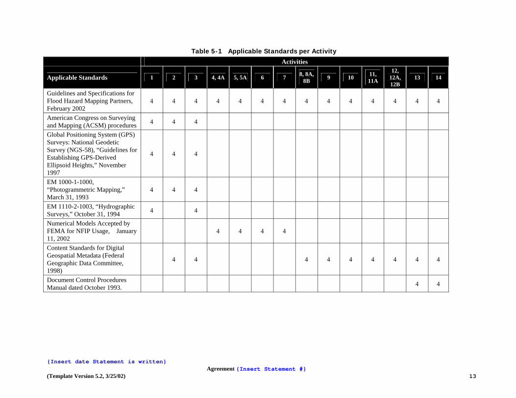
Table 5-1 Applicable Standards per Activity
Activities
Applicable Standards 1 2 3 4, 4A 5, 5A 6 7 8, 8A, 8B 9 10 11,
11A
12, 12A, 12B
13 14
Guidelines and Specifications for Flood Hazard Mapping Partners, February 2002
4 4 4 4 4 4 4 4 4 4 4 4 4 4
American Congress on Surveying and Mapping (ACSM) procedures 4 4 4
Global Positioning System (GPS) Surveys: National Geodetic Survey (NGS-58), “Guidelines for Establishing GPS-Derived Ellipsoid Heights,” November 1997
4 4 4
EM 1000-1-1000, “Photogrammetric Mapping,” March 31, 1993
4 4 4
EM 1110-2-1003, “Hydrographic Surveys,” October 31, 1994 4 4
Numerical Models Accepted by FEMA for NFIP Usage, January 11, 2002
4 4 4 4
Content Standards for Digital Geospatial Metadata (Federal Geographic Data Committee, 1998)
4 4 4 4 4 4 4 4 4
Document Control Procedures Manual dated October 1993. 4 4
{Insert date Statement is written}
Agreement {Insert Statement #} (Template Version 5.2, 3/25/02) 13

Table 5-2 Mapping Activities and Applicable Sections of Guidelines and Specifications for Flood Hazard Mapping Partners
Activity Number Task Description Applicable Volume, Section/Subsection, and Appendix of
Guidelines and Specifications
1 Field Surveys and Reconnaissance Volume 1, Sections 1.2, 1.3, 1.4 (specifically Subsection 1.4.2.1) Appendix A, Sections A.5, A.6, A.7, and A.8 Appendices B, C, and M
2 Topographic Data Development Volume 1, Section 1.4 (specifically Subsection 1.4.2.1) Appendix A, Sections A.2 and A.3 Appendix M
3 Independent QA/QC of Topographic Data Volume 1, Section 1.4 (specifically Subsections 1.4.1 and 1.4.2.1) Appendix A, Sections A.2, A.3, A.7 (specifically Subsection A.7.5),
and A.8 (specifically Subsection A.8.6) Appendix M
4 Hydrology Volume 1, Section 1.4 (specifically Subsections 1.4.2.2 and 1.4.2.4)
Appendix C, Sections C.1 and C.7
Appendices E, F, G, H, and M 4A Coastal Hazard Analyses Volume 1, Section 1.4 (specifically Subsection 1.4.2.2)
Appendix A, Section A.4 Appendices B, D, and M
5 Independent QA/QC Review of Hydrology Volume 1, Section 1.4 (specifically Subsection 1.4.1) Appendix C, Section C.2 Appendices E, F, G, H, and M
5A Independent QA/QC Review of Coastal Hazard Analyses Volume 1, Section 1.4 (specifically Subsection 1.4.1) Appendix A, Section A.4 Appendices B, D, H, and M
6 Hydraulic Analyses Volume 1, Section 1.4 (specifically Subsections 1.4.2.2 and 1.4.2.4) Appendix A, Section A.4 (specifically Subsection A.4.7) Appendix C, Sections C.3 and C.7 Appendices B, E, F, G, H, and M
{Insert date Statement is written}
Agreement {Insert Statement #} (Template Version 5.2, 3/25/02) 14

{Insert date Statement is written}
Agreement {Insert Statement #} (Template Version 5.2, 3/25/02) 15

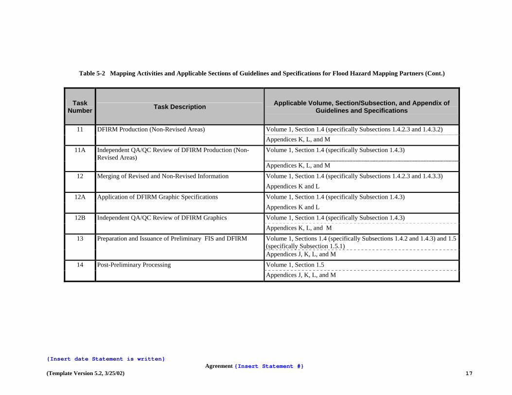
Table 5-2 Mapping Activities and Applicable Sections of Guidelines and Specifications for Flood Hazard Mapping Partners (Cont.)
Task Number Task Description Applicable Volume, Section/Subsection, and Appendix of
Guidelines and Specifications
7 Independent QA/QC Review of Hydraulic Analyses Volume 1, Section 1.4 (specifically Subsection 1.4.1) Appendix A, Section A.4 (specifically Subsection A.4.7) Appendix C, Section C.5 Appendices B, E, F, G, H, and M
8 Floodplain Mapping (Detailed Riverine or Coastal Analysis)
Volume 1, Section 1.4 (specifically Subsection 1.4.2.3)
Appendix C, Sections C. 4 and C.6 Appendices K, L, and M
8A Floodplain Mapping (Redelineation Using Effective Profiles and Updated Topographic Data)
Volume 1, Section 1.4 (specifically Subsections 1.4.2.2 and 1.4.2.3)
Appendices K. L, and M
8B Floodplain Mapping (Refinement or Creation of Zone A) Volume 1, Section 1.4 (specifically Subsection 1.4.2.3) Appendix C, Sections C.4 and C.6 Appendices K, L, and M
9 Independent QA/QC Review of Floodplain Mapping Volume 1, Section 1.4 (specifically Subsections 1.4.1 and 1.4.2.3) Appendix C, Sections C.4 and C.6 Appendices D, K, L, and M
10 Base Map Acquisition and Preparation Volume 1, Sections 1.3 (specifically Subsection 1.3.1.8) and 1.4 (specifically Subsection 1.4.3)
Appendices A and B
{Insert date Statement is written}
Agreement {Insert Statement #} (Template Version 5.2, 3/25/02) 16
{Insert date Statement is written}
Agreement {Insert Statement #} (Template Version 5.2, 3/25/02) 17
Table 5-2 Mapping Activities and Applicable Sections of Guidelines and Specifications for Flood Hazard Mapping Partners (Cont.)
Task Number Task Description Applicable Volume, Section/Subsection, and Appendix of
Guidelines and Specifications
11 DFIRM Production (Non-Revised Areas) Volume 1, Section 1.4 (specifically Subsections 1.4.2.3 and 1.4.3.2) Appendices K, L, and M
11A Independent QA/QC Review of DFIRM Production (Non-Revised Areas)
Volume 1, Section 1.4 (specifically Subsection 1.4.3)
Appendices K, L, and M
12 Merging of Revised and Non-Revised Information Volume 1, Section 1.4 (specifically Subsections 1.4.2.3 and 1.4.3.3) Appendices K and L
12A Application of DFIRM Graphic Specifications Volume 1, Section 1.4 (specifically Subsection 1.4.3) Appendices K and L
12B Independent QA/QC Review of DFIRM Graphics Volume 1, Section 1.4 (specifically Subsection 1.4.3) Appendices K, L, and M
13 Preparation and Issuance of Preliminary FIS and DFIRM Volume 1, Sections 1.4 (specifically Subsections 1.4.2 and 1.4.3) and 1.5 (specifically Subsection 1.5.1)
Appendices J, K, L, and M
14 Post-Preliminary Processing Volume 1, Section 1.5 Appendices J, K, L, and M

6. Schedule and Milestones:
TO BE DETERMINED AFTER AWARD IS APPROVED. 7. Certification: The following certifications apply to this Mapping Activity Statement (as appropriate): Activity 1 (Field Surveys and Reconnaissance) and Activity 2 (Topographic Data Development)
• Registered Professional Engineer or Licensed Land Surveyor will certify topographic information, in accordance with 44 CFR 65.5(c).
• Certification of topographic information by the American Society for Photogrammetry and Remote Sensing is also acceptable.
Activity 10 (Base Map Acquisition and Preparation) • Community official or responsible party will provide written certification that the digital data
meet FEMA’s minimum standards and specifications.
• Responsible Mapping Partner will provide documentation that the digital base map can be used by FEMA.
Activities 8, 8A, and 8B (Floodplain Mapping) and Activity 11 (DFIRM Production – Non-Revised Areas)
• The DFIRM metadata files will include a description of the horizontal and vertical accuracy of the DFIRM base map and floodplain information.
Activity 4 (Hydrology), Activity 6 (Hydraulics), and Activities 8, 8A, and 8B (Floodplain Mapping) • Hydrologic and/or hydraulic analyses and data will be certified by a Registered Professional
Engineer or Licensed Land Surveyor in accordance with 44 CFR 65.6(f).
• Topographic information will be certified by a Registered Professional Engineer or Licensed Land Surveyor in accordance with 44 CFR 65.5(c).
• Any levee systems to be accredited will be certified in accordance with 44 CFR 65.10(e). {For Coastal Hazard Analyses, the following also applies:}
• In areas outside the V-Zone, if fill is to be considered in the mapping to raise land areas to or above the 1% annual chance flood elevation, certification of the fill will be provided in accordance with 44 CFR 65.5(a)(6) by the community’s NFIP permit official, a Registered Professional Engineer, or a Licensed Land Surveyor. No fill can be used or considered in V-Zone areas and wave analyses unless adequately protected by an armored structure.
• Any coastal levee systems to be accredited will be certified in accordance with 44 CFR 65.10(e).
8. Technical Assistance and Resources: ODNR may obtain copies of FEMA-issued LOMCs, archived engineering backup data, and data collected as part of the Mapping Needs Assessment Process from the MCC. The MCC may be contacted at 1-877 FEMA MAP (1-877-336-2627). General technical and programmatic information, such as FEMA 265, the Quick-2 computer program, and the MT-2 forms, can be downloaded from FEMA’s Flood Hazard Mapping website (www.fema.gov./mit/tsd/). Specific technical and programmatic support may be provided through FEMA’s MCC; such assistance should be requested through the FEMA MCC Project Officer specified in Section 11 of this Mapping Activity Statement.
ODNR may also consult with the FEMA Regional Project Officer to request support in the areas of selection of data sources, digital data accuracy standards, assessment of vertical data accuracy, data collection methods or sub-contractors, and GIS-based engineering and modeling training.
9. Contractors: ODNR will ensure that procurement of subcontractors as part of this Mapping Activity
Statement complies with the requirements of 44 CFR 13.36.
Financial Reporting: Financial reporting requirements will be in accordance with Cooperative Agreement Articles V & VI.
10. Points of Contact: The FEMA Regional Project Officer is Ken Hinterlong, and the CTP Project Manager is
Cindy Crecelius or subsequent personnel of comparable experience who are appointed to fulfill these responsibilities. When necessary, the assistance of FEMA’s MCC should be requested through the FEMA MCC Project Officer, {insert FEMA Project Officer's Name}.
Each party has caused this Mapping Activity Statement to be executed by its duly authorized representative. ________________________________ _______________ Mark B. Ogden, P.E., Administrator Date Ohio Department of Natural Resources Division of Water ________________________________ _______________ {Insert CTP Project Manager's Name, Title} Date Portage County, Ohio _________________________________ _______________ {Insert FEMA Regional Project Officer's Name} Date Federal Emergency Management Agency _________________________________ _______________ {Insert FEMA MCC Project Officer's Name} Date Federal Emergency Management Agency

Map Modernization State Business Plan for Ohio January 2004
Attachment #3
DRAFT PROJECT CHARTER
Ohio Map Modernization Temporary Mapping Coordinator and Pilot Study
Ohio Department of Natural Resources, Division of Water
PROJECT SCOPE
Project Objective The purpose of this project is to provide a countywide DFIRM for Portage County and to develop the role of Mapping Coordinator (MC) for the Map Modernization Implementation Plan (MMIP) in Ohio. The federal government, through the Federal Emergency Management Agency (FEMA), is making a significant investment in updating Flood Insurance Rate Maps (FIRMs) throughout the country with $200 million appropriated for Fiscal Year 2003. FEMA Headquarters has indicated that they are looking for states and other cooperating technical partners to develop projects that will provide “quick wins” for the mapping initiative. FEMA defines quick wins as projects that will provide map products or other data sets in the near term (30 days, 45 days, 3 months, 6 months, 12 months). FEMA Region V has asked Ohio for three priority projects that will provide quick wins in the state, and this project was submitted. The Ohio Department of Natural Resources (ODNR), Division of Water is considering what role we are interested in, or able to accept as the MC for Ohio. The pilot project will provide a Temporary Mapping Coordinator (TMC), a private consultant experienced in flood mapping projects, to perform the tasks necessary to develop a countywide Digital Flood Insurance Rate Map (DFIRM) for Portage County, Ohio. In the process of developing the DFIRM, the TMC will also develop a position description for a FEMA-funded MC position, and establish a process for implementing Ohio’s Map Modernization initiative.
Project Customers/Stakeholders FEMA Region V – Project Sponsor Floodplain Officials of Portage County and Communities in Portage County Private Consultant as the Temporary Mapping Coordinator Division of Water
Customer Needs

FEMA Region V needs “quick win” products to meet their map modernization goals and they need a DFIRM product meeting their current technical standards. Portage County officials need a countywide DFIRM to use in floodplain management decisions. The Division of Water has limited experience in preparing FIS’ making full use of local GIS resources and capabilities and then distributing the updated floodplain information electronically and needs the knowledge gained from this pilot project to make decisions on the further implementation of the mapping coordinator position. The division also needs a tool to share this information with mapping partners in Ohio.
Customer Requirements • Portage County and FEMA Region V requires a DFIRM that meets all the
standards of FEMA’s “Guidelines and Specifications for Flood Hazard Mapping Partners.”
• The Division of Water requires a complete and thorough PD and Technical Memoranda for the mapping coordinator position.
Division of Water Project Tasks
Task Individual Responsible Finalize the project charter and Mapping Activity Statements with FEMA
Project Manager
Meet with the TMC on a weekly basis for updates and coordination of the pilot study and development of TMC position description and technical memoranda.
Project Manger
Meet with TMC during the development of the pilot study for review of draft deliverables
Project Manager/Division of Water staff
Prepare a mid-project update report for FEMA Project Manager Review draft deliverables for the pilot study and the TMC and technical memoranda
Project Manager/Division of Water staff
Review the project final deliverables Project Manager/Division of Water staff
Prepare a final project update report for FEMA Project Manager
CONSULTANT SCOPE (TMC)
Consultant Tasks for TMC • Develop a position description (scope of services) for the FEMA funded
State Mapping Coordinator (MC) Position.

• Establish a process to ensure adequate coordination, administration, accountability and timeliness for the ODNR’s MC and the partners in the MMIP effort.
• Act as the TMC for the performance period of this agreement, assuming that a sufficient FEMA grant is made available for Ohio MMIP activities.
• Produce a detailed technical memorandum (Tech-Memo-1) to document administrative procedures for MC duties. Produce a detailed technical memorandum (Tech-Memo-2) describing technical procedures for the preparation of digital FIS’ (DFIRMs) in Ohio, and a separate detailed technical memorandum (Tech-Memo-3) describing administrative procedures for the preparation of digital FIS’ (DFIRMs) in Ohio. These memoranda will be based directly on the experiences of this Pilot Study and the lessons learned from work already performed by the USGS. The Tech-Memos will assist ODNR and local officials and consultants in preparing FIS’ and DFIRMs under the Map Modernization program, guiding them through the steps necessary for successful completion of a countywide FIS.
• It is the hope of the ODNR that federal Map Modernization funds will be available to support the eventual update of maps in all of Ohio’s communities where such updating is appropriate. The TMC shall prepare a PowerPoint presentation to serve as the core of a workshop on the preparation of a countywide digital FIS. The presentation will summarize the contents of the three technical reports, the work conducted in Portage County, the difficulties faced, the procedures developed to overcome those difficulties, and the work products resulting from the Pilot Study.
Consultant Tasks for the Pilot Study In Portage County there is floodplain information already prepared or currently being prepared by entities other than FEMA that needs to be included in their FIS. Examples include studies sponsored by local governments, and studies performed for private property owners. In addition, USGS has already completed new H&H for several streams within the county. The conversion project should make use of available floodplain data in both hard copy and digital formats with the end goal of having a DFIRM format for the county. The project proposes to prepare the DFIRM for Portage County using existing and readily available information, to include the following items:
• Updated basemap information, including streets and highways, stream centerlines, vertical and horizontal control information, corporate limits, and boundaries of federal lands, all in a format that is compatible with FEMA’s technical criteria.
• Floodplain information in plan and profile view, prepared for FEMA by USGS, showing hazards for selected stream reaches.
Deliverables TMC Duties:

• Detailed position description (Scope of Services) for a FEMA-funded State Mapping Coordinator who will work either as a full-time staff member of the ODNR or as a full-time consultant to the ODNR.
• PowerPoint presentation suitable for a workshop to teach local, state, and federal government officials and private consultants about technical and administrative procedures and requirements for successfully producing state-of-the-art floodplain mapping in Ohio using GIS and meeting recognized federal and state standards.
Portage County Pilot Study:
• An appropriate GIS compiled for Portage County (unincorporated areas and municipalities) using ArcInfo.
• Floodplain information, available from existing data sources, in plan and profile view for the study areas in Portage County incorporated into the GIS.
• Floodplain information, from FEMA and USGS, in plan and profile view.
Detailed Technical Memoranda: • Detailed technical memorandum (Tech-Memo-1) in MS Word format describing
the administrative procedures for MC duties related to the MMIP. • Detailed technical memorandum (Tech-Memo-2) in MS Word format describing
the technical process and requirements for successfully producing state of the art floodplain mapping in Ohio using GIS and that are compatible with recognized federal, state and local standards.
• Detailed technical memorandum (Tech-Memo-3) in MS Word format describing the administrative process and requirements for successfully producing state of the art floodplain mapping in Ohio using GIS and meeting recognized federal, state and local standards.
Services TMC Duties:
• Provide the ODNR with a qualified professional to assist with TMC tasks as outlined in the charter including weekly updates and coordination (by meeting, conference call and/or email) with the Division of Water, Portage County and FEMA Region V officials as appropriate.
• At the completion of the project, hold a project completion meeting with Division of Water, Portage County and FEMA Region V officials as appropriate. At this meeting the TMC will present the final deliverables and lessons-learned from the project.
Reviews and Approvals Required

All deliverables of the consultant must be submitted to the Division of Water in a draft format for review and approval. The final products must also be reviewed
and approved by FEMA Region V.
PROJECT RESOURCES
Team Assignments Project Manager: Mark Ogden, Division of Water Project Resources: Cindy Crecelius, Division of Water Chad Berginnis, Division of Water Mike Gease, Division of Water Darlene Magold, Division of Water Dena Barnhouse, Division of Water George Meyers, Division of Water Rick Archer, Division of Water FEMA Region V staff Private Consultant as the TMC
Project Budget • FEMA will provide funding for the private consultant and all TMC and pilot
study activities. • The Division of Water will provide funding to pay for the Project Manager
and other staff resources (about $10,000 to $15,000) • The Division will also pay for incidentals such as printing, mailing, etc.

Project Schedule Task Due Date
TMC TasksTMC administrative duties Ongoing until
about 9/1/03 Detailed position description (scope of services) for MC 8/1/03 Tech-Memo-1 for administrative procedure for MC 9/21/03 Pilot Study Tasks Compile base GIS for Portage County 7/21/03 Incorporate existing floodplain info for Portage County 8/7/03 Incorporate USGS H&H 8/21/03 Tech-Memo-2 for technical aspects of GIS process 9/21/03 Tech-Memo-3 for administrative aspects of GIS process 9/21/03 PowerPoint presentation on preparing countywide digital flood info 9/21/03 Final products delivered to the ODNR 9/30/03
PROJECT COMMUNICATION PLAN
Who? Needs to Know What? When? In What Form? Division of Water
Progress on TMC activities Ongoing during the project
Regular update meetings (at least three) with the TMC during the course of the pilot study.
Division of Water
An explanation of the Technical Memoranda
At the time of the draft submittals
A meeting with the TMC to provide an update.
Region V Progress of the project Mid and end of project
Update report prepared by the Division of Water.
PROJECT RISK MANAGEMENT PLAN
Risk Probability Impact Contingency Plan/ Individual Responsible
FEMA will not fund the project
Low The division will not have sufficient funding for the TMC or the pilot study.
The project will be cancelled.
The consultant will Low A decision on the MC The project manager

not complete the project on time
position will be delayed which could affect planning for future fiscal years.
will work closely with the TMC to keep the project on schedule, or to assure that enough information can be provided to make a preliminary decision on the MC position.
The division will not have sufficient resources to fund the project manager position or other pilot review positions.
Low Review of deliverables and coordination with TMC will be delayed. This could delay the overall completion of the project.
If the division experiences additional budget cuts, priorities will be assessed and staff reassigned to complete the project.

Map Modernization State Business Plan for Ohio January 2004 Attachment #4
Ohio Department of Natural Resources
Cooperating Technical Partners Mapping Activity Statement
(Revised 4/22/03)
Mapping Activity Statement for Coordinating CTP Development and Monitoring in the State of Ohio
In accordance with the Cooperating Technical Partners (CTP) Memorandum of Agreement dated X, 2003, between the Ohio Department of Natural Resources and the Federal Emergency Management Agency, this Cooperative Agreement is as follows: 1. Agreement Objective and Scope: The primary objective of this agreement is to establish ODNR as the coordinator for CTP agreement development, including performing associated scoping activities in communities with CTP agreements within the State of Ohio in accordance with the Division of Water’s authority under Section 1521.13 of the Ohio Revised Code. Secondary objectives include providing high quality customer service, assisting FEMA with the cultivation and development of local CTP agreements that leverage as many contributory funds from non-FEMA partners as possible, promote the development of local CTP agreements that meet the State of Ohio Map Modernization Plan, and to ensure the successful implementation of FEMA’s Map Modernization Program. This project will be completed by the following partners: Ohio Department of Natural Resources FEMA MCC or IDIQ Contractor Local Mapping Partner Federal Emergency Management Agency The activities, and who will complete them, are summarized in the table below: Activity ODNR Local CTP
Partner MCC or IDIQ
FEMA
FEMA to provide training to ODNR to perform activities identified below, get consensus on CTP development process as proposed (one time coordination)
X X
Coordinate quarterly meeting with prospective and current local CTP partners, partnering federal and/or state agencies, and/or private contractors to explain CTP, and cultivate interest, and monitor implementation of active agreements
X X
Follow-up with prospective local CTP partners to develop and adopt a CTP Memorandum of Agreement
X X
Coordinate and undertake pre-scoping meeting activities including: Formation of project management team (coordinate), prepare preliminary project management plan (undertake), conduct initial project conference call (coordinate), form project team (coordinate),
X X X X

initiate initial project conference call (coordinate), identify mapping needs in CTP community (undertake), research (undertake – for other data only / MCC will undertake for effective FEMA data), identify potential obstacles (undertake), identify other potential resources (undertake), assist local partner with preparing mapping activity statements (undertake), develop draft scope of project (undertake), make draft scope of project conference call (coordinate), revise draft scope of project (undertake), distribute background information (undertake) Coordinate and undertake scoping meeting activities: Schedule and coordinate meeting (undertake), overview NFIP (undertake and/or FEMA), finalize and prioritize needs list (undertake with local partner assistance), refine draft scope of project (undertake), finalize local partner mapping activity statements (coordinate), assign team members tasks (undertake)
X X X X
Coordinate and undertake post-scoping meeting activities: Document scoping meeting (undertake), prepare statement of work (could undertake with FEMA review), distribute statement of work (undertake), project team members prepare T&C estimates (coordinate), document unmet mapping needs in MNUSS (undertake), flag needs being addressed by project (undertake), revise needs that could not be verified (undertake), finalize project management plan (undertake with FEMA review), issue task orders, cooperative agreements, and FEMA approval of local partner mapping activity statements (FEMA), PRODUCE MAPS!
X X X X
Monitor and report on existing CTP agreements quarterly
X
2. Period of Performance: This mapping activity is anticipated to last throughout the FEMA map modernization process (5-7 years). However, for purposes of this annual cooperative agreement, this mapping activity will begin on May 1, 2003 and will end on September 30, 2003. 3. Funding/Cost Sharing: It is anticipated that ODNR activities identified in this agreement will require one FTE (approximately $70,000). This activity will be funded 90% by FEMA and 10% by ODNR. 4. Standards: The following standards and resource documents are relevant to this mapping activity and cooperative agreement: Guidelines and Specifications for Flood Map Production Coordination Contractors: Guidelines for Scoping Flood Mapping Projects (January, 2001)

FEMA Cooperative Technical Partners template forms and related information. 5. Products: ODNR shall make the following products available:
• Quarterly CTP Meeting Report. This report will identify communities that participate wishing to know more about the CTP program and provide a status update on existing CTP agreements.
• Documentation of all conference calls, pre-scoping activities, scoping activities, and post-scoping meeting activities as identified in the Guidance of Scoping Flood Mapping Projects for new CTPs.
6. Schedule and Milestones: Meetings with federal mapping partners, potential local partners (CTPs) and other interested parties will occur quarterly. The pre-scoping process will be initiated on demand as evidenced by interested CTPs. Once initiated, the entire scoping process (pre-scoping, scoping, funding) will take up to two years. 7. Certification: Not applicable 8. Technical Assistance and Resources: It is expected that the scoping process will be managed, and many activities actually undertaken by ODNR. However, the Project Management Team of the FEMA Regional Engineer, FEMA Contracting Officer, FEMA Engineer from Headquarters (if applicable), Mapping Coordination Contractor (MCC) Representative, and Study Contractor Representative will all be expected to participate and undertake activities identified in the Guidance of Scoping Flood Mapping Projects. Examples of such involvement include costing out various activities, MCC assistance in creating the paneling scheme, and FEMA review and/or creation of a Scope of Work. 9. Subcontractors: Not applicable 10. Quality Assurance/Quality Control (QA/QC) Procedures: ODNR shall establish mechanisms for feedback and process adjustment for scoping and CTP cultivation such as creating a survey or other instrument. 11. Reporting: Reports shall be filed quarterly including minutes of quarterly CTP coordination meeting, and reports of scoping activities being undertaken. 12. Points of Contact: The FEMA Project Officer is Ken Hinterlong and the CTP Project Manager for ODNR is Cindy Crecelius or subsequent personnel of comparable experience who are appointed to fulfill these responsibilities. Each party has caused this Cooperative Agreement to be executed by its duly authorized representatives. _____________________________________ _________________ James R. Morris, Chief, ODNR – Div. of Water Date _____________________________________ _________________ FEMA Authorized Representative Date


Map Modernization State Business Plan for Ohio January 2004 Attachment #5
Ohio Department of Natural Resources – Division of Water
Federal Emergency Management Agency Cooperating Technical Partners
Mapping Product and Activity Statement
Agreement Statement #2 – Digital Flood Hazard Data Preparation
In accordance with the Cooperating Technical Partners Memorandum of Agreement dated XXXX, 2003, between the Ohio Department of Natural Resources (ODNR) and the Federal Emergency Management Agency (FEMA), Agreement 2 is as follows:
Preliminary Digital Flood Hazard Information Responsible Entity: Ohio Department of Natural Resources, Division of Water Scope: The creation of digital updated flood maps requires digital files of flood hazard information, such as the 100-year, 500-year and floodway boundaries. FEMA has established minimum standards and specifications for digital data and digital flood hazard map products. The State of Ohio has digitized flood hazard information from the effective hardcopy FIRMs and FHBMs to support the map modernization plan and preparation of DFIRMs. Annotated Letters of Map Revision (LOMRs) issued since the current effective FIRM for each affected community are incorporated. Period of Performance: The digital coverages and metadata identified below will be available to FEMA within thirty (30) days of this Agreement’s mutual acceptance by the ODNR and FEMA. Funding/Cost-Sharing: The creation of these datasets was totally funded by the State of Ohio. Standards: The digital flood themes created by ODNR have not been reviewed by FEMA for compliance with the minimum standards and specifications for DFIRM production per “Guidelines and Specifications for Flood Hazard Mapping Partners” dated February 2002. The product is being submitted as “preliminary digital data” and may need to be modified to comply with FEMA file structure and data format with guidance. KEN What if any of Appendix L applies???? (Volume 1 and Appendicies A, B, K as applicable???) Deliverables: ODNR, Division of Water shall make the following products* available, on CD-ROM in accordance with the provisions of the Ohio Revised Code Section 149.43, to the FEMA lead:
• 100-year Floodplain Boundary coverage by county • 500-year Floodplain Boundary coverage by county • Floodway Boundary coverage by county • Cross-section location coverage by county • Annotated Letter of Map Revision point-coverage by county • Metadata files describing the digital data * The “Available Data Inventory” contains the specific information about the digital flood hazard data being provided.
Certification: ???? Could this be done by whomever does the QA/QC review.
Technical Assistance and Resources: Since the creation of this digital flood hazard data was done by the State without the benefit of the CTP, we anticipate that some of the FEMA standards have not been satisfied. ODNR, Division of Water requests the assistance of FEMA to determine if this digital flood hazard information meets FEMA standards, and if not to assist in the modification of the data so that it does meet the FEMA standards and digital product specifications.
Subcontractors: Not applicable.
QA/QC Procedures: See Technical Assistance and Resources request.
Points of Contact: The FEMA Project Officer is Ken Hinterlong, FEMA Region V, the CTP Project Manager is James R. Morris, PE ODNR, Division of Water, or subsequent personnel of comparable experience who are appointed to fulfill these responsibilities.
Each party has caused this Mapping Product and Activity Statement to be executed by its duly authorized representative.
__________________________________ ________________________________
James R. Morris, PE, Chief Division of Water Date
___________________________________ _________________________________
FEMA authorized representative Date

Agreement # 2a - Digital FIRM Preparation In accordance with the Cooperating Technical Partners Memorandum of Agreement dated XXXX, 2003 , between the Ohio Department of Natural Resources, Division of Water (ODNR) and the Federal Emergency Management Agency (FEMA): Responsible Entity: (Federal Agency CTP or IDIQ)
Scope: This activity will involve obtaining digital base maps, converting the effective FIRM/FHBM panels to digital format in conformance with FEMA’s DFIRM specifications, and ensuring that the unrevised flood hazard information taken from the effective maps is accurately represented on the DFIRM panels.
The following table contains the specific activities associated with creating the countywide DFIRM products for Mahoning and Sandusky Counties in Ohio. The responsible party may be either the MCC or the FED CTP depending on FEMA’s choice and the availability to support the activity.
Activity FEMA CTP
ODNR MCC
PBS&J FED CTP
USGS
Obtain digital files of base maps.
X X
Obtain permission to use and distribute hardcopy and digital map products.
X X
Certify that the digital data meets FEMA specs.
X X
Populate the DFIRM database.
X X
Prepare DFIRM mapping files and database.
X X
Create metadata files describing the DFIRM data.
X X
Complete set of plots of the DFIRM panels of unrevised flood hazard data from effective maps.
X X
QA/QC review and report.
X X
Period of Performance: The mapping activities assigned to either the MCC or the Federal CTP will be completed as specified in the agreement articles of the Cooperative Agreement between the FEMA Regional Project Officer and the MCC or Federal CTP Project Officer.

Funding / Cost-Sharing: The funding to complete these mapping activities will be provided by FEMA through a Federal CTP or IDIQ contract agreement. Standards: Base map preparation and DFIRM production activities and products must conform with the FEMA minimum standards as specified in “Guidelines and Specifications for Flood Hazard Mapping Partners” February 2002. The following table is the specific standards applicable to the tasks identified.
Task Description Volume, Section/Subsection and Appendix
Base map preparation Volume 1, Section 1.3 and 1.4, Appendices A and B
DFIRM for non-revised areas Volume 1, Section 1.4, Appendices K, L and M
QA/QC of DFIRM Volume 1, Section 1.4, Appendices K, L and M Schedule and Milestones: To be determined as part of the FEMA – contractor agreement. Certifications: Responsible party will provide written certification that the digital data meets FEMA’s minimum standards and specifications. Responsible mapping partner will provide documentation that the digital base map can be used by FEMA. Need help here????? If there are other certifications. Technical Assistance and Resources: Contractors: Either the MCC or a Federal CTP will be utilized to complete the activities noted to create DFIRMS for Mahoning and Sandusky Counties. The FEMA Regional Project Officer will ensure that the procurement of subcontractors complies with the requirements of 44 CFR 13.36. Financial Reporting: Financial reporting will be in accordance with the Articles contained in the Cooperative Agreement. Points of Contact: The FEMA Regional Project Officer is Ken Hinterlong, Region V, the ODNR CTP Project Manager is James R. Morris, PE Chief ODNR, Division of Water, or subsequent personnel of comparable experience who are appointed to fulfill these responsibilities. Each party has caused this Mapping Activity Statement to be executed by its duly authorized representative. ____________________________________ _____________________ James R. Morris, PE, Chief Division of Water Date ____________________________________ ______________________ Federal Emergency Management Agency Representative Date

Available Flood Hazard Data Inventory
State of Ohio March 21, 2003 Prepared by:
Ohio Department of Natural Resources Division of Water
This checklist reflects floodplain mapping information and data available or currently underway that may be useful for this project.
Flood Hazard Data
Are digital flood hazard data available? If so, from whom? X Yes ο No The GIS coverages are available from the Ohio Department of Natural Resources (ODNR) Division of Water Floodplain Management Program
Have flood hazard data that have been converted to digital format been compared to the effective FIRMs to ensure that base map to flood hazard relationships have been preserved?
X Yes ο No
The annotated Letters of Map Revision (LOMR) were also included in the digital coverages altering the morphology of the floodplain. A point coverage was also created to illustrate the areas that have been affected by the LOMRs.
What was the source of the digital flood hazard data and how were the data created?
The ODNR Floodplain Management Program had the FEMA map images scanned at a 256 gray scale for a clear resolution and portrayal of flood hazard features. These images will overlay the road centerline network vector files created by The Ohio Department of Transportation (ODOT). These files serve as the base map for the 100-year floodplain boundary, 500-year floodplain boundary, floodway and cross-section ArcInfo coverages. Although the data was not digitized using the Digital Orthophoto Quarter Quads (DOQQ) as a base map, the coverages still correlated well with the DOQQs for the State of Ohio. The procedure approved by ODNR to create the coverages required vector data rather than raster data. The road centerline network from ODOT is updated regularly and is the more accurate than the outdated DOQQs for Ohio, which the accuracy ranges from over 10 years.
Do any new data tie in to the existing effective information? X Yes ο No
The preliminary studies (now approved FIRMS) were incorporated into the GIS coverages.
Do the data cover the entire community or county being restudied? X Yes ο No

Flood Hazard Data (Continued)
Are the data available now? If not, what is the projected completion date? X Yes ο No
{Insert notes.}
What is the accuracy or resolution of each data set or type?
40 feet; scale of 1:24,000
When were the data created, last updated, or reviewed for update needs?
Data is updated as new information is available.
Created Last Updated Reviewed
11/01 1/02 1/02
{Insert notes.}
Are Letters of Map Change (LOMCs) included in any digital data sets? X Yes ο No
The annotated Letters of Map Revision have been included.
What projection, horizontal datum, and vertical datum were used for the flood hazard data sets?
Projection Horizontal Datum Vertical Datum
Ohio State Plane (North/South zones as appropriate)
NAD83 datum N/A
In what file format(s) are the data available?
ArcInfo Export Coverages
How are the data tiled?
All data is countywide
Is a data dictionary or metadata available? X Yes ο No
http://www.dnr.state.oh.us/gims/; this is specific to ODNR GIS standards, not to FEMA standards but can easily be altered.
Have flood hazard data that have been converted to digital format been compared to the effective FIRMs to ensure that base map to flood hazard relationships have been preserved?
X Yes ο No
Check plots were overlaid on top of the original FIRMs to ensure that all of the geometry was captured correctly. This was part of the QA/QC process.
Flood Hazard Data (Continued)
What feature types do the flood hazard data sets contain? (Check all that apply.) X 1% annual chance flood hazard areas
{Insert notes.}
X 0.2% annual chance flood hazard areas {Insert notes.}

X Floodways {Insert notes.}
Coastal Barrier Resources System areas ο
{Insert notes.}
Alluvial fans ο
{Insert notes.}
Base flood elevations, velocities, or depths ο
{Insert notes.}
X Cross sections
Cross section attribute data is not complete, but lines are digitized in line coverage. Elevation Reference Marks (ERMs) ο
{Insert notes.}
X LOMCs
Annotated Letter of Map Revisions were incorporated into the flood coverages and a point coverage was created showing the locations of the annotations.
ο Are data for other flood frequencies available? ο Yes ο No
{Insert notes.}
Do the flood hazard boundaries need to be fitted to newer or more detailed stream locations and/or topography than was previously used for the existing FIRM? ο Yes ο No
{Insert notes.}

Map Modernization State Business Plan for Ohio January 2004 Attachment #6
Map Modernization
Management Plan Engineering and Mapping Process
The Engineering and Mapping Process will develop detailed flood data for Ohio communities. This document addresses the following subproject portions and deliverables.
Subproject Deliverable(s) Estimated Delivery Date
Actual Delivery Date
Preparation of hydrologic and hydraulic analyses for approximately 1 to 2 miles of watercourse.
Digital copies of hydrologic modeling; Discharge tables; GIS data layers; Profile of 1% annual chance water-surface elevations; Floodway data tables; digital copies of hydraulic modeling; Technical Data Notebook; status reports.
To be determined based on negotiations with FEMA.
Preparation of digital format floodplain and floodway boundaries on base maps and flood risk studies.
Digital work maps for 1% annual chance floodplain and floodway boundaries; digital base map files; GIS mapping, database and metadata files; plots; flood study text; structure inventory coverage and map summary; status reports.
To be determined based on negotiations with FEMA.
Scope of Work: The purpose of the engineering and mapping process is to develop a flood risk study and to delineate the 100-year floodplain and floodway areas displayed on Digital Ortho Quarter Quadrangle base maps for each community assisted. The flood risk study and maps will be produced in digital form in addition to hardcopy. The project will include developing new and/or updated flood data. The data development and map production process are summarized in the flow chart on the following page.

A description of each task (brief scope, applicable standards, deliverables) follow the table summary.

Flood Hazard Data Development and Flood Mapping Procedures
A
Task assignments, and mapping activities identified.
Data Acquisition • Topo data
development • Field survey
Hydrology
Hydraulics
Flood Hazard Analysis • Mapping
inundation area 1% annual flood,
Base Map Acquistion
Existing Flood
Layout Flood Risk Study
Prepare digital Flood Risk Map d t b
Final Study and Map • Prelim.
Review • Submit
B Independent QA/QC (performed by FEMA or their agent)
Independent QA/QC (performed by FEMA or their agent)
Scoping • Id flood
sources to study
• Task assignments
• Determine any available flood data
• Community Flood Risk Study
• Flood Risk Map
• Floodplain Management Plan
A – Indicates input from the community to finalize the scoping. B – Indicates input from the community concerning available flood hazard or digital products to support the study and mapping effort.

Task Assignment and Scheduling This assignment and scheduling template can be used for each unique community project and may be modified to add or delete tasks that are not applicable to the specific community. The “Flood Hazard Data Development and Flood Mapping Procedure” flowchart shows the relationship of the overall tasks and activities.
Tasks Lead Staff Supporting Staff Typical Timeframe) Target Deliverable Date
Actual Deliverable Date
1. Field Survey and Reconnaissance
Two staff, full-time, 1 day per site
To be determined
2. Topographic Data Development
Three staff, full-time, 12 days/ site One staff, full-time 2 days/ site
3. Hydrologic Analyses
One staff, full-time, 3 weeks per site
4. Hydraulic Analyses
One staff, full-time, 3 weeks per site
5. Floodplain Mapping
One staff engineer, 20 hours per site
6 Base Map Acquisition
One staff, 8 hours per site
7. Merge existing and new flood information
One staff, 4 hours per site
8. Layout of flood risk study and flood risk map
One staff, 40 hours per site
9. Final study and map products, gis database and digital metadata
One staff, 20 hours per site
10. Digital GIS Product Coordination with FEMA
One staff, 4 hours per site

Task 1 – Field Surveys and Reconnaissance Lead Staff: ODNR, Division of Water Scope: Engineering staff shall conduct detailed field reconnaissance of the specific study area (approximately 1 to 2 miles of stream distance) to determine conditions along the floodplain(s), types and numbers of hydraulic and/or flood control structures, locations of cross-sections to be surveyed, and other parameters needed for the hydrologic and hydraulic analyses. This task includes: • Identification of watercourse to be studied and the detail to support the collection of
field data. This may incorporate information from the community contact and planning data gathered during the project application and development period.
• Determination of available Geographic Information System information to support transfer of data to GIS products. This includes Geographic Positioning System data.
Standards: All work conducted under this task will be consistent with the standards required for the support of hydrologic and hydraulic analysis as specified in FEMA 37. Deliverables: The following products will be made available: • Field Reconnaissance summary notes • GPS / GIS

Task 2 – Topographic Data Development Lead Staff: ODNR, Division of Water Scope: Topographic survey data of the areas of flooding sources will be obtained to support detailed hydraulic studies. Specifically, new topographic data will be generated for (identify the flooding source) using field survey methods. This task also consists of developing topographic maps and/or Digital Elevation Models (DEMs) for the subject flooding sources using the data collected in Tasks 1 and 2 This task includes: • Conducting horizontal and vertical control surveys • Obtaining channel and floodplain cross-sections • Obtaining physical dimensions of hydraulic and flood control structures • All surveys tied to State Plane coordinates using GPS. • Reducing/converting field data to create DEMs Standards: All work conducted under this task shall conform to the standards specified in FEMA’s Guidelines and Specifications for Flood Hazard Mapping Partners as appropriate. Survey field instructions must be performed under the responsible charge of a licensed surveyor. Deliverables: Upon completion of topographic data collection and processing for (identify the flooding source) , this data will be submitted to FEMA Region V or PBSJ for QA/QC review of the topographic data. The following products will be made available: • Maps and drawings that provide the detailed survey results • Survey note book containing cross sections and structures data • Summary report on methodology and results • Triangular Irregular Network (TIN) data on CD-ROM • Checkpoint analyses to assess the accuracy of TIN data including Root Mean Square Error (RMSE) calculations to support vertical accuracy • Identification of remote sensing data voids and methods used to supplement data
voids
Task 3 – Hydrologic Analyses Lead Staff: ODNR, Division of Water Scope: Hydrologic analyses will be completed for approximately (number of square miles) square miles of drainage area for (identify the flooding source). The hydrologic methods used for this analysis will be (insert the hydrologic method used, note if multiple methods are used) Peak flood discharge will be calculated for the (specify the recurrence interval) annual chance storm. This flood discharge will be the basis for subsequent hydraulic analyses of the identified watercourse. GIS-based modeling will be used and automated data processing and modeling algorithms will be documented. Digital data sets (e.g. elevation, basin, or land use data) will be documented. The ODNR, Division of Water will be applying a custom software (Application 3) to accomplish the hydrologic analyses. FEMA approval of the model and software will be requested prior to performance of the task. Standards: All work conducted under this task shall conform to the standards specified in FEMA’s Guidelines and Specifications for Flood Hazard Mapping Partners. Deliverables: Upon completion of hydrologic modeling for (identify the reach and watercourse), the data will be submitted to FEMA Region V or their agent for QA/QC review of the hydrologic modeling. The following products will be made available: • Hardcopy of all hand calculations supporting the hydrologic modeling • Digital copies of all hydrologic modeling (input and output) files for the 10%, 2%, 1%,
and 0.2% annual chance floods • Discharge summary for the flooding source • Back up data used in the analysis • GIS layers • Metadata

Task 4 – Hydraulic Analyses Lead Staff: ODNR, Division of Water Scope: Hydraulic analyses will be completed for approximately (number of linear miles) miles of stream reach for (identify the flooding source). The modeling will include the 10%, 2%, 1%, and 0.2% annual chance events based on peak discharge computed in Task 3. The hydraulic methods used for this analysis include (insert the hydraulic methods used, if multiple note). Cross section and field data collected in Tasks 1 and 2 will be used to prepare the hydraulic analysis. The hydraulic analysis will be used to establish 10-year, 50-year, 100-year, and 500-year flood elevations and floodways for the identified flooding source. GIS-based modeling will be used and automated data processing and modeling algorithms will be documented. Digital data sets will be documented. The ODNR, Division of Water will be applying a customized version of standard software (ArcView, HEC-RAS, and HEC-GeoRAS) to accomplish the hydraulic analyses. Standards: All work conducted under this task shall conform to the standards specified in FEMA Guidelines and Specifications for Flood Hazard Mapping Partners. Deliverables: Upon completion of hydraulic modeling for (identify the reach and watercourse), this data will be submitted to FEMA Region V for QA/QC review of the hydrologic modeling. The following products will be made available: • Digital profile of the 10%, 2%, 1%, and 0.2% annual chance water-surface elevations
representing existing conditions (from HEC-RAS) • Floodway data table for the identified flooding source • Digital copy of all hydraulic modeling (input and output) files • Back-up data used in analysis • GIS data layers, final digital format products, database structure

Task 5 – Floodplain Mapping Lead Staff: ODNR, Division of Water Scope: Digital floodplain and floodway boundaries will be delineated for (identify the flooding source and reach). The mapping will incorporate hydraulic modeling and topographic information. The floodplain boundary for the 100-year flood (1% annual chance), 500-year flood (0.2% annual chance), and a floodway will be delineated on a digital work map based on topographic data developed in Task 2, which will be the basis of the final Flood Risk Map. Cross section locations will also be shown. Standards: All work conducted under this task shall conform to the standards specified in FEMA Guidelines and Specifications for Flood Hazard Mapping Partners. Deliverables: • Digital work maps with the 1% and 0.2% annual chance floodplains and floodway
boundaries delineated. These maps will also include cross sections and Base Flood Elevations.
• Back-up and supplemental information used to produce the mapping. • 100-year floodplain and floodway coverages • Shapefiles • Base map images

Task 6 – Base Map Acquisition Lead Staff: ODNR, Division of Water Scope: This task consists of obtaining the digital base map for (identify the community or flooding source??). The following activities are included: • Obtain digital files (raster or vector) of the base map • Certify that the digital data meets the minimum standards and specifications that
FEMA requires for DFIRM production Standards: All work conducted under this task shall conform to the standards specified in FEMA Guidelines and Specifications for Flood Hazard Mapping Partners or DFIRM standards as specified in “Basemap Specifications for New Digital FIRM Product,” May 1999. Deliverables: • Written certification that the digital data meets the minimum standards and
specifications • DOQQ and community data (roads, topography, etc.)

Task 7 – Merge Existing and New Flood Hazard Information Lead Staff: ODNR, Division of Water Scope: This task consists of tying in flood profiles, floodplain boundaries and floodways with any contiguous or already existing flood hazard data not generated as a result of this project. The existing data will be obtained from the digital flood hazard area coverages or shapefiles. The existing information will be displayed with the new study mapping and flood hazard information. Standards: All work conducted under this task shall conform to the standards specified in FEMA Guidelines and Specifications for Flood Hazard Mapping Partners or DFIRM standards as specified in “Basemap Specifications for New Digital FIRM Product,” May 1999. Deliverables: • GIS staff to finalize and perform any additional conversion to meet FEMA format. • Digital mapping files in one of the GIS file formats meeting FEMA specifications? • Digital database files in one of the GIS file formats meeting FEMA specifications? • Metadata files • Complete set of plots of the digital map showing detail at (identify appropriate scale)
scale • QA/QC report describing ODNR, Division of Water automated or manual quality
assurance steps taken during the preparation of the digital maps.

Task 8 – Lay-out of Flood Risk Study and Flood Risk Map Lead Staff: ODNR, Division of Water Scope: This task consists of the final preparation of the Flood Risk Study document and Flood Risk Map products. It includes; • Flood Risk Study Report preparation, inserting flood profiles, data tables, structure
inventory data, and cross section schematic and/or location data. Format will be similar to FEMA FIS without insurance components.
• Final QA/QC of preliminary maps and study • Discrepancy resolution • Support of the distribution of the preliminary products for community and partner
review/comment. Standards: All work conducted under this task shall conform to the standards specified in FEMA Guidelines and Specifications for Flood Hazard Mapping Partners or appropriate guidelines. Deliverables: • Draft Flood Risk Study (profiles, floodway data tables, cross section location data) • Draft Flood Risk Map (100-year and 500-year floodplain and floodway boundaries)
with DOQQ base map

Task 9 – Issue Flood Risk Study and Flood Risk Map Lead Staff: ODNR, Division of Water Scope: This task is the finalizing of the Flood Risk Map and the Flood Risk Report after the preliminary products have been reviewed. It includes the coordination with FEMA concerning newly available flood hazard information and mapping for the communities assisted under the larger scope of this project. There will also be elements of maintenance and distribution of the new study and map information that will be addressed as the task evolves. Standards: All work conducted under this task shall conform to the standards specified in FEMA Guidelines and Specifications for Flood Hazard Mapping Partners. Deliverables: • DFIRM – paper copy and digital data • Study – paper and digital • Metadata files
Task 10 – Digital / GIS Product Coordination with FEMA Lead Staff: ODNR, Division of Water Scope: This task consists of maintenance procedure, policy for use, plan for distribution and metadata specifications. Standards: All work conducted under this task shall conform to the standards specified in FEMA ‘s “New DFIRM Product Development.” Deliverables: • Point of contact • Metadata files • Procedures for maintenance of data • Distribution policy

Map Modernization State Business Plan for Ohio January 2004
Attachment #7 - Coalition Development
Tasks/Actions 1. Identify all state, federal & local agencies interested in mapping such as Center for Mapping,
OEMA, USGS, ODOT, Coastal, Geo Survey – 2 months 2. Develop an educational presentation and materials to use in meeting with these potential partners
– 3 months (concurrent with 1) 3. Arrange and meet with potential partner agencies and educate them on the benefits of mapping
partnership – 2 months (subsequent to 1 & 2) 4. Establish specific MOU’s on sharing of data and mapping activities – 6 months (concurrent with
3) 5. Monitor and maintain the MOU’s and sharing of data – ongoing
Timeline – 11 to 12 months
Resources • One Environmental Specialist FTE with 0.25 FTE division Engineering support • Associated training, computer, office equipment, etc. • Educational Materials • Total cost approximately $97,500
Risk
• Partner agencies not interested – low risk – consequences will be fewer partnerships • Current datasets and needs of partners will not be in line with FEMA digital standards and format
– medium risk – the consequence will be additional efforts to develop useful links for the data • Partner agencies not able financially to participate – high risk – consequences will be fewer
partnerships • Partner agencies not able to commit resources – high risk – consequences will be fewer
partnerships

Map Modernization State Business Plan for Ohio January 2004 Attachment #8
The Ohio Department of Natural Resources Floodplain Management Program Geographic Information Management System (GIMS) The Floodplain Management Program provides leadership for the cooperative management of Ohio’s floodplains to reduce flood risk for life and property and to protect the natural function and benefit of the floodplain resources. The purpose of the GIMS is to create a GIS-based information management system to manage selected flood hazard information and to support general operations and priority applications of the Floodplain Management Program. Three priority applications exist and digital data creation of the Federal Emergency Management Agency (FEMA) maps for the 88 counties in Ohio has been completed. Paper Flood Insurance Rate Maps (FIRM), Flood Hazard Boundary Maps (FHBM) and Floodway Maps have been converted into scanned images. Selected features have been converted into GIS coverages. These features include the 100-year and 500-year floodplain boundaries, floodway and cross-sections. Application one is Integrated Spatial Data Access and Information Management. The function of this application is to provide interactive access to floodplain and community data for Ohio as well as the ability to display and link to databases and other information for creation of custom maps and reports. The software used is Visual Basic, Map Objects Lite 2.0 and Microsoft Access. Application two is the Structure Inventory of Flood Hazard Areas. This is an interactive inventory of structures at risk of flooding with integration of data from local management authorities for mitigation and planning efforts. Application two is also used for maintenance and editing of base data layers. The software used is ArcView 3.2a and Avenue. Application three is Hydrologic and Hydraulic Modeling. This application is the integration of hydrologic and hydraulic modeling with local terrain maps for more accurate representation of flooding scenarios and demonstrations. Software used is HEC-RAS, HEC-HMS, ArcView 3.2a, Spatial Analyst, 3-D Analyst, Avenue and Visual Basic.