map-a-planet 2 mosaic projection web service
TRANSCRIPT
Map-A-Planet 2 - Mosaic Projection Web ServiceS.W. Akins, T.M. Hare, R.M. Sucharski, J. Shute, L. Gaddis, T. Gaither, J. Richie; Astrogeology Science Center. [email protected]
Getting Started with MAP2The USGS Astrogeology Science Center has developed Map-A-Planet 2 (MAP2), an update to the existing Map-A-Planet [1] of the Planetary Data System (PDS), an on-line tool for extracting science-ready, map-projected images from global mosaics. MAP2 stores the mosaics in a searchable document management system or data portal called Astropedia. (http://astropedia.astrogeology.usgs.gov) [2]. The user enters a mosaic selection and processing options that are executed on a local processing cluster using tools in Astrogeology’s “freeware” image processing package Integrated Software for Imagers and Spectrometers (version 3 or “ISIS3” [3]) and the Geospatial Data Abstraction Library (GDAL) [4]. When the processing is complete, the user is noti�ed by email to collect the product from the web site.
The current version of PDS Map-a-Planet (MAP) is heavily relied on by planetary scientists, educators, and students at all levels. The site receives an average of 620,000 hits and a download average of 447 GB per month. MAP allows users to explore digital, global mosaics of the planets and satellites created from PDS data obtained from a wide variety of planetary missions through a web interface. Users can customize and download map-projected image maps of the Moon, Mars, Venus, and other planets and moons. The MAP image processing engine, called Mapmaker, was an innovative tool created 17 years ago (in 1997) to locate and load the tiles required to produce a requested digital mosaic, scale the tiles to the desired resolution, knit the tiles together, then apply a density stretch and projection to �nalize the product requested.
The �rst step for a new MAP2 user is to request an Astrogeology cloud services account (http://astrocloud.wr.usgs.gov). This account will be used as a point of contact to keep the user informed about when their processing requests are complete and to help tailor their web experience. MAP2 extends and reuses the web interface recently developed for the Map Projection on the Web (POW, [6]) service. The MAP2 interface includes the account system, noti�cations to send e-mail when a job is completed, and job tracking tools to monitor which jobs are running, which products are ready for download, and to review job processing options.
A user will select an image either through a link on a product description page in Astropedia or by browsing the MAP2 eligible products page (http://astrogeology.usgs.gov/tools/map), or by selecting a result from an Astropedia search. The mosaics stored in the Astropedia system are supplemented with detailed FGDC-based (Federal Geographic Data Committee) geospatial metadata [7, 8] about the heritage and quality of each product. The FGDC metadata standard is commonly used to document Earth-based data and includes the scienti�c rationale for the image, authorship, accuracy, known errors, and other key details. These data help to identify which mosaic images meet the user’s scienti�c requirements. Associated with each mosaic product the user sees detailed information, including the source data, date of creation, geographic extent, coordinate system and map projection used, bit type, digital dimensions, spatial resolution, and (for multispectral products) number of bands, their wavelengths, resolution, and any band math functions used to derive the image. The user can use any or all of these data properties to identify the desired product and to enter a MAP2 processing request to extract a full or portion of a mosaic and/or to calculate a derived product.
MAP2 will provide all of the layers currently available for processing in the existing MAP software and will feature new products as they are released such as the latest mosaics of Mercury from the MESSENGER Team, Lunar Orbiter Laser Altimeter topography and Lunar Reconnaissance Orbiter Camera wide angle mosaic from the LRO Team, and the newly released Vesta global products from the Dawn Team. Once the user identi�es a product in Astropedia for processing with MAP2, they are sent to the MAP2 web interface. The MAP2 web interface prompts them to download the entire product or to identify the processing options supported for that product.
References: [1] Garcia, P. A., et. al., 2010, LPSC 41, abstract 2669 and references therein. [2] Bailen, M.S., et al., 2012, LPSC 43, abstract 2478 and this volume. [3] Keszthelyi, L., et al., 2013, LPSC 44, abstract 2546 and this volume. [4] Hare, T.M., et al., 2007, LPSC XXXVIII, abs #2364. [5] Gaddis et al., 1997, LPSC 38, p. 387, 1997. [6] Hare, T.M., et al., 2013, LPSC 44, abstract 2068. [7] see http://www.fgdc.gov/. [8] Hare, T.M., et al., 2011, LPSC 42, Abstract 2154. [9] Lucey, P.G. et al., 2000, Journal of Geophysical Research, 105(E8), pp. 20297-20305.
Available MAP2 Processing Functionality:
» Setting a bounding box to extract a desiredsub-scene or a smaller, more manageableproduct
» Selecting an output map projection (i.e., PolarStereographic, Sinusoidal)
» Selecting which band(s) from a multi-bandimage to use for grayscale or an RGB image
» Selecting from a de�ned set of band mathfunctions
» File format for the �nished product includingGeoTIFF, GeoJPEG2000, ISIS3 cube, PDSimage, or simple graphic formats like Jpegand PNG with GIS headers.
This image from the Clementine UV/VIS 5 Band Warped Mosaic using the FeO (wt%) from Lucey 2000 [9] in a Simple Cylindrical projection
The above image shows the screen shot of the processing options page after a product is selected in Astropedia for MAP2 processing. In this screen shot, the “Image Options” tab has been opened showing the band options for this base product. The other tabs include:
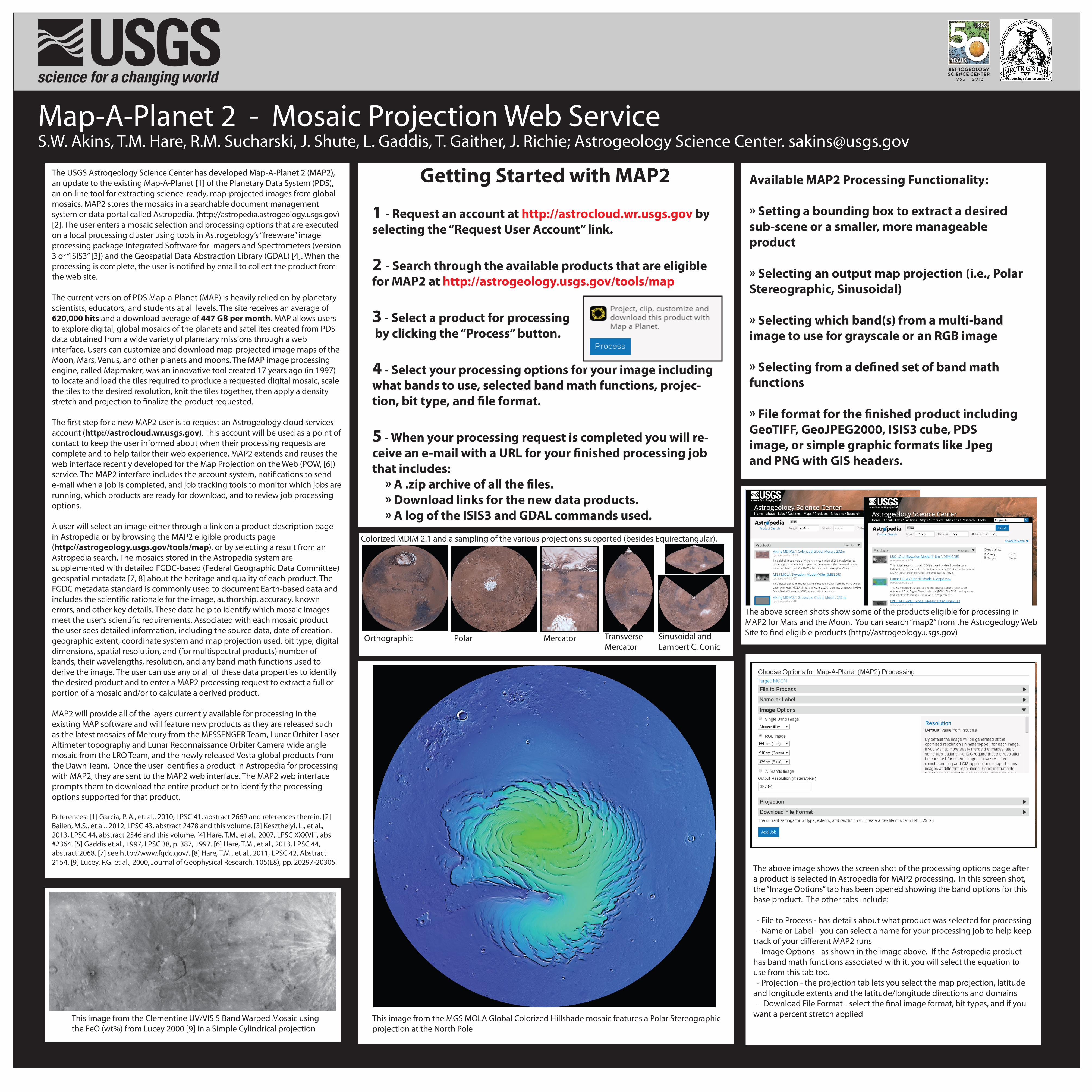
- File to Process - has details about what product was selected for processing - Name or Label - you can select a name for your processing job to help keep track of your di�erent MAP2 runs - Image Options - as shown in the image above. If the Astropedia product has band math functions associated with it, you will select the equation to use from this tab too. - Projection - the projection tab lets you select the map projection, latitude and longitude extents and the latitude/longitude directions and domains - Download File Format - select the �nal image format, bit types, and if you want a percent stretch appliedThis image from the MGS MOLA Global Colorized Hillshade mosaic features a Polar Stereographic
projection at the North Pole
The above screen shots show some of the products eligible for processing in MAP2 for Mars and the Moon. You can search “map2” from the Astrogeology Web Site to �nd eligible products (http://astrogeology.usgs.gov)
Orthographic Polar Mercator
Colorized MDIM 2.1 and a sampling of the various projections supported (besides Equirectangular).
TransverseMercator
Sinusoidal and Lambert C. Conic
1 - Request an account at http://astrocloud.wr.usgs.gov by selecting the “Request User Account” link.
2 - Search through the available products that are eligible for MAP2 at http://astrogeology.usgs.gov/tools/map
3 - Select a product for processing by clicking the “Process” button.
4 - Select your processing options for your image including what bands to use, selected band math functions, projec-tion, bit type, and �le format.
5 - When your processing request is completed you will re-ceive an e-mail with a URL for your �nished processing job that includes: » A .zip archive of all the �les. » Download links for the new data products. » A log of the ISIS3 and GDAL commands used.