manitoba hydro bipole iii transmission project review of...
TRANSCRIPT
Manitoba Hydro Bipole III Transmission Project
Review of EIS Sections on Birds, Caribou, Severe Weather, Agriculture, Economics, GHG, Climate Change
Summary of Major Findings and Options for Avoidance,
Mitigation and Compensation
Prepared for the Bipole III Coalition by
Jim Collinson
Arnold/Collinson Research and Consulting
Ottawa, Canada
November 12, 2012
Arnold/Collinson Research and Consulting
2
EIS REVIEW: PROPOSED BIPOLE III TRANSMISSION LINE
ANALYSIS AND
AVOIDANCE, MITIGATION AND COMPENSATION OPTIONS
JIM COLLINSON1
Chapter 1: Introduction 1.0 Scope This report considers potential impacts of the currently proposed Bipole III line. It draws on information provided by Manitoba Hydro (MH) in its Environmental Impact Statement (EIS), research papers and articles relevant to the issues in the affected area, as well as personal knowledge and experience. Four areas of concern are addressed within the context of the three major “impact zones”. Environmental and economic factors are dealt with under categories as found in the MH EIS: i.e. Birds, Ungulates (essentially caribou and moose), agriculture and security. It concludes with a general commentary regarding more general economic factors, including the issue of climate change. Finally, options are proposed to address primary concerns. 1.1 Background/context MH has proposed routing a new transmission line from the Lower Nelson River generating stations to a new converter station (Riel) in Winnipeg. The proposed route, currently under review by the Manitoba Clean Environment Commission (CEC) starts on the north side of the Nelson River about 65 km downstream from Gillam and ends in Winnipeg. It follows a route that cuts diagonally from the Nelson towards The Pas, then south to the west edge of Lake Winnipegosis, east of Swan River in a SSE direction to just west of Portage la Prairie. From there it continues about 50 km south of the Trans Canada Highway, then goes east to a point just short of Steinbach, and from there north to the east side of Winnipeg.
1 Jim Collinson is a consultant on strategy and complexity: see resume appended (pages 65 – 70).
Arnold/Collinson Research and Consulting
3
The proposed line, estimated at 1384 km in length, will involve some 2800 km of HVdc conductors, 1400 km of optical ground wire strung between and attached to the tops of the towers, and 2854 towers. Guy wires will support the northern towers but, to reduce footprint, the towers in the agricultural area affected will be on concrete pads without guy wires. The optical ground wire will require four permanent repeater stations spaced along the route. These sites will require regular access for servicing and refueling the generators where they are needed. Clearing right-of-way and construction of the line will take place in winter months in the north, and anytime practical in the southern more accessible region. On-going monitoring and maintenance will be carried out once the operational phase begins. 1.2 Economic/environment/energy context This project proposal comes forward at a time when the entire global energy market situation is in a state of flux. Moreover, energy factors cannot be separated from economic and environmental factors. They are all interrelated. Market uncertainty exists world-wide with economic difficulties facing Europe, the beginning of oil depletion in the Russian mainland, security issues in Nigeria, political uncertainties in Venezuela and a significant shift in the energy realities (movement towards self-sufficiency) in the United States. This latter factor most directly affects Manitoba and its electrical energy market. The global situation is not expected to return to any sort of “equilibrium” in the foreseeable future. The Nelson River development has served Manitoba well since the 1970‟s, but continued development needs to be considered in a much altered future context. Both Canadian and US energy demand has been affected by reduced consumption. For example, efficiencies derive from such developments as automobile fuel efficiencies, appliance efficiencies, improved insulation in homes and offices, etc. On the supply side, recent adaptation of fracking for natural gas extraction has changed energy cost options. Gas-fired generators can be located closer to markets in the US than the Nelson River, thus final delivered costs are readily competitive with MH. Natural gas reserves are substantial, and not a passing diversion despite some arguments, not scientifically proven, that surface pollution may become a factor. Given the above, MH needs to consider accessing other markets as well as pacing the development of the remaining Nelson River sites to reflect realistic

Arnold/Collinson Research and Consulting
4
potential US demand, as well as other sales opportunities. A review of the latter is now contemplated. Although selling surplus energy at a loss may be best use of power that otherwise is lost, a sustainable business cannot exist by selling below cost over the long term. Transport of energy in the future could take different forms, with notably different impacts. For example, demand for hydrogen may well grow in the near future, and it could be produced on site at the Nelson River through electrolysis of water, and then shipped by rail along the existing line to such markets as the Alberta oil sands, or by rail to Churchill and forwarding by ship to developing European markets. As societies better understand and address energy and emission realties, climate change becomes more of a concern. The resources currently available may dramatically change and societies may face uncertainty about their capacity to successfully adapt to shifts in climate. In the case of Manitoba, the likelihood of increased frequency of severe weather events, including both flooding (e.g. reduced crop production) and drought (e.g. greater probability of forest fires in the north and reduced agricultural production in the south) is now becoming a strong possibility. Environmental assessments also become more complicated as understanding grows about the complexities of economic, energy and environmental interactions. It is no longer simply a matter of individual disciplines assessing the impact on one species at a time, but the interrelationships of these impacts on aggregate ecosystems and the economic activity and social well-being that must be addressed. The concern, then, is not simply local environmental impacts, but these plus the cumulative environmental and economic impact and the implications over the longer term for Manitoba taxpayers, as well as those impacted beyond Manitoba‟s borders. The proposed route passes through what are essentially three zones of impact. Although there are physical and ecological zones affected (these are noted in the EIS), it is the actual impacts of the proposed transmission line and its converter stations that are under review. These impacts derive in part from ecological and physical features, but also from external factors, including climate, industrial activity, and protection, and use and enjoyment of Manitoba migratory bird resources both within the province and beyond. 1.3 Impact zones For purposes of clarity, this report reviews impacts of the proposed Bipole III transmission line in the context of three major “impact zones” as shown on Map 1, which has been made using the MH EIS Ecozones map.

Arnold/Collinson Research and Consulting
5
Map 1

Arnold/Collinson Research and Consulting
6
1.3.1 The northern impact zone which runs from the Nelson River to just short of North Moose Lake (approximately 500 km).
This zone is primarily boreal Precambrian (except for the far north-east which extends into the Hudson Bay Lowlands), with significant mineral deposits (greenstone belt), considerable hydro-electric development, some forestry activity, and tourism investments. Significant wildlife habitat is found in this region, particularly for woodland caribou and moose, as well as for wolves, black bears and wolverine. Polar bears use some parts of the Lowlands area for denning and migration purposes, and may be expected to occasionally “visit” the lower Nelson where some of the later dam sites will be located, especially if garbage is not effectively contained. Barren ground caribou frequent the coast of Hudson Bay in summer. In this zone, the primary concerns are caribou, moose, mineral activity and line security. The primary security factor here is the separation from the other bipole lines for risk reduction associated with severe weather events. Bird-sensitive areas exist at many points along the proposed route. Those of particular note are the Partridge Crop Lake/Wintering Lake area and Setting Lake area. Although some portions of the route within this zone are not nearly as significantly impacted as those in the mid-north impact zone, woodland caribou calving habitat in the area north and east/west of Ponton are important. Woodland caribou are classified as “threatened”. Consequently, these require special attention. Their low fecundity rates represent a serious danger to their continued existence.
1.3.2 The mid-north impact zone which runs from east of North Moose Lake to the south side of Big Grass Marsh (approximately 630 km).
The essence of the importance of this zone derives from its wildlife habitat: primarily for birds, both migratory and resident. They rely on the marsh ecologies and sparsely wooded terrain for migration, staging, feeding and nesting. The area is a critical portion of the Mississippi Flyway, where migratory birds, including many species of ducks and several geese, as well as Sandhill Cranes, Great Blue Heron and many other water-oriented and songbirds stop and feed on their routes both north and south. The length of these feeding stops varies depending on weather, but often can be up to 3 weeks in both the spring and fall, sometimes more. It represents critical habitat within a long migration route for these birds. Local birds, particularly several species of grouse, rely on the area for year-round food supply, mating locations and nesting areas. Woodland caribou are also a significant wildlife resource in this area. The only herd that showed any sign of growth, according to data in the EIS, is
Arnold/Collinson Research and Consulting
7
The Bog herd, located in the area to the south of the Pas, down to the Overflowing River. The proposed line goes directly through this area. Moose are also common to this area, and represent a considerable food resource for aboriginal people. Although there are smaller areas of good agricultural land in the Dauphin area, they are well away from the proposed line. The Swan River area and Carrot River farming area near The Pas are more directly within the feeding area of birds near the proposed line. Swan River area agricultural practices will be impacted by the proposed line.
1.3.3 The agricultural impact zone which runs from the south of Big Grass Marsh to Winnipeg (approximately 270 km).
Although there is some agricultural activity in the mid-north zone, the bulk of commercial farming along the proposed route begins to the west and south of Big Grass Marsh. There are farming areas beginning north of Swan River, but continuous commercial annual crop farming near the proposed route effectively starts farther south. Mixed farming and livestock operations, however, are to be found considerably farther north. From there to Winnipeg, with the exception of a small area south of Portage la Prairie, lies much of the best agricultural land in Manitoba. These lands are classified under the Canada Land Inventory as Class 1 to 3: essentially prime land for cultivation and growth of agricultural crops. Migratory bird feeding activities of considerable magnitude take place in this agricultural area in both spring and fall.
Arnold/Collinson Research and Consulting
8
Chapter 2: Birds 2.0 Scope of work undertaken The Environmental Impact Statement (EIS) provides two volumes of material on birds. The work that produced these volumes involved detailed data collection as well as considerable literature review. Because of the initial larger study area, massive data collection and analysis was undertaken, and the results were assessed and conclusions reached. This resulted in a set of proposed means to address impacts. However, the data were not collected specifically to facilitate analysis of impacts of the Final Preferred Route (FPR), but for the selection of it. Consequently, it lacks detail needed for careful final review. Despite the huge geographical area involved, the work undertaken has been carefully done and assessed. Unfortunately, data on total migrating populations, and more precisely their particular route segment (which side of which lake), along with numbers for each route segment, are not available. This is a significant gap in the information. For example, although the EIS map shows routes of equal width on each side of Lakes Manitoba and Winnipeg, the largest migration routes are in fact through the southern Interlake and to the west of Lake Manitoba2. 2.1 The Mississippi Flyway3 The particular international migration route affected by Bipole III is known as the Mississippi Flyway (see dark blue routes on Map 2). Nearly half of North America‟s bird species and 40% of North American waterfowl and shorebirds migrate along this route4. Although some birds may migrate all the way from the Arctic Ocean to Patagonia, the majority stops in or near the southern US states along the Gulf of Mexico coast, primarily Mississippi, Louisiana and Texas, as either a wintering site or a way-point en route to South America. In all, this route takes them up to 5000 km each way. It is ideal in the sense that along the way there are no high mountains (Baldy Mountain is the highest, at 832 m), and there are many water-covered areas in the form of small or large lakes, as well as potholes and marshes. It is also blessed with a mid-point where ample food is available to permit a “break” both on the way north in the spring and south in the
2 Personal observations over some 20 years from 1963 to 1982, and work associations then with wildlife
biologists, including Al Pakaluk (who sadly was killed in a helicopter crash while working on Oak Hammock Marsh), and with Jack Howard, Gene Bossenmaier and Rich Goulden. 3 www.birdnature.com/allupperflyways.html 4 http://en.wikipedia.org/wiki/Mississippi_Flyway

Arnold/Collinson Research and Consulting
9
fall, where the birds can rest and eat to build strength for the remainder of their migration. This mid-point is mostly in Manitoba and adjacent states. A large percentage of the migrating birds fly along both sides of Lake Manitoba.
Map 2 Map source: birdsnature.com/allupperflyways For the above reasons, the strip of the Mississippi Flyway through Manitoba is a critical element of the entire Flyway. The impacts are not just those that occur within Manitoba, but those which contribute to the overall health and habitat of the migratory birds covered by the Canada-United States Migratory Birds Convention: a document signed first in 1916 in recognition the value of this shared continental resource. Initially, it was a focus for protecting birds for hunting (establishing bag limits, hunting seasons and poaching penalties but, within the past few decades, recognition was given to the need to protect habitat5, realizing that without protection there would be little left to either hunt or watch. The relevant section of the Migratory Birds Convention Act, 1994 follows:
5 Migratory Birds Convention Act, 1994, see Article IV

Arnold/Collinson Research and Consulting
10
“Article IV
Article IV of the Convention is deleted and replaced by the following:
Each High Contracting Power shall use its authority to take appropriate measures to preserve and enhance the environment of migratory birds. In particular, it shall, within its constitutional authority:
(a) seek means to prevent damage to such birds and their environments, including damage resulting from pollution;
(b) endeavour to take such measures as may be necessary to control the importation of live animals and plants which it determines to be hazardous to the preservation of such birds;
(c) endeavour to take such measures as may be necessary to control the introduction of live animals and plants which could disturb the ecological balance of unique island environments; and
(d) pursue cooperative arrangements to conserve habitats essential to migratory bird populations.”
The bird population of the Flyway represents seasonal sources of food, particularly for aboriginal people, and sport for avid hunters throughout its route, provides economic returns for a wide range of services and goods associated with hunting, and gives considerable enjoyment, recreation benefits and economic activity associated with bird-watching. The latter activity has grown rapidly in recent years, and includes a disproportionate segment of well-educated, higher income people in both countries. Although comparable data are not readily available for Manitoba, the magnitude of data from the United States gives a good indication that it is significant. This is highly relevant, as it illustrates how a continental resource is affected. Some examples of economic significance do exist. In 1987, Parks Canada conducted a study of Point Pelee bird-watching impacts, and discovered that $5.4 million ($US) was spent in that area alone, with a higher per capita daily expenditure than visitors who arrived for purposes other than birding. As an aside, some $800,000 was spent on film processing, an expenditure that would not register today! Recent information from the US shows that 20% of all Americans are birdwatchers, contributing $36 billion to the US economy in 20066. Participation in Montana and Minnesota exceeded 30%. In that year, 71 million US residents reported observing, feeding or watching birds and other wildlife, spending $45 billion. Bird watching is a growing activity, while hunting is gradually dropping in participation rates.
6 http://news.mongabay.com/2009/0715-birds.html#ixzz21Sy7GyDH

Arnold/Collinson Research and Consulting
11
The chart below illustrates this point.7
Unfortunately, data for Manitoba alone is weak. Hunting remains a significant element of bird management, with 45% of waterfowl hunters in the US active within the US portion of the Mississippi Flyway. Waterfowl hunters, numbering 1.3 million in 2006, spent $900 million on travel, food and lodging and equipment8. Although comparable figures for Manitoba are not available, it would be logical to assume they are somewhat higher in ratio, in recognition of food hunting by aboriginal people, plus an influx of US hunters. The economic impact of the Mississippi Flyway in the US alone, due to bird watching and hunting, illustrates the significance of the Flyway and confirms the wisdom and importance of the Migratory Birds Convention. Impacts from a major transmission line are not limited to a strip of Manitoba, but are significant all along the migratory routes from north to south. The EIS uses Mallard Ducks, Bald Eagles and Great Blue Herons as representative of larger birds found along the FPR. It is unfortunate that geese (Canada, Blue, Snow) as well as Sandhill Cranes are not given attention as they exist in huge numbers within the Mississippi Flyway, and are the best known of the large migratory birds. These larger birds, including Tundra Swans, are particularly susceptible to striking power lines, especially in poor weather
7 “Restoring North America’s Migratory Birds, Report to the White House, January, 2007
8 Economic Impact of Waterfowl Hunting in the United States, Report 2006-2, US Fish and Wildlife Service.
Arnold/Collinson Research and Consulting
12
conditions, as they have difficulty making sharp maneuvers. There are many songbirds, shorebirds and others that make up the living elements of the Flyway. As noted in the EIS, a number of these that are recognized as “species at risk”. Several of these include for example, the yellow rail, least bittern, short-eared owl, common night hawk (below the tree line), olive-sided flycatcher, Canada warbler and rusty blackbird. These birds are present along the proposed route, and most notably in several of the sensitive areas shown on Map 3. 2.2 Non-migratory birds Resident birds are also present within the proposed route area. Ruffed grouse are found along most of the route outside intensive agricultural areas, spruce grouse and ptarmigan in the more northern regions and sharp-tailed grouse mostly in the southern 2/3 of the route. All three species are susceptible to collisions with guy wires on towers, as well as transmission wires. Clearing will have some impact, especially on ruffed and spruce grouse nesting and winter cover areas, and sharp-tailed grouse leks MUST be identified in advance of clearing right of way. Given that their use varies from as early as March and on into July in some cases, although normal use is more likely to be between mid April to the end of May, construction activity anywhere near an active lek should be avoided. The EIS implies leks are used only for several years, but this is highly unlikely in the areas proposed for the route. In large measure, vegetation along the west side of Lake Manitoba where the line is proposed to go, is not fast growing, so leks (essential to ensure survival of the local group of birds) are very likely to be used for a decade or more. Cutting growing trees and taller shrubs within the lek, to ensure sight lines from the edge are not impaired for the females while they ponder their choices, may even extend years of use. Certainly, line clearing through an active lek or over the winter prior to mating season will severely frustrate the capacity of the group to breed. The US Bureau of Land Management has recognized these risks, and has issued the following9: “To reduce the risk of collisions, avoid the use of guy wires for turbine or MET tower supports. All existing guy wires should be marked with recommended bird deterrent devices.
The siting of new temporary MET towers must be avoided within 2 miles of active sage-grouse leks, unless they are out of the direct line of sight of the active lek.”
9 http://www.world-wire.com/news/0912160001.html, “Federal Action to Prevent Fatal Bird Collisions
with Western Public Land Structures Praised”
Arnold/Collinson Research and Consulting
13
2.3 Tundra Swans: a “cross flyway” species One species that passes through the proposed route that is not mentioned in the EIS is the tundra swan. This bird has been monitored for some considerable time by both the US and Canadian Wildlife Services. Interestingly, the swans winter along the Atlantic coast (Georgia, South and North Carolina), which is within the Atlantic Flyway, but their migration to the high arctic tundra region of Canada, essentially in the region of the Northwest Passage, takes them south of the Great Lakes and through Manitoba, primarily along the west of Lakes Manitoba and Winnipegosis. These are large birds, as large or larger than Great Blue Herons and Sandhill Cranes, and are susceptible to injury or death from collisions with wires or towers (the latter in poor weather as these birds are not readily able to make sharp turns quickly). 2.4 The Central Flyway The Central Flyway passes through western Manitoba and Saskatchewan. It is not affected by the proposed Bipole III line. 2.5 The Environmental Impact Statement and implications of bird/line interactions10 The bird report within the EIS, as noted above, is detailed in terms of general factors for the larger Study Area, and these have been refined to the extent possible for the specific proposed route. It is stated by MH in the EIS that the information was taken into account in determining the final route siting. Clearly, it was not possible for additional data to be collected to refine the analysis subsequent to the actual routing being chosen. It is also clear that the significant bird impacts were subordinated by other factors, implying they were judged insignificant. By taking one species at a time and using the best information available on the route finally chosen by MH, the data becomes somewhat thin; yet aggregating the data provides some basis for considering how the issue can be approached. By superimposing a combination of significant impact areas for all species considered onto one map, along with the locations of all actual bird counts, a picture emerges that indicates that the impacts are not to be taken lightly. This is shown by red circles on Map 3, using the MH map of Mallard sightings in the EIS
10
An interesting compilation of bird kills from human-made structures has been done, indicating the magnitude of concern about this issue: see “BIRD KILLS AT TOWERS AND OTHER HUMAN-MADE STRUCTURES: AN ANNOTATED PARTIAL BIBLIOGRAPHY (1960-1998)”, John L. Trapp mailto:[email protected]

Arnold/Collinson Research and Consulting
14
as a base map. These areas marked represent very significant bird areas for nesting, feeding and resting during migration and staging. With the exception of physical damage to leks, the dangers from wire and tower/guy wire collisions exceed the damage from clearing, and are on-going for the entire life of the line.
Map 3
Arnold/Collinson Research and Consulting
15
Critical bird areas, using MH data from EIS re bird sightings and prime habitat superimposed on Mallard sightings map It is noted that North Dakota studies indicate that between 124 and 200 bird strikes occur annually for each kilometer of line11. Extrapolating even the lower figure by half the distance and the number of years the line is expected to operate, generates a significant number of bird deaths: 8,400,000! It should be noted, however, that the North Dakota area did not have as great a concentration of birds as west of Lakes Manitoba and Winnipegosis, and up past The Pas. Although a much lower figure will apply generally to the rest of the line, the area noted is that which experiences significant feeding and staging activity over up to three weeks twice a year for birds on route north and south, in addition to those nesting in the area. Over all of Manitoba, there is no route that would negatively impact birds and their movements more than the one chosen by MH. The conclusions in the EIS regarding bird impacts rest on two key factors: one, the basic assumption that the inevitable bird deaths caused by construction and operation of the proposed line are not significant overall, and second, that the impact on habitat is below 5% (<2% in most cases). In other words, bird fatalities are given the lowest priority over other factors. The magnitude of economic impact from birds and their migrations has been outlined above. In addition, there are specific impact implications that need to be taken into account in determining the final route for Bipole III. These implications include:
Heavy impact areas cover a large proportion of the proposed route The Bird Technical Report identifies the bottleneck to the northeast of The Pas, but the conclusions do not reflect the significance of it in terms of risks of collisions with wires and towers. Although the length of the bottleneck is about 75 miles, or 125 km, it affects a significant proportion of flyway activity. Taken alone, this section may be the longest section causing major concerns, but there are many additional critical areas to the south as far as the south end of Big Grass Marsh. Feeding in agricultural fields in spring and fall will bring birds, especially Mallards, Sandhill Cranes and Canada Geese, into regular proximity to the proposed line all the way to Winnipeg.
11
Albert M. Manville, II, “Bird Strikes and Electrocutions at Power Lines, Communication Towers, and Wind Turbines: State of the Art and State of the Science – Next Steps Toward Mitigation”, US General Forest Service General Technical Report, PSW-GTR-191.2005, p. 1055
Arnold/Collinson Research and Consulting
16
The Big Grass Marsh is shown as outside the affected area of the proposed route, but birds will be moving between Lake Manitoba and the Big Grass Marsh in large numbers, so this fact will need to be taken into account. Unfortunately, the numbers of Sandhill Cranes in the area of the Big Grass Marsh has already dropped from over 6000 in the mid-1960s to less than half at present. Studies have shown that 25% of Whooping Crane deaths are due to collisions with transmission lines12. Sandhill Cranes have the same type of difficulty doing quick maneuvers.
Recent MH responses to questions on bird/line collisions indicate that two mitigation measures are proposed: routing away from sensitive areas and where this is not possible using bird diverters.
o Routing choice MH has indicated that it has chosen the route so as to avoid close contact with sensitive bird areas, such as those in the area known as the “pothole country” in the Minnedosa region to the south of Riding Mountain National Park. MH is correct in noting the importance of this significant waterfowl and bird part of Manitoba. What has been ignored is the critical bird areas along the west sides of both Lakes Manitoba and Winnipegosis, as well as Swan Lake and the west corner of Cedar Lake. Moreover, the second very critical area northeast of The Pas is also ignored. Both these highly important bird areas must be avoided.
o Diverters do not solve it all Reliance on diverters over such long distances is expensive and speculative at best. What can be done after the fact when monitoring shows that collisions are still significant? Diverters have some effect with certain birds, particularly those birds that fly during daylight hours. Others, however, including large birds such as geese and some ducks, often fly at night13. Moreover, they fly regularly at dawn and dusk going to and returning from feeding areas. At such times they are most susceptible to wire and tower strikes. Large birds such as cranes and Great Blue Herons have difficulty making sharp maneuvers during
12 See Anne E. Morkill and Stanley H. Anderson, “Effectiveness of marking power lines to reduce Sandhill
Crane collisions”, Wildlife Society Bulletin 19:442-449, 1991. 13
“Evaluating diverter effectiveness in reducing avian collisions with distribution lines at San Luis National Wildlife Refuge Complex, Merced County, California”, Linda Speigel, Ventana Wildlife Society, August 2009CEC-500-2009-078 Prepared For: California Energy Commission, Public Interest Energy Research Program; Pacific Gas and Electric Company; Edison Electric Institute

Arnold/Collinson Research and Consulting
17
flight, so are particularly at risk to wires14. With clear visibility, one study found that diverters did reduce crane impacts by 66%15. But, reduced visibility due to weather conditions contribute significantly to collision frequency. Such weather realities are not uncommon in the area proposed for the line. Reflectors that illuminate at night giving earlier warning of lines are available, and may have some value under certain conditions. However, they are ineffective in conditions of fog, precipitation, overcast skies and wind conditions favorable to migration16. They need to be placed no more than 10 m apart, and on different lines. If installed during the construction phase, costs will be lower, but if they are added after the line is operational, installation may have to be done by helicopter at considerable expense and risk.
Illuminating diverters cost $40 each, and to space them at 10-m intervals (as recommended) from east of North Moose Lake to Winnipeg (the area most likely to record bird strikes due to feeding activities) would cost about $4 million for the material alone, with no assurance they would be sufficiently effective. Labour and associated costs would be extra, and significant where helicopters must be used after the line is in operation.
Even with diverters installed, monitoring would be essential to
determine the number of strikes and types of birds that still encounter the wires. Given the separation of the conductors of the line compared to regular local and regional distribution lines, the 10-m spacing might not be sufficient, and a shorter spacing regime might need to be used.
The research on bird strikes in the southern Interlake near Oak Hammock Marsh is not particularly relevant to the proposed Bipole III line: MH admits they have
14
Morkill and Anderson, op cit, “Our results confirm the overall effectiveness of wire marking as a way to reduce, but not eliminate, bird collisions with power lines. If raw field data are not corrected by carcass losses due to scavengers and missed observations, findings may be biased. The high cost of this conservation measure suggests a need for more studies to improve its application, including wire marking with non-visual devices. Our findings suggest that different species may respond differently to marking, implying that species-specific patterns should be explored, at least for species of conservation concern.”
15 A study in South Carolina found a 53% reduction in bird collisions with deflectors, but found that 82%
of all collisions were with static wires: see “Avian behavior and mortality at power lines in coastal South Carolina”, Anthony J. Savereno et al, Wildlife Society Bulletin, 1996.
16
“Weather influences on nocturnal bird mortality at a North Dakota tower”, Michael Avery, Paul f. Springer, j. Frank Cassel, The Wilson Bulletin, Vol 89, June, 1977

Arnold/Collinson Research and Consulting
18
not carried out research on bird/wire collisions on the Interlake portions of either Bipole I or II. These have been around for many years, and it is difficult to believe that no one ever thought it would be helpful to have done so, especially in the context of Bipole III planning.
The optical ground wire not considered The EIS neglects the known danger to raptors from the centre optical ground wire. These have been shown to be particularly deadly to raptors during an attack on prey, where the two larger lines are readily seen but the bird strikes the centre line during its downward plunge. Raptors, particularly bald eagles, are common along the proposed route. More time is spent in the EIS on the possibility of collisions with vehicles (neglecting the fact that most strikes can be avoided by not driving at night), yet nothing is mentioned in the Report about the optical ground wire being a danger. Some studies have shown that these smaller wires are a significant factor (68%) in all bird strikes17. Studies from many sources indicate that attention to the optical ground wire deserves special attention, especially for raptors, which alone should have indicated its importance. Furthermore, the EIS concentrates only on the optical ground wires for the addition of deflectors, when recommendations indicate they need to be staggered amongst all three lines: otherwise, the other two lines, in times of poor visibility, put birds at risk.
Repeater stations and generators The EIS notes that “repeater station sites will require an all-weather access road or a helicopter pad, an ac electric service pole line, and a property sufficiently large to develop a graded and gravel- surfaced area, approximately 33 m x 40 m in dimension, to accommodate parking and building areas. The building area will require a chain link perimeter fence and will house two structures, a back-up diesel generator (genset) building and a communications building. The generator structure, approximately 2.6 m x 3.5 m in size, will house a diesel motor, fuel tank and ac generator. The communications building, approximately 4.3 m x 11.0 m in area, will house communications equipment, lead acid standby batteries, and an electric toilet.”
These facilities are proposed to be located near Partridge Crop Lake and east of Dauphin Lake: both bird-sensitive areas. As with the line location, care will be needed to avoid leks and prime nesting and winter habitat, as well as
17
EDM International, Inc.Dr. Arun Pandely, Richard Harness and Misti Kae Schriner Fort Collins, Colorado
80525Commission Contract No. 500-01-032, 2008. Prepared For: Public Interest Energy Research (PIER, )California Energy Commission
Arnold/Collinson Research and Consulting
19
minimizing chances of collisions with the smaller and lower lines.
2.6 Recent legal implications for large projects impacting birds
Syncrude in 2010 was under court order to pay a $3 million fine18 as a result of 1600 ducks being killed in a tailings pond in the oil sands development: thus setting the price of a duck at $1875! They were supposed to prevent ducks from entering the pond: Manitoba Hydro by analogy should be under the same vigilance with respect to collisions with wires. A similar case occurred in North Dakota where companies agreed to pay significant fines associated with bird deaths by electrocution and by contact with hydrocarbons in uncovered storage tanks. The birds were identified as being under the US Migratory Bird Act. This Act is similar to Canada‟s legislation based on the North America Migratory Birds Convention.
“In July 2009, Pacificorp agreed to pay $10.5 million in fines, restitution and equipment upgrade costs for the deaths of at least 232 golden eagles, 46 hawks, 50 owls and nearly 200 other birds that had been electrocuted in Wyoming since January 2007. The cost per bird computes to a little less than $20,000. (2) “On August 13, 2009, ExxonMobil pled guilty in federal court to charges that it killed 85 birds—all of which were protected under the Migratory Birds Act. The company agreed to pay $600,000 in fines and fees for the bird kills, which occurred after the animals came in contact with hydrocarbons in uncovered tanks and waste water facilities on company properties located in five western states,” reports Robert Bryce. Each bird kill cost the company over $7,000.”19
Towers also represent obstructions that kill birds, and the Bipole III line will have about 2900 towers, about 70% of them with guy wires. 2.7 Climate change considerations Climate change is noted in the EIS as an additional possible source of stress on birds. This is a factor that needs attention, as more recent shifts in climate in the form of more frequent “events” occur, even though they are within the bounds of previous “records”. It is the frequency, and perhaps the duration of these events that appear to be on the way to becoming phenomena worth noting. Periods of warmer weather in recent winters have already impacted the viability of winter roads. Drier periods imply increases in forest fires. Periodic heavy rains or winter storms lead to flooding, etc. It is the shift in intensity that is
18 http://www.upstreamonline.com/live/article233656.ece 19 Jack Dini, Canada Free Press, “Bird Death Fines Depend on Who Kills the Birds”, September 19, 2011.

Arnold/Collinson Research and Consulting
20
particularly worrisome. Although the Canadian north has had milder winters recently, the opposite is true of Europe. Work continues on projecting expected changes and how to deal with them, and attention needs to be given to these while also dealing with the known situation at this time. If drier conditions occur, there will be lower levels in some lakes and marshes, but they are not likely to disappear in the medium term. Temporary sloughs that develop in wet periods may become fewer, but may also increase in size with occasional heavy rains that may occur instead of more “normal” precipitation. Therefore, it is these extreme variations that are of greatest concern. 2.8 Concluding remarks Based on the above, it is clear that the impacts on migratory and resident birds are of a magnitude that requires a re-examination of the route proposed. Massive mitigation efforts, relying primarily on diverters, hold a very high risk of not solving the problem. Impacts are not just on birds within the route itself, but the entire length of the migration routes of those birds that migrate (a high percentage of all birds using the area) with subsequent and significant economic effects as well as serious implications to Canada‟s role in the century-old Migratory Birds Convention with the United States. To argue that only 2% of migratory birds would be impacted ignores the fact that if 10 other projects having similar impacts within any segment of the Mississippi Flyway were put in place, the impact would be 20%. Creeping impacts occurring as a result of considering one project at a time produce cumulative effects that no amount of mitigation can correct. The deficiencies in the EIS from ignoring geese, Sandhill Cranes and Tundra Swans and the implications of the optical ground wire have a considerable effect on the conclusions reached by MH. An option would be to put the line underground, especially in agricultural areas where feeding takes place. This could be expensive in more northerly segments where rock is so close to the surface, but relatively inexpensive through Class I to III lands south of the Yellowhead through to Winnipeg, where very little rock exists.. By superimposing all the bird-sensitive areas noted within the EIS onto a map with acquired sightings plus habitat analysis (Map 3), it is clear that the line should not pass through the part of the mid-north zone presently proposed without more serious attention being addressed to the reality of bird-wire (including guy wires) and bird/tower collisions in the context of options for alternate routes having less impact.

Arnold/Collinson Research and Consulting
21
Chapter 3: Caribou, Moose, Wolves and Polar Bears20
3.0 Scope Five herds of caribou live within the impact zones of the proposed Bipole III project. Two herds of coastal caribou inhabit the lowland areas along Hudson Bay, and three woodland caribou herds range within the FPR to the southwest of the generating stations down as far as Lake Winnipegosis. Both groups have different characteristics and will be affected in different ways. Moose are also found in most of the northern and mid-north areas. They represent a significant source of food for aboriginal people, although their numbers appear to be declining. In the areas also frequented by caribou, moose (although they do not compete for the same food) tend to attract wolves which, once drawn to the area, will also prey on caribou. Wolves form part of an interdependent troika with caribou and moose. If the three are (ever) in balance, they symbiotically strengthen each other: wolves (and black bears) cull frail animals from the herds, leaving healthy ones to share the food and breed strong calves (although calves are also primary prey for the predators). Often, however, the “balance” is uneven, and the risk of excess depletion of either caribou herds or moose is increased. Therefore, the three are discussed together in this section, along with specific concerns regarding polar bears and coastal caribou over the life of the line. Implications of the construction and operational activity proposed at the generating stations and the northern converter station are taken into account. 3.1 The Environmental Impact Statement The section on “caribou and neighbours” in the Environmental Impact Statement (EIS) was done essentially as a review of the entire Study Area, to facilitate delineation of a tentative Final Preferred Route (FPR). Unfortunately, the data within that section, although adequate for its purpose, was not sufficiently detailed to assess the FPR with confidence. Consequently, in August of 2012, Manitoba Hydro (MH) released a “Supplemental Caribou Technical Report” to fill some of the gaps. Although this Report contains considerably more information pertinent to the FPR, it should have been provided as a part of the original EIS. As it stands, it has required a major rework of an assessment based on the original, with less time to fully absorb the findings, many of which differ substantially from the original. These differences are not surprising, given that the newer data focus more directly on the FPR. The new data are appreciated, but the timing suggests the original tabling of the EIS was rushed.
20
Unless otherwise specified, information for this section comes from the EIS, along with a Supplementary Report provided by MH dated August, 2012.
Arnold/Collinson Research and Consulting
22
In late October, a further revision to better accommodate caribou and moose ranges was tabled before the CEC. 3.2 Coastal caribou Caribou studies (most particularly on barren ground caribou) of an ad hoc nature have been ongoing for some time, and in fact began in the „50‟s when there were times the Hudson Bay Railroad trains had to stop for several hours while a barren ground caribou herd crossed the tracks. Those days are long gone, but some years barren ground caribou still migrate into the area north of the Nelson River. There are two herds of coastal caribou that live much or most of the year near Hudson Bay. The Pen Island herd tends to occupy the area to the south of the Nelson River, and their range extends into Ontario, as well as some distance to the south. The Cape Churchill herd occupies the area from the Cape down to the Nelson River, tending to spend considerable time around the Owl River region. At times there might be a slight overlap of the two herds at the Nelson, but the river itself tends to provide a sort of dividing line except in limited cases where some have crossed the river for short periods. Both herds periodically occupy territory near the sites of the lower Nelson generating stations, as well as the proposed converter and ground electrode sites. Except for minor contact incidents due to construction or operations as the herds move through or browse in the immediate area, impacts are not expected to be serious. However, as these sites fall within the critical winter range of coastal caribou, caution will be needed to avoid noises and activities during the periods the wintering areas may be occupied. A rather large winter range for these caribou exists along the north side of the Nelson River from the Henday converter site to the west end of Stephens Lake. Activity within this area during the winter months need to be carried out with care and, if possible, avoided until other times of the year. Although this may not be possible for the converter site, it should not affect line construction unduly as long as the actual locations of the caribou are known at the time and monitored regularly. Barren ground caribou have been known to wander through facilities during periods of limited activity without much apparent concern21. But, for coastal caribou, wintering and calving areas are quite a different matter. Winter range is important for their survival, so significant disruption can have serious effects. Coastal caribou keep together as a herd. This means there are many animals
21 One example of such wandering, confirmed by the author during site visits in 1974, was at Prudhoe Bay
on the Alaska north slope, particularly near Deadhorse.

Arnold/Collinson Research and Consulting
23
nearby at the time of calving. External noise and activity nearby can seriously disturb the animals at that time, with tragic effect. However, the activities associated with the construction and operations of the line and generating stations are not close to calving areas, so little impact is anticipated. The numbers of both coastal caribou herds appear to have grown from those of the ‟70s, so herd viability is not at any immediate risk, as long as no activities take place that could seriously impact wintering or calving habitat. As these are known, avoidance should not be a problem.
Cape Churchill coastal caribou near the Owl River on Hudson Bay, 8/87 (Jim Collinson) 3.3 Potential polar bear threat?22 These two coastal caribou herds occupy common territory with polar bears along the coastal region. To date, these animals seem to have generally ignored each other. However, if continued warming occurs so that Bay ice persists for even shorter periods, the availability of seals as a source of food for the bears will diminish, and the caribou could become a secondary source. Although this is outside the direct implications of the Hydro project, it is nonetheless a valid projection which requires recognition that the Bipole III line will not exist within a vacuum: the world is continually changing, and those changes are a part of the
22 This section has been developed based on the author’s personal experience and observations between
1967 and 1989.

Arnold/Collinson Research and Consulting
24
reality for any proposed development. In this regard, Bay ice longevity and polar bear health needs monitoring to detect any notable change from the present.
Polar bears just north of the Owl River on Hudson Bay, 8/71 (Jim Collinson) The area of coastal beach ridges is perfect denning habitat for female bears and their offspring. Although the sites impacted by construction and operations at this point are not within prime denning terrain, they most certainly will be nearby. Polar bears are known to wander near the area where construction is proposed23, and this may become a concern if garbage is not very carefully managed. Potential impacts of climate change will be discussed in a later chapter. 3.4 Woodland caribou (threatened species) There are eight herds of woodland caribou in the north and mid-north impact zones. Their primary areas run from west of Thompson down to the area between Lake Winnipeg (near Long Point) and Lake Winnipegosis. None are particularly large. Three herds will be directly impacted by the proposed Bipole III line. These occupy the ranges known as Wabowden, Reed Lake and The Bog.
23 Personal observations

Arnold/Collinson Research and Consulting
25
Woodland caribou differ from the coastal caribou. They are somewhat less gregarious, and at calving time the females split off and calve in solitaire, often using small “islands” in boggy areas for protection from predators. It is believed that this is a general protective measure leaned by this species. Hence, calving areas are quite large24. The calving season is mid-to-late May (primarily closer to the end of May)25, so any construction activity at that time will cause serious problems. The woodland caribou by nature is a shy animal, and tends to avoid contact with human activities and their residue by a considerable distance. For this reason, the EIS recommends buffer or setback distances of 3 km around calving complexes (when occupied) and 5 km around core winter ranges26. Construction work on a line passing through their natural territory can become extremely disruptive, essentially cutting up their habitat or forcing disruption of their patterns, causing them stress. Recent studies noted in the EIS indicate that fecundity, which is generally low for woodland caribou anywhere in North America, is extremely low in the area studied. In only one of the three ranges under review was there an actual addition to the herd27 from newborn animals, within the sample groups of collared animals. What this implies is that, even if there are no other mortalities in those sampled in all three herds, only three calves28 will survive their first summer to be recruited into overall herd size. This happens despite a pregnancy rate of 87%. The fact that several other animals will die from age/predation and perhaps hunting means that a gradual decline in herd numbers is the likely current trend. The studies for the EIS and Supplemental Report confirm this potential. Both provincial and federal wildlife agencies are actively working to improve woodland caribou viability: they are a “threatened” species. Impacts of any magnitude from construction and operation of the transmission line will have severe consequences, thus line routing should not be allowed to cross or cut up their critical ranges. This point deserves special attention. Given their sensitivity to external impacts, and given their low recruitment rates (slightly negative at present), is it reasonable to permit intrusions into sensitive calving and wintering areas while knowing additional negative impacts could occur? Although a case may be made that less than 5 km in certain instances can be justified, it needs to be set
24
EIS and Supplementary Report 25
EIS p.37 26 EIS p. 164 27 EIS p.157 28 The three were only amongst those monitored, so the actual number could be higher. Nonetheless,
the chance of herd growth, even without Bipole III, is precarious, and reason for concern on the part of both the federal and provincial governments.
Arnold/Collinson Research and Consulting
26
in the context of long-term herd viability, which is why the woodland caribou are “threatened” to begin with. Beyond some unknown point, they may not be able to recover in numbers that ensure their continued existence. The Supplementary Report indicated that sample data indicate more limited impact outside 2 km29, but does not tie this finding to their other findings that, although wolves prefer to be somewhat near water and young growth vegetation, a cleared line will provide the latter in a matter of time. It is much easier to facilitate growth in a larger herd than in a very small one. By the time monitoring shows continued decline, it may be too late for the herd to recover, given all the other factors militating against their survival. Moreover, if the decline can be traced to right-of-way clearing, it would be impossible to replace the vegetation in time to turn around the impact: regrowth is slow in this area. The coastal caribou can lose some numbers and still be viable: the woodland caribou may not. Woodland caribou feed primarily on lichens, which are found in old growth forest as well as bog areas. Corridors through heavily treed areas disrupt their habitat while offering easy and fast access for predators. The EIS proposes various options for mitigating this damage by such methods as spreading cut organic material, allowing smaller trees to grow, construction of barriers to make travel for predators awkward, etc. This endeavor at least recognizes the problem. However, there is little evidence that they will work. The fact that the construction and disruption alone will cause the animals to try to avoid critical habitat for up to 5 km each side (a 10 km strip of habitat taken away from their range) means that serious impacts are probable. The Supplementary Report30 notes that wolves tend to frequent areas near water and near relatively younger growth: obviously, these areas are where their preferred prey are to be found. Although they do not frequent newly cut or burned area, these areas will become “young growth” in a few years, thus becoming a preferred area for wolves: an additional reason for a cautious buffer area. The most significant range of the three is The Bog, which lies to the south of The Pas and runs down between the Saskatchewan border and the west shores of Cedar Lake and Lake Winnipegosis. Although there is a highway and existing hydro lines through that area, incremental damage to the habitat and increased activity can only add to the stress on the animals and impact their survival. The Supplementary Report notes that The Bog falls below Environment Canada‟s 65% habitat benchmark to be self-sustaining31, yet this appears to be the one herd that has some vitality. Specifically, the Supplemental Caribou Technical Report, page 52, states “The Environment Canada (2011b) CEA currently indicates The Bog as likely as not to be self-sustaining, whereas Reed Lake and
29 Supplemental Report, p.38 30
See Supplementary Report, Executive Summary, pp. ii and iii 31
Ibid, pp. 51-52
Arnold/Collinson Research and Consulting
27
Wabowden ranges were all identified as self-sustaining.” Then, the August Report goes on to appear to contradict this statement in Table 37 (page 56 of the August document) where it is indicated that total disturbance is about 15%. Some clarity is needed in this case.
Using the 65% figure as a “falling off the wall Humpty Dumpty absolute” implies a reality not readily supported by logic. It implies that 65.1% demonstrates viability while 64.9% does not. At least a third category should be contemplated. 65% may well be the drop-off point, but it is likely that somewhere in the 75-80% range there is a point where susceptibility to herd viability becomes more serious, and this needs to be explored further so that action can be taken before it is too late.
The installation of generators to power the optical ground wire is proposed for locations near Partridge Crop Lake and Lake Winnipegosis. These, too, could result in a 10 km diameter area being effectively removed from woodland caribou habitat. The other herds that will be impacted significantly are the Wabowden range and Reed Lake range herds. Both herds will have their winter range impacted. In the case of the Wabowden herd, an up-to-now intact wintering area will be cut by a corridor if the line goes according to the Preferred Final Route. Winter range is critical to the animals, and bisecting it with a transmission line will severely impact a herd that is already struggling to maintain its population. Again, beyond creating a corridor with all its implications, another 10 km alley is effectively eliminated from their critical winter range. Similarly, a portion of the Reed Lake winter range will be impacted. Winter is a particularly sensitive time for any disturbance to occur to the wintering herd. As they live on lichens, their diet tends to give them some protection from predators because other ungulates do not share their diet and will be wintering elsewhere. Map 4 indicates the locations of critical and wintering habitat for woodland caribou. Construction and clearing activity in these ranges will increase stress on the animals and lead to even lower Reed Lake numbers because only a small portion of its winter range is affected by the FPR, and calving areas are farther away, yet the FPR, as well as the Wuskwatim line, runs right by it, and together will result in a larger area of young growth to develop in time that will attract moose and their wolf predators. The Supplemental Report also notes that only 3.43% of calving habitat32 in the Wabowden range will be affected (2.99% for The Bog), but these statistics need to be put in context of the recruitment rate for that herd. They cannot afford to lose any such habitat! Note: the list of responses to questions received from Manitoba Hydro on August 15, 2012, indicated (CEC/MH-VI-311.P.274) that the FPR “avoids
32
See Supplemental Report, p. 31
Arnold/Collinson Research and Consulting
28
known calving areas and potential critical caribou calving habitat”. This obvious contradiction needs to be corrected. It is noted, however, that the latest proposed modification to the FPR, the line has been moved away from segmenting key winter habitat for the Wabowden herd, reducing the impact accordingly. Again, however, the lateness of this modification illustrates the problem of rushing the process without complete consideration of all factors. For example, are any leks located within the new proposed route? In other words, every decision becomes another variable, and a full review is required for every change. The concluding paragraph of the Supplemental Report (p.88) states the following (bolding added):
“As described in Chapter 8 of the Bipole III Transmission Project EIS, predicted effects of the Project on boreal woodland caribou evaluation ranges intersected by the FPR may include increased mortality from predation, decreased reproductive capacity (i.e., increased disturbance = lower Lambda rates), direct and sensory loss of habitat, and habitat fragmentation. The results of monitoring and data analysis all support the conclusion that the residual effects of the HVdc transmission line on boreal woodland caribou evaluation ranges, after successful implementation of the mitigation measures outlined in the EIS, are expected to be negative in direction, small in magnitude, short-term (construction) and medium-term (operation) in duration, regular to continuous in frequency and reversible after Project decommissioning, and therefore not significant. Similarly, the predicted effects and cumulative effects described in the Bipole III Transmission Project EIS for coastal caribou also remain consistent based on the new analyses presented in this supplemental report”.
To go from the findings to this conclusion is a leap of faith. It assumes that the caribou still exist, then it assumes that extracting the wires and towers will not create any disturbance. The reality is that the fecundity rate and recruitment rate are so low now that there is a much greater likelihood that the drop in vitality of the woodland caribou herds will have been so great (assuming the caribou even exist by the time of decommissioning), that reversing the trend will not be possible. This is the very real risk that must be given careful attention.

Arnold/Collinson Research and Consulting
29
Map 4

Arnold/Collinson Research and Consulting
30
Winter and key habitat areas noted in the EIS superimposed on the MH Caribou Range map 3.5 Other Threats Woodland caribou face considerable difficulties from other sources. Global climate change may result in more forest fires that could seriously affect habitat. It could also increase the possibility of encroachment into their habitat by deer, which carry a parasite the caribou cannot fight. Although deer to the south of The Bog currently may not carry the brainworm, it does not follow that in future they never will. The chance of the infection spreading amongst existing deer farther south cannot be discounted. Increased hunting pressure (legal or otherwise) may follow easier access to their areas and predation by wolves following moose (covered in the following section) and regrowth areas could decrease their numbers. The cumulative effects of roads, mining and forestry also impact the caribou. All such activities need clear regulations and monitoring, but the fact that these other disturbances exist is not justification to approve a transmission line through key habitat that is known to have negative effects on a threatened species. To assure even a chance of avoiding extirpation of the woodland caribou, the route cannot be allowed to cross known critical wintering range of existing herds. Other threats to their existence are real, but should not be used as an excuse to build the line through their territory, simply because they may not survive anyway. Other initiatives are ongoing to address these issues. 3.6 Monitoring is not mitigation! Monitoring programs are included in the EIS to track future changes in caribou numbers and herd health. However, fragile woodland caribou herds are already threatened, and results from the monitoring may very well come too late to make any difference other than to record their extirpation. If the problem turns out to be fragmentation and its effects on regrowth, what kind of mitigation can be taken after the corridor is in place? Complete regrowth in that area would take many decades, and in the meantime would provide younger browse for other animals that attract wolves. Thus, monitoring should be seen as a recording technique only, and it needs to be recognized that if problems occur, no amount of monitoring will help the caribou once their habitat is seriously impacted and their numbers diminished. Thus, monitoring may be of interest to biologists and to MH, but of little value to the caribou after the fact.

Arnold/Collinson Research and Consulting
31
3.7 Moose, wolves and black bears33 These three different animals are discussed together because they have an interesting impact on caribou. Moose share some similar general habitat to caribou, but not the same food, so they do not compete in that respect. What they do, inadvertently, is bring wolves along with them. As moose expand their range, they share woodland caribou areas. Although moose are the main target for wolves, the existence of the smaller caribou in the same area makes these caribou equally targets for the wolves. The effect, then, is that the caribou are put at risk by the moose. Wolves: Healthy wolf packs operate throughout the north and mid-north areas. It is important to recognize their role in wildlife balance. They generally attack weaker animals, including sick or older animals. The result is that the herd health in a perhaps perverse way is maintained. Young and elderly moose are also prey, but the fecundity of moose is sufficient for this not to represent as great a problem for the overall population. Hunting pressure, legal or otherwise, is a different matter, and may explain why some moose populations are declining, and others moving into caribou territory in greater numbers. Low fecundity for caribou substantially reduces their capacity to rebound in numbers. Wolf/caribou interrelationships: This relationship is noted, not to suggest that wolves should be reduced in numbers, but to illustrate the intricate mix of species and how their activities affect each other. Efforts to “manage” wildlife by species alone, specifically, reduction of predators by bounties, extra hunting, etc., have not had the expected results.34 Black bears: Black bears are also known as occasional predators of caribou, particularly calves. These bears are found along the entire route of the line outside of the agricultural areas, and occasionally even within them. Hunting: As hunters seeking moose, either for food or sport, enter areas containing caribou, the risk to caribou increases. Roads or trails made to facilitate line construction and associated facilities will improve access to such areas. No matter how diligent the attempts to foil such access, determined hunters will find a way to enter the areas left susceptible to caribou hunting. Regular monitoring may locate breaches in the barriers, but then it will be too late. Fines for poaching, assigned after the fact, cannot bring back a poached animal, even though it may be a threatened species.
33
See EIS and Supplemental Report 34 For examples of what not to do, see Alston Chase, “Playing God in Yellowstone: The Destruction of
America’s First National Park”, 1986.

Arnold/Collinson Research and Consulting
32
The re-routing of the transmission line to avoid caribou habitat is the only viable approach that gives any assurance the herds can survive.

Arnold/Collinson Research and Consulting
33
Chapter 4: Severe Weather Security Threat 4.0 Introduction Two Bipole transmission lines running more or less in the same right-of-way currently link the Nelson River generating stations with Winnipeg. The location of the proposed third Bipole line is under review, and Manitoba Hydro (MH) has determined that its location is to be separated from the others by at least 40 km to provide a greater degree of security, particularly from severe weather events. A severe storm such as the one that impacted the southern segment of both lines in September 1996 put them out of service while a costly repair was carried out. Given this experience, for security reasons, MH has established criteria requiring this new line to be preferably not less than 40 km from the other two. Already, this stated criterion has been compromised by MH. In order to meet demands from the mining sector, about 110 km of the 440 km distance from the Henday Converter Station to south of Wekusko Lake fall inside the 40-km security zone- 25% of that route segment. It raises the question about how important the setback of 40 km really is. In other words, do long term weather predictions for northern Manitoba rule out major weather events, or is MH prepared to put mining interests (and by extrapolation potentially others) ahead of the security of power transmission and supply for Manitoba ratepayers? 4.1 Background People living in southern parts of Manitoba are not strangers to severe weather events. Heavy rains and thunderstorms are common in summer (as they are, incidentally, in the north, where they are responsible for lightning strikes that start forest fires). Strong winds occur throughout the province from time to time, and icing can be a factor for transmission lines in winter. There is always risk associated with long-term weather projections, but to imagine a summer devoid of heavy storms, including some tornadoes, is difficult. Many parts of southern Manitoba, particularly the agricultural areas that run from the southeast to the northwest areas that are generally suited to arable farming, experience numerous severe weather events throughout the normal summer storm season. In recent years, the intensity, if not the frequency, of many storms has increased throughout the Great Plains35. Manitoba has not escaped this apparent climate
35 EPA website, Great Plains Impacts and Adaptation.

Arnold/Collinson Research and Consulting
34
shift, which has also resulted in hotter summers and heavier spring rains with accompanying floods in some locations. Map 5 below illustrates Manitoba‟s severe weather risk region by plotting the location of tornadoes in the Prairies over a 133-year period.36
Map 5 It is clear from this map that there is high risk of severe weather events, including tornadoes, along the proposed route from the Swan River area all the way to Winnipeg. The west side of Lake Manitoba has been affected, as has the agricultural lands to the south, to and beyond Winnipeg. The F5 tornado that touched down at Elie in 2007, would have demolished a section of Bipole III, had it been in the way of that storm. The MH statement that the new towers are much stronger than those of the earlier lines, although true, would not prevent
36 Map developed by Rob Paola, Meteorologist, Prairie and Storm Prediction Centre, Winnipeg

Arnold/Collinson Research and Consulting
35
damage from a storm of that intensity. Under projected conditions of climate change, storms have the potential to become more frequent if not more severe. Secure mitigation would involve putting the line underground through the tornado-prone region. If that was done, significant repair costs would easily offset any increase in construction expenses, and a more direct route could be taken from west of Portage la Prairie to Winnipeg, concurrently reducing the cost of the line and of line losses. A further illustration of severe weather in Manitoba can be seen on the chart below37.
Although the lines in the above chart for recent years show a rise in hail and tornado events, data for the years since 2007 do not show any particular trend. Nonetheless, Manitoba will continue to experience tornadoes and other severe weather events, particularly in the southern agricultural region. Locating a major transmission line through this area for security purposes does little to reduce risk unless it is underground or relocated to a more acceptable route.
37 Rob Paola, Meteorologist, Prairie and Arctic Storm Prediction Centre, Winnipeg
Arnold/Collinson Research and Consulting
36
Underground costs are approximately between two and three times as much as above ground. The lower of these costs are the most recent from experience with underground lines as described at the IEEE Conference in San Diego this past July38. In that respect, recent responses to questions have elicited information from MH that it has been using costs of five or six times the overhead line costs: these appear to be outdated, unless they are assuming it has to go underground the entire route. Europe is effectively using this technique, sometimes combined with underwater, to a greater extent, including for transmission from “massive green energy” sources and between countries39. The new “Champlain Hudson” project will transmit up to 1,000 MW of wind and hydro power from the Canadian border to New York City. The DC cable transmitting this power will be under waterways or buried beside rail routes to minimize impact40. Given the reduction in distance possible for the agricultural area affected by the line, the cost differential between above ground and underground would appear much less than asserted by MH. The assumption is that going underground in soil devoid of stones or subsurface rock would lead to costs at the low end of the cost estimate range. Combined with the high probability of damage from severe weather along that particular portion of the proposed route, there could be a real cost savings associated with the shorter underground line. Moreover, bird collisions with the wires over that distance would be eliminated. There would be no particular need to cross agricultural fields, as the underground lines could go within or immediately adjacent to road allowances, perhaps even along the right-of-way of both the Yellowhead Highway (PTH 16) and the Trans Canada Highway or, if needed, the route could be modified to ensure no pipelines needed to be crossed. The lack of other underground installations through this area would keep construction costs to a minimum, and horizontal drilling makes it possible to go under other infrastructure such as the Portage Diversion or the Trans Canada Highway etc. without difficulty. 4.2 Conclusion Severe weather can be projected to have a real impact on the proposed Bipole III line as now planned. This threat raises the question of reliability of the line to provide dependable and consistent electrical power to MH customers. Therefore, Bipole III should and can be located away from areas at risk of severe weather events or, if there is no other option, the prospect of going underground through the storm-prone agricultural area should be explored. This point is also
38 Dennis Woodford, personal communication 39
Europacable, “An Introduction to High Voltage Direct Current (HVDC) Underground Cables”, Brussels, 10 October, 2011 40 http://www.chpexpress.com

Arnold/Collinson Research and Consulting
37
covered in the section on options that follow the analysis of the remaining topics (particularly agriculture).

Arnold/Collinson Research and Consulting
38
Chapter 5: Agriculture
5.0 Introduction The Environmental Impact Statement (EIS) for the proposed Bipole III transmission line estimates that it will pass through some 586 km of lands within the agricultural area of Manitoba, south of Mafeking. Of this, about half is cultivated (282 km). With a few exceptions, the great majority of these cultivated areas are south of the Yellowhead Highway (PTH 16), east of Gladstone. However, areas of good arable land exist through much of the area to the north of the Yellowhead, especially in the Swan River region. Line construction and operation impacts differ depending on the type of land use, and this in turn is governed by the nature of the soil and its capability for varying types of agriculture. Native pasture and wild hay, and to a degree tame forage crops, can be more readily managed with transmission towers and lines within the fields. This is in large part because haying machinery is much narrower than is the case with equipment for annual crops. Indeed, there are impacts on these lands, but of a very different nature than intensively cropped areas. The cultivated lands are most seriously affected. The EIS used a combination of data from Soil Surveys, Canada Land Inventory (CLI), and current use to arrive at certain conclusions. These data provide a solid basis for assessing impacts. However, the conclusions reached in the Technical Report suggest far lower impact than, in all likelihood, will actually occur over the course of the construction and long term operation of the line. 5.1 Preferred route According to the Agricultural Technical Report prepared by J & V Nielsen & Associates Ltd.:
“The preferred line will require 3 to 4 towers per mile. The line will necessitate a new right-of- way to be developed, of which 231 km (Table 17) will be in field away from road allowances or field edges, 104 km will be on the 1⁄2 mile and 251 km will be on the diagonal (crossing lands with limited agricultural use or agricultural potential). There will be 244 km of field severance or approximately 42% of the line will cause a field severance. The agricultural portion of the transmission line is 586.5 km long. Baseline information about the line includes the percentage cultivated and tame hay lands at 48% or 282 km. The percentage pasture, native grass lands is 17% or 98.5 km and the percentage trees, water, marsh lands is 32.4% or 191 km. None of the route is on the road allowance or drainage ditch edge.”41
41 Bipole III EIS, Agriculture Technical Report, p. 50-51 (italics added)
Arnold/Collinson Research and Consulting
39
5.2 Impacts on agriculture are unique When considering the impacts of Bipole III on birds, ungulates, etc., it largely involves assessing how the construction and operation of the line would affect a rather predictable annual pattern. For example, birds go south in the fall, north in spring, nest, feed, some stage and feed, and the annual cycle goes on. Ungulates have their annual patterns too. They have wintering areas, calving areas and summer grazing areas. Both forms of wildlife have predators and the proposed line impacts both as they go about their annual activity patterns. In the case of agriculture, a significant variable makes such patterns very different. Agriculture itself is not a living thing: it is an activity carried out by people that use land and space to produce living things that become food and fibre. In the course of this activity, inputs to the business of agriculture are purchased from third parties. These include fertilizer, seed, feed, machinery and parts, chemicals for weed and insect control. Purchases also include services including repair technicians, veterinarians, accountants, technical services including aerial spraying and an array of electricians, plumbers, carpenters and mechanics and many others. Most importantly, agriculture is a business that applies an ever-changing array of technologies to put the farmer in a position to compete in an international market. 5.3 Environmental Impact Statement and Agriculture Technical Report conclusions As noted in the introduction, there are agricultural activities along many parts of the proposed route from Mafeking south to Winnipeg. In addition, some agriculture is carried out near The Pas. The EIS on agriculture covers basic factors, and identifies the key lands impacted as well as the nature of agriculture operations on these lands. The description of where the different lands are along the route will be used a basic starting point for consideration. Essentially, there are two types of agriculture affected, for purposes of line impact considerations. These are arable on the one hand and largely non-arable operations on the other. The latter take place (on lower capability lands) to a very high degree to the north of the Gladstone area (the Yellowhead Highway), and the former (on high capability lands) to the south and east. Within these two general distinctions, there are additional breakdowns, but the two set the stage for a different approach to analysis, mitigation and compensation. The problem, however, arises for the better soils suited to cultivation. In its approach to compensation on these lands, MH does not use a true present value analysis, even though it would have limitations for these particular areas. MH

Arnold/Collinson Research and Consulting
40
essentially uses a crude market-value calculation of the land alone, ignoring how that has changed and will change as a function of technology and global food demand. Land is only one component of the agricultural industry, but an essential one. Without land as the basis for crop production, the opportunity to add capital, technology and management skills to produce food and fibre does not exist. Therefore, every acre taken out of production, and every accessibility issue and every inconvenience added to the mix that frustrates production on adjacent lands and increases costs, must be factored into the equation. Thus, the opportunity costs associated with this issue lead to concern that using the land and impact corridor for power transmission is a misallocation of resources. The value, now and over future years, is highest for agriculture when all relevant factors are taken together.
5.3.1 Agriculture on lower capability lands
Agriculture on lower quality lands (categories 1 to 3 in the Agricultural Technical Report) usually involves using the lands for native pasture and hay, sometimes special seeds may be harvested (e.g. alfalfa from narrow fields surrounded by bush where the leafcutter bees live that fertilize the alfalfa). In some cases, limited land areas may be suited to some cultivation, and tame hay or oats or other feed may be grown. There are lands of higher capability to the north of the Yellowhead, especially for a part of the Swan River section. Therefore, the impact of the line cannot be ignored in this area, even though the land currently, on the whole, is not as arable. However, this report will not cover farming in these types of soil capability areas.
5.3.2 Farming on arable agricultural lands
Agriculture on arable agricultural soils (categories 4 to 7 in the Technical Report) is a very different matter, as these are large contiguous areas well suited (due to a combination of soil type, climate and topography) to growing a wide variety of crops. These crops range from grain crops such as wheat (spring and winter), barley, rye, and oats to oil crops (flax, canola, sunflower and soybeans) to row crops including potatoes and corn. Other special crops are also grown in these areas, and as new varieties of crops are developed in the future, they will be added to this list, including those currently grown elsewhere because of climatic needs. Irrigation is now used in some cases where soil conditions and the availability of water make it possible, and there remain many other areas where irrigation could be practical in the future. The heavy clay soils in the lower Red River Valley are less suited but still open to irrigation, and
Arnold/Collinson Research and Consulting
41
much of those areas to the south and west have potential, with some already developed. The area to the south of Winnipeg has evolved somewhat differently, with large hog, poultry, dairy and other similar intensive operations locating close to market. This also reflects on the evolution from original operations over time. Rural residential developments have also evolved near the City. All the literature cited in the Report noted there was an additional cost to the farmer if towers were located within a field and had to be avoided. This decreases efficiency by the extra turning needed, overlap of seed and fertilizer, and extra spraying costs because aircraft cannot operate safely close to the lines. There is the additional problem with aerial spraying in that, especially in the heavy clay soils near Winnipeg, soil moisture often prevents ground-based spraying, and for many crops more than one application per season is needed. Especially where soil moisture is present, crop damage of some magnitude can occur. Towers within fields could impact tile drainage systems, and frustrate injection of liquid manure by equipment trailing a flexible hose carrying the manure. This latter is an operation strongly recommended by the Manitoba Government to prevent nutrients from entering streams. Although MH has routed the Bipole III line in a manner that attempts to avoid, except for a segment in the Swan River area, most of the best farming areas from the north as far south as the Yellowhead, (at the expense of major impacts on migratory birds), the same cannot be said for the agricultural land further south. Once down to the Yellowhead, MH ran out of both avoidance options and imagination: the rest of the lands, with the exception of the Almasippi soils near St. Claude, right to Winnipeg are high capability agricultural lands. Mitigation efforts need to consider inconvenience and inefficiencies for farmers in the high capability soils areas: the lands of highest value to agriculture. Alternatives to compensation, such as avoidance deserve attention. Compensation is the only an option of last resort for this major Manitoba industry. Recognition of the complexity, importance and pace of technological change implies complete revision to avoidance options, with mitigation the prime alternative. Map 6 illustrates the extent of agricultural lands, both fully arable and those generally less suited to large arable operations. The latter are, however, well suited to livestock and mixed farming.
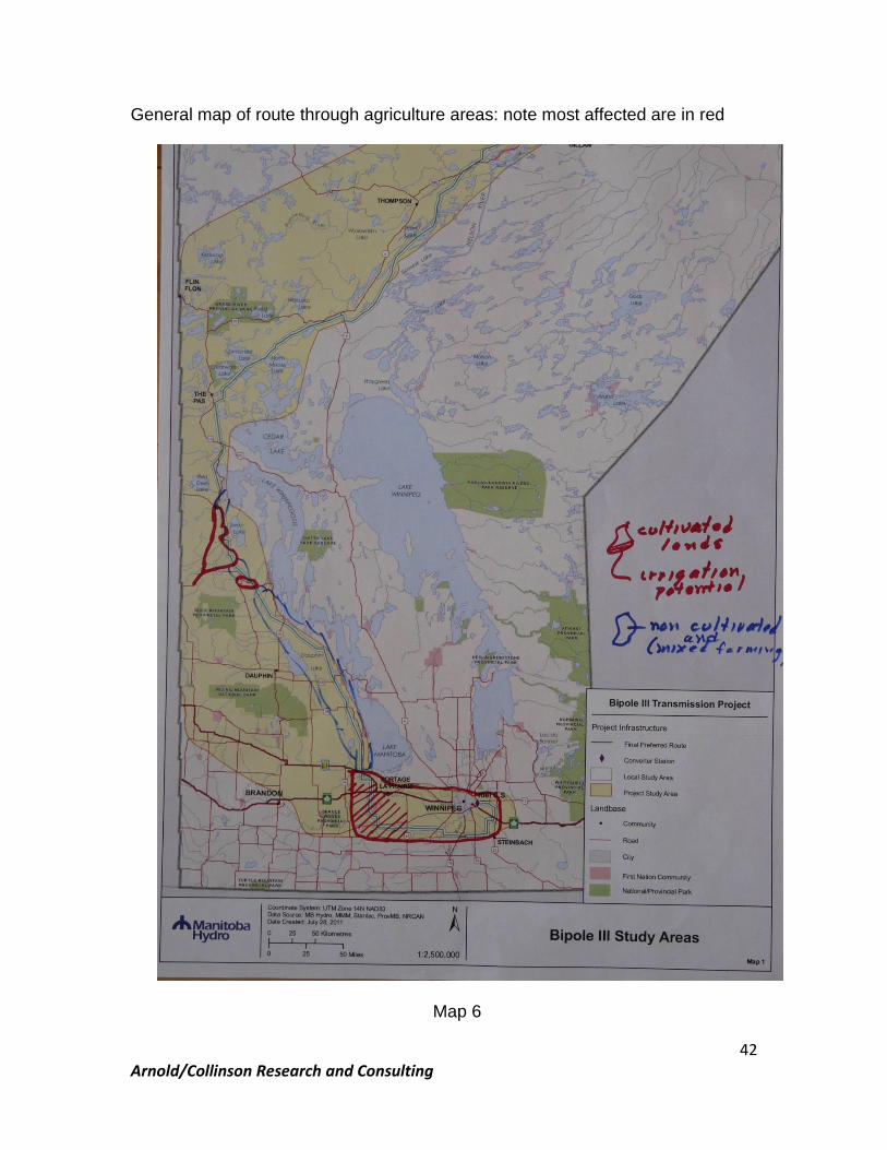
Arnold/Collinson Research and Consulting
42
General map of route through agriculture areas: note most affected are in red
Map 6

Arnold/Collinson Research and Consulting
43
5.3.3 Roads and infrastructure
MH set up some additional location criteria with regard to roads and other infrastructure, to avoid damage impacts from vehicle collisions. The line is not permitted to be adjacent to roads, and MH has arbitrarily chosen a setback south of the Yellowhead of 42 metres rather than the 33 metres to be used north of the Yellowhead. This setback ignores the maneuvering of large machinery currently in use. It does not, however, mitigate the effects on decreased efficiency noted earlier. Nor, does it take into account the progressive trends in increasing size and complexity of machinery. An additional concern by MH was that, if the route were within a road allowance, one of the lines could be near or almost above the road itself, risking contact with light or sign apparatus. This seems a weak argument considering the impact of a line within farm fields. Alternatively, MH would permit the line to run on the half mile (104 km). Although efforts were made to avoid diagonal field crossings, it was not achieved for considerable lengths (251 km of the 586, mostly in the lower soil capability areas). Any incursion of the transmission line into cropped fields represents a cost. It is not clear that options to avoid damage to towers on road allowances have been fully investigated. Obviously, there is a safety factor there for motorists, but they drive by office buildings in cities at highway speed every day, and barriers prevent damage. Why is it so difficult to design appropriate barriers to achieve their power transmission needs without undue impact on drivers? Barriers protect drivers from going into rivers or rock cliffs, why not protect towers? After all, there are only 3 or 4 per mile. The lack of imagination boggles the mind. Or, is it simply cheaper to make the farmers avoid the towers at considerable loss of efficiency and increased safety risk than to place protection devices along roads?
5.3.4 Irrigation system issues
The Agricultural Technical Report itself takes note of serious problems in the southern area:
“The clay soils turn to sandy soils at Carman to Elm Creek. The sandy soils have irrigation potential and quarter-section irrigation pivots are common for the production of potatoes and some other crops. The sandy soil treed area contains numerous smaller farms and many rural residences. These are found from Carman to Elm Creek, St. Claude, Rathwell in the R.M. of Grey, and to the Assiniboine River. All types of
Arnold/Collinson Research and Consulting
44
crops are produced from potatoes, corn, wheat, oats, barley, canola, sunflowers, alfalfa, peas and other pulse crops. Mixed farming is common with the utilization of tame pasture and alfalfa hay as well as native grazing and haying in sandy dunned (sic) soil areas. Active pivot irrigations systems exist north of Carman and west of St. Claude.
The sands with irrigation potential continue across the Assiniboine River and north past Highway #1 to Gladstone in the R.M. of Westbourne. Active pivot irrigation systems are found on both sides of the Assiniboine River on the lower side of the Arden Ridge, as well as south and north of Bagot, MacGregor and Austin. Several new irrigation pivots are found south of the community of Beaver in the R.M. of North Norfolk. North of Beaver the soils are more clay based and therefore they have less potential for irrigation.”42
It was noted that the transmission line and towers could impact irrigation systems. Towers prevent pivot irrigation systems from turning if they are within the field, and the line may affect the irrigation system if water sprayed hits a conducting wire. Moving or assembling pipes could result in contact with conducting wires. Consequently, the line was to be located away from existing irrigation systems. This helps those farmers now irrigating, but is of no value to those who may choose to install irrigation in the future. The line clearly should avoid all lands with irrigation capability. The impact of irrigated lands on productivity is considerable, and needs to be taken into account in location of the transmission line. MH‟s position on irrigation systems is set out in the Agricultural Technical Report.43 It clearly implies that the transmission line takes priority, once
42 Bipole III Agriculture Technical Report, p.18 (italics added) 43 “Irrigation systems operating in proximity of energized transmission lines pose a number of hazards to
the personnel on the ground and their equipment as well as to Manitoba Hydro due to:
Electric flashovers caused by water spray contacting energized conductors;
● Electric flashovers during installation or maintenance of the irrigation equipment and contacting energized conductors; and
● Line outages causing disturbance to Manitoba Hydro system. Safe co-existence of both
transmission lines and irrigation systems is possible providing the following safety measures are taken:
● Safe separation between irrigation pivot and energized conductors is maintained;
● Safe spray irrigation clearances to energized conductors are maintained; and
● Safe operating procedures are followed to install and maintain the irrigation system. It is
Arnold/Collinson Research and Consulting
45
the line is built, if no foresight is used in avoiding land with irrigation or irrigation potential.
5.4 The magnitude of Manitoba’s agricultural industry is significant Agriculture is a complex industry with a very high capital to labour ratio. It is also one of Manitoba‟s largest industries, having directly generated about 4.5% of Manitoba‟s GDP annually44. This number increases to nearly 12% when all spinoffs from the agri-food sector are taken into account. The following page from the “State of Agriculture in Manitoba”, published by Manitoba Industry Intelligence, MAFRI, illustrates the point that the industry is a critical element of Manitoba‟s economy.
CONTRIBUTION OF AGRICULTURE
“In Manitoba, the agricultural industry is a key driver of productivity and prosperity. The diversity of agriculture in the province plays an important role in maintaining economic strength and generating socio-economic stability.
Agriculture contributes to Manitoba’s Gross Domestic Product (GDP) through net profits and incomes including wages, depreciation and investment income. Improvements in GDP can be attributed to improved crop prices and production. Historically, agriculture’s direct and indirect contribution to GDP ranges between 4.4% and 4.8%.
Food processing represents close to one-quarter of the total manufacturing output and with approximately $4 billion of foods processed, contributes an additional 2 to 4% to provincial GDP. Agriculture supports growth and employment in the rural economy by providing a market for services needed by the industry.
Agriculture-connected industries, including food and beverage processing,
impossible to provide a one-stop-shop solution to all irrigation system issues. Each case will have to be dealt with individually to assess its physical size and operating mode and to determine if the location of the Bipole III corridor and its towers will interfere with safe irrigation. If conflict occurs the following mitigation measures should be considered:
● Relocate the Bipole III centre line and tower locations;
● Change irrigation operation scheme (i.e., adjustments of spray nozzles, change in overall geometry); and
Relocate irrigation system.”43
44 Manitoba Agriculture and Food and Rural Initiatives, (MAFRI) “State of Agriculture in Manitoba”,
undated
Arnold/Collinson Research and Consulting
46
supply inputs to agriculture, as well as wholesale, retail and other service sector components which supply services to farmers and other agriculture-related workers. When agri-food’s indirect contribution to the GDP is added to its direct contribution, an estimated 9% of Manitoba’s GDP is attributed to agriculture in 2011. It is estimated that when tierciary (sic) level contributions are included, the total impact on GDP may be closer to 12%.”
5.5 The pace of technological change
The pace of change has a significant bearing on how the impacts are calculated and how compensation, if needed, must be considered. The old practice of projecting current productivity into the future, applying a discount rate and arriving at a present value to determine fair compensation is no longer a viable or acceptable practice. Imagine the technological change that will take place over the next 60 years: the projected life of the line. How can the effect of 60 years of change be estimated? Considerable work on the pace of change has been carried out by Ray Kurzweil on what he refers to as “accelerating intelligence”45 Following years of work tracking changes over the past decades and centuries, he has concluded that at some point the rate of change for a given process or activity becomes exponential. Clearly, the rate of change in agriculture in recent years has taken off, especially if one thinks back a century ago when farming was done with horses, a few small capacity machines and considerable labour. Agriculture today is a very modern business based on the latest scientific innovations and business management practices. These changes and the pace at which they are occurring result from the combined evolution of what, on the surface, seems to be a disjointed incremental flow of new ideas and consequent technological progress emanating concurrently from myriad scientific efforts, but which, taken together, make the future of agriculture predictably much different as time passes. The farmers of today are productivity managers operating a complex business enterprise that employs capital with technology to produce huge amounts of food with limited labour inputs. The sea change in agriculture is due in no small way to the resourcefulness and the acumen of farmers and of the industries that support farming. Forms of technology utilized by farmers today are vastly different than those used 60 years ago, and those 60 years into the future will be orders of magnitude beyond current experience.
45
See @Kurzweil on Accelerating Intelligence.

Arnold/Collinson Research and Consulting
47
Tractors today are huge by 1950 standards, and electronics do today what a lever or trip cord used to do. Monitoring is electronic: no more relying on a rag attached to a pulley on the far side of the combine to tell the operator it‟s still turning! Cabs have replaced the “heat houser” and come complete with not just stereo and air conditioning, but with a slate of electronic monitors that tell the operator exactly what is happening on all fronts. Many activities that used to require a special talent to perform have been replaced with scientific technologies requiring very different skills. GPS is one example of these new technologies, and its use and scope increases as the years go by. Machinery is now so large and wide (50 to 80 feet, some even up to 130 feet) that previous mechanisms to help the operator avoid overlaps or misses can no longer cope. Everything needed for the seeding operation can now take place in one pass. Tied into a GPS system is the option of using GIS technology to overlay the soils variations of the field so that seed or fertilizer applications will be adjusted according to soil fertility and type. Breakthroughs in genetics represent another example of a rapidly changing field that is also impacting agriculture. Who would have thought, 60 years ago, that eurucic acid could be bred out of rapeseed, making it a food product rather than just a lubricant, paving the way for canola which, in 2009, produced sales that reached almost $1.3 billion? Seeds for varieties of crops are now tailor-made for specific purposes, and have been developed with certain features that include modifications to eliminate undesirable characteristics. Many other seeds now have features that improve yield, prevent diseases or improve quality. An entire team of specialists from plant breeders and nutritionists to engineers and economists are at work seeking ways to produce more and do it more efficiently. The above illustrates how differently agriculture must be considered when it comes to assessing the impacts of Bipole III. It is a major industry, with changes occurring as part of the natural industry evolution. The pace of change in agriculture, although not as fast as that of electronic devices such as smart phones, is nonetheless fascinating to observe. Electronic developments play a major role in how this pace is continuously advancing, and has been a key player in the modernization of agriculture into a progressive and science-based industry. In light of this, assessing the impacts of the Bipole III line construction and operations becomes a more complex matter than might have been contemplated initially, and is certainly more complex than is reflected in the EIS for Bipole III.

Arnold/Collinson Research and Consulting
48
5.6 Compensation
MH has developed a well-intentioned and comprehensive policy for compensating farmers for the negative impacts of the proposed transmission line. This approach has had merit in the past, and the idea that, if mitigation fails, compensation should be available to those impacted is valid in most circumstances.
“Mitigation cannot eliminate all of the effects of the presence of the transmission line on cultivated or uncultivated agricultural land. Therefore, easement agreements will include provisions to compensate landowners for the physical impacts associated with the transmission line. Manitoba Hydro compensates landowners by acquiring an easement for the right-of-way and by payment for structure placement on agricultural land. For towers structures the right-of-way easement is 66.0 meters wide. Compensation for all of the lands within the easement is calculated at 75% of market value.46 Normally land under the transmission line continues to be farmed.
Payments are a onetime lump sum to compensate for all impacts of the structure for the lifetime of the line. With the assistance of Manitoba Agriculture, Manitoba Hydro establishes a payment rate per tower for the year it is placed on the farmer's land. The annual compensation rate is calculated and then capitalized into a onetime payment per tower. The main considerations are:
Lost income from land taken out of production;
Reduced yields around the structure;
Additional time required to work around the structure;
Extra cost of double application of seed, fertilizer and chemicals; and
Weed control around the structure.”47
Beyond the difficulty in projecting the impacts of technological change over the longer term, taking this the next step to develop the value today of a flow of losses into the future provides an unusual challenge. The state of the global economy suggests that choosing an appropriate discount rate for present value calculations would be difficult. On the one hand, interest rates, which are often used for such calculations, may be low in terms of the cost to the Government of Manitoba, but risks and uncertainties are having
46 Now 150% of market value 47 EIS Agriculture Technical Report, pp. 65-66
Arnold/Collinson Research and Consulting
49
interesting consequences in Europe, and on local governments in the US where overspending during times of economic decline has become a serious concern. Given the concern about markets for new power generation contemplated in Manitoba, is there a chance, that as the guarantor of MH loans, Manitoba could be putting its own credit rating at risk? Regardless, making the assumption that a particular discount rate can be valid over a greater-than-60 year period carries high risk of error. It rewards a current farmer for future revenue lost by someone other than the person who could be the farmer 40 or more years into the future. The problem, however, is even greater, as MH does not use a true present value analysis, even though it has limitations as noted above for this particular case. MH uses only a crude valuation calculation of the land alone, ignoring how that has changed and will change as a function of technology and global food demand. Land is only one component of the inputs to the agricultural industry, but an essential one. Without land as the basis for crop production, the opportunity to add capital, technology and management skills does not exist. Therefore, every acre taken out of production and every accessibility issue and inconvenience added to the mix that frustrates production on adjacent lands and increases costs must be factored into the equation. Thus, the opportunity costs associated with this issue lead to concern that using only the value of the land today, as the EIS does, understates the impact of the corridor on farming. The value, now and over future years, is highest for agriculture when all relevant factors are taken together. A once-only payment to farmers to compensate them for their long-term losses is both unfair and, given the pace of technological change, virtually impossible to calculate in a manner that is fair to all sides. Nor, does it address the fact that impacts will still be felt long after the current farmer is no longer in the business: his/her successor will still be affected, and the assumption that the difference in productivity is taken into account through the price paid for the land is speculative, and only of value to MH. Farmers receive income annually, not in a one-time lump for the rest of their career. Their compensation should follow that course. It also has the benefit of compensating whomever the landowner is at the time. Over the life of the line, there could be several different landowners. The conclusion reached from this analysis is that landowners should be compensated on the basis of the following:
Compensation should be calculated on a present value basis for periods between five and ten years at a time, but not exceeding ten years, in order to correct for the impacts of technological change a decade at a time; and
Arnold/Collinson Research and Consulting
50
Compensation so determined should be disaggregated into annual payments made to farmers each year to more accurately represent the flow of income foregone due to the presence of the line, as well as having a more realistic impact on income tax.48
Compensation based on the above should be managed with the involvement of a third party organization to ensure fair oversight of the process.
5.7 Concluding summary
There are serious impacts on agricultural operations from the construction and operation of Bipole III with the choice of the Final Preferred Route. Routing Some tinkering with siting along road allowances could help to a limited degree, but the best way to mitigate these impacts would be to select an entirely different route or structural approach that avoids the problem projected for cultivated lands. One such option would be to place the line entirely underground for the section from the Yellowhead to the Riel Converter Station (or better yet La Verendrye). Assuming the highest costs would be incurred in areas of rock, and the lowest in reasonably dry soils with few if any stones, then line costs would be only double for the underground section. The actual length would be considerably shorter because proximity of an underground line to the existing bipoles and their converter station would have no bearing on reliability problems that could occur as a result of severe weather events. It could pass through lower-quality land to the north of Portage la Prairie and go directly to the north of Winnipeg and then southeast to the Riel site (or La Verendrye). The distance could be reduced substantially, and in addition to the construction savings, this shorter distance should also reduce line transmission losses, making it a viable option worthy of consideration. Compensation Appropriate compensation cannot readily be calculated with any degree of confidence for the entire useful life of the line, at least within the arable land area. The pace of change within the agricultural industry is too rapid to offer any means of calculating present value that will yield a reasonable estimate. This being the case, if the line, as a result of the final decision, actually
48 Personal communications with CRA officials disclosed that a one time lump sum payment is subject to
taxation in the year in which it is received.

Arnold/Collinson Research and Consulting
51
crosses CLI land capability classes 1 to 3, (classes 4 to 7 as described by the categories used in the Agricultural Technical Report), compensation should be paid in annual increments, with each payment determined from a maximum of ten-year present value estimations using the best information available at the time. To do otherwise leaves an unfair advantage to MH, while penalizing future farmers by sidestepping line implications in the distant future. Annual payments more accurately reflect income foregone and tax implications to the landowner annually. However, while this change in compensation policy would be an improvement over the proposed policy, it would be of no help to the migratory and resident birds affected by the lines farther north, nor would it help the caribou (a threatened species) and other ungulates and their predators.
Arnold/Collinson Research and Consulting
52
Chapter 6: Economic, Greenhouse Gas and Climate Change Issues 6.1 Economic impacts
The economic impact assessment provided in the Technical Reports49 takes information provided by MH and identifies direct and indirect economic benefits in terms of employment, labour income, GDP and tax revenue. The findings come from running the estimated expenditures and direct jobs created through the Provincial Input-Output Model. This is normal practice for such a project, and yields a set of numbers that are reasonably accurate as long as the data provided are correct. It does not assess the primary benefit or cost: that being the flow of benefits from secure and economical (if true) electrical power and return on investment that MH has argued are the underlying reasons for proceeding with the project. Without criticizing the assessment per se, this type of analysis is most suited to those projects that have already met the tests of due diligence. Given the findings of this report, that is in serious doubt. The problem is not what was done, but rather what was not done. MH might have been pushed by the Government of Manitoba to avoid the east side of Lake Winnipeg and, as the Government has the responsibility to allocate and manage Crown resources, they have the right to do that. MH, on the other hand, has the responsibility to provide reliable and affordable electrical power to Manitoba residents and businesses. It does not follow from the above that a transmission line must always go above ground. The reluctance of MH to give only passing attention to alternatives (the job of looking into the Lake Winnipeg option several years ago was contracted out), without any indication that MH was prepared to have or encourage a capacity in-house to consider a variety of options. The easy way to protect the status quo seemed to be to argue the costs were too high. If due diligence had been done, then the other question is whether or not the cost estimate is reasonable. Oddly, if the estimate is high, the short-term benefits or impacts of higher expenditures are even greater, even though the project itself may lose money. In other words, if so much is spent on the project that it is not economically viable, the impact of spending the money to build it will be greater than if the cost were lower; a seeming contradiction, yet real because the cost of construction has its own particular short-term impacts. However, any benefits from it are overwhelmed by the losses incurred by the operation of the project itself over time. In a time of high unemployment, this would be less of a factor, because of the stimulus effect of the expenditures. But, even under these circumstances, the question of opportunity cost most probably would point in another direction, towards
49
Technical Reports Volume 9
Arnold/Collinson Research and Consulting
53
initiatives that directly address the portions of the economy causing the slump. If there is full employment in the construction trades, for example, what is produced is inflation. Little more needs to be said about the economic analysis of the investment dollars in terms of impact. It is properly done, but adds little to the consideration of the project itself.
6.2 Greenhouse gas lifecycle
In a somewhat similar vein, the section on greenhouse gas lifecycle analysis follows an acceptable methodology. In this case, however, the entire study contains a huge set of assumptions; which is due to the lack of direct site-specific information for the route proposed. Although over 3000 hectares of forest land is calculated to be permanently disturbed, it is not clear how this figure was reached. As a rule of thumb for this particular boreal area, about 35% is densely tree covered, the rest is sparsely or open tree/shrub, rocks, lakes, streams and bog.50 There is reference to European forests, the source of some of their estimates, as being perhaps more dense than those of northern Manitoba. Also not included, is the increase in diesel fuel needed by farmers to maneuver around towers. In the end, the emissions are not particularly significant, given the nature of the project. They would, however, be reduced if one of the possible shorter alternative routes were assessed using the same methodology.
6.3 Climate change
Climate change is a global phenomenon, caused by gases that impede heat from the sun escaping back into space. The actual changes in climate globally are driven primarily by changing ocean temperatures, and their impact on air temperature and flows. Water vapour (a greenhouse gas) is a major contributor to warming and, as air gets warmer, more water evaporates and the air can hold more vapour, so the warming process feeds on itself. Other greenhouse gases51 are believed to contribute to the effect, and include such well-known gases as carbon dioxide (CO2) and methane (CH4). Both can be released as a result of human activities and from the decomposition of vegetative matter.
50
A Report done in 2008 by IISD, Winnipeg, of the area east of Lake Winnipeg proposed for World Heritage consideration, assessed that area as having 32.3% dense coniferous, broadleaf or mixed tree cover, with another 19% open or sparse. See IISD, “Pimachiowin Aki World Heritage Project Area Ecosystem Valuation Assessment”, November, 2008, p.11 51 http://climate.nasa.gov/causes/
Arnold/Collinson Research and Consulting
54
NASA notes the following evidence of rapid climate change:52
Sea level rise: 17 cm in the last century, with the rate for the past decade nearly double that of the last century.
Global temperature rise: the earth has warmed since 1880, but all of the 20 warmest years occurred since 1980.
Warming oceans: top 700 metres of ocean water rose 0.3F since 1969.
Ice Sheets: decreased in mass (Greenland up to 250 cubic km/year from 2002 to 2008.
Arctic sea ice: declining rapidly.
Glacial retreat: occurring everywhere.
Extreme events: high temperature events in the US, low temperatures getting warmer since 1950, increased rainfall and severe weather events.
Climate warming has been occurring in Canada for longer than the past decade.53 Like elsewhere in the world, the degrees of impact vary across the country.
6.3.1 Nelson River watershed
In the case of the proposed Bipole III line, the area through which the line runs deserves attention in this matter. But the entire Nelson River watershed, along with that portion of the Churchill River watershed that is diverted into the Nelson, also needs to be taken into account. After all, it is the flow of water available in these two watersheds that will power the generators from which the electricity comes for the line to carry. When plotted (Map 7), the importance immediately becomes clear: the drainage area extends from the Alberta almost the NWT border north of Reindeer Lake to south of Fargo, North Dakota and on into Ontario.
52 http://climate.nasa.gov/evidence/ 53 Statistics Canada, “Climate change in Canada”, http://www.statcan.gc.ca/pub/16-201-
x/2007000/10542-eng.htm

Arnold/Collinson Research and Consulting
55
Map 7 Map from Atlas of Canada, hatching added shows combined Nelson and Churchill basins 54
Within the combined Churchill-Nelson Basin, overall water flows might increase as time passes, mostly due to increased melt and drainage from the Rockies, a main source of water anyway. Precipitation and both summer and winter temperatures are all projected to increase, with intensity of rainfall events greater at times55. This projection is now ten years old, but events since that time suggest the original work was close to the mark. Although precipitation is projected to increase, evaporation and evapotranspiration will also increase due to the additional heat. In turn, this will increase water vapour in the air, which can increase greenhouse effect and keep temperatures up. It is possible that total flows could increase somewhat, but greater annual variations in precipitation are expected to increase over time, indicating a need for greater attention to flow management, along with its accompanying frustrations. These latter
54 http://atlas.nrcan.gc.ca/site/english/maps/environment/hydrology/drainagebasins 55
http://atlas.nrcan.gc.ca/site/english/maps/climatechange/potentialimpacts/sensitivityriverregions/1
Arnold/Collinson Research and Consulting
56
include high shoreline water damage in such basins as Lake Winnipeg, as well as the possibility of miscalculating and finding there is either too much stored or too little: the former could cause flooding problems and the latter energy shortages. This kind of climate impact has been more obvious in the past few years, as flooding on the Souris and Assiniboine Rivers has occurred, and both wet and dry periods have persisted longer than “normal”. Winters have become milder, summers hotter, which is not to say yearly variations will not occur; only that the long-term trend will be in this direction, with significant annual variations becoming more frequent. Severe weather events may be expected to increase in frequency and intensity, and both drought and flooding could materialize with greater impact. Shorter periods of sea ice, including in Hudson Bay, mean that the whiteness of the ice is not around as long to reflect heat back to space, so the process feeds on itself as water absorbs some of the heat. Similarly, in the agricultural areas, even if there is somewhat of an increase in precipitation, the warmer temperatures will speed up evaporation. The severe drought to the south in the American Great Plains this year illustrates the difficulties. Fortunately, farming practices are no longer those of the 30s, and limited tillage should prevent the kind of dust storms common in those years. Northern Manitoba has been affected very directly in recent years. The most obvious impact has been on winter roads, which are now useable for as little as one-third of the period that had been previously expected, especially the major winter road up the east side of Lake Winnipeg to the Island Lake area. In forested areas, the invasion of pine beetles, a species that can survive if not subjected to temperatures of minus 40º C, may begin to kill pine trees, which makes the forests more susceptible to serious forest fire situations56. Warmer winters have facilitated the movement of pine beetles out of British Columbia into the northern prairies. Ice over Hudson Bay does not remain for as long as historically has been the case, reducing the time polar bears have on the ice to feed on seals, their prime food source. Melting permafrost may also affect their denning areas along the beach ridges back from the Bay. Warmer winters and summers may not reduce precipitation, but increase more severe events, and make fires more challenging. This could well impact birds and ungulates. The Atlas of Canada (Map 8) has the following projection for winter temperatures to 2050: the hatched area of the Nelson-Churchill basins has been added for reference in this report. It notes that it is the inland
56 Ibid.
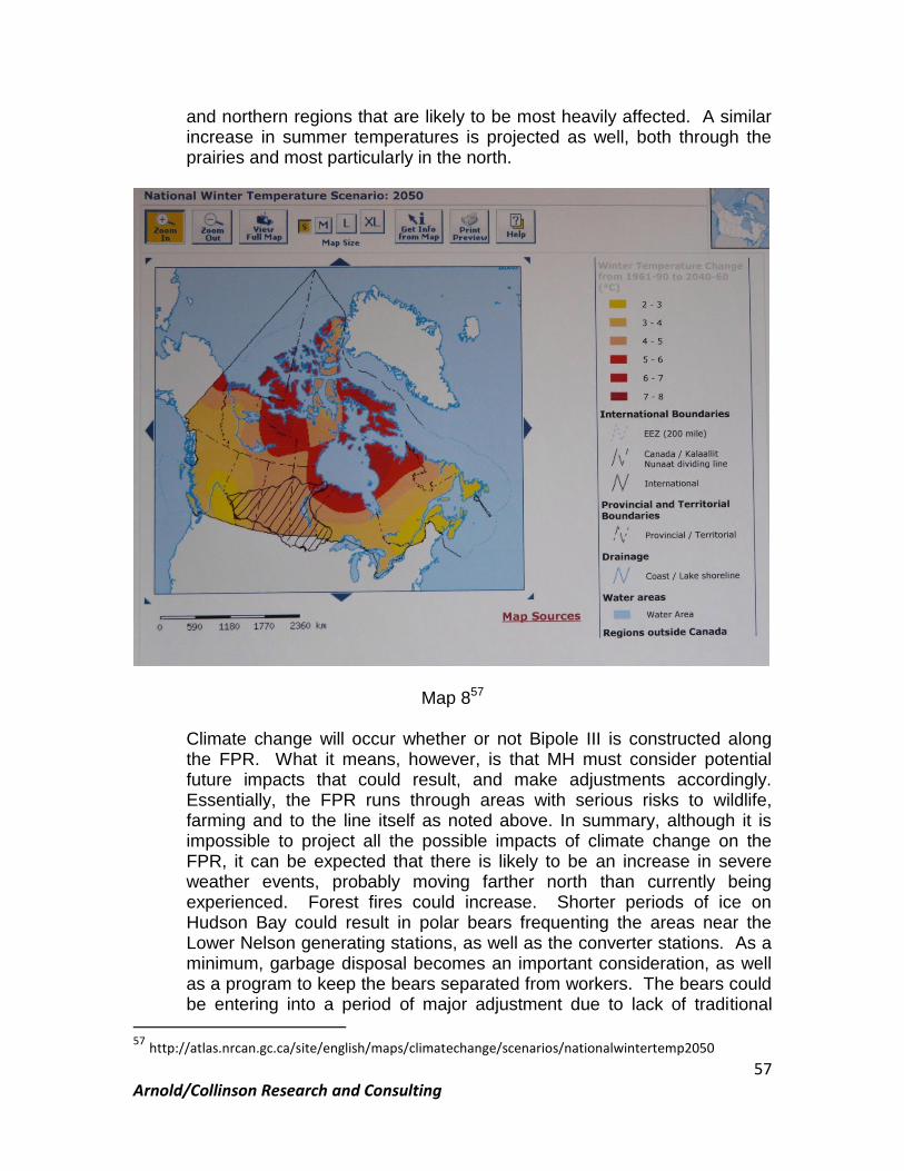
Arnold/Collinson Research and Consulting
57
and northern regions that are likely to be most heavily affected. A similar increase in summer temperatures is projected as well, both through the prairies and most particularly in the north.
Map 857
Climate change will occur whether or not Bipole III is constructed along the FPR. What it means, however, is that MH must consider potential future impacts that could result, and make adjustments accordingly. Essentially, the FPR runs through areas with serious risks to wildlife, farming and to the line itself as noted above. In summary, although it is impossible to project all the possible impacts of climate change on the FPR, it can be expected that there is likely to be an increase in severe weather events, probably moving farther north than currently being experienced. Forest fires could increase. Shorter periods of ice on Hudson Bay could result in polar bears frequenting the areas near the Lower Nelson generating stations, as well as the converter stations. As a minimum, garbage disposal becomes an important consideration, as well as a program to keep the bears separated from workers. The bears could be entering into a period of major adjustment due to lack of traditional
57 http://atlas.nrcan.gc.ca/site/english/maps/climatechange/scenarios/nationalwintertemp2050

Arnold/Collinson Research and Consulting
58
food, and it would be most unfortunate if some had to be killed for attempting to adapt, simply by coming into proximity with human activity. Churchill has learned to deal with it, so efforts will be needed on the lower Nelson River to adjust to bears in the vicinity. Woodland caribou may find their habitat further impacted by forest fires, and the general increase in forest fire risk from climate change suggests that forest fire capacity and strategies be carefully reviewed to prevent burns from affecting their key habitat areas. Traditional “forest fire fighters” tended to regard their role as protecting harvestable timber, but this notion needs to be updated to ensure that key habitat is given a much higher priority. Bird migrations may begin earlier in the spring, and southbound birds could spend more time resting and feeding along the FPR west of Lakes Winnipegosis and Manitoba, as well as in the key agricultural areas south of the Trans Canada Highway. In this respect, they could be exposed for longer periods to the risk of collisions with the proposed line. As a result of uncertainties about precipitation in agricultural areas, farmers on land suitable for irrigation will be giving serious thought to putting in irrigation systems to improve productivity and reduce risk. If MH places Bipole III through lands with capability for irrigation, this will seriously reduce the options of those farmers to remain competitive. It is the annual variations in climate that will make farming a greater challenge58. Means to hold water longer close to where it falls as precipitation will become a priority. If this can be accomplished, downstream flooding will be reduced to lower peaks, and a return to more riparian type of vegetation will improve wildlife vitality and retain moisture to “dampen” the impacts of droughts that will become more common. Manitoba has limited sites where large impoundments can be located, but re-creation of old potholes could go a long way to restore some form of buffer against frequent variations in climate. Severe weather events are likely to increase along the southern parts of the FPR, exposing the line to potentially greater risks than at present.
58
Dr. Paul Bullock, Soil Science Department, University of Manitoba, personal communication.
Arnold/Collinson Research and Consulting
59
Chapter 7: Cumulative Findings from Previous Sections: New Strategic Options Evolve
7.1 Conclusions from the review of the Environmental Impact Statement for birds, caribou, extreme weather, agriculture and climate change Previous sections of this report have assessed impacts of the proposed FPR for Bipole III. The conclusions reached are unsettling. Some mitigation efforts will help relieve some impacts, but others are of either such a magnitude, or of a lose/lose nature, that the question of significant route modifications appears to be worthy of attention. This question comes from the following conclusions:
1 The impact on migratory birds, even if the use of bird diverters over most of the line is assumed, remains significant. Migratory birds, protected under the North American Migratory Birds Convention, will be heavily impacted. The Mississippi Flyway, which accounts for 40% of the migratory birds in North America, crosses through the southern Interlake and the west side of Lakes Manitoba and Lake Winnipegosis. This area is also used by the birds for staging and for feeding in both spring and fall, leaving them vulnerable to collisions with some 650 km of transmission line. This impediment is particularly the case with larger birds which are either unable to maneuver quickly enough to avoid colliding with the high but small “optic ground wire” or raptors so intent on their prey that they do not notice the line. Between 35 and 50% of other bird strikes may be mitigated but the residual number that strike the line, when some 1400 km of line over some 60 years is taken into account, becomes a very large number (approximately 8,400,000 for 50% of the line). If this alternative is the best routing of all options within the study area, Manitoba has a problem. There are too many “bottlenecks” (e.g. The Pas to past North Moose Lake) and narrow routes (from the west side of Cedar Lake to the Delta Marsh), for adequate mitigation and/or rerouting to be effective. Certainly, as pointed out in the EIS, going farther west to implicate the “pothole country” does nothing to lessen the impacts. 2 Woodland caribou are an endangered species and are not able at this time to improve fecundity and recruitment rates. Even what would be minor impacts to other species would appear to have strong probability of increasing the risk of extirpation of this species. Three of eight herds are somewhat negatively impacted by the proposed routing. 3 Severe weather events along the west side of Lake Manitoba and across the southern Manitoba east-west portion of the proposed route are well documented. Whether changes in climate will increase severity or not, it is certain that, over time, frequencies of incidents could increase,
Arnold/Collinson Research and Consulting
60
and the area known as “tornado alley” will still exist. Risk of line disruptions are therefore relatively high, as has been the case since Bipoles I and II went into operation. It was a tornado in 1996, near Winnipeg, that put Bipoles I and II out of commission for a short time, and the one that hit Elie in 2007 was only about 30 km from the existing lines. Better ways to avoid exposure to these events need consideration. 4 Agricultural production on arable lands to the south of the Yellowhead Highway (PTH 16) all the way to Winnipeg will be impacted. These are some of the most productive lands in the entire province. Mitigation will only go so far, and costs to farmers will rise as they maneuver around towers. Spraying, particularly on special crops that need crop protectants several times before harvest, often when soils may be wet from rain and not amenable to the use of ground-based equipment, must be done by air; which is made dangerous and more costly with large power lines through fields. Aerial sprayer operators may simply not accept contracts where lines are near. Weed growth under and around towers could prevent marketing of certified seed crops and necessitate the removal of those lands from registered seed production. Compensation cannot be calculated to anticipate the pace of technological change affecting the farming industry, so those farmers affected will fall behind their peers in competitiveness.
5 Climate change over the life of the line will have some impacts that warrant attention. Birds will likely begin migrating earlier, and stay to feed longer in Manitoba, particularly during their southbound flights. Warmer winters and summers, increased summer evaporation and evapotranspiration will put more vapour into the air, thus increasing greenhouse effects. Greater variations in climate could increase severe weather events and the risk of forest fires, putting woodland caribou habitat at risk and requiring MH input to fire protection for habitat that might not fit routine forest fire priorities. Polar bears will be affected by reduced periods of Bay ice, and special programs may be required to maintain bear/worker separation. Irrigation on lands suited for it will likely increase, implying that MH should avoid lands with irrigation capability.
Taking these factors together, it becomes evident that the FPR presents many significant problems for the future, and consideration of wider options deserve attention. The government policy decision to avoid the east side of Lake Winnipeg proposed to UNESCO for World Heritage consideration creates a conundrum. It may be possible to correct some critical agricultural impacts, most severe weather impacts and a portion of the negative effects on migratory birds by putting the line underground from the Yellowhead to Winnipeg, but not on woodland caribou; nor on the remaining 500 km or so of line and tower (and guy

Arnold/Collinson Research and Consulting
61
wires) impacts on the birds; nor on agriculture in the Swan River and The Pas areas. 7.2 The broader energy and economic setting is in a state of flux
7.2.1 That there is a need to improve system security is not in question.
MH has proposed Bipole III as the means to achieve this objective.
7.2.2 However, if that is the only criterion, then construction of a second converter station near Winnipeg, perhaps even at La Verendrye, would enable MH to significantly improve security without actually needing Bipole III until clear evidence of sustainable demand growth materializes. After all, MH states that the sole purpose of Bipole III is to increase security.
7.2.3 The market for the energy produced by MH is uncertain at this time. Efficiencies and an economic slowdown, particularly in the US, have caused demand to flatten, and this has been exacerbated by the availability of natural gas at very low prices. Although recent evidence shows that some gas wells in Montana, on the same gas/oil field as in North Dakota (Bakken), Saskatchewan and Manitoba, are showing signs of reduced production after six years, it is not clear this is a trend for the entire field, or for fracking operations elsewhere. Huge potential exists over much of North America for developing these deposits, both in Canada and the US.
7.2.4 It is clear, however, that the US will not be needing extra shipments of Manitoba power in the short term, thus, the construction of an additional converter at Winnipeg will offer as much as a decade of breathing space to allow a more comprehensive review of transmission options from the Nelson, if they are ever to be needed, given the range of increasing alternatives due in large part to innovations and technology.
7.3 The present situation
7.3.1 The currently proposed route for Bipole III is beyond doubt the worst possible, beginning with its alignment through a considerable area susceptible to severe weather incidents: including tornadoes. Booming ahead on an out-of-date macro plan developed over 40 years ago, recently modified by provincial policy, has resulted in an extremely expensive track that defies full mitigation, and has impacts that cannot be compensated effectively. More specifically, woodland caribou could be further reduced to the point of "endangered", or worse; migratory birds would have one more major barrier impacting their North American patterns; security would be little improved as the FPR goes right through
Arnold/Collinson Research and Consulting
62
“tornado alley”; and commercial agriculture in Manitoba will suffer effects that will slow the pace of improved productivity needed for farms along the route to remain competitive, and the Manitoba agri-food industrial sector will be forced to acknowledge effects on growth. These concerns are of a magnitude that effective mitigation is impossible (for the caribou), expensive for migratory birds, and costly on arable agricultural lands (going beyond the limits of traditional compensation calculations due to the pace of technological change).
7.3.2 This raises the question about other alternatives, bearing in mind that a significant portion of the east side of Lake Winnipeg has been dedicated by the Government of Manitoba for some form of protected area. 7.3.3 MH has been operating on the assumption that plans from the 1960s and 70s remain valid today. This is no longer the case, even though the plans were valid at the time. Moreover, new options are available that open up possibilities for different approaches to electrical transmission: all it needs is a sea change in management thinking from "doing things the way they've always been done", to "let's see what our choices are".
7.4 There are other options
7.4.1 The construction of a second Winnipeg converter, appropriately relocated and replacing a tired existing converter offers time to think about and assess these new options. 7.4.2 Going underground for the arable land portions of the current FPR is one variation that will mitigate some of the problems forecast for the southern area. However, there are no obvious ways to address bird and caribou impacts with any certainty that they will be sufficient. Overall distance and consequent line losses remain significant. Nonetheless, for comparison purposes, this variation and the original FPR are included to keep all options open.
7.4.3 Employing a combination of transmission modes in a new route. This option employs one principal idea. Essentially, starting at Keewatinoow, the line could run south of the Nelson River, cross the historic segments of the Hayes somewhere near Oxford House, then run south to the east side of Molson Lake and over to the northeast end of Lake Winnipeg. All of this route misses woodland caribou range, is away from prime mining activities, and is outside major bird migration routes (although there are migratory birds that nest there). The Pen Island barren ground caribou use the part of the area traversed near the Nelson

Arnold/Collinson Research and Consulting
63
from time to time, but after construction, little impact is expected because of the nature of this species. This proposal would require crossing Lake Winnipeg at various possible points.
No doubt the requirement to go underwater for distances across of Lake Winnipeg would present engineering challenges but not to explore all options does a disservice to the environment and people along Bipole III who are adversely impacted by a selection not under their control. It is critical to seek alternative locations for the proposed line, conceptually at least, and/or means to mitigate impacts (particularly agricultural) that, as things stand, could prove to be seriously underestimated in a short time. These options have been cited, not as firm proposals, but simply to illustrate that alternative routings might be available, keeping in mind the provincial policy to avoid the proposed protected area east of Lake Winnipeg. No doubt there are other options as well, but these are put forward as examples
worth exploring.
As mentioned previously, evidence elsewhere indicates that an underground is not out of line, (at about double above-ground costs) especially where there are no underground or underwater obstacles to be conquered. It also avoids the need for compensation for agricultural lands and can be drilled under major roads or under other major structures, for example, the Portage Diversion. Costs may be in the order of double the costs of above ground lines, but this varies with soil and type of sub-surface material (e.g. granite or limestone). The areas where the line is proposed to go underground generally consists of loam to clay topsoil with largely similar or mostly clay subsoil, with few stones and virtually no rock.
It is important to note that underwater and underground, often in combination, are not just theories. Examples exist in Europe59 and a new transmission line is underway in the State of New York, linking Canadian electrical power to New York City and other locations via what are primarily underwater lines below Lake Champlain and the Hudson River60. The fact that Lake Champlain freezes in winter makes it comparable to Lake Winnipeg.
Although MH argues maintenance is more frequent and expensive, it has not clearly disclosed in the EIS the number of incidents that have affected Bipoles I
59 Europacable, “An Introduction to High Voltage Direct Current (HVDC) Underground Cables”, Brussels,
10 October, 2011 60 http://www.chpexpress.com

Arnold/Collinson Research and Consulting
64
and II, nor do technologies appear to have been explored that can be used or adapted. The point is that the option as promulgated by Manitoba Hydro is unacceptable. If reliability is key, as asserted by Manitoba Hydro, then the status quo as well is unacceptable. “Tweaking” the line will not solve the many and cumulative negative impacts of Bipole III. Best practices requires a fresh and serious look at alternatives, other than the „doomed to dismissal‟ of the other alternatives selected by Manitoba Hydro in its EIS as a comparison to Bipole III.
Environmental assessments of major projects are going to continue to identify significant problems into the future, so the time has come to be more open to new ideas and technologies.
Arnold/Collinson Research and Consulting
65
Appendix 1: Resume for Jim Collinson
University of Manitoba, BSA, (Agricultural Economics): course work included,
inter alia, chemistry, microbiology, botany, zoology, constitutional and common law, economics, agricultural economics, marketing, statistics, animal nutrition, plant science, philosophy and agricultural engineering.
University of Michigan, MSC, (Conservation and Resource Economics): course work included economics, resource economics, demography, water resources, land use and conservation
Jim is a management consultant with particular focus on research and strategy pertaining to the complexities surrounding energy/economy/environment issues. His consulting focus has evolved in part from training and experience and from following changes taking place globally that set a context within which national as well as more local situations develop. Some of these observations are outlined in a paper produced several years ago61. Today the reality of global complexity is that everything is changing, everywhere, all the time. Consulting clients have included Federal and Provincial departments and agencies as well as corporate clients in the areas of organization. environment, energy and economic strategies, and the World Bank and FAO on environmental information management systems. Consulting followed 30 years in senior public service positions in the Manitoba and Federal governments. Specific examples of responsibilities include:
Assistant Deputy Minister for Canada’s State of the Environment Report. Jim had responsibility for planning, establishing relevant content, coordinating and bringing to fruition the “The State of Canada‟s Environment Report, 1991”. The Report reflected Jim‟s interest and concerns with the interrelationships of all the factors affecting Canada‟s environment. Particular emphasis was placed on the necessity for all elements of the natural environment as well as human activities and motivations to be viewed as interactive pieces of a whole, not isolated parts. He edited and wrote parts of Chapter 1 (overall conceptual framework and direction), reviewed and commented on all other chapters, and was responsible for final signoff on content in all other chapters. The Report is regarded as a milestone in environmental information for Canada. Concurrent with these responsibilities, Jim was Head of Canadian Delegation to the OECD High Level Committee on
61 http://www.new-management-network.com/publications/Global Complexity-New-Opportunities.pdf
Arnold/Collinson Research and Consulting
66
Economy and Environment, 1991-93. This group focused on the inter-relationships amongst environment and economy, coming out of the Bruntland Commission Report62, which coined the term “sustainable development”. Jim was the only member of that Committee with a background in both ecology and economics.
Assistant Deputy Minister (position now classified as CEO) Parks Canada for five years. Relevant activities included developing and implementing a process for management planning that established and followed specific criteria for protection of natural ecosystems while concurrently ensuring public access and enjoyment to these national treasures. During this period, management plans for all existing national parks were updated, and new legislation was initiated and eventually passed that recognized the importance of protecting ecological systems. Of particular significance were sensitive individual negotiations with British Columbia and the Haida Nation that culminated (after over three years of intense work) in the creation of Guaii Haanas National Park Reserve and Haida Heritage Site, on what was then known as South Moresby, in the Queen Charlotte Islands. The Agreement was based on respect for the history and the objectives of all parties involved, and provided a management structure and process that equally respected each participant. Guaii Haanas illustrates how many objectives, sometimes apparently conflicting ones, can be achieved through understanding everyone‟s principles, history and future objectives and working to achieve them all, as compared to operating in win/lose situations. Northern Ellesmere National Park Reserve, Grasslands, Pacific Rim and Fathom Five Marine Park were also finalized during that period. Of special interest was Northern Ellesmere, where as a result of an aerial inspection Jim realized that although not many tourists were likely to make use of the Park, resource protection was needed, as scientists and other explorers were leaving behind garbage and doing damage that in such eco-climatic regions would remain for decades, if not centuries. Consequently, the Reserve was established in less than two months to provide regulation and protection for this fragile environment. Notable specific issues addressed over that period included bangs disease and TB in the Wood Bison herd in Wood Buffalo National Park, deer damage and deer ticks at Point Pelee National Park and tourist impact on high use and sensitive ecological areas in several popular
62 Report of the World Commission on Environment and Development: Our Common Future, United
Nations, 1987
Arnold/Collinson Research and Consulting
67
destinations. Highlighting the breadth and scope of the resources involved and emphasizing sustainable practices, he set in place the capacity for and published the first “State of the Parks Report”. Continued interest in the Hudson Bay area involved several trips along the coast from York Factory to Churchill, that concluded with an agreement with Manitoba to begin studies to consider a national park in that area. This is now the Wapusk National Park of Canada, highlighting the polar bear of the region and protecting their denning areas. The erosion of the bank of the Hayes River remains a concern, and pictures of Port Nelson are fixed in memory as an illustration of the impact of “investment ahead of analysis”.
President of the UNESCO World Heritage Committee, 1986-88. The Committee, composed of experts appointed by countries signatory to the Convention, reviewed in detail assessments of nominations from the IUCN (natural sites) and ICOMOS (cultural sites) and decided on listings for the World Heritage List. Natural Site assessments often included endangered species (e.g. White Rhino) and sustainable biodiversity.63 Jim set up a review of procedures to ensure all applications met criteria, and began a process that culminated in “cultural landscapes” becoming a category that included both natural and cultural features as valid elements of a nomination.
Assistant Secretary to the Cabinet for Aboriginal Constitutional Affairs and Chair: Neilsen Task Force on Program Review on Native Programs. In this role, Jim established a team of private sector and public service experts to carry out research on aboriginal concerns and their connections and relationships to lands and resources. He made presentations on these factors to many Ministerial committees within the processes leading to First Ministers meetings, and spent considerable time consulting aboriginal groups to ensure their concerns were documented and understood. An overriding concern was the negative impact of change on the decision-making processes of aboriginal communities, particularly the more remote ones. These had long-standing and effective systems for community decision-making that were designed to handle several decisions each year, and were suddenly being expected to meet new demands to address numerous decisions each day.
63 Examples of natural sites listed during his terms include the Queensland Rain Forest, Kakadu National Park and Tasmanian Wilderness in Australia, Gross Morne National Park in NL. Iguazu Fall in Brazil and Argentina, Sichuan Giant Panda Reserves, Kilimanjaro National Park, Tanzania, etc.
Arnold/Collinson Research and Consulting
68
Jim has had a long association with aboriginal people and their objectives, concerns and interests. Beginning initially in Northern Manitoba, this involvement expanded over the years to all of northern Canada and later to all of Canada. The importance of listening, respecting and honestly defining concerns was clearly the critical aspect of this association, and led to ultimately resolving issues in ways no-one might have been able to predict in advance.
Assistant Deputy Minister for Regional Economic DREE for Western and Northern Canada, including responsibility for PFRA from 1975 to 1982. He emphasized the provisions of the then British North America Act regarding federal and provincial responsibilities, by emphasizing close cooperation with provincial governments, involvement of private sector and consultation with interest groups, farmers and the academic community to ensure policies and programs under development were realistic and practical. DREE‟s decentralized organizational structure encouraged solutions that were directly relevant to the region involved.. Solutions were found for real problems, without as much concern for setting an unacceptable precedent elsewhere. These initiatives included: revised assistance for developing water sources on farms; managed programs to address serious drought in 1979, that included both crop impacts as well as water table and stream flow (community and hydro water supply) issues. During his tenure, DREE began to apply programs to northern areas for the first time, beginning with the first of three multi-year comprehensive development agreements for Northern Manitoba. These included airstrips, housing, water supply, training, resource management and economic development., and applied to all of northern Manitoba. The first of these agreements was signed at Norway House in 1975. Subsequent to that, DREE programs were initiated in all four western provinces and the (then) two Territories, with special emphasis on development for aboriginal communities and businesses.
Assistant Deputy Minister for Industry, Science and Technology Canada Consulted provincial and territorial governments and aboriginal leaders in the process and program design that resulted in the establishment of the Native Economic Development Fund, and set up its management structure.
Assistant Deputy Minister for Mines, Resources and Environmental Management for Manitoba: including research and policy development for Northern Manitoba, which led to a northern regional development strategic planning map. Based on trips through all parts of Northern Manitoba with a team of specialists in various fields, the findings and
Arnold/Collinson Research and Consulting
69
concerns of all disciplines were integrated into a coherent overlay of options and concerns. This map was used as a guide by at least three successive governments. Considerable time was spent on the Nelson River area, the Hudson Bay coast and the corridor between Thompson and The Pas.
Under Special Assignment, Chaired the study team on the social and economic impact of the Churchill and Nelson Rivers and Lake Winnipeg Regulation Hydro-Electric Project: one significant finding was the impact on community decision-making processes that were not able to cope with the sudden deluge of issues. The Report64 led to the Northern Flood Agreement. This project involvement provided an opportunity to become well acquainted with the natural resources of the area from the top of Lake Winnipeg to the Lower Nelson, and over to Saskatchewan along the Burntwood and Rat Rivers, Southern Indian Lake and the entire length of the Churchill River within Manitoba. It also provided the opportunity to spend considerable time in formal and informal settings, with aboriginal leaders and community members in each community potentially affected by the Diversion. The result was a report that reflected all parties objectives and concerns at that point in time.
Assistant Secretary to the Manitoba Cabinet responsible for federal-provincial agreements, including northern development. Jim managed a review of northern development potential and needs, publishing an internal report consisting of papers prepared by working groups he coordinated. Of interest was a special job development program in 1970, involving both federal and provincial programs working with the private sector and local government to achieve job creation. Many projects were initiated in the north, and included airstrip development and forestry/fishing/trapping programs. A parallel set of training options was put in place, reflecting the need for a flexible and comprehensive approach.
Additional background: Having grown up on a dairy/grain farm near Souris, MB, as a youth Jim spent much of his spare time walking around bush and slough areas of the farm observing the habits of animals and birds, and for several years operated a small trap-line. He was fascinated by the interactions of birds and animals with farming activities, including how deer flourished on crops planted near the edge of bush,
64 The Report was published along with all other reports on the Project. This one, however, as agreed with The Premier at the time the assignment was accepted, was released to the public the same day it was received by the Government of Manitoba, and communities affected were briefed on the findings before the final report was completed, so any last minute concerns could be taken onto account.
Arnold/Collinson Research and Consulting
70
sharp tailed grouse came to the same lek every year and waterfowl sought out sloughs and their immediate periphery for nesting. This interest led to a serious concern about the pressures of farm viability forcing farmers to drain sloughs and remove bush to get the best returns from their lands, while the public good from wildlife and soil and water conservation was sacrificed. As a consequence, water now runs off fields faster, causing flooding downstream (the severity of recent floods can be traced in part to this); while birds, deer and other wildlife of interest and benefit to the general public, have lost their habitat. The complexity of these linkages within ecological systems became a life-long interest, and a factor throughout his career. He is also a licensed pilot, and has flown over all of Manitoba, especially in northern areas, and most particularly those in the extreme north-west, those impacted by the Churchill-Nelson Project, the east side of Lake Winnipeg and along the Hudson Bay coast.