mangroves in the northern territory - nt.gov.au · pdf filemangroves in the northern territory...
TRANSCRIPT

i
Mangrovesin the Northern Territory
Report Number 25/2003D

Northern Territory Mangrove Education Kit
ii
Mangroves in the Northern Territory. Edited and produced by Geraldine Lee.
Published by Department of Infrastructure, Planning and Environment (DIPE)PO Box 30Palmerston NT 0831Tel: 08 8999 4455Fax: 08 8999 4445Website: http://www.ipe.nt.gov.au/
Northern Territory Government
All rights reserved. No part of this publication may be reproduced, stored in any retrieval system ortransmitted in any form or by any means electronic, mechanical, photocopying, recording or otherwise forcommercial purposes without the prior written permission of the publisher.
The information in this publication has been published by DIPE to assist public knowledge of mangroveecosystems.
Publication dataLee, G.P. (2003), Mangroves in the Northern Territory, Department of Infrastructure, Planning andEnvironment, Darwin.
Report Number 25/2003D
Cover photograph shows a Rhizophora stylosa surrounded by Avicennia marina pneumatophores
Funding provided by The Natural Heritage Trust and Department of Infrastructure, Planning andEnvironment.

Northern Territory Mangrove Education Kit
iii
TABLE OF CONTENTSWHAT ARE MANGROVES? _______________________________________________________________ 1WHERE DO MANGROVE COMMUNITIES OCCUR? __________________________________________ 1
MANGROVES IN AUSTRALIA 2MANGROVES IN THE NORTHERN TERRITORY 2MANGROVES IN DARWIN HARBOUR 2
HARSH CONDITIONS ____________________________________________________________________ 3ADAPTATIONS TO SALT 3
Salt Exclusion 3Salt Excretion 3Storage 3
ADAPTATIONS TO INUNDATION AND WAVE ACTION 4Stabilisation with Roots – Mangrove Balancing Acts 4Aeration through Roots 5Seed Dispersal and Establishment 6
MANGROVE PLANTS (FLORA)____________________________________________________________ 7Aegialitis annulata (Club mangrove) 8Avicennia marina (Grey mangrove) 9Bruguiera exaristata (Orange mangrove) 10Ceriops tagal (Yellow mangrove) 11Excoecaria ovalis (Blind your eye) 12Hibiscus tiliaceus (Beach hibiscus) 13Lumnitzera racemosa (Black mangrove) 14Rhizophora stylosa (Stilt rooted mangrove) 15Sonneratia alba (Mangrove apple) 16
MANGROVE ZONATION ________________________________________________________________ 17WHY DOES ZONATION OCCUR? 17
Environmental Variables 17Propagule characteristics 17
WHAT ZONES OCCUR ? 18The Seaward Zone 19The Middle Zone 19The Landward Zone 19
MANGROVE ANIMALS (FAUNA)_________________________________________________________ 20VERTEBRATES 20
Mammals 20Birds 20Reptiles 20Fish 21
INVERTEBRATES 21Arthropods 21Molluscs 22
MANGROVE SOILS _____________________________________________________________________ 23WHAT’S THAT SMELL? 23ACID SULPHATE SOILS 23
WHY ARE MANGROVES SO IMPORTANT? ________________________________________________ 24ECOLOGICAL IMPORTANCE 24
Coastal Stabilisation 24Sediment Traps 24High Productivity 26High Biodiversity 26
ECONOMIC IMPORTANCE 27Tourism 27Faunal Harvesting 27Wood Harvesting 27

Northern Territory Mangrove Education Kit
iv
RECREATIONAL AND CULTURAL USES 27Indigenous Harvest 27Fishing 28Other Recreational Pursuits 28
IMPACTS ON MANGROVES _____________________________________________________________ 29COASTAL DEVELOPMENT 29POLLUTION 29 SEDIMENTATION 29WEED AND FERAL ANIMAL INVASION 30
Weeds 30Feral Animals 30Marine Pests 30
MANGROVE MONITORING AND PROTECTION ____________________________________________ 31COMMUNITY MANGROVE MONITORING PROGRAM 32NORTHERN TERRITORY UNIVERSITY / GOVERNMENT PROJECTS 32
REMOTE SENSING -A MANAGEMENT TOOL ______________________________________________ 33LANDSAT SATELLITES 33
Mangrove Monitoring using Landsat 34AERIAL PHOTOGRAPHY 34
MANGROVE MAPPING _________________________________________________________________ 35MANGROVE VISITS ____________________________________________________________________ 36CONTACT DETAILS ____________________________________________________________________ 36REFERENCES __________________________________________________________________________ 42INDEX ________________________________________________________________________________ 43
ACTIVITIESWHY ARE MANGROVES IMPORTANT? ___________________________________________________ 37MANGROVE SNORKELS ________________________________________________________________ 38REMOTE SENSING _____________________________________________________________________ 39
LIST OF FIGURESFigure 1: Schematic profile of mangrove zonation, topography and elevation in Darwin Harbour. ............... 18Figure 2: Coral Reefs in Darwin Harbour........................................................................................................ 25Figure 3: Darwin Harbour mangrove communities ......................................................................................... 35
LIST OF PLATESPlate 1: Mangroves, Channel Island................................................................................................................ 1Plate 2: Sonneratia alba (Mangrove apple)..................................................................................................... 3Plate 3: Salt crystals on the leaf of Aegialitis annulata (Club mangrove)....................................................... 3Plate 4: Leaf fall in Bruguiera exaristata (Orange mangrove)........................................................................ 3Plate 5: Rhizophora stylosa (Stilt rooted mangrove) roots.............................................................................. 4Plate 6: Ceriops tagal (Yellow mangrove) base.............................................................................................. 4Plate 7: Avicennia marina (Grey mangrove) base........................................................................................... 4Plate 8: Sonneratia alba (Mangrove apple) pneumatophores at low tide........................................................ 5Plate 9: Sonneratia alba (Mangrove apple) pneumatophores at high tide....................................................... 5Plate 10: Bruguiera exaristata (Orange mangrove) knee roots......................................................................... 6Plate 11: Developing propagule of Rhizophora stylosa (Stilt rooted mangrove) .............................................. 6Plate 12: Acrostichum speciosum (Mangrove fern)........................................................................................... 7Plate 13: Base of Ceriops tagal (Yellow mangrove) Avicennia marina (Grey mangrove) ............................... 7Plate 14: Aegialitis annulata (Club mangrove) at Dundee beach...................................................................... 8Plate 15: Club shaped base of Aegialitis annulata (Club mangrove) ................................................................ 8Plate 16: Salt crystals on the leaf of Aegialitis annulata (Club mangrove)....................................................... 8Plate 17: Developing propagules of Aegialitis annulata (Club mangrove) ....................................................... 8Plate 18: Avicennia marina (Grey mangrove) at Nightcliff Beach.................................................................... 9Plate 19: Pencil like pneumatophores................................................................................................................ 9

Northern Territory Mangrove Education Kit
v
Plate 20: Avicennia marina (Grey mangrove) base........................................................................................... 9Plate 21: Avicennia marina (Grey mangrove) leaf (pale underside showing salt excretion)............................. 9Plate 22: Bruguiera exaristata (Orange mangrove) flowers ........................................................................... 10Plate 23: Bruguiera exaristata (Orange mangrove) knee roots....................................................................... 10Plate 24: Bruguiera exaristata (Orange mangrove) base ................................................................................ 10Plate 25: Bruguiera exaristata (Orange mangrove) calyx............................................................................... 10Plate 26: Buttress roots of Ceriops tagal (Yellow mangrove) showing close up of bark................................ 11Plate 27: Ceriops tagal (Yellow mangrove) fruit ............................................................................................ 11Plate 28: Ceriops tagal (Yellow mangrove) form ........................................................................................... 11Plate 29: Oval shaped leaves and white latex of Excoecaria ovalis (Blind your eye)..................................... 12Plate 30: Excoecaria ovalis (Blind your eye) tree ........................................................................................... 12Plate 31: Excoecaria ovalis (Blind your eye) leaves ....................................................................................... 12Plate 32: Hibiscus tiliaceus (Beach hibiscus) flower ..................................................................................... 13Plate 33: Hibiscus tiliaceus (Beach hibiscus) heart shaped leaf...................................................................... 13Plate 34: Hibiscus tiliaceus (Beach hibiscus) form ......................................................................................... 13Plate 35: Stunted growth form of Lumnitzera racemosa (Black mangrove) and close up of bark.................. 14Plate 36: Heart shaped leaves of Lumnitzera racemosa (Black mangrove) .................................................... 14Plate 37: Rhizophora stylosa (Stilt rooted mangrove) roots............................................................................ 15Plate 38: Rhizophora stylosa (Stilt rooted mangrove) leaves, showing dark upper and pale underside.......... 15Plate 39: Developing Rhizophora (Stilt rooted mangrove) at Nightcliff ......................................................... 15Plate 40: Sonneratia alba (Mangrove apple) fruit........................................................................................... 16Plate 41: Sonneratia alba (Mangrove apple) cone shaped pneumatophores ................................................... 16Plate 42: Sonneratia alba (Mangrove apple) flowers...................................................................................... 16Plate 43: Sonneratia alba (Mangrove apple) at high tide, East Arm Inlet ...................................................... 16Plate 44: Leaders Creek................................................................................................................................... 17Plate 45: Sonneratia alba and Rhizophora stylosa in the seaward zone.......................................................... 19Plate 46: Ceriops tagal (Yellow mangrove) in the middle zone ..................................................................... 19Plate 47: Melaleuca (Paperbark) and Pandanus in Landward zone ................................................................ 19Plate 48: Pteropus scapulatus (Little red flying fox........................................................................................ 20Plate 49: Merops ornatus (Rainbow bee-eater) ............................................................................................... 20Plate 50: Mangrove snake ............................................................................................................................... 20Plate 51: Periophthalmus sp. (Mudskippers) .................................................................................................. 21Plate 52: Camouflaged spider on the bark of an Avicennia marina (Grey mangrove) .................................... 21Plate 53: Fiddler crab (Uca sp.)....................................................................................................................... 22Plate 54: Katydid............................................................................................................................................. 22Plate 55: Telescopium telescopium (Long bum).............................................................................................. 22Plate 56: Mangrove mud ................................................................................................................................. 23Plate 57: Rhizophora stylosa (Stilt rooted mangrove) and Bruguiera exaristata (Orange mangrove)............ 24Plate 58: Mangrove snake ............................................................................................................................... 26Plate 59: Fishing off Channel Island ............................................................................................................... 28Plate 60: Recreational mangrove use .............................................................................................................. 28Plate 61: Rubbish is serious form of pollution ................................................................................................ 29Plate 62: Rhizophora stylosa (Stilt rooted mangrove) and sedimentation. ...................................................... 29Plate 63: Coffee Bush (Leucaena leucocephala) ............................................................................................ 30Plate 64: Overlooking the protected mangroves of Charles Darwin National Park ........................................ 31Plate 65: Leaf litter collection provides an indication of mangrove productivity. .......................................... 31Plate 66: Litter collection ................................................................................................................................ 32Plate 67: DIPE workers monitoring mangrove health..................................................................................... 32Plate 68: Satellite image of Darwin Harbour................................................................................................... 33Plate 69: Demonstration of pixellation in Landsat satellite images................................................................. 33Plate 70: Aerial photograph of the mangrove communities at Rapid Creek (1994)........................................ 34Plate 71: Comparisons over time. Rapid Creek in 1978 and 1994 .................................................................. 35Plate 72: Stuart Park Primary students visiting East Point board walk ........................................................... 36Plate 73: Mangrove zonation, Leaders Creek.................................................................................................. 37Plate 74: Mangrove snorkels of Avicennia marina (Grey mangrove) ............................................................. 38

Northern Territory Mangrove Education Kit
vi

Northern Territory Mangrove Education Kit
1
What are Mangroves?Mangroves consist of a variety of growthforms, from trees, palms, shrubs, vines,epiphytes, samphires, grasses and ferns.Mangroves form valuable ecosystems alongsheltered tropical and subtropical coastalenvironments. Typical mangrove habitatsare periodically subjected to tidal influences.Mangroves grow in soil that is frequentlywaterlogged by saline water. The firstexplorers described them as ‘forests of thesea’ (Mastaller 1997).
Plate 1: Mangroves, Channel Island
Mangroves have specialised adaptations enabling them to grow and reproduce indemanding conditions. High levels of salt, tidal inundation and wave action typifythese challenging conditions (Mastaller 1997).
Where do Mangrove Communities Occur?Mangroves are predominantly found in tropical regions between the Tropic of Cancerto the north and the Tropic of Capricorn to the south. The geographical distribution ofmangroves can be divided into two main regions, consisting of a Western Group andan Eastern Group. The Eastern Group (Eastern Hemisphere) incorporates East Africa,the Red Sea, India, Southeast Asia, Southern Japan, the Philippines, Australia, NewZealand and the South Pacific archipelago, as far east as Samoa. The Western Group(Western Hemisphere) comprises African-American regions including, the Atlanticcoasts of Africa and the Americas, the Pacific coasts of Tropical America and theGalapagos Islands. Approximately 80% of all known mangroves occur in the Indo-Pacific region (Mastaller 1997).
The total area of mangrove communities across the globe can still only be estimated.Current area estimates are in the range of 15.7 million hectares (Mastaller 1997).
Most tropical countries were originally covered with mangrove vegetation. The fivebasic requirements for extensive mangrove development include (Mastaller 1997):
• tropical temperatures• fine grained alluvium• shores free of strong wave and tidal action• salt water; and• large tidal range.
These factors can influence the occurrence and size of mangroves, the speciescomposition, species zonation, other structural characteristics and the functions of theecosystem itself (Mastaller 1997).

Northern Territory Mangrove Education Kit
2
Mangroves in AustraliaAustralia’s coastline has vast tracts of mangroves. The highest levels of speciesdiversity can be found on the northern and northeastern coastlines. The greatestconcentration is along the tropical northeastern coast from Mackay to Cape York. Thetallest, most extensive forests are situated along the north coast of Queensland(Claridge & Burnett 1993).
The western coast has a reduced number of mangrove species, compared to theeastern coast. This is mainly due to seasonal aridity of the western coast and a limitedpresence of estuaries and embayments to accommodate mangrove communities(Claridge & Burnett 1993).
Mangroves do occur as far south as Victoria and South Australia, although thesecommunities are almost limited to stunted Avicennia marina and only in those areasthat are predominantly frost-free. No mangroves occur in Tasmania (Claridge &Burnett 1993).
Mangroves in the Northern TerritoryMangroves in the Northern Territory cover approximately 4 120 km2 of 10,953kilometres of Northern Territory coastline and river systems, incorporating bothmainland mangrove communities and islands off the Northern Territory coastline.This area represents more or less 35% of the 11,600 km2 of mangroves foundthroughout Australia (Wightman 1983).
The mangrove stands in the Northern Territory contrast significantly in stand,structure and species diversity. Extensive stands of mangroves are located along thenorthern coasts of Arnhem Land, in Darwin Harbour and on Bathurst and MelvilleIslands. Isolated pockets can occur within any number of small embayments orsurrounding small coastal estuaries (Wightman 1983).
Mangroves in Darwin HarbourThe mangrove communities of Darwin Harbour are a significant natural resource bothlocally and globally. The mangroves in the harbour are amongst the most diverse inAustralia. Approximately 50 species are regarded as ‘mangroves’ worldwide, 36 ofthese occur naturally in Darwin Harbour. The largely undisturbed tracts of mangrovesoccupy an area of approximately 20,400 hectares (Approx. 5% of the NT’s and 0.1%of remaining world mangrove area) (Brocklehurst & Edmeades 1996)

Northern Territory Mangrove Education Kit
3
Harsh ConditionsThe coastal environment provides challenges which many plants would be unable tocope with. Mangrove plants demonstrate a wide range of adaptations which enablethem to thrive in these demanding conditions (Mastaller 1997).
Adaptations to SaltSalt tolerant plants are calledhalophytes. Halophytes haveadaptations which can counteracthigh concentrations of salt found intheir environment. Salt, or sodiumchloride (NaCl), poses a significantthreat to non-halophytic plantsbecause it can influence the amountof available fresh water and becausesalt can be toxic in highconcentrations (Knox et al. 1994).
Plate 2: Sonneratia alba (Mangrove apple)
Salt Exclusion
Don’t let the salt in! Many of the major mangrove plants including Avicennia,Bruguiera, Ceriops, Excoecaria and Rhizophora are able to selectively take in waterwhile filtering most of the salt out. This type of adaptation is called ultra-filtration(Claridge & Burnett 1993).
Salt Excretion
Getting the salt out! Some mangroves are able to actively pump saltout from their leaves. In plants such as Avicennia and Aegialitis it ispossible to see salt which has been excreted in the form of crystalson the outside of leaves (Claridge & Burnett 1993).
Plate 3: Salt crystals on the leaf of Aegialitis annulata (Club mangrove)
Storage
Keep the salt for a while, and then get rid of it! Salt whichhas been taken up by a mangrove plant can be selectivelytransported by the plant to the most expendable leaves.This salt will be totally lost from the plant when theseleaves are dropped. Salt may also be stored in bark(Claridge & Burnett 1993).
Plate 4: Leaf fall in Bruguiera exaristata (Orange mangrove)

Northern Territory Mangrove Education Kit
4
Adaptations to lnundation and Wave ActionMechanical adaptations are structural features which enable plants to survive andsuccessfully compete for resources in a particular environment. One of the mostobvious mechanical adaptations of mangroves to the marine environment are variousroot structures. Additionally many mangrove timbers are very heavy which assists inanchoring the plant (Mastaller 1997).
Stabilisation with Roots – Mangrove Balancing Acts
Mangrove root systems are generally not deep,but are widely spread out. Mangroves haveseveral different root types which enable them toremain securely anchored in regions whichrepeatedly become waterlogged and are subject totidal influences and wave actions (Claridge &Burnett 1993).
Stilt Roots
Stilt roots or prop roots are elongated aerial rootswhich originate from the tree trunk and lowerbranches. Rhizophora trees have easilyrecognisable prop roots (Mastaller 1997).
Plate 5: Rhizophora stylosa (Stilt rooted mangrove) roots
Buttress Roots
Buttress roots radiate from the base of atree to increase the width of the base. Byhaving a greater width, the chances of thetree being knocked over by wave action orover balancing in the soft mud are reduced(Mastaller 1997).
Plate 6: Ceriops tagal (Yellow mangrove) base
Cable RootsThe Avicennia marina (Grey mangrove)cable roots shown in Plate 7 have beenexposed through erosive processes. Theydemonstrate how mangrove roots canspread radially underground to assist withstabilisation in wet and rough conditions.Plate 7: Avicennia marina (Grey mangrove) base

Northern Territory Mangrove Education Kit
5
Aeration through Roots
Plant roots require oxygen for cellular respiration. Normally this gas would beavailable to plants in the tiny spaces, called interstitial spaces, which occur betweensoil particles. This space is not available in mangrove mud, due to frequent waterlogging and inundation. Some mangrove species have adapted to this challengingsituation by developing above ground roots, such as pneumatophores and knee roots(Knox et al 1994).
Pneumatophores – Mangrove Snorkels
Pneumatophores arespecialised roots which growupwards from a cable rootsystem. By having roots abovethe surface of the mud thesetrees are able to ‘breathe’during low tide.Pneumatophores occur inAvicennia, Sonneratia andXylocarpus mangroves.Pneumatophores can varyextensively in height, shapeand diameter (Claridge &Burnett 1993).
Plate 8: Sonneratia alba (Mangrove apple) pneumatophores at low tide (above)
Plate 9: Sonneratia alba(Mangrove apple) pneumatophoresat high tide (right)

Northern Territory Mangrove Education Kit
6
Knee Roots
Knee roots are loops in cable roots,they appear as knee like projectionsabove the surface of the mud. Kneeroots are found in Bruguiera andLumnitzera (Claridge & Burnett1993).
Plate 10: Bruguiera exaristata (Orangemangrove) knee roots
Seed Dispersal and Establishment
The seeds of mangroves are well adapted to dispersal by waterand establishment in tidal areas. Large quantities of buoyantseeds are produced to account for high levels of predation anddestruction. Additionally some mangroves are viviparous(Claridge & Burnett 1993).
Vivipary means giving birth to live young, as opposed toproducing eggs. For example mammals are considered to beviviparous, while birds are not. When referring to a plant,vivipary means that a fertilised seed actually begins to growwhile still attached to the parent plant (Claridge & Burnett1993).
The seeds produced by the mangroves germinate while stillattached to the parent tree to form seedlings, calledpropagules. When the seedling falls to the ground it hasalready started to develop a root system which will assist it toanchor to the muddy substrate despite constant wave actionsand tidal inundation (Claridge & Burnett 1993). Rhizophorastylosa propagules can often be spotted along the high tidemark (See Plate 11). Like all mangrove seeds, Rhizophorapropagules are able to float, allowing them to be dispersedwith the tide far away from the parent plant. This is one waythat mangroves are capable of colonising new areas.
Plate 11: Developing propagule of Rhizophora stylosa (Stilt rooted mangrove)

Northern Territory Mangrove Education Kit
7
Mangrove Plants (Flora)Many plant growth forms are associated with mangrove ecosystems including vines,grasses, shrubs, chenopods, sedges, forbs, palms, ferns and parasitic plants (Mastaller1997).
Plate 12: Acrostichum speciosum (Mangrove fern)
For the purpose of this resource nine tree species have been chosen as representativesof the mangrove communities present in the Top End of the Northern Territory. Thesespecies vary considerably in their appearance, adaptations to the coastal habitats,position in relation to the coast and their cultural uses. The chosen species are:
• Aegialitis annulata (Club mangrove)• Avicennia marina (White or grey mangrove)• Bruguiera exaristata (Orange mangrove)• Ceriops tagal (Yellow mangrove)• Excoecaria ovalis (Blind your eye)• Hibiscus tiliaceus (Beach hibiscus)• Lumnitzera racemosa (Black mangrove)• Rhizophora stylosa (Stilt rooted mangrove)• Sonneratia alba (Mangrove apple)
* Common names havebeen included to assiststudent learning. It shouldbe noted thatdiscrepancies can existwith common names, sowhere possible scientificnames should bepreferentially learned andused.
Plate 13: Base of Ceriops tagal (Yellow mangrove-left) Avicennia marina (Grey mangrove-right)

Northern Territory Mangrove Education Kit
8
Aegialitis annulata (Club mangrove)This mangrove is a small shrub, whichgenerally does not exceed 1.5 metres but canreach up to 3 metres in height (Brock 1988).
Plate 14: Aegialitis annulata (Club mangrove) atDundee beach
The trunk is thick at the base, but quicklynarrows to give the appearance of a club.Aegialitis annulata is found in a variety ofhabitats, including rocky beachenvironments in the seaward zone (Brock1988).
Plate 15: Club shaped base of Aegialitisannulata (Club mangrove)
Plate 16: Salt crystals on the leaf of Aegialitisannulata (Club mangrove)
The leathery leaves have specialised glands whichexcrete salt from their upper surface. The leavesdiffer from many other mangroves in that they arestem-sheathing. This means that the leaf stemactually flattens out and curls around the stem towhich it is attached (Brock 1988).
Aegialitis flowers between September andDecember. The flowers are small, tubular andwhite. The fruiting period is between January andMarch. The fruit are smooth, narrow and bananashaped (Brock 1988).
Plate 17: Developing propagules of Aegialitis annulata(Club mangrove)

Northern Territory Mangrove Education Kit
9
Avicennia marina (Grey mangrove)
This is the most widespread mangrove inAustralia. Avicennia marina generally takesthe form of a multi-stemmed tree between 4and 10 metres high, however in some areasthese trees can reach 25 metres. Avicennia isfound in varied environments, including theupper tidal limit of estuaries, salt flats andalong the seaward margin (Brock 1988).
Plate 18: Avicennia marina (Grey mangrove) atNightcliff Beach
Another distinguishable feature of this treeis the pencil like pneumatophores whichprotrude upwards through the mud fromlateral roots below. These assist with theaeration of the plant (Brock 1988).
Plate 19: Pencil like pneumatophores
The bark of the Avicennia is generally apale white to grey/green. The flowers ofAvicennia are small and orange generallyoccurring between October and January.The fruiting period is between Januaryand February. The fruit are small, green,dish-like capsules (Brock 1988).
Plate 20: Avicennia marina (Grey mangrove) base
Plate 21: Avicennia marina (Grey mangrove) leaf (paleunderside showing salt excretion)
The leaves are elongated (up to 12cm), with a shiny upper surface and pale greycoloured underside (it is this colour which accounts for the common name). Thisspecies has salt secreting glands on the leaves. Avicennia fruit can be eaten afterextensive preparation, including soaking and cooking. Leaves and shoots are used formedicinal purposes. Correct preparation enables the treatment of cuts and marinestings (Brock 1988).

Northern Territory Mangrove Education Kit
10
Bruguiera exaristata (Orange mangrove)
Plate 22: Bruguiera exaristata (Orange mangrove) flowers
These spreading trees are generallybetween 3 and 10 metres high. Thetrunks of Bruguiera are oftenbuttressed and surrounded by manyknee like pneumatophores. The bark ofthese trees is generally dark andfissured along the trunk and at theroots. Bruguiera exaristata is generallyfound in the landward zone ofmangrove communities (Brock 1988).
Plate 23: Bruguiera exaristata (Orangemangrove) knee roots
The thick leathery leaves of Bruguiera arefound clustered towards the ends ofbranches. The flowers, which give thismangrove its common name, are brightorange and surrounded by a green calyx.These are found between May andNovember. The fruit, occurring betweenJune and December, are cone shaped andabout 1.5 cm long (Brock 1988).
Plate 24: Bruguiera exaristata (Orange mangrove) base
The timber of Bruguiera is used to make valuable instrumentsincluding oars and tools. The fruit may be eaten afterconsiderable preparation (Brock 1988).
Plate 25: Bruguiera exaristata (Orange mangrove) calyx

Northern Territory Mangrove Education Kit
11
Ceriops tagal (Yellow mangrove)
Ceriops can form as small trees or shrubs,generally between 2 and 6 metres high. The baseof Ceriops is often buttressed. Bark is generally
pale brown, which can be flaky within thebuttresses. Ceriops generally cannottolerate high levels of water inundation andas a consequence are mainly found on thelandward fringe of mangrove communitiesand in salt pan areas (Brock 1988).
Plate 26: Buttress roots of Ceriops tagal (Yellow mangrove) showing close up of bark
Plate 27: Ceriops tagal (Yellow mangrove) fruit
The leaves of Ceriops trees are yellowish green in colour(hence the common name yellow mangrove). The flowers,which occur between June and November are small, whiteand appear in clusters. Fruit is present on the plantbetween June and December. The fruits are smooth, coneshaped and approximately 1.3 cm long. Some Ceriopsvarieties can be used to create medicines for the treatmentof burns (Brock 1988).
Plate 28: Ceriops tagal (Yellow mangrove) form

Northern Territory Mangrove Education Kit
12
Excoecaria ovalis (Blind your eye)This is generally a small tree or shrub whichcan reach up to 4 metres in height. The rootsof this species occasionally knot above the soilsurface. Excoecaria can be found in andaround mudflats and in coastal mangrovecommunities (Wightman 1983).
Plate 29: Oval shaped leaves and white latex ofExcoecaria ovalis (Blind your eye)
The species name 'ovalis' refers to the oval shape of the leaves. The leaves generallyrange between 3 and 7 cm in length. If plucked from the stem Excoecaria leave stemswill release a small amount of milky white fluid called latex. The flowers ofExcoecaria occur between October and December. The individual flowers of thisspecies are tiny, the inflorescence produced are in the form of spikes up to 3 cm long.Small mottled brown seeds occur between December and February (Wightman 1983).
While the latex of Excoecaria is considered tobe toxic and is thought to cause irritation toeyes (hence the common name), it can be usedmedicinally in the treatment of some diseasesincluding leprosy and for marine stings. Thetimber may also be used for firewood(Wightman 1983).
Plate 30: Excoecaria ovalis (Blind your eye)tree
Plate 31: Excoecaria ovalis (Blind your eye)leaves

Northern Territory Mangrove Education Kit
13
Hibiscus tiliaceus (Beach hibiscus)
The Beach hibiscus is a smallspreading tree which can reach 8meters in height. The tree is frequentlyfound in sandy beach areas, but canalso be found below the high tide mark(Wightman 1983).
The large flowers have yellow petalsand a deep maroon centre. These treesflower all year round in the tropics.Fruiting is restricted to betweenJanuary and April. The fruit arebrown, woody capsules which splitwhen they are ripe (Brock 1988).
Plate 32: Hibiscus tiliaceus (Beach hibiscus) flower
The large leaves of the hibiscus are heart shaped.The top side of the leaves are smooth and darkgreen, while the underside is covered with manyfine hairs which form a pale grey colour (Brock1988).
The wood and bark of these trees can be used byAboriginal people to make objects includingweapons and rope. The sap can be used in thetreatment of boils and wounds (Brock 1988).
Plate 33: Hibiscus tiliaceus (Beach hibiscus) heartshaped leaf
Plate 34: Hibiscus tiliaceus (Beachhibiscus) form

Northern Territory Mangrove Education Kit
14
Lumnitzera racemosa (Black mangrove)
This shrub or tree can reach 5 metresin height, however in substandardconditions, such as those found insalt pans, Lumnitzera may remainunder 1 metre (Plate 35) (Wightman1983). The bark of the blackmangrove is often very dark - henceits name. These trees are generallyfound towards the landward edge ofmangrove areas (Brock 1988).
Plate 35: Stunted growth form of Lumnitzera racemosa(Black mangrove) and close up of bark
The leaves of Lumnitzera are one of the bestways to identify this species. Each leaf has anindentation at its tip which forms a heart shape.If you look carefully a small gland can be seenat the base of the indentation (Brock 1988).
Lumnitzera racemosa flowers between Octoberand May. The flowers are small, white andusually occur in groups. The fruit of theLumnitzera are small, smooth lobes (Brock1988).
Aboriginal people choose to use Lumnitzeratimber for fire wood because it is slow burningand maintains hot coals (Brock 1988).
Plate 36: Heart shaped leaves of Lumnitzera racemosa (Black mangrove)

Northern Territory Mangrove Education Kit
15
Rhizophora stylosa (Stilt rooted mangrove)
Rhizophora is perhaps one of the best knownof all mangroves as a result of the intertwined,arching prop roots which originate from thebase and lower branches of these trees. Theseroots have proved highly successful inenabling Rhizophora to colonise the seawardedge of mangrove communities, despiteconstant tidal inundation and wave action.The trees can vary in height between 5 and 12metres (Brock 1988).
Plate 37: Rhizophora stylosa (Stilt rooted mangrove) roots
Plate 38: Rhizophora stylosa (Stilt rooted mangrove) leaves,showing dark upper and pale underside
Rhizophora leaves are thick, leathery and have a smallpoint projecting at the apex. The flowers of this species,which occur between April and November, are small,white and feathery. The fruit, which can be observedbetween April and November, is smooth, brown andpear shaped (Brock 1988).
Rhizophora is used by Aboriginal people in thetreatment of several medical conditions, includingchicken pox (Brock 1988).
Plate 39: Developing Rhizophora (Stilt rooted mangrove) atNightcliff

Northern Territory Mangrove Education Kit
16
Sonneratia alba (Mangrove apple)
This spreading tree is generally between 4 and 5metres high, however it can reach 8 metres inheight. Sonneratia trees have large, cone shapedpneumatophores. Sonneratia are found in theseaward zone (Brock 1988).
Plate 40: Sonneratia alba (Mangrove apple) fruit
Plate 41: Sonneratia alba (Mangrove apple) cone shapedpneumatophores
The leaves of Sonneratia are bright green, thick and fleshy. The flowers, which occurbetween March and October, are red or white. The flowers do not have visible petals,but instead are made of many coloured stamen. The fruit, which also occurs betweenMarch and October, appear as flattened, globular berries, which give Sonneratia itscommon name. The edible fruit remains attached to the green calyx which surroundsthe flowers. As the fruit forms the calyx is forced into a star shape (Brock 1988).
Plate 42: Sonneratia alba(Mangrove apple) flowers(above)
Plate 43: Sonneratia alba(Mangrove apple) at high tide, EastArm Inlet (left)

Northern Territory Mangrove Education Kit
17
Mangrove ZonationMangrove communities are oftenmade up of obvious zones which runparallel to the shore. Each zone islikely to be dominated by oneparticular tree species which hasadapted to specific environmentalcharacteristics (Claridge & Burnett1993). The aerial photograph (Plate44) shows distinct zones formed bymangrove species which run parallelto the coast or riverine system.
Plate 44: Leaders Creek
Why does Zonation Occur?The amazing way that mangroves sort themselves into zones has been the subject of agreat deal of scientific research. Many ideas have been put forward to explain whythis happens. Some ideas are summarised below.
Environmental Variables
It has previously been explained that mangroves have different ways of adapting tothe challenging conditions of coastal life. Conditions such as salt concentration, waveaction, inundation levels and even levels of predation (mainly by crabs)varyconsiderably between the coastal edge and the landward extremes of a mangrovecommunity (Mastaller 1997).
Different plant species have different adaptations which enable them to successfullycompete against other mangrove species for positions at varying distances from thewater’s edge. Rhizophora, Avicennia and Sonneratia all have complex root systems,which enable them to live in, the areas most affected by tidal inundation and waveaction. This accounts for the consistent presence of these tree species at the seawardedge of mangrove communities (Claridge & Burnett 1993).
Propagule characteristics
Propagule size, shape and density have also been implicated in mangrove zonation.The larger and more irregularly shaped propagules, are less likely to be transported bywave action through complex root structures and mud to the landward side of amangrove community. For example the large propagules produced by Rhizophorastylosa (see Plate 11) are rarely transported to the landward edge of a community andit is only large propagules that are capable of withstanding the wave action which canprevent smaller lighter propagules from establishing in tidal areas. Smaller propagulessuch as those of Bruguiera are more likely to be landward, where the reduced levelsof inundation allow root establishment (Tomlinson 1986).

Northern Territory Mangrove Education Kit
18
What zones occur ?Generally a minimum of three zones are recognised, these being the landward zone, the seaward zone and an intertidal zone (Claridge & Burnett 1993).These simplified zones will be outlined. Figure 1 depicts a more complicated zonation pattern which has been mapped in Darwin Harbour.
Figure 1: Schematic profile of mangrove zonation, topography and elevation in Darwin Harbour (Metcalfe 1999).

Northern Territory Mangrove Education Kit
19
The Seaward Zone
The Seaward zone runs parallel to the sea.Because of the close proximity to thewater this zone is the most susceptible towave action and inundation. Themangrove species which are found in thiszone are highly adapted to the associatedchallenging conditions. The species mostlikely to occur within the tidal zoneinclude Rhizophora, Avicennia andSonneratia (Claridge & Burnett 1993).
Plate 45: Sonneratia alba and Rhizophora stylosa in the seaward zone
The Middle Zone
This zone is generally at a higherelevation than the seaward zone and as aresult is inundated far less frequently.The species which are likely to occurwithin the middle zone include Ceriopstagal, Bruguiera exaristata andExcoecaria ovalis (Claridge & Burnett1993).
Plate 46: Ceriops tagal (Yellow mangrove) inthe middle zone
The Landward Zone
The landward zone is inundated lessfrequently than both other zones,depending on tides. The landward zoneoccurs between the middle zone andthe terrestrial environment (hinterland).In these areas other species may occurincluding Eucalyptus, Melaleuca,Pandanus and Acacia. Mangrovespecies found in this zone includeLumnitzera racemosa, Hibiscustiliaceus and Ceriops tagal (Claridge& Burnett 1993).
Plate 47: Melaleuca (Paperbark) and Pandanus in Landward zone

Northern Territory Mangrove Education Kit
20
Mangrove Animals (Fauna)VertebratesVertebrates are animals that have backbones,or more specifically an internal skeleton.Mammals, reptiles, amphibians, fish and birdsare all vertebrates (Knox et al. 1994).
Mammals
Bats are the most prevalent mammals withinmangrove communities. In particular the littlered flying fox (Pteropus scapulatus) feeds onthe pollen of mangroves. These and other batsretreat to the mangroves to roost often ingroups of thousands. Wallabies, dingoes,possums and small rodents can be foundwithin and near the landward fringe (Strahan1995).
Plate 48: Pteropus scapulatus (Little red flying fox)Photo courtesy of Denise Batten
Birds
Many birds are dependent on the rich levels ofproductivity and sheltered habitats whichmangroves provide. Mudflats and intertidal areasprovide important feeding grounds for wadingbirds. Numerous flowers and fruits of mangrovecomminutes provide rich food sources fornectarivores (nector eaters) and frugivores (fruiteaters). Many migratory bird species aredependent on north Australian mangroves (Donatoet al. 1997). These visitors highlight theimportance of mangrove conservation on a globalscale.
Plate 49: Merops ornatus (Rainbow bee-eater)
Reptiles
Various reptiles are found in mangroveforests including the dangeroussaltwater crocodile (Crocodylusporosus), mangrove monitors and otherlizards and snakes.
Plate 50: Mangrove snake

Northern Territory Mangrove Education Kit
21
Fish
Many fish, including commercially viablespecies, are dependent on mangroveassemblages for food and for breeding(Mastaller 1997). An influx of various fishspecies can be observed entering themangroves with the rising high tide.
MudskippersMudskippers are a type of fish whichcontinue to live in mangrove environmentseven when the tide is out. Strong pectoralfins assist movements on land. When out ofwater mudskippers can breathe air frommoisture trapped in their gill chambers.Mudskippers prey on crustaceans and othersmall animals (Mastaller 1997).
Plate 51: Periophthalmus sp. (Mudskippers)
lnvertebratesInvertebrates are animals which do not have backbones. Major groups includearthropods and molluscs (Knox et al. 1994).
ArthropodsArthropods are a group of invertebrates which includes spiders, crustaceans andinsects. Arthropods do not have internal skeletons like humans and other vertebrates,instead they have a hard external skeleton called an exoskeleton. The exoskeleton isjointed which allows movement of limbs (Knox et al. 1994).
Spiders
Most spiders have three types of sensory organswhich enable them to decipher what is happeningin their immediate environment. Hairs on thebody and legs of spiders actually assist the spiderto detect vibrations in the air. Slit sense organs,rather than ears, are used to detect soundvibrations. While most spiders have simple eyes,only hunting spiders, such as the huntsmanpictured, can actually see detailed images (Knoxet al. 1994).
Plate 52: Camouflaged spider on the bark of an Avicennia marina (Grey mangrove)

Northern Territory Mangrove Education Kit
22
Crustaceans
Crustaceans, a group of animals which includesprawns and crabs, can be differentiated fromother animals by having appendages (legs) whichsplit into two. The most obvious example beingthe claw of crabs (see Plate 52) (Knox et al.1994).
Crabs play an important role in mangrove nutrientrecycling and soil aeration (Moritz- Zimmermanet al 2002).
Plate 53: Fiddler crab (Uca sp.)
Fiddler crabs can be easily identified, as male fiddler crabs have one massivelydisproportionate, brightly coloured claw which is used when courting female crabs, interritorial defence and as a warning system (Mastaller 1997).
Insects
Many different types of insects can be found inmangrove environments. However theirsignificance to tropical mangrove systems,specifically in regards to pollination andherbivory is poorly understood. The linksbetween mangroves and insects is a currentfocus of study in Darwin Harbour (Moritz-Zimmerman et al 2002).
Plate 54: Katydid
The most infamous of mangrove insects are those which parasitise humans. Bitinginsects found in the mangroves include mosquitos and sand flies. Visitors tomangroves should be careful by wearing protective clothing and insect repellent.
Molluscs
Molluscs are animals which have soft bodies whichare supported and protected by unusually hardshells. Examples of molluscs include snails, oystersand mussels. Many different types of molluscs canbe found in the mangroves. Indigenous peopleharvest various mollusc types for food. Bush tuckercan include long bums, periwinkles, scallops, mudwhelks and mussels (Puruntatameri et al 2001).
Plate 55: Telescopium telescopium (Long bum)
Northern Territory Mangrove Education Kit
23
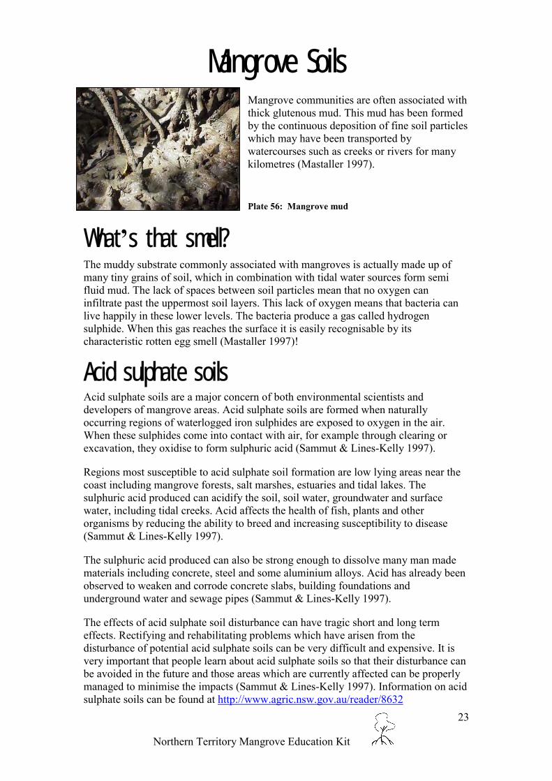
Mangrove SoilsMangrove communities are often associated withthick glutenous mud. This mud has been formedby the continuous deposition of fine soil particleswhich may have been transported bywatercourses such as creeks or rivers for manykilometres (Mastaller 1997).
Plate 56: Mangrove mud
What’s that smell?The muddy substrate commonly associated with mangroves is actually made up ofmany tiny grains of soil, which in combination with tidal water sources form semifluid mud. The lack of spaces between soil particles mean that no oxygen caninfiltrate past the uppermost soil layers. This lack of oxygen means that bacteria canlive happily in these lower levels. The bacteria produce a gas called hydrogensulphide. When this gas reaches the surface it is easily recognisable by itscharacteristic rotten egg smell (Mastaller 1997)!
Acid sulphate soilsAcid sulphate soils are a major concern of both environmental scientists anddevelopers of mangrove areas. Acid sulphate soils are formed when naturallyoccurring regions of waterlogged iron sulphides are exposed to oxygen in the air.When these sulphides come into contact with air, for example through clearing orexcavation, they oxidise to form sulphuric acid (Sammut & Lines-Kelly 1997).
Regions most susceptible to acid sulphate soil formation are low lying areas near thecoast including mangrove forests, salt marshes, estuaries and tidal lakes. Thesulphuric acid produced can acidify the soil, soil water, groundwater and surfacewater, including tidal creeks. Acid affects the health of fish, plants and otherorganisms by reducing the ability to breed and increasing susceptibility to disease(Sammut & Lines-Kelly 1997).
The sulphuric acid produced can also be strong enough to dissolve many man madematerials including concrete, steel and some aluminium alloys. Acid has already beenobserved to weaken and corrode concrete slabs, building foundations andunderground water and sewage pipes (Sammut & Lines-Kelly 1997).
The effects of acid sulphate soil disturbance can have tragic short and long termeffects. Rectifying and rehabilitating problems which have arisen from thedisturbance of potential acid sulphate soils can be very difficult and expensive. It isvery important that people learn about acid sulphate soils so that their disturbance canbe avoided in the future and those areas which are currently affected can be properlymanaged to minimise the impacts (Sammut & Lines-Kelly 1997). Information on acidsulphate soils can be found at http://www.agric.nsw.gov.au/reader/8632

Northern Territory Mangrove Education Kit
24
Why are Mangroves so Important?Ecological importance
Coastal Stabilisation
Coastlines and beaches are dynamic. This means thatthey are constantly changing as a result of both naturaland anthropogenic (man made) influences (Mastaller1997).
Plate 57: Rhizophora stylosa (Stilt rooted mangrove - left) andBruguiera exaristata (Orange mangrove - right) on Lee PointBeach
Mastaller (1997) states that natural processes which can influence coastal andestuarine dynamics include
• longshore currents;• wave action;• wind action; and• storm surges, including tropical cyclones.
Anthropogenic processes which can influence coastal and estuarine dynamics include:
• coastal development; and• removal and destruction of coastal vegetation including mangroves.
In many cases natural processes are accelerated by human development andpopulations. The rate at which coastal change takes place can be quite slow and mayonly become evident over a number of years. However even gradual changes cancause serious environmental and economic problems (Mastaller 1997).
The dense structure of mangrove communities results in a firmly anchored physicalwall of trees linked together through complex interlaced root systems. As a resultmangrove communities provide protection against coastal erosion by creating a bufferagainst currents, waves, wind and storm events (Mastaller 1997).
In many regions of the world, including Australia, the removal of mangroves hasresulted in severe erosion and subsequent economic cost. The construction of artificialbarriers is structurally challenging due to the unstable nature of coastal substrates andas a consequence is very expensive (Mastaller 1997).
Sediment TrapsMangrove comminutes and their complex root systems trap large quantities of siltwhich is carried downstream from rivers and other estuarine systems. By trappingthese tiny particles of silt and soil, mangroves act as a filter and consequentlycontribute to the quality of coastal waters (Mastaller 1997).

Northern Territory Mangrove Education Kit
25
This function is important particularly for the sustainability of coral reefs. The tiny coral polyps which form reef communities are sensitive to sedimentloadings. If these polyps become smothered the coral communities die back and are no longer able to support the rich and diverse ecologicalcommunities associated with reef environments. Darwin has several coral reefs which provide interesting snorkelling and diving. Figure 2 depicts thesurprisingly high number of coral reefs which can be found around Darwin Harbour, many of which correlate to mangrove communities. Moreinformation on the attributes of Darwin Harbour can be found at: http://www.ntlis.nt.gov.au/ by selecting Australian Coastal Atlas NT Node andfollowing the prompts. This site provides interactive access to a geographic information system (GIS) which allows the user to access various layers ofinformation which can be overlaid onto a map of the Northern Territory.
Figure 2: Coral Reefs in Darwin Harbour

Northern Territory Mangrove Education Kit
26
High Productivity
Productivity is a term used by scientists to describe the ecological value of a vegetationcommunity. The productivity of mangrove communities is high in comparison with many othervegetation communities. The high productivity of mangroves form an integral part of the marinefood web (Mastaller 1997).
A food web is now widely recognised as a more accurate and complicated version of a foodchain. The complexity and extensiveness of the food web stems from the high nutrientavailability, which has come from extensive mangrove leaf litter decomposition over time(Mastaller 1997).
When mangrove leaves and branches fall to the ground they provide many terrestrial and marinespecies with a 'primary' food source. These primary level consumers are then consumed bysecondary level consumers such as small fish, who are in turn eaten by third level consumerssuch as crocodiles (Mastaller 1997).
High Biodiversity
The word biodiversity is made up of the two words‘biological’ and ‘diversity’. Biodiversity refers to the allspecies in an ecosystem and therefore can be used as ameasure of the variety of life (Knox et al. 1994).
The high level of productivity associated with mangroveecosystems support complex plant communities, these in turnbecome the unique habitats that sustain extensive and variedpopulations of animals. The high level of biodiversityassociated with mangroves is an important indicator in theneed for conservation of these ecosystems (Mastaller 1997).
Plate 58: Mangrove snake
Mangroveleaf litter
Protein richparticulate
debris
Eaten byherbivorous
marineorganisms
Eaten bycarnivorous and
omnivorous marineorganisms
Microbial activity

Northern Territory Mangrove Education Kit
27
Economic lmportanceTourism
Mangroves provide a habitat for many animals and birds which are very important to the tourismindustry. Tourists can now readily access mangroves through the use of boats or via board walks.Tourism provides an excellent opportunity for people to learn about the ecological and economicimportance of mangroves.
Faunal Harvesting
Mangroves are now recognised as being extremely important for recreation and commercialfisheries. The harvesting of animals from mangroves may be either direct or indirect. As the tidesflush in they bring with them a wealth of animals including stingrays, fish and prawns. Low tideexposes alternate harvests including invertebrate species such as long bums and mud crabs.
Indirectly many industries are dependent on mangroves as breeding grounds. The young of manyspecies are not harvested until well after they mature and leave the mangrove environment. Suchspecies include prawns and barramundi, both of which are economically important in theNorthern Territory.
Wood Harvesting
Wood harvesting of mangroves is not as common in Australia as it is in many overseas countries.Countries such as Thailand are dependent on the timber of mangrove species for fuel, charcoal,pulp and for the construction of rural dwellings. Other smaller pieces of wood may be used forwooden carvings and in the creation of small household objects (Mastaller 1997).
Recreational and Cultural UsesIndigenous Harvest
Cultural uses of mangroves include various uses of flora and fauna for food, medicine and for theconstruction of weapons and artworks. Traditional Aboriginal hunting and gathering practicesreap bountiful and varied harvests. Food sources include fish, stingrays, mammals, reptiles,invertebrates and honey (Puruntatameri et al 2001).

Northern Territory Mangrove Education Kit
28
Fishing
Fishing in the Northern Territory is seen to beimportant from both cultural and recreationalperspectives. Mangroves provide importantbreeding and feeding grounds for many species offish including the highly sought after barramundi.Mud crabs (Scylla serrata) are also a prized foodsource that can be caught in shallow tidal watersusing a crab pot or in the mangroves themselves.
Plate 59: Fishing off Channel Island
Other Recreational Pursuits
Mangroves are also used bymany people for theiraesthetic value. Wildlifeobservers, field naturalists,bird watchers andphotographers frequently usemangrove areas.
Plate 60: Recreational mangrove use - Photograph courtesy of Libby Benson

Northern Territory Mangrove Education Kit
29
lmpacts on MangrovesCoastal DevelopmentThe development of population centres, such as Darwin, have the potential to alter the ecologicalbalance of mangrove communities. Some areas of mangroves have been reclaimed (cleared andfilled) to make way for coastal developments including residential and industrial estates, marinasand wharf precincts (Moritz-Zimmerman et al. 2002).
PollutionMany types of pollution can affect mangrovecommunities. Landward pollution sources includestormwater runoff, sewage discharges, thermaldischarges, pesticide runoff and rubbish. Mangrovesare also vulnerable to pollution from the seawardside. Pollution from the sea most often results fromvessels including boats and ships. These pollutiontypes may include rubbish, discarded fishingequipment and oil (Mastaller 1997).
Plate 61: Rubbish is serious form of pollution
Several legislative mechanisms are in place to monitor and control the amount of pollutionentering the environment. Information on mechanisms to reduce and combat pollution can befound at the following Internet site: http://www.lpe.nt.gov.au/enviro/poldoc/waste.htm. It doeshowever remain important for members of the public to consciously reduce the amount of wastethey are producing and responsibly dispose of or recycle waste which is generated.
SedimentationThe accumulation of sediments in mangroves can begreatly increased by upstream disturbances includingclearing of vegetation and construction. Increased levelsof silt and soil in mangroves can lead to decreases inwater quality and lowered dissolved oxygen levels.These impacts can destroy plant and animal life andsubsequently impact on food webs (Mastaller 1997).Plate 62: Rhizophora stylosa (Stilt rooted mangrove) andsedimentation.
The amount of sedimentation can be reduced by controlling the amount of erosion. Informationon how this can be achieved may be found at the following Internet site:http://www.lpe.nt.gov.au/advis/land/soils.htm

Northern Territory Mangrove Education Kit
30
Weed and Feral Animal InvasionWeeds
A weed is a plant which has established in an environmentoutside its natural range. Often when plants enter a foreignecosystem there are no population control mechanisms.Noxious weeds have the capacity to out-compete nativeplants for space, light and nutrients. The establishment ofweeds can further affect natural ecosystems by impactingon the food resources and habitats of native species. Weedscan be spread in many ways. Transport mechanisms forseeds and runners include wind and water (includingstormwater drains), native and feral animals, vehicles, andpeople! We can easily transport seeds on our clothing andshoes (Smith 1995).
Plate 63: Coffee Bush (Leucaena leucocephala)
Weeds were either accidentally or intentionally introduced. Accidental introductions can occurwhen plants or seeds ‘hitchhike’ with people or cargo. Intentional introductions include plantsthat were brought in for a specific purpose, for example to provide cattle with nutrient richpasture or for their attractive qualities (Smith 1995).
Information on weeds, including ways to identify and help reduce them can be found athttp://www.nt.gov.au/dbird/dpif/plants/weeds/weed_buster_logos.shtml
Feral AnimalsMany feral animals have established stable and often destructive populations in Australia. Feralanimals which can impact on mangrove ecology include buffalos and feral pigs. As an example,feral pigs are omnivorous, they compete with native and pastoral animals for feed and have beenobserved to hunt small animals and birds. Feral pigs can also significantly alter their chosenhabitat by destroying vegetation, spreading weeds and by compacting and eroding soils. Inaddition feral pigs are pose a significant threat to our agriculture industry through to theircapacity to spread disease to livestock (Strahan 1995).
Marine Pests
Aquatic pest species can threaten aquaculture, commercial and recreational fisheries, portindustries, tourism, defence and coastal biodiversity. An example of an aquatic pest whichrecently had to be eradicated from Darwin Harbour is the black stripped mussel. If you believeyou have identified an aquatic pest, please link to the Department of Business, Industry andResource Development website at(http://www.nt.gov.au/dbird/dpif/fisheries/environment/pestman/index.shtml) to report theincident.

Northern Territory Mangrove Education Kit
31
Mangrove Monitoring and ProtectionThe Northern Territory Government recognises theimportance of mangroves and is committed to theirconservation and effective management. Sustainablecoastal development is dependent on maintainingkey ecological habitats. To give effect to this theNorthern Territory Government has initiatedmeasures to under the Planning Act to provideconservation status to over 90% of all mangroves inDarwin Harbour.
Plate 64: Overlooking the protected mangroves of Charles Darwin National Park towards the Darwin CBD
The Mangrove Management in the Northern Territory Report, completed by the Department ofInfrastructure, Planning and Environment in 2002, summarises the current status of ourknowledge of this resource, and the management practices in place to ensure the values of ourharbour are not endangered. This report can be down-loaded fromhttp://www.lpe.nt.gov.au/advis/land/mangrove/mangrovemgt/default.htm
The current Northern Territory Coastal Management Policy Implementation Strategy can also beaccessed via the Internet at: http://www.lpe.nt.gov.au/advis/land/coastal/dwnload.htm. ThisPolicy is currently under review, with a representative stakeholder committee developing arevised policy which will address coastal and marine matters.
Scientific monitoring of mangrove communities isnecessary to increase our knowledge and understandingof mangrove ecology, particularly in relation to potentialdevelopment impacts. The Department of Infrastructure,Planning and Environment has recently published theDarwin Harbour mangrove monitoring methodologyreport. The report outlines the methodologiesimplemented in the Mangrove Monitoring Program.
Plate 65: Leaf litter collection provides an indication ofmangrove productivity.
The main objectives of the Mangrove Monitoring Program are:
1. To help determine the natural status and condition of the mangroves in Darwin Harbour.2. To monitor seasonal and annual changes in productivity of mangrove communities in
Darwin Harbour.3. To determine the impact of coastal development on Darwin Harbour mangroves.4. To establish and monitoring framework and standard methodology for present and future
research.The monitoring attributes assessed as a part of the plan include vegetation stand structure, soil,phenology, site information and descriptions, crab holes, primary productivity and regeneration.

Northern Territory Mangrove Education Kit
32
Community Mangrove Monitoring Program2002 saw the completion of the joint Commonwealth and NT Government CommunityMangrove Monitoring Program. The objectives of this program were to determine the impacts ofcoastal development on mangrove communities in the Darwin region. Over 880 communitymembers were directly involved in the mangrove survey work, as a consequence education andawareness was considered to be a major achievement of the project (Lewis 2002).
As part of the above program, a rubbishsurvey was developed through the NationalRevive our Wetlands Program. The surveyinvolved volunteers collecting and assessingrubbish accumulated in mangroves at six sitesin three different catchments. The mostdominant form of rubbish was aluminiumcans, followed by plastic bottles and bags(Lewis 2002).
Plate 66: Litter collection
Northern Territory University / Government ProjectsThe Department of Infrastructure, Planning and Environment; and the Department of BusinessIndustry and Resource Development, in conjunction with the Northern Territory Universitysupport post-graduate studies involving mangroves. Past and present projects include:
• analysis of links between mangrovecommunities and fish population andecology;
• establishing the role of Sesarmid crabsin mangrove leaf litter breakdown;
• establishing links between insects andmangroves;
• description of the biological diversityof mangroves;
• studies pertaining to the recovery ofmangroves from disturbance;
• studies pertaining to mangroverehabilitation; and
• mud crab habitat analysis.
Plate 67: DIPE workers monitoring mangrove health

Northern Territory Mangrove Education Kit
33
Remote Sensing – A Management ToolAll natural ecosystems are dynamic, meaning they canchange over time. It is important that we understandhow mangrove communities can change as a result ofnatural occurrences such as cyclones or in response todevelopment. This information is very important forfuture conservation strategies (Mastaller 1997).
Plate 68: Satellite image of Darwin Harbour (mangroves arebright green regions parallel to the coast)
Remote sensing refers to the process of obtaining information about the Earth’s surface fromremote locations, such as satellites, aeroplanes or shuttles. Remote sensing technologies canprovide vast amounts of digital information, which is being increasingly used in environmentalmanagement. The large-scale spatial information provided by satellites is particularly useful inareas like the Northern Territory because it can provide information about areas which are vastand often inaccessible. Remotely sensed images can be compared over time to enable temporalcomparison (Gratz et a.l 1992).
Landsat SatellitesLandsat is the name given to a series of satellites which were first launched in 1972. Thesesatellites continuously orbit the Earth at an altitude of approximately 705 km. Each orbit crossesthe equator twice and travels past both poles. A full orbit of the Earth only takes 99 minutes! Asthe satellite orbits the Earth it records digital images based on the spectral reflectance of theEarth’s surface at particular points. Each image represents an area on the Earth’s surface 185kmlong by 185km wide (Gratz et a.l 1992). The picture is made up of millions of square pixelswhich are 30m long by 30m wide. It is possible to zoom in on a satellite image and see theindividual pixels (see below).
Plate 69: Demonstration of pixellation in Landsat satellite images

Northern Territory Mangrove Education Kit
34
Various reflective values of a target landscape result in different colour pixels. The reflectancechanges with different structures (Gratz et a.l 1992), for example it is easy to see the pink-whiteareas on the map which correlate to the high reflectance characteristics of buildings and roads inthe Darwin and Palmerston district centres. Pixel colours also vary between different types ofvegetation. Mangrove communities stand out on the image as deep green regions parallel to thecoastline. This means that satellite images can be used to delineate mangrove habitat. Over timedieback or recolonisation will become evident on this large scale (Hosking et al. 2001).
Mangrove Monitoring using Landsat
Landsat images taken of the Mary River, NT between 1987 and 2000 were used by the NTGovernment to detect mangrove colonisation (increases) as salt water intruded into previouslyfreshwater floodplains. It has been estimated that over 100km of mangroves have beenestablished on tidal creek extensions during this period (Hosking et al. 2001).
Aerial PhotographyAerial photographs also provide goodinformation on mangroves. Aerialphotographs show a high level ofdetail.
Information about an aerialphotograph is displayed at the topedge of the photograph. The photo inPlate 70 shows the photograph wastaken on 4 May 1994, the targetlocation was Darwin and the scale ofthe photograph was originally 1:8500.The direction of the photograph inrelation to north is indicated by thearrow. The average height of theflight above sea level (1311 metres).The small dials give the time thephotograph was taken and the plane’saltitude above ground level.
Plate 70: Aerial photograph of the mangrove communities at Rapid Creek (1994).

Northern Territory Mangrove Education Kit
35
Aerial photography has been usedconsistently in the Darwin Harbour regionsince 1944. This kind of visual informationhas proved very important in enablingcomparisons of mangrove growth andregeneration over time.
Plate 71 demonstrates the vast tracts ofRapid Creek mangroves which were clearedin 1978 for development which nevereventuated. The 1994 photograph on theright shows the extent of mangroveregeneration that has occurred.
Plate 71: Comparisons over time. Rapid Creek in 1978 (left) and 1994 (right)
Mangrove MappingIn 1994 and 1995 the then Conservation Commission of the Northern Territory, undertook asurvey of the mangrove communities in Darwin Harbour. One of the aims of this project, fundedby the National Forestry Inventory, was to create a map and detailed list of mangrove communitytypes. A more detailed map and report on this project can be found athttp://www.lpe.nt.gov.au/advis/LAND/mangrove/default.htm.
Figure 3: Darwin Harbour mangrovecommunities (Brocklehurst and Edmeades1996)
Further reports and maps, which outline mapping techniques reliant on aerial photography can befound on the Department of Infrastructure, Planning and Environment website athttp://www.lpe.nt.gov.au/advis/LAND/mangrove/bynoe/default.htm.

Northern Territory Mangrove Education Kit
36
Mangrove VisitsThere are many areas around Darwin which are well suited to learning more about mangroves.Board walks with helpful interpretive signs, suitable for use by tourists, scientists and students,can be found at East Point Nature Reserve, Mindil Beach and Casuarina Coastal Reserve.
If you choose to go and spend some time in mangrove areas be sure to observe basic safetyprecautions including the following:
• Wear protective clothing. Long sleeves and pants will protect you from sharp objects andbiting insects.
• Wear sturdy footwear. Mud, mud and more mud! Be aware that the mud may hide sharpobjects.
• Insect repellent should be worn on any exposed areas including your hands and neck.• Wear sun cream, especially if you are observing mangroves in open areas such as beach
foreshore.• Drink lots of water. Walking in hot, humid mangroves can be hard work!
Always stay on the boardwalk where possible
and
take care not tounnecessarily damage any
plant or animal species.
Plate 72: Stuart Park Primary students visiting East Point board walk
Contact DetailsThis educational resource is available from the Conservation and Natural Resources Group of theDepartment of Infrastructure, Planning and Environment in hard copy or digital format. Weencourage any suggestions which can improve the quality of this resource package. TheConservation and Natural Resources Group may be contacted on 8999 4455.

Northern Territory Mangrove Education Kit
37
Why are Mangroves lmportant?Activity 1
Focus Question:
Why are mangrovesimportant?
Aim:1) To gain an understanding of mangrove
types and how they vary betweendifferent environments.
Main Ideas:
The NT coastline has many variedand beautiful mangrove ecosystems.The mangrove species presentdepend on the level of tidalinundation, severity of wave actionand on the concentration of salt.
Simplistic zones can be identified asthe seaward zone, the middle zoneand the landward zone.
Need:Art materials, large pieces of paper or awhite board for group drawing.
Consider:Read the section on zonation and tree typesin this resource. Look at the various photosin this kit.
Analysis:• Identify and then draw (using their
distinctive shaped roots and forms) themangrove trees which exist in differentzones.
• Then include the different factors, suchas wave action and salt which affect theposition of the tree types.
Reflection:
Trees like Rhizophora and Sonneratia areoften found in the seaward zone. Whenmight this type of tree be of value tohumans? Consider extreme weather eventsand coastal development.
Plate 73: Mangrove zonation, Leaders Creek

Northern Territory Mangrove Education Kit
38
Mangrove SnorkelsActivity 2
Focus Question:
Why are pneumatophoresimportant?
Aim:1) To increase understanding of mangrove
adaptations to coastal environments.
Main Idea:
Pneumatophores are specialised rootswhich grow upwards through the soilfrom underground roots.
They enable mangrove roots tocontinue to take up oxygen despitewaterlogged soils and high level ofinundation.
Need:A clear container and a straw. Rocks ofvarious sizes, sand and water.
Consider:
This experiment will demonstrate theconcept of water logged soils.
Most plants are able to ‘breathe’ in gaseswhich exist in the tiny gaps between soilparticles, called interstitial spaces. Theuptake of oxygen is necessary for rootgrowth and for water and nutrient uptake.
Mangroves often live in soils which areregularly inundated or are completely waterlogged. In these instances gas is notavailable to mangrove roots under the soilsurface. Some mangroves have adapted tothese challenging conditions by developingpneumatophores and knee roots.
Analysis:
Place the clear container in a centrallocation.Ask a volunteer to come and fill the jar withrocks. Ask the class is the container full.Ask a second volunteer to come and add asmuch sand as possible to the container,avoiding the straw. Again ask the class if thecontainer is full.Finally add the water to the brim of thecontainer. Finally the container is full!
Reflection:
Discuss why pneumatophores are animportant adaptation of mangrove species.Discuss how the concept is similar to peopleusing snorkels in a pool or the ocean.
Extension:
Research different mangrove species whichhave pneumatophores. Explore how thesepneumatophores look different.
Plate 74: Mangrove snorkels of Avicennia marina(Grey mangrove)
*Did you know a three metre tallAvicennia marina can have over 10,00
pneumatophores!

Northern Territory Mangrove Education Kit
39
Remote SensingActivity 3
Focus Question:
Why are remote-sensingtechnologies important whenmonitoring mangroves?
Aim:1) To increase understanding of satellite
remote sensing and how its use can helpto address many of the challenges whichface environmental scientists in the NT.
Main Idea:
Remote sensing refers to the processof obtaining information about theEarth’s surface from remotelocations, such as satellites,aeroplanes or shuttles.
The large-scale spatial informationprovided by satellites is particularlyuseful in areas like the NorthernTerritory because it can provideinformation about areas which arevast and often inaccessible.
Remotely sensed images can be usedto compare spatial and temporalinformation.
Need / Consider:
Read and discuss the Section on remotesensing which starts on page 33. Studentthen complete the Student Sheet 1 on thefollowing page.
Analysis / Answers to StudentSheet 1:
Question 1. Difficulties may arise in scientistsaccessing remote regions due a number of factorsincluding vehicle access restrictions, time constraintsand crocodiles.
Accessibility would be made far more difficult as aresult of the wet season. Vast regions of the NTbecome submerged for extended periods of time,limiting vehicle access to boat or airboat. The MaryRiver Wetlands are an example.
Question 2.
a) A 24 hour day – approximately 14.5 revolutionsb) A week – approximately 101.8 revolutions
Question 3. Spatial refers to space and consequentlydistances and areas. Temporal refers to time.Temporal environmental changes may occurrelatively rapidly over days or may only becomenoticeable over a period of years or decades.
Question 4. Significant amounts of mangroves havebeen cleared as a result of developments includinghousing estates and marinas. Mangrove dieback hasalso been observed in close proximity to suchdevelopments.
Some human impacts can actually enhance thedensity and health of mangrove ecosystems byincreasing the amount of nutrients available to thesecommunities through sewage and aquacultureoutfalls.
Reflection:
Aerial photographs and remotely sensedimagery is available for purchase from MapsNT. Your class may like to purchase andimage and interpret it to the best of yourability.

Northern Territory Mangrove Education Kit
40
Student Sheet: Remote SensingQuestions1. Why might it be difficult for scientists to access regions of the
Territory’s coastline? Would accessibility vary between seasons?_________________________________________________________________________________________________________________________________________________________________________________________________________
2. If a Landsat satellite takes 99 minutes to complete a full orbit of theEarth, how many times would the satellite circle the Earth in:
a) A 24 hour day? ___________________b) A week? ___________________
3. Define spatial and temporal._________________________________________________________________________________________________________________________________________________________________________________________________________
4. What temporal changes may be visible using remote sensingtechnologies with respect to mangroves in Darwin Harbour?
_________________________________________________________________________________________________________________________________________________________________________________________________________
ExtensionThere are many different uses for satellite technology. Research thevarious uses and capabilities of satellites on the Internet. Examplesinclude military applications, weather tracking and fire monitoring. Thefollowing sites provide useful information.
• http://www.ssec.wisc.edu/data/• http://ourworld.compuserve.com/homepages/mjff/sources.htm• http://ask.usgs.gov/satimage.html
List as many different Satellite names as you can find. Where possible listtheir potential scientific applications.

Northern Territory Mangrove Education Kit
41
Want more activities?????Greening Australia NT has produced an educational kit designed for primary andjunior secondary teachers entitled East Point Mangrove Boardwalk.
The education kit was designed in parallel to the 1994 construction of the mangroveboardwalk at East Point (opposite the Lake Alexander carpark). The 1.5 KM walkwinds its way through several plant communities. The 200 metre boardwalk throughthe mangroves is best viewed at low to mid tides.
The activities in the kit are cross-curriculum and relate to a class visit to the mangroveboardwalk. The kit was designed to be flexible, allowing teachers the choice of whatthey use. For those who want to study the mangrove community in depth there is adetailed 10 week teacher/learning sequence written by teachers and mangrove expertswith the classroom teacher in mind. Alternatively, for the class who want to simplyvisit the East Point Mangrove Boardwalk, all the necessary information is provided.
This publication is available from Greening Australia NT for $25 by phoning(08) 8981 1344.

Northern Territory Mangrove Education Kit
42
ReferencesBrock, J. (1988) Top End Native Plants. John Brock, Darwin.
Brocklehurst, P.S. and Edmeades, B.F. (1996) Mangrove Survey of Darwin Harbour, NorthernTerritory, Australia, Technical Report No. R96/7 Department of Lands, Planning and Environment,NT.
Claridge, D. & Burnett, J. (1993) Mangroves in Focus. Wet Paper Marine Education, Ashmore
Donato, D., Wilkins, J., Smith, G. & Alford, L. (1997) Finding Birds in the Northern Territory. CSIROPublishing, Melbourne.
Graetz, D., Fisher, R. and Wilson, M. (1992) Looking Back: The changing face of the Australiancontinent, 1972-1992. CSIRO Office of Space Science & Applications, Canberra.
Hosking, E.J., Bach C.S., Applegate R.J., Karfs R.A. and Wallace J.F. (2001) Mangrove Monitoringusing Sequences of Landsat Imagery in the Mary River Wetlands. Proc. IEEE 2001 International andRemote Sensing Symposium 9-13 July 2001, Sydney, Australia.
Knox, B., Ladiges, P. & Evans, B. (1994) Biology McGraw Hill Book Company, Sydney.
Lewis, D. (2002) Community mangrove monitoring program - Impact assessment of coastaldevelopment on estuarine mangrove environments in Darwin Harbour -technical manual and finalreport (report no. 26/2002), Department of Infrastructure, Planning and Environment, Darwin.
Mastaller, M. (1997) Mangroves: The Forgotten Forest between Land and Sea. Tropical Press Sdn.Bhd., Kuala Lumpur.
Metcalfe, K. (1999) Mangrove Litter Production, Darwin Harbour NT – A study of litter fall as ameasure of primary production in the mangrove communities of Darwin Harbour. Masters thesis,Northern Territory University, Darwin.
Moritz-Zimmerman, A., Comley, B., and Lewis, D. (2002) Darwin Harbour Mangrove MonitoringMethodology Technical Manual. Land Monitoring Series No.3, Report N. 25/2002. Department ofInfrastructure, Planning and Environment, Darwin, Northern Territory.
Puruntatameri, J,. Puruntatameri, R., Pangiraminni, A., Burak, L., Tipuamantymirri, C., Tipakalippa,M., Puruntatameri, J., Puruntatameri, P., Pupangamirri, J.B., Kerinaiua, R., Tipiloura, D., Orsto, M.,Kantilla, B., Kurrupuwu, M., Puruntatameri, P.F., Puruntatameri, T.D., Puruntatameri, L., Kantilla, K.,Wilson, J. Cusack, J., Jackson, D. and Wightman, G. Tiwi Plants and Animals: Aboriginal flora andfauna knowledge from Bathurst and Melville Islands, northern Australia. Tiwi Land Council, Darwin.
Sammut, J. & Lines-Kelly, R. (1997) Acid Sulphate Soils. Department of Environment, Sport andTerritories, Ballina.
Smith, N.M., (1995) Weeds of natural ecosystems, The Environment Centre NT Inc., Darwin
Strahan, R. (ed.) (1995) The mammals of Australia. Reed Books, Chatsworth.
Tomlinson, P.B. (1986) The Botany of Mangroves. Cambridge University Press, Sydney.
Wightman, G.M. (1989) Mangroves of the Northern Territory. Conservation Commission of theNorthern Territory, Palmerston.

Northern Territory Mangrove Education Kit
43
lndexacid, 34acid sulphate soils, 34Aegialitis annulata, 10aeration, 6aerial photography, 49aesthetic value, 40anchoring, 4, 7anthropogenic, 35aquaculture, 43arthropods, 31artificial barriers, 35Australia, 2Australian Coastal Atlas NT Node, 36Avicennia marina, 12awareness, 46bacteria, 33barramundi, 39bat, 30Beach hibiscus, 20beaches, 34biodiversity, 38biological diversity, 46bird watchers, 40birds, 30Black mangrove, 22Blind your eye, 18Bruguiera exaristata, 14buffalos, 43buffer, 35bush tucker, 33buttress roots, 4cable roots, 4, 7calyx, 26Casuarina Coastal Reserve, 53cellular respiration, 6Ceriops tagal, 16clearing (vegetation), 42Club mangrove, 10coastlines, 34colonisation, 49commercial fisheries, 39Common names, 8Community Mangrove Monitoring Program,
46conservation, 38contact details, 53coral, 36
polyps, 36reefs, 36
crabs, 46fiddler, 32
crocodile, 30crustaceans, 31, 32cyclones, 48Darwin, 41, 49Darwin Harbour, 36, 51deposition, 33development, 35, 41
coastal, 35
discharges, 41disease, 43East Point Nature Reserve, 53education, 46elevation, 29erosion, 35, 42Excoecaria ovalis, 18exoskeleton, 31feral animals, 43feral pigs, 43fish, 31, 46fishing, 40food web, 38footwear, 53frugivores, 30gas, 33gathering, 39geographic information system, 36geographical distribution, 1germinate, 7Grey mangrove, 12halophytes, 3herbivory, 32Hibiscus tiliaceus, 20hunting, 39hydrogen sulphide, 33Indigenous, 39insect repellent, 53insects, 32, 46interstitial spaces, 6invertebrates, 31knee roots, 6Knee roots, 7Landsat, 48Landward Zone, 29latex, 18leaf litter, 38legislation, 41little red flying fox, 30long bum, 33, 39longshore currents, 34Lumnitzera racemosa, 22mammals, 30Mangrove apple, 26Mangrove Management in the Northern
Territory, 44Mangrove Monitoring Program, 44mangrove visits, 53mapping, 51marine Pests, 43Mary River, 49Middle Zone, 29Mindil Beach, 53molluscs, 33monitoring, 44mosquitos, 32mud, 33mud crab, 39, 40, 47mudskippers, 31

Northern Territory Mangrove Education Kit
44
mussels, 33nectarivores, 30Northern Territory, 2, 36, 48Northern Territory Coastal Management
Policy Implementation Strategy, 44Northern Territory University, 46Orange mangrove, 14oxidise, 34oysters, 33pesticide runoff, 41photographers, 40pixels, 49pneumatophores, 6pollution, 41prawns, 39predation, 27primary level consumers, 38productivity, 38prop roots, 4propagule, 7protection, 44protective clothing, 53Rapid Creek, 50recolonisation, 49recreation, 39recycling, 32reflectance, 49remote sensing, 48reptiles, 30Rhizophora stylosa, 24root structures, 4rubbish, 41, 46Salt, 3
exclusion, 3Excretion, 3storage, 3
salt pans, 22satellites, 48
Seaward zone, 29secondary level consumers, 38sediment, 36sedimentation, 42Seed, 7
dispersal, 7establishment, 7
sewage, 41snails, 33Snorkels, 6sodium chloride, 3soil, 32soils, 33Sonneratia alba, 26spiders, 31spike, 18stamen, 26Stilt rooted mangrove, 24Stilt roots, 4storm surges, 35stormwater, 41substrate, 33sulphides, 34sun cream, 53sustainable coastal development, 44third level consumers, 38tourism, 39tropical cyclones, 35vertebrates, 30vivipary, 7wave action, 35weed, 42wind action, 35wood, 39Yellow mangrove, 16zonation pattern, 28zones, 27