managing the rise of a hydro-hegemon in asia: china’s
TRANSCRIPT
Jesper Svensson
IDSA Occasional Paper No. 23
Managing the Rise of a Hydro-Hegemon in Asia
China’s Strategic Interests in the Yarlung-Tsangpo River
Managing the Rise of a Hydro-Hegemon in Asia | 1
Managing the Rise ofa Hydro-Hegemon in Asia
China’s Strategic Interests in theYarlung-Tsangpo River
Jesper Svensson
IDSA Occasional Paper No. 23
Institute for Defence Studies and Analyses
2 | Jesper Svensson
Cover Illustration Courtesy: http://www.cits.net/china-guide/places/yarlung-tsangpo-river.html
Institute for Defence Studies and Analyses, New Delhi.
All rights reserved. No part of this publication may be reproduced, sorted ina retrieval system or transmitted in any form or by any means, electronic,mechanical, photo-copying, recording or otherwise, without the priorpermission of the Institute for Defence Studies and Analyses (IDSA).
ISBN: 978-93-82169-00-078-81-86019-97-9
First Published: April 2012
Price: Rs. 125/-
Published by: Institute for Defence Studies and AnalysesNo.1, Development Enclave, Rao Tula Ram Marg,Delhi Cantt., New Delhi - 110 010Tel. (91-11) 2671-7983Fax.(91-11) 2615 4191E-mail: [email protected]: http://www.idsa.in
Cover & Layout by: Vaijayanti Patankar & Geeta Kumari
Printed at:

Managing the Rise of a Hydro-Hegemon in Asia | 3
ACKNOWLEDGEMENTS
IDSA provided the academic base for my work, fostering a climateof intellectual freedom. The author wishes to thank Col. PK Gautam,Dr. Uttam Kumar Sinha and Dr. Shebonti Ray Dadwal for theirknowledge and support. The author also thanks Priyanka, Vidya,Allyd and Vivek for their suggestions. Special thanks to Dr. OliverHensengerth who has been of great importance to my academic workon China the last two years. Finally, I wish to thank Sanne Norströmand my family who helped me in innumerable ways.

4 | Jesper Svensson

Managing the Rise of a Hydro-Hegemon in Asia | 5
1 Water Security is defined as freedom from direct or indirect impacts oflacking provision of sufficient and Development Report,Gordonsville:Palgrave Macmillan.
2 Asia Society, (2009), “Asias Next Challenge: Securing the Regions WaterFuture”, A report by the Leadership Group on Water Security in Asia,pp.7-59.
3 Hydro-hegemony is hegemony at the river basin level. The most stablesituation in terms of riparian relations is when riparians share control ofthe resource, whereby the hegemon has negotiated a water-sharingagreement that is perceived positively by all riparians. This can be takenas the positive form of hydro-hegemony. At the other end of the spectrum isnegative/dominative form of hydro-hegemony when the stronger competitormay seek to attain and consolidate maximum control of water resourcesthrough unilateral action. For hydro-hegemony, see Mark Zeitoun and JeroenWarner, (2006), “Hydro-Hegemony: A Framework for Analysis of TransboundaryWater Conflicts”, Water Policy, Vol. 8, No. 5, pp.435-60.
MANAGING THE RISE Of A HYDRO-HEGEMON IN ASIA
China´s Strategic Interests in theYarlung-Tsangpo River
Introduction
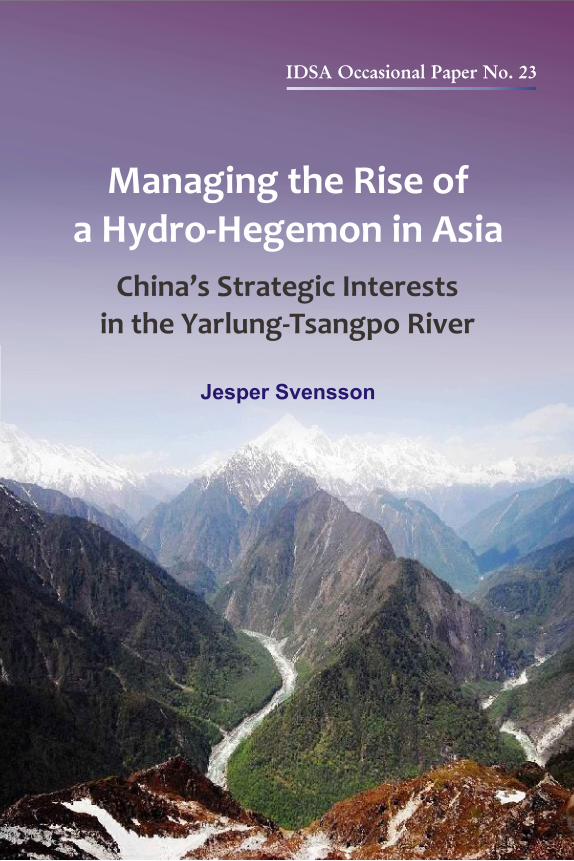
Water security has become one of the greatest challenges of Asia inthe 21st century.1 Today, water problems in Asia are severe – oneout of five persons (700 million) does not have access to safe drinkingwater and half of the region’s population (1.8 billion) lacks access tobasic sanitation.2 In the light of increasing scarcity of clean water andits rising demand, India and China sit at the headwaters of several ofAsia´s most important rivers. Although India has entered into watersharing treaties with Pakistan, Nepal and Bangladesh with whom itshares important trans-boundary river systems, it doesn´t have onewith China which is the source country of the Yangtze, Mekong,Yarlung-Tsangpo, Indus, Irrawaddy, Sutlej and the Salween River,thereby exercising a degree of hydro-hegemony.3 In recent years,
6 | Jesper Svensson
4 The Yarlung-Tsangpo originates in the Jima Yangzong glacier near MountKailash in Tibet and flows 1,625 km before it enters into Arunachal Pradeshin India as Siang. The Siang is named the Brahmaputra (918 km) in Assamafter the confluence of the Dibang and Luhit before it flows south throughBangladesh (337 km) as the Jamuna. There it merges with the Ganges andthen splits into two, the Padma and the Meghna to form a vast delta. So farChina and India have not yet signed any agreement on distribution ofwater resources. However, in 2002 the two sides agreed to set up anarrangement about sharing flood season data on the Brahmaputra with anew memorandum in 2002, 2005 and 2008-2012. Since 2006 the two sideshave also set up an expert-level mechanism to cooperate on flood-seasondata and emergency management.
5 Ma Jun,, (2009), “Pollution and Scarcity: In perilous waters”, China EconomicQuarterly, pp.21.
many in India have warned that China use its upstream position toreroute the Yarlung-Tsangpo4. Although there are successful water-sharing arrangements in Asia, the cooperative management ofinternational water basins are often hard to achieve due to powerasymmetries. Grounded in the theoretical framework of hydro-hegemony, this paper examines the status of the Chinese projects todivert water from Yarlung-Tsangpo with the aim of suggesting policyimplications for India. To further understand the role that powerasymmetry plays in international water-relations and the strategiesof downstream riparians to promote cooperation, the guidingquestions of this analysis are: What is China´s general performanceas a hydro-hegemon in Asia? What is China´s hydrobehaviour in theYarlung-Tsangpo river?
Water in China: The Internal Dimension
Water challenges are not a new phenomenon in China. For 2,000years the country´s rulers sought to quell the destructive power ofsummer floods, while historians link drought with the demise ofseveral dynasties.5 But as China’s thirsty economy is stretching the
Managing the Rise of a Hydro-Hegemon in Asia | 7
6 Chen Gang,, (2009), “Politics of China’s Environmental Protection: Problemsand Progress”, World Scientific Publishing CO: Singapore, pp.7.
7 In 1980, only 0.667 kg was produced per ton of water. By 2007, it had risento 1.393 kg/ton, an average annual rate of 2.67 per cent. The main reasonit was possible to produce more grain with less water was the rapidimprovement in irrigation water productivity. For details see Lin, Shijun.,(2010), “Will China´s water shortage shake the worlds food security?”, WaterInternational, Vol. 35, No. 1, pp. 6-17.
Northern China Plain (which accounts for over half of China’sproduction of wheat) to its limits, water is today becoming astumbling block to the red giant´s aspiration for prosperity. Thestatistics of China speak for itself. Two-thirds of China´s 669 citiessuffer from water shortage and over 300 million lack access to cleandrinking water6, a grim picture that has been painted as “whereverthere is a river, there is no water; wherever there is water; it is heavilypolluted”. Although use of water for industries has decreased andChina has maintained an increase in grain output despite irrigationwater decreasing over the last 30 years7, energy sectors water thirstcontinues to soar unquenchably. Driven by its thirst for energy tosustain its juggernaut growth, Beijing is facing a confrontation betweenwater scarcity and rising energy demand. Being the largest industrialwater consumer with 120 billion cubic meters a year, China´s coalmining and processing, and electric generating industries account fora fifth of the national water consumption. By 2020, China´s growingdependence on coal for primary energy is projected to grow by anadditional billion metric tons annually, representing a 30 per centincrease. This will create a geographical headache for the government:while the coal reserves are concentrated in the dry northern provincesof Gansu, Ningxia, Shaanxi, Shanxi, Xinjiang and Inner Mongolia,the water to develop them is in the south. Since the western line isthe only one, of the three routes of the South-North Water Transfer

8 | Jesper Svensson
8 The $62 billion South-North Water Transfer Project was launched in 2002and is the largest water transfer system in the world. The Eastern Routediverts water from the lower reach of the Yangtze river to the north, whilethe Central Route mainly serves domestic and industrial water uses inBeijing, Tianjin and some cities in Hebei, Henan and Hubei provinces.The Western Route, which is in the planning stage, diverts water from theupper reach tributaries of the Yangtze River to the upper reach of theYellow river. The Eastern Route was set to be finished around 2007 butwill be completed only by 2013 while the Central route, originallyscheduled for 2010, has been delayed to 2014. The whole project isenvisioned to be completed in 2050 with a total diversion capacity of 45billion m3 through the three routes. Correspondence with Chinese waterexpert at CAS, Mar 27, 2011. Also: Yang, Hong., (2005), “SNWTP in China”,Water International, Vol. 30, Number 3, pp.339-349.
9 Circle of Blue., (February 15, 2011), “Choke Point: China – ConfrontingWater scarcity and Energy demand in the Worlds largest country”, http://www.circleofblue.org/waternews/2011/world/choke-point-china—confronting-water-scarcity-and-energy-demand-in-the-world’s-largest-country/.
10 Correspondence with Chinese water expert at the Chinese Academics ofSciences, Mar 27, 2011.
Project (SNWTP) (nanshui beidiao gongcheng)8, that will deliver waterdirectly to the dry Yellow river to feed the thirsty energy-richnorthern and western provinces, it gives the unproven western transferscheme more momentum for approval (see Map 1).9 AlthoughSNWTP will ease the imbalance between supply and demand of waterresources in the Northern China Plain, water resources per capitawill still be at the lowest level at about 300 m3/person in China nomatter how SNWTP goes.10
China as a Hydro-Hegemon in Asia
Positive or negative forms of hegemony?
While the impacts of the Three Gorges Dam and the SNWTP willbe borne by the country itself, China´s ambitions to exploit theresources of the rivers that emanate from the Himalayas will imply

Managing the Rise of a Hydro-Hegemon in Asia | 9
11 H.H. Lai, (2002), “China’s Western Development Program: Its Rationale,Implementation, and Prospects”, Modern China, Vol. 28, No. 4, pp.432-66.
12 In 2007, the installed capacity was 145.26 GW. The technically exploitableinstalled capacity has been determined as 542 GW, while economicallyexploitable ones as 402 GW. For more detail, see: National Developmentand Reform Commission, the People´s Republic of China, (2008), “TheEleventh Five-year Plan of Renewable Energy Source Development”, Beijing,China.
externalities for her neighbours. China´s water policy was spelledout in the Western China Development Strategy, otherwise knownas “Opening Up the West”. As per this, water, minerals and energyare part of the Chinese government´s plan to develop the autonomousregions of Xinjiang, Tibet, Ningxia, Guangxi, Inner Mongolia; theprovinces of Qinghai, Gansu, Shaanxi, Sichuan, Yunnan andGuizhou; and the municipality of Chongqing through an extensiveeconomic programme.11 Having the richest hydro-resources on theplanet with a total theoretical hydropower potential of 694 GW,developing hydropower is of great importance to energyindependence and to develop the landlocked western provinces.China´s southwest has 59 per cent of the hydropower resources inthe country and electricity transfer schemes are trumpeted as key torelieving eastern electricial shortages in Guangdong, Shanghai andBeijing. According to China´s Hydropower Development Plan for2005-2020, 13 bases have been identified: the Northeast, Yellow Rivermain (north), Yellow River Up reaches, Daduhe River, YalongjiangRiver, Yangtze River Up reaches, Jinshajiang River, Nujiang (Salween)River, Wujiang River, West Hunan, Fujian, Zhejiang and Jiangxi,and the Lancangjiang (Mekong) River. Up by 2020, the installedcapacity of hydropower will aim to reach 300 GW, 275 GW of whichwill be from these hydropower bases.12 However, its ambition hasgrown stronger. According to the new Twelfth Five-year plan, Chinahas given priority to developing the following five bases: theJinshajiang River (59 GW), the Yalongjiang River (25 GW), Daduhe
10 | Jesper Svensson
13 “China announces ambitious clean energy plans for the next 5 years”, XinhuaNews, (March 5, 2011), http://news.xinhuanet.com/english2010/china/2011-03/05/c_13762067.htm.
14 Correspondence with an independent Chinese geologist who has studiedthe Himalayan Rivers, Apr 28, 2011.Also see: China daily.,”Nujiang hydroproject back on agenda”, (Feb 1, 2011), http://www.chinadaily.com.cn/china/2011-02/01/content_11949587.htm.
15 Xinhua News, (April 27, 2011), “Huadian Group to build four 10-mIn-kwhydropower bases in 2011-15”, http://www.istockanalyst.com/business/news/5090705/huadian-group-to-build-four-10-mln-kw-hydropower-bases-in-2011-15.
16 See: Darrin Magee, et al, (2008), “Hydropower and sustainability: Resilienceand vulnerability in China’s powersheds”. Journal of EnvironmentalManagement, pp.1-8.
River (24.5 GW)13, the Lancangjiang (Mekong) River (25.6 GW), theNujiang (Salween)River (21.4 GW) and the Yarlung-Tsangpo River(79 GW) in order to meet its target of producing 15 per cent of thenation’s energy with renewable sources by 2020.14 In the realm ofdam-building, the China Huadian Group, an important actor inhydropower development, is planning to build four 10 GWhydropower bases in upstream and midstream of Jinshajiang River,Wujiang River and Nujiang River between 2011-2015 as part of alarger cascade to reach an installed capacity of 330 GW by 2020.15
Additionally, China´s four other electric power behemoths namely,China Guodian Corporation, China Huaneng Group, China PowerInvestment Corporation and China Datang Corporation, haveimportant access to decision makers in the Energy Bureau of theNational Development and Reform Commission, which hasconsiderable influence in large-scale hydropower decisions.16
While hydropower has become the centerpiece of the ’Open Up theWest Campaign’ (Xibu Da Kaifa) and the ’Send Western ElectricityEast Campaign’ (Xi Dian Dong Song), a third component can beadded: to use Yunnan´s position in the Salween, Mekong and Jinsharivers to get access to Southeast Asia´s electricity export market. But
Managing the Rise of a Hydro-Hegemon in Asia | 11
17 For details on China’s performance in Mekong Basin, see OliverHensengerth, (2009), “Money and Security: Chinas Strategic Interests in theMekong River Basin”, briefing paper Asia Programme, ChathamHouse:London, pp.2-11.
18 The Economist, ( October 4, 2011), “Myanmar´s surprising government:Dammed if they don’t”, http://www.economist.com/node/21531278.
19 State Council of the People´s Republic of China, “Chinas National Defensein 2006, White paper”, Beijing, China. http://www.china.org.cn/english/features/book/194421.htm.
China´s overriding interest in developing eight dams on the MekongRiver Basin irrespective of Cambodia´s and Vietnam´s preferenceshave provoked concern that once all Chinese dams are in place, theywill disrupt the flow of the river and adversely affect fisheries andagriculture for downstream countries.17 Another case in point is thegiant 3,200 megawatt Myitsone Dam along the Irrawaddy river,Burma´s most important waterway, that has triggered ethnicinsurgency. Burma´s decision to suspend one of seven Chinese-builtdams planned on the Irrawaddy is a reputational crisis for the Chinesegovernment and gives more ammunition to environmentalists arguingagainst aggressive plans for large-scale hydropower plants.18 In addition,Beijing´s move to build 13 dams on the middle and lower reaches ofthe Salween river, further stimulates anxieties of China´s dominanceover the hydrological contours of South Asia as downstream states,Burma and Thailand don´t possess the means to directly andphysically influence the flow. Clearly, the Chinese leadership seesthe Mekong and Salween rivers not simply as part of its strategy tobreak out of the downward fossil-fuel spiral, but rather through thebroader prism of its economic and hence political stability. This isfurther highlighted by the fact that China’s 2006 White paper onnational defence explained that the People´s Armed Police Force(PAPF) had taken part in the construction of 21 key national projects,including the Qinghai-Tibet railway, the SNWTP and majorhydropower projects.19
12 | Jesper Svensson
20 India did not do it a great favour by abstaining from voting. See, StephenC. McCaffrey & Mpanzi Sinjela, (1998), “The 1997 United NationsConvention on International Watercourses”, American Journal ofInternational Law 92, no. 1, pp.97-107.
21 For details on China’s performance in Salween Basin, see Aaron Wolf,(2008), “Case Study of Transboundary dispute resolution: Salween River”,www.transboundarywaters.orst.edu/research/case_studies/Documents/salween.pdf.
More importantly, downstream states like Egypt in the Nile basin,often have the potential to influence “weaker” upstream states andupend the traditional upstream-downstream power dynamic. But incontrast to Egypt in the Nile Basin, China´s geographical position asthe source country of many rivers provides it with an additionaladvantage. Not only is it Asia’s strongest economic, political andmilitary power, but this power graph is reinforced by its hydro-hegemony. This upstream-downstream relationship (China vs South& Southeast Asia) makes interstate cooperation particularlycomplicated because incentives to cooperate are not uniform betweenriparians. In that light, China has given priority to geopolitical interestsover ideology. When the resolution containing the “Convention onthe Law of the Non-Navigational Use of International Watercourses”came before the General Assembly for adoption on May 21, 1997,China was one of the three countries who rejected the idea of nationalintegrity, instead claiming indisputable sovereignty over a watercoursewhich flows through its territory.20 A similar Sino-centric attitudetowards international cooperation can be seen from the fact that Chinahas rejected all entreaties to join as a full member of the MekongRiver Commission (MRC) for managing water-disputes, and has stuckto its strategy to develop hydropower from the Mekong and Salweenunilaterally without consulting other nations.21 However, it needs tobe borne in mind that China is willing to embrace multilateralismwhenever the leadership in Beijing feels that unilateral actions and
Managing the Rise of a Hydro-Hegemon in Asia | 13
22 Hensengerth, (2009).23 For details see David Shambaugh., (2005), “China Engages Asia Reshaping
the Regional Order”, International Security, Volume 29, Number 3, pp. 64-99.24 For a broader perspective on China´s strategy in Tibet see, Thierry
Malthou,, (2005), “Tibet and Its Neighbors: Moving Toward a New ChineseStrategy in The Himalayan Region”, Asian Survey, Vol. 45, No. 4, pp.503-521.
bilateral relations are not sufficient to secure its national interests.Despite its rejection to join the MRC and its denial of permissionfor hydroelectric dams on the Mekong and Salween rivers, Chinahas turned to the Mekong region to build cooperation mechanismsover other issues; from fighting transnational crime to theconstruction of cross border infrastructure.22 China´s expandedengagement with ASEAN and the SCO also reflects an increasedimportance of cooperative security and conflict management amongChina, ASEAN and the SCO states.23
Following China´s performance in the UN-led process onInternational Watercourses, its rejection to join the MRC and itsunilateral move to harness the power of the Mekong and Salweenrivers, as well as its willingness to emphasise multilateralism onlywhen it coincides with its own national interests, it can obviously beconcluded that China seeks to attain and consolidate maximum controlof water resources, thereby exercising a negative/dominating formof hydro-hegemony.
China’s strategic interests in the Yarlung-Tsangpo River
Until recently, China´s strategy in the Himalayan region wasexclusively focused on power relations with India and a defensiveapproach to the Tibet issue. With major plans like the Western ChinaDevelopment strategy (Xibu Da Kaifa) and the West-East ElectricityTransfer Project (Xi Dian Dong Song) , the PRC aims to positionTibet as a trading hub in the Himalayan region.24 Under the ’Opening
14 | Jesper Svensson
25 China Dialogue, (January 17, 2011), “A New Era for Tibet´s Rivers”, http://www.chinadialogue.net/article/show/single/en/4055-A-new-era-for-Tibet-s-rivers.
26 Malthou, (2005), p.509.27 China Dialogue, (January 17, 2011).28 A project is RoR only if inflow equals outflow on a real-time basis, if there
is no storage or flow modification at all.
up the West’ campaign, the extraction of Tibet´s natural resourcesare supposed to fuel the economic engines of eastern China, which inturn will pull “backward” Tibet forward. Hailed as Xizang, the placeof western treasure, the Tibet Autonomous Region´s untapped waterresources remains an important objective for Chinese authorities topromote economic integration and stability. It is in this context thatChina´s hydro-behaviour in Yarlung-Tsangpo River must be seen.
Moving westward into the Tibetan hinterland, China has increasinglystressed the need to build hydroelectric programmes in the TAR.Currently less than 0.6 per cent of Tibet´s hydropower resourceshave been developed25 in a region which produces approximately 200GW of natural hydro energy annually which is about 30 per cent ofChina´s total.26 The entire Yarlung-Tsangpo River Basin was foundto have hydropower potential of 114 GW, 79 GW of which was onthe main river.27 China´s main hydro-project has been the constructionof the 510 MW Zangmu Hydropower Station, while four otherprojects, Lengda, Zhongda, Langzhen and Jiacha have begunpreparations on the middle reaches of the Yarlung-Tsangpo (seeannex). Even though China from its side argues that the projects areRun-of-the-River projects28 and that they have taken full considerationof the impact on the downstream area, every intervention in a riverdoes have downstream consequences and could lead to disruption in
Managing the Rise of a Hydro-Hegemon in Asia | 15
29 Even if total quantity of flow remains the same downstream, everyintervention in a river has consequences to the river flow, sedimenttransportation, how much pollution it can take and the cleaning capacityof the river. Interview with Professor Ramaswamy R. Iyer at Centre forPolicy Research, Delhi, Mar 24, 2011.
30 Peoples Daily, (November 15, 2010), “Tibet to build first large hydropowerstation”, http://english.people.com.cn/90001/90778/90860/7200115.html.
31 Peoples Daily, (March 28, 2011), “Tibet to double investment in waterinfrastructure”, http://english.peopledaily.com.cn/90001/98649/7333367.html.
natural flow patterns29 . Worringly, the People’s Daily said the Zangmuproject can also be used for flood control and irrigation, whichindicates it needs to store or divert water.30 Moreover, on March 28,2011, the People’s Daily reported that the People’s Government ofTibet Autonomous Region had released the “Opinions on AcceleratingTibet´s Water Infrastructure Reforms and Development” which saidthat Tibet will undergo a series of large water infrastructure projectsalong several major rivers in order to increase water supply capacityby 700 million m3 and enable all rural towns and townships to haveaccess to hydroelectric power. The same report claimed that the“Opinions on Accelerating Tibet’s Water Infrastructure Reforms andDevelopment” required Tibet to establish a relatively sound floodcontrol system under which major towns and infrastructure cansurvive the worst floods in 30, 50 or 100 years – combined withsupporting water conservation projects for expansion of key largeand medium-sized irrigated areas by 2020.31
While these projects are likely to have transboundary impacts, Indiais more concerned that China will use its dominant upstream positionto build a gigantic dam on the Great Bend of the Yarlung-Tsangpo/Brahmaputra. Tapping the hydroelectric potential of the Great Bendas she bends and plunges from the Third Pole down towards India
16 | Jesper Svensson
32 B.G.Verghese,, (2001), “Reorienting India: The New Geo-Politics of Asia”,New Delhi: Konark Publishers Pvt Ltd, pp. 161-162.
33 Ramaswamy R. Iyer, (2008), “India´s Water Relations With Her Neighbours”,a tour d´horizon survey published in Knowledge World Publishers PvtLtd, National Security studies, pp.198.
and Bangladesh, the Tsangpo would generate 38 GW, which is doublethe capacity of the Three Gorges Dam. Initial plans were developedby a Japanese firm in the late eighties, followed by an alternativeconstruction proposal made by Richard Brook Cathcart in 1999.Cathcart proposed to build a low-rise inflatable dam in place of ahigh concrete or rock-fill gravity dam at a key site on the Yarlung-Tsangpo/Brahmaputra southeast of Namche Barwa within Tibet.What was proposed was that a 10 metre-high nylon-reinforced rubberbladder filled with either air or water be “securely anchored in arock-locked steel-reinforced base-plate”. This would create a shallowreservoir behind the barrier below, from which the river flow couldbe diverted to the head gate of the pressure tunnel at appropriatetimes without building up any huge weight of impoundment thatcould cause a seismic or rock-slide hazard.32 Indian scholars fromtheir side stressed that if China decides to avoid large dams altogetherand take full advantage of the 2,500 metre drop, it would leave theflow intact. According to Ramaswamy R. Iyer, Professor at Centrefor Policy Research in New Delhi, any hydro-electric power projectat the point of the Great Bend may have horrendous ecologicalconsequences; but if the waters are returned to the river after theypass through the turbines, it may not affect the flow to India andBangladesh. But that is clearly not the case with a storage projectbecause that would reduce the flow correspondingly and thereforebe a matter of concern to downstream riparians.33
Managing the Rise of a Hydro-Hegemon in Asia | 17
34 Tibetanplateau.blogspot.com has uploaded several Chinese sources whohave discussed the Motuo project. For detail see: http://www.chinatibetnews.com/dili/2008-06/20/content_339502.htm, http://online.hhu.edu.cn/jpkc/sgjianzhuxue/webclass0101.htm, http://b l o g . s c i e n c e n e t . c n / h o m e . p h p ? m o d = s p a c e & u i d = 2 9 5 8 2 6&do=blog&id=249662.
35 Correspondence with Chinese water experts at the Chinese Academicsof Sciences, Mar 27, 2011.
36 Correspondence with an independent Chinese geologist who has studiedthe Himalayan Rivers, Apr 28, 2011
37 Malthou, (2005), p.519.
Indeed, even if Beijing has not yet given the go-ahead for a 38 GWdam, there is plenty of evidence that the Motuo dam is under activeconsideration.34 As stated by a scholar at Chinas Academics of Sciences:
“Precious natural resources should be utilised for promoting thewellbeing of people. So if required conditions meet, China shouldplan to harness the hydroelectric potential of the Great Bend.”35
Four of China´s state owned electric power companies have signedcontracts with the TAR government to develop hydropower in theLancangjiang, Nujiang and Yarlung-Tsangpo Rivers to spur economicdevelopment and to gain access to South and Southeast Asia’s electricitymarkets, mainly in Nepal and Burma.36 Efforts to develop hydropowerin these rivers can best be understood in the context of its growingtransportation capabilities in South and Southeast Asia. The “threevertical and two horizontal links”, namely the China-Nepal, Qinghai-Tibet, Xinjiang-Tibet, Tibet-Sichuan, and the Tibet-Yunnan highwaysare supposed to link Tibet’s economy to South Asia.37 China´s hydro-diplomacy is a natural extension of that two-step strategy. On theone hand, developing hydropower resources helps Beijing to reducethe income gap between China´s eastern provinces and its westernregions, which strengthens both, national economic integration andpolitical stability. On the other hand, selling electricity to its
18 | Jesper Svensson
38 ChinaTibetOnline, (March 07, 2011), “Three drivers of Tibets future economicdevelopment”, http://chinatibet.people.com.cn/96057/7310155.html.
39 ChinaTibetOnline, (December 13, 2010), “Motuo: Dream of connecting tooutside world to come true”, http://chinatibet.people.com.cn/7229128.html.
neighbours promotes cross-border integration, which benefits theWestern China Development programme. A glimpse of Tibet´sstrategic relevance was spelled out in China´s state-run online magazineChinaTibet in 2011 that stressed the need for state-strengtheningprojects like the Zangmu HPP and the Qinghai-Tibet Power GridInterconnection project. The article highlighted three drivers ofTibet´s future economic development: state investment, developmentof distinctive industry and more efforts in building up the continentaltrade route to South Asia which would bring more opportunitiesfor Tibet.38 In addition to these goals, hydropower development servesalso as a locomotive for mining in order to create the conditions fortransforming Tibet into a “strategic resources reserve base”. Apartfrom improved transport links, energy is a key for tapping significantreserves of uranium, chromite, borax, lithium, copper, zinc and ironin the TAR.
China has made headway in harnessing the hydroelectric potential ofthe Great Bend at Motuo in the lower reaches of the Yarlung-Tsangpo/Brahmaputra River. Preliminary work on building the 38GW dam has already started with the construction of the MotuoHighway. From the Grand Yalungzangpo Gorge, the 117 km longhighway crosses six rivers and various tunnels before it connects theTibetan hinterland to mainland China.39 With the construction ofQinghai-Tibet Railway and Motuo Highway, China has thus beenable to put the infrastructure in place that is needed to tap the powerof the river and to gain access to its neighbour’s electricity exportmarkets. In addition to roads and railways, China will most likely

Managing the Rise of a Hydro-Hegemon in Asia | 19
40 See: http://www.hydrochina.com.cn/zgsd/images/ziyuan_b.gif.(Accessed on May 18, 2011).
41 Ibid, The names of the dams are in Tibetan and has been taken fromTibetanplateau.blogspot.com.
42 Correspondence with an independent Chinese geologist who has studiedthe Himalayan Rivers,April 28, 2011.
need to build nearby dams and ultra-high voltage power transmissionlines to provide a basis for the construction of Motuo dam. Accordingto a map of planned dams put up on the state-run Hydro ChinaCorporation´s website, a 38 GW dam at Motuo is planned withother large infrastructure-based hydro projects set to majorly alterthe riverscape.40 Considering the distribution of hydropowerresources, China has proposed nine hydropower projects in its twomajor tributaries, the Yiwong-Tsangpo and the Parlung-Tsangpo.These are: Sangba (480 MW), Lhari (340 MW), Nyewo (300 MW),Drakke (632 MW), Yiwong (640 MW), Sothang (840 MW), Pome(580 MW), Sumdzom (320 MW) and the Palong (2760 MW).41
Hydropower generated by these smaller dams is likely to be utilisedto meet power needs and to run the construction of the Motuo dam.According to a geologist who has studied the Yarlung-Tsangpo River,the 38 GW dam is not primarily designed to generate electrical powerfor Tibet because there is no electrical load in the south-eastern partof Tibet. It is designed as a key component to fuel the eastern economicpowerhouse of China as well as for sending hydroelectricity to SouthAsia.42
The Great Bend of the Yarlung-Tsangpo/Brahmaputra River has alsobeen proposed as the starting point of launching the major waterdiversion project named the “Great Western Route” (see Map 2).Red nationalists like Guo Kai and Li ling – authors of the bookSaving China Through Water From Tibet (Xizang zhi shui jiu Zhongguo)– have argued for funnelling water away from Yarlung-Tsangpo into
20 | Jesper Svensson
43 Peoples Daily., (November 18, 2010), “Hydro-power dam in Tibet stirsdebate”, http://english.people.com.cn/90001/90776/90882/7203018.html.
a reservoir at the Laija Gorge in Maqin County, Qinghai Province.From Laija Gorge the water would be transportered to the Yellowriver and be connected to the Qinghai Lake and then channelled tothe freshwater Erhai Lake. From there Guo Kai has proposed theconstruction of three watercourses. The first one would link up withthe Gaxan Nur in Inner Mongolia to the north. The second onewould arc out to the northwest, supplying the cities of Urumqi andKaramay while the final one would head west to the Tarim Basinwith the goal of irrigating the desert. Damming the Yarlung-Tsangpo/Brahmaputra at the Great Bend near the Shuomatan point wouldbenefit the entire project – named the Shuotian canal project (Shuotianyunhe fangan) – by channelling a total of 200 billion m3 of waterannually and linking up with the central and eastern routes of Southto North Water Transfer Project. Although there has been no officialconfirmation that the construction of the “Great Western Route”will go ahead, it continues to be a debated option to solve China’semerging water crisis. Building difficult projects in difficult locationswhere it is also expensive has not discouraged Chinese technocratsfrom planning to build them. Ding Yifan, a researcher with theDevelopment Research Center of the State Council, told the GlobalTimes that the pros of building the dam outweigh the cons ashydropower is the cleanest energy and will help reduce carbonemissions. “Any mega-projects in China are likely to arousecontroversy. Most projects proceed as planned and prove beneficial inthe long run.”43 But the “Great Western Route” has also been criticised.
In 2000, the Minister of Water Resources and supporter of the ThreeGorges Dam Project – Qian Zhengying – told the State Council thatin the near future, there would be no feasibility, technical or
Managing the Rise of a Hydro-Hegemon in Asia | 21
44 Southern Weekend, (August 8, 2006).45 Xinhua News., (May 25, 2009), “Ex water chief: China won´t divert world´s
highest river to thirsty north”, http://news.xinhuanet.com/english/2009-05/25/content_11433586.htm.
46 Correspondence with Chinese water expert at Chinese Academics ofSciences, March 27,2011..
47 Correspondence with an independent Chinese geologist who has studiedthe Himalayan Rivers,April 28, 2011.
economical for the “Great Western Route” scheme.44 On May 25,2009, the former Minister of Water Resources – Wang Shucheng –told the Xinhua News that China´s has no intention of including theYarlung-Tsangpo River in the western route of SNWTP and calledthe Great Western Route “unnecessary, infeasible and unscientific.”45
A water expert at CAS who studied the Yarlung-Tsangpo River in2008 has also echoed this concern:
“Firstly, China use very less water now and will use less in thefuture, less than 2 % of the total water resource generated inChina within the catchment. Secondly, it’s not possible forChina to divert water from the Tsangbo River to NorthwestChina. Economically, it´s not feasible. It´s too difficult to divertbig quantity of water in that high mountain area with evidentnew tectonic movements and frequent threats of earthquakes.”46
Furthermore, the idea of launching large water division projects isdismissed by a Chinese geologist who completed a survey of theHimalayan rivers in 2010. He explained that:
“the proposal only exists in civil discussions, and it´s not feasibleeither by technology or by economic senses. It is not includedin government plans, so I cannot see the future for it now.”47
However, China´s preliminary work on building the world´s biggestdam at the Great Bend raises the possibility of using the Great Bend
22 | Jesper Svensson
48 The Guardian, ( May 24, 2010), “Chinese engineers propose world´s biggesthydro-electric project in Tibet”, http://www.guardian.co.uk/environment/2010/may/24/chinese-hydroengineers-propose-tibet-dam.
49 Interview with B.G. Verghese at Centre for Policy Research, New Delhi,Dec 20, 2010.
50 Correspondence with Chinese water expert at Chinese Academics ofSciences,March 27, 2011.
as a source of pumping power for moving water North. But theseintentions are dismissed by Tashi Tsering, a Tibetan environmentalist,who argues that the dam at Motuo would be for hydropower, notwater diversion. “The law of physics will not allow water diversionfrom the Great Bend.”48 Indeed, technical costs may be the real obstacleof any diversion scheme. According to Tsering, a dam at Mouto (850altitude) would involve the construction of a series of tunnels, pipesand reservoirs to exploit the 2,000 m fall of the river, but a waterdiversion that must be transferred over corrugated mountains wouldhave lost 2000 m of height. This was confirmed by B. G. Verghese,Professor at Centre for Policy Research in New Delhi:
“A structure to divert the Yarlung-Tsangpo/Brahmaputra wouldrely on power generated by a hydro powerplant on the GreatBend to pump the water over the Namcha Barwa Mountains.But when you generate a lot of power of the drop in the GreatBend you would be using more power to pump it up again,which would be very foolish.”49
Thus, China´s strategic interest in the Yarlung-Tsangpo/BrahmaputraRiver is hydropower development, not pumping water. Moreover,Tsering argued that a major issue for water diversion is the climate ofthe Tibetan Plateau, where it is below freezing point during wintersand early spring when water demand is highest in the Northern ChinaPlain, but Chinese scholars in their turn argued that most of themain stream of the Yarlung-Tsangpo is not frozen in the winter.50
Managing the Rise of a Hydro-Hegemon in Asia | 23
51 Science & Technology, (June 8, 2011), “China to Consider Diverting theBrahmaputra River”, http://www.2point6billion.com/news/2011/06/08/china-to-consider-diverting-the-brahmaputra-river-9430.html.
52 Ibid.,
Although the “Great Western Route” near the Great Bend has beenfound scientifically unfeasible, it hasn´t deterred red nationalists likeLi Ling who has moved his grandiose project further upstream ofYarlung-Tsangpo. Faced with severe drought in the middle and lowerreaches of the Yangtze river in 2011, engineers have newly proposedthat China go beyond diverting three tributaries of the Yangtze –Tongtianhe (Qinghai), Yalongjiang (Sichuan) and Daduhe (Sichuan)rivers by also diverting water from the upper reaches of the Yarlung-Tsangpo/Brahmaputra to send water northward.51 In his book SavingChina Through Water From Tibet (Xizang zhi shui jiu Zhongguo) from2005, Li ling proposed that the waters of the Yarlung-Tsangpo/Brahmaputra be captured by a dam at Suma Tan, the gorge belowTsethang town to transfer water 1,239 kilometers across mountainsas well as gorges of the Gyalmo Ngulchu (Salween), Zachu (Mekong)and Drichu (Yangtze). A recent report by Xinhua News Agency saysChinese experts have raised a new proposal to divert water from theupper reaches of the river, from where China can reroute the waterto Xinjiang along the Qinghai-Tibet Railway and the Hexi Corridors– part of the Northern Silk Road located in Gansu Province.52 Anadvantage in damming this location further upstream of Yarlung-Tsangpo/Brahmaputra is that it has an altitude of 3, 600 metres abovesea level, thereby reducing the need for pumping uphill. Even if thenewly proposed route is stirred up by the drought in the YangtzeRiver, the economic costs and benefits may hamper its plannedfunction due to engineering and technical difficulties in the highelevation of the Qinghai-Tibet plateau. For instance, if the price ofthe transferred water is extremely high while the ability to pay for it

24 | Jesper Svensson
53 Correspondence with Chinese water expert at Chinese Academics ofSciences, 2011/03/27.
54 Iyer, Ramaswamy.R., (2008).55 China Daily, (November 22, 2006), “Dam proposal rubbished by critics”,
http://www.chinadaily.com.cn/china/2006-11/22/content_739379.htm.
by the water users is relatively low, intended recipients of the watertransfers will look for substitutes. A leading water scholar at theCAS declared that:
“…the far west routes will not be feasible, mainly because thehigh cost of water diversion compared with what can producedby the diverted water. It would be more cost-effective to investin alternatives.”53
However, if operating costs are low and Beijing has decided that thenational interest demands diversion of Yarlung-Tsangpo/Brahmaputra, then the authorities are unlikely to rank internationallaw or lower-riparian concerns high up on their agenda. What maydeter them, however, would be political considerations; if they feelthat good relations with India and Bangladesh are desirable for politicalreasons, then they may indeed take their concerns into account andtry not to upset them.54 Qin Hui, a professor in the School ofHumanities and Social Sciences of Tsinghua University, raised thisconcern in the Economic Observer:
“Without international co-operation it is impossible to launchany major water project for an international river like this.”55
At the same time, the SNWTP lays the foundation on which therationality of diverting Yarlung-Tsangpo/Brahmaputra can be judged.The rationality of quenching the dragon´s thirst with a giant watertransport scheme has also raised a fundamental question: What if theSNWTP does not operate as planned?
Managing the Rise of a Hydro-Hegemon in Asia | 25
56 Circle of Blue, (March 1, 2011), “Choke Point: China – A Dry and AnxiousNorth Awaits China´s Giant, Unproven Water Transport Scheme”, http://www.circleofblue.org/waternews/2011/world/a-dry-and-anxious-north-awaits-chinas-giant-unproven-water-transport-scheme/.
57 Hong Yang,, (2005), p.346-347.
All three legs of the South-to-North water project have problems.The eastern route, with the existing Grand Canal, was supposed tostart withdrawing about 14.8 billion m3 of water from the lowerreaches of the Yangtze River, and pump the water 65 m high anddeliver it 1150 km northward by artifical channels to the easternNorth China Plain in 2007. But the eastern leg of the SNWTP hasnot been as easy as planned and the completion time is delayed to2013. Delivering polluted water northward through water treatmentplans is so expensive that Tianjin and other cities prefer to builddesalination plants. Additionally, pumping water 65 m high makesthe delivery cost high compared to other water resource options. Asstated by Zou Ji, a professor at the Renmin University in Beijing:
“The unit water cost of desalination is actually cheaper thanthat of the South-to-North Water Diversion Project.”56
The longer middle route was originally planned for completion by2010, but has been delayed by four years because of environmentaland cost concerns. Even if both routes will be completed as planned,the big outstanding problem of the diversion schemes will be costrecovery. If the water price is set too low, not only will the governmenthave to cough up the cash for the diversion, but also the transferredwater will go a waste and little water would be left for the ecosystems.On the other hand, pricing it too high would oppress water demands,forcing urban users and industrial enterprises to use cheaperalternatives such as water conservation and seawater desalinationplants.57 Under such circumstances the government will be unable to
26 | Jesper Svensson
58 Southern Weekend., (August 8 , 2006).59 Correspondence with Chinese water expert at Chinese Academics of
Sciences,March 27, 2011.60 Correspondence with an independent Chinese geologist who has studied
the Himalayan Rivers,April 28, 2011.
recover the mammoth engineering investments; the largest watertransfer proejct in the world could become a “sunshine” project. Itmust be noted that cost recovery may be the real problem if Chinagoes ahead with major water diversion projects in the Yarlung-Tsangpo. Coming at an estimated cost of 125 billion US dollars58, theoperating costs of the “Great Western Route” might be so high thatthe project will be unable to provide water at costs lower than otheralternatives, including water conservation and seawater desalinationfacilities. Experience of the central and eastern routes of the SNWTPshows it can be tough to persuade the intended sectors to purchasediversion water, especially when the “Great Western Route” coststwice as much as the entire SNWTP. Now we come to the crux ofthe problem: what happens if a wet season comes?
According to one of the leading water experts at CAS, the dry periodof the North China plain which has been more than 28 years since1980 will end and the wet season will be back soon. Since the receivingareas are under the semi-humid monsoon climate zone, there wouldbe little need for water transfer in the wet years, thereby pushing theprice of transferred water up while users would look for demandmanagement alternatives.59 The delays that the SNWTP in China hasalready seen in the eastern and central routes mean that any timelinefor western diversions will also be pushed back. In the new 12thFive-Year Plan, China will accelerate the construction of the east lineand the middle line of the SNWTP as well as the supporting facilities.Itwill ensure project quality and develop preliminary research on thewestern line.60 This is also confirmed by another Chinese scholar:
Managing the Rise of a Hydro-Hegemon in Asia | 27
61 Correspondence with Chinese water expert at Chinese Academics ofSciences,March 27, 2011. Also see: Peoples Daily, (May 28, 2010), “Chinaaccelerates south-north water project”, http://english.peopledaily.com.cn/90001/90776/90882/7004377.html.
62 Chansheng He et al., (2010), “China´s South-to-North Water Transfer Project:Is it Needed?”, Geography Compass, pp.1312-1323.
“China is now focusing on finishing the East and Middle Routesof SNWTP. The East Route will be finished in 2013, whilethe Middle Route in 2014. And then, the West Route will beput on the schedule. Although the cost is high, it may benecessary for feeding the thirsty Northwest and North China.”61
Although China has gradually developed several major demandmanagement policies, including setting a proper water pricing systemand establishing water rights and marketing systems, the current waterdeficit in the North China plain will still be 43 billion m3 annually.Chansheng et al. (2010) report that even if China achieves water savinggoals by 2050, the water deficit in the North China Plain still rangesbetween 48-49 m3/year in the dry years and the SNWTP is only apartial solution to relieve the water deficit in the region.62 Given themagnitude of deficit in the future, the western leg is the “maker orbreaker” of China´s development. Moreover, even if the westernroute would divert more water than the other two combined, it needsto overcome many engineering difficulties and obstacles. These are:
1. Environmental: Around 50 per cent of Yangtze discharge tothe sea comes from the upper basin, where the hydrologicalprocessess have shown changes due to glacial melting. As theglaciers are retreating it is also possible than the SNWTP willhave an impact on the hydropower generation of Yangtze Basindams due to the losses of water. Furthermore, diverting 17 billionm3 of water annually accounts for nearly 80 per cent of the meanannual flows in the three tributaries, which would leave 20 per
28 | Jesper Svensson
cent of the flow in the lower reaches. Transferring that quantityof water during dry years could deplete the flows in the lowerreaches of the river and provoke protests or violence.63
2. Social: Since 1995, the number of demonstrations has risen bymore than 25 per cent a year to reach 128,000 – about twelvetimes the number from a decade ago.64 With the anti-dammovements against the Three Gorges Dam and the Nujiangproject, it is becoming increasingly difficult to push throughelephantine projects like the SNWTP. Teh-Chang Lin (2007)argues that the movements against these projects, and the issuesof resettlement and environmental protection associated with damconstructions, have incited society to challenge the state. In thisregard, the SNWTP is a litmus test for China. The political impactof relocating large numbers of Tibetans and Mongolians in orderto tap the three tributaries of the Yangtze and channellise theminto the Yellow River is a dilemma for Beijing because it couldprove counterproductive by creating social instability in theQinghai-Tibet plateau.
Therefore, using the SNWTP as a locomotive to drive the resource-intensive economy without drastic efficiency gains is likely to intensifydebate in China between the powerful political-business elite and anincreasingly vocal group of farmers, individuals, scholars andenvironmentalists calling for a change in high-risk industrial projects.Bringing a strong India to the table by diverting the Yarlung-Tsangpo/Brahmaputra would be strategically unwise for Beijing given the factthat water can be diverted from Lancangjiang, Nujiang and JinshaRivers more easily.
63 Chansheng He et al., (2010), p.1320.64 Lei Xie, (2009), “China´s Environmental Activism in the Age of
Globalization”, City University of London, Working papers onTransnational politics, pp.1-21.

Managing the Rise of a Hydro-Hegemon in Asia | 29
India´s Water Strategy:
Maximise cooperation, Minimise mistrust
In order to influence China´s position as the upper riparian, athoughtful strategy would be to cite the principles laid down in theInternational Water Law. As a source of bargaining power, theprinciples of ’no significant harm’ and ’prior notification of works’may increase the legitimacy of downstream riparians and enhanceIndia´s bargaining position in the negotiation process vis-à-vis China.India is entitled to ask the People´s Republic of China for informationfor determining the implications for them, and insist on priorconsultation before dam-activities are set in motion. But this can onlybe done by constantly raising concerns over any major Chineseintervention in the river, as there is no point in crying wolf overreductions in flow after a dam has been built. At the same time, Indiacannot ignore the needs of the upper riparian and needs to give dueconsideration to the principle of ’restricted territorial sovereignty’prescribed in the International Water law. This means that China hasthe right to use rivers that flow through their territory but notwithout keeping the interests of the lower riparians in mind andrefraining from causing significant harm. Since China as an hydro-hegemon is not likely to cooperate voluntarily, a framework for actionrequired to coax China to acquiesce, has to provide incentives for itto play a responsible role as a upper riparian, while hedging againstthe possibility of aggressive dam-behavior as China´s power grows.A twofold strategy seems to be appropriate, namely, ’desecuritisationof water resource management’ and ’river basin approach’.
Desecuritisation of Water Resource Management
In order to enter into an understanding over the Yarlung-Tsangpo,it is important that the water issue is not held hostage to differentpolitical issues. It was in fact through the deliberate isolation of thismatter from political and military concerns that the Indus Waters

30 | Jesper Svensson
65 Even the Indus-treaty is affected by politics today. For details on the Indus-treaty see Ramaswamy Iyer,, (2003), “Water: perspectives, issues, concerns”,New Delhi: Sage publications India.
66 The main idea of benefit-sharing is that by focusing on benefits instead ofquantities, difficult negotiations on water allocations may be avoided. Interms of China-India relations, I can identify three forms of benefit-sharing:1) Side Payments; payment for benefits or compensation for costs 2) Issuelinkages, 3) Benefits from the river, to the river and beyond the river. Formore information, see: Ines Dombrowsky,, (2010), “The role of intra-watersector issue linkage in the resolution of transboundary water conflicts”, WaterInternational, Volume 35, Issue 2, pp.132-149.
67 In the case of an issue linkage (linking water with other issues),representatives from different sectors will have to negotiatiate with oneanother, and it may be difficult for them to appreciate the reciprocitywith the arrangement unless a higher level of authority fosters suchlinkages. See: Ines Dombrowsky, (2010).
Treaty has managed to survive three wars between India and Pakistansince its signing in 1960.65 Given the complex Sino-Indian relations,efforts at linking water with other issues can increase the risk ofmaking negotiations more complicated by bringing too many issuesonto the table and by further politicising water relations. Instead ofreactivating other disputes in the context of disagreements over watermanagement, India should try to remove water from the securitydiscourse by promoting the idea of better resource management withChina. Since water ignores boundaries, benefit-sharing can be a strategyto move the riparians away from the sharing of water quantities tothe sharing of the benefits the users receive from its use.66 Theadvantage of such cooperation within the water sector is that itinvolves lower transaction costs than issue linkages.67 As China, Indiaand Bangladesh are all energy-deficient, a joint hydroelectric dam onthe Great bend of the Yarlung-Tsangpo (38 GW) can be among theareas of mutually benefial cooperation if the distribution of benefitsis perceived as acceptable by all riparians. In this case, side-paymentsfrom the benefiting party (India, Bangladesh) to the providing party
Managing the Rise of a Hydro-Hegemon in Asia | 31
68 Mats Eriksson, et al.,(2009), “The Changing Himalayas – Impact of climatechange on water resources and livelihoods in the Greater Himalayas”,ICIMOD, p.11, http://books.icimod.org/index.php/search/type/1/45.
69 The Pacific Institute´s definition and discussion of the soft path for wateris available at http://www.pacinst.org/publications/worlds_water/worlds_water_2002_chapter1.pdf.
(China) would be rational if joint provision can be interpreted as apositive-sum game. Utilising water resources in collaboration withother neighbours may indeed promote win-win solutions. But it mustbe added that political conflicts over river water often happen in thecontext of large projects. China´s hydropower projects in the MekongRiver basin have the potential to create conflicts over water with itsneighbours. In the case of the Indus-treaty, the Baglihar project has createdsome misunderstandings between India-Pakistan over the Indus waters.
An additional problem for building a gigantic 38 GW dam in theHimalayas is that it faces a high risk of catastrophic failure due toearthquakes. According to the United Nations International Strategyfor Disaster Reduction (UNISDR), in 2007, seven of the top tennatural disasters by number of deaths occured in China, India,Bangladesh and Pakistan, accounting for 82 per cent of total naturaldisaster related deaths worldwide.68 In the face of such uncertainties,the idea of harnessing hydroelectricity jointly in a fragile andseismically active ecosystem seems to carry implications of a large-scale technology-driven planning which is neither flexible nor adaptiveto climate change. Instead of putting all eggs in one basket, Indiashould take the lead and embark on a “soft path for water”69 withChina and Bangladesh by moving away from large-scale, supply-sideplanning towards a strategy that tries to improve water efficiency,decentralise infrastructure and broadly rethink water usage andsupply. Thus it can be seen that the “soft path” – improvingmanagement of water – is the most important level at which India

32 | Jesper Svensson
70 Lan Jianxue,, (2009), “Cooperation on Water Resource Security and Interactionin Sino-Indian Relations” (Shiziyuan anquan he Zhong-Yin guanxi ), ChineseInternational Studies, No.18, pp.108-124.
can engage both China and Bangladesh to strengthen water efficiencyand maximise opportunities to utilise technologies. “Soft path”requires a holistic approach to water that fosters cross-sector, cross-agency and transnational cooperation rather than merely a state-to-state interaction.
Given that water is a multi-functional resource with multiple uses atvarious levels, cooperation can be driven by benefits from the riverand to the river, through joint multipurpose projects: improving themanagement of water resources (rivers, lakes, mountains, aquifers);monitoring changes in glaciers, and adapting to impacts of glaciermelt; conservation of wetlands, floodplains and groundwater rechargeto maintain their capacity to buffer river flow and water qualityvariations; dealing with common problems such as preserving soilfertility and reducing contaminant and sediment soil transport; copingwith floods and strengthening natural disaster management; sharingknowledge in local water-harvesting and building extensive,decentralised local water storages. These are all areas of collaborationthat can foster a change in perception away from the possibility ofthreat (securitisation) to the possibility of shared benefits(desecuritisation). Emphasising options for cooperation at variouslevels (governments, NGOs, academic institutions) within each ofthe above spheres may then start broadening the basket of potentialbenefits to both upstream and downstream countries. This approachharmonises well with what Lan Jianxue suggests implicitly in his paper“Cooperation on Water Resource Security and Interaction in Sino-Indian Relations” when he argues for strengthening and improvingthe management of water resources in basin areas to transcend thezero-sum mentality.70 Lan Jianxue states:
Managing the Rise of a Hydro-Hegemon in Asia | 33
“with the purpose of seeking benefits, the two countries shouldpay attention to cooperation for “avoiding damage”, such asjoint effort on control of trans-boundary water pollution,protection of biodiversity, early warning, forecast and preventionof major emergencies, reduction of regional poverty andmaintenance of regional security.”71
However, joint projects for shared benefits and trust building remainsinstitutionally demanding and can be diffult to design between India-China as it can erode state sovereignty. A first step for any jointwater resource management effort would therefore be to set up ahydrological data-sharing mechanism as it would support trustbuilding. Having a trust-building component already in place withthe expert-level mechanism to exchange hydrological data from 2006,it is clearly possible to take the next step and speak of benefit sharing.72
In fact, Chinese experts have taken an interest in developing differentinstitutional arrangements for collective management oftransboundary water resources. This is echoed by Jianxue who arguesfor a multilateral water-cooperation mechanism between China, India,Pakistan, Nepal, Bhutan and Bangladesh on international rivers topromote environmental protection and achieving the “integratedbenefits of regional coordination.”73 Another Chinese scholar states:
“to reduce the looming larger and larger water resource disputeswe can establish water resources forum, a mechanism to focus
71 Ibid, p.122.72 The idea of sharing benefits is not a new phenomenon for China. They are
indeed increasing their focus on water rights and eco-compensationmechanisms (side-payments) by means of “liking water to benefits” toaddress environmental and ecological imbalances in the country. See:Jesper Svensson,, (2010), “Transboundary Water-Cooperation in China: ACase-Study of Hebei-Beijing district”.
73 Lan Jianxue,, p.123.

34 | Jesper Svensson
on hydro-cooperation in the immediate regions and clear upsome misunderstandings and even disputes related with hydro-power utilisation. And also, this forum could be charged withduties in mapping the water resources and formulatingcomprehensive arrangement by taking all the concerns andrequirements. Without efforts, the water shortage will makematters worse between China and India, since these twocountries share the common main watersheds.”74
The same scholar has also argued for hydro-cooperation betweenChina and India as well as with other countries. He states:
“The first step is to tap the hydro-electricity jointly incountries between China-India, mainly Nepal, Bhutan,Afghanistan and other countries by setting up joint ventures,which is to build regional hydro-electricity transmission anddistribution system, both in physical infrastructure likehydro-power grid and institutional setup like power tradinginstitution, to improve the efficiency in utilizing theelectricity generated. The electricity generated in one regioncould via this trading institution and grid net be economicallyconsumed by local and more to surrounding consumers.”75
A South Asian scholar at Sichuan University went further:
“We can join hands to enter into mutual understandings oncertain specific water issues because both of us are clear thatgood and close bilateral relations are necessary for furtherdevelopment.”76
74 Correspondence with a South Asian expert at China’s Institute ofContemporary International Relations, April 02, 2011 .
75 Ibid.76 Correspondence with a South Asian expert at Sichuan University,May 03, 2011.
Managing the Rise of a Hydro-Hegemon in Asia | 35
In this regard, a Chinese geologist suggested that China should addresswater issues in a cross-sectoral fashion with India:
“China should enhance cooperation with India, especially onwater monitoring and river basin development in an effectiveand long-term manner. Since the Yarlung-Tsangpo is aseismologically sensitive area we could develop a comprehensivedisaster-management program to reduce the harm and takeprecautions together.”77
Additionally, a common institution – like a Himalayan Council forthe Himalayan rivers – between Asian populations can help stabiliserelationships and provide platforms to address transboundary waterissues. Similar initiatives have been emphasised by water scholars atIDSA, who have argued for raising water resources in Tibet as a“global commons” in order to build a ’coalition for the commons’.
IDSA`s Task Force Report, Water Security for India: The ExternalDynamics states: “International awareness of such concernshopefully will create the grounds for sharing the benefits of thewater resources of Tibet.”78
Whether a common institution can be adopted for Asia depends onwhether these countries are willing to abandon absolute legal doctrinesand adopt a doctrine of limited territorial sovereignty. Hence, it willbe rather difficult to find a mutually beneficial solution to the problemunless China eases its position to the principle of ’absolute territorialsovereignty’.
77 Correspondence with an independent Chinese geologist who has studiedthe Himalayan Rivers,April 28, 2011.
78 Uttam Kumar Sinha et al, (2010), “Water Security for India: The ExternalDynamics”, IDSA Task Force Report, IDSA: New Delhi, p.50.

36 | Jesper Svensson
Besides, benefits can be generated not just from the river, to the riverbut also beyond the river by adopting cross-sectoral approaches towater management within China and India. A common thread thatties India and China together is that the agriculture sector is the largestwater user in both countries, which requires a common solution.Co-benefits of that kind could be: intensive rice production methods,planting drought-resistant crops, improving water infrastructure andcoordinating adoption of technologies in order to improve theefficiency of water use for agriculture. As stated by a Chinese scholarat China Institutes of Contemporary International Relations (CICIR):
“We can cooperate on water management in a more generalway, on how to use water efficiently, how to provide tap-waterto rural areas, how to build home-based water tanks, how toproduce water from the sea, how to build small hydro-plants inmountainous areas, how to reduce the transmission loss ofelectricity. This collaboration would be not so politicallysensitive. When such cooperation becomes rewarding and buildsup mutual trust, then gradually expand cooperation and evenfinally cover the frontier regions between China and India.”79
Thus, India´s strategy should be-- expanded cooperation with Chinaon less contentious water issues that creates “spill-over” effects into alarger basket of benefits so that settlement of the water-sharing issuemight be possible. The idea of benefit-sharing between India-Chinais also intimately linked to a basin-wide approach with the inclusionof a downstream state, namely Bangladesh.
79 Correspondence with a South Asian expert at China’s Institute ofContemporary International Relations,April 02, 2011.
Managing the Rise of a Hydro-Hegemon in Asia | 37
River Basin Approach
While combating less contentious water problems throughcollaboration with the aim of mutual gain with China, it is necessaryfor India to bring Bangladesh into negotiations over the Yarlung-Tsangpo/Brahmaputra with China. Moreover, getting Bangladeshon board remains critical from India´s point of view even if an addedriparian is less favourable for reaching a consensus between ripariansin general. Excluding Bangladesh from negotiations which affect themwould not just cause fear but also be perceived as a threat toBangladesh´s national sovereignty with serious implications forconflict prevention in the long-term. As Green Cross Internationalpoints out:
“Fragmented attempts at resolving water disputes, which excludeother basin states or important sectors of water users, haveseriously compromised chances of achieving long-term solutions.Example of such attempts are all too common, including the1994 peace agreement between Israel and Jordan, which leftout the Palestinians, Lebanon and Syria, and the 1959 agreementbetween Egypt and Sudan over the Aswan High Dam whichignored all other Nile riparian states, most importantlyEthiopia.”80
Even if China rejects multilateralising an issue that it perceives as abilateral affair, it will be tough for it to totally disregard the legitimateinterest of Bangladesh in any water-dialogue with India given thatChina has signed a provision of flood-season hydrological data toBangladesh, thereby “accepting” its contribution to the flow in
80 Green Cross International (GCI), (2000), “National Sovereignty andInternational Watercourses”. GCI: Renens; Switzerland, p.59, http://www.gci.ch/en/communication/publications.
38 | Jesper Svensson
Dhaka.81 However, India´s preference for a multilateral approachincluding Bangladesh will only work if water issues are insulated fromother political issues, because injecting the border-dispute into thewater situation will only bilateralise the whole issue and rule outBangladesh´s participation while making it more difficult for Indiato press the case against China and thus gaining the upper hand in thenegotiation process. The threat to Bangladesh´s survival that climatechange poses offers an additional incentive for India to protect theinterest of Bangladesh. A population exceeding that of thegeographically massive Russia, coupled with a possible multifoot risein sea level will trigger the largest mass migration in human historyto India.82 As a country surrounded by the Indian landmass on threesides, India must try to be a positive influence in Bangladesh with along-term approach. Brahma Chellaney, an Indian security expert,outlines it thus:
“A Bangladesh that sinks deeper in extremism andfundamentalism will be a serious geopolitical headache for India.But a Bangladesh from where the refugee flows become a torrentwill be a geopolitical nightmare for India.”83
Although both states have an incentive to cooperate because of theporous nature of their border, it is questionable whether Bangladesh
81 In addition to its sharing of hydrological data, India, China and Bangladeshsigned the Memorandum of Understanding on Provision of HydrologicalInformation of the Yarlung Tsangpo/ Brahmaputra River by China toBangladesh in 2008. See: Lan Jianxue,, (2009).
82 National Geographic, (May 2011), “The Coming Storm”, http://ngm.nationalgeographic.com/2011/05/bangladesh/belt-text/1.
83 Brahma Chellaney, (2007), “Climate Change and Security in Southern Asia:Understanding the National Security Implications”, RUSI April, Vol.152No 2, p.67.

Managing the Rise of a Hydro-Hegemon in Asia | 39
want to engage China on the Yarlung-Tsangpo by banding togetherwith India given the highly volatile Indo-Bangladesh water-ties.
Unlike China, India´s treaty with Bangladesh on the Ganges imposesengineering-restrictions as to what India can do and not do. Whilethis treaty has settled the issue of the Ganges water, a similarframework has not yet been applied to the other rivers – Teesta,Muhuri, Manu, Gumti, Khowai, Brahmaputra, Dharla and DudhKumar – that the two states share. Being the lowest riparian in theGanga-Brahmaputra-Meghna systems, Bangladesh could well feel asense of water insecurity, particularly considering its giant andgeographically enveloping neighbour India. The strong state/weakstate perception is further complicated by the fact that there are 54rivers crossing the Indo-Bangladesh border and that 94 per cent ofBangladesh waters originate beyond its boundary.84 Meanwhile,India´s inter-linking of rivers has caused another thorn in the sidebetween the two countries simply because of the Himalayancomponent – diversion of waters from the Brahmaputra & Gangasystems westwards to southern Uttar Pradesh, Haryana, Punjab,Rajasthan and southwards to the peninsular component – will haveimplications for Bangladesh.85 Another issue that is pent up is thedamming of Barak river, from which Bangladesh gets 7-8 per cent ofits water. Bangladesh feels that the Tipaimukh dam is limiting freeflowing Surma and Kushyara rivers and will disrupt agriculture,irrigation, water supply, navigation and reduce ground water rechargeduring the lean season, affecting all dug wells and shallow tube wellsin Bangladesh.86 Consequently, India´s Achilles heel as a middle
84 Ramaswamy Iyer,, (2003), p.214.85 Ibid, p.314-315.86 Jiten Yumnam,, (2009), “Transboundary Water Conflicts and Tipaimukh
Dam”, http://icrindia.org/?p=412.

40 | Jesper Svensson
riparian in the Yarlung-Tsangpo/Brahmaputra river is that Bangladeshwill turn round and say that China is only doing to India what Indiahas been doing to Bangladesh. As stated by a Bangladeshi water expert:
“We have not been able to resolve disputes with a friendly stateand an immediate neighbour (India) for years, how could weeven think of any benefit of raising concerns about China? Thereare some people in Bangladesh who might even be happy thatChina´s projects would be a natural justice as it would depriveIndia in the same way India is depriving us. But of course, Iagree that, in an ideal world India and Bangladesh should joinhands against Chinese projects. Regarding smaller projects,Bangladesh would be interested in any type of genuine andmutually beneficial cooperation. No doubt about that.”87
Moreover, India hardly has the legitimacy in raising serious concernsabout the ongoing dam plans on the Yarlung-Tsangpo by China giventhe fact that India is planning at least 168 large hydroelectric projectsin the Northeastern region, acclaimed as India´s potential ’futurepower house’ including a 11,000 MW project over the same Yarlung-Tsangpo River, called Siang in Arunachal Pradesh.88 The middle andlower Siang project with 750 MW and 2,700 MW power generatingcapacitities respectively are other large hydropower schemes in theregion. The 2,000 MW Lower Subansiri project and 1,750 MWDemwe Lower (Lohit) project are two more dams to be built overtributaries of the Yarlung-Tsangpo/Brahmaputra River running
87 Correspondence with a Water law expert at Dhaka University,April 07,2011.
88 Assessed hydroelectric power potential of the Northeast is 63, 257 MW.See: Vagholikar, Neeraj et al., (2010), “Damming Northeast India: juggernautof hydropower projects threatens social and environmental security of region”.Briefing paper co-published by Kalpavriksh, Aaranyak aandActionAidIndia, pp. 1-20.
Managing the Rise of a Hydro-Hegemon in Asia | 41
through disputed regions named Xibaxia Qu, controlled by India.China is worried that these hydroprojects could result in someTibetan regions in China drowning.89 It is evident that Beijing willuse its history card, coupled with India´s projects to justify its owndam-behaviour in Yarlung-Tsangpo. While China´s building of damson Yarlung-Tsangpo carries strategic implications for India, it is evenmore worrying that the subcontinent is stuck in the same supply-side hydrology paradigm as China.90 India can try to remove thatsickness attached to its middle riparian position by changing the“language of the game” when dealing with China and Bangladesh.Instead of the paradigm of the dams, diversion and groundwatermining approach, India has to break free from and embrace “softpaths” that seek to improve the overall productivity of water userather than to find new sources of supply. By changing the “languageof the game”, Indian policy-makers should involve China andBangladesh in a new innovative dialogue that strives to improve Asia´sagricultural water productivity by employing technological andmanagement methods. On this path, India and Bangladesh canconfront water challenges through collaboration, including: improvingwater quality (combating arsenic in groundwater), sharing rain-waterharvesting experiences, along with improving flood-forecasting, flood-coping and flood-preparedness. In the light of improved bilateralrelations91, a better political climate can serve to open the windowfor a treaty on the Teesta River which has been discussed in recent
89 Correspondence with a South Asian expert at China’s Institute ofContemporary International Relations,April 02, 2011.
90 This paradigm has come under enormous criticism in recent years. Formore detail see: Rohan D’Souza, (2010), ‘From Damming Rivers to LinkingWaters: Is this the Beginning of the End of Supply-Side Hydrology in India?’ inT. Terje, G. Chapman, and R. Hagen, (ed.), A History of Water: Water,Geopolitics and the New World Order, Series II Volume 3, I.B. Tauris:London, New York, pp. 356-73.
91 For more detail see: Sreeradha Datta,, (2010), “Indo-Bangladesh Relations:An Enduring Partnership?”, IDSA: New Delhi.
42 | Jesper Svensson
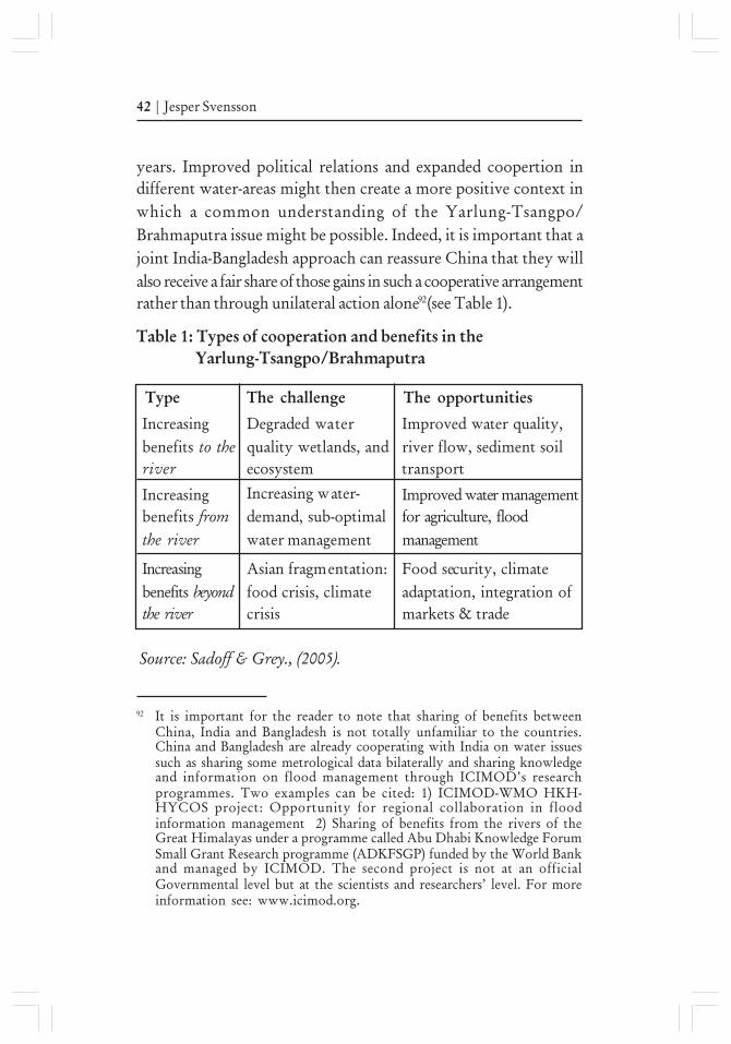
years. Improved political relations and expanded coopertion indifferent water-areas might then create a more positive context inwhich a common understanding of the Yarlung-Tsangpo/Brahmaputra issue might be possible. Indeed, it is important that ajoint India-Bangladesh approach can reassure China that they willalso receive a fair share of those gains in such a cooperative arrangementrather than through unilateral action alone92(see Table 1).
92 It is important for the reader to note that sharing of benefits betweenChina, India and Bangladesh is not totally unfamiliar to the countries.China and Bangladesh are already cooperating with India on water issuessuch as sharing some metrological data bilaterally and sharing knowledgeand information on flood management through ICIMOD’s researchprogrammes. Two examples can be cited: 1) ICIMOD-WMO HKH-HYCOS project: Opportunity for regional collaboration in floodinformation management 2) Sharing of benefits from the rivers of theGreat Himalayas under a programme called Abu Dhabi Knowledge ForumSmall Grant Research programme (ADKFSGP) funded by the World Bankand managed by ICIMOD. The second project is not at an officialGovernmental level but at the scientists and researchers’ level. For moreinformation see: www.icimod.org.
Food security, climateadaptation, integration ofmarkets & trade
Table 1: Types of cooperation and benefits in the Yarlung-Tsangpo/Brahmaputra
Type The challenge The opportunities
Source: Sadoff & Grey., (2005).
Increasingbenefits to theriver
Degraded waterquality wetlands, andecosystem
Improved water quality,river flow, sediment soiltransport
Increasingbenefits fromthe river
Increasing water-demand, sub-optimalwater management
Improved water managementfor agriculture, floodmanagement
Increasingbenefits beyondthe river
Asian fragmentation:food crisis, climatecrisis
Managing the Rise of a Hydro-Hegemon in Asia | 43
In the face of the water challenges ahead, an optimal policy for Indiawould be to operate on multiple levels: initiating NGO, academicand industrial cooperation while trying to expand governmentdialogue and widen the field of cooperation into less contentiouswater issues while trying to bring Bangladesh into negotiations withChina. Blooming collaboration on water issues across sectors(agriculture, climate sphere) will serve as a building block in thefostering of cooperation on more difficult political issues.
Conclusion
China is on the precarious path of squandering its water resourcesand exporting the damages to its neighbours unless it eases its position.Throughout this paper it has been shown that a strong demandmanagement policy will be unable to solve the water shortage crisisof the North China Plain and water resources per capita will still bethe lowest in the world at (about 300 m3 per person) in China nomatter how the SNWTP goes. While China is the strongest economic,political and military power in Asia, its hydrological positionreinforces this asymmetry. Being the source of major internationalrivers, China is exercising a degree of hydro-hegemony. Against thisbackground, Beijing´s performance in the UN-led process onInternational Watercourses, its rejection to join the MRC and itsaggressive dam-behaviour in the Mekong and Salween Rivers clearlyshows that China employs a negative/dominating form of hydro-hegemony. However, it is found that the Chinese leadership sees theYarlung-Tsangpo/Brahmaputra River as an important river fordeveloping hydro powerplants, but not for launching major waterdiversion schemes. The Great plan to to divert water from theYarlung-Tsangpo/Brahmaputra to the Yellow River and then furtherto Northwest China is dismissed or ignored by all legitimate academicinstitutions and governmental agencies because it is environmentallyrisky, technically and economically unfeasible. Yet, if national interest
44 | Jesper Svensson
demands diverting water from the Yarlung-Tsangpo/Brahmaputra,international law or lower-riparian concerns will not deter Beijingfrom undertaking major diversion schemes if the price of transferredwater is cheaper than conservation or getting water from the sea.Moreover, it has also been showed that Chinese scholars have takenan interest in developing cooperation with India on smaller, lesscontentious and more easily manageable projects to reduce thelooming larger and larger water resources disputes. Even if that isindeed encouraging, China has not been transparent to either Indianor Bangladesh regarding its plans to build a 38 GW dam on theGreat Bend of the Yarlung-Tsangpo/Brahmaputra. For China,building large dams on the Yarlung-Tsangpo/Brahmaputra River hasbecome a multipurpose strategic option: from enhancing nationalpolitical-economic integration to seek cross-border integration withSouth Asia while spurring mining in the Tibetan hinterland.
In order to influence China´s hydro-behaviour in the Yarlung-Tsangpo/Brahmaputra River, a thoughtful twofold strategy wouldbe ’desecuritization of water resource management’ and a ’river basinapproach’. This cooperation-strategy aims to widen the field ofcooperation into less contentious water issues that creates “spill-over”effects into a larger basket of benefits with China while trying tobring Bangladesh into negotiations over Yarlung-Tsangpo/Brahmaputra. Along this path, India should revisit the supply-sidehydrology ’desecuritisation of water resource management’ and a’river basin approach’. This cooperation-strategy aims to widen thefield of cooperation into less contentious water issues that creates“spill-over” effects into a larger basket of benefits with China whiletrying to bring Bangladesh into negotiations over the approach inAsia. It will help embark on a “soft path for water” with China andBangladesh that seeks to strengthen and improve the management ofwater rather than to find new sources of supply.

Managing the Rise of a Hydro-Hegemon in Asia | 45
Map
1:
Wes
tern
Ro
ute
of
the
SN
WT
P
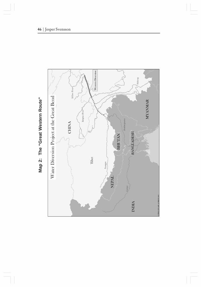
46 | Jesper Svensson
Map
2:
Th
e “G
reat
Wes
tern
Ro
ute
”
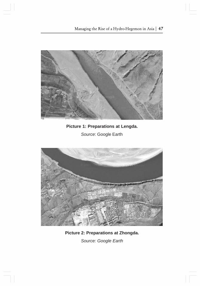
Managing the Rise of a Hydro-Hegemon in Asia | 47
Picture 1: Preparations at Lengda.
Source: Google Earth
Picture 2: Preparations at Zhongda.
Source: Google Earth
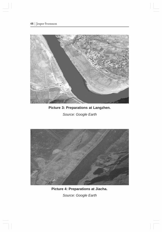
48 | Jesper Svensson
Picture 3: Preparations at Langzhen.
Source: Google Earth
Picture 4: Preparations at Jiacha.
Source: Google Earth
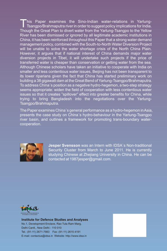
Jesper Svensson
IDSA Occasional Paper No. 23
Managing the Rise of a Hydro-Hegemon in Asia
China’s Strategic Interests in the Yarlung-Tsangpo River
Jesper Svensson was an Intern with IDSA`s Non-traditional Security Cluster from March to June 2011. He is currently studying Chinese at Zhejiang University in China. He can be contacted at [email protected].
his Paper examines the Sino-Indian water-relations in Yarlung-Tsangpo/Brahmaputra river in order to suggest policy implications for India. T
Though the Great Plan to divert water from the Yarlung-Tsangpo to the Yellow River has been dismissed or ignored by all legitimate academic institutions in China, it has been reinforced throughout this Paper that a strong water demand management policy, combined with the South-to-North Water Diversion Project will be unable to solve the water shortage crisis of the North China Plain. However, it argues that if national interest of China demands major water diversion projects in Tibet, it will undertake such projects if the price of transferred water is cheaper than conservation or getting water from the sea. Although Chinese scholars have taken an initiative to cooperate with India on smaller and less contentious water issues, Beijing has not been transparent to its lower riparians given the fact that China has started preliminary work on building a 38 gigawatt dam at the Great Bend of Yarlung-Tsangpo/Brahmaputra. To address China´s position as a negative hydro-hegemon, a two-step strategy seems appropriate: widen the field of cooperation with less contentious water issues so that it creates ”spillover” effect into greater benefits for China, while trying to bring Bangladesh into the negotiations over the Yarlung-Tsangpo/Brahmaputra.
The Paper examines China´s general performance as a hydro-hegemon in Asia, presents the case study on China´s hydro-behaviour in the Yarlung-Tsangpo river basin, and outlines a framework for promoting trans-boundary water-cooperation.
Institute for Defence Studies and AnalysesNo.1, Development Enclave, Rao Tula Ram Marg,
Delhi Cantt., New Delhi - 110 010
Tel.: (91-11) 2671-7983 Fax: (91-11) 2615 4191
E-mail: [email protected] Website: http://www.idsa.in