managing icebridge airborne mission data at the national snow and ice data center m. kaminski, m....
TRANSCRIPT

Managing IceBridgeAirborne Mission Data at theNational Snow and Ice Data Center
M. Kaminski, M. Brodzik, J. Deems, T. ScambosNational Snow and Ice Data Center, University of ColoradoBoulder, Colorado USA 80309April 4, [email protected]
1

2 European Geosciences Union, CR3.10April 4, 2011
NSIDC’s IceBridge Data Management
Project goals: Ensure preservation of dataIncrease and broaden usageof data
Project tasks:
Provide access to related data that is safely archived elsewhere
Data brokering
Also archive flight reports; Level 0 data; ancillary data; broad scope of pre-IceBridge data
Data archive - ongoing flight campaign data - pre-IceBridge data
Portal with map-based access using geometry of flight lines; data readers, documentation, …
Tools & services
Compiled data sets for streamlined analysis
Value-added products

3 European Geosciences Union, CR3.10April 4, 2011
IceBridge Data Providers
ISTIST
POS/AV
CAMBOTPARIS
UAF
ATM
DMS
LVIS
POS/AVPOS/AV
HiCARS
WISE
GEOMET
BGM-3SigmaSpace
LidarScanner
Global Hawk
P-3
DC-8
LidarProfiler
ISTIST
ISTIST ISTIST
IST
NSERC
ICECAPplatform
instrument
team
AccRadar
SnowRadar
AirGrav
IST
Ku-BandRadar
MCoRDS

4 European Geosciences Union, CR3.10April 4, 2011
NSIDC IceBridge Data Web Site
nsid
c.org
/dat
a/ice
brid
ge

5 European Geosciences Union, CR3.10April 4, 2011
Data Availability
NASA IceBridge Alaska Glaciers (UAF) ICECAP
flight reports Acc Radar Air
Gravimeter ATM Atmos chem (br)
CAMBOT DMS Ku-Band
Radar LVIS MCoRDS Airborne met PARIS POS/
AV Snow Radar flight reports
Lidar Profiler
Lidar Scanner
flight reports UTx suite
L1B L1B L1B L2 L1B L1B L0 L1B L1B L0 L1B L2 L1B L2 L1B L2 1B L1B L1B L1B suite
Pre-IB in work √ √ in work in work in work
Gr ’09 √ √ √ √ 1 file √ √ √ √
An ’09 √ √ √ √ √br √ √ √ in work √ 1 file in work √ √ √ √ √ in work
Al ’09 √ √ √
Gr ’10 √ in work √ √ √ √ √ √ in work √ in work in work √ √ 1 day
An ’10√ in work in work br √ √ √ √
Al ’10 √ √
in workin work at NSIDC for ftp access
1 file partial data received and published
√all data published
√brdata brokered (updates are independent of NSIDC)
instrument not flown
no data received from provider
blank cells uncertain
last update: 3/28/11
No data restrictions or period of exclusivityNew data announced through news page, RSS feed, user
noticesCurrently data is downloadable from ftp siteOrganized by instrument and campaign; no spatial filter
6 European Geosciences Union, CR3.10April 4, 2011
Tools and Services
NSIDC provides a wide range of supporting services
-Documentation- detailed user guide for each data set
-User Services Office- personal service via email or phone, with backup support from
NSIDC programmers/scientists and instrument teams-Software for reading and interpreting data files-Data access portal (in work)
- Web-accessible map-based interface to all available data- Planned comprehensive filtering by instrument/spatial/temporal
parameters; easy access to data

7 European Geosciences Union, CR3.10April 4, 2011
IceBridge Data Access Portal
First release June 2011 with access to flight lines and flight reportsFrequent iterative releases for access to instrument data and value-added productsAdditional features will be user-driven
8 European Geosciences Union, CR3.10April 4, 2011
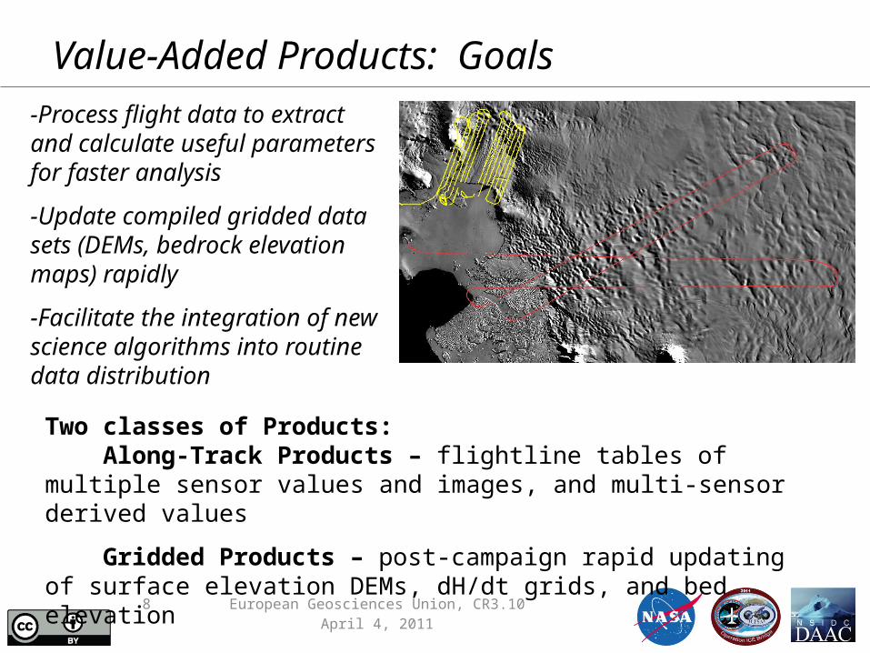
Value-Added Products: Goals-Process flight data to extract and calculate useful parameters for faster analysis
-Update compiled gridded data sets (DEMs, bedrock elevation maps) rapidly
-Facilitate the integration of newscience algorithms into routine data distribution
Two classes of Products: Along-Track Products – flightline tables of multiple sensor values and images, and multi-sensor derived values
Gridded Products – post-campaign rapid updating of surface elevation DEMs, dH/dt grids, and bed elevation

9 European Geosciences Union, CR3.10April 4, 2011
Value-Added Products
-Aligned (time and location) data sets, and pre-calculated parameters –All these data sets and derived parameters are co-located–
Along-track product examples: Surface Properties Table
Snow radar data image +Two layer picks (VAP)
Snow thickness between layer picks (VAP)
Subset of digital camera
Subset of Laser altimeter
Imagehistogram(VAP)
Surfacehistogram(VAP)
10 European Geosciences Union, CR3.10April 4, 2011
• Project Manager, Marilyn Kaminski: – [email protected], 1-303-735-5408
• Web Site: – nsidc.org/data/icebridge
• User Services: – [email protected], 1-303-492-6199
Contact Information