management plans for community land - city of charles · pdf filemanagement plans . for...
TRANSCRIPT

Management Plans For Community
Land
Prepared by: Property Services
City of Charles Sturt 66 East Avenue
Beverley SA 5009
November 2017 08/163220
Page 1
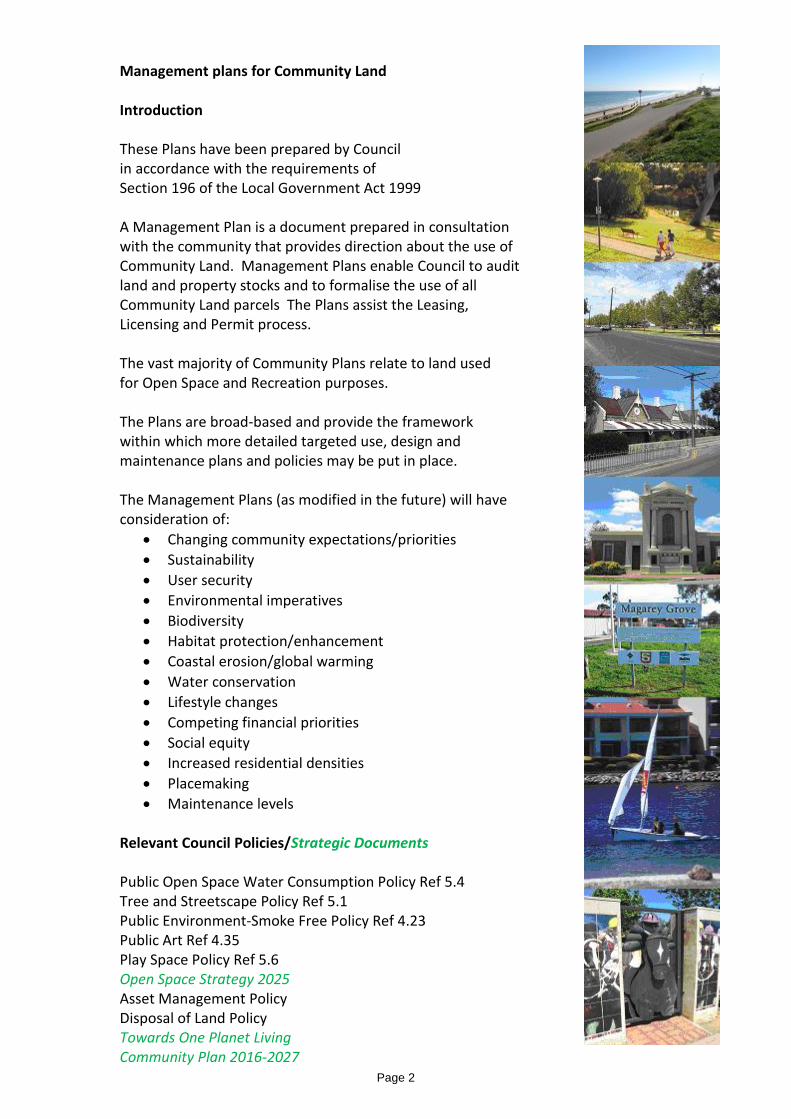
Management plans for Community Land Introduction These Plans have been prepared by Council in accordance with the requirements of Section 196 of the Local Government Act 1999 A Management Plan is a document prepared in consultation with the community that provides direction about the use of Community Land. Management Plans enable Council to audit land and property stocks and to formalise the use of all Community Land parcels The Plans assist the Leasing, Licensing and Permit process. The vast majority of Community Plans relate to land used for Open Space and Recreation purposes. The Plans are broad-based and provide the framework within which more detailed targeted use, design and maintenance plans and policies may be put in place. The Management Plans (as modified in the future) will have consideration of:
• Changing community expectations/priorities • Sustainability • User security • Environmental imperatives • Biodiversity • Habitat protection/enhancement • Coastal erosion/global warming • Water conservation • Lifestyle changes • Competing financial priorities • Social equity • Increased residential densities • Placemaking • Maintenance levels
Relevant Council Policies/Strategic Documents Public Open Space Water Consumption Policy Ref 5.4 Tree and Streetscape Policy Ref 5.1 Public Environment-Smoke Free Policy Ref 4.23 Public Art Ref 4.35 Play Space Policy Ref 5.6 Open Space Strategy 2025 Asset Management Policy Disposal of Land Policy Towards One Planet Living Community Plan 2016-2027
Page 2

Council owned land excluded from Community Land classification Council is not required to provide Management Plans for land that has been excluded (by Council) from the classification as Community Land nor for public roads REFER TRIM 07/167935 Open Space Strategy 2025-August 2015 (Report developed for Council) Defining the Future of Open Spaces
• Background Report-TRIM 16/24180 • Directions Report-TRIM 16/24182 • Open Space Works Matrix
Background to Open Space Strategy 2025 Report The City of Charles Sturt recognises the benefits that useable and attractive open space provides for its community. The development and provision of open space remains one of Council’s key priorities and strategic drivers. Council’s Community Plan, “Liveability and Place”, highlights Council’s commitment to improve the quality of these places within the framework of changing social, urban and recreational trends. Urban consolidation will significantly reduce the amount of private open space per capita, and is therefore likely to increase demand for public open space in those areas where it will occur. This has already been the focus of a recent research study by the City of Charles Sturt; Best Practice Open Space in Higher Density Developments. Within the City, there is a diverse range of reserves, sporting and other leisure facilities which are used by clubs, groups and community members under various use arrangements. There are competing demands for open space areas and the Council’s future response needs to take into account changing leisure trends, population demographics (in particular ageing), and community needs and expectations, particularly the increasing demand for passive recreation, structured and unstructured recreation activities. Open space areas contribute to quality of life, economic development and urban amenity and provide opportunities for managing and enhancing the natural environment and stormwater. The Open Space Strategy 2025 has updated the existing Open Space Strategy redefining open space, use, access, provision and distribution and also provides a framework for future capital expenditure on open space assets Outcomes Nine themes have been identified to guide the objectives and strategies for the whole of the City.
• Open space provision • Recreation destinations • Sport and aquatic facilities • Open space connections • Biodiversity and nature • Landscape design and innovation • Water management and climate adaptation • Place Making and Place Activation • Open space management
Page 3
Exclusion of Council Land as Community Land Council has endorsed the following criteria to be applied when considering those properties that should be excluded from Community Land Classification.
• Is not available to the public as a right • Is used for Council operations, OR • Is used or has been purchased for strategic or commercial purposes.
Ref: POL Minutes 28/95/2001 Item 63 List of Properties Excluded: TRIM 07/212804 Register of Community Land: TRIM 07/167935
Page 4

Management Plans for Community Land • RESERVE - DISTRICT PARK
• RESERVE - NEIGHBOURHOOD PARK
• RESERVE - LOCAL PARK
• SCREENING RESERVE
• COASTAL RESERVE
• RIVER TORRENS LINEAR PARK
• RIVER TORRENS LINEAR PARK RESERVE
• PORT ROAD PLANTATION
• AQUATIC RESERVE
• BOUCATT PLACE RESERVE
• BOWER COTTAGES COMMUNITY CENTRE
• CEMETERY RESERVE
• COMMUNITY GARDEN
• COOKE RESERVE
• CORCORAN RESERVE
• DON KLAEBE RESERVE
• EMMA STREET RESERVE
• EMU PARK RESERVE
• FINDON COMMUNITY CENTRE
• FINDON RESERVE
• GELLAND SOLDIERS MEMORIAL RESERVE
• HAMILTON ROAD RESERVE
• HENLEY COMMUNITY ARTS CENTRE
• HENLEY TOWN HALL & SOLDIERS MEMORIAL
• HENLEY SQUARE
• HENLEY SQUARE CAR PARK
• HENLEY RSL CLUBROOMS
• HINDMARSH CEMETERY
• HORSLEY RESERVE
• HORTICULTURAL CENTRE AND HISTORIC JAMES BRICKWORKS
• KILN DRIVE RESERVE
• MAGAREY GROVE RESERVE
Page 5

• MIDCOURSE RESERVE
• MIRANI COURT RESERVE
• OZONE RESERVE
• PEDLAR RESERVE
• PUMPING STATION
• RAY STREET RESERVE
• ST CLAIR RECREATION RESERVES (Ovals 2,3 and 4)
• THE AVENUE RESERVE
• THOMAS HARKNESS RESERVE
• TRIMMER PARADE DRAINAGE RESERVE
• WEST LAKES SEAWATER LAKE
• WEST RESERVE
Page 6

Reserve - District Park Name and address of property • Refer schedules A and B Ownership details • Refer Schedules A and B Purpose for which the land is held • To provide a hierarchy of open space strategically located throughout the City to meet
the recreational needs of the community or to address specific environmental, heritage or urban design objectives.
Objectives for the management of the land • To provide an area for the use and enjoyment of the community where a range of active
and passive recreational activities may be undertaken. Policies and proposals for the management of the land • To provide opportunities for the community to be involved in a range of structured and
informal recreational activities. • To encourage and support clubs to utilise facilities to optimise opportunities for the
community to participate in a range of sporting and recreational activities and to put in place the required leases/licences.
• Council may grant or renew a lease or licence to various sporting, recreation, social or community clubs or groups for the use of buildings, sports fields /courts or open space whose activities cater for the local or broader community.
• Council may issue a permit to allow access over the Reserve or to allow for an activity of a ‘short term’ nature.
• It may be appropriate to utilise portion of the site for stormwater management purposes. • Council Policy-Play Space Policy Ref 5.6 Performance targets • To provide a safe and attractive facility developed and maintained in a manner
appropriate to its location and purpose. Performance measures • Regular inspection and maintenance of facility.
Page 7

Schedule A: Management Plans - Community Land - Reserve – District Park NAME LOCATION OWNER Carnegie South Reserve
Crown Terrace/Kingston Ave/Durham Tce, ROYAL PARK
City of Charles Sturt
Collins Reserve
Valetta Rd/Barbara St/Chatswood Cres, KIDMAN PARK CT’s V5539 F554: V5806 F153: V5553 F674: V5723 F804: V2632 F166
City of Charles Sturt
Fawk Reserve Hanson Rd/Hamilton Rd, WOODVILLE NORTH CT V5824 F82
City of Charles Sturt
Findon Reserve Drummond Ave/Reserve Pde, FINDON
City of Charles Sturt
Robert Haigh Reserve (Formally Finsbury Reserve)
Park Ave/Northgate St, WOODVILLE NORTH CT V5642 F988: V5440 F558
City of Charles Sturt
Flinders Park Oval Reserve
Hartley Rd/Flinders Pde, FLINDERS PARK City of Charles Sturt
Frank Mitchell Reserve Todville St/Minns St, WOODVILLE WEST CT V5690 F340: V5552 F577
City of Charles Sturt
Gleneagles Reserve Park Ave/Leven Ave/Humphries Ave, SEATON CT V5806 F153
City of Charles Sturt
Grange Reserve Military Rd/Trimmer Pde, GRANGE CT V4101 F209: V3823 F63
City of Charles Sturt
Greenshields (Albert Greenshields) Reserve
Torrens Rd/Greenshields Plce, RIDLEYTON CT V5810 F320: V5710 F’s 820,821 V5858 F453 (Pt only:29m from Torrens Rd excluded)
City of Charles Sturt
Henley Memorial Reserve
Cudmore Tce/Atkin St/White St, HENLEY BEACH CT V5602 F812: V5840 F998: V5602 F813
City of Charles Sturt
Josiah Mitton Reserve*
Hawker Street, BROMPTON CT V3846 F20,21: V5133 F137: V5321 F259: V5816 F842
City of Charles Sturt/CROWN
Jubilee Park Reserve Hawkesbury Way/Edwin St/Bartley Tce, WEST LAKES CT V5550 F87: V5752 F215
City of Charles Sturt
Ledger Oval Reserve Ledger Road/Hill St, WOODVILLE SOUTH CT V5196 F658
City of Charles Sturt
Matheson Reserve Matheson Ave/Brice St/Buccleuch Ave, FINDON CT V5631 F189: V2145 F165
City of Charles Sturt
Pennington Oval Reserve
Butler Ave/Gilligan St, PENNINGTON CT’s V5688 F840,841
City of Charles Sturt
Sam Johnson Reserve Bolingbroke Ave/Cavan Ave/Palmer Crt, RENOWN PARK CT’s V5234 F134,135
City of Charles Sturt
West Lakes Shore Oval Reserve
Bartley Tce/Newcombe Ave/Lambert Ave, WEST LAKES SHORE CT V5487 F110
City of Charles Sturt
Woodville Oval Reserve Complex
Oval Ave/Koolunda Ave, WOODVILLE SOUTH CT V5218 F142
City of Charles Sturt
* Soil Remediation Report - Construction Environment Management Report TRIM 15/178898
Page 8

Schedule B: Management Plan - Community Land - Reserve – District Park NAME LOCATION OWNER TRUST, DEDICATION OR RESERVATION ON LAND
(WHERE OWNER NOT CCS) Jubilee Park Reserve
Hawkesbury Way/Bartley Terrace, WEST LAKES SHORE (Portion only Ref CT V5752 F215 Lt 499)
The Crown- custodian, City of Charles Sturt
Land dedicated for recreation purposes pursuant to the Crowns Lands Act 1929 Subject to Native Title claim
Page 9

Reserve - Neighbourhood Park Name and address of property • Refer schedules A and B Ownership details • Refer schedules A and B Purpose for which the land is held • To provide a hierarchy of open space strategically located throughout the City to
meet the recreational needs of the community or to address specific environmental, heritage or urban design objectives.
Objectives for the management of the land • To provide an area for the use and enjoyment of the community where generally,
passive recreational activities may be undertaken Policies and proposals for the management of the land • To provide opportunities for the community to be involved in a range of passive
and active recreational activities. • To encourage and support clubs to utilise facilities to optimise opportunities for
the community to participate in a range of sporting and recreational activities and to put in place the required leases/licences.
• The appropriate range of activities will vary for each location depending on the physical characteristics of the reserve, demography, location, accessibility and adjoining uses.
• Council may grant or renew a lease or licence to various sporting, recreation, social or community clubs or groups for the use of buildings, sports fields /courts or open space whose activities cater for the local community
• Council may issue a permit to allow access over the Reserve or to allow for an activity of a ‘short term’ nature.
• It may be appropriate to utilise portion the site for stormwater management purposes.
• Council Policy-Play Space Policy Ref 5.6 Performance targets • To provide a safe and attractive facility developed and maintained in a manner
appropriate to its location and purpose. Performance measures • Regular inspection and maintenance of facility.
Page 10

Schedule A: Management Plan for Community Land - Reserve - Neighbourhood Park NAME LOCATION OWNER A D Whiteford Reserve Fletcher Rd/Burford Rd/Yorktown Crs/Kinkaid
Rd/Lexington Rd, HENLEY BEACH SOUTH CT’s V3856 F115: V5526 F13
City of Charles Sturt
Allenby Gardens Reserve Lewanick St, ALLENBY GARDENS CT V5542 F536
City of Charles Sturt
Collin Sellars Reserve Wight St, HENLEY BEACH CT’s V5868 F 211,212: V5863 F1
City of Charles Sturt
Grange Lakes Reserve Jetty St, Kentdale St, Searange Crt, GRANGE CT’s V5574/F614: V5471/F981 V4188/F81 V6177/F628,629 V3859/F119 V5462/F137
City of Charles Sturt
Grant Place Reserve Grant Place, FLINDERS PARK CT V5588 F321
City of Charles Sturt
Harold and Cynthia Anderson Reserve
Seaview Rd/Burbridge Rd, WEST BEACH CT V6126 F767
City of Charles Sturt
Inlet Reserve Military Rd/Trimmer Pde, TENNYSON CT V5758 F251
City of Charles Sturt
John Mitchell Oval Reserve
Whibley St, Mitchell St, Vivian St, HENLEY BEACH CT 5519 F14
City of Charles Sturt
Kirckaldy Park Reserve Kirkaldy Ave, Beach St, Grange Rd, Charlotte Ave, GRANGE CT V5594 F509: V5455 F450: V5866 F193
City of Charles Sturt
Oarsman Reserve Military Road, Military Road, WEST LAKES SHORE CT’s V5458 F159: V5084 F697
City of Charles Sturt
Pennington Gardens Reserve
Morias Place, PENNINGTON CT’s V5064 F632
City of Charles Sturt
Riverpark Reserve Moorfield Terrace, ALLENBY GARDENS CT V5480 F607
City of Charles Sturt
Scullers Reserve Sportsmans Drive, WEST LAKES. CT’s V5756 F791
City of Charles Sturt
Smith Reserve Albany St/Gawler St, WOODVILLE WEST CT V5489 F796
City of Charles Sturt
Sunningdale Reserve Sunningdale Road/Holthouse Road/Fisher Tce, FULHAM GARDENS CT’s V5515 F’s 967,968,969,97O: F5718 F749: V5458 F222: V5553 F505 V5169 F115
City of Charles Sturt
Trust Reserve Bartley Tce/Eagle Court, SEMAPHORE PARK CT’s V5475 F96: V5454 F954: V5553 F 939: V5805: F455: V5738 F568
City of Charles Sturt
Page 11

Schedule B: Management Plan for Community Land - Reserve - Neighbourhood Park NAME LOCATION OWNER TRUST, DEDICATION OR
RESERVATION ON LAND (WHERE OWNER NOT CCS)
M J McInerney Reserve
Sackville Street, Kilkenny
The Crown- custodian City of Charles Sturt (part) City of Charles Sturt
Land dedicated for recreation purposes pursuant to the Crown Lands Act, 1929 Subject to Native Title claim
Josiah Mitton Reserve
Hawker Street/Wood Avenue, Brompton
The Crown-custodian, City of Charles Sturt (part) City of Charles Sturt (part)
Land dedicated for open space purposes pursuant to the Crown Lands Act 1929. Subject to Native Title claim
Page 12
Reserve - Neighbourhood Park Name and address of property • Kevin Taylor Reserve • Kevin Taylor Lane, BOWDEN • Lot 23 D90924 CT V6110 F472 Ownership details • City of Charles Sturt Purpose for which the land is held • To provide a hierarchy of open space strategically located throughout the City to
meet the recreational needs of the community or to address specific environmental, heritage or urban design objectives.
Objectives for the management of the land • To provide an area for the use and enjoyment of the community where generally,
passive recreational activities may be undertaken Policies and proposals for the management of the land • The appropriate range of activities will vary for each location depending on the
physical characteristics of the reserve, demography, location, accessibility and adjoining uses.
• To provide formal landscaping and built form elements to create a versatile and stimulating place that can be enjoyed by a variety of users.
• To provide a built form that reinforces the prevailing urban design character of the locality using a variety of materials and interesting elements.
• The on-going successful function of this dynamic space will require detailed maintenance at a high level.
• Council may issue a permit to allow access over the Reserve or to allow for an activity of a ‘short term’ nature.
Performance targets • To provide a safe and attractive facility developed and maintained in a manner
appropriate to its location and purpose. Performance measures • Regular inspection and maintenance of facility.
Page 13
Regional Park-Wetland Name and address of property St Clair Reserve-Wetland 1 St Clair Avenue/Furlong Drive, ST CLAIR CT V6180 F807, Lot 7001, D94012 St Clair Reserve-Wetland 2 Stallion Drive/Hill Smith Boulevard, ST CLAIR CT V6180 F807, Lot 7002, D94012 St Clair Reserve-Wetland 3 Cnr Torrens Road/Cheltenham Parade, CHELTENHAM CT V6143 F 798, Pt Lot 1040, D94013 Ownership details • City of Charles Sturt Purpose for which the land is held • To provide a hierarchy of open space strategically located throughout the City to
meet the recreational needs of the community or to address specific environmental, heritage or urban design objectives.
• To deliver a flood mitigation and stormwater detention system* • To deliver a stormwater capture/re-use system* Objectives for the management of the land • To provide an area for the use and enjoyment of the community where generally,
passive recreational activities may be undertaken • To manage stormwater in a manner that provides an attractive environment,
compatible with the amenity of adjoining residential development. • To manage the stormwater detention basin in a manner that promotes
biodiversity and provides habitat for fauna. • To manage the stormwater detention basin in a manner that prevents the
breeding of mosquitos and the production of unpleasant odours. Policies and proposals for the management of the land • To provide opportunities for the community to be involved in a range of passive
activities. • Council may issue a permit to allow access over the Reserve or to allow for an
activity of a ‘short term’ nature. . Performance targets • To provide a safe and attractive facility developed and maintained in a manner
appropriate to its location and purpose. Performance measures • Regular inspection and maintenance of facility.
*Refer Consultant Report Functional Design-AECOM Jan 2012 TRIM 12/131628
Page 14

Reserve - Local Park Name and address of property • Refer schedules A and B Ownership details • Refer schedules A and B Purpose for which the land is held • To provide a hierarchy of open space strategically located throughout the City to
meet the recreational needs of the community or to address specific environmental, heritage or urban design objectives.
Objectives for the management of the land • To provide an area for the use and convenience of the community where limited
recreational activities may be undertaken or landscaping is established. Policies and proposals for the management of the land • The appropriate range of activities will reflect the constraints of the site including
the size of the land and the proximity of adjoining dwellings and have regard to the demographics of the area.
• In some locations the primary function of the reserve will be to provide a landscaped area or to facilitate pedestrian movement.
• Council may issue a permit to allow access over the Reserve or to allow for an activity of a ‘short term’ nature.
• It may be appropriate to utilise portion of the site for stormwater management purposes.
• Council policy-Play Space Policy Ref 5.6 Performance targets • To provide a safe and functional facility developed and maintained in a manner
appropriate to its location and purpose. Performance measures • Regular inspection and maintenance of facility.
Page 15
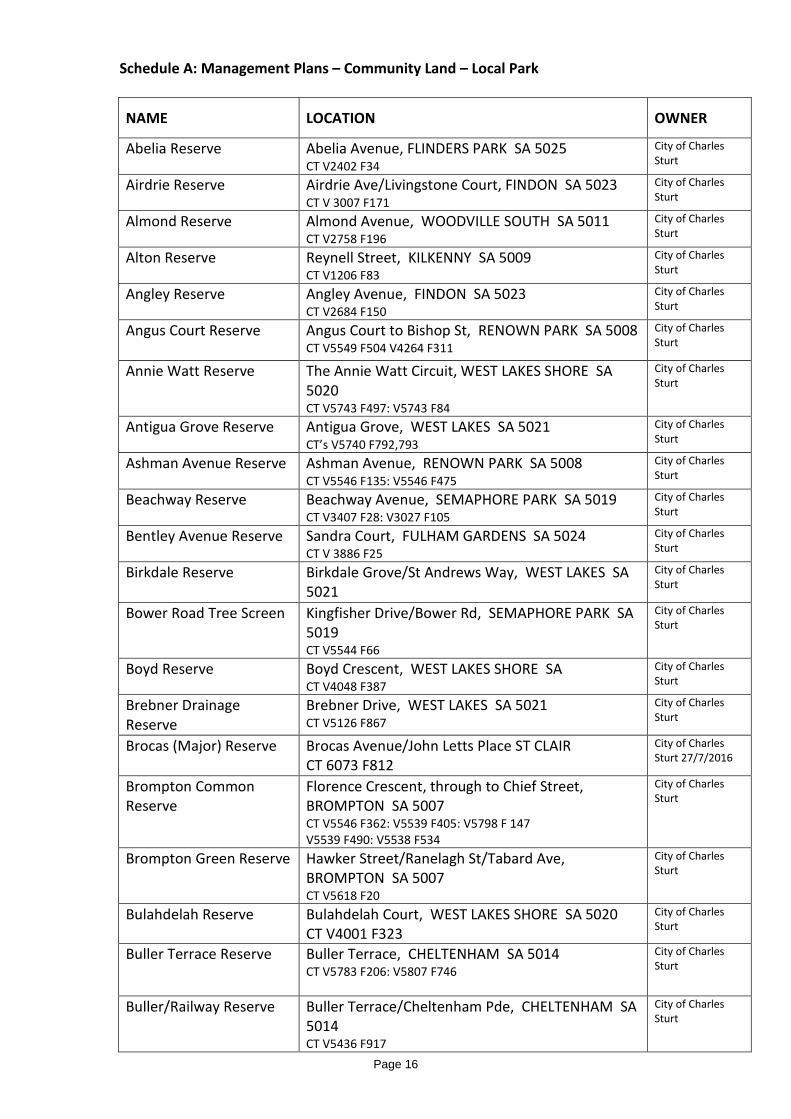
Schedule A: Management Plans – Community Land – Local Park
NAME LOCATION OWNER
Abelia Reserve Abelia Avenue, FLINDERS PARK SA 5025 CT V2402 F34
City of Charles Sturt
Airdrie Reserve Airdrie Ave/Livingstone Court, FINDON SA 5023 CT V 3007 F171
City of Charles Sturt
Almond Reserve Almond Avenue, WOODVILLE SOUTH SA 5011 CT V2758 F196
City of Charles Sturt
Alton Reserve Reynell Street, KILKENNY SA 5009 CT V1206 F83
City of Charles Sturt
Angley Reserve Angley Avenue, FINDON SA 5023 CT V2684 F150
City of Charles Sturt
Angus Court Reserve Angus Court to Bishop St, RENOWN PARK SA 5008 CT V5549 F504 V4264 F311
City of Charles Sturt
Annie Watt Reserve The Annie Watt Circuit, WEST LAKES SHORE SA 5020 CT V5743 F497: V5743 F84
City of Charles Sturt
Antigua Grove Reserve Antigua Grove, WEST LAKES SA 5021 CT’s V5740 F792,793
City of Charles Sturt
Ashman Avenue Reserve Ashman Avenue, RENOWN PARK SA 5008 CT V5546 F135: V5546 F475
City of Charles Sturt
Beachway Reserve Beachway Avenue, SEMAPHORE PARK SA 5019 CT V3407 F28: V3027 F105
City of Charles Sturt
Bentley Avenue Reserve Sandra Court, FULHAM GARDENS SA 5024 CT V 3886 F25
City of Charles Sturt
Birkdale Reserve Birkdale Grove/St Andrews Way, WEST LAKES SA 5021
City of Charles Sturt
Bower Road Tree Screen Kingfisher Drive/Bower Rd, SEMAPHORE PARK SA 5019 CT V5544 F66
City of Charles Sturt
Boyd Reserve Boyd Crescent, WEST LAKES SHORE SA CT V4048 F387
City of Charles Sturt
Brebner Drainage Reserve
Brebner Drive, WEST LAKES SA 5021 CT V5126 F867
City of Charles Sturt
Brocas (Major) Reserve Brocas Avenue/John Letts Place ST CLAIR CT 6073 F812
City of Charles Sturt 27/7/2016
Brompton Common Reserve
Florence Crescent, through to Chief Street, BROMPTON SA 5007 CT V5546 F362: V5539 F405: V5798 F 147 V5539 F490: V5538 F534
City of Charles Sturt
Brompton Green Reserve Hawker Street/Ranelagh St/Tabard Ave, BROMPTON SA 5007 CT V5618 F20
City of Charles Sturt
Bulahdelah Reserve Bulahdelah Court, WEST LAKES SHORE SA 5020 CT V4001 F323
City of Charles Sturt
Buller Terrace Reserve Buller Terrace, CHELTENHAM SA 5014 CT V5783 F206: V5807 F746
City of Charles Sturt
Buller/Railway Reserve Buller Terrace/Cheltenham Pde, CHELTENHAM SA 5014 CT V5436 F917
City of Charles Sturt
Page 16

NAME LOCATION OWNER
Bunker Court Reserve Gleneagles Court, SEATON SA 5023 CT V5546 F445
City of Charles Sturt
Butler Reserve Butler Drive, HENDON SA 5014 CT V5375 F86
City of Charles Sturt
Cable Station Reserve Seaview Road/Fort St, TENNYSON SA 5022 CT V5831 F239
City of Charles Sturt
Caddy Reserve Frederick Road, SEATON SA 5023 CT V6195 F491
City of Charles Sturt
Canino Reserve Canino Drive/Frogmore Rd, KIDMAN PARK SA 5025 CT F5814 F285
City of Charles Sturt
Carley Crescent Reserve Carley Crescent, SEATON SA 5023 CT V3716 F117
City of Charles Sturt
Carnarvon Reserve Reynell Street/Carnarvon Pde, WEST CROYDON SA 5008 CT’s V5552 F435,436,437,438
City of Charles Sturt
Carnegie North Reserve Kingston Avenue/Crown Tce/Lowe St, ROYAL PARK SA 5014 CT F5717 F517
City of Charles Sturt
Car park, landscaped area and foreshore
Seaview Road/Esplanade HENLEY BEACH SOUTH SA 5022 No titles exist
City of Charles Sturt
Cascades Reserve Torrens Road/Hill Smith Boulevard, ST CLAIR CT V6157 F784
City of Charles Sturt 25/7/2016
Cedar Avenue Reserve Croydon Ave/ Cedar Avenue/William, WEST CROYDON SA 5008 CT V5429 F651: V5782 F137: V5736 F202: V5778 F829
City of Charles Sturt
Chambers Reserve Chambers St/White, HENLEY BEACH SA 5022 CT V5602 F813
City of Charles Sturt
Charles Mathews Reserve
Charles Mathews Circle ST CLAIR Lot 301 D82283
City of Charles Sturt 27/7/2016
Cheadle Reserve Rivett Avenue/Cheadle St, FULHAM GARDENS SA 5024 CT’s V5307 F655,656,657,658,659,660 V3737 F39
City of Charles Sturt
Cheltenham Open Space 18 Buller Terrace, CHELTENHAM SA 5014 CT V5900 F459
City of Charles Sturt
Clare Reserve Clare Street, ATHOL PARK SA 5012 CT V6028 F493
City of Charles Sturt
Clare/Ely Reserve Clare Street/Ely St, ATHOL PARK SA 5012 CT V5511 F864 CT V5900 F459
City of Charles Sturt
Clarice Sutherland Reserve
De Haviland Avenue, HENDON SA 5014 CT V5538 F630: V5076 F936
City of Charles Sturt
Condon Reserve Harcourt Avenue, PENNINGTON SA 5013 CT V3237 F173
City of Charles Sturt
Coxswain Reserve (northern section)
Sunlake Place, TENNYSON SA 5022 CT V5520 F165: V5520 F167
City of Charles Sturt
Coxswain Reserve (southern section)
Sunlake Place, TENNYSON SA 5022 CT V4332 F737: V5520 F168
City of Charles Sturt
Page 17

NAME LOCATION OWNER
Crompton Reserve Crompton Drive/Reid Street, ST CLAIR CT V6062 F263
City of Charles Sturt
Croydon Playground Reserve
Day Terrace/Thomas St/Elizabeth St, CROYDON SA 5008 CT V5430 F989
City of Charles Sturt
Cudmore Reserve Cudmore Terrace/HMAS Australia/Henley Beach Rd, HENLEY BEACH SA 5022 CT V5516 F852
City of Charles Sturt
Dampier Reserve Lot RES Dampier Avenue, FINDON SA 5023 CT V2021 F198
City of Charles Sturt
David Reserve Findon Road/David Ave/Dunn Ave, FINDON SA 5023 CT’s V5623 F58,59,60,61,62: V1731 F90
City of Charles Sturt
Debney Reserve Debney Street to Peters Avenue, FULHAM GARDENS SA 5024 CT 3099 F189: V3118 F62
City of Charles Sturt
Devonshire Reserve Devonshire Avenue, FULHAM GARDENS SA 5024 CT V5717 F451
City of Charles Sturt
Don Ferguson Reserve Chambers St/Wright St HENLEY BEACH SA 5022 CT V5868 F211
City of Charles Sturt
Dotterel Drive Reserve Curlew Court, SEMAPHORE PARK SA 5019 CT V5553 F366
City of Charles Sturt
Doughty Reserve Kennington Avenue, BROMPTON SA 5007 CT V5315 F594
City of Charles Sturt
Drainage Reserve North Monaco Cres, GRANGE SA 5022 CT V5822 F400: V5253 F316: V5588 F693 V5553 F766: V5554 F209: V5580 F693
City of Charles Sturt
Drainage Reserve South Fort St to Terminus St GRANGE SA 5022 CT V5822 F400: V5554 F209: V3865 F89
City of Charles Sturt
Drysdale Reserve Drysdale Court, WEST LAKES SHORE SA 5020 CT V4003 F142
City of Charles Sturt
Edwin Street Reserve Edwin Street, WEST LAKES SHORE SA 5020 CT V5553 F566
City of Charles Sturt
Eights Reserve Sportsmans Drive, WEST LAKES SA 5021 CT V5474 F879
City of Charles Sturt
Elaine Avenue Reserve Elaine Avenue, SEATON SA 5023 CT’s V5522 F234,235: V5553 F940
City of Charles Sturt
Ethelbert Square Reserve Chief Street/Third St, BROMPTON SA 5007 CT’s 8091 Folios A,B
City of Charles Sturt
Everritt Reserve Everritt Avenue/Kopcheff Ave, FULHAM GARDENS SA 5024 CT V5850 F421: V5850 F418
City of Charles Sturt
Fairway Reserve Sportsmans Drive, WEST LAKES SA 5021 CT V4091 F443: V5520 F553
City of Charles Sturt
Fergusson Reserve Fergusson Avenue/Wilde Ave/Rosalia Court, KIDMAN PARK SA 5025 CT V5169 F941 V5175 F881
City of Charles Sturt
Firbank Reserve Firbank Avenue through to Stanley Street, FULHAM GARDENS SA 5024 CT V1979 F56: V5571 F8123: V5571 F815
City of Charles Sturt
First Avenue Reserve First Avenue, SEATON SA 5023 CT V5611 F165
City of Charles Sturt
Page 18
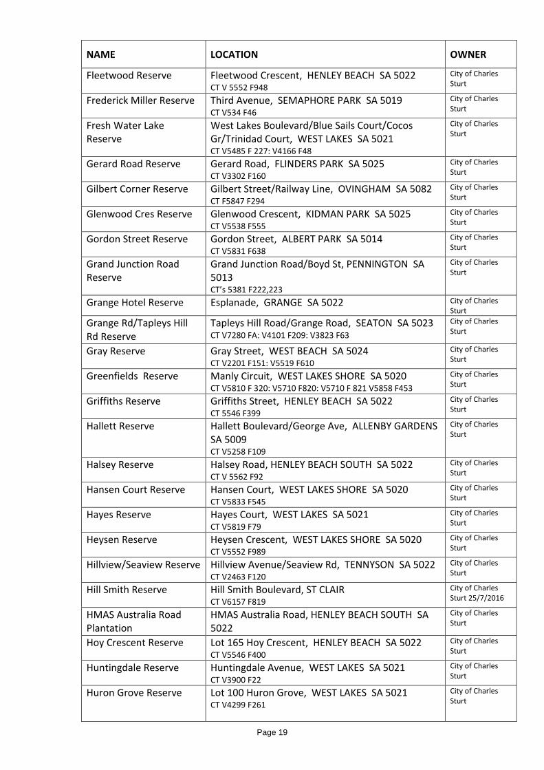
NAME LOCATION OWNER
Fleetwood Reserve Fleetwood Crescent, HENLEY BEACH SA 5022 CT V 5552 F948
City of Charles Sturt
Frederick Miller Reserve Third Avenue, SEMAPHORE PARK SA 5019 CT V534 F46
City of Charles Sturt
Fresh Water Lake Reserve
West Lakes Boulevard/Blue Sails Court/Cocos Gr/Trinidad Court, WEST LAKES SA 5021 CT V5485 F 227: V4166 F48
City of Charles Sturt
Gerard Road Reserve Gerard Road, FLINDERS PARK SA 5025 CT V3302 F160
City of Charles Sturt
Gilbert Corner Reserve Gilbert Street/Railway Line, OVINGHAM SA 5082 CT F5847 F294
City of Charles Sturt
Glenwood Cres Reserve Glenwood Crescent, KIDMAN PARK SA 5025 CT V5538 F555
City of Charles Sturt
Gordon Street Reserve Gordon Street, ALBERT PARK SA 5014 CT V5831 F638
City of Charles Sturt
Grand Junction Road Reserve
Grand Junction Road/Boyd St, PENNINGTON SA 5013 CT’s 5381 F222,223
City of Charles Sturt
Grange Hotel Reserve Esplanade, GRANGE SA 5022 City of Charles Sturt
Grange Rd/Tapleys Hill Rd Reserve
Tapleys Hill Road/Grange Road, SEATON SA 5023 CT V7280 FA: V4101 F209: V3823 F63
City of Charles Sturt
Gray Reserve Gray Street, WEST BEACH SA 5024 CT V2201 F151: V5519 F610
City of Charles Sturt
Greenfields Reserve Manly Circuit, WEST LAKES SHORE SA 5020 CT V5810 F 320: V5710 F820: V5710 F 821 V5858 F453
City of Charles Sturt
Griffiths Reserve Griffiths Street, HENLEY BEACH SA 5022 CT 5546 F399
City of Charles Sturt
Hallett Reserve Hallett Boulevard/George Ave, ALLENBY GARDENS SA 5009 CT V5258 F109
City of Charles Sturt
Halsey Reserve Halsey Road, HENLEY BEACH SOUTH SA 5022 CT V 5562 F92
City of Charles Sturt
Hansen Court Reserve Hansen Court, WEST LAKES SHORE SA 5020 CT V5833 F545
City of Charles Sturt
Hayes Reserve Hayes Court, WEST LAKES SA 5021 CT V5819 F79
City of Charles Sturt
Heysen Reserve Heysen Crescent, WEST LAKES SHORE SA 5020 CT V5552 F989
City of Charles Sturt
Hillview/Seaview Reserve Hillview Avenue/Seaview Rd, TENNYSON SA 5022 CT V2463 F120
City of Charles Sturt
Hill Smith Reserve Hill Smith Boulevard, ST CLAIR CT V6157 F819
City of Charles Sturt 25/7/2016
HMAS Australia Road Plantation
HMAS Australia Road, HENLEY BEACH SOUTH SA 5022
City of Charles Sturt
Hoy Crescent Reserve Lot 165 Hoy Crescent, HENLEY BEACH SA 5022 CT V5546 F400
City of Charles Sturt
Huntingdale Reserve Huntingdale Avenue, WEST LAKES SA 5021 CT V3900 F22
City of Charles Sturt
Huron Grove Reserve Lot 100 Huron Grove, WEST LAKES SA 5021 CT V4299 F261
City of Charles Sturt
Page 19

NAME LOCATION OWNER
Hythe St Reserve Hythe Street, RIDLEYTON SA 5008 CT V5717 F994: V5838 F761
City of Charles Sturt
Ivan Franko Reserve Burley Griffin Blvd/Mc Burnie Close, BROMPTON SA 5007 CT V5071 F81:V5133 F139
City of Charles Sturt
Johns Reserve Military Road to East St, HENLEY BEACH SOUTH SA 5022 CT V5732 F468
City of Charles Sturt
Jordan Reserve Messenger Road to Jordan Avenue, FULHAM GARDENS SA 5024 CT V 3720 F126: V5740 F557
City of Charles Sturt
Kenneth Reserve Kenneth Street, FINDON CT V6137/F284
City of Charles Sturt 25/7/2016
Keppel Grove Reserve Keppel Grove, WEST LAKES SA 5021 CT V5557 F118: V5542 F520: V5529 F403
City of Charles Sturt
Krista Court Reserve Francis Street/Roder Crt/Krista Crt/Brigitte Crt, KIDMAN PARK SA 5025 CT’s V5555 F97,98
City of Charles Sturt
Landscaped allotment Seaview Rd (adjacent to No 33) HENLEY BEACH SOUTH SA 5022
City of Charles Sturt
Langman Reserve Jervois Avenue, WEST HINDMARSH SA 5007 CT V1742 V77
City of Charles Sturt
Laver Reserve Laver Crescent, WEST LAKES SHORE SA 5020 CT V5552 F988
City of Charles Sturt
Leason Street Reserve Parkview Avenue to Trimmer Pde, GRANGE SA 5022 CT V4296 F843: V5486 F293
City of Charles Sturt
Lines Reserve Crafter Street/Lines St/Grady Way, GRANGE SA 5022 CT V5539 F157: V57327 F694
City of Charles Sturt
Lochside Reserve Lochside Drive, WEST LAKES SA 5021 CT V5740 F213
City of Charles Sturt
Madeline Reserve Madeline Crescent, FULHAM GARDENS SA 5024 CT V2637 F185
City of Charles Sturt
Maramba Reserve Frederick Rd/West Lakes Blvd/Sunlake Crt. WEST LAKES SA 5021 CT V3865 F165: V3902 F120
City of Charles Sturt
Market Place Reserve Market Place, OVINGHAM SA 5082 CT V5698 F657
City of Charles Sturt
Mason Reserve Mason Street, WEST BEACH SA 5024 CT V5819 F878
City of Charles Sturt
Mc Grath Reserve Hallet Boulevard/Sellars Pl/Mc Grath Crt/McCole Circuit, ALLENBY GARDENS SA 5009 CT V5380 F79: V5429 F659
City of Charles Sturt
McCole Court Reserve McCole Circuit, ALLENBY GARDENS SA 5009 CT V5429 F660
City of Charles Sturt
McDonnell Reserve McDonnell Avenue, WEST HINDMARSH SA 5007 CT V5808 F109
City of Charles Sturt
McMahon Reserve McMahon Place, SEATON SA 5023 CT V3318 F11
City of Charles Sturt
Page 20

NAME LOCATION OWNER
Menkens Reserve Jeanes Street, HENLEY BEACH SA 5022 CT V5546 F397: V5546 F401
City of Charles Sturt
Milner Street Median Reserve
Milner Street, HINDMARSH SA 5007 City of Charles Sturt
Mooloola Reserve Nambour Crescent, WEST LAKES SHORE SA 5020 CT V4001 F323
City of Charles Sturt
Moredun Reserve Moredun St, TENNYSON SA 5022 CT V57543 F901
City of Charles Sturt
Morely Road Allotment West Lakes Boulevard/Clarke Tce, ALBERT PARK SA 5014
City of Charles Sturt
Morris Reserve Morris Street, KIDMAN PARK SA 5025 CT V5568 F554
City of Charles Sturt
Morse Reserve Grange Road/Messenger Rd, FULHAM GARDENS SA 5024 CT V5819 F873
City of Charles Sturt
Mudge Way Reserve Gibson Street, BOWDEN SA 5007 CT V54117 F143
City of Charles Sturt
Murphy Reserve Murphy Street, FULHAM GARDENS SA 5024 CT V5520 F206
City of Charles Sturt
Nancy Fischer Reserve Nevis Street, WEST BEACH SA 5024 CT V5526 F14
City of Charles Sturt
Nash Reserve Nash Street, GRANGE SA 5022 CT V5245 F110
City of Charles Sturt
Nedford Crescent Reserve
Nedford Cres/York Avenue, FULHAM GARDENS SA 5024 CT V3739 F130
City of Charles Sturt
Neighbourhood Reserve Bartley Terrace, WEST LAKES SHORE SA 5020 CT V5080 F215
City of Charles Sturt
New Brompton Estate Reserve
John Hindmarsh Frontage/Torrens Rd/Francis Ridley Circuit, BROMPTON SA 5007 CT’s V5366 F’s 789,790,791
City of Charles Sturt
Newcombe Reserve Newcombe Avenue, WEST LAKES SHORE SA 5020 CT V4048 F387
City of Charles Sturt
Newlands Reserve Newlands Drive/Mayfair Drive, WEST BEACH SA 5024 CT’s V5823 F’s 751,752: V5734 F908
City of Charles Sturt
Newporter Reserve Newporter Terrace, WEST LAKES SHORE SA 5020 CT V5552 F420
City of Charles Sturt
Ninth Street Reserve Drayton Street/Ninth Street, BOWDEN SA 5007 No title Ref
City of Charles Sturt
Noble Laneway Reserve Hallett Boulevard/Noble Terrace, ALLENBY GARDENS SA 5009 CT V5380 F799
City of Charles Sturt
Norman Street Res. Norman Street, WOODVILLE SA 5011 CT V 5815 F276: V5815 F773
City of Charles Sturt
Old Port Reach Reserve Jetty Road/Charlotte Court/Napier Drive, GRANGE SA 5022 CT V5539 F367: V4188 F81: V5574 F614: V5396 F130: V5455 F450
City of Charles Sturt
Page 21

NAME LOCATION OWNER
Old Port Road Reserve
Old Port Road, WEST LAKES SA 5021 CT’s V5546 F’s 412,414,416,417: V4283 F467; Note portion has been revoked ref TRIM 15/301312
City of Charles Sturt
Opie Reserve Opie Street, WEST BEACH SA 5024 CT V3898 F24
City of Charles Sturt
Ozone Reserve (Includes Coastal Section)
Seaview Road, HENLEY BEACH SOUTH SA 5022 CT V5708 F888: V5338 F203: Pieces A,B,D,F on Road Plan 77390 (no title)
City of Charles Sturt
Pamela Reserve Colin Street, FINDON SA 5023 CT V1927 F65
City of Charles Sturt
Pape Allotment Reserve Pape Avenue, SEATON SA 5023 CT V1436 F30
City of Charles Sturt
Parfitt Square Reserve Drayton Street/Fourteenth Street/Thirteenth Street, BOWDEN SA 5007 CT’s V5151 F892,893,894:V5568 F661: V5392 F890: V5568 F661:V5153 F743
City of Charles Sturt
Parkway Reserve Valetta Road/The Parkway/Irene Avenue, FULHAM GARDENS SA 5024 CT V3715 F94
City of Charles Sturt
Peace Park Torrens Road/Rosetta St.,WEST CROYDON SA 5008 CT V5835 F773
City of Charles Sturt
Pine Lodge Reserve Pine Lodge Crescent, SEATON SA 5023 CT V3786 F19
City of Charles Sturt
Pioneer Reserve Seaview Road/Henley Beach Rd, HENLEY BEACH SA 5022 CT V5583 F286
City of Charles Sturt
Powell Court Reserve Powell Court, WEST LAKES SA 5021 CT V5866 F934
City of Charles Sturt
Pumping Station Lot 68 Halsey Road, HENLEY BEACH SOUTH SA 5022 CT V5340 F421
City of Charles Sturt
Railway Car park Reserve Glenys Nunn Drive, WOODVILLE SA 5011 CT V5399 F984
City of Charles Sturt
Railway Reserve Hanson Road/Cambridge St/Ely St/Gateshead St/Berkshire St, ATHOL PARK SA 5012 CT V5437 F425
City of Charles Sturt
Railway Screening Reserve North
Belmore Tce (Kilkenny Rd to Woodville Rd) WOODVILLE PARK SA 5011
City of Charles Sturt
Railway Screening Reserve South
Russell Tce(Kilkenny Rd to Woodville Rd) WOODVILLE PARK SA 5011
City of Charles Sturt
Raymond Avenue Reserve
Raymond Ave/Campbell Ave, SEATON SA 5023 CT V5812 F497: V5453 F11
City of Charles Sturt
Richard Russell Reserve Fisher Street, ROYAL PARK SA 5014 CT V5506 F658
City of Charles Sturt
Ridleyton Walk Reserve Ashley Place, RIDLEYTON SA 5008 CT V5369 F233
City of Charles Sturt
Road Island Reserve Woodlands Crescent, BEVERLEY SA 5009 CT V5432 F950
City of Charles Sturt
Road Island Reserve Anthea Court, WEST LAKES SA 5021 CT’s V5553 F’s 569,570,571
City of Charles Sturt
Page 22
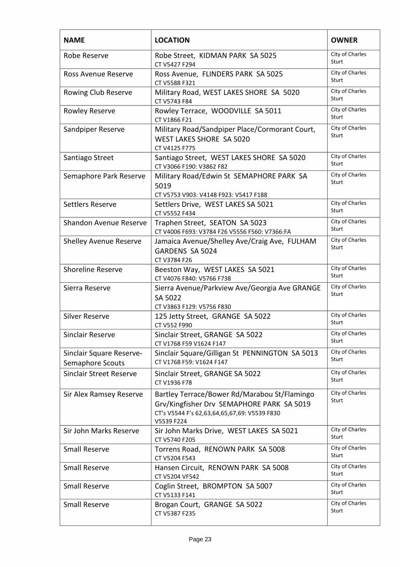
NAME LOCATION OWNER
Robe Reserve Robe Street, KIDMAN PARK SA 5025 CT V5427 F294
City of Charles Sturt
Ross Avenue Reserve Ross Avenue, FLINDERS PARK SA 5025 CT V5588 F321
City of Charles Sturt
Rowing Club Reserve Military Road, WEST LAKES SHORE SA 5020 CT V5743 F84
City of Charles Sturt
Rowley Reserve Rowley Terrace, WOODVILLE SA 5011 CT V1866 F21
City of Charles Sturt
Sandpiper Reserve Military Road/Sandpiper Place/Cormorant Court, WEST LAKES SHORE SA 5020 CT V4125 F775
City of Charles Sturt
Santiago Street Santiago Street, WEST LAKES SHORE SA 5020 CT V3066 F190: V3862 F82
City of Charles Sturt
Semaphore Park Reserve Military Road/Edwin St SEMAPHORE PARK SA 5019 CT V5753 V903: V4148 F923: V5417 F188
City of Charles Sturt
Settlers Reserve Settlers Drive, WEST LAKES SA 5021 CT V5552 F434
City of Charles Sturt
Shandon Avenue Reserve Traphen Street, SEATON SA 5023 CT V4006 F693: V3784 F26 V5556 F560: V7366:FA
City of Charles Sturt
Shelley Avenue Reserve Jamaica Avenue/Shelley Ave/Craig Ave, FULHAM GARDENS SA 5024 CT V3784 F26
City of Charles Sturt
Shoreline Reserve Beeston Way, WEST LAKES SA 5021 CT V4076 F840: V5766 F738
City of Charles Sturt
Sierra Reserve Sierra Avenue/Parkview Ave/Georgia Ave GRANGE SA 5022 CT V3863 F129: V5756 F830
City of Charles Sturt
Silver Reserve 125 Jetty Street, GRANGE SA 5022 CT V552 F990
City of Charles Sturt
Sinclair Reserve Sinclair Street, GRANGE SA 5022 CT V1768 F59 V1624 F147
City of Charles Sturt
Sinclair Square Reserve-Semaphore Scouts
Sinclair Square/Gilligan St PENNINGTON SA 5013 CT V1768 F59: V1624 F147
City of Charles Sturt
Sinclair Street Reserve Sinclair Street, GRANGE SA 5022 CT V1936 F78
City of Charles Sturt
Sir Alex Ramsey Reserve Bartley Terrace/Bower Rd/Marabou St/Flamingo Grv/Kingfisher Drv SEMAPHORE PARK SA 5019 CT’s V5544 F’s 62,63,64,65,67,69: V5539 F830 V5539 F224
City of Charles Sturt
Sir John Marks Reserve Sir John Marks Drive, WEST LAKES SA 5021 CT V5740 F205
City of Charles Sturt
Small Reserve Torrens Road, RENOWN PARK SA 5008 CT V5204 F543
City of Charles Sturt
Small Reserve Hansen Circuit, RENOWN PARK SA 5008 CT V5204 VF542
City of Charles Sturt
Small Reserve Coglin Street, BROMPTON SA 5007 CT V5133 F141
City of Charles Sturt
Small Reserve Brogan Court, GRANGE SA 5022 CT V5387 F235
City of Charles Sturt
Page 23
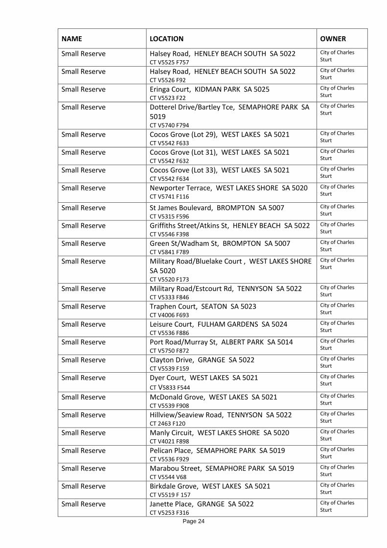
NAME LOCATION OWNER
Small Reserve Halsey Road, HENLEY BEACH SOUTH SA 5022 CT V5525 F757
City of Charles Sturt
Small Reserve Halsey Road, HENLEY BEACH SOUTH SA 5022 CT V5526 F92
City of Charles Sturt
Small Reserve Eringa Court, KIDMAN PARK SA 5025 CT V5523 F22
City of Charles Sturt
Small Reserve Dotterel Drive/Bartley Tce, SEMAPHORE PARK SA 5019 CT V5740 F794
City of Charles Sturt
Small Reserve Cocos Grove (Lot 29), WEST LAKES SA 5021 CT V5542 F633
City of Charles Sturt
Small Reserve Cocos Grove (Lot 31), WEST LAKES SA 5021 CT V5542 F632
City of Charles Sturt
Small Reserve Cocos Grove (Lot 33), WEST LAKES SA 5021 CT V5542 F634
City of Charles Sturt
Small Reserve Newporter Terrace, WEST LAKES SHORE SA 5020 CT V5741 F116
City of Charles Sturt
Small Reserve St James Boulevard, BROMPTON SA 5007 CT V5315 F596
City of Charles Sturt
Small Reserve Griffiths Street/Atkins St, HENLEY BEACH SA 5022 CT V5546 F398
City of Charles Sturt
Small Reserve Green St/Wadham St, BROMPTON SA 5007 CT V5841 F789
City of Charles Sturt
Small Reserve Military Road/Bluelake Court , WEST LAKES SHORE SA 5020 CT V5520 F173
City of Charles Sturt
Small Reserve Military Road/Estcourt Rd, TENNYSON SA 5022 CT V5333 F846
City of Charles Sturt
Small Reserve Traphen Court, SEATON SA 5023 CT V4006 F693
City of Charles Sturt
Small Reserve Leisure Court, FULHAM GARDENS SA 5024 CT V5536 F886
City of Charles Sturt
Small Reserve Port Road/Murray St, ALBERT PARK SA 5014 CT V5750 F872
City of Charles Sturt
Small Reserve Clayton Drive, GRANGE SA 5022 CT V5539 F159
City of Charles Sturt
Small Reserve Dyer Court, WEST LAKES SA 5021 CT V5833 F544
City of Charles Sturt
Small Reserve McDonald Grove, WEST LAKES SA 5021 CT V5539 F908
City of Charles Sturt
Small Reserve Hillview/Seaview Road, TENNYSON SA 5022 CT 2463 F120
City of Charles Sturt
Small Reserve Manly Circuit, WEST LAKES SHORE SA 5020 CT V4021 F898
City of Charles Sturt
Small Reserve Pelican Place, SEMAPHORE PARK SA 5019 CT V5536 F929
City of Charles Sturt
Small Reserve Marabou Street, SEMAPHORE PARK SA 5019 CT V5544 V68
City of Charles Sturt
Small Reserve Birkdale Grove, WEST LAKES SA 5021 CT V5519 F 157
City of Charles Sturt
Small Reserve Janette Place, GRANGE SA 5022 CT V5253 F316
City of Charles Sturt
Page 24

NAME LOCATION OWNER
Small Reserve Dutton Grove, WEST LAKES SHORE SA 5020 CT V4073 F654
City of Charles Sturt
Small Reserve Edgecombe Street/Blackburn Court, WOODVILLE NORTH SA 5012
City of Charles Sturt
Small Reserve Edgecombe Street/Sansom Street, WOODVILLE NORTH SA 5012
City of Charles Sturt
Small Reserve Hall Court/Woodmore Street, WOODVILLE NORTH SA 5012
City of Charles Sturt
Small Reserve Sheridan Street/York, WOODVILLE NORTH SA 5012
City of Charles Sturt
Small Reserve Stone Street/Woodmore Street, WOODVILLE NORTH SA 5012
City of Charles Sturt
Small Reserve Fourth Avenue/Colston Street, CHELTENHAM SA 5014
City of Charles Sturt
Small Reserve Arthur Street/Whimpress Avenue, FINDON SA 5023
City of Charles Sturt
Small Reserve Balcombe Avenue, SEATON SA 5023 City of Charles Sturt
Small Reserve Dumfries Avenue/Fortrose Avenue, SEATON SA 5023
City of Charles Sturt
Small Reserve Falkirk Avenue/Thornton Street, SEATON SA 5023 City of Charles Sturt
Small Reserve Leven Avenue/Ballater Avenue, SEATON SA 5023 City of Charles Sturt
Small Reserve Lothian Avenue/Angley Avenue, SEATON SA 5023 City of Charles Sturt
Small Reserve Selkirk Avenue/Lanark, SEATON SA 5023 City of Charles Sturt
Small Reserve Stacey Street, RENOWN PARK SA 5008 City of Charles Sturt
Small Reserve Trimmer Parade, SEATON SA 5023 City of Charles Sturt
Small Reserve Tapleys Hill Road/NE corner Trimmer Parade. SEATON SA 5023
City of Charles Sturt
Small Reserve Ely St/Claire Street, ATHOL PARK SA 5012 City of Charles Sturt
Small Reserve Coronado Court, WEST LAKES SHORE SA 5020 City of Charles Sturt
Small Reserve Uriah Place, WEST LAKES SHORE SA 5020 City of Charles Sturt
Small Reserve Military Road/Mellor Street, WEST BEACH SA 5024
City of Charles Sturt
Small Reserve Torrens Road/Harrison Road, RENOWN PARK SA 5008
City of Charles Sturt
Small Reserve Marabou Street, SEMAPHORE PARK SA 5019 City of Charles Sturt
Small Reserve Martin Court, WEST LAKES SA 5021 City of Charles Sturt
Small Reserve Powell Court/West Lakes Boulevard, WEST LAKES SA 5021
City of Charles Sturt
Small Reserve Tern Place, SEMAPHORE PARK SA 5019 City of Charles Sturt
Small Reserve Alma Terrace, SEATON SA 5023 City of Charles Sturt
Page 25

NAME LOCATION OWNER
Small Reserve Market Place/Hawker Street, BOWDEN SA 5007 City of Charles Sturt
Small Reserve Cheltenham Parade/Chippenham Street, CHELTENHAM SA 5014
City of Charles Sturt
Small Reserve St James Boulevard/Kennington Avenue, BROMPTON SA 5007
City of Charles Sturt
Small Reserve Hallett Boulevard/Noble Terrace, ALLENBY GARDENS SA 5009
City of Charles Sturt
Somerset Reserve Riverway/Somerset Avenue FULHAM GARDENS SA 5024
City of Charles Sturt
Sparrow Reserve Thirteenth Ave/Fourteenth Avenue, WOODVILLE NORTH SA 5012
City of Charles Sturt
St Andrews Way Reserve St Andrews Way, WEST LAKES SA 5021 City of Charles Sturt
Stacey Street Reserve Stacey Street, RENOWN PARK SA 5008 City of Charles Sturt
St Clair Greenway Reserve
Apprentice St/St Clair Ave, ST CLAIR CT’s V6073/V810; V6016/F 596; V6073/F811 V6106/F595
City of Charles Sturt 25/7/2016
St Clair Rail Plaza Reserve Beyer Street, ST CLAIR CT V6113/F407
City of Charles Sturt 25/7/2016
Sunset Reserve Nash Street/Sunset Crescent, GRANGE SA 5022 City of Charles Sturt
Syd Knight Reserve Cudmore Terrace/Chambers Street , HENLEY BEACH SA 5022
City of Charles Sturt
Tandanya Reserve Wandilla Street, GRANGE SA 5022 City of Charles Sturt
Tatura Reserve Tatura Crescent, FULHAM GARDENS SA 5024 City of Charles Sturt
Tennyson Reserve Moredun Street, TENNYSON SA 5022 Crown Thiele Reserve Thiele Crescent, WEST LAKES SHORE SA 5020 City of Charles
Sturt Terminus Street Reserve Terminus Street, GRANGE SA 5022 City of Charles
Sturt
Tiranna Reserve Tiranna Way, WEST LAKES SA 5021 City of Charles Sturt
Todd Reserve Daly Crescent/Todd Place/Ord Close WEST LAKES SHORE SA 5020
City of Charles Sturt
Toledo Reserve Toledo Avenue/Malabu Drive/Annes Court, WEST BEACH SA 5024
City of Charles Sturt
Tomlinson Reserve Granville Street/Tomlison Rd, SEMAPHORE PARK SA 5019
City of Charles Sturt
Torres Reserve Torres Avenue, FLINDERS PARK SA 5025 City of Charles Sturt
Towpath Reserve Military Road, WEST LAKES SHORE SA 5020 City of Charles Sturt
Turnbull Reserve Telford Street, OVINGHAM SA 5082 City of Charles Sturt
Valentine Street Reserve Valentine Street/Veronica Street KIDMAN PARK SA 5025
City of Charles Sturt
Valetta Reserve Valletta Road/Frogmore Road KIDMAN PARK SA 5025
City of Charles Sturt
Veronica Reserve Veronica Street to Margaret Street KIDMAN PARK SA 5025
City of Charles Sturt
Page 26

NAME LOCATION OWNER
Wallman Reserve Grey Avenue, WEST HINDMARSH SA 5007 City of Charles Sturt
Walter Kidman Reserve Miller Street/Sydney Avenue KIDMAN PARK SA 5025
City of Charles Sturt
Wastell Court Reserve Arthur Street/Wastell Court/Marie Court, PENNINGTON SA 5013
City of Charles Sturt
West Lakes lake bed Total Lake Area City of Charles Sturt
West Reserve West Street, BROMPTON SA 5007 City of Charles Sturt
West Street Reserve West Street, BROMPTON SA 5007 City of Charles Sturt
Wilford Avenue Reserve Meakin Terrace/Prior Avenue/Wilford Avenue SEATON SA 5023
City of Charles Sturt
Willcocks Avenue Reserve
Willcocks Avenue, SEATON SA 5023 City of Charles Sturt
William Atkins Reserve Canberra Street/Lexington Road HENLEY BEACH SOUTH SA 5022
City of Charles Sturt
Wilpena Terrace Closure Reserve
David Terrace/Wilpena Terrace, KILKENNY SA 5009
City of Charles Sturt
Windsor Reserve (previously PENNINGTON RESERVE)
Butler Avenue/Windsor Avenue/Booker Court, PENNINGTON SA 5013
City of Charles Sturt
Woodlake Reserve Maramba Avenue/Frederick Road WEST LAKES SA 5021
City of Charles Sturt
Woodville West Reserve Todville Street/Lawton Crescent, WOODVILLE WEST SA 5011
City of Charles Sturt
Woodville West Greenway Reserve
Alma Tce/Northcote lane/Lawton Crescent WOODVILLE WEST CT V6171/Folios 854,855,856
City of Charles Sturt 25/7/2016
Woodville/Torrens Rd Reserve
Woodville Road/Torrens Road WOODVILLE SA 5011
City of Charles Sturt
Wright Reserve Wright Street/Harrison Road, RENOWN PARK SA 5008
City of Charles Sturt
Wright Street Reserve Wright Street, RIDLEYTON SA 5008 City of Charles Sturt
Wye Reserve May Street/Wye Street WOODVILLE WEST SA 5011
City of Charles Sturt
Page 27

Schedule B: Management Plans - Community Land Reserve – Local Park NAME LOCATION OWNER TRUST, DEDICATION OR RESERVATION ON LAND (WHERE
OWNER NOT CCS)
Trimmer Parade/Frederick Road Allotment
Trimmer Parade/Frederick Road, West Lakes
The Crown - Custodian City of Charles Sturt
Land dedicated for Plantation purposes pursuant to the Crowns Act 1929
Chiropractic Reserve
Torrens Road/South Road, Croydon
Commissioner of Highways
Highways Reserve
Torrens Road (Exeter Tce to Napier St), Renown Park
Commissioner of Highways
Semaphore Park Reserve
Military Road/Edwin Street, Semaphore Park
- The Crown (part)-custodian, City of Charles Sturt - City of Charles Sturt(part)
Land dedicated for District Council purposes pursuant to the Crown Lands Act 1929. Subject to Native Title claim.
Page 28

Reserve - Local Park Name and address of property • Refer schedule C Ownership details • Refer schedule C Purpose for which the land is held • To provide a hierarchy of open space strategically located throughout the City to
meet the recreational needs of the community or to address specific environmental, heritage or urban design objectives.
Objectives for the management of the land • To provide an area for the use and convenience of the community where limited
recreational activities may be undertaken or landscaping is established. Policies and proposals for the management of the land • The appropriate range of activities will reflect the constraints of the site including
the size of the land and the proximity of adjoining dwellings and have regard to the demographics of the area.
• In some locations the primary function of the reserve will be to provide a landscaped area or to facilitate pedestrian movement.
• Council may issue a permit to allow access over the Reserve or to allow for an activity of a ‘short term’ nature.
• It may be appropriate to utilise portion of the site for stormwater management purposes.
• The presence of cadmium has been detected in the soil on the Reserve. Council has put in place an Environmental Management Plan to ensure that the risk to human health of persons using the Reserve or undertaking maintenance on the Reserve is minimised.
• Council policy-Play Space Policy Ref 5.6 Performance targets • To provide a safe and functional facility developed and maintained in a manner
appropriate to its location and purpose. Performance measures • Regular inspection and maintenance of facility.
Page 29

Schedule C: Management Plan for Community Land - Reserve - Local Park NAME LOCATION OWNER Anthea Court Reserve
Corcoran Drive, WEST LAKES 5021 CT 5553/950
City of Charles Sturt
Aquatic Reserve Bower Road, WEST LAKES 5021 CT 5460/936
City of Charles Sturt
Bali Reserve Bali Court, WEST LAKES 5021 CT
City of Charles Sturt
Corcoran Reserve CT 5355/980 City of Charles Sturt
Dame Pattie Reserve Dame Pattie Circuit, WEST LAKES 5021 CT 5552/976
City of Charles Sturt
Eildon Reserve Lakeview Avenue, WEST LAKES 5021 CT 5740/216
City of Charles Sturt
Frome Reserve Frome Crescent, WEST LAKES 5021 CT 5740/217
City of Charles Sturt
Gretel Grove Reserve
Gretel Grove, WEST LAKES 5021
City of Charles Sturt
Hawaii Court Reserve
Hawaii Court, WEST LAKES 5021 City of Charles Sturt
Hero Reserve Hero Way, WEST LAKES 5021 CT 5546/413
City of Charles Sturt
Lakeview Reserve Lochside Drive, WEST LAKES 5021 CT 5740/214
City of Charles Sturt
Liberman Reserve Liberman Court, WEST LAKES 5021 CT 5553/3
City of Charles Sturt
Mariners Reserve Mariners Crt/Settlers Dr/Eildon Crt, WEST LAKES 5021 CT 5740/218
City of Charles Sturt
Martin Court Reserve
Martin Court, WEST LAKES 5021 CT 5819/894
City of Charles Sturt
Mc Donald Grove Reserve
Mc Donald Grove, WEST LAKES 5021 CT 5539/910
City of Charles Sturt
Rapid Reserve Hero way, WEST LAKES 5021 City of Charles Sturt
Samoa Court Reserve
Samoa Court, WEST LAKES 5021 CT 5539/487
City of Charles Sturt
For work on these Reserves, refer Standard Work Procedure TRIM 08/70146
Page 30

Screening Reserve Name and address of property • Refer schedule Ownership details • See schedule Purpose for which the land is held (by the City of Charles Sturt) • To provide a hierarchy of open space strategically located throughout the City to
meet the recreational needs of the community or to address specific environmental, heritage or urban design objectives.
Objectives for the management of the land • To provide a physical barrier to control vehicular access to collector (and other)
roads and landscaping to visually screen fencing and buildings. Policies and proposals for the management of the land • Generally these areas will be landscaped to form an effective visual screen between
fencing/buildings and the users of adjoining roads. • Plantings will need to be replaced periodically to ensure that an effective visual
screen is maintained. • Particular attention to location and maintenance of planting is required to ensure
the safety and convenience of pedestrians using the adjoining footpaths. • Where the prime purpose of the screening reserve is to control vehicular access, a
reduced level of landscaping and screening may be appropriate. • A permit to allow temporary access over the Reserve may be issued from time to
time. Performance targets • To provide a safe and attractive facility maintained and developed in a manner
appropriate to its location and purpose. Performance measures • Regular inspection and maintenance of facility.
Page 31

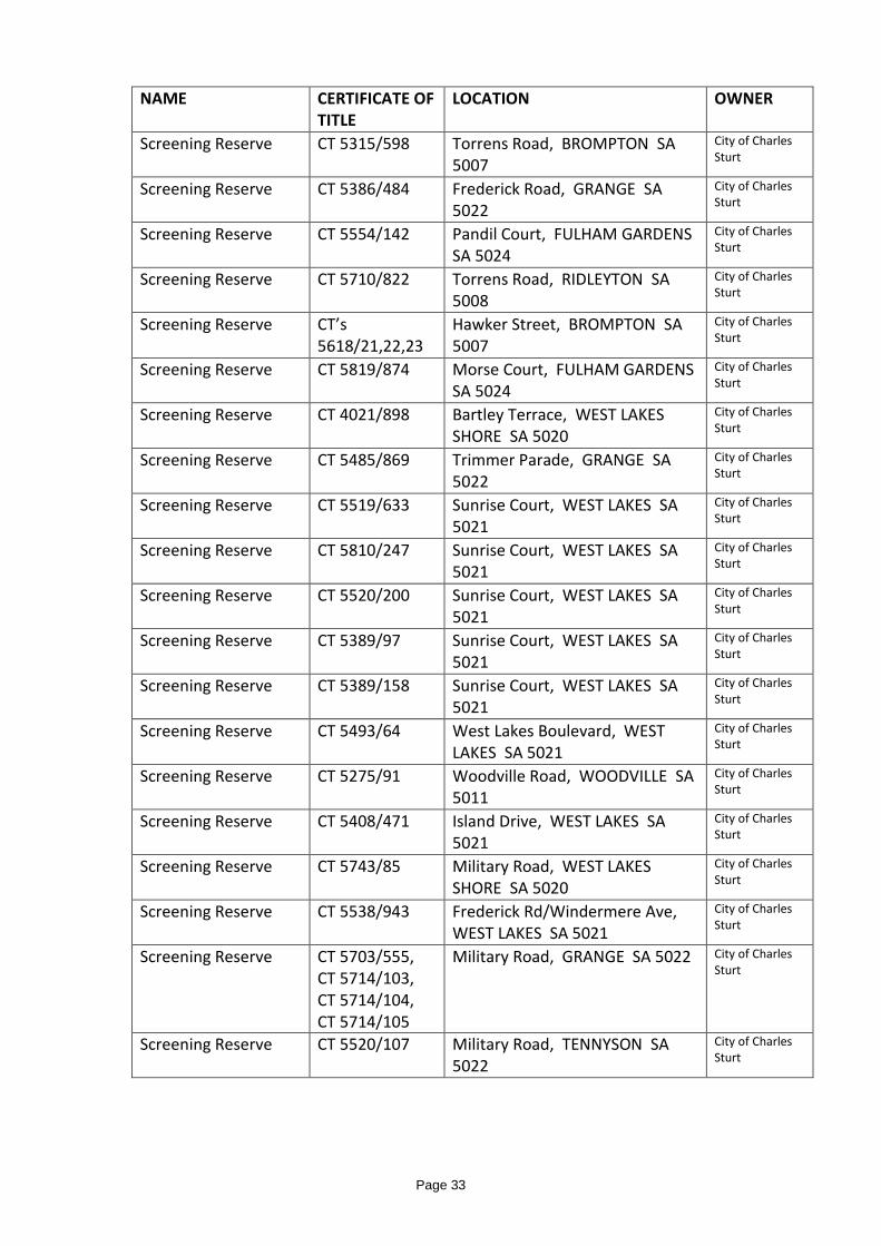
Schedule: Management Plans - Community Land Screening Reserves
NAME CERTIFICATE OF
TITLE LOCATION OWNER
Screening Reserve CT 3900/22 Sportsmans Drive, WEST LAKES SA 5021
City of Charles Sturt
Screening Reserve CT 4006/905 Military Road, TENNYSON SA 5022
City of Charles Sturt
Screening Reserve CT 5546/338, CT 5546/337
Delfin Drive, WEST LAKES SA 5021
City of Charles Sturt
Screening Reserve CT 5380/797 Hallet Boulevard, ALLENBY GARDENS SA 5009
City of Charles Sturt
Screening Reserve CT 4021/897 Bartley Tce, WEST LAKES SHORE SA 5020
City of Charles Sturt
Screening Reserve CT 5544/71 Prion Place, SEMAPHORE PARK SA 5019
City of Charles Sturt
Screening Reserve CT 5552/987 Bartley Terrace, WEST LAKES SHORE SA 5020
City of Charles Sturt
Screening Reserve CT 4048/387 Bartley Terrace, WEST LAKES SHORE SA 5020
City of Charles Sturt
Screening Reserve CT 5493/63 Island Drive, WEST LAKES SA 5021
City of Charles Sturt
Screening Reserve CT 5709/409 Island Drive, WEST LAKES SA 5021
City of Charles Sturt
Screening Reserve CT 5552/421 Military Road, WEST LAKES SHORE SA 5020
City of Charles Sturt
Screening Reserve CT 5743/86 Military Road, WEST LAKES SHORE SA 5020
City of Charles Sturt
Screening Reserve CT 4056/427 Sportsmans Drive, WEST LAKES SA 5021
City of Charles Sturt
Screening Reserve CT 5075/719 Trimmer Parade, GRANGE SA 5022
City of Charles Sturt
Screening Reserve CT 5836/125 West Lakes Boulevard, WEST LAKES SA 5021
City of Charles Sturt
Screening Reserve CT 5133/138 Burley Griffin Blvd, BROMPTON SA 5007
City of Charles Sturt
Screening Reserve CT 5151/890 Burley Griffin Blvd, BROMPTON SA 5007
City of Charles Sturt
Screening Reserve CT 5582/252 West Lakes Boulevard, WEST LAKES SA 5021
City of Charles Sturt
Screening Reserve CT 5315/597 Torrens Road, BROMPTON SA 5007
City of Charles Sturt
Page 32
NAME CERTIFICATE OF
TITLE LOCATION OWNER
Screening Reserve CT 5315/598 Torrens Road, BROMPTON SA 5007
City of Charles Sturt
Screening Reserve CT 5386/484 Frederick Road, GRANGE SA 5022
City of Charles Sturt
Screening Reserve CT 5554/142 Pandil Court, FULHAM GARDENS SA 5024
City of Charles Sturt
Screening Reserve CT 5710/822 Torrens Road, RIDLEYTON SA 5008
City of Charles Sturt
Screening Reserve CT’s 5618/21,22,23
Hawker Street, BROMPTON SA 5007
City of Charles Sturt
Screening Reserve CT 5819/874 Morse Court, FULHAM GARDENS SA 5024
City of Charles Sturt
Screening Reserve CT 4021/898 Bartley Terrace, WEST LAKES SHORE SA 5020
City of Charles Sturt
Screening Reserve CT 5485/869 Trimmer Parade, GRANGE SA 5022
City of Charles Sturt
Screening Reserve CT 5519/633 Sunrise Court, WEST LAKES SA 5021
City of Charles Sturt
Screening Reserve CT 5810/247 Sunrise Court, WEST LAKES SA 5021
City of Charles Sturt
Screening Reserve CT 5520/200 Sunrise Court, WEST LAKES SA 5021
City of Charles Sturt
Screening Reserve CT 5389/97 Sunrise Court, WEST LAKES SA 5021
City of Charles Sturt
Screening Reserve CT 5389/158 Sunrise Court, WEST LAKES SA 5021
City of Charles Sturt
Screening Reserve CT 5493/64 West Lakes Boulevard, WEST LAKES SA 5021
City of Charles Sturt
Screening Reserve CT 5275/91 Woodville Road, WOODVILLE SA 5011
City of Charles Sturt
Screening Reserve CT 5408/471 Island Drive, WEST LAKES SA 5021
City of Charles Sturt
Screening Reserve CT 5743/85 Military Road, WEST LAKES SHORE SA 5020
City of Charles Sturt
Screening Reserve CT 5538/943 Frederick Rd/Windermere Ave, WEST LAKES SA 5021
City of Charles Sturt
Screening Reserve CT 5703/555, CT 5714/103, CT 5714/104, CT 5714/105
Military Road, GRANGE SA 5022 City of Charles Sturt
Screening Reserve CT 5520/107 Military Road, TENNYSON SA 5022
City of Charles Sturt
Page 33
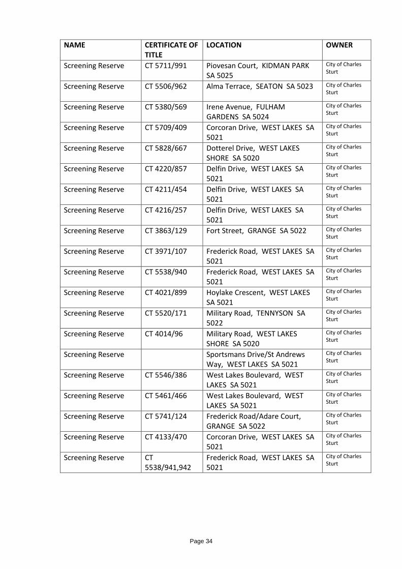
NAME CERTIFICATE OF
TITLE LOCATION OWNER
Screening Reserve CT 5711/991 Piovesan Court, KIDMAN PARK SA 5025
City of Charles Sturt
Screening Reserve CT 5506/962 Alma Terrace, SEATON SA 5023 City of Charles Sturt
Screening Reserve CT 5380/569 Irene Avenue, FULHAM GARDENS SA 5024
City of Charles Sturt
Screening Reserve CT 5709/409 Corcoran Drive, WEST LAKES SA 5021
City of Charles Sturt
Screening Reserve CT 5828/667 Dotterel Drive, WEST LAKES SHORE SA 5020
City of Charles Sturt
Screening Reserve CT 4220/857 Delfin Drive, WEST LAKES SA 5021
City of Charles Sturt
Screening Reserve CT 4211/454 Delfin Drive, WEST LAKES SA 5021
City of Charles Sturt
Screening Reserve CT 4216/257 Delfin Drive, WEST LAKES SA 5021
City of Charles Sturt
Screening Reserve CT 3863/129 Fort Street, GRANGE SA 5022 City of Charles Sturt
Screening Reserve CT 3971/107 Frederick Road, WEST LAKES SA 5021
City of Charles Sturt
Screening Reserve CT 5538/940 Frederick Road, WEST LAKES SA 5021
City of Charles Sturt
Screening Reserve CT 4021/899 Hoylake Crescent, WEST LAKES SA 5021
City of Charles Sturt
Screening Reserve CT 5520/171 Military Road, TENNYSON SA 5022
City of Charles Sturt
Screening Reserve CT 4014/96 Military Road, WEST LAKES SHORE SA 5020
City of Charles Sturt
Screening Reserve Sportsmans Drive/St Andrews Way, WEST LAKES SA 5021
City of Charles Sturt
Screening Reserve CT 5546/386 West Lakes Boulevard, WEST LAKES SA 5021
City of Charles Sturt
Screening Reserve CT 5461/466 West Lakes Boulevard, WEST LAKES SA 5021
City of Charles Sturt
Screening Reserve CT 5741/124 Frederick Road/Adare Court, GRANGE SA 5022
City of Charles Sturt
Screening Reserve CT 4133/470 Corcoran Drive, WEST LAKES SA 5021
City of Charles Sturt
Screening Reserve CT 5538/941,942
Frederick Road, WEST LAKES SA 5021
City of Charles Sturt
Page 34

NAME CERTIFICATE OF
TITLE LOCATION OWNER
Screening Reserve CT 5178/136 West Lakes Boulevard, WEST LAKES SA 5021
City of Charles Sturt
Screening Reserve CT 5455/72 Military Road, SEMAPHORE PARK SA 5019
City of Charles Sturt
Screening Reserve CT 5455/74 Military Road, SEMAPHORE PARK SA 5019
City of Charles Sturt
Screening Reserve CT 5455/73 Military Road, SEMAPHORE PARK SA 5019
City of Charles Sturt
Screening Reserve CT 5740/808 Military Road, SEMAPHORE PARK SA 5019
City of Charles Sturt
Screening reserve Lot 50 DP74723 Area 1sq m
27 South Road RIDLEYTON City of Charles Sturt
Screening Reserve CT 5372/623 Trimmer Parade, GRANGE SA 5022
City of Charles Sturt
Screening Reserve Wylde Street, KIDMAN PARK SA 5025
City of Charles Sturt
Screening Reserve CT 5178/136 West Lakes Boulevard, WEST LAKES SA 5021
City of Charles Sturt
Screening Reserve CT 5990/915 Lot 50 DP74723
27 South Road, RIDLEYTON, SA 5008-narrow Reserve to prevent vehicular access to South Road
City of Charles Sturt
Screening Reserve William Langman Circuit, RIDLEYTON SA 5008
City of Charles Sturt
Page 35

Adopted by Council 26/04/2016 Coastal Reserve Name and address of property • Coastal Reserve • West Beach to Semaphore Park (Refer Schedule) • Includes:
• Pt Malcolm Reserve • CT V5752 F216; V5753 F887; V5759 F865 • Moredun Street Reserve • CT V5753 F901 • Tennyson Heights Court Reserve • CT V5538 F198
Ownership details (Refer Schedule) • The Crown • City of Charles Sturt Dedications (Refer Schedule) Purpose for which the land is held • To provide a hierarchy of open space strategically located throughout the City to
meet the recreational needs of the community, to address specific environmental or urban design objectives and to provide protection of the land (as relevant).
Objectives for the management of the land • To protect the coastal dune system and coastal vegetation and to provide
convenient and controlled public access to the beach and environs Policies and proposals for the management of the land • To support State Government programs for coastal management as they affect
the City. • To deliver the State Government’s Coast Park initiatives. • To support measures to protect, stabilise and refurbish the coastal dune system. • To provide, as far as possible, a continuous shared-use two-way pathway or trail
for walkers, cyclists and other suitable users, along the coastal foreshore. • To provide public access across the dunes in various forms in appropriate
locations. • To support the provision of facilities in beach localities that contribute to the
convenience and enjoyment of the public. • To recognise the importance of the coastal landscape to the Kaurna people, their
culture and heritage. • Infrastructure may be installed in certain locations to facilitate the pumping of
sand to replenish stocks in other nearby coastal locations. • To support the provision of facilities associated with the surf lifesaving activities • To facilitate the installation of public art in appropriate locations. • To support programs that encourage community involvement in dune care and
revegetation.
Page 36

• To control the encroachment of plantings from private property that extends into the dunes.
• To support measures to control pest plants and animals. • Council may issue a permit to allow access over the Reserve or to allow for an
activity of a ‘short term’ nature. Policies • Vegetation Management Plans • Coastal Management Plan • Open Space Strategy • Development Plan-Charles Sturt Council • Horses on the foreshore • Use of Public Reserves for Commercial Fitness Activities
Performance targets • To provide a safe and attractive facility developed to a level appropriate to its
location and purpose. Performance measures • Regular inspection and maintenance of facility.
Page 37

SCHEDULE TC 27/04/2016
CT* LENGTH(metres)
LOT OWNER DEDICATION LOCATION
5752/217 5753/888
630 343 CROWN-CCS CUSTODIAN NATURAL FEATURES PRESENTATION PURPOSES
Bower Road to Recreation Parade
5752/216 340 Lot 101 CROWN-CCS CUSTODIAN RECREATION AND LIFESAVING PURPOSES
Pt Malcolm Reserve Ozone Avenue to Recreation Parade
5753/887 Sect 815 CROWN-CCS CUSTODIAN RECREATION PURPOSES Pt Malcolm Reserve Military Road
5753/894 395 Sec 993 & Sec 994
CROWN-CCS CUSTODIAN NATURAL FEATURES PRESERVATION PURPOSES
Recreation Parade to Third Avenue
5759/865 Sect 345 CROWN-CCS CUSTODIAN RECREATION AND SURF LIFESAVING PURPOSES
Pt Malcolm Reserve Military Road
5740/809 5740/814
610 94 and 97 CCS NONE-RESERVE Third Avenue to Mirani Court
4006/905 550 19 CCS NONE Sandpiper Place to Cormorant Court 5538/198 220 41 CCS NONE-RESERVE Tennyson Heights Court 5219/142 15 151 CCS NONE - RESERVE South of Bournemouth Avenue 5753/894 150 Sec 993 & Sec
994 CROWN-CCS CUSTODIAN NATURAL FEATURES PRESERVATION Esplanade/Hillview Avenue
5753/893 38 Sec 988 CROWN-CCS CUSTODIAN COAST PROTECTION PURPOSES Esplanade/Moredun Street 5753/901 100 Sec3286 CROWN-CCS CUSTODIAN UNSPECIFIED LOCAL GOVT. PURPOSES Moredun Street 5753/893 1170 Sec987 CROWN-CCS CUSTODIAN COAST PROTECTION PURPOSES Moredun Street to Fort Street 5753/895 1170 Sec 995,996 CROWN-CCS CUSTODIAN WALKWAY PURPOSES Moredun Street to Fort Street 5753/889 250 Sec 897 CROWN-CCS CUSTODIAN RECREATION PURPOSES Fort Street to Terminus Street No title 310 Lot A CCS NONE-Includes Grange Jetty Cafe Terminus Street to Jetty Street 5753/892 640 487 CROWN-CCS CUSTODIAN RECREATIION PURPOSES Jetty Street to Grange Road 5753/916 50 Sec5830 CROWN-CCS CUSTODIAN RECREATION AND PARKING PURPOSES Grange Road/Seaview Road
Page 38

5753/891 675 Sec 940,941 CROWN-CCS CUSTODIAN RECREATION PURPOSES Grange Road to Marlborough Street 5753/896 670 Sec1004 CROWN-CCS CUSTODIAN RECREATION PURPOSES Marlborough Street to Main Street 5753/896 105 Sec1004 CROWN -CCS CUSTODIAN RECREATION PURPOSES The Esplanade 5753/898 40 Sec 1650 CROWN-CCS CUSTODIAN CLUBROOM PURPOSES The Esplanade 5753/897 80 Sec 1649 CROWN -CCS CUSTODIAN SWIMMING POOL AND LEISURE CENTRE
PURPOSES The Esplanade
5753/896 520 Sec1004 CROWN -CCS CUSTODIAN RECREATION PURPOSES South Street to Henley Beach Road 5753/886 970 Sec 692 CROWN-CCS CUSTODIAN RECREATION AND PARKING PURPOSES Henley Beach Road to Ozone Street No title (closed Rd)
100 Lt E CCS NONE Esplanade/Ozone Street
5753/884 295 Sec 678 CROWN-CCS CUSTODIAN RECREATION AND PARKING PURPOSES Seaview Road (Mellor Street to Burbridge Road)
5753/883 940 Sec652 CROWN-CCS CUSTODIAN RECREATION AND PARKING PURPOSES Burbridge Road to West Beach Road 6126/767 250 Sec688 CROWN-CCS CUSTODIAN RECREATION AND PARKING PURPOSES West Beach Road to Chetwynd Street CCS OWNED CROWN OWNED-CCS CUSTODIAN Public roads are excluded
Page 39

River Torrens Linear Park Overview The three bodies responsible for the Linear Park and River Torrens are: • City of Charles Sturt. • South Australian Government • Torrens Catchment Water Management Board Name and address of property • Refer schedule Ownership details • Refer schedule Purpose for which the land is held • To provide a hierarchy of open space strategically located throughout the City to
meet the recreational needs of the community or to address specific environmental or urban design objectives.
Objectives for the management of the land • To provide a continuous corridor of open space adjacent to the waterway with
some sections developed in a more structured manner for informal recreation, catering for the local and the wider community.
Policies and proposals for the management of the land • To develop and maintain the Park in a manner that is consistent with the stated
objectives of the State Government for that section of the Linear Park that falls within the City.
• To establish pedestrian and cycle links from surrounding areas with the linear paths existing in the Park.
• To provide play equipment, barbecues, and park furniture in appropriate locations that have good access to adjoining residential areas.
• To adopt maintenance practices that has minimal adverse impact on wild life habitats.
• To provide an attractive environment. Performance targets • To provide a safe and attractive facility developed and maintained in a manner
appropriate to its location and purpose. Performance measures • Regular inspection and maintenance of facility.
Page 40

Schedule: Management Plans For Community Land - River Torrens Linear Park
NAME LOCATION OWNER LEASE/LICENCE (FUTURE)
Blamey Reserve Kooralla Grove (Frogmore Road to Findon Road), KIDMAN PARK
- City of Charles Sturt - Minister for Water Resources - Minister for Infrastructure - SA Water Corporation
Breakout Reserve (North)
Military Road, Henley Beach South
- Minister for Employment and Training - SA Water
Breakout Reserve (South)
Military Road, West Beach - Minister for Employment and Training - SA Water
George Jones Section Reserve
Riverway Place, Kidman Park - Minister of Water Resources - Minister for Government Enterprises - City of Charles Sturt
Tedder Reserve Belgrave Avenue Flinders Park - Minister for Infrastructure - City of Charles Sturt
City of Charles Sturt to continue to lease car parking area adjacent to Findon Road
Montgomery Reserve
Kanbara Street, Flinders Park - Minister for Infrastructure - Minister for Water Resources - City of Charles Sturt
John Keeley Reserve (formerly Mountbatten)r
Mountbatten Terrace (Frogmore Road to Findon Road), FLINDERS PARK
- Minister for Water Resources - Minister for Infrastructure - Minister for Government Enterprises - City of Charles Sturt
Page 41

Adam Street Reserve (River Torrens Linear Park)
Name and address of property • Adam Street Reserve • Adam Street, Hindmarsh (from Port Road to South Road) • CT V5812 F420 – Area 3.504 Ha Ownership details • City of Charles Sturt Purpose for which the land is held • To provide a hierarchy of open space strategically located throughout the City to
meet the recreational needs of the community or to address specific environmental or urban design objectives.
Objectives for the management of the land • To provide a continuous corridor of open space adjacent to the waterway with
some sections developed in a more structured manner for informal recreation, catering for the local and the wider community.
Policies and proposals for the management of the land • To develop and maintain the Park in a manner that is consistent with the stated
objectives of the State Government for that section of the Linear Park that falls within the City.
• To establish pedestrian and cycle links from surrounding areas with the linear paths existing in the Park.
• To provide play equipment, barbecues, and park furniture in appropriate locations that have good access to adjoining residential areas.
• To adopt maintenance practices that has minimal adverse impact on wild life habitats.
• To provide an attractive environment. • Council may issue a permit to allow commercial traders to sell goods from
temporary facilities located adjacent to the car parking areas. • Council may issue a permit to allow access over the Reserve or to allow for an
activity of a ‘short term’ nature (including car parking) – such use may be on a regular basis.
Performance targets • To provide a safe and attractive facility developed and maintained in a manner
appropriate to its location and purpose. Performance measures • Regular inspection and maintenance of facility.
Page 42

Port Road Plantation Overview The Port Road plantation separates the up/down carriageways of the Port Road. Historically this wide road plantation area has been used for landscaping, sports courts and car parking. The Port Road and plantation is of metropolitan significance and remains a great urban resource by virtue of its monumental proportions. The land is dedicated for recreation purposes and is owned by the Crown with the City of Charles Sturt being the custodian. Name and address of property • Port Road plantation; from Park Terrace, Bowden to Chief Street, Hindmarsh. Ownership details • Crown - City of Charles Sturt, custodian
Nature of trust, dedication or restriction • - Dedicated for recreation purposes pursuant to the Crown Lands Act, 1929 • - Subject to Native Title Claim Purpose for which the land is held • To provide a hierarchy of open space strategically located throughout the City to
meet the recreational needs of the community or to address specific environmental or urban design objectives.
Objectives for the management of land • To provide an area for the use and enjoyment of the community where,
generally, passive recreational activities may be undertaken. • To provide an area for the location of infrastructure. • To provide an area for establishing historical, landscaping and community art
nodes. • To provide off-street car parking areas close to established businesses.
Policies and proposals for the management of the land • Landscaping to provide an aesthetically pleasing environment within the broader
urban context. • The visual impact of car parking areas to be minimised and no additional car
parking areas to be established. • Sections of the plantation to be available for any future stormwater management
systems. • The two Council owned buildings located in the plantation area may be leased to
community based groups or commercial organisations. Performance targets • To provide a safe and attractive facility developed and maintained in a manner
appropriate to its location and purpose. Performance measures • Regular inspection and maintenance of facility.
Page 43
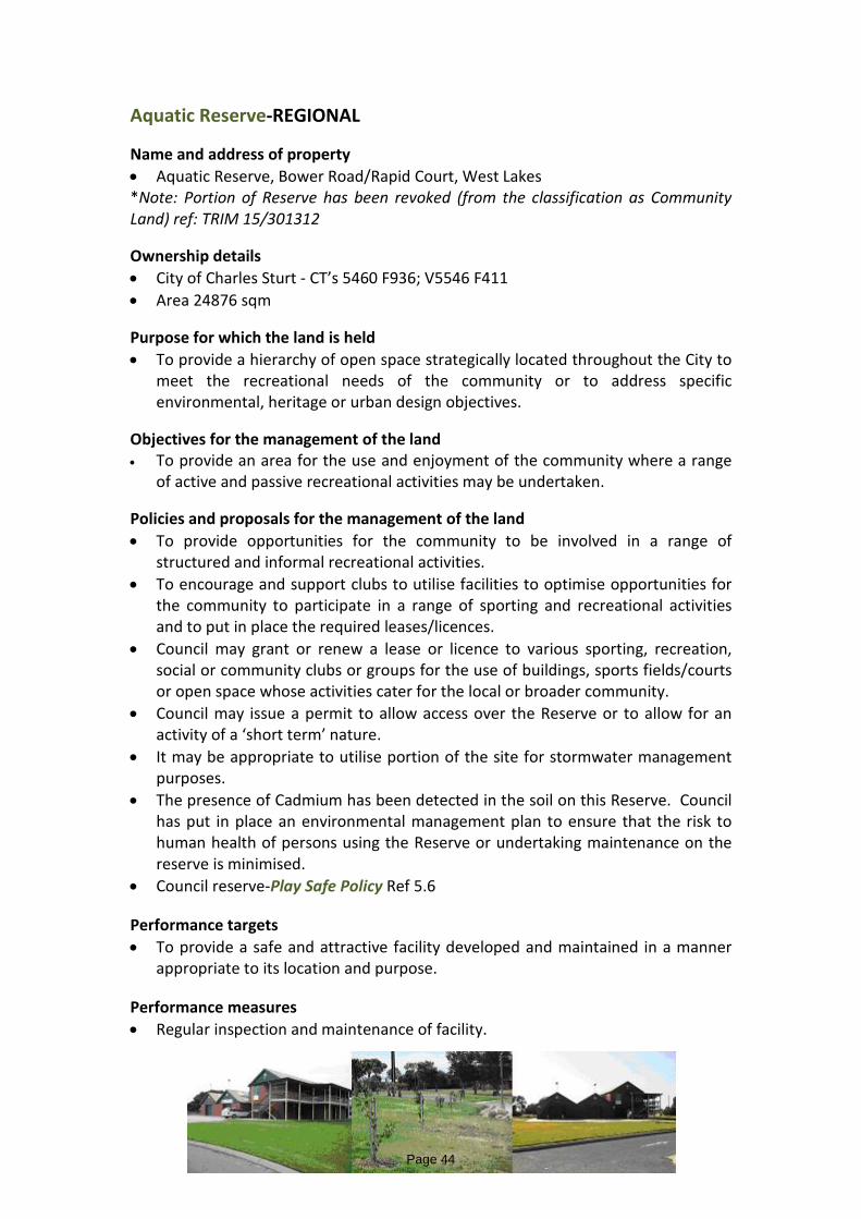
Aquatic Reserve-REGIONAL Name and address of property • Aquatic Reserve, Bower Road/Rapid Court, West Lakes *Note: Portion of Reserve has been revoked (from the classification as Community Land) ref: TRIM 15/301312 Ownership details • City of Charles Sturt - CT’s 5460 F936; V5546 F411 • Area 24876 sqm Purpose for which the land is held • To provide a hierarchy of open space strategically located throughout the City to
meet the recreational needs of the community or to address specific environmental, heritage or urban design objectives.
Objectives for the management of the land • To provide an area for the use and enjoyment of the community where a range
of active and passive recreational activities may be undertaken. Policies and proposals for the management of the land • To provide opportunities for the community to be involved in a range of
structured and informal recreational activities. • To encourage and support clubs to utilise facilities to optimise opportunities for
the community to participate in a range of sporting and recreational activities and to put in place the required leases/licences.
• Council may grant or renew a lease or licence to various sporting, recreation, social or community clubs or groups for the use of buildings, sports fields/courts or open space whose activities cater for the local or broader community.
• Council may issue a permit to allow access over the Reserve or to allow for an activity of a ‘short term’ nature.
• It may be appropriate to utilise portion of the site for stormwater management purposes.
• The presence of Cadmium has been detected in the soil on this Reserve. Council has put in place an environmental management plan to ensure that the risk to human health of persons using the Reserve or undertaking maintenance on the reserve is minimised.
• Council reserve-Play Safe Policy Ref 5.6 Performance targets • To provide a safe and attractive facility developed and maintained in a manner
appropriate to its location and purpose. Performance measures • Regular inspection and maintenance of facility.
Page 44

Boucatt Reserve – Local Park Name and address of property • Boucatt Reserve, Boucatt Place, Brompton • CT V6063 F78 Ownership details • Renewal SA • Area 1880 sqm Purpose for which the land is held • To provide a hierarchy of open space strategically located throughout the City to
meet the recreational needs of the community or to address specific environmental, heritage or urban design objectives.
• To provide an Environmental Protection Authority approved controlled landfill site.
Objectives for the management of the land • To provide an area for the use of the community where limited recreational
activities may be undertaken and landscaping is established. • To manage the site to ensure that the buried contaminated soil is not disturbed
and to monitor gas emissions.
Policies and proposals for the management of the land • The appropriate range of activities will reflect the constraints of the site including
the size of the land and the proximity of adjoining dwelling and have regard to the demographics of the area.
• In some locations the primary function of the reserve will be to provide a landscaped area or to facilitate pedestrian movement.
• Council may issue a permit to allow access over the Reserve to allow for an activity of a ‘short term’ nature.
• An Agreement to manage the site will be put in place between Council and the Renewal SA who will retain ownership of the land.
• Council policy-Play Safe Policy Ref 5.6 Performance targets • To provide a safe and functional facility developed and maintained in a manner
appropriate to its location and purpose. Performance measures • Regular inspection and maintenance of the facility
Page 45

Bower Cottages - Community Centre Name and address of property • Bower Cottages - Community Centre, 200 Bower Road, Semaphore Park • CT V5679 F369 Ownership details • City of Charles Sturt Purpose for which the land is held • To provide community facilities for community development. Objectives for the management of the land • To provide a facility for the use and enjoyment of the community where a range
of passive activities may be undertaken. Policies and proposals for the management of the land • To provide opportunities for the community to be involved in a range of
structured and informal activities including recreational, cultural, educational and personal development.
• To encourage and support groups and individuals to utilise the facilities to optimise opportunities for the community to participate in a range of activities and to put in place the required leases/licences.
• Council may grant or renew a lease or licence to various parties to conduct activities that cater for the community.
• The facilities may be used from time to time for private and/or business functions.
• The facilities should be used in a manner that does not adversely impact upon nearby properties.
• The property is listed on the State Heritage Register. Performance targets • To provide a safe and attractive facility maintained to a level appropriate to its
location and purpose. Performance measures • Regular inspection and maintenance of facility.
Page 46
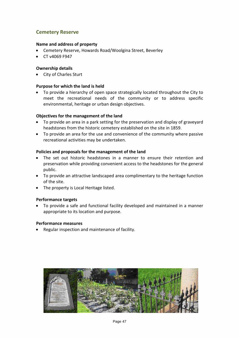
Cemetery Reserve Name and address of property • Cemetery Reserve, Howards Road/Woolgina Street, Beverley • CT v4069 F947 Ownership details • City of Charles Sturt Purpose for which the land is held • To provide a hierarchy of open space strategically located throughout the City to
meet the recreational needs of the community or to address specific environmental, heritage or urban design objectives.
Objectives for the management of the land • To provide an area in a park setting for the preservation and display of graveyard
headstones from the historic cemetery established on the site in 1859. • To provide an area for the use and convenience of the community where passive
recreational activities may be undertaken. Policies and proposals for the management of the land • The set out historic headstones in a manner to ensure their retention and
preservation while providing convenient access to the headstones for the general public.
• To provide an attractive landscaped area complimentary to the heritage function of the site.
• The property is Local Heritage listed. Performance targets • To provide a safe and functional facility developed and maintained in a manner
appropriate to its location and purpose. Performance measures • Regular inspection and maintenance of facility.
Page 47

Community Garden Name and Address of Property • Brompton Community Garden • 17 Green Street, Brompton • CT Volume 5994 Folio521 Ownership Details • The City of Charles Sturt (to be transferred) Purpose for which the Land is to be Held • To provide community facilities for community development. Objectives for the Management of the Land • To provide a facility for the use and enjoyment of the community where passive
activities are undertaken.
Policies and Proposals for the Management of the Land • To provide opportunities for the community to be involved in a range of activities
that meet social and recreational needs: specifically community garden related pursuits.
• To encourage and support individuals to utilise the facility. • To operate the facility in a manner that complements and/or integrates with the
adjoining Bowden/Brompton Community Centre. • To put in place the required leases/licences. • Council may grant or renew a lease or licence to various parties to conduct
activities that cater for the community. • The facility should be used in a manner that does not adversely impact upon
nearby properties. Performance Targets • To provide a safe and attractive facility developed and maintained in a manner
appropriate to its locality and purpose. Performance measures • Regular inspection and maintenance of the facility.
Page 48

Cooke Reserve – Local Park Name and address of property • Cooke Reserve, Frederick Road/Cooke Crescent/Forest Avenue, Royal Park • CT’s V5718 F681 and V 5704 F5723 • Area 16980 sqm Ownership • City of Charles Sturt Purposes for which the land is held • To provide a hierarchy of open space strategically located throughout the City to
meet the recreational needs of the community or to address specific environmental, heritage, educational, environmental, or urban design objectives.
Objectives for the management of the land • To provide an area to facilitate the management of stormwater, in a landscape
setting and where educational, scouting and limited recreational activities may be undertaken by the community.
Policies and proposals for the management of the land • That the land provide for wetlands and managed aquifer recharge activities. • The wetland environment should be managed to facilitate the creation of habitat
and promote biodiversity. • Facilities may be established that provide educational opportunities relating to
the use of the land. These may be in association with scouting activities on the land.
• Council may grant or renew a lease or licence to enable scouting, educational, recreational or other community activities to be conducted on the land.
• The appropriate range and intensity of activities will reflect the constraints of the site including the size of the land and the proximity of adjoining dwellings.
• Council may issue a permit to allow access over the Reserve to allow for an activity of a ‘short term’ nature.
Performance targets • To provide a safe and functional facility and maintained in a manner appropriate
to its location and purpose.
Performance measures • Regular inspection and maintenance of facility.
Page 49
Corcoran Reserve Name and address of property • Corcoran Reserve, Corcoran Drive/Sir John Marks Drive, West Lakes Ownership details • City of Charles Sturt Purpose for which the land is held • To provide a hierarchy of open space strategically located throughout the City to
meet the recreational needs of the community or to address specific environmental, heritage or urban design objectives.
Objectives for the management of the land • To provide an area for the use and enjoyment of the community where generally,
passive recreational activities may be undertaken Policies and proposals for the management of the land • To provide opportunities for the community to be involved in a range of passive
and active recreational activities. • To encourage and support clubs to utilise facilities to optimise opportunities for
the community to participate in a range of sporting and recreational activities and to put in place the required leases/licences.
• The appropriate range of activities will vary for each location depending on the physical characteristics of the reserve, demography, location, accessibility and adjoining uses.
• Council may grant or renew a lease or licence to various sporting, recreation, social or community clubs or groups for the use of buildings, sports fields/courts or open space whose activities cater for the local community
• Council may issue a permit to allow access over the Reserve or to allow for an activity of a ‘short term’ nature.
• It may be appropriate to utilise portion the site for stormwater management purposes.
• The presence of cadmium has been detected in the soil on this Reserve. • Council has put in place an environmental management plan to ensure that the
risk to human health of persons using the Reserve or undertaking maintenance on the reserve is minimised.
Performance targets • To provide a safe and attractive facility developed and maintained in a manner
appropriate to its location and purpose. Performance measures • Regular inspection and maintenance of facility. For Work on this Reserve, refer Standard Work Procedure TRIM 08/70146
Page 50
Don Klaebe Reserve – District Park Name and address of property • Don Klaebe Reserve, Drummond Avenue, Findon • CT V5756 F110 Ownership details • City of Charles Sturt Purpose for which the land is held • To provide a hierarchy of open space, strategically located throughout the City to
meet the recreational needs of the community or to address specific environmental, heritage or urban design objectives.
Objectives for the management of the land • To provide an area for the use of the community where a range of passive and
active recreational activities may be undertaken.
Policies and proposals for the management of the land • To provide opportunities for the community to be involved in a range of
structured and passive recreational activities. • To encourage and support clubs to optimise opportunities for the community to
participate in a range of sporting and recreational activities and to put in place the required leases/licences.
• Council may grant or renew a lease or licence to various sporting or recreation clubs or groups for the use of sports fields or open space whose activities cater for the local or broader community.
• Council may issue a permit to allow access over the Reserve or to allow for an activity of a ‘short term’ nature.
• It may be appropriate to utilise portion of the reserve for stormwater management purposes.
• Council policy-Play Space Policy Ref 5.6
Performance targets • To provide a safe, functional and attractive facility developed and maintained in a
manner appropriate to its location and purpose. Performance measures • Regular inspection and maintenance of the facility
Page 51

Emma Street Reserve – Local Park Name and address of property • Emma Street Reserve, Emma Street/The Avenue, Athol Park Ownership details • City of Charles Sturt Purpose for which the land is held • To provide a hierarchy of open space strategically located throughout the City to
meet the recreational needs of the community or to address specific environmental, heritage or urban design objectives.
Objectives for the management of the land • To provide an area for the use of the community where limited recreational
activities may be undertaken and landscaping is established.
Policies and proposals for the management of the land • The appropriate range of activities will reflect the constraints of the site including
the size of the land and the proximity of adjoining dwellings and have regard to the demographics of the area.
• Council may issue a permit to allow access over the Reserve or to allow for an activity of a ‘short term’ nature.
Performance targets • To provide a safe and functional facility developed and maintained in a manner
appropriate to its location and purpose. Performance measures • Regular inspection and maintenance of the facility
Page 52
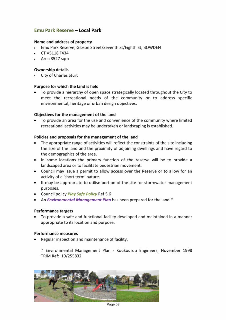
Emu Park Reserve – Local Park Name and address of property • Emu Park Reserve, Gibson Street/Seventh St/Eighth St, BOWDEN • CT V5118 F434 • Area 3527 sqm Ownership details • City of Charles Sturt Purpose for which the land is held • To provide a hierarchy of open space strategically located throughout the City to
meet the recreational needs of the community or to address specific environmental, heritage or urban design objectives.
Objectives for the management of the land • To provide an area for the use and convenience of the community where limited
recreational activities may be undertaken or landscaping is established. Policies and proposals for the management of the land • The appropriate range of activities will reflect the constraints of the site including
the size of the land and the proximity of adjoining dwellings and have regard to the demographics of the area.
• In some locations the primary function of the reserve will be to provide a landscaped area or to facilitate pedestrian movement.
• Council may issue a permit to allow access over the Reserve or to allow for an activity of a ‘short term’ nature.
• It may be appropriate to utilise portion of the site for stormwater management purposes.
• Council policy Play Safe Policy Ref 5.6 • An Environmental Management Plan has been prepared for the land.* Performance targets • To provide a safe and functional facility developed and maintained in a manner
appropriate to its location and purpose. Performance measures • Regular inspection and maintenance of facility.
* Environmental Management Plan - Koukourou Engineers; November 1998 TRIM Ref: 10/255832
Page 53

Findon Community Centre Name and address of property • Findon Community Centre, 222 Findon Road, Findon Ownership details • City of Charles Sturt • CT V1949 F151 Purpose for which the land is held • To provide community facilities for community development.
Objectives for the management of the land • To provide a facility for the use and enjoyment of the community where a range
of passive activities may be undertaken. Policies and proposals for the management of the land • To provide opportunities for the community to be involved in a range of
structured and informal activities including recreational, cultural, educational and personal development.
• To encourage and support groups and individuals to utilise the facilities to optimise opportunities for the community to participate in a range of activities and to put in place the required leases/licences.
• Council may grant or renew a lease or licence to various parties to conduct activities that cater for the community.
• The facilities may be used from time to time for private and/or business functions.
• The facilities should be used in a manner that does not adversely impact upon nearby properties.
Performance targets • To provide a safe and attractive facility maintained to a level appropriate to its
location and purpose. Performance measures • Regular inspection and maintenance of facility.
Page 54
Findon Reserve – Local Park Name and address of property • Findon Reserve (incorporates Findon Skid Kids) Reserve Parade/Drummond
Avenue, Findon • CT V6095 F731 - Area 7252 sqm.
Ownership details • City of Charles Sturt Purpose for which the land is held • To provide a hierarchy of open space strategically located throughout the City to
meet the recreational needs of the community or to address specific environmental, heritage or urban design objectives.
Objectives for the management of the land • To provide an area for the use of the community where limited recreational
activities may be undertaken and landscaping is established.
Policies and proposals for the management of the land • To provide opportunities for the community to be involved in a range of
structured and passive recreational activities. • To encourage and support clubs to optimise opportunities for the community to
participate in a range of sporting and recreational activities and to put in place the required leases/licences.
• Council may grant or renew a lease or licence to various sporting or recreation clubs or groups for the use of the reserve for activities that cater for the local or broader community.
• Council may issue a permit to allow access over the Reserve or to allow for an activity of a ‘short term’ nature.
• It may be appropriate to utilise portion of the reserve for stormwater management purposes.
Performance targets • To provide a safe and functional facility developed and maintained in a manner
appropriate to its location and purpose. Performance measures • Regular inspection and maintenance of the facility
Page 55

Gelland Soldiers Memorial Reserve Name and address of property • Gelland Soldiers Memorial Reserve, Rowell Crescent, West Croydon Ownership details • City of Charles Sturt • No CT (public road) • Area 1050 sqm Purpose for which the land is held • To provide a hierarchy of open space strategically located throughout the City to
meet the recreational needs of the community or to address specific environmental, heritage or urban design objectives.
Objectives for the management of the land • To provide an area for the establishment of a war memorial monument and park
for the use and enjoyment of the community. Policies and proposals for the management of the land • To maintain or reinforce the primary function of the land as a war memorial. • To design, develop and maintain the land in a manner that reflects its historical
and cultural status within the community. • To facilitate gatherings and ceremonies related to the use of the land. Performance targets • To provide a safe and functional facility developed and maintained in a manner
appropriate to its location and purpose. Performance measures • Regular inspection and maintenance of facility.
Page 56

Hamilton Road Reserve – Local Park Name and address of property • Hamilton Road Reserve, Hamilton Road/Richardson Street, Woodville North • CT V6028 F494 • Area 2218 sqm Ownership details • City of Charles Sturt Purpose for which the land is held • To provide a hierarchy of open space strategically located throughout the City to
meet the recreational needs of the community or to address specific environmental, heritage or urban design objectives.
Objectives for the management of the land • To provide an area for the use of the community where limited recreational
activities may be undertaken and landscaping is established.
Policies and proposals for the management of the land • The appropriate range of activities will reflect the constraints of the site including
the size of the land and the proximity of adjoining dwellings and have regard to the demographics of the area.
• Council may issue a permit to allow access over the Reserve or to allow for an activity of a ‘short term’ nature.
Performance targets • To provide a safe and functional facility developed and maintained in a manner
appropriate to its location and purpose. Performance measures • Regular inspection and maintenance of the facility
Page 57

Henley Community Arts Centre Name and address of property • Henley Community Arts Centre, Atkin Street, Henley Beach Ownership details • City of Charles Sturt Purpose for which the land is held • To provide community facilities for community development. Objectives for the management of the land • To provide a facility for the use and enjoyment of the community where passive
activities may be undertaken. Policies and proposals for the management of the land • To provide opportunities for the community to be involved in a range of activities
including art related pursuits. • To encourage and support groups and individuals to utilise the facilities to
optimise opportunities for the community to participate in activities and to put in place the required leases/licences.
• Council may grant or renew a lease or licence to various parties to conduct activities that cater for the community.
• The facilities may be used from time to time for private and/or business functions.
• The facilities should be used in a manner that does not adversely impact upon nearby properties.
Performance targets • To provide a safe and attractive facility developed and maintained in a manner
appropriate to its location and purpose. Performance measures • Regular inspection and maintenance of facility.
Page 58

Henley Town Hall and Soldiers Memorial Name and address of property • Henley Town Hall and Soldiers Memorial Hall, 378 Seaview Road, Henley Beach
Ownership details • City of Charles Sturt
Purpose for which the land is held • To provide a number of community facilities catering primarily for indoor
activities strategically located throughout the City.
Objectives for the management of the land • To provide a facility for the use and enjoyment of the community where a range
of passive activities may be undertaken. • To establish a war memorial and to house and display war memorabilia
Policies and proposals for the management of the land • To provide opportunities for the community to be involved in a range of
structured and informal activities including recreational, cultural, educational and personal development.
• To encourage and support groups and individuals to utilise the facilities to optimise opportunities for community to participate in a range of activities and to put in place the required leases/licences.
• Council may make the building available to various groups on a regular basis. • The facilities may be used from time to time for private and/or business
functions. • The facility should be used in a manner that that does not adversely impact upon
nearby properties. • To provide an area appropriately located and designed to house and display
artefacts and memorabilia associated with the theatre of war. • The War Memorial and the Town Hall is listed on the State Heritage Register.
Performance targets • To provide a safe and functional facility maintained to a level appropriate to its
location and purpose. Performance measures • Regular inspection and maintenance of facility.
Page 59
Henley Square Name and address of property • Henley Square, Seaview Road, Henley Beach • CT V5382 F922 Ownership details • City of Charles Sturt Purpose for which the land is held • To provide a hierarchy of open space strategically located throughout the City to
meet the recreational needs of the community or to address specific environmental, heritage or urban design objectives.
Objectives for the management of the land • To provide an area for the use and convenience of the community where a range
of passive recreational activities may be undertaken. • To create an environment that encourages and supports the establishment of
restaurants and other commercial activities around the perimeter of the Square. Policies and proposals for the management of the land • To provide opportunities for the community to be involved in a range of
structured and informal recreational activities. • To develop and maintain the area to a level conducive to its regional and tourist
status. • To provide street furniture, lighting and other landscape elements of quality, and
visual interest. • To create a convenient, attractive and stimulating visual and physical link to the
beach, jetty and promenade. • To establish and promote the Square as the primary coastal node within the city. • To provide convenient pedestrian and cycle access through the Square for all
users. • To balance the needs of all categories of users of the Square. • To promote the Square and its surrounds as a commercial and cultural hub. • Council may issue a licence or permit to allow commercial operators to occupy
portion of the land. • Council may issue a permit to allow access over the Square or to allow for an
activity of a ‘short term’ nature. Performance targets • To provide a safe and functional facility developed and maintained in a manner
appropriate to its purpose. Performance measures • Regular inspection and maintenance of facility.
Page 60

Henley Square Carpark Name and address of property • Seaview Road, Henley Beach Ownership details • City of Charles Sturt Purpose for which the land is held • To provide an area of land in close proximity to Henley Square and the beach to
facilitate the use and enjoyment of the Square, the beach and the surrounds, by the community.
Objectives for the management of the land • To provide facilities in a convenient, functional and attractive manner having
regard to the special characteristics of the area. Policies and proposals for the management of the land • Car parking on the land should be designed and maintained to ensure efficient,
safe and convenient use of the area. • Alternative uses to the existing use (car parking) may be appropriate provided
that the current benefits to the locality are not diminished. • Any alternative development on the land should be of a high standard and reflect
characteristics of the seaside location and the existing high level of public access. • The strong visual and physical links with the beach and the promenade should be
maintained or reinforced. • Existing leases to allow commercial operators to occupy portion of the land, may
be renewed in the future. Performance targets • To provide a safe and functional facility developed and maintained in a manner
appropriate to its purpose. Performance measures • Regular inspection and maintenance of facility.
Page 61

Henley RSL Clubrooms Name and address of property • Soldiers Memorial Hall, 378 Seaview Road, Henley Beach Ownership details • City of Charles Sturt Purpose for which the land is held • To provide a number of community facilities catering primarily for indoor
activities strategically located throughout the City.
Objectives for the management of the land • To provide a facility for the use and enjoyment of the community where a range
of passive activities may be undertaken. • To establish a war memorial and to house and display war memorabilia
Policies and proposals for the management of the land • To provide facilities to enable the RSL to establish and operate clubrooms. • The premises should continue to be used by the RSL in the foreseeable future. • To put in place the necessary leases to enable the current use of the premises to
continue. • The premise should be used in a manner that does not impact adversely on
nearby properties. Performance targets • To provide a safe and functional facility maintained to a level appropriate to its
location and purpose. Performance measures • Regular inspection and maintenance of facility.
Page 62

Hindmarsh Cemetery Name and address of property • Hindmarsh Cemetery and Caretakers Cottage, 32 Adam Street, Hindmarsh Ownership details • City of Charles Sturt Purpose for which the land is held • To provide land for the in-ground burial of deceased persons and the display of
memorial stones and plaques. Objectives for the management of the land • To provide a cemetery for the use of the general public to enable long term
internment of deceased persons. • To manage the facility in an orderly and professional manner having regard to
the rights and sensitivities of those associated with those deceased. • To maintain the facility to an appropriate standard having regard to its
prominent location and the sensitive nature of the use.
Policies and proposals for the management of the land • The availability of further burial plots is limited and would be generally restricted
to historical existing arrangements and non-renewal of existing plots. • The property should demonstrate a level of maintenance and landscaping
appropriate to its special use. • The caretaker’s cottage could be leased for residential purposes independent of
the cemetery operations. • The property is listed on the State Heritage Register.
Performance targets • To provide a safe and functional facility maintained to a level appropriate to its
location and purpose.
Performance measures • Regular inspection and maintenance of facility.
Page 63

Horsley Reserve – Local Park Name and address of property • Horsley Drive Reserve, Horsley Drive, Kidman Park CT V6045 F275 Ownership details • City of Charles Sturt Purpose for which the land is held • To provide a hierarchy of open space strategically located throughout the City to
meet the recreational needs of the community or to address specific environmental, heritage or urban design objectives.
Objectives for the management of the land • To provide an area for the use of the community where limited recreational
activities may be undertaken and landscaping is established. • To provide a detention basin for the management of stormwater. Policies and proposals for the management of the land • The appropriate range of activities will reflect the constraints of the site
including the size of the land and the proximity of adjoining dwellings and have regard to the demographics of the area.
• In some locations the primary function of the reserve will be to provide a landscaped area or to facilitate pedestrian movement.
• The stormwater detention basin is designed to form an integral part of the function of the reserve by providing informal, grassed open space suitable for recreational activities when not inundated with stormwater.
• Council may issue a permit to allow access over the Reserve to allow for an activity of a ‘short term’ nature.
Performance targets • To provide a safe and functional facility developed and maintained in a manner
appropriate to its location and purpose. Performance measures • Regular inspection and maintenance of the facility
Page 64

Horticultural Centre and Historic, James Brickworks Name and address of property • Horticultural Centre and Historic James Brickworks, Toogood Avenue, Beverley
CT V5816 F854
Ownership details • City of Charles Sturt Purpose for which the land is held • To provide a facility conveniently located to enable Council to carry out its
operations. • To secure the brick kiln structures , pending long term consideration of their
future
Objectives for the management of the land • To provide a facility that is functional and efficient to enable Council to deliver
services to the community. • To operate the facility in a manner that does not impact adversely on adjoining
properties. • To ensure the safety of Council staff and the general public and other groups
using the site with respect to the brick kiln structures.
Policies and proposals for the management of the land • To put in place physical barriers and warning signs to ensure that users of the
site are not endangered with respect to the brick kiln structures • To provide and maintain appropriate facilities to enable Council staff to
undertake their duties in a professional and effective manner • The property is on the State Heritage Register • To have regard to the Conservation Plan* when considering any proposed
changes to the site, buildings or structures. • Council may grant or renew a lease or licence to various clubs or groups for the
use of buildings or land, whose activities cater for the local or broader community.
Performance targets • To provide a safe and functional facility developed and maintained in a manner
appropriate to its location and purpose. Performance measures • Regular inspection and maintenance of the facility
*(Swanbury Penglase, March 2005 - TRIM 05/32124)
Page 65

Kiln Drive Reserve – Local Park Name and address of property • Kiln Drive Reserve, Kiln Drive, Brompton • CT V5994 F541 Ownership details • City of Charles Sturt Purpose for which the land is held • To provide a hierarchy of open space strategically located throughout the City to
meet the recreational needs of the community or to address specific environmental, heritage or urban design objectives.
Objectives for the management of the land • To provide an area for the use of the community where limited recreational
activities may be undertaken and landscaping is established.
Policies and proposals for the management of the land • The appropriate range of activities will reflect the constraints of the site
including the size of the land and the proximity of adjoining dwellings and have regard to the demographics of the area.
• Council may issue a permit to allow access over the Reserve or to allow for an activity of a ‘short term’ nature.
Performance targets • To provide a safe and functional facility developed and maintained in a manner
appropriate to its location and purpose. Performance measures • Regular inspection and maintenance of the facility
Page 66

Magarey Grove Reserve Name and address of property • Magarey Grove Reserve, South Parade/West Lakes Boulevard, Seaton Ownership details • City of Charles Sturt • CT V5446 F974 - Area 6504 sqm Purpose for which the land is held • To provide a hierarchy of open space strategically located throughout the City to
meet the recreational needs of the community or to address specific environmental, heritage or urban design objectives.
Objectives for the management of the land • To provide an area for the use and enjoyment of the community where
generally, passive recreational activities may be undertaken. • To provide an area to commemorate the recipients of the Magarey Medal,
presented to players participating in the South Australian National Football League.
Policies and proposals for the management of the land • To establish large, single-species trees to provide a strong visual element in a
park setting. • To provide plaques and signage appropriate to the use of the land. • Council may issue a permit to allow access over the Reserve or to allow for an
activity of a ‘short term’ nature. Performance targets • To provide a safe and attractive facility developed and maintained in a manner
appropriate to its location and purpose. Performance measures • Regular inspection and maintenance of the facility.
Page 67

Midcourse Reserve Name and address of property • Midcourse Reserve, Brebner Drive, West Lakes Ownership details • City of Charles Sturt • CT V4076 F840 - Area 8175 sqm Purpose for which the land is held • To provide a hierarchy of open space strategically located throughout the City to
meet the recreational needs of the community or to address specific environmental, heritage or urban design objectives.
Objectives for the management of the land • To provide an area for the use and convenience of the community where limited
recreational activities may be undertaken or landscaping is established. Policies and proposals for the management of the land • The appropriate range of activities will reflect the constraints of the site including
the size of the land and the proximity of adjoining dwellings and have regard to the demographics of the area.
• In some locations the primary function of the reserve will be to provide a landscaped area or to facilitate pedestrian movement.
• Council may issue a permit to allow access over the Reserve or to allow for an activity of a ‘short term’ nature (including car parking) - such use may be on a regular basis.
• It may be appropriate to utilise portion of the site for stormwater management purposes.
Performance targets • To provide a safe and functional facility developed and maintained in a manner
appropriate to its location and purpose. Performance measures • Regular inspection and maintenance of facility.
Page 68
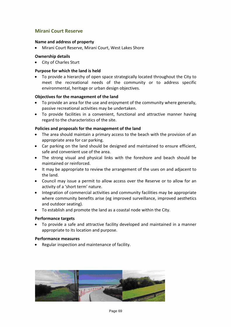
Mirani Court Reserve Name and address of property • Mirani Court Reserve, Mirani Court, West Lakes Shore
Ownership details • City of Charles Sturt
Purpose for which the land is held • To provide a hierarchy of open space strategically located throughout the City to
meet the recreational needs of the community or to address specific environmental, heritage or urban design objectives.
Objectives for the management of the land • To provide an area for the use and enjoyment of the community where generally,
passive recreational activities may be undertaken. • To provide facilities in a convenient, functional and attractive manner having
regard to the characteristics of the site.
Policies and proposals for the management of the land • The area should maintain a primary access to the beach with the provision of an
appropriate area for car parking. • Car parking on the land should be designed and maintained to ensure efficient,
safe and convenient use of the area. • The strong visual and physical links with the foreshore and beach should be
maintained or reinforced. • It may be appropriate to review the arrangement of the uses on and adjacent to
the land. • Council may issue a permit to allow access over the Reserve or to allow for an
activity of a ‘short term’ nature. • Integration of commercial activities and community facilities may be appropriate
where community benefits arise (eg improved surveillance, improved aesthetics and outdoor seating).
• To establish and promote the land as a coastal node within the City.
Performance targets • To provide a safe and attractive facility developed and maintained in a manner
appropriate to its location and purpose.
Performance measures • Regular inspection and maintenance of facility.
Page 69

Ozone Reserve Name and address of property • Ozone Reserve, Seaview Road, Henley Beach South Ownership details • City of Charles Sturt/Coast Protection Board.
CT 2042/99; CT 5708/888; CT 5338/203 Pieces A, B, D and F on Road Plan 7390 (no titles)
Purpose for which the land is held • To provide a hierarchy of open space strategically located throughout the City to
meet the recreational needs of the community or to address specific environmental, heritage or urban design objectives.
Objectives for the management of the land • To provide an area for the use and convenience of the community having regard
to the special characteristics of the area. Policies and proposals for the management of the land • To provide safe and convenient car parking areas adjacent to the coast. • To facilitate safe and convenient pedestrian access to the beach. • To facilitate strong pedestrian and cycle links connecting north and south of the
site. • To provide facilities to cater for the various users of the beach and foreshore
environs. • To develop the area in a manner that is integral to the function of the Coastal
Park within the City. • The strong visual and physical links with the beach and linear cycle/pedestrian
paths should be maintained or reinforced. Performance targets • To provide a safe and functional facility developed and maintained in a manner
appropriate to its location and purpose. Performance measures • Regular inspection and maintenance of facility.
Page 70
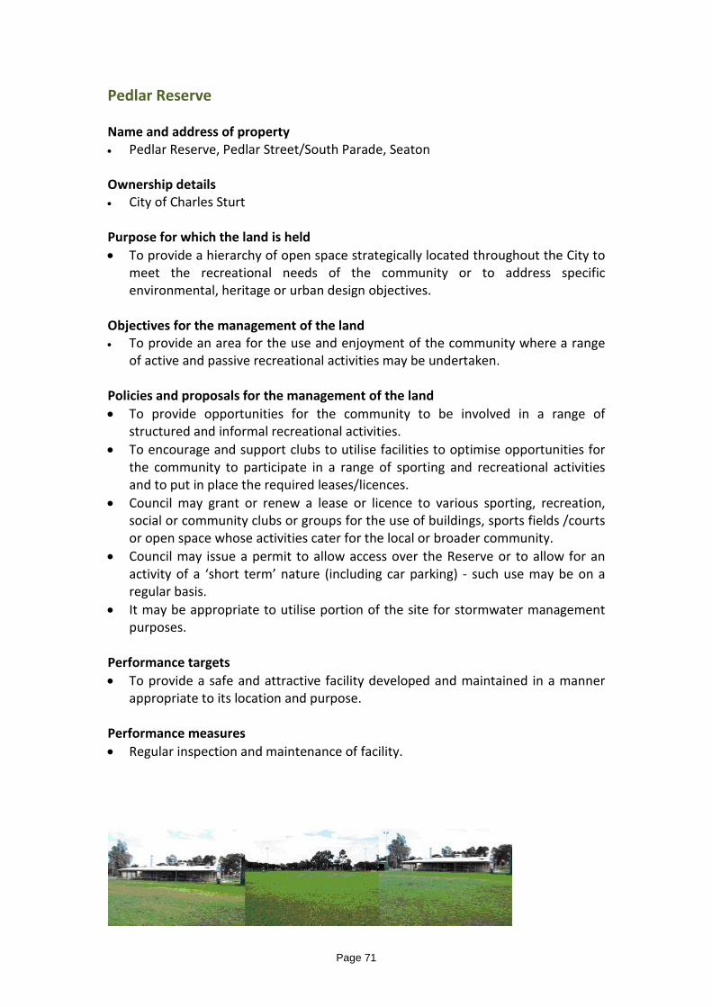
Pedlar Reserve Name and address of property • Pedlar Reserve, Pedlar Street/South Parade, Seaton Ownership details • City of Charles Sturt Purpose for which the land is held • To provide a hierarchy of open space strategically located throughout the City to
meet the recreational needs of the community or to address specific environmental, heritage or urban design objectives.
Objectives for the management of the land • To provide an area for the use and enjoyment of the community where a range
of active and passive recreational activities may be undertaken. Policies and proposals for the management of the land • To provide opportunities for the community to be involved in a range of
structured and informal recreational activities. • To encourage and support clubs to utilise facilities to optimise opportunities for
the community to participate in a range of sporting and recreational activities and to put in place the required leases/licences.
• Council may grant or renew a lease or licence to various sporting, recreation, social or community clubs or groups for the use of buildings, sports fields /courts or open space whose activities cater for the local or broader community.
• Council may issue a permit to allow access over the Reserve or to allow for an activity of a ‘short term’ nature (including car parking) - such use may be on a regular basis.
• It may be appropriate to utilise portion of the site for stormwater management purposes.
Performance targets • To provide a safe and attractive facility developed and maintained in a manner
appropriate to its location and purpose. Performance measures • Regular inspection and maintenance of facility.
Page 71

Pumping Station Name and address of property • Pumping Station, Halsey Road, Henley Beach Ownership details • City of Charles Sturt Purpose for which the land is held • To provide appropriate infrastructure to enable the City to function in a safe,
efficient, convenient and innovative manner. Objectives for the management of the land • To provide infrastructure to manage the collection, treatment and disposal of
stormwater.
Policies and proposals for the management of the land • To provide mechanisms to pump stormwater collected from the lower lying
surrounding area into the River Torrens. • To provide a mechanism to enable stormwater to be transported away from the
site at times of excessive stormwater collection. Performance targets • To provide a safe and attractive facility developed and maintained in a manner
appropriate to its location and purpose. Performance measures • Regular inspection and maintenance of facility.
Page 72

Ray Street Reserve – Local Park Name and address of property • Ray Street Reserve, Ray Street/Rondo Street, Findon • CT V6062 F766 Ownership details
• City of Charles Sturt Purpose for which the land is held • To provide a hierarchy of open space strategically located throughout the City to
meet the recreational needs of the community or to address specific environmental, heritage or urban design objectives.
Objectives for the management of the land • To provide an area for the use of the community where limited recreational
activities may be undertaken and landscaping is established. • To provide a detention basin for the management of stormwater. Policies and proposals for the management of the land • The appropriate range of activities will reflect the constraints of the site
including the size of the land and the proximity of adjoining dwellings and have regard to the demographics of the area.
• In some locations the primary function of the reserve will be to provide a landscaped area or to facilitate pedestrian movement.
• The stormwater detention basin is designed to form an integral part of the function of the reserve by providing informal, grassed open space suitable for recreational activities when not inundated with stormwater.
• Council may issue a permit to allow access over the Reserve to allow for an activity of a ‘short term’ nature.
Performance targets • To provide a safe and functional facility developed and maintained in a manner
appropriate to its location and purpose. Performance measures • Regular inspection and maintenance of the facility
Page 73

St Clair Recreation Reserves
Ovals 2, 3 and 4 Name and address of property • St Clair Oval No 2,Brocas Avenue/Actil Avenue, ST CLAIR • CT V6063 F757(Part) Lot 2 DP 84492 (Refer Appendix A) • St Clair Oval No 3, Brocas Avenue, ST CLAIR • CT V6073 F812 Lot 305 D86011 • St Clair Oval No 4 St Clair Avenue/Brocas Avenue, ST CLAIR • CT V6080 F518 Lot 911 D86910 Ownership details • City of Charles Sturt Purpose for which the land is held • To provide a hierarchy of open space and facilities, strategically located
throughout the City to meet the recreational needs of the community or to address specific environmental, heritage or urban design issues.
Objectives for the management of the land • To provide an area for the use and enjoyment of the community where a range
of passive and active recreational activities may be undertaken.
Policies and proposals for the management of the land • To provide opportunities for the community to be involved in a range of
structured and informal recreational activities. • To encourage and support clubs to optimise opportunities for the community to
participate in a range of sporting and recreational activities and to put in place the required leases/licences.
• Council may grant or renew a lease or licence to various sporting, recreation, social or community clubs or groups for the use of buildings, sports fields or open space whose activities cater for the local or broader community.
• Council may grant a permit to allow access across the Reserve or to allow for an activity of a ‘short term’ nature.
Performance targets • To provide a safe and attractive facility developed and maintained in a manner
appropriate to its location and purpose.
Performance measures • Regular inspection and maintenance of facility. TC 26/04/2016
Page 74

The Avenue Reserve – Local Park Name and address of property • The Avenue Reserve, The Avenue, Athol Park
CT V6044 F253 Ownership details • City of Charles Sturt Purpose for which the land is held • To provide a hierarchy of open space strategically located throughout the City to
meet the recreational needs of the community or to address specific environmental, heritage or urban design objectives.
Objectives for the management of the land • To provide an area for the use of the community where limited recreational
activities may be undertaken and landscaping is established. • To provide a detention basin for the management of stormwater. Policies and proposals for the management of the land • The appropriate range of activities will reflect the constraints of the site
including the size of the land and the proximity of adjoining dwellings and have regard to the demographics of the area.
• In some locations the primary function of the reserve will be to provide a landscaped area or to facilitate pedestrian movement.
• The stormwater detention basin is designed to form an integral part of the function of the reserve by providing informal, grassed open space suitable for recreational activities when not inundated with stormwater.
• Council may issue a permit to allow access over the Reserve to allow for an activity of a ‘short term’ nature.
Performance targets • To provide a safe and functional facility developed and maintained in a manner
appropriate to its location and purpose. Performance measures • Regular inspection and maintenance of the facility
Page 75

The ‘Brocas’ Name and Address of property • The ‘Brocas’, 111 Woodville Road, St Clair • CT V5596 F992 Ownership details • City of Charles Sturt Purpose for which the land is held • To provide office/meeting/learning/storage/display facilities suitable to be used
for Council, the community or non-profit community service organisations. • To ensure the long term survival of the historic building. Objectives for the management of the land • To provide a multi-purpose community facility with the primary focus on youth
services. • To promote an inter-generational community space. • To facilitate the co-location of agencies on a seasonal basis to provide
meaningful and transparent outcomes for young people. • To provide flexible spaces for foundation and taster programs and services that
foster improved youth health and well-being, leadership and transitional pathways.
• Office space, display, management and public viewing for The Historical Society of Woodville may be provided.
• To maintain the property in a manner that ensures its long term structural integrity and aesthetic appearance.
• To maintain the property to a standard that it suitable for use by Council or the community.
• Opportunities exist to develop and use the property in conjunction with adjoining properties at 111A and 111B Woodville Road.
Policies and proposals for the management of the land • To centralise Council initiated (or supported) youth services and programs in the
City. • To promote and encourage the delivery of development and training programs
that enhance social interaction/education/employment and enterprise, relevant to youth.
• To manage the facility and programs in conjunction with external agencies and in an integrated and co-operative manner.
• Council may allow the premises to be hired by community based groups, • Community health/welfare groups or agencies. • Council may grant a permit to allow the property to be used for an activity of a
‘short term’ nature. . National Trust Register of Historic Buildings -1975; Register of National Estate- 1978; Register of State Heritage -1982. . ‘The Brocas Conservation Plan’ Swanbury Penglase Architects August 2006 TRIM 05/126108
Page 76

Performance targets • To provide a safe and functional facility maintained to a level appropriate to its
location and purpose. Performance measures • Regular inspection and maintenance of the facility.
Page 77

The Brocas-Intergenerational Place Name and Address of property • The Brocas-Intergenerational Place. • 111A Woodville Road, St Clair • CT V6155 F278 Ownership details • City of Charles Sturt Purpose for which the land is held • To provide car parking, storage and meeting space suitable for use by Council,
the community or non-profit community service organisations. • To provide a facility that can be accessed by user groups outside normal
business hours. • To develop and use the land in a manner that compliments the use of the
adjoining properties at 111 and 111A Woodville Road Objectives for the management of the land • To provide a facility that focuses on the needs of youth in a non-formal
environment. • To provide a meeting place for intergenerational activities with a focus on young
people. • To maintain the property to a standard that it suitable for use by Council or the
community. • Opportunities exist to develop and use the property in conjunction with
adjoining properties at 111A and 111 Woodville Road. Policies and proposals for the management of the land • To centralise Council-initiated (or supported) youth services and programs in the
City. • To promote and encourage the delivery of development and training programs
that enhance social interaction/education/employment and enterprise, relevant to young people.
• To manage the facility and programs in conjunction with external agencies and in an integrated and cooperative manner.
• Council may allow the premises to be hired to be used by community -based groups, community health/welfare groups or agencies. t
• Council may grant a permit to allow the property to be used for an activity of a ‘short -term’nature.
Performance targets • To provide a safe and functional facility maintained to a level appropriate to its
location and purpose. Performance measures • Regular inspection and maintenance of the facility.
Page 78

St Clair Clinic Name and Address of property St Clair Clinic 111A Woodville Road, St Clair CT V6155 F278 Ownership details • City of Charles Sturt Purpose for which the land is held • To establish premises suitable for the delivery of Council services to the
community Objectives for the management of the land • To establish clinical facilities to enable Council to provide immunisation services
to the general community • To maintain the property to a standard that it suitable for use by Council or the
community. • To locate the clinic where it is reasonably convenient to be accessed by public
transport. • To deliver Council’s Communicable Disease Control Procedure to protect staff
from vaccine preventable diseases that may be associated to occupational exposure and ensure Council meets its Work Health and Safety legislative requirements.
Policies and proposals for the management of the land • To provide immunisation services by accredited registered nurses • To provide immunisation services in a manner that creates confidence with
clients. To offer workplace visits. • To liaise with other health services and providers to maximise the exposure of
the service provided by Council • Council may grant a permit to allow the property to be used for an activity of a
‘short term’ nature. • Council is required to provide/support the provision of immunisation programs
for the protection of public health within its area pursuant to the requirements of the South Australian Public Health Act.
• Hazardous Work Policy Performance targets • To provide a safe and functional facility maintained to a level appropriate to its
location and purpose. Performance measures • Regular inspection and maintenance of the facility.
Page 79

St Clair Recreation Reserve Name and address of property • St Clair Recreation Reserve (contains Recreation Centre)
Woodville Road/Brocas Avenue, ST CLAIR (Refer TRIM 16/231286 for Plan of area affected)
• CT V6063 F757:D84492,Part Lot 2 (excludes public road) • CT V5690 F657:D84492,Lot 8 (excludes public road) Ownership details • City of Charles Sturt Purpose for which the land is held • To provide a hierarchy of open space and facilities, strategically located
throughout the City to meet the recreational needs of the community or to address specific environmental, heritage or urban design issues.
Objectives for the management of the land • To provide an area for the use and enjoyment of the community where a range
of passive and active recreational indoor and outdoor activities may be undertaken.
Policies and proposals for the management of the land • To provide opportunities for the community to be involved in a range of
structured and informal recreational activities. • To encourage and support clubs to optimise opportunities for the community to
participate in a range of sporting and recreational activities and to put in place the required leases/licences.
• Council may grant or renew a lease or licence to various sporting, recreation, social or community clubs or groups, for the use of buildings sports fields/courts or open space, whose activities cater for the local or broader community.
• Council may grant a permit to allow access across the Reserve or to allow for an activity of a ‘short term’ nature.
• The facilities may be used from time to time for private and/or business functions.
• The open space, sports fields/courts on the land may be modified or relocated to best meet the future requirements of the community.
• The Recreation Centre is a Local Heritage Place Performance targets • To provide a safe and attractive facility developed and maintained in a manner
appropriate to its location and purpose. Performance measures • Regular inspection and maintenance of facility.
Page 80

Thomas Harkness Reserve – Local Park Name and address of property • Thomas Harkness Reserve, Spurs Avenue , Brompton • CT V6028 F762 and CT V6025 F240 Ownership details • City of Charles Sturt Purpose for which the land is held • To provide a hierarchy of open space strategically located throughout the City to
meet the recreational needs of the community or to address specific environmental, heritage or urban design objectives.
Objectives for the management of the land • To provide an area for the use of the community where limited recreational
activities may be undertaken and landscaping is established. • To provide a detention basin for the management of stormwater. Policies and proposals for the management of the land • The appropriate range of activities will reflect the constraints of the site including
the size of the land and the proximity of adjoining dwellings and have regard to the demographics of the area.
• The stormwater detention basin is designed to form an integral part of the function of the reserve in providing informal recreational grassed open space when not inundated with stormwater.
• Council may issue a permit to allow access over the Reserve to allow for an activity of a ‘short term’ nature.
Performance targets • To provide a safe and functional facility developed and maintained in a manner
appropriate to its location and purpose. Performance measures • Regular inspection and maintenance of the facility
Page 81
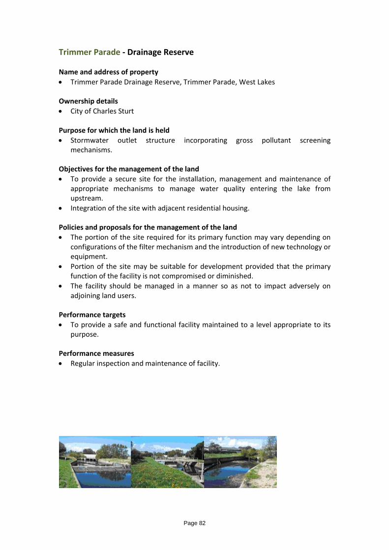
Trimmer Parade - Drainage Reserve Name and address of property • Trimmer Parade Drainage Reserve, Trimmer Parade, West Lakes Ownership details • City of Charles Sturt Purpose for which the land is held • Stormwater outlet structure incorporating gross pollutant screening
mechanisms. Objectives for the management of the land • To provide a secure site for the installation, management and maintenance of
appropriate mechanisms to manage water quality entering the lake from upstream.
• Integration of the site with adjacent residential housing. Policies and proposals for the management of the land • The portion of the site required for its primary function may vary depending on
configurations of the filter mechanism and the introduction of new technology or equipment.
• Portion of the site may be suitable for development provided that the primary function of the facility is not compromised or diminished.
• The facility should be managed in a manner so as not to impact adversely on adjoining land users.
Performance targets • To provide a safe and functional facility maintained to a level appropriate to its
purpose. Performance measures • Regular inspection and maintenance of facility.
Page 82

West Lakes Seawater Lake Name and address of property • West Lakes Seawater Lake, West Lakes Ownership details • Minister of Marine. Licence between Minister of Marine and the Council to
occupy, control and be responsible for the bed of West Lakes (exclusive of all concrete bank protection works, inlet and outlet structures)
• TRIM 11/262665 Purpose for which the land is held • To provide a hierarchy of open space, strategically located throughout the City to
meet the recreational needs of the community or to address specific environmental, heritage or urban design issues.
Objectives for the management of the land • To provide opportunities for the community to be involved in a range of
structured and informal, aquatic based recreational activities. • To encourage and support clubs to optimise opportunities for the community to
participate in a range of aquatic based sporting and recreational activities and to put in place the required leases/licences.
• To provide an attractive environment. • A permit to allow exclusive or restricted use of the lake may be issued from time
to time • Generally, activities on the lake should not affect, adversely the amenity of
residents living in close proximity of the lake. Performance targets • To provide a safe and attractive facility maintained to a level appropriate to its
location and purpose. Performance measures • Regular inspection and maintenance of facility.
Page 83

West Reserve Name and address of property • West Reserve, West Street, Brompton Ownership details • Minister for Employment and Training. Purpose for which the land is held • To provide a hierarchy of open space strategically located throughout the City to
meet the recreational needs of the community or to address specific environmental, heritage or urban design objectives.
Objectives for the management of the land • To provide an area for the use and convenience of the community where limited
recreational activities may be undertaken or landscaping is established. Policies and proposals for the management of the land • The appropriate range of activities will reflect the constraints of the site including
the size of the land and the proximity of adjoining dwellings and have regard to the demographics of the area.
• In some locations the primary function of the reserve will be to provide a landscaped area or to facilitate pedestrian movement.
• The land is used jointly by the Brompton Primary School and the community. • The area is maintained by the City of Charles Sturt. Performance targets • To provide a safe and functional facility developed maintained in a manner
appropriate to its location and purpose. Performance measures • Regular inspection and maintenance of facility.
Page 84