management plan for antarctic specially protected area no. 107 … · management plan for antarctic...
TRANSCRIPT

Management Plan forAntarctic Specially Protected Area No. 107
EMPEROR ISLAND, DION ISLANDS, MARGUERITE BAY, ANTARCTICPENINSULA
1. Description of values to be protected
The Dion Islands (Latitude 67°52' S, Longitude 68°42' W), on the western side of the centralAntarctic Peninsula in north-western Marguerite Bay, were originally designated as SpeciallyProtected Area (SPA) No. 8 through Recommendation IV-8 in 1966 after a proposal by the UnitedKingdom. All of the islands in the Dion Islands archipelago were included. Values protectedunder the original designation were described as the presence of the only colony of emperorpenguins (Aptenodytes forsteri) known to exist on the west side of the Antarctic Peninsula and thatthe isolation of this colony from others of the same species makes it of outstanding scientificinterest. A management plan for the Area was adopted through Recommendation XVI-6 (1990),which reaffirmed the values of the Area. The boundaries were extended to include the interveningsea between the islands to ensure protection of the emperors at sea or on sea-ice in the immediatevicinity. Attention was drawn to the additional important value of the colony being one of onlytwo known in which breeding occurs on land. It was also noted as the most northerly andprobably the smallest of Emperor colonies, with annual numbers fluctuating around 150 pairs.
The values of the emperor penguin colony are reaffirmed in this revised management plan.The boundaries of the Area are now defined more precisely.
2. Aims and objectives
Management at Emperor Island aims to:
• avoid degradation of, or substantial risk to, the values of the Area by preventing unnecessaryhuman disturbance to the Area;
• allow scientific research on the ecosystem and physical environment, particularly on theavifauna, provided it is for compelling reasons which cannot be served elsewhere;
• minimise the possibility of introduction of pathogens which may cause disease in birdpopulations within the Area;
• minimise the possibility of introduction of alien plants, animals and microbes to the Area;
• gather data on the population status of the emperor penguin colony on a regular basis,preferably at least once every five years;
• allow visits for management purposes in support of the aims of the management plan.
3. Management activities
The following management activities shall be undertaken to protect the values of the Area:

• Maps showing the location of the Area (stating the special restrictions that apply) shall be
displayed prominently at any operational research station located within 50 km of the Area,
where copies of this management plan shall also be made available.
• Markers, signs or other structures erected within the Area for scientific or management
purposes shall be secured and maintained in good condition.
• Visits shall be made as necessary (preferably no less than once every five years) to assess
whether the Area continues to serve the purposes for which it was designated, and in particular
to conduct bird censuses, and to ensure management and maintenance measures are adequate.
4. Period of designation
Designated for an indefinite period, provided the Emperor penguins continue to breed in the Area.
5. Maps and photographs
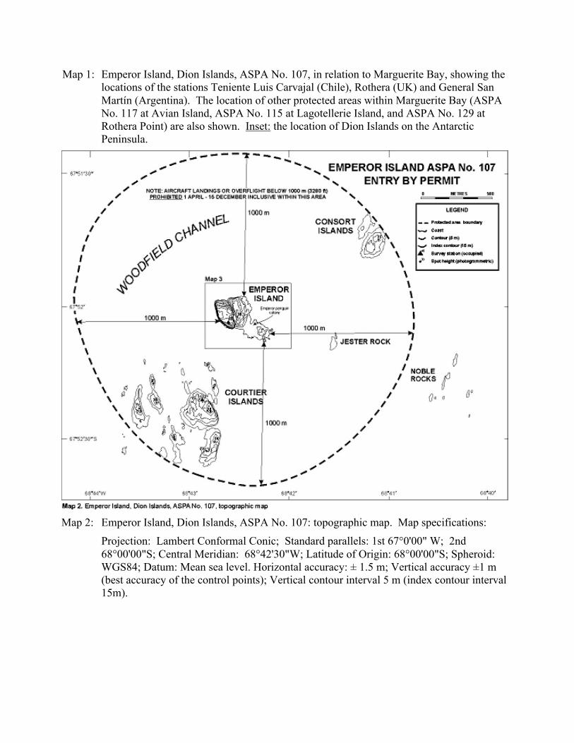
Map 1: Emperor Island, Dion Islands, ASPA No. 107, in relation to Marguerite Bay, showing thelocations of the stations Teniente Luis Carvajal (Chile), Rothera (UK) and General SanMartín (Argentina). The location of other protected areas within Marguerite Bay (ASPANo. 117 at Avian Island, ASPA No. 115 at Lagotellerie Island, and ASPA No. 129 atRothera Point) are also shown. Inset: the location of Dion Islands on the AntarcticPeninsula.
Map 2: Emperor Island, Dion Islands, ASPA No. 107: topographic map. Map specifications:
Projection: Lambert Conformal Conic; Standard parallels: 1st 67°0'00" W; 2nd68°00'00"S; Central Meridian: 68°42'30"W; Latitude of Origin: 68°00'00"S; Spheroid:WGS84; Datum: Mean sea level. Horizontal accuracy: ± 1.5 m; Vertical accuracy ±1 m(best accuracy of the control points); Vertical contour interval 5 m (index contour interval15m).

Map 3: Emperor Island, ASPA No. 107: topographic map. Map specifications as for Map 2.
6. Description of the Area
6(i) Geographical coordinates, boundary markers and natural features
GENERAL DESCRIPTION
The Dion Islands (Latitude 67°53' S, Longitude 68°42' W, within a region of approximately12 km2), situated 13.5 km south of the south-western extremity of Adelaide Island in north-western Marguerite Bay (Map 1), is a small archipelago comprising the following islands, rocksand reefs: Envoy Rock, Regent Reef, Consort Islands (approximately 3 ha), Emperor Island(approximately 5 ha), Jester Rock, Noble Rocks, Courtier Islands (approximately 8 ha), EmbassyIslands and Consul Reef. The islands are generally small, rocky and precipitous, especiallyEmperor Island, which at a maximum elevation of 46 m is also the highest. The island groupcontains numerous offshore islets, rocks and reefs, which are potentially hazardous to shipping.The Dion Islands have only been visited occasionally and detailed descriptions of the Area haveyet to be made. The islands are generally ice-free in summer, although there are a few smallpatches of permanent ice and persistent snow. A meltwater pond is located on the northern side ofEmperor Island. Terrain suitable for breeding birds is limited, and the colonies present arerelatively small, mostly found on Emperor Island. For a detailed description of the geology andbiology of the Area see Annex 1.

BOUNDARIES
The designated Area of just over 3 km2 comprises Emperor Island and the marineenvironment (including sea ice when present) within 1000 m of the coastline of Emperor Island(Maps 2 and 3). The 1000 m boundary is set as a precautionary limit to avoid disturbance tobreeding Emperor penguins. Within this zone landing and overflight restrictions apply to aircraftduring the period 1 April to 15 December (see Section 7(i) below). However, the area does notinclude the terrestrial areas of the Consort Islands in the north, Jester Rock in the east, or theCourtier Islands in the southwest.
6(ii) Restricted and managed zones within the Area
None.
6(iii) Structures within and near the Area
No structures are known to be present within the Area. A GPS survey station, consisting ofa nail driven into a rock marked by a small cairn, was installed on the northeastern side of thelargest of the Courtier Islands in March 1997 (Gray and Fox 1997).
The nearest scientific research station is 14 km north-west at Teniente Luis Carvajal (Chile),on southern Adelaide Island (Latitude 67°46' S, Longitude 68°55' W), a summer-only facilityoperated from October until March since 1982. Over this period the station has generallyaccommodated up to 10 personnel. Formerly, this facility was established and operated by the UKyear-round from 1961 until 1977. The nearest year-round scientific station is Rothera ResearchStation (UK), 41 km to the north-east on Rothera Point, also on Adelaide Island.
6(iv) Location of other protected areas within close proximity of the Area
The nearest protected areas to Emperor Island are Avian Island (ASPA No. 117) about12.75 km NNW, Lagotellerie Island (ASPA No. 115) 58 km east, and Rothera Point (ASPA No.129) 41 km to the NE (Map 1).
7. Permit conditions
Entry into the Area is prohibited except in accordance with a Permit issued by an appropriatenational authority. Conditions for issuing a Permit to enter the Area are that:
• it is issued only for compelling scientific reasons that cannot be served elsewhere, in particularfor scientific study of the avifauna and ecosystem of the Area, or for essential managementpurposes consistent with plan objectives such as inspection, maintenance or review;
• the actions permitted will not jeopardise the values of the Area;
• any management activities are in support of the objectives of the management plan;

• the actions permitted are in accordance with the management plan;
• the Permit, or an authorised copy, shall be carried within the Area;
• a visit report shall be supplied to the authority named in the Permit;
• permits shall be issued for a stated period;
• the appropriate authority should be notified of any activities/measures undertaken that werenot included in the authorised Permit.
7(i) Access to and movement within the Area
• Subject to the following restrictions, access to the Area shall be by boat, aircraft or over seaice by vehicle or foot.
• Vehicles are prohibited on land within the Area and all movement on land within the Areashall be on foot.
• Access shall be conducted so as to minimise disturbance to any fauna that may be present, andvehicles or boats should not approach closer than 200 m to any breeding colony.
• There are otherwise no special restrictions on the locations where vehicle or small boat travelor landings may be made, but this shall be by the shortest route consistent with the restrictionsin this plan and the objectives and requirements of the permitted activities.
• Aircraft are prohibited from landing within the Area or overflying the Area below 1000 m inthe period 1 April to 15 December inclusive.
• Vehicle, aircraft or boat crew, or other people on vehicles, aircraft or boats, are prohibitedfrom moving on foot beyond the immediate vicinity of their landing site unless specificallyauthorised by Permit.
• All movement should be undertaken carefully so as to minimise disturbance to breeding birds,the soil and vegetated surfaces.
• Pedestrian traffic should be kept to the minimum consistent with the objectives of anypermitted activities and every reasonable effort should be made to minimise effects.
7(ii) Activities that are or may be conducted in the Area, including restrictions on time or place
• Scientific research that will not jeopardise the avifauna or ecosystem of the Area, and which isfor compelling reasons that cannot be served elsewhere;
• Essential management activities, including monitoring;
Restrictions on times and locations at which aircraft may operate within the Area apply, specifiedin Section 7 (i) of this Management Plan.
7(iii) Installation, modification or removal of structures
Structures shall not be erected within the Area except as specified in a Permit andpermanent structures or installations are prohibited. Small temporary refuges, hides, blinds or

screens may be constructed for the purpose of scientific study of the avifauna. Installation(including site selection), removal, modification or maintenance of structures shall be undertakenin a manner that minimises disturbance to breeding birds. All scientific equipment or markersinstalled within the Area must be clearly identified by country, name of the principal investigatorand year of installation. All such items should be made of materials that pose minimal risk ofharm to bird populations or of contamination of the Area. Removal of specific structures,equipment or markers for which the Permit has expired shall be a condition of the Permit.
7(iv) Location of field camps
Temporary camping within the Area is allowed when necessary for purposes specified inthe Permit. Specific campsite locations have not been designated, but camping within 200 m ofthe emperor penguin colony should be avoided.
7(v) Restrictions on materials and organisms that can be brought into the Area
No living animals, plant material, pathogens or microorganisms shall be deliberatelyintroduced into the Area and the precautions listed in 7(ix) below shall be taken against accidentalintroductions. In view of the presence of breeding bird colonies on Emperor Island, no poultryproducts, including products containing uncooked dried eggs, including wastes from suchproducts, shall be released into the Area, including into the sea. No herbicides or pesticides shallbe brought into the Area. Any other chemicals, including radio-nuclides or stable isotopes, whichmay be introduced for scientific or management purposes specified in the Permit, shall beremoved from the Area at or before the conclusion of the activity for which the Permit wasgranted. Fuel is not to be stored in the Area, unless specifically authorised by Permit for specificscientific or management purposes. All materials introduced shall be for a stated period only,shall be removed at or before the conclusion of that stated period, and shall be stored and handledso that risk of their introduction into the environment is minimised. If release occurs which islikely to compromise the values of the Area, removal is encouraged only where the impact ofremoval is not likely to be greater than that of leaving the material in situ. The appropriateauthority should be notified of any materials released and not removed that were not included inthe authorised Permit.
7(vi) Taking or harmful interference with native flora or fauna
Taking or harmful interference with native flora or fauna is prohibited, except by Permitissued in accordance with Annex II to the Protocol on Environmental Protection to the AntarcticTreaty. Where taking or harmful interference with animals is involved, the SCAR Code ofConduct for the Use of Animals for Scientific Purposes in Antarctica should be used as aminimum standard.
7(vii) Collection or removal of anything not brought into the Area by the Permit holder
Collection or removal of anything not brought into the Area by the Permit holder shall onlybe in accordance with a Permit and should be limited to the minimum necessary to meet scientificor management needs. Permits shall not be granted in instances where it is proposed to take,remove or damage such quantities of soil, native flora or fauna that their distribution or abundancewithin the Area would be significantly affected. Samples of flora or fauna found dead within theArea may be removed for analysis or audit without prior authorisation by Permit. Anything ofhuman origin likely to compromise the values of the Area, which was not brought into the Area bythe Permit Holder or otherwise authorised, may be removed unless the impact of removal is likelyto be greater than leaving the material in situ: if this is the case the appropriate authority should benotified.
7(viii) Disposal of waste
All wastes, except human wastes, shall be removed from the Area. Human wastes shall beremoved from the Area or disposed of into the sea.
7(ix) Measures that are necessary to ensure that the aims and objectives of the management plan
can continue to be met
1. Permits may be granted to enter the Area to carry out monitoring and site inspection activities,which may involve the small-scale collection of samples for analysis or review, or forprotective measures.
2. Any specific long-term monitoring sites shall be appropriately marked.
3. To help maintain the ecological and scientific values found at Emperor Island visitors shalltake special precautions against introductions. Of concern are pathogenic, microbial or plantintroductions sourced from other Antarctic sites, including stations, or from regions outsideAntarctica. Visitors shall ensure that sampling equipment or markers brought into the Area arecleaned or sterilised. To the maximum extent practicable, footwear and other equipment usedor brought into the Area (including backpacks, carry-bags and tents) shall be thoroughlycleaned before entering the Area.
4. Poultry products and other introduced avian products, which may be a vector of aviandiseases, shall not be released into the Area.
7(x) Requirements for reports
Parties should ensure that the principal holder for each Permit issued submits to theappropriate authority a report describing the activities undertaken. Such reports should include, asappropriate, the information identified in the Visit Report form suggested by SCAR. Partiesshould maintain a record of such activities and, in the Annual Exchange of Information, shouldprovide summary descriptions of activities conducted by persons subject to their jurisdiction,which should be in sufficient detail to allow evaluation of the effectiveness of the managementplan. Parties should, wherever possible, deposit originals or copies of such original reports in apublicly accessible archive to maintain a record of usage, to be used both in any review of themanagement plan and in organising the scientific use of the Area.

Bibliography
Barlow, 1968. Biological Report. Adelaide Island. 1967/68. Unpublished British Antarctic Surveyreport, BAS Archives Ref. AD6/2T/1967/N.
Conroy, J.W.H. 1975. Recent increases in penguin populations in Antarctica and the Subantarctic.In The biology of penguins, Stonehouse, B. (ed). Macmillan Press, London.
Croxall, J.P. and Kirkwood, E.D. 1979. The distribution of penguins on the Antarctic Peninsulaand the islands of the Scotia Sea. British Antarctic Survey, Cambridge.
Dewar, G.J. 1970. The geology of Adelaide Island. British Antarctic Survey Scientific Report 57.
Fox, A. and Gray, M. 1997. Aerial photography field report 1996-97 Antarctic field season.Unpublished British Antarctic Survey report, BAS Archives Ref. AD6/2R/1996/L2.
Glenister, T.W. 1954. The Emperor penguin Aptenodytes forsteri Gray: II. Embryology. FalklandIslands Dependency Survey Scientific Reports No. 10.
Gray, M. and Fox, A. 1997. GPS Survey field report 1996-97 Antarctic field season (plusAppendix). Unpublished British Antarctic Survey report, BAS Archives Ref.AD6/2R/1996/L1.
Gray, N.F. and Smith, R.I. Lewis. 1984. The distribution of nematophagous fungi in the maritimeAntarctic. Mycopathologia 85: 81-92.
Jennings, P.G. 1976. Tardigrada from the Antarctic Peninsula and the Scotia Ridge region. BritishAntarctic Survey Bulletin 44: 77-95.
McGowan, E.R. 1958. Base Y Ornithological report 1958-59. Unpublished British AntarcticSurvey report AD6/2Y/1958/Q.
Moyes, A.B., Willan, C.F.H., Thomson, J.W. and others 1994. Geological map of Adelaide Islandto Foyn Coast, BAS GEOMAP Series, Sheet 3, Scale 1:250,000, with supplementarytext. British Antarctic Survey, Cambridge.
Poncet, S. 1982. Les lles Dion. In Le grand hiver: Damien II, Base Antarctique. Paris, Arthaud:93-97.
Poncet, S. and Poncet, J. 1987. Censuses of penguin populations of the Antarctic Peninsula, 1983-87. British Antarctic Survey Bulletin 77: 109-129.
Procter, N.A.A. 1959. Ornithology: report on Emperor penguins at Dion Islands. UnpublishedBritish Antarctic Survey report AD6/2Y/1958/Q.
Skinner, A.C. 1969. Field report on the geological landings carried out on selected islands off thewestern coast of the Antarctic Peninsula, and in the Marguerite Bay area, in thesummer season of 1968-69. Unpublished British Antarctic Survey report, BASArchives Ref. AD6/2/1968/G2.
Smith, R.I. Lewis, 1996. Terrestrial and freshwater biotic components of the western AntarcticPeninsula. In Ross, R.M., Hofmann, E.E. and Quetin, L.B. Foundations for ecologicalresearch west of the Antarctic Peninsula. Antarctic Research Series 70: AGU,Washington D.C.: 15-59.
Spaull, V.W. 1973. Distribution of soil nematodes in the maritime Antarctic. British AntarcticSurvey Bulletin 37: 1-6.

Stonehouse, B. 1949. Report on biological activities at Base E 1948-49. Unpublished BritishAntarctic Survey report BAS Archives Ref. AD6/2E/1948/N1.
Stonehouse, B. 1949. Dion Islands, Marguerite Bay, 1949: Notes on Emperor penguin rookeryJune 5th – August 16th. Unpublished FIDS report, BAS Archives Ref. AD6/2E/1949/Q.
Stonehouse, B. 1950. Preliminary report on biological work Base E 1949-50. Unpublished BritishAntarctic Survey report BAS Archives Ref. AD6/2E/1949/N.
Stonehouse, B. 1953. The Emperor penguin Aptenodytes forsteri Gray I. Breeding behaviour anddevelopment. Falkland Islands Dependencies Survey Scientific Reports 6.
Thomson, M.R.A. 1972 New discoveries of fossils in the Upper Jurassic Volcanic Group ofAdelaide Island. British Antarctic Survey Bulletin 30: 95-101.
Thomson, M.R.A. and Griffiths, C.J. 1994. Palaeontology. Supplementary text to Whillan, C.F.H.,Moyes, A.B. and Thomson, J.W. (eds) BAS GEOMAP Series, Sheet 3, Scale 1:250000. Cambridge, British Antarctic Survey: 35-38.
Willey, I.M. 1969. Adelaide Island bird report 1968. Unpublished British Antarctic Survey report,BAS Archives Ref. AD6/2T/1968/Q.
Woehler, E.J. (ed) 1993. The distribution and abundance of Antarctic and sub-Antarctic penguins.SCAR, Cambridge.

Annex 1.
6(i) Additional information on the natural features of the Area.
CLIMATE AND SEA ICE
Extended meteorological records are not available for Dion Islands, but records from 1962-74 for Adelaide Base (formerly UK; now Teniente Luis Carvajal, Chile), show a mean dailymaximum temperature of 3ºC in February (extreme maximum 9ºC) and a mean daily minimum of-8ºC in August (extreme minimum -44ºC). This general pattern is consistent with observations atthe Dion Islands recorded by Stonehouse (1953) during the winter of 1949, who also noted that thedominant winds occurred from a northerly direction. The islands are surrounded by fast ice up to2 m thick for about seven months of the year, with a variable presence of open water and pack iceduring the summer.
GEOLOGY, GEOMORPHOLOGY AND SOILS
The geology of the Dion Islands consists of dark fine-grained lavas and tuffs of Jurassic toEarly Tertiary age belonging to the Antarctic Peninsula Volcanic Group (Dewar 1970, Moyes et al1994). Andesitic and basaltic lavas and pyroclastic rocks dominate toward the south, while in thenorth are found well-bedded sedimentary and volcaniclastic rocks. Shales, sandstones, grits andconglomerates are also present, usually as thin units of up to about 1 m thick (Skinner 1969).Poorly preserved plant fossils have been observed on Consort Islands and Noble Rocks, whereindeterminate carbonaceous compressions, presumably representing tree trunks, of up to 1 macross occur (Thomson 1972). Flattened, carbonised and mineralised logs, up to 4 m long and 50cm across, are common in siltstones on these islands (Thomson and Griffiths 1994). Small veinsof copper are prominent as green streaks on the rocks.
There is virtually no soil development in the island group, except for small pockets ofornithogenic mud composed largely of guano, decayed moss and Prasiola crispa, notably onEmperor Island. Deposits of pure guano 10-30 cm thick have been observed on the edge of theEmperor Island cormorant colony. On the raised pebble beach on the largest of the CourtierIslands, periglacial circles of yellowish-brown clay suggest an ornithogenic origin, although birdcolonies do not presently occupy the site. In moist depressions this soil type is colonised by themoss Sanionia uncinata (=Drepanocladus uncinatus). The soils have exceptionally highconcentrations of Ca, P and Mg, and also of Na in soils associated with the seabird colonies, as,for example, near the cormorant colony on Emperor Island (Smith 1996).
Several small low-lying areas on the Courtier and Emperor islands consist of large pebbles,suggesting raised beach deposits. The deposits occur on the south-eastern side of Emperor Islandand on the largest of the Courtier Islands. Small sorted soil circles are evident in the deposits atabout 6 m above mean sea level on this island. The geomorphology of the Dion Islands hasotherwise not been described.
BREEDING BIRDS
Six species of birds have been recorded as breeding on Dion Islands. Owing to thedifficulties of access, however, data are few and dated. Descriptions below are thus often basedon limited and/or old observations and it should be emphasised that these data are therefore notnecessarily representative of present numbers or trends.

The outstanding feature of the avifauna is the presence of a small colony of emperorpenguins, which typically breeds on a low-lying shingle beach and rocky headland on the northerncoast of south-eastern Emperor Island. The colony was discovered in October 1948 by Stonehouse(1953), who studied the breeding behaviour and performance, while Glenister (1954) investigatedemperor penguin embryology from specimens taken by Stonehouse. It is the only emperorpenguin colony in this region of Antarctica; it is also the most northerly colony and possibly thesmallest, and one of only two in which breeding occurs on land (the other is at Taylor Rookery,SPA No. 1). It is also the most isolated, being about 2500 km (by sea) from the nearest knownbreeding colony. Stonehouse (1953) reported that the birds spent most of their time on the low-lying beach, occupying an area of about 650 m2.
Stonehouse (1953) reported numbers of adult birds varying between 100 and 183 during the1949 winter (observations between 5 June – 15 August), and from egg counts it was estimated thatabout 150 breeding pairs were present. In the previous year 100 adults and 70 chicks werecounted. Egg-laying occurred from around 1 June until 29 June, 1949, with most eggs laid in thefirst week. Birds laid one egg per pair, and replacement eggs were not laid if originals were lost.Initially, eggs were passed a number of times between pair partners, eventually being held by themale for incubation over several months while their partners were at sea, most of which returnedaround the end of July / early August when hatching occurred. The numbers of adult birds presentincreased after hatching, with frequent arrivals and departures. Observations made on chicks theprevious year showed they had formed crêches by October, and some evidence in the 1949 seasonsuggested crêches were formed around a month earlier. A chick mortality rate of less than 10%was estimated by Stonehouse for this season.
Fluctuations in numbers have been discussed by Conroy (1975), Croxall and Kirkwood(1979) and Woehler (1993). Approximately 150 breeding pairs were observed until about 1968,with some evidence (based on aerial photographs) of an increase (possibly to about 500 pairs) in1977. However, it is probable this latter count included Adélie penguins which breed nearby, asonly 70-80 adults and about 20 chicks were reported from a ground count in late July 1978(Poncet 1982). The most recent count was made in July 1999, when only 14 males with eggs werecounted in the same location on Emperor Island. It is not known whether this number is typical ofrecent seasons. If so, continued presence of the colony may be marginal.
A small colony of Adélie penguins (Pygoscelis adeliae) in several groups occupies thesoutheastern part of Emperor Island. A rough count in 1948 indicated about 500 pairs, while a1969 estimate indicated about 175 pairs. The most recent data available (a rough estimate made in1986) indicated a population of 700 breeding pairs (Poncet and Poncet 1987, Woehler 1993).
A small colony of blue-eyed cormorants (Phalacrocorax atriceps) was present in the DionIslands in October 1948, although numbers were not recorded (Stonehouse 1949). About 50 pairswere recorded on Emperor Island on 30 August 1968 (Willey 1969), while a more precise nestcount at the same location in February 1969 recorded 107 pairs and 33 pairs in two adjacentgroups. About 200 empty nests were counted on broad ledges on the steep northwestern side ofEmperor Island in July 1978, and there was evidence of the smaller breeding group closer to thelocation of the emperor penguin colony (BAS internal records, Bonner and Smith 1984). InFebruary 1986, 388 pairs were recorded in two main colonies on Emperor Island, one in the northand one in the southeast. Eight pairs were recorded nesting within the Adélie penguin colony(Poncet pers comm., 1999).
Kelp gulls (Larus dominicanus) and brown skuas (Catharacta loennbergi) are numerous,with several pairs nesting on the larger islands (Bonner and Smith 1984). A breeding pair of kelpgulls with a chick was observed on Consort Islands on 24 February 1969 (BAS internal records).Southern giant petrels (Macronectes giganteus), cape petrels (Daption capensis) and snow petrels

(Pagodroma nivea) are frequently seen around the islands, but breeding of these or other seabirdsthat have been observed in the area is unconfirmed, the nearest major breeding site being AvianIsland, 12.75 km to the north-west. A few Wilson's storm petrel (Oceanites oceanicus) nests werenoted on Emperor Island in February 1969 (BAS internal records).
VEGETATION
Vegetation on Dion Islands is generally sparse, and the flora has not been described indetail. Collections have been made principally on Emperor and Consort islands. Phanerogams areabsent from the island and there is a limited range of cryptogams, although there is a rich lichenflora. The few taxa recorded on the islands are typical of maritime Antarctic sites exposed tostrong winds, sea spray and nitrogenous enrichment from seabirds. The flora of the Area is notregarded as possessing properties that in itself merits special protection. To date, six mosses andat least 19 lichen species have been identified as present within the Area (BAS Plant Database1999).
Bryophytes are restricted to small patches dominated by Sanionia uncinata(=Drepanocladus uncinatus) in moist hollows where there is some soil accumulation. The mostsubstantial stands, covering several square metres, occur on the largest of the Courtier Islands.Bryum pseudotriquetrum (=Bryum algens), Ceratodon purpureus and Pohlia nutans are usuallyassociated. The moss Syntrichia princeps (=Tortula princeps) has been recorded on CourtierIslands and Polytrichastrum alpinum (=Polytrichum alpinum) has been recorded on EmperorIsland.
The epipetric communities are composed entirely of lichens. Macrolichens, such as Usneaand Umbilicaria, are rare although are common in the general region. The most prominent lichensinclude Acarospora macrocyclos, Amandinea petermannii, Buellia anisomera, B. cf.latemarginata, B. russa, Caloplaca cirrochrooides, C. spp., Lecania brialmontii, Lecanora spp.,Lecidea atrobrunnea, L. spp., Mastodia tessellata, Physcia caesia, Usnea antarctica, Verrucariaelaeoplaca, V. psychrophilia, Xanthoria candelaria and X. elegans. Haematomma erythromma isfrequent on the largest of the Courtier Islands. The only soil encrusting lichen noted isCandelariella vitellina. Moist rock depressions and faces associated with sea bird coloniessupport small patches of the alga Prasiola crispa and cyanobactarium Phormidium.
INVERTEBRATES, FUNGI, BACTERIA
The micro-invertebrate fauna, fungi and bacteria on Dion Islands have yet to be investigatedin detail. Nine species of micro-invertebrate fauna have been recorded from the island group(BAS Invertebrate Database 1999): two Collembola (Cryptopygus antarcticus, Friesea grisea);one mesostigmatid mite (Gamasellus racovitzai), four cryptostigmatid mites (Alaskozetesantarcticus, Halozetes belgicae, Magellozetes antarcticus and Globoppia loxolineata (=Oppialoxolineata)); and two prostigmatid mites (Eupodes minutus and Pretriophtydeus tilbrooki). Thedominant species are Cryptopygus antarcticus and Alaskozetes antarcticus.
Nematodes have been recorded as abundant in Sanionia uncinata on the largest of theCourtier Islands, but were rare in Prasiola growing on Emperor Island (Bonner and Smith 1985).A sample of Sanionia uncinata intermixed with Bryum pseudotriquetrum from Emperor Islandyielded several nematode taxa: mostly of the genus Mesodorylaimus, with Plectus andEudorylaimus also present (Spaull 1973). Of the tardigrades in the sample, most wereMacrobiotus furciger and Hypsibius dujardini, with a small proportion of H. alpinum and H.pinguis also present. Of nine specimens recovered from a soil sample from Consort Islands all
were H. renaudi (Jennings 1976). Rotifers have been recorded on Emperor Island, although noprotozoans. Three predacious fungi have been isolated from the Dion Islands: an unidentifiedendoparasite from Sanionia uncinata on Courtier Islands; and Arthrobotrys robusta andCephalosporium balanoides from Prasiola on Emperor Island (Gray and Smith 1984).
BREEDING MAMMALS AND MARINE ENVIRONMENT
Crabeater seals (Lobodon carcinophagus) are common on ice floes near the islands, withWeddell seals (Leptonychotes weddellii) and Leopard seals (Hydrurga leptonyx) being lessfrequent visitors (Bonner ad Smith 1985). A single immature bull Elephant seal (Miroungaleonina) was seen on the largest of the Courtier Islands on 14 March 1981. The marineenvironment within the Area has not been investigated.
HUMAN ACTIVITIES AND IMPACTS
There has been little human activity at the Dion Islands. Visits have comprised a mixture ofscience and topographical survey. The impacts of activities such as these have not been describedand are not known, but are believed to have been minor and limited to items such as transientdisturbance to breeding birds, campsites, footprints, occasional litter, human wastes, scientificsampling and markers. A fuel drum, a box (possibly a food cache, as mentioned in 1969 fieldreports), and several poles were apparent in aerial photographs of Emperor Island taken inDecember 1998, although their status has not been assessed in the field.