management of a water distribution network by coupling … · epanet for the chetouane water...
TRANSCRIPT

SHORT RESEARCH COMMUNICATION
Management of a water distribution network by coupling GISand hydraulic modeling: a case study of Chetouane in Algeria
Cherifa Abdelbaki1 • Mohamed Mouad Benchaib2 • Salim Benziada3 •
Hacene Mahmoudi4 • Mattheus Goosen5
Received: 22 December 2014 / Accepted: 12 April 2016 / Published online: 27 April 2016
� The Author(s) 2016. This article is published with open access at Springerlink.com
Abstract For more effective management of water dis-
tribution network in an arid region, Mapinfo GIS (8.0)
software was coupled with a hydraulic model (EPANET
2.0) and applied to a case study region, Chetouane, situated
in the north-west of Algeria. The area is characterized not
only by water scarcity but also by poor water management
practices. The results showed that a combination of GIS
and modeling permits network operators to better analyze
malfunctions with a resulting more rapid response as well
as facilitating in an improved understanding of the work
performed on the network. The grouping of GIS and
modeling as an operating tool allows managers to diagnosis
a network, to study solutions of problems and to predict
future situations. The later can assist them in making
informed decisions to ensure an acceptable performance
level for optimal network operation.
Keywords Water distribution network � GIS � Database �Modeling � EPANET
Introduction
Geographic information systems (GIS) have become
essential tools in the spatial and statistical analysis of water
resources for more effective management (Tsihrintzis et al.
1996; Kalivas et al. 2003; Udovyk 2006). Vairavamoorthy
et al. (2007) even reported that such systems have been
employed for spatial data management and manipulation of
spacewalks. Spatial data, also known as geospatial data, is
information about a physical object that can be represented
by numerical values in a geographic coordinate system.
GIS provides a consistent environment for viewing of the
display model and the input/output data results. This ability
is very useful in the decision making process. In the field of
urban hydraulics, for instance, Blindu (2004), Abdelbaki
and Touaibia (2011, 2014), and Abdelbaki et al. (2012)
demonstrated that the use of GIS allows for a more thor-
ough awareness of a water distribution network; thus
making it easier to update a system after a change. Fur-
thermore, for a better management of a water distribution
network (WDN) it is also possible to combine in a GIS
database information, such as water quantity and quality in
a specific territory. It is thus important to collect in the
same computer support all the information related to a
water system based on geographical location. This precise
knowledge of the network will improve efficiency at both
the technical and administrative management levels and
will enhance the quality of service provided to subscribers
(Gandin and Doutre 2007).
According to Tabesh and Delavar (2003), the develop-
ment of a GIS model combined with the generation of
information required for effective water services manage-
ment is time consuming and expensive. It has become clear
that all desired management goals cannot be reached in the
application of GIS in water distribution systems without a
& Cherifa Abdelbaki
1 Department d’Hydraulique, Faculte de Technologie,
Universite de Tlemcen, BP 230, 13000 Chetouane Tlemcen,
Algeria
2 Department of Hydraulics, National Polytechnic School,
Algiers, Algeria
3 Research Laboratory of Water Sciences-LRS-EAU, National
Polytechnic School, Algiers, 10 Av. Hacene-badi BP182,
16200 El-Harrach, Algeria
4 Faculty of Sciences, University Hassiba Benbouali, BP 151,
Chlef, Algeria
5 Office of Research and Graduate Studies, Alfaisal University,
Riyadh, Saudi Arabia
123
Appl Water Sci (2017) 7:1561–1567
DOI 10.1007/s13201-016-0416-1
link to hydraulic simulation models. Additionally, coupling
GIS to external models enhances the overall management
efficiency of water delivery systems (Bartolin et al. 2001,
2008; Argent 2004; Vairavamoorthy et al. 2007; Panago-
poulos et al. 2012; Abdelbaki 2014).
Hydraulic model EPANET software (Rossman 2000)
has been recognized as the standard for identifying key
parameters. EPANET which first appeared in 1993 is a
public domain, water distribution system modeling soft-
ware package developed by the United States Environ-
mental Protection Agency’s (EPA) Water Supply and
Water Resources Division. The model performs extended
period simulation of hydraulic and water-quality behavior
within pressurized pipe networks and was designed to be a
research instrument that advances our understanding of the
movement and destiny of drinking water constituents
within distribution schemes (Rossman 1999, 2000). Data to
be analyzed has to be entered through a graphic interface
by means of property dialogs (Bartolın et al. 2008). EPA-
NET is employed in various fields of research, where there
is a need for continuous improvement (Ardeshir et al. 2006;
Martinez et al. 2007; Worm et al. 2010; Guidolin et al.
2010; Yu et al. 2010; Ramesh et al. 2012; Padilla et al.
2013; Abdelbaki 2014). For example, in Algeria a
methodology for implementation of GIS coupled with
EPANET for the Chetouane water distribution network
(WDN) has been developed to take advantage of a pow-
erful modeling environment.
The aim of this study was to develop a more effective
management system for a water distribution network in an
arid area by coupling Mapinfo GIS (8.0) software with a
hydraulicmodel (EPANET 2.0) and then applying it to a case
study region, Chetouane, situated in the north-west of Alge-
ria. Specifically, network modeling was used to analyze and
to comprehend the functioning of the distribution network
better in terms of diagnosing problem areas, such as supply
discontinuity, leakages and replacement of worn out pipes.
Description of case study area and waterdistribution network
The municipality of Chetouane which is located in the
North-East of Tlemcen, in Algeria in North Africa, is 5 km
from the city center (Fig. 1). It represents the northern part
of the town of Tlemcen and is bounded on the North-East
by the municipality of Amieur, on the North-West by the
municipality of Henaya, on the South-West by the town of
Tlemcen, and on the South-East by the municipality of Ain
Fezza (Abdelbaki et al. 2012). About 47,600 people live in
105 km2 of Chetouane (DPAT 2008).
The water distribution network of Chetouane is inter-
connected with branched extensions and serves 4642
subscribers (ADE 2012). The network length (main pipes)
is 25 km with the pipe diameter varying between 33 and
500 mm (steel and galvanized steel). The water is dis-
tributed by gravity using four tanks whose capacities are,
respectively, 3000, 1000, 300 and 250 m3. The primary
network performance is 51 % and the linear loss index is in
the range of 15 m3/day/km (ADE 2012).
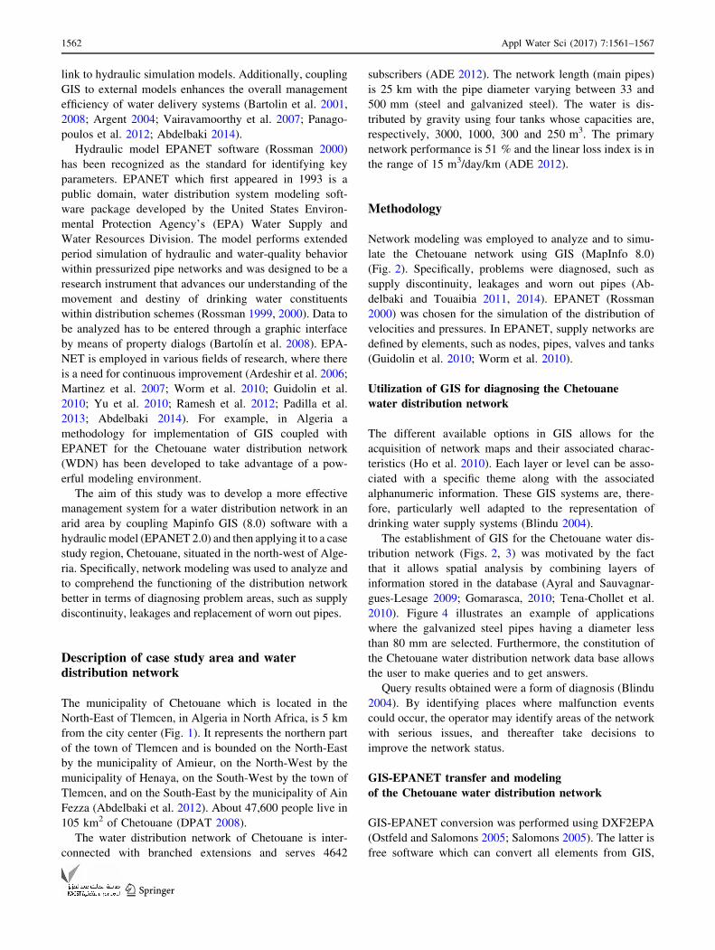
Methodology
Network modeling was employed to analyze and to simu-
late the Chetouane network using GIS (MapInfo 8.0)
(Fig. 2). Specifically, problems were diagnosed, such as
supply discontinuity, leakages and worn out pipes (Ab-
delbaki and Touaibia 2011, 2014). EPANET (Rossman
2000) was chosen for the simulation of the distribution of
velocities and pressures. In EPANET, supply networks are
defined by elements, such as nodes, pipes, valves and tanks
(Guidolin et al. 2010; Worm et al. 2010).
Utilization of GIS for diagnosing the Chetouane
water distribution network
The different available options in GIS allows for the
acquisition of network maps and their associated charac-
teristics (Ho et al. 2010). Each layer or level can be asso-
ciated with a specific theme along with the associated
alphanumeric information. These GIS systems are, there-
fore, particularly well adapted to the representation of
drinking water supply systems (Blindu 2004).
The establishment of GIS for the Chetouane water dis-
tribution network (Figs. 2, 3) was motivated by the fact
that it allows spatial analysis by combining layers of
information stored in the database (Ayral and Sauvagnar-
gues-Lesage 2009; Gomarasca, 2010; Tena-Chollet et al.
2010). Figure 4 illustrates an example of applications
where the galvanized steel pipes having a diameter less
than 80 mm are selected. Furthermore, the constitution of
the Chetouane water distribution network data base allows
the user to make queries and to get answers.
Query results obtained were a form of diagnosis (Blindu
2004). By identifying places where malfunction events
could occur, the operator may identify areas of the network
with serious issues, and thereafter take decisions to
improve the network status.
GIS-EPANET transfer and modeling
of the Chetouane water distribution network
GIS-EPANET conversion was performed using DXF2EPA
(Ostfeld and Salomons 2005; Salomons 2005). The latter is
free software which can convert all elements from GIS,
1562 Appl Water Sci (2017) 7:1561–1567
123

such as lines and polylines in layers at DXF format, in a set
of pipes and fittings in EPANET (Rossman 2000). Addi-
tional elements such as tanks, pumps and valves should be
added manually to the model in EPANET (Worm et al.
2010). The conversion software can calculate the lengths of
pipes; while other network data, such as elevations nodes,
water need and pipe diameters must be modified using
EPANET (Rossman 2000) after the converted file is loa-
ded. After the conversion of the different layers network
data, such as diameters, pipe roughness, altitudes, reser-
voirs and valve characteristics is input into the system. The
network consumption is defined in the nodes of the water
distribution network, which allocates the flow based on the
needs of the population; this rate is divided according to the
importance of consumption points in the network. The
modeling goal is to establish a consumption profile for each
part of the network starting from the 296 nodes needs of the
Chetouane network and its peak flow. Figure 5 shows some
of the scenarios of the water distribution network
operation.
Results and discussion
According to EPANET network analysis of the pressure
distribution, it was found that 115 of the 296 demand nodes
(i.e., 39 %) have a pressure greater than 6 bar (Fig. 6). This
signifies that more than 39 % of the network nodes may
have serious leakage problems. Unacceptable noise inside
the customer houses was also reported (Dupont 1979;
Bonnin 1986; Valiron 1994). Three of the 296 nodes had a
pressure lower than 1 bar, suggesting that 1 % of the nodes
present may have broken pipes. It can be argued that
subscribers of these regions are not properly served
(Dupont 1979; Bonnin 1986; Gomella 1985; Tatietse and
Rodriguez 2001). Furthermore, 178 of the 296 nodes (i.e.,
60 %) had a pressure between 1 and 6 bar. This means that
60 % of the nodes were in the standard range and were
working properly as proposed by Dupont (1979) and
Bonnin (1986).
Analysis of the velocity distribution indicated that 200
out of 306 pipes (i.e., 65 %) were characterized by water
velocity less than 0.5 m/s (Fig. 7). This can result in
damage to 65 % of the network pipes since low velocity
can cause deposit build up as a consequence of settling and
low shear (Gomella 1985). In addition, 64 pipes among 306
(i.e., 21 %) had a velocity between 0.5 and 1.5 m/s, which
Fig. 1 Location of the case study area
Implementation of GIS for the Chetouane Water Distribution Network
Repartition of the network of Chetouane in distribution zones
Import Chetouane network under EPANET and complete loading data using the DXF2EPA (make corrections if necessary)
Start simulations for each zone and make the necessary corrections (calibration)
Perform various thematic analysis according to the distribution of pressures and velocities of Chetouane
Fig. 2 Methodology flowchart
Appl Water Sci (2017) 7:1561–1567 1563
123

is in the acceptable range according to international stan-
dards (Dupont 1979; Bonnin 1986). However, the
remaining 42 pipes (i.e., 14 %) had a velocity greater than
1.5 m/s, which is not ideal. Thus, 14 % of the network may
be damaged by an internal erosion or abrasion, due to shear
effects caused by high fluid flow rates (Dupont 1979;
Bonnin 1986).
The overall analysis indicated that the Chetouane water
distribution network is not functioning ideally. Several
actions are required to improve the performance and to
reduce the rate of leakage in the network. Updating of the
network should take into consideration the operating
conditions (i.e., velocity, pressure, soil characteristics). It
is important to note that the storage and updating of
Fig. 3 Extract of water distribution network of Chetouane
Fig. 4 Example of GIS applications
1564 Appl Water Sci (2017) 7:1561–1567
123

descriptive and spatial operations data allows the opera-
tors and managers to access the history of operating
problems of specific parts of the network. Knowing where
breaks have occurred, and where renewals have been
made, for instance, is very useful for predicting future
interventions in the network, and thus for budgeting
purposes.
The results showed that the combination of GIS and
modeling allows network operators to have a management
tool that can analyze malfunctions with a response to any
incident that may occur and facilitate understanding of the
work performed on the network. Furthermore, the
grouping of GIS and modeling as an operating tool allows
managers to diagnosis the network, to study the solutions
of problems and to predict future situations. The later can
assist them in making more informed decisions to ensure
an acceptable performance level for optimal network
operation.
Conclusion
This study has shown a methodology for improved
management of a water distribution network by coupling
Mapinfo GIS 8.0 software with hydraulic modeling
(EPANET2.0). By applying this methodology to a case
study region of Chetouane in Algeria, it revealed which
areas of the network are working properly and which
areas need to be changed. In addition, the storage and
updating of descriptive and spatial operations data allows
operators and managers to access the history of operating
problems of specific parts of the network. Knowing where
fractures have occurred, and where renewals have been
made, for instance, is very useful for predicting future
interventions in the network, and thus for budgeting
purposes.
Acknowledgements The authors wish to thank the staff of the
Operations Department of the Algerian water-Unit (ADE Tlemcen)
for their help and cooperation.
Fig. 5 Scenarios for water distribution network modeled by EPANET
39%
1%60%
Fig. 6 Pressure distribution in the nodes of the WDN of Chetouane
65%14%
21%
Fig. 7 Velocity distribution in the WDN of Chetouane
Appl Water Sci (2017) 7:1561–1567 1565
123

Open Access This article is distributed under the terms of the
Creative Commons Attribution 4.0 International License (http://
creativecommons.org/licenses/by/4.0/), which permits unrestricted
use, distribution, and reproduction in any medium, provided you give
appropriate credit to the original author(s) and the source, provide a
link to the Creative Commons license, and indicate if changes were
made.
References
Abdelbaki C (2014) Modelisation d’un reseau d’AEP et contribution a
sa gestion a l’aide d’un SIG-Cas du Groupement Urbain de
Tlemcen, These de Doctorat, Universite de Tlemcen, pp 208.
doi:10.13140/2.1.4131.9207
Abdelbaki C, Touaibia B (2011) Modelisation d’un reseau d’alimen-
tation en eau potable et contribution a sa gestion a l’aide d’un
SIG—Cas du groupement urbain de Tlemcen, Algerie, Proceed-
ing du 4eme colloque international sur les ressources en eau et le
developpement durable, 22 et 23 fevrier 2011, Alger, Algerie,
pp 583–587
Abdelbaki C, Touaibia B (2014) Apport des systemes d’information
geographique et de la modelisation hydraulique dans la gestion
des reseaux d’alimentation en eau potable—Cas du groupement
urbain de Tlemcen (Algerie). TSM 5:52–60
Abdelbaki C, Benhamouda F, Chikh M (2012) SIG: Outils de gestion
des reseaux d’alimentation en eau potable, Cas du reseau de la
ville de Birtouta -Alger, Algerie, Editions universitaires
europeennes, Allemagne
Algerienne Des Eaux ADE (2012) Rapport technique d’exploitation,
pp 42
Ardeshir A, Saraye M, Sabour F, Behzadian K (2006) Leakage
management for water distribution system in GIS environment.
World environmental and water resource congress, May 21–25,
2006, Omaha, Nebraska, USA, pp. 1–10. World Environmental
and Water Resource Congress 2006: Examining the Confluence
of Environmental and Water Concerns, pp 1–10. doi:10.1061/
40856(200)27
Argent RM (2004) An overview of model integration for environ-
mental application components, frameworks and semantics.
Environ Model Softw 19(3):219–234
Ayral PA, Sauvagnargues-Lesage S (2009) Systemes d’Information
Geographique: outil d’aide a la gestion territoriale. Techniques
de l’ingenieur, France H7415:1–14
Bartolin H, Martinez F, Monterde N (2001) Connecting ArcView 3.2
to EPANET 2. A full environment to manage water distribution
systems using models. Water software systems: theory and
applications. International Conference on Computing and Con-
trol for the Water Industry (CCWI’01). Montfort University,
Leicester (UK), 6–9 September 2001, pp 355–368
Bartolın H, Martınez F, Cortes J (2008) Bringing up to date WDS
models by querying. An EPANET-Based GIS Geodatabase,
Eighth Annual Water Distribution Systems Analysis Symposium
(WDSA), Cincinnati, Ohio, USA, pp 1–17
Blindu I (2004) Outil d’aide au diagnostic du reseau d’eau potable pour
la ville de Chisinau par analyse spatiale et temporelle des
dysfonctionnements hydrauliques. These de doctorat, Ecole
nationale superieure des mines de Saint-Etienne, France, pp 304
Bonnin J (1986) Hydraulique Urbaine Appliquee aux agglomerations
de petite et moyenne importance. Edition Eyrolles, Paris
DPAT (2008) Schema d’amenagement de la commune de Chetouane,
Note technique, pp 56
Dupont A (1979) Hydraulique urbaine, Tome 2. Edition Eyrolles,
Paris
Gandin F, Doutre O (2007) Le SIG du SEDIF : un outil performant au
service de la gestion de l’eau potable, L’eau, les nuisances.
l’industrie 303: 53–56
Gomarasca MA (2010) Basics of geomatics. Appl Geomat
2:137–146. doi:10.1007/s12518-010-0029-6
Gomella C (1985) Guide de l’alimentation en eau dans les
agglomerations urbaines et rurales. Editions Eyrolles, Paris
Guidolin M, Burovskiy P, Kapelan Z, Savic DA (2010) CWS Net: an
object-oriented toolkit for water distribution system simulations,
water distribution system analysis, WDSA2010, Tucson, AZ,
USA, Sept. 12–15. doi:10.1061/41203(425)2
Ho CI, Lin MD, Lo SL (2010) Use of a GIS-based hybrid artificial
neural network to prioritize the order of pipe replacement in a
water distribution network. Environ Monit Assess
166(1–4):177–189
Kalivas DP, Kollias VJ, Karantounias G (2003) A GIS for the
assessment of the spatio-temporal changes of the Kotychi
lagoon, western Peloponnese, Greece. Water Resour Manag
17(1):19–36
Martinez F, Hernandez V, Miguel Alonso J, Rao Z, Alvisi S (2007)
Optimizing the operation of the Valencia water distribution
network, IWA Publishing. J Hydroinform 9(1):65–78
Ostfeld A, Salomons E (2005) Securing water distribution systems
using online contamination monitoring. J Water Res PL-ASCE
131(5):402–405
Padilla Sifontes V, Davila Quintero J (2013) Multi-agent geosimu-
lation for a water distribution System, Computing Conference
(CLEI), XXXIX Latin American, Naiguata: 7–11 Oct. 2013,
pp 1–12. doi:10.1109/CLEI.2013.6670651
Panagopoulos GP, Bathrellos GD, Skilodimou HD, Martsouka FA
(2012) Mapping urban water demands using multi-criteria
analysis and GIS. Water Resour Manag 26(5):1347–1363
Ramesh H, Santhosh L, Jagadeesh CJ (2012) Simulation of hydraulic
parameters in water distribution network using EPANET and
GIS. In: International Conference on Ecological Environmental
and Biological Sciences (ICEEBS’2012) Jan. 7–8, Dubai,
pp 350–353
Rossman LA (1999) Computer models/EPANET. Water distribution
systems handbook. McGraw Hill, New York
Rossman L (2000) Epanet 2 user’s manual. Environmental Protection
Agency, Cincinnati
Salomons E (2005) DXF2EPA—AutoCad DXF File Conversion
Utility for EPANET. http://www.water-simulation.com/wsp/
2005/06/03/dxf2epa-autocad-dxf-file-conversion-utility-for-epanet.
Accessed 27 March 2013
Tabesh M, Delavar MR (2003) Application of integrated GIS and
hydraulic models for unaccounted for water studies in water
distribution systems, Advances in Water Supply Management.
In: Proceedings of the CCWI’03 Conference, London, 15–17
September, Edited by Cedo Maksimovic, Fayyaz Ali Memon,
and David Butler, Taylor & Francis, Print ISBN: 978-90-5809-
608-1, eBook ISBN: 978-0-203-83366-7
Tatietse TT, Rodriguez M (2001) A method to improve population
access to drinking water networks in cities of developing
countries. J Water Supply Res Technol Aqua 50(1):47–60
Tena-Chollet F, Sauvagnargues-Lesage S, Thierion V, Ayral PA
(2010) Systemes d’information geographique: mise en œuvre.
Techniques de l’ingenieur, France H7416:1–22
Tsihrintzis VA, Hamid R, Fuentes HR (1996) Use of geographic
information systems (GIS) in water resources: a review. Water
Resour Manag 10(4):251–277
Udovyk O (2006) GIS for intergrated water resourses management.
In: Hlavinek P, Kukharchyk T, Marsalek J, Mahrikova (eds)
Integrated urban water resources management. Springer, The
Netherlands, pp 35–42
1566 Appl Water Sci (2017) 7:1561–1567
123

Vairavamoorthy K, Yan Jimin, Galgale Harshal M, Gorantiwar Sunil
D (2007) IRA-WDS: a GIS-based risk analysis tool for water
distribution systems. Environ Model Softw 22:951–965
Valiron F (1994) Memento du gestionnaire de l’alimentation en eau
potable et de l’assainissement, Tome 1, 2, 3, Edition Lavoisier,
Paris, France, pp 1262
Worm GIM, Van der Helm AWC, Lapikas T, Van Schagen KM,
Rietveld LC (2010) Integration of models, data management,
interfaces and training support in a drinking water treatment
plant simulator. Environ Model Softw 25(5):677–683
Yu T, Liya M, Xiaohui L, Yunzhong J (2010) Construction of water
supply pipe network based on GIS and EPANET model in
Fangcun District of Guangzhou. In: Geoscience and Remote
Sensing (IITA-GRS), 28–31 August 2010, Second IITA Inter-
national Conference on (vol 2, 268-271). IEEE. doi:10.1109/
IITA-GRS.2010.5604123
Appl Water Sci (2017) 7:1561–1567 1567
123