man-made new orleans: some interactions … new orleans: some interactions between the physical and...
TRANSCRIPT

Man-made New Orleans: Some Interactions between the
Physical and Esthetic Environments
by RONALD F. LOCKMANN, assistant professor, Department of Anthropology and Geography, University of New Orleans, Lake- front, New Orleans, La. 70122.
ABSTRACT.-The relations between the physical environment and esthetic dimensions of the New Orleans cultural landscape are examined. The esthetic characteristics associated with New Orleans urban morphology are examined with respect to possible constraints by the physical environment. Salient townscape features such as street grid system, surface-drainage network, and spatial features of selected residential neighborhoods provide instances that dem- onstrate the varying levels of physical environmental impingement upon the esthetic landscape.
Because of i t s close, i f no t abject , de- pendence u v o n local building materials which, in geological terms a t least, are und local qkalities of site, the c i t y epitom- rapidly. ixes the surrounding country and gives a special character to t he natural sett ing. The visual or esthetic landscape is At n o momen t in i t s existence i s the compounded of the disparate elements divorce between the man-made environ- m e n t and the ear th complete. of the physical and human scene, and
-LEWIS MUMFORD, in i t becomes chaotic and illegible in cer- T h e Cul ture of Cities tain locales as a result of the uneasy
THE NEW ORLEANS urban complex stands upon what has been termed
the flattest, lowest, and geologically youngest site of any major city in the United States (fig. 1). The site has been above sea level for roughly a thousand years, while the most signifi- cant human landscape modification has transpired roughly within the past two centuries.
The growing demands for space to ac- commodate the population of one of the world's major ports have transmogrified the physical landscape of New Orleans so fundamentally that the designation - man-made - applies not only to buildings, roads, and other components of the cultural landscape, but also to the undulations of the land surface itself. Indeed, the processes of site preparation and maintenance (that is, from extreme meteorologic or hydrologic events) have built a virtual walled city that is pri- marily below sea level, and portions of
symbiosis of man and nature. Especially t he street grid, drainage system, and spatial structure of certain residential neighborhoods give visual evidence of the inextricably interwoven physical and human landscapes.
ASPECTS OF THE PHYSICAL MILIEU
New Orleans' global importance as a port followed from its geographical loca- tion on the lower deltaic plain of North America's premier river. The "Isle of Orleans" depicted by the eighteenth century cartographer Delisle is reality when one considers that marshlands flanli the city's eastern and western edges, and the banks of Lake Pont- chartrain on the north and the Missis- sippi to the south are permanent, though dynamic, physical boundaries. The char- acteristics of the land surface have long confounded potential residents as well as visitors, as an eighteenth century account affirmed :
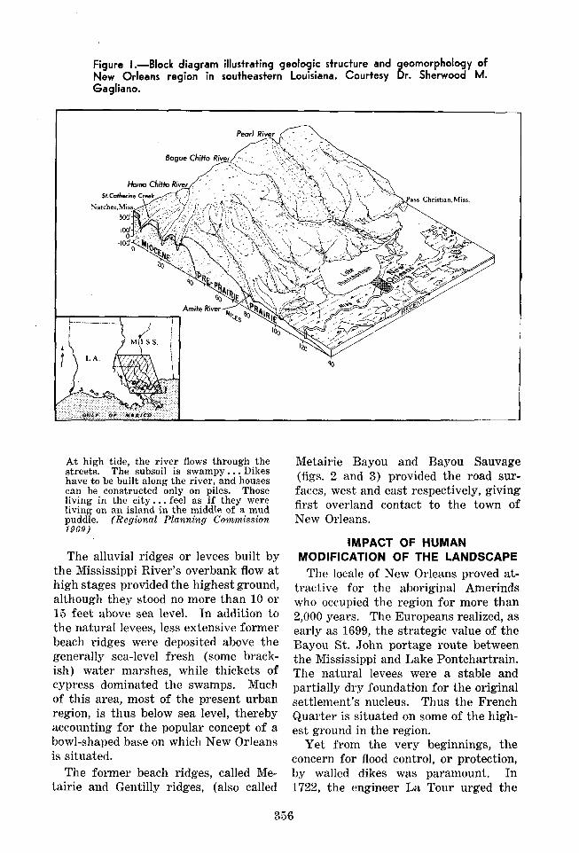
Figure I.-Block diagram illustrating geologic structure and geomorphology of New Orleans region in southeastern Louisiana. Courtesy Dr. Sherwood M. Gagliano.
s Christian, Mlss.
A t high tide, the river flows through the streets. The subsoil is swampy. . . Dikes have to be built along the river, and houses can be constructed only on piles. Those living in the ci ty . . . feel a s if they were living on an island in the middle of a mud puddle. (Regional Planning Commission 1969)
The alluvial ridges or levees built by the Mississippi River's overbank flow a t high stages provided the highest ground, although they stood no more than 10 or 15 feet above sea level. In addition to the natural levees, less extensive former beach ridges were deposited above the generally sea-level fresh (some brack- ish) water marshes, while thickets of cypress dominated the swamps. Much of this area, most of the present urban region, is thus below sea level, thereby accounting for the popular concept of a bowl-shaped base on which New Orleans is situated.
The former beach ridges, called Me- tairie and Gentilly ridges, (also called
Metairie Bayou and Bayou Sauvage (figs. 2 and 3) provided the road sur- faces, west and east respectively, giving first overland contact to the town of New Orleans.
IMPACT OF HUMAN MODIFICATION OF THE LANDSCAPE
The locale of New Orleans proved at- tractive for the aboriginal Amerinds who occupied the region for more than 2,000 years. The Europeans realized, a s early as 1699, the strategic value of the Bayou St. John portage route between the Mississippi and Lake Pontchartrain. The natural levees were a stable and partially dry foundation for the original settlement's nucleus. Thus the French Quarter is situated on some of the high- est ground in the region.
Yet from the very beginnings, the concern for flood control, or protection, by walled dikes was paramount. In 1722, the engineer La Tour urged the

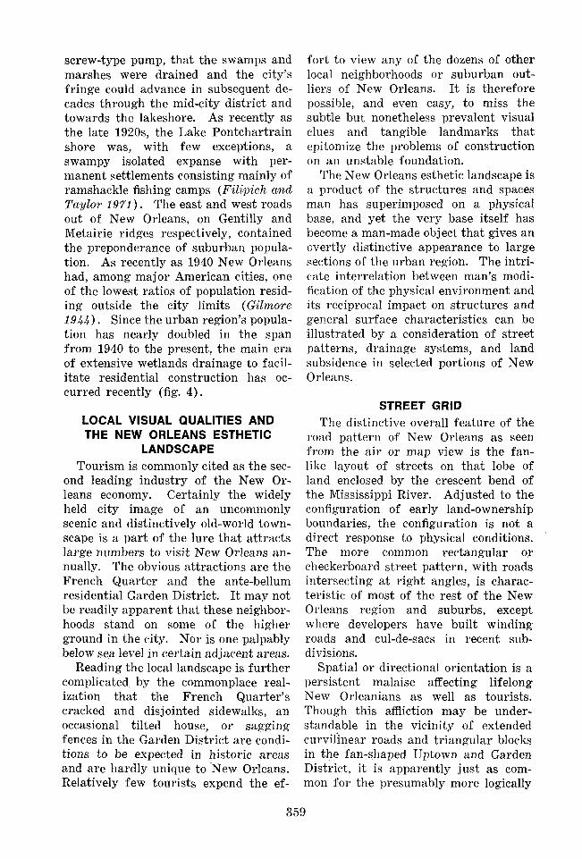
Figure 2.-Regional geomorphology of New Orleans in the Pontchartrain Basin vicinity. From Saucier 1963.
Small sllt and shell beaches
f o n t c h a r t r o i n
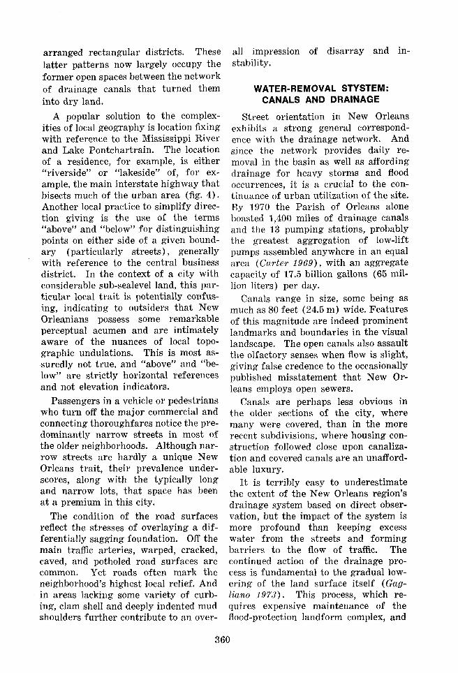
Figure 3.-Typical north-south profile through city of New Orleans. Courtesy Dr. Sherwood M. Gagliano.
10- -10 -MSL
-10 distr ibutary natura l levees
Mississippi R.
1 1 I 0
wort. .nag. X l O O 3 6 miles 9
Drained Flood Basin Lake Fill
N Natural S Levee
river floods 20 ft- -20 ft storm tides

construction of higher and wider dikes than those already being built. And nineteenth century maps clearly depict the correspondence of urban morphology and the higher ground of the natural levees. A Mississippi River Commis- sion report in 1896 indicated that a t least half of the land inside the present- day city limits remained swamp and marshland. The nineteenth century saw cycles of levee building and subsequent destruction by major floods.
At present, the Army Corps of En- gineers builds the levees in the New Orleans area, and local or parish agencies
retain the responsibility for their main- tenance. The system consists of levees on both banks of the Mississippi, aver- aging 25 feet (7.6 m) above sea level. Thus New Orleans' site is likened to a high-rimmed saucer. The levees may keep the river from entering the city, but they have also served to retain whatever water may enter.
The city averages more than 60 inches (150 em.) of precipitation yearly; and disposal of excess water was one of the historic urban woes in New Orleans (Jennings 1972). It was only in 1917, upon the employment of the electric
Figure 4.-Areas surveyed by Soil Conservation Service, 1970, showing soils potentially unsuitable for urban construction. Courtesy Dr. Dan W. Earle.
screw-type pump, that the swamps and marshes were drained and the city's fringe could advance in subsequent de- cades through the mid-city district and towards the lakeshore. As recently as the late 1920s, the Lake Pontchartrain shore was, with few exceptions, a swampy isolated expanse with per- manent settlements consisting mainly of ramshackle fishing camps (Filipich and T a y l o ~ 1971). The east and west roads out of New Orleans, on Gentilly and Metairie ridges respectively, contained the preponderance of suburban popula- tion. As recently as 1940 New Orleans had, among major American cities, one of the lowest ratios of population resid- ing outside the city limits (Gilmore 1944) + Since the urban region's popula- tion has nearly donbled in the span from 1940 to the present, the main era of extensive wetlands drainage to facil- itate residential construction has oc- curred recently (fig. 4).
LOCAL VISUAL QUALITIES AND THE NEW ORLEANS ESTHETIC
LANDSCAPE Tourism is commonly cited as the sec-
ond leading industry of the New Or- leans economy. Certainly the widely held city image of an uncommonly scenic and distinctively old-world town- scape is a part of the lure that attracts large numbers to visit New Orleans an- nually. The obvious attractions are the French Quarter and the ante-bellum residential Garden District. I t may not be readily apparent that these neighbor- hoods stand on some of the higher ground in the city. Nor is one palpably below sea level in certain adjacent areas.
Reading the local landscape is further complicated by the commonplace real- ization that the French Quarter's cracked and disjointed sidewalks, an occasional tilted house, or sagging fences in the Garden District are condi- tions to be expected in historic areas and are hardly unique to New Orleans. Relatively few tourists expend the ef-
fort to view any of the dozens of other local neighborhoods or suburban out- liers of New Orleans. I t is therefore possible, and even easy, to miss the subtle but nonetheless prevalent visual clues and tangible landmarks that epitomize the problems of construction on an unstable foundation.
The New Orleans esthetic landscape is a product of the structures and spaces man has superimposed on a physical base, and yet the very base itself has become a man-made object that gives an overtly distinctive appearance to large sections of the urban region. The intri- cate interrelation between man's modi- fication of the physical environment and its reciprocal impact on structures and general surface characteristics can be illustrated by a consideration of street patterns, drainage systems, and land subsidence in selected portions of New Orleans.
STREET GRID The distinctive overall feature of the
road pattern of New Orleans as seen from the a i r or map view is the fan- like layout of streets on that lobe of land enclosed by the crescent bend of the Mississippi River. Adjusted to the configuration of early land-ownership boundaries, the configuration is not a direct response to physical conditions. The more common rectangular or checkerboard street pattern, with roads intersecting a t right angles, is charac- teristic of most of the rest of the New Orleans region and suburbs, except where developers have built winding roads and cul-de-sacs in recent sub- divisions.
Spatial or directional orientation is a persistent malaise affecting lifelong New Orleanians as well as tourists. Though this affliction may be under- standable in the vicinity of extended curvil'inear roads and triangular blocks in the fan-shaped Uptown and Garden District, i t is apparently just as com- mon for the presumably more logically
arranged rectangular districts. These latter patterns now largely occupy the former open spaces between the network of drainage canals that turned them into dry land.
A popular solution to the complex- ities of local geography is location fixing with reference to the Mississippi River and Lake Pontchartrain. The location of a residence, for example, is either "riverside" or "lakeside" of, for ex- ample, the main interstate highway that bisects much of the urban area (fig. 4) . Another local practice to simplify direc- tion giving is the use of the terms "above" and "below" for distinguishing points on either side of a given bound- ary (particularly streets), generally with reference to the central business district. In the context of a city with considerable sub-sealevel land, this par- ticular local t ra i t is potentially confus- ing, indicating to outsiders that New Orleanians possess some remarkable perceptual acumen and are intimately aware of the nuances of local topo- graphic undulations. This is most as- suredly not true, and "above" and "be- low" are strictly horizontal references and not elevation indicators.
Passengers in a vehicle or pedestrians who turn off the major commercial and connecting thoroughfares notice the pre- dominantly narrow streets in most of the older neighborhoods. Although nar- row streets are hardly a unique New Orleans trait, their prevalence under- scores, along with the typically long and narrow lots, that space has been a t a premium in this city.
The condition of the road surfaces reflect the stresses of overlaying a dif- ferentially sagging foundation. Off the main traffic arteries, warped, cracked, caved, and potholed road surfaces are common. Yet roads often mark the neighborhood's highest local relief. And in areas lacking some variety of curb- ing, clam shell and deeply indented mud shoulders further contribute to an over-
all impression ob disarray and in- stability.
WATER-REMOVAL STYSTEM: CANALS AND DRAINAGE
Street orientation in New Orleans exhibits a strong general correspond- ence with the drainage network. And since the network provides daily re- moval in the basin as well as affording drainage for heavy storms and flood occurrences, i t is a crucial to the con- tinuance of urban utilizatioa of the site. By 1970 the Parish of Orleans alone boasted 1,400 miles of drainage canals and the 13 pumping stations, probably the greatest aggregation of low-lift pumps assembled anywhere in an equal area (Carter 1969), with an aggregate capacity of 17.5 billion gallons (65 mil- lion liters) per day.
Canals range in size, some being as much as 80 feet (24.5 m) wide. Features of this magnitude are indeed prominent landmarks and boundaries in the visual landscape. The open canals also assault the olfactory senses when flow is slight, giving false credence to the occasionally published misstatement that New Or- leans employs open sewers.
Canals are perhaps less obvious in the older sections of the city, where many were covered, than in the more recent subdivisions, where housing con- struction followed close upon canaliza- tion and covered canals are an unafford- able luxury.
It is terribly easy to underestimate the extent of the New Orleans region's drainage system based on direct obser- vation, but the impact of the system is more profound than keeping excess water from the streets and forming barriers to the flow of traffic. The continued action of the drainage pro- cess is fundamental to the gradual low- ering of the land surface itself (Gag- liano 1973). This process, which re- quires expensive maintenance of the flood-protection landform complex, and

the gradual moving and tilting of struc- tures built on the surface of a different- ially undulating topography, is among the chief features of the New Orleans esthetic landscape,
LAND SUBSIDENCE:: THE CHANGING NEW ORLEANS SCENE
The phenomellon of land subsidence is among the paramount physical proc- esses i~nlpacting on urban expansion in the New Orleans metropolitan region. It has been succinctly defined by Saucier (196.9) as the relative lowering of the land surface with respect to sea level. &Tore recently Earle (197'5) has pointed out that the term is often invoked with reference to tectonic occurreplees over a larger region wl~ereas ""settlement" usuallgr refers to a less extensive area and "c~e changing compaction of soil. The term "loweering" is employed in re- gards to road, building, levee, or other compression of underlying soil. The popular equivalent of "subsidence" is ""sinking".
Land subsidence is a. global nuisance and axany cases have been closely ob- served and documented. This phenom- enon has occurred in London, England ; Osaka, Japan ; Lake Maracaibo, Vene- zuela; and Mexico City to name a few notable examples. In Mexico City an exposed well casing in the Plaza de 1% Republics, origirlally flush with the stw- face, was m e a s ~ ~ r e d a t 23 feet (9 m) above the present after about 60 years of use (Fox 1'965, L ~ g g e t 1.9739.
Tn the United States, land subsidence is by no means uncommon. Owing, per- haps, to the somewilat less extreme na- ture of land subsidence, New Orleans is not me.tltio~aed in most of the standard subsidence IitelAature, although the ex- tent of the local problem is visibly ap- parent tliro~aghou"c"Lh m&et~opolitall area and especially in a few noteworthy neigbborlioods, In the drained wetland regions such as New Orleans, the com- plexity of organic soils makes i t diEcult to relate subsidence to a single cause.
The major factors inipingi~lg on land subsidence rates in New Orleans are : del~ydration and shrinking of the de- posits ; oxidation of organic substances ; the drop in the local water table; and excavation for sewers and water lines. Some local soil types may contain 4 to 12 feet of compressible organics, and the water content of humus may be 400 to '100 percent of dry weight (Soi! Con- s~ritntion Sr~tl ict: 197'0, .fig. 5 ) . A series of level surveys in the organic sojls of the Florida Everglades lneasured an $-fooL(2.5-m) drop in surface over a span of 50 years of regular. measurenzent ( S t ~ p h ~ n s and S p ~ i r 197'0).
Land subsidence in the New Orleans metropolitall area is prevalent in vir- tually all rleigkborhoods, but a few dis- "crits in particular epitomize the prob- lematic extremes of this phenomenon, Cracks, broken, axad uxldulating side- walks; tilted ltouses and other stre~c- tures; inclined tree trunks and utility poles; and undulating lawns, and other open-space surfaces are virtually ubi- quitous manifestations of the semi-fluid regional substrate.
The older neighborhoods may be rela- tively less affected, yet in the established districts of Carrollton, Mid City, or B1:tlievie\v, each with sub-sealevel areas, scarcely one block exists without num- erous visual symptoms of subsidence (fig. 5)- In the highest and oldest por- tions of New Orleans, numerous strue- Lures have lasted for many decades with negligible tilt or settlement,
FOP this reason, foualdation support by pilings or caissons are not mamlda- tory for coltstruetion In the metropoli- tan region. On the other hand, the largest strrrctures such as the 60-storied One Shell Square Building or Ilouisiana Superdome have had steel or concrete ~ ~ i l i n g s extended beneath their foullda- tions to between 100 and 150 feet (31 to 45 m ) . Most residential construc- tion, employs log pilings about 40 to 50 feet 412 to 15 n1) in length, which is ~enera l ly suEcieat to ensure structural

Figure 5.-Residence in 6300 block, Wesf End Boulevard in Lakeview secPiorr, New Orleans, N o h undtila+ing sidewalk as well as cracked snd til+ed sfairway,
~"cability in ~?aost locations in the region* But since fiat necess;u.y drainage sys- tem "cends to lower the ~previotas'ly higher water table, followecl by oxidation a.ujrB con~paciion, most of the urban complex experiences lhe effects of subsidence f Gctylia?zo 3973) . On the ioumerly sea- level drained marshland on the eastern and western suburban fringes of New Orleans, two subdivisions stand in 111ute testimony lo the extreme ant9 dramatic impaci of land srabs~deuce in the re,' 0 ion,
LAND SUBSIDENCE: EPITOME DlSTRlCTS
%'illage Del'Est i s n subdivision in the castern pttrt of the city o f New Orleans, built in an area long avoided for urbani- zation because of its marslly forrndation. The XZavold P a ~ k seetrsn is located in ilie mt~riicip>tIity of Renmler, in~medi- ately north of New Orleans Interna- tional Airport and was built as the t~opul;~tion of New Orle;~ns' western sul.,rr~l~an fringe expanded rl~al*iurg the
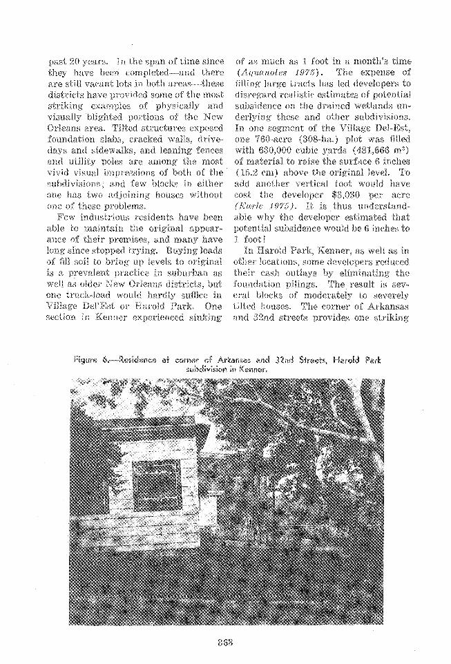
past 20 years, In "ce span of time sinice they have been completed-and there a re still vacant lots in both areas--these districts have provided some of "cie most striking exagaip/es! of pliysically and visually blighted portions of the New Orleans area. Tilted s t ruc tu~es exposed fountlation slabs, cracked walls, drive- days and sidewallis, and leaning fences and eatility poles are anlong the nnost vivid visual in~pressions of both of the subdivisions; and few blocks in either orae has two adjoining houses without or1e of these problems.
Few industrious residents have beext able to maintain the origir-ral zppear- ancc o f their premises, and Batany have 10~1g since stol?p?ed trpirag. Buying loads of Gll soil to bring up levels to original is a p1~ee7alean-l practice in suburban as well as older New Orleans districts, but one truck-load would hardly suffice in Villaga DeX'Est or Harold Park. One section in Kenner experienced sinking
of as much as 1 foo t in a montli9s time (Aq7~ctnotes 197'5). The expense of filling large tracts has led developers to disregard realistic estimates of potential subsidence on the drained wetlands un- derlying these and oktier subdivisions. In one segment of the Village Del-Est, one 760-acre (308-ha.) plot was filled with 630,000 cubic yards (481,666 m3) of material to raise the surface 6 inches (35.2 em) above the o-rigiatal level. To add anotlzer vertical foot would have cost the developer $3,030 per acre (Enrle 197'5). I t is thus understand- able why the dexleloper estimated that potential subsidence would be 6 inches to 1 foot! In EIayold Park9 Kenner, as well as in
otller locations, some developers reduced their cash outlays by eliminating the fotandatiora pilings. The result is sev- eral bloclas of moderately to severely tilted Izouses. Tlae corner of Arkansas and 32nd streets provides one striking
Figurs &.-Residence at corner of Arkansas end 32nd Streets, Harold Park subdivision in Kenr~er.

Figure T=-Wes;dence a t 4% 1 1 Williams Boulevard, Menner. Support pilings appear to be stilts, Note incline of unsupporfed concrete pad.
Figure @.-Residence in 3200 block (sf Colorado Sfreet, Hareold Park subdivision, Kenner.
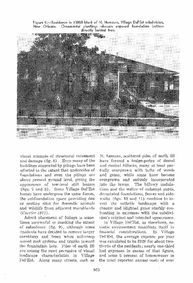
Figure 9,-Residence in 13000 bBock of N. Nemours, Village DeB'Est subdivision, New Orleans. Ornamental plawfings obscure exposed faundafion bottom
direc+ly behind tree,
visual. example of structraral movemea.tS; and damage (fig. 6). Even many of the buildings supported by pilings have been affected to the extent thahnders ides of foundations and even the pilings are above present ground level, giving the appearance of low-level stilt houses (figs. 7 and 8). Some Village Del'Est homes have undergone the same forces, the subfounda"ilon space providing den or nesting sites for donlest-ic animals and wildlife from adjacent niarshlands (Cc1q?iw 2975) .
Adroit placement oC foilage is some- times successful in masking the extent of subsidence (fig. 9) , althougl1 some residents have decided to remove larger shrubbery and trees when soil-creep moved root systems and trunks toward the foux~dntion hole. Biles of earth fill a re among the most pervasive of visual landscape characteris"ccs in Village De19Est. Along many streets, sucli as
N. Lenians, scattered piles of earth fill have formecl a hodge-podge of domal and conical hilloclrs, many a t least par- tially overgrown with tufts of weeds and grass, while some have become overgrown and entirely incorporated into the lawns. The billowy erndula- tions and the welter of unkempt yards, devastated foundations, fences and side- walks (figs, 10 and PI) combine t o in- vest the esthetic landscape with a chaotic and blighted guise starkly con- trasting in extremes with the subdivi- sion's original and intended appearance.
In Village Del'Est, as elsewliere, es- thetic environment manifests itself in a n a l considerations. In Village Del'Est, the average expense per year was calculated to be $120 for about two- thirds of the residents ; nearly one-third had expenses in excess of that figure, and some 6 percent of homeowners in the tract reported annual costs of over


$600. One liouse experienced settle- REFERENCES rner?"cof more than 11 inches (27.9 ~111) Ayuartotes. in a B-rnon-ilk span owing to a 1075. S u r x s ~ o ~ w c ~ : rrazhnu o r \vE:TeaNn UE-
\ ICI.OPMENT. AquanoLes 4 : 1, 5, 6. table change after adjacent construe- Carrrcr, Cornella
tione $borinj4 repain.s on %;his property 1975. I~I~ILINEU MrI:TLANDS: 1lOW INFIRIll 4 F ~ ~ J N I ~ L Y C X O R ' ? NFW Orleans T~nles-Picayune,
were estinsated t ~ t $5,000, while other ~ p n i 13. owners have paid between $1,200 and carter, 1969. E o r r ~ s r ~ l ~ i * ALJ~ANAC. Pelican, New Or- $6,000 for swell avork. Despite hopes I,~,,,. 450 of appreciation of about 2 percerxt per Earle, Daniel W ~ l l ~ a r n , Jr,
1975. 1,knu sr Rsrn?:rauc PRonrdEMs 1n.1, nr irN- year, some Ilab-e experienced a deprecia- TCV~INCI: COSTS TO IIOBIEOW NGRS IN CAST Y ~ V tion of as mucll as 25 ill less ORIRkXs, LOT tSIANk. La. State c n i ~ . Uep
Xarlne Sci., P h D . Diss. 356 p. Raton Rouge. than a decade (6(~?*& 191t'i, C a ~ ~ i e r 1.975, Flhplch, ~ u d ~ A., and Lee Taylor. ~ ~ ~ ~ ~ ~ f . ~ . ~ 1975) . [n boill the $Village 1974. LAKEFROKT Ph'f:~ ORLEANS. I'L4NNIVG
ANn I)C\E:T,OI~MI':NT 1926-1971. liinir. Kew Del'Est and FIarold Park subdivisions, o ~ i e a l l s u ~ b a n s tud . Inst. 53 p. the pldhore of I4'OR SA1.E signs, added
I'::iE."";;\::lvATp;R RELaT ronhlIri,s &ll:I,KO- to the variety of other 'Vi~uZil cues, is a llor,rr,\w M'xrco. Geogr. 12ev. 5h: 723-546, Purtller iardicatiosr of consumer dissatis- C:agllano9 Sherwoocl nf.
1973. CANALS, uREX)ClNG, AND LAND KECLABIA- factiott. witl-1 these problematic areas. TION IK TIXL ~,OIJISY.".N~~ COASTAL ZONE, La.
State L n l i , Cent. Wetland Res. Eep. 14. 104 p Baton Rouge.
SUMMARY Gilnrore, X-I. W. 1944. TlrE ocn XEW ORLI:~NS a x o TmrE ~ E W : a CASE FOR F:COI.O(;Y. Am, SoeioI. Rev. 9 :
Thc New Orleans esthetic landscape :3a1j_:394. is the p ~ o d u c t of a. melange of disi7arate Je"" iw% Willianl.
1972. Eeo~ocrcaL IVT E;P\'TORY or TFIC ('ITY OF inflexences, among which street-pattern NF:J~ ~RLI.:,QJS. &re,,- Orleapls Health Dep. orientilfion, drainage network, and 18113.
Legget, Robcrt especially topograph~c fluctuations re- 1973. C r ~ r s s A N D C,EOLOGY. A ~ ~ G ~ ~ ~ ~ - - E ~ I I , s~alting from laud subsidence are most xc\v Yorli. 624 P.
Arumford, Eewls. striking visually. While some districts 1938~ T,, ,,,, ,,,, ,, ,,,. M ,,,our t, provicte niorg? extlsertnc and ohviot~s cases York. 586 P,
Rcgional Planning Cornn~ission. of physical-esthetic In"ceractions, these 1969. Brsroar OF nscxoxne GRO\VTEI OF JEF- influences ,are nevertlleless general FI~RSON, OI~LEANS, .%NU ST. BERNARD PAR-
rsrrss, I , o u r s ~ a ~ a . Neu Or l ra~ is Reg. Plan. throt~ghout the entire arba-iaized region. con,,,. 101 P, Exeept for the most blatant and severe saucirr , R ~ c l T-
1963. RECI<'KT GI2ORIOIEPIIIC TIISTORY OF TIlE sores of disreaption, New Oleleans resli- ~ O , ~ ~ ( ~ I I A R T R , I ~ B.~SIK. La. s ta te Univ.
dents seem to have imglieitlp accepted S 0 : ; o ~ : ~ i s ~ F ~ ~ ; 1 ~ ~ r 6 ~ ; , " ~ . ~ Raton Rouge.e. "ce gradexal but pe~eeptible change in 19x1. Sorr, sr RVL:Y OF POIITIONS OF JI.:FFERSOM, form of their sh?ired plot of grouald :is O R ~ X A ~ S , ST. BERNARD PAR~SPIES. New
Orlcar~s Reg. Plan. Comm. yet anlother part of the local ambience, stp1311ens, johIl c., and ~ ~ l l ~ ~ ~ M, speir. TEle man-induced kansformation of %;lie 1970. ~ [ J B S X D E N C E OF ORGANIC SOIT,S Ih TNh
V.S.A. I n Land Sub.;idence: 523 534. New Orleans landscape has modified -___-------
physical processes that a re changitlg th r Acknoulledgments The author thanks the surface configuration of the ground. hollowing for aid and encouragement: J.
Richard ShenBeX and David 0. Roberts, This dynamic, almost fluid, nature of ~~~~~t~~~~~ of Anthropology and Geog- the land base is one of the paramount raphy, University of New Orleans; Robert detern~inarats of those visrna] qualities eunninghal~, U S Corps of En-
gineers; Sherwood N Gagllano, Coastal that constitute the New Orlealls rstlietic ~ ~ ~ i ~ ~ ~ ~ ~ ~ ~ ~ , lnc., Baton Rouge, Louisiana: environment, and Dan W. EarXe, J r , Department of
Landscape Arclartectuse, Louisiana State U~liverslty, Baton Rouge