making a difference with geo
TRANSCRIPT

Making a Difference with GEO
Thank You Attending This Workshop
OR for the developers in the room: import arcpy arcpy.Union_analysis( [“GEO”, “GIS”], awesomeness)
GEO-X

Introduction

Backgrounds Disciplines
Interests Organizations Cultures
A Global Network of Policy Makers, Scientists, Earth Observation Professionals, …
You
Evolving Geography as a Platform

Our World is Facing Serious Challenges Collectively We Need to Create a Better Future
Leveraging Our Best Science, Technology, and Design
Social Conflict Inequality
Resource Shortage
Climate Change
Energy
Land Use Urbanization
Globalization
Water
Ecological Change
Natural Resources Economic Development
Economic Development
Loss of Nature
Human Health
Food
Population Growth Poverty
Biodiversity

GIS Is Already Helping Users Address These Challenges
Integrative
Visual
Qualitative
Systematic
Comprehensive
Providing the Practical Means for Transforming Our World

GIS Users Demographic and Health Surveys | USAID

GIS Users Health and Nutrition | World Vision

GIS users Clean Water | World Resources Institute

GIS Users Conservation Planning I South Africa

GIS Users Polio Eradication | Gates Foundation

GIS users Agricultural Production CGIAR and HarvestChoice

GIS users Citizen Engagement and Accountability | The World Bank
GeoResults
OnTrack

GIS Is Changing How We Think and Act Integrating Geographic Science into What We Do
We Need to Expand GIS . . . . . . Across Organizations and Society
Measure
Analyze Predict
Prepare
Design
Decide
Manage
Evaluate
Act
Plan

GIS Is Being Transformed Into A Web GIS
Making GIS Easier, and Always Available,
Common Geospatial Platform

The ArcGIS Platform

GIS Users Portals- Organizing Data Access
Citizen Access
Northern Ireland
Government Infrastructure Open Data Internal

Web GIS Connects Everyone
Executive Access
Public Engagement
Work Anywhere
Knowledge Workers
Enterprise Integration
Geospatial Professionals
Making Mapping and GIS Available Across Organizations
Transforming the Role of GIS

Web GIS Makes Maps and Geography More Accessible Extending The Reach of Geo-Sciences

Marten Hogeweg
Esri GEO Portal
Demo

ArcGIS Is a Platform Organizing Content and Managing Access
Available in the Cloud . . . . . . and On-Premises
Desktop Web Device
Server Online Content and Services
Simple
Integrated
Open
Portal

The Web GIS Platform Supports Everything
Open API
Mobile
Apps
Enterprise Systems
Mapping Analytics Sharing Content
Web GIS Platform
GIS Simple Mapping

Web GIS Integrates All Data Types As Web Maps and Web Services
Providing a New Medium for GIS
Imagery
Social Media
Big Data
Services
Sensor Networks
Maps
Enterprise Data

GIS Servers and Cloud Services Provide Infrastructure Powerful Data Management and Geospatial Services
The Foundation for Shared GIS Resources
Many Apps
GIS Server
Cloud Resources
Secure
Highly Scalable

Steve Kopp
Water SBA Demo
Demo
GIS Contributes to GEO

GIS Integrates Organizations and People Breaking Down the Barriers
Creating Easy Opportunities ….for Sharing and Collaboration
Creating New Relationships

Creating Regional and National GIS Infrastructure
Russia US
India Abu Dhabi
EU
Singapore
Indonesia
China
Bogotá, Colombia
Geneva, Switzerland

ArcGIS Includes Online Content – A Living Atlas
Global
Best Available
Ready to Use

Online Basemaps
Canvas Imagery
Topographic
Oceans
Terrain

GIS Consumes from GEO

ArcGIS Enables Spatial Analytics Leverage Cloud Infrastructure
Enabling New Approaches for GiScience
Aggregate Points
Find Hot Spots
Drive-Time Areas
Enrich Layer

ArcGIS Supports Developers
Open – Empowering a New Community

Benefits for the Users of GEO

Shift Focus From Infrastructure to Use
INSPIRE
OGC
GEOSS
W3C
ISO
FGDC
ANSI
NEN
GEMINI
ANZLIC
We have figured out the plumbing aspect of SDI
CGDI

Focus on Using SDI
• Who ARE the users? - GIS Professionals - Subject Matter Experts - New Media Editors - Policy advisors - Executives - Developers
• What do they NEED? - Information Products - Maps - Data - C#, Java, .NET, PHP

Information Products Require Good Design
• Understanding Issues • Appropriate Data • Analysis & Manipulation
. . . And A Compelling Design
… Not This

Good Information Products Are Timely
Tsunami Forecast

Good Information Products Disseminate Knowledge
Fukushima Radiation Exposure

Good Information Products Communicate Importance
Suitability For Conservation
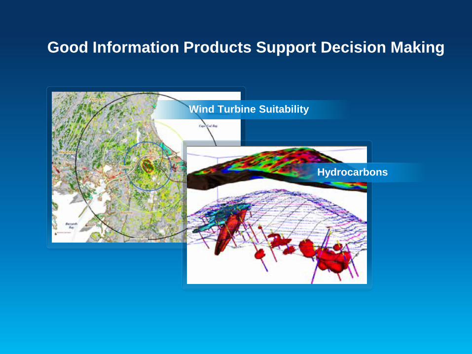
Good Information Products Support Decision Making
Wind Turbine Suitability
Hydrocarbons

Good Information Products Show Status
Government Expenditures vs. Need
World Bank Projects
Haiti AID Funding

Good Information Products Illustrate Change
Urbanization – Landsat
Sedimentation
Temperature

Web Maps are a Medium for Information Products
• Integrating Services (Data, Maps, Models…) • High quality mapping • Pop-ups, charts, and graphs • Live links to web services • Temporal data (trend data) • Spreadsheets and map data • User annotation and sketching • Spatial analysis • Embedding in other applications

Marten Hogeweg
Building an Information Product
Demo


GIS Community Development Advancing UN and International Collaboration
GISfortheUN.com
GIS for the United Nations and International Community Conference Geneva, Switzerland | April 7-8, 2014