major hydrocarbon trap types in dhansiri valley, … hydrocarbon trap types in dhansiri valley,...
TRANSCRIPT

Basin Research Group KDMIPE Dehradun- 248001
P-161
Major Hydrocarbon Trap Types in Dhansiri Valley,
Assam and Assam Arakan Basin, India.
Ram Krishna Singh*, Pratim Bhaumik, Md. S. Akhtar, H.J. Singh,
Sanjive Mayor and Manoj Asthana.
Summary
Dhansiri valley is the southern part of Assam Shelf which is a commercial hydrocarbon producing area. The hydrocarbon
bearing reservoirs are fractured basement (Pre-Cambrian) and sandstone ranging in age from Paleocene to Miocene. The
Tertiary reservoirs are distributed (stratigraphically) within Tura (Paleocene), Sylhet, Kopili (Eocene) and Bokabil, (Miocene)
Formations from bottom to top. Shallow marine thick carbonaceous shale of Kopili Formation (Late Eocene) is a proven
effective source rock for hydrocarbon generation in the study area. The shale above each producing reservoir forms effective top
and lateral seal. The hydrocarbon migrations are through faults and majority of known traps in the study area are mainly
structural with stratigraphic element within.
The detailed analysis of major hydrocarbon producing structures indicates that there are three types of hydrocarbon entrapment
pattern in Dhansiri valley, these are 1) Faulted Horst and Graben structure, 2) Inverted Normal fault and 3) Compressed
Normal fault. The entrapment of hydrocarbons is restricted either inverted or compressed part of hanging wall hading towards
basinal side, besides in the horst block in faulted horst and graven structure. The accumulations are essentially controlled by the
structural element. Even the lanticular sand charged with hydrocarbon is occurring at structurally favorable and highest part.
The study helps in identifying potential traps in this area and may contribute towards accretion of hydrocarbon reserve.
Introduction
Dhansiri valley also known as South Assam Shelf (SAS) is located in the northeastern part of India (Fig.1). Assam shelf consists of sedimentary succession of strata ranging in age from Mesozoic to Recent (Fig.2). It covers an area of about 57,000 Sq Km with the maximum thickness nearly 13 km. in deepest part of the basin. The success in hydrocarbon explorations in Dhansiri valley is marked with
the discovery of Borholla field (1970) and Changpang field (1973) where oil have been tested from fractured basement, Basal sandstone and sands within Sylhet and Kopili Formations. Besides gas from Tipam and Namsang sands. Oil has been discovered from Basal sandstone of Mekrang structure 1996. The lanticular sands at lower part of Bokabil Formation proved to be productive and oil was discovered from Tynephy (1986),Uriamghat 1988, Khoraghat 1989, Nambar 1999. East Lakhibari (2003 ),
Kalyanpur(2007), Babejia (2008), Hazarigaon (2008). Kasomarigaon (2009) Oil was tested from Bokabil and Tipam sands.
Hydrocarbon shows/ indication have also been observed from Pre-Tertiary reservoirs from East Lakhibari (2003 ) but its commercial viability is required to be ascertained.

Major Hydrocarbon Trap Types
2
Tectonic Evolution Tectonically the Assam and Assam Arakan basin is subdivided in to Shillong and Mikir Massifs, Himalayan frontal fold belt, Mishmi massif, Assam shelf, Schuppen Belt (Evans,1964), Indo-Burmese Ranges (Assam-Arakan
Ranges) and Compressed thrust fold belt (CTFB) of Tripura-Cachar - Mizo folds & Eastern belt of metamorphics including Ophiolite belt (Fig.3). The sedimentary rocks in the Shillong Plateau, rest over the Precambrian crystalline basement were studied by the Geological Survey of India . Subsequent drilling has proved the extension of these rocks in the subsurface of Assam Shelf. It has been inferred from the various studies
that ENE-WSW and NW-SE trends are two dominant stress trends in the exposed basement. The intensely fractured and highly weathered basement (Ranga Rao, 1983; Bastia, et al., 1993,) has been producing from Borholla-Changpang fields in the study area.
PreTertiary Rifting and Drifting Phase
Late Jurassic – Early Cretaceous rifting of Gondwanaland and its fragmentation has resulted in a regional extensional regime. This was associated with opening of Bay of Bangal and generation of ‘new’ oceanic crust between India and Australia-Antarctica, which has resulted in development of a passive margin all along the eastern margin of India.
Pre-Tertiary sedimentary record from Assam shelf preserves imprints of multicyclic tectonic evolution in space and time. The Gondwana sediments of were deposited in isolated intra continental rift grabens in fluvial environment followed by marine condition. Sediments of Dergaon group together with Mikir traps correspond to this phase.
Tertiary Phase
The Paleogene sediments (Jaintia and Barail Group) sediments range in thickness from 150-950m and represent the deposit of pervasive passive margin condition in this sector of eastern margin of India . These conditions continued until Late Oligocene when flexuring of the crust
took place owing to oblique eastward collision with the

Major Hydrocarbon Trap Types
3
Burmese plate. It has resulted in the formation of a fore deep which accommodated clastic sediments of Bokabil and Tipam Formations (Murty, 1983). In the Later phase, northward collision has resulted in the development of northern fore deep(younger) in which Pliocene and younger
sediments were deposited.
Source, Reservoir and Cap Rock/Seal
(a) Source Rock The source rock geochemistry data obtained from number of wells of Assam shelf indicates that Shallow marine thick carbonaceous shale of Kopili Formation (Late Eocene) is effective source for hydrocarbon generation in the study area. The organic richness and their maturity increases towards Schuppen belt (Singh, et al., 2008).
(b) Reservoir Rock The sandstone within Bokabil (Miocene),Tura (Paleocene), Sylhet and Kopili Formation (Eocene) are having good reservoir characteristics, besides Fractured basement of Precambrian age. The thickness of multilayered sandstone reservoirs within Sylhet and Kopili Formation varies from
2 to 17 m with porosity variations from 11-29.The thickness of lenticular sand within Bokabil Formation varies from 3 to 12 m with porosity variation from 15-21 %.
(c) Cap Rock/Seal Shale of Kopili Formation acting as lateral seal in host-graben settings for fractured basement reservoirs. Shale at the top of each reservoir sand within Tura, Sylhet, Kopili,
Bokabil Formations are acting as seals for different reservoirs in the area.
Hydrocarbon Bearing Structures in Dhansiri valley
Borholla-Changpang,Khoraghat and Nambar are the major producing fields from Dhansiri valley which account for more than 90% of the proven hydrocarbon reserve. Study
of geo-scientific and production testing data of producing fields indicates hydrocarbons trapped in Dhansiri valley are grouped in to three structural traps:- 1) Faulted Horst and Graben structure 2) Inverted Normal fault and
3) Compressed Normal fault
1) Falted Horst and Graben Structure
The analysis of geo-scientific and production testing data of Borholla-Changpang field indicates that the hydrocarbon have been trapped in the basement involved “Faulted Horst
and Graben” type structure (Fig.4 a & b, Fig.7 a & b). Where thick shale of Kopili Formation and at places shale and limestone of Sylhet Formation juxtaposing against the fractured basement ( Fig.4 b) and forming ideal trap for hydrocarbon entrapment in fractured Basement. The folding in successive overlying Tura, Sylhet and Kopili Formations over tilted fractured basement forms favorable structural entrapment conditions for hydrocarbon
entrapments in these formations (Fig.4 b).

Major Hydrocarbon Trap Types
4

Major Hydrocarbon Trap Types
5
Basal sandstone of continental origin directly overlying fractured basement forms single hydro-dynamically connected reservoir with fractured basement.
Sylhet Formation composed of multilayered limestone, shale and sandstone alternation, where sandstone is charged with the oil (Fig.4c). Kopili Formation consists of predominantly shale and thin lanticular sand in between at places. These lanticular sands at lower part of Kopili Formation become more areneceous and oil bearing (Fig.4c).
2) Inverted Normal fault
The analysis of geo-scientific and production testing data of another major producing field “Khoraghat main field” indicates the hydrocarbon have been trapped in the inverted hanging wall of Khoraghat main structure (Fig. 5 a & b, Fig. 8 a & b). The critical analysis indicates that the normal fault with reasonable through which got inverted at
the later stage of compressed and ultimately resulting inverted normal fault by the reactivation of normal fault. In which the hydrocarbons are accumulated the crestal part of the inverted hanging wall (Fig. 5 a & b, Fig. 8 a & b). Except two well (were sand within Sylhet and Barail
Formation are hydrocarbon producers are having limited areal extent.). The major hydrocarbon producing reservoirs are lanticular sands and are restricted in the lower part of the Bokabil formation in Khoraghat area (Fig. 5 c).

Major Hydrocarbon Trap Types
6
3) Compressed Normal fault The analysis of geo-scientific and production testing data of another major producing field “Nambar field” indicates the hydrocarbon have been trapped in the compressed hanging
wall, down thrown side of Nambar structure (Fig. 6 a & b, Fig. 9 a & b). The critical analysis indicates that the faulted down thrown side of normal fault with reasonable high throw (> 200m), got compressed and resulted normal fault with compressed faulted down thrown side . Hydrocarbons are accumulated the crestal part of compressed faulted down thrown side (Fig. 6 a & b, Fig. 9 a & b). The Bokabil Formation consists of shale with lanticular
sands at places in between. The upper part of Bokabil formation is composed of thick shale with minorsandstone at few places where as thelower part of Bokabil Formation is composed of alternation of lanticular sands and shale .The hydrocarbon producing reservoirs (lanticular sands ) are restricted in the lower part of the Bokabil Formation in Nambar area (Fig. 6 c).

Major Hydrocarbon Trap Types
7
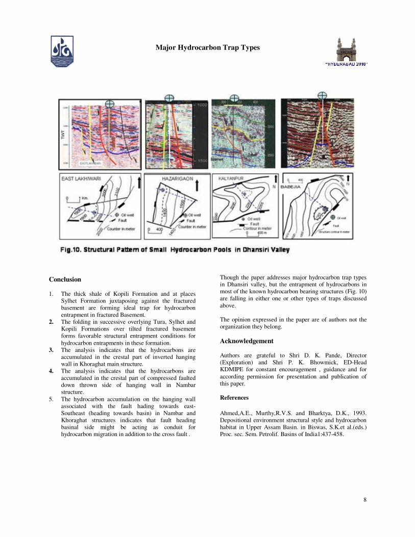
The hydrocarbon pools discovered in East Lakhibari, Hazarigaon, Kalayanpur ,Babejia etc. are having limited aerial extent and are entrapped in faulted inverted structures (Fig. 10).
Major Hydrocarbon Trap Types
8
Conclusion 1. The thick shale of Kopili Formation and at places
Sylhet Formation juxtaposing against the fractured basement are forming ideal trap for hydrocarbon entrapment in fractured Basement.
2. The folding in successive overlying Tura, Sylhet and Kopili Formations over tilted fractured basement forms favorable structural entrapment conditions for
hydrocarbon entrapments in these formation. 3. The analysis indicates that the hydrocarbons are
accumulated in the crestal part of inverted hanging wall in Khoraghat main structure.
4. The analysis indicates that the hydrocarbons are accumulated in the crestal part of compressed faulted down thrown side of hanging wall in Nambar structure.
5. The hydrocarbon accumulation on the hanging wall associated with the fault hading towards east-Southeast (heading towards basin) in Nambar and Khoraghat structures indicates that fault heading basinal side might be acting as conduit for hydrocarbon migration in addition to the cross fault .
Though the paper addresses major hydrocarbon trap types in Dhansiri valley, but the entrapment of hydrocarbons in most of the known hydrocarbon bearing structures (Fig. 10) are falling in either one or other types of traps discussed
above. The opinion expressed in the paper are of authors not the organization they belong.
Acknowledgement Authors are grateful to Shri D. K. Pande, Director (Exploration) and Shri P. K. Bhowmick, ED-Head KDMIPE for constant encouragement , guidance and for
according permission for presentation and publication of this paper.
References
Ahmed,A.E., Murthy,R.V.S. and Bharktya, D.K., 1993. Depositional environment structural style and hydrocarbon habitat in Upper Assam Basin. in Biswas, S.K.et al.(eds.) Proc. sec. Sem. Petrolif. Basins of India1:437-458.

Major Hydrocarbon Trap Types
9
Bastia, R.,Naik, G. C. and Mohpatra, P., 1993 Hydrocarbon prospects of Schuppen Belt Assam Arakan Basin in Biswas, S.K.et al.(eds.) Proc. sec. Sem. Petrolif. Basins of India1:493-506.
Bhandari, L.L.,Fuloriya, R. C. and Sastri, V.V.,1973, Stratigraphy of Assam Assam Valley,India, A. A. P. G .Bull.,57(4):642-654. Evans, P.1964.The Tectonic framework of Assam.Geological society of India Jour., 5:80-96. Kumar, S.P., 1993.Hydrocarbon exploration in Assam
Basin-Restrospect and Prospect in Biswas, S.K.et al.(eds.) Proc. sec. Sem. Petrolif. Basins of India1:545-551. Murty, K.N., 1983.Geology and hydrocarbon prospect of Assam shelf-Recent advances and present status.Petroleum Asia Jour.,6(4):1-14 Ranga Rao, A., 1983.Geology and hydrocarbon Potential of
a part of Assam-Arakan Basin and its adjacent Region. Petrol. Asia Jour., Nov. Ranga Rao, A., 1987.Structural style of the Naga overthrust belt and its implication on exploration.O.N.G.C. Bull.,vol.24(1):69-109. Singh,Ram Krishna, Bhaumik,P., Akktar,Md.S., Siawal,A.,
and Singh,H.J.; 2008, Deeper (Paleogene ) hydrocarbon Plays and their Prospectivity in South Assam Shelf, A & A A Basin, India.7Th Biennial international conference and Exposition on Petroleum Geophysics, Hydrabad, 2008. Singh,Ram Krishna, Bhaumik,P., Akktar,Md.S., Siawal,A., and Singh,H.J.; 2008. Tectono-Sedimentation and Hydrocarbon Prospectivity of Paleogene Sediments in Dhansiri Valley, A&AA Basin, India. GEOIndia 2008,
Noida, New Delhi. Singh,Ram Krishna, Bhaumik,P., Akktar,Md.S., and Singh,H.J.; 2008. Petroleum System of Dhansiri Valley-An Example from Shelf and Fore Land Setting Assam and Assam Arakan Basin-India. GEOIndia 2008, Noida, New Delhi.