maharashtra state board of technical education...
TRANSCRIPT
17310 SURVEYING Model Answer – Summer 2017 Page 1/21
MAHARASHTRA STATE BOARD OF TECHNICAL EDUCATION (Autonomous)
(ISO/IEC -270001 – 2005 certified)
Summer- 2017 EXAMINATION
Subject code:17310 SURVEYING Model Answer Page No:01/21
Important Instructions to examiners:
1) The answer should be examined by keywords and not as word-to-word as given in the model answer
scheme.
2) The model answer and the answer written by candidate may vary but the examiner may try to assess
the understanding level of the candidate.
3) The language error such as grammatical, spelling errors should not be given more importance. (Not
applicable for subject English and communication skill).
4) While assessing figures, examiner may give credit for principal components indicated in the figure.
The figure drawn by candidate and model answer may vary. The examiner may give credit for any
equivalent figure drawn.
5) Credits may be given step wise for numerical problems. In the some cases, the assumed constants
values may vary and there may be some difference in the candidates answer and model answer.
6) In case of some questions credit may be given by judgment on part of examiner of relevant answer
based on candidates understanding
Question and Model Answers Marks
Q.1. A) Attempt ANY SIX of the following 12M
a) State the principles of surveying
1) To work from whole to the part
2) To locate position of new station by atleast two independent measurements or
processes.
02M
b) Differentiate between ‘ Plain Survey ’ & ‘ Geodetic Survey ’
Plain Survey Geodetic Survey
1) Effect of curvature of earth is not
considered
2) They are carried out for small areas
3) Degree of accuracy is
comparatively low
4) It involves plain trigonometry
5) Extent of surveys up to 260 sq.km
are considered suitable for plane
surveying
6)
1) The curvature of earth is taken into
considered
2) Used for surveying of large areas
3) It is carried out with a high degree
of accuracy
4) It involves spherical trigonometry
5) It is carried out for locating distant
control points & for surveying
large areas i.e. beyond 260 sq. km
1M each point any two
17310 SURVEYING Model Answer – Summer 2017 Page 2/21
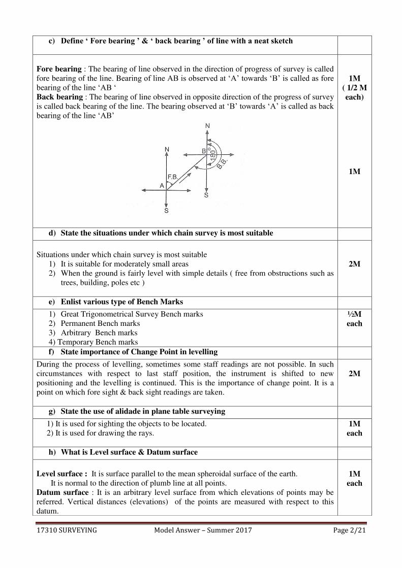
c) Define ‘ Fore bearing ’ & ‘ back bearing ’ of line with a neat sketch
Fore bearing : The bearing of line observed in the direction of progress of survey is called
fore bearing of the line. Bearing of line AB is observed at ‘A’ towards ‘B’ is called as fore bearing of the line ‘AB ‘ Back bearing : The bearing of line observed in opposite direction of the progress of survey
is called back bearing of the line. The bearing observed at ‘B’ towards ‘A’ is called as back bearing of the line ‘AB’
1M ( 1/2 M each)
1M
d) State the situations under which chain survey is most suitable
Situations under which chain survey is most suitable
1) It is suitable for moderately small areas
2) When the ground is fairly level with simple details ( free from obstructions such as
trees, building, poles etc )
2M
e) Enlist various type of Bench Marks
1) Great Trigonometrical Survey Bench marks
2) Permanent Bench marks
3) Arbitrary Bench marks
4) Temporary Bench marks
½M each
f) State importance of Change Point in levelling
During the process of levelling, sometimes some staff readings are not possible. In such
circumstances with respect to last staff position, the instrument is shifted to new
positioning and the levelling is continued. This is the importance of change point. It is a
point on which fore sight & back sight readings are taken.
2M
g) State the use of alidade in plane table surveying
1) It is used for sighting the objects to be located.
2) It is used for drawing the rays.
1M each
h) What is Level surface & Datum surface
Level surface : It is surface parallel to the mean spheroidal surface of the earth.
It is normal to the direction of plumb line at all points.
Datum surface : It is an arbitrary level surface from which elevations of points may be
referred. Vertical distances (elevations) of the points are measured with respect to this
datum.
1M each

17310 SURVEYING Model Answer – Summer 2017 Page 3/21
Q.1. B) Attempt any TWO of the following 08
a) Draw conventional symbols for the following i) Road Over Bridge ii) Cutting
iii) Marshy land iv) Pond
OR
1M each
b) Explain code of signals in Ranging
Signal by the surveyor (Follower) Action taken by Assistant (Leader)
1) Rapid sweeps with right hand on
right side
2) Rapid sweeps with left hand on left
side
3) Slow sweeps with right hand on
right side
4) Slow sweeps with left hand on left
side
5) Right arm extended
6) Left arm extended
7) Right arm up & move towards right
8) Left arm up & move towards left
9) Both hands above head & brought
down
Move considerably to the right
Move considerably to the left
Move slowly to the right
Move slowly to the left
Continue to move to the right
Continue to move to the left
Make the rod vertical by moving
towards right
Make the rod vertical by moving
towards left
Correct position
1M each any four

17310 SURVEYING Model Answer – Summer 2017 Page 4/21
c) Explain indirect ranging with neat sketch
Elevation
Plan Indirect or Reciprocal ranging is done when the ends of survey line are not inter visible due
to high ground or a hill intervening. It also done when the ends of survey line are not
clearly 1visible due to long distance between them
Let ‘A’ and ‘B’ be two survey stations. They are not mutually visible due to high ground
between them. It is required to measure the distance between ‘A’ and ‘B’ Let two chainman at ‘M1’ & ‘N1’ are as shown in figure
The chainman at ‘M1’ can see the both the ranging rods at‘N1’ and ‘B’ The chainman at ‘N1’ can see the ranging rods at ‘M1’ and ‘A’ . The two chainman then directs each other alternately. The chainman at ‘N1’ directs the chainman at ‘M1’ to come in line with ‘AN1’ to occupy position ‘M2’ Then the chain man at ‘M2’ directs the chainman at ‘N1’ to come in line with ‘M2B’ By successively directing each other, they finally occupy position ‘M’ and ‘N’ on line ‘AB’ Now ‘AMNB’ are exactly in the same line
1M
1M
2M
Q. 2. Attempt Any FOUR of the following 16
a) State the different point to be considered in selection of survey station for a closed traverse
1) Main survey stations should be inter visible.
2) The main survey lines should form well-conditioned triangles.
3) Each triangle or portion of skeleton must be provided with sufficient check lines.
4) As far as possible the main survey lines should not pass through obstacles.
5) The lines must run through a level ground as possible.
6) The frame work should have one or two base lines. The base line should run
through the middle of the area.
7) To avoid trespassing, the main survey line should fall within the boundaries of the
property to be surveyed.
8) Survey line must be as few as possible so that the frame work can be plotted
conveniently.
1M each any four

17310 SURVEYING Model Answer – Summer 2017 Page 5/21
b) The length of survey line measured with a 20m chain was found to be 2500m. The same length was again measured with a 30m chain & found to be 2492m. If the 20m chain was found to be 5cm too short, what was error in 30m chain?
The true length of survey line = L’/L x Measured length of line Where
L’ = Faulty ( incorrect ) length of the chain L = True length of the chain
For 20 m chain,
L’ = 20 – 0.05 = 19.95m , L = 20 m
True length = L’/L x Measured length
= 19.95/20 x2500 = 2493.75m
Now for 30 m chain,
True length = L’/L x Measured length
2493.75 = L’/ 30 x 2492
L’ = 30.02106 m Error in 30m chain = 30.02106 – 30 m
= 0.02106 m
= 2.106 cm
1M
1M
1M
1M c) How do you overcome the obstacle when chaining across a river ? Explain
with neat sketch
This is a case of chaining obstructed vision free.
Fig-a) A & B are two points on opposite banks of river as shown in fig 1. obstructed
length is AB on the chain line MN , Set AC perpendicular to AB & bisect at O . Errect
perpendicular at C & mark a point D in a line with BO , measure the length CD , from
principle of similar triangles ABO & CDO, AB = CD
OR Fig.c) In fig 2, A & B are two points on either side of the river, set out perpendicular AC at
A of sufficient length. Errect perpendicular CE at C , measure the length AC & AE
Triangles ABC & ACE are similar Triangles
AB/AC = AC/AE
AB = (AC)^2 /AE
(Note- If the students write explanation on similar lines for fig. b & d credit may be given)
2M
2M For any one
expl.
17310 SURVEYING Model Answer – Summer 2017 Page 6/21
d) Explain principle of chain surveying
1) Principle of chain surveying is triangulation
2) Triangulation consists of frame work of triangles. The whole area is divided into
network of triangles.
3) A triangle is the only simple plane figure which can be plotted by measuring its
sides alone in the field.
4) No angular measurements are taken.
5) To obtain good result, the framework should consists of triangles which are
nearly equilateral. Such triangles are known as well shaped or well conditioned
triangles.
6) Well conditioned triangles can be plotted more accurately than the ill conditioned
triangles.
7) Ill conditioned triangles should always be avoided.
8) The frame work of triangles to be adopted depends upon the shape &
configuration of the ground & the natural obstacles.
4M
e) Write the uses of following survey instruments
i) Ranging Rod ii) Pegs iii) Cross-staff iv) Plumb bob
i) Ranging Rod : Ranging rod are used for ranging.
ii) Pegs : Pegs are used for marking the positions of stations or terminals points of
survey lines.
iii) Cross-staff : It is used for setting out perpendicular or right angle to given chain
line. It is also used to find out the foot of the perpendicular on chain line.
iv) Plumb bob : It is used to transfer the point to the ground . It is also used for
accurate centering of the surveying instruments like theodolite, compass, plane
table etc.
1M each
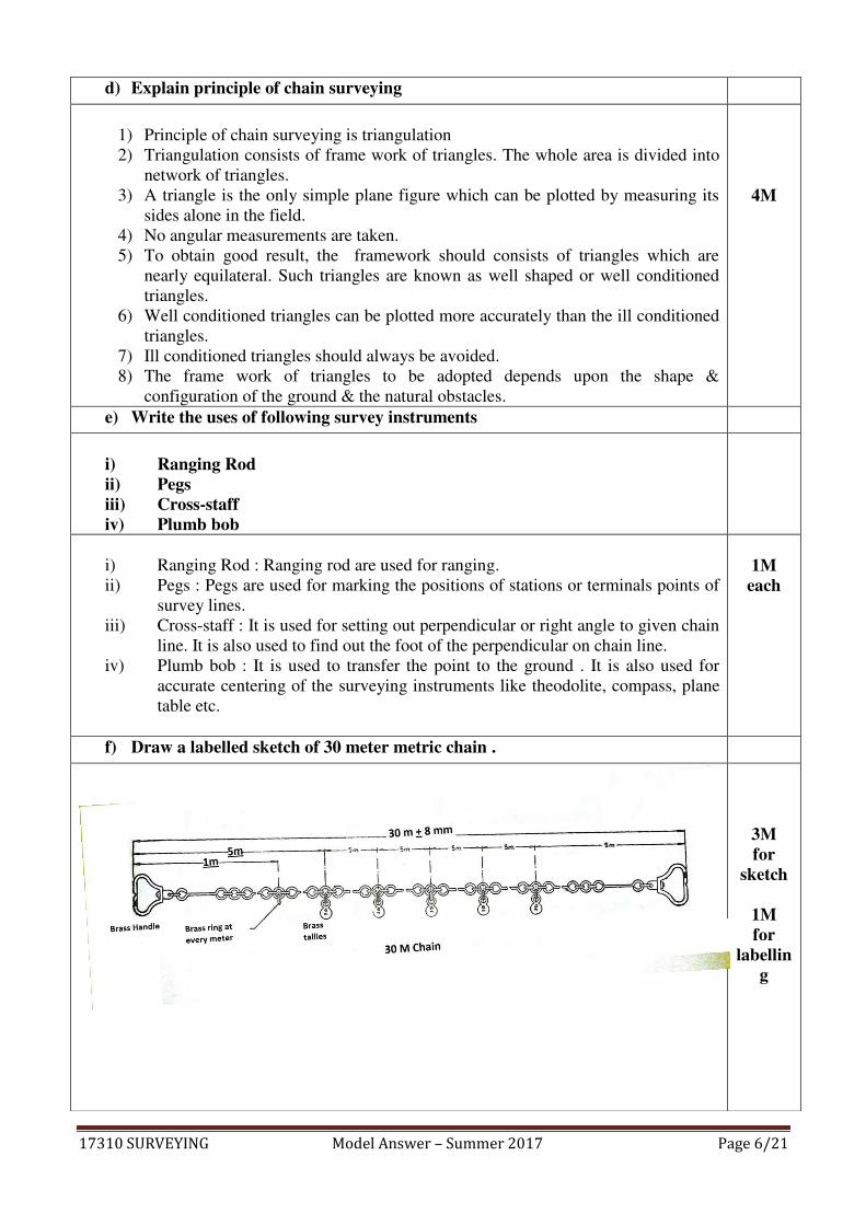
f) Draw a labelled sketch of 30 meter metric chain .
3M for
sketch
1M for
labelling
17310 SURVEYING Model Answer – Summer 2017 Page 7/21
Q.3 Attempt Any Four of the following: 16
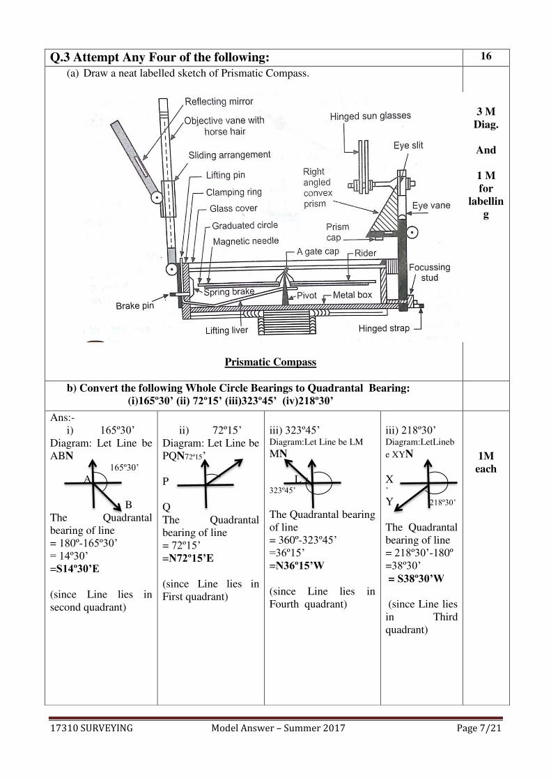
(a) Draw a neat labelled sketch of Prismatic Compass.
Prismatic Compass
3 M Diag.
And
1 M for
labelling
b) Convert the following Whole Circle Bearings to Quadrantal Bearing: (i)165º30’ (ii) 72º15’ (iii)323º45’ (iv)218º30’
Ans:-
i) 165º30’ Diagram: Let Line be
ABN 165º30’ A
B
The Quadrantal
bearing of line
= 180º-165º30’ = 14º30’ =S14º30’E (since Line lies in
second quadrant)
ii) 72º15’ Diagram: Let Line be
PQN72º15’
P
Q
The Quadrantal
bearing of line
= 72º15’ =N72º15’E (since Line lies in
First quadrant)
iii) 323º45’ Diagram:Let Line be LM MN
L 323º45’
The Quadrantal bearing
of line
= 360º-323º45’ =36º15’ =N36º15’W (since Line lies in
Fourth quadrant)
iii) 218º30’ Diagram:LetLineb
e XYN
X ’ Y 218º30’
The Quadrantal
bearing of line
= 218º30’-180º
=38º30’ = S38º30’W (since Line lies
in Third
quadrant)
1M each
17310 SURVEYING Model Answer – Summer 2017 Page 8/21
c) Explain with reasons i)The zero is marked at south end in prismatic compass ii) Prism is provided in Prismatic Compass
2M each
i)The zero is marked at south end in prismatic compass Ans:- prismatic compass gives WCB directly.
WCB is read by prism.When object is bisected
by object vane, reading on aluminium
graduated ring exactly below object vane
should be the value of WCB. But prism is
placed diametrically opposite to object vane.
Therefore zero is marked on south end..
ii)Prism is provided in Prismatic Compass Ans: a)Prism is provided to see the
magnified image of the reading on
graduated ring . Inverted graduations are
converted to true image when seen
through prism.
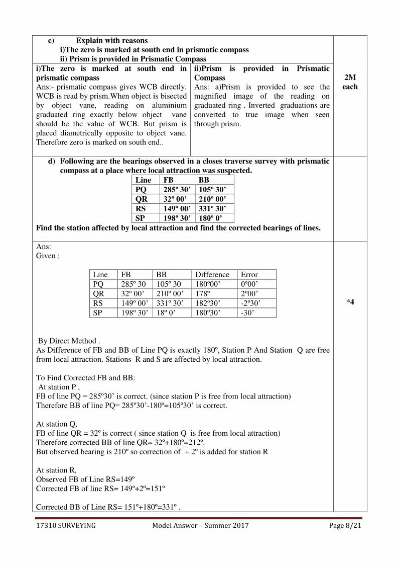
d) Following are the bearings observed in a closes traverse survey with prismatic compass at a place where local attraction was suspected.
Line FB BB PQ 285º 30’ 105º 30’ QR 32º 00’ 210º 00’ RS 149º 00’ 331º 30’ SP 198º 30’ 180º 0’
Find the station affected by local attraction and find the corrected bearings of lines.
Ans:
Given :
Line FB BB Difference Error
PQ 285º 30 105º 30 180º00’ 0º00’ QR 32º 00’ 210º 00’ 178º 2º00’ RS 149º 00’ 331º 30’ 182º30’ -2º30’ SP 198º 30’ 18º 0’ 180º30’ -30’
By Direct Method .
As Difference of FB and BB of Line PQ is exactly 180º, Station P And Station Q are free
from local attraction. Stations R and S are affected by local attraction.
To Find Corrected FB and BB:
At station P ,
FB of line PQ = 285º30’ is correct. (since station P is free from local attraction)
Therefore BB of line PQ= 285º30’-180º=105º30’ is correct.
At station Q,
FB of line QR = 32º is correct ( since station Q is free from local attraction)
Therefore corrected BB of line QR= 32º+180º=212º.
But observed bearing is 210º so correction of + 2º is added for station R
At station R,
Observed FB of Line RS=149º
Corrected FB of line RS= 149º+2º=151º
Corrected BB of Line RS= 151º+180º=331º .
*4
17310 SURVEYING Model Answer – Summer 2017 Page 9/21
Observed BB of line RS=331º30’ Correction at station S= - 0º30’
At station S,
Observed FB of Line SP=198º30’ Corrected FB of line SP= 198º30’-0º30’=198º . Corrected BB of Line SP=198º-180º=18º
Line FB BB Corrected Bearing
FB BB
PQ 285º 30 105º 30 285º 30’ 105º 30’ QR 32º 00’ 210º 00’ 32º 212º
RS 149º 00’ 331º 30’ 151º 331º
SP 198º 30’ 180º 0’ 198º 18º
* Note: 1 M for identifying stations affected by local attraction, 1/2 mark each for calculating FB and BB of line QR, RS, SP
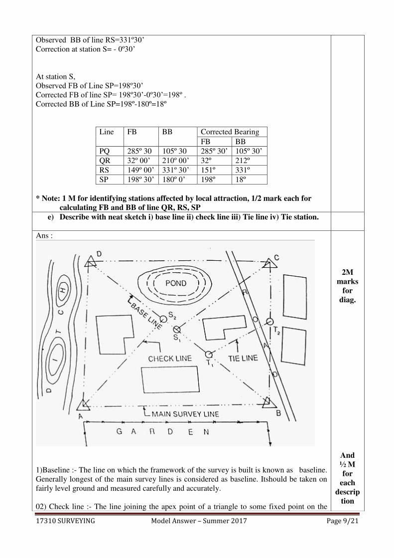
e) Describe with neat sketch i) base line ii) check line iii) Tie line iv) Tie station.
Ans :
1)Baseline :- The line on which the framework of the survey is built is known as baseline.
Generally longest of the main survey lines is considered as baseline. Itshould be taken on
fairly level ground and measured carefully and accurately.
02) Check line :- The line joining the apex point of a triangle to some fixed point on the
2M marks
for diag.
And ½ M for
each descrip
tion
17310 SURVEYING Model Answer – Summer 2017 Page 10/21
baseline is called as check line. It is taken to check the accuracy of the triangle.
03) Tie line:- The line joining the tie stations are known as the Tie Lines. Tie Lines are
taken to locate the interior details.
04) Tie Stations: The subsidiary or secondary stations taken on the main survey lines are
known as Tie stations. Tie stations are denoted by symbol . . With letters T1 , T2, T3 etc. in
figure.
f) Plot the following cross staff survey of field and calculate area. D
98
E
74--------------32
C
38 ------------------------56
F
28----------------------46
B
24---------------16
0
A
Ans: Plotting the given traverse survey
D98
IV
J 32 E
III 74
38
C I V
56
II 46 F
H
24 28
B G VI
16
I
A
Calculating Area : ( Tabular Form)
Fig
no.
Figure Base Offset Mean
Offset
Area= Base x
Mean offset
Area
I Tri AGB 16 0 & 24 12 16x12 =192
II Trap BGIC 56-16=40 24 &38 31 40x31 =1240
III Tri DIC 98-56=42 38 & 0 19 42x19 =798
1M diagra
m
½ M for
each area
17310 SURVEYING Model Answer – Summer 2017 Page 11/21
IV Tri DJE 98-74=24 32 & 0 16 24x16=384 =384
V Trap JEFH 74-28=46 32 & 46 39 46x39 =1794
VI Tri AHF 28 46 & 0
23 28x23 =644
TOTAL Area
5052
Sq.m
Q.4 Attempt Any Four of the following: 16
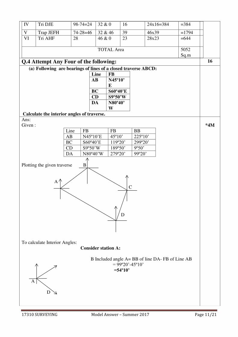
(a) Following are bearings of lines of a closed traverse ABCD: Line FB AB N45º10’
E BC S60º40’E CD S9º50’W DA N80º40’
W Calculate the interior angles of traverse.
Ans:
Given :
Line FB FB BB
AB N45º10’E 45º10’ 225º10’ BC S60º40’E 119º20’ 299º20’ CD S9º50’W 189º50’ 9º50’ DA N80º40’W 279º20’ 99º20’
Plotting the given traverse B
A
C
D
To calculate Interior Angles:
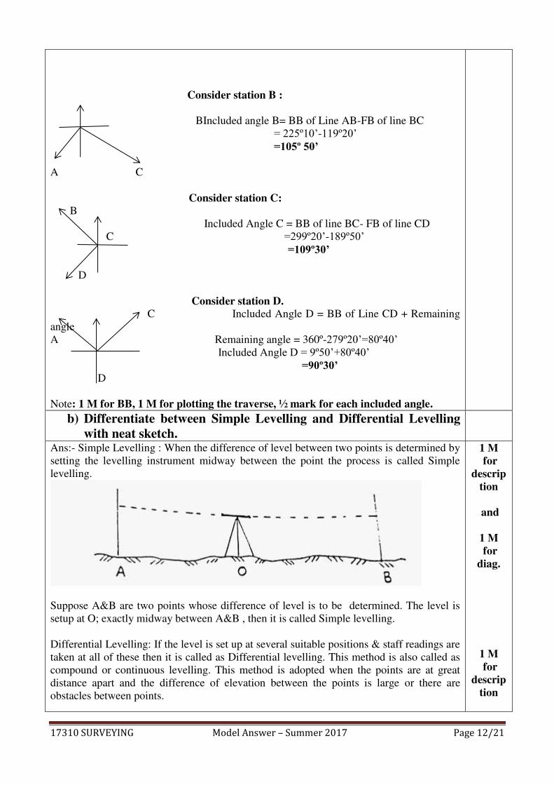
Consider station A:
B Included angle A= BB of line DA- FB of Line AB
= 99º20’-45º10’ =54º10’
A
D
*4M
17310 SURVEYING Model Answer – Summer 2017 Page 12/21
Consider station B :
BIncluded angle B= BB of Line AB-FB of line BC
= 225º10’-119º20’ =105º 50’
A C
Consider station C: B
Included Angle C = BB of line BC- FB of line CD
C =299º20’-189º50’ =109º30’
D
Consider station D. C Included Angle D = BB of Line CD + Remaining
angle
A Remaining angle = 360º-279º20’=80º40’ Included Angle D = 9º50’+80º40’ =90º30’ D
Note: 1 M for BB, 1 M for plotting the traverse, ½ mark for each included angle.
b) Differentiate between Simple Levelling and Differential Levelling with neat sketch.
Ans:- Simple Levelling : When the difference of level between two points is determined by
setting the levelling instrument midway between the point the process is called Simple
levelling.
Suppose A&B are two points whose difference of level is to be determined. The level is
setup at O; exactly midway between A&B , then it is called Simple levelling.
Differential Levelling: If the level is set up at several suitable positions & staff readings are
taken at all of these then it is called as Differential levelling. This method is also called as
compound or continuous levelling. This method is adopted when the points are at great
distance apart and the difference of elevation between the points is large or there are
obstacles between points.
1 M for
description
and
1 M for
diag.
1 M for
description
17310 SURVEYING Model Answer – Summer 2017 Page 13/21
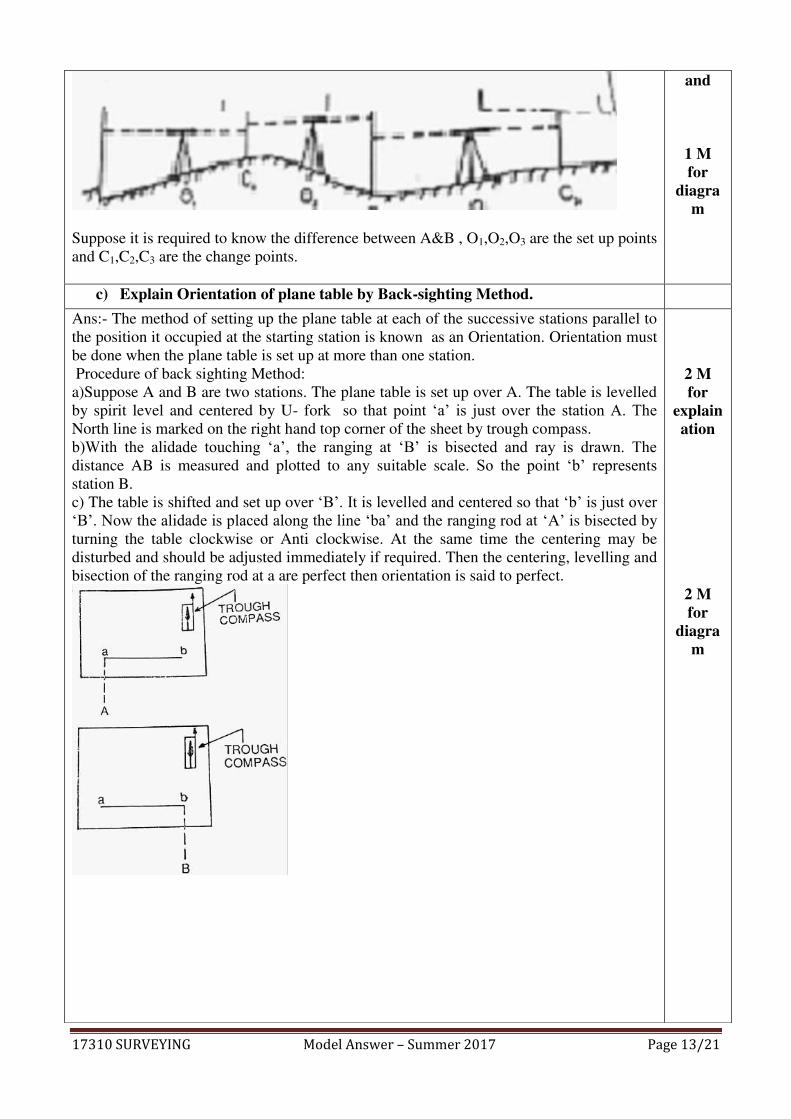
Suppose it is required to know the difference between A&B , O1,O2,O3 are the set up points
and C1,C2,C3 are the change points.
and
1 M for
diagram
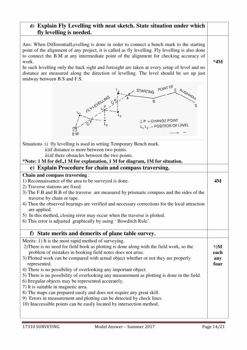
c) Explain Orientation of plane table by Back-sighting Method.
Ans:- The method of setting up the plane table at each of the successive stations parallel to
the position it occupied at the starting station is known as an Orientation. Orientation must
be done when the plane table is set up at more than one station.
Procedure of back sighting Method:
a)Suppose A and B are two stations. The plane table is set up over A. The table is levelled
by spirit level and centered by U- fork so that point ‘a’ is just over the station A. The North line is marked on the right hand top corner of the sheet by trough compass.
b)With the alidade touching ‘a’, the ranging at ‘B’ is bisected and ray is drawn. The distance AB is measured and plotted to any suitable scale. So the point ‘b’ represents station B.
c) The table is shifted and set up over ‘B’. It is levelled and centered so that ‘b’ is just over ‘B’. Now the alidade is placed along the line ‘ba’ and the ranging rod at ‘A’ is bisected by
turning the table clockwise or Anti clockwise. At the same time the centering may be
disturbed and should be adjusted immediately if required. Then the centering, levelling and
bisection of the ranging rod at a are perfect then orientation is said to perfect.
2 M for
explaination
2 M for
diagram
17310 SURVEYING Model Answer – Summer 2017 Page 14/21
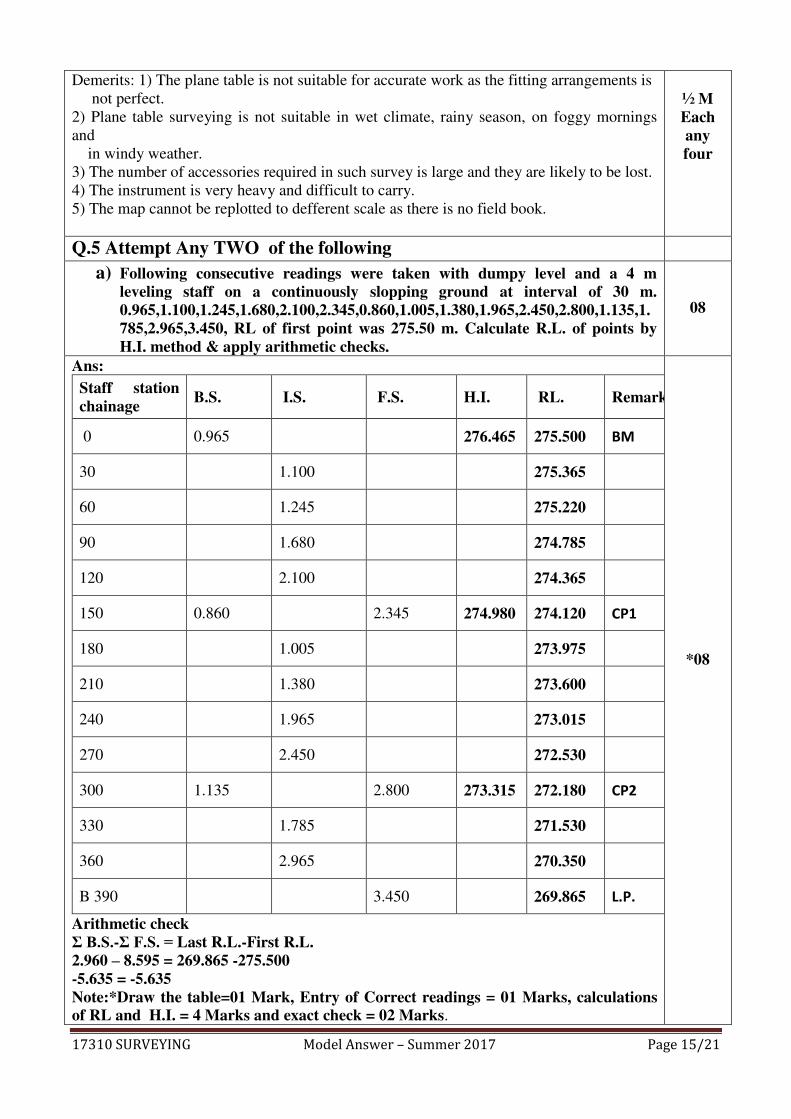
d) Explain Fly Levelling with neat sketch. State situation under which fly levelling is needed.
Ans: When DifferentialLevelling is done in order to connect a bench mark to the starting
point of the alignment of any project, it is called as fly levelling. Fly levelling is also done
to connect the B.M at any intermediate point of the alignment for checking accuracy of
work.
In such levelling only the back sight and foresight are taken at every setup of level and no
distance are measured along the direction of levelling. The level should be set up just
midway between B.S and F.S.
Situations :i) fly levelling is used in setting Temporary Bench mark.
ii)if distance is more between two points.
iii)if there obstacles between the two points.
*Note: 1 M for def.,1 M for explanation, 1 M for diagram, 1M for situation.
*4M
e) Explain Procedure for chain and compass traversing.
Chain and compass traversing :
1) Reconnaissance of the area to be surveyed is done.
2) Traverse stations are fixed.
3) The F.B and B.B of the traverse are measured by prismatic compass and the sides of the
traverse by chain or tape.
4) Then the observed bearings are verified and necessary corrections for the local attraction
are applied.
5) In this method, closing error may occur when the traverse is plotted.
6) This error is adjusted graphically by using ‘ Bowditch Rule’.
4M
f) State merits and demerits of plane table survey.
Merits: 1) It is the most rapid method of surveying.
2)There is no need for field book as plotting is done along with the field work, so the
problem of mistakes in booking field notes does not arise.
3) Plotted work can be compared with actual object whether or not they are properly
represented.
4) There is no possibility of overlooking any important object.
5) There is no possibility of overlooking any measurement as plotting is done in the field.
6) Irregular objects may be represented accurately.
7) It is suitable in magnetic area.
8) The maps can prepared easily and does not require any great skill.
9) Errors in measurement and plotting can be detected by check lines.
10) Inaccessible points can be easily located by intersection method.
½M each any four
17310 SURVEYING Model Answer – Summer 2017 Page 15/21
Demerits: 1) The plane table is not suitable for accurate work as the fitting arrangements is
not perfect.
2) Plane table surveying is not suitable in wet climate, rainy season, on foggy mornings
and
in windy weather.
3) The number of accessories required in such survey is large and they are likely to be lost.
4) The instrument is very heavy and difficult to carry.
5) The map cannot be replotted to defferent scale as there is no field book.
½ M Each any four
Q.5 Attempt Any TWO of the following
a) Following consecutive readings were taken with dumpy level and a 4 m leveling staff on a continuously slopping ground at interval of 30 m. 0.965,1.100,1.245,1.680,2.100,2.345,0.860,1.005,1.380,1.965,2.450,2.800,1.135,1.785,2.965,3.450, RL of first point was 275.50 m. Calculate R.L. of points by H.I. method & apply arithmetic checks.
08
Ans:
Staff station chainage
B.S. I.S. F.S. H.I. RL. Remark
0 0.965 276.465 275.500 BM
30 1.100 275.365
60 1.245 275.220
90 1.680 274.785
120 2.100 274.365
150 0.860 2.345 274.980 274.120 CP1
180 1.005 273.975
210 1.380 273.600
240 1.965 273.015
270 2.450 272.530
300 1.135 2.800 273.315 272.180 CP2
330 1.785 271.530
360 2.965 270.350
B 390 3.450 269.865 L.P.
Arithmetic check Σ B.S.-Σ F.S. = Last R.L.-First R.L. 2.960 – 8.595 = 269.865 -275.500 -5.635 = -5.635 Note:*Draw the table=01 Mark, Entry of Correct readings = 01 Marks, calculations of RL and H.I. = 4 Marks and exact check = 02 Marks.
*08
17310 SURVEYING Model Answer – Summer 2017 Page 16/21
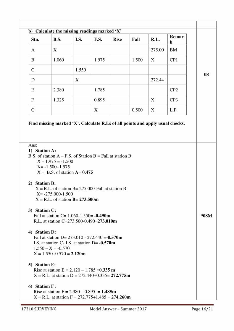
b) Calculate the missing readings marked ‘X’
Stn. B.S. I.S. F.S. Rise Fall R.L. Remark
A X 275.00 BM
B 1.060 1.975 1.500 X CP1
C 1.550
D X 272.44
E 2.380 1.785 CP2
F 1.325 0.895 X CP3
G X 0.500 X L.P.
Find missing marked ‘X’. Calculate R.Ls of all points and apply usual checks.
08
Ans:
1) Station A: B.S. of station A – F.S. of Station B = Fall at station B
X – 1.975 = -1.500
X= -1.500+1.975
X = B.S. of station A= 0.475
2) Station B: X = R.L. of station B= 275.000-Fall at station B
X= -275.000-1.500
X = R.L. of station B= 273.500m
3) Station C: Fall at station C= 1.060-1.550= -0.490m
R.L. at station C=273.500-0.490=273.010m
4) Station D: Fall at station D= 273.010 - 272.440 =-0.570m
I.S. at station C- I.S. at station D= -0.570m
1.550 – X = -0.570
X = 1.550+0.570 = 2.120m
5) Station E: Rise at station E = 2.120 – 1.785 =0.335 m
X = R.L. at station D = 272.440+0.335= 272.775m
6) Station F : Rise at station F = 2.380 – 0.895 = 1.485m
X = R.L. at station F = 272.775+1.485 = 274.260m
*08M
17310 SURVEYING Model Answer – Summer 2017 Page 17/21
7) Station G : R.L at station G = 274.260 – 0.500 = 273.760m
B.S. at station F - F.S. at station G = -0.500m
1.325 - X=-0.500
X = 1.325+0.500 = 1.825m
Stn. B.S. I.S. F.S. Rise Fall R.L. Remark
A 0.475 275.00 BM
B 1.060 1.975 1.500 273.500 CP1
C 1.550 0.490 273.010
D 2.120 0.570 272.440
E 2.380 1.785 0.335 272.775 CP2
F 1.325 0.895 1.485 274.260 CP3
G 1.825 0.500 273.760 L.P.
Arithmetic check:- | ΣBS – ΣFS| = | ΣRise – ΣFall| =| Last RL – First RL|
|5.240 -6.480| = |1.820 -3.060| = |273.76 – 275.000|
-1.24 = -1.24 = -1.24
*(Note- correct missing reading and calculation of RLs 06 marks ,02 marks for check)
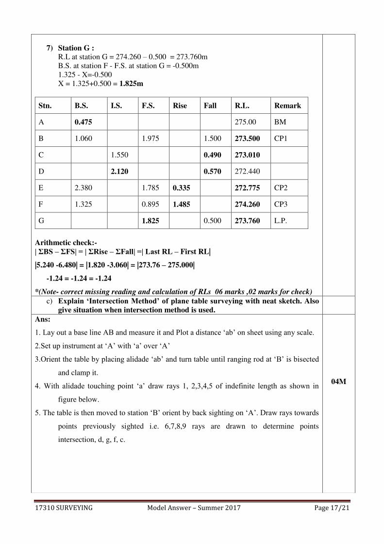
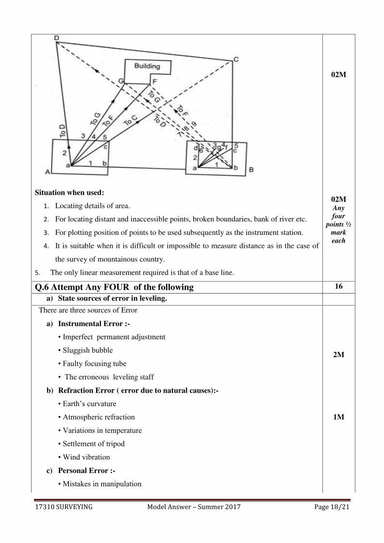
c) Explain ‘Intersection Method’ of plane table surveying with neat sketch. Also give situation when intersection method is used.
Ans:
1. Lay out a base line AB and measure it and Plot a distance ‘ab’ on sheet using any scale.
2.Set up instrument at ‘A’ with ‘a’ over ‘A’
3.Orient the table by placing alidade ‘ab’ and turn table until ranging rod at ‘B’ is bisected
and clamp it.
4. With alidade touching point ‘a’ draw rays 1, 2,3,4,5 of indefinite length as shown in
figure below.
5. The table is then moved to station ‘B’ orient by back sighting on ‘A’. Draw rays towards
points previously sighted i.e. 6,7,8,9 rays are drawn to determine points
intersection, d, g, f, c.
04M
17310 SURVEYING Model Answer – Summer 2017 Page 18/21
Situation when used:
1. Locating details of area.
2. For locating distant and inaccessible points, broken boundaries, bank of river etc.
3. For plotting position of points to be used subsequently as the instrument station.
4. It is suitable when it is difficult or impossible to measure distance as in the case of
the survey of mountainous country.
5. The only linear measurement required is that of a base line.
02M
02M Any
four
points ½
mark
each
Q.6 Attempt Any FOUR of the following 16
a) State sources of error in leveling.
There are three sources of Error
a) Instrumental Error :-
• Imperfect permanent adjustment
• Sluggish bubble
• Faulty focusing tube
• The erroneous leveling staff
b) Refraction Error ( error due to natural causes):-
• Earth’s curvature
• Atmospheric refraction
• Variations in temperature
• Settlement of tripod
• Wind vibration
c) Personal Error :-
• Mistakes in manipulation
2M
1M

17310 SURVEYING Model Answer – Summer 2017 Page 19/21
• Mistake in reading the rod
• Errors in sighting
• Mistakes in recording
1M
b) Compare Rise & Fall method and H.I. method. 04
Ans:
Sr.No. Rise and Fall Method H.I. Method
1 It is slow and more tedious. It is more rapid and less tedious
2 It is laborious as it involves more
calculations.
It is simple as it involves less
calculation.
3 In this method there is complete check
on all calculation work.
In this method there is no check on
calculations of R.L. of intermediate
sight and mistakes made remain
unchecked
4
In this method the mistake made in
calculating the R.L. of any point will
be carried forward.
In this method the error in calculating
the R,L, of I.S. is not carried forward
as the R,L, are calculated from the
respective plane of collimation
5 It is used in precise leveling work,
check leveling calculations.
It is usually used in profile leveling
calculation.
6 Arithmetical check ΣB.S.-ΣF.S=ΣRise–Σfall =Last RL-First RL
Arithmetical check ΣB.S.- ΣF.S=Last RL-First RL
*(Any four points 1 mark each)
*04
c) Explain Graphical adjustment of closing error in a closed traverse. 04
Step: 1) Draw a horizontal line AA1 equal to the length of perimeter of the traverse to a
suitable scale.
02M

17310 SURVEYING Model Answer – Summer 2017 Page 20/21
2) Mark the distances AB,BC,CD,…etc on the line as per their lengths.
3) Draw a perpendicular or (parallel to the direction of closing errors) to the line AA1
equal to the closing errors.
4) Join Aa‟ as shown in figure.
5) Draw lines parallel to the direction of closing errors at B, C, D, E,To join the line „Aa‟
at b,c,d,e
6) Transfer the ordinates to the respective stations on the traverse parallel to the closing
errors
7) Join the the new points which gives the closed traversed. A, B, C, D and A.
02M
d) Explain the procedure for profile leveling with neat sketch. 04
ANS: 1) Let PQR be the given line of section.
2) Mark point at 10 m intervals on this line.
3) Level is set up on a firm ground at a suitable point I1.
4) Temporary adjustment of level is done and B.S. is taken on B.M.
5) The RL of collimation (HI) is worked out by adding B.S. to the R.L. of B.M. The
chain is stretched from P toward the point Q.
6) Also, the staff readings are taken at 10 m points, and entered in the I.S column
against the respective changes.
7) Beside these points, the staff readings are taken at the representative points, for
example slope of ground surface changes appreciably.
8) When it is found necessary to shift the instruments on account of the length of sight
exceeding about 100 m or the further points not being possible to be observed
owing to the irregularities of the ground, CP1 is taken at suitable position, and F.S
is taken on it and entered in F.S column.
9) The instrument is then shifted and set up on firm ground at I2 as before.
10) B.S is taken on CP1 and new HI is calculated
01M sketch
03M Proced.
17310 SURVEYING Model Answer – Summer 2017 Page 21/21
e) State advantages of Auto-Level over dumpy level. 04
Ans: 1) Auto level gives quick and easy leveling with less effort than dumpy level.
2) It is most accurate and precise which gives least error about 0.5 to 0.8 in 5 km.
3) It is simply to use, compact in nature and easy to handle than dumpy level
4) Auto level telescope facilitates normal readings to read; which reflects inverted in
some dumpy level.
5) It gives more operational comfort to surveyor.
*(Any four points 1 mark each)
*04
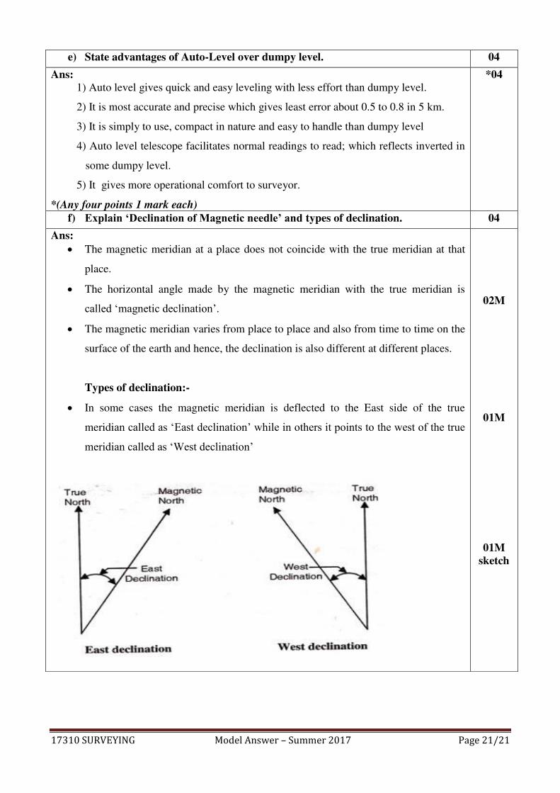
f) Explain ‘Declination of Magnetic needle’ and types of declination. 04
Ans: The magnetic meridian at a place does not coincide with the true meridian at that
place.
The horizontal angle made by the magnetic meridian with the true meridian is
called ‘magnetic declination’.
The magnetic meridian varies from place to place and also from time to time on the
surface of the earth and hence, the declination is also different at different places.
Types of declination:-
In some cases the magnetic meridian is deflected to the East side of the true
meridian called as ‘East declination’ while in others it points to the west of the true
meridian called as ‘West declination’
02M
01M
01M sketch