lower lea valley - democracy.towerhamlets.gov.uk
TRANSCRIPT

LOWER LEA VALLEY
January 2007Strategic Planning Guidance

I I | OPPORTUNITY AREA PLANNING FRAMEWORK
LOWER LEA VALLEY
Copyright:
Greater London Authority andLondon Development Agency January 2007
Published byGreater London AuthorityCity HallThe Queen’s WalkLondon SE1 2AA
www.london.gov.ukenquiries: 020 7983 4100minicom: 020 7983 4458ISBN 978 1 85261 988 6
Photographs:Cover: LDAForeword: Liane Harris
Maps based on Ordnance Survey Material. Crown Copyright. License No. LA100032379
AcknowledgementsThe Framework was prepared by the Greater London Authority with the support of a consortium led by EDAW plc with Allies & Morrison, Buro Happold, Capita Symonds, Halcrow and Mace and with additional support from Faithful & Gould, Hunt Dobson Stringer, Jones Lang LaSalle and Witherford Watson Mann Architects.

OPPORTUNITY AREA PLANNING FRAMEWORK | i
LOWER LEA VALLEY
FOREWORD
I am delighted to introduce the Opportunity Area Planning Framework for the Lower Lea Valley.
The Framework sets out my vision for the Valley, how it could change over the next decade, and what that change would mean for residents, businesses, landowners, public authorities and other stakeholders. It builds on the strategic planning policies set out in my 2004 London Plan for an area of nearly 1450 hectares, extending from the Thames in the south to Leyton in the north, straddling the borders of Newham, Tower Hamlets, Hackney and Waltham Forest.
The Lower Lea Valley is currently characterised by large areas of derelict industrial land and poor housing. Much of the land is fragmented, polluted and divided by waterways, overhead pylons, roads and railways. My aim is to build on the area’s unique network of waterways and islands to attract new investment and opportunities, and to transform the Valley into a new sustainable, mixed use city district, fully integrated into London’s existing urban fabric.
The Valley will host the 2012 Olympic and Paralympic Games and is one of the most exciting and challenging urban regeneration opportunities in Britain, with the potential to accommodate up to 40,000 new homes and provide 50,000 new jobs.
The Opportunity Area Planning Framework forms part of a suite of documents that together make up a comprehensive regeneration strategy for the Valley.
I look forward to working in partnership with the Lower Lea Valley Boroughs, the London Thames Gateway Development Corporation, the Olympic Delivery Authority, the Government, landowners and the development industry to implement the vision it sets out.
Ken Livingstone
Mayor of LondonJanuary 2007

i I | OPPORTUNITY AREA PLANNING FRAMEWORK
LOWER LEA VALLEY
LOWER LEA VALLEY
EXECUTIVE SUMMARY
The Lower Lea Valley (LLV) is one of the largest regeneration projects in Britain. The decision to bid for the 2012 Olympic and Paralympic Games focussed attention on what could be achieved in the LLV, and highlighted the need to identify the optimum scale of change across the valley.
The key opportunity for transformation in the LLV is provided through the managed release of industrial land and ensuring that new development is sustainable and built to the highest environmental and design standards. The LLV Opportunity Area Planning Framework (OAPF) takes London Plan policies as a starting point and concludes that up to a maximum of 173 hectares of existing industrial land in the LLV could be released between 2005 and 2016. Maximising the use of this land and the industrial land that is retained indicates that the LLV would have the capacity to deliver between 30,000 and 40,000 new homes (with at least 44% required as family housing) and 50,000 new jobs. At the heart of the regeneration will be the creation of a major new park that will provide high quality public open space, and enhanced water spaces and wildlife habitats, linking the Lea Valley Regional Park to the Thames.
The LLV OAPF is the Mayor of London’s strategic planning guidance for the Lower Lea Valley, and will be a material planning consideration for the LLV Boroughs, the LTGDC and the ODA. The LLV OAPF presents a vision of comprehensive social, economic and environmental change in the Valley for all who live, work and visit there now and in the future. The overall vision is:
To transform the LLV to become a vibrant, high quality and sustainable mixed use city district, that is fully integrated into the urban fabric of London and is set within an unrivalled landscape that contains new high quality parkland and a unique network of waterways.
The vision is underpinned by a series of strategic development principles to guide future development and change in the LLV. Landowners, developers, funding and delivery agencies, and local and strategic stakeholders, will be expected to demonstrate that these development principles are appropriately incorporated into planning documents, site masterplans and development briefs, development proposals, stakeholder strategies and investment programmes.
The LLV OAPF sets out a balanced and comprehensive approach to land use and development in the LLV, based on fifteen sub-areas, and sets out a series of key strategic and local interventions that will be required to achieve Valley-wide objectives and create mixed and balanced sustainable communities. Certain sub-areas require further planning to demonstrate how the strategic principles can be delivered at a local level, and all development proposals will be expected to demonstrate consistency with the sub-area guidelines, and contribute appropriately to the strategic and local objectives set out in this Framework
The Olympic and Legacy development, as well as delivering a new sporting facilities, housing and commercial space, will remove major tracts of polluted land. It will remove outmoded infrastructure and provide a major portion of the overall infrastructure for the regenerated valley, including new park space, cleaner and extended watercourses, riverine parkland space, and a network of connections into and across the Valley.
Strategic and local organisations, working in partnership with the private sector, will need to build on these interventions and deliver additional new infrastructure, facilities and services in the LLV, including social infrastructure and transport projects, to support projected levels of household and employment growth and ensure that the LLV is actively integrated with its surrounding communities.
OPPORTUNITY AREA PLANNING FRAMEWORK | i i i

LOWER LEA VALLEY
GLOSSARY OF TERMS AND ACRONYMS
DCLG Department for Communities and Local Government
dph Dwellings per Hectare
GIS Geographic Information Systems
GLA Greater London Authority
IBP Industrial Business Park (a type of SEL)
JAAP Joint Area Action Plan
LBH London Borough of Hackney
LBN London Borough of Newham
LBTH London Borough of Tower Hamlets
LBWF London Borough of Waltham Forest
LDA London Development Agency
LLV Lower Lea Valley
LLV RS Lower Lea Valley Regeneration Strategy
LLV RS PO Lower Lea Valley Regeneration Strategy Preferred Land Use and Density Option
LSIS Locally Significant Industrial Sites
LTGDC London Thames Gateway Development Corporation
LVRP Lee Valley Regional Park
LVRPA Lee Valley Regional Park Authority
Matrix Group Lower Lea Valley Matrix Group
MOL Metropolitan Open Land
ODA Olympic Delivery Authority
OAPF Opportunity Area Planning Framework
O&LF Olympic and Legacy Facilities Planning Application (2007)
O&LPP Olympic and Legacy Planning Permission (2004)
OSPCC One Stop Primary Care Centre
PTAL Public Transport Accessibility Level
SEL Strategic Employment Location
SCDL Stratford City Development Limited
TGLP Thames Gateway London Partnership
TFL Transport for London
u/ha Units per Hectare
iv | OPPORTUNITY AREA PLANNING FRAMEWORK
OPPORTUNITY AREA PLANNING FRAMEWORK | v
LOWER LEA VALLEY
CONTENTS
1. Introduction 1 Background to the LLV Regeneration Strategy 1 The LLV RS & OAPF Study Area 1
2. Vision & Development Principles 5 A Vision for the LLV 5 Introducing the Development Principles 5 The Potential & Parameters for Change 6 Delivering Change 6 Development Principles for a Water City 7 Development Principles for Thriving Centres 13 Development Principles for Neighbourhoods & Communities 15 Development Principles for the Working Valley 19 Development Principles for a Connected Valley 25 Development Principles for a Sustainable & Enduring Legacy 28 Development Principles for Reaping the Benefits of the Olympic Investment 33
3. Borough wide Issues, Opportunities & Land Use Scenarios 39 London Borough of Hackney 39 London Borough of Newham 40 London Borough of Tower Hamlets 40 London Borough of Waltham Forest 41
4. Sub-Area Issues, Opportunities & Land Use Scenarios 43 Sub-area 1: Leyton 43 Sub-area 2: New Spitalfields 47 Sub-area 3: Lee River Park 49 Sub-area 4: Wider Stratford City 51 Sub-area 5: Hackney Wick 55 Sub-area 6: Stratford 57 Sub-area 7: Fish Island & Marshgate Area 61 Sub-area 8: Bromley by Bow 63 Sub-area 9: Three Mills 65 Sub-area 10: West Ham 68 Sub-area 11: Cody Road 71 Sub-area 12: Poplar Riverside 75 Sub-area 13: Canning Town 77 Sub-area 14: Blackwall & Leamouth 79 Sub-area 15: Newham Thameside West 83
5. Delivery & Implementation 87 The Role of Public Sector Authorities 87 Key Projects to Underpin and Accelerate Sustainable Regeneration of the Valley 89 Implementing the LLV OAPF 91 The Planning Process in the LLV 92
6. Appendix A: Planning Context 95 Background 95 The Planning Policy Status of the LLV OAPF 95 The Role & Content of Opportunity Area Planning Frameworks 96 The Relationship of the OAPF to the LLV RS 96 The LLV RS as the LTGDC’s Regeneration Framework 97
vI | OPPORTUNITY AREA PLANNING FRAMEWORK
LOWER LEA VALLEY
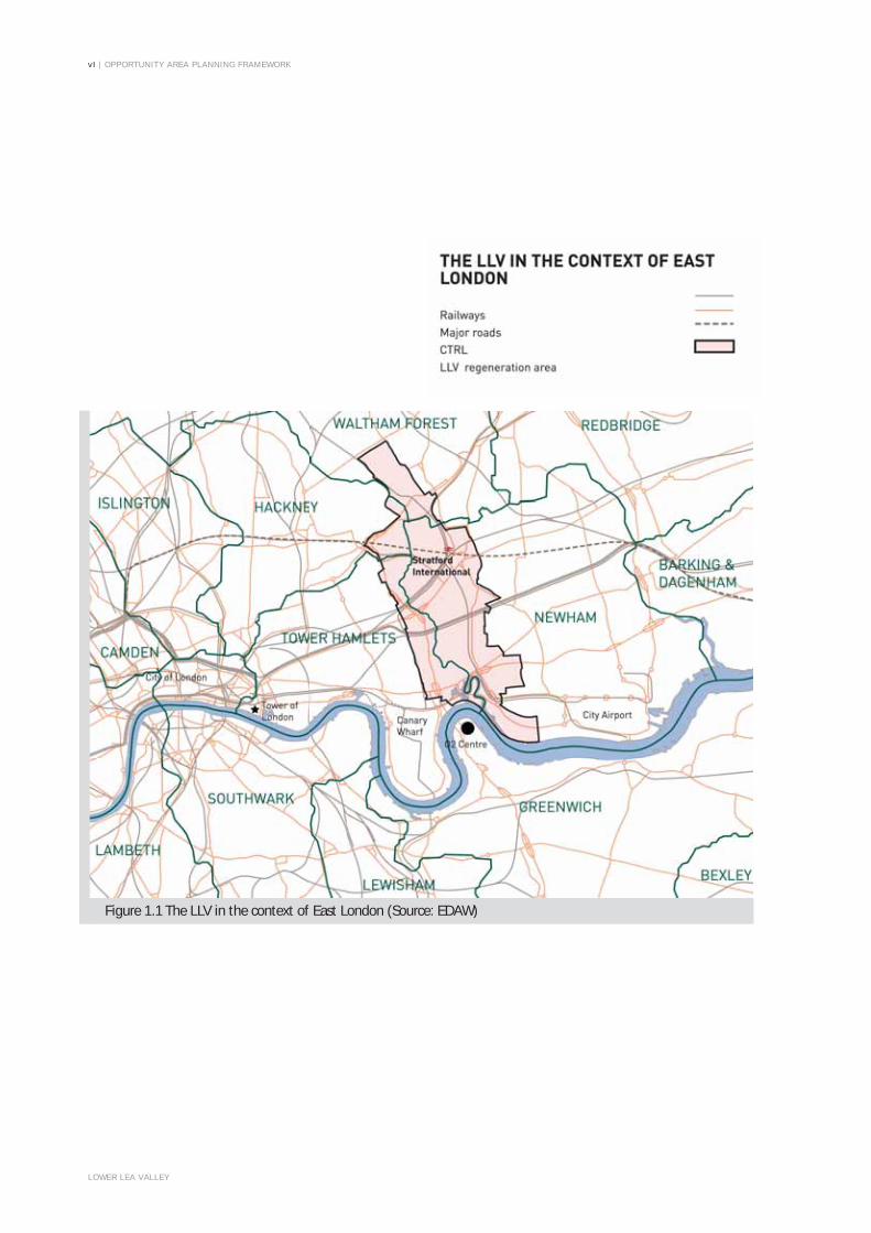
Figure 1.1 The LLV in the context of East London (Source: EDAW)

OPPORTUNITY AREA PLANNING FRAMEWORK | 1
LOWER LEA VALLEY
SECTION 1: INTRODUCTION
1.1. This Opportunity Area Planning Framework provides Mayoral planning guidance for the Lower Lea Valley (LLV) and was prepared by the Greater London Authority in close consultation with the London Development Agency (LDA), Transport for London (TfL), the four Lower Lea Valley Boroughs of Hackney, Newham, Tower Hamlets and Waltham Forest, the London Thames Gateway Development Corporation (LTGDC) and the Olympic Delivery Authority (ODA). It covers the period to 2016.
1.2. The Framework is a tool to visualise the implementation of London Plan policy and to aid negotiation, consultation and implementation. It also establishes a strategic planning context for the sensitive management of land-use change in the LLV so as to promote and improve the profile of the area, and the quality of life for people who may travel through, use or visit or live or work across the Valley. The policies set out in this Framework should be read together as a whole.
1.3. The LLV OAPF sets out the regeneration agenda for the LLV, and the four Boroughs, the LTGDC and the ODA will be invited to formally endorse it as a valid and relevant material planning consideration that they will use within their statutory and non statutory planning processes, in particular when taking development control decisions and preparing policy documents.
1.4. It is the intention of the LLV OAPF to stimulate and encourage investment from the private sector to deliver the regeneration objectives. It will be for those parties involved in the development control process to prioritise objectives on a site by site basis to ensure that the strategic regeneration objectives in the Framework are realised.
BACKGROUND TO THE LLV REGENERATION STRATEGY1.5. The decision to bid for the 2012 Olympic and Paralympic Games
focussed the attention on what could be achieved in the LLV. The bid presented a vision for change in the valley, beginning with the preparations for the Games in 2012, and culminating in a legacy of thousands of new jobs and homes arranged around new parks and public spaces. In July 2004 the LDA, in partnership with the GLA and in consultation with the four LLV Boroughs of Hackney, Newham, Tower Hamlets and Waltham Forest started work on the LLV Regeneration Strategy (LLV RS) to identify the potential scale of change across the Valley and advise on the appropriate approach to deliver that change. Figure 1.1 illustrates the LLV RS & OAPF study area in the context of East London.
THE LLV RS & OAPF STUDY AREA1.6. The LLV RS & OAPF study area is shown at Figure 1.2. It covers
an extensive area, transcending the boundaries of four London Boroughs: Hackney Wick in London Borough of Hackney, and Leyton in London Borough of Waltham Forest, to the north; Leaside (Fish Island and Bow, Bromley-by-Bow, Poplar Riverside, Blackwall and Leamouth) in the eastern part of Tower Hamlets to the west; and the Newham Arc (Stratford, Three Mills, West Ham, Canning Town and Thameside West) to the east. Figure 1.3 indicates the subdivision of the OAPF area into sub-areas.
1.7. The LLV is defined primarily by the River Lea and its associated watercourses, which run through the area from Hackney Wick and Temple Mills in the north to Leamouth and the River Thames in the south. The study area also features a number of important transport links and nodes, which provide the opportunity for development and intensification.

| OPPORTUNITY AREA PLANNING FRAMEWORK
LOWER LEA VALLEY
Figure 1.2 LLV Boundaries (Source: EDAW)2

OPPORTUNITY AREA PLANNING FRAMEWORK |
LOWER LEA VALLEY
Figure 1.3 Sub-areas (Source: EDAW) 3

4 | OPPORTUNITY AREA PLANNING FRAMEWORK
LOWER LEA VALLEY

OPPORTUNITY AREA PLANNING FRAMEWORK | 5
LOWER LEA VALLEY
SECTION 2: VISION AND DEVELOPMENT PRINCIPLES
A VISION FOR THE LLV2.1. The London Plan (GLA, 2004 and 2006) sets out a broad
planning framework for development within the Lower Lea Valley Opportunity Area. It identifies the Valley as the main focus and location of the London 2012 Olympic & Paralympic Games, and indicates that the LLV OAPF should:
• Maximise development opportunities afforded by the excellent transport connections;
• Develop the potential of key centres such as Stratford, West Ham, Hackney Wick and Canning Town to create high-density development hubs;
• Promote the creative industries, in particular the cluster at Three Mills;
• Build on the potential of the network of waterways to create a high quality environment, that can attract investment, new residents and businesses;
• Provide for substantially more than 6,000 new housing units, leisure opportunities and enhanced public open space; and
• Enable site assembly and land decontamination to realise the full potential of the area.
2.2. Within this context, the OAPF has been developed in parallel with a Regeneration Strategy for the Lower Lea Valley (LLV RS), which presents a vision of comprehensive social, economic and environmental change in the Valley for all who live, work and visit there now and in the future. The overall Vision is:
To transform the Lower Lea Valley to become a vibrant, high quality and sustainable mixed use city district, that is fully integrated into the urban fabric of London and is set within an unrivalled landscape that contains new high quality parkland and a unique network of waterways.
2.3. The vision for the LLV is built up of seven core themes, which have been defined in response to the existing characteristics of the area, the aspirations for change, and the opportunities that this presents. The themes have enabled the definition of a series of strategic development principles as set out below.
INTRODUCING THE DEVELOPMENT PRINCIPLES2.4. Future development and change in the LLV should be guided by
a series of development principles. These are expressed in the LLV OAPF firstly as thematic principles derived from the seven themes of the LLV Vision for Change1, and secondly as sub-area specific development principles.
2.5. Landowners, developers, funding and delivery agencies, and local and strategic stakeholders, will be expected to demonstrate that these development principles are appropriately incorporated into LDFs, site masterplans and development briefs, development proposals, stakeholder strategies and investment programmes.
2.6. The seven themes from which thematic development principles are developed are:
(i) The environmental transformation of the Valley to create a Water City through enhancement and extension of the existing waterway network and associated development of a linear park and ecological corridor along the waterways linking the Lee Valley Regional Park to the Thames and the East London Green Grid.
(ii) Providing a strong urban structure of Thriving Centres by clustering community infrastructure in new centres and expanded existing centres, supported by an effective transport network.
(iii) The development of cohesive Neighbourhoods and Communities by using the land released from industrial use for housing, especially family housing, supported by necessary community, education and health facilities, shops and businesses, and open space and other amenity uses.
(iv) Supporting the LLV’s role as a Working Valley by retaining important employment functions and intensifying activities in key areas to create dynamic employment areas that are carefully integrated into the urban fabric.
(v) Ensuring that new development will create an internally and strategically Connected Valley by improving local movement routes and ecological linkages, as well as creating a sustainable transport strategy that encourages people to walk and cycle to their local destinations.
(vi) Working with all partners to ensure that any development provides a Sustainable and Enduring Legacy in terms of utilities provision and management, and enhancing aspects of the unique environmental and historic character of the Valley.
(vii) Optimising the Benefits of the Olympic Investment to focus inward investment on opportunities in the rest of the Valley, ensure continued excellence in design and creation of dynamic new employment sectors.
1: Lower Lea Valley Vision, LTGDC, May 2006

6 | OPPORTUNITY AREA PLANNING FRAMEWORK
LOWER LEA VALLEY
THE POTENTIAL AND PARAMETERSFOR CHANGE IN THE LLV
2.7. The potential and parameters for change that are set out in this OAPF have been informed by the LLV RS technical studies2 whose key findings have been encapsulated within the OAPF.
2.8. The key opportunity for transformation is provided through the potential for change of use of industrial land, and its redevelopment for housing and associated uses. The LLV RS has tested this potential against housing and employment growth targets identified in the London Plan and individual borough planning documents.
2.9. This OAPF assumes that a maximum of 173 hectares of existing industrial land in the LLV could be acceptably released for other uses between 2005 and 2016. This potential release is illustrated in Figure 2.6.
2.10. Based on these assumptions, the LLV may have the capacity to deliver between 30,000 and 40,000 new homes. The upper end of this range assumes that all existing large-scale planning permissions (such as Olympic and Legacy and Stratford City) are implemented, mixed use is brought forward to the extent that is assumed in the LLV RS, local transport capacity issues are resolved, and local flood mitigation measures are put in place. Conversely, the lower end of the range assumes that existing permissions are not fully implemented, limited mixed use is brought forward, and local transport capacity and flood risk issues are not resolved.
2.11. Although this planning framework covers the period to 2016, It is unlikely that all the housing capacity indicated within it will be realised within this timeframe, but it is expected that at least 20,000 housing units will be delivered across the LLV by 2016.
2.12. Intensification of retained industrial land and development of new employment areas have the potential to deliver up to 50,000 new full time equivalent jobs, with up to 7,000 construction jobs and between 30,000 and 60,000 volunteer opportunities arising from hosting the Olympic and Paralympic Games.
2.13. Whilst it is the release of industrial land that will generate the greatest level of change, it is equally important that sufficient industrial land is retained in appropriate locations, to accommodate a range of strategic employment / service functions that should remain, and in some instances grow, to support the creation of new sustainable communities.
2.14. Where industrial land is released, housing and community uses should be the predominant new land use, with delivery of new housing areas, appropriate intensification of existing residential areas3, and introducing mixed use development into parts of some employment areas.
2.15. It will be important to ensure that new development does not simply provide housing, but that this is supported by key service facilities, and that these are clustered together. The regeneration and expansion of existing town centres and development of new local centres around highly accessible transport interchanges will create ‘Places of Exchange’ to provide a wide range of new opportunities, services and facilities as well as an improved living and working environment.
2.16. The improvement and extension of the waterways in the LLV will play a crucial role in upgrading and transforming the physical environment in the Valley. In parallel, the development of a new Lower Lea Valley Park system will help meet the requirements of London Plan and borough policy for adequate provision of green space to new and existing development, and will also create a city scale park and open space network of international significance and quality.
DELIVERING CHANGE2.17. Achieving the Vision and the scale of change across the LLV will
be challenging and require the concerted effort of the public sector working in cooperation with the private sector to overcome a wide range of physical and financial barriers to change.
2.18. The opportunities for change are currently restricted by a number of key constraints including poor access and local connectivity, contamination, complicated land ownerships, and limited good quality open space and social infrastructure. Addressing these constraints will require the concerted and coordinated efforts of public agencies to address viability and stimulate private sector to investment in the area. Further information on delivery is included in Section 5 of this document.
2: See Section 5 – Delivery and Implementation3: Where in accordance with local and strategic policy.

OPPORTUNITY AREA PLANNING FRAMEWORK | 7
LOWER LEA VALLEY
A. DEVELOPMENT PRINCIPLES FOR A WATER CITY2.19. The London Plan recognises the important contribution the
network of rivers and canals (’The Blue Ribbon Network’) have in promoting regeneration and economic growth. Whilst development in waterside settings in the first instance should be prioritised for uses that require a waterside location, other development should be promoted that includes a mix of opportunities to use, enjoy and improve the Blue Ribbon Network (Policy 4C.12 and supporting text, London Plan).
2.20. The London Plan also recognises and promotes the positive links between open space and health, sport and recreation, play, regeneration, the economy, culture, biodiversity and the environment (Policy 3D.7).
2.21. The Lower Lea Valley waterway system is intrinsic to the character of the Valley. Consequently, improving and enhancing these waterways, creating new linked green spaces, dealing with polluting sewer misconnections and storm water discharges, and connecting new and existing open spaces and communities will be central to the successful regeneration of the Valley
2.22. In order that new development, particularly residential development, is sustainable and attractive, the waterways will need to be improved and the network of existing open spaces must be expanded to provide high quality resources that are fully accessible to people that wish to use them. Whilst the Lee Valley Regional Park has an extensive catchment area which extends throughout the majority of the study area, the southern portion of the Valley suffers from more limited accessibility and there is significant deficiency in access to open space for sites along the centre of the Valley area.
2.23. The Vision for a ‘Water City’ is illustrated in Figure 2.1. It should be delivered through the creation of a new open space network structured around the waterway system; ecological enhancement and re-naturalisation of sections of this waterway system whilst maintaining their navigation function; reinstatement and extension of the waterway system; greater use of the waterways, for living, transportation, and recreation; and, by ensuring that flood risk is appropriately assessed, mitigated and managed as an integral component of the future development.
A1. Development proposals in the LLV should seek to realisethe potential of the waterways and open spaces to createamazing places.
2.24. The Lower Lea Valley OAPF recognises the different character of the existing waterways in the LLV and differentiates between the canal and river elements and promotes and requires development that appropriately relates to and enhances these features. In general terms new parks and open spaces should be focussed on the tidal and semi-tidal river system, with bank edges broken out and re-graded where appropriate, while the non-tidal canal system should generally retain a more urban character.
2.25. New and enhanced waterways and open spaces should create high quality urban and landscape environments and integrate new and existing neighbourhoods. New development should respect and build on the unique character and heritage of the LLV, and strengthen its physical and environmental assets.
2.26. Maintaining and managing new and existing waterways and park spaces will be crucial to the long term success of the Vision. The LDA, LTGDC, four LLV Boroughs, British Waterways and the Lea Valley Regional Park Authority (LVRPA) should therefore work together to address this and deal with difficulties arising from fragmented ownerships.
A2. Opportunities to upgrade the waterways that do not compromise the flood defence role, transport potential, landscape character and ecological value of the rivercorridor and associated floodplain of the LLV shouldbe supported.
2.27. The LLV OAPF includes a clear focus on the enhancement of the LLV water network. Proposals to extend or improve the existing water networks will be supported where these do not conflict with other objectives of the LLV OAPF. De-canalisation works will need to be carefully engineered to ensure no reduction in standard of defence or increase in flood risk.
2.28. Subject to London Plan policy 4C.15 which protects Safeguarded Wharves for cargo-handling uses, development proposals on waterside sites should seek to incorporate, where appropriate, active uses including boat servicing, river maintenance and canal boat facilities, and provision for rowing boats, canoes, and barge moorings for visitors and residential moorings. Development proposals will also need to be in accordance with London Plan Policies 4C.18 and 4C.19 on Support Facilities and Activities in the Blue Ribbon Network and Mooring facilities. Safe and attractive walking routes should be developed through parks and between neighbourhood and other centres along canal towpaths.
2.29. Where development includes green space, and the site is located alongside a river or canal, the green space should be generally located on the waterfront to maximise the benefits of the green space and incorporate flexibility for future adaptation of the river system for flood risk and water quality management, including future flood plain provision. Provision of new canal basins or canal extensions could be considered as compensatory flood storage for new developments.
2.30. Proposals for upgrading and extension of waterways should be developed in consultation with key stakeholders, in particular British Waterways and the Environment Agency. The LLV OAPF identifies a zone where new canal basins increase use of the waterways and masterplans and development proposals within this zone should assess the viability of delivering functional canal basins which could also be used to increase flood storage capacity. Figure 2.1 illustrates the strategy for waterways in the LLV.

| OPPORTUNITY AREA PLANNING FRAMEWORK
LOWER LEA VALLEY
Figure 2.1 Water Strategy (Source: EDAW)8

OPPORTUNITY AREA PLANNING FRAMEWORK | 9
LOWER LEA VALLEY
A3. Development proposals in the LLV should help establish aGreen Grid for the Lee Valley.
2.31. The Green Grid is a vision for a strategic network of green space across east London. Development proposals in the LLV should contribute to the development of this network by enhancing and extending the open space of the Lea Valley, celebrating its natural attributes, creating an ecological and heritage resource with a range of leisure and recreational opportunities for all sectors of the community, and helping to bind together existing and new communities.
2.32. Green Grid principles should be adopted and new development should:
• Link elements into a wider network that functions as a whole, crossing administrative boundaries and connecting, urban, suburban, rural areas and waterways;
• Address deficiencies in access to public open spaceand nature;
• Be planned and managed to include environmental, social and economic benefits;
• Be designed, located and managed to perform a wide range of functions, including improving pedestrian and cycle access, enhancing biodiversity, reducing flood risk, adapting to climate change, promoting recreational use and healthy living;
• Engage and incorporate a wide range of diverse disciplines and expertise throughout the process, including planning, urban design, landscape, ecology, environment, conservation and civil engineering;
• Engage key partners and involve diverse strategic and local stakeholders in planning and implementation, including the GLA group and government.
2.33. The strategic objectives of the Green Grid in the Lea Valley are:
(i) To provide a multi-functional landscape with provision for access, recreation, flood-risk management, biodiversity and food production;
(ii) To create a diverse recreational landscape with opportunities for formal and informal recreation with a strong river character and with river related activities;
(iii) To create high quality multi-functional open spaces,which have particular regard to waterways and surrounding urban context;
(iv) To support the extension of the LVRP to create a major new park in the Olympic Legacy proposals;
(v) To improve access to the Thames and links across watercourses in the Lower Lea;
(vi) To provide high quality urban parks linked by the Regent’s Canal in the Victoria Park/Mile End Park Link, integrating artand culture;
(vii) To retain references to the industrial heritage of the LowerLea Valley;
(viii) To refurbish and enhance the Northern Outfall Link and connect it with the Thames Gateway Bridge proposals;
(ix) To improve and formalise public access to the Higham’s Park Link in association with flood risk management;
(x) To address the identified public open space deficiency areas at Hackney Wick, East India Docks, Bow Common, Bow, Bromley, Hackney, Leyton, Spitalfields and Bethnal Green;
(xi) To address the identified areas of deficiency in accessto nature;
(xii) To enhance pedestrian and cycle access across major roads and railways at Bow Common, Bow, Bromley; and
(xiii) To improve access to Springfield House and Tide Mills.

| OPPORTUNITY AREA PLANNING FRAMEWORK
LOWER LEA VALLEY
Figure 2.2 Green Space (Source: EDAW) 10

OPPORTUNITY AREA PLANNING FRAMEWORK | 11
LOWER LEA VALLEY
A4. Development proposals in the LLV should protect and improve existing areas of open space or, where proposalsare brought forward that impact upon existing openspace, ensure that re-provision of any space is achievedto equal or greater quality, dimensions and accessibility.
2.34. It is vital that a wide range of open space is provided and that all spaces are of high quality. LLV boroughs should also ensure that access to, and quality of, existing facilities is improved.
2.35. The OAPF supports the proposals in the LLV RS for an open space network structured around six new major park areas broadly following the course of the Lea River, linked together by green corridors along the waterways, to form a continuous open space network extending from Hackney Marshes in the north to the Thames in the south and related to existing and proposed centres of activity, communities and local movement corridors.
2.36. New public open spaces should be focussed on areas of deficiency and new provision should aim to meet the needs of new and existing communities. New open spaces should be sought within large scale mixed use, employment generating and residential developments. Different types of open space should be provided across a range of typologies, including uses such as parks, allotments, gardens, special wilderness spaces, and appropriate provision for environmental and biodiversity purposes built in. Allotments should be designated and protected as open space and if necessary reprovided in a similar location. Development proposals which intensify existing residential areas should contribute to improvements to existing open spaces, and provide new amenity spaces.
2.37. The LLV is deficient in open space provision in terms of the overall quantum of open space, and in the types of open space provided, particularly in the south of the valley, where there is a deficiency of open spaces of neighbourhood and district scale. The Olympic Park will assist in the provision of a sufficient quantum of open space to serve new and existing communities, but will not directly address areas of deficiency in the south of the LLV. The implementation of the open space areas proposed within the OAPF will help to address the deficiencies in the south. The OAPF proposes at least 130 hectares of new open space in the LLV, in addition to the existing 105 hectares which should be improved.
2.38. Roof terraces, play space, traffic calming measures, and better use of amenity space around residential areas, should all be encouraged. Improvements to existing spaces by updating facilities, improving access and accessibility, and enhancing landscape character and biodiversity should also be sought. The broad distribution of existing and potential new green space in the LLV is illustrated in Figure 2.2.
A5. Metropolitan Open Land (MOL) will continue to beprotected from inappropriate development.
2.39. Metropolitan Open Land (MOL) will continue to be protected from any inappropriate development in accordance with the London Plan (Policy 3D.9), and borough policies on MOL should be maintained where they comply with this principle. Proposals to alter the boundary of MOL will only be considered in exceptional circumstances:
• to consolidate and improve areas of existing open space into larger areas; or
• if it is necessary to assist cross-borough working to facilitate innovative solutions to complex phasing and ownership scenarios, and where these exceptional circumstances form part of a wider agreed regeneration strategy; and
• Any proposed changes to MOL should be brought forward through the development plan process
2.40. Proposals should not adversely affect the designation of MOL for example damaging a link to the MOL or if the land is of historic importance. Any replacement must meet the criteria for designation as MOL in the London Plan. It is important that existing areas of MOL are stitched into the urban fabric rather than being treated as residual to areas subject to change. Any common land acquired for statutory purposes will need to be replaced by an equal or greater area of land which is equally or more beneficial to those who use it.
2.41. In all cases, public access should be maintained or sought and the spaces designed to be fully accessible for peoplewith disabilities.
A6. Environmental and sustainable features should beincluded within developments in the LLV.
2.42. The choice of environmental mitigation measures on any development need to have regard to the likely effects of the particular development and mitigation and environmental enhancement of the environmental effects. Features such as buffer zones, green chains, wildlife refuges, floodplain restoration and allotments should be included in developments where feasible. Equally, measures such as SUDS4 (with long-term maintenance regimes), grey water recycling facilities, low water use appliances, and rainwater harvesting for irrigation should all be considered and incorporated as appropriate. The provision of a dual water supply would also assist in securing a sustainable and enduring legacy for the LLV. Sustainable building design incorporating solar energy, wind energy, and green and brown roofs should be incorporated within individual developments and as part of a mix of uses.
4: SUDS – Sustainable Urban Drainage Systems

| OPPORTUNITY AREA PLANNING FRAMEWORK
LOWER LEA VALLEY
Figure 2.3 Places of Exchange (Source: EDAW) 12

OPPORTUNITY AREA PLANNING FRAMEWORK | 13
LOWER LEA VALLEY
A7. Development proposals in the LLV should seek to protect and enhance important wildlife, biodiversity and ecologicalasset and character.
2.43. London Plan policies seek to protect, promote and manage biodiversity and this will be equally important in new development and regeneration areas such as the LLV (Policy 3D.12). The LLV continues to have high value in terms of biodiversity and natural heritage. The biodiversity of the area reflects its history, and falls into two main habitat types. The watercourses and dock basins are important for wetland plants and animals, while the post-industrial landscape supports diverse communities of plants, both native and exotic, and provides valuable habitat for invertebrates and the rare black redstart. In particular, where appropriate, development proposals for the waterways should consider the re-grading of bank edges to provide ecological enhancement through creating a more diverse mix of marginal habitats, and improved riparian vegetation management (particularly control of invasive species and establishment of desirable marginal habitats).
2.44. Development proposals should aim to restore and regenerate the existing ecological value wherever possible. The key environmental objectives of the regeneration of the Valley are to protect existing valuable habitats and species; provide enhanced wetland habitats and areas of open, flower-rich vegetation that reflect the post-industrial landscape; reintroduce indigenous flora and fauna; remediate contaminated land; address deficiencies in access to nature; and limit construction on greenfield sites by prioritising brownfield sites for redevelopment.
B. DEVELOPMENT PRINCIPLES FOR THRIVING CENTRES2.45. To ensure people have access to a full range of services the
London Plan promotes a five tier hierarchy of centres, according to the function and role of the centre (Annex 1). Policy 3A.15 highlights the need to plan and provide new social infrastructure and community facilities. This will be of particular importance in major areas of new development and regeneration.
2.46. The LLV RS proposes the development of a large number of new residential units in the LLV, in a series of connected neighbourhoods with access to a range of social infrastructure. In support of this a hierarchy of accessible town, district and local centres is required to provide access for residents to jobs, shops, schools, healthcare, open space and recreation, general community facilities, public transport and emergency services.
2.47. This hierarchy of town and local centres should be developed through the strengthening of existing centres and creation of new centres where these are in an accessible location (i.e. close to transport interchanges) and will provide services and amenities for both new and existing communities, linking these together to become ‘Places of Exchange’. This concept of ‘Places of Exchange’ builds on the notion of developing clusters of community facilities, where flexible space and shared facilities can be provided to meet demand and the needs of service providers. It is likely that one key service or facility will provide the ‘anchor’ around which complementary retail, leisure, education, health and other community facilities will cluster. Figure 2.3 illustrates the strategy for places of exchange in the LLV.
2.48. To create the type of place in which people will want to live, work and spend leisure time, and to help create healthy, successful and sustainable communities into the future, it will also be vital to invest in social infrastructure to ensure that the Valley is served by a high quality network of schools, health centres, community, leisure and recreation facilities. The proposed requirements contained in the OAPF have been anticipated from the proposed form and type of residential development, existing provision and service providers’ requirements.
2.49. The GLA, LDA, LTGDC, four LLV Boroughs and social infrastructure service providers and funders will need to ensure that the necessary social infrastructure is provided in tandem with growth through the Valley. To ensure that land is made available for this purpose, the maximum scenario of required land for social-infrastructure facilities should be safeguarded from other forms of development. This safeguarding should be subject to regular 5 year reviews as development of the Valley progresses. If population trends prove different from those modelled as part of the LLV RS process the land can be released for other purposes. In the short term this land can be used for temporary open space provision.
2.50. The development of Places of Exchange should be further supported by improved transport infrastructure and the development of a network of routes and connections across the LLV and between neighbourhoods.

14 | OPPORTUNITY AREA PLANNING FRAMEWORK
LOWER LEA VALLEY
B1. Development proposals in the LLV should seek to provide and support a mix of uses in key activity nodes (‘places of exchange’) such as metropolitan, major, district and localcentres to provide a range of facilities and services inaccessible locations.
2.51. Community infrastructure, including local retail, commercial (such as banks, buildings societies and other professional services) and social services infrastructure (including schools, further/higher education, health centres, community halls, places of worship, libraries and emergency service provision) should be appropriately clustered in the following accessible locations:
• Stratford (major/metropolitan centre);
• West Ham (new district centre);
• Canning Town (district centre);
• Chrisp Street (district centre);
• Bromley-by-Bow (enhanced local centre);
• Newham Thameside (part of new district centre at Silvertown Quays); and
• Hackney Wick (new local centre).
2.52. In the development of centres it will be important to consider the need to safeguard land for community and social services infrastructure especially for the emergency services, and this should be done in consultations with the relevant authorities(MPA, LFEPA, LAS etc.)
2.53. Development proposals should seek to encourage sustainable patterns of movement to and between these centres. The LLV OAPF promotes mixed use, multi-functional buildings and clusters of buildings to provide a range of community infrastructure. Borough involvement is critical in bringing public land forward to accommodate this infrastructure and anticipate future demand.
B2. Development proposals in the LLV should provide for a rangeof educational facilities and pre-school nursery childcare toaccommodate the growing population of the area.
2.54. A range of pre-school nursery and education facilities should be provided to meet the needs of the new residential community. New primary and secondary schools should be provided within the LLV and contributions sought for the enhancement of further and higher education facilities. It will be vital to pursue cross-boundary working to meet education needs, as school catchment areas may fall across administrative boundaries.
2.55. Nursery services should be provided to facilitate access to jobs and learning and can be attached to primary schools. The ‘Extended Schools’ model should be followed, where appropriate, to provide out of hours education and other services for the benefit of the wider community. Schools with specialist subjects and enhanced links to the local business community, known as ‘Academies’, will also be supported.
2.56. New schools should be of high quality design to encourage civic pride and facilitate learning, with a range of resources provided for shared use with the community after-school hours. They should be positioned in accessible locations, close to centres, parks and recreation facilities to provide structure and focus for new communities, enhancing character and supporting place making principles. The co-location of education with other social and community facilities will be encouraged.
B3. Development proposals in the LLV should provide for a range of health facilities to address the needs of the new residential community and enable health providers to provide new modern services.
2.57. A sufficient range of health facilities should be provided to accommodate the health needs of the existing communities and new population. New facilities will need to be planned for and provided to meet the needs and objectives of the local Strategic Health Authority and local Primary Care Trusts. The ‘hub’ and ‘spoke’ model should be applied to provide key One Stop Primary Care Centres (hubs) in accessible locations such as town and district centres and Walk-in Centres and GP Surgeries in local centres (spokes) to provide a range of facilities in accessible locations across the Valley. Consideration must be given to the need for additional demand for local hospital services and mental health care, which should be satisfied where possible through the expansion of existing well located facilities. New buildings should make a positive contribution to the neighbourhoods they serve and where appropriate healthcare should be co-located with other complementary social infrastructure services.
B4. of town centre uses in a hierarchy of centres to maintain vitality and viability.
2.58. Shopping centres which are designated as ‘major centres’, ‘district centres’, or ‘local centres’ within the LLV Opportunity Area should be promoted and enhanced to improve the range and quality of retail floorspace, and provide a mix of retail, small-scale commercial and community infrastructure. Significant retail outside of these existing and new centres will be resisted.
2.59. The layout and design of new development proposals should provide direct and safe access to the centres from surrounding residential neighbourhoods, particularly on foot, bicycle and public transport. A vibrant mix of services and facilities should be provided to maintain the functionality and viability of the centre. The co-location of services is encouraged to support policy objectives and delivery of services and better integration between different agencies.
2.60. In particular, development proposals should support the creation of a major new commercial centre at Stratford, drawing on its European links to establish a new mixed use business quarter for London, complemented by strategically significant new retail and leisure provision sufficient to ensure that Stratford develops a new ‘Metropolitan’ town centre. Close integration of new development on the rail lands and rejuvenation of the existing town centre, including physical links, is crucial.

OPPORTUNITY AREA PLANNING FRAMEWORK | 15
LOWER LEA VALLEY
B5. Development proposals in the LLV should seek to protectand develop the character and identity of existing centres.
2.61. New development should identify and enhance the unique character of the Valley. Developments should be of high quality design and carefully configured to strongly relate to the existing or proposed urban structure of the wider area. Thus developments should make a positive contribution to the urban life of the area with generous and well designed public realm and active frontages which link with the wider network of local activity and landscape.
B6. The delivery of social infrastructure should ensure thatappropriate facilities and services are brought forward in tandem with housing development.
2.62. The detailed delivery of social infrastructure facilities should be considered as part of the borough’s AAP process, and will need to be considered by the LTGDC, LDA and ODA working in partnership with social infrastructure providers (including the PCTs) to ensure that the necessary infrastructure is provided to meet the needs of the new communities.
2.63. The location and phasing of social infrastructure within the Valley and its hinterlands will need to be considered in more detail through the production of local planning frameworks for ten identified masterplan areas in the LLV (see Figure 5.2). Developers bringing forward proposals in these areas will be expected to work with the GLA Group, LTGDC, local authorities and local delivery agencies to demonstrate how the planned implementation of their proposals will contribute to the wider regeneration of the LLV and the development of necessary infrastructure, especially social infrastructure.
C. DEVELOPMENT PRINCIPLES FOR NEIGHBOURHOODS AND COMMUNITIES
2.64. The London Plan highlights how new housing should help support economic growth and offer a range and choice of housing, including affordable housing.
2.65. The vision for the LLV seeks to ensure the creation of new sustainable residential communities occupying a range of accommodation types and tenures that are accessible to the whole community. Residential development proposals should help bring communities together with integrated approaches to transport nodes and links. This cohesion should be achieved through the parallel delivery of private and affordable housing (normally on-site) , seamless and integrated design of different housing types, and good access to a wide range of social and community facilities.
C1. Development proposals in the LLV should seek to meet and exceed the 2004 LLV Housing target of 6,000 new homes by 2016, within the context of development capacity analysis demonstrated by the LLV RS.
2.66. New residential development in the LLV should seek to exceed the targets established by the London Plan, and make a substantial contribution to borough-level homes targets for the 10 year period from 2007/8 to 2016/7 (31,500 in Tower Hamlets; 35,100 in Newham; 10,850 in Hackney; and 6,950 in Waltham Forest by 2016 as set out in the published alterations to the London Plan.
2.67. Development capacity analysis in the LLV RS has demonstrated the potential for between 30,000 and 40,000 new homes in the LLV in the context of London Plan Policy on housing densities (table 4B.1 ‘Density Location and Parking Matrix’) and the achievement of other regeneration objectives. It is unlikely that this figure will be achieved in the current planning timeframe, but it is expected that at least half the number of housing units indicated by the figure at the upper end of the range will be delivered by 2016 across the LLV.
C2. Development proposals in the LLV should promote sufficientprovision of affordable housing across the LLV area.
2.68. New development proposals should seek to meet the London Plan target of 50% affordable housing. Of the affordable units delivered in the LLV, a 70% rental and 30% intermediate split will act as a benchmark for the area as a whole, and will be informed by London wide, borough and sub-regional Housing Needs Surveys (Policy 3A.7).
2.69. It is acknowledged that the achievement of the London Plan targets on individual sites is likely to depend on a number of factors, including the availability of public subsidy, borough LDF policy, remediation costs, local market conditions, the achievement of other regeneration objectives and affordable provision elsewhere in respective Boroughs. It is anticipated that sites will be subject to an individual detailed appraisal to determine their ability to meet this target.

| OPPORTUNITY AREA PLANNING FRAMEWORK
LOWER LEA VALLEY
Figure 2.4 Housing Intensification (Source: EDAW)
OPPORTUNITY AREA PLANNING FRAMEWORK | 17
LOWER LEA VALLEY
2.70. A range of types, high quality design, and refurbishment of existing affordable homes need to be provided. Individual sites may also vary to achieve more or less than these aggregate targets. The Mayor’s SPG on Housing (November 2005) gives detailed guidance on how to develop sites for housing and how to determine housing mix and density for individual sites.
C3. Development proposals in the LLV should promotea suitable range of residential accommodation with amix of dwelling types and maximise opportunities forfamily housing5.
2.71. The LLV is home to a diverse population. It is vital that the needs of individuals, families and communities are met with the provision of an integrated and suitable mix of dwelling types and tenures, including family housing and sheltered accommodation. The exact mix of dwellings must be appropriate to individual borough and sub-regional housing needs and will vary across different neighbourhoods.
2.72. Providing a range of housing to meet local needs is a requirement of the London Plan, expressed through Policy 3A.4. New development should provide a range of housing size and type to meet the needs of a range of users including students, older people, families with children and people willing to share accommodation. The OAPF therefore proposes a mix of new residential development to meet diverse requirements and local needs.
2.73. The provision of a substantial quantity of housing suitable for families is a key requirement of the OAPF. Development in the LLV should therefore maximise opportunities for family housing and all residential schemes should aim to meet a target of at least 44% family housing. Family housing will therefore be sought from all residential developments but it is acknowledged that the precise proportion of family housing may vary from site to site, according to criteria such as flood risk, proximity to existing or proposed social infrastructure, proximity to existing or proposed parks and open spaces, and density. Family housing should incorporate private external space in the form of gardens, terraces or balconies wherever possible.
2.74. Special needs housing (London Plan policy 3A.10) should also be provided in terms of hostels and shared accommodation. This should be based on estimates of need for the LLV area. The four LLV Boroughs should develop a co-ordinated approach to assessing the accommodation needs of travellers and gypsies, which should involve protecting existing sites, assessing the suitability of new sites, identifying where shortfalls occur (London Plan Policy 3A.11) and identifying acceptable alternative sites where relocation is required for strategic purposes.
C4. Development proposals in the LLV should concentrate housing in areas of high public transport accessibility.
2.75. Subject to adequate public transport and/or highway capacity being available or provided, high density housing or high trip generating uses will be supported in appropriate locations with regard to the Public Transport Accessibility Level (PTAL), proximity to town centres and the character of the area, where
these locations are within a 10 minute walk of a town centre, and can support higher residential densities as recommended in the London Plan, table 4B.1.
2.76. Overall there should be an increase in scale and grain around areas of high public transport accessibility and around town centre nodes.
C5. Housing Development proposals in the LLV shouldmeet high quality design, accessibility and sustainability standards.
2.77. Long-term sustainability of housing should be ensured by specifying homes to high quality design and build standards, meeting high sustainability objectives and achieving national and London wide targets for sustainable development in line with London Plan policy 3A.4 and the GLA’s Supplementary Planning Guidance on Housing (November 2005). The LLV should be sustainable and function to meet the local residents’ and occupiers’ needs, including as far as possible waste disposal and energy production. Additional facilities should be required to meet the needs of the new community, which, as technologies advance, will have diminished impacts on their neighbours. EcoHomes (the homes version of BREEAM) standards should also be met by all new housing within the LLV Boroughs.
2.78. Development proposals in the LLV should create an inclusive environment and meet the highest standards of accessibility and inclusion. ‘Lifetime homes’ standards should be adopted for all new housing development and homes should be easily adaptable for wheelchair users. The London Plan and OAPF require that ten percent of new housing should be wheelchair accessible (Policy 3A.4). Development proposals should provide an access statement indicating how the principles of inclusive design have been integrated into the proposal; that the development shall be undertaken in accordance with the advice of the Disability Rights Commission on access, the Disabled Persons Transport Advisory Committee’s Principles on Inclusive Design, and the ODPM’s best practice planning and access guide; and how inclusion will be maintained and managed.
2.79. As well as bringing forward new housing development, the OAPF has as a key objective the need to improve existing housing within the OAPF boundary, especially those on the fringes of the core development area.
C6. Development proposals in the LLV should promotecommunity safety in partnership working with key stakeholders.
2.80. Partnership working with the Metropolitan Police and Local Authority Community Safety Officers at a pre-application stage and a police presence at major developments are key components of delivering community safety. Development proposals should incorporate the principles of ‘Secured by Design’ and ‘Crime Prevention through Environmental Design’.
2. 81. Development proposals should also consider fire safety, through discussion with the London Fire Brigade, especially with respect to fire prevention, fire awareness, escape, and access for fire brigades officers. The distribution and operation of Fire Stations does not take account of borough boundaries.
5. Defined as 2 bedroom social rented units and all units of 3 bedrooms or larger. If the 2 bedroom social rented units are excluded, the target for provision of 3 bedroom andlarger units should be at least 33% of all new residential units.

| OPPORTUNITY AREA PLANNING FRAMEWORK
LOWER LEA VALLEY
Figure 2.5 Core Industrial Areas (Source: EDAW)

OPPORTUNITY AREA PLANNING FRAMEWORK | 19
LOWER LEA VALLEY
D. DEVELOPMENT PRINCIPLES FOR THE WORKING VALLEY2.82. The London Plan seeks to increase the prosperity of London
through securing strong and diverse economic growth. This will involve the growth of many economic sub-sectors beyond the central financial business district and include the provision of a range of premises of varying type, size and costs to meet the needs of various sectors of the economy (Policy 3B.1). Within Opportunity Areas, where new office development is acceptable, it should generally be provided alongside a mix of other uses including housing and other uses (Policy 3B.4). Clusters of creative industries and related activities and environments should be identified and supported (Policy 3B.9).
2.83. The LLV plays an important role in the economy of London. The LLV RS analysis indicates that this key economic role will continue into the future, but that the physical nature of activity, in terms of land use and the range of businesses, will undergo significant transformation over coming years. The intensification of industrial activities, upgrading of facilities, and the managed release of industrial land for a broader mix of land use will result in a stronger and more diversified economy in the Valley, providing a greater range of opportunities for local people and the new communities that will be created over the coming years. The LLV OAPF and LLV RS identify the potential for some 50,000 net new jobs, based on existing permissions and the land use assumptions promoted in this document.
D1. Development proposals in the LLV should retain Strategic and Local Significant Employment Sites and managethe transition of industrial land through release andintensification in accordance with the geography of industry set out in the OAPF.
2.84. London Plan Policy 3B.5 and the draft Supplementary Guidance on Industrial Capacity (September 2003) seek to ensure the adequate provision of industrial land across London for employment uses, whilst recognising the opportunities to transfer genuinely surplus industrial land into more active uses. The LLV RS has assessed the potential for industrial land release and restructuring in the context of London Plan guidance on sustainable levels of industrial land release within the East London region to 2016. Analysis suggests that the LLV has the potential to release a maximum of 173 hectares of industrial land from 2005 to 2016 for other uses.
2.85. The pace and extent of this industrial land release will be shaped by market conditions, the phasing of strategic regeneration interventions across the Valley, site specific characteristics, and the extent and locations of investment in public transport and other infrastructure.
2.86. The industrial land release set out in this document is at the upper limit of the maximum acceptable release, and therefore careful definition, management and monitoring of the release of industrial land in the Valley is necessary to ensure that this is not exceeded.
2.87. Sites that contain operational industrial activities that perform functions that are important to the performance of London’s economy, that require a location close to the central business areas of the City of London or Canary Wharf, and that cannot be relocated to suitable alternative sites, should be retained within the Valley.
2.88. Industrial activities that do not have a business need to be located within the Valley, or provide limited local labour or economic benefits to the local area and can be successfully relocated elsewhere offer the maximum opportunities for land-use change, in accordance with the principles set out in this document.
2.89. The transition from traditional employment and industrial uses should be controlled within the plan period to 2016, with initial retention and strengthening of existing uses in key locations.
2.90. The geography of industrial land release set out in this document seeks to maintain a concentration of industrial activities in a ‘corridor’ along the centre of the Valley (see Figure 2.5). Within this corridor there are a series of key concentrations, sub sector clusters and strategic transport connections, including Safeguarded Wharves and rail-based infrastructure as follows:
• Seven6 Strategic Employment Locations (SELs), and a series of Locally Significant Industrial Sites (LSISs);
• Seven statutorily safeguarded wharves;
• Five clusters of specialised industrial activity; and
• Several industrial uses with ‘fixed’ physical infrastructure:
- Two major rail depots- Rail and water freight facilities- Gas, electricity and water utilities.
2.91. In addition the LLV will continue to accommodate a diversity of predominantly London serving activities which are not locationally tied, including strategic storage and distribution facilities, more localised supply including offices, food preparation, vehicle equipment hire and repair, small scale manufacturing, creative industries and depot facilities. This also includes construction and environmental industries (waste/recycling) where expansion is likely to be particularly significant.
2.92. The approach to land use set out in the OAPF is to retain and intensify industrial and employment development in locations that are in close proximity to road, rail and water freight systems to take advantage of good connectivity (and minimise industrial congestion in other areas).
2.93. The approach set out in the LLV OAPF was ratified through the London Plan SRDF process, which in turn will inform the first review of the London Plan, and the optimum distribution of industrial land across the Valley is set out in Figure 2.6.
6: The 2004 London Plan identifies six Strategic Employment Locations in the Lower Lea Valley. The LLV OAPF and the East London SRDF identifies a seventh SEL at Empson Street.

| OPPORTUNITY AREA PLANNING FRAMEWORK
LOWER LEA VALLEY
Figure 2.6 Distribution Industrial Land (Source: EDAW) 20

OPPORTUNITY AREA PLANNING FRAMEWORK | 21
LOWER LEA VALLEY
2.94. For the purposes of the OAPF, ‘industry’ includes a wide range of sectors and activities, including all uses categorised as B1C (light industrial compatible with residential areas), B2 (general industrial), B8 (storage and distribution), and also includes utilities, transport support and storage, and wholesale markets.
D2. Development in the LLV should safeguard and intensify activity in Strategic Employment Locations (SELs).
2.95. There are seven key industrial land concentrations identified as Strategic Employment Locations in this OAPF, in accordance with London Plan policy 3B.5 (See Table 2.2). Important site characteristics of SELs include that they:
• Are well located in relation to the strategic highway network or local highway network;
• Offer potential for transport of goods by rail orwater transport;
• Offer potential for environmentally suitable 24-hour working; and
• Provide facilities for ‘difficult neighbour uses’, such as aggregate supply, waste management, and energy generating activities, in locations where they will not detract from the environment of other activities.
2.96. SELs are not intended for large scale B1(a) office development. The inclusion of small scale walk-to facilities, such as convenience shops and cafes, which serve the needs of people working in industrial areas, should be planned for and encouraged. Other than these small scale support uses, development of non industrial uses within SELs will be resisted.
2.97. New development within SELs should make efficient use of sites through intensification and rationalisation, and improve the quality of the public realm.
D3. Locally Significant Industrial Sites (LSISs) outside of the SEL framework should be protected for industrial use.
2.98. In addition to the SELs, five clusters of specialised industrial activity and eight sites with sustainable transport connections have also been identified, and these should continue to be protected and promoted by the GLA and the Boroughs.
2.99. Locally Significant Industrial Sites (LSIS) perform similar functions to SELs. The difference between the two designations relates to the nature and scale of the industrial employment activity within an LSIS, which will often serve more local industrial functions and needs rather than strategic or sub-regional activities.
2.100. Similar to SELs, development of non-industrial uses within LSISs should be resisted, and the more efficient use of sites through intensification and rationalisation of activities should be promoted.
LocationsStrategic Industrial Clusters
SafeguardedWharves and Strategic Transport sites
Hackney Hackney Wick Hackney Wick(printing, food,creative/cultural)
NewhamMarshgate LaneBritish Gas SiteThameside West
Three Mills/SugarHouse Lane(creative/cultural)
Priors WharfMayer Parry WharfThames WharfPeruvian WharfSunshine WharfManhattan Wharf
Tower Hamlets
Fish IslandEmpson Street
Fish Island food)Leamouth Peninsula/ Trinity Buoy Wharf(creative/cultural)
Bow MidlandOrchard Wharf
Waltham Forest
Lea Bridge GatewaySpitalfields (food wholesale)
Table 2.2: LLV RS Potential Industrial Land Strategy (Source: EDAW)
D4. In the other industrial areas set out in Figure 2.6 planning authorities should continue to protect industrial capacitybut should look to satisfactorily introduce additional usesand activities.
2.101. The OAPF has identified a number of industrial areas that are seen as having potential to accommodate a proportion of non industrial uses whilst still maintaining existing industrial capacity; or that are wholly new industrial areas in which industrial uses could be mixed with other uses, subject to the industrial use being the primary use, and the satisfaction of the criteria set out in the paragraphs below. These areas are set out in Figure 2.6.
2.102. For the purposes of the OAPF, ‘industrial capacity’ is primarily defined as the overall industrial space comprising internal floor areas and all functional external areas (excluding soft landscape)7.
2.103. Non-industrial uses could be introduced into such an area without incurring an overall net loss of industrial capacity through more efficient use of sites, by, for example, the reduction in site area occupied by an industrial development through the more compact arrangement of facilities on a site, stacking the industrial facilities, enabling the release of land for other uses and/or by using the site in a way that increases employment activity on the site.
2.104. This will enable the introduction of higher density, mixed re-development in those industrial sites or parts of sites so designated, that have good public transport accessibility, especially those within or on the edge of town centres.
7: Floorspace is the prime unit of measurement used to compare the industrial capacity before and after consolidation, other factors such as the intensity ofuse, value added processes, indirect and multiplier employment projections canbe used to fully explain employment characteristics.

22 | OPPORTUNITY AREA PLANNING FRAMEWORK
LOWER LEA VALLEY
2.105. To allow this intensification, including the addition of non-industrial uses, to occur in a managed way and to be sustainable, it is an essential pre-requisite that these areas are subject to a detailed analysis and spatially specific masterplan process that:
• Demonstrates to the satisfaction of the Strategic and Local Planning Authorities that there is no net loss of industrial capacity;
• Determines the geographical area of industrial land to be retained and designated as new LSIS, the extent of industrial land to be released, areas where mixed uses could be satisfactorily co-located, and the type and location of non-industrial uses;
• Demonstrates that no unacceptable disturbance would be caused to new land uses and the existence of new land uses would not unacceptably constrain existing and future flexibility of industrial uses; and,
• Demonstrates that, where residential and community uses are proposed, they have adequate and safe access to public transport.
. Until the criteria above are met, these industrial areas should be considered as a LSIS for development control policy purposes, to ensure that a master planned approach to the site is not compromised by premature development.
2.107. The masterplanning process should deliver industrial areas that are generally located adjacent to other industrial areas to establish clearly defined, viable and contiguous industrial areas. Residential or community uses should be close to similar uses and other local amenities (e.g. local retail and open space), to ensure that isolated communities are not created. Design, massing, layout and access arrangements should be considered to minimise any potential conflict or disturbance between uses.
2.108. These masterplans could be prepared by a variety of parties but should be prepared in consultation with the LLV Boroughs, GLA, LDA, LTGDC, ODA, TfL and site owners (as appropriate). LSIS masterplans should be incorporated into Local Planning Frameworks identified at paragraph 5.18 and illustrated on figure 5.2, where the boundaries overlap.
D5. Development proposals in the LLV should encourage a mix of employment uses.
2.109. The LLV RS has identified areas for other significant employment generating activities in addition to industrial use, including retail, office, leisure and education. The LLV is also considered appropriate for creative and cultural industries. Therefore, new employment
generating development in the LLV should seek to achieve a varied mix of economic and business activities, including:
• Industrial development;
• Small scale offices and retail/leisure development, primarily to support the needs of an expanded local population;
• Creative and cultural industries; and
• Environmental industries.
2.110. A different range of uses and proportion of mixes will be appropriate across different areas, subject to local characteristics and the suitability to introduce new uses.
2.111. Viable industrial sites that are capable of accommodating small industrial units suitable for start-ups and small industrial businesses should be protected. Where larger, higher value schemes are proposed and there is a demonstrable need for smaller or affordable industrial premises, Boroughs should seek to encourage these through Section 106 Legal Agreements.
D6. Development proposals in the LLV should seek to promote office and appropriate employment generatingdevelopment as mixed-use activities, principally located within designated centres.
2.112. Development proposals should support the creation of a major new commercial centre at Stratford, drawing on its European links to establish a new mixed use business quarter for London, complemented by strategically significant new retail and leisure provision.
2.113. Flexible office space, managed business areas and appropriate employment generating development should occur within and in close proximity to existing centres of activity across the Valley. Such locations are characterised by good transport links and local accessibility and will in many cases provide the ‘place of exchange’ between existing communities around the Valley and new development proposed within the Valley core. It is not envisaged that office development would be a major focus of regeneration activity within the LLV (outside of Stratford).
D7. Development proposals in the LLV should promote thedevelopment of specialist industries, creative industries, entertainment and tourism-related uses.
2.114. Creative industries can have an important role to play in driving forward regeneration. Priority areas should be identified for the protection of creative industry and to meet their needs, helping them remain competitive (London Plan Policy 3B.9).

OPPORTUNITY AREA PLANNING FRAMEWORK | 23
LOWER LEA VALLEY
2.115. The London Plan identifies specific areas of the LLV, such as Three Mills and the Leamouth Peninsula/ Trinity Buoy Wharf, where creative industries and entertainment sectors already exist and there is potential to intensify these as activity clusters. The LLV OAPF has identified other key clusters of specialised industries at Hackney Wick, Fish Island, and New Spitalfields. These sectors should be encouraged through appropriate development proposals that recognise the needs of these industries.
2.116. Development of uses such as specialist industries, creative industries and tourism should be sensitive to local characteristics, both in terms of the built heritage and the natural environment. Site specific opportunities for the creative industries are highlighted within proposals in the borough specific chapters of this document.
D8. Development proposals in the LLV should promote environmental industries.
2.117. London Plan policy 3B.11 supports the establishment of green industries and practices through funding, training, business support, market development, promotional initiatives and land use policies. Land and premises at, or appropriately relocated to, river and rail locations (including Safeguarded Wharves) should be safeguarded to secure industries and facilities that are centred on recycling, the processing of locally produced waste and local energy production. These should be developed as clusters of related environmental industries, including manufacturing and supply of sustainable products.
2.118. Demand for environmental goods and products should be encouraged by applying policies on sustainable design and construction both for new development and refurbishment, such as the standards set out in BREEAM Industrial and BREAAM Offices to achieve Very Good or Excellent ratings. These should focus on the specification of construction materials that are recycled or from renewable resources, minimise construction waste, achieve maximum possible energy efficiency, incorporate the on-site generation of renewable energy, and incorporate efficiency in water use and appropriate sustainable drainage methods.
D9. Development proposals in the LLV should improve wealth creation and provide opportunities for all to participate inthe local and wider economy.
2.119. The LLV OAPF partners and the four LLV Boroughs are determined to increase the level and quality of business activity within the LLV, and to ensure that local people have greater access to economic opportunities through:
• Creating a new climate for business activity across the LLV;
• Creating an excellent working environment;
• Improving access to business and employment opportunities, including for disabled people;
• Supporting existing business development and creating a context for a wide range of new and diverse employment opportunities; and
• Delivering skills support initiatives to ensure that residents are themselves able to generate and more generally access the new employment and business development opportunities.
2.120. Development proposals should enable local people to find work in a range of sectors suited to their needs. Developers will be expected to contribute towards skills training for construction work in the LLV or jobs in new businesses through Section 106 Legal Agreements.

| OPPORTUNITY AREA PLANNING FRAMEWORK
LOWER LEA VALLEY
Figure 2.7 Rail Infrastructure (Source: EDAW) 24

OPPORTUNITY AREA PLANNING FRAMEWORK | 25
LOWER LEA VALLEY
E. DEVELOPMENT PRINCIPLES FOR A CONNECTED VALLEY 2.121. The London Plan seeks to improve the accessibility of London
through the better integration of development and transport proposals. Where transport capacity is insufficient to meet the needs of new development such development should be phased alongside proposed capacity upgrades or improvements (London Plan Policies 3.C1 and 3.C2). This is especially important for opportunity and regeneration areas such as the LLV.
2.122. Improving connectivity in the LLV is integral to facilitating development and enhancing the sustainability of existing and future communities. The aim is to achieve a series of transport hubs or nodes, including those that currently exist at Canning Town, Bromley-By-Bow, Blackwall, West Ham and Stratford, incorporating several forms of mainly public transport. Proposed improvements to the local movement network will address the issues of local severance and inhospitable routes which currently reinforce the fragmented character of LLV. The LLV local movement network will link open spaces and other amenities with surrounding communities.
2.123. In line with London Plan Policies 3C.1 and 3C.2, the highest densities of development should be located where public transport capacity is high and capacity is or will be sufficient in order to maximise the use of public transport and enhance access to local facilities and services. Where public transport accessibility is high the aim is to achieve reduced car parking and, where appropriate, car free development in order to minimise the potential impact on the road network.
2.124. Regeneration and development will in particular impose specific additional requirements for transport and other physical services infrastructure. Strategic modelling has shown that the public transport improvements already committed, including those associated with the Olympic and Paralympic Games, will make possible the accommodation of over 20,000 new homes in the Lower Lea Valley. In particular the conversion of the North London Line to DLR operation will create significant additional capacity which will benefit development in the eastern corridor.
2.125. Beyond this, further improvements to the strategic transport network are planned including Crossrail and further enhancements to the DLR network, which should accommodate the full development aspirations of the OAPF, over the longer term. However, there are a number of improvements that will also be required including improved bus services, enhanced accessibility to public transport connections, improvements to strategic infrastructure facilities, station capacity and access improvements in certain areas. Where already identified these are set out in the sub-area sections of this OAPF.
2.126. A Lower Lea Valley Connections Study is underway to take forward work on the concept of a north-south spine road. The study will aim to develop a comprehensive network of local routes that are needed to provide road access, improved public transport including new or extended routes and connecting links for pedestrians and cyclists. These will be fundamental to enabling the realisation of an increase in development capacity, in particular through the centre of the Valley.
2.127. The impact of the planned development on strategic transport capacity will depend on a number of factors including characteristics and travel patterns of the increased population, rate of local employment growth and the effects of demand management including restricted parking. Modelling can only provide a guide to future transport capacity and there will be a need for continued monitoring to ensure that development and transport improvements are appropriately phased.
2.128. The potential extent of change and the key parameters of change are illustrated at Figure 2.11 LLV OAPF Composite Proposals map.
E1. Development proposals in the LLV should help reducephysical severances across the LLV.
2.129. The LLV is currently characterised by a number of physical barriers to movement, which prevent the formation of coherent neighbourhoods. Examples of these include waterways and strategic transport corridors, strategic utility functions such as overhead power lines, and the limited extent of local road networks.
2.130. The under grounding of power cables between Hackney and West Ham, now underway to facilitate the delivery of the Olympic and Paralympic Games, is a positive step in terms of freeing up land for development and improving the environmental quality in the LLV, therefore enabling a broader mix of uses to be introduced into the Valley core.
2.131. Where appropriate, development proposals should ensure that they are fully integrated into the proposals to achieve a comprehensive local movement network across the valley which will allow ease of movement through and around new development areas, and between these and other areas.
2.132. Where appropriate, development proposals should include, or contribute towards, new bridges or other crossings to allow movement across existing barriers. Section 5 of the LLV OAPF identifies the key projects to enable the transformation of the Valley, including specific transport improvements.
E2. Development proposals in the LLV will need to contributetowards improving the accessibility and capacity of the LLV public transport network.
2.133. It is vital that residential development proposals are accompanied by provision of suitable and sustainable methods of transport. A key principle in influencing development proposals should be the need to reduce the demand for travel. Congestion should be tackled and traffic reduced in line with London Plan policy 3C.16. In line with Planning Circular 05/2005 (Planning Obligations), development proposals in the LLV will be required to contribute towards improvements to public transport accessibility and additional capacity, including station upgrades, on the public transport network to accommodate development aspirations and support higher residential densities. Figure 2.7 illustrates the committed and potential rail infrastructure for the LLV.
| OPPORTUNITY AREA PLANNING FRAMEWORK
LOWER LEA VALLEY
Figure 2.8 Illustrative Local Movement Network (Source: EDAW) 26

OPPORTUNITY AREA PLANNING FRAMEWORK | 27
LOWER LEA VALLEY
2.134. There will be a need to provide additional transport infrastructure to support the anticipated increase in service provision. This will include additional bus standing and drivers’ facilities and passenger facilities including enlarged interchanges as well as suitably located replacements for any facilities displaced as a result of redevelopment.
E3. Development proposals in the LLV should improve the network of road links, public transport links and cycle/ pedestrian networks running east-west and north-souththrough the Valley without compromising the value of the river and associated corridor.
2.135. In line with London Plan policy 3C.17, a balance should be established between the needs for through travel and local transport needs on the Transport for London Road Network (TLRN) and most other ‘A’ Roads, particularly for those making business journeys, bus passengers and commercial vehicle operators. There should be a presumption in favour of local access and amenity on other London roads, particularly for residents, buses, pedestrians and cyclists and where necessary, business. There should also be active consideration to the re-allocation of road space and land to bus priority, bus or other schemes, cyclists and pedestrians, while recognising the need to provide for delivery and servicing, in terms of both road and kerb space.
2.136. Conditions for buses should be improved in line with London Plan policy 3C.19. In particular, there should be good access to and within town centres and major developments and walking routes to bus stops from homes and workplaces are direct, secure, pleasant and safe. Further work should be undertaken to ascertain the need for changes to the highway network including any arising from new housing areas, such as the need for new local access roads and measures to assist public transport, pedestrian and cycle movements in line with the LTGDC connections study.
E4. Existing walking and cycling routes should be enhancedby Development proposals in the LLV and additional linksprovided as part of an environmentally sustainable network.
2.137. This objective reflects the need for sustainable solutions, which have low environmental impact and benefit the community, both in terms of health and connectivity. Walking and cycling allow for greater density of development and better integration of the area, creating permeable routes rather than divisive barriers. Pedestrian and cycle networks will also enable a more integrated approach to open space provision. Where feasible, new pedestrian links to the existing and proposed network of open spaces should take the form of green corridors. Figure 2.8 indicates an illustrative local movement network for the LLV.
2.138. Particular attention should be paid to improving pedestrian links to bus stops and other public transport facilities. All development proposals should be assessed in terms of their traffic generation and impact on congestion, with particular regard to impacts on bus routes and the main road network. Transport and Green Travel Plans should be prepared for development proposals in the LLV to demonstrate:
• High quality and safe pedestrian routes and cycle access and storage which should be in accordance with secured by design principles;
• Provision of access which meets the needs ofthe disadvantaged;
• Prioritise movement to venues, retail areas and employment generating development by public transport;
• Promote connectivity and the movement of peoplewithin developments.
E5. restraint-based car parking strategy.
2.139. The London Plan sets out maximum parking standards (Annex 4) to seek to minimise additional car travel, reduce trip lengths and encourage movement on foot, bicycle or public transport.
2.140. Maximum parking standards should be applied to development proposals across the LLV. On-site car parking in new developments should be at the minimum necessary to ensure there is no over provision that could undermine the use of more sustainable non car modes. Parking standards should be adopted that are not less stringent than the maximum parking standards set out in annex 4 of the London Plan, taking account of local circumstances and allowing for reduced car parking provision in areas of good transport accessibility. In areas of good public transport accessibility, car free developments linked to car clubs, such as the Bed-Zed development, should be promoted. London Plan standards for inner London should apply for employment development.
E6. Development proposals in the LLV should seek tomaximise the use of rail and water transport for freight and other related purposes.
2.141 Development proposals should actively investigate ways of using the rail and waterway network in the LLV to transport construction and waste materials from/to the Olympic site and other LLV development sites and as part of the long term sustainable transport network in the LLV. Any proposals for de-canalisation, naturalisation and improved public access to waterside land should not preclude this possibility. London Plan policy 4C.15 should be followed in instances where a strategic transport connection, including Safeguarded Wharves and rail-based infrastructure, becomes vacant.

28 | OPPORTUNITY AREA PLANNING FRAMEWORK
LOWER LEA VALLEY
F. DEVELOPMENT PRINCIPLES FOR A SUSTAINABLE AND ENDURING LEGACY2.142. Development proposals in the LLV should demonstrate their
sustainability particularly in terms of access for all; waste management; water conservation and recycling; use of ecologically sensitive materials and design; efficient use of energy and resources; drainage; and consideration of flood risk and management. The regeneration of the Valley should aim to promote best practice in environmental protection. Figure 2.9 illustrates proposed and potential engineering works for the LLV.
2.143. The scale of redevelopment envisaged in the LLV will result in many individual proposals falling within the scope of Schedule 2 of the Town and Country Planning Environmental Impact Assessment, England and Wales Regulations 1999. Where the relevant council(s) consider that a proposal is likely to have significant environmental effects the submission of an Environmental Statement with the application will be required. The relevant council(s) will issue a scoping opinion to identify those effects it would wish to see considered in such a statement upon request.
2.144. Flood Risk is a key issue to be taken into account for development in the Thames Gateway and the LLV in particular. A Strategic Flood Risk Assessment (SFRA)8 has been undertaken and the key outcomes of relevance include:
(i) The majority of the area is classified as Zone 3 (High Risk)9; however, the Regeneration Area is generally protected from flooding by an extensive system of defences;
(ii) The SFRA identifies parts of the Sub Areas of Leyton, Hackney Wick, Stratford and West Ham within the Regeneration Area as lying at ‘Actual Flood risk’.10
(iii) There is limited Residual Risk11 of flooding, and this is more likely from a fluvial than a tidal flood event;
(iv) Potential mitigation options are identified including strategic land raising behind defences, flood storage and temporary barriers; and,
(v) Housing developments in the Royal Docks area have particular constraints owing to the required mitigation and risk.
2.145. Although contributing to flood risk in the LLV, its many waterways are a key characteristic of the Valley, and regeneration offers the opportunity to re-engage with the waterways and re-establish their importance at the heart of the physical fabric and life of the Valley.
2.146. The opportunities to establish a sustainable future for the Valley in relation to energy, waste and water usage will need to be capitalised upon, in particular in association with the 2004 O&LPP proposals to ensure that the overall regeneration of the Valley can proceed in an environmentally sensitive and sustainable manner.
2.147. Achieving the development potential of the LLV will depend on achieving sufficient capacity in utilities networks, with an emphasis on sustainability of provision. This presents a significant opportunity for the pursuit of alternative solutions to provision of utilities services within the LLV, at a strategic scale, such as through CHP/CCHP and renewable energy sources.
2.148. The management of waste arising from the Lower Lea Valley Regeneration Area offers a number of significant opportunities for sustainable provision of utilities services. There is scope to develop sustainable waste management in the valley that could influence the approach across a wider area. It should be possible to achieve much higher recycling rates than are currently achieved elsewhere in the 4 Boroughs, in line with the targets contained within the Draft Further Alterations to the London Plan.
2.149. Waste that cannot be recycled should be used for generation of heat and power, in accordance with London Plan policy. New technologies such as gasification and anaerobic digestion, that have the ability to produce renewable hydrogen, should be used in preference to any increase in conventional incineration.
2.150. Waste should be regarded as an opportunity to provide secondary material, local decentralised heat and power, or transport fuel, and be an increasing source of green collar employment. In line with the policies of the London Plan, the management of waste as a resource should be consistent with the aims of regeneration.
F1. Development proposals in the LLV should identifyand employ best practice mechanisms to enhance the remediation of contaminated sites and bring land in theLLV back into beneficial use.
2.151. Where practicable, brownfield sites, including those affected by contamination, should be recycled into new uses. Older industrial land may require decontamination and development proposals should demonstrate consideration of the following measures:
• Soil gas protection;• Stabilisation;• Cover;• Physical processing;• Soil vacuum extraction;• Chemical/thermal oxidation;• Bio-remediation;• LNAPL12 recovery, • Permeable reactive/low permeability barriers; and,• Phyto-remediation.
2.152. Containment may be necessary for highly contaminated sites or hot spots depending on the method in which development areas are brought forward. Where comprehensive redevelopment is not achievable, contaminated brownfield areas can still be put to beneficial use.
10: ‘Actual Risk’ refers to the risk associated with a 1 in 100 year event.11: ‘Residual Risk’ refers to the risk associated with a 1 in a 1000 year event.12: Light Non-Aqueous Phase Liquid – refers to the skimming off of contaminantsthat float on water, such as refined oil
8: LLV Regeneration Strategy, Technical Document No. 5, Capita Symonds, 2005.9: There are three levels of flood zone, ranging from 1 (low risk) to 3 (high risk). Definition of flood zones does not take into account existing flood defences.

OPPORTUNITY AREA PLANNING FRAMEWORK | 29
LOWER LEA VALLEY
F2. Development proposals in the LLV flood plain will needto be supported by detailed hydrologic and hydraulicassessments of the potential flooding effects, andmitigation proposals.
2.153. Individual development proposals brought forward in the LLV will need to demonstrate consistency with this approach established by the SRFA to ensure that:
• People and property are not put at unacceptableflood risk;
• Proposed development does not prejudice the flood defence standards of third parties, either by reducing flood plain flood storage or conveyance, or by increasing the rate and quantity of surface water entering the river system;
• Flood defence standards are not put at risk; and,
• De-canalisation works are carefully engineered to ensure no reduction in standard of defence or increase in flood risk.
F3. Specific areas that are at ‘Actual Risk’ of flooding willrequire physical interventions in order for residential uses (especially family housing) to be acceptable.
2.154. Individual development proposals will be expected to include physical interventions as part of site-specific proposals, where appropriate, or contribute towards off site strategic interventions to be delivered by the Environment Agency or LTGDC13. Additionally, proposals in flood Zone 3 must address the following issues:
• The need (and means) to provide compensatoryflood capacity;
• Specifying flood warning and evacuation plans/routes; and
• Appropriate ground floor design.
2.155. In line with London Plan policies 4C.7 permanent built development should allow for their necessary replacement or repair, and any future raising to be carried out in a sustainable and cost-effective way. Suitable measures will need to be identified on a site-by-site basis as the result of flood risk assessments, and may include flood warning systems; design of buildings to ensure that they will remain structurally sound and could recover in the event of flooding; and, for sites near flood defences, a suitable development-free margin that will allow for the sustainable and cost effective maintenance and improvement of flood defences. In some cases, flood defences can be incorporated into buildings. Where development remains at risk to flooding, measures should be taken to achieve safety, flood protection and flood proofing.
2.156. While developments will be independently assessed for flood risk, consideration must be made of how developments affect each other across the whole of the LLV area.
F4. Development proposals in the LLV should promotesustainable urban drainage systems as one of the techniques for managing long-term flood risk.
2.157. Figure 2.9 illustrates the surface area required for storm water attenuation within new developments in the LLV, based on the potential for land use change identified in the LLV OAPF. Sustainable drainage design principles should be embraced in order to ensure that no additional flooding risk results from development. Storm water regulation will be achieved both through SUDS (using methods such as filter strips, swales, permeable surfaces, filter drains, soakaways, infiltration devices, detention basins, attenuation ponds and even urban water features) and large-scale basins proposed in the Green Grid, green roofs and rainwater recycling systems are all likely to be appropriate. In higher density developments the full range are appropriate such as swales, filter strips, tanks and green roofs which have an important role to play in SUDS. Management of SUDS should be attached to conditions of any planning permission. There will also be a need for management and maintenance of SUDS within developments.
2.158. Clean surface water should be kept separate (after SUDS or recycling) so that it can discharged to rivers or canals rather than to combined sewers, to help reduce the over burdening of the combined sewer system.
2.159. Development briefs for future development proposals should require that (in line with the aspirations for the LLV RS) the design of residential and employment generating properties will make use of current best practice (at the time of development) for reducing water consumption, for example through grey-water recycling for WCs and irrigation, rainwater harvesting, and use of smaller capacity, more efficient toilet cisterns. The secondary and tertiary drainage systems must also be designed as separate foul and surface water systems for discharge into the foul and surface water public drainage networks.
F5. Development proposals in the LLV should protect andimprove water quality and associated wildlife habitat.
2.160. Inner London has a combined drainage system, collecting both sewage and surface water. The current sewerage system is inadequate for the amount of combined sewage and surface water flow that occurs at times of high rainfall and sewage sometimes overflows to the Thames and River Lee. High volumes of storm water runoff and low dilution of sewage during dry periods also adversely impact on water quality within the LLV.
13: The advice and landuses set out in this OAPF took account of GovernmentGuidance contained in PPG25 (Development and Flood Risk). In December 2006 the Government replaced this with PPS25 (Development and Flood Risk) - whichrequires development in Flood Zone 3 to demonstrate strategic need, be on brown field land, and be safe. The Mayor’s London Plan Alterations (Housing Provision Targets), establish new housing targets for the four LLV boroughs, that have assumed a housing component from Flood Zone 3.
(cont.) The OAPF therefore focuses on measures to ensure that any suchdevelopment will be safe and flood resilient, will enhance and maintain flood defences, and will plan for and provide safe access and escape routes should aflood event occur.

| OPPORTUNITY AREA PLANNING FRAMEWORK
LOWER LEA VALLEY
Figure 2.9 Engineering (Source: EDAW) 30

OPPORTUNITY AREA PLANNING FRAMEWORK | 31
LOWER LEA VALLEY
2.161. Water quality must be protected throughout remediation, construction and occupation stages of development and development proposals should ensure that:
• Adequate sewerage infrastructure and treatment capacity is available for developments;
• Urban runoff is minimised (as discussed above) and filtered through reed beds and balancing ponds to minimise pollution;
• Domestic and infrastructure mis-connections between foul and surface water drains are identified and rectified; and,
• Poor water quality caused by diffuse groundwater pollution from contaminated land is addressed as partof the redevelopment.
F6. Development proposals in the LLV should support the Mayor’s Energy Strategy and the objectives of reducing carbon dioxide emissions, improving energy efficiencyand increasing the proportion of energy uses generatedfrom renewable sources.
2.162. There is a huge opportunity to provide a truly sustainable and low carbon energy solution in the LLV, which in part will be assisted by the Energy strategy delivered as part of the Olympic and Legacy developments. All developments should minimise carbon dioxide emissions and seek to connect to district energy systems. All development should incorporate the power, heating and cooling infrastructure to make such a connection.
2.163. Development proposals should comply with London Plan policies 4A.7, 4A.8 and 4A.9, along with emerging strategic policy by establishing likely baseline carbon dioxide emissions, then reducing the demand for energy through design. Schemes should incorporate energy efficient and renewable energy technology for energy not supplied by sustainable district energy systems, such as:
• Combined heat and power (for heating and cooling) preferably fuelled by renewables;• Borehole cooling;• Community heating;• Photovoltaics;• Solar water heating;• Wind;• Hydroelectric generation; and• Fuel cells.
2.164. Schemes should provide a minimum 10% reduction in carbon dioxide emissions from renewable energy technologies and aim to achieve a 20% reduction
F7. Development proposals in the LLV should seek toimplement the Mayor’s Air Quality Strategy and achieve reductions in pollutant emissions.
2.165. The LLV RS seeks to integrate land use and transport provision to reduce the need for travel especially by car, and promotes the use of sustainable design and construction.
2.166. Development proposals should ensure that air quality is taken into account, undertaking air quality assessments where appropriate. Proposals should demonstrate the use of London Plan Best Practice Guidance14 (GLA Nov 2006) to reduce emissions during construction and demolition and promote combined measures to reduce air pollutant and greenhouse gas emissions from heating, including through improved energy efficiency.
F8. Development proposals in the LLV should promotean efficient approach to the management of wasteand safeguard existing facilities unless appropriatecompensatory provision is identified (London Planpolicy 4A.2).
2.167. The management of waste should be one of the key sustainability features of the LLV. The London Plan policies 4A.1, 4A.2, 4A.3 and New Waste Policies 1, 2, 3, 4, 5 and 6 are of relevance to waste management. The LTGDC, GLA and LLV Boroughs will need to work together to identify how the LLV can contribute to the management of waste apportioned to the Sub-Region through New Waste Policy 2. Strategically important waste management and disposal facilities should be identified and safeguarded. New sites in suitable locations should be identified for new facilities that will meet the waste apportioned to the LLV. Suitable waste and recycling storage facilities should be provided in all new developments.
2.168. Sites for waste management and disposal should be identified with regard to proximity to source of waste, the nature of activity proposed and its scale, the environmental impact on surrounding areas, particularly how material is transported to and from the site, the use of rail and water transport, and using sites that are located on Preferred Industrial Locations or existing waste management locations.
2.169. In accordance with London Plan policy 4C.15 safeguarded wharves should continue to be protected for cargo handling uses.
14: www.london.gov.uk/mayor/environment/air_quality/construction-dust.jsp

32 | OPPORTUNITY AREA PLANNING FRAMEWORK
LOWER LEA VALLEY
F9. Development proposals in the LLV should promote an efficient approach to the use of waste as a resource for energy generation using new and emerging advanced conversion technologies for waste.
2.170. Energy can be harnessed in a number of different ways, for example through anaerobic digestion or gasification. These processes convert the waste into a fuel source that can then be used to generate heat and power. The use of such plants in CHP or CCHP mode produces the greatest efficiencies. These processes produce a hydrogen rich gas, called synthesis gas or biogas, that can be used in an engine to provide stationary heat and power, or that can be used as a transport fuel. They can also be reformed into hydrogen for use in highly efficient fuel cells. The London Plan and LLV OAPF promote the use of new technologies rather than conventional incineration plants.
F10. Development proposals in the LLV should achieve anexemplary level of water efficiency.
2.171. Efficient use of water in the LLV is critical to ensure the success of the Water City. The London Catchment Abstraction Management Strategy15 classifies London as being over abstracted and over licensed. The effects of climate change are likely to further reduce supply and increase demand. The design of buildings and landscapes in the LLV must incorporate measures to maximise water efficiency in new and existing homes and businesses.
2.172. Residential development should aim to reduce water consumption through use of water efficient fixtures and fittings such as low flush toilets, low flow taps and showers, as well as water efficient white goods.
2.173. Rainwater harvesting and use of grey water for toilets and irrigation will further reduce water consumption, and should be implemented wherever possible in both business and residential development.
2.174. Parks, green spaces and water features should be designed with water efficiency in mind, including the use of drought resistant plants, to minimise water use in times of drought.
F11. Development proposals in the LLV should seek toimplement the Mayor’s Ambient Noise Strategy and achieve reductions in noise.
2.175. Development proposals should minimise the existing and potential adverse impacts of noise on, from, within and in the vicinity of the development site. Development proposals should demonstrate the use of best practice and new technologies to reduce noise at source. Local sources of noise should be addressed through sensitive design, management and operation, including the contribution of urban development and landform to noise reduction and soundscape improvement. Soundscape quality should be a particular focus in public realm and water-related works, e.g. bank naturalisation or weir remodelling.
F12. Planning for a sophisticated communications infrastructureshould be an integral part of the design solution in the LLV.
2.176. Development proposals must comply with London Plan policy 3B.7 and ensure that new residential and employment generating developments are ‘E-enabled’ in terms of ducts to existing or proposed fibre cables, multiple duct nests for individual buildings and internal ducting or appropriate alternative provision.
F13. Masterplans and development proposals in the LLV should be designed with sensitivity to its unique local environment, in particular its landscape character, environmental assets, and historic buildings and places.
2.177. The rich and diverse character of the LLV is increasingly recognised as a unique asset which can play a major part in forming the future identity of the area. The valley as a whole has been shaped by a long history of industrial use and a unique role in London’s urban expansion. This has created a remarkably complex urban environment, which includes residential areas and town centres amongst and alongside city-scale infrastructure, an extraordinary topography, a rich waterway environment and ecology, and diverse industrial areas. New developments in all parts of the LLV must respond positively to this context. Within this there are several areas of particular heritage value – three of these are highlighted in the sub-area sections of the OAPF, at Fish Island, Three Mills and Leamouth, where existing character should be acknowledged and enhanced.
F14. The London Plan (2004) principles of ‘design for a compact city’ and ‘sustainable design and construction,’ should be pursued in the LLV, with maximum use of site potential whilst not compromising the principles of sustainable development.
2.178. In general policies 4B.1, 4B.2 and 4B.6 to 4B.12 of the London Plan should be adhered to. For example, Development proposals should seek to:
• enhance the public realm;
• provide or enhance a mix of uses;
• attain high levels of accessibility;
• be sustainable, durable and adaptable;
• be safe for users;
• respect local context and communities;
• be inspiring, exciting, practical and legible;
• provide tall buildings where appropriate;
15: Environment Agency, 2006

OPPORTUNITY AREA PLANNING FRAMEWORK | 33
LOWER LEA VALLEY
• be sensitive to the surrounding environment;
• integrate with the urban context in cases of largescale development;
• recognise the historic environment and archaeological significance in terms of conservation and regeneration;
• provide strategic management of views and panoramasin the LLV area;
• connect with the natural environment and capitalise on opportunities to create, manage and enhance wildlife habitat and natural landscape; and
• avoid unhealthy construction materials.
2.179. These policies should be considered in line with the Mayor’s Supplementary Planning Guidance on Sustainable Design and Construction (GLA May 2006) which provides further advice to architects, developers, designers and other professionals on how to achieve sustainable design and construction in their projects to help achieve the Mayor’s vision of London as a model of sustainable living.
F15. Development Proposals should anticipate and ensure that suitable longer term management arrangements are put in place when new infrastructure is provided.
2.180. Development proposals will be expected to demonstrate that they have addressed future management and funding arrangements for maintenance of infrastructure and elements such as buildings, (for both affordable and non-affordable housing), parking provision, private communal amenity open space, the wider public realm, and utilities (such as CHP or renewable energy). Models may include the use of endowments, Public Private Partnerships with appropriate bodies, Community Trusts and community ownership of utility assets.
G. DEVELOPMENT PRINCIPLES FOR REAPING THE BENEFITS OF THE OLYMPIC INVESTMENT2.181. The LLV OAPF recognises that the regeneration and development
of the LLV will take place over a considerable timescale, both before and after the 2012 Games. Therefore it is critically important that physical development and investment in infrastructure is appropriately planned and phased in order to maximise integration and synergy. After years of disinvestment and limited aspiration, the momentum of positive change and profile raising must be sustained.
2.182. In common with other significant existing planning permissions, the proposals set out in the 2004 Olympic and Legacy Planning Permissions (2004 O&LPP) have formed the basis for the land use proposals set out in the LLV OAPF for the areas concerned. It is important to note, however, that due to the ongoing design process on the Olympic Masterplan, these permissions will not now be implemented. Instead, the ODA will be making new applications for the facilities required for the Olympic and Paralympic Games, and their Legacy use, as well as further applications for the Legacy developments. These submissions will need to ensure that proposals for the Olympic site are fully integrated with emerging proposals and aspirations for the wider Lower Lea Valley.
Specifically, the legacy Olympic Park development should be designed and built in a way that guarantees its economic, social, health and environmental sustainability for the generations after 2012. It should also form an integral and integrated part of the regenerated wider Lower Lea Valley to meet the needs of the area’s current and future communities. The unique status and recognition arising from association with the Games should be used to effect a permanent, positive transformation of this part of London.
2.183. The LLV OAPF uses the land use assumptions set out in the Olympic Masterplan, as published by the ODA in June 200616. Changes from the 2004 O&LPP include the relocation of:
• International Broadcast Centre / Media Press Centre to Hackney Wick;
• Hockey pitches to Hackney Wick (Games only, in Legacy these are proposed to move to Eton Manor);
• One arena off-site, and a second arena south to the area immediately north of the Olympic Stadium;
• Cycling facilities south of the A12; and,
• Fencing halls to join the cycling facilities north of the Athletes’ Village.
16: These changes have not been formally referred to or considered by the Mayor of London in his planning role, and will the subject of a new planning applicationsubmitted by the ODA in February 2007.

| OPPORTUNITY AREA PLANNING FRAMEWORK
LOWER LEA VALLEY
Figure 2.10 June 2006 Olympic Masterplan (Source: EDAW) 34
OPPORTUNITY AREA PLANNING FRAMEWORK | 35
LOWER LEA VALLEY
G1. Partnership working will be required to deliver the regeneration of the LLV.
2.184. In order to progress the delivery of the LLV RS and subsequent masterplans and development frameworks, partnership working between key stakeholder and delivery organisations will be essential. Such bodies include land owners, Local Authorities; the GLA, LDA, the Olympic Delivery Authority (ODA) and TfL; the London Thames Gateway Urban Development Corporation (LTGDC); local regeneration partnerships; and other local organisations with specialist stakeholder knowledge of the LLV, such as the Lee Valley Regional Park Authority, British Waterways, English Heritage, the Environment Agency and the Gateway to London (the sub-regional Inward Investment Agency). Collaboration should focus in particular on Strategic proposals, e.g. the linear park, waterways, and strategic utilities infrastructure.
2.185. The corporate plans and performance management systems of public sector bodies should recognise and prioritise the requirements of the LLV, particularly in respect of their Asset Management Plans and related strategies; and the appropriate skill sets and capacity building required to deliver the LLV RS.
G2. Development in the LLV will apply a phased approach to regeneration.
2.186. The complexity, financial implications and scale of change envisaged will require detailed and wide ranging cross-agency business planning in order to release land, secure funding, manage supply and provide infrastructure at appropriate times. The LTGDC will provide the lead in advising and co-ordinating a cross-agency approach to prioritisation of projects and locations across the LLV through its business plan, and will lead on high level interface with private sector investors.
G3. Development Proposals in the LLV should consider the synergy and appropriateness of development in respect of the Olympic Investment and its Legacy as well as fully integrate with the Olympic Park Development.
2.187. Proposals received in the non-Olympic area should have regard to the wider requirements within the LLV RS in order to ensure synergy and maximise opportunities. The complexity and long term phasing across the Valley will require that development is appropriately integrated with the Olympic zone and relates well in physical terms to actual and anticipated end uses nearby or of strategic relevance. Figure 2.10 illustrates the June 2006 Olympic masterplan.
2.188. Equally, legacy development in the Olympic Zone will be expected to be brought forward with due regard to existing conditions and potential future development in the wider LLV.
2.189. Development proposals will be expected to contribute positively to phased investment in strategic transport infrastructure in particular transport, utilities, open space andsocial infrastructure.
G4. Development proposals in the LLV should contributetowards a pooled system of S106 planning obligations.
2.190. To ensure the proper functioning of individual development sites and local areas, certain key infrastructure and social facilities will need to be funded and delivered to coincide with new development. The LTGDC is currently consulting on a S106 Strategy to achieve these objectives and further detail, is set out in Section 5. In some cases elements of this infrastructure, or its cost, can be provided by developers through established mechanisms such as Section 106 Legal Agreements.
2.191. Residential schemes will continue to be assessed by the Mayor against the London Plan 50% affordable housing target and the maximum reasonable level of affordable housing will be required.
G5. Development proposals in the LLV should identify their physical, social and community Infrastructurerequirements and demonstrate how that provisionwill be delivered.
2.192. Achieving transformational change and ensuring long term market interest and viability for the area will be highly dependent on the quality of physical development and the long term management of its public and private aspects. Models may include the use of endowments, Public Private Partnerships with appropriate bodies, Community Trusts and community ownership of utility assets.
2.193. In the areas identified on Figure 5.2 developers will be expected to work with the LTGDC, the local authority and local delivery agencies to demonstrate how the planned implementation of their proposals will contribute to the wider regeneration of the LLV and the development of necessary infrastructure.
2.194. Major developments in the ten identified areas should include a Local Planning Framework. The framework should identify the infrastructure requirements of the development and detail how those requirements will be met. The framework should also provide information on the phasing of development and how that impacts on the phasing of infrastructure provision. More information on the content and purpose of Local Planning Frameworks is included in section 5 of this document.
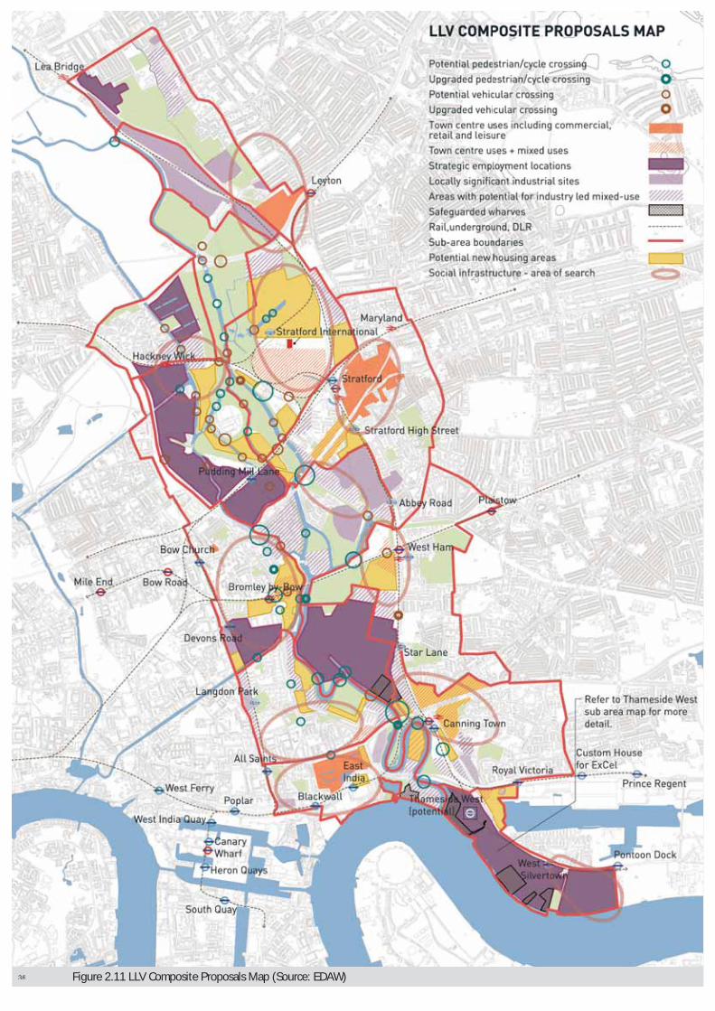
| OPPORTUNITY AREA PLANNING FRAMEWORK
LOWER LEA VALLEY
Figure 2.11 LLV Composite Proposals Map (Source: EDAW) 36

OPPORTUNITY AREA PLANNING FRAMEWORK | 37
LOWER LEA VALLEY

38 | OPPORTUNITY AREA PLANNING FRAMEWORK
LOWER LEA VALLEY

OPPORTUNITY AREA PLANNING FRAMEWORK | 39
LOWER LEA VALLEY
3.1. This section considers the specific issues, opportunities and land use scenarios in each borough as a result of the LLV RS. The potential for land use change across the LLV is examined at the following levels:
a. Borough wide (in this section): incorporating a brief review of the existing context and policy status for each of the four Boroughs, and presenting borough-wide profiles of land use change to 2016.
b. Sub-area specific (in section 4): presenting strategic proposals for each of the fifteen identified sub-areas highlighting the potential for land use change and key strategic and local interventions that are required to achieve Valley-wide objectives and create mixed and balanced sustainable communities.
LONDON BOROUGH OF HACKNEYContext & Policy Status
3.2. LB Hackney makes up 6% of the LLV Opportunity Area with 79 hectares. It has the highest proportion of green space (40% of its LLV area). The LLV RS proposes release of approximately 30% (10ha) of industrial land in LBH, most of which is allocated to new green space, due to the incorporation of the land use proposals in the Olympic and Legacy Planning Permissions (2004 O&LPP).
3.3. The Hackney Wick SPG contains the following core elements:
• The majority of the development would comprise B1 (business), B2 (general industrial), D1 (non residential institutions), and D2 (assembly and leisure), with a limited proportion of C3 (dwelling houses);
• Employment generating development is sought for the north east, south east and south west of the area. A key objective is to secure some uses of regional, national and even international significance, thereby fulfilling the employment potential of this significant site. B2 (general industrial) development in the area should be of a high quality, and be a demonstrably “good neighbour” use. B8 uses (storage or distribution centres) would be excluded from the area due to their limited impact on employment generation;
• Transport infrastructure improvements, especially to the quality and frequency of the North London Line service to Hackney Wick, alongside station improvements, will be needed to support the new developments and improve access from the area to London’s transport network;
• Where reconfiguration of Metropolitan Open Land (MOL) and common land is proposed, it is expected that reprovision will comprise a net gain in MOL accessible to the community.
Housing Outputs and Opportunities.3.4. Based on strategic assumptions of industrial land release in the
LLV, Hackney Wick has the potential capacity to deliver a total of between 350 and 360 new homes.
SECTION 3: BOROUGH WIDE ISSUES, OPPORTUNITIES AND LAND USE SCENARIOS
LLV Borough Hackney
Date of adopted UDP 1995
Key land use designations inthe UDP
Defined employment areas and protected open space (Metropolitan Open Land).
Future Review Process
Hackney has adopted an SPG for the Hackney Wicksection of the LLV, based on early work emerging as part of the JAAP process. The Council has given a commitment to keep the SPG under review to reflect the LLV OAPF and the emerging Hackney LDF and will investigate taking forward the policies contained within the SPG as an Area Action Plan as part of its LDF. TheCouncil prepared an Issues and Options version of the Core Strategy. Public consultation took place from 5 December 2005 to 28 February 2006. A consultation report on the Issues and Options will be published andconsidered in the preparation of the LDF Core StrategyPreferred Option.
Table 3.1: LBH Summary of Borough Local Development Frameworks (Source: EDAW)

40 | OPPORTUNITY AREA PLANNING FRAMEWORK
LOWER LEA VALLEY
LONDON BOROUGH OF NEWHAMContext & Policy Status
3.5. LB Newham makes up approximately 60% of the LLV Opportunity Area, with 738 hectares. Residential and industrial uses each make up around a third of this area, with 10% in green space. The LLV RS proposes release of up to 53% of Newham’s industrial base in the LLV, most of which is allocated for new housing development and significant increases in green space. The combined development of Stratford City and the 2004 O&LPP would introduce a new retail and office core, and legacy sports facilities.
3.6. The eastern side of the River Lea, extending from Stratford to Thameside has been identified as a key regeneration area by the London Borough of Newham, providing an ‘Arc of Opportunity’ to accommodate new jobs and housing. The LLV OAPF provides a context for the managed transition from traditional industrial uses, bringing forward the most accessible sites first, and creating the conditions to assist regeneration.
3.7. Key priorities include:
• Creating mixed and balanced sustainable communities in line with local and strategic policies;
• Improving the quality of the physical environment, in particular through the under grounding of the overhead power lines and removal of pylons;
• Enhancing accessibility into and through the Arc through the suggested introduction of a north-south spine road and better connections throughout the area;
• Enhancing the waterside and natural environments; and
• Managing the phased release of surplus industrial land, including the appropriate relocation of uses and activities.
Housing Outputs and Opportunities3.8. Based on strategic assumptions of industrial land release to
2016 Newham has the potential capacity to deliver a total of between 24,000 and 30,500 new homes. 4,440 of these would be delivered as part of Stratford City, and 8,107 as part of the 2004 O&LPP. A further 9,750 units could be delivered in the borough through development in new residential areas, 6,350 through mixed use development, and 2,000 from potential residential intensification17 focused on new and existing town centres at Stratford, West Ham and Canning Town, and through estates renewal.
LONDON BOROUGH OF TOWER HAMLETSContext & Policy Status
3.9. LB Tower Hamlets makes up approximately 22% of the LLV Opportunity Area, with 273ha. Almost half is existing residential area, with 38% industrial. LB Tower Hamlets has the lowest proportion of green space (3%) in the LLV. The LLV RS proposes release of up to 37% of Tower Hamlet’s industrial base in the LLV, most of which is allocated for new housing development.
3.10. The AAP highlights the diminished demand for industrial land in the area and the consequent identification of Leaside as a national regeneration priority and part of London’s 2012 Olympic area. There is an opportunity to transform the quality of the environment and develop land for a balance of different uses. This will provide more leisure, retail and employment opportunities, as well as new homes. Homes will be supported by modern social and community facilities such as new parks, schools, health centres and places of worship. Improved connections such as new bridges, public transport routes and pedestrian and cycle paths will link new residential areas and existing communities with new opportunities and facilities created through regeneration.
3.11. Key policies in the Preferred Options consultation Leaside AAP are to:
• Capture the investment potential provided by the Olympics and Paralympic Games to benefit local people including new homes, jobs and facilities;
• Retain employment land in parts of Fish Island, Empson Street/St Andrew’s Way and Gillender Street;
LLV Borough Newham
Date UDP Adopted 2001
Current UDPTimescale 10-15 years
Key LLV land usedesignations within the UDP
Principle employment location / industrial area + protected areas of open space.
Future ReviewProcess
Newham intends to produce an Area Action Plan forStratford and the Lower Lea Valley. This will furtherconsider boundaries of industrial employment land and mixed use areas, and these designations will bemonitored, reviewed and where necessary revised as part of the LDF process. The Council will prepare a preferred options version of the Core Strategy and Area ActionPlan for the Royal Docks and Thameside West area forconsultation Spring 2007 and subsequent adoption.
Table 3.2: LBN Summary of Borough Local Development Frameworks(Source: EDAW)
17: Where in accordance with local and strategic policy, in particular Newham’s Vision for Mixed Communities, approved by Borough Cabinet 15/12/2005.
LLV Borough Tower Hamlets
Date UDP Adopted 1998
Current UDP Timescale 10 years
Key LLV land use designations withinthe UDP
Majority zoned as Industrial employment land for B1, B2 & B8 Land uses
Future Review Process
Tower Hamlets produced a consultation draft first deposit UDP in May 2004, including an outline Area ActionFramework for Leaside. Subsequently, Tower Hamlets is preparing an Area Action Plan for Leaside (that part of the LLV within Tower Hamlets). The preferred options for the Leaside AAP were launched for public consultation in September 2005, with the final AAP intended to be adopted in 2008.
Table 3.3: LBTH Summary of Borough Local Development Frameworks(Source: EDAW)

OPPORTUNITY AREA PLANNING FRAMEWORK | 41
LOWER LEA VALLEY
• Promote new business space, especially for design and design-related manufacturing and creative arts and cultural industry uses in the Leamouth and Three Mills area;
• Allow higher density developments in appropriate locations, such as near Bromley-by-Bow station;
• Require a range of housing types, especially larger homes;
• Support 3 new primary schools and modern health care centres to meet the needs of existing and new communities; and
• Support the extension of the Olympic Park alongside the River Lea to the Thames, and a new district park at Leven Road.
3.12. The Preferred Policy Option in the Leaside AAP identifies that Fish Island East and the part of Fish Island South will be reserved for Olympic and related infrastructure uses unless it is demonstrated that these areas are not required for these uses. The 2004 O&LPP for Fish Island East indicated that this area would be developed for a residential mixed use development including a new primary school with the southern part of the site providing a new legacy sports and leisure use. That part of Fish Island South developed for the Olympic temporary parking and drop off facility will remain as an employment area. These employment proposals will be guided by a Master Plan, which will be prepared for the site.
Housing Outputs and Opportunities3.13. Based on strategic assumptions of industrial land release to
2016, Tower Hamlets has the potential capacity to deliver between 7,560 and 8,340 new homes. Of these, 919 would be delivered as part of the 2004 O&LPP, a further 3,500 units could be delivered in the borough through development in new residential areas, 1,700 through mixed use development and 2,000 from intensification of existing residential areas (including estates renewal)18.
LONDON BOROUGH OF WALTHAM FORESTContext & Policy Status
3.14. LB Waltham Forest makes up approximately 10% of the LLV Opportunity Area, with 128ha. No significant reallocation of land is proposed in LBWF.
3.15. The north of the Waltham Forest area contained within the OAPF area is known as Lea Bridge and the southern part is known as Leyton. Despite being a relatively small zone within the LLV, it is clear that the area will play a major role in improving Leyton and the wider implementation of Waltham Forest’s regeneration agenda.
3.16. The area includes Leyton Mills, part of the existing district centre and location of the recently developed ASDA store and other A1 and A3 uses. The strip of land running north-south, parallel to the Stratford railway line is the former Temple Mills marshalling yard and is safeguarded for rail or related uses in connection with the Channel Tunnel Rail Link. The parcel of land bounded by the A106 to the north, the A12 to the south,
Temple Mill Lane to the west and the railway line to the east is designated as a borough employment area (BEA18, Temple Mills Lane). The zone to the north west of BEA 16 is also an employment area. The northern and north-western sections of the zone are identified as ‘Mixed Use Regeneration Areas’. The A12 road which traverses the Temple Mills area east-west is part of the Transport for London Road Network (TLRN).
3.17. The adopted 2006 UDP identifies that there are two major areas of regeneration activity within the Lee Valley Regeneration Corridor, which broadly correspond to Principal Industrial Locations (PILs). They consist of:
• Blackhorse Lane; and
• Lea Bridge Gateway, extending to Temple Mills
3.18. The Lea Bridge Gateway and Leyton areas are identified as the most significant locations of current regeneration activity in the borough, extending northwards from Stratford. There is in excess of 40 hectares of vacant or underused land in the area, which is currently being redeveloped. This consists of the 9.3 hectare Civil Engineer’s Depot site, which has been developed and is now known as Leyton Mills; the 25 hectare former Marshalling Yards, which is currently under construction for the CTRL depot or safeguarded for CTRL use; the 4 hectare (11 acre) former town gas works site, which is intended to be developed for a cluster of food industry firms; and, the 1.4 hectare Auckland Road site, which is identified as a potential relocation site to accommodate displaced activity from the O&LPP area. In addition, there are potential redevelopment sites in the Argall Avenue industrial area, including the former Low Hall Tip site (2.7 hectares), which has been redeveloped for industrial use.
Housing Outputs and Opportunities3.19. Based on the levels of recent development in this part of
Waltham Forest there is limited scope for further industrial land release to 2016. Net new development capacity is limited, and principally expected through the intensification of existing residential areas19.
3.20. In terms of improving accessibility, a number of opportunities exist including: improving the Leyton tube station; providing a new station at Lea Bridge; re-instating the Hall Farm Curve (to the north of the Valley) thus enabling a Metro service to link the strategic centres of Chingford, Walthamstow, Lea Bridge, and Stratford; and, increased services have been running between Stansted and Stratford since December 2005, while improved public transport and better pedestrian and cycle links could do much to address current accessibility problems.
18: Where in accordance with local and strategic policy.
LLV Borough Waltham Forest
Date UDP Adopted March 2006
Key land usedesignations inthe UDP
Protected open space (Metropolitan Open Land).
Future ReviewProcess
The London Borough of Waltham Forest is now developing its LDF. The core strategy is planned to beadopted in Spring 2009.
Table 3.4: LBWF Summary of Borough Local Development Frameworks (Source: EDAW)
19: Where in accordance with local and strategic policy.

42 | OPPORTUNITY AREA PLANNING FRAMEWORK
LOWER LEA VALLEY

OPPORTUNITY AREA PLANNING FRAMEWORK | 43
LOWER LEA VALLEY
SECTION 4: SUB AREA ISSUES, OPPORTUNITIESAND LAND USE SCENARIOS
SUB-AREA 1: LEYTONSub-Area Definition, Location and Character
4.1. This is the northernmost of the 15 sub-areas, and is bounded by Lea Bridge Road, Church Road, Oliver Road, Ruckholt Road, York Road, Alexandra Road and Leyton High Road on the northern and eastern sides. Its western and southern boundaries run along the Lea Valley Railway line, Orient Way, Temple Mill railway lands, and the Central Line Railway. The sub area links to Leyton town centre which has good east-west public transport linkages and a wide range of retail and leisure activity. Leyton town centre and the wider Leyton area will benefit from capitalising on the opportunities that can flow from the Olympic park and Stratford City developments. Some of the borough’s most deprived wards, Leyton, Cathall and Cann Hall adjoin the Olympic Park in the LLV. Redevelopment of the LLV offers a key opportunity for the borough to address local deprivation.
4.2. The sub-area borders sub-areas 2 (New Spitalfields) and 4 (Wider Stratford City), to the west and south respectively. The sub-area is entirely within LB Waltham Forest. The sub-area contains residential communities along its eastern edge, together with a mix of commercial and industrial activities along its western and northern edges, including the Lea Bridge Gateway Strategic Employment Location (SEL).
The Potential for Land Use Change4.3. The potential for land use change in the sub-area is limited
by a number of existing development activities that are well established and are land use fixes. Proposals for change in this sub-area are principally for intensification of existing residential areas20, and redevelopment of some industrial areas with mixed use typologies, to deliver residential units without loss of industrial floor space.
Sub-Area Proposed Components4.4. Residential Uses: No significant land use change or industrial land
release is suggested across this sub-area. The Leyton Sub-area has the potential capacity to deliver around 20 net additional units through intensification of existing residential areas. This sub-area is particularly suited to delivery of family housing.
4.5. If the proposed re-opening of the railway station at Lea Bridge Road is committed, additional housing capacity through higher density development, more mixed use typology and/or some industrial land release could be achievable in the north of the sub-area, provided that this does not incur a net loss of industrial capacity, or prejudice employment functions.
4.6. Commercial Uses: There is no industrial land release or new retail or office space suggested across this sub-area. The boundary of the Lea Bridge Gateway SEL should be retained. Further development in the sub-area should seek to:
• Intensify industrial activity where appropriate;
• Focus new industrial development on B1 activity, with limited B2 and B8 uses; and
• Restrict industrial activities incompatible with residential uses in areas adjacent to residential areas.
4.7. In order to achieve Valley-wide objectives and create mixed and balanced sustainable communities, the level of potential land use change envisaged for the sub-area should be supported by strategic and local interventions. Development proposals within each sub-area will be expected to provide an appropriate reasonable contribution towards the cost of delivering the identified strategic and local interventions.
4.8. Social/Community: Development in the sub-area should include, or contribute towards strategic interventions to provide:
• A two GP local surgery to support the existing and potential residential development.
4.9. A further piece of work is required to accurately plan the delivery of these facilities in relation to the likely phasing of housing and the resultant populations.
20: Where in accordance with local and strategic policy.

44 | OPPORTUNITY AREA PLANNING FRAMEWORK
LOWER LEA VALLEY
Green routesRetained open space Potential new open spacePartial new open space (location not defined)Open space outside sub-area boundaryOther industrial areasSEL (strategic employment locations)LSIS (locally significant industrial sites)Partial retail/office mixed-useExisting town centre uses including commercial,retail and leisurePotential mixed use, retail and commercialPotential new housing areasSocial infrastructure - Area of search
Figure 4.1 Leyton Sub-area Site Plan
Existing railway stationProposed railway stationExisting underground stationExisting DLR stationProposed DLR stationExisting A-roadsPotential or improved vehicular crossingPotential or improved cycle/pedestrian crossingSub-area boundaryPotential release of existing SELPrecise boundary of retained SEL to be definedLegacy sports facilities Legacy sports facilities (location not defined)Silvertown/Greenwich safeguarded river crossingSafeguarded wharves
OPPORTUNITY AREA PLANNING FRAMEWORK | 45
LOWER LEA VALLEY
4.10. Open Space: Development in the sub-area should include, or contribute towards strategic and local interventions to provide:
• The consolidation of a series of disparate open spaces to form the most northern of the six major park spaces within the LLV open space network as set out in this document;
• Retention of all existing open space along with the current mix of functions and uses – sports provision, informal recreation, ecological areas and allotments;
• A 3.2ha ‘SCORE’ sports facility on the south east edge of the sub-area to link into the existing open space areas to the west. This project was completed in 2005 and has significantly increased the provision of local sports facilities;
• Environmental improvement works to park spaces and ongoing maintenance (target of Green Flag standard) focussed on defining appropriate edges to, and improving access into and within the open space; and
• The integration of open space and watercourses.
4.11. Waterways: Dagenham Brook is a relatively small watercourse which flows in a south east direction through the sub-area. In the north, the Brook is in an open canalised course adjacent to or within open space areas. To the south the water course is fully culverted. The watercourse is polluted and would benefit from treatment by provision of reed beds in the open spaces through which it flows, which would also potentially include areas for flood storage. Development in the sub-area should include, or contribute towards local interventions to provide ecological enhancement through re-grading of bank edges, as set out in Development Principle A7.
4.12. The northwest corner of the sub-area lies within PPG25 Flood Zone 2. Two smaller areas alongside Dagenham Brook are defined as Flood Zone 3. These areas are likely to be inundated during a flood event even with flood defences fully operational.
4.13. There is relatively little land use change suggested for this sub-area. In terms of flood risk, the most significant change is in the increase in residential development in particular family housing. Such development should be located away from flood risk areas in the northwest corner and along Dagenham Brook in the sub-area’s north-eastern edge. Mitigation measures may need to be considered, including flood resistant building design and ensuring access can be maintained during a flood event. Whilst the use of Sustainable Urban Drainage Systems (SUDS) are promoted throughout the LLV, they should form an integral element of the overall design of all new development in this sub-area, because of the particular risks of drainage and flooding. SUDS will regulate groundwater infiltration and through-flow, minimising the peaks in release of water associated with the impermeable surfaces of the built environment and therefor offering a form of flood mitigation. Development at Orient Way provides an example of a particularly successful SUDS scheme.
4.14. Transport & Movement Infrastructure: Development in the sub-area should include provision for, or contribute towards, funding or investigation of the following strategic and local transport interventions:
• Re-opening of Lea Bridge Station at the north end of the sub-area (currently being tested by stakeholders);
• Upgrading of local movement routes to link this sub-area’s park space to the LLV park network and LVRP at Hackney Marshes, as well as linking the mixed use and residential areas to the park spaces, and improving connections to the retail warehouse development in the south of the sub-area and Leyton Station;
• Suggested replacement of the existing pedestrian bridge at the north of the park space with a new pedestrian and cycle bridge over the railway lands as part of an upgraded route linking to Hackney Marshes in the west;
• Upgrades to pedestrian and cycle routes along Ruckholt Road, linking the southern end of this sub-area’s park space to Hackney East Marsh;
• Provision of pedestrian and cycle routes along Orient Way connecting the above two routes and integrating the various elements of the park space together;
• Improvements to orbital movements around the North Circular; and
• Improved bus services in the surrounding area.
4.15. Engineering: As part of the Games delivery, the over-ground electricity cables will be under-grounded to release land for development and improve the visual character of the area.
Local Masterplanning4.16. A masterplan or planning and development brief worked up
in partnership between the GLA, TfL, LDA, LTGDC and LLV borough(s), as appropriate, could usefully indicate how the strategic development proposals can be delivered at a local level.

46 | OPPORTUNITY AREA PLANNING FRAMEWORK
LOWER LEA VALLEY
Figure 4.2 New Spitalfields Sub-area Site Plan
Green routesRetained open space Potential new open spacePartial new open space (location not defined)Open space outside sub-area boundaryOther industrial areasSEL (strategic employment locations)LSIS (locally significant industrial sites)Partial retail/office mixed-useExisting town centre uses including commercial,retail and leisurePotential mixed use, retail and commercialPotential new housing areasSocial infrastructure - Area of search
Existing railway stationProposed railway stationExisting underground stationExisting DLR stationProposed DLR stationExisting A-roadsPotential or improved vehicular crossingPotential or improved cycle/pedestrian crossingSub-area boundaryPotential release of existing SELPrecise boundary of retained SEL to be definedLegacy sports facilities Legacy sports facilities (location not defined)Silvertown/Greenwich safeguarded river crossingSafeguarded wharves

OPPORTUNITY AREA PLANNING FRAMEWORK | 47
LOWER LEA VALLEY
SUB-AREA 2: NEW SPITALFIELDSSub-Area Definition, Location and Character
4.17. This sub-area is bounded by Orient Way and Marshall Road to the east and by the River Lea, Sherrin Road and Ruckholt Road and Temple Mill Lane to the west and southwest. Its southern boundary is the A12 Eastway. The sub-area lies entirely within the London Borough of Waltham Forest, and generally suffers from poor accessibility due to the barriers created by the main transport corridors to the south and east.
4.18. The sub-area contains the New Spitalfields Market, the proposed Eurostar North Pole depot in Temple Mills, and several industrial activities bordering the railway lines that run directly through the sub-area.
4.19. The potential for land use change in the sub-area is limited by a number of existing development activities that are well established and should be treated as development fixes. These include the New Spitalfields Market and the Eurostar proposal. No significant industrial land release is suggested in the sub-area.
Sub-Area Proposed Components4.20. Residential Uses: No residential uses are suggested for this
sub-area.
4.21. Commercial Uses: No significant industrial land release is suggested in the sub-area. The cluster of specialised industrial activity at Spitalfields for food wholesale should be protected and promoted by the GLA and the Boroughs. The existing use of railway lands and market activities will be maintained. No new physical commercial development is suggested apart from the possible introduction of additional railway sidings (see below).
4.22. Development proposals within each sub-area will be expected to provide an appropriate and reasonable contribution towards the cost of delivering the identified strategic and local interventions.
4.23. Social / Community: No social or community uses are suggested for this sub-area.
4.24. Open Space: No new open spaces are suggested for thissub-area.
4.25. Waterways: The River Lea forms the western boundary of the northern part of this sub-area. The river here is semi-tidal and canalised within relatively steep, vegetated banks. The river levels fluctuate daily with the tide, and markedly with fluvial flood flows. This will necessitate careful design of the enhancements. Development in the sub-area should include, or contribute towards local interventions to provide ecological enhancement through re-grading of bank edges, as set out in Development Principle A7.
4.26. Most of the area lies within PPG25 Flood Zone 2, with limited areas along the river banks in Flood Zone 3. This will be a consideration should any future land use change be contemplated. Although actual flood risk in this sub-area is limited to the land alongside the watercourse plus the railway and associated lands, the majority of the zone is at residual risk of flooding from an extreme flood event, which would result in inundation of the majority of railway and associated lands. The topography suggests that breach hazard is low. The flood risk implications for the currently suggested land uses do not require significant mitigation measures in this sub-area, although suitable mitigation measures may need to be considered for any proposed railway siding development.
4.27. Transport and Movement Infrastructure: The Olympic development will require the relocation of railway sidings currently located at Thornton Fields, potentially to the southern part of the sub-area in WF12.
4.28. Development in the sub-area should include provision for, or contribute towards, funding or investigation of the following strategic and local transport interventions:
• An upgrade to the pedestrian and cycle route on Ruckholt Road to provide a primary pedestrian/cycle connection linking Leyton (Sub-area 1) to the southern part of the Valley, including linking park areas in Sub-areas 1 (Leyton) and 3 (Lea River Park).
4.29. Engineering: As part of Olympic and Paralympic Games delivery, the over-ground electricity cables will be under-grounded although the implications for this sub-area are limited.
Local Masterplanning4.30. A masterplan or planning and development brief worked up in
partnership between the GLA, TfL, LDA, LTGDC and the London Borough of Waltham Forest could usefully indicate how the strategic development proposals can be delivered at a local level. An initial priority is to consider the area around Leyton and New Spitalfields.

48 | OPPORTUNITY AREA PLANNING FRAMEWORK
LOWER LEA VALLEY
Figure 4.3 Lea River Park Sub-area Site Plan
Green routesRetained open space Potential new open spacePartial new open space (location not defined)Open space outside sub-area boundaryOther industrial areasSEL (strategic employment locations)LSIS (locally significant industrial sites)Partial retail/office mixed-useExisting town centre uses including commercial,retail and leisurePotential mixed use, retail and commercialPotential new housing areasSocial infrastructure - Area of search
Existing railway stationProposed railway stationExisting underground stationExisting DLR stationProposed DLR stationExisting A-roadsPotential or improved vehicular crossingPotential or improved cycle/pedestrian crossingSub-area boundaryPotential release of existing SELPrecise boundary of retained SEL to be definedLegacy sports facilities Legacy sports facilities (location not defined)Silvertown/Greenwich safeguarded river crossingSafeguarded wharves

OPPORTUNITY AREA PLANNING FRAMEWORK | 49
LOWER LEA VALLEY
SUB-AREA 3: LEE RIVER PARKSub-Area Definition, Location and Character
4.31. This sub-area is bounded by New Spitalfields Market and Hackney Marshes to the north and west, the Clays Lane Estate and Stratford City site to the east, and Waterden Road to the west. The sub-area lies across the boundaries of the London Boroughs of Hackney, Newham and Waltham Forest.
4.32. The sub-area contains a considerable amount of open space, including Hackney East Marsh, Eton Manor Sports Ground and the Eastway Cycle Circuit. It also contains some industrial uses between Waterden Road and the River Lea. The southern part of this strip of land is proposed to provide a key western access point into the Stratford City development.
4.33. The 2004 O&LPP covers the entire part of this sub-area. The sub-area includes most of the northern part of the Olympic and Legacy park space, as well as a number of Olympic sports facilities, some of which are retained after the Games.
The Potential for Land Use Change4.34. The potential for land use change in the sub-area is governed
by the O&LPP, although this is limited in real terms with most of the area retained in park use in Legacy. The core objectives for this sub-area are to enhance its parkland and waterway setting. This will include improvement of existing park areas to create coordinated larger areas of open space with major sports facilities, areas for passive recreation and significant ecological habitat areas.
Sub-Area Proposed Components4.35. Residential Uses: Based on strategic assumptions of industrial
land release in the LLV, the Lee River Park Sub-area has the potential capacity to deliver up to 250 units at an average overall density of 340dph (875 hrph), along the eastern edge of the sub-area, contiguous with new housing development to the north of Stratford City. Of the total potential capacity, the 2004 O&LPP development provides for 230 units, as part of the O&LPP development, through conversion of the Olympic Athletes’ Village. Without implementation of the O&LPP, the modelling work undertaken in the LLV RS PO would indicate that lower densities would be appropriate, with only around 30 new units provided in the sub-area at densities of 65-110dph (225-325 hrph).
4.36. Commercial Uses: The strategic assumptions of industrial land release in the LLV include the potential release of 6.1ha of existing industrial land in the sub-area, to be used as Olympic concourse and subsequently incorporated into the Legacy Park. The 2004 O&LPP proposes a small amount of commercial office space (approximately 5,803 sqm) as part of the Legacy Plans.
4.37. In order to achieve Valley-wide objectives and create mixed and balanced sustainable communities, the level of potential land use change envisaged for the sub-area should be supported by strategic and local interventions. Development proposals within each sub-area will be expected to provide an appropriate and reasonable contribution towards the cost of delivering the identified strategic and local interventions.
4.38. Social / Community: No social or community uses are suggested within this sub-area.
4.39. Open Space: The 2004 O&LPP proposes the following strategic interventions:
• Creation of the second major park space in the proposed LLV open space network set out in this document – the Lee River Park – as the largest contiguous area of open space within the study area. This will provide: a mix of high quality sports facilities, a diverse mix of new ecological habitats, and a stunning new landscape with a network of accessible spaces for more passive recreation;
• Towards the east of the sub-area, where the existing open space areas of Eaton Manor and Eastway will be comprehensively redeveloped for Olympic sports venues. Much of this will be retained in parkland after the Games;
• Major topographical change on both sides of the River Lea, and potential realignment of the river course in the south of the sub-area. The new Legacy Park will encompass existing and new open space on either side of a widened river valley, providing ecological habitats and informal recreation areas in a riverine landscape; and
• In the north of the sub-area, where Hackney East Marsh will be least affected by the Olympic Park development (except for temporary use during the Games period for car parking), but will be returned to its existing use as sports pitches, with improvements to these facilities.
4.40. Waterways: The waterways in the sub-area suffer from poor water quality. The 2004 O&LPP includes commitments to deliver the following strategic interventions:
• De-canalisation of the Lea River south of the A12 flyover to create a naturalised river corridor to provide ecological, recreational and landscape benefits, and enhance flood storage capacity for the Olympic Park.
4.41. The majority of this sub-area is in PPG25 Flood Zone 1 (low risk); however, it is likely that the Olympic and Paralympic Games proposals will require considerable topographical change which will require consideration of flood risk for the Games and Legacy uses. Proposed Legacy development in this sub-area includes residential development, much of which is intended as family housing and therefore a more vulnerable development type.

50 | OPPORTUNITY AREA PLANNING FRAMEWORK
LOWER LEA VALLEY
Figure 4.4 Wider Stratford City Sub-area Site Plan
Green routesRetained open space Potential new open spacePartial new open space (location not defined)Open space outside sub-area boundaryOther industrial areasSEL (strategic employment locations)LSIS (locally significant industrial sites)Partial retail/office mixed-useExisting town centre uses including commercial,retail and leisurePotential mixed use, retail and commercialPotential new housing areasSocial infrastructure - Area of search
Existing railway stationProposed railway stationExisting underground stationExisting DLR stationProposed DLR stationExisting A-roadsPotential or improved vehicular crossingPotential or improved cycle/pedestrian crossingSub-area boundaryPotential release of existing SELPrecise boundary of retained SEL to be definedLegacy sports facilities Legacy sports facilities (location not defined)Silvertown/Greenwich safeguarded river crossingSafeguarded wharves

OPPORTUNITY AREA PLANNING FRAMEWORK | 51
LOWER LEA VALLEY
4.42. In light of the topographical change envisaged, new development should be located on higher ground away from areas at risk of flooding. Mitigation measures may need to be considered, including:
• Flood resistant building design;
• Provision of additional flood water storage capacity through river channel naturalisation;
• Storm and surface water attenuation measures; and
• Ensuring access to development can be maintained during a flood event.
4.43. Transport and Movement Infrastructure: The 2004 O&LPP proposed the following strategic interventions:
• New pedestrian and cycle routes through the park space,in particular:
- east-west routes linking Stratford City (Sub-area 4)and Hackney Wick (Sub-area 5); and,
- North-south routes along the river and over the proposed land bridges (see below), linking park spaces together, and providing continuity for a wider route network leading south from the Lee Valley Regional Park.
4.44. Engineering: The 2004 O&LPP permissions include commitments to deliver the following strategic interventions:
• Under-grounding of the over-ground electricity cables to release land for development and improve the visual character of the area;
• Provision of two land bridges – one at the north linking across the A12 and Ruckholt Road, to provide the northern access to the Olympic Park and ensure continuity of the Legacy Park space with the LVRP; the second at the southern end of the sub-area will cross over the North London Line Railway and Carpenters Road, to ensure continuity of the Olympic Concourse and subsequently of the Legacy Park. The second land bridge should be designed and constructed so as to minimise the impact on the unique Carpenters Road Lock.
Local Masterplanning4.45. A masterplan or planning and development brief worked up
in partnership between the GLA, TfL, LDA, LTGDC and LLV borough(s), as appropriate, could usefully indicate how the strategic development proposals can be delivered at a local level.
SUB-AREA 4: WIDER STRATFORD CITYSub-Area Definition, Location and Character
4.46. This sub-area is bounded by the A12 to the north, Leyton Road to the east, the Great Eastern Line rail corridor to the south, and City Mill River, River Lea and Eastway Cycle Circuit to the west. Most of the sub-area lies within the London Borough of Newham, with a small portion of the sub-area lying within Waltham Forest
4.47. The sub-area is currently dominated by the Stratford International Station and Stratford City construction sites. The 2004 O&LPP overlaps the Stratford City Development, and covers those parts of the sub-area to the north and south of it, including industrial areas at Carpenters Road, Thornton Fields railway sidings, Clays Lane residential area and open space to the north of this. There is an additional area of industrial activity along Leyton Road to the east of Stratford City.
The Potential for Land Use Change4.48. This sub-area will be subject to comprehensive land use change.
Preparatory works for the Stratford City development are under construction, and most of the industrial land in this area is suggested for release to other uses, due to the significant accessibility of the area with its new and existing transport connections, the strategic significance of the Olympic games and associated land use change implications.
4.49. The Olympic and Legacy proposals will have a considerable impact on the suggested land use for the Wider Stratford City Sub-area, with significant new areas of open space and new residential areas in the Legacy Plans. The northern and southern parts of the sub-area will house Olympic sports facilities, some of which will be retained in Legacy, including the Aquatics Centre, while additional housing and park space will also be delivered in these areas in Legacy. The Olympic Athletes’ Village is located in this sub-area, the majority of which will be delivered as part of the Stratford City development and on land to the north of Clays Lane. The proposed changes to the Olympic Park announced in July 2006 indicate that part of Chobham Farm south will be used for a temporary coach park during the Games phase. It will be important to ensure that both the Olympic and Stratford City developments are integrated with Stratford Town Centre in Sub-area 6.
4.50. Other proposals include the retention of industrial uses along the Lea Valley Line railway corridor, running along the eastern side of sub-area, and the addition of a limited new area of industrial use at the northern end of the sub-area, alongside the A12 Eastway, as a buffer to new residential development.
4.51. Release of the existing area of Metropolitan Open Land (MOL) at the northern end of the sub-area for Olympic and Legacy development is compensated for by both improvements to and extension of the remainder of the MOL area, and increased provision elsewhere (a land swap). This will be in Sub-area 7 (Fish Island) where a new park space will be created as part of the LLV park network, to a standard capable of being designated as MOL.

52 | OPPORTUNITY AREA PLANNING FRAMEWORK
LOWER LEA VALLEY
Sub-Area Proposed Components 4.52. Residential Uses: Based on strategic assumptions of industrial
land release in the LLV, the Wider Stratford City has the potential capacity to deliver between 7,440 and 9600 new homes with densities ranging across the sub-area from 85-340dph (265-875 hrph those at the top end located in areas with highest PTAL ratings).
4.53. Of the total potential capacity, the 2004 O&LPP provides for 3,758 units, and circa 5,000 units are provided as part of the Stratford City development. A further 900 units could be delivered in the sub-area through development of new residential areas, and 525 from mixed use residential development. The latter should be concentrated in the south east of the sub-area in the Leyton Road area (retail/office residential mix) and Chobham Farm area (industry led mixed use) provided this does not incur a net loss of industrial capacity, or prejudice employment functions. The 2004 O&LPP and Stratford City permissions retain the potential for some family houses to be developed at lower densities on the northern and eastern periphery of the sub-area.
4.54. Commercial Uses: The strategic assumptions of industrial land release in the LLV include the release of 25.4ha of existing industrial land in the western part of the sub-area. The Stratford City development will create a major new retail and office district to the north of the existing Stratford Town Centre (in Sub-area 6), with outline planning permission already granted for 465,000 sqm of B1(a) office space and 140,000 sqm of retail space. The 2004 O&LPP provides for a limited amount of new industrial space after the Games, principally in the north of the sub-area, with around 17,655 sqm allocated for B1(b,c), B2 and B8, as well as a domestic waste handling facility (see utilities), and 7,704 sqm of Class A1 and A3 retail floor space.
4.55. In order to achieve Valley-wide objectives and create mixed and balanced sustainable communities, the level of potential land use change envisaged for the sub-area should be supported by strategic and local interventions. Development proposals within each sub-area will be expected to provide an appropriate and reasonable contribution towards the cost of delivering the identified strategic and local interventions.
4.56. A further piece of work is required to accurately plan the delivery of these facilities in relation to the likely phasing of housing and the resultant populations.
4.57. Social / Community & Civic Facilities: The 2004 O&LPP and Stratford City permissions include commitments to retain the Olympic Aquatics Centre as a sport and leisure facility; to create a ‘Community Campus’, containing secondary and primary schools, with playing fields, as well as a ‘health hub’ or OSPCC and additional co-located social/community facilities; and to provide local employment initiatives. Further development in the sub-area should include, or contribute towards, a smaller community facility in the west of the sub-area, to house a 3 GP walk-in health centre.
4.58. Open Space: The 2004 O&LPP and Stratford City permissions include commitments to deliver the following strategic and local interventions:
• In the west of the sub-area, new open space provision, contiguous with, and part of, the major park area described in Sub-area 3, providing both ecological habitat areas and informal recreation provision.
• In the south and west of the sub-area, new open space provision contiguous with, and part of, the third major park area to be created around the multiple waterways of the Waterworks River, City Mill River, Pudding Mill canal and the River Lea (more fully described in Sub-area 7).
• In the north of the sub-area, new sports pitches to be developed on the Temple Mill Lane Recreation Ground and a range of connective green spaces and amenity spaces developed within the mixed use urban environment of Stratford City.
4.59. Waterways: Four watercourses run through the sub-area – the River Lea, Waterworks River, City Mill River, and Channelsea River/Henniker’s Ditch. The 2004 O&LPP include commitments to deliver the following strategic interventions:
• Decanalisation of parts of the Lea and Waterworks Rivers creating a naturalised river bank on one side and re-alignment of the Channelsea River through re-grading of topography in Sub-area 3.
4.60. The City Mill River is part of the non-tidal canal network on the western side of the LLV. Proposals for further development in the sub-area should include, or contribute towards some minor bank modifications to enhance ecological conditions, where this has no negative impact on the navigation of the waterways.
4.61. Parts of this sub-area lie within PPG25 Flood Zones 2 and 3, especially in the southwest of the sub-area around Carpenters Road. The existing defences are sufficient for protection against a 1% probability flood event. Breach Hazard analysis indicates a low to moderate hazard in the area west of Carpenters Road arising from a flood defence breach. In an Actual Risk scenario, which includes allowance for climate change impacts, the railway through CTRL site has a potential to actual as a conduit to flow. De-canalisation works must be carefully engineered to ensure no reduction in standard of defence or increase in flood risk. Any development, (especially housing) in this area will need to acknowledge flood risk. Mitigation measures should be considered, including:
• location of vulnerable uses away from affected areas;
• flood resistant building design;
• raising ground levels; and
• ensuring that access could be maintained during a flood event.

OPPORTUNITY AREA PLANNING FRAMEWORK | 53
LOWER LEA VALLEY
4.62. Transport and Movement Infrastructure: Government undertakings and the 2004 O&LPP and Stratford City permissions include commitments to deliver the following strategic interventions:
• Provision of a new International CTRL station, with links to Kings Cross, Kent and Europe, and commuter services from Ashford to Kings Cross;
• Upgrades to Stratford Central Station and new northern and western accesses;
• Conversion of part of the North London Line between Stratford and Canning Town to DLR operation, and a new link and station to Stratford International providing connections to the Royal Docks and Woolwich Arsenal;
• New access roads to the Stratford City development – western access linking to Waterden Road, southern access linking to Warton and Carpenters Roads;
• Several new bridges across waterways and railways, to provide both vehicular and pedestrian/cycle access for construction of the Olympic Park and circulation during the Games. Many of these will be retained in Legacy, although several will be reduced in size; and
• A new pedestrian bridge at Stratford Central railway station, linking the sub-area to the existing town centre to the south.
4.63. Further development in the sub-area should include provision for, or contribute towards, funding or investigation of the following strategic and local transport interventions:
• The running of Lea Valley and Stansted Services from Stratford means that the terminating rail platform(s) to the north of Stratford Station will be well used once again – it is vital that space is safeguarded in order to allow this rail infrastructure to function efficiently as a terminus;
• Improved access to open up sites and create new links across the LLV for public transport, pedestrians and cyclists as identified by the LLV Connections Study;
• New internal road networks integrating the sub-area internally and to the surrounding areas; and
• Possible new pedestrian bridges across the waterwaysand railways.
4.64. Engineering: As part of the Olympic and Paralympic Games delivery, the over-ground electricity cables are being under-grounded to release land for development and improve the visual character of the area.
4.65. Utilities: The 2004 O&LPP includes provision for a 2,500sqm waste handling facility to provide Olympic and Legacy domestic waste needs in the northern part of the sub-area.
Local Masterplanning 4.66. Zonal masterplans for the Stratford City area and new Olympic
submissions will need to evolve and refine the scope and scale of permitted development proposals.

54 | OPPORTUNITY AREA PLANNING FRAMEWORK
LOWER LEA VALLEY
Figure 4.5 Hackney Wick Sub-area Site Plan
Green routesRetained open space Potential new open spacePartial new open space (location not defined)Open space outside sub-area boundaryOther industrial areasSEL (strategic employment locations)LSIS (locally significant industrial sites)Partial retail/office mixed-useExisting town centre uses including commercial,retail and leisurePotential mixed use, retail and commercialPotential new housing areasSocial infrastructure - Area of search
Existing railway stationProposed railway stationExisting underground stationExisting DLR stationProposed DLR stationExisting A-roadsPotential or improved vehicular crossingPotential or improved cycle/pedestrian crossingSub-area boundaryPotential release of existing SELPrecise boundary of retained SEL to be definedLegacy sports facilities Legacy sports facilities (location not defined)Silvertown/Greenwich safeguarded river crossingSafeguarded wharves

OPPORTUNITY AREA PLANNING FRAMEWORK | 55
LOWER LEA VALLEY
Sub-Area Proposed Components4.72. Residential Uses: Based on strategic assumptions of industrial
land release in the LLV, Hackney Wick has the potential capacity to deliver between 350 - 360 new homes with densities ranging across the sub-area from 110-340dph (325-875 hrph) (those at the top end located in areas with highest PTAL ratings).
4.73. Of the total potential capacity the 2004 O&LPP proposed 49 units. A further 130 units could be delivered in the sub-area through development of new residential areas, 50 through intensification of existing residential areas22 and 133 from mixed use residential development. The latter should be concentrated around Hackney Wick Station or on the canalside especially at the southern end of the sub-area, through mixed use provided this does not incur a net loss of industrial capacity, or prejudice employment functions. Around 48% of the new potential units should be delivered as family sized accommodation (60% when including 2 bed social rented properties).
4.74. Commercial Uses: The strategic assumptions of industrial land release in the LLV includes the release of 4.5ha of existing Industrial land in the eastern part of the sub-area and release of up to 1 hectare through intensification of existing industrial areas west of the Lee Navigation, provided there is no net loss of industrial capacity in these areas. The boundary of the Hackney Wick SEL has been ratified through the London Plan SRDF process to reflect this potential release.
4.75. The cluster of specialised industrial activity at Hackney Wick for printing, food, and creative/cultural should be protected and promoted by the GLA and the boroughs. The southern and eastern parts of the sub-area sit within the principal area of mixed use industrial and commercial activity running north-south through the LLV.
4.76. The 2004 O&LPP proposed 52,666 sqm industrial floor space (Classes B1b, c, B2 and B8) and 51,757 sqm office space (B1a), focussed on Legacy use of the IBC/MPC. In addition to the 2004 O&LPP outputs further development around Hackney Wick Station could provide up to 3,600 sqm office space and 4,000 sqm of retail space (Class A1 and A3) in the form of a new local centre. Future masterplanning work will be needed to test the viability of retail and office proposals and should ensure that the viability and vitality of existing centres is not undermined.
4.77. Employment activities established after the Olympics should focus on reintroducing the specialised industrial activity and encouraging new and emerging industrial sectors. Industries should investigate use of the waterways as a transport route for the delivery and transhipment of suitable waterborne materials. New commercial activity should also be introduced as part of mixed use redevelopment. Mixed use development should not incur a net loss of industrial capacity. Industrial floorspace suggested to the west of Waterden Road should be designed in such a manner to ensure permeability and accessibility between residential uses in this sub-area and open space to the east of Waterden Road.
SUB-AREA 5: HACKNEY WICKSub-Area Definition, Location and Character
4.67. This sub-area is bounded by the A12 East Cross Route and Blackwall Tunnel Approach roads to the north and west, Wallis Road and the North London Line to the south, and Waterden Road to the east. The sub-area lies solely within the London Borough of Hackney.
4.68. The sub-area contains the Trowbridge residential estate, Gainsborough Primary School and the Arena Fields area of open space. The area is occupied primarily by industrial uses including manufacturing, distribution, wholesale, light industrial (particularly printing, food, and creative/ cultural) and vehicle depots. The sub-area is traversed by the River Lee Navigation, the North London Line runs along the southern boundary of the sub-area, and Hackney Wick mainline station is located to the south of the area. The eastern half of this sub-area, i.e. east of the Lee Navigation, falls within the Olympic and Legacy Planning Permissions (2004 O&LPP).
The Potential for Land Use Change4.69. The extent of land use change in this sub-area is driven by the
2004 O&LPP. Outside of the Olympic zone, there are limited proposals for land use change. Exisiting land uses include the established Trowbridge Estate residential area, a primary school, some minor industrial uses and local open space (Hackney Wick northwest). There is some potential for land use change around Hackney Wick Station to create a new centre of activity for the wider area, capitalising upon investment to enhance the capacity of Hackney Wick station as part of the 2004 O&LPP proposals, for example step free access and improvements to the station building and platforms environment.
4.70. Development for the Olympic and Paralympic Games will clear the existing uses east of the River Lee Navigation. During the Games this area will play host to a number of sports arenas, the International Broadcast Centre and Main Press Centre (IBC/MPC)21, and part of the Olympic Concourse on the far eastern side of the sub-area. Post Games this area will be redeveloped for a mix of uses, principally industrial, but also including a significant amount of green space or new water space. The consolidation of green space required to create the Olympic Concourse will be carried through to the Legacy, with Arena Fields reduced in size after the Games but an additional area of green space provided in the east of the sub-area as part of the park area described in Sub-area 3, creating a consolidated park space on either side of the River Lea.
4.71. Legacy redevelopment will retain one of the sports arenas as a multi-purpose sports venue. The Legacy use of the IBC/MPC should reinforce the existing Strategic Employment Location in the north-eastern part of the sub-area. Additional Legacy development will introduce mixed use development in the southern part of the sub-area, around the station and immediately east of the canal. The possibility of direct access into these areas from Hackney Wick Station should be explored.
21: As proposed in the ODA’s June 2006 Masterplan. 22: Where in accordance with local and strategic policy.
56 | OPPORTUNITY AREA PLANNING FRAMEWORK
LOWER LEA VALLEY
4.78. In order to achieve Valley-wide objectives and create mixed and balanced sustainable communities, the level of potential land use change envisaged for the sub-area should be supported by strategic and local interventions. Development proposals within each sub-area will be expected to provide an appropriate reasonable contribution towards the cost of delivering the identified strategic and local interventions.
4.79. Social/Community & Civic Use: The 2004 O&LPP includes a strategic intervention to retain the Olympic Arena for Legacy sporting and recreation use (approximately 4,500 to 5,000 sqm). Further development at Hackney Wick should include, or contribute towards, a small scale community space of approximately 130 sqm and investigate the potential for a new Water Safety Centre with canoe and boating facilities to encourage safe use of the extensive network of waterways. The existing travellers’ site will be relocated as a result of delivering the Games.
4.80. A further piece of work is required to accurately plan the delivery of these facilities in relation to the likely phasing of housing and the resultant populations.
4.81. Open Space: The 2004 O&LPP included the following strategic interventions:
• Increase the area of open space in the eastern part of the sub-area, through re-alignment of Waterden Road to the west, and inclusion of the area to the east of the new road alignment into a new park, as described in Sub-area 3.
• Reconfigure the existing open space at Arena Fields, reducing its size, but providing effective links to new open space in the east of the sub-area.
4.82. Waterways: Hackney Cut (canal) runs broadly north south through the centre of the sub-area. This canal is part of the Lee Navigation, and links into part of the wider canal network of east London, including the Hertford Union and Regents Canals to the west, and south to the Thames via the River Lea and Limehouse Cut. Strategic interventions could include new canal basins on either side of the Lee Navigation as redevelopment and intensification takes place, as long as the land uses set out in the LLV OAPF are maintained. Local interventions should include waterway enhancements such as minor bank modifications to enhance ecological values, as set out in Development Principle A7.
4.83. Most of the western part of this sub-area lies within PPS 25 Flood Zone 3 (Planning Policy Statement 25: Development and Flood Risk. Dec 2006). This area is not currently adequately protected by defences against a flood event of this magnitude. New development should therefore not be located in the western part of the sub-area unless mitigation measures are considered. These may include enhancing defences, flood resistant building design, ensuring access can be maintained during a flood event, and/or non-inclusion of vulnerable uses, such as family housing. Any works to the River Lee Navigation, including new canal basins, will need to be carefully engineered to ensure no reduction in standard of defence or increase in flood risk.
4.84. Transport and Movement Infrastructure: Government undertakings and the 2004 O&LPP permissions include the following strategic interventions:
• Upgraded access to Hackney Wick Station;
• New and improved links over the Lee Navigation, especially between the station and the new park area in Sub-area 3 (Lea River Park);
• Improvements to the Waterden Road environment to encompass segregated cycle and pedestrian links, an improved public realm and improved linkages to retained Olympic facilities;
• Improved accessibility through the provision of North-south links from Hackney Wick to Hackney Marshes;
• Improved connections and provision of safer routes in predominantly residential zones;
• Uniting neighbourhoods by improving connectivity between areas of recent and earlier housing;
• A strategy for current and future vehicle movements and access, particularly for heavy goods vehicles, in the area; and,
• New and improved links to Victoria Park, including links to and from Hackney Wick and the Olympic Park itself.
Local Planning Framework 4.85. A Local Planning Framework (paragraph 5.18) including a
masterplan, a phasing schedule and an investment strategy, worked up by a partnership of landowners, developers, the GLA, TfL, LDA, LTGDC and the London Borough of Hackney would usefully indicate how the development proposals can be delivered at a local level. It could also provide certainty that the required infrastructure will be delivered at the appropriate time. The Local Planning Framework could also consider the site area around Hackney Wick Station, incorporating infrastructure upgrades at the station, ensuring that retail provision contributes to the vitality and viability of existing and proposed neighbourhood centres and identifying the potential to introduce new uses along the canal-side frontages.

OPPORTUNITY AREA PLANNING FRAMEWORK | 57
LOWER LEA VALLEY
SUB-AREA 6: STRATFORDSub-Area Definition, Location and Character
4.86. This sub-area is bounded by City Mill River and the Bridge Road Jubilee Line Depot to the south and west, Manor Road, Vicarage Lane, Water Lane and Leytonstone Road to the east, and Leyton Road and the mainline/Central Line railway tracks to the north and west. The sub-area lies solely within the London Borough of Newham.
4.87. The sub-area contains predominately residential land uses including the Chobham, Skiers, Pond and Carpenters residential areas, as well as Stratford Town Centre. The town centre includes the rail and bus stations, mixed-use activities (mainly commercial) along the High Street, and mixed activities (leisure /residential/commercial) at Burford Road. The 2004 O&LPP overlaps the western part of the sub-area.
4.88. New investment in Stratford will rejuvenate the town centre and improve its retail, leisure and cultural facilities.
The Potential for Land Use Change4.89. In light of the established nature of residential and other town
centre activities, the existing land uses will be retained across most of this sub-area. Additional mixed use development is anticipated within the town centre, through intensification of existing sites and release of non-productive areas (such as surface parking).
4.90. The 2004 O&LPP would have a limited impact on the suggested land use for the Stratford Sub-area, with the southern half of the southern land bridge falling into this sub-area and a limited amount of residential development as part of the Legacy Plans. It will be important to ensure that both the Olympic and Stratford City development are effectively integrated with Stratford Town Centre.
4.91. Public Transport: Accessibility Levels will increase significantly with new bus, DLR, Crossrail and CTRL services. It is therefore anticipated that there will be significant market interest in delivering intensification in existing residential areas. If this were found to be acceptable23, then any such intensification would need to be carefully assessed and designed to ensure it would support and enhance existing communities and social infrastructure.
Sub-Area Proposed Components4.92. Residential Uses: Based on strategic assumptions of industrial land
release in the LLV the Stratford Sub-area has the potential capacity to deliver between 3,300 and 3,400 units at densities ranging across the sub-area from 110-440dph (325-1025 hrph) (those at the top end located in areas with highest PT AL ratings).
4.93. Of the total potential capacity, the 2004 O&LPP proposed 357 units. A further 500 units could be delivered in the sub-area through development of new residential areas, 1,500 from the potential intensification24 of existing residential areas, and around 990 could be expected from mixed use residential development which should be concentrated in the north of the sub-area in and around the town centre (retail/office residential mix) and Warton Road areas provided this does not incur a net loss of industrial capacity, or prejudice employment functions. Stratford sub area is considered to be highly appropriate for delivery of significant proportion of family housing, given the well-established communities and the imperative to deliver mixed, sustainable communities.
4.94. Commercial Uses: The strategic assumptions of industrial land release in the LLV, include the release of up to 11ha of existing industrial land in the western part of the sub-area, especially where sites are along or adjacent to Stratford High Street. The existing shopping centre could be redeveloped and intensified with new commercial development over the existing shopping centre. Retail and office development could be promoted in the town centre, with the potential to deliver additional retail floor space of up to 15,200 sqm and office floor space of up to 15,100 sqm. Further consideration should be given through the LB Newham LDF process to the role of Stratford as a centre for hospitality and entertainment, cultural facilities and creative industries.
4.95. In order to achieve Valley-wide objectives and create mixed and balanced sustainable communities, the level of potential land use change envisaged for the sub-area should be supported by strategic and local interventions. Development proposals within each sub-area will be expected to provide an appropriate reasonable contribution towards the cost of delivering the identified strategic and local interventions.
4.96. Social/Community: Development in the sub-area should include, or contribute towards, strategic interventions to provide a new 4 FE primary school, a 4 GP walk-in health centre and an associated large scale community space.
4.97. A further piece of work is required to accurately plan the delivery of these facilities in relation to the likely phasing of housing and the resultant populations.
23: I.E. in accordance with local and strategic policy. 24: Where in accordance with local and strategic policy.

58 | OPPORTUNITY AREA PLANNING FRAMEWORK
LOWER LEA VALLEY
Figure 4.6 Stratford Sub-area Site Plan
Green routesRetained open space Potential new open spacePartial new open space (location not defined)Open space outside sub-area boundaryOther industrial areasSEL (strategic employment locations)LSIS (locally significant industrial sites)Partial retail/office mixed-useExisting town centre uses including commercial,retail and leisurePotential mixed use, retail and commercialPotential new housing areasSocial infrastructure - Area of search
Existing railway stationProposed railway stationExisting underground stationExisting DLR stationProposed DLR stationExisting A-roadsPotential or improved vehicular crossingPotential or improved cycle/pedestrian crossingSub-area boundaryPotential release of existing SELPrecise boundary of retained SEL to be definedLegacy sports facilities Legacy sports facilities (location not defined)Silvertown/Greenwich safeguarded river crossingSafeguarded wharves

OPPORTUNITY AREA PLANNING FRAMEWORK | 59
LOWER LEA VALLEY
4.98. Open Space: The 2004 O&LPP proposed a 3ha open space in the western corner of the sub-area as part of a green link over a new land bridge across the Great Eastern Line Railway. This new open space is the southernmost point of the legacy Olympic park, and therefore adjacent developments should ensure that there are excellent views and links to this landscape from Stratford High Street, to maximise its benefits. It is important that a high quality ‘green link’ is achieved in the western part of the sub-area to connect the Olympic Park to the Greenway and south to the proposed LLV greenspace network. Further development in the sub-area should include provision for, or contribute towards, local interventions to improve the management and maintenance of the existing and potential open spaces (to Green Flag standards).
4.99. Waterways: Development in the sub-area should include, or contribute towards, strategic interventions to:
• Enhance the existing linear open space on the western bank of the Waterworks River, through breaking down concrete walls, re-grading and naturalising the banks; and
• Enhance City Mill River, through minor bank modifications to enhance ecological values, as set out in Development Principle A7.
4.100. A significant part of the southern and south-western parts of this sub area lies within PPG 25 Flood Zone 3. The results of the SFRA indicate that existing flood defences will protect most of this area except in an extreme flood event. A breach in flood defences could cause a high hazard at the rail overpass and a low hazard over a significant part of the western and southern areas. Family housing provision should be directed away from areas most at risk of flooding in the south west of the sub-area unless mitigation works are undertaken, including raising ground levels, flood resistant building design and ensuring access can be maintained during a flood event.
4.101 Transport & Movement Infrastructure: Government undertakings and the 2004 O&LPP and Stratford City permissions proposed the following strategic interventions:
• Strategic interventions comprise new DLR stations at Stratford High Street and Abbey Road.
• A new land bridge across the overland railways, improving local movement routes and providing continuity of green space from the Legacy Park southwards.
• A new pedestrian bridge at Stratford Central railway station, linking this sub-area with Stratford City to the north.
4.102 Further development in the sub-area should include provision for, or contribute towards, funding or investigation of the following strategic and local transport interventions:
• The results of the Stratford Gyratory study which considers the potential reconfiguration of the gyratory system;
• Improved access to open up sites and create new links across the LLV for public transport, pedestrians and cyclists as identified by the LLV Connections Study; and
• Coordinating improved access to the DLR stations with development of the wider local movement network, especially routes westwards from the stations.
4.103. Engineering: As part of the Olympic and Paralympic Games delivery, the over-ground electricity cables are being under-grounded to release land for development and improve the visual character of the area.
Local Planning Framework 4.104. A Local Planning Framework (paragraph 5.18) including a
masterplan, a phasing schedule and an investment strategy, worked up by a partnership of landowners, developers, the GLA, TfL, LDA, LTGDC and the London Borough of Newham would usefully indicate how the development proposals can be delivered at a local level. It could also provide certainty that the required infrastructure will be delivered at the appropriate time.

60 | OPPORTUNITY AREA PLANNING FRAMEWORK
LOWER LEA VALLEY
Figure 4.7 Fish Island and Marshgate Lane Sub-area Site Plan
Green routesRetained open space Potential new open spacePartial new open space (location not defined)Open space outside sub-area boundaryOther industrial areasSEL (strategic employment locations)LSIS (locally significant industrial sites)Partial retail/office mixed-useExisting town centre uses including commercial,retail and leisurePotential mixed use, retail and commercialPotential new housing areasSocial infrastructure - Area of search
Existing railway stationProposed railway stationExisting underground stationExisting DLR stationProposed DLR stationExisting A-roadsPotential or improved vehicular crossingPotential or improved cycle/pedestrian crossingSub-area boundaryPotential release of existing SELPrecise boundary of retained SEL to be definedLegacy sports facilities Legacy sports facilities (location not defined)Silvertown/Greenwich safeguarded river crossingSafeguarded wharves

OPPORTUNITY AREA PLANNING FRAMEWORK | 61
LOWER LEA VALLEY
SUB-AREA 7: FISH ISLAND AND MARSHGATE AREASub-Area Definition, Location and Character
4.105. This sub-area is bounded by the Blackwall Tunnel Approach Road to the west, White Post Lane (and the boundary with the London Borough of Hackney) to the north, the City Mill River and the Carpenters Estate to the east, and High Street / Bow Back River to the south. The sub-area lies partly within the London Borough of Newham and partly within the London Borough of Tower Hamlets.
4.106. The sub-area currently contains a number of established industrial areas including Fish Island, within which is Bow Industrial Estate, Marshgate and Pudding Mill Lane, and is crossed by a number of waterways including the River Lea, City Mill River, with further frontages to the Bow Back River and Waterworks River. The elevated mainline railway/Central Line/DLR tracks run directly across the southern half of the sub-area, with a DLR station located at Pudding Mill Lane. The 2004 O&LPP covers over half this sub-area, including all areas to the east of the River Lee Navigation.
4.107. There are several areas and buildings in Fish Island of historic significance, which should be recognised in development proposals and development control decisions. There are two areas of particular significance where the historic character of the overall urban environment has been retained, which could be considered for conservation area status:
• Dace Road/Smeed Road area – the area north of the Greenway including frontage onto the River Lea Navigation. This area is perhaps the most intact fragment of a late Victorian and Edwardian industrial estate remaining in the LLV, which contains several significant buildings including the complete Wick Lane Rubber Works complex; and,
• Hackney Wick – the area south east of the station, focused around White Post Lane where there are several complete historic factory buildings and public houses, including the King’s Yard complex.
4.108. Both of the two areas are characterised by flat fronted stock brick buildings with a hard edge onto the streets, and historic canal towpaths and street layouts. Any masterplans and development proposals should ensure that the overall historic urban character of the area is retained.
The Potential for Land Use Change4.109. The 2004 O&LPP proposed the wholesale clearance of most of
the eastern part of this sub-area, including approximately 37ha of industrial land in the Bow Industrial Estates and Marshgate Lane North, all of which will be comprehensively redeveloped for the Games and subsequent Legacy uses. The Olympic Stadium will be located in the north-eastern part of this sub-area, and will be retained (although reduced in size) for Legacy use.
4.110. The western part of this sub-area is more constrained in terms of land use change, with limited possibilities for release of existing industrial uses due to their designation as Strategic Employment Locations, where the primary industrial uses will be retained. The area is also subject to potential relocation sites to accommodate displaced activity from the O&LPP area. Plans have been drawn up and submitted to the local planning authority for a bus garage in Wyke Road to replace facilities that will be lost at Hackney Wick.
4.111. The Leaside AAP recognises that Fish Island East and part of Fish Island South will be required for Olympic and related infrastructure uses as set out in the 2004 O&LPP. Part of Fish Island South is required as a temporary area for use as a coach park and security check area, returning to industrial use in Legacy. In addition, the long term legacy uses for Fish Island East set out in the 2004 O&LPP indicate the retention of part of the area for leisure uses with the remainder being developed principally for residential uses and a new primary school serving the wider area.
Sub-Area Proposed Components4.112. Residential Uses: Based on strategic assumptions of industrial
land release in the LLV, the Fish Island and Marshgate Sub area has the potential capacity to deliver up to 2,400 units at an average overall density of 250dph, with a range of densities between 65 and 275dph (225-725 hrph).
4.113. Of the total potential capacity, the 2004 O&LPP proposed 2,000 units, and a further 460 units from mixed use development in the north of the sub-area.
4.114. Most new housing will be provided in new residential areas through release of industrial land; but this area is also a key location for mixed-use development. A significant proportion of all new units should be provided in mixed-use development, provided this does not incur a net loss of industrial capacity, or prejudice employment functions.

62 | OPPORTUNITY AREA PLANNING FRAMEWORK
LOWER LEA VALLEY
4.115. Commercial Uses: The strategic assumptions of industrial land release in the LLV include the release of up to 31ha of existing Industrial land in the eastern part of the sub-area. The boundary of the LLV (Part) and Marshgate Lane SELs has been ratified through the London Plan SRDF process to reflect this potential release while retaining industrial land in the western and southern parts of the sub-area. The cluster of specialised food industrial activity at Fish Island and the strategic industrial transport site at Bow East should be protected and promoted by the GLA and the Boroughs. The 2004 O&LPP proposed up to 5,847 sqm of industrial space (B1 b, c, B2 and B8), 11,350 sqm of office space (B1a), 200 sqm of leisure and community space (D1, D2) and up to 900sqm retail space (A1 and A3) after the Games as part of mixed-use residential development.
4.116. In order to achieve Valley-wide objectives and create mixed and balanced sustainable communities, the level of potential land use change envisaged for the sub-area should be supported by strategic and local interventions. Development proposals within each sub-area will be expected to provide an appropriate reasonable contribution towards the cost of delivering the identified strategic and local interventions.
4.117. Social/Community: The 2004 O&LPP would deliver the following strategic interventions:
• A school (15,204 sqm); and• A community space of 400 sqm.
4.118. The form in which these strategic interventions will be delivered has yet to be determined. The LLV RS indicates that a 4 FE primary school, a 3 GP walk-in health centre, and a community space of 875 sqm are needed to meet the needs of new development in the sub-area and contribute towards meeting existing deficiencies. Development in the sub-area should include, or contribute towards, the delivery of these strategic interventions.
4.119. A further piece of work is required to accurately plan the delivery of these facilities in relation to the likely phasing of housing and the resultant populations.
4.120. Open Space: The 2004 O&LPP includes the following strategic interventions:
• Deliver part of the third major park space in LLV open space network, as the southern part of the Olympic Legacy Park;
• Upgrades to the Greenway; and
• The construction of a land-bridge across the North London Line railway tracks and Carpenters Road to draw the park system down into the centre of the Valley.
4.121. Waterways: The 2004 O&LPP would deliver the following strategic interventions:
• New canal basins to create a potential ‘ladder’ of canals along the River Lee Navigation and the re-opening and extension of Pudding Mill River canal, subject to detailed analysis and retention of the land uses set out in the LLV OAPF.
4.122. Development in the sub-area should include, or contribute towards strategic interventions to:
• Provide other enhancements to the area’s extensive waterways which could include minor bank modifications; and
• Maintaining and enhancing the navigation function of Old Ford Locks.
4.123. Significant parts of this sub-area are designated as PPG25 Flood Zone 3 (1% probability). Existing flood defences generally provide adequate protection from a flood event of this magnitude; however two areas, around Rothbury Road in the north and at old Ford Locks in the centre, are considered at high risk of flooding. New development should be directed away from these areas. If development were to occur at these sites, flood storage compensation must be provided for the displaced floodwaters. Mitigation measures may need to be considered, including allocating these areas to green space, flood resistant building design and ensuring access can be maintained during a flood event. The topography suggests that a low breach hazard rating is generally applicable to this sub-area.
4.124. Transport & Movement Infrastructure: Government undertakings and the 2004 O&LPP could deliver the following strategic interventions:
• New bridges over the Hackney Cut / Lee Navigation, City Mill River and Lea River (canal); and
• New pedestrian and cycle connections throughout the park spaces, in particular to facilitate north-south movement through the enhanced park system.
4.125. Further development in the sub-area should include provision for, or contribute towards, funding or investigation of the following strategic and local transport interventions:
• The redevelopment and upgrading of Pudding MillLane Station;
• A potential new vehicular or enhanced pedestrian bridge over the A12 at Old Ford Road; and
• Upgrading the Greenway pedestrian and cycle route, including potential crossing points at the Great Eastern Line Railway, Stratford High Street (A11), and the A12.
4.126. Engineering: As part of the Olympic and Paralympic Games delivery, the over-ground electricity cables are being under-grounded to release land for development and improve the visual character of the area.
4.127. Utilities: The area to the south of the Greenway, including the strategic industrial transport site at Bow East should be considered for development as a strategic waste facility.
Local Masterplanning 4.128. A masterplan or planning and development brief worked up
in partnership between the GLA, TfL, LDA, LTGDC and LLV borough(s), as appropriate, could usefully indicate how the strategic development proposals can be delivered at a local level.

OPPORTUNITY AREA PLANNING FRAMEWORK | 63
LOWER LEA VALLEY
SUB AREA 8: BROMLEY BY BOWSub-Area Definition, Location and Character
4.129. This sub-area is bounded by Parnell Road, Fairfield Road, the DLR tracks and Campbell Road to the west, Limehouse Cut canal to the south and the Blackwall Tunnel Approach Road and River Lea to the east.
4.130. The sub-area currently contains a number of established residential areas including Locton Green, Bow Quarter, Bow Bridge Estate, Devons Estate and Bromley, and is crossed from east to west by a number of transport corridors including the elevated mainline/Central Line, A11 (Bow Road), and surface mainline/District Line railway tracks towards West Ham.
4.131. Two DLR stations are positioned on the western boundary of the sub-area at Bow Church and Devons Road, with Bromley by Bow station providing direct access to the underground network. This station is surrounded by a mix of uses including commercial (industrial and retail) along the River Lea and industrial at Empson Street, together with the vacant St. Andrews Hospital site. The sub-area benefits from river frontages along its south-eastern and southern edges.
The Potential for Land Use Change4.133. Residential Uses: Based on strategic assumptions of industrial
land release in the LLV, and subject to adequate public transport and/or highway capacity being available or provided, the Bromley by Bow Sub-area has the potential capacity to deliver between 1,500 and 2,300 units at densities between 110 and 340dph (325-875 hrph), with the majority of housing delivered at the higher density of 275dph. For example, the area directly north east of the station has an average PTAL of 5 and could therefore accommodate the upper density ranges.
4.134. Of the total potential capacity, 300 units are already under construction or with permission.
4.135. A further 1,500 units could be delivered in the sub-area through development of new residential areas, around 30 units from the intensification of existing residential areas25 and around 360 could be expected from mixed use residential development with retail use through the relocation of the existing supermarket within the local centre, closer to Bromley by Bow station, enabling new residential units to be provided as part of the redevelopment, both through release of the existing site (2ha) and as part of a mixed use retail development on the new site. Developments should deliver a significant proportion of family sized accommodation. Bromley by Bow sub-area is considered an appropriate location for family housing, given the well established existing communities and social infrastructure, and the imperative to deliver mixed, sustainable neighbourhoods.
4.136. Commercial Uses: The strategic assumptions of industrial land release in the LLV include the potential release of up to 3.85ha of existing Industrial land in the sub-area. Further development in the sub-area could deliver approximately 6,700 sqm gross new retail space; approximately 5,000 sqm of which could be provided through the relocation of the Tesco superstore and the remainder envisaged as a cluster of new local-scale
retail facilities. Mixed-use B1 and residential development will be provided as a buffer between established industrial areas and other residential uses, or between strategic infrastructure elements and other residential uses.
4.137. The boundary of the suggested Empson Street SEL have been ratified through the London Plan SRDF process and discussions between the strategic and local planning authorities. Where retained, industrial activity should be intensified where possible. New industrial development should be focused upon B1 activity, with B2, B8 and industrial uses that are incompatible with residential uses restricted adjacent to residential areas.
4.138. In order to achieve Valley-wide objectives and create mixed and balanced sustainable communities, the level of potential land use change envisaged for the sub-area should be supported by strategic and local interventions. Development proposals within each sub-area will be expected to provide an appropriate and reasonable contribution towards the cost of delivering the strategic and local interventions identified.
4.139. Social / Community: Development in the sub-area should include, or contribute towards strategic interventions to provide:
• A large scale social infrastructure cluster, preferably near to Bromley by Bow station, including: a 2 FE primary school, a 6 FE secondary school, 10 GP OSPCC health centre, and associated community space of 840 sqm.
4.140. A further piece of work is required to accurately plan the delivery of these facilities in relation to the likely phasing of housing and the resultant populations.
4.141. Open Space: Development in the sub-area should include, or contribute towards local interventions to provide:
• Enhanced accessibility to the canal network along the eastern boundary of the sub-area, through development of a linear open space link along the western bank of the canal, where this has no negative impact on the navigation of the waterways.
4.142. Waterways: Development in the sub-area should include, or contribute towards local interventions to provide:
• New slipway and wharf to ensure management and maintenance of the waterways;
• New canal basins off the existing canal network alongside new development in the southeast of the sub-area (subject to detailed viability testing and masterplanning); and
• Waterway enhancement through minor modificationsto banks.
25: Where in accordance with local and strategic policy..

64 | OPPORTUNITY AREA PLANNING FRAMEWORK
LOWER LEA VALLEY
Figure 4.8 Bromley by Bow Sub-area Site Plan
Green routesRetained open space Potential new open spacePartial new open space (location not defined)Open space outside sub-area boundaryOther industrial areasSEL (strategic employment locations)LSIS (locally significant industrial sites)Partial retail/office mixed-useExisting town centre uses including commercial,retail and leisurePotential mixed use, retail and commercialPotential new housing areasSocial infrastructure - Area of search
Existing railway stationProposed railway stationExisting underground stationExisting DLR stationProposed DLR stationExisting A-roadsPotential or improved vehicular crossingPotential or improved cycle/pedestrian crossingSub-area boundaryPotential release of existing SELPrecise boundary of retained SEL to be definedLegacy sports facilities Legacy sports facilities (location not defined)Silvertown/Greenwich safeguarded river crossingSafeguarded wharves

OPPORTUNITY AREA PLANNING FRAMEWORK | 65
LOWER LEA VALLEY
SUB-AREA 9: THREE MILLSSub-Area Definition, Location and Character
4.147. This sub-area is bounded by the Bow Back River and High Street to the north, Lee Navigation / River Lea to the west, the elevated mainline/District Line tracks to the south and the Channelsea River and North London/Jubilee Line tracks to the east. The sub-area lies solely within the London Borough of Newham. The A11 (High Street) runs south-west north-east through the northern part of the sub-area.
4.148. The sub-area currently contains a varied mix of uses including the Bisson Road residential area south of the High Street, industrial activities at Sugarhouse Lane and Rick Roberts Way, utility sites at Abbey Mills pumping station, and the Jubilee Line transport depot south of Burford Road. The sub-area also contains the creative industry / media hub at Three Mills and neighbouring open space at Mill Meads and Three Mills Green. The sub-area benefits from river frontages surrounding Three Mills Island, and along the western fringe alongside the River Lea / Lee Navigation. The 2004 O&LPP impacted on the northern and eastern parts of the sub-area, to the north side of the High Street and at Rick Roberts Way.
4.149. The Three Mills Sub-area contains several highly significant historical areas and buildings, and future development proposals must give particular consideration to retaining the historic character of this sub-area. The designated Three Mills conservation area preserves an important 18th century centre of gin production, and the surrounding open landscape. The conservation area also includes the Abbey Mills Pumping station which is a major local landmark.
4.150. In the northwest of the sub-area there is a group of 20th century industrial buildings on Sugarhouse Lane, which form an urban environment with significant historical character due to the variety of building types and sense of enclosure created, and could be considered for conservation area status as part of the historic Three Mills area.
The Potential for Land Use Change4.151. The sub-area has the potential for significant land use change,
primarily from the release of industrial sites that benefit from high public transport accessibility along the High Street. An opportunity also exists to build upon the creative industries sector at Three Mills, as well as on its heritage uses. Fixed land-use components include the utility sites at Abbey Mills, and the Jubilee Line Depot, as well as the established Bisson Road residential community.
Sub-Area Proposed Components4.152. Residential Uses: Based on strategic assumptions of industrial
land release in the LLV the Three Mills Sub-area has the potential capacity to deliver 1,300-1,500 units at densities between 65 and 110dph (225-325 hrph) (those at the top end located in areas with highest PTAL ratings).
4.143. Flood Risk is not a significant issue in this sub-area, which is considered at little risk of flooding, making it suitable for more vulnerable developments such as family housing and social infrastructure.
4.144. Transport and Movement Infrastructure: Development in the sub-area should include provision for, or contribute towards, funding or investigation of the following strategic and local transport interventions:
• Contributions to Bromley by Bow station improvements to upgrade access, improve the interchange and create additional capacity;
• A possible new vehicular or enhanced pedestrian bridge at Old Ford Road;
• Improvements to pedestrian crossing facilities at the Bow Roundabout (A11/A12);
• Improved facilities for pedestrians and cyclists across the A12;
• A new pedestrian and cycle link along the west bank of the Lee Navigation / Lea River to connect to existing tow paths to north and south;
• A new or enhanced bridge is also suggested across the waterways in the southeast of this sub-area, in particular to connect the new local centre to areas to the east; and
• Subject to further feasibility work, improved public transport priority in the A12 corridor.
4.145. Engineering: This sub-area has the potential for the introduction of new canal basins as discussed in the Waterways section above.
Local Planning Framework 4.146. A Local Planning Framework (paragraph 5.18) including a
masterplan, a phasing schedule and an investment strategy, worked up by a partnership of landowners, developers, the GLA, TfL, LDA, LTGDC and the London Borough of Tower Hamlets would usefully indicate how the development proposals can be delivered at a local level. It could also provide certainty that the required infrastructure will be delivered at the appropriate time. The Local Planning Framework could also define further the precise scope and scale of potential land use change, including the ability to reconfigure existing land uses and introduce new types of activity as appropriate.

66 | OPPORTUNITY AREA PLANNING FRAMEWORK
LOWER LEA VALLEY
Green routesRetained open space Potential new open spacePartial new open space (location not defined)Open space outside sub-area boundaryOther industrial areasSEL (strategic employment locations)LSIS (locally significant industrial sites)Partial retail/office mixed-useExisting town centre uses including commercial,retail and leisurePotential mixed use, retail and commercialPotential new housing areasSocial infrastructure - Area of search
Existing railway stationProposed railway stationExisting underground stationExisting DLR stationProposed DLR stationExisting A-roadsPotential or improved vehicular crossingPotential or improved cycle/pedestrian crossingSub-area boundaryPotential release of existing SELPrecise boundary of retained SEL to be definedLegacy sports facilities Legacy sports facilities (location not defined)Silvertown/Greenwich safeguarded river crossingSafeguarded wharves
Figure 4.9 Three Mills Sub-area Site Plan

OPPORTUNITY AREA PLANNING FRAMEWORK | 67
LOWER LEA VALLEY
4.153. Of the total potential capacity, the 2004 O&LPP proposed 161 units, and approximately 132 units have been secured as part of planning permissions outside of the Olympic Zone. A further 900 units could be delivered in the sub-area through development of new residential areas, and around 400 could be expected from mixed use residential development which should be concentrated in the Rick Roberts Way and Hunts Lane areas, provided this does not incur a net loss of industrial capacity, or prejudice employment functions. Development in this sub-area should deliver a high proportion of family housing, of which a significant proportion could be family housing with private gardens.
4.154. Commercial Uses: The strategic assumptions of industrial land release in the LLV include the release of up to 9.9ha of existing Industrial land in the sub-area. The cluster of creative/cultural activity at Three Mills/Sugar House Lane should be protected and promoted by the GLA and the Boroughs. The 2004 O&LPP proposed up to 23,311 sqm of B1a office space along the High Street. Further development in the sub-area could accommodate an additional 22,000 sqm of B1 (a) office space, principally also along the High Street.
4.155. Where retained, industrial activity should be intensified where possible. New industrial development should be focused upon B1 activity, with B2, B8 and industrial uses that are incompatible with residential uses restricted adjacent to residential areas. Mixed use B1 and residential development should be promoted as a buffer between established industrial areas and residential uses, potentially incorporating ancillary retail functions to serve an increased local residential population in the sub-area.
4.156. In order to achieve Valley-wide objectives and create mixed and balanced sustainable communities, the level of potential land use change envisaged for the sub-area should be supported by strategic and local interventions. Development proposals within each sub-area will be expected to provide an appropriate and reasonable contribution towards the cost of delivering the identified strategic and local interventions.
4.157. Social/Community: Development in the sub-area should include, or contribute towards strategic interventions to:
• Provide a medium scale social infrastructure cluster in this sub-area, to include a 3 FE primary school, a 2 GP walk-in health centre, and a local community space associated with the school and health centre, of 480 sqm.
4.158. A further piece of work is required to accurately plan the delivery of these facilities in relation to the likely phasing of housing and the resultant populations.
4.159. Open Space: Development in the sub-area should include, or contribute towards strategic interventions to provide:
• The fourth major park area of the LLV open space network, the Greater Three Mills park space, which is focussed around the industrial legacy of the LLV and includes the existing open spaces at Three Mills Green and Mill Meads. The latter will require re-designation and enhancement.
• A link between this new park space and the Olympic Legacy park spaces further north, by provision of green links along the banks of the semi tidal Three Mile Wall River.
4.160. Waterways: Although the proposal for the Kessler canal has made a significant contribution to raising aspirations for change in the LLV and delivery of a ‘water city’, the OAPF proposes focussing primarily on enhancing the existing waterways rather than introducing significant new waterways and mooring opportunities, though the OAPF recognises the potential new canal basins have to enhance the urban environment at appropriate locations. Moorings can provide significant interest and vitality to areas, local economies and the waterways. Development in the sub-area should include, or contribute towards strategic and local interventions to:
• Provide new canal basins off the existing canal network on the western side, alongside new development, to provide a high quality environment for associated new mixed use residential developments within the sub-area, and also including water related employment opportunities;
• Ensure that any potential use of the canals to generate renewable energy is protected;
• Create new open spaces adjacent to the waterways, where appropriate, to enable stretches of the existing canalised walls to be broken down, and banks to be re-graded and naturalised, potentially to provide increased flood storage;
• Introduce terraces along the inside of the canal walls to provide the opportunity for marginal habitats to establish within the canalised watercourse, subject to navigability and flood flow capacity ; and
• The construction of a water control structure at Prescott Channel, combining a sluice, lock, public access and fish pass26.
4.161. The majority of this sub-area lies within PPG 25 Flood Zone 3. The southern section of Three Mills Island is likely to be inundated in a flood event and is considered at high risk, although the majority of the zone is protected by flood defences except during an extreme event. Low lying areas in the north of the sub-area have a potential low to moderate hazard rating arising from a breach in flood defences. New development should be located in the northeast of the sub-area, away from areas at risk of flooding, particularly the south west corner. Elsewhere, mitigation measures may need to be considered, including flood resistant building design and ensuring access can be maintained during a flood event.
26: British Waterways is developing a proposal for reinstating the Water ControlStructure in Prescott Channel. The project has been developed in consultationwith the ODA, LTGDC, Environment Agency, English Nature and DEFRA. Potentialbenefits of the water control structure will include the potential to use thewaterways for construction freight transport; to improve the opportunity forgreater social and economic legacy benefits through improved aesthetics; and to improve opportunities for leisure boating and recreational use of the River Lea.

68 | OPPORTUNITY AREA PLANNING FRAMEWORK
LOWER LEA VALLEY
4.162. Transport and Movement Infrastructure: Government undertakings and the 2004 O&LPP would deliver the following strategic interventions:
• A new DLR station at Abbey Road. This will enhance local accessibility to the public transport network in the eastern part of the sub-area; and
• Upgrade the existing cycle and pedestrian route along the Greenway as part of the delivery of the Games.
4.163. Further development in the sub-area should include provision for, or contribute towards, funding or investigation of the following strategic and local transport interventions:
• Improved access to open up sites and create new links across the LLV for public transport, pedestrians and cyclists as identified by the LLV Connections Study;
• A new link between the Greenway and West Ham Station provided alongside the Jubilee Line railway corridor (in Sub-area 10);
• Upgrade the pedestrian and cycle routes along the Three Mile Wall and Lea Rivers;
• Potentially provide new or upgraded pedestrian/cycle bridges and underpasses to ensure links between the various park spaces, including:
- A new bridge over the Prescott channel linking thepark spaces;
- A new bridge over the Lee Navigation; and- Enhanced links across the railway between the park
spaces in this sub-area and those in Sub-area 10.
Engineering: As part of the Olympic and Paralympic Games delivery, the over-ground electricity cables are being under-grounded to release land for development and improve the visual character of the area.
Local Planning Framework 4.165. Local Planning Frameworks (paragraph 5.18) including
masterplans, phasing schedules and an investment strategy, worked up by a partnership of landowners, developers, the GLA, TfL, LDA, LTGDC and the London Borough of Newham would usefully indicate how development proposals can be delivered at a local level, and could provide certainty that the required infrastructure will be delivered at the appropriate time. The Local Planning Framework should focus on the areas around Sugarhouse Lane/Hunts Lane, and around Rick Roberts Way.
SUB-AREA 10: WEST HAM Sub-Area Definition, Location and Character
4.166. This sub-area is bounded by Manor Road, Plaistow Road, the Greenway and the Channelsea River in the north, with its eastern boundary following the Regeneration Area boundary through Plaistow to the A13 Newham Way at Canning Town, its southern boundary along Malmesbury Road, Oak Road, Barking Road, Beckton Road and Newham Way, and its western boundary along the Jubilee Line railway corridor, Cody Road, The Cody Road Business Centre, the south of the Bromley by Bow gasworks, and the Lea River. The sub-area is entirely within the Borough of Newham.
4.167. This sub-area principally contains existing residential areas, the RTZ site, the Bromley by Bow gas holders, along with important development sites to the west of the railway corridor, currently occupied by industrial uses. The Jubilee Line railway corridor runs through the western part of the sub-area, and the District Line / mainline railway corridor through the northern part of the sub-area, intersecting at West Ham Station in the northwest of the sub-area. The 2004 O&LPP would have limited direct impact on the West Ham Sub-area.
The Potential for Land Use Change4.168. Potential for land use change in the sub-area is limited to the area
of industrial and utilities land, including the Bow Gas Holders site. The release of land in close proximity to West Ham station provides the opportunity for relatively high density residential mixed use development, incorporating a significant quantity of retail and office floorspace, along with appropriate open space and social infrastructure provision. Part of the Parcelforce site is identified as a potential relocation site to accommodate displaced activities as a consequence of the 2004 O&LPP area. TfL has drawn up plans for a bus depot to replace existing facilities at Hackney Wick. Fixed land-use components include the existing residential and open space areas.
Sub -Area Proposed Components4.169. Residential Uses: Based on strategic assumptions of industrial
land release in the LLV the West Ham Sub-area has the potential capacity to deliver between 2,760 - 3,030 units at densities between 110 and 340dph (325-875 hrph), those at the top end located in areas with highest PTAL ratings.
4.170. Of the total potential capacity 2,300 units could be delivered in the sub-area through development of new residential areas, 430 units through the potential intensification of existing residential areas27 and around 150 could be expected from mixed use residential development which should be concentrated near to West Ham station (office/retail-led mixed use), provided this does not incur a net loss of industrial capacity, or prejudice employment functions.
4.171. Consideration should be given to the need to buffer new residential uses in this sub-area from industrial uses in adjoining areas, in particular the Strategic Employment Location in Sub-area 11 Cody Road, and from Bidder Street within the Canning Town Sub area.
27: Where in accordance with local and strategic policy

OPPORTUNITY AREA PLANNING FRAMEWORK | 69
LOWER LEA VALLEY
4.172. Commercial Uses: The strategic assumptions of industrial land release in the LLV include the release of up to 14ha of existing Industrial land in the sub-area. A small amount of industrial land should be retained alongside the West Ham electricity sub-station. The focus of office and retail land use in the sub-area should be around the proposed new local centre at West Ham Station. Further development in the sub-area could accommodate approximately 5,500 sqm of gross office floorspace and 9,300 sqm of gross retail space. Other commercial space provision should take the form of multi-storey flexible business space containing a mix of office suites, workshops and live-work units in close proximity to West Ham station, and if approved, the proposed bus garage which might also include additional office accommodation.
4.173. In order to achieve Valley-wide objectives and create mixed and balanced sustainable communities, the level of potential land use change envisaged for the sub-area should be supported by strategic and local interventions. Development proposals within each sub-area will be expected to provide an appropriate and reasonable contribution towards the cost of delivering the identified strategic and local interventions.
4.174. Social/Community: With potential intensification of existing residential areas immediately alongside the station, and development of mixed use typologies including ground floor retail and commercial floor space, this has the potential to create a significant local centre at and around West Ham station. Development in the sub-area should include, or contribute towards strategic interventions to:
• Provide a community facilities cluster at West Ham Station, incorporating a 2 FE primary school, a 6 FE secondary school, a 5 GP Primary Care Health Centre, religious provision and a multi-purpose community centre of approximately 1,145 sqm.
4.175. A further piece of work is required to accurately plan the delivery of these facilities in relation to the likely phasing of housing and the resultant populations.
4.176. Open Space: Development in the sub-area should include, or contribute towards strategic interventions to provide:
• The southern part of the Greater Three Mills park space – the fourth major park space in the LLV open space network;
• Retention of the Bow Gas Holders as part of the Greater Three Mills park space and complemented by additional open space on adjoining sites; and
• New open space to the south contiguous with the existing Memorial Gardens (located in Sub-area 11), and additional new open space in the northwest and northeast of Sub-area 11, linking the park space to the River Lea, and across the river to Bromley by Bow station and surrounding residential areas.
4.177. Waterways: Development in the sub-area should include, or contribute towards local interventions to enhance the ecology and landscape value of the banks through introducing terraces within the watercourses, subject to navigation and flood capacity.
4.178. The whole of this sub-area lies within PPG25 Flood Zone 3. The existing defences will prevent flooding except in an extreme flood event. A moderate and in some cases high potential hazard rating is applicable over the southern parts of the sub-area. New development should be directed towards the north of the sub area where potential breach hazards are lower. Given the level of potential development proposed, including for vulnerable uses such as family housing and community infrastructure, mitigation measures will need to be considered, including flood resistant building design and appropriate design of infrastructure to ensure access can be maintained during a flood event.
4.179. Transport and Movement Infrastructure: Government undertakings and the 2004 O&LPP could deliver the following strategic interventions:
• A new DLR Station (Star Lane) at Cody Road;
• Upgrading the Greenway as a pedestrian and cycle route, with a new direct connection to West Ham provided through the Olympic development – the West Ham ramp (described in Engineering below);
• Capacity improvements at West Ham Station to enable visitors to the Games to arrive and travel up the proposed West Ham Ramp to the north of the station onto the Greenway; and
• A new DLR station at West Ham after the North London line is converted to DLR operations.
4.180. Further development in the sub-area should include provision for, or contribute towards, funding or investigation of the following strategic and local transport interventions:
• A new road link, or improvements to the existing link, over the railway, assisting in providing access to the DLR station and in connecting the two parts of the sub area;
• Proposals to open up sites and create new links for public transport, pedestrians and cyclists, including a potential new internal access road (spine route) providing links to West Ham station from the areas to the north and south, which are subject to identification and review in the LLV Connections study;
• Improvements in access to the Parcelforce site, especially direct pedestrian access from West Ham station via a new western entrance, to ensure that the anticipated level of development is viable;
• A new foot/cycle link across the Channelsea River at Three Mills to link those parts of the Greater Three Mills park in this sub-area and Sub-area 9;

70 | OPPORTUNITY AREA PLANNING FRAMEWORK
LOWER LEA VALLEY
Green routesRetained open space Potential new open spacePartial new open space (location not defined)Open space outside sub-area boundaryOther industrial areasSEL (strategic employment locations)LSIS (locally significant industrial sites)Partial retail/office mixed-useExisting town centre uses including commercial,retail and leisurePotential mixed use, retail and commercialPotential new housing areasSocial infrastructure - Area of search
Existing railway stationProposed railway stationExisting underground stationExisting DLR stationProposed DLR stationExisting A-roadsPotential or improved vehicular crossingPotential or improved cycle/pedestrian crossingSub-area boundaryPotential release of existing SELPrecise boundary of retained SEL to be definedLegacy sports facilities Legacy sports facilities (location not defined)Silvertown/Greenwich safeguarded river crossingSafeguarded wharves
Figure 4.10 West Ham Sub-area Site Plan

OPPORTUNITY AREA PLANNING FRAMEWORK | 71
LOWER LEA VALLEY
• High quality pedestrian and cycle links to West Ham Station and surrounding residential areas;
• Potentially, two new pedestrian and cycle crossings to bridge over Manor Road and the railway, reducing the barriers created by these two infrastructural elements, at Cody Road and Gainsborough Road;
• New foot/cycle route south of the railway tracks linking West Ham station with Bromley-by-Bow gasworks; and
• Upgrading or replacement of the existing bridge over the River Lea linking to Bromley by Bow, to provide a link between this sub-area and Sub-area 8, especially for public transport, cycles and pedestrians.
4.181. Engineering: The 2004 O&LPP includes the followingstrategic interventions:
• The under-grounding of the over-ground electricity cables;
• A new access ramp from West Ham Station to the Greenway, including a new entrance to the station and a pedestrian ramp from this entrance up to the Greenway itself. The ramp should be designed to allow better access via the Greenway to areas east of the rail corridor and to provide access through the Parcelforce site with new western entrance to the station, and connect to the local movement network; and
• Upgrading of the Greenway route.
Local Planning Framework 4.182. A masterplan for West Ham was prepared by Newham Council in
2003, but it does not reflect the 2004 O&LPP, or the decision to host the 2012 Olympic Games in the Lower Lea Valley. A Local Planning Framework (paragraph 5.18) including a masterplan, a phasing schedule and an investment strategy, worked by a partnership of landowners, developers, the GLA, TfL, LDA, LTGDC and the London Borough of Newham would usefully indicate how the development proposals can be delivered at a local level. It could also provide certainty that the required infrastructure will be delivered at the appropriate time. The Local Planning Framework could also consider the wider opportunity sites to the north and south of the original masterplan area and the decision on any planning application for a new bus depot in this area.
SUB-AREA 11: CODY ROADSub-Area Definition, Location and Character
4.183. This sub-area is bounded by the River Lea to the west, the West Ham Masterplan and Bidder Street sites to the east and the Bromley by Bow gas works to the north. The sub-area lies entirely within the boundary of the London Borough of Newham.
4.184. The sub-area contains mainly industrial and distribution uses, in particular within the Cody Road business park, together with a substantial strategic utility site at the West Ham electricity sub-station. The sub-area currently suffers from relatively poor accessibility, as it is separated from neighbouring areas by the Jubilee Line railway corridor and the River Lea.
The Potential for Land Use Change4.185. Potential for land use change in the sub-area is limited due to
the concentration of strategically important employment land and uses. This sub-area contains two safeguarded wharves, Priors Wharf and Mayer Parry Wharf, which should continue to be protected for cargo-handling uses, including waste and aggregates in line with national and strategic policy. Development proposals adjoining or near these sites should not prejudice their potential for wharf activities.
4.186. The sub-area lies at a strategically important location in terms of delivering a Valley wide open space strategy, with the River Lea along its western edge, along which a green link is proposed down towards the River Thames, and incorporation of the existing green space on Bow Creek near Cody Dock into the cross-river Bow Creek park space.
Sub-Area Proposed Components4.187. Residential Uses: No residential uses are suggested for
this sub-area.
4.188. Commercial Uses: The strategic assumptions of industrial land release in the LLV include the release of up to 3.2ha of existing Industrial land in the west and northern part of the sub-area. The sub-area falls almost entirely within the corridor of retained industrial land in the centre of the Valley identified in section 3 of the OAPF. The boundary of the British Gas Site SEL has been retained through the London Plan SRDF process. The strategic Safeguarded Wharves at Priors and Mayer Parry Wharves should be protected and promoted by the GLA and the Boroughs. Where retained, industrial activity should be intensified where possible. This sub-area should not include any new retail or office developments, except for local retail provision.
4.189. In order to achieve Valley-wide objectives and create mixed and balanced sustainable communities, the level of potential land use change envisaged for the sub-area should be supported by strategic and local interventions. Development proposals within each sub-area will be expected to provide an appropriate and reasonable contribution towards the cost of delivering the identified strategic and local interventions.

72 | OPPORTUNITY AREA PLANNING FRAMEWORK
LOWER LEA VALLEY
Green routesRetained open space Potential new open spacePartial new open space (location not defined)Open space outside sub-area boundaryOther industrial areasSEL (strategic employment locations)LSIS (locally significant industrial sites)Partial retail/office mixed-useExisting town centre uses including commercial,retail and leisurePotential mixed use, retail and commercialPotential new housing areasSocial infrastructure - Area of search
Existing railway stationProposed railway stationExisting underground stationExisting DLR stationProposed DLR stationExisting A-roadsPotential or improved vehicular crossingPotential or improved cycle/pedestrian crossingSub-area boundaryPotential release of existing SELPrecise boundary of retained SEL to be definedLegacy sports facilities Legacy sports facilities (location not defined)Silvertown/Greenwich safeguarded river crossingSafeguarded wharves
Figure 4.11 Cody Road Sub-area Site Plan

OPPORTUNITY AREA PLANNING FRAMEWORK | 73
LOWER LEA VALLEY
4.190. Social / Community: No social infrastructure facilities are suggested for this sub-area.
4.191. Open Space: Development in the sub-area should include, or contribute towards strategic interventions to provide:
• At least 3 ha of new open space in the north of the sub-area, contiguous with new open space provided in Sub-area 10, and contributing to delivery of the fourth major LLV park space (Greater Three Mills park space);
• Part of the fifth major LLV park space (Bow Creek cross river park – the greater portion of which will be provided in Sub-area 12), which will be provided largely through improvements to the existing area of green space near Cody Dock, and should have an ecological and passive recreation focus to complement the active recreation provision that should be provided on the southern side of the river; and
• Retention of the existing high quality river edge links between these open spaces, with potential new river crossings to provide links to the wider hinterland.
4.192. Waterways: Development in the sub-area should include, or contribute towards local interventions to provide:
• Substantial naturalisation of the eastern bank of the River Lea in this area to create a wildlife corridor, either through breaking out the existing canal walls and re-grading the banks, or through constructing terraces within the watercourse where this has no negative impact on navigation. Either option would enhance the ecological value of the river, improve accessibility and increase its attractiveness. However they will have different impacts on flood storage capacity, which would be increased through the first option, but decreased in the second. These works should not increase flood risk and every opportunity to increase floodplain storage should be taken.
4.193. The eastern half of this sub-area lies within PPG 25 Flood Zone 3, with some pockets of the western half in Flood Zone 2. The western part of this sub area is in Flood Zone 1 with little or no risk of flooding from a fluvial or tidal source. Existing flood defences are likely to be adequate, except for land immediately adjacent to the river. There is a high to extreme potential hazard rating in the south eastern corner arising from a breach in the flood defences. Development in this area should avoid the south east corner, where flood risk hazards are most severe. Mitigation measures may need to be considered, including flood resistant building design and ensuring access can be maintained during a flood event.
4.194. Transport and Movement Infrastructure: Development in the sub-area should include provision for, or contribute towards, funding or investigation of the following strategic and local transport interventions:
• Improved access to open up sites and create new links across the LLV for public transport, pedestrians and cyclists as identified by the LLV Connections Study;
• The introduction of a number of pedestrian and cycle routes through the area, linking it with adjacent Sub-areas 10 (West Ham) and 12 (Poplar), with additional pedestrian and cycle bridges suggested across the River Lea at Lochnagar Street, linking the two parts of the park together, and immediately north of the A13 crossing;
• Enhancements to the existing pedestrian and cycle route along the river bank; and
• Investigate the potential to reopen Cody Road Dock for transporting aggregates.
4.195. Engineering: As part of the Olympic and Paralympic Games delivery, the over-ground electricity cables are being under-grounded to release land for development and improve the visual character of the area. To allow this to proceed the West Ham Sub-station in the south of the sub-area will require a new sealing end compound.
4.196. Utilities: The area to the south east of the sub-area, including the strategic industrial transport sites at Priors and Mayer Parry Wharves, should be considered for development as an ‘Eco-park’, including a waste processing centre and waste to power plant.
4.197. Upgrades and improvements will need to occur to increase the capacity of West Ham Sub-station, including works sites to underground the existing overhead electricity cables. National Grid would like to redevelop / upgrade at this site which may require acquisition of an adjacent site.

74 | OPPORTUNITY AREA PLANNING FRAMEWORK
LOWER LEA VALLEY
Green routesRetained open space Potential new open spacePartial new open space (location not defined)Open space outside sub-area boundaryOther industrial areasSEL (strategic employment locations)LSIS (locally significant industrial sites)Partial retail/office mixed-useExisting town centre uses including commercial,retail and leisurePotential mixed use, retail and commercialPotential new housing areasSocial infrastructure - Area of search
Existing railway stationProposed railway stationExisting underground stationExisting DLR stationProposed DLR stationExisting A-roadsPotential or improved vehicular crossingPotential or improved cycle/pedestrian crossingSub-area boundaryPotential release of existing SELPrecise boundary of retained SEL to be definedLegacy sports facilities Legacy sports facilities (location not defined)Silvertown/Greenwich safeguarded river crossingSafeguarded wharves
Figure 4.12 Poplar Riverside Sub-area Site Plan

OPPORTUNITY AREA PLANNING FRAMEWORK | 75
LOWER LEA VALLEY
SUB AREA 12: POPLAR RIVERSIDESub-Area Definition, Location and Character
4.198. The Poplar Riverside Sub-area is bordered by the Limehouse Cut canal and River Lea to the north and east respectively, East India Dock Road to the south, and Violet Road / Morris Road / Chrisp Street to the west. The sub area lies entirely within the London Borough of Tower Hamlets.
4.199. The sub-area is dominated by established residential areas including the Aberfeldy, Brownfield and Teviot estates, together with more mixed use opportunity sites located along the banks of the River Lea to the east. The sub-area benefits from waterside frontages to the north and east.
The Potential for Land Use Change4.200. The potential for land use change in the sub-area is limited
by a number of existing development activities that are well established and likely to act as fixes. These include much of the existing residential areas, although opportunities exist within these for selective redevelopment and intensification28. The Tower Hamlets Housing Choice Programme is being undertaken through the RSL’s, with Poplar Harca leading the work on the majority of estates in the OAPF area.
Sub-Area Proposed Components4.201. Residential Uses: Based on strategic assumptions of industrial
land release in the LLV the Poplar Riverside Sub-area has the potential capacity to deliver between 1,750 and 1,850 units in a range of densities between 65 and 275dph (225-725 hrph), with the majority of housing delivered at 275dph. This higher density is subject to improvements in local public transport accessibility; otherwise lower densities will be more appropriate.
4.202. Of the total potential capacity, 800 units could be delivered through development of new residential areas, 800 through potential intensification of existing residential areas29 and 150 units through mixed use residential development with retail and office uses, principally on waterfront sites, including Ailsa Street.
4.203. Commercial Uses: The strategic assumptions of industrial land release in the LLV include the potential release of up to 16.3ha of existing industrial land in the sub-area principally along the River Lea corridor, and in high PTAL areas. Further development in the sub-area could deliver a small amount of office and retail floorspace (up to 3,970 sqm of office floorspace and 2,330 sqm of retail floorspace) through the development of a mixed use living and working environment in the north-eastern part of this sub-area.
4.204. In order to achieve Valley-wide objectives and create mixed and balanced sustainable communities, the level of potential land use change envisaged for the sub-area should be supported by strategic and local interventions. Development proposals within each sub-area will be expected to provide an appropriate and reasonable contribution towards the cost of delivering the identified strategic and local interventions.
4.205. Social / Community: Development in the sub-area should include, or contribute towards strategic interventions to provide:
• A medium scale social infrastructure cluster to serve the needs of new and existing residential areas, to include: a new 2 FE primary school, a 2 GP surgery, and a medium scale co-located community space of 575 sqm.
4.206. A further piece of work is required to accurately plan the delivery of these facilities in relation to the likely phasing of housing and the resultant populations.
4.207. Open Space: Development in the sub-area should include, or contribute towards strategic and local interventions to provide:
• Part of the southern portion of the fifth major park space in the LLV open space network, a new Bow Creek cross river open space to provide a significant open space area for potential adjoining new housing and the neighbouring Aberfeldy Estate;
• A new bridge over the River Lea at Lonchnagar Street, linking the two parts of the park; and
• New open space links along the river edge to the north and south of the new open space, connecting the new park space north to the Greater Three Mills Park, and south to the park spaces at Lea Mouth where this has no negative impact on the navigation flood flow capacity of the waterways.
4.208. Waterways: Development in the sub-area should include, or contribute towards local interventions to provide:
• Enhancements to attractiveness and ecology of the canal banks through introducing terraces alongside the canal wall, subject to navigability of these channels; and
• Investigate the potential to improve use of the waterways for leisure, commuting and freight purposes.
4.209. The majority of this sub-area lies within PPG 25 Flood Zone 3. Although there is low actual risk of flooding due to existing flood defences, except for the land immediately adjacent to the watercourses, there is a potential extreme hazard at the east of the sub-area, alongside the watercourse, and a potential high hazard over the majority of the central area. This sub-area is reliant on the performance of flood defences to reduce flood risk. Subsequently, proposals for residential development, in particular family housing, should preferably be directed away from the eastern part of the sub area. Mitigation measures may need to be considered in areas completely reliant on flood defences, including flood resistant building design and measures to ensure that access is maintained during a flood event. Traditional family housing and social infrastructure facilities in particular should not be located in the eastern part of this sub-area.
28: Where in accordance with local and strategic policy.29: Where in accordance with local and strategic policy.

76 | OPPORTUNITY AREA PLANNING FRAMEWORK
LOWER LEA VALLEY
Green routesRetained open space Potential new open spacePartial new open space (location not defined)Open space outside sub-area boundaryOther industrial areasSEL (strategic employment locations)LSIS (locally significant industrial sites)Partial retail/office mixed-useExisting town centre uses including commercial,retail and leisurePotential mixed use, retail and commercialPotential new housing areasSocial infrastructure - Area of search
Existing railway stationProposed railway stationExisting underground stationExisting DLR stationProposed DLR stationExisting A-roadsPotential or improved vehicular crossingPotential or improved cycle/pedestrian crossingSub-area boundaryPotential release of existing SELPrecise boundary of retained SEL to be definedLegacy sports facilities Legacy sports facilities (location not defined)Silvertown/Greenwich safeguarded river crossingSafeguarded wharves
Figure 4.13 Canning Town Sub-area Site Plan

OPPORTUNITY AREA PLANNING FRAMEWORK | 77
LOWER LEA VALLEY
Transport and Movement Infrastructure 4.210. Development in the sub-area should include provision for, or
contribute towards, funding or investigation of the following strategic and local transport interventions:
• Enhanced public transport priority in the A12 corridor including subject to feasibility a potential new dedicated public transport route parallel to A12, using Gillender Street and linking to Ailsa Street;
• A new DLR station at Langdon Park;
• New bridges over the Lea to connect with the rest of the movement network on both sides of the valley;
• Closure of existing subways under the A12 and potential replacement with new at-grade crossings at Zetland Street / Lochnagar Road, with additional cycle/pedestrian crossings at Abbot Road and Findhorn Street (although these would not be at grade crossings as this would would have an unacceptable impact on traffic flows).
4.211. Engineering: The LLV RS proposes that the Leven Road gas works should be removed (subject to operational considerations), to provide land for the provision of strategic open space for the benefit of the southern part of the Valley.
4.212. Redevelopment of Leven Road would require the decommissioning and removal of the gas holders together with associated remediation.
Local Planning Framework 4.213. A Local Planning Framework (paragraph 5.18) including a
masterplan, a phasing schedule and an investment strategy, worked up by a partnership of landowners, developers, the GLA, TfL, LDA, LTGDC and the London Borough of Tower Hamlets would usefully indicate how the development proposals can be delivered at a local level. It would also provide certainty that the required infrastructure will be delivered at the appropriate time. The Local Planning Framework could also consider the measures required to facilitate the release of utilities land at Leven Road for open space and associated development.
SUB-AREA 13: CANNING TOWNSub-Area Definition, Location and Character
4.214. The Canning Town Sub-area is bordered in the west by the River Lea, Mayer Parry Wharf and West Ham Sub-station, in the south by the Lower Lea Crossing and existing DLR alignment, Freemasons Road to the East, and in the north by Malmesbury Road, Oak Road, Barking Road, Beckton Road and Newham Way (A13). The sub-area lies entirely within the London Borough of Newham.
4.215. The sub-area is dominated by established residential areas around Canning Town, most of which are subject to regeneration proposals set out within the adopted Canning Town and Custom House SPG. Newham Way runs east-west through the northern part of the sub-area, and a major public transport interchange and retail facilities are located at Canning Town station. The sub area has strong connections with Sub-area 14 (Blackwall and Leamouth). Although the areas of Canning Town and Leamouth Peninsula are identified separately, in reality they will function jointly in terms of housing, support services and employment.
The Potential for Land Use Change4.216. Potential for land use change in the sub-area is defined by
the established nature of existing activity, and the advanced proposals for regeneration and estate restructuring set out in the current Canning Town and Custom House SPG. The land use proposals and outputs of the SPG have informed the development of proposals for this sub-area in the LLV RS. The LTGDC and LB Newham have commissioned additional master planning work that will update the current SPG.
4.217. Although the extent of land release is limited, the riverside sites along the western edge of the sub-area offer the greatest scope for change to other uses. There is considerable potential for mixed use development in this sub-area, and this along with the potential intensification and estate restructuring proposals of the Canning Town and Custom House SPG, will introduce a considerable number of new residential units across this sub-area which must support and enhance existing communities and social infrastructure. The sub-area contains part of one Safeguarded Wharf, Mayer Parry, which should continue to be protected for cargo-handling uses including waste and aggregates in line with national and strategic policy.
Sub-Area Proposed Components4.218. Residential Uses: Based on strategic assumptions of industrial
land release in the LLV the Canning Town Sub-area has the potential capacity to deliver between 5,950-7,100 units at densities between 275 and 400dph (725-1025 hrph) for new residential areas and 85 to 400 dph (265-1025 hrph) for mixed use areas, with the higher end of the range applicable only in those areas with the highest PTAL ratings.

78 | OPPORTUNITY AREA PLANNING FRAMEWORK
LOWER LEA VALLEY
31: The Limmo site has been identified as a potential Crossrail construction site.
4.219. Of the total potential capacity, up to 5,500 units could be delivered as part of the estates renewal and the restructuring process set out in the adopted Canning Town and Custom House SPG. A further 600 units could be delivered through the potential intensification of existing residential areas30, and around 650 units could be expected from mixed use residential development, which could come forward from redevelopment of the existing supermarket site in the north west of the sub-area as retail-led mixed use. All new housing should be adequately protected from potential nuisance from nearby industrial activities and location and design of housing and other noise sensitive uses should have regard to potential increase in the number of London City Airport overflights, particularly in the south of the area.
4.220. Commercial Uses: The strategic assumptions of industrial land release in the LLV include the release of up to 5.5ha of existing Industrial land in the sub-area. The strategic Safeguarded Wharf at Mayer Parry Wharf should continue to be protected and promoted by the GLA and the Boroughs. The Canning Town and Custom House SPG indicates a combined floorspace figure of up to 95,000 sqm for office and retail uses. Further development in the sub-area should support the rejuvenation of Canning Town as a town centre, to become an important local centre within the LLV, and could deliver approximately 10,700 sqm of office floorspace and 9,150 sqm of new retail space located around the existing centre at Canning Town, principally focused around Canning Town Station and aim to increase the range and offer of the existing town centre.
4.221. The western edge of the sub area is suited to mixed use development including commercial and residential subject to the other objectives of the OAPF being realised.
4.222. In order to achieve Valley-wide objectives and create mixed and balanced sustainable communities, the level of potential land use change envisaged for the sub-area should be supported by strategic and local interventions. Development proposals within each sub-area will be expected to provide an appropriate reasonable contribution towards the cost of delivering the identified strategic and local interventions.
4.223. Social/Community: Development in the sub-area should include, or contribute towards strategic interventions to provide:
• A large scale social infrastructure cluster to include: a 10 GP OSPCC Health Centre; a 2 FE primary school, and 1,860 sqm of multi-use community space.
4.224. The Canning Town and Custom House SPG includes provision to enhance two existing schools. Analysis in the LLV RS suggests that these schools should each be expanded by 1 form of entry.A significant part of the proposed multi-use community space should be required to deliver emergency services for the LLV as a whole. A further piece of work is required to accurately plan the delivery of these facilities in relation to the likely phasing of housing and the resultant populations.
4.225. Open Space: Development in the sub-area should include, or contribute towards strategic interventions to provide:
• A large new open space (2.5ha) at the Limmo site31 as an ecologically focused open space link, incorporating the proposed Crossrail ventilation shaft. Together with the Bow Creek Nature Reserve, these spaces will form the Leamouth Park space, the sixth major park area in the proposed LLV open space network;
• Enhancements to the Bow Creek Nature Reserve, with limited public access allowed so as to retain the ecological focus, yet enable pedestrian and cycle movement; and
• Linkages between these two park spaces and complementary spaces in Sub-area 14 through a series of green links along the waterways, and bridges across these.
4.226. Waterways: Development in the sub-area should include, or contribute towards local interventions to:
• Enhance the ecology and attractiveness of the river banks through re-grading and naturalisation of banks, subject to navigation; and
• Investigate the potential to improve use of the waterways for leisure, commuting and freight purposes.
4.227. The whole of this sub-area, apart from the far southwest corner, lies within PPG 25 Flood Zone 3, but will be protected by existing flood defences except in an extreme event when flooding over a significant area is likely. The majority of the zone is considered at low to moderate potential hazard resulting from a breach in the defences although some areas, particularly in the west, have a high or extreme potential hazard rating. The sub-area is reliant on flood defences to prevent inundation. New development, particularly more vulnerable residential development and/or social infrastructure, should be directed towards lower risk areas in the southwest corner or eastern parts. Mitigation measures, including flood resistant building design and ensuring access is maintained during a flood event, should be considered when proposals are developed.
30: Where in accordance with local and strategic policy.

OPPORTUNITY AREA PLANNING FRAMEWORK | 79
LOWER LEA VALLEY
4.228. Transport and Movement: Infrastructure Development in the sub-area should include provision for, or contribute towards, funding or investigation of the following strategic and local transport interventions:
• Proposed improvements to the transport interchange at Barking Road and Silvertown Way to link the station to the town centre;
• Reconfiguration of the junctions around the A13 roundabout and flyover as part of the comprehensive redevelopment of the town centre;
• The potential introduction of shared pedestrian and cycle crossings across existing movement barriers such as the River Lea, which separates the Canning Town area from Sub-area 12 (Poplar Riverside) and Sub-area 14 (Leamouth) to the West, including possibly three new bridges across the Lea, which are:
- immediately north of the A13,- between Canning Town Station and Orchard Place
North, - between the Limmo Peninsula and the
Leamouth Peninsula;
• A new pedestrian/cycle route across Silvertown Way and the railway corridor in the south of the sub-area, linking existing and proposed Canning Town residential communities with the new development, open space and riverfront area on the Limmo Site;
• Improvement to north-south pedestrian and cycle linkages between existing communities in the sub-area and new development around Victoria Dock and Excel, to overcome the physical barrier created by the rail and road infrastructure corridor; and
• The conversion of the NLL corridor to DLR operation and the upgrading of the Bexton Woolwich Arsenal junction east of Canning Town to a grade separated (fly over) junction.
4.229. Engineering: The LLV RS proposes under-grounding the over ground electricity cables running south from West Ham Substation through the western part of this sub-area. The viability of under-grounding these power lines is being investigated by the LTGDC.
Local Planning Framework 4.230. A Local Planning Framework (paragraph 5.18) including a
masterplan, a phasing schedule and an investment strategy, worked up by a partnership of landowners, developers, the GLA, LDA, TfL, LTGDC and the London Borough of Newham would usefully indicate how the development proposals can be delivered at a local level. It could also provide certainty that the required infrastructure will be delivered at the appropriate time.
SUB-AREA 14: BLACKWALL AND LEAMOUTHSub-Area Definition, Location and Character
4.231. This sub-area is bounded by the River Thames and Aspen Way to the south, the River Lea to the east, East India Dock Road to the north, and the DLR tracks south of All Saints station to the west. The sub-area lies entirely within the London Borough of Tower Hamlets.
4.232. The sub-area contains the Robin Hood residential neighbourhood and the East India office complex between East India Dock Road and Aspen Way, together with a number of industrial uses on riverside sites including Virginia Quay, and the Leamouth Peninsula.
4.233. The area at the mouth of the River Lea was one of the first areas of the LLV to develop industrially, and today Leamouth Peninsula south of the Lea Crossing maintains its historic character and could be considered for conservation area status. Trinity Buoy Wharf contains a significant group of listed 19th century industrial buildings, including London’s only lighthouse. The wider area preserves the 19th century dockside streetscape on Orchard Place, with brick buildings and boundaries fronting directly onto the pavements. East India Dock Basin survives nearby as a nature reserve, and the waterfronts retain many features relating to the historic wharves and docks. Future masterplans and development proposals must give particular consideration to enhancing the historic character of this area.
The Potential for Land Use Change4.234. The potential for change in the sub-area is focused on a number
of sites along the waterside frontages that are suitable for change to other uses. The sub-area contains a number of established residential and office and council functions (depot), which have a limited potential for change. The Leamouth Peninsula contains one Safeguarded Wharf, Orchard Wharf, which should continue to be protected for cargo-handling uses, including waste and aggregates in line with national and strategic policy. Development proposals adjoining or near this site should not prejudice its potential for wharf activities.
Sub-Area Proposed Components4.235. Residential Uses: Based on strategic assumptions of industrial
land release in the LLV the Blackwall and Leamouth Sub-area has the potential capacity to deliver between 2,380 and 2,580 units at densities between 110 and 400 dph (325-1025 hrph). The majority of housing will however be delivered at 275dph. High densities should be located in areas with high PTAL ratings and close to existing centres of activity.
4.236. Of the total potential capacity, around 1,200 units could be delivered through development of new residential areas, around 500 through the potential intensification of existing residential areas32 and around 580 units could be expected from mixed use developments such as Orchard Place North, Orchard Place South and Cotton Street, provided this does not incur a net loss of industrial capacity, or prejudice employment and the operational function of the Safeguarded Wharf. This will require imaginative design solutions to create effective buffers between employment and new residential uses. Location and design of housing and other noise sensitive uses should have particular regard to potential increase in the number of London City Airport overflights.
32: Where in accordance with local and strategic policy.
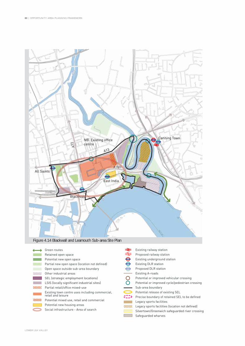
80 | OPPORTUNITY AREA PLANNING FRAMEWORK
LOWER LEA VALLEY
Green routesRetained open space Potential new open spacePartial new open space (location not defined)Open space outside sub-area boundaryOther industrial areasSEL (strategic employment locations)LSIS (locally significant industrial sites)Partial retail/office mixed-useExisting town centre uses including commercial,retail and leisurePotential mixed use, retail and commercialPotential new housing areasSocial infrastructure - Area of search
Existing railway stationProposed railway stationExisting underground stationExisting DLR stationProposed DLR stationExisting A-roadsPotential or improved vehicular crossingPotential or improved cycle/pedestrian crossingSub-area boundaryPotential release of existing SELPrecise boundary of retained SEL to be definedLegacy sports facilities Legacy sports facilities (location not defined)Silvertown/Greenwich safeguarded river crossingSafeguarded wharves
Figure 4.14 Blackwall and Leamouth Sub-area Site Plan

OPPORTUNITY AREA PLANNING FRAMEWORK | 81
LOWER LEA VALLEY
4.237. Commercial Uses: The strategic assumptions of industrial land release in the LLV include the potential release of up to 8.3ha of existing industrial land in the sub-area. The Safeguarded Wharf at Orchard Wharf should continue to be protected and promoted by the GLA and the Boroughs. The sub-area should build on its established office activity at Clove Crescent, Saffron Avenue and Coriander Avenue and the creative uses at Trinity Buoy Wharf. Further development in the sub-area could deliver up to 7,000 sqm of office floorspace in areas east of the established commercial core; and approximately 9,000 sqm new retail floorspace (distributed as local retail provision).
4.238. In order to achieve Valley-wide objectives and create mixed and balanced sustainable communities, the level of potential land use change envisaged for the sub-area should be supported by strategic and local interventions. Development proposals within each sub-area will be expected to provide an appropriate and reasonable contribution towards the cost of delivering the identified strategic and local interventions.
4.239. Social/Community: Most of the social infrastructure requirements arising out of development in this sub-area will be met in neighbouring sub-areas. However, development in the sub-area should include, or contribute towards strategic interventions to provide a medium scale stand alone multi-use community facility, of 795 sqm. A further piece of work is required to accurately plan the delivery of these facilities in relation to the likely phasing of housing and the resultant populations.
4.240. Open Space: Development in the sub-area should include, or contribute towards strategic and local interventions to provide:
• Part of the sixth major park area in the potential LLV open space network – the Leamouth Park space – which links the LLV open space network to the River Thames;
• The safeguarding and ecology-led enhancement of the existing open space around the East India Dock Basin (included in the Leamouth Park space);
• The enhancement of the existing riverside walk along the west bank of Bow Creek, including the allocation of additional green space along this link; and
• Creating improved public access from East India Dock basin to the cultural area of Trinity Buoy Wharf, providing this can be accommodated without constraining the Safeguarded Wharf at Orchard Wharf.
4.241. Waterways: Waterways dominate the southern and eastern parts of this sub-area, with the Thames making up most of the southern boundary, and the Bow Creek meander along the east side. Development in the sub-area should include, or contribute towards local interventions to provide enhancements to the ecological and landscape value of the river through the introduction of terraces within the watercourse along the canal edge, subject to navigation and flood capacity.
4.242. Most of this sub-area lies within PPG25 Flood Zone 3, with the exception of the central part which lies within Flood Zone 2. Existing flood defences will offer adequate protection if they are sufficiently maintained. There are areas of high and extreme potential hazard, particularly in the vicinity of the Blackwall Tunnel approach road. The sub-area is suitable for more vulnerable development, although potential breach of flood defences should be considered when planning the location of development. New development should generally be located in the east of the sub-area where the potential hazard from a flood defence breach is significantly less. Mitigation measures may need to be considered, including flood resistant building design and ensuring access can be maintained during a flood event.
4.243. Transport and Movement Infrastructure: Development in the sub-area should include provision for, or contribute towards, funding or investigation of the following strategic and local transport interventions:
• Improvements to the existing bridge over the Lea to the Bow Creek Nature Reserve to accommodate pedestrian and cycle routes;
• Capacity improvements at Blackwall and East India DLR stations and pedestrian improvements in the area around Blackwall station.
• The potential introduction of a number of shared pedestrian and cycle crossings overcome existing movement barriers such as the A13 and the River Lea. These include possible new bridges across the Lea:
- Linking Canning Town Station to Orchard Place North; and
- From the Limmo Peninsula to the Leamouth Peninsula.
4.244. Engineering: The LLV RS proposes to potentially under-ground the over-ground electricity cables running south from West Ham Sub-station through the western part of this sub-area. The viability of under-grounding these power lines is being investigated by the LTGDC.
4.245. Following on from the Thames Gateway Bridge decision and subject to funding, plans for the Silvertown Link river crossing will be developed. The crossing would provide for local links between Silvertown and North Greenwich. Indicative phasing in the London Plan is for completion in the period 2017 - 2022.
Local Planning Framework 4.246. A Local Planning Framework (paragraph 5.18) including a
masterplan, a phasing schedule and an investment strategy, worked up by the developer/s, in partnership with the GLA, TfL, LDA, LTGDC and the London Borough of Tower Hamlets would usefully indicate how the development proposals can be delivered at a local level. It would also provide certainty that the required infrastructure will be delivered at the appropriate time. The Local Planning Framework could consider the area around Leamouth Peninsula and Orchard Place North to update previous analysis and consider emerging major development proposals.
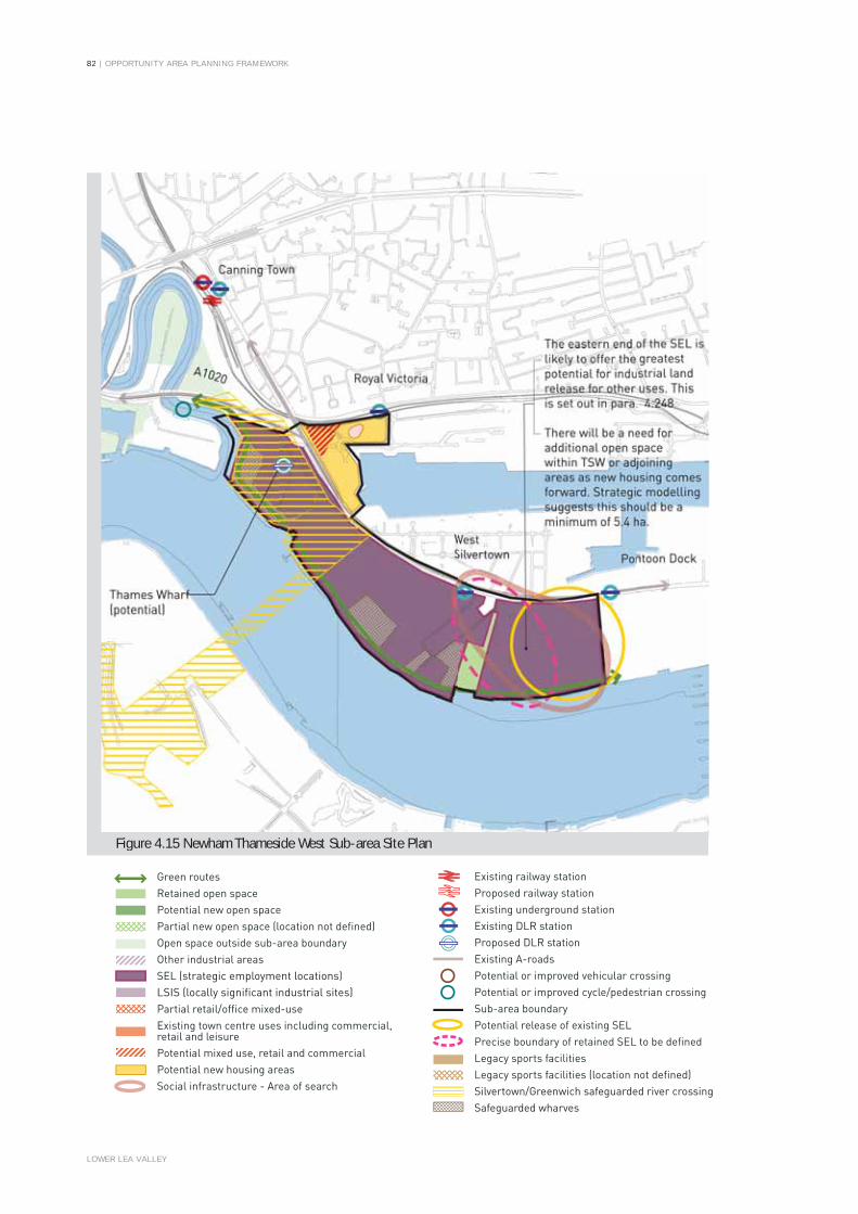
82 | OPPORTUNITY AREA PLANNING FRAMEWORK
LOWER LEA VALLEY
Green routesRetained open space Potential new open spacePartial new open space (location not defined)Open space outside sub-area boundaryOther industrial areasSEL (strategic employment locations)LSIS (locally significant industrial sites)Partial retail/office mixed-useExisting town centre uses including commercial,retail and leisurePotential mixed use, retail and commercialPotential new housing areasSocial infrastructure - Area of search
Existing railway stationProposed railway stationExisting underground stationExisting DLR stationProposed DLR stationExisting A-roadsPotential or improved vehicular crossingPotential or improved cycle/pedestrian crossingSub-area boundaryPotential release of existing SELPrecise boundary of retained SEL to be definedLegacy sports facilities Legacy sports facilities (location not defined)Silvertown/Greenwich safeguarded river crossingSafeguarded wharves
Figure 4.15 Newham Thameside West Sub-area Site Plan

OPPORTUNITY AREA PLANNING FRAMEWORK | 83
LOWER LEA VALLEY
SUB AREA 15: NEWHAM THAMESIDE WESTSub-Area Definition, Location and Character
4.247. The Newham Thameside West Sub-area sits at the southernmost extent of the LLV, bounded by the Rivers Lea and Thames on its west and south sides. The northern edge of the sub-area is defined by the Lower Lea Crossing and existing DLR line to Beckton, while to the east it is directly adjacent to the proposed Silvertown Quays residential development and the recently completed Thames Barrier Park. The sub area is located entirely within the London Borough of Newham. The sub-area is predominantly industrial with wharf activities focussed along the riverside. All of the sub-area south of the North Woolwich Road, apart from Lyle Park and the existing housing, is identified as a Strategic Employment Location (SEL) in the London Plan, and it contains four Safeguarded Wharves (Thames, Peruvian, Manhattan and Sunshine), which should continue to be protected for cargo handling uses such as waste and aggregates in line with national and strategic policy. Development proposals adjoining or near these sites should not prejudice their potential for wharf activities.
The Potential for Land Use Change The LLV OAPF has assumed that to 2016 any industrial land release is concentrated on the area to the east of the sub-area. This release should provide new open space and social infrastructure facilities and any new residential uses would be expected to make appropriate contributions to this provision. Fig 4.15 shows how the Mayor believes this might be best achieved, where a smaller SEL is focussed on and around the safeguarded wharves, an area to the east of Lyle Park is released for mixed use development, and the area between the two zones is looked at in more detail to agree a definitive and coherent SEL boundary. Any scenario should retain a significant quantum of industrial space and associated employment activity focussed on the Safeguarded Wharves. The precise geography of any SEL release will need to be agreed by the strategic and local authorities in light of statutory planning policies, the implications of the Public Inquiry decision for Peruvian Wharf33 and the LDA’s Wharf reactivation initiative.
Sub-Area Proposed Components4.249. Residential Uses: Based on strategic assumptions of industrial
land release in the LLV the Newham Thameside West Sub area has the potential capacity to deliver between 2,000 and 3,000 units at densities between 110 and 250dph (325-640 hrph), those at the top end located in areas with highest PTAL ratings. 1,400 units could be delivered in the sub-area through development of new residential areas, and around 600 could be expected from mixed use residential development with retail and employment (B1 – light industrial) uses at the ground floor.
4.250. A higher density of new development may be appropriate given its Thameside location, but this would require additional transport measures, (in addition to the recent DLR works), and an increase in social infrastructure provision. Location and design of housing and other noise sensitive uses, such as education and health, should have particular regard to potential increase in the number of London City Airport overflights.
4.251. Commercial Uses: New industrial uses should focus on activities that make use of waterborne freight transport. Industrial floor space should be intensified where possible and new provision designed to act as a land use buffer between the established industry and other new uses. Part of the area around Thames Wharf has also been identified as a relocation site to accommodate uses displaced by the 2004 O&LPP.
4.252. Analysis in the LLV RS suggests there is limited scope for new retail or office uses beyond local provision. Up to 1,500 sqm of new retail floorspace could be appropriate, depending on the development of other uses, with the location to be determined through further work. The proposed development at Silvertown Quays (north east area of the sub area) will deliver a new district centre which will be the focus for any significant new office/retail floorspace in this area.
4.253. In order to achieve Valley-wide objectives and create mixed and balanced sustainable communities; the level of potential land use change envisaged for the sub-area should be supported by strategic and local interventions. Development proposals within each sub-area will be expected to provide an appropriate and reasonable contribution towards the cost of delivering the identified strategic and local interventions.
4.254. Social / Community: Development in the sub-area should include, or contribute towards strategic interventions to provide:
• A large scale social infrastructure cluster (or two distinct clusters), providing:
- a full service model 6 FE secondary school that will be the key anchor facility to enable co-location of other community facilities;
- a 2 FE primary school;- a 4 FE primary school;- a 3 GP Walk-in Health centre; and- a medium scale multi-use community space (660sqm).
4.255. The secondary school will be required to serve a wider catchment area that includes Canning Town to the north and areas to the east, including the proposed Silvertown Quays development.
4.256. Additional work will be required to determine the phasing and location of schools, so that the delivery of these facilities is accurately planned in relation to the likely phasing of any housing delivery and the resultant populations associated with this.
33: The Secretary of State for Communities and Local Government dismissed a mixed use scheme at Peruvian Wharf, that proposed the introduction of residential uses into the SEL on the 15 January 2007 (ref APP/G570/A05/1193216).

84 | OPPORTUNITY AREA PLANNING FRAMEWORK
LOWER LEA VALLEY
4.257. Open Space: Development in the sub-area should include, or contribute towards strategic interventions to provide:
• A Thames Walk through the area to link major park spaces of the LLV park network to the Thames Barrier Path to the east (though this should not adversely impact on the safeguarded wharves or wharf activity);
• The expansion of the existing open space at Lyle Park and provision of a series of smaller pocket parks in appropriate locations; and
• New open space and new/enhanced local movement routes in association with new social infrastructure, to ensure the wider local communities can access new services and facilities.
4.258. Waterways: The whole of this sub-area lies within PPG25 Flood Zone 3. Although existing flood defences are generally adequate to prevent inundation, the majority of the sub-area has a high or extreme potential hazard rating. The land in this sub-area is in a low lying basin and is reliant on maintenance of flood defences for protection from extreme flooding. Residential development in this area would be vulnerable to flooding, and if development is to take place consideration should be given to a greater proportion of higher density non-family housing, as well as mitigation measures including flood resistant building design and ensuring access can be maintained during a flood event. The outputs of the SFRA should also be considered by the strategic and local authorities in determining the nature and location of new development in the sub-area.
4.259. Transport and Movement Infrastructure: Government undertakings have already delivered the strategic intervention of the DLR extension to City Airport with new stations at West Silvertown and Pontoon Dock.
4.260. Development in the sub-area should include provision for, or contribute funding towards, the investigation and development of the following strategic and local transport interventions:
• The DLR has made passive provision for a station to be built at Thames Wharf, subject to future demand and the nature of new development.
• A new local movement network, including: public transport routes, vehicular access, and cycle and pedestrian routes to provide connections between this sub-area and the adjoining areas of Canning Town, Leamouth and Silvertown Quays, as well as access to public transport and the river. New roads which should be designed to provide a secondary flood defence and ensure that access is maintained to vulnerable areas in the event of a major flood; and
• Safeguarding for the proposed Silvertown Link, which will connect Thameside West to the Greenwich Peninsula. An initial review of the timescale for taking forward the scheme identified that it could be delivered in the period 2017-2022, as noted in the London Plan
Engineering: The LLV RS proposes that further consideration should be given to the potential for under-grounding the over ground electricity cables running south from West Ham Substation through the northern part of this sub-area. The viability of under-grounding these power lines is being investigated by the LTGDC.
4.262. Following on from the Thames Gateway Bridge decision and subject to funding, plans for the Silvertown Link river crossing will be developed. The crossing would provide for local links between Silvertown and North Greenwich. Indicative phasing in the London Plan is for completion in the period 2017-2022.
Local Planning Framework 4.263. A Local Planning Framework (paragraph 5.18) including a
masterplan, a phasing schedule and an investment strategy, worked up by a partnership of landowners, developers, the GLA, TfL, LDA, LTGDC and the London Borough of Newham, would usefully indicate how the development proposals could be delivered at a local level. It could also provide certainty that the required infrastructure will be delivered at the appropriate time. Further work will be needed to demonstrate how the development principles and sub-area guidelines in the LLV OAPF can be delivered.

OPPORTUNITY AREA PLANNING FRAMEWORK | 85
LOWER LEA VALLEY

86 | OPPORTUNITY AREA PLANNING FRAMEWORK
LOWER LEA VALLEY

OPPORTUNITY AREA PLANNING FRAMEWORK | 87
5.1. Achieving the Vision set out in the document will require the concerted effort of the public, private and community sectors working together to secure the successful transformation ofthe Valley.
5.2. This Section considers delivery and implementation34
focussing upon:
• The role of the public sector authorities and the importance of strong and effective cross organisational working.
• Key projects to underpin and accelerate sustainable regeneration of the Valley
• Implementing the LLV Opportunity Area Planning Framework.
• How major planning applications in the Lower Lea Valley will be assessed and determined.
THE ROLE OF THE PUBLIC SECTOR AUTHORITIES5.3. The scale of development that is possible and desired will require
the public and private sectors to work together to overcome a wide range of physical and financial barriers. Where necessary the public sector authorities will intervene to directly stimulate and secure new investment. The public sector organisations in the LLV are committed to working together and have financial resources, assets and a wide range of powers to bring to bear. These include:
• Preparing planning briefs and local frameworks, and taking development control decisions that appropriately reflect the OAPF and relevant Development Plans;
• Assembling sites through the use of Compulsory Purchase powers, contributing land in their ownership and promoting cooperation between individual landownersand developers;
• Helping to ensure that the necessary infrastructure is provided at the right time and in the right location, and that social and community facilities such as open spaces, schools, health provision, transport infrastructure, utilities, emergency services and cultural, leisure, youth and sporting facilities, are planned for and provided;
• Coordinating delivery and funding, taking into account the extent to which the private sector could realistically contribute to Valley wide infrastructure; and
• Being responsive to the realities involved in successful regeneration of the Valley and recognising the need for projects and priorities to evolve over time.
5.4. Some of the organisational building blocks have already been put in place - for example the creation of the LTGDC and ODA who will provide strategic coordination in their parts of the Valley.
5.5. The overall strategic management of the regeneration of the LLV is provided by the Lower Lea Valley Management Group35, which was formed in late 2006 to provide a focus and forum for effective public sector cross organisational working.
5.6. The LLV Management Group comprises Director level officers from each of the public bodies and meets quarterly to review progress on developing and implementing regeneration projects in the LLV.
5.7. The LLV Management Group undertakes the following tasks:
• Review and oversee the regular updating of a Delivery and Investment Strategy (DIS) which includes a Public Sector Investment Plan;
• Ensure the integration of the DIS plans with their own organisation’s spending plans where appropriate;
• Review progress on obtaining funding and implementing projects;
• Monitor progress at a project level to ensure that strong partnership working is taking place.
SECTION 5: DELIVERY AND IMPLEMENTATION
34: The detailed proposals for the delivery of the vision for the LLV are contained in the LTGDC’s Delivery and Investment Strategy (DIS) – See paragraph A.22 in theappendix. This section of the OAPF provides an overview of the public authorities’roles in regenerating the LLV.
35: The Lower Lea Valley Management Group comprises senior representativesof the LTGDC, English Partnerships the GLA group (GLA, LDA and TfL), Housing Corporation, Lea Valley Regional Park Authority, the London Boroughs of Hackney, Newham, Tower Hamlets and Waltham Forest, the ODA and Government(represented by the Department of Communities and Local Government). TheSecretariat function for the group is provided by LTGDC and it is currently chairedby its Chief Executive.
LOWER LEA VALLEY

| OPPORTUNITY AREA PLANNING FRAMEWORK
LOWER LEA VALLEY
Figure 5.1 Possible Delivery Projects 2006 (Source: EDAW) N.B for illustrative purposes only88

OPPORTUNITY AREA PLANNING FRAMEWORK | 89
LOWER LEA VALLEY
KEY PROJECTS TO UNDERPIN AND ACCELERATE SUSTAINABLE REGENERATION OF THE VALLEY
5.8. A number of organisations have already developed projects and begun their implementation in order to bring about a ‘step-change’ in the scale and quality of development in the Valley.
5.9. These interventions will underpin and accelerate the transformation of the Valley as an attractive place for mixed and balanced communities to live and work whilst enjoying access to high quality, local public services. In particular the provision of schools, health facilities and a transformed physical environment will result in a shift in the perception of the area as one that is attractive to families as a place to live.
5.10. At the northern end of the Valley, London and Continental Railways’ promotion of the Stratford City development is currently well advanced with a developer selected for both the commercial and retail elements. A residential developer will also be selected shortly who will be required to deliver a wide range of housing typologies and tenures – many of which will be suitable for families.
5.11. The planning of the Olympic Park, including the post 2012 venue legacy uses is well developed by the Olympic Delivery Agency which will be submitting a new Olympic Planning Application in January 2007. Additionally, the LDA with ODA will be commissioning a Legacy Masterplan Framework in early 2007, which will consider the detailed form of legacy development, including new housing and business space, within the context of the OAPF. These proposals will be developed with key stakeholders and in consultation with the community.
5.12. In addition to their work in the Olympic Zone the LDA is leading on a series of projects. These include:
• ‘West Ham’, the development of a Master Plan for West Ham Parcelforce site as a location of a mixed use development and potential Olympic relocations such as a new bus depot36;
• ‘St. Andrew’s Hospital’, a key site within the Bromley by Bow area where the LDA will select a Joint Venture partner to develop a mixed use development comprising 800-1,000 dwellings (including family housing and a large proportion of affordable units) and a health centre;
• Site assembly to facilitate re-development, through compulsory purchase orders at Ailsa Street in Poplar Riverside, and Silvertown Way as part of the emerging LTGDC led proposals for Canning Town;
• The LDA is working with London Borough of Newham to seek a development partner for the Landmark site; and,
• The LDA will continue to manage their landholdings to support local businesses in the 3 Mills and Sugar House Lane area.
5.13. In remaining parts of the LLV, four major projects are being promoted by LTGDC as follows:
• ‘Lower Lea Valley Park’ will extend from the Olympic Park along the River Lea to its mouth with the Thames. The park will provide a range of leisure facilities and open space that will support high density residential development in the surrounding area. The project will also entail the provision of connections to remove the severance created by the Valley’s roads, railway lines and waterways in order to better integrate local communities.
• ‘Olympic fringe’ is the title of a series of projects aimed at harnessing the investment interest stimulated by the Olympic Park development to deliver top quality business space in Hackney Wick, Fish Island and Stratford. To do this it will be crucial to deliver high quality infrastructure and neighbourhood facilities that will benefit from easy access to the new parklands in the Valley.
• ‘Bromley by Bow’ aims to promote sustained investment in the area to the east of the A12 through the provision of better neighbourhood facilities and access to the river and high quality environmental improvements. In this area the LTGDC is working in close conjunction with the LDA on the redevelopment of St. Andrew’s Hospital site, to bring forward new residential development and ancillary community uses. Joint Master Planning of the area will ensure that the area functions as a coherent district centre in the future with the necessary social infrastructure for this area which is already undergoing rapid population growth due to new development.
• ‘Canning Town’ is proposed as a site for the creation of a new town centre close to the existing transport hub that will serve the needs of both existing and incoming communities. In total the area will be able to accommodate 8,500 new homes and a vibrant commercial centre reflecting the diversity of the local community and the opportunities offered by its proximity to Canary Wharf and the City.
5.14. In addition the LTGDC is examining projects aimed at improving the quality of the urban environment through the removal of power lines south of West Ham, the potential impounding of the River Lea at Prescott Lock, and improving pedestrian, cycle and vehicular access.
5.15. All of these projects will include elements of social infrastructure where required. In many cases the social infrastructure will be embedded within them – most notably land for schools and land and facilities suitable for accommodating health centres and community facilities.
5.16. The LTGDC will also assist Government departments, its agencies and Local Authorities in the planning and delivery of schools, health and community facilities and has already begun this process through the completion of a Public Sector Investment Plan for the Valley which has formed part of its CSR ’07 submission to Government.
36: Depending on the outcome of any planning application.

| OPPORTUNITY AREA PLANNING FRAMEWORK
LOWER LEA VALLEY
Figure 5.2 Local Planning Framework (Source: EDAW) 90

OPPORTUNITY AREA PLANNING FRAMEWORK | 91
LOWER LEA VALLEY
5.17. In addition, most of the projects listed will embody some or all of the following attributes:
• Local utilities will be enhanced including the undergrounding of existing power lines and the development of sustainable solutions to power, energy and water provision.
• Transportation in the Valley will be improved through capacity increases, new transport infrastructure, service extensions and improved depot facilities. The need for investment in the local road network will also be examined as part of a wider review of the improvements needed to enable movement within the valley both on foot, bicycle, bus and car.
• Training and enterprise support - the public, private and community sectors are working together to develop programmes to strengthen the economic success of the LLV through local business development, training and employment brokerage, including programmes tailored to meet the needs of major developments such as the 2012 Games, Stratford City, and Canning Town.
5.18. The public authorities responsible for the wider regeneration in the Valley are concerned to ensure that where possible the funding and delivery of affordable housing and social infrastructure such as schools and health facilities is supported by the appropriate use of section 106 agreements and the LTGDC is committed to developing a formal strategy setting out how it will negotiate and pool section 106 requirements and contributions. The strategy will pay appropriate regard to London Plan policies 6A.4 and 6A.5 (which refers to developing with the boroughs a voluntary system of pooling for the provision of facilities related to proposed developments), and will also pay appropriate regard to boroughs’ existing and developing section 106 policies and strategies.
5.19. Development Principle G5 establishes the need for coordination in terms of provision of infrastructure and states that:
Development proposals in the LLV should identify their physical, social and community Infrastructure requirements and demonstrate how that provision will be delivered.
5.20. The successful delivery of the overall vision for the valley and the creation of truly sustainable communities will require significant coordination, plan making, monitoring and management. The establishment of the LTGDC provides a key vehicle to facilitate and provide such strategic coordination.
5.21. Developers and landowners should work in partnership with the boroughs, the GLA, the LDA, the LTGDC and other public bodies to identify, plan and help deliver the infrastructure necessary to achieve the sustainable regeneration of the LLV.
5.22. In the ten areas identified on Figure 5.2 developers will be expected to work with the LTGDC, local authorities and local delivery agencies to demonstrate how the planned implementation of their proposals will contribute to the wider regeneration of the LLV and the development of necessary infrastructure.
5.23. This would help ensure compliance with London Plan policy 3A.5 which requires planning frameworks to be prepared for major residential sites, that assess the need for community and ancillary services (such as local health facilities, schools and public open space), and identify the potential impacts on the surrounding areas and how these will be dealt with.
5.24. These frameworks should be prepared in consultation with key stakeholders, including developers, landowners, local authorities, TfL, the LDA, Strategic Health Authorities and Primary Care Trusts, housing associations and local communities. Where large residential sites are near to Areas for Regeneration, the appraisal should take account of social and economic impact assessments. Detailed consideration should also be given to the compatibility of uses, permeability and layout, sustainable design and construction, phasing, delivery mechanisms, management and maintenance and renewable energy.
5.25. This approach is in accordance with the Panel Report of the Examination into the London Plan First Alterations37, which concluded that new development and infrastructure needs must be identified and planned for, and that a full inventory of such needs should be prepared, responsibilities identified and timetables prepared.
37: Panel Report of the Examination into the London Plan Alterations,GLA 2006.

92 | OPPORTUNITY AREA PLANNING FRAMEWORK
LOWER LEA VALLEY
THE PLANNING PROCESS IN THE LLV5.26. Within the LTGDC area shown on Figure 1.2, the LTGDC is the
local planning authority for most applications above a certain threshold (see www.ltgdc.org.uk for more details). A protocol has been agreed between the LTGDC and the boroughs of Hackney, Newham and Tower Hamlets where the LTGDC has planning powers to determine planning applications. This provides for much of the work involved in the processing of these applications to be carried out by the boroughs on behalf of the LTGDC. The LTGDC also takes the lead on both pre-application discussions and the negotiation of section 106 agreements and generally oversees the application process.
5.27. The ODA has been given planning powers from September 7th 2006 over the Olympic Planning Area (see Figure 1.2). All planning applications in this area will need to be made to the ODA, though the ODA may pass an application back to local borough or the LTGDC for decision if it is unrelated to the 2012 Games.
5.28. The Mayor of London’s powers of direction are unchanged by these arrangements
5.29. The process for handling all other planning applications in the LLV should be based on the principle of partnership working between the four LLV boroughs, the LTGDC and the GLA, and where appropriate the ODA.
5.30. The LTGDC, the LLV Boroughs and the GLA should notify each other party immediately of any pre-application approach received concerning prospective major or strategically significant developments, (whether or not such development falls within the thresholds set out in the Planning Order). The planning authorities should work closely together and with developers in pre application discussions and public consultation, so that the principal issues of any proposed development, and general conformity or otherwise with the London Plan, LLV OAPF and borough UDP’s/Local Development Documents, are well known before submission of an application.
5.31. Under the terms of the LTGDC/LLV borough protocol the LLV boroughs will inform the LTGDC of all strategic applications received within the designated area, or any significant applications below the LTGDC thresholds which the LTGDC may wish to make observations on. A copy of any such notification should be sent to the GLA at the same time.
5.32. Under the terms of the protocol regular meetings are held between the LTGDC and planners in the LLV Boroughs to review how well the protocol is working and to identify any necessary changes in procedures and/or any actions required.
5.33. The material planning considerations to be taken into account when determining applications include: the London Plan and UDP’s (or successor documents); the sub-regional development framework; relevant supplementary planning guidance; and the LTGDC’s Strategic Regeneration Framework (including the SFRA). The LLV OAPF will be a material planning consideration by virtue of its relationship to the London Plan and the LTGDC’s Strategic Regeneration Framework.
5.34. Planning negotiations should be carried out through a partnership of the LTGDC, the GLA and LLV borough(s) on applications referable to the Mayor and to potentially significant applications below the LTGDC and Mayoral thresholds. Legal agreements are drawn up between the applicant and the LTGDC, in consultation with the LLV borough(s) and the GLA.

OPPORTUNITY AREA PLANNING FRAMEWORK | 93
LOWER LEA VALLEY

94 | OPPORTUNITY AREA PLANNING FRAMEWORK
LOWER LEA VALLEY

OPPORTUNITY AREA PLANNING FRAMEWORK | 95
LOWER LEA VALLEY
BACKGROUNDA.1. The LLV RS & OAPF study area was established following
consultation with the GLA, LDA, the four LLV Boroughs and the ODPM (in lieu of the LTGDC). The size of the study area and the huge character variation within it require the definition of sub-areas within which strategically-specific land use designations can be identified and around which partnership working can be focused on key interventions and projects. There are 15 sub-areas in the LLV, which have been illustrated in Figure 1.2 and are:
1. Leyton2. New Spitalfields3. Lea River Park4. Wider Stratford City5. Hackney Wick6. Stratford7. Fish Island and Marshgate Lane8. Bromley by Bow9. Three Mills10. West Ham11. Cody Road12. Poplar Riverside13. Canning Town14. Blackwall and Leamouth15. Newham Thameside West
A.2. More information on the LLV RS strategic land use proposals for each of the fifteen identified sub-areas is presented in Section 4 of the LLV OAPF.
A.3. In light of the pressing need to prepare a cross-borough planning framework for the area, the ‘Lower Lea Matrix Group’ (comprising key local stakeholders including the four LLV boroughs) was formed in 2002 to develop an Area Development Framework (ADF) for the Lower Lea. A number of specialist sub-groups were established to progress specific areas of the strategy, the ‘Housing and Planning’ sub-group was given responsibility for developing the ADF as a ‘Joint Area Action Plan’ (JAAP).
A.4. As the process of preparing the JAAP continued, it became clear that it was not possible to take forward the document as a formal Joint ‘Area Action Plan’ under the Planning and Compulsory Purchase Act 2004. It was decided to secure ‘Opportunity Area Planning Framework’ status for the document, which could then be reflected in due course through the four LLV Boroughs LDFs.
THE PLANNING STATUS OF THE LLV OAPFA.5. The Mayor of London’s Spatial Development Strategy (the
London Plan) was published in February 2004. First Alterations were published in Dec 2006. Under section 38(6) of the Planning and Compulsory Purchase Act 2004, the London Plan is classified as part of the Development Plan in force for London; the rest of the development plan comprises the relevant borough Unitary Development Plan or LDF.
A.6. OAPFs are prepared and adopted under the Mayor’s general duty as set out in section 30 of the GLA Act 1999, i.e. that the Authority [GLA] has the power to do anything which it considers will further any one or more of its principal purposes. These principal purposes being: (a) promoting economic development and wealth creation in Greater London; (b) promoting social development in Greater London; and (c) promoting the improvement of the environment in Greater London.
A.7. The weight that can be given to the planning policy in OAPFs when determining planning applications is increased depending on the process used to prepare the framework and the general conformity of the content to the London Plan and other planning documents. To ensure that the strategy has sufficient weight to guide development activity across the LLV, the OAPF has been progressed in an open and transparent manner with key stakeholders, and was subject to a 12-week public consultation period that was taken into account by the Mayor when he agreed this document
A.8. The weight of the LLV OAPF has also been reinforced by the technical work that was undertaken as part of the LLV Regeneration Strategy, which forms an evidence base for this document and demonstrates a thorough process of options assessment in deriving the suggested strategic land use situation. More information concerning the preparation and content of this Strategy is presented below.
APPENDIX A: PLANNING CONTEXT
96 | OPPORTUNITY AREA PLANNING FRAMEWORK
LOWER LEA VALLEY
THE ROLE AND CONTENT OF OPPORTUNITY AREA PLANNING FRAMEWORKS
A.9. As part of the process of producing sub-regional frameworks, the Boroughs and GLA are expected to work together to prepare planning frameworks for Opportunity Areas, or take forward frameworks that have already been developed. Opportunity Area Planning Frameworks (OAPFs) are a tool to visualise the implementation of London Plan policy, to aid negotiation, consultation and implementation. They should set out a sustainable development programme for each Opportunity Area, which can be taken forward by Boroughs in the production of their statutory LDFs. An OAPF should:
• Seek to exceed the minimum targets for housing and have regard to the indicative targets for employment as set out in the London Plan;
• Maximise access by public transport;
• Promote social inclusion and relate development to nearby Areas for Regeneration; and
• Take account of the community, environmental and other distinctive local characteristics of each area.
OAPFs also need to demonstrate general conformity with the London Plan from which their principal planning status is drawn.
A.11. OAPFs are strategic planning documents and are not intended to go into the levels of detail that are more appropriate in a Local Development Document, Area Action Plan or detailed planning and development briefs. OAPFs should not preclude the options appraisal process that each borough will develop as part of its LDF procedures (as set out in PPS12).
A.12. While it is important for an OAPF to be flexible to allow LDF procedures and options appraisal process, the OAPF must also be sufficiently robust to be able to be used within the development control process. This requires a strategic approach to land-use designations where these relate to strategic fixes or strategic proposals that require cross-Valley coordination, e.g.:
• The boundaries of strategically important industrial land such as Strategic Industrial Locations and and safeguarded wharves;
• Essential bridges and connections;
• New water courses and enhancements;
• Town Centres;
• Valley-wide engineering and transport infrastructure such as under-grounding of power lines, flood storage, waste management and energy generation, and new transport corridors (including the potential spine road); and,
• The broad spatial distribution of necessary socio-economic and environmental infrastructure such as watercourse networks, open space strategy, education, health and community facilities.
Specific land use detail, for example the location of uses within mixed-use areas, should be taken forward through Boroughs’ LDFs, Area Action Plans or detailed planning and development briefs. Preparation of this detailed information will require consultation with the Mayor of London and the LTGDC, in furtherance of the requirement to demonstrate general conformity with the London Plan, or to ensure that LDFs are kept under review to take account of the LTGDC’s Regeneration Framework. The relationship between the London Plan, LDFs and OAPFs is illustrated in Figure A.1.
THE RELATIONSHIP OF THE OAPF TO THE LLV RSA.14. The LLV RS has tested the capacity for change in the Valley, and
promotes a series of regeneration opportunities in relation to land-use, environmental enhancement, engineering, transport and socio-economic issues. Since the work was completed, a number of sites have been developed and come forward for development. LTGDC plan to carry out regular ‘stock-takes’ of progress on sites so that it can report on population and employment growth and assist in the shaping of wider public sector plans in social and physical infrastructure.
A.15. The LLV RS comprises two core (public facing) documents; the LLV OAPF and the LLV Vision. The LLV Vision sets out the aspirations of the LTGDC and its partners for regeneration and change in the LLV and explains the core outputs of the LLV RS under a series of key themes. The LLV OAPF and LLV Vision were informed by five technical documents that provide evidence and supporting detail for the OAPF and the strategies set out in the LLV Vision. These documents are:
• Sustainability Appraisal (SA), which appraises the future land use distribution and likely housing output set out in the OAPF;
• Strategic Land Use Strategies (SLUS), which provides evidence and context to support the land use approach and themes set out in the OAPF and LLV Vision;
• Socio-Economic Strategies (SES), which explain the strategies for social infrastructure provision in the OAPF and employment support initiatives in the LLV Vision;
• Delivery and Investment Strategies (DIS), which explains the roles and responsibilities of key players in delivering the LLV Vision, defines specific projects including costs and phasing, and indicates the scale of financial commitment required to support the LLV RS; and,
• Strategic Flood Risk Assessment, which determines the flood risk implications of future development in the LLV.
A.16. The core and technical documents derive their key data from a number of models that have been developed to analyse the regeneration potential of the LLV, including the LLV RS PO and flood risk, transport capacity impacts, and social infrastructure modelling. The LLV RS PO is a theoretical, analytical model, setting out a potential future land use scenario for the LLV.

OPPORTUNITY AREA PLANNING FRAMEWORK | 97
LOWER LEA VALLEY
A.17. As figure A.2 indicates, there is a hierarchical relationship between the core documents, the technical documents, and the analytical models, which is reflected in the level of detail contained in the various documents38.
THE LLV RS AS THE LTGDC’SREGENERATION FRAMEWORK
A.18. In recognition of the challenge and opportunity that the Lower Lea presents to the social and economic future of London, the Government has established an Urban Development Corporation for East London to accelerate the delivery of regeneration of Lower Lea and also London Riverside. Established in summer 2004, the aim of the Corporation is to promote and deliver the sustainable regeneration and growth of London Thames Gateway, within the context of the national policies set out in the Sustainable Communities Plan, the strategies for the wider Thames Gateway sub-region and the Spatial Development Strategy for Greater London.
A.19. The Corporation’s statutory duties are to:
• Bring land and buildings into effective use;
• Encourage the development of existing and new industry and commerce;
• Create an attractive environment; and
• Ensure that housing and social facilities are available to encourage people to live and work in the area.
A.20. The statutory powers of the Corporation are defined in the 1980 Act and in the more recent Planning and Compulsory Purchase Act 2004. In summary, the Corporation has the power to:
• Acquire, hold, manage, reclaim and dispose of land and other property;
• Carry out building and other operations;
• Seek to ensure the provision of water, electricity, gas, sewerage and other services;
• Carry on any business or undertaking for the purposes of regenerating its area; and
• Generally do anything necessary or expedient in support of these activities.
A.21. The London Thames Gateway Development Corporation is the development control authority for strategic planning applications within its boundary (powers allocated by Parliamentary Order in October 2005). The Mayor of London’s planning powers remain unchanged.
A.22. While the LTGDC will set the Strategic Regeneration Framework for its area, plan making powers stay with the local planning authorities and the Mayor of London. In principle the LTGDC has agreed to join with the LDA and the four LLV Boroughs to co-sponsor the LLV RS so that it will also become the Strategic Regeneration Framework for the LLV area of its operation. The LTGDC has given an undertaking to keep the LLV RS documents under review throughout its life and a commitment to work with four LLV Boroughs, the GLA and LDA on detailed planning briefs and masterplans prepared in furtherance of the LLV OAPF.
A.23. The LTGDC has given a commitment to consult on its Strategic Regeneration Framework and corporate plan, to give stakeholders the opportunity to contribute to the building blocks of the LTGDC.
38: LLV background technical documents can be requested from the LDA PublicLiaison Unit 0207 593 9000.

98 | OPPORTUNITY AREA PLANNING FRAMEWORK
LOWER LEA VALLEY
Development Plan
Regional Spatial Strategy
(London Plan)Development Plan Documents
Core Strategy
Site Specific Allocations
Adopted Proposals Map
Area Action Plans
Other Development Plan Documents
Other Material
Considerations
Planning Briefs / MasterplansSRDF’s & OAPF’sSPGs (Industrial Capacity, Accessible
London)
Figure A.1 Relationship between London Plan and LDF documents. (Source: EDAW)

OPPORTUNITY AREA PLANNING FRAMEWORK | 99
LOWER LEA VALLEY
Core Public Documents
Analytical Models
LLV Vision
Themes, Principles, Outputs, &
Projects
OAPF
Strategic Planning Guidance
Population and Child Yield
ScenariosFlood Risk Transport Capacity
and Impacts LLV RS Preferred
Option
Technical Documents
Strategic Land Use Strategies
Land Use and Outputs
Socio-Economic Strategies
Social Infrastructure,
Skills & Programmes
Delivery and Investment
Strategy
Projects, Phasing and Viability
Sustainability Appraisal
Incorporating Strategic
Environmental Assessment
Strategic Flood Risk Assessment
Flood Risk and Implications
Figure A.2 Components of the LLV RS (Source: EDAW)

100 | OPPORTUNITY AREA PLANNING FRAMEWORK
LOWER LEA VALLEY

OPPORTUNITY AREA PLANNING FRAMEWORK | 101
LOWER LEA VALLEY