long valley management plan
TRANSCRIPT

Page | 1
LongValleyManagementPlanMountSanJacintoStatePark
A guide for the operation and management of Long Valley for the betterment of public use and
improved resource protection into the future.
www.parks.ca.gov

Page | 2
California State Parks Mission
The mission of the California Department of Parks and Recreation is
to provide for the health, inspiration, and education of the people of
California by helping to preserve the state’s extraordinary biological
diversity, protecting its most valuable natural and cultural resources,
and creating opportunities for high‐quality outdoor recreation.
Declaration of Purpose – Mount San Jacinto State Park
The purpose of Mount San Jacinto State Park is to preserve and
protect for the public enjoyment and inspiration, the scenic grandeur
of the granite peaks, forest, and mountain meadows of the San
Jacinto Mountain range. The sheer escarpment soaring up to one of
the highest peaks in Southern California, the panoramic desert
views, the wilderness and the opportunity for solitude, will remain
available for future generations.
California State Parks will preserve, protect, and interpret natural
and cultural resources making these features available to the public
for their educational, scientific, and recreational benefits. California
State Parks will establish interpretive programs for visitors that
instill an appreciation for the Park’s special features and maintain
cooperative partnerships with adjoining entities to foster mutual
conservation and natural resource management goals.
Management Plan Inquiries
The Long Valley Management Plan was prepared by California State Parks’
Southern Service Center. For general information about the document
contact the Southern Service Center at (619) 220‐5300, or direct
correspondence to:
California Department of Recreation
Southern Service Center
8885 Rio San Diego Drive, Suite 270
San Diego, CA 92108
Attn: Long Valley Management Plan Team

3 | P a g e
LongValleyManagementPlanMountSanJacintoStatePark
A guide for the operation and management of Long Valley for the betterment of public use and
improved resource protection into the future.
January 2012
www.parks.ca.gov

LongValleyManagementPlan
4 | P a g e
TableofContents
Introduction ....................................................... 5
Park Location (Figures 1 & 2) ......................... 5
Long Valley Location (Figure 3) ...................... 6
Long Valley Area (Figure 4) ............................ 7
Project Background ............................................ 8
Summary of Existing Conditions and Issues ..... 10
Setting .......................................................... 10
Proximity ...................................................... 10
Transition ..................................................... 10
Importance of Long Valley to Visitors’
Experience .................................................... 10
Ease of Access .............................................. 11
Visitor Use .................................................... 11
Existing Facilities .......................................... 11
Management Zones ..................................... 13
Natural Resources ........................................ 13
Cultural Resources ....................................... 14
Historic Resources ........................................ 14
Interpretation .............................................. 15
The Plan ............................................................ 16
Provide Greater Protections for Long Valley
Meadow and Creek ...................................... 16
Improve Trail Conditions and Accessibility .. 18
Add and Improve Visitor‐use Facilities ........ 21
Add New Interpretive Facilities .................... 25
Provide Better Operations Facilities ............ 26
Facility Design Guidelines ............................ 28
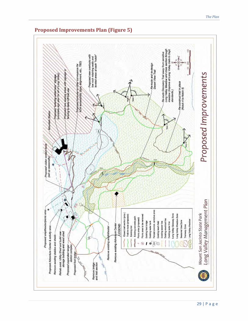
Proposed Improvements Plan (Figure 5) ..... 29
Proposed Improvements Plan (Blow‐Up)
(Figure 6) ...................................................... 30
Appendices ....................................................... 31
Appendix 1 ‐ Long Valley Statistics .............. 31
Appendix 2 ‐ List of Abbreviations and
Glossary ....................................................... 32
Appendix 3 ‐ Preliminary Building Programs33
Appendix 4 ‐ References .............................. 34
Appendix 5 ‐ Guiding Principle for Quality
Aesthetic Design at State Parks ................... 35
Acknowledgments ........................................... 36
Planning Team ................................................. 37
Planning Assistance ......................................... 37

Introduction
5 | P a g e
Introduction
ParkLocation(Figures1&2)
Mount San Jacinto State Park and Wilderness (the Park) is located in Southern California’s western
Riverside County, along the northern edge of the San Jacinto Mountains. It is almost entirely
surrounded by the San Jacinto Wilderness, which is part of the San Bernardino National Forest. The Park
lies between the communities of Palm Springs and Idyllwild.
Mount San Jacinto State Park and Wilderness is approximately 13,718 acres in size and includes the
second highest summit in Southern California, San Jacinto Peak which reaches an elevation of 10,834
feet above sea level.
The view from Mount San Jacinto “was the most sublime
spectacle to be found anywhere on this earth.”
‐ attributed to John Muir

LongValleyManagementPlan
6 | P a g e
LongValleyLocation(Figure3)
At an elevation of approximately 8,400 feet above sea level, Long Valley is found in the northeastern
corner of Mount San Jacinto State Park, at the base of a 0.21‐mile (375‐yard) pathway leading from the
Mountain Station terminus of the Palm Springs Aerial Tramway (the Tram) operated by the Palm Springs
Aerial Tramway organization (PSAT) which is part of the Mount San Jacinto Winter Park Authority
(WPA). Long Valley sits near the edge of one of the steepest escarpments in the nation, which takes a
dramatic northeastward plunge from the nearby Mountain Station toward Palm Springs.
Long Valley Creek enters Long Valley from the west, with its upper headwaters beginning at San Jacinto
Peak and Jean Peak before flowing through Tamarack Valley and Round Valley. Once in Long Valley, the
creek takes a southward turn then exits at the southern end before turning eastward and cascading
down San Jacinto Mountain toward the Coachella Valley.

Introduction
7 | P a g e
LongValleyArea(Figure4)
Long Valley is flanked on the east by a ridge overlooking the Coachella Valley and on the west by
intermediate peaks leading upward toward Round Valley and San Jacinto Peak. Long Valley generally
has an elongated “bowl” shape that slopes downhill slightly from north to south. Running along the
mid‐line of this “bowl” is the flat and easy, 0.55‐mile Discovery Trail which loops along both sides of
Long Valley Creek and Long Valley Meadow, and passes by the Adventure Center, a snow‐play
equipment rental building operated in winter by the PSAT. The 0.82‐mile Desert View Trail generally
travels along Long Valley’s eastern ridge to six viewpoints overlooking the Coachella Valley 8,000 feet
below. A trail leading past the ranger station and amphitheater rises gently out of Long Valley to the
farther reaches of the Park’s wilderness areas beyond. Connecting Long Valley with the PSAT’s
Mountain Station is a relatively short but steep concrete pathway.

LongValleyManagementPlan
8 | P a g e
ProjectBackground
Planning for the Future of
Long Valley
The Mount San Jacinto State
Park General Plan, approved
in 2002, provides the overall
and long‐range vision for
Park management. Rather
than prescribing specific
facilities, capacities, or
locations, its broad goals and
guidelines give general
direction for the desired
resource conditions and
visitor experiences. Specific
future actions are
determined by parameters
outlined in management
plans that build on the
general plan framework.
Because the general plan
identified the need for a
Long Valley Management
Plan, and because of the
many important issues
needing to be addressed,
California State Parks (State
Parks) initiated the planning
process with funds
earmarked from State
Proposition 84 (Water
Quality, Safety and Supply,
Flood Control, Natural
Resource Protection, Park
Improvements, Bonds,
Initiative Statute of 2006).
This Long Valley Manage‐
ment Plan serves as a guide
for the operation, develop‐
ment, and management of
Long Valley. As such, it
shows where relocated,
refurbished, and new
facilities are proposed in
order to improve resource
protection and provide
better facilities, as well as
foster increased public
enjoyment and appreciation
of this unique area.
The recommendations con‐
tained in this Plan are
consistent with State Parks’
Mission and the General Plan
for Mount San Jacinto State
Park.
Importance of Long Valley
Mount San Jacinto State Park
was designated a unit of the
State Park System in 1933.
The primary impetus behind
acquiring the land for public
use was its value as
wilderness. Since that time,
the Park’s importance as a
relatively untouched wilder‐
ness area remains its highest
purpose and value. With its
location at the terminus of
the Tram, Long Valley acts as
the Park’s doorstep and
serves as a gateway to the
wilderness areas beyond.
Long Valley’s proximity to
urban populations and ease
of access make it a unique
and valuable recreational
resource.
At the center of Long Valley
is Long Valley Meadow.
Long Valley Creek
Bob Patterson

ProjectBackground
9 | P a g e
Through this relatively level
meadow, Long Valley Creek
meanders slowly, nourishing
sensitive plants and creating
habitat for many animal
species. This meadow is an
exceedingly uncommon and
fragile wetland habitat,
made all the more rare by its
isolation high above the
Southern California desert.
Protecting this rare and
sensitive resource is a high
priority of California State
Parks.
Purpose of the Management
Plan
In calling for a management
plan to be completed for
Long Valley, the authors of
the General Plan recognized
that there were issues of
importance that needed to
be addressed in greater
detail than the General Plan
effort could accomplish at
that time. The Management
Plan picks up where the
General Plan left off by
adhering to and using the
management zone pre‐
scriptions contained in the
General Plan. Building on
the prescriptions of the
General Plan, the Manage‐
ment Plan further defines
the types of facilities that will
be offered in Long Valley and
where they will be located.
Purpose of the
Management Plan
The purpose of the Long
Valley Management
Plan is to define the
general scope, scale,
character and location
of proposed facilities,
including trails, build‐
ings, and other
structures, as well as
describe the means to
better protect Long
Valley’s resources, in
particular the montane
meadow habitat, from
human impacts.
LongValleyManagementPlan
10 | P a g e
SummaryofExistingConditionsandIssues
SettingThe approximately 67‐acre
Long Valley is perched high in
the San Jacinto Mountain
Range at the northeast
corner of Mount San Jacinto
State Park. At about 8,400
feet above sea level it
exhibits similar characteris‐
tics to valleys in California’s
Sierra Nevada Mountains: a
high‐elevation, snow‐fed, in‐
termittent stream meander‐
ing through a wide, sedge‐
covered meadow sur‐
rounded by coniferous
forest. It is one of only three
major valleys in Mount San
Jacinto State Park and its
fragile montane meadow is a
very rare resource especially
in Southern California.
ProximityOne truly unique quality of
Long Valley is its proximity to
highly urbanized areas and
easy access to millions of
people. The Tram carries
about 400,000 people up to
the Park each year and many
of those walk down the 0.21‐
mile (375‐yard) path‐way to
Long Valley, entering an
environment that, without
the Tram, only seasoned
hikers on a multi‐hour
journey would normally
encounter.
TransitionIn the span of only 15‐
minutes, the time it takes to
ride the Tram and walk down
the pathway into Long
Valley, a visitor goes from an
often dry, hot desert to a
cool, mountain oasis. The
excitement, crowds, noise
and confinement of the Tram
ride and Mountain Station
make this seemingly
“instant” transformation to
the calm, spacious, and quiet
wilderness setting even more
dramatic. Once in Long
Valley, the noise and crowds
of the Tram and Mountain
Station seem far away.
One’s senses quickly become
attuned to subtle sights,
sounds and smells such as a
lizard scooting across the
trail, the flap of a raven’s
wings as they strike the cool
mountain air, or the scent of
pine duff as it is warmed by
the sun.
ImportanceofLongValleytoVisitors’ExperienceA large majority (about 80%)
of visitors to Mount San
Jacinto State Park come by
way of the Tram and a
majority of people who hike
down the pathway into the
park stay within Long Valley
during their visit. Therefore,
a visitor’s experience of Long
Valley is crucial to their
impression of the park, as a
whole. Many who come to
Long Valley are first‐time or
infrequent visitors to
wilderness. They include
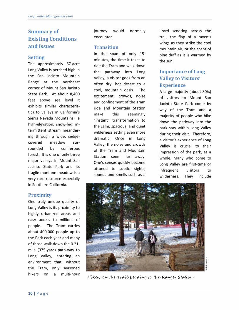
Bob Patterson
Hikers on the Trail Leading to the Ranger Station

SummaryofExistingConditionsandIssues
11 | P a g e
inner‐city school children on
field trips, international
travelers, family groups with
young children, casual
sightseers, and senior groups
on day trips.
EaseofAccessDespite being a forested
wilderness high in the
mountains, Long Valley is
easy to get to thanks to the
Tram. And because Long
Valley is easy to travel
through, it allows people of
all ages, experience, and
ability to discover, enjoy and
appreciate the rare, natural
setting. The generally level,
easy trails in Long Valley
(particularly the Discovery
Trail) make it simple for
visitors of even marginal
ability or limited experience
to hike amongst its scenery.
And the fact that Long Valley
is relatively compact in size
makes seeing a representa‐
tive sample of the park quick
and simple, which is
preferable to most visitors to
Long Valley. Despite this
ease of access, the hike
down and back up the
concrete pathway from the
Mountain Station is relatively
short but steep, and is an
impediment to those with
mobility impairments (the
pathway is 0.21 miles [375
yards] and the elevation
difference between the
Mountain Station and Long
Valley is approximately 120
feet, which averages to a
10% slope, but is steeper in
some locations). A system
for transporting these people
from the Mountain Station
to Long Valley and back
again is needed. In addition,
the trails on Long Valley’s
floor can be improved to
State Parks accessibility
standards so that disabled
persons can make their way
around and to each facility
and feature in Long Valley.
But overall, Long Valley is
uniquely situated and
assembled to provide an
easily available, enjoyable
experience for people of all
abilities.
VisitorUseA majority of visitors come to
Long Valley to spend a few
hours walking the trails and
enjoying the mountain
scenery. In wintertime, most
who visit are families excited
to play in the snow. Some
visitors pass through Long
Valley on their way to hike to
other locations within the
park, such as Round Valley or
San Jacinto Peak. A few
visitors enter Long Valley on
horseback from the west and
are interested in a brief stop
to rest and water their
horses as they take in the
amenities at the Mountain
Station.
Some school groups use Long
Valley as an outdoor class‐
room by learning about the
park’s resources through
interpreter‐led programs or
self‐guided discovery.
There are no designated
campsites and no overnight
use is allowed within Long
Valley.
ExistingFacilitiesBesides trails, trail bridges,
on‐grade and above‐grade
utility lines, and leach fields
operated by the PSAT, most
of the existing facilities
within Long Valley are
situated at the north and
west sides of Long Valley.
Pathway from Mountain Station to Long Valley
Bob Patterson

LongValleyManagementPlan
12 | P a g e
The main facilities are the
State Park ranger station
located at the north end, and
the Adventure Center, oper‐
ated by the PSAT, at the west
side of Long Valley.
The Long Valley Ranger
Station, built in 1963, is
currently in serviceable
condition but is undersized
for current staff functions as
well as visitor needs. For
example there are only two,
single‐stall restrooms (men’s
and women’s) available to
service all visitors to Long
Valley, including large school
groups. In addition, the
visitor contact area, sleeping
quarters, staff offices and
storage areas are all too
small to accommodate
current operations.
The Adventure Center was
built in the 1970s and is in a
dilapidated state. Its loca‐
tion at the west side of Long
Valley inadvertently causes
visitors to cross the creek
and meadow. During winter,
the snowpack usually pro‐
tects the meadow from
disturbance. However, dur‐
ing spring and fall, the snow
cover may be so minimal
that such foot traffic results
in damage to meadow
vegetation. The Adventure
Center needs to be moved to
a place in Long Valley that
does not encourage visitors
to cross the meadow and is
closer to the ranger station,
so that winter activities can
be more closely and easily
monitored in one area.
The remaining facilities
consist of an amphitheater
and picnic tables spaced
randomly near Long Valley
Creek and at the base of the
pathway from the Mountain
Station to Long Valley. These
are mostly placed too close
to the creek and meadow,
and dispersed such that
access to them causes
unnecessary trampling of
vegetation. Relocation of
these facilities away from the
Creek will better protect
sensitive resources.
The waste water system for
the Mountain Station and
Long Valley Ranger Station
consists of septic tanks and
leach fields that are largely
located within the Long
Long Valley Meadow in winter 2010
Bob Patterson

SummaryofExistingConditionsandIssues
13 | P a g e
Valley Gateway Zone. These
components were originally
built away from Long Valley
Creek, such that no affect to
the creek’s water quality
would be expected.
However, the results of
water quality monitoring by
the WPA has not been
reported to State Parks, and
no water quality monitoring
by State Parks has taken
place, so the actual effect of
these facilities is uncertain at
this time. In addition, the
potential effect of additional
and/or larger waste water
systems associated with any
new development within
Long Valley would need to be
evaluated.
The fire suppression system
for the Long Valley Ranger
Station and other structures
within Long Valley consists of
a 120,000 gallon above‐
ground dedicated fire water
tank and booster pump
system, powered by an
auxiliary generator. The tank
is supplemented every spring
with water from Long Valley
Creek. The fire suppression
system is currently deemed
adequate. However, any
additional structures added
to Long Valley will need to
meet current fire codes, be
approved by the State Fire
Marshal, and may require
additional fire suppression
resources and facilities. In
addition, the potential
impacts to water resources
and habitat due to withdraw
of water from the creek
needs to be evaluated and
addressed prior to the
implementation of any
additional development.
ManagementZonesThe Mount San Jacinto State
Park General Plan designates
“management zones” for all
areas of the Park. The intent
of these management zones
is to establish and define the
general resource character
and management, visitor
experiences and uses, and
possible range of proposed
facilities for the varied areas
of the Park. In particular for
Long Valley, the General Plan
describes three management
zones: the Long Valley
Gateway Zone, the Long
Valley Meadow Zone, and
the Seasonal‐Use Zone. Each
zone varies in character with
the corresponding needs and
intent of each different area.
In general, the Long Valley
Gateway Zone designates an
area of fewer sensitive
resources, potentially greater
numbers of visitors, and a
concentration of Long
Valley’s facilities including
the PSAT’s Mountain Station.
The Long Valley Meadow
Zone has the priority of
providing maximum protect‐
tion for the meadow and
limiting facilities to trails and
minor interpretive elements.
The Seasonal‐Use Zone was
established to recognize an
area of Long Valley that is
used only during the winter
season for snow play
activities. The Long Valley
Management Plan follows
the direction established for
each of these management
zones and incorporates their
boundaries in the “Proposed
Improvements” figures pre‐
sented in this document.
NaturalResourcesThe most sensitive and
important habitat located
within Long Valley is the
montane meadow habitat
found along Long Valley
Creek. This is characterized
by a dense growth of sedges
and other perennial wetland
species. Several sensitive
plant taxa potentially occur
in Long Valley Meadow. In
addition, several sensitive
animal species potentially
exist in Long Valley. Natural
resources of concern have
been classified as
Environmentally Sensitive
Areas (ESAs) and surrounded
by fencing to prevent
inadvertent encroachment
and provide long‐term
protection (See Proposed
LongValleyManagementPlan
14 | P a g e
Improvements Plan (Figure
5)):
Vegetation classification
types within Long Valley
include the Mixed Conifer
Forest and Montane
Meadow (A Manual of
California Vegetation by J.
Sawyer and Keeler‐Wolf,
1995). Wildlife habitat
classifications include the
Sierran Mixed Conifer and
Wet Meadow habitats
(California Wildlife Habitat
Relationship classification
system).
CulturalResourcesThere are seven recorded
archaeological sites located
in and adjacent to Long
Valley. Of these, three are
prehistoric including two
isolated artifacts within Long
Valley and a bedrock grinding
area near the ranger station.
The remaining five sites are
historic archaeological
features including historic
graffiti, a rock and cement
bench, and the remnants of a
rock structure.
There are also geographic
formations within the Park,
including San Jacinto Peak,
that are held sacred by the
Cahuilla Indians. However,
consultation with Native
American groups during the
General Plan process did not
indicate any specific
concerns for Long Valley at
that time.
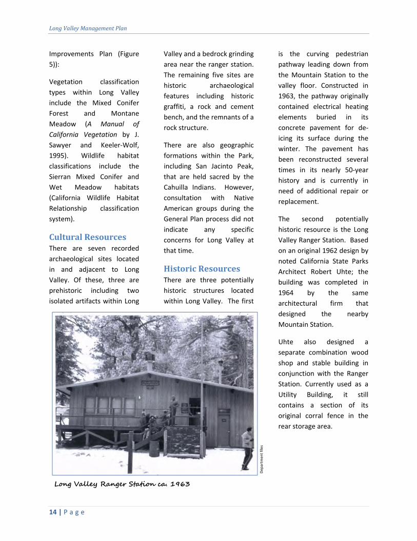
HistoricResourcesThere are three potentially
historic structures located
within Long Valley. The first
is the curving pedestrian
pathway leading down from
the Mountain Station to the
valley floor. Constructed in
1963, the pathway originally
contained electrical heating
elements buried in its
concrete pavement for de‐
icing its surface during the
winter. The pavement has
been reconstructed several
times in its nearly 50‐year
history and is currently in
need of additional repair or
replacement.
The second potentially
historic resource is the Long
Valley Ranger Station. Based
on an original 1962 design by
noted California State Parks
Architect Robert Uhte; the
building was completed in
1964 by the same
architectural firm that
designed the nearby
Mountain Station.
Uhte also designed a
separate combination wood
shop and stable building in
conjunction with the Ranger
Station. Currently used as a
Utility Building, it still
contains a section of its
original corral fence in the
rear storage area.
Departm
ent files
Long Valley Ranger Station ca. 1963

SummaryofExistingConditionsandIssues
15 | P a g e
InterpretationA State Park Interpreter is
currently stationed in Long
Valley to coordinate and lead
school group programs as
well as train park aids and
provide support to the Park
volunteers. Park aids con‐
duct many of the
summertime programs.
Volunteers provide guided
nature walks, conduct roving
interpretation, assist at the
ranger station, give campfire
and Junior Ranger programs,
and are school program
docents.
Within Long Valley there is a
very popular and heavily
used self‐guided nature trail
called the Discovery Trail.
Along the trail there are ten
engraved stone interpretive
panels which talk about Long
Valley’s resources.
Interpretation Master
Plan
An Interpretation Master
Plan (IMP) for Mount San
Jacinto State Park is
being developed con‐
currently with this
Management Plan by
State Park staff. The IMP
provides objectives and
strategies for develop‐
ment and delivery of
future interpretation
projects, programs and
services.
Contact the Inland
Empire District at (951)
443‐2423 for more
information or to obtain
a copy of the IMP.

LongValleyManagementPlan
16 | P a g e
ThePlan
The following section contains specific
management actions and facility
recommendations for Long Valley, consistent
with and in support of State Parks’ Mission and
the Mount San Jacinto State Park General Plan.
The general intent of these actions is to provide
better protection of resources in Long Valley as
well as improve visitors’ enjoyment and
appreciation of Mount San Jacinto State Park.
The actions and recommendations proposed in
this Plan are subject to future funding and
approval of State Parks management (See
Proposed Improvements Plans (Figures 5 & 6).
Provide Greater Protections forLongValleyMeadowandCreek
Long Valley Meadow contains some of the most
sensitive natural resources within the Park.
Long Valley Creek nourishes the meadow’s
sedges and other perennial vegetation which, in
turn, provide habitat for many animal species.
The meadow is a natural draw for visitors for its
beauty and openness within the surrounding
forest. The Discovery Trail circumnavigates the
meadow and in some locations is poorly located
too close to the riparian habitat. In addition,
volunteer trails and natural open areas
unintentionally invite visitors to venture into
the creek and meadow. This causes trampling
of sensitive vegetation and results in
degradation of the meadow habitat. Greater
protection for Long Valley Meadow will be
accomplished in the following ways:
Re‐locateFacilitiestoLongValley’sNorthEnd
All facilities other than trails, trail bridges,
and interpretive panels will be situated
north of the trail that runs between the
ranger station and terminus of the
pathway from/to the Mountain Station,
and kept within the Long Valley Gateway
Zone. This includes re‐locating the
Adventure Center and amphitheater. By
locating facilities within this area, visitors
will be less likely to enter the creek or
cross the meadow.
BuildNewSectionsoftheDiscoveryTrailtoAvoidtheExistingMeadowCrossing
The new sections will extend the
Discovery Trail by about 1,480 lineal feet
(0.28 miles) and include a new footbridge
over Long Valley Creek upstream (west)
of the meadow. The footbridge will be
similar to the existing bridge at the
southern‐most portion of the Discovery
Trail. This new trail alignment will avoid
crossing the meadow and establish a new
crossing point that is out of the creek. In
addition to the environmental benefits,
the new trail alignment will cause users to
pass by the ranger station, which offers
them an opportunity to stop in for maps
and information.
The Discovery Trail at the southern end of Long Valley
Bob Patterson

ThePlan
17 | P a g e
RemovetheTrailCrossingthroughtheMeadowanditsCorrespondingFootbridge
Because of the proposed new alignment
of the Discovery Trail (see prior bullet
point), the existing section of trail that
passes through the meadow and the
corresponding footbridge over the creek
is no longer needed and will be removed.
Removing this creek crossing will reduce
visitors’ unintentional trampling of native
vegetation in this area.
Re‐LocateSectionsoftheDiscoveryTrailthatEncroachontheMeadow’sEdge
Where sections of the Discovery Trail
enter the meadow, the trail will be moved
away to keep a buffer area between the
trail and meadow, to deter unintentional
trampling of meadow vegetation and
erosion of meadow soils. It is proposed
that the Discovery Trail be moved outside
the riparian habitat of the meadow
environment. Its current alignment
impacts the meadow and related
sensitive species. The actual trail re‐route
will be flagged by a team consisting of
staff from the State Parks’ trail program,
District resource specialists, and ranger
staff. Trail staff will have the responsibility
of finding a suitable final alignment within
the flagged route. In addition to moving
the trail away from the meadow’s edge,
periodic rest stops are proposed along
the meadow‐side of the Discovery Trail
that will allow viewpoints into the
meadow.
RedirectInadvertentFootTrafficawayfromtheMeadowandCreekthroughNaturalScreeningandFencing
At the terminus of the pathway to/from
the Mountain Station, where the current
Discovery Trail and the trail to the ranger
station branch off, visitors have a clear
view of Long Valley Creek across an open
area. This clear view and the open area
entice visitors to hike off‐trail to the
creek, bypassing established trails and
causing unintentional disturbance of the
open area and creek edges.
It is proposed that techniques of natural
screening and/or fencing be employed to
reduce the amount of open area that is
visible to the public and discourage
visitors from crossing the open area to
the creek. In particular, existing downed
logs, downed brush, and/or new split rail
fencing (in limited quantity) will be placed
between Long Valley Creek and the
terminus of the pathway connecting the
ranger station and Mountain Station, as
well as potentially in other open, sensitive
areas that are susceptible to
unintentional disturbance. A team of
selected District and other State Parks
staff will determine the final locations and
types of barriers.
MoveandEstablishAccessibleLocationsforPicnicAreasawayfromtheCreekandMeadow
Currently, several existing picnic tables
are located close to Long Valley Creek and
Meadow. These picnic tables entice
visitors to access these areas causing
additional unintentional resource
damage. It is proposed that these picnic

LongValleyManagementPlan
18 | P a g e
tables be moved away from the creek and
meadow to areas closer to the ranger
station and trail heads. In addition, the
picnic areas need to be designed to
comply with State Parks accessibility
standards. The final location and design
of these picnic areas will be determined
by District staff and with assistance of
State Parks trail program staff.
RevegetateandEnhanceHabitatalongLongValleyCreek
Concentrated foot traffic has contributed
to vegetation trampling and soil
compaction along the margins of the
creek creating large patches of bare dirt
in some locations. Revegetation with
plant species native to the area will serve
to protect the wetland from
encroachment, control erosion into the
creek, alleviate soil compaction, and
improve habitat quality. Methods of
revegetation and strategies for excluding
foot traffic will be devised to address
specific on‐site conditions, and will be
determined by District and other State
Parks specialists.
MonitorandProtectWaterResources
With the current waste water and fire
suppression systems in Long Valley, it is
uncertain if the quality of ground water
and water within the creek is being
affected. In addition, any new
development in the valley may pose new
or increased impacts to water quality. For
this reason, a water monitoring program
shall be implemented. Several water
quality parameters should be regularly
sampled, and assessed by trained
personnel. These should include pH,
dissolved oxygen, biological oxygen
demand (BOD), temperature,
conductivity, turbidity, and discharge or
flow measurements. Fecal coliform
samples should also be collected by
trained personnel, and tested by a
certified laboratory. Should the data
reveal significant degradation of water
quality, additional mitigation measures
shall be implemented to alleviate
potential sources of pollution and restore
acceptable water quality levels. In
addition, the source of supplemental
water for fire suppression tanks shall no
longer be withdrawn from Long Valley
Creek but instead from imported water
delivered by way of the Tram.
Improve Trail Conditions andAccessibility
The two main trails in Long Valley, the
Discovery Trail and the Desert View Trail, are
very popular and well used by visitors. They
allow visitors to access most areas of Long
Valley, such as the creek and meadow, as well
as take them to vantage points with spectacular
views of the Coachella Valley. Because of the
ease of access to Long Valley by way of the
Tram, many visitors come unprepared for
rigorous hiking conditions. For this reason,
Long Valley’s trails need to be designed for a
wider range of ability levels and to the highest
level of accessibility that topography and
natural and cultural resources will allow. In
addition, the trails need to be improved from
user‐created routes to sustainable trail designs
that represents minimal impact to the
resources, low maintenance cycles, and high
quality recreational experiences.

ThePlan
19 | P a g e
Discovery Trail
The Discovery Trail is a relatively easy, level,
0.55‐mile trail that travels around the meadow
and has two crossings over Long Valley Creek,
one wooden foot bridge and one metal
puncheon (a small, bridge‐type structure built
close to the ground, generally 3‐feet tall or less,
with or without handrails, that may be used to
cross small drainages, streams, and wet areas).
The trail is useable by Park visitors, but is
entrenched and impacts the high mountain
ecosystem in many areas. The puncheon is a
resource concern because it was placed without
high‐water clearances and crosses the creek at
a location without adequate bank heights. This
causes the puncheon at high flow to be
inundated with water and catch debris, forcing
hikers to bypass the puncheon and
inadvertently trample the riparian vegetation.
State Parks’ Trail Program staff has recently
built a wooden bridge over Long Valley Creek at
the southern end of the Discovery Trail where it
branches off to the Desert View Trail. This
bridge, as well as its accessory abutments and
causeway, were placed to allow for high flows
from snow melt and summer thunderstorms.
They were constructed for low maintenance,
durability, and compatibility with the forest
setting. By removing the current puncheon and
installing a similar bridge upstream, in an
appropriate location for high water flow and
away from the meadow, resource protection
would be improved and lower maintenance
achieved. In addition, sections of the Discovery
Trail need to be re‐routed away from Long
Valley Meadow in order to deter visitors from
entering the sensitive habitat. Because the
Discovery Trail follows gentle terrain, it is
suitable for a change in use to an accessible trail
which will connect facilities and features within
Long Valley.
Desert View Trail
The Desert View Trail is generally steeper,
longer and a more challenging hike than the
Discovery Trail. This trail developed over time
by visitors desiring the dramatic desert views.
The 0.82‐mile trail branches off in three
locations from the Discovery Trail and navigates
the eastern ridge of Long Valley which
overlooks the Coachella Valley. Six overlook
locations along the trail (Grubb’s Notch, and
Notch 1 through Notch 5) offer different
vantage points. Many visitors, regardless of
experience or ability, make the trek along the
Desert View Trail to obtain these views. Not
being designed but user‐created, the overall
condition of the trail is not to State Parks design
standards and loses sediment (which ends up in
the fragile meadow ecosystem) from the high
use. The trail is generally too steep, travels
across elevation contours, and/or is
entrenched. This creates difficult hiking
conditions and is unsustainable for long term
maintenance. The Desert View Trail is in need
of re‐routing and/or re‐construction. Because
the six overlook areas are heavily used, they are
in need of leveling and widening to make them
more sustainable and user‐friendly.
The unofficial “Skyline Route” enters/departs
Long Valley and intersects the Desert View Trail
at Grubb’s Notch. There, it descends the
mountainside roughly 8,000 feet to Palm
Springs. Currently unresolved Issues such as
land ownership, potential impacts to Peninsular
Big Horn Sheep, and connections to the regional
trail system will likely affect its use in the future.
For this reason it will remain an “unofficial”
route until these issues are addressed.
Improving trail accessibility and conditions will
be accomplished through the following actions
(See Proposed Improvements Plan [Figure 5]):
LongValleyManagementPlan
20 | P a g e
ImproveTrailstoMeetStateParksAccessibilityStandards
All portions of the Discovery Trail
(including new sections) and sections of
the Desert View Trail up to Grubb’s Notch
and Notch 5 (approximately 5,872 lineal
feet or 1.11 miles) will be re‐routed
and/or reconstructed to meet State Parks’
“accessible” trail standards (admission,
passage, circulation, and full use of
buildings, facilities, programs, and the
various elements within or the
combination of them, to persons with
disabilities). The section of the Desert
View Trail between Grubb’s Notch and
Notch 5 (approximately 2,690 lineal feet
or 0.51 miles) cannot be brought up to
accessibility standards because of steep
and difficult terrain. This portion of the
trail will be re‐routed and re‐constructed
to improve usability and bring it up to
Department design standards, thus
improving sustainability.
EstablishNewSectionsofTrailtoConnectWithTheRoundValleyLoopTrailandtheWillowCreekTrail.
With the proposed creek crossing (foot
bridge) upstream from Long Valley
Meadow, there is the opportunity to
establish two new trail sections
connecting this portion of the Discovery
Trail to the Round Valley Loop Trail and
the Willow Creek Trail (approximately 818
lineal feet or 0.15 miles). These new
sections will eliminate the need for the
section of the Willow Creek Trail
(approximately 447 lineal feet or .085
miles) that crosses the creek and allow for
the removal of its existing, small wooden
puncheon, which does not meet
Department design standards. In addition,
placement of a new trail section north of
the creek will allow for removal of the
portion of the Round Valley Loop Trail
between the ranger station and the
intersection with the Willow Creek Trail
(approximately 667 lineal feet or 0.13
miles). This portion needs to be
abandoned due to its steep alignment,
deep ruts, and unsustainability. New trail
sections will be designed to avoid
sensitive resources and will be approved
by State Parks resource specialists and
operations staff.
Re‐RouteSectionsoftheDesertViewTrail
Sections of the Desert View Trail will be
re‐routed (approximately 2,230 lineal feet
or 0.42 miles) so that the trail alignment
View of Coachella Valley from the Desert View Trail “Notch 3”
Bob Patterson
ThePlan
21 | P a g e
better follows slope contours, thereby
reducing the steepness of grade. This will
make for a better user experience and
will result in less maintenance
requirements over the long term. Where
sections of the trail cannot be re‐routed,
such as between Notch 4 and Notch 5, it
will be re‐constructed in place for the
purpose of reducing maintenance needs
and creating a better trail for hikers to
use. All re‐routed trail alignments will be
designed to avoid sensitive resources and
approved by State Parks resource
specialists and operations staff.
Re‐ConstructAllSixOverlooksoftheDesertViewTrail
Although situated to take advantage of
the best views, the current overlooks are
un‐defined, sometimes steep, semi‐
cleared areas that were formed by visitor
foot traffic. All six overlooks will be
reconstructed in‐place to provide a
cleared and level pad area. This will be
accomplished by building low, native rock
retaining walls along the view‐side of the
overlook. Only about 6‐inches of each
retaining wall will be visible while
standing at the overlook while the rest
will be hidden below and would only be
seen if looking back at the overlook from
the view‐side. Each re‐constructed
overlook will keep to the same size
footprint as the original.
RehabilitateClosedTrailSections
Following closure of the selected trail
sections, and removal of the existing
small foot bridge (puncheon), restoration
will be conducted to prevent the
continued and inadvertent use of the
pathways. The trail surface will be
decompacted and/or regraded, and
downed vegetation (e.g., logs, shrubs)
could be placed to block or obscure entry
to the closed sections. Broadcast seeding
or container plantings may also be used
to revegetate the trail; thereby
reestablishing native habitat and
promoting recovery over the long‐term.
Add and Improve Visitor‐useFacilities
Current visitor‐use facilities in Long Valley
consist of trails, restrooms at the ranger station,
amphitheater, picnic tables, and an Adventure
Center. The Adventure Center is a winter‐only
snow‐play equipment rental building operated
by the PSAT. All of these facilities are in need of
some form of improvement. The restrooms in
the ranger station and the leach fields that
service them are undersized to handle current
capacity. The picnic tables need to be re‐
located away from the meadow and creek to
reduce existing impacts to the riparian area.
The Adventure Center is dilapidated and in a
location that encourages visitors to cross the
meadow and creek, inadvertently causing
resource damage.
In addition, because so many people come to
Long Valley in winter to enjoy snow‐play
activities, there is an opportunity to provide
additional recreational activities that are
consistent with the use of Long Valley and in
keeping with the guidelines of the General Plan.
These activities can provide additional quality
recreational experiences consistent with the
State Parks’ Mission.
Following are proposed additional and
improved facilities (See Proposed
Improvements Plan (Blow Up) (Figure 6)):

LongValleyManagementPlan
22 | P a g e
NewAdventureCenter
A new Adventure Center is to be located
at the site of the former equestrian
stables (the existing abandoned
equestrian stables, barn and storage
sheds will be removed). This generally
cleared area has seen significant past
disturbance from the former mule‐ride
concession, it sits on several feet of
decomposed manure, has few sensitive
resources, is away from the creek and
meadow, and is close to the ranger
station. For these reasons it is a good
location for the new Adventure Center
and associated snow‐play activities.
The Adventure Center will be built,
maintained, and operated by the PSAT to
function as a snow‐play equipment rental
concession. When not in winter use, it
may be maintained for group use by
reservation, staff functions, and its deck
used for picnicking.
Because the building site has many feet of
unconsolidated fill (decomposed
manure), a pier or stem wall foundation
that extends through the fill to the
underlying native soil may be required.
The building will be designed to blend
with the natural setting and be
compatible with other, rustic structures in
the vicinity, such as the ranger station,
maintenance shop, and water storage
tanks.
The existing Adventure Center will be
demolished. Materials will be either
salvaged and stored at the maintenance
shop or removed from the park and
disposed of at an appropriate off‐site
facility. Rehabilitation measures to return
the Adventure Center area landscape to a
natural setting (e.g., regrading, revege‐
tation) will be determined by site
assessment.
OutdoorActivityArea
An outdoor activity area, suitable for
various recreational, interpretive, and
operational needs, is proposed for the
former equestrian stables area adjacent
to the new Adventure Center. The intent
of this area is to be a flexible space for
winter activities such as snow play and
skating (see “Synthetic Ice Rink”), as well
as for school group activities, gatherings
for educational programs, and other
various uses at any time of the year.
The outdoor activity area will be located
at the previously disturbed former
equestrian stables area. This area is
relatively level making it well suited for
the intended activities.
SyntheticIceRink
Winter‐time skating could be a popular
visitor activity that is similar to and an
extension of the current snow‐play
activities in Long Valley. A synthetic ice
Bob Patterson
Existing Adventure Center
ThePlan
23 | P a g e
rink; installed, operated, and maintained
by the PSAT; is proposed to be located at
the outdoor activity area for this purpose.
The synthetic ice rink would be used
during the winter season and afterward
disassembled so that potential noise and
high levels of use would occur only during
the winter months to coincide with snow‐
play activities. The synthetic ice rink will
not require any major permanent utility
or equipment infrastructure, and is a
temporary facility.
The synthetic ice rink shall be blended as
best possible with the natural setting and
terrain. This can be accomplished
through creative siting, rustic railings
and/or barriers, equipment screening,
and maintaining a small footprint. In
addition, the facility will be designed,
installed, and maintained so as to reduce
potential sound, crowding, and visual
impacts to the greatest extent possible.
Funicular
Currently, there is no way for people in
wheelchairs or with limited mobility to
access Long Valley. The existing concrete
pathway from the Mountain Station to
Long Valley is too steep for wheelchairs
and too long for many people with
disabilities. Providing access to Long
Valley for the elderly and people with
mobility impairments is a desire of
California State Parks and the PSAT.
Having this access will allow all visitors to
have a first‐hand experience of Long
Valley instead of merely looking at Long
Valley from the Mountain Station.
The proposed funicular device, funded
and operated by the PSAT, will serve the
purpose of transporting people in
wheelchairs or with limited mobility from
the Mountain Station to Long Valley’s
floor. It would be used only for this
purpose and fees could not be charged
for its use.
A feasibility study is also proposed to
determine the most suitable type of
funicular and alignment, as well as
establish cost and operational
parameters. This feasibility study would
be an independent analysis, funded by
the PSAT and subject to State Parks
approval.
NewRestroomBuilding
A restroom building and associated septic
tank and leach field, of adequate size to
serve the needs of visitors who are using
the Adventure Center, outdoor activity
area, and synthetic ice rink, is to be built
adjacent or attached to the Adventure
Center. The restroom building will be
designed to blend with the natural setting
and be compatible with other rustic
structures in the vicinity, such as the
ranger station, maintenance shop, and
water storage tanks.
EquestrianStagingArea
A small, compact equestrian staging area,
with room for up to six horses, is
proposed for visitors to Long Valley who
arrive on horseback and wish to take a
break from trail riding and rest their
horses. The location is proposed between
the new ranger station, Adventure
Center, and maintenance shop in a
suitable, already‐cleared open area. The
equestrian staging area will include a
corral, shade ramada, hitching post, and
LongValleyManagementPlan
24 | P a g e
watering device. The area will be available
for day use only (no overnight use) and no
horse washing facilities will be available.
All facilities in the equestrian staging area
will be rustic in appearance, blend as best
possible with the natural terrain and
setting, and match as closely as possible
to other structures in the vicinity.
Responsibility for maintaining and
cleaning this facility will be State Parks
staff and/or volunteers.
AreaforSummerEquipmentRentalSeasonalStructure
An area for a seasonal structure to house
a summer equipment rental (climbing
gear, etc., for areas within the park and
north of Long Valley) is proposed for a
suitable, already‐cleared open area
located near the outdoor activity area.
The temporary structure could be a tent
on elevated platform, such as a yurt or
canvas‐walled structure, which can be
easily set up and dismantled after the
climbing season is over (once winter
weather begins). Funding, operation, and
maintenance of the seasonal structure
would be the sole responsibility of the
concessionaire with oversight by the
PSAT.
ReplacementConcretePathwayandHandrail
The existing, 0.21‐mile (375‐yard)
concrete pathway from the Mountain
Station to Long Valley, although recently
replaced, is already deteriorating and
poses a slipping hazard in several
locations. For this reason, a replacement
pathway is proposed for the entire length.
Level, pull‐out areas for wheelchair users
that are strong enough to navigate the
steep pathway are needed at regular
intervals so that they may rest. In
addition, the pathway is in need of a new
handrail along the entire length that will
provide a more reliable hand‐hold and
prevent children from passing
underneath. The pathway and handrail
replacement will be designed to comply
with all applicable codes including the
Americans with Disabilities Act (ADA).
Care will be taken to maintain the existing
pathway's historic alignment. The
pathway and handrail replacement will be
paid for by the PSAT and will be
considered a high priority due to the need
for reliable and safe access to and from
Long Valley.
NewBenchesalongConcretePathway
The 0.21‐mile (375‐yard) concrete
pathway from the Mountain Station to
Long Valley is relatively steep. While
walking this pathway, many visitors tire
and need a place to rest. It is proposed
that new benches be installed at
appropriate places along the pathway,
such as at switchbacks and at regular
intervals, to provide resting places for
visitors walking to or from Long Valley.
These benches will be rustic in
appearance to blend with the natural
surroundings while remaining durable in
extreme weather conditions. Larger
benches will be considered at switchbacks
as long as fencing or other barriers are
erected to deter people from traveling off
trail.

ThePlan
25 | P a g e
AddNewInterpretiveFacilities
With a high number of first‐time, foreign and
school‐age visitors to Long Valley’s wilderness
setting, there is a great opportunity to inform
and educate them about the Park’s resources
and recreation activities. New interpretive
facilities are proposed that will help accomplish
this goal.
AmphitheaterwithRusticStageforInterpretivePrograms
In a clearing just north of the terminus of
the pathway leading from the Mountain
Station into Long Valley, an amphitheater
with seating for up to 100 people is
proposed to replace the existing
amphitheater located between the ranger
station and Long Valley Creek. Moving
the amphitheater to this location, which
currently serves as an informal picnic area
and has already incurred ground
disturbance, will significantly reduce foot
traffic damage in and around the creek.
In addition, the location at the pathway
bottom is a more strategic location for
interpretive programs and large, school
group presentations. When not in use as
an amphitheater, the seating areas may
be used by the public for picnicking,
resting, and observing nature.
On the site of the new amphitheater, a
rustic pavilion with a stage is proposed for
conducting school group programs and
interpretive presentations to the public.
The amphitheater will blend with the
forested setting and match the rustic
appearance of the nearby, existing water
storage tank. Split logs will be used for
seating at the amphitheater.
At the existing amphitheater, the seating,
fire pit, and electrical outlets will be
removed and may be re‐used for other
park purposes. The area will then be
reviewed to evaluate the level of
disturbance, so that District and State
Parks specialists can develop, and
subsequently implement, suitable
methods of habitat restoration and/or
enhancement.
VisitorContactKiosk
For many visitors to Long Valley it is their
first time to the Park and many are
uncertain what there is to see and do. In
addition, many of these visitors have not
been introduced to wilderness conditions
and may not understand the value and
importance of the Park’s resources. For
this reason, there is a great opportunity
for a State Parks’ employee or volunteer
to greet the public as they enter Long
Valley and offer trail maps and
information, Park brochures, and public
safety information, to direct hikers to the
ranger station for wilderness permits and
answer visitor’s questions, as needed.
A small, moveable, rustic‐appearing kiosk
is proposed that will serve as a meet‐and‐
greet station and storage area for hand‐
outs and interpretive materials. The
intent of this kiosk is to be set up
intermittently at the terminus of the
concrete pathway from the Mountain
Station. This could be done during any
busy season, such as winter holidays,
then removed and stored until it is
needed again.

LongValleyManagementPlan
26 | P a g e
SignPlan
In many locations throughout Long Valley,
signs are needed to better inform visitors
of Park regulations, identify trails, and
provide information about Park resources
consistent with the intent of the 2011
Interpretation Master Plan (IMP) for
Mount San Jacinto State Park. For
example, a sign informing visitors that
they are entering a wilderness setting is
needed somewhere along the pathway
leading from the Mountain Station to
Long Valley, to warn visitors of a
potentially harsh environment beyond
the confines of the Mountain Station.
A comprehensive sign plan is proposed
that would accomplish these goals. This
plan will consider all types of signs such as
those for trail identification, information
and interpretation, regulatory, way‐
finding, and building identification. The
scale of signs in Long Valley will be as
minimal as possible and their appearance
will be compatible with the natural
surroundings and rustic buildings and
structures.
Provide Better OperationsFacilities
To help make the staff and volunteer
work environment more hospitable and
efficient to use, as well as provide new
and improved areas where staff can
interact with visitors, the following
operations facilities within Long Valley
will be replaced with new, more efficient
facilities (See Appendix 3 – Preliminary
Building Programs).
ExpandedRangerStationComplex
The existing 1964‐built Long Valley
Ranger Station and Utility Building will be
rehabilitated as part of a new, expanded
Ranger Station Complex. An additional
building (or buildings) will accommodate
current and future staff levels and uses,
including a larger and improved visitor
contact area, work stations, storage, and
sleeping quarters (sleeping quarters are
needed because of the area's remote
location and for multi‐day assignments).
Designers will consider the option of
having the multiple buildings
interconnected by covered walkways or
decks to improve accessibility to each.
The appearance of the new building(s)
will complement but not mimic the
original Ranger Station. Like the latter,
the new building(s) will blend in with the
natural surroundings, as well as work into
the existing grade.
NewMaintenanceShop,StorageBuilding,andWoodShed
A new larger structure will be built near
Existing Ranger Station
Bob Patterson
ThePlan
27 | P a g e
the original Utility Building for additional
maintenance, heavy equipment, and
wood storage space. Additional space will
be provided for shop tables, tool racks,
and work areas.
An additional smaller storage building is
proposed with cabinets, racks, and
shelves to store supplies, chemicals,
paint, lubricants, etc. A new wood
storage shed will also be constructed
nearby to house all of the wood and other
building materials needed for repair and
refurbishment of State Parks‐maintained
structures in the Park. A rustic fence will
surround the maintenance shop, storage
building, and wood shed to provide a
secure area for working and material
storage.
ImproveElectricalService
Currently, electrical service for facilities in
Long Valley is supplied by way of
overhead lines from the Mountain
Station. These lines and the poles which
support them impact the natural scenery.
In addition, the electrical power available
from these lines is insufficient to supply
all the power needs of the existing ranger
station. For this reason, the ranger
station has an auxiliary generator. This
generator runs frequently and contributes
to noise impacts in the wilderness setting.
It is proposed that the existing auxiliary
generator be removed once the proposed
expanded ranger station complex and
other buildings are constructed in Long
Valley. This generator will be replaced
with:
1) new and improved electrical lines
from the Mountain Station,
preferably placed underground if
soil conditions are favorable and if
existing natural and cultural
resources can be protected; and/or
2) solar power for each building;
and/or
3) tying into the auxiliary power at the
Mountain Station.
The final solution will be sustainable, cost
effective, and have the least effect on the
environment.
NewAnimal‐ProofTrashandRecyclingEnclosures
At a location near the terminus of the
concrete pathway from the Mountain
Station to Long Valley there is a fenced
area designated for trash containers. The
current containers are not animal‐proof.
By not providing animal‐proof receptacles
there is the potential to lure bears and
other wildlife from adjacent wilderness
areas to Long Valley. It is proposed that
new animal‐proof trash and recycling
enclosures be installed in place of the
existing containers. Besides being animal‐
proof these enclosures will be ADA
compliant, as well as blend as best
possible with the natural setting.

LongValleyManagementPlan
28 | P a g e
FacilityDesignGuidelines
When the design of buildings and structures dominates, competes with, or ignores a
Park’s natural surroundings, it can detract from a visitor’s overall Park experience as
well as diminish their appreciation of the natural environment. To help guide the design
of facilities proposed in this Management Plan, the following guidelines are presented
to help create an integrated and aesthetically pleasing park setting. In addition to these
guidelines, further recommendations are found in Appendix 5 – “Guiding Principle for
Quality Aesthetic Design at State Parks”.
Development will blend with and compliment the natural surroundings.
Structures will not dominate the site but rather remain in harmony with the
native landscape.
Disturbance of native vegetation will be avoided or minimized by integrating
structures with the native landscape and topography. Whenever possible, place
structures in open areas rather than removing trees or vegetation.
Sustainable design and maintenance practices will be followed that promote
energy conservation, waste reduction, recycling, and other resource
conservation practices.
Textures of the development, whether of material or the overall physical profile,
will be reflective of the surrounding environment.
Night lighting will be designed so as not to obscure or intrude upon the night
sky. Activities such as star gazing will be fully considered in developing lighting
options. If required for visitor safety, energy efficient light fixtures set low to
the ground plane, should be used to reduce glare and light pollution.
Both existing and future utilities such as telephone and electrical lines will be
installed underground wherever possible.
ThePlan
29 | P a g e
ProposedImprovementsPlan(Figure5)

LongValleyManagementPlan
30 | P a g e
ProposedImprovementsPlan(Blow‐Up)(Figure6)
Appendices
31 | P a g e
Appendices
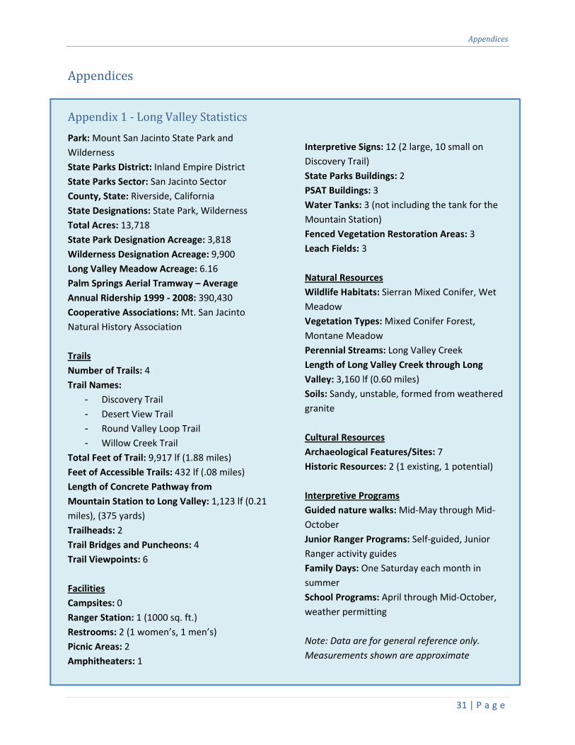
Appendix1‐LongValleyStatistics
Park: Mount San Jacinto State Park and
Wilderness
State Parks District: Inland Empire District
State Parks Sector: San Jacinto Sector
County, State: Riverside, California
State Designations: State Park, Wilderness
Total Acres: 13,718
State Park Designation Acreage: 3,818
Wilderness Designation Acreage: 9,900
Long Valley Meadow Acreage: 6.16
Palm Springs Aerial Tramway – Average
Annual Ridership 1999 ‐ 2008: 390,430
Cooperative Associations: Mt. San Jacinto
Natural History Association
Trails
Number of Trails: 4
Trail Names:
- Discovery Trail
- Desert View Trail
- Round Valley Loop Trail
- Willow Creek Trail
Total Feet of Trail: 9,917 lf (1.88 miles)
Feet of Accessible Trails: 432 lf (.08 miles)
Length of Concrete Pathway from
Mountain Station to Long Valley: 1,123 lf (0.21
miles), (375 yards)
Trailheads: 2
Trail Bridges and Puncheons: 4
Trail Viewpoints: 6
Facilities
Campsites: 0
Ranger Station: 1 (1000 sq. ft.)
Restrooms: 2 (1 women’s, 1 men’s)
Picnic Areas: 2
Amphitheaters: 1
Interpretive Signs: 12 (2 large, 10 small on
Discovery Trail)
State Parks Buildings: 2
PSAT Buildings: 3
Water Tanks: 3 (not including the tank for the
Mountain Station)
Fenced Vegetation Restoration Areas: 3
Leach Fields: 3
Natural Resources
Wildlife Habitats: Sierran Mixed Conifer, Wet
Meadow
Vegetation Types: Mixed Conifer Forest,
Montane Meadow
Perennial Streams: Long Valley Creek
Length of Long Valley Creek through Long
Valley: 3,160 lf (0.60 miles)
Soils: Sandy, unstable, formed from weathered
granite
Cultural Resources
Archaeological Features/Sites: 7
Historic Resources: 2 (1 existing, 1 potential)
Interpretive Programs
Guided nature walks: Mid‐May through Mid‐
October
Junior Ranger Programs: Self‐guided, Junior
Ranger activity guides
Family Days: One Saturday each month in
summer
School Programs: April through Mid‐October,
weather permitting
Note: Data are for general reference only.
Measurements shown are approximate

LongValleyManagementPlan
32 | P a g e
View of San Gorgonio Mountain from Desert View Trail “Notch 3”
Bob Patterson
Appendix2‐ListofAbbreviationsandGlossary
Accessible Admission, passage, circulation, and full use of buildings, facilities, programs, and
the various elements within or the combination of them, to persons with disabilities
(per California State Parks, 2009, Accessibility Guidelines).
ADA Americans with Disabilities Act
CEQA California Environmental Quality Act
IMP Interpretation Master Plan (for Mount San Jacinto State Park)
PSAT Palm Springs Aerial Tramway. The organization that operates and maintains the
Tram.
Puncheon A small, bridge‐type structure built close to the ground (generally 3‐feet tall or less),
with or without handrails, that may be used to cross small drainages, streams, and
wet areas.
WPA Mount San Jacinto Winter Park Authority. The governing body of the Palm Springs
Aerial Tramway. A public agency and public corporation of the State of California.

Appendices
33 | P a g e
Appendix3‐PreliminaryBuildingProgramsLong Valley Ranger Station, Maintenance
Shop, Storage Building, and Wood Storage
Shed
Long Valley Ranger Station Complex
- Building(s) will accommodate at least
ten (10) staff working simultaneously
- Multi‐purpose room with seating for
about fifteen (15), to serve as training
room, incident command post, park
aide office, and overflow sleeping area.
Equip with projector and screen, copy
machine, smart board, and at least two
(2) computer stations with flat panel
monitors
- Ranger office: space for three desks,
three file cabinets, gun safe, secure fax
line, lost and found/evidence storage
- Two (2) bunk rooms, with sleeping
capacity of (4) four per room
- Two (2) staff restrooms with shower,
towel hooks, toiletry cabinet for each
employee
- Locker room with ten (10) wall lockers
(lockers 2’‐wide X 6’‐high due to large
amount of winter gear)
- Visitor contact room (approx. 300 sf)
- Kitchen with pantry space for ten (10)
- Fitness room
- Communications area for base station
radio and battery chargers
- Animal‐proof garbage and recycle
receptacles
- Adequate electrical outlets and storage
- Adequate propane storage tanks,
propane water heaters, and automatic
generator for electrical power outages
and periods of insufficient electrical
supply
- Building(s) will evoke the spirit and
minimal‐rustic feel of the original
ranger station
Maintenance Shop
- Insulated Maintenance Shop with roll
up door (for tractor)
- Washer/dryer hookups
- Sink
- Chemical/paint/lubricant storage locker
- Emergency shower and bathroom
- Assembly shop table with dust
collection system
- Lumber rack
- Tool tables
- Hand tool rack
- Attached or integrated pull‐through
carport for trailer
Storage Building
- Non‐insulated Storage Building with roll
up door
- Chemical/paint/lubricant storage
lockers
- Shelving, racks, and storage
compartments
Wood Storage Shed
- Non‐insulated, wood storage shed with
roof and enclosed back and sides to
insulate wood and building materials
from weather
- Racks of various sizes to accommodate
random sizes of lumber and various
types of building materials

LongValleyManagementPlan
34 | P a g e
Appendix4‐References
Bevil, Alex, State Historian II, California State
Parks, E‐mail 6/2011.
Bevil, Alex and Mealey, Marla, 2001 Mount San
Jacinto State Park and Wilderness
Resources Inventory – Cultural Section.
California Department of Parks and Recreation,
2002. Mount San Jacinto State Park
General Plan.
California Department of Parks and Recreation,
Concessions and Reservations Office,
1996. Operating Agreement for Mount
San Jacinto Winter Park Authority.
California Department of Parks and Recreation,
2011, Interpretive Master Plan for
Mount San Jacinto State Park.
California Department of Parks and Recreation,
2008, Project Evaluation for Long Valley
Interpretive/Directional Sign, for P.R.C.
5024, 5024.5 and E.O. W‐26‐92.
California Legislature, Fifty Sixth Session, 1945,
Mount San Jacinto Winter Park
Authority Act, Statutes 1945, Chapter
1040.
California State Parks, 2009, Accessibility
Guidelines
California State Parks, 2002, Mount San Jacinto
State Park Map
Chester, Tom; Stith, Dave; and Dillane, James;
2008, Flora of Tamarack, Round and
Long Valleys, San Jacinto Mountains,
http://tchester.org/sb/plants/floras/rou
nd_et_al_valleys.html.
Mealey, Marla, Associate State Archaeologist
with Southern Service Center, California
State Parks, E‐mail 6/2011.
Palm Springs Aerial Tramway, 2004, Visitor
Guide & Map.
Palm Springs Aerial Tramway, 2009, Ridership
History, FY 1998/1999 – 2008/2009.
Rischbieter, Douglas, 2000, Reconnaissance
Evaluation ‐ Select Hydrologic
Resources of Mt. San Jacinto State Park
and State Wilderness: Long Valley
Meadow, Round Valley, Hidden Lake.
San Diego Natural History Museum, 2008, San
Jacinto Centennial Resurvey,
http://www.sdnhm.org/research/sanjac
into/index.php.
Wassenberg, Katherine; Hendricks, William W,
Ph.D.; Greenwood, Jerusha B., Ph.D.,
2008, Mount San Jacinto State Park
Visitor Survey, California Polytechnic
State University, San Luis Obispo,
Recreation, Parks & Tourism
Administration.

Appendices
35 | P a g e
Appendix5‐GuidingPrincipleforQualityAestheticDesignatStateParks

LongValleyManagementPlan
36 | P a g e
“The clearest way to the Universe is through a forest
wilderness”
–attributed to John Muir
Acknowledgments
We wish to thank all of the people who have helped support and
develop this project. The staff of the California State Parks
Headquarters, Inland Empire District and San Jacinto Sector provided
considerable assistance and knowledge. Special thank you goes to staff
at the Palm Springs Aerial Tramway. Their help in providing a wonderful
venue for the public meeting is greatly appreciated. And finally we
wish to thank the many public citizens who helped shape this plan
through their participation at the workshops and meetings.
Sincerely,
Ron Krueper
District Superintendent
Inland Empire District
Bob Patterson
Project Leader
Southern Service Center

PlanningTeam&PlanningAssistance
37 | P a g e
PlanningTeam
Ellen Absher
State Park Interpreter II
Perris Sector
Garratt Aitchison
Sector Superintendent
San Jacinto Sector
Enrique Arroyo
Associate Park and Recreation Specialist
Inland Empire District
Larrynn Carver
Associate State Archaeologist
Inland Empire District
Lynn Earls‐Holliday
Park Maintenance Chief III
Inland Empire District
Rob Howard
State Park Interpreter I
San Jacinto Sector
Ken Kietzer
Environmental Scientist
Inland Empire District
Ron Krueper
District Superintendent
Inland Empire District
Bob Patterson
Associate Landscape Architect
Southern Service Center
PlanningAssistance
Alexander Bevil
State Historian II
Southern Service Center
Mike Bonk
Research Program Specialist I (GIS)
Southern Service Center
Rich Burg
Senior Environmental Scientist
Southern Service Center
Bart Grant
Supervising Park Ranger
San Jacinto Sector
Karl Knapp
Staff Park and Recreation Specialist
Facilities Management Division
Barney Matsumoto
Supervising Landscape Architect
Southern Service Center
Marla Mealey
Associate Archaeologist
Southern Service Center
Steve Musillami
Associate Landscape Architect
Planning Division
Luke Serna
Park and Recreation Specialist
Southern Service Center
Debbie Waldecker
Environmental Scientist
Southern Service Center
LongValleyManagementPlan

LongValleyManagementPlan
Edmund G. Brown Jr.
Governor
John Laird
Secretary for Natural Resources
Ruth Coleman
Director of Parks and Recreation
State of California
The Natural Resources Agency
Department of Parks and Recreation
P.O. Box 942896
Sacramento, CA 94296‐0001
Printed on 30% post‐consumer waste recycled paper