location study procedures update 2015 - new...
TRANSCRIPT

Post Office Box 1149Santa Fe, NM 87504
Location Study Procedures Update 2015
A Guidebook for:Planning and Environmental Linkages, Alignment Studies, and Corridor Studies


Table of Contents
i
Section 1: Introduction and Process Overview .................... 1-1Introduction and Purpose .......................................................................... 1-1
Applicability of the Location Study Procedures ...................................... 1-2
Transportation Project Development Overview ...................................... 1-3
Project Certifications ................................................................................. 1-10
Section 2: Preliminary Scoping and Project Initiation .......... 2-1Project Definition ......................................................................................... 2-1
Level of Effort and Schedule ...................................................................... 2-1
Identify Issues of Importance ..................................................................... 2-3
Establish Study Team ................................................................................... 2-4
Products of Project Definition Phase ......................................................... 2-5
Section 3: Alignment/Corridor Study Process ...................... 3-1Phase A: Alternative Identification and Screening ............................... 3-4
Step A 1: Existing Conditions and Constraints ....................................... 3-6
Step A 2: Agency Coordination and Public Involvement ................. 3-10
Step A 3: Establish Purpose and Need ................................................. 3-14
Step A 4: Development of Study Alternatives ..................................... 3-17
Step A 5: Initial Screening of Alternatives ............................................ 3-22
Phase B: Detailed Alternatives Analysis ................................................ 3-33Step B 1: Detailed Evaluation of Alternatives ...................................... 3-34
Step B 2: Engineering Refinement of Preferred Alternative(s) ........... 3-39
Step B 3: Alternatives Analysis Report ................................................... 3-40
Phase C: Environmental Documentation ............................................ 3-42Step C 1: Prepare Resource Reports and Agency Consultation ...... 3-43
Step C 2: Prepare Environmental Document ...................................... 3-44
Step C 3: Final Environmental Certification ......................................... 3-46
Step C 4: Environmental Re-evaluation ............................................... 3-51
Phase D: Preliminary Design ................................................................... 3-52

Location Study Procedures Update 2015A Guidebook for Alignment Studies and Corridor Studies
ii
Section 4: Requirements and Methods ................................. 4-1Overview and Purpose ............................................................................... 4-1
Traffic Analysis .............................................................................................. 4-2
Safety Analysis ............................................................................................. 4-5
Systems Engineering.................................................................................... 4-7
Preliminary Drainage Analysis .................................................................. 4-10
Air Quality ................................................................................................... 4-13
Noise ........................................................................................................... 4-15
Environmental Justice , Social, and Economic Issues ........................... 4-17
Visual Resources ........................................................................................ 4-20
Relocations ................................................................................................ 4-22
Farmlands ................................................................................................... 4-24
Cultural Resources .................................................................................... 4-26
Section 4(f) and 6(f) Resources ............................................................... 4-29
Surface Water, Water Quality, and Wetlands ....................................... 4-32
Floodplains ................................................................................................. 4-36
Biological Resources ................................................................................. 4-38
Threatened, Endangered, and Sensitive Species ................................. 4-41
Hazardous Materials ................................................................................. 4-45
Appendix ASummary of Federal Environmental Legislation and Regulations
Appendix BGlossary of Terms and Acronyms

Acronyms
iii
Acronym DefinitionAAI All Appropriate Inquiry
ADA Americans with Disabilities Act
CAC Citizen Advisory Committee
CE Categorical Exclusion
CERCLA Comprehensive Environmental Response, Compensation and Liability Act
CFR Code of Federal Regulation
CME Construction Maintenance Easement
CMP Congestion Management Process
CMS Congestion Management System
CO Carbon Monoxide
CoO Concept of Operations
CSS Context Sensitive Solutions
CWA Clean Water Act
DEIS Draft Environmental Impact Statement
DSI Detailed Site Investigation
DTM Digital Terrain Model
EA Environmental Assessment
EGS Environmental Geology Section
EIS Environmental Impact Statement
EO Executive Order
EP Environmental Professional
EPA Environmental Protection Agency
FEIS Final Environmental Impact Statement
FHWA Federal Highway Administration
FONSI Finding of No Significant Impact
FPPA Farmland Protection Policy Act
FTA Federal Transit Administration
HCM Highway Capacity Manual
HMAH Hazardous Material Assessment Handbook
HSM Highway Safety Manual
IDD Infrastructure Design Directive
IP Individual Permit
ISA Initial Site Assessment
ITS Intelligent Transportation System
LEDPA Least Environmentally Damaging Practicable Alternative
LMP Limited Maintenance Plan
LOS Level of Service
MPO Metropolitan Planning Organization
MS4 Municipal Separate Storm Sewer Systems
MTP Metropolitan Transportation Plan
MUTCD Manual on Uniform Traffic Control Devices

Location Study Procedures Update 2015A Guidebook for Alignment Studies and Corridor Studies
iv
Acronym DefinitionNAAQS National Ambient Air Quality Standards
NAC Noise Abatement Criteria
NEPA National Environmental Policy Act
NMAC New Mexico Administrative Code
NMDOT New Mexico Department of Transportation
NMED New Mexico Environment Department
NMTMS New Mexico Traffic Monitoring Standards
NPDES National Pollution Discharge Elimination System
NRCS Natural Resources Conservation Service
OSHA Occupational Safety and Health Act
PEL Planning and Environment Linkages
pISA Preliminary Initial Site Assessment
PS&E Plans, Specifications, and Estimates
PSI Preliminary Site Investigation
RCRA Resource Conservation and Recovery Act
ROD Record of Decision
RPO Regional Planning Organization
SAMM State Access Management Manual
SARA Superfund Amendments and Reauthorization Act
SE Systems Engineering
SEMP Systems Engineering Management Plan
SHPO State Historic Preservation Officer
STIP Statewide Transportation Improvement Program
SWMP Storm Water Management Plan
TAC Technical Advisory Committee
TCP Temporary Construction Permit
TDM Travel Demand Management
TESCM Temporary Erosion and Sediment Control Measures
TESCP Temporary Erosion and Sediment Control Plan
TIP Transportation Improvement Program
TMA Transportation Management Area
TNM Traffic Noise Model
TRB Transportation Research Board
TSCA Toxic Substances Control Act
TSM Transportation System Management
USACE United States Army Corps of Engineers
USC United States Code
USDA United States Department of Agriculture
USFWS United States Fish and Wildlife Service
USGS United States Geological Survey

Section 1Introduction and Process Overview
1-1
Introduction and Process OverviewIntroduction and PurposeThis guidebook has been prepared to assist transportation engineers, planners, and other practitioners in conducting alignment and corridor studies for New Mexico Department of Transportation (NMDOT) projects. While the guidebook provides the information needed to cover the most complex transportation projects, it emphasizes the processes appropriate for the most common project scopes. The guidebook is also intended to establish consistency in how location studies are prepared, reviewed, and processed by the NMDOT.
This edition of the Location Study Procedures focuses on several recent changes in federal law intended to streamline project delivery. These changes include: (1) fully incorporating the principles of the Federal Highway Administration (FHWA) Planning and Environment Linkages (PEL) policy into the study procedures to avoid duplication of efforts and cost as projects advance from planning to project development; (2) changes by FHWA to allow additional types of projects that can be authorized with a categorical exclusion (CE); and (3) changes to improve programming and delivery schedules.
The guidance and procedures described herein are consistent with all National Environmental Policy Act (NEPA) legislative requirements, the regulatory requirements codified in 23 CFR 770-772 and 774, the FHWA PEL policy, and other federal and state regulations and policies related to transportation planning and project development. This guidebook, together with other Department policies and procedures, also meets the requirements of 23 CFR 771.111.h(1) for states to have procedures for public involvement.
The guidebook is structured in a logical sequence of steps and activities that make up the alignment/corridor study process. The information begins with an overview of the larger project development process and a brief explanation of how alignment/corridor studies fit into that process. A step-by-step description of each major phase of the alignment/corridor study process is then provided, followed by more detailed information regarding major work activities.
These guidelines fully incorporate the concepts of Planning and Environmental Linkages, address expanded use of Categorical Exclusions, and improve project programming and scheduling.

NMDOT
Section 1Introduction and Process Overview
1-2
While all major elements of the alignment/corridor study process are discussed within this guidebook, practitioners should use it together with other NMDOT processes to gain a more complete understanding of the various elements and requirements of alignment/corridor studies. Readers should understand that this guidebook is not intended to be all encompassing, nor are the procedures meant to be prescriptive. While a structured and consistent process is important, the study process requires flexibility to address issues that are unique to each situation and must integrate many different factors and issues. Accordingly, a prevailing theme of this guidebook is an interdisciplinary approach to decision making. The development and evaluation of engineering concepts requires the involvement and collaboration of many people including engineers, planners, environmental specialists, cultural resource specialists, and others with expertise in project development. An interdisciplinary approach will lead to good engineering decisions that meet both the requirements and intent of NEPA.
A second theme of this guidebook—and the policy of the NMDOT—is the involvement of the public and other agencies in the decision making process. Public involvement must be a cooperative and collaborative process that involves many groups with diverse needs and perspectives. This includes federal, state, and local agencies, local jurisdictions, users of the proposed facility, property owners, the general public, and other persons or groups having a stake or interest in the final decision. Coordination with other agencies and involvement of the public must be proactive, comprehensive, and continuous through the project development process. The tools available to enhance public access to project information have evolved considerably over the last fifteen years. Changes in the methods used to inform and involve the public are discussed in this update.
Applicability of the Location Study ProceduresThe Location Study Procedures are the NMDOT’s process for corridor-level planning and are applicable to all NMDOT projects, regardless of transportation mode (highways, railroads, airports, etc), that involve the development and analysis of alternatives. These are normally projects such as (1) new roadways and major changes to existing roadways that alter the roadway alignment, and/or add traffic lanes or auxiliary lanes greater than ½ mile in length, and/or substantially alter roadway
A prevailing theme of this guidebook is an interdisciplinary approach to decision making. This approach leads to good engineering decisions that meet both the requirements and intent of NEPA.

Location Study Procedures Update 2015A Guidebook for Alignment Studies and Corridor Studies
1-3
access; and (2) location and design of park-and-ride facilities and other major transit investments; (3) new or realigned rail lines; (4) major multipurpose trail and other bicycle/pedestrian/equestrian projects that consider alternative alignments and designs; and (5) major ITS projects that develop ITS architecture for an area.
The location study procedures do not apply to general maintenance projects or minor spot improvements that do not require consideration of alternatives, the addition of lanes, or major changes to roadway geometry. These projects are typically constructed with internal NMDOT forces or let to bid as “book” projects without associated design plans and receive environmental clearance with a programmatic categorical exclusion (PCE). It is important to note that exclusion from the location study process does not exempt projects from complying with the National Environmental Policy Act (NEPA). The NMDOT Environmental Section should be consulted if there are any questions on the need for an alignment/corridor study or environmental clearance.
Transportation Project Development OverviewThe development of transportation projects is a multi-phased, multi-year process that involves a significant commitment of technical and financial resources (Figure 1-1). Project development involves six major phases including (1) long-range planning, (2) prioritization and programming, (3) study scoping and conceptual design, (4) preliminary and final design, (5) construction, and (6) maintenance and performance monitoring. The NMDOT combines the Study and Conceptual Design Phase with Preliminary Design to form what is called Phase I of project design. The Final Design Phase is termed Phase II and construction is Phase III. The following is an overview of each of these phases:
1. Long-Range Planning serves to establish long-range goals, objectives, and system needs at the statewide, regional, or metropolitan planning area level. By federal law, states must develop and adopt a statewide long-range transportation plan that identifies
Construction
Maintenance & Performance
Monitoring
Preliminary & Final Design
Study & Conceptual
Design
Long Range
Planning
Prioritization & Programming
Figure 1-1: Project Development

NMDOT
Section 1Introduction and Process Overview
1-4
transportation needs at least 20 years into the future. Federal law also requires metropolitan areas with a population of 50,000 or more to develop their own long-range transportation plan with special rules for metropolitan areas over 200,000 population.
Currently, five metropolitan areas are recognized within the state: Albuquerque, Santa Fe, Farmington, Las Cruces, and a portion of the El Paso MPO that extends into New Mexico. Both El Paso and Albuquerque have populations over 200,000 and are designated Transportation Management Areas (TMA). The TMA designation requires them to maintain a Congestion Management Process (CMP) that establishes regional congestion management strategies that influence both long-range and near-term planning documents.
The statewide long-range transportation plan may include a financial implementation plan but is not required to be fiscally constrained, (i.e., the identified transportation needs are not constrained by the availability of funding resources). In contrast, long-range transportation plans for metropolitan areas are required to assess and balance the identified transportation needs with the availability of funding resources. Furthermore, transportation projects in large metropolitan areas (i.e. Albuquerque and El Paso) must be included in the adopted long-range Metropolitan Transportation Plan (MTP) before they can be authorized for design and construction using federal funds. All MTPs and Regional Transportation Plans (RTPs) must be consistent with the statewide long-range plan.
2. Prioritization and Programming is a collaborative effort involving the state, local jurisdictions, and implementing agencies. It is the process by which near-term transportation needs are identified and prioritized, and funding is allocated. Typically, transportation programs cover a four- to six-year period. At the statewide level, the NMDOT State Transportation Improvement Program (STIP) includes needs for a six-year period, although funds are allocated only for the first four years. Similarly, MPOs are required to develop a short-range Transportation Improvement Program (TIP). The TIP for the Albuquerque metropolitan planning area covers a six-year time frame. By federal law, transportation programs must be updated at least every four years, although the NMDOT practice is to update the STIP every two years.
Prioritization and Programming is the process by which near-term transportation needs are identified and prioritized, and funding is allocated.

Location Study Procedures Update 2015A Guidebook for Alignment Studies and Corridor Studies
1-5
Study Scoping and conceptual Design establishes the “design concept and scope” for a proposed action and obtains authorization for federal funding.
Alignment studies are prepared for less complex actions where the roadway location is already established.
Projects included in the long-range plans and programs are based on transportation needs determined by other Departmental plans and studies, such as the Transportation Asset Management Plan, Bicycle/Pedestrian/Equestrian Plan, Strategic Highway Safety Plan, Freight Plan, State Rail Plan, Border Master Plan, regional transit plans, and by various monitoring programs designed to identify deficiencies in the transportation system (e.g., bridge, pavement and traffic monitoring systems). Projects may also be included to achieve local, state, or federal goals and objectives such as economic development. For those metropolitan areas subject to a CMP, the CMP project priorities and strategies should also be referenced in project programming.
3. Study Scoping and Conceptual Design is the process whereby the improvement needs identified in the transportation improvement program are defined, the level of effort is determined, and improvement alternatives are developed and evaluated. This process establishes the “design concept and scope” for a proposed action and obtains authorization for federal funding. Design concept and scope means the type, extent, and location of the improvement to be implemented. This includes design features such as the typical section, center-line, right-of-way limits, type of access control, termini, and associated drainage improvements. The product of this phase is a defined transportation improvement that is ready and authorized to be advanced into preliminary and final design.
The NMDOT accomplishes project scoping and conceptual design by performing a location study—either an “alignment study” or a “corridor study.” Alignment studies are prepared for less complex actions where the roadway location is already established. Changes to the roadway alignment are generally minor and limited to a shift in the center-line due to lane and/or shoulder widening, or the need to flatten horizontal or vertical curves. Alignment studies provide a sufficient level of analysis for the vast majority of projects. In contrast, corridor studies are prepared for more complex actions where the route location is not established, or the magnitude of improvements may result in a substantial change to an existing alignment (e.g., a new roadway or major changes to the typical section and/or alignment of an existing highway).
While the type of study may vary, the general approach is the same. Both alignment and corridor studies address the same general steps including purpose and need, improvement

NMDOT
Section 1Introduction and Process Overview
1-6
For most NMDOT actions, especially those with a very limited range of improvement alternatives, Phases A and B are often conducted as a single step; however, it is important that the objectives of each distinct phase are still achieved and documented when this approach is followed.
alternatives, environmental, social and cultural effects, and agency coordination and public involvement.
The level of environmental effort and processing generally differs between alignment and corridor studies. Because alignment studies typically involve less complex actions, the amount of right-of-way acquisition, the number of relocations, and the magnitude of environmental impacts are generally minor. Consequently, environmental clearance can usually be obtained with a categorical exclusion (CE) or an environmental assessment (EA). For most projects undertaken by NMDOT, a CE will be sufficient documentation for environmental clearance. However, when substantial impacts are apparent, an EA may be needed. In cases with significant impacts that cannot be fully mitigated, an Environmental Impact Statement (EIS) may be required. This could be expected for a more complex corridor study.
The alignment or corridor study is part of Phase I of the NMDOT project development process and is performed in three distinct phases—commonly referred to as Phases IA, IB, and IC (or simply A, B, and C). The first two phases serve to develop, evaluate, and refine the range of possible alternatives to achieve the need for an action. The third phase involves the preparation of an environmental document and subsequent processing in accordance with NEPA. For most NMDOT actions, especially those with a very limited range of improvement alternatives, Phases A and B are often conducted as a single step; however, it is important that the objectives of each distinct phase are still achieved and documented when this approach is followed. There can also be a similar overlap between Phases C and D, with Phase D being the Preliminary Design Phase described below (Figure 1-2).
Figure 1-2: Study Phases
Phase AInitial Evaluation of Alternatives
Public Involvement
Phase CEnvironmental Documentation
Phase DPreliminary
DesignFinal Design
Phase BDetailed Evaluation
of Alternatives
Corridor studies are prepared for more complex actions where the route location is not established, or the magnitude of improvements may result in a substantial change to an existing alignment.

Location Study Procedures Update 2015A Guidebook for Alignment Studies and Corridor Studies
1-7
Phase B further evaluates and refines the alternatives advanced from Phase A.
Phase A verifies the need for an action, develops a range of potential alternatives to achieve the need, and eliminates alternatives that are clearly not feasible.
A brief description of each phase of the alignment/corridor study process is covered in the following paragraphs.
Phase A is the Initial Evaluation of Alternatives. The primary objectives of this phase are: (1) establishment of the need for an action, (2) development of a range of potential alternatives to achieve the need, and (3) elimination of alternatives that are not feasible or are clearly inferior to other options. Other important elements of Phase A are the development and implementation of a context sensitive agency coordination and public involvement program and determining the appropriate level of effort for subsequent environmental documentation and processing.
Alternatives considered during Phase A should include a full range of build alternatives and the no-build alternative. The no-build alternative should always be considered as a viable option and can serve as a baseline from which other alternatives can be compared. Alternatives are evaluated for their effectiveness in achieving the need, their engineering feasibility, and their environmental, cultural and social effects. It is important to understand that the amount of engineering detail and depth of analysis is not highly detailed in Phase A. As shown in Figure 1-3, the level of detail and analysis increases as the number of alternatives decreases. Decisions to eliminate alternatives that are clearly inferior or not feasible can generally be made with a limited amount of engineering detail and analysis.
Phase B is the Detailed Evaluation of Alternatives. This phase is intended to further evaluate and refine the alternatives advanced from Phase A. This phase involves the development of additional information such as conceptual engineering plans, right-of-way requirements, costs, performance data, environmental and social effects, and other data. This phase often includes additional studies such as geotechnical investigations and/or pavement coring. When these and other ground-disturbing investigations are performed, environmental clearance for these specific activities may be required prior to
Figure 1-3. Level of effort: the amount of analysis increases as the number of alternatives is reduced.
The effort for public involvement remains high throughout the study process.
NMDOT
Section 1Introduction and Process Overview
1-8
Phase C includes the preparation of a categorical exclusion, environmental assessment, or environmental impact statement.
obtaining the environmental clearance for the overall project. The NMDOT Environmental Section should be consulted before ground-disturbing investigations are initiated.
During Phase B, information that is relevant to the decision-making process is generally developed at a level of detail sufficient to enable an equitable comparison of each alternative and to allow for the identification of a preferred alternative or alternatives to advance to Phase C. For all alternatives advanced to Phase C, the engineering level of effort must be adequate to confidently define the project footprint (i.e., the area of temporary and permanent disturbance needed to construct the project). This detail allows an early and accurate estimate of right-of-way, construction easements, and project cost. While refinements to the design concept may occur in preliminary design, any changes made should not expand the footprint defined by Phase B (the footprint can become smaller though). Once these factors have been determined and the Phase B report is developed, the final Phase B report is then signed by the Project Development Engineer, the Regional Design Division Manager, the District Engineer, and the Chief Engineer.
At this point, the FHWA should also be formally engaged in the study. The FHWA should concur with an executive summary or checklist that covers the Phase A/B process and identifies alternatives to advance into Phase C. This is a fundamental component of the PEL process. With this step, the Phase B report can then serve as the basis for the preparation of an environmental document and the project can continue to advance into Phase C and preliminary design.
Phase C is the Environmental Documentation and Processing Phase. For the vast majority of projects, this phase will include the preparation of a CE; however, more complex projects may require an EA or EIS. Regardless of the NEPA level of effort, affected and interested agencies, stakeholders, and the general public should be consulted. For a CE, this could involve letters describing the project and environmental concerns while an EA or EIS would need to be circulated for review and comment. Commitments and changes to the project, as appropriate, which result from agency and public comments, are then presented to the FHWA for final action. For projects involving a CE, Phase C culminates with FHWA approval of the document while projects involving an EA are concluded with
For all alternatives advanced to Phase C, additional engineering should be completed in order to confidently define a project footprint (i.e., the area of disturbance needed to assess impact) and to accurately estimate project costs for programming purposes.
Location Study Procedures Update 2015A Guidebook for Alignment Studies and Corridor Studies
1-9
Agency coordination and public involvement are a crucial element of the study process and must begin at the start of the first phase and continue through Phase C.
Finding Of No Significant Impact (FONSI) and an EIS would result in a Record of Decision (ROD). The approved CE, FONSI, or ROD serves as authorization by the FHWA for right-of-way acquisition, final design and construction.
Agency coordination and public involvement are a crucial element of each phase of the alignment/corridor study process and must begin at the start of the first phase and continue through phase C. A properly designed and implemented public involvement program will follow the NMDOT Context Sensitive Public Involvement Plan (CSPIP) and will ensure that: (1) the needs and concerns of affected agencies, stakeholders, and the general public are understood and fully considered, (2) interested groups and persons are involved in key decisions, and (3) the public is informed of key decisions and progress of the study. Social media is a vital communication method in today’s society and should be implemented as an outreach tool for all phases of project development whenever possible and appropriate.
4. Preliminary and Final Design — Preliminary and final design involves the preparation of detailed plans, specifications, and estimates that will be used for project construction. Preliminary design is considered “Phase ID” in the project development process. Final design is Phase II. Preliminary design defines the general project concepts such as the horizontal and vertical alignment, the typical sections, and major elements related to drainage and/or structural requirements of the project. Final design includes the development of final detailed construction plans and final specifications for the performance of construction work. The last stage of final design is called Plans, Specifications, and Estimates (PS&E), which are the plans used by construction contractors to bid on and construct projects. In order to reach the PS&E stage, NMDOT must certify that the project has identified and mitigated all potential conflicts for the five certification areas. Certifications are an essential aspect of project development and are further described in “Project Certifications” at the end of this Section.
5. Project Construction — Project construction is considered Phase III of the project development process. It involves construction of the authorized improvements and final inspection of the completed project before it is opened for public use.

NMDOT
Section 1Introduction and Process Overview
1-10
6. Maintenance and Performance Monitoring — The project development process continues even after a completed project is opened for public use. Periodic maintenance of the facility is necessary to maintain the roadway and right-of-way and to keep the facility in safe operating condition. Likewise, monitoring of the facility is important to track changes in traffic volume, vehicle classification, travel speeds, accident rates, and other factors. Monitoring data serves to identify emerging needs and is used as input to long-range planning and prioritization and programming.
The preceding information provides an overview of the entire project development process from long-range planning to construction. The remainder of this guidebook focuses on the study and conceptual design phase of the overall project development process and provides more detailed information on the steps and activities followed in the preparation of alignment studies and corridor studies.
Project Certifications Project certifications are required for the five areas of Intelligent Transportation Systems (ITS), Utilities, Railroads, Environmental, and Right-of-way. The Bureau Chiefs for the respective areas are responsible for final certification of projects although it is the Project Development Engineer (PDE) or project proponent who coordinates with the appropriate Bureau Chief, relays information, and facilitates the necessary investigations to support certification. Following is a brief description of the certification requirements for each area.
• ITS certification requires that all design elements of the statewide or regional ITS system are fully incorporated in the project. This involves consideration of installing ITS architecture such as conduit, signs, and cameras or implementing a full system with coordinated real time messaging.
• Utilities certification requires documentation that all existing utilities within the corridor have been located, utility owners are aware of any conflicts with the roadway design, and appropriate agreements are in place to alleviate any conflicts. The certification also establishes which, if any, utility relocations are eligible for reimbursement utilizing state or federal funds.
• Railroad certification is required to identify and address any at-grade, overpass, or underpass railroad crossings or infringement into railroad right-of-way.
In order to conclude final design, a project must be certified in the areas of ITS, Utilities, Railroad, Environmental/SHPO, and Right-of-way.

Location Study Procedures Update 2015A Guidebook for Alignment Studies and Corridor Studies
1-11
• Environmental/SHPO certification confirms the project design has completed both the NEPA process and consultation with the State Historic Preservation Officer (SHPO). SHPO consultation is required by Section 106 of the National Historic Preservation Act and NEPA requirements are detailed in 23 CFR 771. As mentioned earlier, the environmental clearance authorizes the NMDOT to advance a project into final design, purchase right-of-way, and begin construction, although additional consultation with FHWA may be needed in some instances.
• Right-of-way certification confirms that all right-of-way, temporary construction permits (TCP), and construction maintenance easements (CME), and encroachments have been identified and secured. Identifying right-of-way needs at the preliminary design stage or earlier is essential as this can be a lengthy process. Also, environmental clearance is needed to complete any right-of-way acquisition, including TCP’s and/or CME’s, and should therefore be factored into the project schedule.

Section 2Preliminary Scoping and Project Initiation
2-1
Project definition identifies the level of effort and general approach for a study.
Preliminary Scoping and Project InitiationProject DefinitionProject Definition, as used in the location study process, identifies the level of effort and general approach that is appropriate for a particular study and the steps that must be undertaken to commence work (Figure 2-1). Typically, project definition is the responsibility of the NMDOT and should be performed by an interdisciplinary team with expertise in both engineering and environmental issues. The major decisions made during scoping include:
• The level of effort and anticipated schedule. This includes a determination of the type of study to be conducted, e.g., corridor study or alignment study, the anticipated level of effort required for environmental clearance, an estimate of the budget for the study, and the time required to complete the study.
• The major and/or unique issues and factors that need to be considered. This could include engineering issues such as drainage, structures, or traffic operations, unique mapping needs, important environmental considerations such as wetlands or air quality, applicable plans, or special requirements for public involvement.
• The composition of the technical study team and the specific staff that are needed to complete the study.
Traffic & Safety Needs
Right-of-Way Requirements
Engineering Requirements &
Constraints
Mapping & Surveying Needs
Jurisdictional Requirements
Available Funding
Community Concerns
Environmental Considerations
Study Emphasis
Figure 2-1: Project definition should identify all areas that require emphasis during a study.

NMDOT
Section 2Project Definition
2-2
Projects within metropolitan transportation planning areas must be included in the adopted long-range MTP and the TIP.
Level of Effort and ScheduleIdentifying the appropriate level of effort is an essential element of study scoping. The level of effort and detail required depends on the scope, complexity, and location of the particular study. Factors to be considered in identifying the level of effort are outlined below.
1. The design concept and scope of transportation improvements that are expected to result from the project are a major factor in determining the level of effort. Typically, projects involve one of two general categories of improvements:
a. Projects that principally involve the rehabilitation of an existing facility with relatively minor changes to the typical section and/or geometry (e.g., addition of turn lanes, passing lanes, shoulder widening, etc.) involve the preparation of a CE. In some rare instances, an EA may be needed for more complex rehabilitation projects.
b. Projects that involve a new transportation facility on a new alignment or substantive improvements to an existing facility (e.g., the addition of travel lanes, a new roadway corridor, or changes that substantially alter an alignment) require the preparation of an EA or possibly an EIS.
2. If the project is within or affects a metropolitan area (e.g., Albuquerque, Santa Fe, Las Cruces, Farmington, or El Paso) and is under the jurisdiction of a metropolitan planning organization (or will be within the 20-year planning horizon), special factors need to be considered. Projects within metropolitan transportation planning areas must be included in the adopted long-range Metropolitan Transportation Plan (MTP) and TIP before the project can be authorized for final design and construction. Thus, it is important to anticipate the design concept and scope of the proposed improvements to ensure that they are consistent with the concept and scope assumed within the MTP and TIP.
3. The project limits and study area should be identified as part of the scoping process. Projects must be based on logical termini and have independent utility. This means that the project is usable and would be a reasonable expenditure of public funds even if no additional transportation improvements are constructed within the area. The selection of logical termini should include the following considerations:
a. The termini should be of sufficient length to address environmental matters on a broad scope.
b. The resulting action should be usable and be a reasonable expenditure even if no additional transportation improvements in the area are made.
Projects must be based on logical termini and have independent utility. This means that the project is usable and would be a reasonable expenditure of public funds even if no additional transportation improvements are constructed within the area.

Location Study Procedures Update 2015A Guidebook for Alignment Studies and Corridor Studies
2-3
c. The termini should not restrict consideration of alternatives for other reasonably foreseeable transportation improvements.
d. The termini should not be limited to improvements that may be included in the short-term transportation improvement program, but should cover the entire length of corridors that may be planned for construction in the foreseeable future. This approach allows for thorough evaluation of corridor needs and development of a project phasing plan that satisfies independent utility considerations.
Identify Issues of ImportanceThe range and complexity of issues that will be addressed affect the cost, schedule and type of staff needed to complete the conceptual design phase of the project. Thus, the identification of major engineering, environmental or public involvement factors that need to be addressed is an important part of the scoping process. This requires input from a variety of personnel including engineering, environmental, and right-of-way staff. Examples of issues that could affect the cost, schedule, and staffing needs for a study include:
• Engineering factors that will require specialty studies such as complex drainage, geotechnical conditions, topography and terrain, traffic operations, bridges and structures, road classification, value engineering, etc.
• Mapping and surveying needs should be scoped to reflect the complexity and timing of the project. Projects that involve simple terrain in rural areas generally have lesser needs than projects in complex terrain and/or in highly developed urban areas. However, even with simple rural projects, detailed mapping may be needed to address ADA concerns or to identify right-of-way encroachments. The timing of the final design phase should also be considered in establishing the mapping level of effort. Detailed mapping may be cost-effective for projects that advance quickly into final design. Conversely, when several years may elapse between conceptual engineering and final design, mapping should be kept to the minimum needed to develop and evaluate design concepts. The graphic and presentation needs of the project should also be considered in establishing mapping parameters.
The termini should cover the entire length of corridors that may be planned for construction in the foreseeable future. This approach allows for thorough evaluation of corridor needs and development of a project phasing plan that satisfies independent utility considerations.

NMDOT
Section 2Project Definition
2-4
such as Albuquerque, Las Cruces, Farmington, Santa Fe, and the El Paso area within New Mexico. The time required to prepare forecasts and the responsibility (i.e., MPO, NMDOT, or consultant) for forecasting should be factored into the project schedule and budget.
• The anticipated need for additional right-of-way and/or relocations of residences or businesses. This includes an investigation of environmental justice, availability of replacement housing, hazardous materials contamination, community cohesion and other community effects. The acquisition of property from railroads or tribal lands requires special consideration in determining study schedule and cost.
• Environmental factors that may require in-depth investigations and coordination with other agencies. These could include a wide range of factors such as cultural resources, wetlands, threatened and endangered species, visual resources, air quality, hazardous materials, etc.
• Public involvement needs such as the level of controversy, public interest, and environmental justice concerns.
• Planning factors such as applicable plans and policies that require special consideration.
Establish Study TeamEstablishing the study team for an alignment/corridor study requires that the specific technical disciplines needed for a particular effort be identified and assembled. The study team usually includes highway engineers, structural engineers, transportation planners, environmental specialists, public involvement specialists, right-of-way specialists, and others who will be involved in the day-to-day work activities of the study. Typically, representatives from the following groups should be invited:
• Project Development Engineer or Team Leader • District Engineer and/or District Technical Services Engineer • FHWA Representatives • Local Jurisdiction Representatives (MPO, local agency
representatives, etc.) • Environmental Specialist • Public Involvement Specialist • Planning Liaison
The time required to prepare travel demand forecasts and the responsibility for forecasting should be considered in the project schedule and budget.
The anticipated public controversy influences the extent and approach used for public outreach and community involvement.

Location Study Procedures Update 2015A Guidebook for Alignment Studies and Corridor Studies
2-5
• Right-of-Way and Utility Specialists • Other Engineering Specialists (structural, drainage, traffic, etc.) • Other Environmental Specialists (archeologists, biologists,
geologists, etc.) • Consultants (when used)
The composition and technical expertise of the Study Team will vary for each study; therefore, the staffing needs should be identified on a case-by-case basis. The above list serves as a useful starting point.
The Study Team’s role is to perform technical investigations, develop and implement the agency coordination and public involvement plan, and develop recommendations based on the technical analysis and public comments. While the Study Team is instrumental in making decisions, the decision process also requires the involvement of senior managers from the Department and FHWA with a broader view of financial resources and statewide needs.
The Study Team may be assisted by a technical advisory committee (TAC) when the study is within a large metropolitan area with multiple jurisdictions (e.g., Albuquerque metro area). The use of a TAC enhances coordination with local public works, transit, land use planning, and environmental agencies. The TAC also assists the Study Team in the identification of local issues, requirements, and needs.
Products of Project Definition Phase The products of the project definition phase are the result of an iterative planning process including identification in the NMDOT Long Range Plan and programming in the STIP. The products of the project definition phase include:
• A decision on the type of study and anticipated level of environmental processing to be conducted;
• Refinement of the project termini and study area boundaries;
• Identification of major issues that need to be addressed and supporting information required to complete the study;
• Composition of the Study Team and a decision on the need for a TAC; and,
• Budget and schedule needs
The study team includes highway engineers, transportation planners, environmental specialists, public involvement specialists, right-of-way specialists, and others.
3-1
Section 3Alignment/Corridor Study Process
Alignment/Corridor Study ProcessThis section of the guidebook includes a step-by-step discussion of each major phase and the individual work activities performed for the alignment/corridor study process. The discussion begins with an overview of the three major phases of the study process and is followed by a description and discussion of the individual work activities that make up each major phase. A flowchart that summarizes the steps of the overall study process is provided and illustrates how the individual steps fit together.
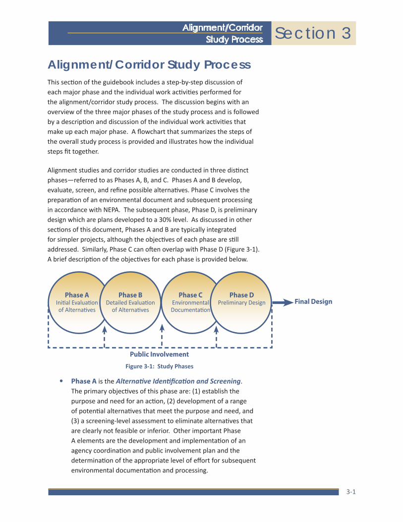
Alignment studies and corridor studies are conducted in three distinct phases—referred to as Phases A, B, and C. Phases A and B develop, evaluate, screen, and refine possible alternatives. Phase C involves the preparation of an environmental document and subsequent processing in accordance with NEPA. The subsequent phase, Phase D, is preliminary design which are plans developed to a 30% level. As discussed in other sections of this document, Phases A and B are typically integrated for simpler projects, although the objectives of each phase are still addressed. Similarly, Phase C can often overlap with Phase D (Figure 3-1). A brief description of the objectives for each phase is provided below.
Figure 3-1: Study Phases
Phase AInitial Evaluation of Alternatives
Public Involvement
Phase CEnvironmental Documentation
Phase DPreliminary Design Final Design
Phase BDetailed Evaluation
of Alternatives
• Phase A is the Alternative Identification and Screening. The primary objectives of this phase are: (1) establish the purpose and need for an action, (2) development of a range of potential alternatives that meet the purpose and need, and (3) a screening-level assessment to eliminate alternatives that are clearly not feasible or inferior. Other important Phase A elements are the development and implementation of an agency coordination and public involvement plan and the determination of the appropriate level of effort for subsequent environmental documentation and processing.

NMDOT
Section 3Alignment/Corridor Study Process
3-2
(pub
lic m
eetin
g)*
(pub
lic m
eetin
g)*
(pub
lic h
earin
g or
mee
ting)
*
*Var
ies
by p
roje
ct n
eeds
.
Pro
ject
Defi
nitio
n
Scop
ing
and
Initi
atio
nId
entif
y Ex
istin
g Co
nditi
ons
Esta
blish
Pur
pose
an
d Ne
edPu
blic
Invo
lvem
ent
Plan
Iden
tify A
ltern
ative
sIn
itial
Scr
eeni
ng o
f Al
tern
ative
s
Deta
iled
Eval
uatio
n of
Alte
rnat
ives
Engi
neer
ing
Refin
emen
ts
of P
refe
rred
Alte
rnat
ive(s
)
Envir
onm
enta
l Do
cum
enta
tion
and
Cons
ulta
tion
Alte
rnat
ives
Anal
ysis
Repo
rt
Road
way
and
Ro
adsid
e Fe
atur
es
Revie
w P
ertin
ent
Plan
ning
Doc
umen
ts
Desc
ribe
Phys
ical
Defic
ienc
ies
Defin
e Go
als
and
Obje
ctive
s of
Pub
lic
Invo
lvem
ent
Road
way
Alte
rnat
ives
Iden
tify
Scre
enin
g M
etric
s an
d Cr
iteria
Prep
are
Conc
eptu
al R
oadw
ay
and
Stru
ctur
e Pl
ans
Traf
fic a
nd S
afet
y Ana
lysis
Com
plet
e Dr
aina
ge
Anal
ysis
and
Repo
rt
Prep
are
Repo
rtCo
mpl
ete
Inve
stig
atio
ns a
nd
Anal
yses
Hydr
olog
yAs
sess
Exis
ting
and
Desig
n Ye
ar Tr
affic
Op
erat
ions
Over
view
of P
roje
ct
Cont
ext a
nd S
ettin
g,
Com
mun
ities
, and
St
akeh
olde
rs
Mul
ti-M
odal
Co
mpo
nent
sCo
nduc
t Ini
tial
Scre
enin
g As
sess
men
t
Acce
ss A
nalys
is
Prel
imin
ary
Drai
nage
An
alys
is
Cons
truct
abilit
y Ana
lysis
Prel
imin
ary
Righ
t-of-W
ay
Anal
ysis
Geot
ech
Inve
stig
atio
n
Utilit
y In
vest
igta
tion
Esta
blish
Brid
ge/ S
truct
ure
Type
s an
d Cr
iteria
FHW
A Co
ncur
renc
e Re
view
Prep
are
Reso
urce
Rep
orts
and
Co
mpl
ete
Agen
cy C
onsu
ltatio
ns
Traf
fic a
nd S
afet
y
Asse
ss C
rash
Hist
ory
and
Othe
r Saf
ety
Need
s
Iden
tify
Outre
ach
Met
hods
and
App
roac
h
ITS
Elem
ents
Iden
tify A
ltern
ative
s to
Ad
vanc
e
Natu
ral R
esou
rce
Surv
eys
Prep
are
Prel
imin
ary
Plan
and
Pr
ofile
She
ets
and
Cros
s Se
ctio
nsPr
epar
e En
viron
men
tal D
ocum
ent
Iden
tify
Envir
onm
enta
l Cl
ass
of A
ctio
n
Prep
are
Scre
enin
g M
atrix
/Doc
umen
t
Upda
ted
Cost
Est
imat
e
Cultu
ral R
esou
rce
Surv
eys
Eval
uatio
n M
etric
s an
d Su
mm
arize
Det
aile
d Ev
alua
tion
Iden
tify
Pref
erre
d Al
tern
ative
(s)
Prep
are
Prel
imin
ary
Engi
neer
’s Es
timat
e
Righ
t-of-W
ay a
nd
Prop
erty
Ow
ners
hip
Iden
tify
Othe
r Nee
ds
Envir
onm
enta
l, Cu
ltura
l, an
d Co
mm
unity
Fea
ture
s
Iden
tify
& Co
ntac
t M
ajor
Sta
keho
lder
s
Surv
ey &
Map
ping
Phas
e C
: Env
ironm
enta
l D
ocum
enta
tion
Phas
e D
: Pr
elim
inar
y D
esig
n
Pha
se A
: Alte
rnat
ive
Iden
tifica
tion
and
Scre
enin
g
Pha
se B
: Det
aile
d A
ltern
ativ
es A
naly
sis
Iden
tify
Proj
ect
Obje
ctive
s an
d Sc
ope
Prep
are
Proj
ect D
escr
iptio
n an
d De
fine
Term
ini
Iden
tify
and
Desc
ribe
Maj
or
Issue
s, Ne
eds,
and
Chal
leng
es
Iden
tify
Proj
ect T
eam
Iden
tify
Budg
et a
nd S
ched
ule
NM
DO
T A
lignm
ent/
Cor
ridor
Stu
dy P
roce
sscontinued

Location Study Procedures Update 2015A Guidebook for Alignment Studies and Corridor Studies
3-3
• Phase B is the Detailed Evaluation of Alternatives. This phase is intended to further define and evaluate the alternatives advanced from Phase A. Generally, this phase involves the development of additional and more detailed information such as conceptual engineering plans, right-of-way requirements, costs, performance data, environmental and social effects, and other data. Information that is relevant to the decision-making process is developed at a level of detail sufficient to enable an equitable comparison of each alternative and to serve as the basis for the preparation of an environmental document. In most instances, this phase will be conducted in two steps. The first step includes the development of conceptual design plans and the evaluation of each alternative under consideration. Alternatives with major flaws or disproportionate negative impacts will be eliminated from further consideration in the first step of Phase B. The second step includes additional engineering refinements for the remaining alternatives to more precisely define the project footprint, right-of-way needs, costs, and development schedule. Establishing a precise project footprint is crucial to ensuring that the project is adequately covered during Phase C. This avoids delays and extra expense associated with investigating areas that were not previously identified.
At the end of Phase B, FHWA is asked to concur with the planning process, the alternative(s) selected to advance to Phase C, and that planning decisions made to date can be referenced in the environmental clearance document. This is a central element of PEL and a new step from previous versions of the Location Study Procedures.
• Phase C is the Environmental Documentation and Processing. This phase includes the preparation of an environmental document (CE, EA, or EIS) and circulation of the document for agency and public review and comment (when an EA or EIS is prepared). Review comments, changes to the proposed action (if any), project commitments, and information pertaining to the public and agency review process are submitted to FHWA for their use in determining whether or not the proposed action will be authorized (i.e., approval of a CE or issuance of a FONSI or ROD).

NMDOT
Section 3Alignment/Corridor Study Process
3-4
• Phase D is Preliminary Design. Preliminary design defines the general project location and design concepts. It includes preliminary engineering and other activities and analyses needed to establish parameters for the final design. Preliminary design should focus on establishing the horizontal and vertical alignments, typical section, and drainage and structural needs to a level sufficient to establish the project footprint. NMDOT has traditionally defined preliminary design as design plans developed to a 30% level of completion. While preliminary design occurs after the study phase, often times it may overlap with the environmental clearance for a project. However, as described later in this section, it is essential that preliminary design activities not affect the objective consideration of alternatives during the NEPA process or have an adverse environmental impact.
The specific activities and decisions that must be addressed during each phase of the study process are illustrated in the flow chart on page 3-2 and discussed in greater detail in the remainder of this section.
Phase A: Alternative Identification and ScreeningAlternative Identification and Screening is the first phase of the three-phase alignment/corridor study process. The goal of this phase is to verify the need for improvements and to identify and evaluate alternatives that may be a reasonable solution to the need for improvements. The steps to achieve this goal include the following work activities:
1. Identify the existing physical, environmental, and cultural conditions within the study area that may be affected by the proposed action and/or that may affect the project.
2. Establish the purpose and need for the proposed transportation improvement.
3. Develop and implement the agency coordination and public involvement program.
4. Identify the alternatives that could be used to address the purpose and need.
When working in the Albuquerque or El Paso planning areas, project alternatives and congestion mitigation strategies from the CMP should be identified.
The objective of this phase is to verify the need for improvements and to identify and evaluate the alternatives that may be a reasonable solution to the need for improvements.

Location Study Procedures Update 2015A Guidebook for Alignment Studies and Corridor Studies
3-5
5. Perform a screening-level evaluation of each alternative to determine how each alternative ranks against specific performance metrics developed for the project. Performance metrics typically include measures such as the ability to achieve the project purpose and need, constructability, safety, operational performance, cost, right-of-way requirements, and other factors determined on a project-by-project basis. Alternatives that are not feasible or clearly inferior are eliminated from further consideration.
6. Identify the environmental processing actions necessary for federal authorization.
The level of effort and amount of detail required to accomplish the above activities varies and depends on the scope, complexity, and location of the particular study. For many projects, the range of alternatives and evaluation criteria is very simple and can be completed quickly. In other cases, the range of alternatives and evaluation process may require extensive effort and time to complete.
Typically, Phase A concludes with a document that summarizes the purpose and need for an action, describes the alternatives considered, and discusses the findings of the screening evaluation. The document also includes recommendations with regard to which alternatives warrant further investigation, which should be eliminated from consideration, and the appropriate type of environmental documentation and processing. Documentation can range from a series of working papers or a brief report that encompasses all of the requisite information or, for complex studies, may be a larger report with supplementary technical reports for specific issues such as traffic operations, safety analysis, or cultural and natural resources. In either case, it is important that the report focus on issues germane to the decision at hand and not include extraneous or irrelevant information. Statements made within the report should be supported by data and analysis.
The specific work activities for each step of the Initial Evaluation of Alternatives study are described in the following pages.
The level of effort and amount of detail varies depending on the scope, complexity, and location of the particular study.

NMDOT
Section 3Alignment/Corridor Study Process
3-6
Step A 1: exiSting ConditionS And ConStrAintS
A clear understanding of the existing conditions and constraints within the project area is essential to the identification of project alternatives and subsequent screening evaluation. Existing conditions and constraints also form the basis of the “No Build” alternative which is used for baseline comparisons throughout the process. This step includes the inventory of roadway and roadside features, drainage features, traffic and safety conditions, right-of-way and property ownerships, environmental and cultural setting, and major stakeholders.
The types of information to be collected include:
Physical Condition and Features of the Existing Facility
• Typical section of the existing roadway including number and width of lanes, shoulder width, median treatment, curb and gutter, etc.
• Intersection spacing and geometry, traffic control, and signal timing and phasing
• Driveway spacing, parking, and form of access management that affects the capacity of the facility
• Roadway geometry including horizontal and vertical curvature and any notable deficiencies that affect design speed or sight distance
• Posted and design speed
A clear understanding of the existing conditions and constraints within the project area is essential to the identification of project alternatives and subsequent screening evaluation.
Project Definition
Scoping and Initiation
Phase A: Alternative Identification and Screening
Identify Project Objectives and Scope
Prepare Project Description and Define Termini
Identify and Describe Major Issues, Needs, and Challenges
Identify Project Team
Identify Budget and Schedule
Public Involvement Plan
Define Goals and Objectives of Public
Involvement
Overview of Project Context and Setting, Communities, and
Stakeholders
Identify Outreach Methods and Approach
Identify Existing Conditions
Roadway and Roadside Features
Review Pertinent Planning Documents
Hydrology
Traffic and Safety
Right-of-Way and Property Ownership
Environmental, Cultural, and Community Features
Identify & Contact Major Stakeholders
Survey & Mapping

Location Study Procedures Update 2015A Guidebook for Alignment Studies and Corridor Studies
3-7
• Pavement and structure condition including bridge and drainage structures
• Presence and condition of ITS infrastructure and equipment and ITS architecture review
• Hydrologic and hydraulic information including structures, storm sewers, and contributing basins
• Right-of-way information including right-of-way width, and property ownership
• Other data, as needed
Traffic Conditions
• Functional classification of the facility
• Average daily and peak hour traffic volumes for each major link and intersecting roadway. This includes existing volumes and projected volumes for the 20-year horizon
• Intersection turning-movement volumes for peak periods for each major intersection within the study influence area
• Vehicle classification data including the percentage of passenger cars, trucks, and buses. In some instances, special vehicle types (e.g., vehicles associated with mining or the oil and gas industry) may need to be considered and quantified.
• Capacity and level of service analysis for the facility under consideration and any major links where the proposed action causes a change in travel patterns
Safety Analysis
• A review of crash data for at least the last three years for which information is available
• Crash rates should be calculated for each major segment of the roadway where the traffic volume or physical characteristics are different. The accident data should be separated by accident type and severity. The causal factors of the accidents should also be investigated to determine the factors that have contributed to accidents and to identify trends. The preparation of collision diagrams is often useful to help identify the factors that contribute to accidents.
NMDOT
Section 3Alignment/Corridor Study Process
3-8
• Crash rates should be compared to the rates for similar facilities or system-wide averages to determine if the accident rate or severity is significantly higher than expected.
Environmental, Cultural, and Community Setting
• Environmental features such as important farmlands, major floodplains, threatened and endangered species habitat, wetlands, sites of known contamination by hazardous materials, unique geological features, important visual resources
• Cultural features such as archaeological sites, historic properties, and Section 4(f) properties
• Community features such as neighborhoods with minority or other special status populations, important community resources, and noise sensitive areas
• Land use and land use patterns. While not necessary for the majority of projects, complex projects in urban areas may require a more in depth review of land use and growth trends than that needed for rural areas. The distribution of population and employment and growth trends is essential to understanding travel demand within an area and its effect on the facility under consideration. The analysis should be performed to a level commensurate with the needs of the study and could include:
‒ A review of existing land use, population and employment within the study influence area
‒ Inventory of major destinations of trips such as major employment centers, regional shopping centers, major schools or universities, major recreational areas, etc.
‒ A review of population and employment growth trends or forecasts. Projections can be based on past census data or may be based on socioeconomic projections.
Review Pertinent Transportation Plans
• Adopted transportation plans, such as the statewide long-range plan, local long-range plans, the STIP and/or TIP, and any applicable CMP or other locally adopted plans should be reviewed to identify specific concerns, goals, and objectives for and area.
Adopted transportation plans should be reviewed to identify specific concerns, goals, and objectives for and area.

Location Study Procedures Update 2015A Guidebook for Alignment Studies and Corridor Studies
3-9
• Reviewing pertinent plans can also provide a starting point for identifying key stakeholders. Stakeholder agencies responsible for developing plans as well as interested parties identified within the plans can provide valuable input into the conditions and needs of a corridor.
At this stage in the project development process, the area that is inventoried may be large and encompass the entire study area. Therefore, the level of detail is intended to be equally broad and will be obtained from existing data sources and field reconnaissance. Information should be compiled and presented graphically using large-scale aerial photographs, a GIS database, or other similar mapping base. The mapping should depict the approximate boundaries of resources and a brief description of their important features. Graphic presentations are especially useful in helping the public understand why particular alignments have been chosen.
The evaluation of existing roadway and physical and environmental features includes both qualitative and quantitative analysis. For features that do not present unusual or substantive constraints, a general discussion of their presence is adequate. For others, a greater level of effort may be required to better define the geographic limits of a particular feature and their constraints to alternatives. For example, if geologically unstable areas occur within the study limits, the extent of the unstable area should be clearly defined so that the necessary action (avoidance or engineering solutions) can be anticipated in the development of alternatives. Similarly, the boundaries of sensitive environmental features, such as wetlands, Section 4(f) properties, historic sites, etc. should be identified in sufficient detail to determine if they can be avoided or if mitigation will be required.
The findings of the existing conditions inventory should be documented. The documentation should include a description of the pertinent physical, cultural, environmental, and social features that occur within the study area and a discussion of their importance in the development of improvement alternatives. The documentation should include quality graphics of sufficient scale to properly depict important features and convey their implications on alternatives.

NMDOT
Section 3Alignment/Corridor Study Process
3-10
Step A 2: AgenCy CoordinAtion And publiC involvement
Agency coordination and public involvement is a cornerstone of the project development process and are especially critical during the alignment/corridor phase. It is the policy of the NMDOT to involve the public and other pertinent agencies in the decision making process. Public involvement must be a cooperative and collaborative process that involves many groups with diverse needs and perspectives. This includes federal, state, and local agencies, local jurisdictions, users of the proposed facility, property owners, the general public, and other persons or groups having a stake or interest in the final decision.
These concepts are also fundamental elements of a Context Sensitive Solutions (CSS) approach to project development. Context Sensitive Solutions is the idea that transportation projects should not be limited to satisfying certain safety and mobility goals but should also be developed within the context of broader community needs and expectations and the environmental setting. The NMDOT follows the CSS approach to project development and integrates CSS concepts into their public involvement procedures.
Coordination with other agencies and involvement of the public must be proactive, comprehensive, and continuous through the project development process. Accordingly, a plan for public engagement should be developed early in the process. Ideally, this would occur immediately
Involvement of the public must be proactive, comprehensive, and continuous through the project development process.
Establish Purpose and Need
Public Involvement Plan
Describe Physical Deficiencies
Define Goals and Objectives of Public
InvolvementAssess Existing and Design Year Traffic
OperationsOverview of Project Context and Setting, Communities, and
Stakeholders Assess Crash History and Other Safety Needs
Identify Outreach Methods and Approach Identify Other Needs
Phase A: Alternative Identification and Screening
Identify Existing Conditions
Roadway and Roadside Features
Review Pertinent Planning Documents
Hydrology
Traffic and Safety
Right-of-Way and Property Ownership
Environmental, Cultural, and Community Features
Identify & Contact Major Stakeholders
Survey & Mapping
Agency coordination and public involvement are a cornerstone of the project development process and are the policy of NMDOT.

Location Study Procedures Update 2015A Guidebook for Alignment Studies and Corridor Studies
3-11
after the identification of existing conditions as knowing the community characteristics and demographics can provide context and inform the outreach methods used.
Agency coordination includes efforts and activities to coordinate with and involve federal, state, tribal, and local agencies in the project development process. It is an essential step of the study process and ensures that a proposed action is coordinated with and consistent with the actions, policies, and regulations of other agencies and jurisdictions. Agencies should be notified that the results of this planning process may be used during the subsequent NEPA documentation since this is a key provision of PEL.
Public involvement includes efforts to inform property owners, neighborhoods, local officials, and other interested persons and groups about a proposed action and involves these individuals and groups in the decision making process. Public involvement can occur at three levels: (1) making the public aware of a proposed action, (2) informing the public about a proposed action and its potential effects, and (3) involving the public in the decision making process. The level of public involvement will depend on the potential for the action to affect individuals and the general public and the degree they are affected. For example, minor improvements such as shoulder widening on a rural highway that will not involve right-of-way acquisition may be well served by a low-level of public involvement that is limited to a public awareness effort. Conversely, actions involving extensive right-of-way acquisition and relocations, and that may adversely affect neighborhoods or communities, need a very high level of public involvement.
Agency coordination and public involvement serve to build consensus and are an essential component of the determination of needs and alternatives identification and evaluation processes, as well as in the identification and development of mitigation strategies. While coordination and involvement are a regulatory requirement, they should be viewed as an opportunity to involve agencies and the public in decisions that affect them. The input received from agencies and the public will assist the Study Team in identifying critical issues that, if not properly addressed, could delay or stop projects. Conversely, a properly developed and implemented public involvement program saves time and money and leads to good decisions that can be advanced through the final design and implementation phases of the project development process.
A properly developed and implemented public involvement program saves time and money and leads to good decisions.
Public involvement can occur at three levels: making the public aware; informing the public; and involving the public.

NMDOT
Section 3Alignment/Corridor Study Process
3-12
The public involvement program is an integral element of the project development process which serves to generate information that is used by the Study Team and to disseminate information developed by the Study Team. Major considerations in the development of an effective coordination and public involvement program include:
• The program should have clearly stated goals and objectives, and work activities should be established to achieve the stated goals.
• The program should be a dynamic process that is continually evaluated for effectiveness and modified to enhance its effectiveness.
• The program should be proactive. Active efforts must be made to identify and involve agencies, communities, neighborhoods, landowners, businesses, residents, commuters, and other groups that may have a stake in the outcome of the study. This requires that the Study Team take information to these stakeholders rather than waiting for them to come to the Study Team.
• The program should include groups that may be traditionally under-represented in the project development process (e.g., low income, elderly, minority groups, and non-English speaking or disabled individuals). The identification and inclusion of the under-served may require special outreach methods and accommodations.
• Information generated by the process should be accessible to stakeholders. This includes making data and reports accessible and having meetings at locations and times that are reasonable for the affected groups.
• Stakeholders should have an active role in the development and evaluation of concepts and should not be relegated to a review and comment role.
• Occasionally, for especially complex projects, a citizen advisory committee (CAC) may be needed. The composition of the CAC should include citizen representatives from neighborhoods, businesses, developer groups, service providers, and other groups having a stake in the study outcome. The CAC provides a forum for information exchange and serves as a liaison between the Study Team and the community at large. The CAC also assists in identifying community issues of interest and concern and provides feedback to the Study Team.

Location Study Procedures Update 2015A Guidebook for Alignment Studies and Corridor Studies
3-13
The components of the public involvement program vary depending on the location and magnitude of the study and the level of anticipated controversy.
• The format for public information meetings and public hearings should be flexible and adapted to meet the needs of a particular study and/or community. For example, some studies may require the use of open houses, workshops, or other involvement technique to most effectively achieve the objective of the public involvement plan.
• In combination with traditional public meetings, social media and online tools can greatly elevate public awareness and interaction. Online outreach can prove effective because it reaches beyond the individuals who attend a public meeting and facilitates informal and informative input on a project.
The components of the public involvement program vary depending on the location and magnitude of the study and the level of anticipated controversy. At a minimum, the program should include and identify the following components:
1. A statement of goals and objectives to be achieved by the Program
2. The techniques used to identify stakeholder groups
3. The techniques used to provide initial notification to stakeholders of the study and invite their involvement
4. The methods used to provide subsequent notification to stakeholder groups
5. The methods used to involve stakeholders and obtain their input throughout the course of the study
6. The methods used to disseminate information throughout the course of the study
7. The number and timing of public forums and meetings that are anticipated
The agency coordination and public involvement program should follow the NMDOT guidelines for a context sensitive public involvement plan and be reviewed by the environmental analyst and public involvement coordinator of the Environmental Section before implementation.

NMDOT
Section 3Alignment/Corridor Study Process
3-14
Step A 3: eStAbliSh purpoSe And need
Determining the purpose and need for a proposed action is one of the most important elements of the project development process. Federal regulations (40 CFR 1502.13) mandate that study sponsors define the underlying purpose and need which the agency is responding to by proposing alternatives, including the proposed action. Project purpose is a broad statement of the overall objective to be achieved by a proposed transportation improvement. Need is a more detailed explanation of the specific transportation problems or deficiencies that currently exist, or that are expected to exist in the future.
A well defined purpose and need provides credibility to the study and promotes acceptance by the public and review agencies. Furthermore, a credible need becomes particularly important when dealing with issues that may have unavoidable effects on protected resources such as public parks, cultural resources, historic resources, etc. The ability to achieve the project need is also a central factor used in the evaluation and comparison of alternatives. In short, the need serves as the foundation for the entire study, without which the proposed action cannot and should not be advanced.
The need for a proposed action is normally based on one or more factors including capacity, safety, physical deficiencies, system continuity, and/or economic development. In some instances, the need may be in response to a legislative mandate, although the mandate is usually rooted in one of the other factors such as safety or economic development. The stated need for a proposed action must be supported by data and analysis and documented as part of the corridor study process. This requires a comprehensive review and analysis of
A well defined purpose and need provides credibility to the study.
Determining the purpose and need for a proposed action is one of the most important elements of the project development process.
Project purpose is a broad statement of the overall objective to be achieved by a proposed transportation improvement. Need is a more detailed explanation of the specific transportation problems.
Establish Purpose and Need
Public Involvement Plan
Identify Alternatives
Describe Physical Deficiencies
Define Goals and Objectives of Public
Involvement
Roadway Alternatives
Assess Existing and Design Year Traffic
OperationsOverview of Project Context and Setting, Communities, and
Stakeholders
Multi-Modal Components
Assess Crash History and Other Safety Needs
Identify Outreach Methods and Approach
ITS Elements
Identify Other Needs
Phase A: Alternative Identification and Screening

Location Study Procedures Update 2015A Guidebook for Alignment Studies and Corridor Studies
3-15
existing and future conditions involving the transportation system and socioeconomic trends within the study area, as described below. This information is largely derived from the existing conditions information described above. It should be recognized that some of the information is not relevant to some studies, and that the level of investigation, analysis and documentation should be commensurate with the particular study.
The project purpose and need can be developed based on the information compiled for the above factors. Generally, the need for a transportation improvement involves one or more, but often not all, of the following factors:
1. Physical Deficiencies – Physical deficiencies of the existing highway can serve as the basis for need under some circumstances. Substandard lane and shoulder width, substandard horizontal and vertical curves, deficient bridge structures, deficient pavement, and other physical deficiencies are examples of physical deficiencies.
2. Safety – Correcting an unusually high accident rate or severity index or preventing a potential safety problem from occurring can serve as grounds for improving a highway. Safety problems often involve other factors, such as congestion or design deficiencies, that contribute to the high accident rate.
3. Travel Demand and Congestion – Excess travel demand (existing or future condition) within a corridor that results in congestion on an existing facility can serve as the basis to improve an existing roadway or to add a new roadway.
4. Access – A transportation improvement may be warranted to provide access into an area such as a recreational area or an area targeted for growth by a local or regional land use planning authority.
The following purpose and need factors are not as common but still may be applicable to some projects:
5. System Connectivity – System connectivity may serve as the basis for need if a transportation network lacks critical links that would enhance access and/or mobility within a subarea. Similar to safety, system connectivity is generally tied to other factors such as congestion on other facilities that are used because of a missing linkage in the network.
The stated need for a proposed action must be supported by data and analysis.
NMDOT
Section 3Alignment/Corridor Study Process
3-16
6. Economic Development – New roadways or roadway improvements may be necessary to provide access to or support the economic development plans of communities or regions.
7. Legislative Mandate – Mandates by the federal, state or local legislative bodies are sometimes adopted that call for a particular improvement. These mandates are generally tied to other goals, such as economic development or growth management that serve as the genesis of the mandate.
Once the project purpose and need have been identified, a purpose and need statement is developed. The project purpose is intended to be a broad statement that can generally be stated in a few sentences. It should frame the need statement in terms of problems rather than solutions. If the project purpose is stated in terms of a solution, the outcome of the alternatives evaluation process could be perceived to be predetermined and subject to challenge. An example of a correct and incorrect way to state a project purpose could be:
• (Correct) The purpose of the proposed improvements to NM Highway ## is to improve the safety of travel on this highway.
• (Incorrect) The purpose of the proposed improvements to NM Highway ## is to construct a 4-lane divided highway that improves the safety of travel on this highway.
In the first purpose statement above, the need for improvements could be achieved by any one of a number of alternatives (e.g., addition of passing lanes, elimination of substandard curves, reduced speed limits, etc.). The possible alternatives could then be evaluated for their ability to achieve the project objective and compared for cost-benefit and level of impact. In the second statement, the outcome has been predetermined since only a 4-lane highway can achieve the stated objective.
Another example of correct and incorrect project purpose statements could be:
• (Correct) The purpose of the proposed improvements to NM Highway ## is to reduce congestion and to achieve an acceptable level of service for the length of the project.
• (Incorrect) The purpose of the proposed improvements to NM Highway ## is to add additional travel lanes to the existing highway so that congestion is reduced and the level of service is improved.
The project purpose should frame the need statement in terms of problems rather than solutions. If the project purpose is stated in terms of a solution, the outcome of the alternatives evaluation process could be perceived to be predetermined and subject to challenge.

Location Study Procedures Update 2015A Guidebook for Alignment Studies and Corridor Studies
3-17
As was the case for the first example, the need for improvements could be achieved by various approaches such as the construction of an alternative route that diverts traffic from NM Highway ##, the use of a turning lanes to eliminate congestion caused by turning vehicles, or the use of transit to reduce the number of vehicles using the highway. In the second example, only options that add travel lanes could achieve the project objective.
The purpose and need serves as the basis for the development and evaluation of alternatives. Alternatives that do not satisfy the purpose and need, or are clearly inferior to other alternatives, should be documented and eliminated from further consideration. The information compiled and analyzed to develop the need should be presented concisely and should use tables, charts and graphs, as appropriate, to summarize important information. For very complex studies that involve a substantial amount of information, a separate technical report may be necessary. This report should be referenced within the Initial Evaluation of Alternatives study and made available to the public for review.
Step A 4: development of Study AlternAtiveS
Study alternatives are specific transportation improvement options that could be used to satisfy a project’s purpose and need. For most rural projects and projects in small communities, the improvement alternatives generally involve variations of highway concepts such as different typical sections and/or alignments. In large metropolitan areas, the range of alternatives may be diverse and could include non-
Consideration of ITS architecture and multi-modal improvements can be a component of alternatives in both rural and urban settings.
Identify AlternativesInitial Screening of
Alternatives
Roadway Alternatives Identify Screening Metrics and Criteria
Multi-Modal Components
Conduct Initial Screening Assessment
ITS Elements Identify Alternatives to Advance
Identify Environmental Class of Action
Prepare Screening Matrix/Document
Phase A: Alternative Identification and Screening
Establish Purpose and Need
Describe Physical Deficiencies
Assess Existing and Design Year Traffic
Operations
Assess Crash History and Other Safety Needs
Identify Other Needs

NMDOT
Section 3Alignment/Corridor Study Process
3-18
highway options such as transit, travel demand management strategies, and operational management strategies in addition to roadway-based alternatives. Consideration of ITS architecture and multi-modal improvements is a required component of alternatives in both rural and urban settings. Further, regardless of the project type or location, the Study Team should strive to develop alternatives that are in balance with the communities that they serve and that are integrated with the surrounding environment.
Information compiled in the Alternative Identification and Screening phase serve as the basis for identifying and selecting potential alternatives. Key factors that should be considered include:
• The project’s purpose and need
• The requirement for logical termini and independent utility
• Avoidance of sensitive environmental, social and cultural resources
• Avoidance of terrain and other physical features that require complex and costly engineering solutions
• Available funding
The preliminary list of alternatives considered during the Alternative Identification and Screening phase may include a wide range of options, depending on the particular type of transportation problems that are being addressed and the location of the proposed action. The range of alternatives should include the no-build alternative and build alternatives. The no-build alternative is generally considered as a viable option and can serve as a baseline from which other alternatives can be compared against. The no-build alternative assumes that the proposed action is not implemented, although maintenance costs are considered and other planned and programmed improvements to the transportation system within the study influence area are assumed to have been implemented. Planned and programmed means projects are included in the applicable long-range transportation plan and transportation improvement program.
It is important to note that the type and number of alternatives vary depending on the specific circumstances of a given project and need to be developed within the context of these circumstances. Some of the factors to consider when developing alternatives are discussed below.
The no-build alternative should always be considered as a viable option. It assumes that the proposed action is not implemented, although maintenance costs should be considered and other planned and programmed improvements to the transportation system within the study influence area are assumed to have been implemented.

Location Study Procedures Update 2015A Guidebook for Alignment Studies and Corridor Studies
3-19
1. For rural projects or projects within small communities facing capacity needs to an existing facility, the alternatives typically considered include:
‒ Various typical section concepts such as adding lanes, adding auxiliary lanes, rural or urban sections, type of access control, etc.
‒ Alignment concepts such as widening to the left, right, inside, or outside, or alignment shifts to avoid sensitive areas
2. For safety projects on an existing roadway, the alternatives typically include:
‒ modifications to the roadway typical section such as the addition of travel lanes, auxiliary lanes, and/or passing lanes, different median treatments, improvements to roadway shoulders, access closures, etc.
‒ alternatives that modify the roadway alignment such as the elimination of design deficiencies to correct sight-distance problems and/or speed problems related to horizontal and vertical curves.
‒ management and operational alternatives such as changes to posted speed limits, speed warnings, advisory signing, and ITS-related services.
3. Projects in urbanized areas typically require different considerations when developing project alternatives. Urbanized means a geographical area with a population of 50,000 or more. By federal rule, urbanized areas must have a metropolitan transportation plan. Typically, the transportation plans for urbanized areas will have distinct highway, transit, bicycle, and pedestrian elements. Thus, when developing the set of alternatives for an existing roadway project, the multimodal elements identified in the transportation plan for a particular route must be integrated, as feasible, into the project.
4. Projects in TMAs will have additional considerations when developing project alternatives. A TMA is an area with a population of 200,000 or more — currently, the Albuquerque area is the only TMA within the state. The development of the metropolitan transportation plan in a TMA considers congestion management strategies that include various demand management options, system management options, transit, ITS, and capacity
The type and number of alternatives vary depending on the specific circumstances of a given project.

NMDOT
Section 3Alignment/Corridor Study Process
3-20
enhancements. Therefore, the development of alternatives for roadways within TMAs must consider how these strategies will be included in the identification and analysis of alternatives.
Alternatives should be developed to serve future traffic volumes based on a horizon year of 20 years. Other engineering elements that must be identified for each alternative include:
• Functional classification • General alignment • Typical section • Design speed • Right-of-way limits • Location and general configuration of intersections and/or
interchanges • Location and type of drainage structures • Location of special roadside features such as pull-outs for scenic
views, historic markers, rest areas, etc.
All of the above elements should be developed with the objective of being compatible with the surrounding area and should be acceptable to the communities that are affected by the proposed action. While safety and efficiency must be paramount in the development of alternatives, sensitivity to the natural and human environment must be given high priority. For some resources, direct and indirect impacts must be avoided when prudent and feasible alternatives exist that avoid impact. Resources that require the evaluation of avoidance alternatives include Section 4(f) properties (e.g., publicly owned parks, recreational areas, wildlife refuges, significant historic sites) and Section 404 resources (e.g., wetlands and certain aquatic ecosystems).
A key consideration in the development of alternatives is the level of detail needed for the screening phase. This includes both the level of design as well as the required level of mapping and surveying detail. Because Phase A may consider a wide range of alternatives, a schematic level of design including typical sections and simple plan-level drawings overlaid on aerial photography is usually adequate to compare and screen alternatives. This level of design should be sufficient to assess differences in cost, right-of-way needs, and general impacts. Likewise, projects that are in rural areas with uncomplicated terrain can generally use less precise mapping and a less detailed location survey than
While safety and efficiency must be paramount in the development of alternatives, sensitivity to the natural and human environment must be given high priority.
Alternatives should be developed to serve future traffic volumes based on a horizon year of 20 years.
Location Study Procedures Update 2015A Guidebook for Alignment Studies and Corridor Studies
3-21
projects involving complex terrain and/or that are in highly developed urban settings. Mapping at a scale of about 1” = 200’ with 5’ contour intervals will generally suffice for projects with gentle terrain and in undeveloped areas. Higher resolution mapping may be required for projects in complex terrain and/or highly developed urban settings. Similarly, the location survey can be limited to critical features such as culverts, boxes, major utility lines, and other physical features that are not picked up by aerial mapping. A detailed location survey is generally unnecessary during the conceptual engineering phase.
When projects are expected to advance promptly into final design, more precise mapping and a detailed location survey may be cost-effective and should be considered. However, if the elapsed time is more than a few years, the mapping should be limited in scope and detail.
The development of alternatives should be documented for inclusion in the alternatives analysis report that is ultimately prepared for the project. The documentation should include a summary of the process followed to identify alternatives and a description of resulting alternatives. The descriptions should include the termini, typical section, design speed, right-of-way limits, location and general configuration of intersections and/or interchanges, location and type of drainage structures, and other notable features. The write-up should include quality graphics of sufficient scale to properly depict important features of each alternative.
Public Information Meeting
A public information meeting should be held early in the study process. A good opportunity for a meeting is after alternatives have been developed but before the initial evaluation of alternatives. This allows the Study Team enough time to learn about the corridor and provide an informed presentation on the identified deficiencies and transportation needs for the corridor as well as potential alternatives for addressing these needs. This also provides an opportunity for the community to provide meaningful input into these issues and the alternatives evaluation criteria before any alternatives are eliminated. Briefings to local officials, policy boards, community associations, or other groups having an interest in the study should also be provided.
A public information meeting should be held early in the study process. Briefings to local officials, policy boards, community associations, or other groups having an interest in the study should also be provided.

NMDOT
Section 3Alignment/Corridor Study Process
3-22
Step A 5: initiAl SCreening of AlternAtiveS
The alternatives screening step narrows the list of alternatives that will be carried into the detailed evaluation phase (Phase B). Alternatives are eliminated that are not viable or clearly inferior to other alternatives. The evaluation process includes both qualitative and simple quantitative analysis and uses information compiled in the previous steps. The evaluation of issues is not intended to be extensive nor are the analyses intended to be detailed. Rather, the evaluation should focus on factors that are germane to the decision at hand, and the analyses should be of sufficient detail to allow a comparison of the various alternatives.
The factors used to evaluate alternatives vary depending on the circumstances that are unique to every study. The evaluation criteria used to assess alternatives should be developed by the Study Team with consideration of input from the TAC (when used). By obtaining meaningful input on the evaluation criteria before they are applied, questions about the objectivity of the criteria are avoided later in the process. The analyses must be performed by qualified engineers, planners and environmental specialists experienced in the evaluation of transportation projects.
Identify Screening Metrics and Criteria
As noted above, the evaluation criteria vary depending on the needs of each study. Evaluation factors that are common to most studies are outlined below. It should be noted, however, that the list does not apply to every study, and other factors may need to be considered.
The preliminary evaluation of alternatives narrows the list of alternatives that are carried into the detailed evaluation phase (Phase B).
Identify AlternativesInitial Screening of
Alternatives
Roadway Alternatives Identify Screening Metrics and Criteria
Multi-Modal Components
Conduct Initial Screening Assessment
ITS Elements Identify Alternatives to Advance
Identify Environmental Class of Action
Prepare Screening Matrix/Document
Phase A: Alternative Identification and Screening

Location Study Procedures Update 2015A Guidebook for Alignment Studies and Corridor Studies
3-23
Engineering factors focus on operational and construction-related features of each alternative. The factors that should be considered include:
• Responsiveness to the Purpose and Need – The responsiveness of alternatives to the project purpose and need is a fundamental consideration in the evaluation of alternatives. Responsiveness should be based on an alternative’s ability to achieve the need, in whole or in part. Alternatives that do not meet the project need are considered to be “fatally flawed” and should be eliminated from further consideration. As discussed in Step A.2 of this section, the project purpose and need cannot be stated such that it categorically excludes potentially viable options. In large urban areas, non-highway alternatives such as bicycle lanes/trails or transit enhancements may partially address the project need and may warrant inclusion as an element of a highway improvement alternative.
• Operational Performance and Mobility Benefits – The ability of alternatives to serve the 20-year travel demand should be evaluated using simple analysis techniques (e.g., volume to capacity estimates, level of service analysis, etc.). The mobility and accessibility benefits provided by each alternative should also be evaluated and compared. Additional details concerning traffic analysis are provided in Chapter 4.
• Engineering Feasibility and Constructability – A qualitative assessment of the engineering feasibility of each alternative should be performed to compare major differences between alternatives. Feasibility should focus on major differences between alternatives that allow a general comparison of engineering difficulty. The constructability of each alternative should also be reviewed to identify conditions or flaws (e.g., traffic maintenance) that would affect the ability to construct an alternative.
• Safety – The safety aspects of alternatives should be evaluated to determine if potential flaws exist that would result in an unsafe facility and/or to determine if major differences exist in the safety aspects of alternatives.
• Drainage – A preliminary drainage analysis should be prepared to assess the existing drainage conditions and facilities within the study area. The analysis should include both a hydrologic analysis to establish the peak run-off rates to each structure and a hydraulic analysis to identify the type and capacity of drainage structures.

NMDOT
Section 3Alignment/Corridor Study Process
3-24
• Right-of-way Feasibility and Property Ownership – The approximate right-of-way requirements for each alternative should be estimated and compared to determine major differences in the right-of-way to be acquired. The comparison should include approximate costs and identify any specific factors that could affect the feasibility of right-of-way acquisition such as major utilities, relocations, rail lines, etc. Other conditions that could limit right-of-way acquisition, such as tribal lands or lands under the jurisdiction of federal land management agencies or the State Land Office, should also be identified. The right-of-way analysis should also include preliminary property ownership of the potentially affected parcels. At this stage, property ownership should be generated using information from county assessor data files. Property ownership data can also be used to notify property owners of the proposed action.
• Cost – The approximate costs for each alternative should be estimated. At this stage, cost estimates are intended to provide a relative comparison of alternatives and are based on the general features of each alternative. Cost estimates should include the cost of design, right-of-way acquisition, relocations, utilities, construction, construction management, and taxes.
The effects of each alternative on important environmental, social and cultural resources should be evaluated and compared. As was discussed for engineering factors, the assessment is based on existing data and field reconnaissance and is general in nature. Extensive field surveys for biological and cultural resources or detailed quantitative analyses for issues such as noise or air quality are not performed at this stage. Resources and factors that may be considered, depending on the study location and type, include but are not limited to:
• Consistency with community plans and policies, and land use and development patterns
• Minority, low income or other special status populations
• Neighborhood cohesion, safety or community services
• Community values
• Police, fire and emergency medical services
• Access to schools, parks, churches and other community facilities
Conditions that could limit right-of-way acquisition, such as tribal lands or lands under the jurisdiction of federal land management agencies, should be identified.

Location Study Procedures Update 2015A Guidebook for Alignment Studies and Corridor Studies
3-25
• Important farmlands - prime or unique farmlands, or farmland of statewide or local importance as defined by the Natural Resources Conservation Service
• Biological resources such as threatened and endangered species, important habitat, terrestrial and aquatic ecosystems, game animals, etc.
• Aquatic resources such as streams, rivers and associated riparian habitat, wetlands, and other watercourses that qualify as Section 404 or 401 resource
• Other natural resources such as air quality and visual resources
• Properties contaminated by hazardous materials
• Important archeological and historic sites or properties of known cultural importance
• Floodplains
• Important or unique geological features such as karst topography or malpais
• Important visual resources
• Section 4(f) properties
• Noise sensitive areas
• Others
Conduct Initial Screening Analysis and Recommend Alternatives to Advance
Based on the results of preliminary evaluation, alternatives that are not feasible or clearly less desirable than others should be dismissed from further consideration. The remaining alternatives will be advanced into Phase B for a more detailed evaluation.
Screening and summary matrices are a useful tool for summarizing the findings of the preliminary evaluation and comparing alternatives in a concise format. By comparing the findings of each evaluation category for each alternative, major differences (if any) between the alternatives can be quickly surmised. Matrices will vary in form and content, depending upon the circumstances of each particular study. Examples of two types of matrices are provided on the following pages.
Alternatives that are not feasible or clearly less desirable than others should be dismissed from further consideration.

NMDOT
Section 3Alignment/Corridor Study Process
3-26
The first sample matrix provides a summary of findings for each of several major evaluation factors. This type of matrix does not interpret the analysis findings—rather it provides a quick overview and a side-by-side comparison of each alternative. A possible outcome of the information summarized in this matrix could be a recommendation to eliminate Alterative 1 from further consideration due to its poor traffic performance and effect on a public park – a potential 4(f) impact. This type of matrix is useful for presenting summary and comparative information to public groups or other groups when insufficient time is available to discuss the evaluation findings in detail.
The second sample matrix uses a simplified rating system to compare alternatives and highlight major differences between each. In this example, the rating of alternatives is relative to the other alternatives. A finding of “very negative effects” in several evaluation categories is usually evidence that an alternative is inferior to other alternatives and should be eliminated from further consideration. A possible outcome of the data analysis summarized in matrix 2 could be the elimination of Alternatives A and D. Alternative A may be inferior to the other alternatives because of the high number of relocations and substantially greater cost. Alternative D may be flawed because of Section 4(f) impacts. This type of matrix is useful when presenting information to a technical advisory committee or a citizen advisory committee and when adequate time is available to discuss the evaluation findings in detail.
Regardless of the type of matrix used, matrices are not a substitute for a proper analysis and interpretation. They should summarize the analysis and decision-making process — not be the reason for making a decision.
Screening matrices can be used to summarize the findings of the preliminary evaluation and present information in a concise and easy to understand format.

Location Study Procedures Update 2015A Guidebook for Alignment Studies and Corridor Studies
3-27
Sample Screening Matrix 1 *
Alternative/Evaluation Factor
No Build Alternative
Alternative 1 Alternative 2 Alternative 3
Purpose and Need Does not provide needed safety improvements.
Does not meet 20-year traffic projections.
Provides limited safety improvements.
Does not meet 20-year traffic projections.
Improves safety by eliminating sight-distance deficiencies and providing turning lanes.
Added travel lanes and turning lanes meet projected traffic flows.
Improves safety by eliminating sight-distance deficiencies and providing turning lanes.
Added travel lanes and turning lanes meet projected traffic flows.
Traffic Operations 3 intersections operate at LOS F.
2 intersections operate at LOS E.
5 intersections operate at LOS D or better.
2 intersections operate at LOS F.
1 intersection operates at LOS E.
7 intersections operate at LOS D or better.
All intersections operate at LOS D or better.
All intersections operate at LOS D or better.
Environmental Does not disturb any natural resources.
Converts approximately 25 acres of terrestrial habitat, 5 acres of riparian habitat, and 0.5 acres of wetlands.
Converts approximately 25 acres of terrestrial habitat, 5 acres of riparian habitat, and 0.5 acres of wetlands.
Converts approximately 29 acres of terrestrial habitat, 1 acre of riparian habitat, and 0.5 acres of wetlands.
Community Does not directly affect any neighborhoods or communities, although area residents will continue to be adversely affected by unsafe and congested conditions on the existing highway.
Displaces 2 residences and 1 businesses.
Does not affect community cohesion.
Noise levels greater than FHWA NAC at 12 residences.
Displaces 2 residences and 1 businesses.
Access to local facilities and services would be improved.
Noise levels greater than FHWA NAC at 12 residences.
Displaces 1 residence.
Access to local facilities and services would be improved.
Noise levels greater than FHWA NAC at 12 residences.

NMDOT
Section 3Alignment/Corridor Study Process
3-28
Alternative/Evaluation Factor
No Build Alternative
Alternative 1 Alternative 2 Alternative 3
Cultural Does not affect any cultural resources.
Potentially disturbs 4 archeological sites and 1 potentially historic building.
Potentially disturbs 4 archeological sites and 1 potentially historic building.
Potentially disturbs 3 archeological sites.
Other Effects No other known adverse effects
Affected by 2 sites of known hazardous materials contamination.
Acquires property from 1 community park.
Affected by 2 sites of known hazardous materials contamination.
Affected by 2 sites of known hazardous materials contamination.
Right-of-Way No Right-of-way acquired.
Acquires 45 acres of right-of-way.
Acquires 55 acres of right-of-way.
Acquires 50 acres of right-of-way.
Estimated Cost No construction cost or right-of-way acquisition cost.
Approx. $40M for right-of-way, relocations, and construction.
Approx. $45M for right-of-way, relocations, and construction.
Approx. $42M for right-of-way, relocations, and construction.
* The factors included in the above matrix are for illustrative purposes only. The actual factors included in a matrix must be specific to the issues that are germane to the particular action under consideration.

Location Study Procedures Update 2015A Guidebook for Alignment Studies and Corridor Studies
3-29
Sample Screening Matrix 2 *
AlternativeEvaluation Factor No-Build A B C D
Meets purpose and need -- + ++ ++ ++
Traffic Operations -- + ++ + ++
Safety Benefits -- + + ++ ++
Drainage requirements NA + ++ ++ ++
Land use - - 0 0 0
Environmental justice 0 - 0 0 -
Community - -- - - -
Economic - -- 0 0 -
Farmlands 0 - -- -- -
Plants and animals 0 - - - -
Threatened & Endangered Species 0 0 0 0 -
Wetlands/Riparian habitat 0 - - - -
Noise 0 - - - -
Air Quality - 0 + 0 +
Visual 0 - - - -
Hazardous materials 0 0 0 0 -
Floodplains 0 0 0 0 0
Unique geological features 0 0 0 0 0
Cultural resources 0 - 0 0 0
Section 4(f) properties 0 0 0 0 -
Right-of-way requirements NA 35 acres 47 acres 50 acres 46 acres
Number of relocations NA 36 5 7 18
Construction and R/W Costs None $50,000,000 $36,000,000 $38,000,000 $42,000,000
++ = very positive effects+ = positive effects 0 = negligible or no effects- = negative effects-- = very negative effects
* The factors included in the above matrix are for illustrative purposes only. The actual factors included in a matrix must be specific to the issues that are germane to the particular action under consideration.
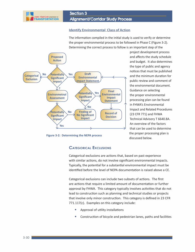
NMDOT
Section 3Alignment/Corridor Study Process
3-30
Identify Environmental Class of Action
The information compiled in the initial study is used to verify or determine the proper environmental process to be followed in Phase C (Figure 3-2). Determining the correct process to follow is an important step of the
project development process and affects the study schedule and budget. It also determines the type of public and agency notices that must be published and the minimum duration for public review and comment of the environmental document. Guidance on selecting the proper environmental processing plan can be found in FHWA’s Environmental Impact and Related Procedures (23 CFR 771) and FHWA Technical Advisory T 6640.8A. An overview of the factors that can be used to determine the proper processing plan is discussed below.
CAtegoriCAl exCluSionS
Categorical exclusions are actions that, based on past experience with similar actions, do not involve significant environmental impacts. Typically, the potential for a substantial environmental impact must be identified before the level of NEPA documentation is raised above a CE.
Categorical exclusions can include two subsets of actions. The first are actions that require a limited amount of documentation or further approval by FHWA. This category typically involves activities that do not lead to construction such as planning and technical studies or projects that involve only minor construction. This category is defined in 23 CFR 771.117(c). Examples on this category include:
• Approval of utility installations
• Construction of bicycle and pedestrian lanes, paths and facilities
Final Environmental
Impact Statement
Finding of No Significant
ImpactRecord of Decision
CategoricalExclusion
Proposed Action
Potentially Significant
Impact
EnvironmetnalAssessment
Draft Environmental
Impact Statement
Potentially Significant
Impact
No Yes
Yes
?Yes
NoNoPotentially
Significant Impact
Figure 3-2: Determining the NEPA process

Location Study Procedures Update 2015A Guidebook for Alignment Studies and Corridor Studies
3-31
Environmental Assessments are prepared for proposed actions that are not a CE and when the need for an EIS is not clear.
• Installation of noise barriers
• Landscaping
• Installation of fencing, signs, pavement markings, traffic signals, small passenger shelters, and railroad warning devices where no substantial land acquisition or traffic disruption would occur as a result of the action
• Projects that would take place entirely within the operational right-of-way (defined as right-of-way that has been disturbed for an existing transportation facility)
The second category of actions meets the criteria for a CE but may require additional documentation and approval by FHWA. This category is defined in 23 CFR 771.117(d). Examples of this category include:
• Modernization of an existing highway by resurfacing, restoration, rehabilitation, reconstruction, adding shoulders, or adding auxiliary lanes for localized purposes such as parking, weaving, turning, or climbing
• Bridge rehabilitation, reconstruction, or replacement, or the construction of grade separation to replace existing at-grade railroad crossings
• Traffic operational and safety improvements
• Construction of new rest areas or weigh stations
The NMDOT uses different levels of documentation for the range of actions that qualify as a categorical exclusion: (1) programmatic CEs which require limited investigations based on archival research; or (2) a CE supported by an evaluation based on a checklist of environmental, social, economic, and cultural factors. When considering the use of a CE, all other environmental laws (i.e. Endangered Species Act, National Historic Preservation Act, etc.) still apply to the project.
environmentAl ASSeSSmentS And environmentAl impACt StAtementS
Occasionally, for complex or controversial projects with substantial environmental impacts, an EA or EIS may be required. EAs are prepared for proposed actions that are not a CE and when the need for an EIS is not clear. One of the purposes of an EA is to determine the need for an EIS.
NMDOT uses two different levels of documentation for the range of actions that qualify as a categorical exclusion: programmatic CEs and checklist CEs.

NMDOT
Section 3Alignment/Corridor Study Process
3-32
An EIS is required for actions that cause, or are likely to cause, significant impacts to the environment. Examples of actions that normally require the preparation of an EIS include:
• A new, controlled access freeway
• A highway project of four or more lanes on a new location
• Construction of a fixed transit facility that will not be within an existing right-of-way
• Construction of a separate roadway for buses or high occupancy vehicles not located within an existing highway facility
Differences exist between CEs, EAs, and EISs that affect the study schedule and budget. Because CEs are prepared for less complex actions and focus on potential impacts, they can usually be prepared and processed in less time than an EA or EIS. Conversely, the complexity and/or controversy of actions requiring an EA or EIS require additional time and effort to complete. Factors that affect schedule include the preparation of a draft and final document and review time for each.
Prepare Documentation
For straight forward studies, where the improvement alternatives are limited in number and similar in design concept and scope, a project can proceed into Phase B without the preparation of a separate Phase A report. While a report may be unnecessary, the information compiled during Phase A should be available for review by agencies and the public. This can be done at a public information meeting or individual meetings with affected stakeholder agencies and groups during the Phase B analysis.
For larger, more complex or controversial studies, separate Phase A and Phase B reports may be necessary. In this case, the Phase A report may require a more detailed document that is supported by various technical reports for specific elements (e.g., needs analysis, traffic operations, safety analysis, existing conditions report, etc.). In either case, it is important that the report focus on the issues that are germane to the decision at hand and not include extraneous or irrelevant information. All statements made within the report should be supported by data and analysis.
Environmental impact statements are required for actions that cause, or are likely to cause, significant impacts to the environment.

Location Study Procedures Update 2015A Guidebook for Alignment Studies and Corridor Studies
3-33
Phase B: Detailed Alternatives Analysis Phase B of the corridor study process serves to further develop and evaluate the alternatives that were advanced from the Initial Screening of Alternatives study. This phase also determines which alternatives will be carried forward into Phase C. Alternatives are developed in greater engineering detail, and systematic analyses conducted to determine their performance, right-of-way needs, costs, and the environmental, social and cultural consequences. Agency coordination and involvement of stakeholders continue to be an essential component of the evaluation and decision-making process.
Phase B is divided into two major efforts including engineering analysis and environmental investigations and analysis. The engineering analysis involves the preparation of conceptual engineering drawings that establishes right-of-way requirements and area of impact. The environmental analysis focuses on the detailed investigations of the direct and indirect impacts that would occur with each alternative. At this stage in the study process, the engineering and environmental investigations include in-depth quantitative analyses and serve as the basis for preparing the environmental document, consistent with FHWA’s PEL policy. Typically, a preferred alternative will be defined during the Phase B analysis although for some projects, multiple alternatives may be advanced into Phase C.
While the focus of Phase B is split into engineering and environmental activities, neither area should be seen as secondary in importance. As discussed in Section 1, an interdisciplinary approach is essential to good decisions. This approach will require an iterative process in which design concepts are continually refined to avoid and/or minimize impacts to sensitive resources.
Phase B concludes with the preparation of conceptual engineering plans that illustrate the major features of the improvement alternatives and a report that summarizes the findings and recommendations of the engineering and environmental analyses. Additional engineering refinement is also included for the alternative(s) that are advanced into Phase C. This additional engineering focuses on design elements that have the greatest influence on defining a final project footprint and facilitating more accurate cost estimates and project schedules. The report should focus on the issues that are germane to the decision at hand and should not include extraneous or irrelevant information.
Phase B of the corridor study process serves to further develop and evaluate the alternatives that were advanced from the initial screening of alternatives.
The engineering and environmental investigations include in-depth quantitative analysis and serve as the basis for preparing the environmental document.

NMDOT
Section 3Alignment/Corridor Study Process
3-34
Step b 1: detAiled evAluAtion of AlternAtiveS
The detailed evaluation of alternatives includes both engineering and environmental evaluations. These require that the conceptual design plans developed in Phase A be refined and include adequate detail to determine right-of-way requirements, costs, and impacts. Typically, plans should be drawn at a scale of about 1” = 200’ although some studies may require a higher level of detail. When possible, plans should be developed from photo-based mapping to facilitate the evaluation of impacts to roadside resources. The concept plans should be developed in plan and profile for each alternative and should include the following elements:
• right-of-way limits—to ensure a viable project footprint, efforts to reduce new right-of-way are not necessary at this stage of the development process.
• slope limits— to ensure a viable project footprint, efforts to reduce project slope limits are not necessary at this stage of the development process.
• Geometry of intersections and/or interchanges
• Sidewalks, bike lanes, bicycle and pedestrian trails
• Location and type of drainage structures including bridges, box culverts, culverts, and ponds
• Locations of structure such as retaining walls and noise walls
• Locations of driveways, curb cuts, and intersecting roadways
Detailed Evaluation of Alternatives
Prepare Conceptual Roadway and Structure Plans
Traffic and Safety Analysis
Access Analysis
Preliminary Drainage Analysis
Constructability Analysis
Preliminary Right-of-Way Analysis
Geotech Investigation
Utility Investigtation
Natural Resource Surveys
Updated Cost Estimate
Cultural Resource Surveys
Evaluation Metrics and Summarize Detailed
Evaluation
Identify Preferred Alternative(s)
Phase B: Detailed Alternatives Analysis
The detailed evaluation of alternatives includes both engineering and environmental evaluations.

Location Study Procedures Update 2015A Guidebook for Alignment Studies and Corridor Studies
3-35
• Location of special roadside features such as pull-outs for scenic views, historic markers, rest areas, bus bays, etc.
• Horizontal and vertical curve sections
• Typical sections
• Cross sections
• The location of construction maintenance easements and temporary construction permits
• Parcel boundaries of properties contiguous to each alignment
• Landscaping
The footprint of the project area is developed through an iterative evaluation process that continually refines the alternatives under consideration to avoid and/or minimize right-of-way acquisition and impacts to sensitive environmental resources and property owners. The overall goal of this process is to establish a project footprint that is broad enough to adequately consider environmental concerns and constructability needs. If the footprint is refined later in the design process, it should become smaller rather than expanded.
Engineering Factors and Analysis
Additional engineering analyses are necessary as the alternatives are refined, in particular to assess traffic operations, safety, access, drainage, right-of-way, and costs. The level of effort for the more detailed analyses varies depending on the particular needs of the study. As a starting point, the preliminary analyses conducted during Phase A serves as the basis for the more detailed analyses. Major factors that should be considered include:
• Traffic Operations and Safety – A detailed traffic analysis may be necessary to better define the operational and safety characteristics of each alternative, to refine the geometric design of the roadway and intersections, and to assess the need for traffic signals. The traffic analysis should be based on traffic projections for the 20-year horizon and include capacity analyses for all major roadway links and intersections. The traffic projections used in the analysis should be prepared by the NMDOT or other agency responsible for traffic forecasting. A technical report that identifies the assumptions, methodologies, and findings should be prepared, the content of which should be summarized in the Phase B report.
Engineering analyses are necessary to assess traffic operations, safety, access, drainage, right-of-way, and costs.

NMDOT
Section 3Alignment/Corridor Study Process
3-36
• Access – Driveways and roads that intersect with the highway should be reviewed to determine if improvements to the main roadway would interfere with access or if there is a need to consolidate access points. Factors such as sight distance and grade should also be examined to ensure that safe access is maintained. The State Access Management Manual (SAMM) should be used when evaluating access issues.
• Preliminary Drainage Analysis – Additional drainage analyses are necessary to identify the specific drainage improvements required for each alternative including conceptual designs of drainage structures, ponds, and any special treatments of drainage channels that are necessary to prevent erosion. The drainage analysis should be performed according to the NMDOT guidelines and documented in a Preliminary Drainage Report.
• Constructability – The constructability of each alternative should be reviewed to ensure that they can be constructed as proposed and would not require major design changes that would have different impacts.
• Right-of-way Analysis – The right-of-way requirements of each alternative should be identified after the alternatives have been refined. The analysis should delineate the location and extent of needed right-of-way, the current ownership of affected parcels, and any utilities that may be affected. The analysis should also identify the approximate value of affected property for use in estimating the cost of each alternative.
• Update Cost Estimates – The cost of each alternative should be estimated after the concepts have been refined. The estimates should include the cost of design, right-of-way acquisition, relocations, utilities, construction, construction management, and taxes.
environmentAl fACtorS And AnAlySiS
The environmental factors identified as germane to the project in Phase A are analyzed in detail as part of the Detailed Evaluation of Alternatives phase. The data and analysis compiled as part of this phase serve as the basis for the preparation of the subsequent environmental documents. Thus, the analysis must be quantitative and adequate to clearly define the impacts of each alternative, allow a comparison of alternatives, and determine the need for mitigation.
Field reviews with resource agencies should be conducted to facilitate a better understanding of issues from both perspectives.

Location Study Procedures Update 2015A Guidebook for Alignment Studies and Corridor Studies
3-37
The factors that are considered and evaluated will vary and depend on the study location and type.
Coordination with reviewing and approving resource agencies is of key importance. Discussions with these groups with regard to the analytical techniques to be used, extent of coverage, evaluation criteria, mitigation requirements, and documentation are essential to efficient and productive analysis. When possible, field reviews with resource agencies should be conducted to facilitate a better understanding of issues from both perspectives.
Resources and factors that should be considered, depending on the study location and type, include, but are not limited to:
• Consistency with approved community plans and policies, and land use and development patterns
• Minority, low income, or other special status populations
• Neighborhood cohesion, safety, or community services
• Police, fire and emergency medical services
• Access to schools, parks, churches, and other community facilities
• Prime or unique farmlands or farmland of statewide or local importance as defined by the Natural Resources Conservation Service
• Biological resources such as threatened and endangered species, important habitat, terrestrial and aquatic ecosystems, game animals, etc.
• Aquatic resources such as streams, rivers and associated riparian habitat, wetlands, and other watercourses that qualify as Section 404 or 401 resources
• Other natural resources such as air quality and visual resources
• Properties contaminated by hazardous materials
• Important archeological and historic sites, or properties of known cultural importance
• Floodplains
• Important or unique geological features
• Important visual resources
• Section 4(f) properties
• Noise sensitive areas
• Others

NMDOT
Section 3Alignment/Corridor Study Process
3-38
Typically, any field surveys for cultural resources and/or biological resources conducted during this phase will consist of 100% coverage surveys. Time of year may limit these surveys in some instances and need to be considered when establishing the study schedule. For example, the window of opportunity for surveying some threatened and endangered species is limited to a few weeks during the spring or summer. If this window is missed, the surveys will be delayed until the following year. Cultural resource surveys are also affected by seasonal conditions. Snow cover may prevent archeological surveys in areas with heavy snowfall. Also, snow accumulation within the right-of-way can sometimes last well into the spring months and delay field surveys. Changes to the project footprint late in the process can create the need to survey additional area and may cause conflicts with these seasonal constraints.
Complete Detailed Analysis
As the additional design, engineering analyses, and environmental analyses are completed, the evaluation metrics from Phase A should be updated and a detailed evaluation, taking into consideration the more in-depth analysis, should be conducted. Usually, alternatives that are clearly not feasible, and some that are inferior, will have been eliminated during the Phase A screening. Phase B will often result in the definition of a preferred alternative for the project. However, in some instances, multiple alternatives may be advanced into Phase C. While this analysis is to be completed by a multi-disciplinary team of technical experts, public opinion should also be considered prior to making a final recommendation.
Public Information Meeting
A public information meeting should be held to present the preliminary findings of the detailed analysis, the alternatives recommended to advance into Phase C, and to solicit public comments before a final decision is made. Briefings to local officials, policy boards, community associations, or other groups having an interest in the study should also be provided.
The window of opportunity for surveying some threatened and endangered species is limited to a few weeks during the spring or summer. If this window is missed, the surveys will be delayed until the following year.

Location Study Procedures Update 2015A Guidebook for Alignment Studies and Corridor Studies
3-39
Step b 2: engineering refinement of preferred AlternAtive(S)
Additional detailed engineering analysis is then completed for alternatives advancing to Phase C. The additional analysis should focus on issues that affect the final project footprint, cost estimates, and schedule. Additional analysis should include:
• Final Drainage Report
• Establishment of Bridge and Structure types and criteria
• Preliminary plan and profile sheets consistent with a 30% design
• Preliminary Cost Estimates
A review of the recommended design concept by an independent team of engineers, planners, and environmental specialists should then be completed as a final step. This review is not intended to be a comprehensive value engineering review. Its purpose is to evaluate the proposed design concept for potential constructability problems, design improvements, cost savings, and ways to reduce or eliminate impacts. At the conclusion of this engineering refinement and independent review, the project footprint should be final and future revisions should be avoided as they would potentially affect the project schedule, cost, and environmental clearance.
Detailed Evaluation of Alternatives Engineering Refinements of Preferred Alternative(s)
Alternatives Analysis Report
Prepare Conceptual Roadway and Structure Plans
Traffic and Safety AnalysisComplete Drainage Analysis and Report
Prepare Report
Access Analysis
Preliminary Drainage Analysis
Contractibility Analysis
Preliminary Right-of-Way Analysis
Geotech Investigation
Utility Investigtation
Establish Bridge/ Structure Types and Criteria
FHWA Concurrence ReviewNatural Resource Surveys
Prepare Preliminary Plan and Profile Sheets
and Cross Sections
Updated Cost Estimate
Cultural Resource Surveys
Evaluation Metrics and Summarize Detailed
Evaluation
Identify Preferred Alternative(s)
Prepare Preliminary Engineer’s Estimate
Phase B: Detailed Alternatives Analysis
Additional engineering analysis should focus on issues that affect the final project footprint, cost estimates, and schedule.

NMDOT
Section 3Alignment/Corridor Study Process
3-40
Step b 3: AlternAtiveS AnAlySiS report
The engineering and environmental data and analysis compiled in Step B.1 is used to compare the advantages and disadvantages of alternatives and is documented in a Detailed Evaluation of Alternatives report. The analysis also identifies environmental issues, the magnitude of impact, and potential for mitigation of impacts. The report should utilize quality and informative graphics, tables, matrices and other methods that enable readers to focus on key issues and compare analysis findings. The use of graphics that do not reproduce clearly should be avoided. When completing a combined Phase A/B Alternatives Analysis, the information compiled during Phase A should be included in the report.
Supporting technical materials and reports are prepared for certain issues, including conceptual engineering plan sets for each alternative and technical reports for:
• Traffic operations and safety
• Drainage, wetland determination and delineation
• Threatened and endangered species evaluation
• Cultural resource evaluation
• Air quality and noise assessment
• Visual resources
• Any other major factor or resource that was the subject of extensive
• Analysis
Engineering Refinements of Preferred Alternative(s)
Environmental Documentation and
Consultation
Alternatives Analysis Report
Complete Drainage Analysis and Report
Prepare Report Complete Investigations and Analyses
Establish Bridge/ Structure Types and Criteria
FHWA Concurrence Review Prepare Resource Reports and
Complete Agency Consultations
Prepare Preliminary Plan and Profile Sheets
and Cross SectionsPrepare Environmental Document
Prepare Preliminary Engineer’s Estimate
Phase C: Environmental Documentation
Phase D: Preliminary
Design
Phase B: Detailed Alternatives Analysis

Location Study Procedures Update 2015A Guidebook for Alignment Studies and Corridor Studies
3-41
The content of these reports should be summarized and referenced in the alternatives analysis report. A suggested format for the Detailed Evaluation of Alternatives report is as follows:
Executive Summary
Chapter 1: Introduction
Chapter 2: Agency Coordination and Public Involvement
Chapter 3: Existing Conditions and Constraints
Chapter 4: Project Purpose and Need
Chapter 5: Description of Alternatives
Chapter 6: Engineering and Environmental Evaluation of Alternatives
Chapter 7: Recommendations
Appendices
FHWA Concurrence and Planning and Environment Linkages
Planning and Environment Linkages represents an integrated approach to transportation decision making that considers environmental, community, and economic goals early in the planning process. The concept of linking transportation planning and NEPA is described in Appendix A of 23 CFR 450 as a “continuum of sequential study, refinement, and expansion performed in transportation planning and during project development/NEPA, with information developed and conclusions drawn in early stages utilized in subsequent (and more detailed) review stages.” The general intent of PEL is to eliminate overlap and repeated effort between corridor-level planning and NEPA. This is accomplished by using terminology and methods consistent with NEPA to develop the project purpose and need, develop alternatives, and evaluate alternatives during the planning process. Once a lead agency concurs that the planning decisions are adequate for use during the NEPA phase, the decisions can then be incorporated by reference and there is no need to duplicate efforts.
Consistent with this policy, an executive summary of the Phase B report should be forwarded to FHWA for concurrence. The executive summary should provide a brief overview of:
The intent of PEL is to eliminate overlap and repeated effort between corridor-level planning and NEPA.

NMDOT
Section 3Alignment/Corridor Study Process
3-42
• Project background
• Methodology used in the alternatives analysis report
• Public and agency coordination efforts
• Purpose and need for the project
• Planning assumptions used
• Status of environmental investigations
• Additional considerations
The information should be consistent with the FHWA PEL Questionnaire and the executive summary should state that the information and decisions from the alternatives analysis will be incorporated into the NEPA document. A copy of the questionnaire can by found on the FHWA website.
Phase C: Environmental Documentation
The preparation of a CE, EA, or EIS and subsequent processing will conclude the alignment/corridor study process and allow the selected alternative to be advanced to the preliminary and final design phases. The technical analyses and information compiled in Phases A and B provide the basis for the document along with agency and public issues identified through the public involvement program. Phase C is not intended to involve extensive new analysis. Rather, it summarizes and discloses the information already compiled. Additional analysis and refinements to the design concept should be limited to issues that are necessary to respond to agency and public comments received at the conclusion of Phase B or additional areas of concern identified during the final engineering refinement of Phase B alternatives.
Environmental Documentation and
Consultation
Alternatives Analysis Report
Prepare Report Complete Investigations and Analyses
FHWA Concurrence Review Prepare Resource Reports and
Complete Agency Consultations
Prepare Environmental Document
Phase C: Environmental Documentation
Phase D: Preliminary
Design
Phase B: Detailed Alternatives Analysis
An executive summary of the Phase B report should be forwarded to FHWA for concurrence.

Location Study Procedures Update 2015A Guidebook for Alignment Studies and Corridor Studies
3-43
Step C 1: prepAre reSourCe reportS And AgenCy ConSultAtion
Any outstanding resource investigations should be completed at this point. However, as mentioned above, additional investigation needs should be minimal and limited to investigations that were not completed for other reasons such as seasonal constraints for biological surveys or additional right-of-way identified after the initial field efforts.
During Phase C, all resource investigations should be documented in separate reports or technical memorandums as appropriate. These separate investigations will then be referenced in the environmental document. Common documents are described below. For a more extensive list, refer to Chapter 4.
• Cultural Resource surveys should be documented in a separate report following the latest version of the NMDOT guidelines, NMAC 4.10, and other applicable regulations.
• Biological surveys and wetland delineations should be documented in a separate report following the latest version of NMDOT guidelines and appropriate regulations.
• Noise analysis should be documented in a technical memorandum that documents adherence to procedures described in NMDOT IDD 2011-02 and 23 CFR 772.
• Air Quality analysis should be documented in a technical memorandum following appropriate guidelines.
• 4(f) analysis should be documented in a technical memorandum with FHWA concurrence.
Agency consultation and concurrence is also needed for certain resource investigations. Agency consultation is conducted between two or more government agencies and is typically developed by the NMDOT Environmental Section. The Environmental Section has developed programmatic agreements with several agencies that streamline the consultation process. A NMDOT environmental specialist should be consulted to determine if a project qualifies for consultation under one of the agreements.
• SHPO concurrence on the determination of effect to cultural resources. If adverse effects would occur as a result of the project, then a memorandum of agreement is needed that commits NMDOT and FHWA to specific mitigation measures.

NMDOT
Section 3Alignment/Corridor Study Process
3-44
In some instances, a programmatic agreement may be developed to establish alternate consultation procedures as the project design advances.
• Tribal consultation is required to determine if Native American tribes have concerns over how the project may affect traditional properties or practices.
• US Fish and Wildlife Service (USFWS) will need to be consulted concerning potential impacts to threatened or endangered species. A project may “have no effect”, “may affect, not likely to adversely affect”, or “may affect, likely to adversely affect”. For a situation with no effect, documentation supporting this decision should be in the project files but no official consultation is required. For may affect, not likely to adversely affect”, informal consultation with USFWS is required. For “may affect, likely to adversely affect”, formal USFWS consultation is required under Section 7 of the Endangered Species Act.
• The U.S. Army Corps of Engineers (USACE) will need to be consulted if fill is placed within Waters of the United States. This includes ephemeral arroyos with a defined bed and bank and wetlands adjacent to jurisdictional waters.
• Additional consultation as needed such as with the New Mexico Department of Game and Fish or land managing agencies such as the US Forrest Service or Bureau of Land Management.
Step C 2: prepAre environmentAl doCument
Regardless of whether a CE, EA, or EIS is prepared, the environmental document should provide basic information about the process that was followed to establish the need and to develop and evaluate alternatives.
The organization and format of environmental documents should follow the general outline described in FHWA Technical Advisory T 6640.8A. Key elements of environmental documents include:
• A discussion of the project purpose and need
• A description of the alternatives under consideration and a brief description, discussion and justification of alternatives that were dismissed
• The designation of a preferred alternative when the analyses clearly favor one alternative over the others
The organization and format of environmental documents should follow the general outline described in FHWA Technical Advisory T6640.8A.

Location Study Procedures Update 2015A Guidebook for Alignment Studies and Corridor Studies
3-45
• A summary of the engineering and environmental analyses that were conducted for each alternative
• A discussion of impacts and measures identified to mitigate adverse impacts
• A description of the activities used to coordinate with agencies and involve affected communities and stakeholders
Environmental documents are intended to assist in fact-based and objective decision making. Therefore, they should be clear, concise, and focused on issues that are germane to the decision at hand. The discussion of unnecessary information should be avoided. The documents should make maximum use of matrices, tables, graphs, and other exhibits that enable readers to access and understand information quickly and easily. While environmental documents focus on technical issues, it should be remembered that the documents are meant for public review and comment. Accordingly, the use of technical terminology should be avoided.
If an EA or EIS is prepared, the document is distributed to review agencies and made available to the public once it has been signed and authorized for distribution. The steps that are taken include:
• Document Distribution – A copy of the document and a cover letter should be delivered to resource agencies, government agencies with jurisdiction or interest in the study, public interest groups, members of the Study Team, the Technical Advisory Committee, and NMDOT staff with expertise or interest in the study, and other groups or individuals having a stake in the study. Copies of the document should also be placed in local libraries, community centers, municipal offices, and other locations within the study area readily accessible to the public. Copies should be made available to the general public and businesses directly affected by the proposed action.
• The cover letter that accompanies the document should provide the length of the comment period and the address where comments should be sent. For an EIS, the comment period must be a minimum of 45 days after the date the notice of availability appears in the Federal Register. An EA must have a minimum 30-day comment period after the notice of availability is announced.
Copies of the environmental document should be available to the general public and businesses directly affected by the proposed action.
While environmental documents focus on technical issues, it should be remembered that the documents are meant for public review and comment.

NMDOT
Section 3Alignment/Corridor Study Process
3-46
Social media outlets such as Facebook and Twitter should be considered when appropriate. Additional methods such as letters and flyers mailed to stakeholders, radio advertisements, newsletters, flyers distributed within the affected communities, and other similar techniques should also be used, when appropriate, to inform the public about meetings.
For most projects, the environmental clearance will be completed with a CE signed and approved by NMDOT and FHWA.
• Publish a Notice of Availability – For an EIS, the notice of availability must be published in the Federal Register by the Environmental Protection Agency (EPA). The notice of availability is prepared by the FHWA and forwarded to EPA for publishing. The EPA must publish the notice within 14 days after the EIS is delivered to their office.
• For EA and EIS documents, the notice of availability must also be published in local newspapers. The notice should be placed in box advertisements and should include the following information:
‒ A brief, meaningful description of the proposed action. The description should include a high quality graphic that delineates the project location and limits
‒ The locations where the EIS/EA is available for review ‒ The names of individuals who can be contacted for more
information ‒ Where comments should be sent and the deadline for
receiving comments ‒ The date, location, and time of the public hearing ‒ The notice should also include a statement that the hearing
will provide an opportunity for the public to comment on pedestrian, bicycle, and equestrian issues and cultural resource issues associated with the proposed action
In addition to announcing document availability and the public hearing in local newspapers, other outreach methods should be considered when appropriate. These could include social media outlets such as Facebook and Twitter, letters and flyers mailed to stakeholders, radio advertisements, newsletters, flyers distributed within the affected communities, and other similar techniques.
Step C 3: finAl environmentAl CertifiCAtion
For most projects, the environmental clearance will be completed with a CE signed and approved by NMDOT and FHWA. The final CE will serve as the project authorization for final design, right-of-way acquisition, and construction. While a public hearing is not required, additional public involvement may still be required to support the CE. A public meeting would be needed if outstanding issues have not been resolved or substantial design changes have occurred since the last public meeting. If it is determined that a public meeting is not needed to support the CE, a meeting, or some alternative form of

Location Study Procedures Update 2015A Guidebook for Alignment Studies and Corridor Studies
3-47
Public hearings should be held at locations and at times that are accessible to the public.
Public hearings provide the public with a formal opportunity to comment on the proposed action described in the EA or EIS and on pedestrian, bicycle, and equestrian issues as required by New Mexico statutes.
notification, should still be conducted during Phase D to update the public on the project design and schedule. All public meetings should be documented with a summary of the meeting information, comments received, and NMDOT responses. The meeting summary should be made available to all stakeholders and members of the public.
For complex projects requiring an EA or EIS, a public hearing will be required in order to provide the public with a formal opportunity to comment on the proposed action described in the EA or EIS and on pedestrian, bicycle, and equestrian issues as required by New Mexico statutes. The public hearing concludes the public review process and is an essential component of every EA and EIS.
When a public hearing is held, a minimum comment period of 30 days is required for environmental assessments. Of this time, a minimum of 15 days must be provided between the public hearing and the notice of availability of the EA. For EISs, the minimum comment period is 45 days with a minimum of 30 days required between the date of document availability and the public hearing.
Public hearings should be held at locations and at times that are accessible to the public. For large studies or studies that encompass a large geographic area, multiple hearings should be considered. The location(s) and time(s) of the hearing should be selected to maximize public access and participation. Likewise, the format of the hearing should be flexible and techniques should be used to maximize the public’s opportunity to comment.
The format of the hearing should include a presentation of key information by Study Team members, followed by a public comment period. The presentation must cover the following information:
• The project’s purpose and need
• A brief description of the alternatives that have been considered, including a description of their major design features and the identification of a preferred alternative when one has been designated
• A description of the proposed action’s impact to social, cultural, and environmental resources
• An explanation of the NMDOT’s policies and procedures for right-of-way acquisition and relocation assistance
NMDOT
Section 3Alignment/Corridor Study Process
3-48
• An explanation of the process to be followed for submitting comments, both oral and written, and how the comments will be addressed in the Input Synopsis or FEIS. The address to send written comments and the deadline for receiving comments should also be provided.
Following the presentation of the above points, the meeting should be opened to comments from the public. Oral comments should be recorded verbatim using either a stenographer or a tape recorder. While not mandatory, the use of a stenographer is preferable, especially when large groups are anticipated. Regardless of the recording method, a written transcript of the presentation and comments should be prepared.
Responses to Agency and Public Comment
After the close of the comment period, all comments should be assembled, indexed, and reviewed. This includes oral and written comments made at the public hearing and written comments received after the hearing but within the designated comment period. The comments should be reviewed by the Study Team and responses developed accordingly. Responses should be concise and should reference information included within the environmental document when appropriate.
After all comments have been reviewed and responses have been prepared, the following issues should be decided:
• Need for additional engineering investigations
• Need for additional environmental investigations
• Need for additional mitigation
• Need for additional and/or changes to the commitments identified in the EA or EIS
• If the project qualifies for a FONSI or if an EIS is required. Need for additional public involvement
• The format of the Final EIS (when appropriate)
Input Synopsis (EAs Only)
The input synopsis serves to organize and summarize information that will be used to support the request by the NMDOT to FHWA for a Finding of No Significant Impact (FONSI). The input synopsis should be concise and limited to the information needed by FHWA including:
Responses to comments should be concise and should reference information included within the environmental document when appropriate.
The format of the hearing should be flexible and techniques to maximize the public’s opportunity to comment should be used.

Location Study Procedures Update 2015A Guidebook for Alignment Studies and Corridor Studies
3-49
• A brief description of the proposed action including the project location and project number
• A description of the process followed for distributing the EA and notifying the public about the EA availability and the public hearing
• A summary of oral and written comments and responses to these comments
• Changes to the proposed action made in response to comments from review agencies and the public
• A summary of commitments and follow-up actions to monitor the implementation of mitigation measures
• Appended items including copies of meeting announcements, the meeting transcript, letters and comment sheets
Final EIS
The Final EIS (FEIS) will be developed after public comments are received and additional investigations (if necessary) are completed. The FEIS includes the same information as the Draft EIS (DEIS), plus additional information and specificity for the following topics:
• The identification of the selected alternative
• A summary of the public involvement activities followed to distribute the DEIS for review and comment
• A discussion of substantive comments received on the DEIS and the responses to comments
• Disclosure of unresolved issues and the steps that were taken to achieve resolution
• A description of changes to the proposed action that have been made to mitigate impacts
• A description of all mitigation measures and project commitments and a description of the monitoring activities and programs to be implemented to ensure the implementation of all mitigation measures and commitments
The notice of availability and distribution of the FEIS follows the same procedures specified for the DEIS, including a notice published in the Federal Register and local newspapers. The notice of availability should also be sent to the agencies and members of the public that provided substantive comments of the DEIS. The review period for the FEIS will be a minimum of 30 days from the date of the Federal Register notice.
The input synopsis serves to organize and summarize information that will be used to support the request by the NMDOT to FHWA for a Finding of No Significant Impact.

NMDOT
Section 3Alignment/Corridor Study Process
3-50
Providing that the public involvement process was adequate for the DEIS, a public hearing is not required for the FEIS. At the conclusion of the comment period, the Study Team will assemble and evaluate any comments received and summarize the comments for submission to FHWA for use in preparing a Record of Decision (ROD).
FONSI/Record of Decision
The request for a FONSI is prepared by the NMDOT and transmitted to FHWA with a copy of the environmental document and the input synopsis. The request letter should include:
• A brief description of the proposed action, including the project location and project number
• A summary of the need for the proposed action
• A brief description of the alternatives considered and identification of the recommended alternative
• A summary of environmental issues, mitigation measures, and commitments
• A summary of the agency coordination and public involvement activities
• A description of any changes to the proposed action made in response to agency and public comments
The FONSI is prepared by FHWA and should be distributed to the agencies and public that commented on the EA.
The ROD is similar to the FONSI request. However, because the FEIS includes all of the information needed by FHWA, additional information is limited to a detailed mitigation plan. The mitigation plan describes in detail how adverse impacts will be mitigated.
• The ROD is prepared by FHWA and documents the following:
‒ The selected alternative ‒ The alternatives considered ‒ Mitigation measures taken to minimize harm to the
environment ‒ Follow-up programs and efforts to monitor the
implementation of specific mitigation measures ‒ Responses to substantive comments on the FEIS

Location Study Procedures Update 2015A Guidebook for Alignment Studies and Corridor Studies
3-51
Step C 4: environmentAl re-evAluAtion
In certain instances, project authorizations for final design, right-of-way acquisition, and construction must be re-evaluated to determine if substantive changes have occurred in the project scope, environmental conditions, or regulatory requirements that could require a new environmental document. Re-evaluations verify that the approved environmental document (i.e., EA/FONSI or EIS/ROD) or categorical exclusion remains valid for the requested action.
Guidance on re-evaluations for FHWA authorizations is provided in 23 CFR 771. This guidance identifies the need for environmental re-evaluations when: (1) an acceptable FEIS has not been submitted to FHWA within 3 years from the date the DEIS was approved for circulation; (2) major steps to advance the action have not occurred within 3 years after the final EIS was approved; and, (3) during final design to establish whether or not the approved environmental document or categorical exclusion remains valid for the action as described in the design plans.
The NMDOT follows FHWA guidance on environmental re-evaluations, although further clarification has been developed to aid determinations regarding when re-evaluations are needed. The NMDOT practice is as follows:
1. A re-evaluation is necessary if three or more years have elapsed since the public hearing and major steps to advance the project have not been made for any project authorization, i.e., final design, right-of-way acquisition, or construction.
2. Authorizations for construction require a re-evaluation or consultation with FHWA as shown in the following table.
In certain instances, project authorizations for final design, right-of-way acquisition, and construction must be re-evaluated to determine if substantive changes have occurred in the project scope, environmental conditions, or regulatory requirements that could require a new environmental document.
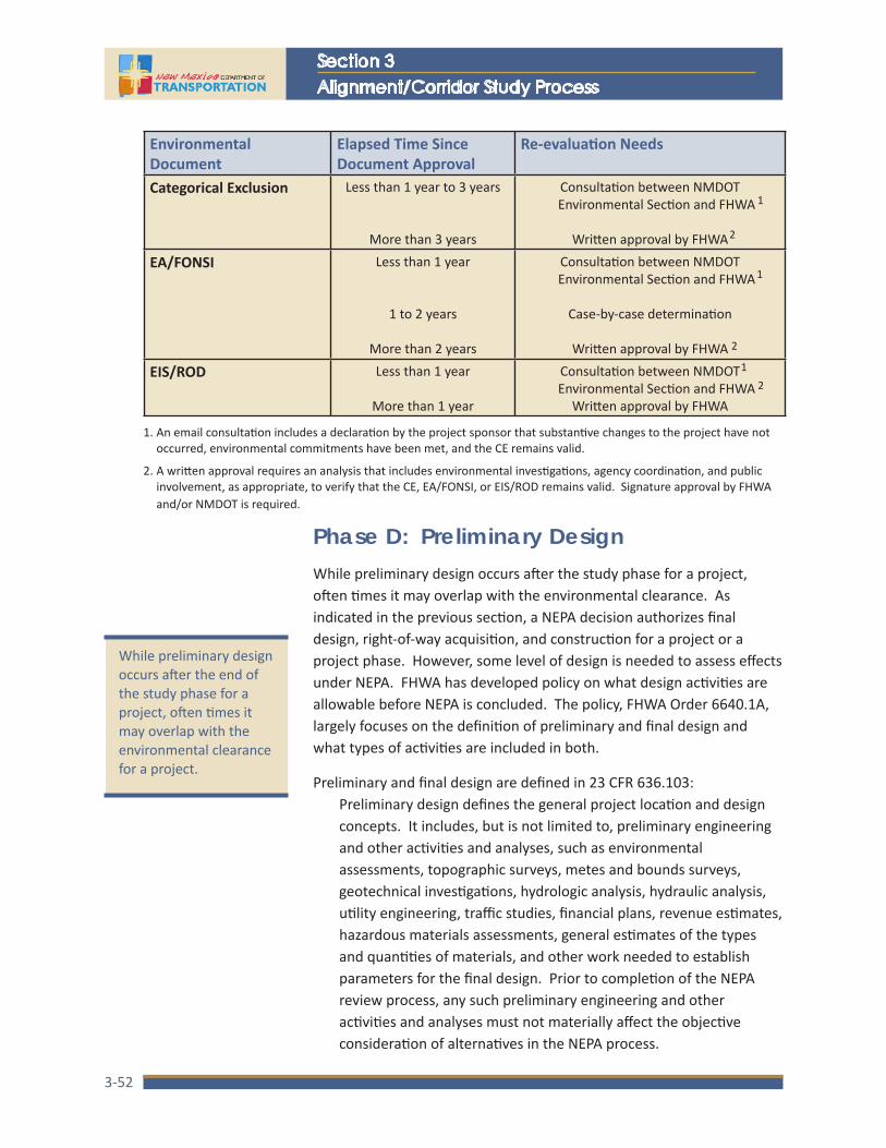
NMDOT
Section 3Alignment/Corridor Study Process
3-52
Environmental Document
Elapsed Time Since Document Approval
Re-evaluation Needs
Categorical Exclusion Less than 1 year to 3 years
More than 3 years
Consultation between NMDOT Environmental Section and FHWA
Written approval by FHWA
EA/FONSI Less than 1 year
1 to 2 years
More than 2 years
Consultation between NMDOT Environmental Section and FHWA
Case-by-case determination
Written approval by FHWA
EIS/ROD Less than 1 year
More than 1 year
Consultation between NMDOT Environmental Section and FHWA
Written approval by FHWA
1
2
2
2
1
1
1. An email consultation includes a declaration by the project sponsor that substantive changes to the project have not occurred, environmental commitments have been met, and the CE remains valid.
2. A written approval requires an analysis that includes environmental investigations, agency coordination, and public involvement, as appropriate, to verify that the CE, EA/FONSI, or EIS/ROD remains valid. Signature approval by FHWA and/or NMDOT is required.
While preliminary design occurs after the end of the study phase for a project, often times it may overlap with the environmental clearance for a project.
Phase D: Preliminary DesignWhile preliminary design occurs after the study phase for a project, often times it may overlap with the environmental clearance. As indicated in the previous section, a NEPA decision authorizes final design, right-of-way acquisition, and construction for a project or a project phase. However, some level of design is needed to assess effects under NEPA. FHWA has developed policy on what design activities are allowable before NEPA is concluded. The policy, FHWA Order 6640.1A, largely focuses on the definition of preliminary and final design and what types of activities are included in both.
Preliminary and final design are defined in 23 CFR 636.103:Preliminary design defines the general project location and design concepts. It includes, but is not limited to, preliminary engineering and other activities and analyses, such as environmental assessments, topographic surveys, metes and bounds surveys, geotechnical investigations, hydrologic analysis, hydraulic analysis, utility engineering, traffic studies, financial plans, revenue estimates, hazardous materials assessments, general estimates of the types and quantities of materials, and other work needed to establish parameters for the final design. Prior to completion of the NEPA review process, any such preliminary engineering and other activities and analyses must not materially affect the objective consideration of alternatives in the NEPA process.

Location Study Procedures Update 2015A Guidebook for Alignment Studies and Corridor Studies
3-53
Final design means any design activities following preliminary design and expressly includes the preparation of final construction plans and detailed specifications for the performance of construction work.
Other preliminary design activities and analyses that FHWA has determined can be completed prior to the environmental clearance include:
• Development of typical sections, grading plans, geometric alignments
• Bridge type/size/location studies, temporary structure requirements, staged bridge construction requirements
• Structural design, retaining wall design, noise wall design
• Guardrail length/layout
• Existing property lines
• Title and deed research
• Soil borings
• Cross sections with flow line elevations
• Ditch designs
• Intersection design/configuration
• Interchange design/configurations
• Pavement design
• Storm/sanitary sewer design
• Culvert design, identification of removal items
• Quantity estimates
• Pavement details/elevation tables
• Preliminary traffic control plans to be maintained during construction
Other activities not listed above can still be advanced as part of preliminary design as long as the NMDOT has asked and the FHWA administrator has determined beforehand that they would not affect the objective consideration of alternatives or have an adverse environmental impact. In making that determination, the division administrator considers both the actual and perceived bias with respect to any alternative under consideration, the extent to which an activity is specific to only one alternative, and whether or not an activity relates to a specific point of controversy.
Preliminary design activities may not materially affect the objective consideration of alternatives in the NEPA process.

NMDOT
Section 3Alignment/Corridor Study Process
3-54
Typically, preliminary design would require a final geotechnical report, utility location and mapping, right-of-way design and legal descriptions, roadway plan and profiles, bridge and structure plans, traffic control, a National Pollution Discharge Elimination System (NPDES), and an engineer’s estimate. These are in addition to activities and analyses that are completed during Phase B, such as a final drainage report, bridge and structure types and criteria, plan and profile sheets, and an engineer’s estimate.
NMDOT has developed a format for plan sets with standard information to be completed to a level consistent with the design stage (see applicable infrastructure design directives). This format consists of:
• 1 Series Sheets including cover, vicinity map, index of sheets, summary of quantities, general notes and environmental notes
• 2 Series Sheets including typical sections, surfacing schedule, estimated structure quantities, miscellaneous quantities and details, Temporary Erosion and Sediment control plan, erosion control plan, and miscellaneous drawings
• 3 Series Sheets including survey data and plan and profiles
• 4 Series Sheets including turnout profiles
• 5 Series Sheets including bridge plans
• 6 Series Sheets including construction traffic control management plans
• 7 Series Sheets including permanent signing/striping
• 8 Series Sheets including lighting
• 9 Series Sheets including signalization and ITS details
• 10 Series Sheets including structure placement sections

Section 4Requirements and Methods
4-1
Requirements and MethodsOverview and PurposeThis section of the Guidebook provides an overview of major engineering and environmental topics that are typically encountered during the alignment study/corridor study process and that require compliance/coordination with other federal and/or state regulations. The purpose of the overview is to provide general guidance to practitioners. The overview is not intended to be all-encompassing or prescriptive.
The information for each topic is presented in the following format:
• The objective to be achieved for each particular topic or resource area from the perspective of the conceptual design and environmental phase of the project development process
• The relevant regulations that are applicable to each topic
• Coordination requirements with review and/or approving agencies
• An overview of the general approach and methodologies followed for performing investigations
• The documentation requirements for supporting technical reports and/or the information that should be presented within the various documents prepared for corridor and alignment studies
There are numerous resources available for performing these analyses and many of these resources are updated frequently. The user can supplement the processes described below with internet research to obtain the latest information.
In the appendices following this section, a summary of federal environmental policies and regulations for issues that may be encountered during the conceptual design and environmental process for transportation projects is provided. The summaries encompass four areas: (1) general environmental statutes and policies, (2) historic and archeological resources, (3) land use and water resources, and (4) air quality and noise. For each topic, the legislative reference, regulatory reference, purpose, applicability, general procedures, and agency coordination requirements are summarized. The information in this section and the accompanying appendix should be reviewed by engineers and planners as reference materials for environmental investigations.

NMDOT
Section 4Requirements and Methods
4-2
Traffic Analysis Objectives
Traffic analysis serves several objectives and the required level of effort depends on the type and location of the project. More in depth analysis is typically required in urban settings than in rural settings. The traffic analysis establishes how the transportation network is performing, how it is expected to perform in the future, and the need for improvements if the performance does not meet acceptable standards. Traffic analysis informs the conceptual design process as the specific operational needs are identified and alternative improvement concepts are evaluated for their effect on traffic flow and other travel modes including pedestrians, bicyclists, and transit vehicles. In addition, the findings of the traffic analyses provide quantitative data that are useful in preparing the overall transportation needs analysis for a project and the pavement design requirements later in the design phase.
Relevant Guidelines and ReGulatiOns
There are numerous resources available for reference when performing the traffic analysis for a transportation improvement project. The user can supplement the documents listed below with internet research to obtain the latest information.
• Highway Capacity Manual (HCM), Transportation Research Board (TRB), current edition
• Manual on Uniform Traffic Control Devices (MUTCD), FHWA, current edition
• A Policy on Geometric Design of Highways and Streets, American Association of State Highway and Transportation Officials, current edition—the “Green Book”
• NMDOT Infrastructure Design Directive IDD-2011-05, Traffic Signal Yellow Change, Red Clearance, Pedestrian Clearance Policy, and Dilemma Zone Guidance
• New Mexico Administrative Code Rule: 18 NMAC 31.6, State Highway Access Management System
• Administrative Directive AD 232-95, Traffic Signals
• New Mexico Traffic Monitoring Standards (NMTMS), current edition
cOORdinatiOn
Traffic analysis requires coordination with several entities, depending on the type and location of the project. These include technical support staff at the general and district offices of the NMDOT, the NMDOT North, Central and South regional design centers, regional governments (MPOs and RPOs), and local municipal and county public works agencies. These entities will have information and knowledge on traffic operations, historic and current traffic flows, growth trends and expectations, and operational parameters for their public roadways and intersections. For future traffic

Location Study Procedures Update 2015A Guidebook for Alignment Studies and Corridor Studies
4-3
volumes, projections for rural projects are prepared using annual growth factors. For transportation projects in urban areas, traffic forecasts will generally be developed by the MPO or local public works agency in collaboration with the NMDOT. Coordination with the NMDOT Intelligent Transportation System (ITS) Bureau should also be performed.
GeneRal appROach
The technical approach for traffic analysis normally includes the following activities:
• Field Review — A field review of the corridor should be conducted to identify physical conditions such as lane geometry, intersection geometry, posted speed limits, ITS devices present, etc. Resources should also be spent observing existing traffic operational levels, multi-modal uses, and vehicle types (e.g., trucks, recreational vehicles, farm equipment) using the roadway segments and intersections within the project area. Special circumstances such as seasonal events or activities (e.g., recreational and tourist traffic) that affect traffic volumes using a facility should also be identified to determine if they should be incorporated into the analysis
• Evaluate Existing Traffic Conditions — Existing traffic conditions should be reviewed and analyzed to assess current performance levels and to assist in the identification of problems and conditions that may need to be corrected. The analyses will require existing traffic count and vehicle classification data, and pedestrian and bicycle count data. A traffic control device review should also be completed and, if applicable, background traffic signal timing data should be obtained from the agency responsible for the traffic signal installation and maintenance.
• Prepare Future Traffic Volume Estimates — Estimates of future traffic volumes must be developed and used in the evaluation of future traffic performance. Typically, future traffic volumes are estimated for a 20-year design horizon, but may also be required for a near-term implementation year or an initial phase of an improvement project. Because the use of a transportation facility may change after improvements have been implemented, separate projections may be required for the existing scenario (No Build) and for the various improvement scenarios that will be evaluated by the corridor study.
• Evaluate Future Traffic Operations — The anticipated traffic performance for each improvement alternative must be evaluated. Depending on the type and location of the facility being evaluated, the analysis may be simple or complex. For simple projects, the evaluation is normally limited to an evaluation of roadway and intersection level of service. Projects involving multiple signalized intersections along a single route may require traffic signal progression analysis. For complex projects, such as major interstate or highway reconstruction efforts, the traffic analysis may require the evaluation of the entire street network within

NMDOT
Section 4Requirements and Methods
4-4
the project influence area, and the use of more sophisticated analytical tools such as micro-simulation models. Micro-simulation analysis may be required when congestion is expected within or adjacent to the project area.
• Conceptual Design Assistance for Traffic Issues — The findings of the traffic analyses should be used in the development of design concepts for geometric issues such as the number of lanes, the need for auxiliary lanes, intersection and interchange geometry and spacing requirements, traffic signal control, vehicle queuing needs, ITS system improvements, etc.
dOcumentatiOn RequiRements
For major alignment/corridor studies, a separate technical traffic report should be prepared that describes the analysis assumptions and methodologies, findings, and recommendations. The key findings of the technical report should be summarized for inclusion in the corridor study report with the full report referenced as supporting documentation. Typically, the content of the report will include:
• Purpose
• Study area description
• Summary of existing roadway conditions, traffic olumes, pedestrian and bicycle usage, and traffic performance
• Traffic signal warrants
• ITS applicability and requirements
• Description of alternatives
• Estimates of future traffic volumes
• Future-year traffic performance by facility type and improvement alternative
• Comparative evaluation of alternatives
• Queuing analysis for critical movements, as applicable
• Conclusions and recommendations
• Attachments and separate appendices, as appropriate for the project
– Existing traffic information – Supporting information used to develop future-year traffic volume estimates – Traffic analysis output reports for each facility type by analysis year and
alternative – Other pertinent information used to complete the traffic analysis

Location Study Procedures Update 2015A Guidebook for Alignment Studies and Corridor Studies
4-5
Safety AnalysisObjectives
A safety analysis is needed to provide project background information and to determine if safety should be included in the project purpose and need. Safety analysis considerations should address substantive and nominal safety concepts. Substantive safety is the actual long term safety performance of a roadway measured using the crash experience of the area. Nominal safety is a consideration of whether a roadway, design alternative, or design element meets minimum design criteria. That is, a highway or proposed design is considered to have nominal safety if its design features (e.g., lane width, shoulder width, alignment, sight distance, etc.) meet the minimum values or ranges. The measure of nominal safety is simply a comparison of design element dimensions to the adopted design criteria.
Relevant Guidelines and ReGulatiOns
• Highway Safety Manual (HSM), American Association of State Highway and Transportation Officials, current edition
• FHWA 13 Controlling Criteria
• NMDOT Design Standards
• A Policy on Geometric Design of Highways and Streets, American Association of State Highway and Transportation Officials, current edition
• NMDOT Infrastructure Design Directive IDD-2006-04, Design Exception & Design Variance Procedures
cOORdinatiOn
Coordination required to complete a safety analysis for a transportation project may involve the following entities:
• NMDOT Planning and Traffic Safety Divisions (source of statewide crash data)
• NMDOT Traffic Technical Support Services
• NMDOT District engineering and maintenance personnel
• Local Agency engineering and maintenance personnel, as applicable
• Emergency service providers, as applicable
GeneRal appROach
The level of effort expended on the safety analysis is dependent on the project type and the extent of the crash experience within the project area. For substantive safety, high crash locations require more in depth evaluation than locations with low crash

NMDOT
Section 4Requirements and Methods
4-6
occurrence. The review of crash data should be performed for a minimum of three (3) years and should quantify the number, type and severity of crashes by facility type. Where definitive crash patterns exist based on predominant crash types and/or severity, mitigation strategies should be identified to reduce the crash potential of the facility associated with the identified crash patterns.
For nominal safety, the safety analyst should coordinate with the design engineers to identify pertinent design criteria and to assess alternative conceptual design layouts for compliance with adopted design standards.
dOcumentatiOn RequiRements
The methodology and findings of the safety analysis are typically incorporated into the corridor/alignment study report. Depending on the complexity of the project, the safety analysis may also be documented in a separate technical memorandum. Crash data may be summarized in tabular format, in cluster diagrams, and/or by collision diagrams.

Location Study Procedures Update 2015A Guidebook for Alignment Studies and Corridor Studies
4-7
Systems EngineeringObjectives
Systems engineering (SE) ensures that when a project includes technological elements for ITS, the deployed systems will be successful at satisfying the needs being addressed. At its most fundamental level, successfully meeting project needs includes being operable, within budget, and on-schedule. This is demonstrated through a series of processes documented at various stages of project development and design.
Systems engineering is required for all Federal Aid projects with ITS elements. The complexity of SE is commensurate with the project scope. Minimal SE requirements include:
• Identify the portions of the regional ITS Architecture being implemented
• Identify participating agencies roles and responsibilities
• Define system requirements
• Analyze alternative system configurations and technology options to meet system requirements
• Identify procurement options
• Identify applicable ITS standards and testing procedures
• Identify procedures and resources necessary to operate and manage the deployed system
There are several on-line resources for the SE process at the NMDOT ITS Bureau website, www.itsnmdot.org. This website contains a link to each of New Mexico’s Regional ITS Architectures (five total) as well as a link to the ITS Project Checklist, which is required as part of the project certification process regardless of the presence or absence of ITS elements.
Relevant Guidelines and ReGulatiOns
• 23 CFR 940—Intelligent Transportation system Architecture and Standards
• FHWA Systems Engineering for Intelligent Transportation Systems—An Introduction for Transportation Professionals
• NMDOT ITS Project Checklist
• NMDOT Dynamic Message Sign Operations Manual
cOORdinatiOn
Systems Engineering for ITS requires coordination with technical support staff at the general and district offices of the NMDOT; the NMDOT North, Central and South regional design centers; and regional governments such as the ITS subcommittees of MPOs and RPOs.
NMDOT
Section 4Requirements and Methods
4-8
GeneRal appROach
To understand the elements within SE, reference is often made to the “V” Diagram on the following page (Figure 4-1). The figure represents the SE processes as it relates to the project development process.
Reference has already been made to ITS Architecture review. Subsequent stages move from planning to the programming/budgeting phase and into project initiation, which includes a Feasibility Study and Concept Exploration that considers various factors including:
• Field Review – A field review of the proposed location being considered for ITS deployment should be conducted to identify physical conditions such as roadway geometry, accessibility to services, or other features that could affect a systems ability to provide the desired levels of service (i.e., lines of sight restrictions).
• Evaluate Existing Traffic Conditions – Existing traffic conditions should be reviewed to determine if there are characteristics associated with it that could affect either placement or type of deployment (i.e., large presence of commercial vehicles or is a significant commuter corridor).
• Prepare and Evaluate Future Traffic Conditions – Consideration should be given to any anticipated changes to the characteristics of the traffic, roadway, or land use developments in the area that could affect a deployment’s efficacy or performance.
• Evaluate Seasonal Considerations – Variances in a location’s seasonal characteristics or weather patterns could have an impact on a deployment’s operations and associated maintenance activities required of agency staff.
Concept of Operations (CoO) defines the goals and objectives of how the system will satisfy the stakeholder’s needs. It does this in the context of the Feasibility Study and Concept Exploration. Specific information on the content within a CoO is contained in the FHWA guidance referenced above.
dOcumentatiOn RequiRements
Completing the ITS Project Checklist will satisfy the documentation requirements associated with ITS deployments for most projects. Embedded in the SE Checklist is reference to the specific documentation elements associated with the SE process. For example, the NMDOT Special Provisions for various ITS elements that are typically deployed (i.e., closed circuit television, traffic sensors, dynamic message signs, roadside weather information systems, or fiber optics) already contain the design elements and acceptance testing that would satisfy SE documentation requirements. For more complex projects (i.e., integrating networks or sharing information across agency stakeholders), an SE Management Plan (SEMP) would be needed.

Location Study Procedures Update 2015A Guidebook for Alignment Studies and Corridor Studies
4-9
Regi
onal
Ar
chite
ctur
e(s)
Feas
ibili
ty S
tudy
/ Con
cept
Expl
orati
onCo
ncep
ts o
f O
pera
tions
Syst
emRe
quire
men
ts
High
-Lev
elDe
sign
Deta
iled
Desig
n Softw
are
/ Har
dwar
eDe
velo
pmen
tFi
eld
Inst
alla
tionUn
it/De
vice
Testi
ngSubs
yste
m
Verifi
catio
nSyst
em
Verifi
catio
n &
De
ploy
men
tSyst
emVa
lidati
on
Ope
ratio
ns &
M
aint
enan
ceCh
ange
s &
Upgr
ades
Retir
emen
t/Re
plac
emen
t
Impl
emen
tatio
n
Decomposition & Definition
Integration & Recomposition
Tran
spor
tatio
n Pl
anni
ng
Proj
ect
Initi
ation
Plan
sSp
ecs &
Estim
ates
Proj
ect
Clos
eout
Prel
imin
ary
Engi
neer
ing
Ope
ratio
ns &
Mai
nten
ance
Chan
ges &
Up
grad
esRe
tirem
ent/
Repl
acem
ent
Cons
truc
tion
Prog
ram
min
g/B
udge
ting
PDE
PM
Figu
re 4
-1:
Dete
rmin
ing
the
NEP
A pr
oces
s

NMDOT
Section 4Requirements and Methods
4-10
Preliminary Drainage AnalysisObjective
The preliminary drainage analysis and report entails the assessment of existing drainage conditions and facilities along the project, preliminary design of upgrades or new facilities as needed, and documentation of the analyses and recommendations. The primary objective of the preliminary drainage report is to identify drainage improvements that are required as part of proposed roadway improvements.
Relevant ReGulatiOns and Guidelines
• NMDOT Drainage Manuals
• Drainage Design Criteria for NMDOT Projects, latest edition
• Federal Water Pollution Control Act of 1972, as amended by the Clean Water Act in 1977 and 1987 (33 USC 1251-1376)
• Regulations attendant to the Clean Water Act at: 23 CFR 650 Subpart B and 23 CFR 771; 30 CFR 209, 320-323, 325, 328 and 329; and 40 CFR 121-125, 129-131, 133, 135-136, 230 and 231
• New Mexico Water Quality Act (74-6-4.C NMSA 1978)
• Regulations attendant to the New Mexico Water Quality Act at 20 NMAC 6.1 (“State of New Mexico Standards for Interstate and Intrastate Streams”)
• Relevant Tribal water quality standards
cOORdinatiOn
The NMDOT Drainage Design Bureau is responsible for ensuring adequate drainage design for highway projects in New Mexico, although changes to stream channels must comply with the requirements of several federal, state and local agencies. These include:
• Municipal Public Works Department staff
• Irrigation and Conservancy Districts
• Soil & Water Conservation Districts
• NM Environment Department
• Native American Tribal Governments
• US Army Corps of Engineers
• Bureau of Land Management
• US Forest Service
• Federal Emergency Management Agency
• Others

Location Study Procedures Update 2015A Guidebook for Alignment Studies and Corridor Studies
4-11
evaluatiOn methOds and GeneRal appROach
As a starting point for the preliminary drainage design, existing conditions along the project need to be determined. The following items should be obtained:
• As-built plans and previous drainage studies
• United States Geological Survey (USGS) quadrangle maps and/or a digital terrain model (DTM) for the study area
• Soil surveys and land use maps
• Stream gauge data
The location of existing drainage structures can be identified from the as-built plans and from field surveys. A site visit should be made to verify the drainage structure locations and sizes shown on the as-built plans.
hydROlOGic analysis
The hydrologic analysis serves to establish drainage flows that may affect the highway project. To begin the hydrologic analysis, the existing drainage structures should be located on USGS quadrangle maps and the drainage basin areas delineated. If the proposed project will shift the alignment of the new road a significant distance away from the existing road, the new alignment should be overlaid on the quad maps and the basin areas adjusted accordingly. If the project is for an entirely new highway where a roadway does not currently exist, the planned alignment should be overlaid on the quad maps and drainage basins with obvious drainage crossings delineated.
Once the drainage basins have been delineated and surface areas estimated, the specific hydrologic analysis method for each basin can be selected according to the guidelines contained in the NMDOT Drainage Manual. Utilizing the appropriate analysis method, peak runoff rates from each basin can be calculated.
Upon completing the initial hydrologic analysis, a site visit should be conducted to field verify assumptions made during the analysis and to inspect the condition of the existing drainage structures. The designer should also discuss drainage needs with pertinent maintenance staff as a source of specific drainage problems and the need for improvements that can be addressed with the new project. Adjustments to the hydrologic calculations may be necessary based on the field observations and discussions with maintenance personnel.

NMDOT
Section 4Requirements and Methods
4-12
hydRaulic analysis
The hydraulic analysis serves to determine the capacity of drainage facilities and is conducted after runoff rates to each structure have been calculated. The hydraulic analysis method will vary depending on the type of structure (e.g., culvert, drop inlet, bridge, ditch, etc.) and should be determined in accordance with the guidelines in the NMDOT Drainage Manual.
Typically, existing drainage structures will be extended or otherwise modified for use in new construction provided that they are structurally sound, meet current design criteria, and do not require replacement due to alignment or grade changes. Otherwise, an adequate sized replacement or new structure is recommended. If a new or replacement bridge is involved, the minimum clear opening required and minimum channel dimensions at the bridge crossing will be determined. In addition to determining the sizes of the replacement and/or new drainage culvert and bridges, preliminary storm drain analysis, outlet protection/energy dissipater requirements, and the need for erosion and sediment control measures should be investigated. A more detailed analysis of the drainage features will be required for the final drainage analysis and report.
dOcumentatiOn RequiRements
Upon completion of the hydrologic and hydraulic analyses, the drainage designer should summarize the results in a formal Preliminary Drainage Report. The report should include the following basic elements:
• Project name, location, number, etc.
• Drainage map with structures shown
• Drainage basin characteristics (area, soil type, curve number, time of conc., runoff, etc.)
• Field inspection results and patrol foreman interview
• Tabulation of hydraulic performance of existing and recommended new structures
• Identify sources of all data used
The drainage designer should provide the report to the project engineer for review and concurrence prior to distribution. For consultant projects, the report is submitted to the Drainage Design Bureau for review and comment. Once the project engineer and Drainage Design Bureau approve the report, it should be distributed to all interested parties.

Location Study Procedures Update 2015A Guidebook for Alignment Studies and Corridor Studies
4-13
Air QualityObjective
Air quality analysis is typically only required when a project is located in a non-attainment or maintenance area and when addressing intersections with a high volume of traffic and low level of service. The objective of an air quality analysis during the preliminary design phase is to evaluate the effect of a particular design concept on ambient air quality. In air quality non-attainment areas and/or maintenance areas, conformity with the state implementation plan must also be demonstrated. Non-attainment means an area that is in violation of National Ambient Air Quality Standards (NAAQS) for a criteria pollutant, i.e., carbon monoxide, nitrogen oxides, sulfur dioxide, lead, PM10, and ozone. Maintenance area means a location that was previously in non-attainment but that has not violated NAAQS within the last three years and that has been formally classified as a maintenance area by the US EPA. A Limited Maintenance Area has met NAAQS for 5 years or more and has an EPA-approved Limited Maintenance Plan (LMP) for the criteria pollutant of concern. A limited maintenance area does not have to satisfy the requirement for a regional emissions analysis.
Relevant ReGulatiOns
• Clean Air Act (as amended)
• Transportation Conformity Rule: 23 U.S.C. 109 (J), 42 U.S.C. 7521(a), (P.L. 101-549)
• 40 CFR 51 and 93
cOORdinatiOn RequiRements
Coordination is required with the state and/or local agency having responsibility for air pollution control and air quality. Statewide, this is the responsibility of the New Mexico Environment Department, Air Quality Bureau. Transportation projects conducted within Bernalillo County must be coordinated with the Albuquerque Environmental Health Department, Air Quality Division. Typically, coordination involves collaboration and agreement on the air quality modeling protocol and modeling assumptions that are to be used in the analysis.
In general, air quality on tribal lands is regulated by the US EPA. In some instances, individual tribes may have their own regulations if they have established an EPA-approved air quality agency. Coordination with the local air quality officials is necessary in these instances.

NMDOT
Section 4Requirements and Methods
4-14
evaluatiOn methOds and GeneRal appROach
An air quality analysis should demonstrate the effect that a project will have on ambient air quality and should be performed by persons with expertise in traffic flow and air quality modeling. The level of effort should be determined by the magnitude and location of the project: i.e., roadways located in a maintenance area and having a high volume of traffic may require a detailed modeling analysis using EPA accepted models; highways with low traffic volumes in rural areas can often rely on qualitative analyses or data developed by previous studies.
Modeling analyses should be performed following the procedures and analytical methods contained within latest EPA guidance. An analysis should be conducted for each project alternative and should be based on design-year conditions and traffic projections.
dOcumentatiOn RequiRements
The discussion of existing conditions should include a brief description of the existing transportation-related air quality concerns within the project area and should reference data from the state and local air monitoring database when pertinent and available. The discussion of impacts should include a summary of the analysis methodology and a discussion of findings for each project alternative. A comparison of findings should be presented in matrix form when multiple alternatives are evaluated.
In non-attainment and/or maintenance areas, the documentation must also include a statement of conformity. Federal conformity rules require that federally funded transportation projects must come from a conforming transportation plan and transportation program, and that the project’s design concept and scope have not changed significantly from those described in the transportation plan. In addition, the project must not cause or contribute to any new localized carbon monoxide (CO) violations, increase the severity of any existing violations in CO nonattainment and maintenance areas, or delay attainment of federal ambient air quality standards. This is often accomplished with a hot spot analysis.
Location Study Procedures Update 2015A Guidebook for Alignment Studies and Corridor Studies
4-15
NoiseObjective
The objective of the noise analysis is to evaluate the effects of project alternatives on ambient noise levels and to determine the need for and feasibility of noise abatement. Noise levels may change as a consequence of changes in traffic volume, travel speed, shifts in vertical and/or horizontal alignment, or changes in the types of vehicles using the facility. Accordingly, 23 CFR 772 requires that noise abatement be considered for all projects involving new highways and improvements to existing highways that substantially change the horizontal and/or vertical alignment or increase the number of through lanes. These are referred to as “Type I” projects. Type II projects involve the construction of noise abatement measures on existing highways not undergoing the substantial changes described above. Type III projects do not meet the definitions of Type I or Type II above and do not require a noise analysis.
Relevant ReGulatiOns
• 23 CFR 772
• NMDOT Infrastructure Design Directive 2011-2, Procedures for Abatement of Highway Traffic Noise and Construction Noise
cOORdinatiOn RequiRements
FHWA and the NMDOT have responsibility for overseeing technical analyses for noise analysis and mitigation. Thus, coordination with other agencies is not typically required. In some instances, however, the noise effects of transportation projects on other resources, such as certain wildlife species or noise-sensitive cultural properties, may require analysis. These cases will require coordination with agencies such as the US Fish and Wildlife Service and/or the State Historic Preservation Officer and will involve collaboration on how impacts will be analyzed.
evaluatiOn methOds and GeneRal appROach
Noise analyses will consist of both qualitative and quantitative analysis. The preliminary evaluation of alternatives will typically be limited to a qualitative assessment.
The qualitative analyses should consist of the following activities:
• Identification of noise-sensitive land uses within the project area
• Noise monitoring to establish existing ambient noise levels
• A review of projected traffic volumes, travel speeds, and vehicle types expected for each alternative
• A qualitative assessment of how noise levels would change with each alternative, and the identification of areas where high noise levels may be unacceptable

NMDOT
Section 4Requirements and Methods
4-16
The detailed evaluation of alternatives will typically require quantitative analysis and will include the following additional steps:
• A detailed modeling analysis using the FHWA Traffic Noise Model (TNM). The analysis should consider the geometric relationship of the roadway-receiver pairs, the projected traffic volumes, travel speed, and types of vehicles using each alternative. The use of each affected property must also be identified to determine the appropriate FHWA “Activity Category” to be used in determining impact.
• The determination of impact and abatement will be based on FHWA Noise Abatement Criteria and NMDOT IDD 2011-2 regarding noise abatement
• The identification and evaluation of noise abatement for all of the areas identified as impacted
• An evaluation of cost and effectiveness of noise abatement for each of the locations evaluated, and a recommendation with regard to the inclusion of noise abatement for each alternative
Analyses should be conducted for each project alternative and should be based on design-year conditions and traffic projections.
dOcumentatiOn RequiRements
The discussion of existing conditions should include a brief description of the existing transportation-related noise sources and the findings of noise monitoring at representative locations within the project area. The discussion of impacts should include a summary of the analysis methodology and a discussion of findings and recommendations for each project alternative. A comparison of findings should be presented in matrix form when multiple alternatives are evaluated.

Location Study Procedures Update 2015A Guidebook for Alignment Studies and Corridor Studies
4-17
Environmental Justice, Social, and Economic Issues Objective
Highway improvements can cause a variety of short- and long-term effects on social and economic conditions. Social effects generally include factors such as displacement of residences, changes to neighborhoods, disruption of community cohesion, loss of access to community facilities, changes in travel patterns, public safety, etc. Economic effects include factors such as displacement of businesses, changes in access to highway-dependent businesses, induced need for other public expenditures, changes in employment, loss of property tax revenues, etc. These topics are also central considerations in developing a project consistent with CSS principles. The topic of relocations, addressed as a separate category, is closely-related to this topic.
The evaluation of social impacts must also consider effects on special status populations that are afforded special protection by civil rights and environmental justice regulations, and policies. These include regulations to:
• Ensure that no person shall, on the grounds of race, color, national origin, age, sex, or disability be subjected to discrimination under any program or activity receiving federal financial assistance
• Achieve environmental justice by identifying and addressing disproportionately high and adverse human health and environmental effects on minority or low-income populations
Relevant ReGulatiOns
• Title VI of the Civil Rights Act of 1964 (42 U.S.C. 2000D et seq.) and related statutes
• 49 CFR 21
• 23 CFR 200
• Executive Order 12898 on Federal Actions to Address Environmental Justice in Minority and Low-Income Populations
• Department of Transportation Order on Environmental Justice (DOT Order 5610.2)
• FHWA Order 6640.23 - FHWA Actions to Address Environmental Justice in Minority and Low-Income Populations
• NMDOT Context Sensitive Public Involvement Plan Guidelines for Location Study Projects

NMDOT
Section 4Requirements and Methods
4-18
cOORdinatiOn RequiRements
There are no mandatory coordination requirements for social and economic issues. However, FHWA is responsible for administration of policies, programs, and activities that are subject to the regulations listed above. If an environmental impact statement is prepared for a transportation project, the US EPA also reviews the document and is responsible for enforcement of civil rights and environmental justice regulations for programs within its jurisdiction.
evaluatiOn methOds and GeneRal appROach
The evaluation approach and data needs for social and economic analyses will vary widely according to the project magnitude and locations. For most projects, the following data will be characterized and evaluated:
• Demographic information (population size, age and ethnic distribution, income)
• Neighborhood composition and boundaries
• Housing factors (type, density, multi vs. single family, owner vs. tenant, availability)
• Community facilities and services (location, type, access)
• Businesses (number, type, size, distribution, access, clientele demographics, number and demographics of employees)
• Tax base/economy (unemployment rate, income distribution, stability)
The analysis should include identification and evaluation of the effects of each project alternative for the factors listed above, including both positive and negative direct, indirect, and cumulative social and economic effects. Issues to be evaluated include, but may not be limited to:
• Impacts to special status populations
• Changes in neighborhoods or community cohesion (e.g. splitting neighborhoods, displacing residents, inducing new development, increasing or decreasing property values)
• An increase or reduction in availability and accessibility to local and regional community facilities and services (e.g. direct loss of facilities which would force further travel distances, indirect effects such as loss of population supporting such facilities, barriers to police and fire protection)
• Increases or decreases in traffic volumes and safety of existing and proposed transportation facilities

Location Study Procedures Update 2015A Guidebook for Alignment Studies and Corridor Studies
4-19
• Potential business displacements, indirect effects on highway-related businesses or other business centers, the potential for induced commercial growth and associated indirect effects, and effects of permanent and temporary changes in business access
• Short- and long-term effects on the regional and local economy, including shifts in levels of income, employment, and property tax revenues and loss of agricultural lands
dOcumentatiOn RequiRements
Documentation should include a discussion of the analysis methodology and source of data use in the analysis. For unusually complex or large projects, a separate report may be prepared. Otherwise, the analysis methodology, data sources, findings and conclusions should be summarized in the environmental document.

NMDOT
Section 4Requirements and Methods
4-20
Visual ResourcesObjective
Visual resources in a transportation project corridor may include natural resources, such as landforms, rock formations, vegetation, natural water bodies, and riparian areas, and man-made resources, including buildings, bridges, roads, reservoirs and ponds, and walls. Location of these resources with respect to a transportation corridor may be in the immediate vicinity of the corridor ranging to distant views from or towards the corridor. Thus, the area of analysis for visual resources can be quite extensive.
Transportation projects can diminish the scenic qualities of an existing corridor or introduce undesirable effects on landscapes from construction of a new corridor. These concerns are also central considerations in developing a project consistent with CSS principles. Specific actions that may affect visual elements include removal of vegetation, destruction or alteration of unique landforms, constructing steep cuts that do not allow for timely revegetation, and alteration of stream courses. The goal in planning and executing a transportation project is to avoid or minimize effects to visual quality early in the planning process. If major impacts are unavoidable, additional mitigation measures to reduce the severity of the impact should be developed.
Relevant ReGulatiOns and Guidelines
• FHWA Technical Advisory T 6640.8A
• FHWA Publication No. FHWA-HI-88-054, Visual Impact Assessment for Highway Projects
• FHWA New Mexico Division Policy on Art and Aesthetic Treatments for Federal Aid Transportation Projects
• NMDOT Context Sensitive Public Involvement Plan Guidelines for Location Study Projects
• NMDOT Architectural and Visual Quality Design Guidelines for Context Sensitive Design and Context Sensitive Solutions
cOORdinatiOn RequiRements
There are no specific regulatory agencies for which coordination is required for visual resources. However, as with all resource areas, coordination with the FHWA is imperative and, depending on the project location, affected federal or state land management agencies, such as the National Park Service, U.S. Forest Service, Bureau of Land Management, New Mexico State Land Office, and New Mexico State Parks Division, and counties and city governments should be consulted. Also, depending on the visual sensitivity of the project, additional coordination beyond the normal public involvement activities may be undertaken with interested persons and agency staff. For instance,

Location Study Procedures Update 2015A Guidebook for Alignment Studies and Corridor Studies
4-21
the FHWA Technical Advisory suggests that, if the proposed project will include features associated with art or architecture, state and local arts councils may be asked to review the engineering design and environmental document.
evaluatiOn methOds and GeneRal appROach
At the onset of project planning (Phase A), background research should be undertaken to determine if the project is located on one of New Mexico’s several scenic byways or would affect visual resources on or from a federal, state, or local park, forest, etc. A broad-based visual resources survey should be conducted for any corridor (existing or proposed) at this stage to identify existing sensitive visual elements, both positive and negative, within the area of analysis. Public involvement through Phases A and B will assist in identification of sensitive visual resources. Avoidance measures can be more readily incorporated into the project design in these phases.
Effects on scenic qualities, both positive and negative, may result from construction of a new visual element (e.g. new bridge or retaining wall) or removal of an existing visual element (e.g. cut or fill sections, removal of historic bridge). Based on early engineering designs, a determination of the type and relative importance of proposed changes to each major existing visual element must be made for each of the project alternatives. Also, new elements to be introduced as part of the project should be evaluated.
For less sensitive visual areas and early engineering designs that appear to have few physical changes to visual elements, the analysis of potential impacts may be a qualitative discussion and comparison. If a project is located in a more sensitive visual area, is a new alignment, or introduces a major change to an existing corridor, a more quantitative approach to the analysis is suggested. There are several methodologies that may be utilized, including the Visual Priority Process developed by the FHWA and U.S. Forest Service and methods specific to various land management agencies. If federal, state, or locally-administered lands are involved, the analysis should follow an accepted method and the results should be used to determine if the proposed project is in compliance with land management or comprehensive plans for the area. Coordination between NMDOT project engineers, environmental specialists, and interested or affected agencies should continue throughout Phase C to minimize or otherwise mitigate effects to visually-sensitive resources.
dOcumentatiOn RequiRements
Early public involvement and agency coordination should be documented with particular emphasis on visually-sensitive areas that have special interest for the public or agencies involved. Methodologies, results, and conclusions of the visual resources effects analysis should be documented as part of the project file. Avoidance and minimization measures should be documented as part of the environmental document as well as inclusion of additional project-specific mitigation measures to reduce impacts to sensitive visual resources.

NMDOT
Section 4Requirements and Methods
4-22
RelocationsObjective
A consequence of right-of-way acquisition for implementation of transportation projects can be the displacement of people from residential and commercial properties. Relocations can have both social and economic consequences and, thus, are closely related to those topics. The Uniform Relocation Assistance and Real Property Acquisition Act of 1970, as amended, was enacted to ensure that owners of real property acquired for all federally or state funded transportation projects and persons displaced by those projects are treated fairly, consistently and equitably, and do not suffer disproportionate impact.
An initial analysis of potential relocations is conducted during the alignment/corridor study process to identify likely relocations. A relocation program administered by the NMDOT completes the relocation process during the final design phase when right-of-way needs are fully developed.
Relevant ReGulatiOns
• Uniform Relocation Assistance and Real Property Acquisition Act of 1970 (42 U.S. C. 4601 et seq., P.L. 91-646) as amended by the Uniform Relocation Act Amendments of 1987 (P.L 100-17)
• 49 CFR 24
• Executive Order 12898 on Federal Actions to Address Environmental Justice in Minority and Low-Income Populations
• Department of Transportation Order on Environmental Justice (DOT Order 5610.2)
• FHWA Order 6640.23 - FHWA Actions to Address Environmental Justice in Minority and Low-Income Populations
• FHWA Technical Advisory T6640.8A, - Guidance for Preparing and Processing Environmental and Section 4(f) Documents.
• NMDOT Right-of-Way Handbook
cOORdinatiOn RequiRements
Relocation issues should be coordinated through the Right-of-Way section of the NMDOT. The New Mexico Division office of the FHWA is the local federal agency contact for relocation issues.

Location Study Procedures Update 2015A Guidebook for Alignment Studies and Corridor Studies
4-23
evaluatiOn methOds and GeneRal appROach
The initial right-of-way analysis determines potential acquisitions of residential and business properties. As early as possible in the study process, the analysis should identify areas of special concern, that is, effects to particular social groups such as low-income, minority, elderly, etc. that could cause the project to be in conflict with Executive Order (EO) 12898. Early identification of potential environmental justice issues will allow for design revisions to avoid those effects, as appropriate. If the effected affected properties cannot be avoided, measures to minimize harm must be developed. The analysis should also include a discussion of the availability of affordable and suitable replacement housing and business sites in the project vicinity and the likelihood of relocation in the area.
Data that will be useful for this analysis may include, but is not limited to, the following:
• Demographic information for the affected area, region, and state
• An estimate of the number of households and businesses to be relocated and demographic information of property owners, tenants, and employees
• An assessment of the existing housing and commercial property market in the area of the displaced persons (e.g. availability, condition, price range, size)

NMDOT
Section 4Requirements and Methods
4-24
FarmlandsObjective
Transportation projects may contribute to the unnecessary and irreversible conversion of farmland to non-agricultural uses. The objective of a farmlands analysis is to avoid or minimize effects on farmlands and maximize compatibility with state and local programs and policies to protect farmland. Farmlands, as defined by the Farmland Protection Policy Act (FPPA), include prime or unique farmlands, or farmlands of statewide importance as determined by the appropriate local unit of government. Prime farmland is land that has the best combination of physical and chemical characteristics for producing food, feed, fiber, forage, oilseed, and other agricultural crops with minimum inputs of fuel, fertilizer, pesticides, and labor, and without intolerable soil erosion, as determined by the Secretary of the Department of Agriculture. Unique farmland is land other than prime farmland that is used for production of specific high-value food and fiber crops, such as citrus, tree nuts, olives, cranberries, fruits, and vegetables as determined by the Secretary of Agriculture. Farmlands of statewide importance are defined by the state and include farmland that produces high yields when treated and managed according to acceptable farming methods. New Mexico has not identified prime or unique farmland but does have farmlands of statewide importance throughout the state.
Relevant ReGulatiOns
• Farmland Protection Policy Act of 1981: 7 U.S.C. 4201-4209, (P.L. 97-98), (P.L. 99-198)
• 7 CFR 658
• State or local policies or regulations to protect agricultural lands (e.g. zoning laws, comprehensive plan provisions)
cOORdinatiOn RequiRements
Coordination with the local U.S. Department of Agriculture (USDA), Natural Resources Conservation Service (NRCS) office should be undertaken early in the environmental process if assistance is needed in determining the presence of farmlands as defined by the FPPA or state or local agencies. If the analysis determines that farmlands would be affected by the proposed project, additional coordination with the NRCS must be conducted for the purpose of making a determination of whether or not to proceed with farmland conversion.
evaluatiOn methOds and GeneRal appROach
The analysis of farmland impacts requires a land evaluation to determine the presence of farmlands in or near the study corridor. Assistance in this determination may be obtained from the NRCS website or other agricultural experts (e.g. New Mexico State University faculty or extension personnel).

Location Study Procedures Update 2015A Guidebook for Alignment Studies and Corridor Studies
4-25
Project impacts to farmlands typically occur in one of two ways. The first type of impact involves acquisition of farmland for right-of-way. Indirect impacts may also occur if the proposed roadway changes field access, disrupts irrigation, or leads to the conversion of farmland to urban uses.
Data collection for each alignment should include the total number of acres and type of agricultural acreage that may be acquired, the number of farm buildings that may be acquired, the number of farm ownership tracts bisected or landlocked by the highway, and potential drainage changes that may affect specific tracts of farmland.
dOcumentatiOn RequiRements
A determination of whether or not to proceed with farmland conversions, based on severity of impacts and other environmental considerations, must be made by the FHWA in cooperation with the NRCS. If the proposed alignment will result in any prime or unique farmland or farmland of statewide importance either being acquired for right-of-way or indirectly converted to urban uses, the NMDOT must complete Parts I & III of Form AD-1006, the Farmland Conversion Impact Rating Form, and submit it to the NRCS field office. The NRCS has 45 days to determine if the affected farmland fits the definition of a farmland as defined by the FPPA. If no lands protected under the FPPA are present, the NRCS completes Part II of the form and coordination is completed. If protected lands are present, the NRCS uses a process to quantify the relative value of the affected farmlands, as described in 7 CFR 658, for reporting farmland conversion to the USDA.

NMDOT
Section 4Requirements and Methods
4-26
Cultural ResourcesObjective
The objective of cultural resource investigations during the alignment/corridor study phase is to identify cultural resources in the vicinity of a proposed undertaking and assess the potential effects of the proposed undertaking on these resources. Determining the potential effects of an undertaking on cultural resources depends on the specific project and the relevant cultural resource laws and regulations that are activated. Generally, projects can be divided into two groups: (1) those involving the use of federal funds or occurring on lands under the jurisdiction of federal agencies and (2) those involving the use of state funds or lands under the jurisdiction of state agencies.
The process governing cultural resource investigations is generally termed the “Section 106” process (Section 106 refers to Section 106 of the National Historic Preservation Act of 1966). Section 106 can be invoked and addressed separately or as part of the wider NEPA documentation process. If Section 106 is performed as part of NEPA, many of the objectives of Section 106 can be conducted concurrently. The degree of overlap between Section 106 and NEPA, and the final scope of work to be performed under Section 106, is ultimately determined through consultations with the SHPO.
Relevant ReGulatiOns
• National Historic Preservation Act of 1966 (as amended)
• 36 CFR 800, Advisory Council on Historic Preservation – Protection of Historic Properties
• Archaeological Resources Protection Act of 1979 (36 CFR 1215)
• Native American Graves Protection and Repatriation Act
• American Indian Religious Freedom Act
• National Register Bulletin 38 (Traditional Cultural Properties)
• New Mexico Cultural Properties Act (NMAC 4.10.3-8, NMAC 4.10.10, and NMAC 4.10.14-17)
• New Mexico Prehistoric and Historic Sites Preservation Act (NMAC 4.10.12)
• New Mexico Unmarked Burial Statute (NMAC 4.10.11)
• New Mexico Act Relating to the Desecration of Roadside Memorials
• New Mexico Cultural Properties Protection Act
• Desecration of Roadside Memorials, Penalty (2011 New Mexico Statues, Chapter 30, Article 15)

Location Study Procedures Update 2015A Guidebook for Alignment Studies and Corridor Studies
4-27
cOORdinatiOn RequiRements
Coordination is required with the State Historic Preservation Officer (SHPO), which has the responsibility of implementing both national and state cultural resource regulations in the state of New Mexico. Coordination may also be required with particular federal and state land managing agencies that have jurisdiction over lands on which a project is located or passes through or with agencies with other jurisdictional authority. In addition, coordination is required with specific Native American groups holding lands on which a project is located or passes through. Coordination may also be necessary with Native American groups with regard to traditional cultural properties that have the potential to be affected by a proposed undertaking.
evaluatiOn methOds and GeneRal appROach
Cultural resource investigations generally follow a four step process: (1) archival records checks, (2) field survey, (3) testing, and (4) mitigation. The purpose of an archival records check is to determine what cultural resources have been previously identified in the project area as well as to anticipate what might be encountered. These cultural resources consist of properties listed on the State Register of Cultural Properties, the National Register of Historic Properties and previously recorded archaeological sites. Once an undertaking has been more narrowly defined, a field survey of the project area is normally conducted. The purposes of the field survey is to identify cultural resources that have not been previously identified, to assess the importance, extent, and current condition of cultural resources (both previously and newly recorded), and to evaluate the potential effect of the proposed undertaking on these resources. Combined, the results of the records check and field survey are often referred to as the cultural resource inventory. In some cases, it may be determined by the NMDOT Environmental Section and SHPO that surveys are not required. This usually occurs in areas that have been thoroughly disturbed or were recently surveyed.
Cultural resource investigations must be performed by qualified individuals who hold the proper permits for each particular action. Permits are issued by the SHPO and other federal and state agencies or Native American groups holding jurisdictional powers. At each stage of the process coordination and consultations must take place with the SHPO and other appropriate agencies in determining proper courses of action.
dOcumentatiOn RequiRements
Documentation of each stage of cultural resource investigations should follow the guidelines set forth by the SHPO and NMDOT, Environmental Section. Minimally, cultural resource inventories should include information on the project location and scope, environmental and cultural settings, methods, results of both the records check and field survey, and recommendations for eligibility and treatment of the cultural resources identified. Information on survey methodology and report content can be found in the NMDOT Guidelines for Cultural Resource Investigations.

NMDOT
Section 4Requirements and Methods
4-28
This documentation is used to inform consultation with the SHPO under Section 106 of the National Historic Preservation Act. This consultation is concluded with SHPO concurrence on a determination of no effect or no adverse effect to cultural resources. When an adverse effect occurs as a result of a proposed project, the Section 106 consultation is concluded with a memorandum of agreement that describes the mitigation measures to be conducted. Upon completion of the mitigation fieldwork, clearance for construction can be obtained by submitting a preliminary report summarizing the mitigation efforts and results to the SHPO and other appropriate agencies. The mitigation effort culminates in the preparation and submission of a report detailing the results. In the case of data recovery this document should incorporate the research orientation, using the results of the work to address the research issues and goals.

Location Study Procedures Update 2015A Guidebook for Alignment Studies and Corridor Studies
4-29
Section 4(f) and 6(f) ResourcesSections 4(f) and 6(f) resources refer to those protected under Section 4(f) of the Department of Transportation Act and Section 6(f)(3) of the Land and Water Conservation Fund Act. They are often discussed together because both protect public lands; however, they have different applications and specific requirements. In New Mexico, 4(f) properties are fairly common while 6(f) properties are not often encountered during transportation projects.
Objective
Section 4(f) restricts the US Department of Transportation from using land from a significant publicly owned park, recreation area, wildlife or wildfowl refuge, or a significant historic site unless a determination is made that:
• There is no feasible and prudent alternative to the use of land from the property
• The action includes all possible planning to minimize harm to the property resulting from such use
Significance is defined by the agency (or agencies) with jurisdiction over the resource, such as the USFWS for wildlife and waterfowl refuges, and the SHPO for historic sites. In the latter case, significance is defined as those properties listed in or eligible for listing in the National Register of Historic Places (see also the discussion of cultural resources). Typically, archaeological sites significant for their research potential are exempted from 4(f) considerations.
The objective of Section 4(f) analysis in the environmental document is to:
• Identify any potential Section 4(f) resources in the project area
• Evaluate if there is a use of Section 4(f) resource
• If there is a use, demonstrate there is no feasible and prudent alternative to that use and that the project includes appropriate measures to minimize harm
Section 6(f) applies to properties acquired or improved with monies from the Land and Water conservation Fund. These are most often parks or outdoor recreation facilities. Any conversion of these lands (i.e. to roadway right-of-way) requires approval from the National Park Service. The project must provide replacement lands of equal value (as determined by formal appraisal), location, and usefulness.
The objective of Section 6(f) analysis is to:
• Identify any potential Section 6(f) resources in the project area
• Evaluate if there will be conversion of a 6(f) resource to roadway uses
• If conversion is required, demonstrate that all practical avoidance alternatives have been evaluated, and propose appropriate replacement property

NMDOT
Section 4Requirements and Methods
4-30
Relevant laws and ReGulatiOns
• Department of Transportation Act of 1966 (23 USC 138)
• Land and Water Conservation Fund Act of 1965
• 23 CFR 774—Parks, recreation Areas, Wildlife and Waterfowl refuges, and Historic Sites (Section 4(f))
• 36 CFR 59—Land and Water Conservation Fund Program of Assistance to States
cOORdinatiOn RequiRements
For Section 4(f), NMDOT must consult early in the process with FHWA and any agencies with jurisdiction over a Section 4(f) property. This could include the USFWS, the National Park Service, or local government parks and recreation departments. For historic sites, the State Historic Preservation Officer must also be consulted—typically this is done as part of the Section 106 process (see Cultural Resources). The NMDOT will contact the FHWA Division office as soon as potential 4(f) resources are identified to discuss the potential use of 4(f) properties and the appropriate level of evaluation.
For Section 6(f), NMDOT must consult with the agencies with jurisdiction over the Section 6(f) property, typically local government parks and recreation departments. They must also consult with the National Park Service if conversion of a Section 6(f) property is required.
evaluatiOn methOds and GeneRal appROach
Typically, if a project will use land from a Section 4(f) resource, a Section 4(f) evaluation must be prepared. The evaluation must describe avoidance alternatives and whether or not these alternatives are feasible and prudent, measures to minimize harm to the resources, and a description of coordination activities with the appropriate agencies.
FHWA has developed five Programmatic Section 4(f) evaluations that can be used in specific circumstances, including:
• Projects that Necessitate the Use of Historic Bridges
• Projects with Minor Involvement of Public Parks, Recreation Lands, and Wildlife and Waterfowl Refuges
• Projects with Minor Involvement with Historic Sites
• Projects that have a Net Benefit to a Section 4(f) resource
• Independent Bikeway or Walkway construction Projects

Location Study Procedures Update 2015A Guidebook for Alignment Studies and Corridor Studies
4-31
However, many of the situations covered by the programmatic agreements are also covered by the provision for “de minimis” impacts. If a project will use a Section 4(f) resource but impacts are determined to be “de minimis” (i.e. not adverse) by FHWA, and the agency with jurisdiction over the resource concurs with the determination, then the analysis of avoidance alternative and preparation of a Section 4(f) evaluation is not required.
Impacts to Section 6(f) properties occur when a Section 6(f) property is converted to a non-recreational use, such as roadway right-of-way. If such a conversion will occur, NMDOT must propose suitable replacement property and receive concurrence from the agency with jurisdiction over the property as well as the National Park Service. This process can take several months (even after suitable replacement property is identified), so early coordination and sufficient planning time is important.
dOcumentatiOn RequiRements
Results of the Section 4(f) evaluation should be documented either as a stand-alone document or as a separate section in an EA or IES. Section 4(f) evaluations should describe the proposed action, the Section 4(f) resource(s) in question, the impacts to those resources, the avoidance alternatives analyzed, and coordination activities. The Section 4(f) evaluation must be completed and approved by FHWA prior to project authorization. Non-programmatic Section 4(f) evaluations must be determined legally sufficient by FHWA Legal Counsel before they can be approved.
Documentation for Section 6(f) typically includes:
• Demonstration that all practical alternatives for avoiding the 6(f) property have been evaluated and rejected
• Appraisals of both the Section 6(f) property and the replacement property
• Demonstration that the replacement property will at least meet the recreation needs provided by the property to be converted

NMDOT
Section 4Requirements and Methods
4-32
Surface Water, Water Quality, and WetlandsObjective
A transportation improvement project can affect surface water quality, aquatic organisms, wetlands or entire aquatic ecosystems. The main types of effects include degradation of water quality through increased sediment loading or introduction of pollutants into a water body, direct impacts to wetlands or other aquatic habitats, and alteration of habitats by changing drainage characteristics. Aquatic ecosystems, including wetlands, provide extremely important functions, particularly in an arid region such as New Mexico. These functions include providing habitat for a wide diversity of fish and wildlife, maintaining unique plant communities, providing flood buffering capacity, maintenance of water quality, and providing unique recreational opportunities and aesthetic qualities.
The objective of the surface water, water quality and wetlands analysis is to provide input into the planning process so that appropriate avoidance and mitigation measures are incorporated into project design. Also, the analysis includes compliance with permitting requirements pursuant to sections 401 (401 water quality certification), 402 (NPDES permit) and 404 (404 dredge and fill permit) of the federal Clean Water Act. NPDES is an acronym for National Pollutant Discharge Elimination System.
The term jurisdictional wetland is used to describe aquatic habitats that meet the regulatory definition of wetlands in the 1987 U.S. Army Corps of Engineers “Wetlands Delineation Manual.” Dredge and fill activities in jurisdictional wetlands are regulated under section 404 of the Clean Water Act. In other surface waters, section 404 permitting is also required for placement of dredge or fill in a water of the United States. In New Mexico, waters of the U.S. cover virtually all surface water drainages, from ephemeral arroyos to perennial streams.
Relevant laws and ReGulatiOns
• Federal Water Pollution Control Act of 1972, as amended by the Clean Water Act in 1977 and 1987 (33 USC 1251-1376)
• Regulations attendant to the Clean Water Act at: 23 CFR 650 Subpart B and 23 CFR 771; 30 CFR 209, 320-323, 325, 328 and 329; and 40 CFR 121-125, 129-131, 133, 135-136, 230 and 231
• Department of Transportation Order 5660.1A
• New Mexico Water Quality Act (74-6-4.C NMSA 1978)
• Regulations attendant to the New Mexico Water Quality Act at 20 NMAC 6.1 (“State of New Mexico Standards for Interstate and Intrastate Streams”)

Location Study Procedures Update 2015A Guidebook for Alignment Studies and Corridor Studies
4-33
• Relevant Tribal water quality standards
• Executive Order 11990: Protection of Wetlands
• FHWA environmental impact and related procedures at 23 CFR 771
cOORdinatiOn RequiRements
Coordination is required with tribal governments, the USACE, Surface Water Quality Bureau of the New Mexico Environment Department, and the EPA (Region 6, Dallas, Texas).
Transportation projects must comply with New Mexico water quality standards, which are numeric and narrative criteria defined by stream segment. Section 401 of the Clean Water Act (CWA) requires that water quality certification (Section 401 permit) be obtained from the Surface Water Quality Bureau for work in any perennial water body. This permitting process ensures that the state water quality standards will be maintained. Many of the Native American tribes in New Mexico have promulgated water quality standards pursuant to their sovereign status. In this case, the tribal government has Section 401 permit authority. The EPA conducts Section 401 permitting for tribes that have not adopted their own water quality standards.
Section 402 of the CWA ensures that non-point source pollution from erosion and transport of sediment to surface waters is controlled. Section 402 requires compliance with National Pollutant Discharge Elimination System General Permit No. NM-R-10-0000. This general permit requires preparation of a Pollution Prevention Plan, design of a Temporary Erosion and Sediment Control Plan (TESCP), and implementation of Temporary Erosion and Sediment Control Measures (TESCM) for all construction activities that disturb more than one acre of land or for smaller areas that drain directly into live streams. In New Mexico, the NPDES program is implemented by the U.S. Environmental Protection Agency, Region 6.
Wetlands are special aquatic sites that are recognized for their importance as fish and wildlife habitat, water quality improvement capacity, flood buffering capacities, and other functions. Placement of dredge or fill in these sites, as well as all other waters of the United States, is regulated under Section 404 of the CWA through a permitting process implemented by the U.S. Army Corps of Engineers (404 permit). Waters of the United States includes all surface water drainages in New Mexico, both ephemeral and perennial.
For most projects, the Section 402 and 404 permitting processes are streamlined through the use of an NPDES General Construction permit and a 404 Nationwide permit. However, occasionally, additional considerations apply. For Section 402, special considerations may be needed for projects in certain urbanized areas with Municipal Separate Storm Sewer Systems (MS4s) that convey stormwater runoff into local waterbodies. In addition to a general or individual NPDES permit, MS4s must also have a stormwater management program (SWMP) to reduce the runoff pollutant loads and prohibit illicit discharges. Roadway drainage should be considered within the context of any existing MS4.

NMDOT
Section 4Requirements and Methods
4-34
Concerning Section 404, some of the more complex projects may not qualify for an existing Nationwide 404 permit and an Individual Permit (IP) would be needed. To streamline the IP application process, NMDOT, FHWA, and the USACE have signed a programmatic agreement to merge the NEPA and Section 404 processes. The agreement allows for the USACE to initiate the CWA process concurrently with the alignment study or environmental documentation. This provides the USACE the opportunity to concur with the project purpose and need and alternatives evaluation and ensures that the preferred alternative is also the Least Environmentally Damaging Practicable Alternative (LEDPA), and can therefore be permitted by the USACE. This agreement should be initiated as early in the project study process as possible.
evaluatiOn methOds and GeneRal appROach
An important consideration at the early stages of project planning is appropriate determination of the geographical extent of the analysis area. Effects to surface water resources, particularly from pollutants, sediment input, and changes in stream morphology, may occur considerable distances away from the project area. Analysis in the early stages of project development should consist of:
• Identifying locations and characteristics of surface water bodies and potential jurisdictional wetlands in the project area through field survey and review of relevant literature
• Identifying pertinent water quality standards
• Reviewing section 404 nationwide permits to identify impact thresholds that, if exceeded, would require individual permitting (a considerably longer, more involved process)
• Initiating coordination with the USACE, USFWS and New Mexico Department of Game and Fish on section 404(b)(1) analysis of practicable alternatives that minimize or avoid impacts to waters of the U.S., including wetlands
Because submission of the 401/404 permit application does not occur until designs are well-developed, close coordination with the regulatory and resource agencies should be conducted early to avoid “11th hour” crises that may require design modifications or result in costly delays.
As the initial information is assimilated into the project development process and alternatives are defined, more detailed information will be required. At this stage, in-depth field surveys to conduct jurisdictional wetland determinations, delineation and assessments may be necessary. Procedures described in the 1987 USACE “Wetland Delineation Manual” and the “Regional Supplement to the Corps of Engineers Wetland Delineation Manual: Arid West Region (Version 2.0)” dated 2008, must be used in

Location Study Procedures Update 2015A Guidebook for Alignment Studies and Corridor Studies
4-35
conducting these field surveys. Detailed quantification of the spatial extent of impacts to wetlands and surface waters and accurate determination of excavation and fill volumes should be conducted at this stage. Also, mitigation options for unavoidable impacts may receive preliminary evaluation at this stage.
dOcumentatiOn RequiRements
Description of existing conditions should discuss:
• Designated uses for surface waters
• Any existing impairments to water quality that may be influencing attainment of designated uses
• Surface water body characteristics (e.g., annual variation in flow, channel morphology, etc.)
• Relevant water quality standards and resources sensitive to water quality impacts that may result from the proposed action
• Mapped locations, extent and characteristics of jurisdictional wetlands
Analysis of effects should consider NPDES Pollution Prevention Plan measures and Best Management Practices that address erosion and sediment transport to surface waters. Proposed mitigation measures for unavoidable wetland impacts should also be described. Analysis of effects to wetlands should address and attempt to quantify important wetland functions that will be impacted, as well as surface area affected, to provide a basis for developing mitigation measures. Changes in hydraulic conditions or surface water drainage patterns may require substantial analysis in cases where important aquatic habitats occur in the project area. If jurisdictional wetlands are found in the project area, the results of the wetland determinations, delineation and assessment should be compiled and presented in a Wetland Report for the project. This report should include copies of the field data forms.

NMDOT
Section 4Requirements and Methods
4-36
FloodplainsObjective
Construction and maintenance of stream crossings in transportation corridors can adversely affect the function of floodplains. Floodplains are defined as the land area immediately adjacent to an active stream channel that becomes inundated at high flows. Typically, the 100-year floodplain is referenced. The 100-year floodplain includes the land area that is inundated the flow that has a 1% probability of occurring in any given year. Floodplains provide a valuable function to society by allowing the energy of flood waters to dissipate laterally and buffering the rate of river stage increase during a flood. Transportation projects that involve placement of through-fill across a floodplain and alteration of drainage patterns can result in reduced floodplain function. Detrimental effects to land uses and structures may be caused by such impacts. The objective of the floodplains analysis is to incorporate protection and restoration of the natural and beneficial values served by floodplains in project design, and to accurately assess and analyze the potential impacts to floodplains from project alternatives.
Relevant ReGulatiOns • EO 11988 – Protection of Floodplains
• FHWA environmental impact and related procedures at 23 CFR 771
• State or local floodplain zoning regulations and ordinances
cOORdinatiOn RequiRements
Executive Order 11988 requires circulation of a public notice when a federal agency proposes an action in a floodplain. This notice should contain an explanation of why the action is proposed to be located in the floodplain. Coordination with the Federal Emergency Management Agency and appropriate state or local agencies should be conducted in relevant project areas.
evaluatiOn methOds and GeneRal appROach
If the project area is in a floodplain, Flood Insurance Administration maps will be available and must be used to delineate floodplain boundaries. This data is also available from ArcGIS Online. For other areas, other sources must be consulted to determine the extent of the floodplain. These sources may include the USGS, USACE and the NMDOT Drainage Section. This information should be incorporated in project development in the early planning stages. As the project progresses, design features planned in the floodplain should be evaluated to determine how they will affect floodplain function.

Location Study Procedures Update 2015A Guidebook for Alignment Studies and Corridor Studies
4-37
dOcumentatiOn RequiRements
The analysis should include a discussion of:
• Risk resulting from the proposed action
• Impacts to natural and beneficial floodplain functions
• Degree to which the action provides direct or indirect support for incompatible development in the floodplain
• Measures to minimize floodplain impacts
• Measures to restore and preserve the natural and beneficial floodplain functions that are impacted
A specific finding is required in the final environmental document for significant floodplain encroachments.

NMDOT
Section 4Requirements and Methods
4-38
Biological ResourcesObjectives and backGROund
This topic encompasses analysis of fish and wildlife, vegetation, and habitat. Associated resource areas that should be considered during this analysis are sensitive species, surface water, water quality, and wetlands. Transportation projects can affect terrestrial and aquatic ecosystems directly through physical manipulation of habitat, mortality of individuals caused by construction activities, elimination of populations, fragmentation of habitat, and other means. Indirect impacts can also result from transportation projects. These impacts can include effects such as habitat alteration that allows invasion of non-native species, increased disturbance from traffic following completion of a project, changes in surface water temperature regimes following removal of vegetation, and many others.
The main objective of the terrestrial and aquatic ecosystem analysis is to identify and evaluate those factors that are most susceptible or vulnerable to project-related impacts and to assess the importance of those impacts in an appropriate context. This objective is achieved not through presentation of an encyclopedic catalog of existing ecosystem attributes, but through careful ecological analysis and accurate identification of relevant issues.
Relevant laws and ReGulatiOns
• FHWA environmental impact and related procedures at 23 CFR 771
• Fish and Wildlife Coordination Act of 1934, as amended (16 USC 661-667e)
• Migratory Bird Treaty Act of 1918 (16 USC 7)
• Pertinent federal or state land management plans
• Local noxious weed ordinances and regulations
cOORdinatiOn RequiRements
Initiating coordination with the USFWS, New Mexico Department of Game and Fish, and pertinent land management agencies early in the project development process is critical to obtain timely information on sensitive resources and ecosystem issues of concern in the project area. This coordination should be maintained throughout project development to ensure that resource agencies have opportunities to remain involved and informed about the project development process.
The Migratory Bird Treaty Act requires non-federal applicants or on-site work crews to obtain permits when birds, nests or eggs of migratory bird species will be destroyed by a project. This Act covers almost all wild birds (a list of bird species covered under the Act can be found at 50 CFR 10.13). Coordination with the U.S. Fish and Wildlife

Location Study Procedures Update 2015A Guidebook for Alignment Studies and Corridor Studies
4-39
Service and New Mexico Department of Game and Fish pursuant to the Fish and Wildlife Coordination Act is required when the proposed action involves modification or control of surface waters, such as temporary diversion, channel alteration, etc. In New Mexico, this coordination is typically conducted through the Clean Water Act, section 404 permitting process.
evaluatiOn methOds and GeneRal appROach
The analysis should fully disclose all project impacts on sensitive species and document the consultation and coordination process. Analysis of the Action Area, a defined buffer zone around the project area, is aimed at evaluating potential impacts to special status species and critical habitat. Both direct and indirect impacts should be considered. It is important to note that while analysis of the action area is required, it is not necessary to survey the entire action area.
During the Phase A/B, sensitive species potentially occurring in the project area should be identified using county lists available online from the USFWS, New Mexico Department of Game and Fish and the Rare Plants Program of the New Mexico Energy, Minerals and Natural Resources Department as a starting point. Analysis at this stage should consist of:
• Determining which species are likely to be present based on knowledge of general habitat and distribution
• Conducting cursory field surveys to determine if suitable habitat occurs in the project area
• Review of reports or collections of sensitive species from the project area in the past
• Review of previous survey results
The results of this initial analysis should be incorporated early in the planning process to develop alternatives and project design features that avoid impacts to sensitive species or their habitats.
Endangered Species Act Section 7 informal consultation with the USFWS should be initiated after alternatives have been developed and a preferred action is designed well enough to allow for an accurate assessment of ecological effects. Informal consultation is initiated with a request for information on listed species in a project area. Consultation is completed by receiving concurrence from the USFWS that the proposed action is not likely to adversely affect any listed species or designated critical habitat. If a determination is made that the proposed action is likely to adversely affect listed species or critical habitat, formal consultation is triggered, which directly involves the FHWA.

NMDOT
Section 4Requirements and Methods
4-40
More intensive field surveys may be required at this stage of project development, depending upon factors such as the species involved, the likelihood of their occurrence in the project area, the importance of habitats in the project area for persistence of populations of the species, the likelihood that suitable habitats will be affected by the proposed action, the sensitivity of the species to the type of disturbance that will occur, etc. The decision to conduct more in-depth field surveys is usually a collaborative effort between the USFWS, NMDOT, consulting biologists, and the New Mexico Department of Game and Fish or the Rare Plants Program of the New Mexico Energy, Minerals and Natural Resources Department.
The requirements and specifications for field surveys to determine the occurrence of sensitive species in a project area vary markedly with the species in question. Some species surveys require considerable effort and repeated sampling to ascertain, with any degree of confidence, the occurrence of the species in a given area. Factors such as season, time of day, sampling method (e.g., simple visual inspection of an area versus implementation of a sampling and collection technique), and required sampling replication are highly variable, depending on the species. Sampling protocols have been established for some federal-listed species, such as southwestern willow flycatcher, Mexican spotted owl, and northern goshawk. Others, such as sensitive species of fish, reptiles or invertebrates require specialized techniques. In most cases, a permit from the USFWS is required to conduct surveys for federal listed animal species because survey techniques may often result in disturbance and disruption of normal behavior of the species. Permits from the New Mexico Department of Game and Fish are also required to conduct sampling for state-listed species. Collection of state-listed plants is prohibited without a permit from the Rare Plants Program of the New Mexico Energy, Minerals and Natural Resources Department.
dOcumentatiOn RequiRements
At the early stages of project development, important ecosystem issues should be identified and impact avoidance or minimization measures should be integrated into project planning. The analysis at subsequent stages should focus on resource features that will be affected by the proposed action. Assessment of effects should be quantified to the extent possible and should be based on sound scientific information. Coordination with resource agencies and issues raised during scoping should be thoroughly documented. Appropriate mitigation measures should be developed and described for those impacts to sensitive and important ecosystem components that are unavoidable. The results of the terrestrial and aquatic ecosystem analysis should be compiled and presented in a Biological Report for the project. Field survey methods and report guidelines are presented in the NMDOT’s Biological Report and Format Standards.

Location Study Procedures Update 2015A Guidebook for Alignment Studies and Corridor Studies
4-41
Threatened, Endangered, and Sensitive SpeciesObjectives and backGROund
The objective of the threatened, endangered, and sensitive species analysis is twofold. The first objective is to accurately disclose effects of alternatives on sensitive species. The second objective is to incorporate avoidance and mitigation measures, to the extent practicable, into project design and the development of alternatives. Plant or animal species listed as endangered, threatened, proposed or candidate under the federal Endangered Species Act are protected from take, which means to harm, harass, pursue, hunt, shoot, wound, kill, trap, capture, or collect or engage in any such conduct. Harm includes significant habitat modification or degradation that results in death or injury, and harass means actions that create the likelihood of injury through disrupting normal behavior patterns. Also, critical habitat may be legally designated for listed species under the Act, in which case it is protected from destruction or adverse modification.
Wildlife species may also be protected under the New Mexico Wildlife Conservation Act. Species listed as endangered or threatened under this state law are protected from unauthorized capture or killing without a permit form the New Mexico Department of Game and Fish. Similarly, plant species listed as endangered or threatened under the New Mexico Endangered Plant Species Act are protected from collection without a permit from the Rare Plants Program of the New Mexico Energy, Minerals and Natural Resources Department.
Species of concern are designated at both the state and federal level. These species are not protected by any of the three laws cited above, but they are considered sensitive because available information indicates that they may be rare or declining throughout their range and that they may potentially become eligible for listing in the future.
The term listed species refers to those species that are protected under any of the three federal or state endangered species laws, while sensitive species encompasses both listed species and species of concern.
Relevant laws and ReGulatiOns
• Endangered Species Act of 1973, as amended (16 USC 1531-1543)
• Regulations attendant to the Endangered Species Act regarding interagency consultation at 50 CFR 402
• Other regulations attendant to the Endangered Species Act at 7 CFR 355, 50 CFR 17, 23, 81, 222, 225-227, 424, and 450-453
• New Mexico Wildlife Conservation Act of 1974, as amended (17-2 NMSA 1978)
• New Mexico Endangered Plant Species Act (9-10-10 NMSA 1978)

NMDOT
Section 4Requirements and Methods
4-42
• Regulation attendant to the New Mexico Endangered Plant Species Act at 19 NMAC 21.2
• FHWA environmental impact and related procedures at 23 CFR 771
cOORdinatiOn RequiRements
Section 7 of the Endangered Species Act requires all federal agencies further the goals of the Act by:
• Implementing programs for the conservation of listed species
• Ensuring that any action they authorize, fund or conduct does not jeopardize the continued existence of a listed species or result in destruction or adverse modification of designated critical habitat
The FHWA has designated the NMDOT as its non-federal representative for the purposes of conducting informal consultation with the USFWS. If the project area includes lands managed by the Bureau of Land Management or U.S. Forest Service, species listed by those agencies as sensitive must also be considered. Consultation with the USFWS should be conducted in accordance with specific agency policies. Formal consultations are conducted by the FHWA. Coordination regarding state-listed species is an informal process conducted with the New Mexico Department of Game and Fish and the Rare Plants Program of the New Mexico Energy, Minerals and Natural Resources Department.
evaluatiOn methOds and GeneRal appROach
The analysis should fully disclose all project impacts on sensitive species and document the consultation and coordination process.
During Phase A/B, sensitive species potentially occurring in the project area should be identified using county lists available online from the USFWS, New Mexico Department of Game and Fish and the Rare Plants Program of the New Mexico Energy, Minerals and Natural Resources Department as a starting point. Analysis at this stage should consist of:
• Determining which species are likely to be present based on knowledge of general habitat and distribution
• Conducting cursory field surveys to determine if suitable habitat occurs in the project area
• Review of reports or collections of sensitive species from the project area in the past
• Review of previous survey results
The results of this initial analysis should be incorporated early in the planning process to develop alternatives and project design features that avoid impacts to sensitive species or their habitats.
Location Study Procedures Update 2015A Guidebook for Alignment Studies and Corridor Studies
4-43
Endangered Species Act Section 7 informal consultation with the USFWS should be initiated after alternatives have been developed and a preferred action is designed to a stage that will allow for an accurate assessment of ecological effects. Informal consultation is initiated with a request for information on listed species in a project area. Consultation is completed by receiving concurrence from the USFWS that the proposed action is not likely to adversely affect any listed species or designated critical habitat. If a determination is made that the proposed action is likely to adversely affect listed species or critical habitat, formal consultation is triggered, which directly involves the FHWA.
More intensive field surveys may be required at this stage of project development, depending upon factors such as the species involved, the likelihood of their occurrence in the project area, the importance of habitats in the project area for persistence of populations of the species, the likelihood that suitable habitats will be affected by the proposed action, the sensitivity of the species to the type of disturbance that will occur, etc. The decision to conduct more in-depth field surveys is usually a collaborative effort between the USFWS, NMDOT, consulting biologists, and the New Mexico Department of Game and Fish or the Rare Plants Program of the New Mexico Energy, Minerals and Natural Resources Department.
The requirements and specifications for field surveys to determine the occurrence of sensitive species in a project area vary markedly with the species in question. Some species surveys require considerable effort and repeated sampling to ascertain, with any degree of confidence, the occurrence of the species in a given area. Factors such as season, time of day, sampling method (e.g., simple visual inspection of an area versus implementation of a sampling and collection technique), and required sampling replication are highly variable, depending on the species. Sampling protocols have been established for some federal-listed species, such as southwestern willow flycatcher, Mexican spotted owl, and northern goshawk. Others, such as sensitive species of fish, reptiles or invertebrates require specialized techniques. In most cases, a permit from the USFWS is required to conduct surveys for federal listed animal species because survey techniques may often result in disturbance and disruption of normal behavior of the species. Permits from the New Mexico Department of Game and Fish are also required to conduct sampling for state-listed species. Collection of state-listed plants is prohibited without a permit from the Rare Plants Program of the New Mexico Energy, Minerals and Natural Resources Department.
NMDOT
Section 4Requirements and Methods
4-44
dOcumentatiOn RequiRements
Description of existing conditions should include a summary of sensitive species potentially occurring in the project area and their habitat requirements. Designated critical habitat should also be discussed if it occurs in the project area. This information should be accurate enough to serve as the basis for an analysis of effects. Species lists received from agencies should be referenced, as should any other relevant correspondence with information on the biology, distribution, or potential effects to sensitive species. When a preferred alternative is developed well enough to accurately determine ecological effects, an analysis of impacts to listed species should be developed. The analysis of impacts should consider direct effects, interrelated and interdependent actions, indirect effects, and cumulative effects on sensitive species. The results of the threatened, endangered and sensitive species analysis should be compiled and presented in a Biological Report for the project. Report guidelines are presented in the NMDOT’s Biological Report and Format Standards.
If the project area includes lands managed by the Bureau of Land Management or U.S. Forest Service, species listed by those agencies as sensitive must also be considered. Consultation with the USFWS should be conducted in accordance with specific agency policies.
Location Study Procedures Update 2015A Guidebook for Alignment Studies and Corridor Studies
4-45
Hazardous MaterialsObjectives and backGROund
Hazardous material investigations are performed in order to identify known and potential sources of contamination that could affect the NMDOT’s project. These investigations may be performed as early as Phase A and, depending on the project complexity, they could conclude during Final Design, with the majority of the work beginning during Phase D.
An early objective, during Phase A, of a hazardous material investigation is to identify known and likely sources of contamination to facilitate the alternative selection. During Phase D and Final Design, the objective is to confirm the presence of contamination and to help estimate the cost and to chart a path to address it during construction. While avoidance of contamination and its source(s) during construction is preferred, it may not always be possible to do so. In such cases, minimizing the effect of the contaminants on the project reduces the risk it poses to the NMDOT, workers, and the public.
Relevant Guidance, laws, and ReGulatiOns
• 40 CFR Part 312, EPA’s Standards and Practices for All Appropriate Inquiries; Final Rule
• Standard practice E1527-13 (ASTM, International) and other environmental standard practices
• Hazardous Material Assessment Handbook (HMAH, 2010)
• Resource Conservation and Recovery Act of 1976 (RCRA)
• Toxic Substances Control Act of 1976 (TSCA)
• Comprehensive Environmental Response, Compensation and Liability Act of 1980 (CERCLA)
• Superfund Amendments and Reauthorization Act of 1986 (SARA)
• Occupational Safety and Health Act of 1971 (OSHA)
• New Mexico Solid Waste Act (NMSA 1978)
• New Mexico Hazardous Waste Act (NMSA 1978)
• New Mexico Ground Water Protection Act (NMSA 1978)
• Petroleum Storage Tank Regulations (20.5.1NMAC)
• Water Quality Regulations (20.6.2NMAC)
• Liquid Waste Disposal Regulations (20.7.3NMAC)
• Solid Waste Management Regulations (20.9.2NMAC)

NMDOT
Section 4Requirements and Methods
4-46
cOORdinatiOn RequiRements
Consultation with professional organizations and individuals during hazardous materials investigations is required in order to reveal areas and sources of contamination. Coordination with regulatory entities shall not be limited only to online resources or electronic databases, and should include the following, at a minimum:
• US EPA
• US Coast Guard
• New Mexico Environment Department
• Utility/environmental/fire agencies of local and tribal governments
• Property owners and/or individuals familiar with the development history of an area
evaluatiOn and GeneRal appROach
The NMDOT’s Environmental Geology Section (EGS) is responsible for performing and/or leading all hazardous material investigations. It is important to note that such an undertaking is not required for all NMDOT projects. Rather, they are only required if the scope of work includes, or may include, any of the triggers listed below:
1. Property acquisition, with or without building demolition; and/or
2. Soil disturbance to a depth of 2 feet or more; and/or
3. Abatement (lead-based paint, asbestos, etc.) activities; and/or
4. Structure Removal; and/or
5. Utility improvements; and/or
6. Bridge repainting or replacement
The timing of each level of effort, the criteria for moving to the next level, the reporting goals, and words of caution are summarized below. Specific reporting details are presented in the HMAH.
The project should be evaluated for the triggers listed above and, if warranted, a preliminary initial site assessment (pISA) is performed. The data collected, identical to that for a full initial site assessment (ISA), is broadly evaluated with respect to the NMDOT conceptual design. Because the design is conceptual only, no final recommendations to move the project forward through construction can be offered. However, conclusions can be drawn regarding the likelihood of contamination entering the project. The information produced is used during the selection of alternatives and to inform the environmental clearance document.
Phase A

Location Study Procedures Update 2015A Guidebook for Alignment Studies and Corridor Studies
4-47
Note: when a scope of work triggers a hazardous material investigation, there is no acceptable substitute for all appropriate inquiry (AAI), see definition in Appendix B. To rely upon a single source of information excludes from consideration an entire documented history of development, local knowledge, and visible evidence of facilities that may not be recorded in other data sources. To omit any data source without valid justification runs contrary to the requirement that the deliverable meets AAI.
Minimum 30% to 90% design complete. If warranted, any level of hazardous material investigation effort (ISA, PSI, DSI, etc.) may be initiated at any time provided sufficient information is available upon which an EPA-defined Environmental Professional (EP), see definition in Appendix B, may reasonably base conclusions and develop recommendations that facilitate the design and/or construction. The goal of the ISA, PSI, DSI, and surveys is to identify contaminants during the project design in preparation to address them during construction. The means to address these conditions shall be reported.
Note: the ISA must meet AAI, be performed under the supervision of an EP, and conform to the latest edition of ASTM E1527 and the HMAH. The investigations that follow must conform to good commercial and customary practice.
Note: the PSI, DSI, and other surveys, may be performed at any point during the project development process, as stand-alone efforts or in concert with others. The justification for omitting sequential levels of effort must be pre-approved and documented by the EGS.
dOcumentatiOn RequiRements
Documentation of each discrete investigative effort is required. Each successive level of effort must include a summary of all efforts to date, an evaluation of the total of the information collected, and present recommendations that facilitate the design and construction of the NMDOT’s project.
Phase D to Final Design

Post Office Box 1149Santa Fe, NM 87504
Location Study Procedures Update 2015
Appendix ASummary of Federal EnvironmentalLegislation and Regulations
A Guidebook for:Planning and Environmental Linkages, Alignment Studies, and Corridor Studies

A‐1
Appendix A: Summary of Federal Environmental Legislation and Regulations Location Study Procedures Update 2015
APPENDIX A Summary of Federal Environmental Legislation and Regulations
General Environmental Statutes ............................................................................................................... A‐2
National Environmental Policy Act .................................................................................................... A‐2 Section 4(f), DOT Act .......................................................................................................................... A‐2 Economic, Social, and Environmental Effects 23 USC109H ............................................................... A‐2 Uniform Relocation Assistance Act (Acquisition and Relocation) ..................................................... A‐3 Title VI, Civil Rights ............................................................................................................................. A‐3 Executive Order ‐ Environmental Justice ........................................................................................... A‐3 Public Hearings, 23 USC128 ............................................................................................................... A‐4 Historic Bridges .................................................................................................................................. A‐4 Wildflowers ........................................................................................................................................ A‐4 Highway Beautification ...................................................................................................................... A‐5
Historic and Archeological Preservation ................................................................................................... A‐6
Section 106, Historical Preservation Act ............................................................................................ A‐6 Section 110, Historic Preservation Act .............................................................................................. A‐6 Archeological and Historic Preservation Act (Moss‐Bennett) ........................................................... A‐6 Archeological Resources Preservation Act ........................................................................................ A‐7 Preservation of American Antiquities ................................................................................................ A‐7 American Indian Religious Freedom Act ............................................................................................ A‐7 Native American Grave Protection and Repatriation Act .................................................................. A‐8
Land Use and Water Usage ....................................................................................................................... A‐9
Wild and Scenic Rivers ....................................................................................................................... A‐9 Land and Water Conservation Fund Act ............................................................................................ A‐9 Executive Order 11990 Protection of Wetlands ................................................................................ A‐9 Compensatory Mitigation for Losses of Aquatic Resources (Clean Water Act)............................... A‐10 Rivers and Harbors Act .................................................................................................................... A‐10 Federal Water Pollution Control Act ................................................................................................ A‐10 Executive Order 11988 ‐ Floodplain Management .......................................................................... A‐11 Water Bank Act ................................................................................................................................ A‐11 Farmland Protection Policy Act........................................................................................................ A‐11 Resource Conservation and Recovery Act ....................................................................................... A‐12 Superfund (CERCLA) ......................................................................................................................... A‐12 Endangered Species Act ................................................................................................................... A‐12 Fish and Wildlife Coordination Act .................................................................................................. A‐13
Noise........................................................................................................................................................ A‐13
Standards 23 USC109 ....................................................................................................................... A‐13
Air Quality ............................................................................................................................................... A‐14
Clean Air Act (Conformity) ............................................................................................................... A‐14 Congestion Mitigation and Air Quality Improvement (CMAQ)........................................................ A‐14

A-2
Appendix A: Summary of Federal Environmental Legislation and Regulations
Location Study Procedures Update 2015
General Environmental Statutes
National Environmental Policy Act
Legislative Reference (1)
National Environmental Policy Act (NEPA):
42 U.S.C. 4321-4347; (P.L. 91-190) (P.L. 94-83)
Regulations Reference 23 CFR 770-772; 40 CFR 1500-1508
Executive Order 11514 as amended by Executive Order 11991 on NEPA responsibilities
Purpose Consider environmental factors through systemic interdisciplinary approach before committing to a course of action.
Applicability All FHWA actions.
General Procedures Procedures set forth in CEQ regulations and 23 CFR 771
Agency for Coordination and Consultation
Appropriate Federal, State, and local agencies
Section 4(f), DOT Act
Legislative Reference (2)
Section 4(f) of The Department of Transportation Act: 23 U.S.C. 138 (P.L. 109-59); (P.L. 112-141); 49 U.S.C. 303; (P.L. 100-17); (P.L. 97-449); (P.L. 86-670)
Regulations Reference 23 CFR 771.135 and 23 CFR 774
Purpose Preserve publicly owned public parklands, waterfowl and wildlife refuges, and significant historic sites.
Applicability Significant publicly owned public parklands, recreation areas, wildlife and waterfowl refuges, and all significant historic sites “used” for a highway project.
General Procedures
Specific findings required:
1. Selected alternative should avoid protected areas, unless note feasible or prudent; and
2. Includes all possible planning to minimize harm.
Agency for Coordination and Consultation
DOI, DOA, HUD, State, or local agencies having jurisdiction and State historic preservation officer (for historic sites).
Economic, Social, and Environmental Effects 23 USC109H
Legislative Reference (3)
Economic, social, and environmental effects:
23 U.S.C. 109(H); (P.L. 91-605); 23 U.S.C. 128
Regulations Reference 23 CFR 771
Purpose To assure that possible adverse, economic, social, and environmental effects of proposed highway projects and project locations are fully considered and that final decisions on highway projects are made in the best overall pubic interest.
Applicability Applicable to the planning and development of proposed projects on any Federal-Aid system for which the FHWA approves the plans, specifications, and estimates, or has the responsibility for approving a program.
General Procedures
Identification of economic, social, and environmental effects; consideration of alternative courses of action; involvement of other agencies and the public; systematic interdisciplinary approach. The report required by Section 128 on the consideration given to S.E.E. impacts, may be the N.E.P.A. compliance document.
Agency for Coordination & Consultation
Appropriate Federal, State, and local agencies.
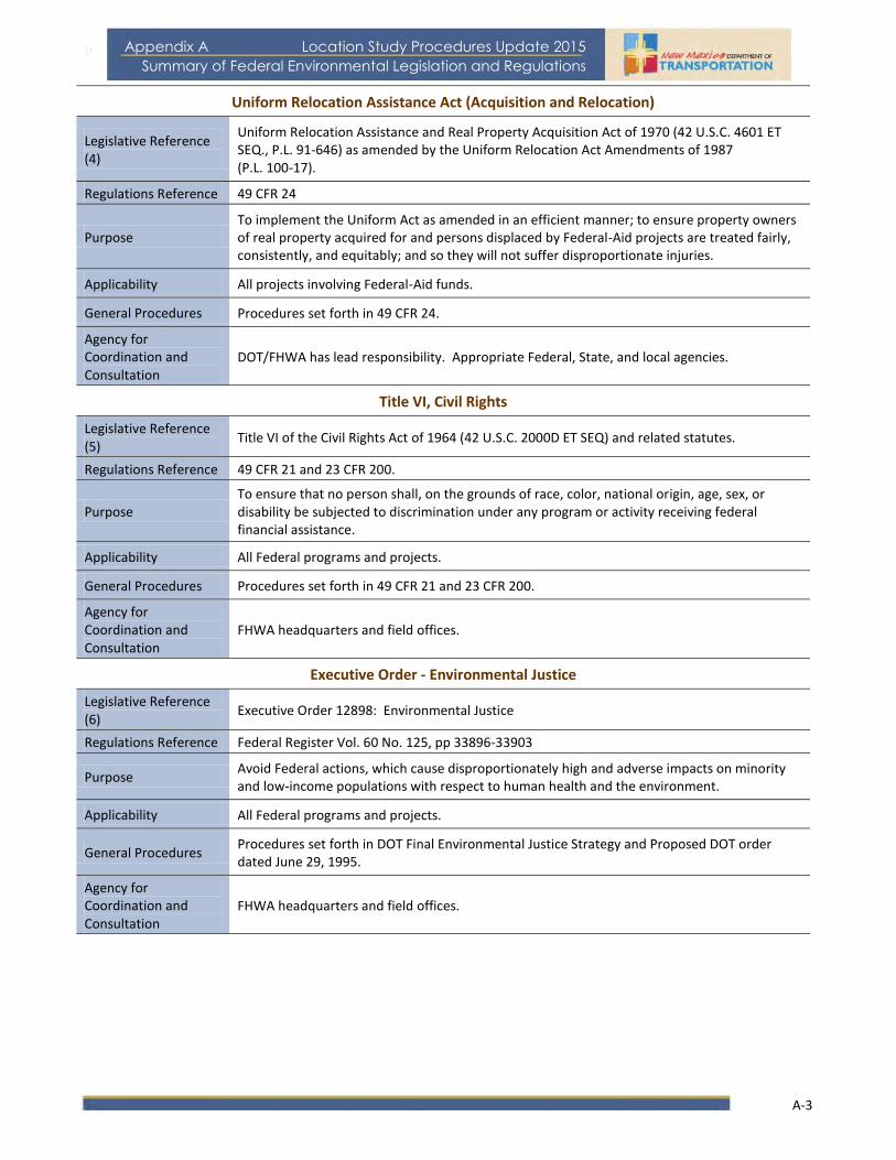
u
A-3
Appendix A Location Study Procedures Update 2015
Summary of Federal Environmental Legislation and Regulations
Uniform Relocation Assistance Act (Acquisition and Relocation)
Legislative Reference (4)
Uniform Relocation Assistance and Real Property Acquisition Act of 1970 (42 U.S.C. 4601 ET SEQ., P.L. 91-646) as amended by the Uniform Relocation Act Amendments of 1987 (P.L. 100-17).
Regulations Reference 49 CFR 24
Purpose To implement the Uniform Act as amended in an efficient manner; to ensure property owners of real property acquired for and persons displaced by Federal-Aid projects are treated fairly, consistently, and equitably; and so they will not suffer disproportionate injuries.
Applicability All projects involving Federal-Aid funds.
General Procedures Procedures set forth in 49 CFR 24.
Agency for Coordination and Consultation
DOT/FHWA has lead responsibility. Appropriate Federal, State, and local agencies.
Title VI, Civil Rights
Legislative Reference (5)
Title VI of the Civil Rights Act of 1964 (42 U.S.C. 2000D ET SEQ) and related statutes.
Regulations Reference 49 CFR 21 and 23 CFR 200.
Purpose To ensure that no person shall, on the grounds of race, color, national origin, age, sex, or disability be subjected to discrimination under any program or activity receiving federal financial assistance.
Applicability All Federal programs and projects.
General Procedures Procedures set forth in 49 CFR 21 and 23 CFR 200.
Agency for Coordination and Consultation
FHWA headquarters and field offices.
Executive Order - Environmental Justice
Legislative Reference (6)
Executive Order 12898: Environmental Justice
Regulations Reference Federal Register Vol. 60 No. 125, pp 33896-33903
Purpose Avoid Federal actions, which cause disproportionately high and adverse impacts on minority and low-income populations with respect to human health and the environment.
Applicability All Federal programs and projects.
General Procedures Procedures set forth in DOT Final Environmental Justice Strategy and Proposed DOT order dated June 29, 1995.
Agency for Coordination and Consultation
FHWA headquarters and field offices.

A-4
Appendix A: Summary of Federal Environmental Legislation and Regulations
Location Study Procedures Update 2015
Public Hearings, 23 USC 128
Legislative Reference (7)
Public hearings: 23 U.S.C. 128
Regulations Reference 23 CFR 771.111 as amended in 2013 (78 FR 8982)
Purpose To ensure adequate opportunity for public hearings on the effects of alternative project locations and major design features; as well as the consistency of the project with local planning goals and objectives.
Applicability Public hearings or hearing opportunities are required for projects described in each State’s FHWA-approved public involvement procedures.
General Procedures
Public hearings or opportunity for hearings during the consideration of highway locations and design proposals are conducted as described in the State’s FHWA-approved, public involvement procedures. States must certify to FHWA that such hearings or the opportunity for them have been held and must submit a hearing transcript to FHWA.
Agency for Coordination and Consultation
Appropriate Federal, State, and local agencies.
Historic Bridges
Legislative Reference (8)
Surface Transportation and Uniform Relocation Assistance Act of 1987: Section 123 (F) Historic Bridges 23 U.S.C. 144(g) (P.L. 100-17) as amended through 2012 (P.L. 112-141)
Regulations Reference
Purpose Complete an inventory of on and off system bridges to determine their historic significance. Encourage the rehabilitation, reuse, and preservation of historic bridges.
Applicability Any bridge that is listed on, or eligible for listing on, the National Register of Historic Places.
General Procedures
1. Identify historic bridges on and off system.
2. Seek to preserve or reduce impact to historic bridges.
3. Seek a recipient prior to demolition.
Agency for Coordination and Consultation
State Historic Preservation Officer
Advisory Council on Historic Preservation
Wildflowers
Legislative Reference (9 )
Surface Transportation and Uniform Relocation Assistance Act of 1987:
Section 130 Wildflowers 23 U.S.C. 319 (B) (P.L. 100-17)
Regulations Reference 23 CFR 752
Purpose To encourage the use of native wildflowers in highway landscaping.
Applicability Native wildflowers are to be planted on any landscaping project undertaken on the Federal-Aid highway system.
General Procedures At least 1/4 of 1% of funds expended on a landscaping project must be used to plant native wildflowers on that project.
Agency for Coordination and Consultation
FHWA
State, Division, Regional contacts.

u
A-5
Appendix A Location Study Procedures Update 2015
Summary of Federal Environmental Legislation and Regulations
Highway Beautification
Legislative Reference (10)
Highway Beautification Act of 1965
23 U.S.C. 131 as amended through 2012 (P.L. 112-141), 23 U.S.C. 136 as amended through 2012 (P.L. 112-141), 23 U.S.C. 319 (P.L. 89-285)
Regulations Reference 23 CFR 750, 23 CFR 751, 23 CFR 752
Purpose
To provide effective control of outdoor advertising and junkyards, to protect the public investment, to promote the safety and recreational value of public travel and preserve natural beauty, and to provide landscapes and roadside development reasonably necessary to accommodate the traveling public.
Applicability Interstate and primary systems including toll sections thereof.
General Procedures Procedures set forth in 23 CFR 750, 751, and 752
Agency for Coordination and Consultation
DOT/FHWA, State, and local agencies.

A-6
Appendix A: Summary of Federal Environmental Legislation and Regulations
Location Study Procedures Update 2015
Historic and Archeological Preservation
Section 106, Historical Preservation Act
Legislative Reference (14)
Section 106 of the National Historic Preservation Act, as amended through 2006:
16 U.S.C. 470s (P.L. 89-665) (P.L. 91-243) (P.L. 93-54) (P.L. 94-422) (P.L. 94-458) (P.L. 96-199) (P.L. 96-244) (P.L. 96-515) (P.L. 102-575) (P.L. 106-208) (P.L. 106-355) (P.L. 109-453)
Regulations Reference Executive Order 11593
23 CFR 771, 36 CFR 60, 36 CFR 63, 36 CFR 800 as amended in 2004
Purpose Protect, rehabilitate, restore, and reuse districts, sites, buildings, structures, and objects significant in American architecture, archeology, and culture.
Applicability All properties on or eligible for inclusion on the National Register of Historic Places.
General Procedures 1. Identify and determine the effects of project on subject properties.
2. Afford Advisory Council an early opportunity to comment, in accordance with 36 CFR 800.
3. Avoid or mitigate damages to greatest extent possible.
Agency for Coordination and Consultation
State Historic Preservation Officer
Advisory Council on Historic Preservation
DOI (NPS)
Section 110, Historic Preservation Act
Legislative Reference (15)
Section 110 of the National Historic Preservation Act, as amended:
16 U.S.C. 470H-2 (P.L. 96-515)
Regulations Reference 36 CFR 65 and 36 CFR 78
Purpose Protect National historic landmarks.
Record historic properties prior to demolition.
Applicability All properties designated as National historic landmarks. All properties on or eligible for inclusion on the National Register of Historic Places.
General Procedures 1. Identify and determine the effects of project on subject properties.
2. Afford Advisory Council an early opportunity to comment, in accordance with 36 CFR 800.
Agency for Coordination and Consultation
State Historic Preservation Officer, Advisory Council on Historic Preservation, DOI (NPS)
Archeological and Historic Preservation Act (Moss-Bennett)
Legislative Reference (16)
Archeological and Historic preservation Act:
16 U.S.C. 469-469C (P.L. 93-291) (Moss-Bennett Act)
Regulations Reference
Purpose Preserving significant historical and archeological data from loss or destruction.
Applicability Any unexpected archeological resources discovered as a result of a Federal construction project or Federally licensed activity or program.
General Procedures 1. Notify DOI (NPS) when a Federal project may result in the loss or destruction of a historic or archeological property.
2. DOI and/or the Federal agency may undertake survey or data recovery.
Agency for Coordination and Consultation
DOI (NPS) Departmental consulting archeologist
State Historic Preservation Officer

u
A-7
Appendix A Location Study Procedures Update 2015
Summary of Federal Environmental Legislation and Regulations
Archeological Resources Preservation Act
Legislative Reference (17)
Archeological Resources Protection Act:
16 U.S.C. 470 AA-11 (P.L. 96-95)
Regulations Reference 18 CFR 1312, 32 CFR 229, 36 CFR 79, 36 CFR 296, 43 CFR 7
Purpose Preserve and protect paleontological resources, historic monuments, memorials, and antiquities from loss or destruction.
Applicability Archeological resources on Federally or native American-owned property.
General Procedures 1. Ensure contractor obtains permit, and identifies and evaluates resource.
2. Mitigate or avoid resource in consultation with appropriate officials in the State.
3. If necessary, apply for permission to examine, remove, or excavate such objects.
Agency for Coordination and Consultation
Department or agency having jurisdiction over land on which resources may be situated (BIA, BLM, DOA, DOD, NPS, TVA, USFS, State Historic Preservation Officer, Recognized Indian Tribe, if appropriate).
Preservation of American Antiquities
Legislative Reference (18)
Act for the Preservation of American Antiquities
16 U.S.C. 431-433 (P.L. 59-209)
Regulations Reference 36 CFR 251.50-.64 and 43 CFR 3
Purpose Gives the President of the United States the authority to, by presidential proclamation, restrict the use of particular public land owned by the federal government.
Applicability Any federally owned land.
General Procedures 1. Notify DOI (NPS) when a Federal project may result in the loss or destruction of a historic or archeological property.
2. DOI and/or the federal agency may undertake survey or data recovery.
Agency for Coordination and Consultation
DOI (NPS) Departmental consulting archeologist
State Historic Preservation Officer
American Indian Religious Freedom Act
Legislative Reference (19)
American Indian Religious Freedom Act: 42 U.S.C. 1996 (P.L. 95-341)
Regulations Reference
Purpose Protect places of religious importance to American Indians, Eskimos, and Native Hawaiians.
Applicability All projects which affect places of religious importance to Native Americans.
General Procedures Consult with knowledgeable sources to identify and determine any effects on places of religious importance. Comply with Section 106 procedures if the property is historic.
Agency for Coordination and Consultation
BIA State Historic Preservation Officer, State Indian Liaison Advisory Council on Historic Preservation if appropriate.

A-8
Appendix A: Summary of Federal Environmental Legislation and Regulations
Location Study Procedures Update 2015
Native American Grave Protection and Repatriation Act
Legislative Reference (20)
Native American Grave Protection and Repatriation Act: 25 U.S.C. 3001-3013 (P.L. 101-601)
Regulations Reference 43 CFR 10
Purpose Protect human remains and cultural material of Native American and Hawaiian groups.
Applicability Federal lands and Tribal lands.
General Procedures Consult with Native American group.
Agency for Coordination and Consultation
DOI (NPS), BIA, State Historic Preservation Officer

u
A-9
Appendix A Location Study Procedures Update 2015
Summary of Federal Environmental Legislation and Regulations
Land Use and Water Usage
Wild and Scenic Rivers
Legislative Reference (22)
Wild and Scenic Rivers Act: 16 U.S.C. 1271-1287 as amended through 2009 (P.L. 111-11)
Regulations Reference 36 CFR 251, 297 and 43 CFR 8350
Purpose Preserve and protect wild and scenic rivers and immediate environments for benefit of present and future generations.
Applicability All projects which affect designated and potential wild, scenic, and recreational rivers, and/or immediate environments.
General Procedures Coordinate project proposals and reports with appropriate Federal Agency.
Agency for Coordination and Consultation
DOI (NPS) and/or AGRICULTURE (USFS), State agencies.
Land and Water Conservation Fund Act
Legislative Reference (23)
Land and Water Conservation Fund Act (Section 6F): 16 U.S.C. 4601 –4 to –11 (P.L. 88-578)
Regulations Reference
Purpose Preserve, develop, and assure the quality and quantity of outdoor recreation resources for present and future generations.
Applicability All projects which impact recreational lands purchased or improved with land and water conservation funds.
General Procedures The Secretary of the Interior must approve any conversion of property acquired or developed with assistance under this act to other than public, outdoor recreation use.
Agency for Coordination and Consultation
DOI, State agencies.
Executive Order 11990 Protection of Wetlands
Legislative Reference (24)
Executive Order 11990: Protection of Wetlands
Regulations Reference DOT Order 5660.1A
23 CFR 777
Purpose To avoid direct or indirect support of new construction in wetlands wherever there is a practicable alternative.
Applicability Federally undertaken, financed, or assisted construction, and improvements in or with significant impacts on wetlands.
General Procedures Evaluate and mitigate impacts on wetlands. Specific finding required in final environmental document.
Agency for Coordination and Consultation
DOI (FWS), EPA, USCE. NMFS, NRCS, State agencies.

A-10
Appendix A: Summary of Federal Environmental Legislation and Regulations
Location Study Procedures Update 2015
Compensatory Mitigation for Losses of Aquatic Resources (Clean Water Act)
Legislative Reference (25)
Environmental Protection Agency - Compensatory Mitigation for Losses of Aquatic Resources: 33 U.S.C. 401, 33 U.S.C. 1344 (P.L. 108-136)
Regulations Reference 40 CFR 230, 33 CFR 332.1-.8
Purpose To offset unavoidable adverse impacts to wetlands, streams and other aquatic resources authorized by Clean Water Act section 404 permits and other Department of the Army (DA) permits.
Applicability
General Procedures
Agency for Coordination and Consultation
EPA, USACE
Rivers and Harbors Act
Legislative Reference (29)
Rivers and Harbors Act of 1899: 33 U.S.C. 401, ET SEQ., as amended and supplemented.
Regulations Reference 23 CFR 650, Subparts D & H, 33 CFR 114-115
Purpose Protection of navigable waters in the U.S.
Applicability Any construction affecting navigable waters and any obstruction, excavation, or filling.
General Procedures Must obtain approval of plans for construction, dumping, and dredging permits (Sec. 10) and bridge permits (Sec. 9)
Agency for Coordination and Consultation
USCE, USCG, EPA, State agencies.
Federal Water Pollution Control Act
Legislative Reference (30)
Federal Water Pollution Control Act (1972), as amended by the Clean Water Act (1977 & 1987): 33 U.S.C. 1251 – 1376 (P.L. 92-500), (P.L. 95-217), (P.L. 100-4)
Regulations Reference DOT Order 5660.1A, 23 CFR 650 Subpart B, 771, 33 CFR 209, 320-323, 325, 328, 329, 40 CFR 121-125, 129-131, 133, 135- 136, 230, 231
Purpose Restore and maintain chemical, physical, and biological integrity of the Nation’s waters through prevention, reduction, and elimination of pollution.
Applicability Any discharge of a pollutant into waters of the U.S.
General Procedures
1. Obtain permit for dredge or fill material from USCE or State agency, as appropriate. (Section 404)
2. Permits for all other discharges are to be acquired from EPA or appropriate State agency (Section 402) Phase 1 – NPDES – Issued for municipal separate storm sewers serving large (over 250,000) populations or medium (over 100,000). Storm water discharges assoc. with industrial waste. Activities including construction sites > 5 acres.
Water quality certification is required from State Water Resource Agency. (Section 401)
3. All projects shall be consistent with the State Non-Point Source Pollution Management Program. (Section 319)
Agency for Coordination and Consultation
USCE, EPA, designated State Water Quality Control Agency, designated State Non-Point Source Pollution Agency

u
A-11
Appendix A Location Study Procedures Update 2015
Summary of Federal Environmental Legislation and Regulations
Executive Order 11988 - Floodplain Management
Legislative Reference (31)
Executive Order 11988:, Floodplain Management, as amended by Executive Order 12148
Regulations Reference DOT Order 5650.2
23 CFR 650, Subpart A, 23 CFR 771
Purpose To avoid the long- and short-term adverse impacts associated with the occupancy and modification of floodplains, and to restore and preserve the natural and beneficial values served by floodplains.
Applicability All construction of Federal or Federally -Aided buildings, structures, roads, or facilities which encroach upon or affect the base floodplain.
General Procedures 1. Assessment of floodplain hazards.
2. Specific finding required in final environmental document for significant encroachments.
Agency for Coordination and Consultation
FEMA
State and local agencies.
Water Bank Act
Legislative Reference (34)
Water Bank Act: 16 U.S.C. 1301 – 1311, (P.L. 91-559), (P.L. 96-182)
Regulations Reference 7 CFR 752
Purpose Preserve, restore, and improve wetlands of the nation.
Applicability Any agreements with landowners and operators in important migratory waterfowl nesting and breeding areas.
General Procedures Apply procedures established for implementing Executive Order 11990.
Agency for Coordination and Consultation
Secretary of Agriculture, Secretary of Interior.
Farmland Protection Policy Act
Legislative Reference (37)
Farmland Protection Policy Act of 1981: 7 U.S.C. 4201-4209, (P.L. 97-98), (P.L. 99-198)
Regulations Reference 7 CFR 658
Purpose Minimize impacts on farmland and maximize compatibility with state and local farmland programs and policies.
Applicability All projects that take right-of-way in farmland, as defined by the regulation.
General Procedures
1. Early coordination with the NRCS.
2. Land evaluation and site assessment.
3. Determination of whether or not to proceed with farmland conversions, based on severity of impacts and other environmental considerations.
Agency for Coordination and Consultation
NRCS

A-12
Appendix A: Summary of Federal Environmental Legislation and Regulations
Location Study Procedures Update 2015
Resource Conservation and Recovery Act
Legislative Reference (38)
Resource Conservation and Recovery Act of 1976 (RCRA), as amended: 42 U.S.C. 6901, ET SEQ. (P.L. 94-580) (P.L. 98-616) as amended through 2012 (P.L. 112-195)
Regulations Reference 40 CFR 260-271
Purpose Protect human health and the environment. Prohibit open dumping. Manage solid wastes. Regulate treatment, storage, transportation, and disposal of hazardous waste.
Applicability Any project that takes right-of-way containing a hazardous waste.
General Procedures Coordinate with EPA or State agency on remedial action.
Agency for Coordination and Consultation
EPA or State agency approved by EPA, if any.
Superfund (CERCLA)
Legislative Reference (39)
Comprehensive Environmental Response, Compensation, and Liability Act of 1980 (CERCLA), as amended: 42 U.S.C. 9601-9657, (P.L. 96-510)
Superfund Amendments and Reauthorization Act of 1986: (SARA) (P.L. 99-499)
Regulations Reference 40 CFR 300
43 CFR 11
Purpose Provide for liability, compensation, clean up, and emergency response for hazardous substances released into the environment and the clean up of inactive hazardous waste disposal sites.
Applicability Any project that might take right-of-way containing a hazardous substance.
General Procedures 1. Avoid hazardous waste sites, if possible.
2. Check EPA lists of hazardous waste sites.
3. Field surveys and reviews of past and present land use.
4. Contact appropriate officials if uncertainty exists.
5. If hazardous waste is present or suspected, coordinate with appropriate officials.
6. If hazardous waste encountered during construction, stop project and develop remedial action.
Agency for Coordination and Consultation
EPA or State agency approved by EPA, if any.
Endangered Species Act
Legislative Reference (40)
Endangered Species Act of 1973, as amended: 16 U.S.C. 1531-1543
(P.L. 93-205), (P.L. 94-359), (P.L. 95-632), (P.L. 96-159), (P.L. 97-304)
Regulations Reference 7 CFR 355
50 CFR 17, 23, 81, 222, 225-227, 402, 424, 450-453
Purpose Conserve species of fish, wildlife and plants facing extinction.
Applicability Any action that is likely to jeopardize continued existence of such endangered/threatened species or result in destruction or modification of critical habitat.
General Procedures Consult with the Secretary of the Interior or Commerce, as appropriate.
Agency for Coordination and Consultation
DOI (FWS)
COMMERCE (NMFS)

u
A-13
Appendix A Location Study Procedures Update 2015
Summary of Federal Environmental Legislation and Regulations
Fish and Wildlife Coordination Act
Legislative Reference (41)
Fish and Wildlife Coordination Act: 16 U.S.C. 661-666 (C)
(P.L. 85-624), (P.L. 89-72), (P.L. 95-616)
Regulations Reference
Purpose Conservation, maintenance, and management of wildlife resources.
Applicability 1. Any project which involves impoundment (surface area of 10 acres or more), diversion, channel deepening, or other modification of a stream or other body of water.
2. Transfer of property by Federal agencies to State agencies for wildlife conservation purposes.
General Procedures Coordinate early in project development with FWS and State Fish and Wildlife Agency.
Agency for Coordination and Consultation
DOI (FWS), State Fish and Wildlife Agencies.
Noise
Standards 23 USC109
Legislative Reference (45)
Standards: 23 U.S.C. 109 (I)
(P.L. 91-605), (P.L. 93-87)
Regulations Reference 23 CFR 772
Purpose Promulgate noise standards for highway traffic.
Applicability All Federally funded projects for the construction of a highway on new location, or the physical alteration of an existing highway which significantly changes either the vertical or horizontal alignment or increases the number of through-traffic lanes.
General Procedures 1. Noise impact analysis.
2. Analysis of mitigation measures.
3. Incorporate reasonable and feasible noise abatement measures to reduce or eliminate noise impact.
Agency for Coordination and Consultation
FHWA

A-14
Appendix A: Summary of Federal Environmental Legislation and Regulations
Location Study Procedures Update 2015
Air Quality
Clean Air Act (Conformity)
Legislative Reference (46)
Clean Air Act ( as amended), Transportation Conformity Rule: 23 U.S.C. 109 (J)
42 U.S.C. 7521(a)
(P.L. 101-549)
Regulations Reference 23 CFR 771
40 CFR 51 and 93.
Purpose To insure that transportation plans, programs, and projects conform to the State’s air quality implementation plans.
Applicability Non-attainment and maintenance areas.
General Procedures 1. Transportation plans, programs, and projects must conform to State Implementation Plan (SIPs) that provide for attainment of the national ambient air quality standards.
Agency for Coordination and Consultation
FTA, EPA, MPOs, State Departments of Transportation and State and local Air Quality Control Agencies.
Congestion Mitigation and Air Quality Improvement (CMAQ)
Moving Ahead for Progress in the 21st
Century Act.
Congestion Mitigation and Air Quality Improvement Program (CMAQ): Sec 1113, 126 Stat.
460
Regulations Reference
Purpose To assist non-attainment and maintenance areas reduce transportation-related emissions.
Applicability Transportation programs or projects in non-attainment areas and areas redesignated to maintenance that are likely to contribute to the attainment or maintenance of the NAAQS.
General Procedures 1. Project sponsor (transit operator, municipal office, etc.) develops formal proposal to improve air quality.
2. Submit to the MPO, State for evaluation, and approval.
3. Included in the TIP and approved as eligible by FTA and FHWA in consultation with EPA.
Agency for Coordination and Consultation
FTA, EPA, MPOs, State Departments of Transportation, and State and local Air Quality Control Agencies.
Post Office Box 1149Santa Fe, NM 87504
Location Study Procedures Update 2015
Appendix BGlossary of Terms
A Guidebook for:Planning and Environmental Linkages, Alignment Studies, and Corridor Studies

B‐1
Appendix B: Glossary of Terms Location Study Procedures Update 2015
APPENDIX B Glossary of Terms Agency Coordination ‐ The process followed to involve other federal, state, and local agencies in the decision‐making process for plans, programs, and projects.
All Appropriate Inquiry (AAI) – a level of inquiry that reflects evolving best practices and a level of rigor that will afford prospective property owners necessary and essential information when making property purchase and construction decisions and meeting continuing obligations under the CERCLA liability protections. This essential information includes the identification of recognized environmental conditions which consist of past releases (including those addressed to the satisfaction of the regulatory agencies), present releases, or the material threat of future releases. While an investigation that meets the ASTM E1527‐13 requirements represents AAI as defined in CERCLA, 42 U.S.C §9601(35)(B), one acceptable to the NMDOT must also meet added reporting components as described in the HMAH.
Americans with Disabilities Act (ADA) ‐ A federal law that prohibits discrimination on the basis of disability in the services, programs, or activities of all state and local governments. Under the provisions of ADA, the NMSHTD must take steps to make all public involvement activities accessible to persons with disabilities. Alignment ‐ The horizontal and vertical location of the centerline of a proposed or existing highway. Alternatives – Potential solutions to a transportation problem. Alternatives may consist of different alignments, lane configurations, type of access control, or transportation modes and strategies (i.e., transit, high occupancy vehicle lane, systems management, demand management, etc.). Authorization ‐ A document from FHWA which authorizes the expenditure of federal funds for a particular project. Categorical Exclusion (CE) ‐ A classification of actions that do not have a significant effect on the environment, either individually or cumulatively. Conformity ‐ The requirement for transportation plans, programs, and projects to be consistent with the local or state air quality plans. Cooperating Agency ‐ A federal agency other than a lead agency that has jurisdiction by law, or special expertise, with respect to any environmental impact of a proposed action. Corridor – A linear route or geographic area that accommodates travel or potential travel. Cumulative Impact ‐ The impact on the environment which results from the incremental impact of an action when added to other past, present or reasonably foreseeable future actions. Design ‐ The process by which engineering plans, estimates, and specifications for a transportation project are developed.

B‐2
Appendix B: Glossary of Terms Location Study Procedures Update 2015
Design Phase ‐ The project development phase from the time a project has been cleared and authorized by an environmental document to the start of construction. Draft Environmental Impact Statement (DEIS) ‐ The detailed environmental document required by the National Environmental Policy Act when an agency proposes an action that is likely to significantly affect the environment. The draft EIS includes a discussion of purpose and need, alternatives, environmental conditions and effects, and public involvement activities. Environmental Assessment (EA) ‐ A concise document which includes a brief discussion of the need for a proposed action, of potential alternatives, and the environmental impacts of the proposed action. Environmental Documents ‐ Includes Social, Economic, and Environmental studies prepared for CEs, Environmental Assessments, and Environmental Impact Statements. Environmental Professional (EP) ‐ a person meeting the education, training, and experience requirements as set forth in 40 CFR §312.10(b). The NMDOT adheres to a strict interpretation of this definition, particularly with respect to “full‐time relevant experience.” Fatal Flaw ‐ factors that render an alternative as impractical or unfeasible. Federal Highway Administration (FHWA) ‐ An agency of the United States Department of Transportation (DOT) charged with carrying out highway transportation programs of the DOT. Final Environmental Impact Statement (FEIS) ‐ A detailed statement on a major action which significantly affects the quality of the human environment, as required by Section 102(2) (C) of the National Environmental Policy Act of 1969. It contains the same supporting information required by the draft EIS with appropriate revisions to reflect comments received from circulation of the draft EIS and the public hearing process. Finding of No Significant Impacts (FONSI) ‐ A document by a federal agency (FHWA) that presents the reasons why the action will not have a significant effect on the human environment, and for which an environmental impact statement, therefore, will not be prepared. The FONSI authorizes a project for design. Footprint – The project footprint is composed of the construction slope limits and associated area needed for construction. This includes the physical footprint of the transportation feature as well as additional areas needed to operate equipment, provide traffic detours, and allow for future maintenance. The footprint boundary needs to be clearly indicated on plan drawings. Hazardous Material – as encountered during NMDOT projects, a generic term for all wastes and contaminated environmental media which could be of concern from a health and safety, risk, and/or regulatory point of view. The term hazardous material includes hazardous wastes as regulated under Resource Conservation and Recovery Act (RCRA) and the New Mexico Hazardous Waste Management Regulations (NMED‐HWMR) as well as “unregulated hazardous wastes.” Examples of unregulated hazardous wastes include those containing petroleum hydrocarbons, other organic and inorganic contaminants, asbestos, lead based paint, or other constituents at concentrations which could trigger regulatory requirements for handling, transportation or disposal or could present a health and safety risk to project personnel or the public.

B‐3
Appendix B: Glossary of Terms Location Study Procedures Update 2015
Interdisciplinary Approach ‐ An analysis which involves the application of the training and knowledge of persons from many professions. Lead Agency ‐ The agency having primary responsibility for preparing an Environmental Impact Statement. Level of Effort ‐ The degree of engineering and environmental analyses required to evaluate a proposed action. Metropolitan Planning Organization (MPO) ‐ The organization designated by the Governor to carry out the continuing cooperative and comprehensive transportation planning process for an urbanized area. It is composed of elected representatives of municipal and county governments supported by a permanent staff. Metropolitan Transportation Plan (MTP) ‐ The long‐range transportation plan for the Albuquerque Metropolitan Planning Area. Mitigation ‐ Action taken to avoid or to minimize adverse environmental impacts. National Environmental Policy Act of 1969 (NEPA) ‐ The basic national charter for protecting the environment. No‐Build Alternative ‐ An alternative that assumes doing nothing is a feasible and logical alternative solution to the problem under investigation. Notice of Availability ‐ A notice published to announce that an environmental document is available for public review. Notice of Intent ‐ A notice published in the Federal Register which briefly describes the proposed action and alternatives and indicates that the lead agency intends to prepare an Environmental Impact Statement. Purpose and Need ‐ Project purpose is a broad statement of the overall objective to e achieved by a proposed action. The project purpose should be consistent with the goals and objectives of pertinent transportation‐related planning policies. Examples of such objectives may include the designation of HOV lanes in a network or system, operational performance goals, or establishing transit along a corridor. Need is a more detailed explanation of the specific transportation problems that exist, or are expected to occur in the future, such as pavement condition, geometric deficiencies, traffic congestion, etc. Public Hearing ‐ A public meeting to formally present and gather comments on project alternatives and an environmental assessment or environmental impact statement. Public Involvement ‐ The process by which the public is informed, made aware, and involved in the transportation project development process. Public Information Meeting ‐ A meeting to provide information to the public and/or to receive input from the public with regards to a proposed action

B‐4
Appendix B: Glossary of Terms Location Study Procedures Update 2015
Public Involvement Plan/Program ‐ A plan developed for a specific study or project that identifies the specific steps and activities to coordinate with agencies and jurisdictions, and to involve the public in the decision‐making process. Right‐of‐Way (ROW) ‐ Real property or interests therein, acquired, dedicated or reserved for the construction, operation, and maintenance of a highway. Section 4(f) Evaluation ‐ A document that describes the consideration, consultations and alternative studies for a determination that there are no feasible and prudent alternatives to the use of land from a publicly owned park, recreation area, or wildlife and waterfowl refuge of national, state or local significance, as determined by the federal, state or local official having jurisdiction thereof; or any land from a historic site of national, state or local significance as so determined by such official. The Section 4(f) statement is also used to support a determination that the proposed action includes all possible planning to minimize harm. Section 106 ‐ The section of the National Historic Preservation Act which requires that federal, federally assisted and federally licensed Historic Places be submitted to the Advisory Council on Historic Preservation for review and comment prior to the approval of any such undertaking by the federal agency. As with Section 4(f), adequate documentation is required. Significant Impact ‐ An action in which the cumulative primary and secondary effects significantly alter the quality of the human environment, curtail the choices of beneficial uses of the human environment, or interfere with the attainment of long‐range human environmental goals. Significance considers the context and intensity of a proposed action. This means that the action must be analyzed in different contexts such as society as a whole, the affected region, the affected interests, and the locality. Intensity refers to the severity of impact Transportation Program ‐ The process and document that identifies and prioritizes near‐term transportation needs, and allocates funding for specific actions. Transportation programs typically cover a three‐ to six‐year period, although funds are allocated only for the first three years.
Transportation Plan – The process and document that establishes long‐range goals (20‐years), objectives, and system needs at the statewide or metropolitan planning area level.

Post Office Box 1149Santa Fe, NM 87504