local tsunami warnings: perspectives from recent...
TRANSCRIPT

Local tsunami warnings: Perspectivesfrom recent large eventsDiego Melgar1, Richard M. Allen1, Sebastian Riquelme2, Jianghui Geng3,4, Francisco Bravo5,Juan Carlos Baez2, Hector Parra6, Sergio Barrientos2, Peng Fang3, Yehuda Bock3, Michael Bevis7,Dana J. Caccamise II7,8, Christophe Vigny9, Marcos Moreno10, and Robert Smalley Jr.11
1Seismological Laboratory, University of California, Berkeley, California, USA, 2Centro Sismológico Nacional, Universidad deChile, Santiago, Chile, 3Cecil H. and Ida M. Green Institute of Geophysics and Planetary Physics, Scripps Institution ofOceanography, University of California, San Diego, La Jolla, California, USA, 4GNSS Center, Wuhan University, Wuhan, China,5Departamento de Geofísica, Universidad de Chile, Santiago, Chile, 6Instituto Geográfico Militar, Santiago, Chile, 7School ofEarth Sciences, Ohio State University, Columbus, Ohio, USA, 8Now at National Geodetic Survey, National Oceanographicand Atmospheric Administration, Silver Spring, Maryland, USA, 9Laboratoire de Géologie, École Normale Supérieure, Paris,France, 10Helmholtz Centre, GFZ German Research Centre for Geosciences, Potsdam, Germany, 11CERI, University ofMemphis, Memphis, Tennessee, USA
Abstract We demonstrate a flexible strategy for local tsunami warning that relies on regional geodeticand seismic stations. Through retrospective analysis of four recent tsunamigenic events in Japan and Chile,we show that rapid earthquake source information, provided by methodologies developed for earthquakeearly warning, can be used to generate timely estimates of maximum expected tsunami amplitude withenough accuracy for tsunami warning. We validate the technique by comparing to detailed models ofearthquake source and tsunami propagation as well as field surveys of tsunami inundation. Our approachdoes not require deployment of new geodetic and seismic instrumentation in many subduction zones andcould be implemented rapidly by national monitoring and warning agencies. We illustrate the potentialimpact of our method with a detailed comparison to the actual timeline of events during the recent 2015Mw8.3 Illapel, Chile, earthquake and tsunami that prompted the evacuation of 1 million people.
1. Motivation
Compared to other natural hazards, large tsunamis are infrequent, and as a result, local tsunami warningsystems are not usually a priority and do not exist in the majority of countries located along subduction zones(including the United States). Recent events in Indonesia, Chile, and Japan, however, have shown that tsuna-mis can lead to substantial casualties, potentially tallied in the tens to hundreds of thousands of lives, as wellas to the total economic collapse of the affected regions [Athukorala and Resosudarmo, 2005; Mimura et al.,2011]. To compound the problem, population in tsunami-prone areas has steadily increased over the last25 years [Center for International Earth Science Information Network (CIESIN) and Centro Internacional deAgricultura Tropical (CIAT), 2005] (Figure 1a), making it difficult to evacuate large numbers of people fromdense population centers in many low-lying coastal areas. Evacuation start time is the most importantvariable in tsunami mortality rates [Yun and Hamada, 2015]; therefore, rapid tsunami information systemsthat forecast intensities at the regional level are needed to provide actionable information to emergencyresponders and decision makers to order evacuations in the affected regions as quickly as possible. All ofthese elements make the development of a rapid and accurate local tsunami warning methodology, andits implementation, a pressing issue.
Currently, after large events, international warning systems rely on teleseismic measurements to estimate anearthquake’s size and the propagation of tsunami waves to deep water pressure sensors far from the sourcearea to provide warnings to more distant locations across an ocean basin [Titov et al., 2005; Kumar et al., 2012;Hirshorn et al., 2013]. These far-field measurements are only available after the tsunami has struck the localcoastline but can be used for robust basin-scale warnings. Tsunami warning systems such as those operatedby Tsunami Warning Centers (TWCs) under the auspices of the U.S. National Oceanographic and AtmosphericAdministration (NOAA) rely on these teleseismic measures of earthquake size, P wave magnitudes (Mwp) andthe W phase centroid moment tensors [Hayes et al., 2011; Hirshorn et al., 2013], and on deep water pressuresensors (Deep-ocean Assessment and Reporting of Tsunamis (DART) buoys) that directly measure the
MELGAR ET AL. LOCAL TSUNAMI WARNINGS 1109
PUBLICATIONSGeophysical Research Letters
RESEARCH LETTER10.1002/2015GL067100
Key Points:• Local warning within 2–3 min of alarge earthquake is possible
• Rapid source models can be used forwarning
• This method can be used with currentinfrastructure
Supporting Information:• Figures S1–S11
Correspondence to:D. Melgar,[email protected]
Citation:Melgar, D., et al. (2016), Local tsunamiwarnings: Perspectives from recentlarge events, Geophys. Res. Lett., 43,1109–1117, doi:10.1002/2015GL067100.
Received 19 NOV 2015Accepted 28 DEC 2015Accepted article online 3 JAN 2016Published online 12 FEB 2016
©2016. American Geophysical Union.All Rights Reserved.

tsunami [Titov et al., 2005]. The NOAAsystem routinely, and very successfully,provides warnings at large distances(~1000 km) from significant earth-quakes and across ocean basins. Theability of this system to issue local tsu-nami warnings, that is, at the coast adja-cent to a large earthquake, is limited tocertain domestic regions. In contrast,the Japanese Meteorological Agency(JMA) operates an independent systemthat issues countrywide alerts to thenear-source coastline of the Japanesearchipelago in the first minutes after anearthquake [Tatehata, 1997; Hoshibaand Ozaki, 2014]. Their approach relieson rapid magnitude and hypocenterestimates from land-based seismic data.Once these two parameters are avail-able, a database query of precomputedtsunami scenarios is used to identifythe scenario with the most similar loca-tion and magnitude. An alert is thenissued to the near-source coastlinebased on the precomputed predictedtsunami runups. This warning paradigmwas chosen because at the time of itsinception more complete characteriza-tion of the seismic source and calcula-tion of tsunami propagation—all inreal time—was deemed too computa-tionally costly and thus unfeasible[Tatehata, 1997]. However, during the2011 Mw9.0 Tohoku-oki earthquake,the earthquake magnitude was severelyunderestimated and so the zones ofevacuation were not wide enough andmay have resulted in higher casualties[Yun and Hamada, 2015]. A similar sys-tem is now operational in Indonesia[Lauterjung et al., 2014] and has beenproposed for Australia [Allen andGreenslade, 2008]. These approacheswhile able to cover the local coast canbe hindered by the approximate charac-
terization of the source, the incompleteness of the scenario events in the database, and the overdependenceon seismic data that can be unreliable for magnitude assessments in the near field of large events [Melgaret al., 2015].
As populations have grown and technology improved, the number of seismic and geodetic (GPS) sensorsacross subduction zones has increased as well (Figures 1b and 1c). Many of these sensors are operated bynational monitoring agencies that routinely produce a suite of rapid earthquake information products.These range from simple location and magnitude estimates to more complex source products such asregional centroid moment tensors (CMTs) that indicate the style of faulting, or more advanced slip inversions
Figure 1. Population growth of the world in the circum-Pacific and IndianOcean regions and geophysical networks. (a) Population growth between1990 and 2015 [CIESIN and CIAT, 2005]. The red lines indicate subductionzones. The four earthquakes analyzed in this study are labeled as follows:the 2010 Maule, Chile (Ma), 2011 Tohoku-oki, Japan (To), 2014 Iquique,Chile (Iq), and 2015 Illapel, Chile (Il). Seismic and GPS stations reportingto public archives (UNAVCO Inc. and Incorporated Research Institutionsfor Seismology (IRIS)) (b) in 2000 and (c) in 2015. These stations arerepresentative of the worldwide growth and distributionof geophysical instruments but are not the total number of availablestations. Many other stations belong to national and other networks,which are not always publicly available.
Geophysical Research Letters 10.1002/2015GL067100
MELGAR ET AL. LOCAL TSUNAMI WARNINGS 1110

that reveal the pattern of heterogeneous slip on an assumed fault surface. Many of these networks are alsodelivering or experimenting with earthquake early warning [Allen et al., 2009].
Here we propose and demonstrate a flexible local tsunami warning strategy, which we call T-larms, thatharnesses the growth of monitoring infrastructure to produce rapid and effective warning. We show thatland-based measurements of the earthquake from local seismic and geodetic stations, coupled with newalgorithms to characterize the event, can be used to produce rapid tsunami warning maps for the local coastwithin 2–3min after the onset of rupture (Figure S1 in the supporting information) and in advance of the tsu-nami arrival. Through retrospective analysis of data collected in real time for four recent large events in Japanand Chile, we find that earthquake source information from local stations can be used to produce accurateenough estimates of maximum expected tsunami amplitude as to be useful for warning. We emphasizethe comparison between our approach and the timeline of response during 2015 Mw8.3 Illapel, Chile, earth-quake and tsunami during which 1 million people were evacuated. We demonstrate the speedup in region-specific tsunami intensity estimation from 31 to 3min for that event. Our results show that local tsunamiwarning is possible with the currently available seismic and geodetic infrastructure inmany subduction zonesaround the world. National monitoring and warning agencies could rapidly implement our approach toimprove situational awareness, thereby potentially saving many thousands of lives in the coming years.
2. Analysis Method and Data
We retrospectively analyze seismic and geodetic data collected during the 2010 Mw8.8 Maule, Chile, 2011Mw9.0 Tohoku-oki, Japan, 2014 Mw8.2 Iquique, Chile, and 2015 Mw8.3 Illapel, Chile, earthquakes (Figures 1and 2). We consider several types of rapid earthquake source products: magnitude and location estimates,CMT solutions, finite fault slip inversions, regional moment tensors, and fully heterogeneous slip inversions.The strategy is to rapidly (within a few minutes) produce an estimate of seafloor deformation from theseearthquake source products and use it as the initial condition in tsunami propagation modeling.
2.1. Earthquake Source Products
To demonstrate the performance of this approach, we focus on themost rapidly available source information:rapid location estimates from seismic stations and magnitude estimates potentially available from coastalseismic and GPS stations (Figure 2) [Melgar et al., 2015]. For the Maule, Tohoku-oki, and Iquique events werely on scaling relationships based on a growing earthquake catalog (M6–M9) of measurements of peakground displacement (PGD) at coastal GPS stations to determine event magnitude [Melgar et al., 2015].PGD scaling has been demonstrated to provide moment magnitude estimates with an uncertainty of 0.3magnitude units within the first 1–2min of origin time for these three events, depending on the earthquakesize and station geometry. For the Mw8.3 Illapel earthquake, the magnitude based on PGD scaling isestimated to beMw8.0 (Table 1, Figure S2). The advantage of using GPS-estimated PGDmagnitude comparedto only seismic data is that it does not saturate for very large earthquakes [Melgar et al., 2015]. The GPSpositions were estimated for all four events in a simulated real-time mode by precise point positioning withambiguity resolution [Geng et al., 2013]. We also highlight the performance of a rapid geodetic source sizeand slip estimates demonstrated for the Mw9.0 Tohoku-oki earthquake [Colombelli et al., 2013]. This methoduses static offset data to fit a small number of large (50 × 90 km) fault patches with the strike and dip of a pre-defined slab model. It has the added advantage of rapidly estimating fault length in addition to magnitude.We choose to use these approaches for rapid magnitude estimation, but other methods exist and are beingdeveloped for both earthquake and tsunami warning [e.g., Ohta et al., 2012; Melgar et al., 2013; Grapenthinet al., 2014; Minson et al., 2014].
We assume a predefined slab model [Hayes et al., 2012]. Once a magnitude is known from the PGD scalingrelationship (or from any other regional source products such as a CMT solution), we use another scaling rela-tionship [Blaser et al., 2010] to estimate the dimensions of fault rupture, width (W), and length (L):
log10 Lð Þ ¼ �2:37þ 0:57�Mw
log10 Wð Þ ¼ �1:86 þ 0:46�Mw:(1)
This scaling relationship is based on an analysis of a historical catalog of finite fault models of subductionzone events.
Geophysical Research Letters 10.1002/2015GL067100
MELGAR ET AL. LOCAL TSUNAMI WARNINGS 1111

Figure 2. Tsunami warning maps and coastline amplitude predictions. (a) The 2010 Maule, Chile, (b) 2011 Tohoku-oki, Japan, (c) the 2014Mw8.24 Iquique, Chile, and(d) the 2015Mw8.34 Illapel, Chile, earthquakes. Figures 2a–2d show warning levels for each event from the joint slip inversion of ocean- and land-based data. Thesemaps are calculated with a fine-scale coastline, and computation takes on the order of tens of hours. They are used as a baseline for comparison of the performanceof the rapid source products but cannot be generated in real time. Magenta stars are the event epicenters. Red or blue contours are the observed pattern of slip(Figures S3–S6). Next to each warning map are the tsunami amplitude predictions at the coastline at 1 km intervals (black curves). The blue stars are theobserved maximum amplitudes at tide gauges (TG) and the grey bars the prediction from the tsunami model at the tide gauge locations. (e–h) Warning mapsand amplitude curves from the rapid magnitude tsunami models. (i) Warning maps and amplitude curves from the rapid geodetic source inversion[Colombelli et al., 2013] (Figure S4c). For the rapid magnitude models, red or blue rectangles represent the inferred source size from scaling laws [Blaser et al.,2010]. Additionally, for these models, amplitude curves are calculated at 1 km intervals on coarse coastlines and are computed in less than 2 min (Figure S1).
Geophysical Research Letters 10.1002/2015GL067100
MELGAR ET AL. LOCAL TSUNAMI WARNINGS 1112

After the fault dimensions are calculated, we place sufficient slip on the fault to match the scalar moment,using a uniform rigidity value of 45 GPa. For the rapid PGD magnitude model, we use the strike and dip ofthe predefined slab model at the hypocenter. For the moment tensor, we use the strike and dip from thenodal plane solution. These source products are all available within 1–2min of rupture initiation[Colombelli et al., 2013; Melgar et al., 2015]. The performance of regional CMT solutions, potentially availablein the first 2–5min [Guilhem et al., 2013; Melgar et al., 2013], is tested as well (Figure S3).
As abaseline for comparison toour simplifiedapproach for obtaining sourceparameters,wealsouse kinematicslip inversions from joint inversions of onshore and offshore data. We use theMudPymultitime window inver-sion code [Melgar andBock, 2015]. The slip inversions andstationdistributions are shown inFigures S4–S7. Eachevent has different types and quantities of station data available (Table 1). We used 3-D surfaces for the faultgeometry obtained from the Slab 1.0 model of global subduction zones [Hayes et al., 2012] for all events. Datafits for the Maule, Iquique, and Illapel inversions are shown in Figures S8–S10. Data fits for the Tohoku-okiinversion are in the original publication [Melgar and Bock, 2015].
2.2. Tsunami Modeling
The simplified approach requires some preparatory work for a particular plate boundary of interest. The slabgeometry is partitioned into 10 × 10 km subfaults and a set of elastic deformation Green’s functions are pre-computed that relate unit slip on each subfault to the deformation of the seafloor on a regular grid spaced at0.05° in latitude and longitude covering the source area. Once the earthquake source is rapidly characterized,the multiplication of the vector containing the computed slip on each subfault and the Green’s functionsmatrix yields the expected deformation at each grid node on the seafloor. We calculate not just the verticaldeformation but also the horizontal motion at each node predicted by the source model. This allows us toaccount for horizontal advection of steep bathymetry [Bletery et al., 2015; Melgar and Bock, 2015], whichcan increase the tsunami amplitude. These seafloor motions are then used as the initial conditions for tsu-nami modeling. At this modeling stage we use a nonlinear shallow water propagation code [LeVeque et al.,2011] from which we obtain tsunami coastal amplitude curves, i.e., the maximum expected tsunami, at1 km intervals along the local coastline (Figure 2). Note that we do not use precomputed tsunami Green’sfunctions at this step; rather, we model the fully nonlinear wave propagation.
In order to determine whether the tsunami coastal amplitude curves derived from rapid earthquake sourceproducts compare favorably with the actual tsunami, we establish a baseline to compare against. For this “groundtruth,” we use the tsunami models derived from the fully heterogeneous joint slip inversions of land- and ocean-based data (Figures 2a–2d). It is reasonable to use these models because they compare favorably with posteventtsunami survey measurements (Figure S11). This approach provides a high-resolution ground truth against whichto judge the more timely and simplified approaches, but importantly, it also provides estimates of the tsunamiwhere there are no directmeasurements from tide gauges. To put this in perspective for effective tsunamiwarning,direct tide gauge readings are typically not available until 15–60min after earthquake origin time.
It is important to note that in order to make the rapid tsunami models of Figures 2e–2i, we have made a cri-tical simplification. The simulations that use the joint ocean- and land-based sensor slip inversion use the bestpublicly available topography and bathymetry data sets. Onshore topography is 90m pixels from the ShuttleRadar Topography Mission (SRTM) 3 data set [Sandwell and Smith, 2009] and bathymetry are 1 km pixels fromthe SRTM30+ data set [Farr et al., 2007]. For the rapid magnitude and moment tensor computations, we useonly the SRTM30+ data set and disregard the more detailed onshore topography. Using only the coarsebathymetry and topography speeds up the tsunami computation from the order of tens of hours to less than
Table 1. Sensors Available for Each Earthquake
Earthquake High-Rate GPSa Strong Motion Wave Gauge Tide Gauge
Mw8.8 2010 Maule, Chile 8 - - 2Mw9.0 2011 Tohoku-oki, Japanb 20 20 6c -Mw8.2 2014 Iquique, Chile 8 15 - 4Mw8.3 2015 Illapel, Chile 9 9 - 8
a1 Hz sampling rate.bSlip model from Melgar and Bock [2015].cTwo ocean bottom pressure gauges and four GPS tsunami buoys.
Geophysical Research Letters 10.1002/2015GL067100
MELGAR ET AL. LOCAL TSUNAMI WARNINGS 1113
2min (Figure S1) for all tested events.There exist semianalytical approachesfor runup computation that do notrequire complex numerical calculationand could reduce the warning timeeven further but also reduce the com-plexity of tsunami propagation thatcan be modeled [Riquelme et al., 2015].
2.3. Tsunami Warning Maps
The tsunami amplitude curves (Figure 2) are not directly useful for warning the general population; they aretoo complex. Instead, we mimic the approach taken by the JMA system that issues warnings at theadministrative level 1, which in Japan corresponds to prefectures and in Chile to regions. Thus, if any pointalong the coast of a particular prefecture or region exceeds one of the predefined amplitude thresholds,the whole region is color coded accordingly. These warning maps use the following standard warning levels:0–0.3m, 0.3–1m, 1–3m, and 3m or more and receive the corresponding color codes (green, yellow, orange,and red). These levels correspond to small, moderate, large, andmajor tsunamis, respectively, based on the poten-tial for infrastructure damage and loss of life. Other simple qualitative levels are used for tsunami warnings. InJapan, for example, the levels are referred to as tsunami advisory, tsunami warning, and large tsunami warning;in Australia, the warning levels are no threat, marine threat, and land threat [Allen and Greenslade, 2008].Irrespective of the warning heuristics chosen, we note that the aggregate of the rapid earthquake source estimateplus tsunami modeling times means our approach to elaborating warning maps can deliver results in minutes.
3. Results
To assess the accuracy and utility of our approach, we compare the tsunami amplitudes based only on therapid magnitude estimates to the amplitudes observed at the few local tide gauges (Figure 2) and find goodagreement. As a further assessment, we compare our rapid tsunami amplitudes to the baseline tsunamiamplitude curves estimated through a more rigorous, but less timely, earthquake slip inversion as discussedin section 2.
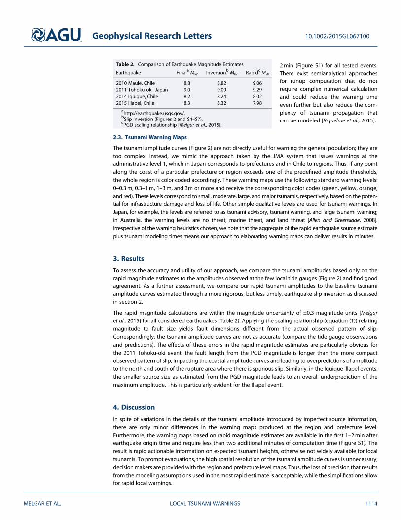
The rapid magnitude calculations are within the magnitude uncertainty of ±0.3 magnitude units [Melgaret al., 2015] for all considered earthquakes (Table 2). Applying the scaling relationship (equation (1)) relatingmagnitude to fault size yields fault dimensions different from the actual observed pattern of slip.Correspondingly, the tsunami amplitude curves are not as accurate (compare the tide gauge observationsand predictions). The effects of these errors in the rapid magnitude estimates are particularly obvious forthe 2011 Tohoku-oki event; the fault length from the PGD magnitude is longer than the more compactobserved pattern of slip, impacting the coastal amplitude curves and leading to overpredictions of amplitudeto the north and south of the rupture area where there is spurious slip. Similarly, in the Iquique Illapel events,the smaller source size as estimated from the PGD magnitude leads to an overall underprediction of themaximum amplitude. This is particularly evident for the Illapel event.
4. Discussion
In spite of variations in the details of the tsunami amplitude introduced by imperfect source information,there are only minor differences in the warning maps produced at the region and prefecture level.Furthermore, the warning maps based on rapid magnitude estimates are available in the first 1–2min afterearthquake origin time and require less than two additional minutes of computation time (Figure S1). Theresult is rapid actionable information on expected tsunami heights, otherwise not widely available for localtsunamis. To prompt evacuations, the high spatial resolution of the tsunami amplitude curves is unnecessary;decisionmakers are providedwith the region and prefecture levelmaps. Thus, the loss of precision that resultsfrom themodeling assumptions used in the most rapid estimate is acceptable, while the simplifications allowfor rapid local warnings.
Table 2. Comparison of Earthquake Magnitude Estimates
Earthquake Finala Mw Inversionb Mw Rapidc Mw
2010 Maule, Chile 8.8 8.82 9.062011 Tohoku-oki, Japan 9.0 9.09 9.292014 Iquique, Chile 8.2 8.24 8.022015 Illapel, Chile 8.3 8.32 7.98
ahttp://earthquake.usgs.gov/.bSlip inversion (Figures 2 and S4–S7).cPGD scaling relationship [Melgar et al., 2015].
Geophysical Research Letters 10.1002/2015GL067100
MELGAR ET AL. LOCAL TSUNAMI WARNINGS 1114

Not all large earthquakes in subduction zones occur on the megathrust. Outer rise normal faulting events[Okal et al., 2010] and strike-slip events [Hill et al., 2015] are possible and can lead to errors in the warningsissued [Lauterjung et al., 2014]. However, for subduction zones the thrust event assumption is reasonable,especially when only minutes are available to issue a warning. At such short time scales, it is the only courseof action. As the event unfolds, and as we have demonstrated here, more elaborate source products such asline source CMT solutions [Melgar et al., 2013] can be used in the sameway, providing ever better estimates oftsunami amplitude and better matching the results (Figures 2a–2d). For example, rapid geodetic estimates offault dimension and slip [Colombelli et al., 2013; Melgar et al., 2013; Grapenthin et al., 2014] can better deter-mine the geographic extent of the tsunami (Figure 2i). These approaches are advantageous especially insituations where the actual source dimension deviates from what is predicted by the scaling laws of Blasseret al. [2010]. The Tohoku-oki event is a good example. The fault length is shorter (~400 km) than what ispredicted by the scaling laws for anMw9.0–9.1 event (~600 km). Regionalmoment tensors confirm (or change)the styleof faultingassumedand the fault geometry (FigureS3), andslip inversions canbetter constrain thehet-erogeneity of slip. Such products are delayed anywhere from tens of seconds to tens of minutes [Dreger et al.,2005;Duputel etal., 2011;Grapenthinet al., 2014]after the rapidmagnitudeestimatesbecomeavailable. There isthus a trade-off between latency and accuracy. A cascading system for local tsunami warning is desirable: first,from rapid magnitude estimates, then refinements from improved source products, followed by direct mea-surements at nearshorewavegauges, tidegauges, andocean-basin sensors suchasDARTbuoys. At each stage,the tsunami warning can be refined formore accurate estimates of the expected extent of inundation and as aguide for rapid response by emergency responders and decision makers.
In this context, and to understand the potential impact of this work, it is demonstrative to review the actualtimeline of events during the recent 2015Mw8.3 Illapel earthquake and tsunami (Figure 3). Tsunami first arri-vals where registered at 14min after observation time (OT) at the closest tide gauges and the first peak ampli-tudes where achieved between 20 and 31min after OT. The Chilean National Emergency Management Office(ONEMI) issued an evacuation notice at 16min after OT for all the coastal areas of Chile; this eventually led toan evacuation of 1 million people. The warnings were based on the earthquake magnitudes estimated by the
Figure 3. Maximum tsunami amplitude and timeline of events for the 2015 Mw8.3 Illapel earthquake. (a) The maximumamplitudes are those predicted by the joint inversion of GPS, strong motion, and tide gauge data (Figure S6b) and is thesame as that used in Figure 2d to generate the coastal amplitude curves. The insets are 75min of tide gauge records atthe closest sties after removing tides and relative to the earthquake origin time. The amplitudes are in meters abovenominal sea level. (b) Timeline of events, on the left-hand side is what would be achievable with the approach proposedhere; on the right are the determinations of national and international agencies. PTWC is the Pacific Tsunami WarningCenter from the United States, CSN the Centro Sismológico Nacional of Chile, SNAM is the Sistema Nacional de Alerta deMaremotos of Chile, ONEMI is the Oficina Nacional de Emergencia del Ministerio del Interior of Chile, and NEIC is thatNational Earthquake Information Center from the United States.
Geophysical Research Letters 10.1002/2015GL067100
MELGAR ET AL. LOCAL TSUNAMI WARNINGS 1115
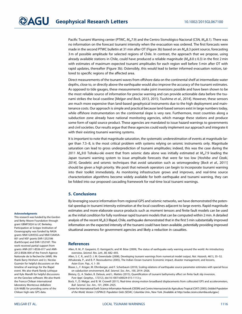
Pacific Tsunami Warning center (PTWC,Mw7.9) and the Centro Sismológico Nacional (CSN,Mw8.1). There wasno information on the forecast tsunami intensity when the evacuation was ordered. The first forecasts weremade in the second PTWC bulletin at 31min after OT (Figure 3b) based on anMw8.3 point source, forecasting3m of possible amplitude for selected regions of Chile. In contrast, the approach that we propose, usingalready available stations in Chile, could have produced a reliable magnitude (Mw8.0 ± 0.3) in the first 2minwith estimates of maximum expected tsunami amplitudes for each region well before 5min after OT withrapid updates, thereafter (Figure 3b). Ostensibly, this would lead to better informed evacuation notices, tai-lored to specific regions of the affected area.
Direct measurements of the tsunami waves from offshore data on the continental shelf at intermediate waterdepths, close to, or directly above the earthquake would also improve the accuracy of the tsunami estimates.As opposed to tide gauges, these measurements make joint inversions possible and have been shown to bethe most reliable source of information for precise warning and can provide actionable data before the tsu-nami strikes the local coastline [Melgar and Bock, 2013, 2015; Tsushima et al., 2014]. However, these sensorsare much more expensive than land-based geophysical instruments due to the high deployment and main-tenance costs. Our approach is simple and practical because land-based sensors exist in large numbers today,while offshore instrumentation on the continental slope is very rare. Furthermore, most countries along asubduction zone already have national monitoring agencies, which manage these stations and producesome form of rapid source product. These agencies are mandated to issue hazard warnings to governmentsand civil societies. Our results argue that these agencies could easily implement our approach and integrate itwith their existing tsunami warning systems.
It is important to note that magnitude saturation, the systematic underestimation of events at magnitude lar-ger than 7.5–8, is the most critical problem with systems relying on seismic instruments only. Magnitudesaturation can lead to gross underprediction of tsunami amplitudes; indeed, this was the case during the2011 Mw9.0 Tohoku-oki event that from seismic data alone was initially estimated at Mw7.9 leading theJapan tsunami warning system to issue amplitude forecasts that were far too low [Hoshiba and Ozaki,2014]. Geodetic and seismic techniques that avoid saturation such as seismogeodesy [Bock et al., 2011]should be given a high priority. We posit that network operators can begin to incorporate tsunami warninginto their toolkit immediately. As monitoring infrastructure grows and improves, and real-time sourcecharacterization algorithms become widely available for both earthquake and tsunami warning, they canbe folded into our proposed cascading framework for real-time local tsunami warnings.
5. Conclusions
By leveraging source information from regional GPS and seismic networks, we have demonstrated the poten-tial speedup in tsunami intensity estimation at the local coastlines adjacent to large events. Rapid magnitudeestimates and more elaborate source products such as moment tensors and finite fault models can be usedas the initial condition for fully nonlinear rapid tsunami models that can be computed within 2min. A detailedanalysis of the recentMw8.3 Illapel, Chile, earthquake demonstrated that in the first 5min substantially improvedinformation on the expected intensity of the tsunami could have been available, potentially providing improvedsituational awareness for government agencies and likely a reduction in casualties.
ReferencesAllen, R. M., P. Gasparini, O. Kamigaichi, and M. Böse (2009), The status of earthquake early warning around the world: An introductory
overview, Seismol. Res. Lett., 80, 682–693.Allen, S. C. R., and D. J. M. Greenslade (2008), Developing tsunami warnings from numerical model output, Nat. Hazards, 46(1), 35–52.Athukorala, P., and B. P. Resosudarmo (2005), The Indian Ocean tsunami: Economic impact, disaster management, and lessons,
Asian Econ. Pap., 4, 1–39.Blaser, L., F. Krüger, M. Ohrnberger, and F. Scherbaum (2010), Scaling relations of earthquake source parameter estimates with special focus
on subduction environment, Bull. Seismol. Soc. Am., 100, 2914–2926.Bletery, Q., A. Sladen, B. Delouis, and L. Mattéo (2015), Quantification of tsunami bathymetry effect on finite fault slip inversion,
Pure Appl. Geophys., 172(12), doi:10.1007/s00024-015-1113-y.Bock, Y., D. Melgar, and B. W. Crowell (2011), Real-time strong-motion broadband displacements from collocated GPS and accelerometers,
Bull. Seismol. Soc. Am., 101, 2904–2925.Center for International Earth Science InformationNetwork (CIESIN) and Centro Internacional de Agricultura Tropical (CIAT) (2005),Gridded Population
of the World, Version 3 (GPWv3): Population Grids (SEDAC, Columbia Univ., New York. [Available at http://sedac.ciesin.columbia.edu/gpw.]
Geophysical Research Letters 10.1002/2015GL067100
MELGAR ET AL. LOCAL TSUNAMI WARNINGS 1116
AcknowledgmentsThis research was funded by the Gordonand Betty Moore Foundation throughgrant GBMF3024 to UC Berkeley.Participation at Scripps Institution ofOceanography was funded by NASAgrants NNX12AH55G and NNX13AI45A-001 and NSF grants EAR-1252186(EarthScope) and EAR-1252187. Thiswork received partial support fromgrants ANR-2011-BS56-017 and ANR-2012-BS06-004 of the French AgenceNationale de la Recherche (ANR). Wethank Barry Hirshorn and Lt. NicolasGuzmán for helpful discussions on thetimeline of warnings for the Illapelevent. We also thank Randy LeVequeand Kyle Mandli for helpful discussionson the Geoclaw software. We also thankthe Franco-Chilean internationallaboratory Montessus deBallore(LIA-MdB) for providing some of theChilean high-rate GPS data.

Colombelli, S., R. M. Allen, and A. Zollo (2013), Application of real-time GPS to earthquake early warning in subduction and strike-slipenvironments, J. Geophys. Res. Solid Earth, 118, 3448–3461, doi:10.1002/jgrb.50242.
Dreger, D. S., L. Gee, P. Lombard, M. H. Murray, and B. Romanowicz (2005), Rapid finite-source analysis and near-fault strong ground motions:Application to the 2003 Mw 6.5 San Simeon and 2004 Mw 6.0 Parkfield earthquakes, Seismol. Res. Lett., 76, 40–48.
Duputel, Z., L. Rivera, H. Kanamori, G. P. Hayes, B. Hirshorn, and S. Weinstein (2011), Real-time W phase inversion during the 2011 off thePacific coast of Tohoku earthquake, Earth Planets Space, 63(7), 535–539.
Farr, T. G., et al. (2007), The shuttle radar topography mission, Rev. Geophys., 45, RG2004, doi:10.1029/2005RG000183.Geng, J., Y. Bock, D. Melgar, B. W. Crowell, and J. S. Haase (2013), A new seismogeodetic approach applied to GPS and accelerometer
observations of the 2012 Brawley seismic swarm: Implications for earthquake early warning, Geochem. Geophys. Geosyst., 14, 2124–2142,doi:10.1002/ggge.20144.
Grapenthin, R., I. A. Johanson, and R. M. Allen (2014), Operational real-time GPS-enhanced earthquake early warning, J. Geophys. Res. SolidEarth, 119, 7944–7965, doi:10.1002/2014JB011400.
Guilhem, A., D. S. Dreger, H. Tsuruoka, and H. Kawakatsu (2013), Moment tensors for rapid characterization of megathrust earthquakes: Theexample of the 2011 M 9 Tohoku-oki, Japan earthquake, Geophys. J. Int., 192, 759–772.
Hayes, G. P., P. S. Earle, H. M. Benz, D. J. Wald, and D. J. Briggs (2011), 88 Hours: The US geological survey national earthquake informationcenter response to the 11 March 2011 Mw 9.0 Tohoku earthquake, Seismol. Res. Lett., 82, 481–493.
Hayes, G. P., D. L. Wald, and R. L. Johnson (2012), Slab1.0: A three-dimensional model of global subduction zone geometries, J. Geophys. Res.,117, B01302, doi:10.1029/2011JB008524.
Hill, E. M., et al. (2015), The 2012 Mw 8.6 Wharton Basin sequence: A cascade of great earthquakes generated by near-orthogonal, young,oceanic mantle faults, J. Geophys. Res. Solid Earth, 120, 3723–3747, doi:10.1002/2014JB011703.
Hirshorn, B., S. Weinstein, and S. Tsuboi (2013), On the application of Mwp in the near field and the March 11, 2011 Tohoku earthquake,Pure Appl. Geophys., 170, 975–991.
Hoshiba, M., and T. Ozaki (2014), Earthquake early warning and tsunami warning of the JapanMeteorological Agency, and their performancein the 2011 off the Pacific Coast of Tohoku Earthquake (Mw 9.0), in Early Warning for Geological Disasters, pp. 1–28, Springer, Berlin.
Kumar, S. T., et al. (2012), Performance of the tsunami forecast system for the Indian Ocean, Curr. Sci., 102(1), 110–114.Lauterjung, J., A. Rudloff, U. Münch, and D. J. Acksel (2014), The earthquake and tsunami early warning system for the Indian Ocean (GITEWS),
in Early Warning for Geological Disasters, pp. 165–178, Springer, Berlin Heidelberg.LeVeque, R. J., D. L. George, and M. J. Berger (2011), Tsunami modeling with adaptively refined finite volume methods, Acta Numer., 20,
211–289.Melgar, D., and Y. Bock (2013), Near-field tsunami models with rapid earthquake source inversions from land- and ocean-based observations:
The potential for forecast and warning, J. Geophys. Res. Solid Earth, 118, 5939–5955, doi:10.1002/2013JB010506.Melgar, D., and Y. Bock (2015), Kinematic earthquake source inversion and tsunami runup prediction with regional geophysical data,
J. Geophys. Res. Solid Earth, 120, 3324–3349, doi:10.1002/2014JB011832.Melgar, D., B. W. Crowell, Y. Bock, and J. S. Haase (2013), Rapid modeling of the 2011 Mw 9.0 Tohoku-oki earthquake with seismogeodesy,
Geophys. Res. Lett., 40, 2963–2968, doi:10.1002/grl.50590.Melgar, D., et al. (2015), Earthquake magnitude calculation without saturation from the scaling of peak ground displacement,
Geophys. Res. Lett., 42, 5197–5205, doi:10.1002/2015GL064278.Mimura, N., K. Yasuhara, S. Kawagoe, H. Yokoki, and S. Kazama (2011), Damage from the Great East Japan earthquake and tsunami—A quick
report, Mitigation Adapt. Strategies Global Change, 16, 803–818.Minson, S. E., J. R. Murray, J. O. Langbein, and J. S. Gomberg (2014), Real-time inversions for finite fault-slip models and rupture geometry
based on high-rate GPS data, J. Geophys. Res. Solid Earth, 119, 3201–3231, doi:10.1002/2013JB010622.Ohta, Y., et al. (2012), Quasi real-time fault model estimation for near-field tsunami forecasting based on RTK-GPS analysis: Application to the
2011 Tohoku-oki Earthquake (Mw 9.0), J. Geophys. Res., 117, B02311, doi:10.1029/2011JB008750.Okal, E., et al. (2010), Field survey of the Samoa tsunami of 29 September 2009, Seismol. Res. Lett., 81, 577–591.Riquelme, S., M. Fuentes, G. P. Hayes, and J. Campos (2015), A rapid estimation of near field tsunami runup, J. Geophys. Res. Solid Earth, 120,
6487–6500, doi:10.1002/2015JB012218.Sandwell, D. T., and W. H. F. Smith (2009), Global marine gravity from retracked Geosat and ERS-1 altimetry: Ridge segmentation versus
spreading rate, J. Geophys. Res., 114, B01411, doi:10.1029/2008JB006008.Tatehata, H. (1997), The new tsunami warning system of the Japan Meteorological Agency, in Perspectives on Tsunami Hazard Reduction,
pp. 175–188, Springer, Netherlands.Titov, V. V., et al. (2005), Real-time tsunami forecasting: Challenges and solutions, in Developing Tsunami-Resilient Communities, pp. 41–58,
Springer, Netherlands.Tsushima, H., R. Hino, Y. Ohta, T. Iinuma, and S. Miura (2014), tFISH/RAPiD: Rapid improvement of near-field tsunami forecasting based on
offshore tsunami data by incorporating onshore GPS data, Geophys. Res. Lett., 41, 3390–3397, doi:10.1002/2014GL059863.Yun, N. Y., and M. Hamada (2015), Evacuation behavior and fatality rate during the 2011 Tohoku-Oki earthquake and tsunami,
Earthquake Spectra, 31(3), 1237–1265.
Geophysical Research Letters 10.1002/2015GL067100
MELGAR ET AL. LOCAL TSUNAMI WARNINGS 1117