local development framework site allocations...allocations for different types of future...
TRANSCRIPT

Colchester Borough Council www.colchester.gov.uk
Local Development Framework
Site AllocationsAdopted October 2010
34726 Site Allocation amended 2010:Site Allocation 1/11/10 15:01 Page 1

34726 Site Allocation amended 2010:Site Allocation 1/11/10 15:01 Page 2

Site Allocations Submission Document
Contents Page
1. Executive Summary 5
2. Introduction and Background 8
3. Centres and Employment 13
Centres and Employment Site Allocations 14
Strategic Employment Zones 15
Local Employment Zones 15
Mixed Use Sites 20
Centres Hierarchy 21
Phasing and Implementation 22
4. Housing 23
Housing Site Allocations 23
Gypsies, Travellers and Travelling Showpeople 25
Phasing and Implementation 27
5. Urban Renaissance 28
Town Centre and North Station 30
East Colchester 36
Garrison 49
North Growth Area 53
Stanway Growth Area 61
Tiptree 70
6. Public Realm 74
7. Transport and Accessibility 77
8. Environment and Rural Communities 78
9. Monitoring and Implementation 82
Appendix 1 – Glossary 83
Appendix 2 – References 89
Appendix 3 – Saved Local Plan policies superseded by the Site Allocations DPD 91
Local Development Framework | Adopted Site Allocations 3
34726 Site Allocation amended 2010:Site Allocation 1/11/10 15:01 Page 3

Index of Site Allocations Policies Page
Centres and Employment
SA CE1 Mixed Use Sites 20
Housing
SA H1 Housing Allocations 25
SA H2 Gypsy and Traveller Accommodation 26
Urban Renaissance
Town Centre and North Station
SA TC1 Appropriate Uses within the Town Centre and North StationRegeneration Area 32
East Colchester
SA EC1 Residential development in East Colchester 39
SA EC2 Development in East Colchester 41
SA EC3 Area 1: Former Timber Dock 42
SA EC4 Area 2: King Edward Quay 43
SA EC5 Area 3: Magdalen Street 44
SA EC6 Area 4: Hawkins Road 45
SA EC7 University of Essex Expansion 46
SA EC8 Transportation in East Colchester 48
Garrison
SA GAR1 Development in the Garrison Area 51
North Growth Area
SA NGA1 Appropriate Uses within the North Growth Area 55
SA NGA2 Greenfield Sites in the North Growth Area 57
SA NGA3 Employment Uses in the North Growth Area 58
SA NGA4 Transport measures in North Growth Area 60
SA NGA5 Transport Infrastructure related to the NGAUE 60
Stanway Growth Area
SA STA1 Appropriate Uses within the Stanway Growth Area 63
SA STA2 Phasing of Greenfield sites in Stanway Growth Area 66
SA STA3 Employment and Retail Uses in Stanway Growth Area 67
SA STA4 Transportation in Stanway Growth Area 68
SA STA5 Open Space in Stanway Growth Area 69
Tiptree
SA TIP1 Residential sites in Tiptree 72
SA TIP2 Transport in Tiptree 73
Local Development Framework | Adopted Site Allocations4
34726 Site Allocation amended 2010:Site Allocation 1/11/10 15:01 Page 4

5Local Development Framework | Adopted Site Allocations
1. Executive Summary
Introduction
1.1 The Site Allocations Development Plan Document (DPD) is one of the planning policydocuments that make up Colchester’s Local Development Framework (LDF). The LDFreplaces the 2004 Local Plan and provides strategy and policies to guide development inColchester to 2021 and beyond. The development decision making process is informed byall of the documents that contribute to the LDF, as well as by national policies and the RSSevidence base, so individual LDF documents should not be read in isolation.
1.2 The first document in the LDF to be produced was the Core Strategy which was adopted bythe Council in December 2008 following an examination led by an independent Inspectorappointed by the Government. This sets out the long-term spatial vision for the Boroughand the spatial objectives and strategic policies to deliver that vision. The Core Strategyshould be consulted for further details about the nature of the LDF system and its nationaland local planning context. The Core Strategy contains 23 strategic policies which providethe cornerstone for the allocations and designations made in the Site Allocationsdocument. The Site Allocations DPD will also contain policies specific to particular areasand is therefore accompanied by a Proposals Map showing designations along withallocations for different types of future development.
1.3 Consultation with the public and stakeholders is an essential part of the preparation of allLDF documents. The Site Allocations DPD went through a number of consultation stages,including an initial Issues and Options stage in November/December 2007, a consultationon the Council’s preferred approach in January/February 2009 (Regulation 25), and a finalconsultation in September/October 2009 which preceded submission of the document tothe Planning Inspectorate and subsequent examination and adoption in October 2010.
Site Allocations
1.4 The purpose of the Site Allocations DPD is to:
• Set out the criteria for the boundaries shown on the Proposals Map
• Provide area specific allocations in line with the overall strategy set by the Core Strategy.
1.5 The Site Allocations document is in general conformity with the Core Strategy and follows asimilar format. In each section the Council outlines the policy background which hasinformed the specific site allocations and policies that are proposed for each topic or area.Each site has been evaluated as part of the Sustainability Appraisal process that weighs upsustainability considerations and compatibility with policy guiding the final view on whethera site should be allocated. Site allocations relevant to the following specific topics andindividual areas are discussed and shown on the Proposals Map that accompanies thisdocument.
Centres and Employment
1.6 The Site Allocations DPD identifies those sites that make up Strategic and LocalEmployment Zones, Mixed Use Areas and Neighbourhood Centres. These sites reflect theapproach and provide sufficient land to deliver the job targets set out in the Core Strategy.Many of the sites have been rolled forward from the Local Plan but new allocations are alsoshown including Stane Park at Stanway and several new rural employment zones. Each siteis listed and they are all shown on the Proposals Map.
34726 Site Allocation amended 2010:Site Allocation 1/11/10 15:01 Page 5

Housing
1.7 The Core Strategy sets out in broad terms where future housing development will belocated. The Site Allocations DPD and the Proposals Map adds detail and provides theactual boundaries for these sites. Allocations outside of the growth areas, regenerationareas and Tiptree are listed in this chapter. The Council’s Housing Trajectory and StrategicHousing Land Availability Assessment contain further detail about housing sites and areupdated annually.
1.8 The Site Allocations DPD and the Proposals Map also identify sites for gypsies andtravellers.
Urban Renaissance
1.9 The boundaries of Colchester’s 22 Conservation Areas are shown on the Proposals Map, asare the 40 Scheduled Monuments and 4 Historic Parks and Gardens. It is impractical to showall 1700 listed buildings but the Register of Listed Buildings is a material planningconsideration.
Public Realm
1.10 The Proposals Map identifies both public and private open space. Allocations have beenrolled forward from the Local Plan and new designations at Tiptree and Stanway included. InNorth Colchester land ‘proposed’ for open space is no longer included but aSupplementary Planning Document for the area is expected to show where new strategicopen space will be provided within the urban extension.
Transport and Accessibility
1.11 The Core Strategy provides a balance between improving accessibility through land useplanning, managing traffic flow and growth and infrastructure provision. Transportimprovements are detailed in the Growth Area chapters and shown on the Proposals Map,including transit corridors in North and East Colchester as well as a new junction on the A12Trunk Road (Junction 28).
Environment and Rural Communities
1.12 The Proposals Map contains allocations for international and nationally designated siteswhich are listed in the Site Allocations DPD. The Proposals Map also identifies 168 LocalWildlife Sites following a review in 2008 (previously known as Sites of Importance for NatureConservation). Also shown are the Coastal Protection Belt and Areas at Risk of Floodingwhich are covered by policies in the Core Strategy and the Development Policies DPD.
Town Centre/North Station
1.13 Boundaries for the Town Centre and North Station Regeneration Area are shown on theProposals Map. The new boundary for the Town Centre enlarges that shown previously inthe Local Plan by including the full extent of the St Botolphs Regeneration Area. The NorthStation area is a new designation and includes not just the station itself but also thesurrounding area including Turner Rise Retail Park, the Cowdray Centre and North StationRoad with guidance that sets out the appropriate mix of development and where it shouldbe located.
Local Development Framework | Adopted Site Allocations6
34726 Site Allocation amended 2010:Site Allocation 1/11/10 15:01 Page 6

East Colchester and the University of Essex
1.14 This area of Colchester has experienced significant change in recent years and an ambitiousregeneration programme is expected to continue. New boundaries for the RegenerationArea and Growth Area have been identified on the Proposals Map and specific policiesdeveloped for those areas likely to be the focus of new development in the next 10 years.There are also policies identifying housing sites and transportation improvements.
1.15 The Council recognises the important role of the University in the Town and a new allocationis shown on the Proposals Map to accommodate new academic development.
The Garrison
1.16 Although development is well under way in the Garrison Regeneration Area and GrowthArea, the Core Strategy provides for the continued progress of this redevelopment andsupporting infrastructure.
North Colchester
1.17 As set out in the Core Strategy, North Colchester is expected to be the focus of significantnew development over the next 15 years. A new urban extension on land off Nayland Roadand Mile End Road is identified on the Proposals Map and is expected to deliverapproximately 2200 new dwellings. The Strategic Employment Zone is also identified whichcomprises of Severalls Business Park, Cuckoo Farm and Crown Interchange. Significantinfrastructure is required including the new A12 junction 28 and park and ride.
Stanway
1.18 Stanway was identified as a Growth Area in the Core Strategy. The Site Allocations DPD andthe Proposals Map identify the sites expected to deliver new housing and employment.Three new sites have been identified for residential development at Fiveways Fruit Farm,land next to the A12 and land between Dyers Road and Warren Lane. Significant areas ofpublic open space are also expected to be delivered through the restoration of landpreviously used for sand and gravel extraction.
Tiptree
1.19 As set out in the Core Strategy, Tiptree is expected to be the subject of limited new growth.Additional land has been allocated to provide for approximately 140 new dwellings. Landpreviously allocated for employment purposes off Grange Road has been identified todeliver the housing along with significant public open space.
1.20 Additional employment land has been allocated adjacent to the Wilkin & Sons factory toenable the company to expand.
Monitoring
1.21 The final section of the document addresses how the Council will monitor delivery of thesites that have been allocated for development to ensure sufficient land is available to meetlocal targets.
Local Development Framework | Adopted Site Allocations 7
34726 Site Allocation amended 2010:Site Allocation 1/11/10 15:01 Page 7
8 Local Development Framework | Adopted Site Allocations
2. Introduction and Background
2.1 The Site Allocations document forms part of the Local Development Framework (LDF)process that came into effect in 2004. This will replace the Local Plan and provide a strategyfor the development of Colchester to 2021 and beyond.
2.2 Since the revocation of Regional Spatial Strategies (RSS) (the East Of England Plan beingthe relevant RSS for Colchester) by the Secretary of State for Communities and LocalGovernment on 6 July 2010, the Development Plan for Colchester Borough comprises theColchester LDF and the 'saved' policies from the Adopted Essex and Southend-on-SeaStructure Plan. The LDF is essentially a portfolio that consists of a collection of individualdocuments. The adoption of this Site Allocations DPD and the Development Policies DPD,supersedes the Adopted Review Colchester Borough Local Plan of March 2004, which willhave been ‘replaced'. The Local Development Scheme sets out the details of theDevelopment Plan Documents the Council will prepare in the next few years and when eachwill be prepared. The Site Allocations DPD must be in conformity with the adoptedColchester Core Strategy. That document was founded upon the then extant East ofEngland Plan. Whilst the evidence base for the East of England Plan remains material to thecurrent DPD documents it needs to be clearly understood that the East of England Plan isno longer part of the Development Plan.
2.3 The determination of planning applications must be made in accordance with theDevelopment Plan unless material considerations indicate otherwise (Section 38(6) Planningand Compulsory Purchase Act 2004). For this reason it is important that the separatedocuments that contribute to the Development Plan are not read in isolation. Othermaterial considerations can also affect the decision making process, so an allocation for ause on a site does not guarantee unconditional approval for all possible categories withinthat use.
2.4 The Site Allocations DPD is only one part of the Development Plan and does not repeatnational planning policy. Consequently, users must refer to a range of other policies anddocuments. In particular:
• National planning policy contained in Planning Policy Statements (PPS) and PlanningPolicy Guidance (PPG);
• County level policies contained in the Essex & Southend-on-Sea Replacement StructurePlan (2001), the Essex and Southend Waste Local Plan (2001) and the Essex Minerals LocalPlan (1996);
• The Core Strategy (2008);
2.5 This list is not exhaustive, and a holistic policy approach will be required against all relevantpolicies available at the time that applications for planning permission are made. RelevantSupplementary Planning Guidance (SPG) and Supplementary Planning Documents (SPD),for example, will be another important consideration. Applicants are advised to seekpreliminary advice from the Council where there is any doubt as to the policy considerationsprior to formally submitting their planning applications to ensure all relevant policies areaddressed. Some policies require evidence and background information to be submitted toinform policy judgements; these will need to be proportionate to the size and scale ofproposals.
34726 Site Allocation amended 2010:Site Allocation 1/11/10 15:01 Page 8

9Local Development Framework | Adopted Site Allocations
The Site Allocations Document and its relationship to other Council documents
2.6 Core Strategy: The first document the Council produced was the Core Strategy, which wasadopted in December 2008. This sets out the long-term spatial vision for the Borough, andthe spatial objectives and strategic policies to deliver that vision. The Site AllocationsDevelopment Plan Document (DPD) is intended to provide further details on wheredevelopment should occur to assist the delivery of the Core Strategy and the considerationof planning applications.
2.7 The Core Strategy provides an overall spatial strategy which focuses growth on the TownCentre and Growth Areas in North Colchester, East Colchester, the Garrison and Stanway.Development locations are to be coordinated with transport infrastructure and the provisionof community facilities, shopping, employment and open space to create sustainablecommunities.
2.8 The overall objectives and policies in the Core Strategy have been tested through theprocess of an examination by an independent Inspector appointed by the Government, sothe general principles underlying the choice of sites in the Site Allocations document havealready been set. The maps in the Core Strategy, however, only showed indicative locationsfor growth. The Inspector’s Report on the Core Strategy stated that the Site Allocations DPDwould need to set the boundaries for Colchester and the three Rural District Centres as wellas review the existing village settlement boundaries.
2.9 The Core Strategy should be consulted for further details about the nature of the LDFsystem and about the national, regional and local planning context under which it is beingprepared. The Core Strategy contains 23 policies which will be used in decision making. TheSite Allocations DPD will also contain policies and is accompanied by a Proposals Mapshowing the designated use of particular areas along with allocations for different types offuture development.
2.10 Development Policies DPD: Alongside the Site Allocations document, the Council is alsoproducing a Development Policies DPD which contains 25 additional policies to thosecontained in the Core Strategy to aid the consideration of planning applications. Thesepolicies expand on the general principles set by the Core Strategy and set out the detailedcriteria and local standards against which planning applications for the development anduse of land and buildings will be considered.
2.11 Proposals Map: The Proposals Map illustrates the planning strategy for an area by showingthe boundaries of allocations and designations set by planning policies. It is revised as eachnew development plan document is adopted to ensure it always reflects the up-to-datestrategy for the area. The Proposals Map in the adopted 2004 Local Plan is now accordinglybeing revised to reflect the allocations and designations provided in the Site Allocationsdocument and to a lesser extent, by a few area-specific policies in the Development Policiesdocument.
2.12 Sustainable Community Strategy: The LDF provides the primary means of delivering thespatial elements of the Sustainable Community Strategy prepared by the Local StrategicPartnership, Colchester 2020. The Sustainable Community Strategy provides a vision andaction plan for achieving co-ordinated action between partners to deliver sustainabledevelopment. The Core Strategy sets out specific links between the documents.
2.13 Strategic Plan: Colchester’s Strategic Plan (2009 – 2012) identifies nine priorities for action.The sites allocated for future development will be expected to contribute to all the prioritiesbut in particular;• Homes for all, and• Enabling job creation.
34726 Site Allocation amended 2010:Site Allocation 1/11/10 15:01 Page 9

2.14 Supplementary Planning Documents and Guidance: The Council is in the process ofadopting a number of Supplementary Planning Documents that provide guidance on thelikely planning obligations that will be sought from new development proposals in order todeliver sustainable communities. Current policy guidance on planning obligations include:Affordable Housing (current SPG adopted 2004 and shortly due to be replaced by updatedSPD); Community Facilities ( adopted September 2009); Economic Development andTraining (SPD due to be adopted 2011); Public Open Space, Sports and Recreation (SPDadopted July 2006); Education (County Council SPG adopted September 2004); andTransport (County Council Developers Guide to Infrastructure Contributions 2008).
2.15 The Planning Act 2008 (Part 11) provides the enabling powers for local authorities to apply aCommunity Infrastructure Levy (CIL) to support infrastructure delivery in an area, and draftregulations for a Community Infrastructure Levy were published in June 2009. Evolvingpolicy in this area accordingly may occasion the need for further policy guidance.
Site Allocations – Format of the document
2.16 The purpose of the Site Allocations DPD is to: • Set out the criteria for the boundaries shown on the Proposals Map• Provide area specific allocations in line with the overall strategy set by the Core Strategy.
2.17 The Site Allocations document is in general conformity with the Core Strategy and follows asimilar format as outlined below. Site allocations relevant to the following topics arediscussed and shown on the Proposals Map that accompanies this document:• Centres and Employment• Housing• Urban Renaissance• Public Realm• Transport and Accessibility• Environment and Rural Communities
2.18 The document then looks at the allocations mapped on the Proposals Map for individualareas which are expected to be subject to change over the plan period:• Town Centre/North Station• North Colchester• East Colchester• The Garrison • Stanway• Tiptree
2.19 The start of each section outlines the policy background which has informed the specific siteallocations and policies that are proposed for each topic or area. Each site has beenevaluated as part of the Sustainability Appraisal process that weighs up sustainabilityconsiderations and compatibility with policy guiding the final view on whether a site shouldbe allocated.
2.20 The final section of the document is a section on the monitoring and implementation of theSite Allocations. Appendices at the rear of the document include a glossary with definitionsfor some of the common terms used within the Site Allocations document and the LDF as awhole; a reference list of policies, strategies and studies that comprise the Council’sevidence base for the Local Development Framework; and a list of saved Local Plan policiessuperseded by the Site Allocations DPD.
Local Development Framework | Adopted Site Allocations10
34726 Site Allocation amended 2010:Site Allocation 1/11/10 15:01 Page 10

Consultation
2.21 One of the key ingredients of the new LDF planning system is the recognition of the needfor the earliest and fullest public involvement in the preparation of new planningdocuments. The Site Allocations DPD has been subject to a number of stages ofconsultation during its production.
Issues and Options
2.22 The first consultation on possible Site Allocations, known as ‘Issues and Options’, took placeat the end of 2007. The purpose of the Issues and Options stage was to explore how thegeneral principles set out in the Core Strategy could be fleshed out to provide sufficientdetail to guide future site allocations. At that stage no specific sites were identified,although for information sites identified in the Housing Land Availability Assessment werepublished to show possible future housing sites. The Council wanted to gather people’sviews about the best approach to site selection and to request the submission of sites forconsideration as potential development sites. The comments received at that stage helpedto shape the policy direction of this document and sites received as candidates fordevelopment were analysed for their suitability using the Sustainability Appraisal process. Afull public consultation took place and the Council received upwards of 300 individual siterepresentations which formed the basis for subsequent consultations.
Regulation 25 (Preferred Approach)
2.23 The Regulation 25 consultation was carried out during January and February 2009. Theconsultation covered the requirements of the new regulations governing the plan makingprocess (published June 2008). This includes the requirement of authorities to consult‘specific’ and ‘general’ bodies (as defined in regulations) on what the ‘content’ of thestrategy should be. The regulations also require authorities to consider whether residentsand businesses should be included at that stage. The Council chose to use the Regulation25 stage to not only seek guidance from the ’specific’ and ‘general’ bodies on whether thecurrent approach is one they support but also to re-consult the public. Because a large scalepublic consultation exercise had already been undertaken at the Issues and Options stage,the Council advanced the Site Allocations DPD to identify its preferred approach. Thepreferred sites for new allocations were presented alongside a summary of the non-selectedsites with the reasons why they had not been included and supported at this stage of theprocess.
2.24 The work undertaken at these previous stages of consultation has been important in thedevelopment of this document. The results of the consultation exercises have been collatedand analysed and, alongside further evidence base work, have informed the production ofthe Site Allocations submission document. The reports from these previous consultationexercises, the draft sustainability appraisal reports, and the evidence studies completed todate are all publically available on the Council’s website or by request.
Sustainability Appraisal
2.25 Sustainability Appraisal incorporating the requirements of Strategic EnvironmentAssessment (SEA) was also carried out at each stage of the documents production. TheSustainability Appraisal is a systematic process used at each stage of the policy makingprocess to help inform the drafting of the options.
2.26 A Sustainability Appraisal has been published for consultation alongside the submissionversion of this DPD. This sets out the outcomes of the sustainability assessment of the policyoptions and demonstrates how the options meet the local sustainability objectives.
Local Development Framework | Adopted Site Allocations 11
34726 Site Allocation amended 2010:Site Allocation 1/11/10 15:01 Page 11

12 Local Development Framework | Adopted Site Allocations
Submission document
2.27 A submission version of the Site Allocations document was published for a six week periodof public consultation during September and October 2009. The work undertaken duringprevious stages of consultation was important in the development of this submissiondocument. The reports from the previous consultation exercises, the draft SustainabilityAppraisal reports, and the evidence studies completed to date were all made publicallyavailable. The submission document and any representations made were then submitted tothe Planning Inspectorate in November 2009 for public examination in Spring 2010.
34726 Site Allocation amended 2010:Site Allocation 1/11/10 15:01 Page 12
13Local Development Framework | Adopted Site Allocations
3. Centres and Employment
3.1 Core Strategy policies CE1 to CE3 outline the Council’s strategic position with regards toemployment provision across the Borough up to 2021. The Council will encourageeconomic development and will plan for the delivery of at least 14,200 jobs in Colchesterbetween 2001 and 2021.
3.2 During the plan period the Council will ensure that a wide range of employment sectors andopportunities are encouraged into and retained within the Borough in line with the Centresand Employment Classification and Hierarchy outlined in Core Strategy Table CE1a.
Strategic Context
3.3 Core Strategy Centres and Employment Objectives
The Core Strategy sets out three main objectives:
• Create a prestigious regional centre and a vibrant network of district and local centresthat stimulate economic activity and provide residents’ needs at accessible locations
• Provide for a balance of new homes and jobs to support economic prosperity of ourgrowing community and reduce the need to travel outside the Borough for employment
• Support and promote the growth of tourism
3.4 As well as establishing Colchester as a centre for major employment to compete with similartowns and cities in the East of England it is essential that the Council ensures a suitablesupply of smaller employment sites to meet the needs of the small or start up business. Thismeans a wide range of appropriate sites need to be identified in order to deliver the CoreStrategy targets and objectives.
3.5 Core Strategy Centres and Employment Policies
The policies in this chapter detail how the vision, objectives and policies contained in theCore Strategy will be delivered through specific site provision. The most relevant policiesare:
• SD1 – Sustainable Development Locations• SD2 – Delivering Facilities and Infrastructure• SD3 – Community Facilities• CE1 – Centres and Employment Classification and Hierarchy• CE2 – Mixed Use Centres• CE2a – Town Centre• CE2b – District Centres• CE2c – Local Centres• CE3 – Employment Zones
3.6 The majority of employment land allocated as part of the Local Plan was within the urbanarea of Colchester which exploited the good transport infrastructure connections and largerpopulation. The Core Strategy continues this approach. The Centres and EmploymentClassification and Hierarchy outlined the indicative locations of the major employment sitesacross the Borough. These are shown indicatively on the Core Strategy Key Diagram withthe specific boundaries interpreted accurately on the Proposals Map which is to be read inconjunction with this document.
34726 Site Allocation amended 2010:Site Allocation 1/11/10 15:01 Page 13

Centres and Employment Site Allocations
3.7 The tables below outline the specific sites which together will provide almost 300 hectaresof employment land. The sites include both existing and proposed employment land whichis required to deliver at least 14,200 jobs between 2001 and 2021.
3.8 The Local Plan contained a variety of allocations which related to Employment Policies.Land allocated for Employment was shown as being either:
• Existing Employment Zone,• Proposed Employment Zone, or• Rural Business Site.
3.9 The Site Allocations document intends to combine all these allocations into one annotationto accord with the Core Strategy which uses the generic term Employment Zone. CoreStrategy Policy CE3 breaks down these areas into Strategic and Local Zones dependent ontheir role, size and indicative location. Strategic Employment Zones are to be found in themost accessible locations in the Borough and Local Employment Zones are found in areaswhich do not score as highly in terms of accessibility but provide a valuable local functionand employment opportunities in both rural and urban areas.
3.10 The 2004 Local Plan allocated some 98 hectares of land for a variety of employment uses.The Employment Land Study published in June 2007 reviewed the existing employmentallocations and proposed to roll forward the majority of these allocations (both existing andproposed). The Council intends to provide a range of employment sites and opportunitiesto ensure that the Core Strategy and Sustainable Community Strategy objectives are metwith regards to the local economy and the standing of Colchester within Essex and the Eastof England.
3.11 The Local Plan also identified eight Rural Business Sites. As part of the Site Allocationsdocument the Council is proposing to carry these forward into the LDF and allocate them asLocal Employment Zones along with a number of new rural sites.
3.12 The tables below identify which Employment Zones are considered to be strategic andwhich are local along with those sites which are to be allocated as mixed useredevelopment sites in accordance with Core Strategy Policies CE1 to CE3. Future uses ofall sites will be guided by Core Strategy Table CE1b and Development Policy DP5 whichsets out the appropriate uses for allocated employment land and provides detail on howallocated land will be protected. Policy DP10 provides further detail on tourism, leisure andculture uses. More specific policies for allocated employment sites within the Growth Areasare contained in the Growth Area sections of this document.
Local Development Framework | Adopted Site Allocations14
34726 Site Allocation amended 2010:Site Allocation 1/11/10 15:01 Page 14

Strategic Employment Zones
3.13 The following sites are allocated as Strategic Employment Zones in accordance with CoreStrategy Policies CE1 and CE3. Development Policy DP5 and Site Allocations Policies SANGA3 and SA STA3 provide detail on the acceptable uses within these areas.
Local Employment Zones
3.14 The following sites are allocated as Local Employment Zones. Development Policy DP5 setsout the appropriate uses for allocated employment land subject to the site specificrequirements where listed in the Comments column below.
Local Development Framework | Adopted Site Allocations 15
Site Area in Ha Comments
Stanway 34.42
• Various sites including Tollgate, Stane Park,Westside Centre and land off London Road(including Wyvern Farm and a new site atEvergreen House)
• Wide range of employment opportunitiesexpected to be delivered including BusinessIncubation Units.
University Research Park (TheKnowledge Gateway)
11.80
• Development expected to supportdevelopment of the University of Essex as akey centre for Research and Development.
• Future uses to be closely connected with theUniversity and to provide some BusinessIncubation Units.
North Colchester 109.90
• Comprises Severalls Business Park, andCuckoo Farm
• Some development is restricted untilcompletion of new A12 junction.
TOTAL 152.90 ha
Site Area in Ha Comments
East Gates/Moorside 7.33 Existing allocation
Davey Close 5.40 Existing allocation
Whitehall Industrial Estate(including extension andFieldgate)
37.31 Existing site and extension
Gosbecks Road 9.53 Existing allocation
Maldon Road 3.19 Existing allocation
Barrack Street 1.91 Existing allocation
34726 Site Allocation amended 2010:Site Allocation 1/11/10 15:01 Page 15
Local Development Framework | Adopted Site Allocations16
Site Area in Ha Comments
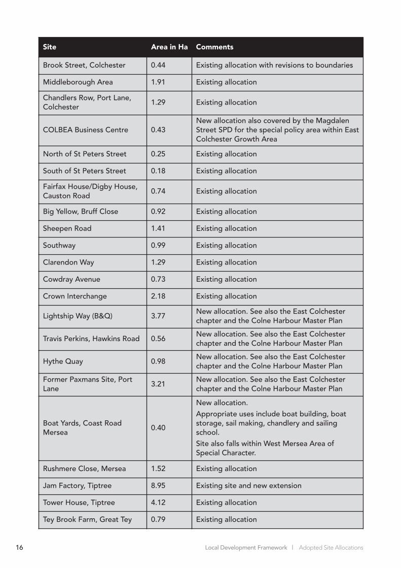
Brook Street, Colchester 0.44 Existing allocation with revisions to boundaries
Middleborough Area 1.91 Existing allocation
Chandlers Row, Port Lane,Colchester
1.29 Existing allocation
COLBEA Business Centre 0.43New allocation also covered by the MagdalenStreet SPD for the special policy area within EastColchester Growth Area
North of St Peters Street 0.25 Existing allocation
South of St Peters Street 0.18 Existing allocation
Fairfax House/Digby House,Causton Road
0.74 Existing allocation
Big Yellow, Bruff Close 0.92 Existing allocation
Sheepen Road 1.41 Existing allocation
Southway 0.99 Existing allocation
Clarendon Way 1.29 Existing allocation
Cowdray Avenue 0.73 Existing allocation
Crown Interchange 2.18 Existing allocation
Lightship Way (B&Q) 3.77New allocation. See also the East Colchesterchapter and the Colne Harbour Master Plan
Travis Perkins, Hawkins Road 0.56New allocation. See also the East Colchesterchapter and the Colne Harbour Master Plan
Hythe Quay 0.98New allocation. See also the East Colchesterchapter and the Colne Harbour Master Plan
Former Paxmans Site, PortLane
3.21New allocation. See also the East Colchesterchapter and the Colne Harbour Master Plan
Boat Yards, Coast RoadMersea
0.40
New allocation.Appropriate uses include boat building, boatstorage, sail making, chandlery and sailingschool.Site also falls within West Mersea Area of Special Character.
Rushmere Close, Mersea 1.52 Existing allocation
Jam Factory, Tiptree 8.95 Existing site and new extension
Tower House, Tiptree 4.12 Existing allocation
Tey Brook Farm, Great Tey 0.79 Existing allocation
34726 Site Allocation amended 2010:Site Allocation 1/11/10 15:01 Page 16
Local Development Framework | Adopted Site Allocations 17
Site Area in Ha Comments
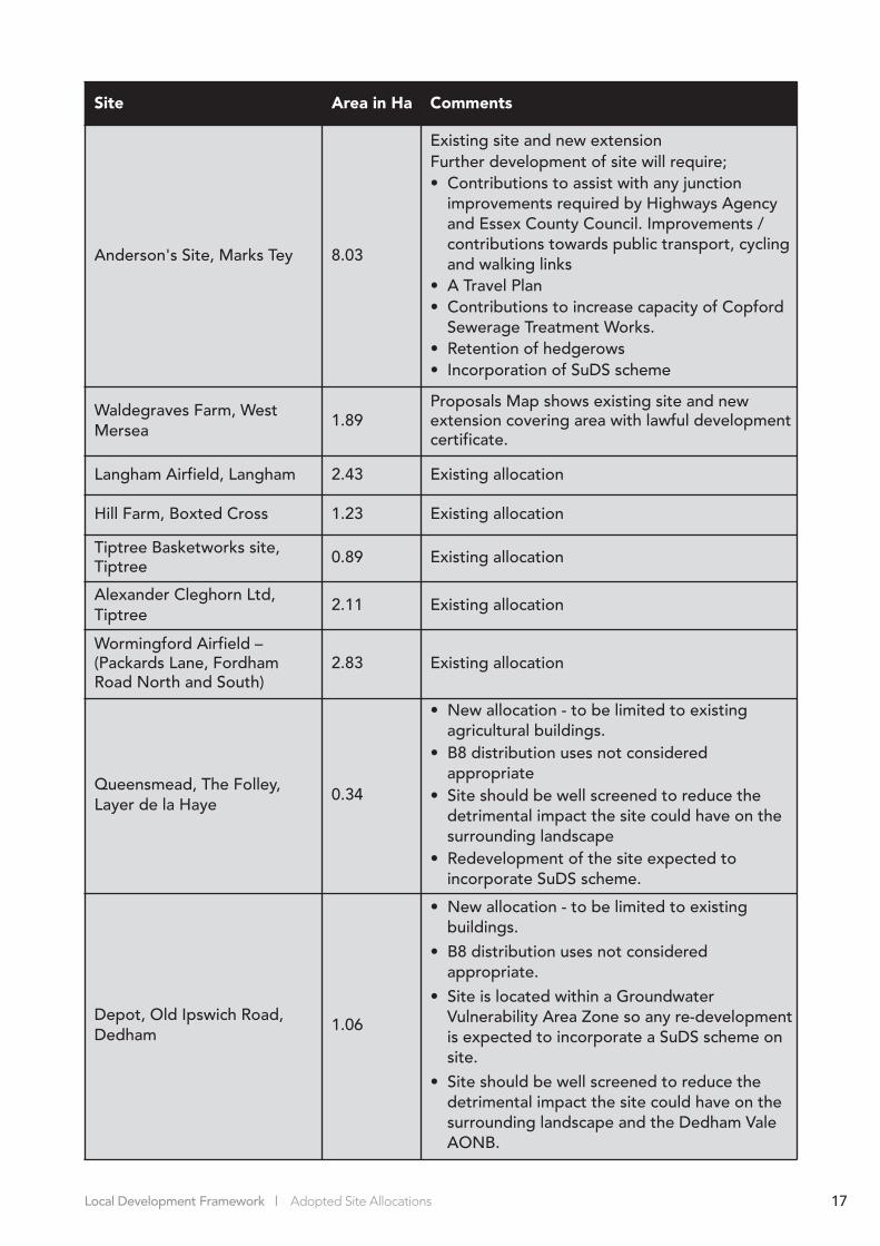
Anderson's Site, Marks Tey 8.03
Existing site and new extension Further development of site will require;• Contributions to assist with any junction
improvements required by Highways Agencyand Essex County Council. Improvements /contributions towards public transport, cyclingand walking links
• A Travel Plan • Contributions to increase capacity of Copford
Sewerage Treatment Works.• Retention of hedgerows • Incorporation of SuDS scheme
Waldegraves Farm, WestMersea
1.89Proposals Map shows existing site and newextension covering area with lawful developmentcertificate.
Langham Airfield, Langham 2.43 Existing allocation
Hill Farm, Boxted Cross 1.23 Existing allocation
Tiptree Basketworks site,Tiptree 0.89 Existing allocation
Alexander Cleghorn Ltd,Tiptree
2.11 Existing allocation
Wormingford Airfield –(Packards Lane, Fordham Road North and South)
2.83 Existing allocation
Queensmead, The Folley,Layer de la Haye
0.34
• New allocation - to be limited to existingagricultural buildings.
• B8 distribution uses not consideredappropriate
• Site should be well screened to reduce thedetrimental impact the site could have on thesurrounding landscape
• Redevelopment of the site expected toincorporate SuDS scheme.
Depot, Old Ipswich Road,Dedham
1.06
• New allocation - to be limited to existingbuildings.
• B8 distribution uses not consideredappropriate.
• Site is located within a GroundwaterVulnerability Area Zone so any re-developmentis expected to incorporate a SuDS scheme onsite.
• Site should be well screened to reduce thedetrimental impact the site could have on thesurrounding landscape and the Dedham ValeAONB.
34726 Site Allocation amended 2010:Site Allocation 1/11/10 15:01 Page 17

Local Development Framework | Adopted Site Allocations18
Site Area in Ha Comments
Picketts Farm, Abberton Road, Fingringhoe
0.55
• New allocation - to be limited to formeragricultural buildings on the site.
• B8 distribution uses not consideredappropriate
• Redevelopment of the site expected toincorporate SuDS scheme.
• Site should be well screened to reduce thedetrimental impact the site could have on thesurrounding landscape.
Pantiles Farm, Peldon Road,Abberton
0.47
• New allocation - to be limited to formeragricultural buildings on the site.
• B8 distribution uses not consideredappropriate
• Redevelopment of the site expected toincorporate SuDS scheme.
• Site should be well screened to reduce thedetrimental impact the site could have on thesurrounding landscape and Pete Tye CommonLand Local Wildlife Site
Powerplus Engineering andWhitnell Contractors Site,School Road, Langham
1.06
• New allocation - to be restricted to existingbuildings on the site.
• Future uses to exclude B8 distribution.• Site should be well screened to reduce the
detrimental impact the site could have on thesurrounding landscape and protect theenvironment as outlined in the LanghamVillage Design Statement.
30a Straight Road, Boxted(known as the Classic PotEmporium)
0.74
• New allocation - to be limited to cover theexisting site.
• B8 distribution uses not consideredappropriate
• Site should be well screened to reduce thedetrimental impact the site could have on thesurrounding landscape
34726 Site Allocation amended 2010:Site Allocation 1/11/10 15:01 Page 18

Local Development Framework | Adopted Site Allocations 19
Site Area in Ha Comments
Straight Road, Boxted (knownas Tin Bins Ltd)
0.47
• New Employment Zone allocation to be limited to existing buildings.
• B8 distribution uses not consideredappropriate
• Site should be well screened to reduce thedetrimental impact the site could have on thesurrounding landscape
Poplar Nurseries, CoggeshallRoad, Marks Tey
2.5
• New allocation - limited to cover the existingpermanent buildings on the site.
• Site to be well screened to limit the impact any future uses have on the landscape.
Land south of PeldonCommon, Lower Road, Peldon
0.09
• New allocation - restricted to existing buildings on site
• B8 distribution uses not consideredappropriate
• Site should be well screened to reduce thedetrimental impact the site could have on thesurrounding landscape
Oak Farm, Layer Marney 0.23
• New allocation – to be limited to the lawful use of the site
• B8 distribution uses not consideredappropriate
• Site should be well screened to reduce theimpact on the landscape
• An ecological survey will be required as part of any future proposals for the site
Holly Lodge, Great Horkesley 0.21
• New allocation – to be limited to existingbuildings on the site
• Site should be well screened to reduce theimpact on the landscape
Pattens Yard, Nayland Road,West Bergholt
0.43
• New allocation – to be limited to the lawful use of the site
• Site should be well screened to reduce theimpact on the landscape
• Landscaping, including improved hardsurfacing, required as part of anyredevelopment
• There is a population of great crested newtsclose to the site; an ecological survey will berequired as part of any future proposals for the site
TOTAL 129.27 ha
34726 Site Allocation amended 2010:Site Allocation 1/11/10 15:01 Page 19
Local Development Framework | Adopted Site Allocations20
Site Area in Ha Comments
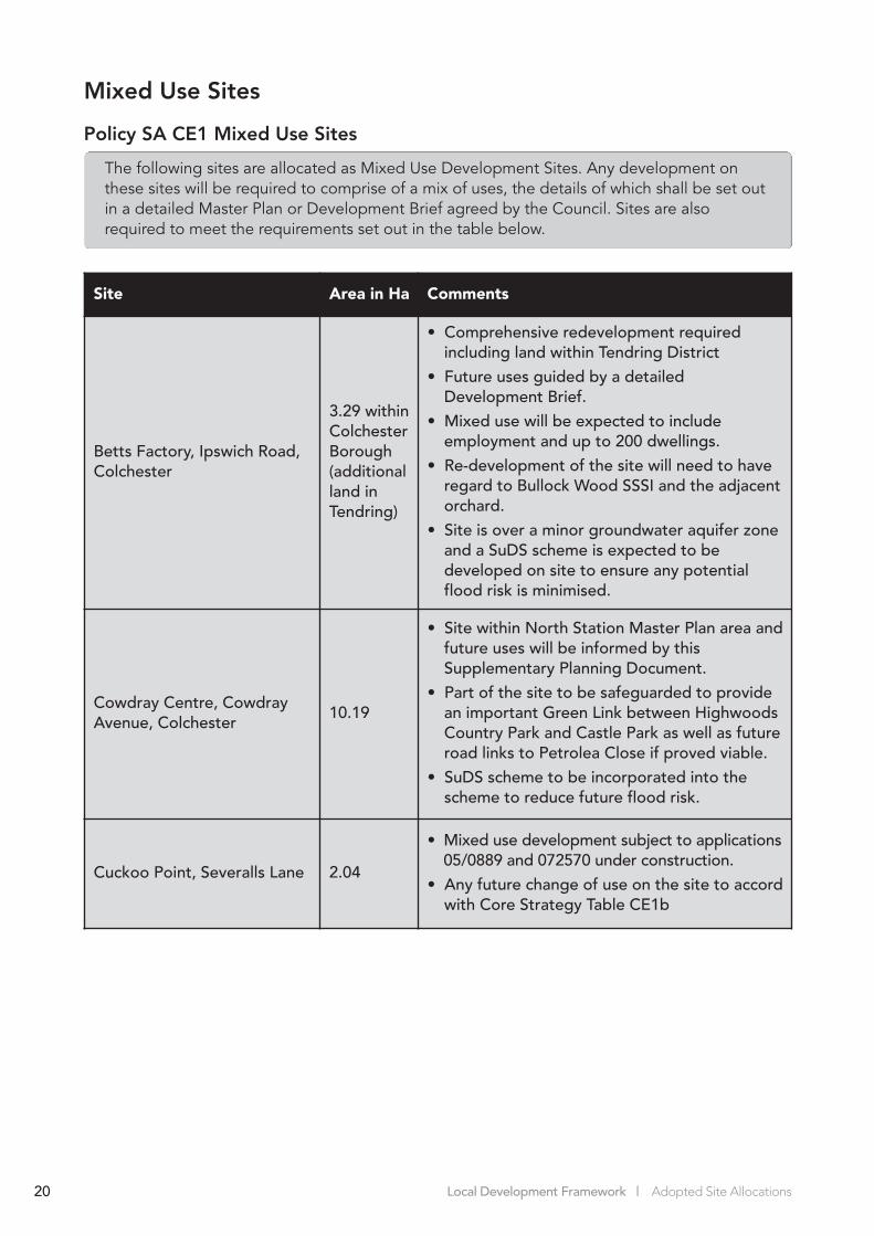
Betts Factory, Ipswich Road,Colchester
3.29 withinColchesterBorough(additionalland inTendring)
• Comprehensive redevelopment requiredincluding land within Tendring District
• Future uses guided by a detailed Development Brief.
• Mixed use will be expected to includeemployment and up to 200 dwellings.
• Re-development of the site will need to haveregard to Bullock Wood SSSI and the adjacentorchard.
• Site is over a minor groundwater aquifer zoneand a SuDS scheme is expected to bedeveloped on site to ensure any potentialflood risk is minimised.
Cowdray Centre, CowdrayAvenue, Colchester
10.19
• Site within North Station Master Plan area andfuture uses will be informed by thisSupplementary Planning Document.
• Part of the site to be safeguarded to providean important Green Link between HighwoodsCountry Park and Castle Park as well as futureroad links to Petrolea Close if proved viable.
• SuDS scheme to be incorporated into thescheme to reduce future flood risk.
Cuckoo Point, Severalls Lane 2.04
• Mixed use development subject to applications05/0889 and 072570 under construction.
• Any future change of use on the site to accordwith Core Strategy Table CE1b
Mixed Use Sites
Policy SA CE1 Mixed Use Sites
The following sites are allocated as Mixed Use Development Sites. Any development onthese sites will be required to comprise of a mix of uses, the details of which shall be set outin a detailed Master Plan or Development Brief agreed by the Council. Sites are alsorequired to meet the requirements set out in the table below.
34726 Site Allocation amended 2010:Site Allocation 1/11/10 15:01 Page 20

Centres Hierarchy
3.15 The Proposals Map shows boundaries for the hierarchy of mixed use centres set out inpolicy CE1 of the Core Strategy. The policy puts the Town Centre at the top of the hierarchyas the preferred location for new Town Centre uses including retail, offices, leisure, hotels,and entertainment uses, with Edge of Centre locations and District Centres following thesequential approach in accordance with PPS4 (Planning for Sustainable Economic Growth).The Core Strategy provides that Neighbourhood Centres as defined on the Proposals Mapwill provide shops and some other local services for the needs of residents in the localneighbourhood. Development Policies provide detail on the mix of uses and thesafeguarding of retail uses in primary and secondary town centre areas as well as moredetail on Rural District and Neighbourhood Centres.
3.16 The Proposals Map identifies the boundary for the Town Centre and is expected to be theprimary location for retail, office, leisure and entertainment uses. Further information on theallocations within this area is provided in the separate Town Centre and North Stationsection.
3.17 The Rural and Urban District Centres are outlined in the Core Strategy Table CE1a and theboundaries of these are shown on the Proposals Map. Any re-development of sites withinthese areas will have to demonstrate that they accord with Core Strategy Policy CE2b andthat they enhance the important role these Centres provide to the local community.
3.18 The Neighbourhood Centres (previously referred to in the Local Plan as local shoppingareas) vary greatly in size. The Council’s approach to their designation is that they shouldnormally include a grouping of several small units with an emphasis on retail sales.Individual shops, outside of the defined Centres, can also play a valuable role incontributing toward sustainable communities and are protected by Development PolicyDP7. Neighbourhood Centres shown on the Proposals Map include the following areas:
• Crouch Street, Christchurch• Butt Road, Christchurch• London Road, Lexden• Villa Road, Stanway• Blackberry Road, Stanway• The Commons, Prettygate• Iceni Way, Shrub End• Homefield Road, Shrub End• William Harris Way, Berechurch• Queen Elizabeth Way, Berechurch
Local Development Framework | Adopted Site Allocations 21
Site Area in Ha Comments
Napier Road (incl. Arena site) 3.85
• Mixed use development (part subject toapplication 080717.)
• Arena site to retain an element of sport andleisure use.
• Any future change of use to accord with CoreStrategy Table CE1b and the Garrison MasterPlan.
TOTAL 19.37
34726 Site Allocation amended 2010:Site Allocation 1/11/10 15:01 Page 21

• Mersea Road, Berechurch• The Willows, Berechurch• Old Heath Road, Harbour• Granville Road/Military Road, New Town• Barrack Street, New Town• Hythe Quay, New Town• Haven Road, Harbour• Hunwicke Road, St Andrew’s• Hawthorne Avenue, St Andrew’s• Bromley Road, St Anne’s• St Christopher Road, St John’s• Nayland Road, Mile End• Vine Parade, Wivenhoe• London Road, Marks Tey
Phasing and Implementation
3.19 Providing jobs for Colchester’s growing community is a central objective of the CoreStrategy. However the Council cannot deliver this employment directly, but it can protectexisting employment land, stimulate new employment developments, and accommodatenew developments at the most suitable locations. There is no specific phasing for thedelivery of employment land during the plan period.
3.20 The Council will plan, monitor and manage the delivery of employment land to ensure thata continuous supply is available to encourage employment development across theBorough.
Local Development Framework | Adopted Site Allocations22
34726 Site Allocation amended 2010:Site Allocation 1/11/10 15:01 Page 22

4. Housing
4.1 The Core Strategy outlines the Council’s overall strategic housing policies (H1 – H5) alongwith the key areas where housing will be focused between 2001 and 2023. The CoreStrategy seeks to direct the majority of housing development within identified RegenerationAreas and urban extensions to the north and south west of Colchester. The Core StrategyKey Diagram and the Settlement Hierarchy guide the overall housing distribution which isshown in Core Strategy Table H1a.
4.2 The Council’s Annual Monitoring Report has demonstrated that in recent years a very highpercentage of new housing has been delivered on previously developed land. The CoreStrategy has set Colchester an ambitious housing target but delivery in previous years hasdemonstrated that the annual requirement can be satisfactorily met. A large proportion ofthe land shown in the Housing Trajectory and in the Strategic Housing Land AvailabilityAssessment (SHLAA) is already allocated as residential or benefits from a current planningpermission for residential use which has put the Borough Council in a good position toachieve the Core Strategy target.
Strategic Context
4.3 Core Strategy Housing Objectives and Relevant Policies:
The Core Strategy identifies two main housing objectives;• Provide decent and affordable housing at accessible locations to accommodate our
growing community• Provide a range of housing options to meet the diverse needs of the whole community.
4.4 The policies in this chapter detail how the vision, objectives and policies contained in theCore Strategy will be delivered through specific sites. The most relevant policies are:• SD1 – Sustainable Development Locations• SD2 – Delivering Facilities and Infrastructure• SD3 – Community Facilities• H1 – Housing Delivery• H2 – Housing Density• H3 – Housing Diversity• H4 – Affordable Housing• H5 – Gypsies, Travellers and Travelling Showpeople
Housing Site Allocations
4.5 The Local Plan contained a series of housing allocations in order to meet the housing targetset within the Essex and Southend-on-Sea Structure Plan. These allocations ranged from largesites such as Colchester Garrison and Severalls Hospital to smaller plots of land on sites inrural locations. The vast majority of the land allocated for housing in the Local Plan was withinthe urban area of Colchester and this is an approach which has been continued in the LDF.
4.6 Each of the sites identified in the Housing Trajectory and the fifteen year supply tables inthe SHLAA will be shown as predominantly residential land on the Proposals Map. Existingresidential allocations will be carried forward from the Local Plan. Other sites identified forregeneration within the Local Plan and expected to deliver housing but without a specificresidential allocation have also been assessed and if appropriate have been allocated forfuture residential use. Examples include Rowhedge Port and sites in east Colchester. All ofthese have been assessed as part of the Sustainability Appraisal to ensure they continue tobe appropriate for residential use.
Local Development Framework | Adopted Site Allocations 23
34726 Site Allocation amended 2010:Site Allocation 1/11/10 15:01 Page 23

4.7 The Proposals Map also allocates additional, new housing sites. These have been identifiedas a result of extensive public consultation and detailed work that has been undertaken toform the comprehensive evidence base which underpins the Colchester Local DevelopmentFramework. Sites have come forward primarily through identification in the SHLAA or havebeen put forward by interested landowners/stakeholders in response to various rounds ofpublic consultation and stakeholder engagement. In accordance with PPS25, sites proposedwere subject to a sequential test to aid site selection as part of the Site Allocations process.
4.8 The Proposals Map which accompanies this document shows the land which the Councilconsiders appropriate for residential allocation to deliver the local housing targets inaccordance with the framework set out in the Core Strategy. It is not practical to list everysite within this document and it would merely repeat information contained within theHousing Trajectory and the SHLAA, which are updated annually and provide acomprehensive picture of current housing land supply. The document does however list themain sites which the Council expect to deliver housing targets. Further information isincluded in the SHLAA which is updated regularly and forms part of the Council’s evidencebase.
4.9 The Council will require that each site is developed in accordance with policies set out inthe Core Strategy and Development Policies DPD as well as any relevant SupplementaryPlanning Documents and Master Plans for specific sites. All new residential developmentproposals, not subject of an extant planning permission, will be expected to secure 35% ofnew dwellings to be provided as affordable housing in accordance with Policy H4 in theadopted Core Strategy. Small schemes below the thresholds referred to in this policy willbe expected to make an appropriate contribution toward affordable housing in accordancewith the SPD due to be adopted in 2010. All new housing will also be subject to developercontributions in accordance with the Council’s adopted guidance.
4.10 Whilst large areas are allocated as predominantly residential on the Proposals Map not allland and buildings within them are considered suitable for residential development.Examples such as community, leisure and educational buildings, allotments and playingfields should be retained for those purposes. Policies within the Core Strategy andDevelopment Policies DPD seek to resist alternative use of these sites.
4.11 Many of the housing units to be delivered over the next 15 years are within RegenerationAreas and Growth Areas. Further details relating to site allocations for these areas arecovered in the area specific sections found in this document. In addition to theRegeneration Areas and Growth Areas there are a number of other sites, listed in Policy SAH1 below, which are expected to deliver new housing. Many of the sites are underconstruction or have extant planning consents. Others are covered by adopted Master Plansand Development Briefs. Where new proposals come forward they will be consideredagainst appropriate policies in the Core Strategy and the Development Policies DPD.Planning contributions will also be sought in accordance with the Council’s adoptedguidance. There are also large areas allocated as predominantly residential on theProposals Map which are not specifically identified in the list below but where furtherresidential development may be appropriate. Planning permission will not be granted fordevelopment unless it can be demonstrated that the wastewater treatment and sewerageinfrastructure can accommodate the development within the confines of existing consents.Furthermore, the receiving environment of additional flows must be able to meet waterquality requirements in accordance with the Water Framework Directive. Anglian WaterServices and the Environment Agency will advise on this matter.
Local Development Framework | Adopted Site Allocations24
34726 Site Allocation amended 2010:Site Allocation 1/11/10 15:01 Page 24
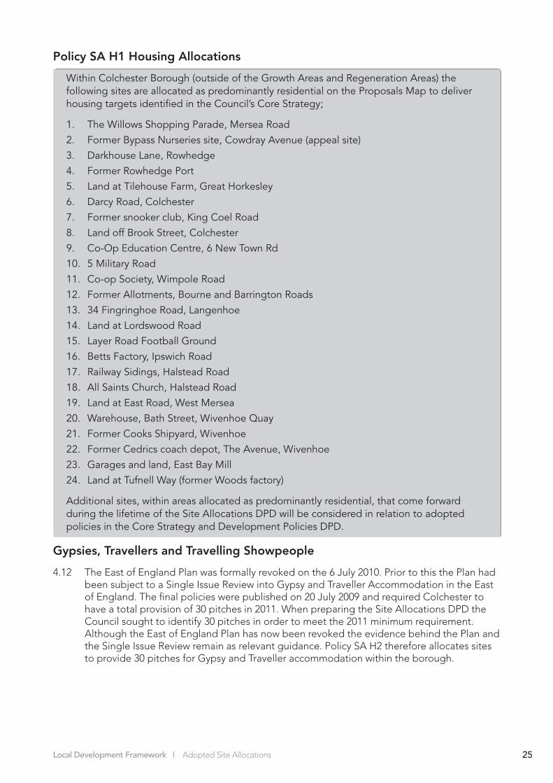
Policy SA H1 Housing Allocations
Within Colchester Borough (outside of the Growth Areas and Regeneration Areas) thefollowing sites are allocated as predominantly residential on the Proposals Map to deliverhousing targets identified in the Council’s Core Strategy;
1. The Willows Shopping Parade, Mersea Road
2. Former Bypass Nurseries site, Cowdray Avenue (appeal site)
3. Darkhouse Lane, Rowhedge
4. Former Rowhedge Port
5. Land at Tilehouse Farm, Great Horkesley
6. Darcy Road, Colchester
7. Former snooker club, King Coel Road
8. Land off Brook Street, Colchester
9. Co-Op Education Centre, 6 New Town Rd
10. 5 Military Road
11. Co-op Society, Wimpole Road
12. Former Allotments, Bourne and Barrington Roads
13. 34 Fingringhoe Road, Langenhoe
14. Land at Lordswood Road
15. Layer Road Football Ground
16. Betts Factory, Ipswich Road
17. Railway Sidings, Halstead Road
18. All Saints Church, Halstead Road
19. Land at East Road, West Mersea
20. Warehouse, Bath Street, Wivenhoe Quay
21. Former Cooks Shipyard, Wivenhoe
22. Former Cedrics coach depot, The Avenue, Wivenhoe
23. Garages and land, East Bay Mill
24. Land at Tufnell Way (former Woods factory)
Additional sites, within areas allocated as predominantly residential, that come forwardduring the lifetime of the Site Allocations DPD will be considered in relation to adoptedpolicies in the Core Strategy and Development Policies DPD.
Gypsies, Travellers and Travelling Showpeople
4.12 The East of England Plan was formally revoked on the 6 July 2010. Prior to this the Plan hadbeen subject to a Single Issue Review into Gypsy and Traveller Accommodation in the Eastof England. The final policies were published on 20 July 2009 and required Colchester tohave a total provision of 30 pitches in 2011. When preparing the Site Allocations DPD theCouncil sought to identify 30 pitches in order to meet the 2011 minimum requirement.Although the East of England Plan has now been revoked the evidence behind the Plan andthe Single Issue Review remain as relevant guidance. Policy SA H2 therefore allocates sitesto provide 30 pitches for Gypsy and Traveller accommodation within the borough.
Local Development Framework | Adopted Site Allocations 25
34726 Site Allocation amended 2010:Site Allocation 1/11/10 15:01 Page 25

4.13 The East of England Plan also required additional sites to be found for the post-2011period. Future reviews of the Site Allocations DPD will consider the post-2011 requirementsfor pitches in the light of further government guidance still to be issued. The Essex Gypsyand Traveller Accommodation Assessment (GTAA) (Fordhams, 2009) will provide importantevidence to inform any such review and currently indicates that the need for pitches in theborough is likely to be low.
Policy SA H2 Gypsy and Traveller Accommodation
The following locations are allocated for gypsy and traveller accommodation, as shown onthe Proposals Map. The sites will be considered suitable for the number of pitches listedbelow.
1. Severalls Lane, Colchester 12 pitches
2. Clearview, Rectory Road, Aldham 1 pitch
3. Colt Farm, Tiptree 2 pitches
4. Emmanuel, Kelvedon Road, Tiptree 1 pitch
5. Nunns Farm, Lower Road, Layer Breton 1 pitch
6. The Paddocks, Kelvedon Road, Tiptee 2 pitches
7. Stableview, Newbridge Road, Tiptree 2 pitches
8. Bridge Side, Turkey Cock Lane, Stanway, 3 pitches
9. Ponys Farm, Kelvedon Road, Tiptree 1 pitch
10. Land adj. to Gwynlian, Kelvedon Road, Tiptree 2 pitches
11. Orchard Place, Vernons Road, Chappel 3 pitches
Total 30 pitches
The Council will consider the need to allocate additional sites to provide for provision post-2011 in light of further government guidance. Any such review will have regard to the needidentified in the Essex Gypsy and Traveller Accommodation Assessment (GTAA) and anyauthorised pitches provided through planning applications up to that date. Core StrategyPolicy H5 provides criteria to assist in the identification of sites and determination ofplanning applications.
4.14 It has been necessary to make some assumptions with regards to pitch sizes. Existing sitesmay commonly have permission for a specific number of caravans but how many pitches thisrelates to is sometimes less clear. It is also necessary to make assumptions when estimatingthe potential number of pitches that could be accommodated by a site. The assumptionson size of pitch have been based on guidance within the Communities and LocalGovernment Good Practice Guide on ‘Designing Gypsy and Traveller Sites’ (May 2008).
4.15 This makes clear at paragraph 7.9 that there is no one-size-fits-all measurement of a pitchas, in the case of the settled community, this depends on the size of individual families andtheir particular needs. Paragraphs 7.12 and 7.13, however, specify that as a general guide afamily pitch should be capable of accommodating an amenity building, a large trailer andtouring caravan (or two trailers, drying space for clothes, and a lockable shed), parkingspace for two vehicles and a small garden area. Smaller pitches should also be able toaccommodate at least an amenity building, a large trailer, drying space for clothes andparking for at least one vehicle. A density of 1 pitch per 500sqm over a whole site hastherefore been used as a guide when estimating pitch numbers. This allows for the on-pitchand communal space required by the facilities listed in paragraphs 7.12 and 7.13 of the
Local Development Framework | Adopted Site Allocations26
34726 Site Allocation amended 2010:Site Allocation 1/11/10 15:01 Page 26
Good Practice Guide. The potential capacity, however, has also been adjusted to takeaccount of the type and character of the site, and any constraints such as existing builtdevelopment. The existing planning permission at Severalls Lane, Colchester, for example,allows for a large site with 12 caravans on plots with associated amenity buildings and hastherefore been counted as 12 pitches. The site at Gwynlian, Kelvedon Road, however,proposes 4 caravans on a much smaller site occupied by 2 families, so this has only beencounted as 2 pitches.
4.16 The pitch numbers listed in the policy attempt to reflect the maximum number of pitchesthat the site reasonably has potential to accommodate. Some sites may also have scope forfuture physical expansion, subject to planning permission, in order to meet the requiredprovision post-2011. The nature of private gypsy and traveller sites means that they cannotbe expected to viably and practically accommodate affordable units as part of the site.Social pitch provision is being developed at Severalls Lane, Colchester, as set out in CoreStrategy Policy H5 and Site Allocations Policy SA H2.
4.17 A Gypsy and Traveller Accommodation Topic Paper has been prepared which providesfurther detail on the identification and allocation of the sites.
Phasing and Implementation
4.18 Providing decent and affordable housing at accessible locations as well as a range ofhousing options to meet the diverse needs of the whole community are central objectivesof the Core Strategy and the Council’s Strategic Plan. The Council can play a key role inensuring that sufficient land is released at appropriate times in order to achieve theseobjectives. The Housing Trajectory, the Strategic Housing Land Availability Assessment andthe Annual Monitoring Report will be key components of the monitoring which will becontinually reviewed during the plan period, to ensure sufficient land is available.
4.19 The Core Strategy provides detail on targets and phasing for housing delivery andpreviously developed land further to the Council’s objectives of adding to the housingstock, making efficient use of land, and encouraging regeneration of previously developedland. It is accepted that the amount of previously developed land will reduce over the planperiod but the target for the final stages of the plan still exceeds those set nationally inPlanning Policy Statement Three: Housing.
4.20 In the period leading up to the submission of this document there was a downturn in the UKeconomy reflecting a general global financial problem. Whilst, at the point of adoption ofthe document, it appears that a recovery is underway, there remains uncertainty, anddifficulty for businesses to obtain necessary finance. This uncertainty and difficulty perhapsaffects the housing market more than some others. It is therefore essential that the Councilcan act quickly to ensure the continued delivery of an adequate number of housing units inthe Borough, certainly in advance of any necessary general review of the document. In thepolicies of this document there is generally an expectation that greenfield sites will notcome forward until after 2016, which is subject to the caveat that sites will be broughtforward if monitoring shows this to be necessary. This monitoring will need to take accountof the ‘lead’ time for development, brought about by the need for surveys, design, etc, andthe processes of development management. The Council intends to use all appropriateflexibility, particularly in the years immediately following adoption, to seek to ensure that the5 year supply of housing, and its delivery, is not interrupted by general adverse economiccircumstances.
Local Development Framework | Adopted Site Allocations 27
34726 Site Allocation amended 2010:Site Allocation 1/11/10 15:01 Page 27

5. Urban Renaissance
5.1 The Core Strategy’s Urban Renaissance policies UR1 and UR2 seek to support urbanregeneration in Colchester by revitalising key areas, enhancing its historic character andpromoting high quality design. Maximising the potential of Regeneration Areas and theTown Centre will help to stimulate the urban renaissance of Colchester by protecting thehistoric character of the Borough and ensuring high standards of urban design in newdevelopments.
5.2 Colchester is the oldest recorded town in England with evidence supporting successiveperiods of settlement from prehistoric times, through the Bronze and Iron Ages, the Romanperiod, Saxon, medieval/post medieval to the present day. Consequently the Borough has awealth of important historic and archaeological features meriting policy protection such ashistoric buildings, ancient monuments and less visible assets buried underground.
5.3 The Core Strategy along with the Development Policies DPD intends to protect the historicassets of the Borough by conservation, enhancement and protection from inappropriatedevelopment and change.
Strategic Context
5.4 Core Strategy Urban Renaissance objectives and policies:
The Core Strategy identifies two key objectives related to urban renaissance;• Revitalise rundown areas and create inclusive and sustainable new communities• Promote high quality design and sustain Colchester’s historic character, found in its
buildings, townscape and archaeology.
5.5 The following Core Strategy Policies are considered relevant:
• UR1 – Regeneration Areas• UR2 – Built Design and Character
5.6 Development Policy DP14 – Historic Environment Assets is also relevant when consideringthe Urban Renaissance of Colchester.
Historic Environment
5.7 The Planning (Listed Buildings & Conservation Areas) Act 1990 requires that Local PlanningAuthorities should designate Conservation Areas, keep designations under review andprepare proposals for preserving and enhancing these areas. Further policy guidance forConservation Areas is contained in Planning Statement 5: Planning for the HistoricEnvironment.
5.8 The boundaries of Colchester’s 22 Conservation Areas are shown on the Proposals Map.Conservation Area Appraisals for Wivenhoe and the Town Centre have recently beenundertaken and form part of the evidence base to support the Colchester LDF. Furtherreviews of the designated Conservation Areas may be undertaken as needed to ensure theboundaries are appropriate and where necessary new Conservation Areas will be created.Where detailed work is undertaken specifically with regards to Conservation Area Appraisalsthese changes will need to be formally adopted by the Council before they can be shownon the Proposals Map and become a material consideration in the planning applicationprocess. When a Conservation Area Appraisal is adopted as outlined by the Planning (ListedBuildings and Conservation Areas) Act 1990 the Council will update the Proposals Map atthe next examination to reflect the most up to date designations with the backgroundmaterial becoming part of the evidence base which supports the LDF.
Local Development Framework | Adopted Site Allocations28
34726 Site Allocation amended 2010:Site Allocation 1/11/10 15:01 Page 28

5.9 There are approximately 1700 Listed Buildings in Colchester protected through the Planning(Listed Building and Conservation Areas) Act 1990. The Borough contains a number ofGrade I, Grade II and Grade II* buildings which are an important element of Colchester’sunique heritage and contribute towards the historic character. It is impractical to show eachListed Building on the Proposals Map but the Register of Listed Buildings is a key materialconsideration in the determining of planning applications and any future proposals will haveto take account of the building’s listing where appropriate. English Heritage must also beconsulted during the application process to ensure proposals accord with the Act.
5.10 Colchester has a rich and varied history which can be dated back to prehistoric timesincluding the Roman period when Colchester (Camulodunum) was the country’s capital. Thevaried history has left an important legacy of 45 Scheduled Monuments which have beendesignated across Colchester Borough by English Heritage. Many of these have beendesignated for a number of years but in recent times new monuments have been foundincluding the Roman Circus near the Garrison which demonstrate that these are importantassets that need to be protected and preserved. The key piece of legislation protectingthese monuments is the Ancient Monument and Archaeological Areas Act 1979 and EnglishHeritage play a key role in ensuring proposals accord with this Act. The Proposals Mapoutlines Scheduled Monuments, the boundaries being set by English Heritage.
5.11 The Borough also contains four Historic Parks and Gardens which are included on theRegister of Parks and Gardens in Colchester. These sites which are shown on the ProposalsMap are graded in a similar way to Listed Buildings (Grade I-III) and are recognised for theirimportant historic interest. English Heritage plays a key role in assisting the Councildetermine any proposals which affect these sites.
5.12 In addition to the Proposals Map, further information on historic areas of the Borough canbe found in the Historic Environment Characterisation Study which provides a map-basedclassification system for different historic character areas across the Borough. The HistoricEnvironment Characterisation Study was published 2009 and forms part of the evidencebase along with the Townscape Character Study published in 2006 which also considersUrban Renaissance issues.
5.13 The Proposals Map also includes boundaries for each of the five Regeneration Areas at EastColchester, St. Botolphs, North Station, the Garrison and North Colchester which aresupported by Core Strategy Policy UR1. Further detail on these areas is provided inseparate sections later in this document.
Local Development Framework | Adopted Site Allocations 29
34726 Site Allocation amended 2010:Site Allocation 1/11/10 15:01 Page 29

Town Centre and North Station
5.14 Colchester’s historic Town Centre is the economic, social and cultural hub of the Borough.National planning policy supports focussing many types of new commercial development inTown Centres. This approach has been carried forward in the Core Strategy, which puts theTown Centre at the head of the Centres and Employment hierarchy as the favoured locationfor new retail, office, leisure and entertainment uses. The Core Strategy provides that theTown Centre ‘will be enhanced through regeneration, public realm improvements, and abalanced mix of uses that sustain activity throughout the day and evening.’
5.15 The North Station area adjacent to the Town Centre serves as a key gateway to the towngiven that it is the location of Colchester’s main train station. The Core Strategy designatesit as a Regeneration Area where priorities include improving its connectivity to the TownCentre and identifying and delivering opportunities for redevelopment of key sites forappropriate office, commercial and residential uses.
Town Centre and North Station Regeneration Area
5.16 Boundaries for the Town Centre and North Station Regeneration Area are provided on theProposals Map. The boundaries for the Town Centre were shown in the 2004 adopted LocalPlan as including the historic core and its inner and outer shopping areas. The newboundaries also include the full extent of the St Botolphs Regeneration Area and its flagshipprojects including the Firstsite art gallery, Vineyard Gate shopping centre, the CulturalQuarter, public transport facilities, and new Magistrates Court. The North Station areacomprises the station and surrounding area, North Station Road (which links the station tothe Town Centre), Turner Rise retail park, and the Cowdray Centre commercial area.
5.17 The Core Strategy provides that consideration of proposals for new development will haveregard to the Centres Classification and Hierarchy in the Core Strategy (Table CE1a). Inaccordance with the sequential approach provided in national policy, the Town Centre is at thehead of the Centres hierarchy, followed by edge of centre locations at the Urban Gateways(North Station, Colchester Town Station and Hythe Station) and the Town Centre fringe.
5.18 Further guidance for the enhancement and development of these key areas will be providedin an Area Action Plan for the Town Centre as well as in a Supplementary Planning Documentfor the North Station area. Detail on Town Centre uses will be provided in the DevelopmentPolicies DPD, which contains a policy guiding the appropriate balance of retail and otheruses in Inner and Outer Core Areas and the surrounding Town Centre mixed use areas.
Strategic Context
5.19 The policies in this chapter detail how the vision, objectives and policies contained in theCore Strategy and other documents will be applied to the Town Centre and North Station.
National Policy
5.20 PPS4, Planning for Sustainable Economic Growth, provides that local planning authoritiesshould ‘set out a strategy that positively and proactively encourages economic growth’including identifying centres and defining the extent of the primary shopping area.
Local Development Framework | Adopted Site Allocations30
34726 Site Allocation amended 2010:Site Allocation 1/11/10 15:01 Page 30
Core Strategy
5.21 The most relevant policies are:
• SD1 Sustainable Development Locations• SD2 Delivering Facilities and Infrastructure• SD3 Community Facilities• CE1 Centres and Employment Hierarchy and Classification• CE2a Town Centre• UR1 Regeneration Areas• UR2 Built Design and Character• PR2 People-Friendly Streets • TA1 Accessibility and Changing Travel Behaviour• TA2 Walking and Cycling• TA3 Public Transport• TA4 Roads and Traffic• TA5 Parking
Development Policies
5.22 The most relevant policies are:
• DP1 Design and Amenity• DP6 Colchester Town Centre Uses• DP14 Historic Environment Assets• DP17 Accessibility and Access • DP18 Transport Infrastructure Proposals• DP19 Parking Standards
Sustainability Appraisal
5.23 The Town Centre was identified as a Growth Area in the Core Strategy. The preferred policyoption sought to direct development towards accessible and previously developedlocations, and to encourage regeneration. The Sustainability Appraisal for the Core Strategydetermined that the preferred option would actively enhance the Town Centre and keyGateways and therefore help to develop a prestigious regional centre.
5.24 The Sustainability Appraisal accompanying the Site Allocations DPD has looked in detail atthe significant sites within the Town Centre and North Station area being proposed formixed use housing and commercial development. Sites within the Town Centre and NorthStation area are in accordance with the encouragement of compact and mixed usedevelopment at accessible locations.
General Development Principles
5.25 It is important to note that all policies contained within this chapter must be read alongsidethe Development Policies DPD. This document sets out the standard planning criteriaapplicable to all forms of development. The relevant criteria will be used to assess thesuitability of any proposal in addition to the following detailed policy guidance.
Local Development Framework | Adopted Site Allocations 31
34726 Site Allocation amended 2010:Site Allocation 1/11/10 15:01 Page 31
5.26 The allocations for the Town Centre and North Station area made in the Site Allocationsdocument reinforce the importance of the Town Centre as the preferred location for newoffice, retail and cultural/leisure facilities. Allocations for new development, however, aremade in the context of the need to preserve and enhance the centre’s rich historicresources. Congestion will need to be managed through a combination of measures thatinclude provision of excellent walking and cycling facilities, reducing through traffic, andmanaging parking to accommodate sufficient short stay spaces while promoting alternativesto help address the demand for long stay parking.
Policy SA TC1 Appropriate Uses within the Town Centre and North StationRegeneration Area
Within the Town Centre and North Station Regeneration Area as shown on the ProposalsMap the following mix of uses will be considered acceptable. These levels of developmentshould not be considered prescriptive but a guide to inform development proposals.
Residential (minimum number of homes 2001-2021) – 2000
Employment;
- 67,000 sqm (net) retail floorspace
- 40,000 sqm (gross) office floorspace
- Up to 390 hotel rooms
This development will be accommodated as follows:
1. Mixed Use – The following areas have been specifically designated for mixed use, ie. amixture of residential and commercial uses. Proposals for single uses will be evaluatedfor their contribution and effect on the overall mix of uses in the area. Further detail onappropriate uses for specific sites will be provided through Master Plans and/or theTown Centre Area Action Plan:
i. Area of the Town Centre specifically designated as ‘Town Centre Mixed Use’ –Selected streets leading to the heart of the Town Centre and adjacent to the retailcore are designated as ‘Town Centre Mixed Use’ on the Proposals Map where arange of residential, shopping, office and appropriate leisure uses are supported.
ii. Cowdray Centre – The Cowdray Centre is designated for ‘Mixed UseRedevelopment’. This should provide a range of uses within the categories of retail,residential, leisure, hotel, and employment. The residential element shall compriseno more than 50% of the site area and existing businesses will be encouraged toremain. Development of the site should also deliver improved connectivity to theTown Centre and North Station for vehicles (especially public transport), pedestriansand cyclists; and a green link between Highwoods Country Park and LeisureWorld/Castle Park. In addition land should be safeguarded for a potential futurevehicular link under the railway to Turner Rise.
iii. Turner Rise – The retail park at Turner Rise is designated as a Urban District Centrein the Core Strategy. As detailed in Core Strategy Policy CE2b proposals for newdevelopment should provide an improved public realm, urban character and amore diverse mix of uses.
2. Residential - Upper floors in appropriate Town Centre Mixed Use developments andinfill sites in the Town Centre fringe and North Station Master Plan area will help deliverthe Council’s housing targets.
Local Development Framework | Adopted Site Allocations32
34726 Site Allocation amended 2010:Site Allocation 1/11/10 15:01 Page 32
Specific sites programmed to deliver the housing identified in the Core Strategy include thefollowing sites (at 1.4.08):
• 36-40 Crouch Street
• Former Jarmin Road Depot
• East Lodge/Central Clinic, East Hill
• Mercury Flats, Balkerne Gardens
• Sites in Clarendon Way
• 101-104 High Street and 6-12 Museum Street
• 21 St Peters Street
• 2 Queen Street and 1-5 Culver Street East
• Former St. Mary’s Hospital
• Sites within the Cultural Quarter, St. Botolphs
• The Cowdray Centre, Cowdray Avenue
• Former Britannia Works site
• Land at Middle Mill, St. Peters Street
3. Employment-
i. Retail – new retail proposals will be focused in the Inner and Outer Core of theTown Centre, including Vineyard Gate (approx 55,000 sqm. gross). Local retailfacilities will be concentrated in St. Botolph’s (Queen Street), Crouch Street andNorth Station Road.
ii. Office development will be concentrated in the Town Centre and North StationMaster Plan area
iii. Hotels – the preferred sites for new hotels are St. Botolphs/Cultural Quarter. Thereis scope for additional provision at edge of centre/out of centre sites.
All new development will be expected to contribute to the enhancement of infrastructure,travel plans, public realm, streets and open spaces.
5.27 Uses within the Town Centre will be further defined by the work detailed below, with thegeneral support for mixed uses tailored to ensure that future development builds on thestrengths of existing uses and local character. The Master Plan for the St. Botolphs area, forexample, provides for a Cultural Quarter to the east of the Town Centre core underpinnedby the new Firstsite art gallery, while retail uses are focused in the core areas of the TownCentre. The Council is giving careful consideration to the balance of uses in the TownCentre to maintain levels of street activity throughout the day and evening as well aspreservation of amenity and character. This is to be achieved through traffic managementand public realm improvements as well as by directing new development to the mostappropriate locations for different uses. Town Centre sites are the most sustainablelocations for new hotel capacity, but a Hotel Study commissioned by the Council has alsoidentified potential edge of centre and out-of-centre sites at SheepenRoad/Middleborough and the Cowdray Centre which could provide capacity if a TownCentre site was unavailable. Residential uses will be supported where compatible withsurrounding uses, in particular in new mixed use developments and in order to bring upperfloors back into use. Upper floors of commercial premises may also be appropriate for officeuse. The Development Policies DPD provides more detailed guidance on the appropriatepercentage of retail uses within primary and secondary shopping areas of the Town Centreas well as criteria for judging appropriate uses in the surrounding mixed use areas. Theboundaries for these areas are illustrated on the Proposals Map.
Local Development Framework | Adopted Site Allocations 33
34726 Site Allocation amended 2010:Site Allocation 1/11/10 15:01 Page 33

5.28 The North Station Master Plan will refine the preferred uses for specific areas within theNorth Station Regeneration Area. In general, mixed commercial and residential uses areconsidered appropriate for the area given its good links to rail and bus transport and itsproximity to the Town Centre. The Core Strategy identifies it as a preferred location to helpdeliver 40,000sqm of office space. The Cowdray Centre and Turner Rise are identified asspecific sites for mixed use (Core Strategy Tables CE1a and b.) The Council values existingbusinesses within the Cowdray Centre and will look to retain or relocate them within anyredevelopment proposals.
5.29 Design for new development within the Town Centre and North Station Regeneration Areashould result in sympathetic high quality designs which create active street frontages andcontribute to the enhancement of the public realm in line with appropriate Core StrategyPolicies and the Development Policies DPD.
Key Areas within the Town Centre and North Station Growth Area
5.30 General guidance for key areas will be supplemented by more detailed Master Plans andguidance as follows:
5.31 Town Centre – An Area Action Plan for the Core Area and St Botolphs quarter of the TownCentre is proposed, providing a comprehensive approach to the phasing and delivery of anumber of projects and strategies for the area which include:
• Public Realm Strategy – This will provide a unified approach to streetscapeimprovements, lighting, landscaping and frontages.
• Historic Town Centre Improvements – The Council, in partnership with the County Counciland transport operators, is developing a co-ordinated plan for traffic management andimprovements to public transport, pedestrian and cyclist facilities for the Core Area of theTown Centre. Cycle improvements will be developed in line with the Colchester CyclingTown Strategy. The work will also look at using ‘smarter choices’ travel plan techniques tochange travel behaviour assist in management of traffic and make best use of thetransport infrastructure.
• Further detail on the guidance provided in the Development Policies DPD on specificappropriate uses within the Inner and Outer Core Areas of the Town Centre and TownCentre fringe (including St Botolph’s).
5.32 St. Botolph’s – A Master Plan for the south-east area of the Town Centre was adopted bythe Council in 2005 as Supplementary Planning Guidance and has provided the foundationfor the phased enhancement and mixed use redevelopment of the area. The Area ActionPlan noted above will provide an opportunity to revisit the Master Plan and adjust elementsof it to account for changing circumstances and new approaches to the coordinateddelivery of public realm and transport infrastructure. Key projects for the area include:
• Firstsite Building – community arts centre• Berryfields Park – new open area behind Firstsite and the Town Wall• Cultural Quarter – includes creative business hub, hotel, retail, residential and restaurants• Public space enhancement at St Botolph’s Priory ruins• New Magistrates building• Vineyard Gate retail development including provision of a new pedestrian/cycleway
bridge across Southway• Public transport facilities including improvements to Colchester Town Station and
replacement facilities for the bus station• Redevelopment of Britannia car park for low carbon housing • Magdalen Street Multi Storey Car Park to reinstate parking capacity lost during
regeneration.
Local Development Framework | Adopted Site Allocations34
34726 Site Allocation amended 2010:Site Allocation 1/11/10 15:01 Page 34

5.33 North Station – A Master Plan is currently under development and scheduled to beadopted as a Supplementary Planning Document in 2010. The vision for the area is to createa welcoming ‘front door’ to the Town, set within a balanced mix of uses focused around fourdistinct places:
• North Station Gateway: The main station providing rail links to London and beyondcurrently suffers from poor visual and physical connectivity to the Town Centre. TheMaster Plan considers potential enhancement to the station forecourt area, ways toincrease access and visibility of the Victorian era southside building and improvements toconnectivity between the station and the Town Centre. The train operating company willmake investment in the station through the National Station Improvement Programme(NSIP) with funding from the Cycling Town Strategy. In partnership with ECC and NationalExpress East Anglia a Station Travel Plan has been developed to promote rail use andencourage rail users to come to and from the station by more sustainable means of travel.
• Cowdray Centre: The Cowdray Centre is currently a mix of commercial uses separated byvacant land created by the demolition of fire damaged industrial buildings. This keyredevelopment site provides an opportunity for a mixed use office, commercial andresidential area supported by improvements to the road network andpedestrian/cyclist/public transport access to the Town Centre.
• Turner Rise: The Master Plan addresses possible options for ways to better integrate thiscar-dominated big box retail development into the surrounding area.
• North Station Road and Station Way: The Master Plan seeks to change and modify thestreet environment around the station and road junctions to rebalance the prioritybetween the car and other road users; create a strong “welcome” to Colchester and byremoving the barriers encourage use of more sustainable modes of travel, as well asaccommodate growth in North Colchester. North Station Road serves as both a keypublic transport, walking and cycling link from north Colchester and the station to theTown Centre as well as a neighbourhood shopping centre. The Master Plan identifiesopportunities to redevelop key sites and to improve the public realm.
Delivery and Implementation
5.34 Colchester Borough Council’s Regeneration team is responsible for guiding the delivery ofkey projects in the five Regeneration Areas, including the St. Botolph’s area of the TownCentre. The Council is working in partnership with a number of other organisations asfollows to progress a co-ordinated programme of enhancement and development:
1. Essex County Council – Measures to reduce Town Centre traffic are under developmentwhich provide for comprehensive traffic management, as well as improvements to publictransport and cycling/pedestrian improvements to support the Town Centre’s vitality. Thework will look at using “smarter choices” travel plan techniques to change travelbehaviour, assist in management of traffic and make best use of the transportinfrastructure. Consultation will take place with transport providers and Town Centreusers, including the Cycling Town Partnership, and businesses.
2. Developers – The Council seeks to ensure that a corporate and interdisciplinaryapproach is applied to working with developers on major schemes. Dedicated projectteams are led by the Regeneration Team to coordinate Council action and helpimplement development. Contributions will be sought from developers to fundinfrastructure, public realm and travel plans.
3. Town Centre businesses – The Council’s Enterprise and Regeneration Team works closelywith both individual businesses and business associations such as the Chamber ofCommerce.
Local Development Framework | Adopted Site Allocations 35
34726 Site Allocation amended 2010:Site Allocation 1/11/10 15:01 Page 35

4. Statutory and other stakeholders – Colchester’s prominence as an historic town meansthat the involvement of English Heritage is an essential element of Town Centredevelopment. The Council also seeks guidance from Inspire East, via their Design ReviewPanel sessions, on proposals from developers or third parties. The Environment Agencyis a key consultee for Town Centre fringe developments in areas at risk of flooding.
5. Network Rail and the Train Operating Company – these two bodies have been closelyengaged in the development of the North Station Master Plan. They have influenced theplan, and are to make investment in the station to make it more welcoming. Initialinvestment is to be made through joint National Station Improvement Programme andCycling Town funding. Further enhancements will need to be funded throughprivate/public sector funding.
Local Development Framework | Adopted Site Allocations36
34726 Site Allocation amended 2010:Site Allocation 1/11/10 15:01 Page 36

East Colchester Growth and Regeneration Areas and theUniversity of Essex
5.35 This area of Colchester has experienced considerable change in recent years. Largeresidential schemes have been built, are under construction or have been granted consentand a number of commercial developments have also been built including B&Q and smallerpremises.
5.36 Despite all this activity, much remains to be done in the area. Many former industrial sitesstill lie dormant and there are problems of pollution and environmental decay at the Hythe.Through traffic levels remain high and alternative transport options and traffic managementmeasures need to be introduced, particularly to help with improving public transport. By theend of the plan period it is expected that approximately 2600 new homes will have beenbuilt in East Colchester. Plans for the University Knowledge Gateway are also at anadvanced stage.
East Colchester Regeneration and Growth Areas
5.37 These areas are defined on the Proposals Map and include the large industrialredevelopment area along the Hythe riverside together with the former commercial quaysand land adjacent to the University, including the Knowledge Gateway. The future academicexpansion of the University itself is just outside the Growth Area but a policy covering thedevelopment is included within this section.
Strategic Context
Core Strategy
5.38 The policies in this chapter detail how the vision, objectives and policies contained in theCore Strategy will be applied to East Colchester. The most relevant polices are;• SD1 Sustainable Development Locations• SD2 Delivering Facilities and Infrastructure• SD3 Community Facilities• CE1 Centres and Employment Hierarchy and Classification• CE3 Employment Zones• H1 Housing Delivery
Sustainability Appraisal
5.39 Redevelopment in East Colchester will contribute to the regeneration objectives for thisarea and the Borough’s housing and employment figures. Regeneration of brownfield siteswill reduce the need for development on greenfield land, which will help to protectlandscape character. The area is currently untidy and underused; redevelopment willimprove the character, appearance and attractiveness of the area. There are a number ofservices and facilities already in the area which can be enhanced through furtherdevelopment and the Town Centre is approximately 1.5 km away. There is good access toemployment, education and food retail facilities. Hythe railway station has been upgradedto allow 12 car trains to stop, allowing a more frequent train service to the area, enhancingaccess for people to and from the area. There are frequent bus links to the Town via anumber of routes which go on to serve the University and the major residential area ofGreenstead.
Local Development Framework | Adopted Site Allocations 37
34726 Site Allocation amended 2010:Site Allocation 1/11/10 15:01 Page 37

5.40 A significant part of the area is within Flood Zone 3, where there is a high probability offlooding. The sequential test has been applied within the Regeneration Area and hasdemonstrated that there are no reasonably available alternative sites in areas of lower flood riskand so development is acceptable in principle. Residential uses should be directed to upperstoreys and commercial development should be included on the ground floor. Flood RiskAssessment will be required for all development proposals which will need to demonstrate thatdevelopment will not increase flood risk and that safe access and egress can be provided.
5.41 Land has been allocated for expansion of the University of Essex. Despite being greenfieldland, this option makes efficient use of land in that it retains all University buildings togetherat one location close to the other academic departments, student facilities and services.This can help reduce the need to travel and dependency on the private car as the primarymode of travel. This will prevent the need to allocate other areas of land at alternativelocations in the Borough. Allocating the site will help support Core Strategy employmenttargets and improve educational opportunities by increasing the range of courses availableat the University. Landscape and biodiversity enhancements will be importantconsiderations in any future planning application for the site and the proposal mustdemonstrate how the impact of settlement coalescence has been minimised.
General Development and Design
5.42 It is important to note that all policies contained within this chapter must be read alongsidethe Development Policies DPD which sets out the standard planning criteria applicable toall forms of development. The relevant criteria will be used to assess the suitability of anyproposal in addition to the following detailed policy guidance.
5.43 The Local Plan sought the creation of a suitable balance and mix of appropriate uses in alldevelopments in the East Colchester Regeneration Area. Although it is still desirable toachieve a mix of uses and a sustainable new community the previous approach was notsuccessful. It applied to all individual sites and did not take account of the highdevelopment costs in the area and a lack of market demand for commercial premises.
5.44 A more pragmatic approach will be taken in the Site Allocations DPD which recognises therole of Whitehall Industrial Estate and the future University Knowledge Gateway asproviding the main centres of employment in the area. There is however a place for usesother than residential and these will be actively encouraged. The flood risk requirements willalso ensure that a satisfactory overall balance of uses is achieved by preventing residentialuses on ground floors in higher flood zone areas (See ‘Making Space for Water’, DEFRA).Flexibility in planning for areas of brownfield land prone to flooding will be built in to allowfor adaptation over time and to respond to changing conditions - e.g. time-limitedpermissions, the inclusion of flood resilience measures in building designs and siteallocations according to risk. Planning for flood risk (both fluvial and from surface runoff) andclimate change management is better provided at a Master Plan stage, where developmentlocation, use, layout and design can be organised according to risk and certainly prior to thesubmission of any planning application. As part of this requirement to promote mixed useschemes, the following types of development will be required or promoted in the area:
5.45 Housing – In recent years there has been a high proportion of flatted developments in theEast Colchester area. In future a more balanced mix of type, size and tenure will be requiredin accordance with the Strategic Housing Market Assessment.
5.46 The Core Strategy identifies that approximately 2600 new dwellings will be built in EastColchester between 2001 and 2021. A number of developments have been completed, suchas Albany Gardens and the remaining sites identified below are shown on the ProposalsMap as being allocated for predominantly residential or mixed use purposes. There areother smaller areas allocated as predominantly residential on the Proposals Map. They arenot specifically listed below but may be acceptable for additional housing.
Local Development Framework | Adopted Site Allocations38
34726 Site Allocation amended 2010:Site Allocation 1/11/10 15:01 Page 38

Policy SA EC1 Residential development in East Colchester
Residential development should be located beyond the flood risk area where possible, andshould demonstrate wider sustainability benefits. Layouts that encourage walking andcycling, architecture adaptable to flooding, and other solutions for flooding reduction, e.g.green roofs and SuDS should be designed for each development site, to suit the context.
The following sites will deliver housing in accordance with the Core Strategy. Sites andfigures are indicative and represent estimated capacity or number of units outstanding at1.4.08 and shown in the housing trajectory and SHLAA;
1. Bridge House, Hythe Quay2. Former Timber Dock and adjacent sites, Hythe Quay3. Garden House, Hythe Quay4. King Edward Quay5. Paxmans Social Club, Hythe Hill6. 28 Hythe Quay7. 26 Hythe Quay8. 30 Barrack Street (Bugle Horn)9. Land to North of Magdalen St. 10. Paxmans/Man B&W, Port Lane11. University, Salary Brook Meadow12. Aim Hire, Hawkins Road 13. Land in Hawkins Road14. Ballantyne Centre/Land Hawkins Rd 15. Jewsons, Hawkins Road
5.47 Commercial – retail, industrial and offices – The Hythe area has long been the location fortraditional industries, many associated with the former port operations. Whilst these usesremain valuable, especially for local employment, they are unlikely to attract the necessaryeconomic and environmental benefits required for the regeneration initiative. Proposals forsuch types of industry are therefore likely to be directed to the Whitehall Road EmploymentZone where there remain undeveloped sites. There are also smaller employment allocationsshown on the Proposals Map at Lightship Way, Hythe Quay and Colne Causeway. Within theRegeneration Area small and medium sized commercial units will be encouraged to provideemployment and local services and facilities for residents. Small-scale community-basedfacilities could complement mixed use schemes throughout the area. Uses such as cafés,restaurants, galleries and clubs would also complement the objectives of the RegenerationArea, especially along the riverside. To be compatible with national policies and the CoreStrategy, no further major retailing is to be allocated within the area within the plan period.Local, small-scale shopping facilities however, would benefit the area and will beencouraged. These should be aimed at local shopping trips or linked to water recreationproposals. Areas within Flood Zone 3 (King Edward Quay and adjacent sites) shouldaccommodate less vulnerable uses, e.g. offices, retail, civic, commercial and industrial,which provide a good means of integrating with other uses in this area and ensuring activefrontages at ground floor level. Buildings within this area should be water resilient, waterresistant or elevated, and provide a degree of flexibility for adaptation to climate changeand flood risk over time. Care will be taken to ensure the overall retail and leisure provisiondoes not prejudice the Town Centre as the main retail and leisure focus of the Borough.
Local Development Framework | Adopted Site Allocations 39
34726 Site Allocation amended 2010:Site Allocation 1/11/10 15:01 Page 39

5.48 Leisure – This range of uses could make a major contribution to the regeneration objectivesfor the area. East Colchester is in need of an urban park/public space as a major communityfacility and a focus for the area. A multi-functional space incorporating soft and hardlandscaping and indoor/outdoor sports and recreation facilities is planned for the area andis expected to be delivered during the lifetime of the plan. Sports-based leisuredevelopment – to provide for such facilities as indoor tennis, cricket, and football –requiring large buildings, may be suitable on large sites within substantial areas allocatedfor mixed use developments, subject to design/townscape requirements.
5.49 The river itself will provide a major opportunity for leisure use and associated development,which it is intended to promote as far as practicable and environmentally desirable. Theriver also provides an opportunity to improve and develop the Borough’s Strategic GreenInfrastructure network. Developments which abut the river, will be expected to includeprovision for such development or indicate how they will contribute towards the promotionof river-based recreation.
5.50 The existing network of pedestrian/cycle green links will be improved and extended tofacilitate and improve accessibility within the East Colchester Growth Area and beyond.Extending these links to the improved King Edward Quay, the regenerated Hythe Stationand all the way to the Town Station and Rowhedge will encourage a transportation modalshift, healthy lifestyles and will attract leisure users to the area.
5.51 The Colchester Cycling Town Delivery Strategy (October 2008) identifies this area as fallinginto the Wivenhoe/Greenstead and Garrision/Rowhedge sectors. The National CycleNetwork uses the Wivenhoe Trail to link together Wivenhoe, the University, the Growth Areaand the Town Centre. There is a mix of segregated on and off road routes. Internal cyclelinkages rely mainly on unsigned residential roads and improved connections to theNational Cycle network are required. The Cycling Town strategy seeks to improve theconnectivity and facilities to the Hythe Railway Station.
5.52 Community uses – These types of uses will be important in enabling community activity totake place especially where that activity meets the needs of the local community, createscommunity cohesion, and enables volunteering and community led activity to thrive. Theywill also be important in enabling agencies to deliver their services locally especially wherethose services meet the needs of the local community. An existing community centre hasbeen built and is well established within the area but during the lifetime of the plan thisfacility is likely to need extending to meet increased demand. Additional provision can bemet in community halls; youth centres; converted houses, flats or shops; scout huts or halls;or rooms attached to faith, school or medical buildings. Development proposals will beexpected to show how they will provide or make satisfactory contribution towards them.
Local Development Framework | Adopted Site Allocations40
34726 Site Allocation amended 2010:Site Allocation 1/11/10 15:01 Page 40

Policy SA EC2 Development in East Colchester
Development within the East Colchester Regeneration and Growth Area will be permittedprovided it complies with all the relevant key criteria, as set out below:
1. All developments shall provide for a balanced and integrated mix of uses that arecompatible with the comprehensive regeneration of East Colchester as set out in theCore Strategy.
2. In and around areas of flooding (Flood Zone 2&3) uses should be organised accordingto risk, to provide good flood risk management, to create a greater flexibility foradaptation over time, and to respond to changing conditions. Less vulnerable, morevulnerable, essential infrastructure and water compatible uses could be accommodatedwithin these flood zones.
3. Development of sites fronting the river will be expected to include uses which attract asignificant number of people including visitors, residents or workers. Public access tothe riverside should be provided so as to create a continuous riverside walkway andcycleway.
4. Contributions will be required from all developments towards the provision ofinfrastructure and/or environmental improvements as mentioned in this chapter and theCore Strategy. Where contributions have already been made in respect of a particularsite, the size and type of those contributions will be taken into account in determiningwhat additional contributions, if any, are required in connection with further phases ofdevelopment. There are several planning contributions which are specific to EastColchester. Where appropriate, contributions will be sought to address the following;
a. Works to enhance the river environment and create full public access to riversideareas. This will involve the provision of public pedestrian rights of way withindevelopment sites fronting the river. Schemes will be required to be designed toprovide such access in attractive environments with the aim of creating a continuousfootpath and cycleway as well as an attractive area for sitting. Contributions will alsobe sought towards the delivery of a comprehensive network of footpaths andcycleways across the whole of East Colchester.
b. Public transport improvements including the East Transit Corridor.
c. Environmental enhancements in the form of urban improvements, natureconservation and landscape measures to improve green links through the area.
d. The creation of an urban park.
5. All applications for development will be required to include, where appropriate; atransport impact assessment; flood risk assessment; proposals to provide and/orenhance infrastructure for the community or the environment; proposeddecontamination measures.
Proposals which it is considered would not support, or would prejudice, the objectives of theRegeneration or Growth Area will be refused.
Key Areas within the Regeneration and Growth Areas
5.53 Within East Colchester, certain key areas are defined which will make major contributions tothe area’s future development. The following policies set out specific requirements for theseareas, particularly with regard to land uses, transport and enhancement measures.
Local Development Framework | Adopted Site Allocations 41
34726 Site Allocation amended 2010:Site Allocation 1/11/10 15:01 Page 41

Area 1: Former Timber Dock and adjacent sites
5.54 This site was originally the focus of shipbuilding at the timber dock and yards, when theHythe operated as a port. The area now comprises some industrial buildings, a scrap yard,and the former gas works. Part of the site near Haven Road and Hythe Quay is within FloodZone 3 and is also prone to surface runoff flooding. There are significant topographicchanges, generally with land sloping down from the west to the east. There is a network offootpaths linking to the wider area in a north-south and east-west direction.
Land Uses
5.55 Development will be required to provide for a mix of uses to include housing, together withsmall-scale commercial and community facilities to serve local needs (in the flood zone andaccessible from the main roads). The development shall have regard to the character of thesite and its setting in the Hythe. All development will be expected to contribute towardsinfrastructure and environmental enhancements. The East Colchester transit link is shownthrough the site, and there is also a desire line for pedestrian/cycle movement.
Enhancement measures
5.56 The existing network of pedestrian/cycle green links through the area will be improved andextended to facilitate and develop accessibility across and within the area. Green linkconnections between the various residential developments, the future urban park, thecommunity centre, Hythe Station and the University of Essex should be facilitated for thebenefit of existing and future residents in East Colchester and adjoining areas. The existinggreen/wildlife corridor from Distillery and Bourne Pond Local Wildlife Site will bestrengthened and extended through new and improved green links.
Policy SA EC3 Area 1: Former Timber Dock
Within Area 1, development will be required to provide for a mix of uses to include housing,small-scale commercial and community uses. Development must have regard to thecharacter and context of the site, and provide a contribution to infrastructure provision andenvironmental enhancements, including green links and the urban park.
Area 2: King Edward Quay, Coldock and adjacent sites
5.57 This area formed the old core of Colchester Port, but commercial use of the quays has nowceased. The surrounding area is a mix of small traditional industrial uses but a number ofsites are vacant, derelict, or contain unsightly uses which would need to be redeveloped orrelocated to promote the overall regeneration objectives. For any industrial uses whichremain, e.g. the electricity transformer site, the relationship with new development will beimportant, and uses which provide a suitable interface to those should be encouraged.
5.58 Most of this area lies within Flood Zone 3 which poses constraints to the use and nature ofnew developments. To provide for the most effective way of dealing with risk from flooding,developments within this area should accommodate less vulnerable uses, e.g. offices, retail,civic, commercial and industrial. These uses also provide a good means of integrating withresidential uses in this area. Buildings within this area should be water resilient, waterresistant or elevated, and provide a degree of robust flexibility for adaptation to climatechange and flood risk environment over time. Residential development should be restrictedto upper levels in Flood Zones 2 and 3a. Parks, recreation areas and public spaces can besituated within the Flood Zone 3 as they are less vulnerable to flood risk, are watercompatible, and provide a valuable flood storage function as well as a good means ofintegrating with other uses in this area.
Local Development Framework | Adopted Site Allocations42
34726 Site Allocation amended 2010:Site Allocation 1/11/10 15:01 Page 42
5.59 Of particular importance will be the relationship of development to the river both in visualand use terms. Small-scale leisure, business and community uses will be preferred, althoughresidential and small-scale retail/service uses (to serve the local area only) may also beacceptable. Landmark buildings of more significant height will be appropriate to mark theentrance gateway at Colne Causeway and the termination of the site at Coldock.
5.60 The quay surface and part of the river wall have been regenerated, with new block paving,lighting and seating to create quality public open space, and set an exemplar fordevelopments which will front the quay. The quay itself remains public highway with a speedlimit of 30mph, and it is likely that this status will need to change to facilitate developmentalong the river frontage, although a public right of way on foot and on bike, at least, wouldneed to be retained.
5.61 The existing network of pedestrian/cycle links should be improved and extended tofacilitate and improve accessibility across and within the area and to facilitate a modal shift.Green link connections between the various developments fronting the river, the futureurban park, Hythe Station, Rowhedge and the University of Essex should be facilitated forthe benefit of existing and future residents in East Colchester and adjoining areas.Development adjacent to the river front will be expected to provide a continuous footpathand cycle route linking to Rowhedge and contributions from other developments in thevicinity will help facilitate this. Pedestrian/cycle bridges across the river will be encouragedto facilitate a better integration of the area.
5.62 Developments in this area will be expected to contribute proportionately towardsinfrastructure and environmental enhancements. Flood Zone 3 would be a suitable locationfor a minimum of 2.5 acres/1 hectare of urban multi-functional space incorporating soft andhard landscaping and indoor/outdoor sports and recreation facilities. This space should berobustly designed to accommodate more frequent and higher volume floods in the futurewith minimal maintenance. Parking can also be accommodated, but should be incorporatedcreatively so that it does not dominate the space.
Policy SA EC4 Area 2: King Edward Quay
Within Area 2, development will be required to provide for a mix of leisure, business andcommunity uses. Residential uses will also be appropriate on upper floors and small-scaleretail and service uses can also be provided. Contributions to infrastructure provision andenvironmental enhancements will be sought from new developments. In addition to genericBorough wide requirements, contributions will also be sought towards the following localinfrastructure;
• Public urban park,
• Improved green links and pedestrian/cycle routes.
Local Development Framework | Adopted Site Allocations 43
34726 Site Allocation amended 2010:Site Allocation 1/11/10 15:01 Page 43

Area 3: Magdalen Street
5.63 A number of recent developments, such as housing and the Foyer Project, together with theabandonment of the Eastern Approaches road, have begun the process of regeneration. Anew food store has been built which partly addresses a need for local shops identified in theLocal Plan. Any further retail development proposed shall be of a scale to serve the localarea only and shall not prejudice other nearby local shopping centres.
5.64 The Site Allocations DPD seeks to continue these initiatives by consolidating and extendingthe residential area to the north of Magdalen Street and retaining the mix of small-scalecommercial and local service uses elsewhere.
5.65 One of the main issues in this area is the high volume of through traffic, which is likely tocontinue to grow in the future. Measures are being investigated, as part of the overall ‘EastColchester Rapid Transport Corridor Study’, to reduce car traffic and promote publictransport to support growth. Walking and cycling routes are being enhanced through theCycling Town Initiative with improved links to the Hythe Station. This is important in bothtransport and environmental terms, especially as the amount of housing in the area grows.New developments should therefore produce the minimum amount of car traffic andmaximise the potential for public transport use, cycling and walking. Land is safeguarded onthe Proposals Map for future transit corridors into the Town Centre serving East Colchesterand beyond.
5.66 A development brief for Magdalen Street has been adopted as a Supplementary PlanningDocument, which sets out in more detail the locational, design, townscape and transportcriteria, which will be applied to proposals.
Policy SA EC5 Area 3: Magdalen Street
To the north of Magdalen Street, housing areas will be extended and consolidated, butother small-scale uses will be permitted provided they are compatible with the overallhousing proposals. Development of sites adjacent to the railway line will be expected tosafeguard land for a future transit link. Development will also be expected to safeguard landand secure contributions towards the proposed footpath / cycleway through thedevelopment areas on the north side of Magdalen Street, between St. Botolph’sRoundabount and Brook Street. New development on the south side of Magdalen Streetshall continue the existing mix of commercial, industrial, service and retail uses. Proposalsmust not adversely affect the amenity of neighbouring housing areas.
Development shall accord with the more detailed criteria set out in the adopted MagdalenStreet SPD.
Area 4: Hawkins Road
5.67 The Hawkins Road area is of considerable employment significance, accounting for arounda third of all firms and employees working within the East Colchester area. Clearly, heavyvehicle movements into and out of the Hawkins Road area combined with relatively low-value economic activities (metal fabrication, wholesale, etc) represent growing “badneighbour” uses in comparison to adjacent retail, office and residential growth. The areashould be retained as a mix of employment uses, but regenerated to provide sites and anenvironment suited to the needs of modern industry.
Local Development Framework | Adopted Site Allocations44
34726 Site Allocation amended 2010:Site Allocation 1/11/10 15:01 Page 44

5.68 The Colne Harbour SPD by David Lock Associates Ltd makes the following observationabout the Hawkins Road area:
‘Reconfiguration of the existing industrial uses to accommodate a greater density ofemployment activities will be a key development aim, enhancing the employment quarterwith improved transport accessibility and a strong relationship with the Hythe RailwayStation’ (para. 6.164, p. 85)
5.69 Proposals elsewhere within the SPD imply that the proximity of Hawkins Road to arefurbished Hythe Station and adjacent leisure amenities will create increased upwardpressures on land values which will act to drive spatial use in the area towards office-centredand residential growth.
5.70 Future plans for the Hawkins Road area must therefore recognise the following:• The importance of the area as an “island” of economic activity for residents of adjacent
wards – especially for residents of St Andrew’s Harbour and New Town; • That the current level of employment within the area is maintained, and ideally increased.
It is, however, recognised that the nature of the sectors providing that employment willshift towards the service sector and towards commercial accommodation which is office-based rather than industrial; and
• The potential for the area to accommodate a Business Incubator Unit to support localenterprise development.
5.71 This whole area is within Flood Zone 3 which requires less vulnerable uses on the groundfloor of new developments and/or the use of flood resistant buildings etc. A vertical mix ofuses would be an option in this area, e.g offices, light industrial units and community uses onthe ground floor with residential above. Riverside sites on the western side of Hawkins Roadare likely to be developed with mixed-use but predominantly residential accommodation.There is an opportunity to plan for a more intensive employment use of the sites on theeastern side of Hawkins Road. This could enhance the range of employment opportunities,attract residents to the Hythe area, and help to create a sustainable community.
5.72 An extension of the green links network to connect across the river and to Hythe Station isplanned and a cycle route will be provided along an upgraded Hawkins Road during itsredevelopment.
Policy SA EC6 Area 4: Hawkins Road
To the west of Hawkins Road housing areas will be extended and consolidated and othersmall-scale uses will be encouraged provided they are compatible with the overall housing andregeneration proposals. New development on the eastern side of Hawkins Road shall continuethe existing mix of commercial and industrial uses, and encouragement will also be given tooffice based employment and business incubation space. Proposals must not adversely affectthe amenity of neighbouring housing areas. New development should incorporate publicrealm enhancements focused on providing improved pedestrian and cycle routes.
Local Development Framework | Adopted Site Allocations 45
34726 Site Allocation amended 2010:Site Allocation 1/11/10 15:01 Page 45
University of Essex
5.73 The Council recognises the important role of the University and how it can support thefuture development and economic prosperity of the Borough. The Knowledge Gateway isan integral part of the East Colchester Growth Area and is allocated as a StrategicEmployment Zone. Constraints within the existing campus make academic expansion theredifficult if not impossible. The need for new buildings to accommodate new academicdevelopments and maintain the University’s high reputation is recognised and reflected inthe allocation on the Proposals Map. The Council also recognises the importance ofretaining settlement separation between Colchester and Wivenhoe, which is supported inthe Assessment of Open Countryside & Settlement Report (2009). Built development istherefore restricted to the area closest to existing buildings. No additional land has beenallocated for residential development as this location does not accord with the housingstrategy in the adopted Core Strategy and there are sufficient sites elsewhere in theBorough. In accordance with PPS7 the facilitation of appropriate sport and recreation usesmaybe appropriate in the countryside particularly where they improve public access. It is nottherefore considered necessary to allocate additional land for sports use in the vicinity ofthe University.
5.74 Approximately 1.2 hectares of the allocated site falls within Flood Zone 3. Any developmentproposal will need to be supported by a Flood Risk Assessment and satisfy the SequentialTest and the Exceptions Test as this type of development is ‘more vulnerable’ in the floodrisk vulnerability classification (Table D2) in PPS25. A well designed scheme which restrictsdevelopment to Flood Zone 1 land within the site curtilage and which provides open spaceareas towards the river frontage could help reduce the future flood risks both to people andthe buildings. Buildings should incorporate flood resilience measures as good practice andthe use of SuDS should be explored.
5.75 The Open Countryside Assessment Report suggested that development south of thecampus could lead to visual coalescence with existing campus buildings but also that thisissue could be mitigated through a high quality landscape enhancement scheme andtherefore any future development will be expected to incorporate this.
5.76 The site is situated immediately beside the Colne Estuary. It falls approximately 3km fromthe boundary of the Essex Estuaries SAC and is located within 0.4km of the Upper ColneMarshes SSSI. Wivenhoe Park is a designated Local Wildlife Site (Co148) and this covers thenorth-west part of the allocation. As this is greenfield land inevitably there will be an adverseimpact on local biodiversity and any future development of the site will be expected toinclude biodiversity enhancements that help support habitats and species targets includedin the Essex Biodiversity Action Plan.
Policy SA EC7 University of Essex Expansion
Permission will be granted for academic expansion within the area denoted by UniversityPurposes on the Proposals Map provided that it relates satisfactorily to its setting on theedge of the built up area of Colchester. Proposals within the existing campus will beacceptable providing they have full regard to the landscape setting and nature conservationinterests. All proposals for development will need to include the following information;
• A Flood Risk Assessment; it should satisfy the Sequential Test and the Exceptions Test ofPPS25 and provide open space to the river frontage;
• A comprehensive landscaping scheme;
• A biodiversity enhancement plan.
Local Development Framework | Adopted Site Allocations46
34726 Site Allocation amended 2010:Site Allocation 1/11/10 15:01 Page 46

Transport and Access
5.77 In addition to complex movement patterns within the area from a wide range of land usesand high-density housing, East Colchester also acts as the main through route from theeastern side of Colchester and the Tendring Peninsula into Whitehall Industrial Estate andthe Town Centre.
5.78 To try to address these issues the Council is working closely with the County Council on theEast Colchester Rapid Transport Corridor Study. The study has identified additionaltransport improvements that are required in the short, medium and long term.
5.79 In the short term these include protecting and enhancing the current major bus corridors inthe area:
• Elmstead Road, Greenstead Road, East Street, East Hill, High Street• Greenstead Road, Hythe Station Road, Hythe Hill, Barrack Street, Magdalen Street• Colne Causeway
These include bus priority measures, improved bus shelters and real-time bus information,increased off bus ticketing (e.g. vouchers, pre paid tickets), increased service frequencies,extended operation and modern high quality buses.
5.80 It is considered necessary to secure land for transit links before further developments in thearea take place. The Colne Harbour Masterplan identified the potential for a link viaRecreation Road to support growth in the area in the medium term. Land from the junctionwith Colne Causeway to Recreation Road should be safeguarded from development(alongside the foot/cycle path described in para 5.84). To cater for long term growth uptoand beyond 2023 a strip of land to the south of the existing rail line should be safeguardedfor a transit link between Hythe Station Road and Colchester Town Station. Thesafeguarding strip of land required will be at least 12 metres from the existing rail line, albeitthe exact requirements for safeguarding shall be agreed on a site by site basis asdevelopment comes forward - either within an agreed Development Brief that outlines theprinciples of redevelopment for sites, or as part of the planning application process.
5.81 Colchester Borough Council in conjunction with the County Council continues to develop aPark and Ride Strategy for the town, with the northern site likely to be delivered in the nextfew years. This strategy may include other possible Park and Ride sites around the town,one of which may serve East Colchester and Tendring.
5.82 Due to the proximity of East Colchester to the Town Centre, the University, and theWhitehall Industrial Estate, a significant proportion of local trips are made by walking andcycling and need to be preserved. As part of the development in the area a network ofshared use foot/cycle paths will be delivered for both commuting, shopping and leisuretrips. Provision will be made within and beyond the Regeneration Area for the proposedRowhedge Trail to connect into the river front public realm areas, the existing network andthe new bridges across the River Colne, connecting the east and west banks of the river andthe surrounding area. A cycle/foot path link between Colne Causeway and Recreation Roadwill also be delivered. The Colne Harbour SPD sets out these links.
5.83 Contributions will be sought from private development and other funding sources includingGrowth Area Funding towards these transport improvements and others that may beidentified as part of the East Colchester Rapid Transport Corridor Study. All newdevelopments will be expected to fund improvements to public transport, cycling andwalking as well as contribute towards the East Colchester Rapid Transport Corridor Study.
Local Development Framework | Adopted Site Allocations 47
34726 Site Allocation amended 2010:Site Allocation 1/11/10 15:01 Page 47

5.84 A comprehensive programme of Travel Planning and promotion of “smarter choices” isrequired. Residential Travel Packs will be required for developments of 10 or more units. Fornon-residential development, organisations with 50 or more employees will need a Travel Plan.
5.85 The Council’s transport strategy for East Colchester is predominantly based on access tosustainable modes of transport. There will however also be a need to provide improvementsto the highway network which new development will contribute towards includingimprovements to Greenstead Roundabout. Some developments such as the UniversityResearch Park have already contributed or committed to contribute towards highwaynetwork improvements.
Policy SA EC8 Transportation in East Colchester
It is proposed that a comprehensive package of public transport improvements will beprovided from the Town Centre to the Hythe and the University. This is to includeappropriate traffic management measures in order to facilitate improvements to bus servicesthrough the area, to improve conditions for cyclists and pedestrians, and to benefit the localenvironment. Land will be safeguarded for a Transit Link between Colne Causeway andRecreation Road and land should be safeguarded alongside the south side of the railwayfrom Hythe Station (Station Road) to Colchester Town.
All new development will be expected to deliver and contribute towards improvements topublic transport (including the development of the East Transit Corridor), cycling andwalking as well as the highway network. Travel Plans and Travel Packs will also be required.
Protecting and enhancing the Natural Environment
5.86 Although East Colchester is largely urban, there are important green links providingattractive spaces and wildlife corridors along the upper River Colne. Parts of the area areprotected by national and local environmental designations.
5.87 The level of protection effectively precludes virtually all development on the marshes andwould have a significant influence on any proposals that would alter the regime of the river.These areas (especially the SSSI) are particularly valuable for their nationally scarce andotherwise diverse plants. They also support varieties of invertebrates together withbreeding and wintering birds.
Delivery and Implementation
5.88 The successful implementation of all these initiatives in a comprehensive and integratedmanner is likely to depend upon the involvement of a range of external organisations andfunding sources, in both the public and private sectors. These could include agencies suchas the Homes and Communities Agency, Essex County Council, the East of EnglandDevelopment Agency, English Heritage, Natural England and the Environment Agency, andfunding sources such as Growth Area Funding and the Heritage Lottery Fund.
5.89 The Council is investigating the potential for, and where appropriate will pursue, initiativessuch as joint ventures and development trusts. If necessary, and in the interests of theproper planning of the area, the Council will consider using its compulsory purchase powersto achieve the policy objectives for the area in a comprehensive and integrated manner.
5.90 The Council recognises that several schemes for important sites have already been grantedplanning permission. Where detailed schemes have yet to be granted planning permission,or where revised proposals are put forward, the Council will seek to secure the communitybenefits specified below and in the Colne Harbour SPD as appropriate for each sitedevelopment by means of legal agreements before any permissions are granted. Where it isconsidered that proposals would or could prejudice the overall strategy of the LDF, thesewill be refused as being prejudicial to the proper planning of the area.
Local Development Framework | Adopted Site Allocations48
34726 Site Allocation amended 2010:Site Allocation 1/11/10 15:01 Page 48
Garrison
5.91 Over the last decade, the Garrison area in the south of Colchester has experiencedextensive redevelopment which includes a new purpose-built garrison. The existing garrisonsite is being redeveloped to provide a new urban village based around Abbey Field,including new homes, new employment uses, and additional sports, leisure and communityfacilities. The redevelopment has been guided by an adopted Master Plan which hasdetermined the boundaries for the area and the uses within it. Work is largely finished onthe new garrison and a number of housing units have been completed, but further workremains to be carried out on the urban village, supporting transport infrastructure andcommunity facilities which will ensure the Garrison integrates into the surrounding area as asustainable new community. The Core Strategy provides for the continued progress of thisredevelopment and supporting infrastructure.
Garrison Regeneration Area and South Growth Area
5.92 The Core Strategy designates the Garrison both as a brownfield Regeneration Area (PolicyUR1), as well as a Growth Area (Policy SD1) where growth is focussed to deliver newsustainable development. These two areas, which have the same boundaries, are definedon the Proposals Map. The boundaries for the Garrison are carried forward from thosedefined by the Master Plan as shown on the 2004 Adopted Local Plan. The Garrison areaextends from the southern edge of the Town Centre to Berechurch Hall Road andincorporates significant amounts of open space including Abbey Fields.
Strategic Context
5.93 The policies in this chapter detail how the vision, objectives and policies contained in theCore Strategy will be applied to the Garrison. The most relevant polices are:
Core Strategy
5.94 The most relevant policies are:
• SD1 Sustainable Development Locations• SD2 Delivering Facilities and Infrastructure• SD3 Community Facilities• CE1 Centres and Employment Classification and Hierarchy• H1 Housing Delivery
Development Policies
5.95 The most relevant policies are:• DP1 Design and Amenity• DP4 Community Facilities• DP12 Dwelling Standards• DP16 Private Amenity Space and Open Space provision for new residential development• DP17 Accessibility and Access• DP19 Parking Standards
Local Development Framework | Adopted Site Allocations 49
34726 Site Allocation amended 2010:Site Allocation 1/11/10 15:01 Page 49

Sustainability Appraisal
5.96 Redevelopment in the Garrison will contribute to the regeneration objectives for this areaand the Borough’s housing and employment figures. Regeneration of brownfield sites willreduce the need for development on greenfield land, which will help to protect landscapecharacter. There are a number of services and facilities already in the area which can beenhanced through further development. The Garrison is a sustainable location for newdevelopment given that the Town Centre is adjacent to the northern edge of theRegeneration and Growth Area.
General Development and Design
5.97 It is important to note that all policies contained within this chapter must be read alongsidethe Development Policies DPD. This document sets out the standard planning criteriaapplicable to all forms of development. The relevant criteria will be used to assess thesuitability of any proposal in addition to the following detailed policy guidance.
Local Development Framework | Adopted Site Allocations50
34726 Site Allocation amended 2010:Site Allocation 1/11/10 15:01 Page 50

Policy SA GAR1 Development in the Garrison Area
Within the Garrison Area as shown on the Proposals Map the following mix of uses will beconsidered acceptable. These levels of development should not be considered prescriptivebut a guide to inform development proposals. Further guidance on approved uses andlayouts is provided in the approved Master Plan for the Garrison.
• Residential – Planning permissions and associated legal agreements currently allow for2600 units. There is scope for a further 400 units to be developed over the plan periodsubject to acceptable mitigation and these will be expected to contribute to infrastructureand facilities in the area
• Employment – B1 uses
• Retail - 2 Local Centres
This development and associated open space, transport infrastructure and communityfacilities will be accommodated within the following areas which are illustrated on theProposals Map:
Residential – The Master Plan provides for the phased development of an urban villagecomprising a number of residential and mixed use sites in the Garrison. The areas shown aspredominantly residential will also include leisure, community and health uses.
Employment -
Business Uses
• 3485sqm B1 floorspace within the mixed use commercial/residential development atFlagstaff and Napier Roads
• Up to 5000sqm B1 floorspace, off Berechurch Hall Road
Retail
• Butt Road – 1000sqm retail - foodstore and three small shops
• William Harris Way, off Berechurch Road – children’s nursery plus five small shops(300sqm retail)
Open Space
• Public open space including Abbey Fields (29 ha)
• North-south green link network
• Cemetery extension (2.5 ha)
5.98 554 housing units were delivered at the Garrison as of April 2008 in line with the adoptedMaster Plan for the area. The economic downturn has slowed progress of residentialdevelopment, but the long term aspirations and designations in the Master Plan areconsidered to remain appropriate guidelines for future development. Residentialdevelopment encompasses a range of densities within the housing areas to provide a widevariety and mix of dwelling types and tenures including a target of 25% affordable housing.The Master Plan provides for relatively higher densities at the northern end of theRegeneration and Growth Area, given the site’s location near the Town Centre and withaccess to good public transport connections.
5.99 In addition to the employment provided within the part of the Garrison area retained formilitary use, employment uses are also allocated on the Proposals Map at a site onBerechurch Road and within a mixed commercial/residential development at Flagstaff andNapier Roads (including the Arena Site).
Local Development Framework | Adopted Site Allocations 51
34726 Site Allocation amended 2010:Site Allocation 1/11/10 15:01 Page 51

5.100 Retail uses to serve local convenience shopping and service needs are provided for at themain Garrison neighbourhood centre off Butt Road as well as at a smaller centre to thesouth of the Regeneration and Growth Area. The neighbourhood centres also include anursery at the smaller centre. A number of other community, education, health and leisureuses, not allocated specifically but identified in the Master Plan, are spread throughout thepredominantly residential areas of the Garrison to support the objective of creating asustainable urban village. In particular, several buildings within the old Garrison are to betransferred to the Council for community uses such as sports facilities, theatre, meetingspaces and health. Abbey Fields is to be retained as a key landscaped open area whichforms an important element in a north-south green link through the Garrison. The ProposalsMap shows a 2.5 hectare extension to the existing cemetery. The need for this was originallyidentified in the Local Plan and the Master Plan subsequently set a boundary for theextension.
5.101 The Garrison area incorporates a number of important historical and archaeological featuressuch as the historic buildings of the Garrison itself as well as underlying remains, includingthe only Roman circus ever found in Britain. Redevelopment of these sites needs to ensureenhancement and preservation of these features, which in the case of the Roman circus hasinvolved reworking of plans to avoid building over the site.
5.102 The planning permission including a Section 299A Agreement (Town and Country PlanningAct 1990) for the Garrison Urban Village includes substantial works and financialcontributions towards improvements to the highway network as well as public transport inthe vicinity of the site and South Colchester. The permission also requires the delivery of asubstantial package of improvements to existing and provision of new cycle and pedestrianlinks, in particular to help overcome the severance of the inner ring road separating theTown Centre from the northern edge of the Garrison area. The permission also includes theneed to provide Travel Plans and Travel Packs.
Delivery and Implementation
5.103 A range of external organisations in both the public and private sectors have been involvedin the successful delivery of comprehensive and integrated growth in the Garrison area. Inaddition to the Ministry of Defence and the lead housing developer, these include agenciessuch as Essex County Council, the East of England Development Agency, English Heritage,Natural England and the Environment Agency; and funding sources such as the HeritageLottery Fund.
Local Development Framework | Adopted Site Allocations52
34726 Site Allocation amended 2010:Site Allocation 1/11/10 15:01 Page 52

North Growth Area
5.104 As set out in the adopted Core Strategy, North Colchester is expected to be the focus ofsignificant new development over the next 15 years. Existing allocations for bothemployment and residential development have been rolled forward from the Local Plan andadditional housing growth is supported in the Core Strategy.
5.105 North Colchester is identified as a Strategic Employment Zone in the Core Strategy and theHaven Gateway Framework for Growth. There is approximately 100 hectares of employmentland allocated, which provides good access to the strategic road network – the A12 andA120.
5.106 Housing allocations are expected to deliver at least 5000 new homes between 2008 and2023 including provision made in the Core Strategy for an urban extension to deliver aminimum of 2200 homes.
Strategic Context
Core Strategy
5.107 The policies in this chapter detail how the vision, objectives and policies contained in theCore Strategy will be applied to the North Growth Area. The most relevant policies are;• SD1 Sustainable Development Locations• SD2 Delivering Facilities and Infrastructure• SD3 Community Facilities• CE1 Centres and Employment Classification and Hierarchy • CE3 Employment Zones• H1 Housing Delivery• TA1 – 5 Transport and Accessibility Policies
Sustainability Appraisal
5.108 North Colchester was identified as a Growth Area in the Core Strategy. The preferred policyoption sought to direct development towards accessible and previously developedlocations, and encourage regeneration.
5.109 The Sustainability Appraisal accompanying the Site Allocations DPD has looked in moredetail at the new sites being proposed for development which for North Colchester can besummarised as follows;A substantial part of the new allocations comprise greenfield sites where there is a higherlikelihood of large areas of open space; sustainable construction and renewable energytechnologies being provided; and contributions being secured towards open space,education, affordable housing and sustainable transport infrastructure. These facilities andinfrastructure will also have the additional effect of benefitting the existing population ofNorth Colchester. The Accessibility Study carried out as part of the Sustainability Appraisalof the Core Strategy identified that the average distance from the new housing area to keyfacilities is 2.1km and that all facilities are accessible by walking and cycling. The area hasgood access to the Town Centre, transport interchanges and other facilities anddevelopment will provide the opportunity to complete and improve transport connections.Particular improvements include the new junction on the A12, the Northern ApproachesRoad and busway, and improvements to the complex road network around the station.
Local Development Framework | Adopted Site Allocations 53
34726 Site Allocation amended 2010:Site Allocation 1/11/10 15:01 Page 53
5.110 All the allocated housing sites within the Growth Area are very close to the established largejob generators such as Severalls Business Park, the Hospital, and the Town Centre.Additional land will also be allocated for employment purposes, so future residents will beprovided with good access to employment opportunities. The education authority hasidentified the need for early years and child care facilities and increased primary andsecondary school capacity in the area. This is expected to be addressed as part of futuredevelopment in the North Growth Area. The Open Space, Sport and Recreation Studyidentifies that North Colchester has a poor provision of allotments, and facilities for childrenand young people, and therefore the need for these will be considered. Open space will berequired and consideration will need to be given to a strategic area of open space. TheHaven Gateway Green Infrastructure Study identifies the opportunity to provide a greencorridor and this will be explored as part of the Master Plan. Chesterwell Wood will beprotected and the Landscape Character Assessment also identifies visually significant treeswithin the urban extension area. The landscape north of the A12 is important formaintaining separation between Colchester and villages to the north. Accordingly nodevelopment (except relocation of a service station, park and ride and appropriaterecreational uses) will take place north of the A12.
Local Development Framework | Adopted Site Allocations54
34726 Site Allocation amended 2010:Site Allocation 1/11/10 15:01 Page 54

General Development and Design Principles
Policy SA NGA1 Appropriate Uses within the North Growth Area
Within the North Growth Area as shown on the Proposals Map, the following mix of uses willbe considered acceptable. These levels of development should not be consideredprescriptive but a guide to inform development proposals:
• Residential (minimum no. of dwellings) – 5000
• Employment – 47,600sqm B1 business uses, 29,900sqm for B2 industrial purposes and70,500sqm for B8, storage and distribution uses.
• Community and educational facilities – new primary schools, early years and child carefacilities, identification of a new secondary school site on a precautionary basis.
This development will be accommodated predominantly within the following areas;
Residential;
a. Severalls Hospital Redevelopment
b. North Growth Area Urban Extension (Land off Nayland Road and Mile End Road) *
c. Land at Axial Way *
d. Land at Turner Rise
e. Land at Severalls Lane (Cuckoo Point)
f. Land at The Myle (Former Royal London sports facility)
(* greenfield sites)
Employment (including land outside the Growth Area):
a. Cuckoo Farm
b. Severalls Business Park
All new development should seek to draw on the character of the existing landscape, withinand adjacent to individual sites. Proposals should seek a comprehensive integration ofidentified existing and new green links and desire lines which link both public and privateopen spaces.
All new development will be expected to provide on site infrastructure as well as provide orcontribute towards off site infrastructure improvements to ensure the North Growth Areaobjectives are achieved.
Housing
5.111 Six main areas have been shown on the Proposals Map to accommodate residentialdevelopment in the North Growth Area. There are other smaller areas allocated aspredominantly residential on the Proposals Map but which are not individually listed below.If developed these will also contribute to the housing delivery targets.
5.112 The Strategic Housing Land Availability Assessment and the Housing Trajectory, set out thenumber of units the sites are expected to deliver, taking into account existing planningconsents and information from developers/landowners and in Planning Policy Statement 3.Using this as a basis for calculating housing delivery it has been possible to establish thatthe six main sites (a-f above) within the Growth Area will deliver the required number of newhomes, in accordance with the Core Strategy. Different scenarios can be used but anaverage density ranging between 35 - 40 dwellings per hectare depending on site specificshas been used to establish housing numbers on those sites without planning permission.Taking account of existing permissions, the outstanding number of units at 1.4.08, togetherwith the new allocations, it is anticipated that at least 5000 dwellings will be constructed inthe North Growth Area.
Local Development Framework | Adopted Site Allocations 55
34726 Site Allocation amended 2010:Site Allocation 1/11/10 15:01 Page 55

Severalls Hospital Redevelopment
5.113 Outline permission was granted for the site for 1500 new homes in accordance with anapproved Master Plan/Design Brief. The accompanying S106 agreement set outrequirements related to on and off site transportation, community and educationalinfrastructure. In accordance with Policy SA NGA4, the development will be required tocontribute towards transport measures in the North Growth Area. Community InfrastructureFunding has already been secured to deliver the new A12 junction in advance of thedevelopment. Other sources of funding including The Regional Growth Fund andgovernment incentives for house building will also be pursued.
North Growth Area Urban Extension (NGAUE)
5.114 A broad area of land in North Colchester was identified in the Core Strategy to deliver newhousing. The actual boundaries to the sites are now defined on the Proposals Map. Thearea comprises approximately 110 hectares and will deliver a minimum of 2200 newdwellings. In addition to housing the new development will provide enhanced open space,including the retention of Chesterwell woods, and new education and community facilitieswhich integrate with the existing community. The development is intended to commencelater in the plan period when the new A12 junction and Northern Approaches Road are inplace. A Supplementary Planning Document is being prepared which will guide the futuredevelopment of this site.
Land at Axial Way
5.115 The allocation in Axial Way is a new greenfield site which has previously been allocated foremployment purposes. The site was put forward by the owners of the land and supportedby the Council in view of surrounding developments and site constraints. The site measuressome 2.3 hectares and is therefore likely to deliver in the region of 70 new units based onthe assumptions made about density and gross/net site areas.
Land at Turner Rise
5.116 This allocation comprises a number of parcels of land with extant planning permissions.Approximately 200 units had been built by 1.4.08 and a further 467 units remainoutstanding. The development has also delivered the Queen Boudicca Primary Schoolwhich opened in September 2009.
Land at Severalls Lane (Cuckoo Point)
5.117 Planning permission was granted in 2005 for a mixed use scheme including the erection of173 flats, 3430sqm of floorspace for B1 (business) purposes and 3 shops. Work hascommenced on site although no units had been completed by 1.4.08.
Land at The Myle (Former Royal London facility)
5.118 A number of planning permissions have been granted for this residential scheme and as at1.4.08 a further 123 units were still to be delivered.
Local Development Framework | Adopted Site Allocations56
34726 Site Allocation amended 2010:Site Allocation 1/11/10 15:01 Page 56
Housing Strategy
5.119 There is sufficient immediately developable land to exceed the dwelling targets set out inthe Core Strategy. The Core Strategy includes some indicative phasing for the residentialelements of the North Growth Area. The new greenfield sites in North Colchester are notexpected to come forward until 2016 to ensure the Council’s regeneration proposals onbrownfield sites are not prejudiced. However housing delivery will be monitored and ifnecessary the sites will be brought forward earlier in response to changing marketdemands, and to ensure delivery in accordance with the core strategy targets.
5.120 In particular a Supplementary Planning Document is being prepared for the North GrowthArea Urban Extension to inform the layout of development, general planning requirementsand transportation improvements. Work has commenced on this and the SupplementaryPlanning Document is expected to be adopted in 2010. The future development willincorporate a Neighbourhood Centre to the north which will include a range of facilities andwill provide a focus for the new and existing community. Every effort has been made to‘future proof’ the new A12 junction design to take account of growth planned for in theCore Strategy. However, the Highways Agency will expect Transport Assessments for theNorth Growth Area to identify impact and where necessary will seek contributions forimprovements.
Policy SA NGA 2 Greenfield Sites in the North Growth Area
Residential development of the greenfield sites identified in Policy SA NGA1 is notexpected to commence delivery until 2016. However, some flexibility will be allowed inphasing to allow development to be brought forward where monitoring proves it necessaryto ensure housing delivery in accordance with agreed targets.
NGAUE Development will incorporate a minimum of 2200 new dwellings and makeprovision for the following;
• The creation of a neighbourhood centre
• The retention of Chesterwell Woods and other visually significant trees and hedgerows
• The provision of additional sports pitches and open space including allotments, greenlinks and a landscaped buffer to the A12
• Education facilities (including secondary, primary, early years and child care)
• New community facilities
• On and off site sustainable transport and highway improvements including continuouslinks through the site for public transport, cycling and pedestrians
• Comprehensive travel planning to reduce the need to travel by private motor car
• Provision of a convenient, cohesive, safe and attractive walking and cycling network toensure local facilities are accessible
• Provision of public transport infrastructure and services to meet local needs and link intothe wider network
Local Development Framework | Adopted Site Allocations 57
34726 Site Allocation amended 2010:Site Allocation 1/11/10 15:01 Page 57

Employment
5.121 North Colchester is identified as a Strategic Employment Zone in the Core Strategy. TheColchester Employment Study 2007 indicates a need for approximately 106,000sqm ofoffice floor space (use class B1a & B1b) in Colchester between 2004 and 2021. Approveddevelopments already provide adequate capacity for projected office (B1) developmentduring the plan period, including schemes in North Colchester. Although these approvalshave not yet all been constructed no further additional office space will be permitted duringthe plan period in Employment Zones at the urban fringe. The strategy will seek to facilitatethe delivery of new office development in and around the Town Centre in accordance withPPS4 (Planning for Sustainable Economic Growth).
5.122 The Colchester Employment Land Study indicates a need to accommodate 45,100sqm ofgross new floor space of manufacturing (B2) and warehouse (B8) developments between2004 and 2021. Assuming a floor space to land ratio of 0.4:1 is achieved in thesedevelopments, then a maximum of 11.3ha of land will be required.
5.123 Manufacturing and warehousing developments need good access to transportinfrastructure, as well as being accessible to the workforce catchment. These developmentsalso involve impacts that are not consistent with residential or mixed use environments (e.g.noise and heavy vehicles). In broad terms, the Employment Zone in the North Growth Areaoffers good access to the strategic road network and North Station, and is also reasonablywell connected to the Town Centre and workforce catchments. The Colchester EmploymentLand Study considered that sites in this area offered good opportunities for businessdevelopment. Furthermore, infrastructure improvements such as the new A12 junction willsignificantly improve access to the trunk road network.
5.124 At present, there is an ample supply of undeveloped employment land in North Colchester,predominantly at Cuckoo Farm but including smaller land parcels within Severalls BusinessPark and at Crown Interchange. Policy SA NGA3 sets out the type of uses that will beappropriate within the North Colchester Strategic Employment Zone including theindicative uses that have planning permission.
Policy SA NGA3 Employment Uses in the North Growth Area
Within the Strategic Employment Zone allocated on the Proposals Map and falling partlyoutside the Growth Area boundary, the following uses will be considered appropriate;
a) Research and Development, Studios, Laboratories, Hi-tech (B1b), Light Industrial (B1c),General Industrial (B2), Storage and Warehousing (B8). Any such development will berestricted by way of condition to prevent change of use to B1a.
b) Display, repair and sale of vehicles and vehicle parts, including cars, boats and caravans
c) Indoor sport, exhibition and conferencing centres
d) A limited amount of retailing only where this is ancillary to another main use in ClassB1b, B1c, B2 or B8
e) Services and facilities to meet the needs of employees in the Employment Zone
f) Business uses (B1, B1a) only where already consented
g) At Cuckoo Farm planning permission exists for a range of uses including an hotel (C1),a public house/restaurant (A3/4), a health and fitness centre (D2) and business units (B1).
Local Development Framework | Adopted Site Allocations58
34726 Site Allocation amended 2010:Site Allocation 1/11/10 15:01 Page 58

Transport Infrastructure
5.125 North Colchester is well located in relation to the Town Centre, the strategic road network andrail station. However, to accommodate the growth proposed successfully, it is important that aneffective and integrated transport network is incorporated into development proposals. Table6d in the adopted Core Strategy provides further details of the infrastructure to be provided inthe North Growth Area. The Council will work in partnership with Essex County Council, theHighways Agency and developers to ensure the efficient circulation of traffic within the GrowthArea and to improve connectivity with the surrounding area. The new A12 junction, theNorthern Approaches Road, and the North Transit Corridor are subject of an approvedplanning application and will be jointly funded by the public and private sector.
5.126 As part of the Severalls development a package of transport measures has been agreed toprovide road and public transport infrastructure. The North Transit Corridor will providebuses with a dedicated corridor to the station from the Community Stadium and CuckooFarm employment area.
5.127 Working with the County Council park and ride will be delivered to the north of the A12accessed from the strategic road network via the new junction 28. This will be the Borough’sfirst park and ride site and will help to reduce traffic flows on radial routes into Colchesterand will also support regeneration of the Town Centre, reducing the need for Town Centrecar parking. It is envisaged that the frequent park and ride bus service will use the newtransit corridor, and the North Station Master Plan SPD will promote measures to improvethe operation of buses in that area, and through to the Town Centre. Adjacent to the parkand ride site provision will be made for the relocation of the North Colchester servicestation to allow the junction to be constructed.
5.128 The Colchester Cycling Town Delivery Strategy (October 2008) identifies this area as part ofthe Highwoods sector. Development in the area will be expected to provide and promotecycling in line with this strategy. The current cycle network relies mainly on unsigned routeson residential roads. Around the station area there are a number of signed and segregatedfacilities, however, the road network in the station area is complex, heavily congested andunattractive for pedestrians and cyclists. Except near the railway at the south end of thearea, there are no dedicated east west routes which could provide access to the majoremployment areas, the hospital, schools and leisure opportunities. The main Colchester railstation is well located to serve the North Growth Area and journeys to work by train fromthe areas north of the station is high. The Council in partnership with the County Counciland the Train Operating Company has developed a Station Travel Plan to encouragegreater use of rail and travel to the station by more sustainable modes.
5.129 There are frequent radial public transport services from the station northwards along MileEnd Road and Turner Rise to the hospital and onto Highwoods and Severalls/NorthColchester Business Park. There is a lower frequency of service along Bergholt Roadheading west. West to east movement from the major development areas will be difficult ifthe existing services are to be relied upon; new west to east services should be provided.Service patterns will need to be increased and greater penetration will be required into thegreenfield development areas.
5.130 A comprehensive programme of Travel Planning and promotion of “smarter choices” isrequired including individualised Travel Planning. For the scale of development envisaged,area wide Travel Planning will be required. Residential Travel Packs will be required fordevelopments of 10 or more units and measures delivered. Contributions to the ColchesterStation Travel Plan will be sought where appropriate. For non-residential development,organisations with 50 or more employees will need Travel Plans and to join an area wideTravel Plan. Work has already started on developing an area wide Travel Plan for the existingSeveralls Business Park.
Local Development Framework | Adopted Site Allocations 59
34726 Site Allocation amended 2010:Site Allocation 1/11/10 15:01 Page 59

5.131 The transport infrastructure that will be related to the North Growth Area Urban Extension(NGAUE) is identified in a statement of common ground between the North Growth Areadevelopers, the planning and transport authorities. This statement was agreed during theproduction of the Core Strategy and now forms the basis for Policy SA NGA5.
Policy SA NGA4 Transport measures in North Growth Area
All proposed development in the North Growth Area will be expected to contribute to apackage of sustainable transport measures including walking, cycling and public transport.Convenient, cohesive, safe, and attractive walking and cycling networks will be provided toconnect to major external attractors such as the Railway Station, the Town Centre, theHospital, major employment areas, schools and the Country Park. Improvements to publictransport infrastructure and services in terms of frequency, accessibility and quality will berequired. Improvements to the highway network will also be required, which may includedemand management and access control measures to the A12.
A comprehensive programme of Travel Planning and promotion of “smarter choices” will berequired. Residential Travel Packs will be required. Contributions to the Colchester StationTravel Plan will be sought where appropriate and for non-residential developmentorganisations will need Travel Plans.
In addition the following schemes shown on the Proposals Map will be delivered;
a) New A12 junction 28
b) Northern Approaches Road (Phase 3)
c) North Transit Corridor
d) North/South Capacity improvements (A133/A134) - the provision of additional off-sitehighway works at but not limited to the Colne Bank, Albert and Essex Hall Roundaboutsare likely to be required
e) Park and Ride and service station
f) Improvements to the A133 Central corridor
Policy SA NGA5 Transport Infrastructure related to the NGAUE
The following infrastructure will be linked to the release of greenfield land in the NGAUE:
• Enhancements to the new A12 Junction 28
• A12 demand management and access control measures
• A comprehensive package of Travel Planning measures
• The North Transit Corridor
• Completion of the Northern Approaches Road
• Improvements to the A133 Central Corridor
• North/South Capacity improvement (A133/A134) - the provision of additional off-sitehighway works at but not limited to the Colne Bank, Albert and Essex Hall Roundaboutsare likely to be required.
• A bespoke package of public transport, cycling and walking measures
The exact scale, timing and nature of this infrastructure will be determined through moredetailed assessment as the planning process develops. The development of the NGAUE willbe phased with the delivery of the infrastructure in accordance with the North ColchesterMaster Plan SPD.
Local Development Framework | Adopted Site Allocations60
34726 Site Allocation amended 2010:Site Allocation 1/11/10 15:01 Page 60

Other Infrastructure
5.132 A range of infrastructure is expected to be provided including additional education andchildcare facilities; allotments; strategic open space; green links including Tower Lane,connection to the Essex Way, and Cymbeline Meadows; community facility improvements;and youth recreation facilities. The emerging North Colchester SPD and the existingSeveralls Hospital Master Plan set out details for the delivery of these facilities within therelevant areas. Standard charges and/or the Community Infrastructure Levy will be appliedacross the North Growth Area to ensure delivery of infrastructure. Indicative green links areshown on the Proposals Map; the exact location will be determined by SPD’s or planningapplications.
Phasing
5.133 The Core Strategy includes some indicative phasing for the residential elements of theNorth Growth Area. The additional units on greenfield sites are not expected to bedelivered until 2016 to ensure the Council’s regeneration proposals on brownfield sites arenot prejudiced. However housing delivery will be monitored and if necessary the sites willbe brought forward earlier in response to changing market demands; and to ensure deliveryin accordance with the Core Strategy targets. There is no phasing planned for theemployment elements of the growth area.
Local Development Framework | Adopted Site Allocations 61
34726 Site Allocation amended 2010:Site Allocation 1/11/10 15:01 Page 61

Stanway Growth Area
5.134 As set out in the adopted Core Strategy, the western and south western fringes of Stanwayare expected to be the focus of significant new development over the next 15 years.Existing allocations for both employment and residential development have been rolledforward from the Local Plan and additional growth is supported in the Core Strategy.Stanway is identified as a Strategic Employment Zone in the Haven Gateway Framework forGrowth. There is approximately 16 hectares of employment land which provides goodaccess to the strategic road network – the A12 and A120.
5.135 Existing housing allocations are expected to deliver approximately 1000 new homes by 2021and provision is made in the Core Strategy for urban extensions to deliver a further 800homes as a minimum by 2023.
Strategic Context
Core Strategy
5.136 The policies in this chapter detail how the vision, objectives and policies contained in theCore Strategy will be applied to the Stanway Growth Area. The most relevant policies are;• SD1 Sustainable Development Locations• SD2 Delivering Facilities and Infrastructure• SD3 Community Facilities• CE1 Centres and Employment Classification and Hierarchy• CE3 Employment Zones• H1 Housing Delivery
Sustainability Appraisal
5.137 Stanway was identified as a Growth Area in the Core Strategy. The preferred policy optionsought to direct development towards accessible and previously developed locations, andencourage regeneration. The Sustainability Appraisal accompanying the Site AllocationsDPD has looked in more detail at the actual sites being proposed for development.
5.138 In the Stanway Growth Area several sites have been identified which will contribute to thedelivery of housing and new jobs in the Stanway Growth Area. As part of the Growth Areathe need to travel will be reduced by encouraging compact and mixed use development ataccessible locations. The sites will also support sustainable travel behaviour, investment insustainable transport infrastructure and reduce car dependence. Owing to the size of theresidential sites new community facilities will be required to support new residents. AMaster Plan should be prepared for the sites to ensure that development in Stanway iscomprehensively planned and that all necessary infrastructure is in place.
5.139 Greenfield sites should be more viable than brownfield sites which will ensure the provisionof new facilities. Although the sites are greenfield they are located adjacent to existingdevelopment and the existing community will benefit from new facilities. As major housingdevelopments, 10% of the site area will be provided as open space which will increase theamount of open space in the Borough, support healthy lifestyles and reduce the fear ofcrime.
5.140 Landscaping will help to soften the approach into Stanway and existing hedgerows shouldbe retained where possible in addition to visually significant areas of trees and woodland (asidentified in the Landscape Character Assessment).
Local Development Framework | Adopted Site Allocations62
34726 Site Allocation amended 2010:Site Allocation 1/11/10 15:01 Page 62

5.141 Major improvements will be needed to the existing sewer system to provide capacity;without major improvements the sewer system is likely to flood either internally orexternally. This issue will need to be resolved before development commences on any ofthe new housing sites. Land between the A12 and B1408 London Road is served byCopford sewage treatment works (STW), which is already operating at capacity,development should not commence until there is an increase to the discharge consent atthis STW. Alternative means of sewage disposal to serve the allocated site would need tobe agreed by both Anglian Water and the Environment Agency. Sustainable drainagesystems (SuDS) should be provided to protect groundwater quality and levels, and reducethe risk of flooding.
5.142 Buffer zones should be created along the southern boundary of the sites in Warren Lane toprotect Warren Lane Pit Local Wildlife Site and a buffer zone should be created betweenthe A12/B1408 London Road to avoid settlement coalescence between Colchester andCopford.
Local Development Framework | Adopted Site Allocations 63
34726 Site Allocation amended 2010:Site Allocation 1/11/10 15:01 Page 63

General Development and Design Principles
Policy SA STA1 Appropriate Uses within the Stanway Growth Area
Within the Stanway Growth Area as shown on the Proposals Map, the following mix of useswill be considered acceptable. These levels of development should not be consideredprescriptive but a guide to inform development proposals.1. Residential (minimum no. of dwellings) – 18002. Employment – 36,500sqm (gross) B1 Business uses and up to 45,100sqm Industry and
Warehousing.
This new development will be accommodated within the following areas:Residential:a. Lakelands – existing allocationb. Land at Fiveways Fruit Farm – new greenfield allocationc. Land between Dyers Road and Warren Lane – new greenfield allocationd. Land between the A12 and London Road – new greenfield allocation
Employment:a. Tollgateb. Stane Parkc. Westside Centred. Land off London Road
A Master Plan will be prepared to ensure that the development is planned comprehensivelyand delivered in a co-ordinated manner. All planning applications will be expected tocomply with the Master Plan and have regard to the following:
1. The use of SuDS to reduce pollution levels in the water, recharging minor aquifers in thearea and also to enable surface water to percolate into them keeping water levelsmaintained;
2. For sites within 250m buffer zones of closed landfill sites there is the possibility oflandfill gas migrating from the landfill sites into the strata below the proposeddevelopment. Any developer should appoint a suitably qualified and experiencedengineer to carry out a site investigation prior to the submission of any planningapplication;
3. Where the site area exceeds 1 hectare or more in Flood Zone 1, or falls within FloodZone 2 or 3, the applicant should provide a Flood Risk Assessment that complies withPlanning Policy Statement 25;
4. Applicants should check if there would be a requirement for archaeological fieldevaluation before submitting a planning application. If nationally importantarchaeological remains are discovered the development would need to be designed toensure that these were preserved in situ. If archaeological remains of lesser importanceare discovered, these would require excavation (preservation by record) prior todevelopment;
5. Public open space will be required immediately to the west of the Gryme's Dyke, aScheduled Monument, in order to secure its management and improved public access;
6. Where protected species are known or suspected to be present on a proposeddevelopment site then an ecological survey by an appropriately qualified consultantmust be submitted prior to the planning application being determined;
7. Planning permission will not be granted for development unless it can be demonstratedthat the wastewater and sewerage infrastructure can accommodate the developmentwithin the confines of existing consents.
Local Development Framework | Adopted Site Allocations64
34726 Site Allocation amended 2010:Site Allocation 1/11/10 15:01 Page 64

Housing
5.143 Four main areas have been shown on the Proposals Map to accommodate residentialdevelopment in the Stanway area. There are other smaller areas allocated which appear inthe Housing Trajectory and Strategic Housing Land Availability Assessment but are notindividually listed below.
5.144 The Strategic Housing Land Availability Assessment and the Housing Trajectory, set out thenumber of units the sites are expected to deliver, taking into account existing planningpermissions, information from developers/landowners and advice contained in PlanningPolicy Statement 3. This sets out how net dwelling density is calculated by including onlythose site areas which will be developed for housing and directly associated uses, includingaccess roads within the site, private garden space, car parking areas, incidental open spaceand landscaping and children’s play areas, where these are provided. It therefore excludesnormal requirements for public open space (10%), schools, community uses etc. A minimumof 15% of gross site area should therefore be discounted. Using this as a basis forcalculating housing delivery it has been possible to establish that the four main sites withinthe Growth Area will deliver the required number of new homes, in accordance with theCore Strategy. Various scenarios can be used but an average density of between 35 - 40dwellings per hectare depending on site specifics has been used to establish housingnumbers on those sites without planning permission.
Lakelands
5.145 Outline permission has been granted for the site and 200 units have already beencompleted on this site as phase 1. Phase 2 has not commenced and will be the subject of areserved matters application for approximately 600 dwellings.
5.146 A S106 agreement that is already in place includes a requirement for the construction of aby-pass, provision of a primary school site and community centre site/building, sportsbuilding contribution and open space. The land earmarked for the second phase ofdevelopment at Lakelands is a Local Wildlife Site and environmental enhancements shouldbe provided as part of the next phase of development of the site to mitigate for the impacton Local Wildlife Site Co62.
Site between the A12 and B1408 London Road
5.147 A boundary has been drawn following existing development of substantial depth in LondonRoad. Part of the site is currently used for employment purposes and there is an extantpermission for B1 use and open space on approximately 3 hectares of the land. It isproposed that an equivalent area within the overall site will be retained for employmentpurposes and open space with the location being determined through the Stanway masterplan SPD. There will remain a site of approximately 10.5 hectares for residential purposes.
5.148 On a precautionary basis Policy SA STA1 makes it clear that development of this site cannotcome forward until there is wastewater treatment and sewage infrastructure capacity tocope with the development.
Site between Dyers Road and Warren Lane
5.149 This site in its entirety covers approximately 8.5 hectares. However, it is understood that thesite is currently in several ownerships and is affected by plans to extend the quarry. To berealistic about delivery it may therefore be necessary to phase the development as it is notcertain that the full site area will be both deliverable and developable within the planperiod. Any phasing requirements will be established through preparation of the MasterPlan for the Growth Area.
Local Development Framework | Adopted Site Allocations 65
34726 Site Allocation amended 2010:Site Allocation 1/11/10 15:01 Page 65
5.150 The first phase of development is likely to comprise 3.3 hectares of land at the northern endof the site based on current information regarding the standoff distance for a proposedextension to the boundary of Colchester Quarry (Essex County Council Minerals DPD Issuesand Options Site A13 Fiveways Fruit Farm).
5.151 In addition various smaller parcels of land totalling about 5.2 hectares are allocated forresidential development in the future. They do however contain numerous trees which aresubject to Tree Preservation Orders and any detailed proposals will need to have regard tothis constraint.
Fiveways Fruit Farm
5.152 This site measures approximately 17.5 hectares but 6.3 hectares is constrained due tostandoff requirements until further quarry work has taken place. A further 14 hectares ofland is planned to be available for strategic public open space in future years.
5.153 The site is affected by plans to extend the quarry and accordingly it is proposed to phasedevelopment to reflect the need for a standoff distance. Post restoration of the quarry landas strategic area of public open space is planned to be provided and integrated with otherrestoration proposals.
5.154 The site lies in an area of some archaeological sensitivity being close to Gryme’s Dyke (aScheduled Monument), Gosbecks and only 600 metres north of the important StanwayBurial site. There would be a requirement for archaeological field evaluation prior to anydevelopment. If nationally important archaeological remains are discovered thedevelopment would need to be designed to ensure that these were preserved in situ. Ifarchaeological remains of lesser importance are discovered, these would require excavation(preservation by record) prior to development.
5.155 Natural England is aware of a population of Jersey Cudweed Gnaphalium luteoalbumpresent on land comprising orchards and arable grassland within the quarry site. JerseyCudweed is protected under Schedule 8 of the Wildlife & Countryside Act 1981 (asamended). Accordingly the following information should be provided in the form of anecological survey by an appropriately qualified consultant, prior to any planning applicationbeing determined;
• What is the species concerned?• What is the population level at the site, or affected by the proposal?• What impact is the proposal likely to have upon the species present?• What can be done to mitigate against this impact?• Is the impact necessary or acceptable?• Is a licence required from Natural England/Defra?
Housing Strategy
5.156 There is sufficient immediately developable land to exceed the greenfield target of 800dwellings. Additional land (phase 2) could come forward once the quarry extension hasbeen dealt with. An area of strategic open space that would come forward post the quarryextension is also shown on the Proposals Map.
5.157 The Core Strategy includes some indicative phasing for the residential elements of theStanway Growth Area. The 800 additional units on greenfield sites in Stanway are notexpected to come forward until 2016 to ensure the Councils regeneration proposals onbrownfield sites are not prejudiced. However housing delivery will be monitored and ifnecessary the sites will be brought forward earlier in response to changing marketdemands; and to ensure delivery in accordance with the Core Strategy targets.
Local Development Framework | Adopted Site Allocations66
34726 Site Allocation amended 2010:Site Allocation 1/11/10 15:01 Page 66

5.158 A Master Plan will be prepared for the Stanway Growth Area to govern layout ofdevelopment, detailed design considerations and general planning requirements. It isanticipated that work will commence in 2009 and the Master Plan will be adopted as aSupplementary Planning Document in April 2011.
Policy SA STA2 Phasing of Greenfield sites in Stanway Growth Area
Residential development of the greenfield sites identified in Policy SA STA1 is not expectedto commence until 2016. However, some flexibility will be allowed in phasing to allowdevelopment to be brought forward where monitoring proves it necessary to ensure housingdelivery in accordance with agreed` targets.
Employment
5.159 Stanway is identified as a Strategic Employment Zone in the Core Strategy.
5.160 The Colchester Employment Study 2007 indicates a need for approximately 106,000sqm ofoffice floor space (use class B1a & B1b) in Colchester between 2004 and 2021. The CoreStrategy indicates that 36,500sqm of this office floor space should be provided in Stanway.Development at Stane Park (approved subject to S106 being completed) containsapproximately 36,560sqm of floorspace. There are also a number of other uncompletedapprovals for office development, including land at Tollgate.
5.161 Therefore, approved developments in the Stanway Growth Area already provide adequatecapacity for projected office (B1a) development during the plan period, although theseapprovals have not yet been constructed. No additional office space will be permitted inStanway during the plan period. It is important, for both sustainability and Town Centrevitality reasons, to ensure that new offices and business are delivered in the Town Centreand not only at the urban fringe. Therefore the Site Allocations DPD does not supportfurther office development in employment zones at the urban fringe. The Strategy will seekto facilitate the delivery of new office development in and around the Town Centre inaccordance with PPS4. The Stanway Growth Area already contains a number of services andfacilities to meet the needs of businesses and employees within the Employment Zone. Thecurrent service provision is therefore considered to be sufficient and no additional servicesand facilities will be required.
5.162 The Colchester Employment Land Study indicates a need to accommodate 45,100sqm ofgross new floor space of manufacturing (B2) and warehouse (B8) developments between2004 and 2021. Assuming a floor space to land ratio of 0.4:1 is achieved in thesedevelopments, then a maximum of 11.3ha of land will be required. Future development atStane Park is well related to the strategic highway network, highly accessible and expectedto meet the identified need for additional good quality incubator premises across theBorough to accommodate and promote new and start up businesses. The ColchesterEmployment Land Study states that it is critical to make provision for small businesses,including proactive initiatives to link property provision with business support. Theconsultants who undertook the Colchester Employment Land Study carried out further moredetailed work focusing on Stane Park in response to a planning application. It identifiedinclusion of incubator space in that area as a key recommendation and noted that theproposal would include grow on space which will allow companies to graduate from theIncubator Centre into new office space without leaving Stane Park or Colchester.
Local Development Framework | Adopted Site Allocations 67
34726 Site Allocation amended 2010:Site Allocation 1/11/10 15:01 Page 67

5.163 Manufacturing and warehousing developments need good access to transportinfrastructure, as well as being accessible to the workforce catchment. These developmentsalso involve impacts that are not consistent with residential or mixed use environments (e.g.noise and heavy vehicles). In broad terms, the Employment Zone at Stanway offers goodaccess to the strategic road network and is also reasonably well connected to the TownCentre and workforce catchments. The Colchester Employment Land Study considered thatsites in this area offered good opportunities for business development. Furthermore,infrastructure improvements, such as the Western Bypass at Stanway, will significantlyimprove access to the A12.
5.164 At present, there is an ample supply of undeveloped employment land in Stanway,including: • Tollgate, Stanway – 11.37ha• London Road, Stanway – 4.75ha• Stane Park – 6.84ha.
Policy SA STA3 Employment and Retail Uses in Stanway Growth Area
No further office development will be permitted within the Stanway Growth Area beyondthe 36,500sqm identified in the Core Strategy. Within the Strategic Employment Zoneallocated on the Proposals Map, the following uses will be considered appropriate;
a) Research and Development, Studio’s, Laboratories, Hi-tech (B1b), Light industrial (B1c),General industrial (B2), Storage and Warehousing (B8). Any such development will berestricted by way of condition to prevent change of use to B1a.
b) Display, repair and sale of vehicles and vehicle parts, including cars, boats and caravans
c) Indoor sport, exhibition and conferencing centres.
d) Business Incubation space (including land within Stane Park).
New town centre uses will not be permitted within the Stanway Growth Area. A limitedamount of retailing will be permitted only where this is ancillary to another mainemployment use in Class B1b, B1c, B2 or B8. Small scale retail uses may also be permitted ifthey can be demonstrated to meet identified local needs and not compete with the towncentre.
Once trading, the new Sainsbury’s store on the north side of London Road will form part ofthe Urban District Centre. Once relocated, the former Sainsbury’s site, to the south ofLondon Road, will be allocated as employment land. The Proposals Map will then beupdated to show the new Sainsbury’s site allocated as part of the Urban District Centre andthe former Sainsbury’s site will be designated as employment land within the StrategicEmployment Zone.
Transport Infrastructure
5.165 Stanway is well located in relation to the strategic trunk road network. Howeverimprovements to the A12/A1124 Eight Ash Green Junction 26 as well as the surroundinghighway network are required to accommodate the forecast growth in the area. StanwayRoad Improvements seeks to upgrade roads to the west and south of the area. A S106Agreement has already secured funding as well as land to enable improvements at theB1022/Warren Lane junction if needed at some stage in the future. Further on-lineimprovements may also be required along Warren Lane between the Stanway WesternBypass and the B1022, particularly at and in the vicinity of the Warren Lane/Dyers Roadjunction. Funding from the Garrison Development will be used for capacity and safetyimprovements along Gosbecks Road and Berechurch Hall Road. Possible other roadimprovements as a result of future development in the area may also be needed, thesebeing identified by Transport Assessments for major developments.
Local Development Framework | Adopted Site Allocations68
34726 Site Allocation amended 2010:Site Allocation 1/11/10 15:01 Page 68

The Stanway/Shrub End area is served by regular bus services feeding into the Town Centrebut local bus services connecting to the major retail and employment area at Tollgate arepoor. Future development must make provision to link residential developments to thesekey areas not just by public transport but cycling and walking too.
5.166 The Colchester Cycling Town Delivery Strategy (October 2008) identifies this area as part ofthe Lexden/Shrub end sector. The National Cycle Network passes through the existingcommunity using a mix of on and off road routes. Development in the area will be expectedto provide and promote cycling in line with this strategy. Internal cycle linkages rely mainlyon unsigned residential roads. The design of the road network and high traffic volumes inparts of Stanway restrict cycle and pedestrian access. Access to the major retail and leisureopportunities in the area i.e. Tollgate, Colchester Zoo and the Gosbecks ArchaeologicalPark by foot and cycle are limited and need improvement.
5.167 To accommodate the growth proposed, it is important that an effective and integratedtransport network is incorporated into development proposals to create better linkages toemployment, educational, health, retail, and leisure opportunities both locally and in theTown Centre. The Council will work in partnership with Essex County Council, the HighwaysAgency and developers to ensure development makes provision for alternative modes oftransport to the car to manage traffic within the Stanway Growth Area and to improveconnectivity with the surrounding area. Developments will require Travel Plans to deliver aprogramme of ‘Smarter Choices’ initiatives.
5.168 A comprehensive programme of Travel Planning and promotion of “smarter choices” isrequired including individualised Travel Planning. For the scale of development envisagedhere area wide Travel Planning will be required. Residential Travel Packs will be required andmeasures delivered. For non-residential development organisations will need to adoptTravel Plans and become part of an area wide Travel Plan, especially those in the Tollgateemployment and retail park. Working with Essex County Council, the Highways Agency andexisting businesses experience has been gained on developing an area wide Travel Plan forSeveralls Business Park in north Colchester. A similar approach will be used in Stanway.
Policy SA STA4 Transportation in Stanway Growth Area
All developments in the Stanway Growth Area will be expected to contribute to a packageof sustainable transport measures including walking, cycling and public transport. Acomprehensive programme of Travel Planning and promotion of “smarter choices” isrequired including individualised Travel Planning. For the scale of development envisagedarea wide Travel Planning will be required. Residential Travel Packs will be required andmeasures delivered. For non-residential developments, where there is not an area wideTravel Plan, organisations will need to provide Travel Plans.
In addition the following road schemes shown on the Proposals Map will be delivered;
a) Completion of the Stanway Western Bypass
b) Improvements to the A12/A1124 Junction 26 as well as the surrounding highwaynetwork
c) Stanway road improvements
d) Possible widening of the Stanway Western Bypass
Local Development Framework | Adopted Site Allocations 69
34726 Site Allocation amended 2010:Site Allocation 1/11/10 15:01 Page 69

Open Space
5.169 There are four separate areas of land between Church Lane and Maldon Road (B1022) thatare considered to have substantial potential for recreational uses in the short to longer-term. These are as follows:
1. The O & H Holdings Ltd site. This area of 19.83 hectares, formerly worked for sand andgravel, has been split by legal agreement between a sub-area for private sector leisuredevelopment (7.69 hectares) and a zone for public recreational use (12.14 hectares). Bylegal agreement the housing developer at Church Lane should provide a financialcontribution of £325,000 (index-linked) towards the building of a sports hall, communitycentre or similar facility with associated car parking facilities on 0.8 hectares of land forthe benefit of residents in Stanway and Colchester.
2. Tarmac site west of Warren Lane (Bellhouse Pit). This site is in active use, partly as thelocation for Tarmac’s area office, in part for the processing of sand and gravel, butpredominantly as a privately operated County Council waste landfill site. It is likely thatthese uses will remain over most of this zone.
3. Tarmac site east of Warren Lane (Stanway Hall). This site is being progressively exploitedfor its sand and gravel reserves, and once the extraction process is complete 49 hectaresof land will become public open space.
4. Land at Fiveways Fruit Farm. This site of approximately 14 hectares is intended to beused to extend the Tarmac quarry in the short term. The allocation of this land will beconfirmed through Essex County Council’s Minerals Development Document (MDD). TheBorough Council have allocated the land as open space which is expected to bedelivered towards the later stages of the plan period.
5.170 The recreational potential of these four sites is recognised by the Council as having animportant role in meeting the leisure needs of local residents in Stanway and Colchester.
5.171 In particular, it would more than fulfil the individual quantity standards recommended in thePPG17 study for the various open space typologies and sports facilities required in theBorough including Stanway to meet existing and future population needs up to 2021. Itwould also serve to keep pressures off more sensitive areas of countryside surroundingStanway and Colchester such as the nearby Roman River Valley.
5.172 There are several important considerations in realising this potential:
• While the site at Church Lane is likely to be available in the short term, the three Tarmacsites will in general not be released from their present uses until towards the end of theplan period;
• There are other existing or potential attractions which are in close proximity to these foursites, including Colchester Zoo, Gosbecks Archaeological Park and the Roman RiverValley itself. Any detailed proposals for the four-site recreational zone will need torecognise and be in harmony with the presence of the Zoo and the Park as an importantcommercial visitor attraction; the Park as a significant archaeological and informalrecreational resource; and the Roman River Valley as an area vulnerable to further visitorpressures;
• Ecological assessments will be required as part of the formulation of proposals to ensurethat any nature conservation interests are accounted for.
Local Development Framework | Adopted Site Allocations70
34726 Site Allocation amended 2010:Site Allocation 1/11/10 15:01 Page 70

5.173 The Council’s general view is that there is scope within the Church Lane/Maldon Roadleisure area for a balanced mix of informal and more formal outdoor leisure activities. It isproposed that the informal component should predominate, and should include water-based activities and a nature conservation element. Any formal indoor and outdoor leisureelement will be limited in extent and be closely related to the housing and employmentland allocations north and south of Church Lane, so as to keep built recreationaldevelopment out of the more open countryside. However, more detailed proposals will bedeveloped in the Stanway Master Plan SPD following consultation with relevant interests,including landowners, the County Council and Stanway Parish Council.
Policy SA STA5 Open Space in Stanway Growth Area
Land between Church Lane and Maldon Road, including Stanway Hall Farm and BellhousePit, is allocated as Open Space for informal and formal outdoor leisure uses, as shown onthe Proposals Map. Any formal indoor and outdoor leisure provision will be limited in extent,and closely related to allocated employment and housing areas at Church Lane.
Other Infrastructure
5.174 A range of infrastructure is expected to be provided in the Stanway Growth Area as detailedin the Core Strategy, Table 6d. This includes additional education and child care facilities,allotments, strategic open space, village hall improvements and youth recreation facilities.The Stanway Master Plan SPD will set out details for the delivery of these facilities andstandard charges and/or the Community Infrastructure Levy will be applied to ensuredelivery.
Local Development Framework | Adopted Site Allocations 71
34726 Site Allocation amended 2010:Site Allocation 1/11/10 15:01 Page 71

Tiptree
5.175 As set out in the adopted Core Strategy, Tiptree is expected to be the focus of limited newdevelopment over the next 15 years. Existing housing allocations have already delivered justunder 500 new dwellings (as at 01.04.08) at which point in time planning permission existedfor a number of sites and a further 118 units remained outstanding. Since that time someplanning applications have lapsed and others built out. Provision is made in the CoreStrategy for a minimum of 680 units to be built in Tiptree over the plan period soaccordingly a new residential allocation is shown on the Proposals Map. Additional openspace will also be allocated as part of the housing development.
5.176 Some of the employment land allocated in the Local Plan but not yet developed will berolled forward and additional land is allocated for employment purposes adjacent to Wilkin& Sons factory. The District Centre is expected to be enhanced through an additional245sqm of net retail floorspace.
Strategic Context
Core Strategy
5.177 The policies in this chapter detail how the vision, objectives and policies contained in theCore Strategy will be applied to Tiptree. The most relevant polices are;
• SD1 Sustainable Development Locations• SD2 Delivering Facilities and Infrastructure• SD3 Community Facilities• CE2b District Centres• H1 Housing Delivery
Sustainability Appraisal
5.178 Tiptree was identified to take some limited growth in the Core Strategy. Several sites havebeen put forward to accommodate residential development and all sites adjacent to theexisting settlement boundary have been assessed in the Sustainability Appraisal (SA). Landis needed to deliver a small number of dwellings in Tiptree and the SA concluded that theallocation of one large greenfield site is more likely to deliver a range of housing types,including affordable housing, and other planning gain benefits than the allocation of severalsmaller sites. The site in Grange Road will also result in benefits to the community throughthe improved provision of recreational facilities and open space. There is a business park tothe north of this site and further uses along Kelvedon Road becoming more sporadictowards Feering. The development of this site will help tie the business park into thesettlement pattern of Tiptree. Part of this site is allocated in the Local Plan for employmentdevelopment and this potential for employment development would be lost by thedevelopment of this site. However, the Employment Land Study concluded that this site isunlikely to come forward in the plan period. Sustainable drainage systems (SuDS) will beessential to reduce flood risk, replenish groundwater levels and reduce the likelihood andamount of pollutants entering the groundwater system. The wildlife area, landscapingscheme, allotments and open space are an important part of the scheme and developmentshould avoid the area designated by Essex Wildlife Trust as a ‘living landscape’.
5.179 New land has been allocated for employment purposes adjacent to Wilkin & Sons factory.Wilkin & Sons is an important part of Tiptree’s culture and heritage and the loss of thefactory and associated uses would bring many adverse affects to Tiptree and the Boroughas a whole if Wilkin’s moved outside of Colchester. It is therefore considered that tomaintain Tiptree’s local distinctiveness and economy the proposal should be supported inprinciple.
Local Development Framework | Adopted Site Allocations72
34726 Site Allocation amended 2010:Site Allocation 1/11/10 15:01 Page 72

Housing
Previous Development
5.180 Between 2001 and 1st April 2008 almost 500 new dwellings were built in Tiptree,predominantly on two sites at Grove Road and the former Tiptree Book Service site offChurch Road.
Existing commitments
5.181 In April 2008 there were a number of sites with planning permission for residentialdevelopment on which 118 units remained to be built. Since then some of these units willhave been built, some will no longer have planning permission and new permissions willhave been granted. April 2008 is taken as the base year for the Core Strategy and forconsistency is used in this document.
Proposed Allocations
5.182 To achieve the Core Strategy target of 680 new dwellings, which is a minimum figure,additional land will need to be allocated. The preferred location for this development is atGrange Road, tied in to community benefits in the form of public open space andallotments. The site is likely to be developed, at a fairly low density in keeping with theedge of village location. The expected number of dwellings on the site is 140. All sitesexpected to be delivered in the plan period are shown on the Proposals Map aspredominantly residential. All sites are shown within the Housing Trajectory and SHLAA.There are other areas in Tiptree allocated as predominately residential that are notspecifically listed in the policy but where further residential development may beappropriate.
Policy SA TIP1 Residential sites in Tiptree
Within Tiptree a number of small sites have been identified within areas allocatedpredominately residential on the Proposals Map which will contribute to the delivery of thehousing targets identified in the Adopted Colchester Borough Core Strategy.
In addition to this a site at Grange Road is allocated to deliver approximately 140 homes.Development of this site is not expected to commence until 2016. Development cannottake place until there is capacity at the Tiptree Sewage Treatment Works. Development ofthe site will also be expected to deliver the following infrastructure;
• Transport improvements (see policy SA TIP2)
• Open space, allotments, sport and recreational facilities in Grange Road.
5.183 The Haven Gateway Water Cycle Study concludes that based on likely development inTiptree within the plan period it is likely that there will be a lack of headroom in 2016/17 atthe Tiptree Sewage Treatment Works (STW). The Council is confident that Anglian WaterServices will apply for increased consent to accommodate additional discharges but on aprecautionary basis no additional development will be permitted within the catchment areaof the Tiptree STW until such time as the STW has capacity to cope with the development.
5.184 There are a number of existing Gypsy and Traveller sites in Tiptree which have beenallocated on the Proposals Map. Further detail on this is provided in the housing section ofthis document which sets out how Gypsy and Traveller accommodation will be providedacross the Borough.
Local Development Framework | Adopted Site Allocations 73
34726 Site Allocation amended 2010:Site Allocation 1/11/10 15:01 Page 73

Employment
5.185 Additional employment land (1.04 hectares) was allocated in the Local Plan to compensatefor the loss of the TBS site and to meet future population growth in Tiptree. A further 5.15hectares at the corner of Kelvedon Road and Grange Road was rolled forward from thepreviously adopted Local Plan. Despite this land being allocated since at least 1995 to datenone has been developed for employment purposes. The Employment Land Reviewundertaken in 2007 concluded that the site in Kelvedon Road/Grange Road was unlikely tobe taken up for employment use within the plan period. Therefore, in accordance withPlanning Policy Statement 3 (para. 44) consideration was given to reallocating the site forresidential purposes.
5.186 There remains 4.13 hectares of land at Tower Business Park off Kelvedon Road, including1.04 hectares of undeveloped land. In addition it is proposed to allocate a further 5.55hectares of land for employment purposes on Factory Hill which is only justified by the needfor Wilkin and Sons Ltd to expand and bring up to date its business premises. Theallocation is not to enable employment development which is unrelated to that company.
Transport Infrastructure
5.187 From the 2001 Census there are 3700 work trips from Tiptree ward. 23% of travel to worktrips remain in the ward. The adjoining districts of Braintree and Maldon attract 12% and11% respectively and 68% of people travel to work by car.
5.188 Tiptree sits on the crossroads of two B roads giving access to Colchester, Maldon andKelvedon/Feering. Access to the A12 strategic trunk road is via the latter villages. Thenearest mainline railway station is in Kelvedon giving access to trains to Colchester andLondon. There is a regular day time bus service to Colchester and 5 services to Kelvedon.Tiptree is also on the National Cycle Network Route 1 linking Colchester to Chelmsford.
5.189 To accommodate the additional housing growth successfully, it is important that an effectiveand integrated transport network is incorporated into development proposals. The Councilwill work in partnership with Essex County Council and developers to ensure the efficientcirculation of traffic within the area and to improve connectivity with the surrounding area.All new developments shall include sustainable transport measures. Travel Plans andResidential Travel Packs will be required.
Policy SA TIP2 Transport in Tiptree
Development of the allocated housing sites in Tiptree will be required to provide highwaycapacity and safety improvements within the vicinity of the site (likely to include but not belimited to the Grange Road/Vine Road and Kelvedon Road junctions) as well as the routesbetween Tiptree and the A12 in particular via Feering/Kelvedon. Development will also beexpected to contribute to a package of sustainable transport measures including publictransport. Travel Plans and Residential Travel Packs will be required. The design of anydevelopment will incorporate measures to encourage walking and cycling within the site andto the village centre, other local facilities, and linkages to the National Cycle Network.
Other Infrastructure
5.190 A range of infrastructure is expected to be provided within Tiptree during the lifetime of theplan including a new health centre, primary school expansion, new sports pitches andallotments. Where sites for these facilities are known they have been allocated on theProposals Map. A new open space allocation is shown on the Proposals Map in GrangeRoad. This is also shown within the Settlement Boundary reflecting its importance within thevillage and the need to integrate the new and existing development.
Local Development Framework | Adopted Site Allocations74
34726 Site Allocation amended 2010:Site Allocation 1/11/10 15:01 Page 74

6. Public Realm Policies
6.1 Core Strategy policies PR1 and PR2 outlines the Council’s strategic position on the provisionof open space across the Borough up to 2021. The Core Strategy highlights the importantfunctions that existing open space, sports facilities and green link networks provide to thepeople of Colchester by creating opportunities for passive and active recreation, andencouraging participation in health active lifestyles.
6.2 The green infrastructure network includes open space, green links, and sports facilities, andis multi-functional in terms of the benefits that it can deliver. In addition to the recreationalvalue of the network, such assets also provide valuable corridors for the movement ofpeople and animals. Green infrastructure networks will become increasingly important fortheir ability to enable species to adapt to changing climatic conditions. Developing anetwork of green links increases the opportunities for people to move between areas onfoot or by bike. This contributes to Core Strategy objectives for reducing the need to traveland dependency on the car as the primary mode of transport; promoting healthy lifestyles;and can help contribute to a reduction in green house gases.
6.3 With a growing population comes increasing demand for access to coastal areas forrecreation and tourism. Much of the Borough’s coastline is protected under Internationaland European Designations for its important nature conservation interest, as a Ramsar Site,a Special Area of Conservation or a Special Protection Area. In addition the Core Strategyincludes a policy aimed at protecting the Coastal Belt. Creating alternative new areas ofgreen infrastructure will be important for relieving pressure on these sensitive sites.
Strategic Context
Core Strategy Public Realm Objective and Policies6.4 The Core Strategy recognises the importance of the Public Realm and contains the
following relevant objective;• Improve streetscapes, open spaces and green links to provide attractive and accessible
spaces for residents to live work and play.
6.5 The following Core Strategy Policies are applicable;• PR1 – Open Space• PR2 – People-friendly streets• ENV1 – Environment
Public Realm Site Allocations
6.6 The Local Plan allocated a wide range of public and private open spaces which wereconsidered to meet the needs of the Borough. The allocations had regard to the NationalPlaying Fields Association standard of 6 acres per 1000 population along with a further 1acre per 1000 population for informal recreation which equates to 2.83hectares/1000 of thepopulation. A number of sites were identified in the Local Plan as open space or potentialareas of open space and these were to be retained in accordance with policies.
6.7 The Site Allocations document proposes carrying forward the majority of these sites toensure that existing communities still have access to open space and sports facilities in theirlocal areas. New developments will be expected to provide open space which at leastmeets or exceeds the minimum standards set out in the Development Policies DPD.Supplementary Planning Documents which are being prepared for the North Growth AreaUrban Extension and Stanway Growth Area will detail how additional open space will bedelivered. This approach ensures that new development provides for the recreational needsof new communities and mitigates impacts on existing communities.
Local Development Framework | Adopted Site Allocations 75
34726 Site Allocation amended 2010:Site Allocation 1/11/10 15:01 Page 75

6.8 The Council has undertaken an Open Space, Sport and Recreation study, in accordance withPlanning Policy Guidance Note 17, to assess current provision levels of open space andsports/recreation facilities, and identify areas of deficiencies with respect to these assets.The study is part of the evidence base which supports Colchester’s Local DevelopmentFramework. As a result of the study the existing open space standard of 2.83hectares/1000population has been revised. A range of new accessibility, quality and quantity standardshave been set for the different types of open space and sports facilities needed across theBorough to ensure that the requirements of existing and new communities are met inrelation to open space, recreation, and sports provision. The revised accessibility, quantityand quality standards are set out in Appendices N, P and Q in the Borough Council’s PPG17Open Space, Sport and Recreation Study.
6.9 The revised quantity standards are set out in the table below.
Recommended quantity standards/typology/1000population (PPG17 Study 2008)
6.10 The Council has adopted a Supplementary Planning Document for Open Space, Sport andRecreational Facilities. This document sets out the level of financial contributions orcommuted sums needed to ensure that the new standards for the different types openspace and sports facilities are met through new development proposals. Decisions aboutwhich type of open space is to be provided as part of individual planning applications willbe informed by the PPG17 study and determined by the Council’s Development Team
6.11 Provision levels will be monitored and reviewed periodically to ensure that the needs of thepopulation are being met. New developments will be expected to take account of theevidence base to ensure that any potential future deficits are addressed.
6.12 Policy PR1 in the Core Strategy and Policy DP16 in the Development Policies DPD set outthe Council’s expectations for the provision of open space, (public and private), sports andrecreation facilities, and green links as part of future development proposals.
6.13 Core Strategy Table PR1 outlines a wide range of new facilities which are to be deliveredover the plan period. Many of these will be delivered alongside future development in theidentified Growth Areas and when established will be allocated as public or private openspace on the Proposals Map. The Growth Areas in North Colchester and at Stanway areexpected to deliver new areas of strategic open space to meet the growing populationneeds in these areas. This supports recommendations in the Haven Gateway GreenInfrastructure Strategy which identified the desirability to provide new or enhance existingopen space and green link networks in the north of Colchester and at Stanway as part offuture growth in these areas. Details will be set out in area based Supplementary PlanningDocuments.
Local Development Framework | Adopted Site Allocations76
Parks &Gardens
(ha)
Nat & Semi Nat
(ha)
AmenityGreenSpace(ha)
Provisionfor
Children(ha)
Provisionfor
Teenagers(ha)
Allotments(ha)
Outdoor SportsFacilities
(ha)
1.76
5.0(urban only)
9.83(urban &
rural)
1.10 0.05 0.05 0.22.1
(includegolf)
1.5(exclude
golf)
34726 Site Allocation amended 2010:Site Allocation 1/11/10 15:01 Page 76

6.14 Strategic Areas of Open Space in the context of Colchester’s LDF refer to areas of openspace that are 2 hectares or more, located within 300m of new development which have thecapacity to deliver a range of functions. Greenfield development in the Growth Areas isexpected to come forward for development post 2016 and the delivery of open space willcoincide with the development timetable for these areas. There will be a presumptionagainst future development on existing and new open space sites and sports facilities asdetailed in policies DP15 and DP16 of the Development Policies DPD.
6.15 The Site Allocations document proposes to retain the distinction between public andprivate open space. During the Regulation 25 Site Allocations consultation, a proposal wasput forward to combine public and private open space into one allocation. A number ofobjections were raised about adopting this approach. The main objection centred on therisk that a generic allocation would potentially lower the perceived value attached to publicopen space. Access rights to private and public open space are quite different. Using oneallocation could increase the risk of misinterpretation that all open space sites shown on theProposals Map are equally accessible when this is clearly not the case. Following furtherconsideration it was therefore deemed necessary to retain the separate allocations. TheProposals Map will show all areas of public and private open space whether they areexisting or proposed – there will be no distinction, to ensure that the future needs ofcommunities are met through new development. Public and private open space, sport andrecreation facilities will also all be protected by one policy, DP15 in the DevelopmentPolicies DPD.
6.16 New allocations on the Proposals Map consist mainly of minor alterations; the identificationof open spaces within residential areas, including new open spaces recently adopted by theCouncil; and a more consistent approach to the allocation of school playing fields. A newarea of private open space is shown west of Irvine Road in Colchester.
6.17 The areas of proposed open space shown in the Local Plan for north Colchester have notbeen shown on the new Proposals Map. This land falls within the North Growth Area andthe allocation of open space, sports and recreation facilities in this area will be set out in aMaster Plan currently being prepared for this area. The Proposals Map clarifies the provisionof open space in Tiptree and in the Stanway Growth Area, including the allocation ofadditional strategic open space in Stanway.
6.18 Land at Bellhouse Pit and Abbotstone Landfill Sites to the west of Warren Lane, Stanway willbe restored for use as public open space on completion of landfill operations. Land to thewest and east of Warren Lane has been safeguarded for quarry uses and this too will berestored to public open space post quarrying operations.
6.19 Land currently used for quarrying on the Inworth Road part of Tiptree Quarry will also besafeguarded for quarry uses and this land will be restored for nature conservation andamenity uses. This site is not publicly accessible therefore it has been allocated as privateopen space.
6.20 The Proposals Map identifies the areas that have been safeguarded and their future uses.
Local Development Framework | Adopted Site Allocations 77
34726 Site Allocation amended 2010:Site Allocation 1/11/10 15:01 Page 77

7. Transport and Accessibility
7.1 Core Strategy policies TA1, TA2, TA3, TA4 and TA5 outline the Council’s strategic positionwith regards to providing and improving transport and accessibility across the Borough upto 2021. The Core Strategy policies are a balance between improving accessibility throughland use planning, managing traffic flow and growth, infrastructure provision, promotionand education programmes.
7.2 Policies seek to encourage a change in travel behaviour, and in appropriate locations givepriority to walking, cycling and public transport. Policies are closely linked to Core StrategyPolicy PR2 People Friendly Streets and UR1 Urban Regeneration. Additional and improvedinfrastructure is required for all modes. Best use of the existing assets will be made by usingland within control of the transportation authorities, however in certain instances land willneed to be safeguarded for transportation improvements to be delivered by the public orprivate sector. Table 6d of the Core Strategy list the key facilities and infrastructure includingtransport infrastructure. Many of these are related to the Growth Areas and are covered inthe specific site allocation sections.
7.3 It is recognised that transport infrastructure will be of benefit to those outside of theidentified area and in certain cases e.g. park and ride in North Colchester will benefit theTown Centre Growth Area. Where it can be evidenced through a Transport Assessment thatthe impact of development will impinge on the operation of the transport network outsideof the identified Growth Area a contribution will be sought through Core Strategy PolicySD2 Delivering Facilities and Infrastructure.
7.4 Schemes will be subject to further consultation either as part of the planning process or ona scheme by scheme basis as part of the Local Transport Plan or National/Regionalprogrammes.
The Trunk Road Network and A133 Central Corridor
7.5 The A12 and A120 trunk road network runs east west across the Borough. These routes arethe responsibility of the Highways Agency. There are currently four main junctions with theA12 from the County Council’s Local Highway network (two of these junctions also giveaccess to the A120). A fifth junction has planning permission, funding and is subject to detaildesign for delivery.
7.6 Through the development of the Core Strategy it was recognised that growth across thewhole of Colchester will impact on the operation of the trunk road and mitigation measureswill be needed. The Highways Agency will expect Transport Assessments for the GrowthAreas to identify impact and where necessary will seek contributions for improvements.
7.7 The A133 running east west across the Town is a key corridor for movement around theTown. Development in the Town Centre and North Growth Areas will have the greatestimpact on the operation of this route. Contributions will be sought to improve this corridor.
Local Development Framework | Adopted Site Allocations78
34726 Site Allocation amended 2010:Site Allocation 1/11/10 15:01 Page 78

8. Environment and Rural Communities
8.1 The Core Strategy outlines the Council’s overall strategic position regarding the protectionof the Borough’s natural and historic assets and landscape character. It also sets the policycontext for delivering sustainable development in the rural hinterland of the Borough.
8.2 Planning Policy Statement 7: Sustainable Development in Rural Areas and Planning PolicyStatement 9: Biodiversity and Geological Conservation set out the approach taken atnational level with regards to promoting sustainable development, and protecting thenatural and historic environment and landscape character. The Core Strategy translatesthese national policies into locally distinctive policies which guide the future growth of theBorough.
Strategic Context
Core Strategy Environment and Rural Communities Objectives and Policies
8.3 The Core Strategy identifies the following objectives;• Conserve and enhance Colchester’s natural and historic environment, countryside and
coastline.• Support appropriate local employment and housing development in villages and rural
communities.
8.4 The following Core Strategy policies are considered relevant;
• SD1 – Sustainable Development Locations• PR1 – Open Space• ENV1 – Environment• ENV2 – Rural Communities
Development Policies
8.5 Policies DP21 Nature Conservation and Protected Lanes, DP22 Dedham Vale Area ofOutstanding Natural Beauty, and DP23 Coastal Areas are also relevant when consideringthe environment and rural communities.
Environment and Rural Communities Site Allocations
8.6 The Local Plan identified a wide range of sites which had a variety of international, nationaland local designations associated with them to protect their nature conservation andlandscape interest. Policies within the Local Plan sought to protect these sites frominappropriate development in line with the relevant legislation for each site. Since the LocalPlan was adopted in 2004 the sites formerly known as ‘Sites of Importance for NatureConservation’ or SINCs have been reviewed and those sites worthy of protection are nowshown on the Proposals Map as Local Wildlife Sites. The Site Allocations and theaccompanying Proposals Map will identify the hierarchy of international, national and localsites and the level of protection associated with each one.
8.7 The Council has a statutory duty to protect European Sites to comply with the Habitats andBirds Directives and responsibilities for Protected Landscapes such as Dedham Vale AONBthrough the National Parks & Access to Countryside Act 1949 and the Countryside & Rightsof Way Act 2000. Public bodies also have a general duty to promote and protect biodiversityin general through the Natural Environment and Rural Communities Act 2006. PPS9 statesthat local authorities should identify important nature conservation, historic and landscapesites on their Proposals Maps making a clear distinction between the hierarchy ofinternational, national, regional and locally designated sites.
Local Development Framework | Adopted Site Allocations 79
34726 Site Allocation amended 2010:Site Allocation 1/11/10 15:01 Page 79

Internationally Designated Sites
Ramsar
8.8 Three sites have been designated in the Borough as Ramsar sites under the InternationalConvention on Wetlands of International Importance, especially as Waterfowl Habitat (theRamsar Convention, Iran 1971). These sites were given added protection under the ParisProtocol 1992 which strengthened the original legislation.
1. Abberton Reservoir2. Blackwater Estuary 3. Colne Estuary
Special Protection Areas
8.9 Three sites have been designated in Colchester Borough as Special Protection Areas. Thesewere designated in accordance with Article 4 of the EC Directive on the Conservation ofWild Birds (79/409/EEC), more commonly known as the Birds Directive.
1. Abberton Reservoir2. Blackwater Estuary 3. Colne Estuary
Special Area of Conservation (SAC)
8.10 Only one SAC has been designated in the Borough – The Essex Estuaries Special Area ofConservation. These are designated under the EC Directive 92/43/EEC on the Conservationof Natural Habitats, and of Wild Fauna and Flora, more commonly known as the HabitatsDirective.
Nationally Designated Sites
Sites of Special Scientific Interest (SSSI)
8.11 Across the Borough a total of ten Sites of Special Scientific Interest (SSSIs) have beendesignated under the Wildlife and Countryside Act 1981 with additional protectionprovided under Countryside and Rights of Way Act 2000.
1. Abberton Reservoir 2. Blackwater Estuary3. Bullock Wood4. Cattawade Marshes5. Colne Estuary6. Marks Tey Brick Pit (geological SSSI) 7. Roman River8. Tiptree Heath9. Upper Colne Marshes
10. Wivenhoe Gravel Pit ( geological SSSI)
Protected Landscapes
8.12 The Dedham Vale Area of Outstanding Natural Beauty is the only nationally protectedlandscape in Colchester.
Local Development Framework | Adopted Site Allocations80
34726 Site Allocation amended 2010:Site Allocation 1/11/10 15:01 Page 80

8.13 The site boundaries for the International and National designations shown on the ProposalsMap are shown for information and assistance in the decision making process. These are setby higher tiers of government and statutory organisations such as Natural England andduring the plan period these boundaries may change outside of the Council’s control.Should any changes result the Council will ensure that the most relevant and up to dateboundary is shown on the Proposals Map when this is updated.
Locally Designated Sites
Local Wildlife Sites
8.14 Following a resurvey in 2008 of the original Sites of Importance for Nature Conservation(SINCs), now referred to as Local Wildlife Sites (LoWS), a total of 168 sites covering 1957hectares of land have been identified as LoWS across the Borough. These are non statutorynature conservation sites designated for their wildlife interest within the wider ecologicalnetwork at the Borough level. LoWS are a material consideration in the planning processand can provide useful guidance when considering landscape or biodiversity enhancementschemes as part of planning applications.
8.15 A full list of Colchester’s 168 LoWS can be viewed in the Local Wildlife Sites Reviewcompleted in 2008. The report contains a map for each LoWS along with a brief descriptionof each sites ecological interest and this study forms part of the LDF evidence base. Thesites are shown on the Proposals Map.
Local Nature Reserves
8.16 Local Nature Reserves (LNRs) are places with wildlife or geological features which are ofspecial interest at the local level. They are important for both people and wildlife in thatthey can have high nature conservation value locally and can also have the potential to offeropportunities for research, education and informal enjoyment of nature by the public. LocalNature Reserve is a statutory designation made under Section 21 of the National Parks andAccess to the Countryside Act 1949. LNRs are generally declared by a Local Authorityhowever Parish and Town Councils can also declare LNRs provided the powers to do sohave been delegated to them by the principal local authority. In Colchester 8 LNR’s havebeen designated and these have been shown on the Proposals Map.
1. Bull Meadows2. Colne3. Hilly Fields4. Lexden Park5. Salary Brook6. Spring Lane Meadows7. Tiptree Parish Field8. Welsh Wood
Holiday Parks
8.17 There are a number of static and touring caravan parks in the Borough which make avaluable contribution to the supply of holiday accommodation used by visitors. The Councilrecognises these sites are an important element of the local tourism industry and theirretention and improvement are generally supported in line with Development Policy DP10.However, caravan parks can be located in environmentally important areas of countrysideand coast and because of their location can be vulnerable to flooding.
Local Development Framework | Adopted Site Allocations 81
34726 Site Allocation amended 2010:Site Allocation 1/11/10 15:01 Page 81

8.18 Extensions to two existing caravan sites have come forward as a result of public consultationwhich are considered to accord specifically with the Environment and Rural Communitiespolicies within the Core Strategy and Development Policies DP21 (Nature Conservation) andDP23 (Coastal Areas). Existing and extended sites are shown on the Proposals Map andfurther details to guide the allocation and future development of each site are shown below.
Local Development Framework | Adopted Site Allocations82
Site Area in Ha Comments
Land adjacent to CoopersBeach Holiday Resort, East Mersea, Pyefleet
7.8
• Delivery of or contribution towards highwayand access improvements required as well asfor public transport, cycling and walking.
• Allocation and any future re-developmentshould not have a detrimental impact on St Edmunds Church adjacent to the site.
• A landscaping scheme designed to minimisethe impact of the extended site on thesurrounding landscape, particularly to thewestern boundary of the site shall be provided.
• No caravans shall be located in Flood Zone 3a.
• A Code of Conduct to be agreed between land owners, Natural England and ColchesterBorough Council.
• Occupancy restrictions to be placed on the site to restrict occupancy during the sensitive winter months.
Land adjacent to Waldegraves Holiday Park,West Mersea
6.86
• Delivery of or contribution towards highwayand access improvements required as well asfor public transport, cycling and walking.
• No caravans shall be located in Flood Zone 3a.
• Code of Conduct to be agreed between landowners, Natural England and ColchesterBorough Council to minimise disturbance and adverse impacts on Blackwater EstuarySPA, Ramsar Site and Essex Estuaries SAC.
• Occupancy restrictions to be placed on the site to restrict occupancy during thesensitive winter months.
34726 Site Allocation amended 2010:Site Allocation 1/11/10 15:01 Page 82
9. Monitoring and Implementation
9.1 The Core Strategy outlined the Spatial Strategy and the Spatial Policies which will guide thefuture growth and development of Colchester until 2021 and beyond. Subsequent LDFdocuments, which will be in general conformity with the Core Strategy, will further assistwith the monitoring and implementation aspects of the LDF and take the strategy forward.
9.2 The Borough Council needs the help of public and private partners to deliver all the siteallocations identified within this document alongside all the necessary infrastructure andfacilities to ensure sustainable communities are developed. The Core Strategy outlines awide number of partners which the Council will work with in order to implement the LDF.
9.3 Continual review is a fundamental element of the LDF system. It is necessary for the Councilto develop targets and indicators to ensure that plans are delivering the objectives outlinedwithin the Core Strategy and other policy documents such as the Council’s Strategic Planand the Sustainable Community Strategy.
9.4 The Council has separated out specific elements of the LDF into individual documents suchas this Site Allocations document in order to ensure that parts can be reviewed andamended individually to deliver a more rapid and responsive system of forward planning.
9.5 The Site Allocations document is primarily focused on ensuring the land is available and inthe right location to deliver the Core Strategy objectives and policies. As a result theimpact of the Site Allocations document will be monitored to ensure there is sufficient landavailable and developable to enable delivery of local targets and objectives. Themonitoring of Site Allocation policies will be achieved by the use of existing Core Strategytargets. The Core Strategy target for homes is to deliver at least 17,100 houses to 2021 andis associated with an indicator of housing completions per annum (net), which is tracked inthe Housing Trajectory included in the Annual Monitoring Report. For jobs, the CoreStrategy target is to deliver at least 14,200 new jobs which is associated with the targets ofamount of floorspace development for employment and leisure by type; the amount ofemployment development delivered in Growth Areas or Regeneration Areas; and thenumber of new businesses setting up in the Borough.
9.6 The Annual Monitoring Report (AMR) is the principal document in the monitoringframework that the Council has introduced to accompany the Colchester LDF. The AMR wasfirst published in 2005 and has been continually published each December in line withregulations. Each AMR looks back over the previous year and assesses how the adopteddocuments have performed in relation to the aims and objectives set out. Typically themonitoring assessment includes:• How the policies, targets or milestones are being met through the implementation of the
plan, or where they are not being met the reasons as to why.• The impact the policies are having with regards to national and local policy targets and
other elements of the LDF.• Whether any of the policies within the LDF need adjusting because they are not
performing as envisaged.• Whether policies need to be changed to accurately reflect the latest national or regional
policy guidance.• Whether elements of the LDF need to be reviewed and changed and how this can be done.
9.7 The Proposals Map which accompanies the Site Allocations document will be updated asnecessary when a new DPD is adopted.
Local Development Framework | Adopted Site Allocations 83
34726 Site Allocation amended 2010:Site Allocation 1/11/10 15:01 Page 83
Appendix 1 – Glossary
Affordable Housing (or sub-market housing) – This breaks down into 2 subcategories: socialhousing where rent levels are set in line with the Governments rent influencing regime. Andintermediate housing: a mix of low cost home ownership products (e.g. shared ownership) andother reduced cost rental products primarily in the form of key worker housing.
Annual Monitoring Report (AMR) – The Annual Monitoring Report sets out how well the Councilis performing in delivering the objectives of its Local Development Framework.
Area Action Plan (AAP) – These are Development Plan Documents that will be used to providethe planning framework for areas where significant change or conservation is needed. They can beused in many ways to help deliver planned growth areas, stimulate regeneration, protect areas thatare sensitive to change, resolve conflicting objectives in areas subject to development pressuresand/or focus the delivery of area based regeneration initiative. They will also focus on theimplementation of policies and proposals and will provide an important way of ensuringdevelopment of an appropriate scale, mix and quality for key areas of opportunity, change andconservation in the Borough. Colchester intends to produce an Area Action Plan for the TownCentre.
Brownfield Site (also known as Previously Developed Land) – Previously developed land that isunused or may be available for development. It includes both vacant and derelict land and landcurrently in use with known potential for redevelopment. It excludes land that was previouslydeveloped where the remains have blended into the landscape over time.
Community Facilities – Are buildings, which enable a variety of local activity to take placeincluding, but not limited to, the following:
– Schools, Universities and other educational facilities– Libraries and community centres– Doctors surgeries, medical centres and hospitals– Museums and art galleries– Child care centres– Sport and recreational facilities– Youth clubs– Playgrounds– Places of worship– Emergency services
Some community activities can also be provided via privately run facilities (eg pubs and villageshops).
Core Strategy – The Core Strategy, adopted in December 2008, sets out the long-term vision forthe sustainable development of Colchester and the strategic policies required to deliver thatvision. It provides for the enhancement of the environment, as well and defines the generallocations for delivering strategic development including housing, employment, retail, leisure,community and transport, which are then given precise boundaries in the Proposals Map.
Development Plan Document (DPD) – Development Plan Documents that the council arerequired to prepare include the core strategy, site specific allocations of land and area action plans.There will also be a proposals map, which will illustrate the spatial extent of policies that must beprepared and maintained to accompany all development plan documents. All Development PlanDocuments must be subject to rigorous procedures of community involvement, consultation andindependent examination, and adopted after receipt of the inspector’s binding report.
Local Development Framework | Adopted Site Allocations84
34726 Site Allocation amended 2010:Site Allocation 1/11/10 15:01 Page 84
Development Policies – A document that the council have produced alongside the SiteAllocations document to guide future development of the Borough. The Policies contained withinthis Development Plan Document, along with other relevant national and Core Strategy Policies,will replace the Local Plan Policies and be used to determine planning applications.
East of England Plan (also known as Regional Spatial Strategy/RSS) – A strategy formerlyknown as Regional Planning Guidance (RPG), for how a region should look in 15-20 years time andpossibly longer. It identifies the scale and distribution of new housing in the region, indicates areasfor regeneration, expansion or sub-regional planning and specifies priorities for the environment,transport, infrastructure, economic development, agriculture, minerals and waste treatment anddisposal. The East of England Plan was revoked by the Secretary of State for Communities andLocal Government on 6 July 2010.
Employment Zone – Employment Zones are designated on the Proposals Map to accommodatebusiness developments including industry and warehousing within the B use class which are notsuited to town centre Mixed Use Centres. Employment Zones include both Strategic EmploymentZones at North Colchester Stanway and the University of Essex, as well as smaller LocalEmployment Zones which include existing and proposed concentrations of employment for ruralenterprises and local employment.
Evidence Base – The Evidence Base for Colchester’s Local Development Framework includes allthe documents used to inform its policies and allocations, including studies, strategies, andnational, regional and local policies. Evidence Base documents can be viewed via links on theCouncil’s LDF website page.
Flood resistance categories
Flood resilient (wet-proof) - constructing a building in such a way that although floodwater mayenter, its impact is reduced;
Flood repairable – constructing a building in such a way that, although floodwater enters,elements that are damaged by flood water can be easily repaired or replaced. This is also a form offlood resilience e.g. frame construction with modular panels to allow replacement if required.Ground floor can be an active flood storage area
Flood resistant (dry-proof) – constructing a building in such a way to prevent floodwater enteringit and damaging its fabric, e.g. waterproofed masonry at ground floor.
Flood Risk Assessment – An assessment of the likelihood of flooding in a particular area so thatdevelopment needs and mitigation measures can be carefully considered.
Green Links – Areas of land which are a vital part of the public realm. Green links provideattractive, safe and accessible spaces which contribute to positive social, economic andenvironmental benefits, improving public health, well-being and quality of life. Green links alsoprovide the opportunity for sustainable travel between areas and are also rich in biodiversity.Strategic green links provide a buffer between urban areas and ensure these areas do not becomeone. Strategic green links are shown on the Core Strategy Key Diagrams.
Greenfield Site – Land which has never been built on before or where the remains of any structureor activity have blended into the landscape over time.
Growth Area – An area broadly identified for future housing and employment growth. A growtharea may include both regeneration areas with potential for brownfield land redevelopment or theuse of greenfield sites as indicated on the Core Strategy key diagram (KD2 Colchester Town).
Local Development Framework (LDF) – This is the term given to the portfolio of documentswhich will provide the framework for delivering the spatial planning strategy for the area.
Local Development Framework | Adopted Site Allocations 85
34726 Site Allocation amended 2010:Site Allocation 1/11/10 15:01 Page 85

Local Development Scheme (LDS) – This is the project plan for a three year period for theproduction of all documents that will comprise the Local Development Framework. It identifieseach Local Development Document stating which are to be Development Plan Documents (seeabove) and which are to be Supplementary Planning Documents, and establishes a timetable forpreparing each.
Mixed Use Development – A well integrated mix of land uses (retail, employment, leisure andother service uses) with decent homes of different types and tenures to support a range ofhousehold sizes, ages and incomes.
Natura 2000 network – The European network of protected sites established under the BirdsDirective and Habitats Directive (SPA, SAC).
Neighbourhood Centre – A Neighbourhood Centre is a collection of local shops, services andcommunity facilities at the centre of both villages and urban neighbourhoods. NeighbourhoodCentres could range from a small parade of shops through to larger commercial areas providing avariety of services and facilities.
Planning Contributions – the principle of a developer agreeing to provide additional benefits orsafeguards, often for the benefit of the community, usually in the form of related developmentsupplied at the developer's expense.
Planning Policy Guidance Notes (PPG) – Guidance notes issued by Government setting outplanning policy and main land uses. They provide guidance and advice on the application ofnational policy.
Planning Policy Statements (PPS) – Statements issued by Government setting out planning policyand the main land uses. They are supported by a range of good practice and other documentsproviding guidance and advice on the application of policy. Planning Policy Statements are thereplacements for the Planning Policy Guidance Notes.
Previously Developed Land (PDL) (also known as Brownfield land) – Previously developed landthat is unused or may be available for development. It includes both vacant and derelict land andland currently in use with known potential for redevelopment. It excludes land that was previouslydeveloped where the remains have blended into the landscape over time.
Primary Schools – Facilities for pupils up to the age of 11 including provision for pre-school agechildren.
Private Open Space – Open spaces usually in private ownership that can fulfil similar functions aspublic open spaces but which tend to have significant access restrictions to the members of thepublic imposed through ownership rights or a requirement to pay to use facilities.
Proposals Map – The Proposals Map shows all boundaries and designations specified in aDevelopment Plan Document (DPD) such as the Core Strategy, Site Allocations or DevelopmentPolicies. The Proposals Map included in the 2004 Adopted Local Plan will be superseded uponadoption of the Site Allocations and Development Policies DPDs.
Public Open Space – includes all spaces of public value, usually in public ownership, which aregenerally accessible to the public and which provide important opportunities for sport, outdoorrecreation as well as fulfilling an amenity function.
Public Realm – Public realm relates to all those parts of the built environment where the public hasfree access. It encompasses all streets, square and other rights of way, whether predominantly inresidential, commercial or community/civic uses; open spaces and parks; and the public/privatespaces where public access is unrestricted (at least during daylight hours). It includes the interfaceswith key internal and private spaces to which the public has normally has free access.
Ramsar Site – An area identified by an international agreement on endangered habitats.
Local Development Framework | Adopted Site Allocations86
34726 Site Allocation amended 2010:Site Allocation 1/11/10 15:01 Page 86
Regeneration Areas – An area in the Borough identified on the basis of potential for brownfieldland redevelopment, economic and social need and proximity to the Town Centre. TheRegeneration Areas are key element in the aim of Colchester becoming a prestigious regionalcentre. Five Regeneration Areas have been identified across the Borough – St Botolphs, NorthStation, East Colchester, North Colchester and Garrison.
Regional Spatial Strategy (RSS) (also known as East of England Plan) – A strategy formerlyknown as Regional Planning Guidance (RPG), for how a region should look in 15-20 years time andpossibly longer. It identifies the scale and distribution of new housing in the region, indicates areasfor regeneration, expansion or sub-regional planning and specifies priorities for the environment,transport, infrastructure, economic development, agriculture, minerals and waste treatment anddisposal. The RSS was revoked by the Secretary of State for Communities and Local Governmenton 6 July 2010.
Regulations – The identification of a consultation stage in relation to a Regulation, ie Regulation25, 27, etc. refers to the relevant section of the June 2008 amendments to the Town and CountryPlanning (Local Development) (England) Regulations 2004. These regulations cover the variousstages in preparing and consulting on Local Development Framework documents.
Residential Travel Pack – Provide information regarding travel and transport between the site andkey attractors. The Packs may also include vouchers for 12 months free travel on public transport.
Retail Frontages – A term given to areas within the Town Centre where shopping is the primaryfunction. The front of the shop facing the street is used to calculate the percentage guidelines setfor primary and secondary frontages in the Development Policies DPD. Boundaries for the primaryand secondary retail frontages are shown on the Proposals Map.
Settlement – A settlement is a general term used in planning for a permanent or temporarycommunity in which people live which avoids being specific as to size, population or importance. Asettlement can therefore range in size from a small number of dwellings grouped together to thelargest of cities with surrounding urbanized areas. The term may include hamlets, villages, townsand cities.
Settlement Hierarchy – A Settlement Hierarchy provides a ranked series of communities. InColchester, the focus of development is on the Regional Centre, which includes Colchester Townand Stanway. Tiptree, West Mersea and Wivenhoe are included within the next layer of DistrictSettlements and other villages in the Borough fall within the Rural Communities category which isto receive very limited development.
Site Allocations Development Plan Document (DPD) – The Site Allocations document sets outthe criteria for the boundaries shown on the Proposals Map and provides area and use specificallocations.
Site of Special Scientific Interest (SSSI) – A SSSI is an area that has been notified as being ofspecial interest under the Wildlife and Countryside Act 1981. They include the best examples ofthe Country’s wildlife habitats, geological features and landforms.
Spatial Planning – “Spatial planning goes beyond traditional land use planning to bring togetherand integrate policies for the development and use of land with other policies and programmeswhich influence the nature of places and how they function. This will include policies which canimpact on land use, for example, by influencing the demands on or needs for development, butwhich are not capable of being delivered solely or mainly through the granting of planningpermission and may be delivered through other means.” (PPS 1 ODPM, 2004, pp3).
Special Area of Conservation (SAC) – A site of European Community importance designated bythe member states, where necessary conservation measures are applied for the maintenance orrestoration, at favourable conservation status, of the habitats and/or species for which the site isdesignated.
Local Development Framework | Adopted Site Allocations 87
34726 Site Allocation amended 2010:Site Allocation 1/11/10 15:01 Page 87

Special Protection Area (SPA) – A site designated under the Birds Directive by the member stateswhere appropriate steps are taken to protect the bird species for which the site is designated.
Statement of Community Involvement (SCI) – This will set out the standards that the councilintend to achieve in relation to involving the community and all stakeholders in the preparation,alteration and continuing review of all Local Development Plan Documents and in significantplanning applications, and also how the local planning authority intends to achieve thosestandards. The Statement of Community Involvement will not be a Development Plan Document(see above) but will be subject to independent examination. A consultation statement showinghow the council has complied with its Statement of Community Involvement should accompany allLocal Development Documents.
Strategic Housing Land Availability Assessment (SHLAA) – The SHLAA is a document requiredby Government to identify capacity to deliver new housing within a local authority area. Colchestercompleted a SHLAA in November 2007 to inform its evidence base, and housing delivery figureshave been regularly updated since then to ensure estimates of capacity remain valid.
Supplementary Planning Document (SPD) – A document produced by the Council to add furtherdetailed guidance and information on a particular subject such as Sustainable Construction orOpen Space, Sport and Recreational Facilities. An SPD is subject to a formal consultation periodand then is used as a material consideration when determining planning applications.
Sustainable Community Strategy – All local planning authorities have a duty to preparecommunity strategies under the Local Government Act 2000 in conjunction with other public,private and community sector organisations. Community Strategies should promote the economic,social and environmental well being of their areas and contribute to the achievement ofsustainable development. Local Development Frameworks provide the spatial expression to thoseelements of the Community Strategy that relate to the use and development of land. Copies of theColchester Sustainable Community Strategy can be viewed at www.colchester2020.com
Sustainable Drainage Systems (SuDS) – A range of techniques for managing the runoff of waterfrom a site. They can reduce the total amount, flow and rate of surface water that runs directly torivers through stormwater systems.
Sustainability Appraisal (SA) – An appraisal of the economic, social and environmental effects of aplan from the outset of the preparation process, so that decisions can be made that accord withsustainable development.
Sustainable Communities are places where people want to live and work, now and in the future.They meet the diverse needs of existing and future residents, are sensitive to their environment,and contribute to a high quality of life. They are safe and inclusive, well planned, built and run, andoffer equality of opportunity and good services for all.
Sustainable Construction – is the name given to building in an energy efficient way. Theincorporation of many new technologies and energy saving techniques into a building candramatically reduce the CO2 emissions and carbon foot print of a building. Initiatives include greywater recycling systems, solar panels, home recycling, wind turbines and ground water heatingsystems. Full details can be found in the Council’s Sustainable Construction SPD.
Sustainable Development – Development which meets the needs of the present withoutcompromising the ability of future generations to meet their own needs.
Town Centre – The Town Centre is the cultural and commercial heart of the Borough. Colchester’sTown Centre includes the historic core of Colchester, as well as the surrounding fringe areas thatare characterised by a mix of retail, residential, office, community facilities and other uses oftenfound in other Centres. North Station and Hythe Station will be major gateways to Colchester andare therefore considered to be another important element of the Town Centre.
Local Development Framework | Adopted Site Allocations88
34726 Site Allocation amended 2010:Site Allocation 1/11/10 15:01 Page 88

Transit Corridor – A rapid transit corridor provides a corridor for the fast and frequent movementof high quality public transport. Colchester’s rapid transport corridors will enable buses andcoaches to bypass traffic congestion and link key facilities, centres, transport nodes andneighbourhoods. These corridors may also provide quality walking and cycling paths.
Local Development Framework | Adopted Site Allocations 89
34726 Site Allocation amended 2010:Site Allocation 1/11/10 15:01 Page 89
Appendix 2 – References
National Planning Guidance
Planning Policy Guidance and Statements:
1 – Sustainable Development (February 2005)
3 – Housing (June 2010)
4 – Planning for Sustainable Economic Growth (December 2009)
5 – Planning for the Historic Environment (March 2010)
7 – Sustainable development in rural areas (August 2004)
9 – Biodiversity (August 2005)
12 – Local Spatial Planning (June 2008)
13 – Transport (March 2001)
17 – Planning for open space, sport and recreation (July 2002)
20 – Coastal planning (September 1992)
23 – Planning and pollution control (November 2004)
24 – Planning and noise (September 1994)
25 – Development and flood risk (March 2010)
25 Supplement – Development and Coastal Change (March 2010)
Regional Policy and Studies
Government Office for the East of England, East of England Plan, May 2008 (Revoked by theSecretary of State for Communities and Local Government on 6 July 2010)
Government Office for the East of England, Accommodation for Gypsies and Travellers andTravelling Showpeople in the East of England, A Revision to the Regional Spatial Strategy for theEast of England, July 2009 (Revoked by the Secretary of State for Communities and LocalGovernment on 6 July 2010)
Haven Gateway Studies
DTZ Pieda Consulting, Haven Gateway Employment Land Study, December 2005
The Landscape Partnership, Haven Gateway Green Infrastructure Study, April 2008
Roger Tym and Partners, Strategic Residential and Infrastructure Study, November 2005
Royal Haskoning and GHK, Haven Gateway Regeneration Study, November 2005
Royal Haskoning, Haven Gateway Water Cycle Study, 2008
Haven Gateway Partnership, Haven Gateway Integrated Development Programme – A Frameworkfor Growth, December 2008
Essex Level Documents
Essex County Council and Southend-on-Sea Borough Council, Essex & Southend-on-SeaReplacement Structure Plan, 2001
Essex County Council and Southend-on-Sea Borough Council, Essex & Southend Waste LocalPlan, 2001
Essex County Council, Minerals Local Plan, 1996
Local Development Framework | Adopted Site Allocations90
34726 Site Allocation amended 2010:Site Allocation 1/11/10 15:01 Page 90

Essex Chief Executives Association, Strategic Countywide Economic and Housing Issues, EssexIssues Paper, July 2009
Essex County Council, Local Transport Plan, 2006-11
Essex County Council, Essex Schools Organisation Plan, 2008-13
Essex County Council, Essex Planning Officers Association, Essex Design Guide, October 2005
Essex County Council, Essex Design Initiative, Urban Place Supplement, May 2007
Essex County Council, Developers’ Guide to Infrastructure Contributions
Essex County Council, Childcare Sufficiency Assessment 2008
Colchester Policy Documents
Colchester 2020, Community Strategy, December 2003
Economic Prosperity Strategy 2007-2010
Adopted Local Plan, March 2004
Statement of Community Involvement (adopted 2006, amended in October 2008)
Annual Monitoring Report (December 2005 and annually thereafter)
Supplementary Planning Documents –Provision of Open Space, Sport and Recreation Facilities (July 2006)Sustainable Construction (October 2007)Extending Your House (2005)
Supplementary Planning GuidanceAffordable Housing – March 2004 (consultation on revision May 2009)Community Facilities – March 2004 (consultation on revision May 2009)Vehicle Parking Standards – 2001
Core Strategy Issues and Options, March 2006
Core Strategy Preferred Options, November 2006
Strategic Environmental Assessment and Sustainability Appraisal of the Preferred Options,November 2006
Development Policies Issues and Options, November 2008
Development Policies Regulation 25 Consultation, January 2009
Site Allocations Issues and Options, November 2008
Site Allocations Regulation 25 Consultation, January 2009
Draft Parks and Green Spaces Strategy, 2007
Colchester Studies
Chris Blandford Associates, Landscape Character Assessment, November 2005
Chris Blandford Associates, Townscape Character Assessment, June 2006
Chris Blandford Associates, Assessment of Open Countryside Between Settlements in Borough ofColchester (July 2009)
Colchester Borough Council, Settlement Boundary Review, July 2009
Essex County Council Historic Environment Branch, Colchester Borough Historic EnvironmentCharacterisation Project, June 2009
Essex Ecology Services Limited (EECOS), Local Wildlife Sites Survey, December 2008
Fordham Associates, Strategic Housing Market Assessment, February 2008
GVA Grimley, North Essex Retail Study, Stage Two Report, Colchester Borough, February 2007
Local Development Framework | Adopted Site Allocations 91
34726 Site Allocation amended 2010:Site Allocation 1/11/10 15:01 Page 91

Humberts Leisure, Hotel Market Demand Appraisal and Sequential Site Assessment, April 2007and update June 2009
Lambert Smith Hampton, Employment Land Study, May 2007
PMP Consultants, Colchester Open Space, Sport and Recreation Study, November 2007
Roger Tym and Partners, Strategic Housing Land Availability Study, November 2007 and June 2008update
Royal Haskoning, Colchester Appropriate Assessment, November 2007
Scott Wilson, Strategic Flood Risk Assessment, November 2007
Local Development Framework | Adopted Site Allocations92
34726 Site Allocation amended 2010:Site Allocation 1/11/10 15:01 Page 92

Appendix 3 – Saved Local Plan policies superseded bythe Site Allocations DPD
Local Development Framework | Adopted Site Allocations 93
Local Plan Policy Site Allocation Policies
UC1 The University of EssexSuperseded by Policy SA EC7 (University ofEssex Expansion)
L9 Colne Riverside WaySuperseded by Policy SA EC2 (Development inEast Colchester) and SA EC8 (Transportation inEast Colchester)
TCS24 Regeneration Areas
Superseded by Regeneration Area policieswithin the Site Allocations document. SA TC1(Appropriate Uses within the Town Centre andNorth Station Regeneration Area)
ECH1 Development in the RegenerationArea – General
Superseded by Policies SA EC2 (Developmentin East Colchester) and SA EC1 (Residentialdevelopment in East Colchester)
ECH2 Area 1 – The Former Moler WorksSite
Superseded by Policy SA EC2 (Development inEast Colchester). The Site Allocationsdocument also defines new areas to whichPolicies SA EC3 – 6 will apply
ECH3 Area 2 – Former Gasworks Site,Hythe Quay
Superseded by Policy SA EC2 (Development inEast Colchester). The Site Allocationsdocument also defines new areas to whichPolicies SA EC3 – 6 will apply
ECH5 Area 4 – The Hythe ConservationArea
Superseded by Policy SA EC2 (Development inEast Colchester). The Site Allocationsdocument also defines new areas to whichPolicies SA EC3 – 6 will apply
ECH6 Area 5 – King Edward Quay andAdjacent Sites
Superseded by Policy SA EC2 (Development inEast Colchester). The Site Allocationsdocument also defines new areas to whichPolicies SA EC3 – 6 will apply
34726 Site Allocation amended 2010:Site Allocation 1/11/10 15:01 Page 93

Local Development Framework | Adopted Site Allocations94
Local Plan Policy Site Allocation Policies
ECH7 Transport and AccessSuperseded by Policy SA EC8 (Transportationin East Colchester)
ECH8 Magdalen Street Special Policy Area
Superseded by Policy SA EC5 (Area 3:Magdalen Street)
ECH9 Magdalen Street Special Policy Area
Superseded by Policy SA EC5 (Area 3:Magdalen Street)
ECH10Magdalen Street Special Policy Area
Superseded by Policy SA EC5 (Area 3:Magdalen Street)
ME1 Mile End GeneralSuperseded by Policy SA NGA1 (AppropriateUses within the North Growth Area)
STA2Land between Essex Yeomanry Wayand South of Church Lane
Superseded by Policies SA STA1 (AppropriateUses within the Stanway Growth Area) and SASTA3 (Employment Uses in the North GrowthArea)
STA3Recreational Zone South of ChurchLane
Superseded by Policy SA STA5 (Open Space inStanway Growth Area)
TIP1 Tiptree Central Area Enhancement
Superseded by SA TIP1 (Residential sites inTiptree) and SA TIP2 (Transport in Tiptree )which include requirements relating to the roleof Tiptree as a Rural District Centre. CoreStrategy Policies CE1 (Centres andEmployment Classification and Hierarchy) andCE2b (District Centres) also provide furtherdetail on this issue.
TIP2 Tiptree Book Services SiteResidential Development in Tiptree is nowcovered by Policy SA TIP1 (Residential sites inTiptree). This site is now developed
34726 Site Allocation amended 2010:Site Allocation 1/11/10 15:02 Page 94

Local Development Framework | Adopted Site Allocations95
34726 Site Allocation amended 2010:Site Allocation 1/11/10 15:02 Page 95

If you need help reading or understandingthis document, please take it to our
Customer Service Centre, High Street, Colchester.Textphone users should
dial 18001 followed by 01206 282222.
We will try to provide a reading service,a translation, or any other format you need.
34726 Site Allocation amended 2010:Site Allocation 1/11/10 15:02 Page 96