local area plans - city of gold coast | home · local area plans item 61: broadbeach local area...
TRANSCRIPT

134 of 222
LOCAL AREA PLANS ITEM 61: BROADBEACH LOCAL AREA PLAN PART 6, DIVISION 2 LOCAL AREA PLANS CHAPTER 2 BROADBEACH 1.0 INTENT The purpose of this Local Area Plan (LAP) is to provide for the integrated and detailed planning of Broadbeach as a Regional Activity Centre. This will provide for a diverse range of employment functions, urban facilities and services, recreation and entertainment facilities and residential opportunities. Moreover, it will provide a framework for high standard development taking full advantage of the area’s major regional facilities, public open space networks and the beach. This LAP seeks to promote the development of a special identity for Broadbeach through distinctive built forms and landscape features that set it apart from Surfers Paradise and other business and accommodation hubs on the Gold Coast. Broadbeach will be characterised by a mix of uses interspersed with residential activity and an active townscape, emphasising strong urban design and distinctive streetscape elements. Highrise buildings should be distinguished as elegant and purposefully designed iconic structures, as well as incorporating mixed use development at ground floor and podium level. This LAP seeks to facilitate new development that will make a significant contribution to the unique character of the area, by encouraging high quality public parks and open spaces, active street frontages, iconic and innovative buildings. All streets will be distinguished through street trees and overall design to achieve an urban landscape character that promotes activity on the street, provides a vibrant and functional pedestrian environment and frames and enhances view and street corridors. These corridors will lead people between destinations and provide an easy, shaded, safe and legible experience of the area. The LAP aims to provide linkages and a comprehensive plan for the development of the existing four major commercial nodes namely the Gold Coast Convention Centre, Jupiter’s Casino, Pacific Fair Shopping Centre and the core area around Broadbeach Mall by providing easy, safe and legible connection between these major destinations and the beach. This commercial “core area” in Broadbeach is intended to be an economically diverse, functional and robust centre, which efficiently provides for the needs of its regional catchment and continues to build on its important tourism and entertainment roles. It is envisaged that this core area will incorporate a public/private transport interchange. This LAP will ensure that parks and open spaces in Broadbeach remain the most valuable local features of the area. The use of the Little Tallebudgera Creek banks for outdoor dining, aquatic activities, water based public transport and general public access is envisaged. The intent of this LAP is to retain and improve existing open spaces, and to facilitate a wide range of active and passive recreation opportunities consistent with the needs of the tourist and residential catchments they serve. Particularly, these parks are to be developed and managed to progressively implement the Gold Coast Broadway concept – Broadbeach LAP Map 2.6. The Gold Coast Broadway would provide a world class pedestrian promenade which links main attractions and destinations within Broadbeach. It will comprise a series of circuits to form the overall broadway which follow important natural and park features, as well as the local streets that link the beach with the Gold Coast Highway. Retailing, tourism and entertainment are the major economic drivers in Broadbeach and in terms of the housing needs of people employed in many of these local service industries, the LAP aims to meet the objectives of the Gold Coast Housing Strategy through the provision of a diverse range of housing (tenure and type) central to identified activity centres and employment areas.

135 of 222
Overall, this LAP aims to build on the strengths of the Broadbeach location by promoting the consolidation of commercial activities, intensification of residential and tourist uses and promotion of further mixed use and iconic developments. Improvements to the pedestrian and public transport linkages, between major commercial nodes and the peripheral residential areas is also an important aim. These improvements include public transport hubs notionally shown on LAP Map 2.7 – Preferred Integrated Transport Network. A major transport hub is indicated on the western side of the Gold Coast Highway, south of Hooker Boulevard as this area provides an ideal location for a major transport junction for the light rail terminus from Helensvale, the proposed trunk cycle route, and potential monorail extension and ferry connections. 2.0 APPLICATION 2.1 This LAP applies to all development subject to the Planning Scheme and located within the
LAP area as indicated in the Broadbeach LAP Map 2.1 - Boundary. 2.2 The Table of Development indicated in Clause 6.0 identifies the level of assessment for
development occurring within this LAP area. 2.3 The codes that may be relevant to the assessment of development in this LAP area are
listed in Clause 7.0. 2.4 It should be noted that self assessable development is consistent with the intent and
Desired Environmental Outcomes (DEOs) of this LAP. Therefore, this category of development need only comply with the acceptable solutions of the Broadbeach LAP Place Code contained in Clause 8.0 and any other acceptable solutions identified in the relevant codes explicitly referred to in Subclause 7.1.
3.0 DESIRED ENVIRONMENTAL OUTCOMES 3.1 The consolidation of services and employment generating activities in Broadbeach to a scale
and intensity consistent with its Regional Activity Centre status (refer DEO Econ.3). 3.2 The improvement of transport linkages, within the Broadbeach LAP area and to the
surrounding residential catchment, for pedestrians, cyclists, motorists and public transport patrons. In particular, improved linkages between Pacific Fair, Jupiter's Casino, the Convention and Exhibition Centre and Broadbeach Central will be achieved (refer DEO Soc.6).
3.3 The achievement of a high standard of urban design for new development in Broadbeach,
ensuring that the centre remains a physically attractive location for business and residential investment (refer DEO Soc.1).
3.4 The promotion of intensive tourism uses within the Broadbeach LAP area, including the
maintenance and further promotion of the vibrant dining and entertainment facilities at street level which characterise Broadbeach as a lively entertainment centre (refer DEO Econ.4).
3.5 The character of prominent open space areas, such as Cascade Gardens, Victoria, Pratten, Kurrawa Parks and Little Tallebudgera creekbanks are protected from development. The beach and foreshore are protected from development that would erode the appearance of a transition between the built environment and recreational spaces (refer DEO Ecol.1). 4.0 LOCAL AREA FEATURES Broadbeach contains a number of regional services including the Pacific Fair Shopping Centre, the Gold Coast Convention and Exhibition Centre and Jupiter’s Casino. Other major destinations in the Broadbeach area include the Broadbeach Mall (Victoria Avenue), Pratten and Kurrawa Parks, Cascade Gardens, Broadbeach Surf Life Saving Club, Kurrawa Surf Life Saving Club and the

136 of 222
Broadbeach State School site. Broadbeach has outstanding natural facilities in the form of Kurrawa Beach, a major recreation resource. For example, Kurrawa Beach has been the location of a number of important surf life saving competitions, including the Australian National Surf Life Saving Championships. Broadbeach is also renowned for its extensive strip of parklands adjacent to the beach frontage (Pratten and Kurrawa Parks). These parks provide a major venue for passive and active recreational activities and are also very popular picnic areas. Kurrawa Park hosts regular craft markets, festivals and sporting events. Broadbeach contains a diverse range of accommodation types and is also a desirable location for permanent residency. Its accessibility to services and to public transport means that Broadbeach is a prime location for mixed use and high density residential development. The Broadbeach terraces (two storey walk-ups) are distinctive residential buildings from the 1960s and 1970s that characterise the streets to the south of Charles Avenue. More recent developments include luxury high rise towers and resort developments. There are a number of iconic residential towers in the Broadbeach area characterised by distinctive design profiles. These include “Carmel by the Sea”, the “Phoenician”, “Aria”, “Belle Maison”, “The Air” and “Broadbeach on the Park”. 5.0 LAND USE PRECINCTS The Broadbeach LAP area has been divided into ten precincts. These precincts each have distinctive characteristics, reflecting existing land use patterns, as well as, a preferred future development pattern. The Broadbeach LAP contains ten land use precincts, shown on Broadbeach LAP Map 2.2 - Precincts: Precinct 1: Central Mixed Use Precinct Precinct 2: Residential Precinct Precinct 3: Highway Tourism Precinct Precinct 4: Pacific Fair Precinct Precinct 5: Jupiter's Casino Precinct Precinct 6: Community Purposes Precinct Precinct 7: Public Open Space Precinct Precinct 8: Low Scale Office Precinct Precinct 9: Highway Business Precinct Precinct 10: Light Industry Precinct 5.1 Precinct 1: Intent for Central Mixed Use Precinct The Central Mixed Use Precinct incorporates the Broadbeach commercial core area, focused around the Victoria Avenue Mall. It is bound by Queensland Avenue to the north, Old Burleigh Road to the east, Elizabeth Avenue to the south and the Gold Coast Highway to the west. It is intended that land uses within this precinct be developed to promote the consolidation of commercial and retail activities in the core area, while intensifying residential and active mixed use development during the day and evening. The most diverse commercial activity and the greatest building intensity will occur within this precinct. Commercial enterprises, particularly restaurants, outdoor dining, retailing, entertainment and ancillary land uses are promoted at ground level in this precinct, provided it can be demonstrated that such developments will have no adverse effect on the amenity of existing residential developments in these localities. Other commercial and office developments will also be supported in this Precinct. Development within this precinct should promote the Broadbeach Streetscape Framework Plan to establish a strong local streetscape character framed by high quality built forms. The long term vision for the eastern extent of this precinct, between Queensland and Elizabeth Avenues fronting onto Kurrawa Park, is to take advantage of the unique park and beach locations by encouraging low intensity activities at the ground level, such as outdoor dining facilities.

137 of 222
5.2 Precinct 2: Intent for Residential Precinct The Residential Precinct includes areas generally to the north and south of the Central Mixed Use precinct. Specifically, the three main areas comprising this precinct are located as described below:
• The area bound by First Avenue in the north, Broadbeach Boulevard to the east, Queensland Avenue to the south and Precinct 3 (Highway Tourism) to the west;
• The area bound by Elizabeth Avenue to the north, Old Burleigh Road to the east, Peerless
Avenue to the south and Precinct 3 (Highway Tourism) to the west; and • The balance area of the TE Peters site located towards the west of the Gold Coast
Convention and Exhibition Centre.
This precinct is intended to cater for medium to high density permanent residential land uses, low impact tourist residential uses and a range of low intensity retail and commercial uses to meet the needs of the immediate residential catchments. Tourism uses must be of a scale and type that do not adversely impact on the residential amenity of permanent residents in the immediate area. Intensive tourist facilities are not considered to be suitable in this Precinct. 5.3 Precinct 3: Intent for Highway Tourism Precinct This precinct is located along the eastern frontage of the Gold Coast Highway, between First Avenue in the north and Mermaid Avenue to the south, but excluding the Central Mixed Business Precinct. The southern extent of this precinct incorporates the areas between Elizabeth Avenue, Surf Parade, Alexander Avenue, and the eastern frontage of the Gold Coast City Highway between Alexander and Mermaid Avenues. The Highway Tourism Precinct is intended to be developed for tourism purposes and ancillary facilities that do not compromise existing residential amenity. The northern extent of this precinct, located between First and Queensland Avenues is intended to be developed for a series of high quality restaurants and convenience services to cater for both tourists and permanent residents. Residential activity within this part of the precinct is encouraged above ground floor level. This part of the precinct is to be developed at a lesser intensity than those areas to the north and to the south. The southern extent of this precinct, located between Elizabeth and Mermaid Avenues comprises two inherently different character areas. Development fronting onto Surf Parade is intended to be residential in character, whilst development fronting onto the highway will be commercial in nature, incorporating tourist accommodation and complementary services such as cafés, bars, and entertainment facilities. A high standard of landscape amenity, urban design and architecture is encouraged in this precinct along the Gold Coast Highway frontage. Innovative design consistent with the precincts’ position at the gateway to the Broadbeach core area and Surfers Paradise tourism cluster is encouraged through the provisions of this LAP. Commercial uses, such as major office or retail developments, are not considered appropriate within this precinct as such uses are clearly intended to be developed within the Central Mixed Use Precinct. 5.4 Precinct 4: Intent for Pacific Fair Precinct Pacific Fair Precinct includes the Pacific Fair Shopping Centre, which is a dominant and successful retail shopping centre development. It offers a range of unique retail and service facilities that cater for a citywide catchment. The centre also has a major tourism function. The City’s busiest bus interchange is located within the Shopping Centre, which links directly to the Nerang Railway Station.

138 of 222
The longevity of the Pacific Fair Shopping Centre beyond the life of the LAP is recognised. This LAP allows for continued expansion of the retail, entertainment and service functions at Pacific Fair, encouraging further diversification and intensification of uses within the precinct. It is also intended to improve connectivity between Pacific Fair and the other commercial nodes within Broadbeach and to minimise the impact of the commercial activities of Pacific Fair on adjoining residential areas. This precinct also aims at achieving an expanded mix of uses, including tourist accommodation and permanent residential land uses. Such development could be in the form of residential towers, above the existing shopping centre facility. Moreover, activities which operate beyond normal business hours will increase vitality within the precinct and complement the introduction of tourist and permanent residential uses. Pacific Fair is physically separated from the rest of Broadbeach, which highlights the need for more integration with adjacent land uses. Further linkages will be encouraged through development incentives contained within the Place Code provisions for the precinct. Any further development in the Pacific Fair Precinct must minimise adverse impacts to existing surrounding residential development, particularly to the residential areas south of Melody Street. 5.5 Precinct 5: Intent for Jupiter’s Casino Precinct The Jupiter’s Casino development is a purpose built, gaming, entertainment and tourist accommodation facility which occupies a single title island site to the west of the Gold Coast City Highway corridor. The development site is subject to specific Queensland Legislation, namely the Jupiter's Casino Agreement Act 1983. Part II Section 17 of the Act deems the subject land to be included in the Special Facilities (Hotel-Casino Complex pursuant to the Jupiter's Casino Agreement Act 1983) Zone. As no such land use zone exists in this Planning Scheme, the Jupiter’s Casino site has been incorporated into the Broadbeach LAP in recognition of the fact that the casino development is a major economic and employment component of the Broadbeach Regional Centre. The inclusion of the casino into the Broadbeach LAP is not intended in any way to undermine or adversely affect the requirements of the Act. The LAP recognises that there may be additional development opportunities on the casino site. Notwithstanding the inability of this Planning Scheme to regulate future development of the existing casino, there are likely to be numerous synergies and opportunities for Council and the complex operators to engage in partnerships, which would ultimately benefit the public. Planned upgrades are underway to improve facilities at the casino and to maximise benefits arising from its proximity to the Gold Coast Convention and Exhibition Centre. The consideration of future development opportunities will be reliant on the ability to demonstrate that no adverse impacts will be caused to neighbouring residential areas by way of noise, light or traffic nuisance. There are also opportunities to link the casino to surrounding areas through improved connectivity for pedestrians and cyclists. The potential exists to extend the existing monorail facility to Pacific Fair and the Convention and Exhibition Centre. Water based transport opportunities are also possible due to the casinos’ position on the canal network. The use of the Little Tallebudgera Creek banks for outdoor dining and general public access is highly desirable. Future development should minimise impacts on existing residential development to the west of the facility. 5.6 Precinct 6: Intent for Community Purposes Precinct This precinct comprises the modified Gold Coast Convention and Exhibition Centre site, the Broadbeach Senior Citizens Centre towards the west of the Convention and Exhibition Centre, and the Broadbeach State School site, including oval. The Gold Coast Convention and Exhibition Centre site is subject to a Ministerial designation of land for community infrastructure pursuant to Section 2.6.7 and Schedule 6 of the Integrated Planning Act 1997. It is intended that the use will continue under the existing Ministerial approval. It is desirable to establish a continuous green link between the Gold Coast Convention and Exhibition

139 of 222
Centre and Cascade Gardens for improved continuity, cohesion, and improved management and a continuous urban landscape. Council will seek to obtain public access to the waterfront around the perimeter of this site and public recreation and entertainment facilities located on the waterfront. The potential exists to link this site to the monorail system and to provide water based access to the site. The Broadbeach State School site bound by Margaret Avenue, Old Burleigh Road, Alexandra and Mary Avenues provides a prime location and is a very special site in terms of redevelopment potential. The purpose for the inclusion of this precinct within the Broadbeach LAP is not to undermine the role of the current public education facility, but to anticipate the possibility of future redevelopment of the site and to identify some broad planning parameters to guide any future development. Due to the location of this site within walking distance of major commercial and employment nodes, activity centres, public transport routes and recreation facilities, it is a highly desirable location for high density residential and tourist accommodation uses. Should the redevelopment of this site be proposed in the future Council will favourably consider residential and low impact tourism development consistent with the dwelling density and building height parameters identified in this LAP. Council will seek to taper building heights downwards from the north of the site to its south, so as to ensure that building heights remain compatible with those in the established residential area to the south of Alexandra Avenue. Council strongly supports the retention of the northern half of the site as a public open space reserve to be developed for a range of active and passive recreational pursuits. Such a park area could become a strong community focus for the high density residential areas that surround the site, similar to the Broadbeach Park. If not, opportunities for cooperative use of public open space will be explored with the public education authority. This precinct seeks to retain and reserve appropriate land throughout Broadbeach for community purposes and public infrastructure. These purposes and infrastructure encompass social facilities and service establishments that are essential for urban living. Such infrastructure is traditionally provided by and regulated by Government legislation. Commercial, office space and retail developments are not considered appropriate in this precinct, due to suitable supply of land designated for such developments within other precincts of the Broadbeach Key Regional Activity Centre. This LAP seeks to ensure that the precinct is integrated with open space networks and other commercial and employment nodes within the Broadbeach area. Pedestrian pathways linking elements of this precinct to other activity nodes should also be developed to reduce reliance on the motor vehicle. The part of the precinct towards the west of the Gold Coast Highway has the potential to greatly improve and increase pedestrian connectivity to the central Broadbeach area, as well as Jupiter’s Casino and Pacific Fair Shopping Centre. Future development within this precinct should make a positive contribution to the surrounding environment in terms of high quality urban design that enhances the local built form character and contributes to the local townscape and city image values. Future development should not alienate the existing open space from the rest of Broadbeach through the construction of permanent barriers. Parkland is to be restricted to recreational activities where these do not detract from the open parkland nature of the Precinct to maintain the generally natural profile and character. The redevelopment of the parkland for any other purpose than open space is not encouraged. 5.7 Precinct 7: Intent for Public Open Space Precinct The Public Open Space Precinct incorporates the major open space networks within the Broadbeach LAP, including the Cascade Gardens, Pratten and Kurrawa Parks, Broadbeach Park, Little Tallebudgera Creek open space corridor, Victoria Park and Federation Park. This LAP aims to retain and improve existing open space areas, and to facilitate a wide range of active and passive recreation opportunities consistent with the needs of the tourist and residential catchments they serve. These parks are to be developed and managed to progressively implement the Gold Coast Broadway. The overall street pattern of the coastal portion of Broadbeach provides for good connectivity. However, a challenge for the future is to improve pedestrian connectivity between Broadbeach and its residential catchment to the west. The Pedestrian Movement Network LAP Map 2.8 builds on the

140 of 222
Streetscape Framework Plan and Broadbeach Masterplan in order to improve existing pedestrian connectivity within the area, as well as to link existing open space areas. It is intended to create a pedestrian link along the Little Tallebudgera Creek corridor to provide recreational access and pedestrian connectivity between the different precincts. Riparian vegetation is also intended to be preserved, rehabilitated where required and enhanced within this waterway corridor. Pratten and Kurrawa Parks are intended to be developed into high quality recreation reserves, forming a green buffer between the beach and the urban area. This area is to be maintained and promoted as a location of passive recreation, festivals and special events. The small parks also offer opportunities for passive recreation and for the staging of festivals and special events, in association with the adjacent commercial areas. These opportunities are to be protected. 5.8 Precinct 8: Intent for Low Scale Office Precinct This precinct incorporates the entire southern extent of Melody Street. Due to amenity concerns generated by the Pacific Fair Shopping Centre, this strip is considered as an appropriate transitional buffer to protect existing residential amenity of areas to the south of Melody Street. It is intended that this precinct will be developed for mixed use purposes consisting of professional low key office development integrated within residential development, whilst ensuring that the residential amenity is maintained. This precinct seeks to accommodate the increasing demand to work from home, but is not intended to be a continuation of the intensive retail development occurring at Pacific Fair Shopping Centre. Uses such as cafés, shops, restaurants and other forms of retail development are considered undesirable in this precinct. Non-residential development will only be permitted on the ground floor level of buildings, while residential development is preferred above ground level. 5.9 Precinct 9: Intent for Highway Business Precinct The Highway Business Precinct includes properties fronting onto the western part of the Gold Coast Highway north of Gaven Crescent, which rely heavily on customer exposure. The purpose of this precinct is to provide for a wide variety of commercial activities specialising in showrooms and low level retail uses, which are not easily accommodated in traditional activity centres. This precinct also provides for limited residential use to encourage inner city living, and take advantage of its proximity to major commercial anchors and the transport network without changing the predominant local service orientation of the business centre, or creating conflicts between residential and commercial uses. The general built form for commercial activities needs to be flexible to enable a wide variety of activities to occur within buildings which are easily reconfigured, re-fitted and renovated. It is anticipated that development within this precinct will make a positive contribution to the streetscape by ensuring development is of a high standard of aesthetic appearance and function as attractive gateways to the City and its major nodes. Wherever possible, redevelopment should ensure that existing pedestrian and vehicular links are improved by providing new local road connections with the Light Industry Precinct located to the west.

141 of 222
5.10 Precinct 10: Intent for Light Industry Precinct This precinct incorporates the area behind properties fronting onto the western part of the Gold Coast Highway, north of Gaven Crescent. The purpose of this precinct is to provide land for industrial, manufacturing and storage activities required to meet the servicing needs of Broadbeach and nearby areas. Small and large scale (low impact) businesses and industries are currently located within this precinct. These uses generally do not trade directly with the general public, and therefore do not require high levels of customer exposure. The primary purpose of this precinct is to accommodate industrial uses, which generally support nearby business and residential activities. Service industry areas generally form an integral part of the economic base of any City. However, it is essential that minimisation of adverse impacts due to the Precinct's high visibility to nearby residences to the south are minimised through design and siting solutions. Noise attenuation through the use of building materials and design will be required to conform with the provisions of this Precinct. 6.0 BROADBEACH LOCAL AREA PLAN TABLE OF DEVELOPMENT Note: This table must be read in conjunction with the explanation provided in Part 6,
Division 1, Chapter 2 - Using Local Area Plans.
A: MATERIAL CHANGE OF USE
EXEMPT SELF ASSESSABLE CODE ASSESSABLE IMPACT ASSESSABLE
Precinct 1 - Central Mixed Use Family Day Care Low Impact
Telecommunications Facility
Minor Change in the scale or intensity of an existing lawful use
Park Private Recreation
n.e.i Public Utility
Café Caretaker’s Residence Commercial Services Convenience Shop Home Occupation Home Office Office with a GFA not
greater than 500m2 Private Recreation
where lighting is proposed
Restaurant Service Industry
(Group A) Shop Take-Away Food
Premises Temporary Use
Apartment when located above ground storey level
Bed and Breakfast Broadcasting Facilities Car Park Child Care Centre Fast Food Premises Medical Centre Office with a GFA
greater than 500m2 Place of Worship Resort Hotel Service Industry
(Group B) Surgery Telecommunications
Facility n.e.i. Veterinary Clinic
Amusement Parlour Apartment n.e.i. Cinema Community Care
Centre Educational
Establishment Hospital Hostel
Accommodation Indoor Recreation
Facility Market Minor Tourist Facility Motel Nightclub Shopping Centre
Development Tavern Transit Centre
Precinct 2 – Residential Family Day Care Home Low Impact
Telecommunications Facility
Minor Change in the scale or intensity of an existing lawful use
Park Private Recreation
n.e.i. Public Utility
Bed and Breakfast Convenience Shop Home Office Private Recreation
where lighting is proposed
Aged Persons Accommodation
Apartment Attached Dwelling Broadcasting Facilities Café Caretaker’s Residence Home Occupation Place of Worship with a
GFA not greater than 300m2
Restaurant where located at ground floor level directly adjacent to a public
Child Care Centre Community Care
Centre Educational
Establishment Hostel
Accommodation Indoor Recreation
Facility Medical Centre Minor Tourist Facility Motel Place of Worship n.e.i Resort Hotel

142 of 222
A: MATERIAL CHANGE OF USE
EXEMPT SELF ASSESSABLE CODE ASSESSABLE IMPACT ASSESSABLE
open space and/or Precinct 1
Shop where located at ground floor level directly adjacent to a public open space and/or Precinct 1
Surgery Take-Away Food
Premises Telecommunications
Facility n.e.i. Temporary Use
Precinct 3 - Highway Tourism Family Day Care Home Low Impact
Telecommunications Facility
Minor Change in the scale or intensity of an existing lawful use
Park Private Recreation
n.e.i. Public Utility
Bed and Breakfast Café Caretaker’s Residence Commercial Services Convenience Shop Fast Food Premises Private Recreation
where lighting is proposed
Restaurant Service Industry
(Group A) Shop with a GFA not
greater than 200m2 Take-Away Food
Premises Temporary Use
Amusement Parlour Apartment when
located above ground storey level
Broadcasting Facilities Medical Centre Place of Worship Service Industry
(Group B) Showroom Telecommunications
Facility n.e.i. Veterinary Clinic
Apartment n.e.i Educational
Establishment Hostel
Accommodation Indoor Recreation
Facility Minor Tourist Facility Motel Resort Hotel Tavern Tourist Facility
Precinct 4 - Pacific Fair Family Day Care Home Home Office Low Impact
Telecommunications Facility
Minor Change in the scale or intensity of an existing lawful use
Park Private Recreation
n.e.i. Public Utility
Amusement Parlour Caretaker’s Residence Café Car Park Cinema Commercial Services Convenience Shop Fast-Food Premises Home Occupation Indoor Recreation
Facility Market Medical Centre Minor Tourist Facility Office above ground
storey Private Recreation
where lighting is proposed
Restaurant Service Industry Shop Showroom Take-Away Food
Premises Tavern Temporary Use Theatre Veterinary Clinic
Apartment above ground storey
Broadcasting Facilities Child Care Centre Hostel Accommodation
above ground storey Office n.e.i. Resort Hotel above
ground storey Shopping Centre
Development Telecommunications
Facility n.e.i.
Apartment n.e.i. Educational
Establishment Nightclub Service Station Transit Centre

143 of 222
A: MATERIAL CHANGE OF USE
EXEMPT SELF ASSESSABLE CODE ASSESSABLE IMPACT ASSESSABLE
Precinct 5 – Jupiter’s Casino
Any use is in accordance with the Jupiter's Casino Agreement Act 1983.
Low Impact Telecommunications Facility
Minor Change in the scale or intensity of an existing lawful use
Public Utility
Precinct 6 – Community Purposes Low Impact
Telecommunications Facility
Minor Change in the scale or intensity of an existing lawful use
Open Sports Ground n.e.i
Park n.e.i Private Recreation
n.e.i. Public Utility
Caretaker’s Residence Cemetery Community Care
Centre Open Sports Ground
where lighting is proposed
Park where lighting is proposed
Private Recreation where lighting is proposed
Public Utility Transit Centre Transport Terminal Temporary Use
Broadcasting Facilities Car Park Caravan Park Child Care Centre Educational
Establishment Indoor Recreation
Facility Market Place of Worship Restricted Club Telecommunications
Facilities n.e.i.
Café Community Purposes
n.e.i. Convenience Shop Medical Centre Minor Tourist Facility Outdoor Sport and
Recreation Reception Room
Restaurant Tourist Shop
Precinct 7 - Public Open Space Conservation (natural
area management) Low Impact
Telecommunications Facility
Minor Change in the scale or intensity of an existing lawful use
Open Sports Ground Park Public Utility
Community Purposes Temporary Use
Caretaker’s Residence Kiosk Market Minor Tourist Facility
Broadcasting Facilities Café Car Park Indoor Recreation
Facility Outdoor Sport and
Recreation Restaurant Restricted Club Telecommunications
Facility n.e.i. Tourist Facility
Precinct 8 – Low Scale Office Family Day Care
Centre Low Impact
Telecommunications Facility
Minor Change in the scale or intensity of an existing lawful use
Park Public Utility
Detached Dwelling Home Occupation Home Office
Attached Dwelling Family Accommodation Office where located at
ground floor level Surgery Telecommunications
Facility n.e.i. Veterinary Clinic
Child Care Centre Medical Centre
Precinct 9 – Highway Business Low Impact
Telecommunications Facility
Minor Change in the scale or intensity of an
Café Convenience Shop Fast Food Premises Office (less than
500m2 GFA)
Apartment when located above ground storey level
Car Park Medical Centre
Funeral Parlour Indoor Recreation
Facility Minor Tourist Facility Motor Vehicle Repairs

144 of 222
A: MATERIAL CHANGE OF USE
EXEMPT SELF ASSESSABLE CODE ASSESSABLE IMPACT ASSESSABLE
existing lawful use Park Private Recreation
n.e.i Public Utility
Service Industry (Group A)
Shop Showroom Surgery Private Recreation
where lighting is proposed
Take Away Food Premises
Temporary Use Veterinary Clinic
Restaurant (less than 150m2 GFA)
Retail Plant Nursery Service Industry
(Group B) Service Station Tavern Telecommunications
Facility n.e.i.
Office n.e.i. Place of Worship Restaurant n.e.i. Vehicle Hire Premises Vehicle Sales
Premises Veterinary Hospital
Precinct 10 – Light Industry Low Impact
Telecommunications Facility
Minor Change in the scale or intensity of an existing lawful use
Park Public Utility
Caretaker’s Residence Manufacturer’s Shop Service Industry (Group
B) Storage Take-Away Food
Premises Temporary Use Vehicle Hire Premises Veterinary Clinic Warehouse
Broadcasting Facilities Brothel Bulk Garden Supplies Convenience Shop Funeral Parlour Industry Motor Vehicle Repairs Service Station Service Industry (Group
A) Telecommunications
Facility n.e.i. Veterinary Hospital
Indoor Recreation Facility
Place of Worship
B: MATERIAL CHANGE OF USE OVERLAY PROVISIONS
EXEMPT SELF ASSESSABLE CODE ASSESSABLE IMPACT ASSESSABLE
Material Change of Use involving Building Work that: exceeds two storeys due
to the inclusion of a partial third storey and the GFA of the partial storey does not exceed 50% of the GFA of the storey immediately below, and the site is not in an area where a maximum building height exceeding two storeys is identified on Broadbeach LAP Map 2.3 – Maximum Building Height
exceeds two storeys (except for a partial third storey with less than 50% of the GFA of the storey immediately below) where the site is not in an area where a maximum building height exceeding two storeys is identified on Broadbeach LAP Map 2.3 – Maximum Building Height OR exceeds the maximum number of storeys indicated for the site identified on Broadbeach LAP Map 2.3 – Maximum Building Height
exceeds the maximum residential density for the subject land, as shown Broadbeach LAP Map 2.4 - Maximum Residential Density

145 of 222
B: MATERIAL CHANGE OF USE OVERLAY PROVISIONS
EXEMPT SELF ASSESSABLE CODE ASSESSABLE IMPACT ASSESSABLE
Material Change of Use involving Building Work that: is on a site identified on
Overlay Map OM13 – Building Setback Line from Canals and Waterways, as being affected by a waterway building setback, and is in compliance with the Acceptable Solutions of Constraint Code 3 - Canals and Waterways
is on a site identified on Overlay Map OM13 – Building Setback Line from Canals and Waterways, as being affected by waterway building setback, and alternative solutions to the Acceptable Solutions of Constraint Code 3 - Canals and Waterways are proposed
is on or adjoins a site that is listed on the Queensland Heritage Register (Queensland Heritage Act 1992); or the Register of the National Estate (Australian Heritage Commission Act 1975); or the National Trust of Queensland list
is within, or adjoins, an allotment containing places, sites, or landscapes of indigenous cultural heritage significance listed on the Queensland Heritage Register – Cultural Records (Landscapes Queensland and Queensland Estate) Act 1987; OR is located on land, which is the subject of a native title claim OR is located on land that is known to the owner and/or the developer to be of indigenous cultural heritage value
is on a site identified on the Domain Maps as being affected by Future Road Requirement and complies with the Acceptable Solutions of Constraint Code 4 - Car Parking, Access and Transport Integration
is on a site identified on the Domain Maps as being affected by Future Road Requirement and alternative solutions to the Acceptable Solutions of Constraint Code 4 - Car Parking, Access and Transport Integration are proposed

146 of 222
C: OPERATIONAL WORK – CHANGES TO GROUND LEVEL
EXEMPT SELF ASSESSABLE CODE ASSESSABLE IMPACT
ASSESSABLE Operational Work that involves extraction, excavation or fill that:
Precincts 1, 2, 3, 4, 5, 6, 9, and 10: exceeds a volume of 20 cubic metres of fill or excavation or is closer than two metres from the allotment boundary
Precinct 7: exceeds a volume of 100 cubic metres of fill or excavation or is closer than 20 metres from the allotment boundary
is within, or adjoins, an allotment containing places, sites, or landscapes of indigenous cultural heritage significance listed on the Queensland Heritage Register – Cultural Records (Landscapes Queensland and Queensland Estate) Act 1987; OR is located on land, which is the subject of a native title claim; is located on land that is known to the owner and/or the developer to be of indigenous cultural heritage value.
D: OPERATIONAL WORK – ADVERTISING DEVICE
EXEMPT SELF ASSESSABLE CODE ASSESSABLE IMPACT ASSESSABLE
Advertising Device that is:
a) Not illuminated, nor animated, and where the total area of signage per street frontage does not exceed the following for each precinct: Precinct 1: 10m2 Precinct 2: 10m2 Precinct 3: 10m2 Precinct 4: 10m2 Precinct 5: 10m2 Precinct 6: 10m2 Precinct 7: 5m2 Precinct 8: 5m2 Precinct 9: 10m2;
Advertising Devices n.e.i.

147 of 222
b) Not visible from any State-controlled road.
E: OPERATIONAL WORK – INFRASTRUCTURE AND LANDSCAPE WORK
EXEMPT SELF ASSESSABLE CODE ASSESSABLE IMPACT
ASSESSABLE Minor Landscape Work Landscape Work n.e.i Landscape Work associated with a detached dwelling or a Caretaker’s Residence
Works for Infrastructure
F: OPERATIONAL WORK – VEGETATION CLEARING
EXEMPT SELF ASSESSABLE CODE ASSESSABLE IMPACT ASSESSABLE
Vegetation Clearing that: results in the removal of,
or damage to, vegetation that is equal to, or in excess of, 40 centimetres in girth (circumference) measured at 1.3 metres above average ground level, and complies with the Acceptable Solutions of Specific Development Code 36 - Vegetation Management
results in the removal of, or damage to, vegetation that is equal to, or in excess of, 40 centimetres in girth (circumference) measured at 1.3 metres above average ground level, and alternate solutions to the Acceptable Solutions of Specific Development Code 36 - Vegetation Management are proposed
G: RECONFIGURING A LOT
EXEMPT SELF ASSESSABLE CODE ASSESSABLE IMPACT ASSESSABLE
Reconfiguring a Lot that: Precincts 1, 3, 4, 5, 6,
8, 9 and 10: results in no lots with an area less than 1,000m2
Precincts 1, 3, 4, 5, 6, 8, 9 and 10: results in one or more lots with an area less than 1,000m2
Precinct 2: results in no lots with an area less than 600m2
Precinct 2: results in one or more lots with an area less than 600m2
Precinct 7: results in no lots with an area less than 400m2
Precinct 7: results in one or more lots with an area less than 400m2

148 of 222
7.0 RELEVANT CODES Codes, relevant for development assessment in the Broadbeach LAP are listed below. The Place Code applies in all cases. A Specific Development Code will only apply if that specific development is proposed. A Constraint Code will only apply, where the proposed development is directly impacted by the constraint that is the subject of that code. 7.1 Self Assessable Development The following codes apply to development that is self assessable in the Broadbeach LAP area.
PLACE CODE SPECIFIC DEVELOPMENT CODES CONSTRAINT CODES Broadbeach LAP Place Code
2 Advertising Devices 7 Bed and Breakfast Tourist
Accommodation 10 Caretakers Residence 13 Detached Dwellings 14 Display Homes and Estate Sales
Offices 21 Landscape Work 24 Office 25 Private Recreation 27 Retail and Related Establishments 34 Temporary Use 36 Vegetation Management 38 Working from Home
3 Canals and Waterways 4 Car Parking, Access and Transport
Integration 8 Flood Affected Areas 10 Nature Conservation 11 Ocean Front Land 13 Road Traffic Noise Management
7.2 Material Change of Use The following codes apply to development that is code or impact assessable Material Change of Use in the Broadbeach LAP area.
PLACE CODE SPECIFIC DEVELOPMENT CODE CONSTRAINT CODES Broadbeach LAP Place Code
1 Adult entertainment 3 Aged Persons Accommodation 6 Attached Dwellings 7 Bed and Breakfast Tourist
Accommodation 8 Brothels 10 Caretakers Residence 12 Child Care Centres 13 Detached Dwellings 14 Display Homes and Estate Sales
Offices 16 Family Accommodation 19 High Rise Residential and Tourist
Accommodation 21 Landscape Work 22 Low Rise Apartment Building 23 Low Rise Commercial Tourist
Accommodation 24 Office 25 Private Recreation 27 Retail and Related Establishments 31 Service Stations 32 Surf Life Saving Club 33 Telecommunications Facilities 34 Temporary Use 37 Vehicle Sales 38 Working from Home 39 Works for Infrastructure
1 Gold Coast Airport and Aviation Facilities
3 Canals and Waterways 4 Car Parking, Access and Transport
Integration 5 Cultural Heritage (Historic) 6 Cultural Heritage (Indigenous) 8 Flood Affected Areas 9 Natural Wetland Areas and Natural
Waterways 10 Nature Conservation 11 Ocean Front Land 13 Road Traffic Noise Management 14 Sediment and Erosion Control

149 of 222
7.3 Operational Work – Changes to Ground Level The following codes apply to development that is code or impact assessable Operational Work – Changes to Ground Level (extracting gravel, rock, sand or soil from the place where it occurs naturally, or excavating or filling that materially affects premises or their use) in the Broadbeach LAP area.
PLACE CODE SPECIFIC DEVELOPMENT CODES CONSTRAINT CODES Broadbeach LAP Place Code
11 Changes to Ground Level and Creation of New Waterbodies
3 Canals and Waterways 4 Car Parking, Access and Transport
Integration 5 Cultural Heritage (Historic) 6 Cultural Heritage (Indigenous) 8 Flood Affected Areas 9 Natural Wetland Areas and Natural
Waterways 10 Nature Conservation 11 Ocean Front Land 13 Road Traffic Noise Management 15 Sediment and Erosion Control
7.4 Operational Work – Advertising Devices, Landscape Work and
Infrastructure The following codes apply to development that is code or impact assessable Operational Work – Advertising Devices (placing an Advertising Device on premises), Landscape Work (undertaking Landscape Work in, on, over or under premises that materially affects premises or their use) or Infrastructure (undertaking Works for Infrastructure) in the Broadbeach LAP area.
PLACE CODE SPECIFIC DEVELOPMENT CODES CONSTRAINT CODES Broadbeach LAP Place Code
2 Advertising Devices 21 Landscape Work 39 Works for Infrastructure
3 Canals and Waterways 4 Car Parking, Access and Transport
Integration 5 Cultural Heritage (Historic) 6 Cultural Heritage (Indigenous) 8 Flood Affected Areas 9 Natural Wetland Areas and Natural
Waterways 10 Nature Conservation 11 Ocean Front Land 14 Sediment and Erosion Control
7.5 Operational Work – Vegetation Clearing The following codes apply to development that is code or impact assessable Operational Work - Vegetation Clearing - in the Broadbeach LAP area.
PLACE CODE SPECIFIC DEVELOPMENT CODES CONSTRAINT CODES Broadbeach LAP Place Code
36 Vegetation Management 3 Canals and Waterways 5 Cultural Heritage (Historic) 6 Cultural Heritage (Indigenous) 8 Flood Affected Areas 9 Natural Wetland Areas and Natural Waterways 10 Nature Conservation 11 Ocean Front Land 14 Sediment and Erosion Control

150 of 222
7.6 Reconfiguring a Lot The following codes apply to development that is code or impact assessable Reconfiguring a Lot in the Broadbeach LAP area.
PLACE CODE SPECIFIC DEVELOPMENT CODES CONSTRAINT CODES Broadbeach LAP Place Code
11 Changes to Ground Level and Creation of New Waterbodies
21 Landscape Work 28 Reconfiguring a Lot 36 Vegetation Management 39 Works for Infrastructure
3 Canals and Waterways 4 Car Parking, Access and Transport
Integration 5 Cultural Heritage (Historic) 6 Cultural Heritage (Indigenous) 8 Flood Affected Areas 9 Natural Wetland Areas and Natural
Waterways 10 Nature Conservation 11 Ocean Front Land 13 Road Traffic Noise Management 14 Sediment and Erosion Control
8.0 BROADBEACH LAP PLACE CODE 8.1 Purpose This Place Code seeks to ensure the scale, density, building height, layout and aesthetic appearance and function of all development is consistent with the tourist gateway theme of Broadbeach and the role of Broadbeach as a Regional Activity Centre within the City. These code provisions also aim to ensure that Broadbeach remains a distinctive and recognisable location within the City, where high standards of urban design, architecture and landscaping are promoted and achieved. 8.2 Application 8.2.1 The Broadbeach LAP Place Code applies to development indicated as self, code or impact
assessable in the Broadbeach LAP Table of Development at Clause 6.0 of this LAP. 8.2.2 Performance Criteria PC1 – PC45 apply to all code and impact assessable development in
this LAP. For development identified as self assessable in Clause 6.0, only the Acceptable Solutions to Performance Criteria PC1-PC10 apply.
8.3 Development Requirements
PERFORMANCE CRITERIA ACCEPTABLE SOLUTIONS DEVELOPMENT THAT IS SELF, CODE OR IMPACT ASSESSABLE
BUILDING HEIGHT Precincts 1, 2, 3, 4, 5, 8, 9 and 10: PC1 The height of buildings is consistent with the role of Broadbeach as a Regional Activity Centre. Building heights reflect the City Image and Townscape Policy objectives to promote the spine of tall buildings along the coastal line.
Precincts 1, 2, 3, 4, 5, 8, 9 and 10: AS1 The maximum height of buildings in each precinct does not exceed the relevant maximums shown on Broadbeach LAP Map 2.3 - Maximum Building Height.
Precinct 1 Hatched Area: PC2 Podium associated with a mixed use building is limited in height, whilst providing for an active street frontage to reinforce a town centre streetscape.
Precinct 1 Hatched Area: AS2 The maximum podium height does not exceed three storeys or 10.5 metres.
Precinct 6: PC3 All buildings must be of a height which is in keeping
Precinct 6: AS3 The building does not exceed 11.5 metres in height

151 of 222
PERFORMANCE CRITERIA ACCEPTABLE SOLUTIONS with the character of the surrounding area. Building height must not result in a significant loss of visual amenity.
and has a maximum of three storeys.
Precinct 7: PC4 All buildings must be of a height which is in keeping with the prevailing character of the surrounding area. Building height must not result in a significant loss of visual amenity.
Precinct 7: AS4.1 The building is not more than 8.5 metres in height and has a maximum of two storeys. OR AS4.2 The building is not more than 11.5 metres in height, and has a maximum of three storeys, and is set back at a minimum of ten metres from all site boundaries.
DWELLING DENSITY All Precincts: PC5 Densities are consistent with the character of Broadbeach. Accordingly, residential density reflects the planned densities within the LAP to ensure that infrastructure capacities are not exceeded.
All Precincts: AS5.1 The dwelling density is one dwelling per lot. OR AS5.2 The maximum dwelling density in any precinct does not exceed the relevant accommodation density (RD number) shown for that precinct on Broadbeach LAP Map 2.4 - Maximum Residential Density.
SITE COVERAGE All Precincts: PC6 The site coverage of development is in accordance with the function of the precinct and its relationship with surrounding precincts. The site coverage of all buildings does not result in a built form that is bulky and visually intrusive, nor intrude the Hatched Area in Precinct 1.
All Precincts: AS6 The maximum site coverage for any development does not exceed the following:
Precinct 1 Hatched Area
90% for the first three storeys and 40% thereafter
Precinct 1 Balance Area
75% for the first three storeys and 40% thereafter
Precincts 2, 6 & 8
40%
Precincts 3, 5, and 9
50%
Precinct 4 95% Precinct 7 5% Precinct 10 70%
BUILDING SETBACK (FIRST THREE STOREYS) Precincts 1 to 7: PC7 Building bulk is greatest within the first three storeys, graduating to towers above, to ensure that the resulting built form is not bulky and visually intrusive. Setbacks contribute to an interesting streetscape, visual amenity and the perception of spaciousness.
Precinct 1: AS7.1 The building has a: (a) frontage setback achieves an average of 1.5
metres for the first storey and a further 3 metres for the second and third storey in the Hatched Area;
(b) frontage setback of 2 metres for the first storey and 5 metres for the second and third storey in the Balance Area;
(c) zero side or rear setbacks up to a height of three storeys.
Precinct 4: AS7.2
• All buildings are setback at least 10 metres from all road frontages; and
• 3 metres from common boundaries. • -
Precincts 2, 3, 5 and 6: AS7.3 The building has a minimum: (a) 10 metre frontage setback for the first three

152 of 222
PERFORMANCE CRITERIA ACCEPTABLE SOLUTIONS storeys;
(b) 1.5 metre setback from side and rear boundaries to that part of a building which is one storey and 2 metres for the second storey and 2.5 metres for the third storey.
Precincts 7 to 10: PC8 All buildings and ancillary uses provide for setbacks from the street frontage and the side and rear boundaries which are appropriate for: (a) the efficient use of the site; (b) the character of the precinct; (c) the separation from neighbouring properties and
from frontages to roads.
Precinct 7: AS8.1 All buildings are set back not less than 10 metres from the frontage of the site and 6 metres from the side and rear boundaries of the site. Precincts 8: AS8.2 The building has a minimum: (a) 6 metre setback from the frontage; (b) 1.5 metre setback from side and rear boundaries
to that part of a building which is one storey in height; 2 metres for the second storey and 2.5 metres for the partial third storey.
Precinct 9: AS8.3 The building is set back an average of 2 metres from the front property boundary. OR AS8.4 The building aligns with the frontage setbacks of one or more adjoining buildings. AS8.5 The site adjoins a public open space area, and the building or structure is set back a minimum of 2 metres from the common boundary with the public open space, and the setback area includes a landscape buffer area. Precinct 10: AS8.6 The building or structure is setback not less than: (a) 10 metres from the primary frontage of the site; (b) 7 metres from the secondary frontage(s). OR AS8.7 The building is aligned with one or more of the buildings on adjoining sites. AS8.8 The site adjoins a residential lot or public open space area, and the building or structure is set back a minimum of 3 metres from the common boundary, with the residential lot or public open space, and the setback area includes a landscape buffer area consisting of dense screen planting.
All Precincts: PC9 All buildings provide for setbacks from water courses/waterways which are appropriate to ensure the protection of water quality in those watercourses and riparian vegetation associated with those watercourses.
All Precincts: AS9 All buildings are setback not less than 30 metres from the tip of the high bank of a waterway as identified on Overlay Map 11 (where no definable bank is present, the setback is to be measured from the normal water level).
VEHICULAR CROSSINGS All Precincts: PC10 Vehicular crossings associated with the development are designed and constructed to ensure: (a) a safe footpath environment; (b) safe vehicular access to the property; (c) appropriate hydraulic performance of the
stormwater infrastructure; (d) no damage to vehicle or road infrastructure;
All Precincts: AS10 The vehicular crossing is provided and designed in accordance with Part 10, Division 1 - Standard Drawings: • Drawing No. 59217 (Driveway and Verges Low
Density Residential); • Drawing No. 59218 (Driveways Industrial,

153 of 222
PERFORMANCE CRITERIA ACCEPTABLE SOLUTIONS (e) minimal loss of on-street parking spaces; (f) continued amenity of the neighbourhood.
Commercial and Multi-Unit Residential). Note: All vehicular crossings require an
approval in accordance with Local Law No:11, Roads and Malls.
DEVELOPMENT THAT IS CODE ASSESSABLE OR IMPACT ASSESSABLE BUILDING SETBACK (ABOVE THREE STOREYS) Precincts 1 to 6: PC11 The upper storeys of buildings do not cause adverse impact on neighbouring sites. The development opportunities of neighbouring sites are to be considered when assessing impacts of development.
Precincts 1 and 4: AS11.1 Above three storeys, the tower is setback at least 3 metres from all podium edges which have a street frontage; AS11.2 The tower is setback 2 metres from inside the podium edge for the initial two storeys plus 0.5 metres for every 3 metres (or part thereof) measured to the outermost projection of the remainder of tower. Precincts 2, 3, 5 and 6: AS11.3 All towers have their upper storeys setback from the lot boundaries consistent with the following distances: (a) a minimum of 13 metres from the frontage; (b) for side and rear boundary setbacks, 3 metres
plus 0.5 metres for every three metres (or part thereof) of that part of the tower above podium.
Precincts 1 to 6: PC12 All buildings without podiums provide for setbacks from the street frontage and the side and rear boundaries, having regard to: (a) the efficient use of the site; (b) the streetscape character of the local area; the
existing and future built form of he adjoining sites; and
(c) the separation from neighbouring properties and from road frontages.
Precincts 1 to 6: AS12 The building is setback not less than 13 metres from the frontage of the site and setback from the side and rear boundaries are not less than: (a) 3 metres to the outermost projection of that
part of the building that is 4.5 metres or less above ground level;
(b) 2 metres to the outermost projection of that part of the building that is greater than 4.5 metres but not exceeding 7.5 metres above ground level; and
(c) 2 metres plus 0.5 metres for every 3 metres or part thereof measured to the outermost projection of that part of the building that is more than 7.5 metres above ground level.
FRONTAGE CONTROLS All Precincts: PC13 Building setbacks, building and frontage design contribute to an interesting street perspective and to the visual amenity of Broadbeach.
All Precincts: AS13.1 Lengths of wall in excess of 15 metres are not provided on the same alignment. AS13.2 Ancillary structures of the building (including awnings, unenclosed decks, terraces and balconies fronting the street), do not extend beyond the front property boundary of the site; AS13.3 Where the site adjoins a residential lot or public open space, all buildings or structures are sited at a minimum of two metres from any boundary of a site.
All Precincts: PC14 All commercial or mixed use buildings are designed to achieve a continuous active frontage for the local business centre, with ample space for pedestrian traffic.
All Precincts: AS14 Where a mixed use building is proposed, residential uses are located above the ground floor and/or to the rear of the development.

154 of 222
PERFORMANCE CRITERIA ACCEPTABLE SOLUTIONS Precinct 1: PC15 The arrangement of commercial uses in individual developments encourage a vibrant and active street frontage on ground level.
Precinct 1: AS15.1 At least 50% of the street frontage is dedicated to retail, and entertainment. AS15.2 Commercial activities are located within the first three storeys of a building. AS15.3 The street frontage at ground level is predominantly a glass wall. AS15.4 Major developments provide functional internal pedestrian circulation and linkage at ground level with a minimum width of 15 metres. Pedestrian thoroughfares clearly link to external pedestrian networks.
SITING All Precincts: PC16 All buildings are sited to complement the town centre character and the built form of the surrounding area, and to reduce potential conflicts between uses having regard to a site analysis, prepared in accordance with Planning Scheme Policy 17 - Site Analysis.
All Precincts: AS16 No acceptable solution provided.
All Precincts: PC17 The layout of the site provide a clear separation between the public access areas and the areas set aside for servicing the building.
All Precincts: AS17 No acceptable solution provided.
BUILDING APPEARANCE Precinct 1: PC18 The design of all buildings in Precinct 1 contribute to the creation of a distinctive, vibrant, cosmopolitan and leisure-oriented centre. This will be achieved through the development of high quality iconic structures, which contribute to a lively streetscape, and complement developments on adjoining sites. All new development address the street frontage and other public areas, and form an attractive and functional component of the centre as a whole.
Precinct 1: AS18.1 Development utilises high quality materials and finishes, which are detailed and distinctive, having regard to form, texture, colour, scale and quality complementary to those of adjoining buildings. AS18.2 Buildings exhibit a variety of façade treatments which incorporate elements such as wide colonnades, verandas, awnings, balconies and eaves, recesses, screens and shutters. AS18.3 Within the Hatched Area, awnings are provided above all public footways. AS18.4 Within the Balance Area, footpath awnings may be provided as long as public benefit can be demonstrated. AS18.5 In all cases footpath awnings are designed to complement and integrate with the building design. AS18.6 Arcade links are to be integrated with the building design and streetscape that provide a high standard of public benefit.
All Precincts: PC19 All buildings are designed and constructed to a high aesthetic standard to complement and enhance the character of Broadbeach.
All Precincts: AS19.1 All development is oriented so as to address the street frontage and complement public areas. AS19.2 Walls in excess of 15 metres in length along a single plane or elevation are avoided, unless such walls are punctuated by:

155 of 222
PERFORMANCE CRITERIA ACCEPTABLE SOLUTIONS (a) balconies, awnings, eaves; (b) a variety of building materials to avoid design
repetition; and (c) variation such as stepping, curving, angling with
the wall planes. Precinct 9: AS19.3 The building facade is detailed with a generous glazed shopfront, unobstructed by signage or opaque surface finishes. Precinct 10: AS19.4 The facade of the industrial building is constructed of masonry, colorbond, concrete, glass or similar materials. AS19.5 The building facade is not greater than 50% of constructed iron, galvanised iron or steel. AS19.6 The building does not have glass exceeding a maximum degree of reflection of both heat and light of 20%.
All Precincts: PC20 Buildings are designed to accentuate the importance of their location and climate through architectural expression and/or landscape treatments, including, but not limited to, increased size of wall openings, building form, roof overhangs, entrance location and orientation, and decorative treatments.
All Precincts: AS20 No acceptable solution provided.
All Precincts: PC21 The building consists of sustainable and durable materials, patterns, textures and colours which contribute to the enhancement of its streetscape and require low maintenance.
All Precincts: AS21 No acceptable solution provided.
All Precincts: PC22 Development along any road adjacent to or adjoining a public open space area contribute to the enhancement of open space and landscaped character of the streetscape.
All Precincts: AS22 No acceptable solution provided.
All Precincts: PC23 Rooftop areas are designed to promote an aesthetic and diverse presentation from all public and private realms.
All Precincts: AS23 The rooftop areas of all buildings are designed to: (a) present an attractive building form which
integrates well with the main building composition;
(b) screen all rooftop machinery, including lift and plant rooms, services and communication devises, from view from public spaces and any adjacent buildings;
(c) provide rooftop terraces to take advantage of views where appropriate.
All Precincts: PC24 Buildings address all street frontages and clearly identify the main point of entry.
All Precincts : AS24.1 Buildings have their most important facades and main public entrances close to, and directly facing, the principal street frontage. AS24.2 Where development is located on a corner site, the main entrance faces the principal street, or the corner, in preference to facing a secondary street and the development addresses that corner in a

156 of 222
PERFORMANCE CRITERIA ACCEPTABLE SOLUTIONS manner that positively contributes to a lively and interesting streetscape.
All Precincts: PC25 Building design and appearance is conducive to the safety and comfort of all building users, as well as to users of all adjoining spaces.
All Precincts: AS25.1 Glass which forms all or part of any external wall of a building does not exceed a maximum degree of reflection of both heat and light of 20%. The glass area does not exceed 60% of the total area of the external wall. AS25.2 The façade(s) facing public spaces contains two-way transparency and/or openings to facilitate casual surveillance. AS25.3 All commercial buildings provide awnings which are cantilevered or suspended at a minimum width of 1.8 metres over the adjoining footway within the road reserve area. AS25.4 Equipment that has potential to create noise is designed and positioned to minimise the penetration of noise to dwelling units on the premises and to residential premises external to the site.
All Precincts: PC26 All car park areas are designed and constructed to service the needs of all users of the development and to complement the character of the local area.
All Precincts: AS26.1 Car park areas, other than that for people with disabilities, provided at ground level are located behind dwellings or recessed behind the dwelling frontage. AS26.2 Basement car parking remains level with adjoining existing built ground levels and where sloping conditions prevail, the basement car park is setback a minimum of 3 metres from property boundaries. AS26.3 Any multi-deck car parking is screened from all adjoining public spaces utilising habitable space. AS26.4 Building materials, patterns, textures and colours used in garage and carport structures are complementary to those of the principal building on the site.
Precinct 2, 4, 5, 6, 7, 8 and 10: PC27 Development along the banks of the Little Tallebudgera Creek enhance the visual amenity of the Broadbeach waterways and give consideration to its open space, nature conservation, outdoor recreation, landscape values and public safety.
Precincts 2, 4, 5, 6, 7, 8 and 10: AS27.1 Development includes public access to Little Tallebudgera Creek. AS27.2 Development contains decorative and flood lighting within buildings and landscaped open spaces to Little Tallebudgera Creek.
157 of 222
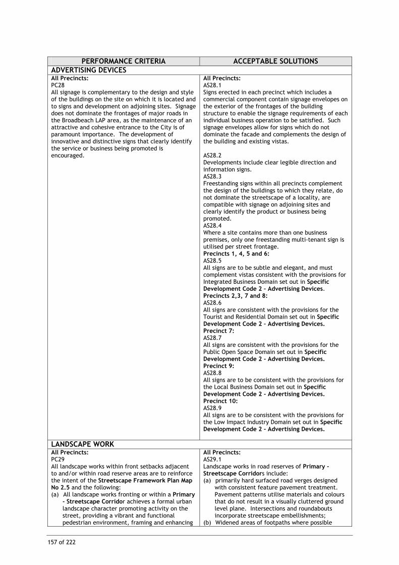
PERFORMANCE CRITERIA ACCEPTABLE SOLUTIONS ADVERTISING DEVICES All Precincts: PC28 All signage is complementary to the design and style of the buildings on the site on which it is located and to signs and development on adjoining sites. Signage does not dominate the frontages of major roads in the Broadbeach LAP area, as the maintenance of an attractive and cohesive entrance to the City is of paramount importance. The development of innovative and distinctive signs that clearly identify the service or business being promoted is encouraged.
All Precincts: AS28.1 Signs erected in each precinct which includes a commercial component contain signage envelopes on the exterior of the frontages of the building structure to enable the signage requirements of each individual business operation to be satisfied. Such signage envelopes allow for signs which do not dominate the facade and complements the design of the building and existing vistas. AS28.2 Developments include clear legible direction and information signs. AS28.3 Freestanding signs within all precincts complement the design of the buildings to which they relate, do not dominate the streetscape of a locality, are compatible with signage on adjoining sites and clearly identify the product or business being promoted. AS28.4 Where a site contains more than one business premises, only one freestanding multi-tenant sign is utilised per street frontage. Precincts 1, 4, 5 and 6: AS28.5 All signs are to be subtle and elegant, and must complement vistas consistent with the provisions for Integrated Business Domain set out in Specific Development Code 2 – Advertising Devices. Precincts 2,3, 7 and 8: AS28.6 All signs are consistent with the provisions for the Tourist and Residential Domain set out in Specific Development Code 2 – Advertising Devices. Precinct 7: AS28.7 All signs are consistent with the provisions for the Public Open Space Domain set out in Specific Development Code 2 - Advertising Devices. Precinct 9: AS28.8 All signs are to be consistent with the provisions for the Local Business Domain set out in Specific Development Code 2 - Advertising Devices. Precinct 10: AS28.9 All signs are to be consistent with the provisions for the Low Impact Industry Domain set out in Specific Development Code 2 - Advertising Devices.
LANDSCAPE WORK All Precincts: PC29 All landscape works within front setbacks adjacent to and/or within road reserve areas are to reinforce the intent of the Streetscape Framework Plan Map No 2.5 and the following: (a) All landscape works fronting or within a Primary
- Streetscape Corridor achieves a formal urban landscape character promoting activity on the street, providing a vibrant and functional pedestrian environment, framing and enhancing
All Precincts: AS29.1 Landscape works in road reserves of Primary -Streetscape Corridors include: (a) primarily hard surfaced road verges designed
with consistent feature pavement treatment. Pavement patterns utilise materials and colours that do not result in a visually cluttered ground level plane. Intersections and roundabouts incorporate streetscape embellishments;
(b) Widened areas of footpaths where possible

158 of 222
PERFORMANCE CRITERIA ACCEPTABLE SOLUTIONS view and street corridors;
(b) All landscape works fronting or within a Secondary Streetscape Corridor achieves a semi - formal urban landscape character supporting activity on the street whilst being appropriate to the uses adjacent, providing a pleasant and functional pedestrian environment and enhancing view and street corridors;
(c) All landscape works fronting or within a Neighbourhood Streetscape Corridor achieves an informal landscape character supporting the uses adjacent to the street, providing a leafy and functional pedestrian environment and enhancing views and street corridors;
(d) All landscape works fronting the Gold Coast Highway Streetscape Frontage Corridor achieves a streetscape which identifies the extent of Broadbeach within the context of the north/south highway’s arterial role.
increasing pedestrian space and outdoor dining; (c) Shrub planting and garden beds provide visual
amenity whilst defining alfresco dining areas, public space and directing and enhancing pedestrian movement;
(d) Street trees are of a consistent form and growth habit, planted in a formal configuration defining the street edge, enhancing views along street corridors and providing visual amenity to the street environment;
(e) Street furniture (including signage) is of a consistent character promoting an active and vibrant streetscape environment including incorporation of public art where appropriate.
AS29.2 Landscape works in road reserves of Secondary Streetscape Corridors include: (a) Feature areas of hard surfaced road verges and
footpath areas combined with soft landscape treatment and turf. Pavement surfaces are designed with consistent pavement treatment in feature nodes such as intersections and resting places. Pavement patterns utilise materials and colours that do not result in a visually cluttered ground level plane;
(b) Shrub planting and garden beds provide amenity whilst defining public space such as outdoor dining, intersections /resting places and directing pedestrian movement;
(c) Street trees are consistent in form and growth habit, planted in a semi - formal configuration predominately along the street edge enhancing views along street corridors and providing visual amenity and shade to the street environment;
(d) Selective location of street furniture of a consistent character supports the uses adjacent to the street.
AS29.3 Landscape works in road reserves of Neighbourhood Streetscape Corridors include: (a) Primarily turfed road verge areas complemented
by pedestrian pathways designed with consistent pavement treatment. Feature pavement treatment is located in areas where pedestrian movement is to be defined and directed such as intersections and resting places;
(b) Shrub planting is limited to feature nodes only; (c) Street trees are a consistent form and growth
habit, planted along the verge edge providing visual amenity and shade to the street environment;
(d) Street furniture limited to traffic infrastructure items (including signage).
AS29.4 Landscape works in road reserves of the Gold Coast Highway Streetscape Frontage Corridor include where appropriate: (a) Definition of entry points and external links
creating a visually cohesive strip of highway fronting Broadbeach;
(b) Integrated signage identifying major vehicular and pedestrian routes and points of entry;
(c) Street planting within road verge areas and median strips creating a visually cohesive highway strip;

159 of 222
PERFORMANCE CRITERIA ACCEPTABLE SOLUTIONS (d) Street furniture, lighting and streetscape
embellishments reinforcing the legibility of the pedestrian experience.
AS29.5 Landscape works in road reserve areas are designed in accordance with the Broadbeach Streetscape Masterplan.
All Precincts: PC30 Extensive areas of visible ground and above ground level landscaping is provided to a standard that promotes a pleasant, attractive and functional environment consistent with the character of Broadbeach.
All Precincts: AS30.1 Incorporate landscape and associated work where located at street level, on top of the podium levels or on terraces, balconies and decks. AS30.2 In ground level open car park areas, landscaped bays for the planting of shade trees are provided throughout car parking areas. Landscape bays have the same dimensions as a vehicle parking space. Any portion of a car parking area that is not utilised for parking bays, access aisles or any other essential purpose is utilised for soft landscaping.
LOT SIZE All Precincts: PC31 All allotments are of sufficient area and dimensions to accommodate buildings designed to the criteria in this LAP.
All Precincts: AS31.1 The minimum lot size for each precinct is as follows:
Precinct Minimum allotment size not less than
1, 3, 4, 5, 6, 7, 9 and 10
1,000m2
2 600m2 8 400m2
All Precincts: AS31.2 The minimum frontage of land proposed to be used for non-residential or commercial purposes is 15 metres.
AMENITY PROTECTION All Precincts: PC32 The proposed use does not detract from the amenity of the local area, having regard, but not limited, to the impact of: (a) noise; (b) hours of operation; (c) traffic; (d) lighting; (e) signage; (f) visual amenity; (g) privacy; (h) odour and emissions.
All Precincts: AS32 No acceptable solution provided.

160 of 222
PERFORMANCE CRITERIA ACCEPTABLE SOLUTIONS All Precincts: PC33 The proposed development takes into account and seek to ameliorate any negative aspects of the existing amenity of the local area, having regard, but not limited, to the existing impact of: (a) noise; (b) hours of operation; (c) traffic; (d) lighting; (e) signage; (f) visual amenity; (g) privacy; (h) odour and emissions.
All Precincts: AS33 No acceptable solution provided.
PLOT RATIO All Precincts: PC34 The bulk of the development proposal is proportional to the character of the local area, with some bonus in floor space available where identified public benefits are provided. Building bulk will generally be greater within the Precinct 1 and Precinct 4 with a lesser building bulk being permitted in peripheral commercial and tourist accommodation precincts where development is intended to be less intensive. The intent of this section is to allow for a built form which addresses the street at ground level, with tall, narrow structures above third floor level, to enable sunlight penetration and views to be achieved.
All Precincts: AS34.1 The basic plot ratios described for each precinct in the Table to Performance Criterion PC34 are not exceeded. OR AS34.2 The basic plot ratio is exceeded by the incorporation of bonus element, in a development consistent with the provisions of Policy 18 – Using the Urban Design Bonus Provisions, provided that the maximum plot ratios described for each precinct in the Table to Performance Criterion PC34, are not exceeded.
TABLE TO PERFORMANCE CRITERION PC 34 PLOT RATIO CONTROLS BY PRECINCT:
Precinct 1 and 4: (a) the basic plot ratio is 4:1 (b) the maximum plot ratio is 6.5:1.
Precinct 7, 9 and 10: (a) no plot ratio applies.
Precincts 2, 3, 5and 8: • the basic plot ratio is 2:1 • the maximum plot ratio is 4:1.
ACCESS PROVISIONS All Precincts: PC35 Development helps to achieve a town centre that accommodates uses, facilities and buildings of a type and scale appropriate to the centre’s desired role and character. Street patterns, lots, urban spaces, buildings and uses must be developed to: (a) facilitate convenient and safe access; (b) provide clear, safe and convenient connections
to existing and/or proposed streets, public transport routes and paths for pedestrians and cyclists;
(c) allow for the location of buildings close to frontages of streets and other urban spaces, in order to facilitate navigation, access and casual surveillance of public and semi-public spaces.
All Precincts: AS35.1 All buildings on land adjoining or directly affected by the Streetscape Framework Plan Map 2.5 are to provide through links for pedestrians as part of any building or development. AS35.2 Pedestrian links through, or as part of, any building are at least ten metres wide, optimise visibility of the destination point, have appropriate signage, and are designed to be secure, safe, attractive and available for public use 24 hours a day, seven days a week.
All Precincts: PC36 Development achieves a high standard of accessibility for vehicles, pedestrians and cyclists.
All Precincts: AS36.1 New development contributes to: (a) developing off-street car parking facilities; (b) encouraging the development of a pedestrian
walkway system, based on a network of shopping arcades, open space links and widened footpaths, throughout the central area;
(c) improving vehicular traffic flows and reducing

161 of 222
PERFORMANCE CRITERIA ACCEPTABLE SOLUTIONS conflicts between local and through traffic;
(d) reducing pedestrian/vehicular conflict by provision of a system of rear vehicular access lane ways.
AS36.2 Pedestrian facilities are provided in exchange for plot ratio bonuses.
All Precincts: PC37 Conflicts between pedestrians and vehicles at entrance points to parking areas are minimised.
All Precincts: AS37.1 The number of vehicle entry points to a development site is kept to a minimum, particularly in areas that have high volumes of pedestrian traffic. AS37.2 Entrance points to parking and loading areas have clear and unobstructed visibility of pedestrian pathway areas with pedestrian crossing points clearly identified which give priority to pedestrians. AS37.3 Rear lanes and/or streets with lesser pedestrian activity are used for access to basements and parking areas on sites which have more than one street frontage. AS37.4 Footpaths are provided along the site frontages to all public streets at the developer’s expense.
CAR PARKING All Precincts : PC38 Adequate on-site car parking facilities are to be provided for new developments to ensure that access can be gained to commercial and residential properties and that the demand for on-street car parking facilities is consistent with the supply of such facilities.
All Precincts: AS38.1 Car parking is provided, consistent with the requirement from Constraint Code 4 – Car Parking, Access and Transport Integration. AS38.2 Car parking required for commercial activities is open to the public.
Precinct 1: PC39 Ground level and above ground level car parking is to be minimised, with underground car parking facilities to be used where possible.
Precinct 1: AS39.1 All car parking (with the exception of visitor and service delivery parking) is provided in consolidated areas behind buildings or underground. AS39.2 Car parking is provided at the following rates: (a) one space per 30m2 of GFA or part thereof, for
the following uses: • café· • child care centre; • commercial services;· • convenience shop;· • fast food premises;· • Laundromat;· • medical centre;· • nightclub;· • office;· • reception room;· • restaurant;· • service industry;· • shop; • showroom;· • take-away food premises • tavern • tourist facility; • tourist shop
(b) all other development has car parking provided in accordance with AS16.1 of Constraint Code 4 – Car Parking, Access and Transport Integration.

162 of 222
PERFORMANCE CRITERIA ACCEPTABLE SOLUTIONS All Precincts: PC40 All ground level car parking, open space and buffer areas are suitably landscaped and maintained to provide an attractive and pleasant outlook and shade for parked vehicles, and to complement the character of the local area and any adjoining residential or public open space areas.
All Precincts: AS40.1 The car park area, open space and buffer areas of the lot are designed with an appropriate landscape character consistent with the character of Broadbeach. The landscape design may incorporate some paved areas and shade trees for pedestrian and car parking use. AS40.2 Significant trees are preserved and incorporated into car parking areas, where reasonably possible. AS40.3 Car parking areas, service areas and access driveways are located where they will not dominate the streetscape and not detract from convenient and safe pedestrian and vehicular movement. AS40.4 All sites, located within Primary Streetscape Corridor Map 2.5, do not provide major vehicular access points (other than passenger pick up and set down areas) on such frontages, where alternative access may be achievable from a Secondary Streetscape Corridor Map 2.5. AS40.5 The site has no vehicular access, and cash in lieu of car parking is provided.
PUBLIC CONVENIENCE FACILITIES WITHIN BUILDINGS All Precincts: PC41 Commercial developments are to include public convenience facilities, where there is a need for their provision.
All Precincts: AS41.1 Where provided, public toilet facilities are open and readily accessible to the general public during retail trading hours or other trading hours relevant to the development. AS41.2 Public convenience facilities provide equitable access.
BUILDING SERVICES All Precincts: PC42 Adequate facilities for commercial and mixed use buildings for the loading and unloading of goods are provided to meet the needs of the development.
All Precincts : AS42 A loading area is provided on site that is separated from the public access areas and readily accessible from all commercial tenancies on the site.
All Precincts: PC43 Adequate facilities for servicing the development with a refuse disposal service are provided to meet the needs of the development.
All Precincts: AS43.1 Provision is made for the storage of refuse on site and suitable access for the removal of refuse. AS43.2 All outdoor storage or refuse disposal areas are screened from public view.
All Precincts: PC44 Council’s water, sewerage, open space and transport infrastructure are capable of serving the proposed development to the appropriate standards.
All Precincts: AS44 The application is supported by an engineering report that indicates the: (a) proposed development is able to be adequately
serviced; (b) extent of any upgrading that is required to serve
the proposed development; (c) method of paying for any additional
infrastructure required by the development.

163 of 222
PERFORMANCE CRITERIA ACCEPTABLE SOLUTIONS All Precincts: PC45 Development resulting in a net increase in demand for recreation facilities contribute to recreation facilities infrastructure to the extent that there is no reduction in the existing desired standards of service.
All Precincts: AS45 Contribution made towards infrastructure for recreation facilities is in accordance with the Priority Infrastructure Plan.
ITEM ORIGIN This item was formerly Amendment 2 – Local Area Plans

BVD
BVD
REBECCA CT
Y
HOOKER
BACARDI C
HELEN CT
MERRIMAC
BVD
0 0.05 0.1
kilometres
AMENDMENT No: 2PART No: 05ITEM No: Broadbeach LAP
APPROVED BY COUNCIL :
RURAL
PARK LIVING
VILLAGE
DETACHED DWELLING
FRINGE BUSINESS
RESIDENTIAL CHOICE
TOURIST AND RESIDENTIAL
INTEGRATED BUSINESS
LOCAL BUSINESS
EMERGING COMMUNITIES
COMMUNITY PURPOSES
CONSERVATION
PRIVATE OPEN SPACE
PUBLIC OPEN SPACE
INDUSTRY 1
INDUSTRY 2
EXTRACTIVE INDUSTRY
MARINE INDUSTRY
GOLD COAST CITY COUNCIL DOMAINS
LOCAL AREA PLAN
DESIGNATED DEVELOPMENT
SPECIAL FACILITIES
NOT DOMAINED
LEGEND
MAP : Gold Coast Planning Scheme Domain MapSurfers Paradise 21
©
© Gold Coast City Council 2004
City Council makes no representations or warranties about its accuracy, reliability,completeness or suitability for any particular purpose and disclaims all
all responsibility and all liability (including without limitation, liability in negligence)for all expenses, losses, damages (including indirect or consequential damage)
responsibility and all liability (including without limitation, liability in negligence)for all expenses, losses, damages (including indirect or consequential damage)and costs which you might incur as a result of the data being inaccurate orincomplete in any way and for any reason.
While every care is taken to ensure the accuracy of this data, the Department of Natural Resources and Mines makes no representations or warranties aboutits accuracy, reliability, completeness or suitability for any particular purpose and
and costs which you might incur as a result of the data being inaccurate orincomplete in any way and for any reason.
The State of Queensland (Department of Natural Resources and Mines) 2004
Based on Cadastral Data provided with the permission of the Department ofNatural Resources and Mines (current as at May 2004).While every care is taken to ensure the accuracy of this data, the Gold Coast
Gold Coast City Council

Gold Coast City Council 2003
The State of Queensland (Department of Natural Resources and Mines) 2003
Based on Cadastral Data provided with the permission of the Department ofNatural Resources and Mines (current as at February 2003).
While every care is taken to ensure the accuracy of this data, the Gold CoastCity Council makes no representations or warranties about its accuracy, reliability,completeness or suitability for any particular purpose and disclaims all
responsibility and all liability (including without limitation, liability in negligence)for all expenses, losses, damages (including indirect or consequential damage)and costs which you might incur as a result of the data being inaccurate orincomplete in any way and for any reason.
c No Window
Armrick Ave
Old B
urleigh Road
Chelsea Ave
Australia Ave
Queensland Ave
Alexandra Ave
Victoria Ave
Elizabeth Ave
Hooker Blvd
Margaret Ave
Surf Pde
0.50.50.50.50.50.50.50.50.5
0.50.25
000000000
kilometreskilometreskilometreskilometreskilometreskilometreskilometreskilometreskilometres
0.250.250.250.250.250.250.250.250.25
0Legend
While every care is taken to ensure the accuracy of this data, the Department of Natural Resources and Mines makes no representations or warranties about itsaccuracy, reliability, completeness or suitability for any particularpurpose and disclaims all responsibility and all liability (including without limitation, liability in negligence) for all expenses, losses, damages (including indirect or consequential damage) and costs which you might incur as a result of the databeing inaccurate or incomplete in any way and for any reason.
c
Gold Coast City Council
LAP Boundary
Broadbeach LAP Map 2.1 - Boundary

Armrick Ave
Old B
urleigh Road
Chelsea Ave
Australia Ave
Queensland Ave
Alexandra Ave
Victoria Ave
Elizabeth Ave
Hooker Blvd
Margaret Ave
Surf Pde
555555555
999999999
888888888
444444444
111111111
666666666 111111111
222222222
666666666
777777777
777777777
333333333
222222222
777777777
333333333222222222
666666666777777777
222222222999999999
101010101010101010
999999999
777777777
222222222333333333
0.50.50.50.50.50.50.50.50.5
kilometreskilometreskilometreskilometreskilometreskilometreskilometreskilometreskilometres
0.250.250.250.250.250.250.250.250.25000000000
Legend
Gold Coast City Council
Draft Broadbeach Local Area Plan - LAP Map 2.2 - Precincts
COMMUNITY PURPOSES
LIGHT INDUSTRY
HIGHWAY BUSINESS
DESIGNATED DEVELOPMENT
PUBLIC OPEN SPACE
LOW SCALE OFFICE
CENTRAL MIXED USEBALANCE AREA
CENTRAL MIXED USEHATCHED AREA
HIGHWAY TOURISM
JUPITER'S CASINO
PACIFIC FAIR
RESIDENTIAL
101010101010101010
999999999
888888888
777777777
666666666
333333333
444444444
555555555
111111111
111111111
222222222
Ver. 1.1
© Gold Coast City Council 2006
City Council makes no representations or warranties about its accuracy, reliability,completeness or suitability for any particular purpose and disclaims all
and costs which you might incur as a result of the data being inaccurate orincomplete in any way and for any reason.
While every care is taken to ensure the accuracy of this data, the Department of Natural Resources and Mines makes no representations or warranties aboutits accuracy, reliability, completeness or suitability for any particular purpose and
and costs which you might incur as a result of the data being inaccurate orincomplete in any way and for any reason.
©
responsibility and all liability (including without limitation, liability in negligence)for all expenses, losses, damages (including indirect or consequential damage)
all responsibility and all liability (including without limitation, liability in negligence)for all expenses, losses, damages (including indirect or consequential damage)
The State of Queensland (Department of Natural Resources, Mines and Water) 2006
Based on Cadastral Data provided with the permission of the Department ofNatural Resources, Mines and Water (current as at June 2006).While every care is taken to ensure the accuracy of this data, the Gold Coast

Gold Coast City Council 2003
The State of Queensland (Department of Natural Resources and Mines) 2003
Based on Cadastral Data provided with the permission of the Department ofNatural Resources and Mines (current as at February 2003).
While every care is taken to ensure the accuracy of this data, the Gold CoastCity Council makes no representations or warranties about its accuracy, reliability,completeness or suitability for any particular purpose and disclaims all
responsibility and all liability (including without limitation, liability in negligence)for all expenses, losses, damages (including indirect or consequential damage)and costs which you might incur as a result of the data being inaccurate orincomplete in any way and for any reason.
c
35 Storeys
20 Storeys
30 Storeys7 Storeys
15 Storeys
202020202020202020
303030303030303030
353535353535353535151515151515151515
777777777
303030303030303030
151515151515151515
353535353535353535
Armrick Ave
Old B
urleigh Road
Chelsea Ave
Australia Ave
Queensland Ave
Alexandra Ave
Victoria Ave
Elizabeth Ave
Hooker Blvd
Margaret Ave
Surf Pde
777777777
202020202020202020
151515151515151515 777777777
151515151515151515
777777777
151515151515151515
353535353535353535
202020202020202020
303030303030303030
303030303030303030
000000000 0.250.250.250.250.250.250.250.250.25
kilometreskilometreskilometreskilometreskilometreskilometreskilometreskilometreskilometres
0.50.50.50.50.50.50.50.50.5
Legend
While every care is taken to ensure the accuracy of this data, the Department of Natural Resources and Mines makes no representations or warranties about itsaccuracy, reliability, completeness or suitability for any particularpurpose and disclaims all responsibility and all liability (including without limitation, liability in negligence) for all expenses, losses, damages (including indirect or consequential damage) and costs which you might incur as a result of the databeing inaccurate or incomplete in any way and for any reason.
c
Gold Coast City CouncilLAP Boundary
Broadbeach LAP Map 2.3 - Maximum Building Heights

Gold Coast City Council 2003
The State of Queensland (Department of Natural Resources and Mines) 2003
Based on Cadastral Data provided with the permission of the Department ofNatural Resources and Mines (current as at February 2003).
While every care is taken to ensure the accuracy of this data, the Gold CoastCity Council makes no representations or warranties about its accuracy, reliability,completeness or suitability for any particular purpose and disclaims all
responsibility and all liability (including without limitation, liability in negligence)for all expenses, losses, damages (including indirect or consequential damage)and costs which you might incur as a result of the data being inaccurate orincomplete in any way and for any reason.
cOne bedroom per 33m² of net site area(Up to 300 bedrooms per net hectare)
One bedroom per 25m² of net site area(Up to 400 bedrooms per net hectare)
One bedroom per 13m² of net site area(Up to 769 bedrooms per net hectare)
RD6RD6RD6RD6RD6RD6RD6RD6RD6
One bedroom per 50m² of net site area(Up to 200 bedrooms per net hectare)
Up to 40 dwellings per net hectare(1 dwelling per 250m² of site area)
RD6RD6RD6RD6RD6RD6RD6RD6RD6
RD7RD7RD7RD7RD7RD7RD7RD7RD7
RD8RD8RD8RD8RD8RD8RD8RD8RD8
RD5RD5RD5RD5RD5RD5RD5RD5RD5
RD3RD3RD3RD3RD3RD3RD3RD3RD3
Armrick Ave
Old B
urleigh Road
Chelsea Ave
Australia Ave
Queensland Ave
Alexandra Ave
Victoria Ave
Elizabeth Ave
Hooker Blvd
Margaret Ave
Surf Pde
RD7RD7RD7RD7RD7RD7RD7RD7RD7
RD6RD6RD6RD6RD6RD6RD6RD6RD6RD7RD7RD7RD7RD7RD7RD7RD7RD7
RD7RD7RD7RD7RD7RD7RD7RD7RD7
RD3RD3RD3RD3RD3RD3RD3RD3RD3 RD3RD3RD3RD3RD3RD3RD3RD3RD3
RD7RD7RD7RD7RD7RD7RD7RD7RD7
RD7RD7RD7RD7RD7RD7RD7RD7RD7
RD6RD6RD6RD6RD6RD6RD6RD6RD6RD5RD5RD5RD5RD5RD5RD5RD5RD5
RD5RD5RD5RD5RD5RD5RD5RD5RD5
RD5RD5RD5RD5RD5RD5RD5RD5RD5
RD8RD8RD8RD8RD8RD8RD8RD8RD8
RD5RD5RD5RD5RD5RD5RD5RD5RD5
RD7RD7RD7RD7RD7RD7RD7RD7RD7RD6RD6RD6RD6RD6RD6RD6RD6RD6
0.50.50.50.50.50.50.50.50.5
kilometreskilometreskilometreskilometreskilometreskilometreskilometreskilometreskilometres
0.250.250.250.250.250.250.250.250.25000000000
Legend
While every care is taken to ensure the accuracy of this data, the Department of Natural Resources and Mines makes no representations or warranties about itsaccuracy, reliability, completeness or suitability for any particularpurpose and disclaims all responsibility and all liability (including without limitation, liability in negligence) for all expenses, losses, damages (including indirect or consequential damage) and costs which you might incur as a result of the databeing inaccurate or incomplete in any way and for any reason.
c
Gold Coast City Council
Broadbeach - LAP MAP 2.4 - Maximum Residential Density
LAP Boundary

Gold Coast City Council 2003
The State of Queensland (Department of Natural Resources and Mines) 2003
Based on Cadastral Data provided with the permission of the Department ofNatural Resources and Mines (current as at February 2003).
While every care is taken to ensure the accuracy of this data, the Gold CoastCity Council makes no representations or warranties about its accuracy, reliability,completeness or suitability for any particular purpose and disclaims all
responsibility and all liability (including without limitation, liability in negligence)for all expenses, losses, damages (including indirect or consequential damage)and costs which you might incur as a result of the data being inaccurate orincomplete in any way and for any reason.
c
Neighbourhood Streetscape Corridor
Gold Coast Highway Corridor
Primary Streetscape Corridor
Secondary Streetscape Corridor
LAP Boundary
Other
Armrick Ave
Old B
urleigh Road
Chelsea Ave
Australia Ave
Queensland Ave
Alexandra Ave
Victoria Ave
Elizabeth Ave
Hooker Blvd
Margaret Ave
Surf Pde
0.50.50.50.50.50.50.50.50.50.50.50.50.50.50.50.50.50.50.50.50.50.50.50.50.50.50.50.50.50.50.50.50.50.50.50.50.50.50.50.50.50.50.50.50.50.50.50.50.5
kilometreskilometreskilometreskilometreskilometreskilometreskilometreskilometreskilometreskilometreskilometreskilometreskilometreskilometreskilometreskilometreskilometreskilometreskilometreskilometreskilometreskilometreskilometreskilometreskilometreskilometreskilometreskilometreskilometreskilometreskilometreskilometreskilometreskilometreskilometreskilometreskilometreskilometreskilometreskilometreskilometreskilometreskilometreskilometreskilometreskilometreskilometreskilometreskilometres
0.250.250.250.250.250.250.250.250.250.250.250.250.250.250.250.250.250.250.250.250.250.250.250.250.250.250.250.250.250.250.250.250.250.250.250.250.250.250.250.250.250.250.250.250.250.250.250.250.250000000000000000000000000000000000000000000000000
Legend
While every care is taken to ensure the accuracy of this data, the Department of Natural Resources and Mines makes no representations or warranties about itsaccuracy, reliability, completeness or suitability for any particularpurpose and disclaims all responsibility and all liability (including without limitation, liability in negligence) for all expenses, losses, damages (including indirect or consequential damage) and costs which you might incur as a result of the databeing inaccurate or incomplete in any way and for any reason.
c
Gold Coast City Council
Broadbeach LAP Map 2.5 - Streetscape Framework Plan

Gold Coast City Council 2003
The State of Queensland (Department of Natural Resources and Mines) 2003
Based on Cadastral Data provided with the permission of the Department ofNatural Resources and Mines (current as at August 2003).
While every care is taken to ensure the accuracy of this data, the Gold CoastCity Council makes no representations or warranties about its accuracy, reliability,completeness or suitability for any particular purpose and disclaims all
responsibility and all liability (including without limitation, liability in negligence)for all expenses, losses, damages (including indirect or consequential damage)and costs which you might incur as a result of the data being inaccurate orincomplete in any way and for any reason.
c Minor connecting paths which enhance the 'circuit"
Indicative paths for the world class promenade
Open space which can relate to the pedestrian treatments and nearby development
Pedestrian Links Existing and Proposed
LAP Boundary
BroadbeachBroadbeachBroadbeachBroadbeachBroadbeachBroadbeachBroadbeachBroadbeachBroadbeachMallMallMallMallMallMallMallMallMall
Armrick AveArmrick AveArmrick AveArmrick AveArmrick AveArmrick AveArmrick AveArmrick AveArmrick Ave
Old Burleigh R
oadO
ld Burleigh Road
Old Burleigh R
oadO
ld Burleigh Road
Old Burleigh R
oadO
ld Burleigh Road
Old Burleigh R
oadO
ld Burleigh Road
Old Burleigh R
oad
Chelsea AveChelsea AveChelsea AveChelsea AveChelsea AveChelsea AveChelsea AveChelsea AveChelsea Ave
Australia AveAustralia AveAustralia AveAustralia AveAustralia AveAustralia AveAustralia AveAustralia AveAustralia Ave
Queensland AveQueensland AveQueensland AveQueensland Ave
Queensland AveQueensland AveQueensland AveQueensland AveQueensland Ave
Alexandra AveAlexandra AveAlexandra AveAlexandra AveAlexandra AveAlexandra AveAlexandra AveAlexandra AveAlexandra Ave
Victoria AveVictoria AveVictoria AveVictoria AveVictoria AveVictoria AveVictoria AveVictoria AveVictoria Ave
Elizabeth AveElizabeth AveElizabeth AveElizabeth AveElizabeth AveElizabeth AveElizabeth AveElizabeth AveElizabeth Ave
Hooker BlvdHooker BlvdHooker BlvdHooker BlvdHooker BlvdHooker BlvdHooker BlvdHooker BlvdHooker Blvd
Margaret AveMargaret AveMargaret AveMargaret AveMargaret AveMargaret AveMargaret AveMargaret AveMargaret Ave
Surf PdeSurf PdeSurf Pde
Surf PdeSurf Pde
Surf PdeSurf PdeSurf PdeSurf Pde
0.50.50.50.50.50.50.50.50.5
kilometreskilometreskilometreskilometreskilometreskilometreskilometreskilometreskilometres
0.250.250.250.250.250.250.250.250.25000000000
Legend
While every care is taken to ensure the accuracy of this data, the Department of Natural Resources and Mines makes no representations or warranties about itsaccuracy, reliability, completeness or suitability for any particularpurpose and disclaims all responsibility and all liability (including without limitation, liability in negligence) for all expenses, losses, damages (including indirect or consequential damage) and costs which you might incur as a result of the databeing inaccurate or incomplete in any way and for any reason.
c
Broadbeach LAP Map 2.6 - Gold Coast Broadway Concept

Broadbeach LAP MAP 2.7 - Preferred Intergrated Transport Network
Gold Coast City Council 2003
The State of Queensland (Department of Natural Resources and Mines) 2003
Based on Cadastral Data provided with the permission of the Department ofNatural Resources and Mines (current as at August 2003).
While every care is taken to ensure the accuracy of this data, the Gold CoastCity Council makes no representations or warranties about its accuracy, reliability,completeness or suitability for any particular purpose and disclaims all
responsibility and all liability (including without limitation, liability in negligence)for all expenses, losses, damages (including indirect or consequential damage)and costs which you might incur as a result of the data being inaccurate orincomplete in any way and for any reason.
c
Line Haul Routes
Major Public Transport Hub
Monorail Routes
Ferry Routes
Feeder Routes
Public Transport Hub
LAP Boundary
0.25 0.5
kilometres0
Armrick AveArmrick AveArmrick AveArmrick AveArmrick AveArmrick AveArmrick AveArmrick AveArmrick Ave
Old Burleigh R
oadO
ld Burleigh Road
Old Burleigh R
oadO
ld Burleigh Road
Old Burleigh R
oadO
ld Burleigh Road
Old Burleigh R
oadO
ld Burleigh Road
Old Burleigh R
oad
Chelsea AveChelsea AveChelsea AveChelsea AveChelsea AveChelsea AveChelsea AveChelsea AveChelsea Ave
Australia AveAustralia AveAustralia AveAustralia AveAustralia AveAustralia AveAustralia AveAustralia AveAustralia Ave
Queensland AveQueensland AveQueensland AveQueensland Ave
Queensland AveQueensland AveQueensland AveQueensland AveQueensland Ave
Alexandra AveAlexandra AveAlexandra AveAlexandra AveAlexandra AveAlexandra AveAlexandra AveAlexandra AveAlexandra Ave
Victoria AveVictoria AveVictoria AveVictoria AveVictoria AveVictoria AveVictoria AveVictoria AveVictoria Ave
Elizabeth AveElizabeth AveElizabeth AveElizabeth AveElizabeth AveElizabeth AveElizabeth AveElizabeth AveElizabeth Ave
Hooker BlvdHooker BlvdHooker BlvdHooker BlvdHooker BlvdHooker BlvdHooker BlvdHooker BlvdHooker Blvd
Margaret AveMargaret AveMargaret AveMargaret AveMargaret AveMargaret AveMargaret AveMargaret AveMargaret Ave
Surf PdeSurf PdeSurf Pde
Surf PdeSurf Pde
Surf PdeSurf PdeSurf PdeSurf Pde
Legend
While every care is taken to ensure the accuracy of this data, the Department of Natural Resources and Mines makes no representations or warranties about itsaccuracy, reliability, completeness or suitability for any particularpurpose and disclaims all responsibility and all liability (including without limitation, liability in negligence) for all expenses, losses, damages (including indirect or consequential damage) and costs which you might incur as a result of the databeing inaccurate or incomplete in any way and for any reason.
c

Broadbeach LAP MAP 2.8 - Pedestrian Movement Network
Gold Coast City Council 2003
The State of Queensland (Department of Natural Resources and Mines) 2003
Based on Cadastral Data provided with the permission of the Department ofNatural Resources and Mines (current as at February 2003).
While every care is taken to ensure the accuracy of this data, the Gold CoastCity Council makes no representations or warranties about its accuracy, reliability,completeness or suitability for any particular purpose and disclaims all
responsibility and all liability (including without limitation, liability in negligence)for all expenses, losses, damages (including indirect or consequential damage)and costs which you might incur as a result of the data being inaccurate orincomplete in any way and for any reason.
c
Pedestrian Links Existing and Proposed
Existing District Cycle Route
Proposed Truck Cycle Route
Proposed Lightrail/bus Transit Lane Corridor
Proposed Coastal Recreation Corridor
LAP Boundary
BroadbeachBroadbeachBroadbeachBroadbeachBroadbeachBroadbeachBroadbeachBroadbeachBroadbeachBroadbeachBroadbeachBroadbeachBroadbeachBroadbeachBroadbeachBroadbeachBroadbeachBroadbeachBroadbeachBroadbeachBroadbeachBroadbeachBroadbeachBroadbeachBroadbeachBroadbeachBroadbeachBroadbeachBroadbeachBroadbeachBroadbeachBroadbeachBroadbeachBroadbeachBroadbeachBroadbeachBroadbeachBroadbeachBroadbeachBroadbeachBroadbeachBroadbeachBroadbeachBroadbeachBroadbeachBroadbeachBroadbeachBroadbeachBroadbeachMallMallMallMallMallMallMallMallMallMallMallMallMallMallMallMallMallMallMallMallMallMallMallMallMallMallMallMallMallMallMallMallMallMallMallMallMallMallMallMallMallMallMallMallMallMallMallMallMall
Armrick Ave
Old B
urleigh Road
Chelsea Ave
Australia Ave
Queensland Ave
Alexandra Ave
Victoria Ave
Elizabeth Ave
Hooker Blvd
Margaret Ave
Surf Pde
0.25 0.5
kilometres
0
Legend
While every care is taken to ensure the accuracy of this data, the Department of Natural Resources and Mines makes no representations or warranties about itsaccuracy, reliability, completeness or suitability for any particularpurpose and disclaims all responsibility and all liability (including without limitation, liability in negligence) for all expenses, losses, damages (including indirect or consequential damage) and costs which you might incur as a result of the databeing inaccurate or incomplete in any way and for any reason.
c

GO
LD C
OA
ST HIG
HW
AY
GO
LD C
OA
ST HIG
HW
AY
GO
LD C
OA
ST HIG
HW
AY
GO
LD C
OA
ST HIG
HW
AY
GO
LD C
OA
ST HIG
HW
AY
GO
LD C
OA
ST HIG
HW
AY
GO
LD C
OA
ST HIG
HW
AY
GO
LD C
OA
ST HIG
HW
AY
GO
LD C
OA
ST HIG
HW
AY
CRONULLACRONULLACRONULLACRONULLACRONULLACRONULLACRONULLACRONULLACRONULLA
VENTURAVENTURAVENTURAVENTURAVENTURAVENTURAVENTURAVENTURAVENTURA
KA
REN
KA
REN
KA
REN
KA
REN
KA
REN
KA
REN
KA
REN
KA
REN
KA
REN
CRCRCRCRCRCRCRCRCR
AVE
AVE
AVE
AVE
AVE
AVE
AVE
AVE
AVE
MONTMONTMONTMONMONMONMONMONMON
GAVENGAVENGAVENGAVENGAVENGAVENGAVENGAVENGAVEN
PDE
PDE
PDE
PDE
PDE
PDE
PDE
PDE
PDE
AVEAVEAVEAVEAVEAVEAVEAVEAVE
SEAVIEW AVESEAVIEW AVESEAVIEW AVESEAVIEW AVESEAVIEW AVESEAVIEW AVESEAVIEW AVESEAVIEW AVESEAVIEW AVE PEERLESS
PEERLESSPEERLESSPEERLESSPEERLESSPEERLESSPEERLESSPEERLESSPEERLESS
SUNBRITESUNBRITESUNBRITESUNBRITESUNBRITESUNBRITESUNBRITESUNBRITESUNBRITE
AVEAVEAVEAVEAVEAVEAVEAVEAVE
MERMAIDMERMAIDMERMAIDMERMAIDMERMAIDMERMAIDMERMAIDMERMAIDMERMAID
AVE
AVE
AVE AVE
AVE AVE
AVE
AVE AVE
ALEXANDRAALEXANDRAALEXANDRAALEXANDRAALEXANDRAALEXANDRAALEXANDRAALEXANDRAALEXANDRA
MA
RY A
VEM
AR
Y AVE
MA
RY A
VEM
AR
Y AVE
MA
RY A
VEM
AR
Y AVE
MA
RY A
VEM
AR
Y AVE
MA
RY A
VE
PDEPDEPDEPDEPDEPDEPDEPDEPDE
STSTSTSTSTSTSTSTST
NORTH
VIEWNO
RTHVIEW
NORTH
VIEWNO
RTHVIEW
NORTH
VIEWNO
RTHVIEW
NORTH
VIEWNO
RTHVIEW
NORTH
VIEWOR
VIETOO
RVIETO
OR
VIETOO
RVIETO
OR
VIETOO
RVIETO
OR
VIETOO
RVIETO
OR
VIETOA
VEA
VEA
VEA
VEA
VEA
VEA
VEA
VEA
VE
PDE
PDE
PDE
PDE
PDE
PDE
PDE
PDE
PDE
STSTSTSTSTSTSTSTST
LELELE LE
LE LELELELE
DRDRDRDRDRDRDRDRDR
MAN
SM
ANS
MAN
SM
ANS
MAN
SM
ANS
MAN
SM
ANS
MAN
S
BR
IGH
TLAN
DS
BR
IGH
TLAN
DS
BR
IGH
TLAN
DS
BR
IGH
TLAN
DS
BR
IGH
TLAN
DS
BR
IGH
TLAN
DS
BR
IGH
TLAN
DS
BR
IGH
TLAN
DS
BR
IGH
TLAN
DS
CTCTCT
CTCT
CTCTCT
CT
BVDBVDBVDBVDBVDBVDBVDBVDBVD
SURFERS
SURFERS
SURFERS
SURFERS
SURFERS
SURFERS
SURFERS
SURFERS
SURFERS
PDEPDEPDEPDEPDEPDEPDEPDEPDE
FRASCATI
FRASCATI
FRASCATI
FRASCATI
FRASCATI
FRASCATI
FRASCATI
FRASCATI
FRASCATI
STSTSTSTSTSTSTSTSTST
AR
STA
RST
AR
STA
RST
AR
STA
RST
AR
STA
RST
AR
AVE
AVE
AVEAVE
AVEAVE
AVE
AVEAVE
AVA
NTI
ST
AVA
NTI
ST
AVA
NTI
ST
AVA
NTI
ST
AVA
NTI
ST
AVA
NTI
ST
AVA
NTI
ST
AVA
NTI
ST
AVA
NTI
ST
VEVEYVEVEYVEVEYVEVEYVEVEYVEVEYVEVEYVEVEYVEVEYSTSTSTSTSTSTSTSTSTM
ASCA
LAM
ASCA
LAM
ASCA
LAM
ASCA
LAM
ASCA
LAM
ASCA
LAM
ASCA
LAM
ASCA
LAM
ASCA
LA
0 0.1 0.2
kilometres
Legend
Gold Coast City Council
Draft Broadbeach Local Area Plan - LAP Map 2.9 - Services Industry
Local Business
Light Industry
Open Space
New Road Connections
Ver. 1.1
© Gold Coast City Council 2006
City Council makes no representations or warranties about its accuracy, reliability,completeness or suitability for any particular purpose and disclaims all
and costs which you might incur as a result of the data being inaccurate orincomplete in any way and for any reason.
While every care is taken to ensure the accuracy of this data, the Department of Natural Resources and Mines makes no representations or warranties aboutits accuracy, reliability, completeness or suitability for any particular purpose and
and costs which you might incur as a result of the data being inaccurate orincomplete in any way and for any reason.
©
responsibility and all liability (including without limitation, liability in negligence)for all expenses, losses, damages (including indirect or consequential damage)
all responsibility and all liability (including without limitation, liability in negligence)for all expenses, losses, damages (including indirect or consequential damage)
The State of Queensland (Department of Natural Resources, Mines and Water) 2006
Based on Cadastral Data provided with the permission of the Department ofNatural Resources, Mines and Water (current as at June 2006).While every care is taken to ensure the accuracy of this data, the Gold Coast