lm01 archaeological report on 19, st mary’s road … · lm01 archaeological report on 19, st...
TRANSCRIPT

LM01
ARCHAEOLOGICAL REPORT ON
19, ST MARY’S ROAD
CONTENTS
SITE HISTORY
LOCATION AND PROTOCOL
ANALYSIS OF RESULTS
Description of pit
Finds
Interpretation

LM01
19, ST MARY’S ROAD
SITE HISTORY
The code for this pit indicates it is
thought to fall within the area of the
marshy margin of the prehistoric gla-
cial lake surrounding Parson’s Hill,
to the north. Our estimate of the ex-
tents of lake (blue) and marshland
(blue hummocks) is shown on map 1.
1586
The most important landholder was
the lord of the manor, Brian Staple-
ton, but the estate survey reveals that
he had leased it a relative, Thomas
Leake. As he was an absentee land-
lord living in Derbyshire the estate
was run for him by his bailiff, Wil-
liam Stapleton, probably related to
Brian. He lived on Husband Street.
Leake farmed a substantial amount of
land directly (i.e. not leased to a tenant) which was
known as ‘domain’ (demesne) land. It comprised
some 280 acres of strips in the open fields scat-
tered throughout the parish. He held another 150
acres. These were 28 ‘closes’ – enclosed parcels of
meadow or pasture land independent of the com-
mon fields, which he had the freedom to farm as
he wished. LM01 is on one of the large enclosures,
called “Cow Close”, designated in the survey as
pasture which Leake would have used for grazing.
It was at the north end of a long plot stretching
from what is now the railway to Long Acre East,
and then called Husband Street (street of the farm-
ers).
1776
Leake’s plot was shortened by 1776 and was held
by Joseph Askew. His farmhouse (Plot 316) stood
was at the southern end of this plot roughly in the
garden of what is now 10 Manor Road. Askew
held about 70 acres and was noted as a farmer in
the 1795 trade’s directory. The 1776 estate survey
descriptions imply that at least half of his land was
grazing. Plots 325 and 328 still carried the name
“Cow Close”.
Modern O.S. map showing the edge of the lake deposit (in
blue) as shown on the BGS 1: 50,000 scale geological map
No 126 for Nottingham. The pit showed that the lake mar-
gin lies further to the south. OS Licence No 0100031673
Conjectural map for 1586

1841
Leake’s 1776 plot survived relatively unaltered and in
1841 went under the name “Wheatley’s Homestead”
but had no house. It was in the occupation of John
Horsepool jnr. He had a total holding of about 76 acres
of arable and 10 of pasture. There is no mention of
John jnr having a house; he probably still lived at
home. Most of the Horsepool family were farmers and
butchers.
1883
The 1883 map shows much the same enclosure. Note
the pond, presumably a sign of permanent pasture and
perhaps that the water table (Lake Margin) is relatively
shallow. The pattern was unchanged by 1910.
1960s
Church Farm Estate, of which St Mary’s Road is part,
was built in the 1950s and 1960s on undeveloped farm
land.
Map for 1776 Tithe map of 1841, with detail transcribed onto
the modern map
O.S map for 1883

LM01
LOCATION AND PROTOCOL
NGR 471010.340065
Height OD
(mid point rim of N face) 20.722 m [error 0.019 m]
Dig dates 10 – 11 Oct 2012
Pit site Rear lawn of garden.
Pit protocol 1-metre pit, 10 cm spits, all spits sieved. Dug to 35 cm, then taken
to 50 cm in a square slot, 14 cm deep dug in the SW corner.
Pit orientated N-S. North face sections only described and measured
unless otherwise stated. Photographs taken facing north unless other-
wise stated.

LM01
ANALYSIS OF RESULTS
Description of pit
This is a very shallow section of soil over the Bingham lake deposit.
Topsoil to 8 cm
Subsoil to 25 cm
Lake clays
The topsoil is turf on dark brown sandy loam
The subsoil is dark brown clay loam with grit and stones to 2 cm making up less than 5%. There
is a marked layer of charcoal at the bottom of this context.
The lake clay lies below the charcoal layer. The upper 5cm is brown-grey clay. This overlies an
impersistent layer 3 – 5 cm thick of orange-brown-grey clay, which is on top of a black peaty clay
with plentiful mollusc shells and charcoal twigs. There are one or two 10 cm skerry stones. The
top is irregular. This unit is no more than 15 cm thick and overlies light grey clayey sand.
Finds
Nearly all the finds were collected from the top 25 cm, with very few in the 10 cm below this and
IMG_1947 View N at 20 cm within the topsoil IMG_1949 View N at c 30 cm near the bottom
of the upper clay layer beneath the topsoil.
A Turf on topsoil of dark brown sandy
loam.
B Subsoil of dark brown clay loam
with grit and stones to 2 cm, 1-5%
C Brown-grey clay.
D Orange-brown grey clay forming an
impersistent layer.
E Black peaty clay with plentiful small
shells, some black twigs. Irregular
top.
F Light green-grey clayey sand.
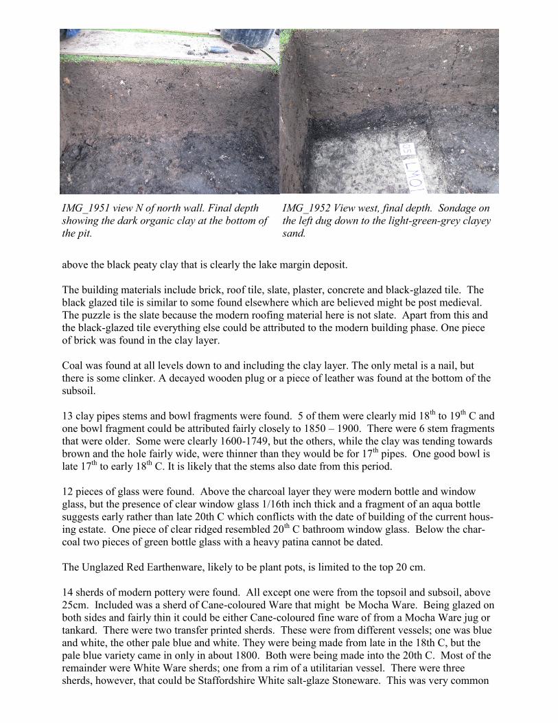
above the black peaty clay that is clearly the lake margin deposit.
The building materials include brick, roof tile, slate, plaster, concrete and black-glazed tile. The
black glazed tile is similar to some found elsewhere which are believed might be post medieval.
The puzzle is the slate because the modern roofing material here is not slate. Apart from this and
the black-glazed tile everything else could be attributed to the modern building phase. One piece
of brick was found in the clay layer.
Coal was found at all levels down to and including the clay layer. The only metal is a nail, but
there is some clinker. A decayed wooden plug or a piece of leather was found at the bottom of the
subsoil.
13 clay pipes stems and bowl fragments were found. 5 of them were clearly mid 18th to 19th C and
one bowl fragment could be attributed fairly closely to 1850 – 1900. There were 6 stem fragments
that were older. Some were clearly 1600-1749, but the others, while the clay was tending towards
brown and the hole fairly wide, were thinner than they would be for 17th pipes. One good bowl is
late 17th to early 18th C. It is likely that the stems also date from this period.
12 pieces of glass were found. Above the charcoal layer they were modern bottle and window
glass, but the presence of clear window glass 1/16th inch thick and a fragment of an aqua bottle
suggests early rather than late 20th C which conflicts with the date of building of the current hous-
ing estate. One piece of clear ridged resembled 20th C bathroom window glass. Below the char-
coal two pieces of green bottle glass with a heavy patina cannot be dated.
The Unglazed Red Earthenware, likely to be plant pots, is limited to the top 20 cm.
14 sherds of modern pottery were found. All except one were from the topsoil and subsoil, above
25cm. Included was a sherd of Cane-coloured Ware that might be Mocha Ware. Being glazed on
both sides and fairly thin it could be either Cane-coloured fine ware of from a Mocha Ware jug or
tankard. There were two transfer printed sherds. These were from different vessels; one was blue
and white, the other pale blue and white. They were being made from late in the 18th C, but the
pale blue variety came in only in about 1800. Both were being made into the 20th C. Most of the
remainder were White Ware sherds; one from a rim of a utilitarian vessel. There were three
sherds, however, that could be Staffordshire White salt-glaze Stoneware. This was very common
IMG_1951 view N of north wall. Final depth
showing the dark organic clay at the bottom of
the pit.
IMG_1952 View west, final depth. Sondage on
the left dug down to the light-green-grey clayey
sand.

in the period 1720-1780. However, there is some uncertainly about the identification of these
sherds. The only sherds from beneath the subsoil in the top layer of the underlying lake deposits
was a rope coil feature from a decorative vessel. It had a yellow glaze and could not be fitted in
any classification. It is likely to be 19th C. Finally, one sherd had no glaze and could not be iden-
tified. It may even be a post-medieval fabric.
There were only two small pieces of stoneware. Both were body sherds and it was not possible to
tell the original vessel. However, one was dated 1720 –1790 and made in Nottingham and the oth-
er a little later, 1760-1840, and made in Derbyshire. Both were found at the bottom of the subsoil.
The coarse earthenware was mainly Pink-bodied black Glazed Coarse Earthenware (3) with two
Red-bodied Black Glazed and one Brown Glazed. They were found in spit 3 in both the subsoil
and the underlying clay. Mostly they were small body sherds with dark brown glaze and it was not
possible to be sure of the nature of the original vessel, but one red-bodied sherd with a black glaze
was from a pancheon. This is the most common form for coarse earthenware.
Three sherds of Mottled Ware and Black Slipware were found near the bottom of the subsoil and
in the underlying clay. One Mottled Ware sherd was a base to a chamber pot. The Black slipware
was part of a bowl.
Interpretation
The lake deposit of black peaty clay, which rests above light green-grey clayey sand, contains
abundant small molluscs (water snails), which may be either terrestrial, marginal or deep water.
They have not been identified, but all three environments were identified where the molluscs were
found elsewhere. The implication is that this was at the lake edge and may not have been used for
agriculture until it was covered by the clay deposits
The lake deposit is covered by two clay layers that are thought also to be either part of the lake de-
posit or a more recent sedimentary deposit. These are contexts C and D. At the top of C is a layer
of charcoal. The soil profile above the charcoal layer suggests that it is a natural sequence of sub-
soil and topsoil with, perhaps, only the turf being imported. Beneath the charcoal layer (25 cm
depth) the two clay layers (contexts C and D) seem to be natural deposits but pottery, clay pipes,
glass and other materials were found in the brown-grey clay (context C). The glass bottle frag-
ments have a heavy patina from chemical reaction with the soil and could be pre-19th C. Sherds
of stoneware, coarse earthenware, Mottled Ware and one glazed modern type were present in the
underlying orange-brown-grey clay (context D). This seems to suggest that these two sediment
deposits were laid down onto the black peaty lake deposit at the edge of the lake, maybe by out-
wash during periods of heavy rain. The pottery and clay pipes may have been deposited on the
sediment in manure scatters. Significantly, all the clay pipe stems found in context C date from the
17th to mid 18th C. No dated clay pipe bowls have been found anywhere in Bingham from before
1620 and most early ones are from the mid 17th C.
The layer of charcoal is significant. It suggest that there may have been a fire on the ground sur-
face. The clay pipe stems from above this layer are nearly all dated post mid 18th C. However,
one bowl fragment from just above the charcoal layer could be fixed at 1675 to 1725. This sup-
ports the conclusion that this ground surface was in use in the late 17th C.
There is a crude stratigraphy in the succession above the peaty clay. Modern pottery, which rang-
es in age from early 18th to mid 20th C extends down to 30 cm; post-medieval pottery including
the stoneware and coarse earthenware was found slightly overlapping this from 20 to 40 cm depth.
The two stoneware sherds range through the 18th to early 19th C, though there is no certainty
about the age rage for the coarse earthenware.

The enclosed pottery in the subsoil and topsoil, therefore, indicates continued activity in this area
from the late 17th C to modern times, though most of the material found was probably deposited
with farmyard manure and does not indicate a habitation nearby until the mid 20th C when the
neighbouring house was built.