lk~ 1 -~ lu,, ~iov ii ni ~ i’vic ‘ji~ · site forms map (please attach a map of the site...
TRANSCRIPT

Cromarty Firth Port Authority
i;.(.. Ii ‘“I C ~\L)
i ( P\i~ NI ~ I’VIC
[ ii ~iov Lu,,
• I .S 1< ‘.111 kl ¼ I) \TE 1LK~__
~_zb___L ;~rI:
-~
Dear Malcolm
Amenity Land at Cromarty Firth Port, Invergordon
Further to my letter dated 28 october 2011, I have now been In contact with Captain Peter Taylorwho was employed as Port Manager by CFPA from 1985 to 1995. During this period the phase threereclamation project was undertaken. Captain Taylor has confirmed to me that the amenity land asshown on the Crown Estates I.ease dated 2 July 1990 formed part of the reclamation and civil worksproject.
I also note from the CFPA Board minutes that the entire project Including the reclamation of theAmenity land was concluded in November 1987. I also understand that it was not until September1988 that any discussions took place between officials of CFPA and the District Council relating to thecommunity having access to this land and these discussions were never finalised.
it is our view that this information further strengthens CFPA’s claim that this land was reclaimedunder CFPA’s powers and thus forms part of the overall Port development and is in fact PortOperational land as previously stated in our letter dated 28 October 2011.
We look forward to an early resolution of this matter, thank you for your assistance.
Yours
,~~~iTcir.i.
ExecutivelHarbOUr Master
Port Office, Shore Road, lnver8ordon, Ross-Shire, IViS OHD, ScotlandTel: Invergordon (01349) 852308 Fat (01349) 853181E.mail: [email protected]: www.c~a.ca.uk
QthLITYSSU RED
UKA5
Cart NO. 7129
‘JI~Ret KG/hmk
9 November 2011
Malcolm Macleod EsqHead of Planning & Building StandardsThe Highland CouncilGlenurquhart RoadINVERNESSlV3 5NX

Site Forms
Map (please attach a map of the site ideallyon an Ordnance Survey base)
YOUR DETAILSYour Name (and organisation Captain Ken Grayif applicable) Cromarty Firth Port AuthorityYour Address! Contact The Port OfficeDetails Shore Road
Invergordon1V18 OHD
landowner’s Name (if Cromarty Firth Port Authorityknown! applicable)Agent (if applicable) As aboveAgent’s Address I Contact As AboveDetails (if applicable)
DETAILS OF SITE SUGGESTEDSite Address Hendersons Yard and Railway sidings,
I nvergordonSite/local Name (if different As abovefrom aboveSite Size (hectares) 2.3 acreasGrid Reference (if known)Proposed Use (e.g. housing, Storage and industrial land linked toaffordable housing, the Port facilitiesemployment, retail, waste,gypsy traveller, utility,community, retained publicopen space)Proposed Non HousingFloorspace I Number ofHousing Units (ifknown/applicable)
If you wish to suggest a site that should !~ be built on, fill in thisformREASONS WHY YOUR SITE SHOULD BE SAFEGUARDED FROM BUILDINGHow do the public Not used by the publicenjoy the space - e.g.used for dog walking,children’s play?What makes the site Owned by the Port Authority and close to themore special than other Invergordon Service Base.areas in thevillage/town? ___________
Does the site haveattractive or rarefeatures such as maturetrees, historicalsignificance orprotected wildlife?
Close to the railway and Port
Landowners, developers and/or agents wishing to suggest a site should fillin the following form and as much as possible of the strategicenvironmental assessment form (at the end of this document) whichassesses the environmental effects ofpossible development sites.
N/A
If you wish to suggest a site that should be built on, fill in this formREASONS FOR YOUR DEVELOPMENT SITE SUGGESTION
How can the site beserviced?(give details ofproposed access, fouldrainage, surface waterand water supplyarrangements)
FORM CONTINUES BELOW
0
Nil
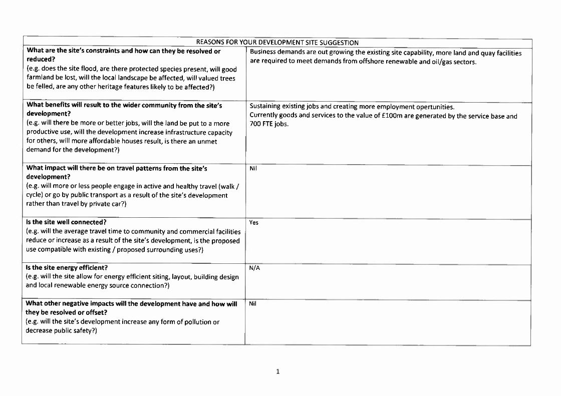
REASONS FOR YOUR DEVELOPMENT SITE SUGGESTIONWhat are the site’s constraints and how can they be resolved or Business demands are out growing the existing site capability, more land and quay facilitiesreduced? are required to meet demands from offshore renewable and oil/gas sectors.(e.g. does the site flood, are there protected species present, will goodfarmland be lost, will the local landscape be affected, will valued treesbe felled, are any other heritage features likely to be affected?)
What benefits will result to the wider community from the site’s Sustaining existing jobs and creating more employment opertunities.development? Currently goods and services to the value of flOOm are generated by the service base and(e.g. will there be more or betterjobs, will the land be put to a more 700 FTE jobs.productive use, will the development increase infrastructure capacityfor others, will more affordable houses result, is there an unmetdemand for the development?)
What impact will there be on travel patterns from the site’sdevelopment?(e.g. will more or less people engage in active and healthy travel (walk /cycle) or go by public transport as a result of the site’s developmentrather than travel by private car?)
Is the site well connected?(e.g. will the average travel time to community and commercial facilitiesreduce or increase as a result of the site’s development, is the proposeduse compatible with existing / proposed surrounding uses?)
Is the site energy efficient?(e.g. will the site allow for energy efficient siting, layout, building designand local renewable energy source connection?)
What other negative impacts will the development have and how willthey be resolved or offset?(e.g. will the site’s development increase any form of pollution ordecrease public safety?)
Yes
N/A
Nil

STRATEGIC ENVIRONMENTAL ASSESSMENT FORM
Landowners, developers and/or agents wishing to suggest a site should fill in as much as possible of the following form. Strategic environmentalassessment of local development plan sites is now a statutory requirement and considers the possible environmental effects of development proposals. Wewill check your answers and fill in any gaps.
No. Issue Detailed Explanation Answer Any Proposed Mitigation Measures
(how will you reduce or offset the___________________________________________________________ effects of your development?)
1
2
3
a) Will the site safeguard Will the site have any impact on useableany existing open space public open space (such as parks, playingwithin the area? fields etc) or any opportunities to create
additional public open space?b) Will the site enablehigh quality open spaceto be provided withinthe area?Will the site encourage Is any part of the site within 400m straightand enable provision for line distance of any community/commercialactive travel (walking, building? or will development provide acycling and public community/commercial building withintransport use)? walking distance of existing residential areas?
- Are there opportunities to create newwalking/cycling routes or improve existingroutes?
Does the site provide an For example, can a subsidy to a local busopportunity for you to route be provided?provide a financialcontribution towardsencouraging moresustainable travelpatterns?Will the site involve “off Is the site likely to improve the local roadsite” road improvements network such as junctions or crossings?that will contribute toroad safety?Is there scope for road Will development incorporate on-site traffic Not required
N/A
No
No
No
No
2

Yes the railway sidings are classed as derelictland
6 No
8
safety measures as part calming measures (e.g. speed bumps) orof the development of Street lighting? Will it incorporate thethe site? principles of Designing Streets available via:
http://www.scotland.gov.uk/publica~jons/2010/03/22120652/0
Is the site near any Will the site be negatively affected by anyexisting “bad neighbour” neighbouring use? (bad neighbour usesuses? include those that affect residential property
by way of fumes, vibration, noise, artificiallighting etc). Is the site affected by any of thePhysical Constraints identified in theCouncil’s Physical Constraints:Supplementary Guidance?
Are there any Are you aware if the site has been previously Unknowncontaminated land used for industrial or any other uses likely toissues affecting the site? cause contamination?a) Is the site on derelict, a) Has the site been identified in Scottishvacant or other land that Government’s Vacant and Derelict Landhas previously been Survey (which can be found here:used? httD :1/scotland .gov.uk/Publ ications/2010/01
/26135819/0 )or has the land got an existinguse?
b) Is the site on b) Will the site be located on presentlygreenfield land? undeveloped land e.g. presently or capably
used for agriculture, forestry or amenitypurposes?
Is the site within the Is the site within any identified settlementcurrent settlement boundary in the Local Plan? Is it allocated forboundary? any uses?Will the site affect the Does the site conform with the Landscapedistinctiveness and Capacity Assessment (if available)? Will thespecial qualities of the site result in the removal of valued landscapepresent landscape features or negatively affect any key views?character or affect any Is it located within or would otherwise affectlandscape designation? a National Scenic Area or Special Landscape
Area, having regard to their special qualities?
No
10
No
No
3
11 No
14
15
No
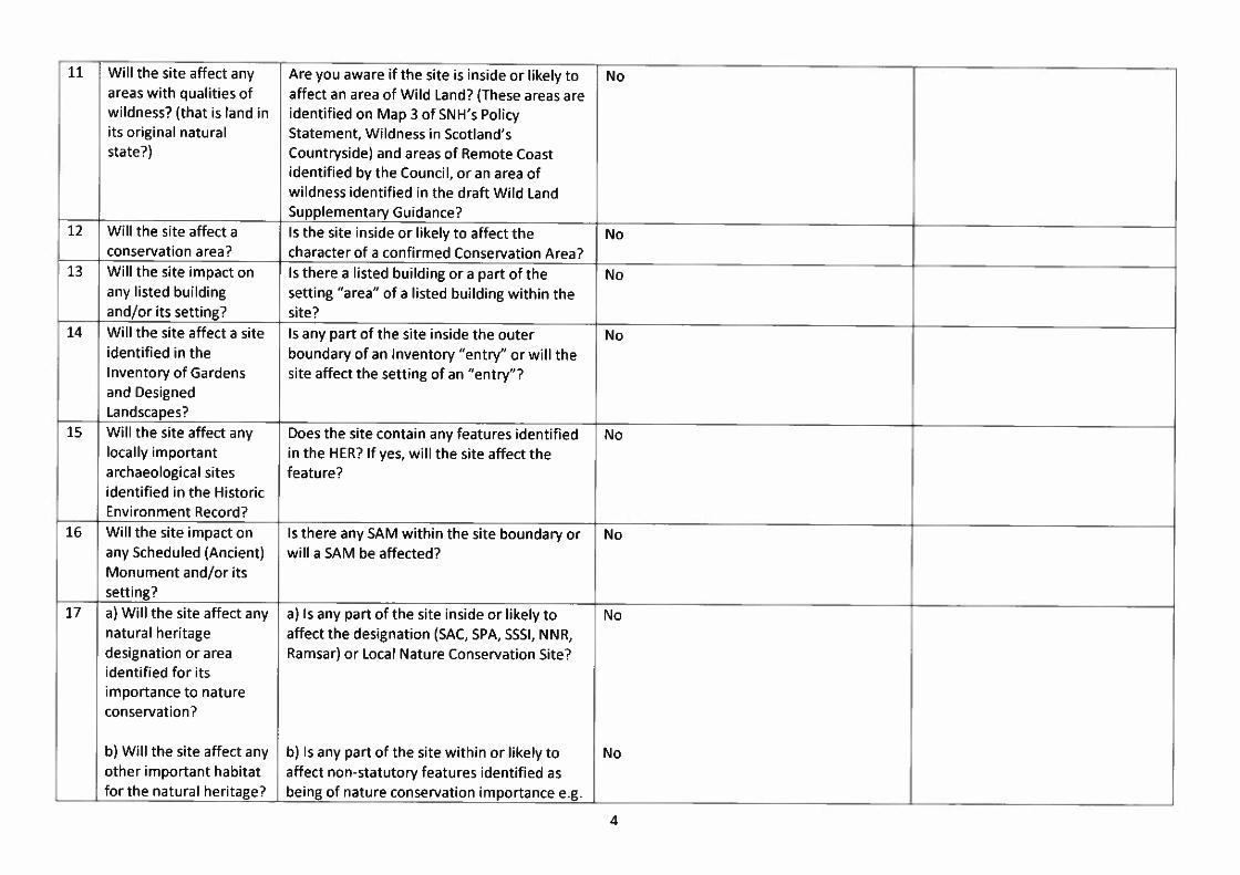
Will the site affect any Are you aware if the site is inside or likely toareas with qualities of affect an area of Wild Land? (These areas arewildness? (that is land in identified on Map 3 of SNH’s Policyits original natural Statement, Wildness in Scotland’sstate?) Countryside) and areas of Remote Coast
identified by the Council, or an area ofwildness identified in the draft Wild LandSupplementary Guidance?
Will the site affect a Is the site inside or likely to affect theconservation area? character of a confirmed Conservation Area?Will the site impact on Is there a listed building or a part of theany listed building setting “area” of a listed building within theand/or its setting? site?Will the site affect a site Is any part of the site inside the outeridentified in the boundary of an Inventory “entry” or will theInventory of Gardens site affect the setting of an “entry”?and DesignedLandscapes?Will the site affect any Does the site contain any features identifiedlocally important in the HER? If yes, will the site affect thearchaeological sites feature?identified in the HistoricEnvironment Record?Will the site impact on Is there any SAM within the site boundary orany Scheduled (Ancient) will a SAM be affected?Monument and/or itssetting?a) Will the site affect any a) Is any part of the site inside or likely tonatural heritage affect the designation (SAC, SPA, 5551, NNR,designation or area Ramsar) or Local Nature Conservation Site?identified for itsimportance to natureconservation?
b) Will the site affect any b) Is any part of the site within or likely toother important habitat affect non-statutory features identified asfor the natural heritage? being of nature conservation importance e.g.
No
No
No
No
4

18
Ancient, Semi-Natural or Long-EstablishedWoodland Inventory sites, priority BAPhabitats, habitats included on the ScottishBiodiversity List, non-designated habitatslisted in Annex 1 of EC Habitats Directive?
a) Will the site affect any a) Will the site affect any European Protectedprotected species? Species, Badgers and species (birds, animals
and plants) protected under the Wildlife andCountryside Act 1981 as amended. If such aspecies may be present on or near the site, asurvey should be carried out to inform thisassessment (for which a licence from SNHmay be required)
b) Will the site affect any b) Will the site affect species listed in the UKother important species and Local BAPs, the Scottish Biodiversity Listforthe natural heritage? and relevant annexes of the EC Habitats
Directive?Is the site proposed to For example, will the site provide or beprovide any form of capable of providing a district heatingrenewable energy? system, solar panels of a wind turbine?Is any part of the site at Are you aware of any part of the site beingrisk from fluvial or within the 1 in 200 year flood risk contour ascoastal flooding as identified by SEPA? (which can be foundshown on SEPA’s flood here:map or from local http://www.sepa.org.uk/flooding/flood riskknowledge? maps/view the map.aspx)Will development of the Will there by any change in rate, quantity,site result in the need quality of run-off plus groundwater impactfor changes in land form on or off site? If so, will these affect priorityand level? If yes, how habitats, especially blanket bog?will soil and drainageissues be addressed?Is there a watercourse, Will there be any culverting, diversion orloch or sea within or channelling of existing watercourses?adjacent to the site? Ifyes, how will the water
No
No
No
No
No
21
5

environment beprotected fromdevelopment?Will the site offer Will the waste produced by the site beopportunities for minimised and processed close to source in asustainable waste sustainable way?management?Can the site be Can the site be connected at reasonableconnected to the public cost? If not, what alternative is proposed?water and seweragesystem?Will the site require Can the site (including access) be developedalteration to the local without significant re-contouring etc.? WillIandform? access tracks and parking areas have
significant cut and fill?Will the site affect or be This will be noted on any relevant shorelineaffected by coastal management plan.erosion or naturalcoastal processes?Is the site sheltered from Will development make best use of the sitethe prevailing wind and in terms of energy efficiency?does it have a principalaspect between SW andSE?Will the site have any Is the site near areas of employment or closeimpact upon local air to public transport? Such developments arequality? less likely to result in additional traffic which
may contribute to air pollution.Will the site have an Is it likely that the Council policy likely willimpact on light pollution require street lighting at this location? Arelevels? there proposals for floodlighting on the site?a) Will it the site affect a) Will the site affect features that currentlythe present green provide for the movement of species and/ornetwork of the area? people e.g. woodland, hedgerows, field
margins, watercourses, coastlines, tree belts,greenspace?
No
Yes
No
No
No
No
No
No
No
6

b) Will the site provide b) Will connectively of natural features oropportunities to open space and paths used for publicenhance the present amenity be improved? Will existinggreen network of the fragmentation of habitats and open spacesarea? be improved? Will species be enabled to
move where at present there is an obstacle?
Will the site provide Is the site close to (within 1.5km) anopportunities for people opportunity to come into contact withto come into contact nature/natural environments e.g. Localwith and appreciate Nature Reserves, local greenspace, greennature/natural networks? Are there proposals which willenvironments? increase opportunities to come into contact
with nature/natural environments?a) Will the site affect any a) Is a diversion of a core path or right of waycore paths or right of required? Will there be any impact on theway? usability of a core path or right of way?
b) Will the site affect any b) Will it affect an existing path in theother existing paths or Highland Path Record? Will it provideoutdoor access additional access opportunities or adverselyopportunities? affect access opportunities afforded by the
Land Reform (Scotland) Act 2003?
c) Will the allocation c) Will new paths be created within andprovide new access beyond the site? Will any existing paths beopportunities within the improved e.g. to increase accessibility to asite and linking to the wider range of users? Will the site help topath network beyond realise priorities identified in the Council’sthe site? outdoor access strategy or aspirational paths
identified in the core path plans?Will the site have an Are you aware if the site lies within orimpact on the adjacent to an un-notified Geologicalgeodiversity of the area? Conservation Review site or Local
Geodiversity Site? (or other site withgeodiversity value e.g. distinctive landforms,areas with natural processes, rock exposures
31
32
33
No
No
No
No
No
7

for study?)Will soil quality and Will the site result in a loss of soil due tocapability of the site be development or removal of good quality soiladversely affected? from the site? Is the site on land identified as
Prime Quality Agricultural Land?Is the site within or functionally connected toan area of peatland? Would the allocationinvolve the disturbance of peat? If yes, howwould impacts on peatland be avoided orminimised? Would any tree felling berequired?
Will the site have any Does the site represent a significant loss ofaffect on the viability of good quality inbye crofting land or commona crofting unit? grazing land?
No
No
No
Is the site on peatland?

Site Forms
YOUR DETAILSYour Name (and organisation Captain Ken Grayif applicable) Cromarty Fifth Port AuthorityYour Address / Contact The Port OfficeDetails Shore Road
lnvergordon1V18 OHD
Landowner’s Name (if Cromarty Fifth Port Authorityknown! applicable)Agent (if applicable) As aboveAgent’s Address / Contact As AboveDetails (if applicable)
DETAILS OF SITE SUGGESTEDSite Address The Invergordon Service Base and
Amenity LandSite/total Name (if different As abovefrom aboveSite Size (hectares) 33 acresGrid Reference (if known)Proposed Use (e.g. housing, Port facilities and engineeringaffordable housing, workshops for oil and gas andemployment, retail, waste, onshore/offshore renewable.gypsy traveller, utility, Port related import and exportcommunity, retained public activities.open space) Amenity land comprising 3 actres to be
realocated for Port use, land previouslyreclaimed by Port Authority under aport development project.
Proposed Non HousingFloorspace / Number ofHousing Units (if
known/applicable)(please attach a map of the site ideallyon an Ordnance Survey base)
If you wish to suggest a site that should not be built on, fill in thisformREASONS WHY YOUR SITE SHOULD BE SAFEGUARDED FROM BUILDINGHow do the public No public access to Service Base as securityenjoy the space - e.g. restricted area.used for dog walking, Amenity Land currently utalised for occasional dogchildren’s play? walking.What makes the site Close proximity to deep water berths and access tomore special than other the Fifth.areas in thevillage/town?Does the site have Workshops, quays, deep water, job creationattractive or rare Economic regenerationfeatures such as maturetrees, historicalsignificance orprotected wildlife?
Landowners, developers and/or agents wishing to suggest a site should fillin the following form ~4 as much as possible of the strategicenvironmental assessment form (at the end of this document) whichassesses the environmental effects of possible development sites.
If you wish to suggest a site that should be built on, fill in this formREASONS FOR YOUR DEVELOPMENT SITE SUGGESTION
How can the site beserviced?(give details ofproposed access, fouldrainage, surface waterand water supplyarrangements)
0

FORM CONTINUES BELOWREASONS FOR YOUR DEVELOPMENT SITE SUGGESTION
What are the site’s constraints and how can they be resolved or Business demands are out growing the existing site capability, more land and quay facilitiesreduced? are required to meet demands from offshore renewable and oil/gas sectors.(e.g. does the site flood, are there protected species present, will goodfarmland be lost, will the local landscape be affected, will valued treesbe felled, are any other heritage features likely to be affected?)
What benefits will result to the wider community from the site’s Sustaining existing jobs and creating more employment opertunities.development? Currently goods and services to the value of £lOOm are generated by the service base and(e.g. will there be more or better jobs, will the land be put to a more 700 FTE jobs.productive use, will the development increase infrastructure capacityfor others, will more affordable houses result, is there an unmetdemand for the development?)
What impact will there be on travel patterns from the site’s Nildevelopment?(e.g. will more or less people engage in active and healthy travel (walk /cycle) or go by public transport as a result of the site’s developmentrather than travel by private car?)
Is the site well connected? Yes(e.g. will the average travel time to community and commercial facilitiesreduce or increase as a result of the site’s development, is the proposeduse compatible with existing / proposed surrounding uses?)
Is the site energy efficient? Yes(e.g. will the site allow for energy efficient siting, layout, building designand local renewable energy source connection?)
What other negative impacts will the development have and how will The development of the site will be an extention of the current site usage.they be resolved or offset?(e.g. will the site’s development increase any form of pollution ordecrease public safety?)
1


STRATEGIC ENVIRONMENTAL ASSESSMENT FORM
Landowners, developers and/or agents wishing to suggest a site should fill in as much as possible of the following form. Strategic environmentalassessment of local development plan sites is now a statutory requirement and considers the possible environmental effects of development proposals. Wewill check your answers and fill in any gaps.
No. Issue Detailed Explanation Answer Any Proposed Mitigation Measures
(how will you reduce or offset theeffects of your development?)
2
3
a) Will the site safeguard Will the site have any impact on useable The main site will have no effectany existing open space public open space (such as parks, playingwithin the area? fields etc) or any opportunities to create The amenity Land was set aside for public use
additional public open space? until such time as the Port developed andb) Will the site enable required this land for expansion. This land ishigh quality open space now required to expand the Port facilities. Itto be provided within is little used by the community and surveysthe area? have shown that its return to industrial use
will have minimum effect on the localcommunity.
Will the site encourage Is any part of the site within 400m straightand enable provision for line distance of any community/commercialactive travel (walking, building? or will development provide acycling and public community/commercial building withintransport use)? walking distance of existing residential areas?
- Are there opportunities to create newwalking/cycling routes or improve existingroutes?
Does the site provide an For example, can a subsidy to a local busopportunity for you to route be provided?provide a financialcontribution towardsencouraging moresustainable travelpatterns?Will the site involve “off Is the site likely to improve the local roadsite” road improvements network such as junctions or crossings?that will contribute to
Limited
No
No
3

S
6
road safety?Is there scope for road Will development incorporate on-site trafficsafety measures as part calming measures (e.g. speed bumps) orof the development of street lighting? Will it incorporate thethe site? principles of Designing Streets available via:
httD:I/www.scotland.gov.ukjpublicationsj2010103122120652/O
Is the site near any Will the site be negatively affected by anyexisting “bad neighbour” neighbouring use? (bad neighbour usesuses? include those that affect residential property
by way of fumes, vibration, noise, artificiallighting etc). Is the site affected by any of thePhysical Constraints identified in theCouncil’s Physical Constraints:Supplementary Guidance?
Are there any Are you aware if the site has been previouslycontaminated land used for industrial or any other uses likely toissues affecting the site? cause contamination?a) Is the site on derelict, a) Has the site been identified in Scottishvacant or other land that Government’s Vacant and Derelict Landhas previously been Survey (which can be found here:used? http://scotland .gov. uk/Pu blications/2010/O1
/26135819/0 )or has the land got an existinguse?
b) Is the site on b) Will the site be located on presentlygreenfield land? undeveloped land e.g. presently or capably
used for agriculture, forestry or amenitypurposes?
Is the site within the Is the site within any identified settlementcurrent settlement boundary in the Local Plan? Is it allocated forboundary? any uses?Will the site affect the Does the site conform with the Landscapedistinctiveness and Capacity Assessment (if available)? Will thespecial qualities of the site result in the removal of valued landscapepresent landscape features or negatively affect any key views?character or affect any Is it located within or would otherwise affect
Not required
No
No
No
No
No
No
4

15 No
No
No
No
5
11 No
landscape designation? a National Scenic Area or Special LandscapeArea, having regard to their special qualities?
Will the site affect any Are you aware if the site is inside or likely toareas with qualities of affect an area of Wild Land? (These areas arewildness? (that is land in identified on Map 3 of SNH’s Policyits original natural Statement, Wildness in Scotland’sstate?) Countryside) and areas of Remote Coast
identified by the Council, or an area ofwildness identified in the draft Wild LandSupplementary Guidance?
Will the site affect a Is the site inside or likely to affect the Adjoiningconservation area? character of a confirmed Conservation Area?Will the site impact on Is there a listed building or a part of theany listed building setting “area” of a listed building within theand/or its setting? site?Will the site affect a site Is any part of the site inside the outeridentified in the boundary of an Inventory “entry” or will theInventory of Gardens site affect the setting of an “entry”?and DesignedLandscapes?Will the site affect any Does the site contain any features identifiedlocally important in the HER? If yes, will the site affect thearchaeological sites feature?identified in the HistoricEnvironment Record?Will the site impact on Is there any SAM within the site boundary orany Scheduled (Ancient) will a SAM be affected?Monument and/or itssetting?a) Will the site affect any a) Is any part of the site inside or likely tonatural heritage affect the designation (SAC, SPA, SSSI, NNR,designation or area Ramsar) or Local Nature Conservation Site?identified for itsimportance to natureconservation?
b) Will the site affect any b) Is any part of the site within or likely to
17

other important habitat affect non-statutory features identified asfor the natural heritage? being of nature conservation importance e.g.
Ancient, Semi-Natural or Long-EstablishedWoodland Inventory sites, priority BAPhabitats, habitats included on the ScottishBiodiversity List, non-designated habitatslisted in Annex 1 of_EC_Habitats_Directive?
18 a) Will the site affect any a) Will the site affect any European Protected Noprotected species? Species, Badgers and species (birds, animals
and plants) protected under the Wildlife andCountryside Act 1981 as amended. If such aspecies may be present on or near the site, asurvey should be carried out to inform thisassessment (for which a licence from SNHmay be required)
b) Will the site affect any b) Will the site affect species listed in the UKother important species and Local BAPs, the Scottish Biodiversity Listforthe natural heritage? and relevant annexes of the EC Habitats
Directive?19 Is the site proposed to For example, will the site provide or be No
provide any form of capable of providing a district heatingrenewable energy? system, solar panels of a wind turbine?
20 Is any part of the site at Are you aware of any part of the site being Norisk from fluvial or within the 1 in 200 year flood risk contour ascoastal flooding as identified by SEPA? (which can be foundshown on SEPA’s flood here:map or from local http://www.sepa.org.uk/floodingjflood riskknowledge? maps/view the map.aspx)
21 Will development of the Will there by any change in rate, quantity, Nosite result in the need quality of run-off plus groundwater impactfor changes in land form on or off site? If so, will these affect priorityand level? If yes, how habitats, especially blanket bog?will soil and drainageissues be addressed?
22 Is there a watercourse, Will there be any culverting, diversion or Yesloch or sea within or channelling of existing watercourses?
6

No
No
No
adjacent to the site? Ifyes, how will the waterenvironment beprotected fromdevelopment?Will the site offer Will the waste produced by the site beopportunities for minimised and processed close to source in asustainable waste sustainable way?management?Can the site be Can the site be connected at reasonable Already connectedconnected to the public cost? If not, what alternative is proposed?water and seweragesystem?Will the site require Can the site (including access) be developedalteration to the local without significant re-contouring etc.? Willlandform? access tracks and parking areas have
significant cut and fill?Will the site affect or be This will be noted on any relevant shorelineaffected by coastal management plan.erosion or naturalcoastal processes?Is the site sheltered from Will development make best use of the sitethe prevailing wind and in terms of energy efficiency?does it have a principalaspect between SW andSE?Will the site have any Is the site near areas of employment or closeimpact upon local air to public transport? Such developments arequality? less likely to result in additional traffic which
may contribute to air pollution. ________________________________
Will the site have an Is it likely that the Council policy likely will Lighting towers in placeimpact on light pollution require street lighting at this location? Arelevels? there proposals for floodlighting on the site?a) Will it the site affect a) Will the site affect features that currentlythe present green provide for the movement of species and/ornetwork of the area? people e.g. woodland, hedgerows, field
margins, watercourses, coastlines, tree belts,
No
Monitored activities
No
7

31
greenspace?
b) Will the site provide b) Will connectively of natural features oropportunities to open space and paths used for publicenhance the present amenity be improved? Will existinggreen network of the fragmentation of habitats and open spacesarea? be improved? Will species be enabled to
move where at present there is an obstacle?
Will the site provide Is the site close to (within 1.5km) anopportunities for people opportunity to come into contact withto come into contact nature/natural environments e.g. Localwith and appreciate Nature Reserves, local greenspace, greennature/natural networks? Are there proposals which willenvironments? increase opportunities to come into contact
with nature/natural environments?a) Will the site affect any a) Is a diversion of a core path or right of waycore paths or right of required? Will there be any impact on theway? usability of a core path or right of way?
b) Will the site affect any b) Will it affect an existing path in theother existing paths or Highland Path Record? Will it provideoutdoor access additional access opportunities or adverselyopportunities? affect access opportunities afforded by the
Land Reform (Scotland) Act 2003?
c) Will the allocation c) Will new paths be created within andprovide new access beyond the site? Will any existing paths beopportunities within the improved e.g. to increase accessibility to asite and linking to the wider range of users? Will the site help topath network beyond realise priorities identified in the Council’sthe site? outdoor access strategy or aspirational paths
identified in the core path plans?Will the site have an Are you aware if the site lies within orimpact on the adjacent to an un-notified Geologicalgeodiversity of the area? Conservation Review site or Local
Geodiversity Site? (or other site with
No
No
No
No
No
S

35 Is the site on peatland?
geodiversity value e.g. distinctive landforms,areas with natural processes, rock exposuresfor study?)
Will soil quality and Will the site result in a loss of soil due tocapability of the site be development or removal of good quality soiladversely affected? from the site? Is the site on land identified as
___________ Prime Quality Agricultural Land?Is the site within or functionally connected toan area of peatland? Would the allocationinvolve the disturbance of peat? If yes, howwould impacts on peatland be avoided orminimised? Would any tree felling berequired?
Will the site have any Does the site represent a significant loss ofaffect on the viability of good qUality inbye crofting land or commona crofting unit? grazing land?
No
No
No