lithostratigraphy and age of the st. ann’s great river ... web page... · lithostratigraphy and...
TRANSCRIPT
Mitchell, S. F., Ramsook, R., Coutou, R. and Fisher, J. 2011. Lithostratigraphy and age of the St. Ann‟s Great River
Inlier, northern Jamaica. Caribbean Journal of Earth Science, Volume 42, 1-16. © Geological Society of Jamaica.
1
Lithostratigraphy and age of the St. Ann’s Great River Inlier,
northern Jamaica
SIMON F. MITCHELL, RYAN RAMSOOK, RICHARD COUTOU AND JASON FISHER
Department of Geography and Geology, The University of the West Indies, Mona, Kingston 7, Jamaica.
Email: [email protected] or [email protected]
ABSTRACT. The geology of the St. Ann’s Great River Inlier is revised. A new map of the inlier
showing the faults is presented as a base to understand the succession. The lithostratigraphy is
described and eight formations are recognised: Windsor Formation (Coniacian: 230+ m thick),
Clamstead Formation (Santonian, divided into five members: Lower Clamstead Mudstones; Lower
Clamstead Sandstones; Middle Clamstead Mudstones; Upper Clamstead Sandstones; Upper
Clamstead Mudstones: 403 m thick), Liberty Hall Formation (Late Santonian and Middle
Campanian separated by a major fault: 60+ m thick); Drax Hall Formation (Middle Campanian:
63 m thick); Cascade Formation (Middle-Late Campanian: 180 m thick); Lime Hall Formation (Late
Campanian: 14 m thick); St. Ann’s Great River Formation (Late Campanian: 14 m thick); and New
Ground Formation (Early to Middle Eocene: 290 m thick). The age assignments of the various
formations are discussed based on previous and new fossil records.
Key words: St. Ann’s Great River Inlier, Jamaica, Cretaceous, Stratigraphy.
1. INTRODUCTION
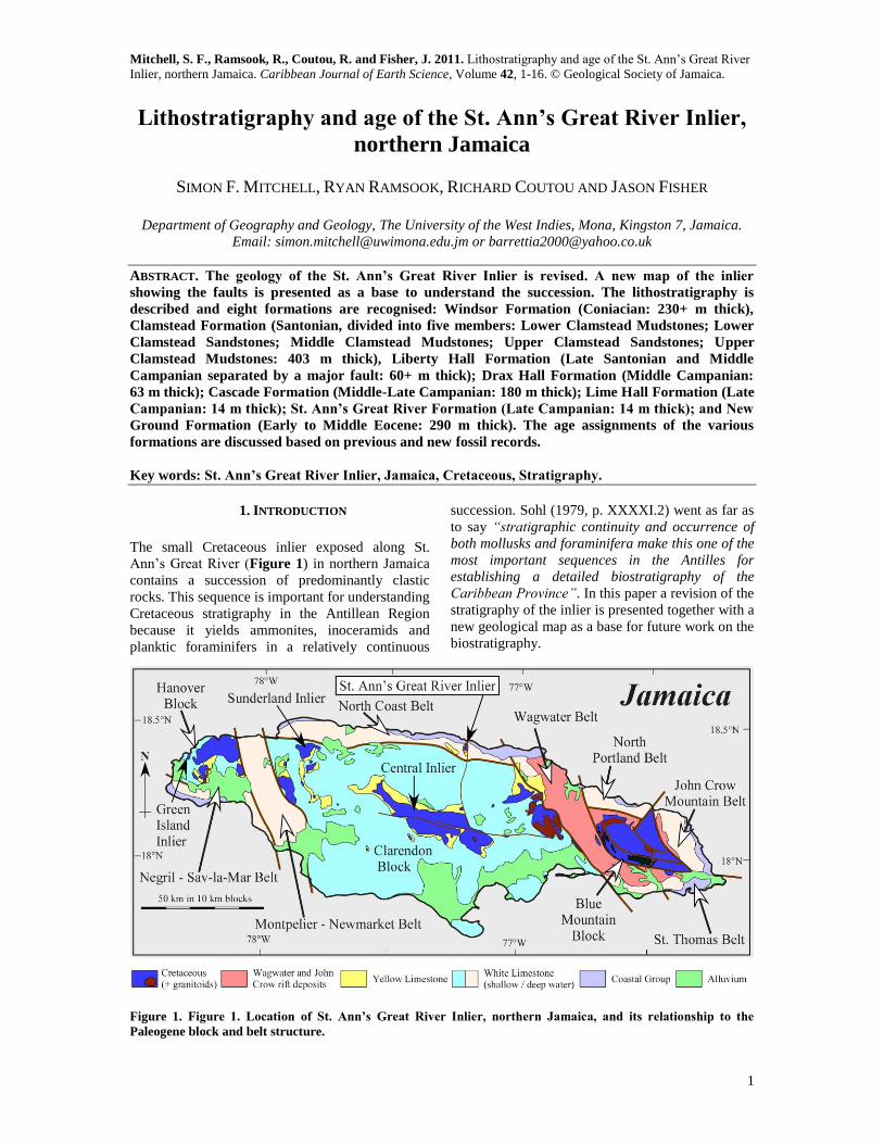
The small Cretaceous inlier exposed along St.
Ann‟s Great River (Figure 1) in northern Jamaica
contains a succession of predominantly clastic
rocks. This sequence is important for understanding
Cretaceous stratigraphy in the Antillean Region
because it yields ammonites, inoceramids and
planktic foraminifers in a relatively continuous
succession. Sohl (1979, p. XXXXI.2) went as far as
to say “stratigraphic continuity and occurrence of
both mollusks and foraminifera make this one of the
most important sequences in the Antilles for
establishing a detailed biostratigraphy of the
Caribbean Province”. In this paper a revision of the
stratigraphy of the inlier is presented together with a
new geological map as a base for future work on the
biostratigraphy.
Figure 1. Figure 1. Location of St. Ann’s Great River Inlier, northern Jamaica, and its relationship to the
Paleogene block and belt structure.
MITCHELL et al. 2011 – Stratigraphy of St. Ann’s Great River Inlier
2
2, PREVIOUS STUDIES
Sawkins (1869, p. 199) in his report of the 10th
of
May, 1866, stated that “the Great St. Ann‟s River
... [and its tributaries] ... have cut through a
portion of the upper conglomerates of the trappean
series and expose some of the superincumbent
black shales to the east of Liberty Hill”. The
exposures do not appear on the Sawkins and Brown
„Geological map of Jamaica‟ of 1865 that was
published in Sawkins (1869) nor on the Hill map of
1898 (Hill 1899), which is largely a copy of the
Sawkins and Brown map. The Sawkins and Brown
map was produced in 1865, before the geological
mapping of Jamaica was completed, probably to
coincide with the legislature imposed termination
of the geological survey of Jamaica at the end of
1865 (Colonial Office Records, The National
Archives, Kew, London). Sawkins, however,
managed to obtain an extension to complete the
surveying, including St. Ann, but the Sawkins and
Brown map of 1865 was never revised. The
trappean exposures in St. Ann are, however, shown
on the geological map of St. Ann, dated 1866, that
was completed for the survey of that parish
(manuscript copy in the Institute of Jamaica) and
this was presumably the map that was referred to
by Matley (1924a) as showing these exposures.
Matley (1924a), during his survey of water
resources in Jamaica, discovered the existence of a
gas seep in the Windsor Spring, a spring that had
been reported by Sawkins (1869), and measured the
gas to be 98.34% methane and 1.66% carbon
dioxide. At that time, Matley regarded the clastic
rocks exposed in the river valley to the south as of
early Eocene age, suggesting that Cretaceous rocks
might exist at depth. Subsequently, he discovered a
Cretaceous limestone in the sequence at the
southern end of the inlier (Matley, 1924b)
containing rudists (Radiolites cancellatus Whitfield
and Radiolites nicholasi Whitfield) which
Trechmann, in a personal communication to
Matley, thought were probably of Maastrichtian
age. Matley suggested that the bulk of the
succession exposed in the inlier was either below
the limestone or separated from it by a fault.
Matley made a hurried geological survey of the
inlier before he left Jamaica (Matley, 1925).
Matley‟s (1925, p. 14) description is reproduced
here: “The strata of the inlier occupy a length of
2¼ miles from north to south along the floor of the
valley with a width not exceeding ¾ mile. The
general structure is an anticline, the principle axis
of which trends nearly north to south, but in the
northern part there are dips to the east, so that
there is some evidence that the inlier may be a
dome. Unfortunately I had not the time to examine
the east and west boundaries of the inlier. There
does not appear, however, to be room on the sides
of the valley for all the strata of the inlier to be
exposed, and the higher beds must be either faulted
out or covered unconformably by the Montpelier
Limestone. The northern end of the anticline is
ruptured by a fault that runs in a north-north-
easterly direction through the mineral spring and
brings down the Montpelier Limestone against the
lower beds of the inlier.” The northern limb of the
anticline “exposes only the lower sandstones and
conglomerates of the inlier” with “dips NNE at 20º
up to 60º”. The southern limb exposes, from the
base upwards, “thick sandstones and conglomerates
with some shaly partings and beds of flaggy grits,
above which comes a few feet of clays followed by
pebbly sandstone. These graduate upward into blue
clays and shales with rare bands of sandstone. In
one place I saw a few marine fossils (small
Pholadomyas) which are apparently of Cretaceous
age. Unsurveyed rocks, about ⅜ mile across their
strike succeed; then, at the point where the tributary
from Dawson Town joins the main river, clays are
again seen with occasional bands of pebbly
sandstone, followed by a thick group of sandstones
and conglomerates over which the river rushes in a
series of cascades. Pebbles up to 24 inches in
diameter were seen in these conglomerates. They
continue as far as the bridge that crosses the river
at the confluence with the Fonthill tributary. Then
comes a bed of shaly Rudist Limestone with a
matrix of yellow marl. It has a superficial
resemblance to a bed of Yellow Limestone, but
contains Radiolites cancellatus, Whitf. and R.
(Lapeirousia) Nicholasi Whitf., so that it is evidently
of Cretaceous age. A few feet of clay succeeds, then
a bed of nodular limestone, followed by more blue
clays in which I found an abundant marine fauna.
Dr. C. T. Trechmann F.G.S. who was then in
Jamaica kindly examined the specimens (as well as
the rudists from the limestone) and identified the
following:- Pecten (Janira) quinquecostatus,
Pholadomya (a species also found at Providence,
parish of Portland), Turritella sp., Cardium,
Cerithium spp., Solarium (?) sp., Amauropsis &
other Naticoids, Dentalium, Volutilites (?),
Plicatula sp., Corals, 2 spp., Echinoid fragments.
Dr. Trechmann considers the horizon represented is
highest Cretaceous (Maastrichtian). The clays pass
up into conglomerates, in one bed of which the
pebbles consist entirely of hard fresh black basalt
with a resinous lusture.”
Trechmann (1927) recorded over 1,400 ft of
section in the inlier, puts thicknesses on Matley‟s
units, recognized that Barrettia occurred in the
MITCHELL et al. 2011 – Stratigraphy of St. Ann’s Great River Inlier
3
Table 1. Succession in St. Ann’s Great River as given by Trechmann (1927, pp. 30-31).
Thickness in feet
1. Tertiary white marls passing up into white limestone ?
Unconformity ? 2. Conglomerates containing numerous limestone pebbles. Richmond or basal Eocene. ?
Unconformity.
3. Grey and black shales becoming calcareous towards the base. Fossils plentiful; Neithea quadricostata, Plicatula cf. andersoni, Pholadomya jamaicensis, Gosaria sp., Glauconia matleyi, Apporrhais sp.,
Cerithium cf. libycum, and other forms. The gastropods occur mostly in calcareous shales a few feet
above the limestone. About 40 4. Clayey limestone with fragments of Rudistae. 10
5. Grey and pink nodular limestone containing complete and broken specimens of Biradiolites cancellatus
and B. subcancellatus, Barrettia monilifera, and a large specimen of Laperiousia nicholasi. 12 6. Massive conglomerate with many igneous and a few limestone pebbles. 50 (?)
7. Grey and blackish shales and shaley sandstones. A bed of small Corbula occurs in these shales about 800
feet below the Rudist limestone and below this is a bed with Turitella cardenasensis, Neithea subcompacta, Natica sp., Ostrea sp., Echinoderm spines, etc. About 1,000 feet below the limestone a
specimen of Inoceramus cf. balticus was collected by Mr. J. V. Harrison. over 1,000
8. Grey nodular shales with calcareous bands, no fossils seen. 300 (?)
9. Thick conglomerates and sandstones, base not seen ?
Table 2. History and relationship of lithostratigraphic schemes used for the rocks exposed in the Cretaceous to
Early Eocene of St. Ann’s Great River Inlier (Fm, Formation; Mbr, Member; Congl., Conglomerate). Ages
apply to this study.
Rudist Limestone, and described various fossils
from the sequence. Trechmann‟s description is
worth repeating here (Table 1) because it has
formed the basis of many subsequent reports, both
on the succession and about the age of the
sequence. Trechmann (1936, p. 253) collected an
ammonite from the “lowest known fossiliferous
shales, some 800 ft below a Barrettia limestone”
that was identified as Nowakites aff. paillettei
(d‟Orbigny) by L. F. Spath (in Trechmann, 1936)
and attributed to the Upper Coniacian or Lower
Santonian. Subsequently this specimen has been
identified as a Santonian Nowakites of the paillettei
group by J. W. Kennedy (written communication in
Sohl, 1979, p. XXXI.3) and as Nowakites
lemarchandi (Grossouvre) which ranges from Early
Coniacian to Late Santonian (Wiedmann and
Schmidt, 1993).
Oil exploration began in Jamaica in 1955 by
Canadian Base Metals, with chairman Franklin D.
Roosevelt, and the initial target was the Windsor
gas seep, but because access could not be gained,
the Geological Survey recommended a site at West
Negril, but the site selected was 5 km to the east of
this because there was easy access to the road and to
a water supply (Wright, 1996; Exploration Division
PCJ, 1982). Various unpublished oil company
reports applied formation names to the various
successions in the Cretaceous of Jamaica and some
of these names have subsequently become
established in the published literature. The Jamaican
Stanolind Oil Company (1956) used the following
names for the Cretaceous succession exposed in St.
Ann‟s Great River (Table 2): Windsor Formation,
Great River Conglomerate, Lime Hall Limestone
and New Grounds Formation.
MITCHELL et al. 2011 – Stratigraphy of St. Ann’s Great River Inlier
4
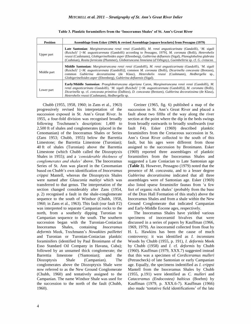
Table 3. Planktic foraminifers from the ‘Inoceramus Shales’ of St. Ann’s Great River
Position Assemblage from Esker (1969) & revised Assemblage [square brackets] from Pessagno (1979)
Upper part
Late Santonian: Marginotruncana renzi renzi (Gandolfi), M. renzi angusticarinata (Gandolfi), „M. sigali
(Reichel)‟ [=M. augusticarenata (Gandolfi) according to Pessagno, 1979], M. coronata (Bolli), Heterohelix
reussi (Cushmann), Globigerinelloides asper (Ehrenberg), Gublerina deflaensis (Sigal), Planoglobulina glabrata (Cushman), Rosita fornicata (Plummer), Globotruncana linneiana (d‟Orbigny), Guembelitria sp. cf. G. cretacea.
Middle part
Middle Santonian: Marginotruncana renzi renzi (Gandolfi), M. renzi angusticarinata (Gandolfi), „M. sigali
(Reichel)‟ [=M. augusticarenata (Gandolfi)], common M. coronata (Bolli), Dicarinella concavata (Brotzen),
common Gublerina decoratissima (de Klasz), Heterohelix reussi (Cushmann), Hedbergella sp., Globigerinelloides asper (Ehrenberg), Gublerina deflaensis (Sigal).
Lower part
Early/Middle Santonian: Praeglobotruncana algeriana Caron, Marginotruncana renzi renzi (Gandolfi), M.
renzi angusticarinata (Gandolfi), „M. sigali (Reichel)‟ [=M. augusticarenata (Gandolfi)], M. coronata (Bolli), Dicarinella sp. cf. concavata primitiva (Dalbiez), D. concavata (Brotzen), Gublerina decoratissima (de Klasz),
Heterohelix reussi (Cushmann), Hedbergella sp.
Chubb (1955, 1958, 1960; in Zans et al., 1963)
progressively revised his interpretation of the
succession exposed in St. Ann‟s Great River. In
1955, a four-fold division was recognised broadly
following Trechmann‟s description: 1,400 to
2,500 ft of shales and conglomerates (placed in the
Cenomanian) of the Inoceramus Shales or Series
(Zans 1953; Chubb, 1955) below the Barrettia
Limestone; the Barrettia Limestone (Turonian);
40 ft of shales (Turonian) above the Barrettia
Limestone (which Chubb called the Diozoptyxis
Shales in 1955); and a „considerable thickness of
conglomerates and shales‟ above. The Inoceramus
Series of St. Ann was placed in the Cenomanian
based on Chubb‟s own identification of Inoceramus
crippsi Mantell, whereas the Diozoptyxis Shales
were named after Glauconia matleyi which was
transferred to that genus. The interpretation of the
section changed considerably after Zans (1954,
p. 2) recognised a fault in the shale-conglomerate
sequence to the south of Windsor (Chubb, 1958,
1960; in Zans et al., 1963). This fault (our fault F2)
was interpreted to separate Campanian rocks to the
north, from a southerly dipping Turonian to
Campanian sequence to the south. The southern
succession began with the Turonian-Coniacian
Inoceramus Shales, containing Inoceramus
deformis Meek, Trechmann‟s Nowakites paillettei
and Turonian or Turonian-Coniacian planktic
foraminifers (identified by Paul Bronimann of the
Esso Standard Oil Company in Havana, Cuba);
followed by an unnamed thick conglomerate; the
Barrettia limestone (?Santonian); and the
Diozoptyxis Shale (Campanian). The
conglomerates above the Diozoptyxis Shale were
now referred to as the New Ground Conglomerate
(Chubb, 1960) and tentatively assigned to the
Campanian. The name Windsor Shale was used for
the succession to the north of the fault (Chubb,
1960).
Greiner (1965, fig. 6) published a map of the
succession in St. Ann‟s Great River and placed a
fault about two fifths of the way along the river
section at the point where the dip in the beds swings
from broadly eastwards to broadly southwards (our
fault F4). Esker (1969) described planktic
foraminifers from the Cretaceous succession in St.
Ann‟s Great River collected to the south of this
fault, but his ages were different from those
assigned to the succession by Bronimann. Esker
(1969) reported three assemblages of planktic
foraminifers from the Inoceramus Shales and
suggested a Late Coniacian to Late Santonian age
(Table 3). However, Pessagno (1979) noted that the
presence of M. concavata, and to a lesser degree
Gublerina decoratissima indicated that all three
assemblages were of Santonian age. Esker (1969)
also listed sparse foraminifer faunas from „a few
feet of organic rich shales‟ (probably from the base
of the Drax Hall Formation of this study) above the
Inoceramus Shales and from a shale within the New
Ground Conglomerate that indicated Campanian
and Early-Middle Eocene ages, respectively.
The Inoceramus Shales have yielded various
specimens of inoceramid bivalves that were
discussed in a series of papers by Kauffman (1966,
1969, 1979). An inoceramid collected from float by
H. L. Hawkins has been the cause of much
controversy; it was identified as I. inconstans
Woods by Chubb (1955, p. 191), I. deformis Meek
by Chubb (1958) and I. cf. deformis by Chubb
(1960). Kauffman (1979, XXX.7) suggested instead
that this was a specimen of Cordiceramus mulleri
(Petrascheck) of late Santonian or early Campanian
age. Equally, the specimens indentified as I. crippsi
Mantell from the Inoceramus Shales by Chubb
(1955, p.191) were identified as C. mulleri and
Cataceramus (Endocostea) balticus (Boehm) by
Kauffman (1979, p. XXX.6-7). Kauffman (1966)
also made „tentative field identifications‟ of the late
MITCHELL et al. 2011 – Stratigraphy of St. Ann’s Great River Inlier
5
Campanian Inoceramus proximus subcircularis
Meek and Hayden in grey shales in the upper part
of the Inoceramus Shales. Thus, Kauffman
concluded that all the inoceramids collected from
the Inoceramus Shales suggest a late Santonian or
early Campanian age.
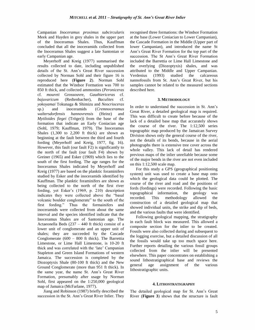
Meyerhoff and Kreig (1977) summarised the
results collected to date, including unpublished
details of the St. Ann‟s Great River succession
collected by Norman Sohl and their figure 16 is
reproduced here (Figure 2). Norman Sohl
estimated that the Windsor Formation was 700 to
850 ft thick, and collected ammonites (Peroniceras
cf. moureti Grossouvre, Gauthiericeras cf.
bajuvaricum (Redtenbacher), Baculites cf.
yokoyamai Tokunaga & Shimizu and Neocrioceras
sp.) and inoceramids (Cremnoceramus
waltersdorfensis hannovrensis (Heinz) and
Mytiloides fiegei (Tröger)) from the base of the
formation that indicate an Early Coniacian age
(Sohl, 1979; Kauffman, 1979). The Inoceramus
Shales (1,300 to 2,200 ft thick) are shown as
beginning at the fault between the third and fourth
fording (Meyerhoff and Kreig, 1977, fig. 16).
However, this fault (our fault F2) is significantly to
the north of the fault (our fault F4) shown by
Greiner (1965) and Esker (1969) which lies to the
south of the first fording. The age ranges for the
Inoceramus Shales indicated by Meyerhoff and
Kreig (1977) are based on the planktic foraminifers
studied by Esker and the inoceramids identified by
Kauffman. The planktic foraminifers are shown as
being collected to the north of the first river
fording, yet Esker‟s (1969, p. 210) description
indicates they were collected above the “basal
volcanic boulder conglomerate” to the south of the
first fording.” Thus the formainifers and
inoceramids were collected from about the same
interval and the species identified indicate that the
Inoceramus Shales are of Santonian age. The
Actaeonella Beds (237 – 440 ft thick) consist of a
lower unit of conglomerate and an upper unit of
shales; they are succeeded by the Cascade
Conglomerate (600 – 800 ft thick). The Barrettia
Limestone, or Lime Hall Limestone, is 10-20 ft
thick and was correlated with the „late‟ Campanian
Stapleton and Green Island Formations of western
Jamaica. The succession is completed by the
Diozoptyxis Shale (80-100 ft thick) and the New
Ground Conglomerate (more than 951 ft thick). In
the same year, the name St. Ann‟s Great River
Formation, presumably after usage by Norman
Sohl, first appeared on the 1:250,000 geological
map of Jamaica (McFarlane, 1977).
Jiang and Robinson (1987) briefly described the
succession in the St. Ann‟s Great River Inlier. They
recognised three formations: the Windsor Formation
at the base (Lower Coniacian to Lower Campanian),
the Cascade Formation in the Middle (Upper part of
lower Campanian), and introduced the name St
Ann‟s Great River Formation for the top part of the
succession. The St Ann‟s Great River Formation
included the Barrettia or Lime Hall Limestone and
the overlying (Diozoptyxis) shales, and was
attributed to the Middle and Upper Campanian.
Verdenius (1993) studied the calcareous
nannofossils from St. Ann‟s Great River, but his
samples cannot be related to the measured sections
described here.
3. METHODOLOGY
In order to understand the succession in St. Ann‟s
Great River, a detailed geological map is required.
This was difficult to create before because of the
lack of a detailed base map that accurately shows
the course of the river. The 1:12,500 series
topographic map produced by the Jamaican Survey
Division shows only the general course of the river,
not the details of its bends, because in the aerial
photographs there is extensive tree cover across the
whole valley. This lack of detail has rendered
previous maps of the inlier unreliable because some
of the major bends in the river are not even included
on this 1:12,500 scale map.
For this study a GPS (geographical positioning
system) unit was used to create a base map onto
which the geological data could be plotted. The
course of the river and road and the positions of
fords (fordings) were recorded. Following the basic
topographical information, the geology was
recorded. This methodology allowed the
construction of a detailed geological map that
showed individual units, the strike and dip of beds,
and the various faults that were identified.
Following geological mapping, the stratigraphy
in each fault block was measured. This allowed a
composite section for the inlier to be created.
Fossils were also collected during and subsequent to
the logging exercise, but a detailed discussion of all
the fossils would take up too much space here.
Further reports detailing the various fossil groups
collected from the inlier will be presented
elsewhere. This paper concentrates on establishing a
sound lithostratigraphical base and reviews the
general age assignment of the various
lithostratigraphic units.
4. LITHOSTRATIGRAPHY
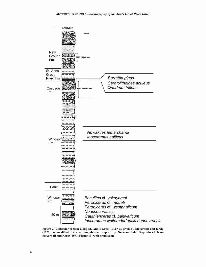
The detailed geological map for St. Ann‟s Great
River (Figure 3) shows that the structure is fault
MITCHELL et al. 2011 – Stratigraphy of St. Ann’s Great River Inlier
6
Figure 2. Columnar section along St. Ann’s Great River as given by Meyerhoff and Kreig
(1977) as modified from an unpublished report by Norman Sohl. Reproduced from
Meyerhoff and Kreig (1977, Figure 16) with permission.
MITCHELL et al. 2011 – Stratigraphy of St. Ann’s Great River Inlier
7
Figure 3. Simplified geological map of St. Ann’s Great River Inlier (Yellow Limestone and White Limestone
uncoloured). Stratigraphic boundaries shown by fine dashed lines, faults by thick dashed lines. St Ann’s Great
River and its tributaries shown by blue (solid) lines. Drivable roads shown by thick double lines, tracks by thin
double lines. Fords (Fordings) are numbered 1 to 5; the main faults that cross the river are labelled F1 to F7.
Latitudes and longitudes from GPS measurements.
MITCHELL et al. 2011 – Stratigraphy of St. Ann’s Great River Inlier
8
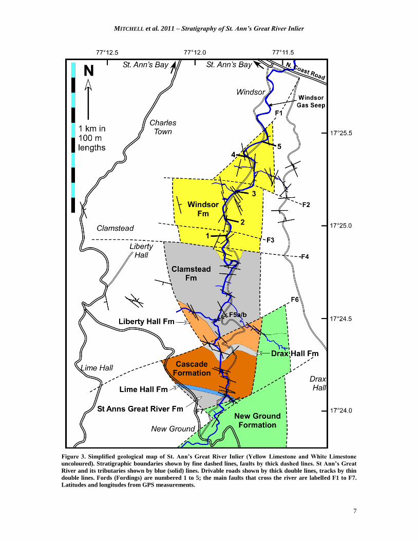
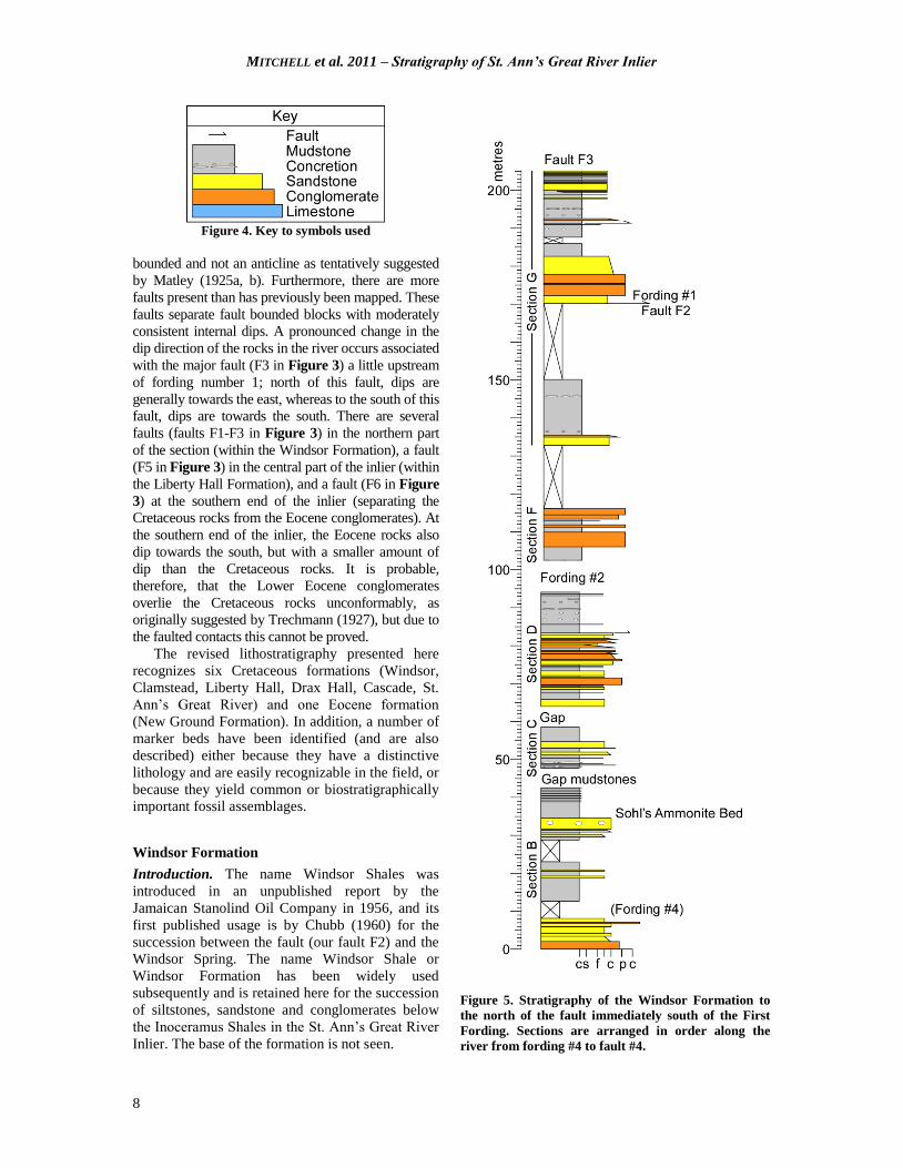
Figure 4. Key to symbols used
bounded and not an anticline as tentatively suggested
by Matley (1925a, b). Furthermore, there are more
faults present than has previously been mapped. These
faults separate fault bounded blocks with moderately
consistent internal dips. A pronounced change in the
dip direction of the rocks in the river occurs associated
with the major fault (F3 in Figure 3) a little upstream
of fording number 1; north of this fault, dips are
generally towards the east, whereas to the south of this
fault, dips are towards the south. There are several
faults (faults F1-F3 in Figure 3) in the northern part
of the section (within the Windsor Formation), a fault
(F5 in Figure 3) in the central part of the inlier (within
the Liberty Hall Formation), and a fault (F6 in Figure
3) at the southern end of the inlier (separating the
Cretaceous rocks from the Eocene conglomerates). At
the southern end of the inlier, the Eocene rocks also
dip towards the south, but with a smaller amount of
dip than the Cretaceous rocks. It is probable,
therefore, that the Lower Eocene conglomerates
overlie the Cretaceous rocks unconformably, as
originally suggested by Trechmann (1927), but due to
the faulted contacts this cannot be proved.
The revised lithostratigraphy presented here
recognizes six Cretaceous formations (Windsor,
Clamstead, Liberty Hall, Drax Hall, Cascade, St.
Ann‟s Great River) and one Eocene formation
(New Ground Formation). In addition, a number of
marker beds have been identified (and are also
described) either because they have a distinctive
lithology and are easily recognizable in the field, or
because they yield common or biostratigraphically
important fossil assemblages.
Windsor Formation
Introduction. The name Windsor Shales was
introduced in an unpublished report by the
Jamaican Stanolind Oil Company in 1956, and its
first published usage is by Chubb (1960) for the
succession between the fault (our fault F2) and the
Windsor Spring. The name Windsor Shale or
Windsor Formation has been widely used
subsequently and is retained here for the succession
of siltstones, sandstone and conglomerates below
the Inoceramus Shales in the St. Ann‟s Great River
Inlier. The base of the formation is not seen.
Figure 5. Stratigraphy of the Windsor Formation to
the north of the fault immediately south of the First
Fording. Sections are arranged in order along the
river from fording #4 to fault #4.
MITCHELL et al. 2011 – Stratigraphy of St. Ann’s Great River Inlier
9
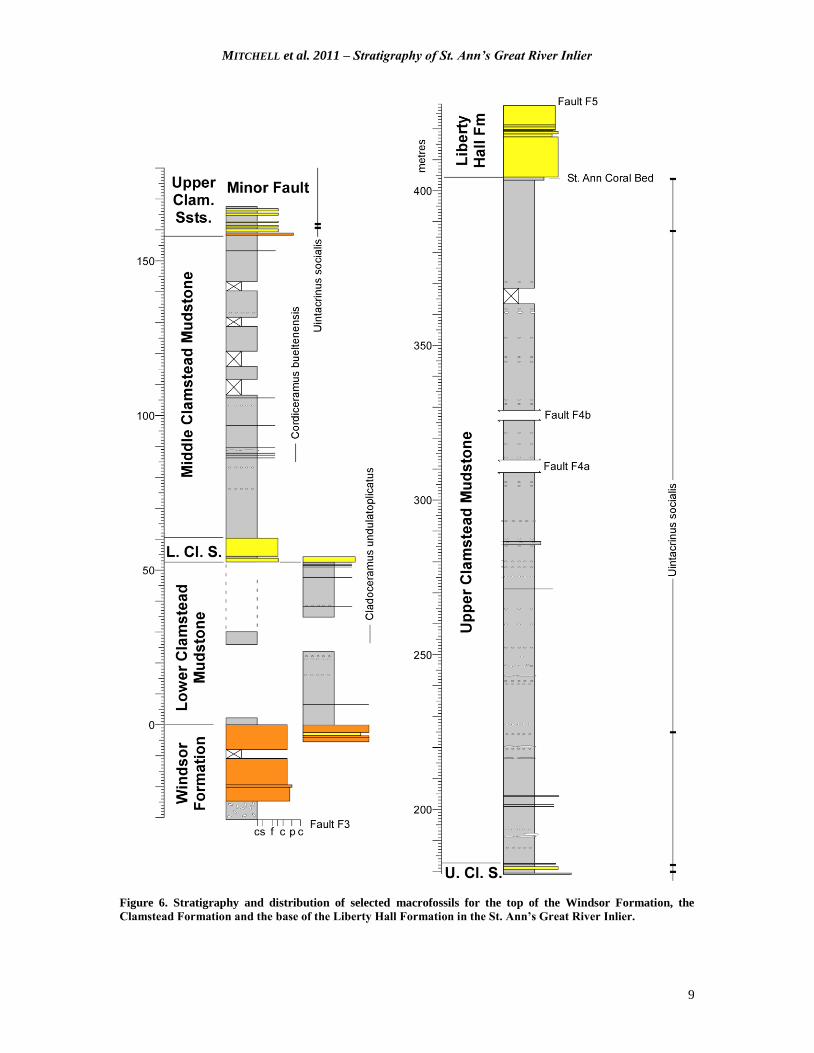
Figure 6. Stratigraphy and distribution of selected macrofossils for the top of the Windsor Formation, the
Clamstead Formation and the base of the Liberty Hall Formation in the St. Ann’s Great River Inlier.
MITCHELL et al. 2011 – Stratigraphy of St. Ann’s Great River Inlier
10
Figure 7. A, Pebble conglomerate with sandstone matrix, upper part of Windsor Formation about 25 m below
Clamstead Formation. B, Bedded sandstones with ripple form sets (middle), Windsor Formation (sandstone to
north of fault F4). C, Upper Clamstead Sandstones, channelled sandstone in mudstones at top of member (note
burrow descending from channelled level). D, Upper Clamstead Mudstones with a specimen of Cordiceramus.
Description. The Windsor Formation consists of
alternating units of sandstones/conglomerates and
shales/siltstones. The conglomerates are clast- and
matrix-supported and contain pebble to cobble-
sized clasts; bedding ranges from a few tens of
centimetres up to several metres. The conglomerate
beds occur in relatively thick packages. Clasts are
dominated by well-rounded fine-grained volcanics,
with rarer limestones; mudstone rip-up clasts
are abundant. At least four units of
conglomerate/sandstone are present in the Windsor
Formation (Figure 4-6). The third unit of
sandstones contains symmetrical (wave) ripples
(Figure 7). The complete thickness of the Windsor
Formation cannot be determined because the base
is unexposed and the succession is cut by a least
two faults. A measured minimum thickness of
230 m has been measured (Figures 4-6).
Sohl’s Ammonite Bed. A single fossil-yielding
level in the lower part of the formation is called
Sohl‟s Ammonite Bed after Norman Sohl who
discovered it in 1971. The location of the bed was
given by Sohl (1979, p. XXXI.2) as “a shale bed in
the upper-middle part of the Windsor Shale at a
river bend about 100 yards above ford number
four”. The deep bend is obvious in the river course
and recent collections from this level have yielded
Peroniceras, Baculites and Cremnoceramus.
Type section. The type section of the Windsor
Formation is here selected to be the continuous
outcrops to the south of Windsor that contain Sohl‟s
Ammonite Bed.
Palaeontology and age. Sohl‟s Ammonite Bed in the
lower part of the Windsor Formation contains a Lower
Coniacian ammonite-inoceramid association (Sohl,
1979; Kauffman, 1979). The ammonites include:
Peroniceras cf. moureti, Gauthiericeras cf.
bajuvaricum, Baculites cf. yokoyamai and
Neocrioceras sp.; the inoceramids: Cremnoceramus
waltersdorfensis hannovrensis and Mytiloides fiegei.
Age diagnostic macrofossils have not been collected
from the middle or upper part of the formation,
although (transported) shallow-water gastropods,
including an undescribed species of Otostoma, are
common in several of the higher conglomerate beds.
MITCHELL et al. 2011 – Stratigraphy of St. Ann’s Great River Inlier
11
Clamstead Formation (new name)
Origin of name. This name, taken from Clamstead
which is situated a short distance north of Liberty
Hall, is introduced here for the Inoceramus Shales
of Chubb (1955, 1958, 1960; in Zans et al., 1963).
The first part of the name (clam) is particularly
appropriate for a unit that was known as the
Inoceramus Shales.
Description. The Clamstead Formation is a thick
monotonous succession of siltstones, with only a
few thin layers of sandstone and numerous layers
of grey calcareous concretions. It is divided into
five successive units (members) here.
Lower Clamstead Mudstones. This is a thick
monotonous series of mudstones. The only marker
beds are: a single layer of pebbles near the base of
the unit, occasional layers of calcareous
concretions, and a few thin, discontinuous
sandstones towards the top of the formation. It has
a thickness of about 53 m.
Lower Clamstead Sandstones. This is a unit
consisting of thin to medium bedded sandstones
that are separated by thin mudstones. Some of the
sandstones have thin lags at their bases, sometimes
including inoceramids. The exposure of the unit is
repeated along the river due to a large meander.
This unit is about 8 m thick.
Middle Clamstead Mudstones. This is a thick
monotonous series of mudstones. The only marker
beds are a few cm thick sandstone beds and
occasional layers of calcareous concretions. It has a
thickness of about 97 m.
Upper Clamstead Sandstones. This unit consists of
medium beds of sandstone and pebble
conglomerates alternating with mudstones. The unit
forms a prominent strike section where the river
has followed a series of mudstones above strongly
cemented pebble sandstones near the top of the
member. The thickness of the member is difficult
to determine due to poor exposure in its middle part
and some minor faulting, but a thickness of about
25 m is probably close.
Upper Clamstead Mudstones. This is a thick
monotonous series of mudstones and siltstones.
The only marker beds are occasional layers of
calcareous concretions. The thickness is at least
220 m, but the succession is interrupted by some
faults (probably associated with a minor fold) of
unknown throw.
Type Locality. The type section extends from
above the last thick conglomerate layer of the
Windsor Formation (south of the first fording) to
the St Ann‟s Coral Bed at the base of the overlying
Liberty Hall Formation at the lower waterfall.
Palaeontology and age. Macrofossils are common
at many levels within the section, but full taxonomic
treatments have yet to be completed. Cladoceramus
undulatopicatus (Roemer) occurs in the Lower
Clamstead Mudstones, and Cordiceramus
bueltenensis (Seitz) occurs in the Middle Clamstead
Mudstones, indicating the Lower and Middle
Santonian respectively. Uintacrinus socialis
Grinnell (Mitchell, 2009) appears near the base of
the Upper Clamstead Sandstones, and ranges up to
the St. Ann‟s Coral Bed at the base of the overlying
Liberty Hall Formation; a cumulative thickness of
about 245 m, probably the greatest thickness for this
zone known anywhere in the World.
Trechmann (1927) listed the gastropods Nerita
subcompacta Trechmann, Lunatia cf. larteti Böhm,
Turritella aff. cardenasensis Böse, Rostellaria spp.
and Volutilithes sp., and the bivalves Ostrea cf.
delettrei Coquand and Corbula cf. parsura Stolley
from the upper part of the Upper Clamstead
Sandstones of this report. Sohl (1998) also
described several gastropods from the same level.
The foraminiferal assemblages described by
Esker (1969) as revised by Pessagno (1979) agree
with the new macrofaunal data indicating a
Santonian age. This is consistent with ages derived
from the ammonite collected by Trechmann (1927)
and most of the inoceramid assemblages in museum
collections discussed by Kauffman (1966, 1969,
1979). The record of the upper Campanian
Inoceramus proximus subcircularis by Kauffman
(1979) is now considered erroneous.
Liberty Hall Formation (new name)
Introduction. The name Liberty Hall Formation,
after Liberty Hall situated to the northwest of the
river section, is introduced here for the succession
of thick units of siltstones alternating with thick
sandstones with minor conglomerates that occurs
above the Clamstead Formation. The base of the
formation is marked by the St. Ann‟s Coral Bed at
the base of the thick sandstone exposed on the
western side of the lower waterfall, whereas the top
of the section is seen in the eastern side of the same
waterfall. The waterfall itself runs along a
significant fault that cuts out much of the formation.
Description. The formation consists of sandstones
and conglomerates, generally in medium to thick
beds. A single marker bed at the base of the
formation is named the St. Ann‟s Great River Coral

MITCHELL et al. 2011 – Stratigraphy of St. Ann’s Great River Inlier
12
Figure 8. Stratigraphy and distribution of selected rudist bivalves for the Liberty Hall (top),
Drax Hall, Cascade, Lime Hall and St. Ann’s Great River Formation in the St. Ann’s Great
River Inlier.

MITCHELL et al. 2011 – Stratigraphy of St. Ann’s Great River Inlier
13
Bed. The formation is at least 60 m thick, although
the presence of a major fault that must cut out a
significant amount of section, maybe several
kilometres when compared to western Jamaica,
means that its actual thickness cannot be
determined.
St. Ann’s Coral Bed. The name St. Ann‟s Coral
Bed appears on specimens preserved in the
University of the West Indies Geology Museum.
This is a sandy siltstone that yields abundant fossils
including corals, inoceramids and ammonites.
Type section. The type section for the formation is
taken at the lower waterfall on St. Ann‟s Great
River where the bottom and top of the formation
are exposed.
Palaeontology and age. The St. Ann‟s Coral Bed
yields a rich fossil assemblage including corals,
ammonites, inoceramids, gastropods, rudist
(Barrettia sp. nov.) and other bivalves, and also
marks the last occurrence of the late Santonian
crinoid Uintacrinus socialis.
Reworked rudists, Whitfieldiella cf. gigas
(Chubb) occur in a conglomerate in the upper part
of the formation suggesting a mid Campanian age
(Mitchell 2010).
Drax Hall Formation (new name)
Introduction. The name Drax Hall Formation is
introduced here for a thick unit of shales and
mainly weakly cemented sandstones that occurs
between the two waterfalls on St Ann‟s Great
River. The name is taken from the Drax Hall Estate
to the east of St. Ann‟s Great River.
Description. The Drax Hall Formation consists of a
series of grey siltstones that contain uncemented
sandstones and pebbly limestones in the lower part.
The shales are dark grey and are characterised by a
high proportion of siltstone beds. The formation
can be divided into three parts: a basal unit of
siltstones and sandstones with common fossils; a
middle unit of monotonous siltstones, and a thin
upper unit of siltstones with thin sandstones
(Figure 8). The formation is 63 m thick, although it
is cut by one fault that possibly cuts out some of
the section.
Actaeonella Bed. The name Actaeonella Beds was
first used by Meyerhoff and Kreig (1977). The
name is retained here, in the singular, for a bed
consisting of a pebbly limestone that contains
scattered fossils including large specimens of the
gastropod Actaeonella.
Type locality. The type locality is exposed in the
river between the two waterfalls on St. Ann‟s Great
River.
Palaeontology and age. Gastropods are common in
the lower part of the Drax Hall Formation; these
include turritellids that occur in the shales both
below and above the Actaeonella Bed, and poorly
preserved specimens of a large species of
Actaeonella in the bed itself. A single well
preserved specimen of Barrettia multilirata
Whitfield was collected from a gritty sandstone
above the Actaeonella Bed (Figure 8) indicating a
correlation with the Stapleton and Green Island
formations of western Jamaica. This occurrence
indicates that the correlation of the Lime Hall
Limestone that occurs much higher in the
succession with these two limestones of western
Jamaica (Meyerhoff and Kreig, 1977) is erroneous.
Esker (1969) recorded the following planktic
foraminfers from “a few feet of highly organic
black shale” within the Drax Hall Formation:
Rosita fornicata (Plummer), Globotruncana arca
(Cushman), G. bulloides Vogler, G. orientalis
El-Nagger, G. cf. linneiana (d‟Orbigny),
Globotruncanita cf. stuartiformis (de Lapparent)
and G. elevata (Brotzen), with a few reworked
Marginotruncana renzi (Gandolfi). These forms
would appear to indicate a Campanian age above
the disappearance of Marginotruncana, if M. renzei
is reworked, which is consistent with the evidence
provided by the rudist bivalves. Verdenius (1993)
recorded Quadrum trifidum (Stradner) from below
the Lime Hall Limestone (presumably within the
Drax Hall Formation), which is consistent with the
age assignment from the rudist bivalves.
Cascade Formation
Introduction. The name Cascade Formation, after
the Cascade at the upper waterfall in St. Ann‟s
Great River, was introduced by Chubb in 1958,
where the name is listed against the log, for the unit
called the Great River Formation in unpublished oil
company reports (e.g., Jamaican Stanolind Oil
Company, 1956).
Description. The formation is about 180 m thick
and consists of thick beds with pebble- to cobble-
sized clasts set in a sandstone matrix; intercalated
are a few thin beds of sandstone and siltstone. The
pebble- to cobble-sized clasts consist predominately
of volcanic material (andesites and porphyritic
lavas), but also include some fine-grained
limestones. Rare reworked examples of the rudist
Durania sp. are present.

MITCHELL et al. 2011 – Stratigraphy of St. Ann’s Great River Inlier
14
Type Section. The type section, nominated here in
the absence of a previous designation, is in the bed
of St. Ann‟s Great River immediately below the
upper waterfall (the Cascade).
Palaeontology and Age. No indigenous fossils are
present in the formation, and it is assigned a
Campanian age on the basis of the ages of the
underlying and overlying units.
Lime Hall Formation
Introduction. The name was first used in
unpublished oil company reports (Jamaican
Stanolind Oil Company, 1956) and was first
published by Meyerhoff and Kreig (1977).
Description. The formation consists of a lower
portion of siltstones, estimated to be about 14 m
thick, but with only the top few metres exposed;
and an upper 14 m thick unit of alternating
limestone/muddy limestone and siltstones,
reminiscent of the cycles seen in the Guinea Corn
Formation (Mitchell, 2002).
Type Section. The type section, nominated here in
the absence of a previous designation, is in the
small tributary that joins St. Ann‟s Great River just
above the bridge on the parochial road.
Palaeontology and age. Rudist bivalves are common in
the Lime Hall Limestone. Although the multiple fold
hippuritids have previously been referred to as
Barrettia monilifera by Trechmann (1927) and
Barrettia gigas by Chubb (1971), they actually belong
to an undescribed form of Whitfieldiella and do not
help with age determination. The presence of Barrettia
multilirata in the Drax Hall Formation, some 400 m
below the Lime Hall Limestone, indicates that the Lime
Hall Limestone should not be correlated with the Green
Island and Stapleton Formations of western Jamaica,
but represents a younger level.
Larger foraminifers of the Lime Hall Limestone
are dominated by specimens of Sulcopeculina. This
assemblage lacks Pseudorbitoides and is therefore
probably of late Late Campanian age above the
extinction level of Pseudorbitoides (Mitchell and
Ramsook, 2009). The nannofossil Ceratolithoides
aculeus (Stradner) was reported from two samples
collected from the Lime Hall Limestone and
indicates zone CC20 or younger (Jiang and
Robinson, 1987, p. 31), consistent with the
foraminiferal evidence.
St. Ann’s Great River Formation
Introduction. The name St. Ann‟s Great River
Formation first appeared on the 1:250,000
Geological Survey map of Jamaica, presumably
after an unpublished name used by Sohl in 1976,
and is equivalent to the „Diozoptyxis‟ Shale of
Chubb (1955). Jiang and Robinson (1987) also gave
a brief description of it.
Description. The formation consists of dark grey
silty shales with common shallow water fossils.
There are no obvious marker beds. The formation
has a thickness of 48 m, but is terminated at the top
by a fault (fault F7 in Figure 3).
Type locality. The type locality of the St. Ann‟s
Great River Formation is exposed in the bed and
banks of St. Ann‟s Great River above the small
bridge on the old parochial road.
Palaeontology and age. Fossils are abundant and
Trechmann (1927) described the gastropods
Solarium sp., „Glauconia‟ matleyi Trechmann,
Vermetes cf. libycus Quaas, Cerithium cf. libycum
Wanner, Rostellaria (Calyptrophorus) sp.,
Aporrhais sp., Gosavia sp. and Lyria sp., and the
bivalves Amusium? cf. membranaceum Nilsson,
Neithea quadricostata Sowerby, Plicatula cf.
andersoni Newton, P. cf. urticosa Morton,
Pholadomya jamaicensis Trechmann and Cytherea
sp. „Glauconia‟ matleyi was erroneously transferred
to the nerinellid genus Diozoptyxis (Chubb, 1955;
Sohl, 1998), and the name Diozoptyxis Shale was
applied to the unit that yielded it. None of these
forms has any biostratigraphic value, and a late
Campanian age is inferred based on the suggested
age of the underlying Lime Hall Formation.
New Ground Formation
Introduction. The St. Ann‟s Great River Formation
is in faulted contact with grey to brown
conglomerates about 50 m upstream of the bridge
on the parochial road. These were called the New
Grounds Formation in unpublished oil company
reports (Jamaican Stanolind Oil Company, 1956).
Subsequently, Sohl resurrected the name in an
unpublished report in 1976 and it was first
published as „New Ground Conglomerate‟ by
Chubb (1960).
Description. The formation consists of pebble
conglomerates in thick to very thick beds. Within
the formation, a thin unit of pyritous mudstones is
present. The thickness of the formation has not been
determined in this study, but Sohl (reported in
Meyerhoff and Kreig, 1977) indicated a thickness of
290 m.
Type locality. The type locality is situated in St.
Ann‟s Great River, south of Fault F6.
MITCHELL et al. 2011 – Stratigraphy of St. Ann’s Great River Inlier
15
Palaeontology and age. Esker (1969) reported the
planktic foraminifers Morozovella (now
Globorotalia) aragonensis (Nuttal) (zones P7-P11),
M. (now Globorotalia) prolata (Bolli), Acarina
(now Truncorotalia) soldadoensis (Bronnimann)
(latest Paleocene to top middle Eocene) and
Pseudohastigerina wilcoxensis (Cushman and
Ponton) (zone P6-P11) from a blue argillaceous
sandstone within the New Ground Conglomerate
which indicate a late Early to early Middle Eocene
age (Toumarkine and Luterbacher, 1985).
Acknowledgements. We thank Beverley Lashley of the UWI
Science Library for finding the old and difficult references. Mr.
Ian Brown and Dr. Gavin Gunter made valuable comments on
the original manuscript which are greatly appreciated. Dr.
Gavin Gunter (Petroleum Corporation of Jamaica) gave
permission to reproduce Figure 2.
REFERENCES
Chubb, L.J. 1955. The Cretaceous succession in
Jamaica. Geological Magazine, 92, 177-195.
Chubb, L.J. 1958. The Cretaceous inlier of St Ann‟s
Great River. Geonotes, 1, 148-152.
Chubb, L.J. 1960. Correlation of the Jamaican
Cretaceous. Geonotes, 3, 85-97.
Chubb, L.J. 1971. Rudists of Jamaica.
Palaeontographica Americana, 7, 161-257.
Esker III, G.C. 1969. Planktonic foraminifera from St.
Ann‟s Great River Valley, Jamaica.
Micropaleontology, 15, 210-220.
Exploration Division, PCJ, 1982. Petroleum
Exploration Onshore Jamaica. Review for Inter-
American Development Bank. Petroleum Corporation
of Jamaica.
Greiner, H.R. 1965. The oil and gas potential of
Jamaica. Geological Survey Department, Jamaica.
Bulletin No. 5, 1-24.
Hill, R.T. 1899. The geology and physical geography of
Jamaica: a study of a type of Antillean development.
Bulletin of the Museum of Comparative Zoölogy at
Harvard College in Cambridge, 34, 1-256.
Jamaican Stanolind Oil Company, 1956. Jamaica
Stanolind Geological Report No. 10. Geology of the
St. Ann‟s Bay Inlier, 1-8, Jamaican Stanolind Oil
Company, Kingston, Jamaica.
Jiang, M.-J. and Robinson, E. 1987. Calcareous
nannofossils and larger foraminifera in Jamaican rocks
of Cretaceous to early Eocene age. In R. Ahmad
(Ed.), Proceedings of a workshop on the status of
Jamaican geology. Special Issue (No. 10) 1987, 24-51,
Geological Society of Jamaica. Signart Printing
House, Kingston, Jamaica.
Kauffman E.G. 1966. Notes on Cretaceous
Inoceramidae (Bivalvia) of Jamaica. The Journal of
the Geological Society of Jamaica, 8, 32-40.
Kauffman E.G. 1969. The Upper Crctaceous
Inoceramus of Puerto Rico. In J.B. Saunders (Ed.),
Transactions of the 4th Caribbean Geological
Conference, Port of Spain, Trinidad and Tobago, 28
March-12 April 1965, 203-218 (dated 1968,
distributed 1969).
Kauffman E.G. 1979. Middle Cretaceous bivalve zones
and stage implications in the Antillean Subprovince,
Caribbean Province. In R.A. Reyment and G.
Thomel (Eds.), Evenements de la partie moyenne du
Cretace (Mid-Cretaceous events) Uppsala 1975 – Nice
1976 Reports sur la biostratigraphie des regions cles
(reports on the biostratigraphy of key areas), Annales
de Museum d‟Histoire Naturelle de Nice, 4 (1976),
XXX.1-10, Centre d‟Etudes Méditerranéennes,
Museum d‟Histoire Naturelle, Nice, France.
Matley, C.A. 1924a. Report on a mineral spring at
Windsor, St. Ann, and on the possibility of the
occurrence of petroleum in its neighbourhood.
Supplement to the Jamaica Gazette, Sept. 25, 1924,
396-398.
Matley, C.A. 1924b. Further report on the possibility of
the occurrence of petroleum deposits in the valley of
St. Ann‟s Great River. Supplement to the Jamaica
Gazette, Sept. 25, 1924, 398.
Matley, C.A. 1925. Report on the strata in the valley of
St. Ann‟s Great River, Parish of St. Ann, Jamaica.
Supplement to the Jamaica Gazette, Thursday, January
1, 1825, XLVIII No. 3, 13-15.
McFarlane, N. (Compiler), 1977. 1:250,000 Jamaica,
Geology, Mines and Geology Division, Ministry of
Mining and Natural Resources, Jamaica.
Meyerhoff, A.A. and Krieg, E.A. 1977. Petroleum
potential of Jamaica, 1-131, Ministry of Mining and
Natural Resources, Kingston, Jamaica.
Mitchell, S.F. 2002. Palaeoecology of corals and rudists
in mixed volcaniclastic-carbonate small-scale rhythms
(Upper Cretaceous, Jamaica). Palaeogeography,
Palaeoclimatology, Palaeoecology, 186, 237-259.
Mitchell, S.F. 2009. The Cretaceous crinoid Uintacrinus
socialis from Jamaica and its significance for global
correlation. Geological Magazine, 146, 937-940.
Mitchell, S.F. 2010. Revision of three large species of
Barrettia from Jamaica. Caribbean Journal of Earth
Science, 41, 1-16.
Mitchell, S.F. and Ramsook, R. 2009. Rudist bivalve
assemblages from the Back Rio Grande Formation
(Campanian, Cretaceous) of Jamaica and their
stratigraphical significance. Cretaceous Research, 30,
307–321.
Pessagno Jr, E.A. 1979. Middle Cretaceous planktonic
foraminiferal biostratigraphy of the Antillean-
Caribbean region and eastern Mexico notes on the
ammonites of eastern Mexico. In R.A. Reyment and
G. Thomel (Eds.), Evenements de la partie moyenne
du Cretace (Mid-Cretaceous events) Uppsala 1975 –
Nice 1976 Reports sur la biostratigraphie des regions
cles (reports on the biostratigraphy of key areas),
Annales de Museum d‟Histoire Naturelle de Nice, 4
(1976), XXVIII.1-9, Centre d‟Etudes Méditerranéennes,

MITCHELL et al. 2011 – Stratigraphy of St. Ann’s Great River Inlier
16
Museum d‟Histoire Naturelle, Nice, France.
Sawkins, J.G. 1869. Reports on the geology of Jamaica
or, part II of the West Indian survey. Memoirs of the
Geological Survey, i-vi, 1-339, Longmans, Green and
Co., London.
Sohl, N.F. 1979. Notes on middle Cretaceous
macrofossils from the Greater Antilles. In R.A.
Reyment and G. Thomel (Eds.), Evenements de
la partie moyenne du Cretace (Mid-Cretaceous
events) Uppsala 1975 – Nice 1976 Reports sur la
biostratigraphie des regions cles (reports on the
biostratigraphy of key areas), Annales de
Museum d‟Histoire Naturelle de Nice, 4 (1976),
XXXI.1-6, Centre d‟Etudes Méditerranéennes,
Museum d‟Histoire Naturelle, Nice, France.
Sohl, N.F. 1998. Upper Cretaceous trochacean
gastropods from Puerto Rico and Jamaica.
Palaeontographica Americana, 60, 109 pp.
Toumarkine, M. and Luterbacher, H.P. 1985. Paleocene and Eocene planktonic foraminifera. In
H.M. Bolli, J.B. Saunders and K. Perch–Nielsen
(Eds.), Plankton Stratigraphy, Cambridge Earth
Science series, 87–154.
Trechmann, C.T. 1927. The Cretaceous shales of
Jamaica. Geological Magazine, 64, 27-42.
Trechmann, C.T. 1936. The Basal Complex question in
Jamaica. Geological Magazine, 73, 251-267.
Verdenius, J.G. 1993. Late Cretaceous calcareous
nannoplankton zonation of Jamaica. In R.M. Wright
and E. Robinson (Eds.), Biostratigraphy of Jamaica.
Geological Society of America Memoir 182, 1-17,
Boulder, Colorado.
Wiedmann, J. and Schmidt, W. 1993. Upper Cretaceous
ammonites from Jamaica and their stratigraphic and
paleogeographic implications. In R.M. Wright and E.
Robinson (Eds), Biostratigraphy of Jamaica,
Geological Society of Jamaica Memoir, 182, 77-91,
Boulder, Colorado.
Wright, R. 1996. Jamaica's Energy: old prospects, new
resources, 266 pp., Petroleum Corporation of Jamaica,
Kingston, Jamaica.
Zans, V.A. 1953. The eastern half of St. Ann (Sheet
F). In Zans, V.A. Annual report of the Geological
Survey Department for the financial year 1951-
1952, 10 pp., Government Printers, Duke Street,
Kingston, Jamaica.
Zans, V.A. 1954. Sheet F, Stratigraphy, Upper
Cretaceous. Annual Report of the Geological Survey
Department, 1952-1953, Government Printers, Duke
Street, Kingston, Jamaica.
Zans, V.A., Chubb, L.J., Versey, H.R., Williams, J.B.,
Robinson, E and Cooke, D.L. 1963. Synopsis of the
geology of Jamaica an explanation of the 1958
provisional geological map of Jamaica. Bulletin No. 4,
Geological Survey Department, Jamaica, 1-72,
Government Printer, Duke Street, Kingston. [Dated on
front cover and title page 1962, Printers imprint at
bottom of front page is 1963,]
Revised manuscript accepted: 3rd
March 2011