lithospheric flexure and related base-level … flexure and related base-level stratigraphic ... ......
TRANSCRIPT

16Lithospheric Flexure and Related Base-levelStratigraphic Cycles in Continental ForelandBasins: An Example from the PutumayoBasin, Northern Andes
John Londono1
Shell Exploration and Production, 150 North Dairy Ashford, Houston, Texas, 77079, U.S.A.(e-mail: [email protected])
Juan M. LorenzoDepartment of Geology and Geophysics, Louisiana State University, E235 Howe-Russell Complex, BatonRouge, Louisiana, 70803, U.S.A. (e-mail: [email protected])
Victor RamirezEmpresa Colombiana de Petroleos, Ecopetrol, Calle 37 No. 8-43, Piso 8, Bogota, Colombia, U.S.A.(e-mail: [email protected])
ABSTRACT
First-order lithospheric flexure, in response to discrete tectonic and sedimentary loads, con-trols basin-scale, base-level cycles in upstream deposits of retroarc continental foreland ba-sins, in the absence of dynamic topography. A depositional sequence in this type of basinmay be defined as a sedimentary succession formed during the adjustment of the fluvial sys-tems to the equilibrium stage at or near base level. This sequence spans two accommodationepisodes. The initial episode with high rates of subsidence corresponds to a thrust-loadingperiod near the hinterland end of the elastic plate and may be identified by regional seismic-reflector onlap shifts from the foreland toward the hinterland. The second episode deepensand enhances the foreland flexure under the weight of the new sediment and may be identifiedseismically by a continuous onlap migration toward the foreland. A depositional cycle endseither when a period of nondeposition dominates the basin because the fluvial system attainsthe graded stage at or near-base level or with the reactivation of thrusting activity, initiating anew cycle. Base level appears to control the top of the sedimentation boundary, but can adjustpassively, during vertical movements caused by the regional isostatic compensation of the
357
Londono, John, Juan M. Lorenzo, and Victor Ramirez, 2012, Lithospheric flexure
and related base-level stratigraphic cycles in continental foreland basins: An
example from the Putumayo Basin, Northern Andes, in D. Gao, ed., Tectonics
and sedimentation: Implications for petroleum systems: AAPG Memoir 100,
p. 357 – 375.
1Previous address: Department of Geology and Geophysics, Louisiana State University, E235 Howe-Russell Complex, Baton Rouge, Louisiana,70803, U.S.A.
Copyright n2012 by The American Association of Petroleum Geologists.
DOI:10.1306/13351561M1003537

elastic plate. Regional paraconformities appear to represent periods of equilibrium of the de-positional profile when the fluvial systems reach a graded stage and total tectonic quiescence.
Seismic and well data from the northern-Andes, continental retroarc Putumayo forelandbasin, in Colombia, are used to test the model for flexure-induced, base-level cycles. Resultssuggest that onlap seismic facies migrating toward the foreland predominate during sediment-controlled flexural periods (on average,�77% of the total deflection), whereas onlap shifts fromthe foreland toward the hinterland mark those periods when thrust belt loads dominateflexure (on average, �23% of the total deflection). The seismostratigraphic record exhibits asmuch as eight flexure-controlled Cenozoic sequences in the basin, in correspondence with anequal number of tectonic reactivation episodes. Geodynamically, the Putumayo foreland basinhas been modeled to encompass a total added lithospheric deflection of as much as 450 km(279 mi) wide. During the Oligocene, the maximum subsidence rates reached approximately150 m/m.y. (�492 ft/m.y.) and the maximum width of the effective tectonic load (a discretepart of the thrust belt) affecting the plate reached a value of approximately 30 km (�20 mi).The geometry of the effective thrust belt and the wavelength of the lithospheric deflectionmodeled in this article preclude the need to invoke dynamic topography as a downward forceacting on the plate and creating extra accommodation in the basin. The effective elastic thicknessof the plate is 30 ± 10 km (19 ± 6 mi; and has not changed apparently since the early Paleocene).Each loading event, for instance, tectonic and sediment loads, produces a corresponding fore-bulge whose location and dimensions change concomitant with the evolution of the basin.
INTRODUCTION
Relatively, little work has been conducted on the causeand effect link between lithospheric flexure and base-level and/or graded-profile and sedimentary sequencesin continental foreland basins, despite that flexure is themain process controlling the creation of these fore-deep depocenters and, consequently, their accommo-dation and base level (Steckler and Watts, 1978; Sclaterand Christie, 1980; Beamont, 1981; Lavier and Steckler1997; Clark and Royden, 2000; Cardozo and Jordan,2001, Catuneanu, 2004). Tectonic uplift via thrustingat the hinterland edge of the basin increases slopeand can become the primary source of sediments forfluvial systems. As a result, river competence and sedi-ment load also increases, although discussion still re-mains regarding the synchronicity between uplift anddeposition of resultant conglomeratic units (Schumm,1993; Horton, 2004). On average, rates of tectonic uplift-ing can be eight times higher than average denudationrates so that a time lag between uplift and denudationis expected between these processes (Lawrence andWilliams, 1987; Blair and McPherson, 1994).
Although the regional isostatic compensation of thelithosphere to supracrustal loads has long been recog-nized as the primary mechanical control in foredeepdevelopment (Jordan, 1995; Cardozo and Jordan, 2001;Catuneanu, 2004; Gomez et al., 2005), most stratigraphicmodels in nonmarine foreland-basin sequences ini-tially focused on the control exerted by eustasy andtectonics on accommodation in fluvial sedimentation
even in areas with well-documented, fluvial-only strati-graphic settings far from marine influence (Posamentierand Vail, 1988). It is now generally accepted that the im-portance of sea level change diminishes in upstreamdeposits (Shanley and McCabe, 1994; Schumm et al.,2000; Chul, 2006). Recent studies (Milana, 1998; Plintet al., 2001; Miall, 2002; Chul, 2006; Miall, 2006) empha-size two patterns in upstream fluvial deposits: a shale-dominated-tract architecture, with isolated sand-channel bodies, representing high rates of subsidenceand accommodation periods; and a channel-dominated-tract architecture representing low rates of subsidenceand accommodation periods. Tectonic (subsidence and/or uplift) and climatic processes control the cycles ofchange in accommodation, for instance, stream dis-charge and sediment supply (Shanley and McCabe,1994; Blum and Tornqvist, 2000). Experimental modelsdeveloped by Allen (1978) show that slow subsidencepromotes channel-belt occurrence and deposition ofmultistorey and multilateral sandstone sheets withrelatively high ratios in the number of sandstone-mudstone beds. In contrast, abrupt subsidence permitssignificant deposition of fine-grained overbank depos-its before the reinitiation of channel belts at a newlocation, resulting in sedimentary units that can becharacterized by low sandstone-mudstone ratios. How-ever, a change in the sandstone-mudstone ratio mayalso indicate a change in the type of stream environ-ment, from braided (high sandstone-mudstone ratio) tomeandering (low sandstone-mudstone ratio). Changesin sediment supply also predict an increase in the
358 Londono et al.

sandstone-shale ratio with an increase in the amountof sediment loading (Miall, 1997). Sandstone-shale ra-tios are important not only because they should reflectthe tectonic history of the basin in terms of subsidencerate, but also because, conversely, if the subsidence ratecan be determined, via flexural analysis for example,it can be used as a predictive tool to infer reservoirfacies (sandstone-mudstone ratios), channelization,and reservoir connectivity.
Accommodation in fluvial settings can be seen ac-cording to Blum and Tornqvist (2000) in terms of accu-mulation (the volume of space available for sediments,limited by base level) and preservation (when sedi-ments subside below erosion levels). If subsidencedoes not occur, stratigraphic records might not be pre-served. In addition, the concept of graded river de-veloped by Mackin (1948) establishes that the regionalslope of a stream system tends to adjust to a profilecorresponding to the flow velocity required to trans-port the sediment load supplied to the basin, for in-stance, no net erosion or deposition along the regionalfluvial system profile exists (Wescott, 1993; Miall, 1997;Emery and Myers, 1997). Thus, the graded stream pro-file has been used in fluvial systems to define the equi-librium surface that limits accomodation (Mackin, 1948;Sloss, 1962; Schumm, 1993; Emery and Myers, 1997).
In this chapter, we try to establish a causal link be-tween the regional isostatic compensation and the re-gional stratigraphy of the upstream part of the continen-tal Putumayo foreland by differentiating quantitatively,via flexural analysis, the tectonic load component ofthe isostatic compensation from the sediment load atdifferent times during the evolution of the basin. Weassume that the net subsidence of the basin floor bal-ances the space for accumulation and preservation inthe basin, achieved through the vertical isostatic ad-justment of the lithosphere instead of the adjustment ofthe longitudinal stream equilibrium profile, which al-ways tends to its graded stage. We try to reconcilethree established concepts in continental forelandevolution by integrating flexure, accommodation, andgraded stage into a model where base-level cycles arecontrolled by the regional deflection of the lithosphere.In addition, we assess the relative importance of tec-tonic versus sedimentary loads to the regional geom-etry of the basin floor and estimate the size and shapeof the equivalent thrust belt load through time.
For the purpose of flexural analysis, we identify fourtectonostratigraphic units bounded by hiatuses in thenondeformed seismostratigraphic records (areas thathave not been affected by thrusting) and well data fromthe documented Putumayo retroarc foreland basin inColombia (PRB). To use these deformed areas, it wouldhave been necessary to reconstruct and balance these
wedge-top zones, which is beyond the scope of this chap-ter. We note the smooth nature of the contours found inthe isochore maps in Putumayo (Cordoba et al., 1997),with no indication of deformation or erosional scars.Each unit is then decompacted as a function of its po-rosity (Steckler and Watts, 1978). We consider that thedecompacted thickness represents the minimumamount of accommodation created by flexure andneeded for the accumulation of the preserved strati-graphic record. The sediment load of each decom-pacted unit is used in forward-model calculations usingthe two-dimensional (2-D) flexural theory of elasticbeams under vertical loads (Hetenyi, 1946; Turcotteand Schubert, 1982). Thus, the regional compensationcaused by the sediment load contained in each tectono-stratigraphic unit is modeled. The difference between thedecompacted thickness (a minimum value estimated fortotal subsidence) and the modeled flexure caused bythe sediments is taken to represent the minimum flex-ure caused by tectonic loading. If a Coulomb wedgemodel for thrust belts is assumed for the tectonic load,the amount of loading can be modeled as a distributedload whose final geometry is a function of its criticaltaper angle. Thus, the minimum width of the thrust belt(effective load) affecting the plate can be estimated. Thefinal geometry of the effective tectonic load will indicatethe need to invoke dynamic topography as an actingfactor in the basin. If a reasonable thrust belt geometryis attained (i.e., it is within the range of thrust belts insimilar tectonic settings around the world) and thewavelength of the first-order flexure does not exceed theorder of magnitude thought to be caused by supra-crustal loads only (<1000 km [621 mi]; Mitrovica et al.,1989), then sedimentary and tectonic loads would ex-plain the deflection history of the basin. If, on the con-trary, unreasonable thrust load geometries are neededto fit flexural curves and/or the first-order flexuralwavelength exceeds thousands of kilometers, dynamictopography would likely need to be invoked to explainthe basin deflection history and geometry.
During forward modeling, we considered that thezero contour found in the isochore maps (Cordoba et al.,1997) represents the distal limit of the primary flexuralbasin deflection during the given period and, therefore,the maximum width of the basin over a given elapsedtime. Modern deposits along the Putumayo foothills com-pletely fill the basin, which is now approximately 450 m[�1480 ft] above sea level, and active fluvial systems runeast–west, mostly orthogonal to the modern Andes. Sim-ilarly, paleodata analyses also suggest that, during theevolution of the basin, sediment transport is mostly per-pendicular to the axis of the basin and is sourced fromthe west (Cordoba et al., 1997). We considered that thePRB behaves as an overfilled depocenter, for instance,
Lithospheric Flexure and Related Base-level Stratigraphic Cycles in Foreland Basins 359

the entire accommodation is full of subaerial sedimentsduring the early foreland period. An underfilled basinwould show sediment sourced from the craton in theeast, and a main fluvial system running north south,parallel with the thrust belt in the present.
The Putumayo Basin, a prolific petroleum province,has the potential for 1 to 6 billion bbl of oil and 0.24to 4.6 tcf of gas of new recoverable reserves (Higley,2001). In Colombia, the PRB covers an area of approx-imately 29,900 km2 (�11,500 mi2) that contains 28 fieldswith 1.4 billion bbl of oil discovered, 0.4 billion bbl ofoil produced, and 1.7 billion bbl of oil in reserves. Themain reservoirs are the lower Cretaceous Caballos For-mation and the upper Cretaceous Villeta and Rumiyacoformations, although reports of production from theupper Eocene Pepino Formation exist (Cordoba et al.,1997). Discoveries of commercial heavy oil in the adjacent
Llanos foreland basin (Gomez et al., 2005) could indicatethat the Putumayo foreland has the potential for similaraccumulations, especially with traps developed in oraround forebulges coevally with each loading event.
GEOLOGIC SETTING
The Putumayo foreland basin started to form in thelatest Cretaceous. It is part of the so-called Sub-AndeanBasin system that developed along the eastern marginof the Andes Mountains in South America (Sarmiento,2002; Figure 1). The PRB extends from southern Co-lombia into Ecuador and Peru under the names of GranCuenca de Oriente and Maranon basins, respectively(Figure 1). The PRB has developed over the Precam-brian continental crust, approximately 35 km (�20 mi)
Figure 1. Putumayo retroarcforeland basin in Colombia. Itextends into Ecuador and Peruwith the name of Gran Cuenca deOriente and Maranon basins,respectively. 200 km (124 mi).
360 Londono et al.

thick, adjacent to the Guyana Shield in the east (Dengoand Covey, 1993; Mora et al., 1997; Sarmiento, 2002).The transition from a back-arc basin into a forelandphase occurs during the Late Cretaceous–early Paleo-gene when the oceanic crust of Western Cordilleratoday (Figure 1) is accreted to the Central Cordillera(Hendenson, 1979; Aspden et al., 1987) and produces athick-skin-styled thrust belt and, in the process, tec-
tonically inverted Paleozoic normal faults along theeastern margin of the PRB (Sarmiento, 2002). The most-ly continental Rumiyaco Formation (Figure 2) is depos-ited during this initial collisional period. The sandstone-shale average ratio in this unit has been estimated at0.21 (Geotec, 1992).
The Tertiary tectonic history of the Putumayo Basinhas been divided into three main uplift events related
Figure 2. Stratigraphic column and welltype log of the Putumayo Basin. Theunconformities have been related to mainuplift events during the Andes orogeny(Geotec, 1992; Cordoba et al., 1997) andidentified in regional seismic lines. GR =gamma ray; RES = resistivity.
Lithospheric Flexure and Related Base-level Stratigraphic Cycles in Foreland Basins 361

to the Colombian Andean orogeny, which coincide withthe dated unconformities, during the middle Eocene,Oligocene, and late Miocene (Geotec, 1992; Cordobaet al., 1997; Figure 2). The first pulse occurred duringthe late Paleocene–middle Eocene in response to anincrease in convergence rate between the Nazca andSouth American plates (Daly, 1989). It has been inter-preted that the continental Pepino Formation is depos-ited mostly in alluvial fans as a product of the contin-uous uplift of the Central Cordillera (Mora et al., 1997;Figure 2). The sandstone-shale average ratio in thisformation has been estimated at 0.52 (Geotec, 1992).This unit is topped on the west by a regional angularunconformity that cuts the thrusts and back thrustsdeveloped during this period. The second uplift event,caused by the collision between the Andes and theChoco Terrane during the middle Eocene to the middleMiocene prolonged the exhumation of the Central Cor-dillera (Sarmiento, 2002) and is responsible for boththe continental Oligocene Orteguaza Formation and theMiocene Orito and Belen formations. The sandstone-shale average ratio of this package has been estimated at0.32 (Geotec, 1992). The third and final tectonic pulseof the foreland stage of the basin was produced by thecollision of Panama with Colombia from the late Mio-cene to the Holocene (Cordoba et al., 1997; Sarmiento,2002; Figure 1). This event generated the greatest tec-tonic shortening and current uplift of the Central Cor-dillera as well as the development of the doubly vergentthrust belt that constitutes the Eastern Cordillera, inthe northern part of the Putumayo Basin. The PRB arearemains as an active foredeep depocenter for sedi-ments derived from the Central Cordillera. Fluvial de-posits of this period have been informally calledOspina and Caiman formations. The sandstone-shaleaverage ratio of this package has been at 0.47 (Geotec,1992).
DATA
Over 700 km (438 mi), 2-D, 3 s-long proprietary seismicdata from Ecopetrol (Figures 3, 4) form the primarysource for interpretations in this study. Compositeseismic sections representative of the regional east–westgeometry of the PRB (Figure 3) are assembled frommore than one single seismic survey for use in flexuralanalysis (Londono, 2004). Over 50 proprietary wellreports from Ecopetrol, containing abundant paleon-tologic data, are used for the isochore maps of theRumiyaco, Pepino, and Orteguaza-Belen-Orito inter-vals (Figure 4; Cordoba et al., 1997). Invariably, all ofthese units have a characteristic wedge-shaped geom-etry that thins toward the foreland but shows a little
change along the north–south trend, indicating a most-ly symmetrical subsidence along strike.
Ecopetrol (Cordoba et al., 1997) subdivides the PRBsuccession into four tectonostratigraphic units (Rumiyaco,Pepino, Orteguaza-Belen-Orito, and Ospino-Caiman)based on well data that are separated by at least threeregional unconformities and/or hiatuses (Figure 2). Timegaps are assessed using paleontologic records (Geotec,1992; Cordoba et al., 1997). The seismic units between theunconformities are interpreted as seismic-stratigraphicsequences following the methodology of Vail et al.(1977). However, in the composite regional seismic-data sections, the equivalent interpreted seismic uncon-formable surfaces do not show any angular relation-ship between the overlying and underlying reflectors.No evidence of structural deformation between theseunits exists nor do they show any associated erosionalfeature (Figure 3). Bounding unconformities are not ap-parent in the isochore maps (Figure 4). Thus, a differentmechanism is needed to explain these long-lived re-gional paraconformities.
We focus our interpretation within unfaulted areasthat are most likely to be undisturbed by thrusting atall times and where it appears reasonable to assumethat the units have preserved their original reflectorgeometry and thickness. Among the monotonous, andtabular, seismic facies found within the four sequences,only two types of relevant regional event terminationsare recognized: continuous onlapping toward the fore-land and as much as eight regional (>50 km [>31 mi])onlap shifts toward the hinterland (Figure 3).
METHODS AND WORKFLOW
Figure 5 summarizes the basic steps we followed todevelop the basin models and analysis. The four se-quences are identified in the seismic data, which aredepth converted using the proprietary time-to-depthcurves of Geotec (1992) and Cordoba et al. (1997) basedon interval velocities of more than 30 wells. Intervalvelocity ranges between 7500 ft/s (2287 m/s) and18000 ft/s (5488 m/s; Geotec, 1992). The thickness ofeach unit was calculated and compared against theisochore maps from Ecopetrol (Geotec, 1992; Cordobaet al., 1997) to check for consistency between the twodata sets. The estimated difference between the seismicdata and the maps is approximately 10% on average.Each sequence, modeled in a composite profile alongthe seismic lines and extended to the edge of the basinusing the isochore maps, is decompacted as a functionof its porosity (Watts, 2001; Table 1), assuming a de-compacted original porosity of 49% and an exponentialconstant of 0.27/km (Cordoba et al., 1997). Although
362 Londono et al.

Jimenez (1997) estimated a 15% tectonic shortening inthe Putumayo foothills, thickness values from isochoremaps are assumed to be the maximum possible valuesfor each sequence (i.e., maximum flexure when decom-pacted). The error in thickness when it is not adjustedby tectonic shortening is estimated between 10 and13% but is considered acceptable, given the unknownnature of the continuation of the thrust belt below theCentral Cordillera in the area. Thus, thickness reduc-
tion by compaction is estimated in the 15 to 35% range.The parameters used for flexural modeling are sum-marized in Table 1.
The implementation of flexural modeling assumesthat the top of the decompacted continental sequenceis originally at base level and that its thickness repre-sents the accommodation of the basin at depositionaltime, created by the combined effect of tectonic andsedimentary loads deflecting the lithosphere. The amount
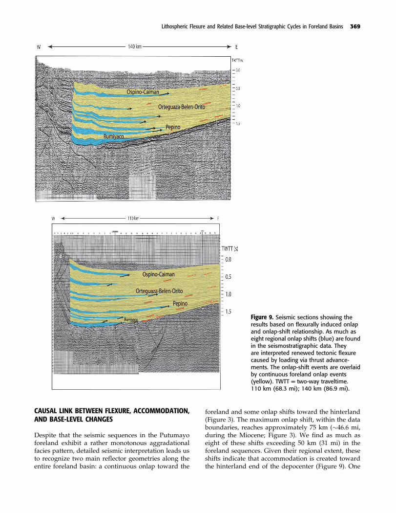
Figure 3. Composite seismic lines 3 (north)and 5 (south; line locations are shown inFigure 4). Color indicates tectonostrati-graphic units, as used in this study, boundedby unconformities (thicker lines representstrong events in seismic lines). We interpretforeland onlap toward the east (red arrows)and hinterland onlap shift toward the west(black arrows). The maximum onlap shiftwithin the data boundaries reaches approx-imately 75 km (�45 mi); as much as eightof these events are found in the forelandsequences (seismic line 3). TWTT = two-way traveltime. 110 km (68.3 mi); 140 km(87 mi).
Lithospheric Flexure and Related Base-level Stratigraphic Cycles in Foreland Basins 363

of flexural subsidence caused by sediment loading isthen calculated with a range of effective elastic thick-ness (10–100 km [6.21–62.1 mi]). The sediment load isdiscretized into individual linear loads (10-km [6-mi]–wide rectangles) whose heights are a function of thedecompacted thickness change along the seismic pro-files and isochore maps (Figure 5).The contribution tothe overall deflection from each individual rectangleis integrated assuming linear superposition (Hetenyi,1946). The calculated amount of deflection caused bythe decompacted load is subtracted from the original
thickness of the decompacted sequence. If the decom-pacted thickness exceeds the calculated deflection causedby the decompacted sedimentary load, then the residualdeflection is taken to represent the minimum accom-modation created by thrust-wedge loads at the time justbefore deposition, this residual flexure is explained by atectonic load. However, if the decompacted thickness issmaller than the calculated deflection caused by the de-compacted load, we assume that no tectonic loading isneeded to create the minimum accommodation for thesedimentary sequence.
Figure 4. Well location and isochore maps showing wedge-like geometries of stratigraphic units (modified from Cordoba et al.,1997). No erosional scars of regional extent are evident in the maps. Values of these isochore maps were used to constrainflexural modeling. 40 km (24.8 mi).
364 Londono et al.

Figure 5. Workflow for flexural analysis. (1) Seismic interpretation and identification of chronostratigraphic units followedby decompaction as a function of porosity. (2) Flexural modeling of sedimentary load. (3) Residual flexure is estimated(represents tectonic-related flexure). (4) Flexural modeling of tectonic wedge. This is an iterative modeling because effectiveelastic thickness also needs to be modeled. Results show the tectonic, and sedimentary flexure, forebulge location andgeometry, the effective elastic thickness, and the estimated width of tectonic wedge. Po = vertical load.
Lithospheric Flexure and Related Base-level Stratigraphic Cycles in Foreland Basins 365

This residual, tectonically induced deflection is thenforward modeled iteratively to determine the geome-try of the best-fitting tectonic load and an effectiveelastic thickness comparable to that corresponding tothe previously modeled sedimentary package (i.e., weassume that no effective elastic thickness changes dur-ing the elapsed time between the onset of tectonic load-ing and the end of the sedimentary cycle; Figure 5).During modeling, the hinterland end of the tectonicwedge coincides with the edge of the semi-infinite elas-tic plate in our flexural models, for instance, we as-sumed that this is the end of the effective load oreffective tectonic wedge, although this end does notcoincide with the geologic thrust belt hinterland limitthat may extend farther toward the arc but has no sig-nificant effect on the flexing plate (Watts, 2001). We canestimate the geometry of the tectonic load if we as-sume that it behaves as a Coulomb wedge, with a crit-ical taper angle that remains constant during thrust beltevolution (Davis et al., 1983). Then, the dimensions of thewedge such as its width and height can be determined.We divided the wedge body along the dip into discrete1 km (0.6 mi) wide rectangles whose heights are afunction of the thrust belt taper angle taken from re-gional cross sections (Figure 6). The taper angle usedduring modeling was 78. It was the average of the crosssections found in published and proprietary articles(Portilla et al., 1993; Geotec, 1992; Dengo and Covey,1993; Balkwill et al., 1995; Cordoba et al., 1997; Jimenez,1997).
The computational routine used for forward model-ing is developed using MATLABR (Londono, 2004).The equilibrium equation, D d4w
dx40 þ ð�m � �ifÞgw ¼ qðxÞ(Turcotte and Schubert, 1982), is used to calculate thedeflection of infinite and semi-infinite elastic beamsunder vertical loads (whereD is flexural rigidity,w(x) isdeflection, x is the horizontal distance from plate end,�m is density mantle, �f is the density of basin-fillingsedimentary rocks, g is gravity, and q(x) is the verticalload; Table 1). We implement the solution developed
by Hetenyi (1946) for semi-infinite beams in whichseveral linear loads load the beam from the end (x = 0)inward so that they represent the distributed tectonicand sedimentary loads flexing the plate (Figure 6):
wðxÞ ¼ qðxÞ2�ð�m � �ifÞg
½fe�x=�ðcosx
�� sin
x
�Þ
þ 2e�x=�ðcosx
�Þgfe�x=�ðcos
x
�þ sin
x
�Þg
� ½2fe�x=�ðcosx
�� sin
x
�Þ þ e�x=�ðcos
x
�Þg
� fe�x=�ðsinx
�Þg� þ e�x=�ðcos
x
�þ sin
x
�Þ�
ð1Þ
Where � is the flexural parameter (sensu Turcotteand Schubert, 1982). Geodynamic constants such as the
Table 1. Geodynamic constants*
Constant Symbol Value Units
Gravity acceleration g 9.8 m/s2
Water density �w 1035 kg/m3
Sediment density �s 1800–1900 kg/m3
Density of tectonic wedge �sw 2500 kg/m3
Density mantle �m 3300 kg/m3
Young’s modulus E 5 � 1011 PaPoisson’s ratio � 0.25Porosity exponent c 0.27 1/km
*Porosity exponent taken from Cordoba et al. (1997).
Figure 6. Flexural modeling of the tectonic load. (A) Thetectonically induced deflection is forward modeled itera-tively to best match the geometry of the tectonic load andthe effective elastic thickness. (B) During modeling, thehinterland end of the tectonic wedge coincides with theedge of the semiinfinite elastic plate in our flexural models.We divide the wedge body into discrete, 1 km (1 mi) longrectangles whose heights are a function of the thrust belttaper angle (B, C), taken from regional cross sections.
366 Londono et al.
Poisson’s ratio and Young’s modulus (which constrainsthe flexural rigidity (D) and/or effective elastic thick-ness of the plate) are shown in Table 1. For an idealelastic plate, the flexural subsidence is treated as oc-curring instantaneously with each loading phase.
FLEXURAL MODELING RESULTS
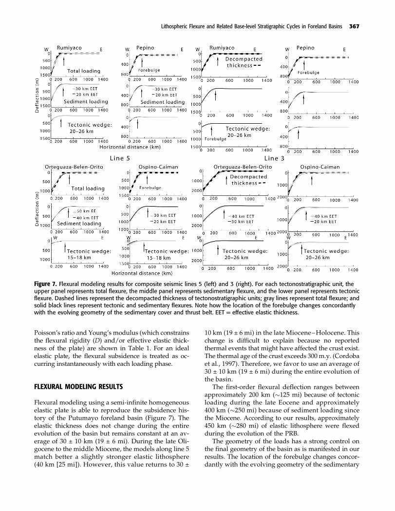
Flexural modeling using a semi-infinite homogeneouselastic plate is able to reproduce the subsidence his-tory of the Putumayo foreland basin (Figure 7). Theelastic thickness does not change during the entireevolution of the basin but remains constant at an av-erage of 30 ± 10 km (19 ± 6 mi). During the late Oli-gocene to the middle Miocene, the models along line 5match better a slightly stronger elastic lithosphere(40 km [25 mi]). However, this value returns to 30 ±
10 km (19 ± 6 mi) in the late Miocene–Holocene. Thischange is difficult to explain because no reportedthermal events that might have affected the crust exist.The thermal age of the crust exceeds 300 m.y. (Cordobaet al., 1997). Therefore, we favor to use an average of30 ± 10 km (19 ± 6 mi) during the entire evolution ofthe basin.
The first-order flexural deflection ranges betweenapproximately 200 km (�125 mi) because of tectonicloading during the late Eocene and approximately400 km (�250 mi) because of sediment loading sincethe Miocene. According to our results, approximately450 km (�280 mi) of elastic lithosphere were flexedduring the evolution of the PRB.
The geometry of the loads has a strong control onthe final geometry of the basin as is manifested in ourresults. The location of the forebulge changes concor-dantly with the evolving geometry of the sedimentary
Figure 7. Flexural modeling results for composite seismic lines 5 (left) and 3 (right). For each tectonostratigraphic unit, theupper panel represents total flexure, the middle panel represents sedimentary flexure, and the lower panel represents tectonicflexure. Dashed lines represent the decompacted thickness of tectonostratigraphic units; gray lines represent total flexure; andsolid black lines represent tectonic and sedimentary flexures. Note how the location of the forebulge changes concordantlywith the evolving geometry of the sedimentary cover and thrust belt. EET = effective elastic thickness.
Lithospheric Flexure and Related Base-level Stratigraphic Cycles in Foreland Basins 367

cover and thrust belt. The geometry of the forebulgereached tens of kilometers in width but only tens ofmeters in height (Figure 7). Invariably, tectonic loadsproduce forebulges that lie closer to the hinterland anddeflections that are narrower and deeper than thosecreated by sedimentary loads. Tectonic-related fore-bulges during the history of the basin tend to move inthe foreland direction (Figure 7).
Total foreland-sediment pileup above point-of-zerodeflection reaches between 1100 ± 150 m (3608 ± 492 ft)and 1350 ± 100 m (4428 ± 328 ft; Figure 7). Tectonicdeflection during the entire foreland period reachesapproximately 1200 m (�3900 ft; line 3) and approxi-mately 1000 m (�3000 ft; line 5). The difference be-tween sediment pileup and tectonic deflection is be-tween 150 and 250 m (492–820 ft). This difference is ofthe same order of magnitude as that of the present-daytopography (between 500 and 250 m [1640–820 ft] in thebasin), which quantitatively validates the results of theflexural model. The continental character of the basinduring its foreland period indicates that it has been anarea above sea level during its evolution because ofsediment accumulation.
The width of the estimated effective tectonic wedgecan range between 15 and 30 km (9–19 mi) for a criticaltaper angle of 78. This geometry is within the param-eter range of tectonic loads (thrust belts) reported inthis tectonic setting around the world (Nemeok et al.,2005). The range in width values of the wedge could bea function of the uncertainty in the effective elasticthickness, which can be as high as approximately 30%in this chapter (25% for elastic thickness around the
world; Burov and Diament, 1995). The height of thewedge ranges between 3 km (1.86 mi, in the Oligocene)and 1.5 km (0.93 mi, in the Eocene). Today, the AndesMountains, contiguous to the Putumayo foreland, reachapproximately 2 km (�1.24 mi) in elevation, approxi-mately 40 km (�20 mi) from the foothills. It is note-worthy that the entire wedge is not necessarily aboveany datum such as sea level. Given the nature of thrustbelt tectonics, it is reasonable to assume that only a partof this wedge would be subaerially exposed.
Figure 8 summarizes the flexural modeling resultin terms of flexural subsidence rates at or near thedeepest part of the basin. These values tend to zero atthe edge of the basin (i.e., zero values in isochore maps).The Putumayo Basin reached a maximum rate of sub-sidence of 155 m/m.y. (508 ft/m.y.) during the late Eo-cene (Pepino Unit: 35 m/m.y. [114.8 ft/m.y.] resultingfrom tectonic loading and 120 m/m.y. [394 ft/m.y.] re-sulting from sediment loading) and a minimum rate of78 m/m.y. (256 ft/m.y.) during the Paleocene: (19 m/m.y.[62 ft/m.y.] resulting from tectonic loading and 59 m/m.y.[194 ft/m.y.] resulting from sediment loading). On av-erage, the tectonic loading subsidence is responsiblefor approximately 23% of the total subsidence, whereassediment loading is responsible for the remaining 77%.The sandstone-shale ratio tends to be higher with in-creasing sediment-related subsidence rate: in the PRB,the highest ratio was reached during the late Eocene(Pepino Formation; Figure 8). However, it is alsohighest when the ratio of tectonic-related subsidenceto sediment-related subsidence tends to be the lowest(Figure 8).
Figure 8. Summary of the history of subsidence during basin evolution. Note how sandstone-shale ratio parallels sedimentaryloading.
368 Londono et al.
CAUSAL LINK BETWEEN FLEXURE, ACCOMMODATION,AND BASE-LEVEL CHANGES
Despite that the seismic sequences in the Putumayoforeland exhibit a rather monotonous aggradationalfacies pattern, detailed seismic interpretation leads usto recognize two main reflector geometries along theentire foreland basin: a continuous onlap toward the
foreland and some onlap shifts toward the hinterland(Figure 3). The maximum onlap shift, within the databoundaries, reaches approximately 75 km (�46.6 mi,during the Miocene; Figure 3). We find as much aseight of these shifts exceeding 50 km (31 mi) in theforeland sequences. Given their regional extent, theseshifts indicate that accommodation is created towardthe hinterland end of the depocenter (Figure 9). One
Figure 9. Seismic sections showing theresults based on flexurally induced onlapand onlap-shift relationship. As much aseight regional onlap shifts (blue) are foundin the seismostratigraphic data. Theyare interpreted renewed tectonic flexurecaused by loading via thrust advance-ments. The onlap-shift events are overlaidby continuous foreland onlap events(yellow). TWTT = two-way traveltime.110 km (68.3 mi); 140 km (86.9 mi).
Lithospheric Flexure and Related Base-level Stratigraphic Cycles in Foreland Basins 369

likely cause for the deepening toward the hinterlandis tectonic loading via thrust advancements. In thiscase, the new space for sedimentation is created throughflexure of the lithosphere under these loads (Figures 3,9). During periods of tectonic loading, the rate of cre-ation of accommodation (flexure) is greater than therate of sediment supply because deflection occurs in-stantaneously (in geologic terms). In addition, the ratesof tectonic uplift may be as much as eight times thoseof denudation (Lawrence and Williams, 1987; Blair andMcPherson, 1994). The onlap-shift events are overlaidby continuous foreland onlap events that represent con-tinuous sedimentation without tectonic reactivation.Plate deflection tends to widen in the direction wherethe sediments are transported as they cover a part of theflexure created by their own weight (Figure 9).
In continental deposits, base level has been com-monly considered as the limiting elevation that con-trols equilibrium between the processes of aggradationand degradation. This abstract definition lacks a phys-ically equivalent boundary in the sedimentary record(Chul, 2006). We cannot always be sure whether anonlap termination coincides with the base-level eleva-tion at that particular time of sedimentation. When abasin is flexed because of sedimentary and tectonicloads, as is the case in the Putumayo foreland basin, thedepositional surface subsides continuously, creatingmore accommodation, although the standard base lev-el may remain unchanged (Figure 10). Sediment ag-gradation proceeds up to base level and eventuallytends to reach the equilibrium profile (Schumm, 1993).During the equilibrium stage, no net sediment deposition
Figure 10. Foreland basin re-gional development model, inte-grating flexure, caused by tectonicand sedimentary loads, base-level and long-term hiatuses. Themodel initiates with a period oftectonic loading (regional hinter-land onlap shifts), followed bya period of sedimentation thatdeepens and widens the basinresulting from sediment loadinguntil either a new tectonic eventloads the basin at the hinterlandend or the fluvial system reachesthe graded stage. If the latter isthe case, a period of nondeposition(hiatus) follows and continues untila new loading event, via flexure,creates further accommodation.
370 Londono et al.
or erosion is observed and, therefore, no stratigraph-ic record remains nor is an erosional scar generated(Figure 10). One possible explanation for the hiatusesreported in the Putumayo Basin is that they representperiods of an equilibrium phase, where the prevail-ing fluvial-system profiles are near graded stage atbase level. Conversely, within this context, a sequencewithin the continental foreland record may be definedas a sedimentary succession formed during the adjust-ment of the fluvial system toward an assumed baselevel during an equilibrium phase (Figure 10).
In addition, and following previous studies (Milana,1998; Chul, 2006), in the Putumayo Basin, sedimentarysequences can be divided into the following accordingto the subsidence regime: (1) tectonically induced high-subsidence facies, with probably low sandstone-shaleratio sediments, that are predicted to be associatedwith onlap shifts toward the hinterland recognizablein seismic data, and (2) sediment-loading-induced low-subsidence facies, containing probably high sandstone-shale ratios, that are predicted to be associated withcontinual onlap events toward the foreland boundedby onlap shifts and/or unconformities recognizable inseismic data (Figure 3). In the Putumayo Basin, somesequences contain both facies or a succession of them,suggesting that it is not necessary to reach the equi-librium stage before a change in subsidence regimeoccurs.
As predicted in models (Plint et al., 2001; Miall, 2002,2006) the sandstone-shale ratio increases with the in-creasing amount of sediment loading (Figures 2, 8) andits ratio to tectonic load.
DISCUSSION
The results obtained in this study disagree with thecurrent evolutionary model proposed for the Putumayoforeland basin in two fundamental aspects. First, it isunclear whether a causal link exists between tectonicepisodes and resultant unconformities (Cordoba et al.,1997). It is also not clear whether the three dated tectono-stratigraphic unconformities described in the PutumayoBasin (Geotec, 1992; Cordoba et al., 1997) represent sin-gle or composite uplift events followed by the sedimen-tation of the corresponding tectonostratigraphic unit.The interpreted unconformities show no evidence oferosion and/or structural deformation across them,and so, little evidence to explain the development ofparaconformities by tectonic episodes exists. On thecontrary, tectonic episodes in foreland basins have beencommonly related to the abrupt deposition of coarse-grained facies (Jordan, 1995). A tectonic episode creates,
necessarily, a corresponding flexural event followedby the initiation of a high-subsidence phase (Figures 7,9, 10). The initial tectonic event is followed by a low-subsidence phase controlled mostly by sediment-induced flexure. Our model, however, indicates thatthese paraconformities may represent hiatuses dur-ing periods of equilibrium or graded stage of the pre-vailing fluvial systems and total tectonic quiescence(Figure 9). Second, we recognize as much as eight re-gional onlap shifts toward the hinterland (exceeding50 km [31 mi]) that represent tectonic loading events(Figure 9). Our results support a model with more thanthree tectonic events to match the seven or more onlapshifts. We interpret that seven periods of thrust beltadvancements are recorded in the seismostratigraphicrecord, and although the resolution in the data doesnot allow us to assess the geodynamic model for flex-ure for each one of these tectonic-loading related units,our model consistently explains the development ofthe paraconformities caused during the tectonic qui-escence stage and explains the seismostratigraphic ar-chitecture found in the foreland sequences.
Figure 9 shows how at least one onlap shift or tec-tonic episode is interpreted during the Paleocene earlyin the sequence, within the limits of our seismic data.Most of the Rumiyaco Formation sequence is domi-nated by sediment-loading facies, represented by con-tinuous onlap toward the foreland, before reachingthe equilibrium stage that produces the succeeding13 m.y.-time gap unconformity. However, the tectonic-related flexure is the highest at this period compared tothe total subsidence and, as predicted in the models,this sequence has the lowest sandstone-shale ratio.
Within the Eocene Pepino Formation, at least twopulses of tectonic episodes can be inferred in theequivalent-age seismic data. Following the secondepisode, the fluvial system appears to reach the equi-librium stage that generates a hiatus of approximately6 m.y. Also during the second period, flexural analysissuggests that the maximum subsidence rate is attainedfor both tectonic and sedimentary loads.
During the late Oligocene to the middle Miocene,at least three episodes of tectonic reactivation are in-terpreted from onlap shifts in the seismic data. Theseepisodes occurred in the lower part of the seismic se-quence: two in the lower half of the section and onetoward the middle. The rates of both tectonic-related andsedimentary-related subsidence appear to be slowerthan for the previous Oligocene section.
Finally, since the late Miocene, at least two tectonicreactivation pulses are interpreted in the lower half ofthe section. Noisy data quality precludes a reliable in-terpretation of the upper half of the remaining seismicsection. Rates of subsidence appear to increase again,
Lithospheric Flexure and Related Base-level Stratigraphic Cycles in Foreland Basins 371

similar to those in the Oligocene, although the tectonic-related subsidence is relatively low compared to thetotal subsidence. As expected, a sharp increase of thesandstone-shale ratio is observed.
In our interpretation, we assume that the basin isalways overfilled, for instance, the fluvial systems runtransversally to the tectonic belt, which may not al-ways be the case. We do not have evidence of anunderfilled basin, in which case we expect the fluvialsystem to be parallel with the thrust belt, probably cre-ating a different type of seismic facies, as described byMilana (1998).
As predicted in models (Plint et al., 2001; Miall,2002, 2006), the sandstone-shale ratio increases withthe increasing amount of sediment loading (Figures 2,9) and its ratio to tectonic load. These results supportthe idea of a time gap between tectonic uplifting anddenudation because they show an increasing amountof fine-grained sediments related to tectonic activity,as the amount of accommodation appears to be a lothigher than that of sediment supply. At the same time,and for the same reason, the results contradict the ideaof direct temporal relationship between coarse-grainedsediment and tectonic activity.
Although our models determine the maximum widthand thickness of the tectonic load or the segment ofthe thrust belt reactivated during each studied period,we cannot establish with certainty a unique positionfor the load. Balance cross sections and palinspasticreconstructions extending through the mountain beltare necessary to assess the geologic position of theeffective load. However, if we consider that the lo-cation of the predicted forebulges associated with eachtectonic episode moves toward the foreland duringthe basin evolution, it is possible to infer a forward-breaking thrust sequence in the Putumayo Basin.
Flexural models predict the change of location anddimension of forebulges along the plate in responseto the change in nature and magnitude of the loadsthroughout the basin history (DeCelles and Giles, 1996).In the Putumayo Basin, our flexural models predictedat least eight forebulges (four tectonic-related and foursedimentary-related) at different locations and withdifferent dimensions (Figure 7). However, we inter-pret at least seven tectonic reactivation pulses from theseismic data. If the corresponding sediment-relatedforebulges are added, at least 14 forebulges should bepredicted according to the foreland system models(DeCelles and Giles, 1996; DeCelles and Currie, 1996).Yet, when we consider each individual loading event,the scale of these forebulge features is subtle, only a fewtens of kilometers wide and, more importantly, onlytens of meters high. Distinguishing these forebulgesfrom elevations created by autogenic processes using
only stratigraphic records is an extremely difficult task(Figure 9). From the perspective of conventional andheavy oil exploration, one important implication ofthis assessment is that many stratigraphic traps mayexist because of the larger number of tectonic pulsesthan identifiable in the seismic data. The location andscale of these expected traps can be predicted fromflexural analysis. Exploring for hydrocarbons using asingle forebulge model for the entire history of thebasin could result in a costly mistake.
According to the results obtained in this study, theeffective elastic thickness (30 ± 10 km [19 ± 6 mi]) doesnot change at a scale of 107 yr, similar to the results ofSinclair et al. (1991) in the Alps. No viscous-elasticrelaxation seems to be necessary to explain the flexurein the Putumayo Basin. Neither the plate curvaturenor the sedimentary cover, via blanketing (Lavier andSteckler, 1997), are sufficient to weaken the plate dur-ing the evolution of the basin. Cretaceous back-arcrifting processes appear to have not affected the litho-sphere in Putumayo and, therefore, the thermal ageof the plate is probably Precambrian to Cambrian(Sarmiento, 2002). The effective elastic thickness foundin this work is similar to, or slightly lower than, theestimated thickness of the crust in the area (35–40 km[22–25 mi]; Sarmiento, 2002; Watts, 2001) during thelatest episode of the Andean orogeny in Colombia dur-ing the late Miocene.
The geometry of the flexural deflection during theevolution of the PRB can be explained using tectonicand sedimentary loads only. The geometry of the mod-eled thrust belt (maximum width, �30 km [�19 mi]) iswithin the range of similar systems around the world(Nemeok et al., 2005). In addition, because the wave-length of the first-order flexural deflection did notexceed 450 km (280 mi) at any point during the evo-lution of the basin, it becomes difficult to endorse dy-namic topography as an acting downward force in thePRB (Mitrovica et al., 1989).
CONCLUSIONS
The regional geometry of stratigraphic sequences inretroarc foreland basins appears to be controlled pri-marily by the flexure of the lithosphere in response totectonic (thrust sheets) and sediment loads. A tectonicevent produces a narrow but deep depocenter, with ahigh subsidence rate (in relation to sediment supply)and a low sandstone-shale ratio. In the seismostrati-graphic record, a tectonic loading event could be rec-ognized by regional (tens of kilometers) onlap shiftsfrom the foreland toward the hinterland. Conversely,
372 Londono et al.

a sediment-related subsidence period (controlled most-ly by the weight and dispersion of sediments) wouldproduce a wide but relatively shallow depocenter, witha high sediment supply rate compared to the subsi-dence rate, and a high sandstone-shale ratio. Duringthese periods, the flexure widens and sediments prop-agate toward the foreland. Seismically, these faciescould be recognized by continuous foreland onlap. Theend of these periods is marked in the seismostrati-graphic record by the regional onlap shifts toward thehinterland that mark the initiation of a new tectonicpulse.
Retroarc foreland sequences can be seen as base-level cycles that move through several stages that in-clude a period of tectonic reactivation, a period ofsedimentary-related subsidence, and a period of graded-stage development. Base-level cycles also explain theorigin of regional long-live paraconformities withina geodynamic flexural framework. A sequence, in acontinental foreland setting, may be defined as a sed-imentary succession formed during the adjustment of afluvial system to the equilibrium stage at base level.
Paraconformities may represent periods of tectonicquiescence and a graded stage of the prevailing fluvialsystems in the Putumayo Basin. If a sedimentary unitdeposited during a period dominated by sediment load-ing is topped by a paraconformity, we may interpret thatno tectonic reactivation immediately following its de-position (no new accommodation was made available)was observed. Without new accommodation and nonew sedimentation and/or erosion, the fluvial profilewould be essentially at base level and at graded stage.
In the Putumayo Basin, the highest rate of subsidence(155 m/m.y. [508 ft/m.y.]: 35 m/m.y. [114.8 ft/m.y.]because of tectonic subsidence and 120 m/m.y. [394 ft/m.y.] because of sediment-related subsidence) was at-tained during the Eocene.
In the Putumayo Basin, at least seven pulses of tec-tonic reactivation are identified in the seismostrati-graphic record of the Tertiary section. These pulses arerecognized as regional (>50 km [>31 mi]) onlap shiftstoward the hinterland. One tectonic pulse is identifiedduring the Paleocene (Rumiyaco Formation), at leasttwo during the Eocene (Pepino Formation), two duringthe early to middle Miocene (Orteguaza-Belen-OritoFormation) and, finally, at least two since the late Mio-cene (Ospino-Caiman Formation). Regional unconfor-mities and hiatuses in the Putumayo represent tectonicquiescence period where fluvial systems reached, orwere near, graded stage.
The mechanical models used in this work predictedthe occurrence of at least 14 forebulges, coincidentwith seven periods of tectonic reactivation and sevenperiods of sediment-controlled subsidence. The scale
of these forebulges reaches tens of kilometers in widthand tens of meters of height.
The subsidence history of the basin can be repro-duced with an elastic semiinfinite plate, whose effec-tive elastic thickness is 30 ± 10 km (19 ± 6 mi). Elasticplate thickness does not need to change during the evo-lution of the basin to match the observed data. Duringthe history of the basin, the total deflection exceeds5500 m (18,045 ft) vertically and over approximately450 km (�280 mi) in width.
ACKNOWLEDGMENTS
We thank Empresa Colombiana de Petroleos (Ecopetrol)and Geotec Colombia for allowing us to use proprietarydata and the Landmark Graphics Corporation for al-lowing us to use their software through an educationalgrant to the Department of Geology and Geophysics,Louisiana State University, Baton Rouge. The originallysubmitted manuscript was greatly benefited by the de-tailed constructive comments from reviewers H. Luoand D. Harry.
REFERENCES CITED
Allen, J., 1978, Studies in fluvial sedimentation: An explor-atory quantitative model for the architecture of avulsion-controlled alluvial suites: Sedimentary Geology, v. 21,p. 129–147, doi:10.1016/0037-0738(78)90002-7.
Allen, P., and J. Allen, 1990, Basin analysis: Principles andapplications: Oxford, United Kingdom, Blackwell Scien-tific Publications, 451 p.
Aspden, J. A., W. McCourt, and M. Brook, 1987, Geometricalcontrol of subduction-related magmatism: The Mesozoicand Cenozoic plutonic history of western Colombia: Jour-nal of the Geological Society (London), v. 144, p. 893–905,doi:10.1144/gsjgs.144.6.0893.
Balkwill, H., G. Rodriguez, F. Paredes, and J. Almeida, 1995,Northern parts of Oriente Basin, Ecuador: Reflection seis-mic expression of structures in A. Tankard, R. Soruco,and H. Welsink, eds., Petroleum basins of South America:AAPG Memoir 62, p. 559–571.
Beamont, C., 1981, Foreland basins: Geophysics Journal Re-search of Astronomical Society, v. 65, p. 471–498.
Blair, T., and J. McPherson, 1994, Historical adjustment byWalker River to lake-level fill over a tectonically tiltedhalf-graben floor, Walker Lake Basin, Nevada: Sedimen-tary Geology, v. 92, p. 7–16, doi:10.1016/0037-0738(94)00058-1.
Blum, M. D., and T. E. Tornqvist, 2000, Fluvial responses toclimate and sea level change: A review and look forward:Sedimentology, v. 47, p. 2–48, doi:10.1046/j.1365-3091.2000.00008.x.
Lithospheric Flexure and Related Base-level Stratigraphic Cycles in Foreland Basins 373

Burov, E. B., and M. Diament, 1995, The effective elasticthickness (Te) of continental lithosphere: What does itreally mean?: Journal of Geophysical Research, v. 100,no. B3, p. 3905–3927, doi:10.1029/94JB02770.
Cardozo, N., and T. Jordan, 2001, Causes of spatially var-iable tectonic subsidence in the Miocene Bermejo fore-land basin, Argentina: Basin Research, v. 13, p. 335 –358, doi:10.1046/j.0950-091x.2001.00154.x.
Catuneanu, O., 2004, Retroarc foreland systems evolutionthrough time: Journal of African Earth Sciences, v. 38,p. 225–242, doi:10.1016/j.jafrearsci.2004.01.004.
Chul, W., 2006, Conceptual problems and recent progress influvial sequence stratigraphy: Geoscience Journal, v. 10,p. 433–443, doi:10.1007/BF02910437.
Clark, M., and L. Royden, 2000, Topographic ooze, buildingthe eastern margin of Tibet by lower crustal flow: Geol-ogy, v. 28, p. 703–706, doi:10.1130/0091-7613(2000)28<703:TOBTEM>2.0.CO;2.
Cordoba, F., E. Kairuz, J. Moros, W. Calderon, F. Buchelli, C.Guerrero, and L. Magoon, 1997, Proyecto EvaluacionRegional Cuenca del Putumayo: Definicion de SistemasPetrolıferos: Ecopetrol Internal Report, 119 p.
Daly, M. C., 1989, Correlations between Nazca/Farallon platekinematics and forearc basin evolution in Ecuador: Tec-tonics, v. 8, p. 769–790, doi:10.1029/TC008i004p00769.
Davis, D., J. Supper, and F. Dahlia, 1983, Mechanics of foldand thrust belts and accretionary wedges: Journal ofGeophysical Research, v. 88, p. 1153 –1172, doi:10.1029/JB088iB02p01153.
DeCelles, P., and B. Currie, 1996, Long-term sediment ac-cumulation in the Middle Jurassic–early Eocene Cor-dilleran retroarc foreland basin system: Geology, v. 24,no. 7, p. 591–594, doi:10.1130/0091-7613(1996)024<0591:LTSAIT>2.3.CO;2.
DeCelles, P., and K. Giles, 1996, Foreland basin systems:Basin Research, v. 8, p. 105–123, doi:10.1046/j.1365-2117.1996.01491.x.
Dengo, C. A., and M. C. Covey, 1993, Structure of the EasternCordillera of Colombia: Implications for trap styles andregional tectonics: AAPG Bulletin, v. 77, p. 1315–1337.
Emery, D., and K. Myers, 1997, Sequence stratigraphy: Oxford,England, Blackwell Science Publications, 297 p.
Geotec, 1992, Facies distribution and tectonic setting throughthe Phanerozoic of Colombia: A regional synthesis com-bining outcrop and subsurface data presented in 17 consec-utive rock-time slices: Bogota, Colombia, Geotec Limitada,100 p.
Gomez, E., T. E. Jordan, R. W. Allmendinger, and N. Cardozo,2005, Development of the Colombian foreland-basin sys-tem as a consequence of diachronous exhumation of thenorthern Andes: Geological Society of America Bulletin,v. 117, p. 1272–1292.
Henderson, W., 1979, Cretaceous to Eocene volcanic arc ac-tivity in the Andes of northern Ecuador: Journal of theGeological Society (London), v. 136, p. 367–378.
Hetenyi, M., 1946, Beams of elastic foundation: The Uni-versity of Michigan Press, 257 p.
Higley, D., 2001, The Putumayo-Oriente-Maranon Province
of Colombia, Ecuador, and Peru: Mesozoic–Cenozoic andPaleozoic petroleum systems: U.S. Geological Survey Dig-ital Data Series 63, 20 p.
Horton, B. K., K. N. Constenius, and P. G. DeCelles, 2004,Tectonic control on coarse-grained foreland-basin se-quences: An example from the Cordilleran foreland ba-sin, Utah: Geology, v. 32, p. 637–640.
Jimenez, C., 1997, Structural styles of the Andean foothills,Putumayo Basin, Colombia: Master’s thesis, University ofTexas at Austin, Austin, Texas, 73 p.
Jordan, T., 1995, Retroarc foreland and related basins, in C.Busby and R. Ingersoll, eds., Tectonics and sedimentation:Blackwell Science Publications, p. 331–362.
Lavier, L., and M. Steckler, 1997, The effect of sedimentarycover on the flexural strength of continental lithosphere:Nature, v. 389, p. 476–479, doi:10.1038/39004.
Lawrence, D., and B. Williams, 1987, Evolution of drainagesystems in response to Acadian deformation: The De-vonian Battery Point Formation, eastern Canada, in F.Ethridge, R. Flores, and M. Harvey, eds., Recent develop-ments in fluvial sedimentology: SEPM Special Publica-tion 39, p. 287–300.
Liu, S., and D. Nummedal, 2004, Late Cretaceous subsidencein Wyoming: Quantifying the dynamic component: Geol-ogy, v. 32, no. 5, p. 397–400, doi:10.1130/G20318.1.
Londono, J., 2004, Foreland basins: Lithospheric flexure,plate strength and regional stratigraphy: Ph.D. disserta-tion, Louisiana State University, Baton Rouge, Louisiana,175 p.
Mackin, J., 1948, Concept of graded river: Geological Societyof America Bulletin, v. 59, p. 463–512.
Miall, A., 1997, The geology of stratigraphic sequences:Berlin, Germany, Springer-Verlag, 433 p.
Miall, A., 2002, Architecture and sequence stratigraphy ofPleistocene fluvial systems in the Malay Basin, based onseismic time-slice analysis: AAPG Bulletin, v. 86, p. 1201–1216.
Miall, A., 2006, Reconstructing the architecture and sequencestratigraphy of the preserved fluvial record as a tool forreservoir development: A reality check: AAPG Bulletin,v. 90, p. 989–1002, doi:10.1306/02220605065.
Mora, C., M. P. Torres, and J. Escobar, 1997, Potencial gen-erador de hidrocarburos de la Formacion Chipaque y surelacion estratigrafica secuencial en la zona axial de laCordillera Oriental (Colombia): VI Simposio BolivarianoExploracion Petrolera en las Cuencas Subandinas, Carta-gena, Colombia, p. 217–237.
Michal, N., S. Steven, and R. Gayer, 2005, Thrust belts:Structural architecture, thermal regimes and petroleumsystems: Cambridge, United Kingdom, Cambridge Uni-versity Press, 541 p.
Milana, J., 1998, Sequence stratigraphy in alluvial settings: Aflume-based model with applications to outcrop seismicdata: AAPG Bulletin, v. 82, p. 1736–1753.
Mitrovica, J. X., C. Beaumont, and G. T. Jarvis, 1989, Tilt-ing of continental interiors by the dynamical effects ofsubduction: Tectonics, v. 8, p. 1079 – 1094, doi:10.1029/TC008i005p01079.
374 Londono et al.

Nemcok, M., S. Schamel, and R. Gayer, 2005, Thrustbelts:structural architecture, thermal regimes and petroleumsystems: Cambridge University Press, 541 p.
Plint, G., P. McCarthy, and U. Faccini, 2001, Nonmarine se-quence stratigraphy, updip expression of sequence bound-aries and systems tracts in a high-resolution framework,Cenomanian Dunvegan Formation, Alberta foreland basin,Canada: AAPG Bulletin, v. 85, p. 1967–2001.
Portilla, O., E. Ch. Kairuz, C. A. Y Lombo, and H. Garzon,1993, Informe Final Proyecto Putumayo Oeste Fase III:Bogota, Colombia, Ecopetrol, 153 p.
Posamentier, H., and P. Vail, 1988, Eustatic controls on clasticdeposition II: Sequence and systems tract models, in C.Wilgus, B. S. Hasting, C. G. Kendall, H. W. Posamentier,C. A. Ross, and J. C. Van Wagoner, eds., Sea level changes:An integrated approach: SEPM Special Publication 42,p. 125–154.
Sarmiento, L., 2002, Mesozoic rifting and Cenozoic basin in-version history of the Eastern Cordillera, Colombian Andes:Inferences from tectonic models: Ph.D. dissertation, VrijeUniversiteit, Amsterdam, The Netherlands, 295 p.
Schumm, S., 1993, River response to base-level change: Im-plication for sequence stratigraphy: Journal of Geology,v. 101, p. 279–294, doi:10.1086/648221.
Schumm, S., J. Dumont, and J. Holbrook, 2000, Active tec-tonics and alluvial rivers: Cambridge, United Kingdom,Cambridge University Press, 276 p.
Steckler, M., and A. Watts, 1978, Subsidence of an Atlantic-type continental margin off New York: Earth Plane-
tary Sciences, v. 7, p. 1 – 13, doi:10.1016/0012-821X(78)90036-5.
Sclater, J. G., and P. A. F. Christie, 1980, Continental stretching:An explanation of the post–mid-Cretaceous subsidence ofthe central North Sea Basin: Journal of Geophysical Re-search, v. 85, p. 3711–3739, doi:10.1029/JB085iB07p03711.
Shanley, M., and P. McCabe, 1994, Perspectives on sequencestratigraphy of continental strata: AAPG Bulletin, v. 78,p. 654–568.
Sinclair, H., B. Coakly, P. Allen, and A. Watt, 1991, Simulationof foreland basin stratigraphy using a diffusion model ofmountain belt erosion: An example from the Alps of east-ern Switzerland: Tectonics, v. 10, p. 599–620, doi:10.1029/90TC02507.
Sloss, L. L., 1962, Stratigraphic models in exploration: AAPGBulletin, v. 74, p. 93–113.
Turcotte, D., and G. Schubert, 1982, Geodynamics: Applica-tion of continuum physics to geological problems: NewYork, Wiley, 448 p.
Vail, P., R. Mitchum, and S. Thompson, 1977, Seismic stra-tigraphy and global changes of sea level: Relative changesof sea level from coastal onlap, in C. E. Payton, ed., Seismicstratigraphy: Applications to hydrocarbon exploration:AAPG Memoir 26, p. 63–81.
Watts, A. B., 2001, Isostasy and flexure of the lithosphere: Cam-bridge, United Kingdom, Cambridge University Press, 472 p.
Wescott, W., 1993, Geomorphic thresholds and complex re-sponse of fluvial systems: Some implications for sequencestratigraphy: AAPG Bulletin, v. 77, p. 1208–1218.
Lithospheric Flexure and Related Base-level Stratigraphic Cycles in Foreland Basins 375