listing of campsites on the manigotagan...
TRANSCRIPT

© Manitoba Eco-Network, Inc. 02/2008 For more information: www.mbeconetwork.org/canoemap 1
Listing of Campsites on the Manigotagan River This document lists and describes the campsites along the Manigotagan River between Highway #314 and the government dock in the community of Manigotagan. The descriptions were originally created in 2006. If you find any discrepancies, please let us know (e-mail to [email protected]). The descriptions start with the campsites closest to Highway #314. To find out more about the river, its history, environmental information and other information that may be of interest to paddlers, visit our website at www.mbeconetwork.org/canoemap. Unnamed Campsite Number of Tents: > 4 Campsite Toilet: 3 toilets – lawn chair, bench and pail toilets with seats Campsite Exposure: Best on the east side Campsite Access: Good, best on west Campsite Staging: Yes Campsite Fire-pit: Stone-ring fire Campsite Privacy: Some boat traffic Campsite View: Good scenery, stone men
Figure 1.1: Campsite view. Photo by A. Kirch.
Figure 1.2: Bench toilet with seat. Photo by L. Dykman.

© Manitoba Eco-Network, Inc. 02/2008 For more information: www.mbeconetwork.org/canoemap 2
Unnamed Campsite on Island Number of Tents: > 4 Campsite Toilet: Little privacy Campsite Exposure: West Campsite Access: Easy Campsite Staging: Yes Campsite Fire-pit: Steel fire-pit Campsite Privacy: Good Campsite View: Very good view Campsite Description: Large flat campsite on an island, good swimming, good access, good
isolation.
Figure 2: Take-out during very low water. Photo by A. Kirch. “S-Bend” Campsite Number of Tents: 2 Campsite Toilet: Fair Campsite Exposure: Breezy Campsite Access: Good Campsite Staging: Good Campsite Fire-pit: Stone fire-pit Campsite Privacy: Fair Campsite View: Good Campsite Description: Campsite with nice, flat ground
Figure 3: Campsite take-out during very low water. Photo by A. Kirch.

© Manitoba Eco-Network, Inc. 02/2008 For more information: www.mbeconetwork.org/canoemap 3
Unnamed Campsite at Long Lake Rapids and Juniper Rapids Number of Tents: 3-4 Campsite Toilet: Fair Campsite Exposure: Protected Campsite Access: Good Campsite Staging: Good Campsite Fire-pit: Steel – however, this is a very hazardous location for a fire due
to the lichen underneath the fire pit and the old conifers that are very close.
Campsite Privacy: Fair, due to portage trail Campsite View: Treed in Campsite Description: Very nice campsite, but little privacy (boaters from Long Lake like to use the swimming hole below the rapids).
Figure 4.1: Campsite stove. Photo by A. Kirch.
Figure 4.2: Swimming hole downstream the rapids. Photo by A. Kirch.

© Manitoba Eco-Network, Inc. 02/2008 For more information: www.mbeconetwork.org/canoemap 4
Unnamed Campsite at Sloperock Falls Number of Tents: >4 Campsite Toilet: Very little soil Campsite Exposure: North-west exposure Campsite Access: Good Campsite Staging: Yes Campsite Fire-pit: Steel fire-pit Campsite Privacy: Yes Campsite View: Great view onto pool downstream.
Figure 5.1: Waterfall during very low water. Photo by A. Kirch.
Figure 5.2: Campsite view. Photo by A. Kirch. Unnamed Campsite Number of Tents: 2 - 3 Campsite Toilet: Poor, no privacy from boaters Campsite Exposure: Shaded, North-West and South exposure Campsite Access: Steep Campsite Staging: Not much space, but possible Campsite Fire-pit: Steel fire-pit with chopped firewood Campsite Privacy: Not good Campsite View: Nice scenery Campsite Description: Mowed grass, fairly large, flat, little privacy

© Manitoba Eco-Network, Inc. 02/2008 For more information: www.mbeconetwork.org/canoemap 5
Figure 6.1: Campsite - empty. Photo by A. Kirch.
Figure 6.2: Campsite - full. Photo by A. Kirch. Unnamed Campsite Number of Tents: Up to 8 tents Campsite Toilet: Mowed area in woods Campsite Exposure: No Campsite Access: Good Campsite Staging: No Campsite Fire-pit: Steel fire-pit with chopped wood Campsite Privacy: Fair due to boat traffic Campsite View: Very good Campsite Description: Large campsite
Figure 7.1: Designated canoe campsite sign. Photo by L. Dykman.

© Manitoba Eco-Network, Inc. 02/2008 For more information: www.mbeconetwork.org/canoemap 6
Figure 7.2: Campsite access during very low water. Photo by A. Kirch.
Figure 7.3: Campsite. Photo by A. Kirch. Jackson's Caribou Lodge Campsite A This campsite is operated by the lodge and needs to be reserved: PH: 1-866-775-8322. Number of Tents: 3-4 Campsite Toilet: Green toilet Campsite Exposure: Strong South and North exposure Campsite Access: Fairly steep Campsite Staging: Good Campsite Fire-pit: Yes Campsite Privacy: Fair (open to the lake) Campsite View: Excellent Campsite Description: Nice swimming area, raspberries, wild roses and pin cherries on the
island

© Manitoba Eco-Network, Inc. 02/2008 For more information: www.mbeconetwork.org/canoemap 7
Figure 8.1: Campsite view. Photo by A. Kirch.
Figure 8.2: Green toilet facilities. Photo by A. Kirch. Jackson's Caribou Lodge Campsite B This paid campsite is operated by Jackson’s Caribou Lodge and needs to be reserved: PH: 1-866-775-8322. Number of Tents: > 4 Campsite Toilet: Green toilet Campsite Exposure: SSE exposure Campsite Access: Good Campsite Staging: Good Campsite Fire-pit: Stone fire-pit Campsite Privacy: Good Campsite View: Very nice Campsite Description: Campsite managed by lodge - reservations are required. No orange
sign, picnic tables, nice bushes with little flowers.
© Manitoba Eco-Network, Inc. 02/2008 For more information: www.mbeconetwork.org/canoemap 8
Figure 9.1: Campsite. Photo by A. Kirch.
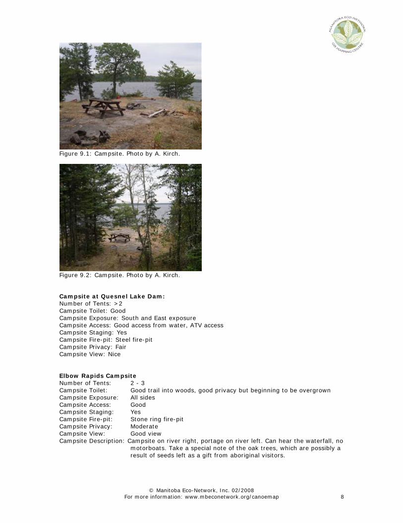
Figure 9.2: Campsite. Photo by A. Kirch. Campsite at Quesnel Lake Dam: Number of Tents: >2 Campsite Toilet: Good Campsite Exposure: South and East exposure Campsite Access: Good access from water, ATV access Campsite Staging: Yes Campsite Fire-pit: Steel fire-pit Campsite Privacy: Fair Campsite View: Nice Elbow Rapids Campsite Number of Tents: 2 - 3 Campsite Toilet: Good trail into woods, good privacy but beginning to be overgrown Campsite Exposure: All sides Campsite Access: Good Campsite Staging: Yes Campsite Fire-pit: Stone ring fire-pit Campsite Privacy: Moderate Campsite View: Good view Campsite Description: Campsite on river right, portage on river left. Can hear the waterfall, no
motorboats. Take a special note of the oak trees, which are possibly a result of seeds left as a gift from aboriginal visitors.

© Manitoba Eco-Network, Inc. 02/2008 For more information: www.mbeconetwork.org/canoemap 9
Figure 10.1: Campsite view, making cowboy coffee. Photo by L. Dykman.
Figure 10.2: Elbow Rapids campsite. Photo by J. Avent.
Figure 10.3: An oak tree. Possibly a result of seeds left as a gift from aboriginal visitors. Photo by L. Dykman.
© Manitoba Eco-Network, Inc. 02/2008 For more information: www.mbeconetwork.org/canoemap 10
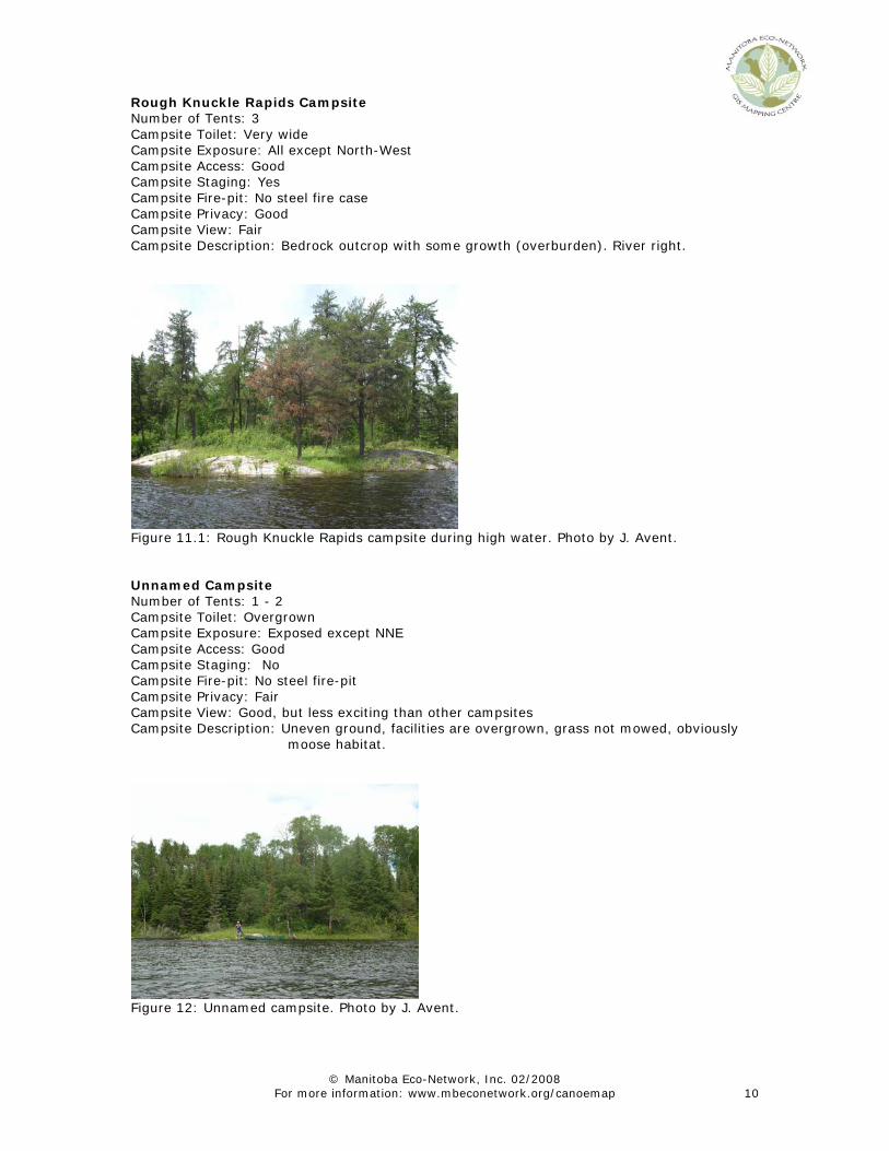
Rough Knuckle Rapids Campsite Number of Tents: 3 Campsite Toilet: Very wide Campsite Exposure: All except North-West Campsite Access: Good Campsite Staging: Yes Campsite Fire-pit: No steel fire case Campsite Privacy: Good Campsite View: Fair Campsite Description: Bedrock outcrop with some growth (overburden). River right.
Figure 11.1: Rough Knuckle Rapids campsite during high water. Photo by J. Avent. Unnamed Campsite Number of Tents: 1 - 2 Campsite Toilet: Overgrown Campsite Exposure: Exposed except NNE Campsite Access: Good Campsite Staging: No Campsite Fire-pit: No steel fire-pit Campsite Privacy: Fair Campsite View: Good, but less exciting than other campsites Campsite Description: Uneven ground, facilities are overgrown, grass not mowed, obviously
moose habitat.
Figure 12: Unnamed campsite. Photo by J. Avent.

© Manitoba Eco-Network, Inc. 02/2008 For more information: www.mbeconetwork.org/canoemap 11
Turtle Falls – Overflow Campsite Number of Tents: ~ 2 Campsite Toilet: Not much privacy Campsite Exposure: East exposure Campsite Access: Good Campsite Staging: Yes Campsite Fire-pit: Steel fire-pit Campsite Privacy: Fair Campsite View: Good Campsite Description: This is a small overflow campsite on low grounds. The site was partially flooded in high water conditions.
Figure 13: Turtle Falls overflow campsite during high water. Photo by J. Avent. Turtle Falls Campsite: Number of Tents: ~ 3 Campsite Toilet: Green toilet facilities, not private Campsite Exposure: East exposure Campsite Access: Steep, slippery when wet Campsite Staging: Yes Campsite Fire-pit: Steel fire-pit Campsite Privacy: Good Campsite View: Excellent Campsite Description: Spacious campsite on high ground with excellent view.
Figure 14.1: Campsite layout. Photo by A. Kirch.

© Manitoba Eco-Network, Inc. 02/2008 For more information: www.mbeconetwork.org/canoemap 12
Figure 14.2: Path to green toilet. Photo by A. Kirch. Campsite at [13] Number of Tents: > 7 Campsite Toilet: Green Toilet facilities Campsite Exposure: South-West Exposure Campsite Access: Good Campsite Staging: Yes, various staging areas Campsite Fire-pit: Steel fire-pit Campsite Privacy: No, portage trail goes through campsite Campsite View: Great view of Pillow Falls Campsite Description: Campsite is beside the falls - great view. Watch out for poison ivy
between the take-out and the campsite. There is a nature trail leading through the re-growth forest. Watch for blueberries, spruce, pine, pin cherries, junipers, blue bells, mosses, poplar, birch, strawberries, young oak trees and lichen on bedrock outcrops.
Figure 15.1: Take-out. Photo by A. Kirch.

© Manitoba Eco-Network, Inc. 02/2008 For more information: www.mbeconetwork.org/canoemap 13
Figure 15.2: Looking back to the falls and campsite during low water. Photo by L. Dykman.
Figure 15.3: Put-in during very low water. Photo by A. Kirch. Campsite at [14] Number of Tents: 1 Campsite Toilet: None Campsite Exposure: South-West exposure Campsite Access: Good Campsite Staging: No Campsite Fire-pit: Stone fire-pit Campsite Privacy: None, on portage trail Campsite View: Very good view Campsite Description: Nice campsite overlooking Steep Rock Falls, poor facilities.

© Manitoba Eco-Network, Inc. 02/2008 For more information: www.mbeconetwork.org/canoemap 14
Figure 16.1: Campsite along portage trail. Photo by A. Kirch.
Figure 16.2: Campsite view during very low water. Photo by A. Kirch. Sand River Falls Campsite Tents: 5 Toilet: Green toilet Exposure: South-West exposure, open and protected areas Access: River right Staging: Multiple staging areas Fire-pit: Steel fire-pit Privacy: Fair (due to portage trail) View: Excellent Description: This is a spacious campsite with a lovely view onto the rapids. We saw lots of
birds, including kingfishers fishing in the rapids. Nighthawks were swooping and catching insects in the air at dusk and a bald eagle was sighted.

© Manitoba Eco-Network, Inc. 02/2008 For more information: www.mbeconetwork.org/canoemap 15
Figure 17.1: Campsite view during very low water. Photo by A. Kirch.
Figure 17.2: Morning mist. Photo by T. Lutz.
Figure 17.3: Campsite. Photo by T. Lutz.

© Manitoba Eco-Network, Inc. 02/2008 For more information: www.mbeconetwork.org/canoemap 16
Sand River Falls Overflow Campsite Tents: No data available – new campsite Toilet: No data available – new campsite Exposure: North-East exposure Access: River left Staging: No data available – new campsite Fire-pit: Steel fire-pit Privacy: Fair View: Good Description: No data available – new campsite Unnamed Campsite Number of Tents: 2 - 3 Campsite Toilet: Dense woods Campsite Exposure: Campsite Access: Good Campsite Staging: Yes Campsite Fire-pit: Steel fire-pit Campsite Privacy: Excellent, no cover from river Campsite View: Nice, view of Alligator Campsite Description: Close to Alligator Polly’s Point Campsite Number of Tents: 2 – 3 on flat ground, more sites available on uneven surface Campsite Toilet: Fair privacy Campsite Exposure: East exposure Campsite Access: Good, better in high waters Campsite Staging: Yes Campsite Fire-pit: Steel fire-pit Campsite Privacy: Good Campsite View: Nice, but less exciting view than other campsites Campsite Description: No sign, just an orange diamond, which is hidden. The undergrowth is
mossy and we encountered a nice breeze due to the lack of underbrush
Name/History: “There used to be a logging camp here. There was a guy named Paul Swain, then they started calling him Polly. He was born here.” Charles Simard, River Steward.
Figure 18.1: Polly’s Point campsite. Photo by A. Kirch.

© Manitoba Eco-Network, Inc. 02/2008 For more information: www.mbeconetwork.org/canoemap 17
Figure 18.2: View of campsite from (low) water. Photo by A. Kirch.
Figure 18.3: View from the campsite. Photo by A. Kirch. Emma Janes Campsite Number of Tents: 0 Campsite Toilet: N/A Campsite Exposure: N/A Campsite Access: N/A Campsite Staging: N/A Campsite Fire-pit: Stone ring fire-pit Campsite Privacy: N/A Campsite View: N/A Campsite Description: Campsite does not exist as it has been overgrown with underbrush.
Firewood left behind from before it was overgrown.

© Manitoba Eco-Network, Inc. 02/2008 For more information: www.mbeconetwork.org/canoemap 18
Figure 19.1: Overgrown campsite. Photo by A. Kirch. Unnamed Campsite Number of Tents: 2 Campsite Toilet: No Campsite Exposure: South-West exposure Campsite Access: Fair Campsite Staging: No Campsite Fire-pit: No Campsite Privacy: Good Campsite View: Good Campsite Description: Overgrown
Figure 19.1: Overgrown campsite. Photo by L. Dykman.

© Manitoba Eco-Network, Inc. 02/2008 For more information: www.mbeconetwork.org/canoemap 19
Figure 19.2: Young oak tree. – Possibly a result of seeds left as a gift from aboriginal visitors. Photo by L. Dykman. Unnamed Campsite Number of Tents: ~ 5 Campsite Toilet: Good Campsite Exposure: North-West exposure Campsite Access: Good Campsite Staging: Yes, starting to become overgrown, though. Campsite Fire-pit: Stone fire-pit Campsite Privacy: Good Campsite View: Good Campsite Description: Very dense poplar re-growth with some small pines, vegetation is very
dense and low. The area was burned by the forest fire in 1999.
Figure 20.1: Campsite layout. Photo by L. Dykman.

© Manitoba Eco-Network, Inc. 02/2008 For more information: www.mbeconetwork.org/canoemap 20
Figure 20.2: View from campsite. Photo by L. Dykman.
Figure 20.3: Approach during very low water. Photo by A. Kirch. Rifle Rapids Campsite Number of Tents: 2 (maybe more) Campsite Toilet: Good Campsite Exposure: North-East exposure, but pretty well protected by shrubs Campsite Access: Necessary Campsite Staging: Steel fire-pit Campsite Fire-pit: Good Campsite Privacy: Good Campsite View: Nice view of rapids Campsite Description: Campsite right next to rapids on bedrock with some grassy spots.
Typical forest re-growth in background with strawberries, some oak. The campsite is located on a spit, but protected by shrubs.
© Manitoba Eco-Network, Inc. 02/2008 For more information: www.mbeconetwork.org/canoemap 21
Figure 21.1: Campsite layout. Photo by A. Kirch.
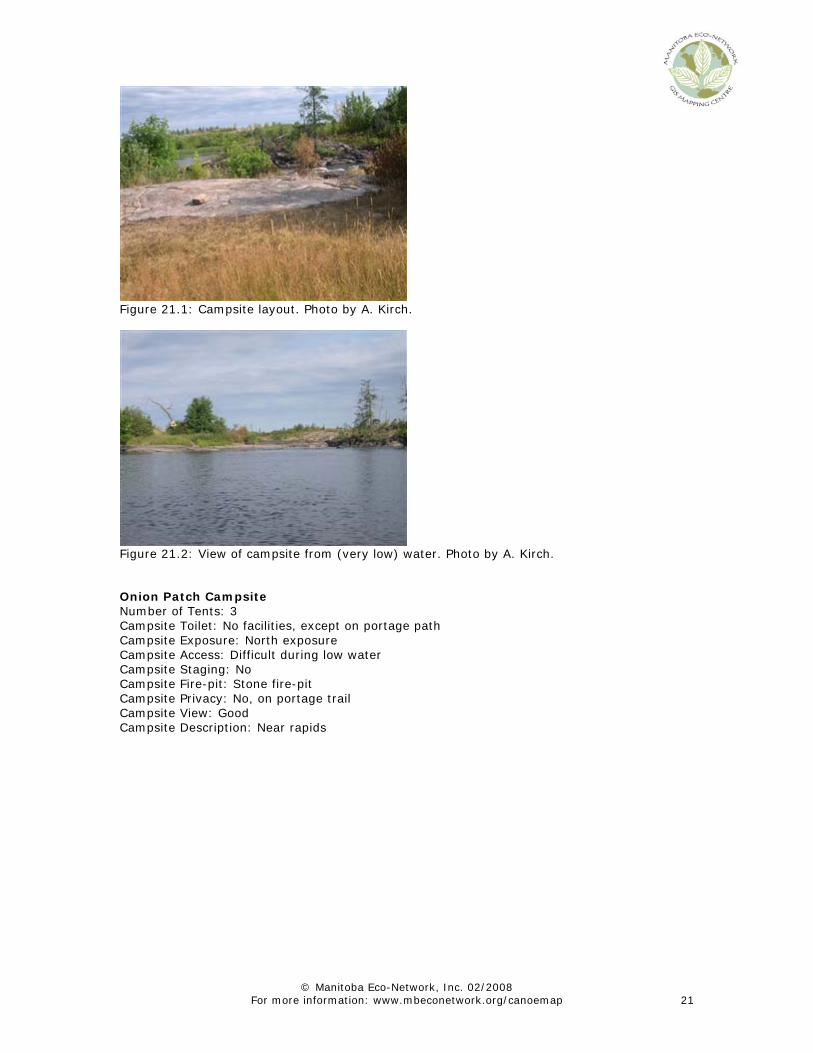
Figure 21.2: View of campsite from (very low) water. Photo by A. Kirch. Onion Patch Campsite Number of Tents: 3 Campsite Toilet: No facilities, except on portage path Campsite Exposure: North exposure Campsite Access: Difficult during low water Campsite Staging: No Campsite Fire-pit: Stone fire-pit Campsite Privacy: No, on portage trail Campsite View: Good Campsite Description: Near rapids

© Manitoba Eco-Network, Inc. 02/2008 For more information: www.mbeconetwork.org/canoemap 22
Figure 22.1: Campsite layout. Photo by A. Kirch. Note: Picture taken in low water. Big Eddy Rapids Campsite Number of Tents: 1 - 2 Campsite Toilet: Little privacy Campsite Exposure: All sides Campsite Access: Steep Campsite Staging: Yes, very good Campsite Fire-pit: Stone fire-pit Campsite Privacy: No, very open Campsite View: Great view Campsite Description: Campsite on top of rock outcrop that towers over the area and provides
a great view of the valley.
Figure 23.1: Campsite layout. Photo by A. Kirch.

© Manitoba Eco-Network, Inc. 02/2008 For more information: www.mbeconetwork.org/canoemap 23
Figure 23.2: Campsite layout. Photo by A. Kirch.
Figure 23.3: View of the valley during low water. Photo by A. Kirch
Figure 23.4: The approach on river left during very low water. Photo by T. Lutz
© Manitoba Eco-Network, Inc. 02/2008 For more information: www.mbeconetwork.org/canoemap 24
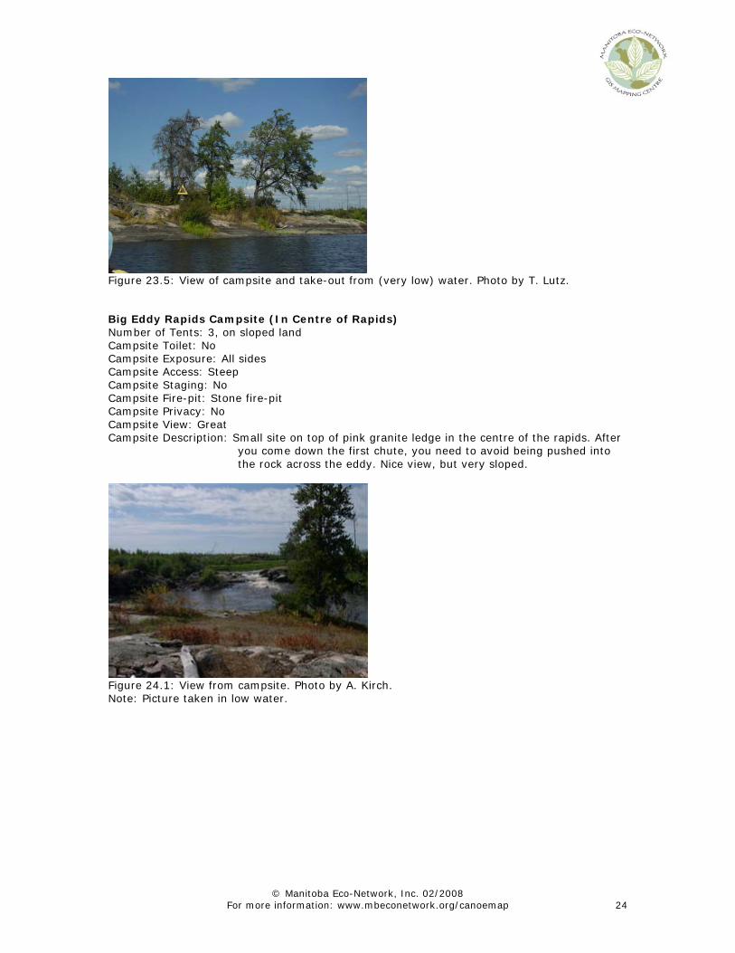
Figure 23.5: View of campsite and take-out from (very low) water. Photo by T. Lutz. Big Eddy Rapids Campsite (In Centre of Rapids) Number of Tents: 3, on sloped land Campsite Toilet: No Campsite Exposure: All sides Campsite Access: Steep Campsite Staging: No Campsite Fire-pit: Stone fire-pit Campsite Privacy: No Campsite View: Great Campsite Description: Small site on top of pink granite ledge in the centre of the rapids. After
you come down the first chute, you need to avoid being pushed into the rock across the eddy. Nice view, but very sloped.
Figure 24.1: View from campsite. Photo by A. Kirch. Note: Picture taken in low water.

© Manitoba Eco-Network, Inc. 02/2008 For more information: www.mbeconetwork.org/canoemap 25
Figure 24.2: Garbage left behind by campers. Photo by A. Kirch. Unnamed Campsite Number of Tents: 2 Campsite Toilet: Good at this level of forest growth Campsite Exposure: South, once forest grows Campsite Access: Difficult Campsite Staging: Fair Campsite Fire-pit: No Campsite Privacy: Fair Campsite View: Good view Campsite Description: Campsite not used often, no fire-pit. Orange marker river right in the
middle of nowhere. The exposure will be to the south, once the forest grows up again.
Figure 25.1: View of campsite. Photo by L. Dykman.

© Manitoba Eco-Network, Inc. 02/2008 For more information: www.mbeconetwork.org/canoemap 26
Figure 25.2: View of campsite from (very low) water. Photo by A. Kirch.
Figure 25.3: Campsite layout. Photo by A. Kirch. Engineer Rapids Campsite Number of Tents: 5 tents, on very sloped land Campsite Toilet: Good Campsite Exposure: All sides, will be west once forest grows Campsite Access: Difficult, very steep. Fun rock climbing Campsite Staging: Yes Campsite Fire-pit: Stone fire-pit Campsite Privacy: Yes Campsite View: Good Campsite Description: This campsite is located 200m upstream from the rapids on an island. It
is starting to overgrow with pine (the entire area is fire regrowth).

© Manitoba Eco-Network, Inc. 02/2008 For more information: www.mbeconetwork.org/canoemap 27
Figure 26.1: Campsite layout. Photo by L. Dykman.
Figure 26.2: Stone Men. Photo by L. Dykman. Unnamed Campsite – we dubbed it “Camp Disappointment” (Overflow from Old Woman Falls) Number of Tents: 3, but no good spots Campsite Toilet: No Campsite Exposure: West Campsite Access: Poor Campsite Staging: Yes Campsite Fire-pit: Steel fire-pit Campsite Privacy: No Campsite View: View of Old Woman Falls Campsite Campsite Description: Not a very nice campsite. Uneven ground with lots of saplings – hard to
find a good place for a tent

© Manitoba Eco-Network, Inc. 02/2008 For more information: www.mbeconetwork.org/canoemap 28
Figure 27.1: View of campsite during very low water. Photo by L. Dykman.
Figure 27.2: View of campsite during very low water. Photo by A. Kirch.
Figure 27.3: Stone Man. Photo by L. Dykman.

© Manitoba Eco-Network, Inc. 02/2008 For more information: www.mbeconetwork.org/canoemap 29
Figure 27.4: Sunset. Photo by T. Lutz. Unnamed Campsite (Overflow from the overflow campsite of Old Woman Falls) Number of Tents: 0, no good spots Campsite Toilet: No Campsite Exposure: East Campsite Access: Bad Campsite Staging: No Campsite Fire-pit: Stone ring fire-pit Campsite Privacy: No Campsite View: Old Woman Falls Campsite Campsite Description: Uneven ground where saplings were too high for tents Old Woman Falls Campsite Number of Tents: 6 Campsite Toilet: Well used, on mainland, river right Campsite Exposure: All sides Campsite Access: Easy Campsite Staging: Yes, good Campsite Fire-pit: Steel fire-pit Campsite Privacy: No, campsite on portage path Campsite View: Good Campsite Description: This is one of the most popular campsites on the Manigotagan. It is a
nice, spacious campsite on the island in the centre of Old Woman's Falls. Chipmunks live on island. However, one of our volunteers commented: “These are the worst toilet facilities of the canoe trip.” - The facilities are actually on the mainland, river right because of extremely high use for portage and a fishing site. If you do camp here, don’t use the island as a toilet.
History/Name: The rapids were named after an old woman drowned here. In fact, some people say that this is a haunted campsite - campers have reported noises and screaming at night. One group actually left the camp in the middle of the night. (Information from Charles Simard, River Steward)

© Manitoba Eco-Network, Inc. 02/2008 For more information: www.mbeconetwork.org/canoemap 30
Figure 28.1: View of campsite from river left. Photo by A. Kirch. Note: The picture was taken during very low water.
Figure 28.2: Campsite layout. Photo by A. Kirch. Jack Pine Rapids Campsite Number of Tents: 4 Campsite Toilet: Good privacy Campsite Exposure: East Campsite Access: Good Campsite Staging: Yes Campsite Fire-pit: Steel fire-pit Campsite Privacy: Yes Campsite View: Nice view from higher elevation Campsite Description: Three camping spots at main area. An additional spot for one tent near
put-in Note: Building structures is prohibited in the park. Please do not build any structures while
canoeing along the Manigotagan. Thanks!

© Manitoba Eco-Network, Inc. 02/2008 For more information: www.mbeconetwork.org/canoemap 31
Figure 29: Jack Pine Rapids campsite. Photo by J. Avent. Poplar Falls Campsite Number of Tents: 3 - 4 Campsite Toilet: Yes, well used but not well managed – there is no holding tank under the
existing wooden box Campsite Exposure: West Campsite Access: Good Campsite Staging: Yes, very good Campsite Fire-pit: Steel fire-pit Campsite Privacy: No, campsite on portage trail Campsite View: Fair, blocked by trees Campsite Description: Take-out was muddy and rocky in low waters
Figure 30.1: Campsite layout. Photo by L. Dykman.

© Manitoba Eco-Network, Inc. 02/2008 For more information: www.mbeconetwork.org/canoemap 32
Figure 30.2: Path to campsite. Photo by A. Kirch.
Figure 30.3: View from campsite. Photo by A. Kirch. Manigotagan Community Campground Number of Sites: 15 Campsite Toilet: Outhouses Campsite Access: Downstream the waterfall and across the bridge at Highway #304 (on river left Campsite Fire-pit: Steel fire-pits Campsite View: View of the river, but obscured by trees Campsite Description: This campground is managed by the Community of Manigotagan. In 2006 the fee per tent was $13. Other: You can use this campsite to park your car while canoeing ($5/day), contact the community’s Administration Office to let them know that you are parked there. They will keep an eye on your vehicle (PH: (204) 363-7375). This service might be worth the cost as vehicles left unsupervised beside the highway have been vandalized in the past.
Figure 31: Entrance to the community campground. Photo by A. Kirch.