list of tables - alaskaforestry.alaska.gov/assets/pdfs/management/tvsf_final_appendix.pdfincrease in...
TRANSCRIPT
APPENDIX A Glossary of Terms Adverse grade: The uphill gradient in the direction of travel of a loaded log truck. Age class: 1. One of the intervals into which the age range of trees is divided for classification or use. 2. A distinct aggregation of trees originating from a single natural event or regeneration activity, or a grouping of trees, e.g., 10-year age class, as used in inventory or management (Society of American Foresters, 1998). Allowable cut: The volume of timber that may be cut from a forest under optimum sustained-yield management (Stoddard and Stoddard, 1987). Area control (area regulation): An indirect method of controlling (and roughly determining) the amount of forest produce to be harvested, annually or periodically, on the basis of stocked area (Society of American Foresters, 1998). Basal area (BA): 1. The cross-sectional area of a single stem, including the bark, measured at breast height (4.5 feet or 1.37 meters above the ground). 2. The cross-sectional area of all stems of a species or all stems in a stand measured at breast height and expressed per unit of land area (Society of American Foresters, 1998). Biological diversity: The variety and abundance of species, their genetic composition, and communities, ecosystems and landscapes in which they occur. It also refers to ecological structures, functions, and processes at all these levels. Biological diversity occurs at spatial scales that range from local through regional to global. (Society of American Foresters Task Force, 1991.) Breast height: A standard height from ground level, generally 4.5 feet, for recording diameter, circumference (girth), or basal area of a tree. The measurement is usually taken on the uphill side of the tree (Society of American Foresters, 1998). See also diameter at breast height. Broadcast burn: A prescribed fire allowed to burn over a designated area within well-defined boundaries to achieve some land management objective (Society of American Foresters, 1998). Cable yarding: Taking logs from the stump area to a landing using an overhead system of winch-driven cables to which logs are attached with chokers. (Society of American Foresters, 1998) Clearcutting: The cutting of essentially all trees, producing a fully exposed microclimate for the development of a new age class (Society of American Foresters, 1998). Commercial forest land (CFL): Land declared suitable for producing timber crops and not withdrawn from timber production by statute or administrative regulation (Society of American Foresters, 1998).
TVSF Management Plan, 2001 Update 172 Appendix A: Glossary

Consultation: Under existing statutes, regulations and procedures, the Department of Natural Resources informs other groups of its intention to take a specific action(s) and seeks their advice or assistance. Consultation is not intended to be binding on a decision; it is a means of informing affected organizations and individuals about forthcoming decisions and getting the benefit of their expertise. Culmination of mean annual increment (CMAI): The age in the growth cycle of a tree or stand at which the mean annual increment (MAI) for height, diameter, basal area, or volume is at a maximum (Society of American Foresters, 1998). Decking: The piling of logs. Diameter at breast height (DBH): The diameter of the stem of a tree measured at breast height (4.5 feet) from the ground. On sloping ground, the measurement is taken from the uphill side (Society of American Foresters, 1998). Ecosystem: All the interacting populations of plants, animals, and microorganisms occupying an area, plus their physical environment. (Hunter, 1990) Ecosystem management: An ecological approach to forest resources management. It attempts to maintain the complex processes, pathways and interdependencies of forest ecosystems and keep them functioning well over long periods of time, in order to provide resilience to short-term stress and adaptation to long-term change. Thus, the condition of the forest landscape is the dominant focus, and the sustained yield of products and services is provided within this context. Humans are also a part of the ecosystem. Thus, ecosystem management must maintain our social and political systems as well as meet our need for both consumptive and non-consumptive uses of the forest. Ecosystem management of forests includes products as an essential part of the mix, including intensive management. Ecosystem management is the strategy by which, in aggregate, the full array of forest values and functions is maintained at the landscape level. Coordinated management at the landscape level, including across ownerships, is an essential component (Society of American Foresters, 1993). Favorable grade: The downhill gradient in the direction of travel of a loaded log truck. Felling: The process of cutting down trees. Feasible: The term "feasible" is defined in the forest practices regulations as “capable of being accomplished in a successful manner within a reasonable period of time, taking into account economic, environmental, technical, and safety factors” (11 AAC 95.900(29)). Feasible and prudent: The phrase "will, to the extent feasible and prudent," is taken from the Standards of Alaska Coastal Management Program (6 AAC 80.010-.900) and means “consistent with sound engineering practice and not causing environmental, social, or economic problems that outweigh the public benefit to be derived from compliance with the standard modified by the term ‘feasible and prudent’” (6 AAC 80.900(20)).
TVSF Management Plan, 2001 Update 173 Appendix A: Glossary
Finding of incompatibility: If the commissioner [of natural resources] finds that a permitted use [described in AS 38.05.112(c)] is incompatible with one or more other uses in a portion of a State Forest, the commissioner shall affirmatively state in the management plan that finding of incompatibility for the specific area where the incompatibility is anticipated to exist and the time period when the incompatibility is anticipated to exist together with the reasons and benefits for each finding. [AS 41.17.230(a)] Fire management: All activities required for the protection of burnable wildland values from fire and the use of fire to meet land management goals and objectives (Society of American Foresters, 1998). Fish and wildlife: Any species of aquatic fish, invertebrates and amphibians, in any stage of their life cycle, and all species of birds and mammals, including feral domestic animals, found or that may be introduced in Alaska, except domestic birds and mammals. NOTE: The term “area(s)” in association with the term "fish and wildlife" refers to both harvest and habitat area. The term "value(s)" in association with the term "fish and wildlife" refers to the relative importance of a harvest area or habitat and its vulnerability to development impacts. (An operational definition of the Alaska Department of Fish and Game derived from the definition of ‘fish’ in AS 16.05.940 (12) and ‘game’ in AS 16.05.940 (18)). Floodplain: Flat land bordering a stream or river onto which a flood will spread. The underlying materials are typically unconsolidated and derived from past stream transportation activity. The extent of the floodplain varies according to the volume of water, and is thus defined by a specified flood size (e.g., a fifty-year-old floodplain would be defined by the largest flood that would, on average, occur once within a fifty-year period, estimated from historic stream flow records) (Dunster and Dunster, 1996). Forest land: Land stocked or having been stocked with forest trees of any size and not currently developed for nonforest use, regardless of whether presently available or accessible for commercial purposes (AS 41.17.950 (5)). Regarding land classification, land classified “forest land” is land that is or has been forested and is suited for forest management because of its physical, climatic, and vegetative conditions (11 AAC 55.070). Forest regulation: The technical (in contrast to administrative and business) aspects of controlling stocking, harvests, growth, and yields to meet management objectives including sustained yield (Society of American Foresters, 1998). See also the definition for “area control.” Goal: A general statement of intent, usually not quantifiable nor having a specified date of completion. Goals identify desired long-range conditions. Guideline: A specific course of action that must be followed when a resource manager permits, leases, or otherwise authorizes use of state lands. Some guidelines state the intent that must be followed and allow flexibility in achieving it. Guidelines also range from giving general guidance for decision-making or identifying factors that need to be considered to setting detailed
TVSF Management Plan, 2001 Update 174 Appendix A: Glossary

standards for on-the-ground decisions. (Adapted from the Tanana Basin Area Plan for State Lands, Alaska Department of Natural Resources, 1991.) Grub (grubbing): To remove stumps or shrubs from the ground by hand or machine, typically prior to road building or regeneration (Society of American Foresters, 1998). Ice bridge: A bridge of ice across a lake, river, or stream, either natural or constructed to a specified thickness to safely accommodate specified vehicle loads. Increment: 1. Increase in circumference (girth), diameter, basal area, height, volume, quality, or value of individual trees or crops. 2. The rate of increment, i.e., increase during a given period (Society of American Foresters, 1998). Ingrowth: Number of trees, or volume of trees that have grown past a predetermined threshold in a set period. Typically used to refer to the dividing line between seedling to sapling or, sapling to pole stage, or a specific diameter class or merchantability class. Once past the sapling stage, the tree is counted into volume calculations, hence ingrowth can make a very significant difference in the assessment of stand condition. It is also called recruitment (Dunster and Dunster, 1996). Landing: A cleared area in the forest to which logs are yarded or skidded for loading onto trucks for transport (Society of American Foresters, 1998). Land classification: The designation of land according to its primary use, and in a manner that will provide maximum benefit to the people of Alaska (11 AAC 55.280 (1)). 11 AAC 55.010 clarifies that although a classification identifies a primary use, all classifications are intended for multiple use. Management guideline: Specific management standards or procedures to be followed in carrying out goals. Guidelines are intended to be sufficiently detailed to guide on-the-ground decisions, such as road construction. Guidelines are applied frequently in day-to-day management decisions. Mature: Pertaining to a tree or stand that is capable of sexual reproduction (other than precocious reproduction), has attained most of its potential height growth, or has reached merchantability standards. Within uneven-aged stands, individual trees may become mature but the stand itself consists of trees of diverse ages and stages of development. (Society of American Foresters, 1998) Mean annual increment (MAI): The total increment of a tree or stand (standing crops plus thinnings) up to a given age divided by that age (Society of American Foresters, 1998). Merchantable: 1. Of trees, crops, or stands, having the size, quality, and condition suitable for marketing under a given economic condition, even if not immediately accessible for logging. 2. Of a bole or stem, the part(s) suitable for sale (Society of American Foresters, 1998).
TVSF Management Plan, 2001 Update 175 Appendix A: Glossary

Minimize: To limit to the extent feasible, and does not include the requirement of improving naturally existing conditions (11 AAC 95.900 (49)). Multiple use: The term “multiple use” as defined in the Alaska Forest Resources and Practices Act means:
1. The management of all the various resources of forest land so that they are used in the combination that will best meet the needs of the citizens of the state, making the most judicious use of the land for some or all of these resources or related values, benefits, and services over areas large enough to provide sufficient latitude for periodic adjustment in use to conform to changing needs and conditions;
2. That some land will be used for less than all of the resources; and 3. Harmonious and coordinated management of the various resources, each with the
other, without significant impairment of the productivity of the land and water, with consideration being given to the relative values of the various resources, and not necessarily the combination of uses that will give the greatest dollar return or the greatest unit output (AS 41.17.950 (8)).
Non-commercial forest land (NCFL): Land incapable of yielding a specified volume of wood per unit area of commercial species, or land only capable of producing noncommercial tree species (Dunster and Dunster, 1996). Ordinary high water mark: The mark along the bank or shore up to which the presence and action of the tidal or nontidal water are so common and usual, and so long continued in all ordinary years, as to leave a natural line impressed on the bank or shore and indicated by erosion, shelving, changes in soil characteristics, destruction of terrestrial vegetation, or other distinctive physical characteristics (11 AAC 95.900(53)). Overmature: 1. A tree or even-aged stand that has reached that stage of development when it is declining in vigor and health and reaching the end of its natural life span. 2. A tree or even-aged stand that has begun to lessen in commercial value because of size, age, decay, or other factors. The term has little applicability to uneven-aged stands, which consist of trees of diverse ages and stages of development (Society of American Foresters, 1998). Policy: An intended course of action or a principle for guiding actions. In this plan, DNR policies for land and resource management include goals, management intent statements, management guidelines, planned activities, implementation plans and procedures, and various other statements of DNR's intentions. (Adapted from the Tanana Basin Area Plan for State Lands, Alaska Department of Natural Resources, 1991.) Prescribed fire: To deliberately burn wildland fuels in either their natural or their modified state and under specified environmental conditions, which allows the fire to be confined to a predetermined area and produces the fireline intensity and rate of spread required to attain planned resource management objectives (Society of American Foresters, 1998).
TVSF Management Plan, 2001 Update 176 Appendix A: Glossary
Primary all-season road: Regarding timber access, an all-season road which generally provides access to within five miles of timber resources. Built to a higher standard than secondary all-season roads Primary winter road: Regarding timber access, a road built and used during the winter. Built to a higher standard than secondary winter roads. See also ‘winter road’. Prohibited use: A use which is not allowed without an amendment to the plan. Put-to-bed: A process to stabilize and terminate the use of a logging road, trail, or other means of ingress and egress. See 11 AAC 95.320 for specific guidelines for closure. Recruitment: The additional trees moving from one size class to another (Society of American Foresters, 1998). Generally, the addition to a population from all causes (Dunster and Dunster, 1996). In silviculture, often referred to as ingrowth. Reduction factor: A numerical reduction from the allowable cut to compensate for unknown, on-the-ground situations where timber harvest may not be feasible or appropriate, and to ensure that the allowable cut is not exceeded due to multiple use considerations. Reduction factors are not allocated to any particular area through the planning process and do not designate specific sites for management for primarily non-timber purposes (TVSF Planning Team, 2000). Rotation: In even-aged systems, the period between regeneration establishment and final cutting. Rotation may be based on many criteria including mean size, age, culmination of mean annual increment, attainment of particular minimum physical or value growth rate, and biological condition (Society of American Foresters, 1998). Salvage cutting: The removal of dead trees or trees damaged or dying because of injurious agents other than competition, to recover economic value that would otherwise be lost (Society of American Foresters, 1998). Sawtimber: Trees that will yield logs suitable in size and quality for the production of lumber. Spruce must be at least 9 inches and hardwoods 11 inches diameter at breast height. Scarification: 1. Mechanical removal of competing vegetation or interfering debris, or disturbance of the soil surface, to enhance reforestation. 2. Chemical, mechanical, heat, or moisture treatment of seeds to make the seed coat permeable and improve germination (Society of American Foresters, 1998). Secondary all-season road: Regarding timber access, an all-season road which generally provides access to within ¼ mile of timber resources. Built to a lesser standard than primary all-season roads, but to a higher standard than spur roads. Secondary winter road: Regarding timber access, a road built and used during the winter. Built to a lesser standard than primary winter roads. See also ‘winter road’.
TVSF Management Plan, 2001 Update 177 Appendix A: Glossary

Selection method: An uneven-aged regeneration method used to regenerate and maintain a multiaged structure by removing some trees in all size classes either singly, in small groups, or in strips (Society of American Foresters, 1998). Selective cutting: A cutting that removes only a portion of the trees in a stand (Society of American Foresters, 1998). Shall: Requires a course of action or set of conditions to be achieved. A guideline modified by the word ‘shall’ must be followed by resource managers or users. If such a guideline is not complied with, a written decision justifying the noncompliance is required (see Finding of Incompatibility, Appendix B.). Should: States intent for a course of action or set of conditions to be achieved. A guideline modified by the word 'should' states the plan's intent and allows a resource manager to use discretion in deciding the specific means for best achieving the intent or whether particular circumstances justify deviation from the intended action or set of conditions. A guideline may include criteria for deciding if such a deviation is justified. Shrub: A woody, perennial plant differing from a perennial herb in its persistent and woody stem, and less definitely from a tree in its lower stature and the general absence of a well-defined main stem (Society of American Foresters, 1998). Shrub-land: A non-forest vegetation type containing brush and shrub vegetation that does not produce commercial timber (Crimp, et al., 1997). Silvics: The study of the life history and general characteristics of forest trees and stands, with particular reference to environmental factors, as a basis for the practice of silviculture (Society of American Foresters, 1998). Silviculture: The art of producing and tending a forest, the application of the knowledge of silvics in the treatment of a forest, and the theory and practice of controlling and managing forest establishment, composition, and growth (AS 41.17.950 (15)). Skid: To haul a log from the stump to a collection point (landing) by a skidder (Society of American Foresters, 1998). Skid trail: A route used by tracked or wheeled skidders to move logs to a landing or road (11 AAC 95.900 (74)). Slash: The residue, e.g., treetops and branches, left on the ground after logging or accumulating as a result of storm, fire, girdling, or delimbing (Society of American Foresters, 1998). Snags: 1. A standing, generally unmerchantable dead tree from which the leaves and most of the branches have fallen. 2. A standing section of the stem of a tree, broken off usually below the crown (Society of American Foresters, 1998).
TVSF Management Plan, 2001 Update 178 Appendix A: Glossary

Special Management Zone (SMZ): An area near a stream or lake that will be managed primarily to protect or enhance recreational values, significant fish and wildlife habitat and human uses, and water quality. Special management zones include side channels, sloughs, and backwaters. Spur road: A short, low-standard road that supports a low level of traffic such as serving one or two landings (Society of American Foresters, 1998). Spur roads are generally built within harvest units. Stand: A contiguous group of trees sufficiently uniform in age-class distribution, composition, and structure, and growing on a site of sufficiently uniform quality, to be a distinguishable unit (Society of American Foresters, 1998). State forest: An area designated by the legislature and retained in state ownership in order to a) provide a base for sustained yield management of renewable resources; and b) permit a variety of beneficial uses (AS 41.17.950 (16)). State lands: All lands, including shore, tide and submerged lands, or resources belonging to or acquired by the state (AS 38.05.965 (20)). Sustained yield: The achievement and maintenance in perpetuity of a high level annual or regular periodic output of the various renewable resources of forest land and water without significant impairment of the productivity of the land and water, but does not require that timber be harvested in a non-declining yield basis over a rotation period (AS 41.17.950 (17)). Another definition of sustained yield is in AS 38.04.910 (12) and should be applied in the context of AS 38.04 authorities and requirements. Thermokarst: A topographic feature, similar in form to karst, produced in a permafrost region by the local melting of ground ice, followed by settling of the ground (Dunster and Dunster, 1996). Timber: A tree, log, pole, bolt, or other wood product (11 AAC 71.910 (17)). Also, merchantable trees, standing or down, or a commercial tree species (11 AAC 95.900 (84)). Timber land: State land chiefly valuable for timber and other forest products (AS 38.05.965 (23)). Tree: A woody perennial plant, typically large and with a well-defined stem or stems carrying a more or less definite crown (Society of American Foresters, 1998). Upland: Land that generally has a higher elevation than the adjacent alluvial plain or low stream terrace, or land above the footslope zone on a hillslope continuum (Dunster and Dunster, 1996).
TVSF Management Plan, 2001 Update 179 Appendix A: Glossary
Water bar: A shallow channel or raised barrier of soil or other material laid diagonally across the surface of a road or skid trail to lead water off the road and prevent soil erosion (Society of American Foresters, 1998). Often used to put a road to bed. Winter road: A road that can normally support regular logging vehicle traffic only during winter months that has a load-bearing capacity derived from a combination of frost, snow, or ice (11AAC 95.900(90)). Will: Same as 'shall' (above), except that when the word 'will' refers to a planned management activity by the DNR or other agency, the carrying out of this activity is contingent on available funding. Yarding: To convey logs or trees to a landing, particularly by cable, balloon, or helicopter logging systems (Society of American Foresters, 1998).
TVSF Management Plan, 2001 Update 180 Appendix A: Glossary

TVSF Management Plan, 2001 Update 181 Appendix A: Glossary
Works Cited for Glossary: Alaska Interagency Wildland Fire Management Plan. October 1998. Alaska Wildland Fire Coordinating Group. Anchorage, AK. (contact the Alaska Division of Forestry or BLM Alaska Fire Service for copies.) Crimp, P.M., S.J. Phillips, and G.T. Worum. 1997. Timber resources on state forestry lands in the Tanana valley. Alaska Department of Natural Resources, Division of Forestry. Dunster, J.A, and K.J. Dunster. 1996. Dictionary of natural resource management. Vancouver, B.C.: UBC Press. Hunter, M.L. Jr. 1990. Wildlife, forests, and forestry: Principles of managing forests for biodiversity. Englewood Cliffs, N.J.: Prentice-Hall, Inc. Society of American Foresters, Helms, J.A., editor. 1998. The dictionary of forestry. Bethesda, MD: Society of American Foresters. Society of American Foresters Task Force. 1991. Task force report of biological diversity in forest ecosystems. Bethesda, MD. Society of American Foresters Task Force. 1993. Task force report on sustaining long-term forest health and productivity. Bethesda, MD. Stoddard, C.H. and G.M. Stoddard. 1987. Essentials of forestry practice. New York, NY: John Wiley and Sons. Abbreviations: ADF&G: Alaska Department of Fish and Game ADNR: Alaska Department of Natural Resources DEC: Department of Environmental Conservation DMLW: DNR, Division of Mining, Land and Water DNR: Alaska Department of Natural Resources DOF: DNR, Division of Forestry DOT/PF: Department of Transportation and Public Facilities DPOR: DNR, Division of Parks and Outdoor Recreation NRCS: Natural Resources Conservation Service USDA: United States Department of Agriculture

APPENDIX B Finding of Incompatibility There are a number of uses within the Tanana Valley State Forest that are not compatible on the same piece of ground at the same time. In accordance with AS 41.17.230(a), following is a list of those activities that are planned for the Tanana Valley State Forest and those uses that will not be permitted for the same location and time. 1. Research Natural Areas (RNAs), 11,141 acres - RNAs are intended to provide sites within which baseline ecological research and education can be conducted. It is intended that these areas be maintained in their natural state as much as possible. Activities that result in significant disturbance that is unnatural will typically not be authorized unless they are found to be consistent with the management intent for the area. These activities include timber harvest, material extraction, and developed recreation. Please see the Scientific Resources section of Chapter 2 for a complete list. Leasehold location is an appropriate measure to allow mineral development with minimal impacts on these research areas. Within research natural areas, mineral exploration or development will be restricted if it conflicts with the overriding scientific values. Within the RNAs, rights to locatable minerals may be acquired only under the leasehold location system, AS 38.05.205, and may not be acquired by locating a mining claim under AS 38.05.195. The stipulations used in approving plans of operations per Leasehold Location Order #24 will also be included in any miscellaneous land use permits issued for exploration activities within the RNAs.
Currently, DOF does not expect incidental individual activities to impair research natural areas. However, if Generally Allowed Uses (11 AAC 96) threaten the integrity of a research natural area, DNR may establish a Special Use Land designation (under 11 AAC 96.010) in the future to regulate individuals’ activities within RNAs. The Special Use Land designation is consistent with the TVSF Management Plan, and may be established without an amendment to this plan. See the Scientific Resources section of Chapter 2 for examples of activities that may be regulated. A Research Natural Area shall not block access to or use of other resources outside the RNA. When access through a Research Natural Area is necessary (if there is no other feasible and prudent access route to resources beyond the RNA), roads will be designed and located to protect the features for which the RNA was designated, as much as possible. Activities such as mineral exploration and development will be permitted provided they can be made compatible with the intended use of RNAs, to the extent feasible and prudent. These restrictions will be in effect for the period this plan is in effect or until the RNAs are withdrawn. These restrictions apply to six RNAs totaling 11,141 acres. They are listed in Table 5.
TVSF Management Plan, 2001 Update 182 Appendix B: Incompatibility
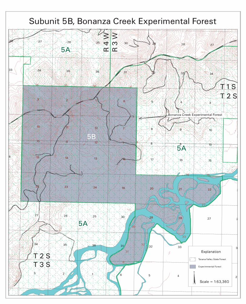
2. Chatanika River Corridor (CRC), 3,450 acres - The CRC (subunit 4B) will be managed consistent with the management of the Chatanika River corridor, subunit 1E-1, of the Tanana Basin Area Plan. The corridor is to be protected as an important recreation river and as important wildlife habitat. The area will be closed to all leases and grazing. The entire unit will be closed to locatable mineral entry and coal leasing but will remain open to oil and gas leasing. These closures will remain in effect for the duration that this plan is in effect. 3. Bonanza Creek Experimental Forest (BCEF), 13,852 acres from lease - The BCEF (subunit 5B) is leased to USDA Forest Service, Pacific Northwest Research Station, for fifty-five years for the expressed purpose of forest research. Management authority is shared between the Pacific Northwest Research Station and DNR. The BCEF is open to mineral entry and mineral leasing. The BCEF is only available for those public uses the U.S. Forest Service’s Boreal Ecology Cooperative Research Unit deems compatible with the intended research use. The lease of the BCEF will remain in effect until 2018. The lands are described in Appendix D. 4. Campgrounds, 280 acres - Improved campgrounds are intended for the enjoyment of the public. Loss of use of campgrounds due to other surface uses is not in the best interest of the general public, therefore, existing and planned campgrounds will be closed to mineral entry, grazing, timber harvest, and hunting for the duration of the period the State of Alaska operates and maintains the campgrounds. These restrictions apply to the Eagle Trail State Recreation Site campground, in Unit 14 (280 acres). 5. Trail and Stream Corridors, 96,200 acres - Trails listed as being of regional or statewide significance and streams protected by Special Management Zones (See Chapter 3 for lists of these streams in each unit) have particular value for recreation, transportation and/or wildlife habitat. Because of the significance of these corridors, commercial timber harvest and other permitted activities will be allowed only when it can be shown to be consistent with the intent of the trails and stream corridors. This restriction will remain in effect for the duration that this plan is in effect for those trails listed in Table 11 and those streams listed in Table 4. 6. Mining and Material Extraction - Mining and material extraction are subsurface and surface activities, respectively, that disrupt other surface uses for the period that the mining and material extraction is going on. For that period that these activities are permitted other surface uses requiring issuance of a DNR permit on the mining and material extraction permitted site will be permitted only when they can be shown to be compatible with the mining or material extraction. 7. Timber Harvest - Timber harvest activities that are a result of a contract between the DNR and a timber purchaser may be incompatible with other uses within the timber harvest area boundaries. Therefore, for that period starting when the DNR and the timber purchaser sign the contract, and until the termination of that contract, activities requiring issuance of a permit by the DNR will be restricted to those that can be shown to be compatible with the timber harvest. In addition, for this same period the area described in the contract for timber harvest will be closed to mineral entry and will be open for leasehold location only.
TVSF Management Plan, 2001 Update 183 Appendix B: Incompatibility

TVSF Management Plan, 2001 Update 184 Appendix B: Incompatibility
8. Remote Cabin Permits. Privately-owned residences and recreation cabins are not compatible with the intent of the Tanana Valley State Forest and will not be permitted within the State Forest for the duration this plan is in effect. The Remote Cabin Permit Program was authorized for state-retained lands by the Legislature in 1979 (AS 38.05.079). The private interests created by this program would have significantly conflicted with the public values and management intents of the Forest.
Appendix C MINERAL ORDERS NOTE: The mineral closing order for the Chatanika River Corridor (MCO #760) must be approved by the legislature, because it includes more than 640 acres. The original 1988 version of the Tanana Valley State Forest Management Plan stated that Subunit 4B, the Chatanika River Corridor, “will be closed to locatable mineral entry.” The 1988 plan also included a Finding of Incompatibility for mineral entry in Subunit 4B. The 1988 plan estimated the acreage of Subunit 4B as 2,500 acres, but more accurate mapping methods used in 2001 show Subunit 4B as containing 3,450 acres. Notice under AS 38.05.945 was not done as part of the 1988 plan, and a mineral closing order was not completed. In 1993, the legislature amended AS 38.05.300 to restrict mineral closing orders to areas less than 640 contiguous acres, except by an act of the state legislature. The 2001 Management Plan Revision includes a mineral closing order for the Chatanika River Corridor, and the public has been noticed of this change under AS 38.05.945. However, the final decision to approve the Chatanika River Corridor Mineral Closing Order rests with the legislature.
STATE OF ALASKA DEPARTMENT OF NATURAL RESOURCES DIVISION OF MINING, LAND AND WATER
MINERAL CLOSING ORDER #760 Closing lands to mineral entry
Chatanika River Corridor
I. Legal Description / Geographic Location
See section III below, attached map and the 2001 Tanana Valley State Forest Management Plan Revision.
II. Commissioner’s Finding and Written Documentation
This mineral order is based upon the attached Commissioner’s Finding and the written documentation contained in the 2001 Tanana Valley State Forest Management Plan Revision, dated: _____________________
III. Legal Description and Acreage
Chatanika River Corridor within the Tanana Valley State Forest, in Subunit 4B (see attached map).
TVSF Management Plan, 2001 Update 185 Appendix C: Mineral Orders
IV. This order will be subject to valid existing rights and issued under the authority granted by AS 38.05.185 - 38.05.275 to the Department of Natural Resources. The above-described lands are hereby closed to entry under the locatable mineral and mining laws of the State of Alaska.
Director, Division of Mining, Land and Water Date Commissioner, Department of Natural Resources Effective Date
TVSF Management Plan, 2001 Update 186 Appendix C: Mineral Orders

TANANA VALLEY STATE FOREST MANAGEMENT PLAN FINDING OF THE COMMISSIONER
FOR MINERAL CLOSING ORDER #760 Chatanika River Corridor
AS 38.05.185 (a) The Tanana Valley State Forest (TVSF) Management Plan, developed in accordance with AS 41.17.230 and AS 38.04.065, proposes closing a corridor along the Chatanika River within the State Forest to new locatable mineral entry because mining activity would not be compatible with significant surface uses (AS 38.05.185(a)). The area recommended to be closed is three discontinuous pieces of Chatanika River shoreline, called Subunit 4B in the TVSF Management Plan, and encompassing 3,450 acres. The Chatanika River is one of the most popular recreation, hunting, and fishing rivers for Fairbanks residents. This area receives significant surface use and the State is committed to taking all reasonable actions necessary to preclude significant surface conflicts. This proposed closure has been given public review through notice under AS 38.04.065 and 38.05.945 through the TVSF Management Plan process. The area is not highly mineralized, and as of October 3, 2001, no mining claims were present in the area proposed for closure. In addition to recreation, hunting, and fishing, other important uses of the Chatanika River include trapping, wildlife viewing and motorized and non-motorized boating. There are very few clearwater streams with developed access in the Tanana Basin, and of them, the Chatanika is the least-developed river close to Fairbanks. In the Tanana Basin Area Plan (TBAP), a stretch of the Chatanika River adjacent to the TVSF Subunit 4B (TBAP Subunit 1E1, TBAP Map 3-3) is critical-rated habitat for spawning and rearing salmon, and prime-rated habitat for resident fish. The Tanana Basin Area Plan assigned Subunit 1E1 as a “Special Value Area,” which includes very productive habitat and/or areas that receive heavy human use, and only compatible activities are recommended. TBAP recommended that stretch of the Chatanika for State Recreation River status, and also closed Subunit 1E1 to mineral entry because of the very high recreation and fish and wildlife habitat values. Because of the high habitat and recreation values of the adjacent units in the Tanana Valley State Forest, the 1988 version of the Tanana Valley State Forest Plan stated that TVSF Subunit 4B (3,450 acres) was closed to mineral entry. A Finding of Incompatibility for mineral entry was included in the 1988 plan (see below), but notice under AS 38.05.945 was never done, and a mineral closing order was never completed. Note that the 1988 plan estimated the acreage of Subunit 4B as 2,500 acres, but more accurate mapping methods used in 2001 show Subunit 4B as containing 3,450 acres.
Finding of Incompatibility, 1988 Tanana Valley State Forest Management Plan: Chatanika River Corridor (CRC), 2,500 acres - The CRC (Subunit 4B) will be managed consistent with the management of the Chatanika River corridor, Subunit 1E-1, of the Tanana Basin Area Plan. The corridor is to be protected as an important recreation river and as important wildlife habitat. The CRC will be closed to locatable mineral entry and coal leasing but will remain open to oil and gas leasing. In addition the area will be closed to all leases and grazing. These closures will remain in effect for the duration that this plan is in effect.
TVSF Management Plan, 2001 Update 187 Appendix C: Mineral Orders
In 1993, the legislature amended AS 38.05.300 to restrict mineral closing orders to areas less than 640 contiguous acres, except by an act of the State Legislature. In order to complete the process that was initiated in the 1988 version of the Tanana Valley State Forest Management Plan, the mineral closing order must now be approved by the Legislature. The 1988 version of the Tanana Valley State Forest Management Plan recommended deleting the eastern portion of Subunit 4B from the State Forest and adding it to TBAP Subunit 1E1. The 2001 Plan Revision also recommends deletion of the subunit from the State Forest. The entire unit would then be managed for public recreation and wildlife habitat, and would be recommended for State Recreation River status. Therefore it is my finding, in accordance with AS 38.05.185(a), that the best interests of the State and its residents are served by this closure to entry under the locatable mineral and mining laws of the State of Alaska of the above areas, more particularly described in Mineral Closing Order #760. This order is subject to valid existing rights. _____________________________________________ _____________ Commissioner, Department of Natural Resources Date
TVSF Management Plan, 2001 Update 188 Appendix C: Mineral Orders
STATE OF ALASKA DEPARTMENT OF NATURAL RESOURCES DIVISION OF MINING, LAND AND WATER
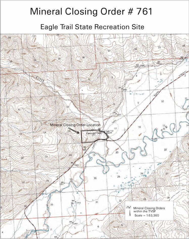
MINERAL CLOSING ORDER #761 Closing lands to mineral entry
Eagle Trail State Recreation Site
I. Legal Description / Geographic Location
See section III below, attached map and the Tanana Valley State Forest Management Plan.
II. Commissioner’s Finding and Written Documentation
This mineral order is based upon the attached Commissioner’s Finding and the written documentation contained in the 2001 Tanana Valley State Forest Management Plan Revision, dated: _____________________
III. Legal Description and Acreage
Eagle Trail State Recreation Site. The Division of Parks and Outdoor Recreation has an ILMA from the Division of Mining, Land and Water for the 280-acre site (ADL 50500). See attached map.
IV. This order is subject to valid existing rights and issued under the authority granted by AS 38.05.185 - 38.05.275 to the Department of Natural Resources. The above-described lands are hereby closed to entry under the locatable mineral and mining laws of the State of Alaska.
Director, Division of Mining, Land and Water Date Commissioner, Department of Natural Resources Effective Date
TVSF Management Plan, 2001 Update 189 Appendix C: Mineral Orders
Tanana Valley State Forest Management Plan Revision, 2001 Appendix I: Index 6
TANANA VALLEY STATE FOREST MANAGEMENT PLAN FINDING OF THE COMMISSIONER
FOR MINERAL CLOSING ORDER #761 Eagle Trail State Recreation Site
AS 38.05.185 (a) The Tanana Valley State Forest (TVSF) Management Plan, developed in accordance with AS 41.17.230 and AS 38.04.065, proposes closing the Eagle Trail State Recreation Site to new locatable mineral entry because mining activity would not be compatible with significant surface uses (AS 38.05.185(a)). The area to be closed is the 280 acres under an ILMA from DMLW surrounding the campground, nature trails, and a picnic pavilion. This area receives significant surface use and the state is committed to take all reasonable actions necessary to preclude significant surface conflicts. This closure is being given public review through notice under AS 38.04.065 and 38.05.945 through the TVSF Management Plan process. The Eagle Trail SRS lies 17 miles to the south of Tok along the Tok Cut-Off and is primarily used as a transient campground. It contains 40 campsites for overnight use and a pavilion for day-use picnicking and group gatherings. A 1-mile walking trail runs along the original route of the historic Eagle Trail, which was the original transportation route between Valdez and Eagle. DPOR plans to expand the trail system at the Eagle Trail SPS. The proposed trail will be 2 miles long and will provide access to the alpine ridges to the west of the campground. The northwest side of the campground is bordered by Clearwater Creek, a clear mountain stream that sometimes dries up during the summer. The location at the mouth of a mountain valley gives the recreation site exceptional scenic value. The Eagle Trail SPS brings in consistently high visitor numbers and revenue for the Northern Area. The 1988 version of the Tanana Valley State Forest Plan recommended that the Eagle Trail State Recreation Site be closed to mineral entry. A finding of incompatibility for mineral entry was included in the 1988 plan (see below), but notice under AS 38.05.945 was not done and a mineral closing order was never completed.
Finding of Incompatibility, 1988 Tanana Valley State Forest Management Plan: Campgrounds, 140 acres - Improved campgrounds are intended for the enjoyment of the public. Loss of use of campgrounds due to other surface uses is not in the best interest of the general public, therefore, existing and planned campgrounds will be closed to mineral entry, grazing, timber harvest, and hunting for the duration of the period the State of Alaska operates and maintains the campgrounds. These restrictions apply to the four campgrounds described below.
Unit Location Estimated Size 4 Chatanika River 20 acres 5 Nenana Ridge 40 acres 12 Robertson River 40 acres 14 Eagle Trail 40 acres
The only campground that was developed since the 1988 version of the plan is the Eagle Trail campground. The area for the site has increased from 40 acres to 280 acres to encompass the adjacent trail system associated with the wayside and campground. Since none of the other

Tanana Valley State Forest Management Plan Revision, 2001 Appendix I: Index 7
campgrounds have been constructed, this mineral closing order addresses only the Eagle Trail site. ________________________________________________ _____________ Commissioner, Department of Natural Resources Date
STATE OF ALASKA DEPARTMENT OF NATURAL RESOURCES DIVISION OF MINING, LAND AND WATER
MINERAL LEASEHOLD LOCATION ORDER NO. #24 Research Natural Areas and Bonanza Creek Experimental Forest
1.0 Order Restricting to Leasehold Location
After the effective date of this order (see paragraph 5.0), and unless otherwise closed to mineral entry, rights to locatable minerals in the land covered by this order may be acquired only under the leasehold location system, AS 38.05.205, and may not be acquired by locating a mining claim under AS 38.05.195.
2.0 The land subject to the terms of this order is shown on the attached map
State lands within the Tanana Valley State Forest Research Natural Area boundaries and state lands within the Bonanza Creek Experimental Forest (ADL 21408) are included in this Leasehold Location Order. See Table C-1 below for a list of the sites. See attached map for location of lands subject to this mineral order.
3.0 Authority for this Order
This order is issued under the authority granted by AS 38.05.185 to the Department of Natural Resources for the State of Alaska.
4.0 Findings and Determinations
The following findings and determinations are made:
4.1 The land shown on the attached map is found and determined to be subject to potential use conflicts which require that mining be allowed only under written lease issued under AS 38.05.205. These potential use conflicts include, but are not necessarily limited to the following:
Research Natural Areas (RNAs), 11,141 acres - RNAs are intended to provide sites within which baseline ecological research and education can be conducted. It is intended that these areas be maintained in their natural state as much as possible. Activities that result in significant disturbance that is unnatural will typically not be authorized unless they are found to be consistent with the management intent for the area. These activities include timber harvest, material extraction, and developed recreation. Please see the Scientific Resources section of Chapter 2 for a complete list. Leasehold location is an appropriate measure to allow mineral development with minimal impacts on these research areas. Within research natural areas, mineral exploration or development will be restricted if it conflicts with the overriding scientific values. Within the RNAs, rights to locatable minerals may be acquired only under the leasehold location system, AS 38.05.205, and may not be acquired by locating a mining claim under AS
TVSF Management Plan, 2001 Update 192 Appendix C: Mineral Orders

38.05.195. The stipulations used in approving plans of operations per Leasehold Location Order #24 will also be included in any miscellaneous land use permits issued for exploration activities within the RNAs.
The Bonanza Creek Experimental Forest is leased to the USDA Forest Service’s Boreal Ecology Cooperative Research Unit, Pacific Northwest Research Station, for fifty years for the purpose of forest research (ADL 21408). Management authority is shared between the Pacific Northwest Research Station and DNR. Rights to locatable minerals within the BCEF may be acquired only under the leasehold location system. The BCEF is only available for those public uses the Pacific Northwest Research Station deems compatible with the intended research use. The lease of the BCEF will remain in effect until 2018. Activities such as mineral exploration and development will be permitted provided they can be made compatible with the intended use of the BCEF, to the extent feasible and prudent.
4.2 A Finding of Incompatibility was issued in Appendix E of the 1988 version of the Tanana Valley State Forest Plan, as required by AS 41.17.230(a). The Finding of Incompatibility is found in this draft of the TVSF Plan, in Appendix B. 4.3 Background
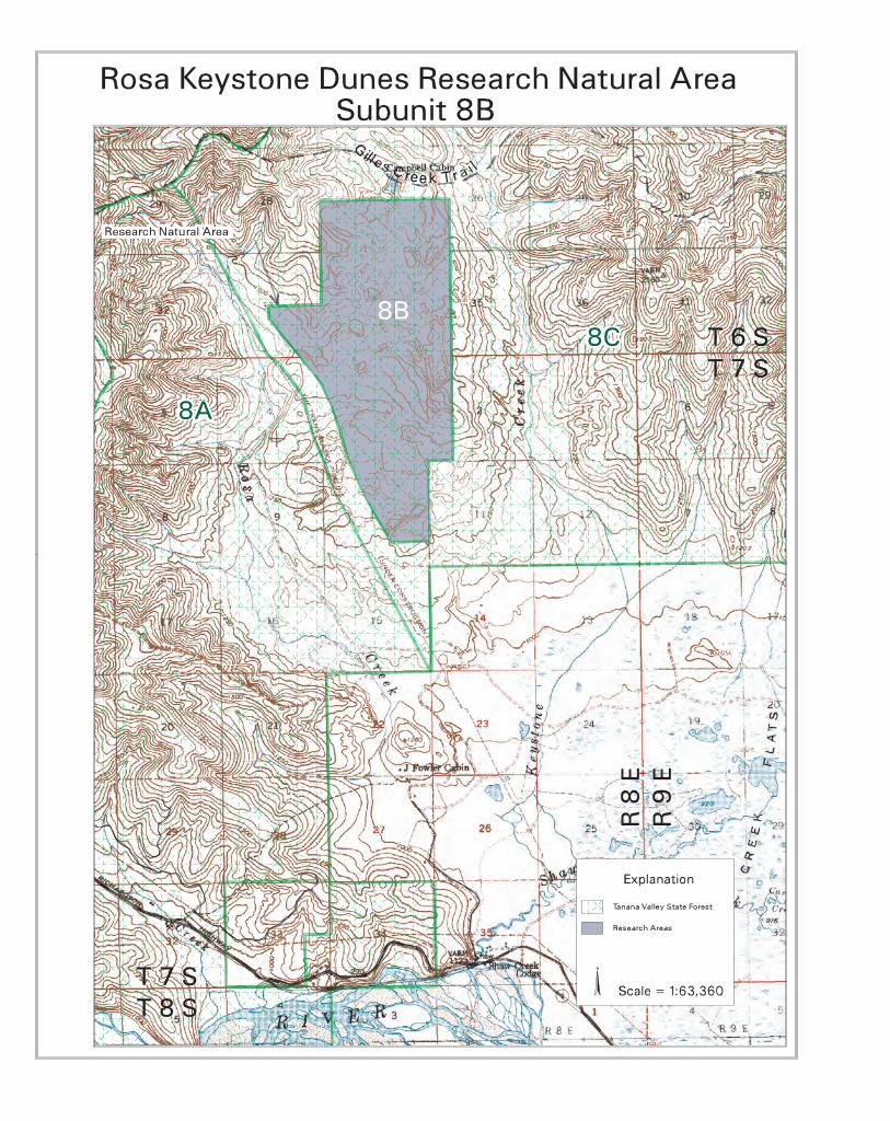
Research Natural Areas The purpose of designating a Research Natural Area is to maintain ecologically representative or unique sites in a natural state for observational research, education, and environmental monitoring. Six research natural areas that total 11,141 acres have been set aside in their natural state for scientific and educational purposes (See C-1 below). Table C-1. Values for which the Research Natural Areas were designated. Research Natural Area Description Oblique Lake (Unit 2B) A deep, undeveloped upland lake in a depression between low,
horseshoe-shaped dunes and a contrasting oxbow lake on the floodplain of the Kantishna River. South-facing sand bluffs support hill prairies greatly reworked by ant colonies.
Caribou Crossing (Unit 2C) An undisturbed, mature white spruce forest, a hill prairie, a bottomland of permafrost, and a wetland marsh. The area appears to be optimum habitat for old-growth, snag cavity-dependent birds and small mammals. The hill prairie is a scientifically interesting sagebrush grassland.
Rosa-Keystone (Unit 8B) A series of high "fossil" sand dunes and a dune-impounded lake. Temperature inversions have formed an inverted tree line in deep, undrained hollows between 200-foot-tall dune crests.
Shaw Creek Tamarack (Unit 9B)
Contains representative upland and lowland stands of tamarack suitable for research uses.
Volkmar Bluffs (Unit 10B) The largest contiguous set of hill prairies in central Interior Alaska. Hill prairie slopes are uniquely gentle and contain uncommon plants pollinated by a specialized species of bee.
Johnson Slough Bluffs (Unit 10D)
Hill prairie surrounded by open aspen forest. Rare species of plants adapted to warm sites and others adapted to high elevations occur together in prairie areas.
TVSF Management Plan, 2001 Update 193 Appendix C: Mineral Orders

Bonanza Creek Experimental Forest The purposes of establishing an Experimental Forest is to provide forest land for forest research that involves site manipulation or long-term observation. The USDA Forest Service Boreal Ecology Cooperative Research Unit (formerly the Institute of Northern Forestry) has leased 13,852 acres for use as an experimental forest for manipulative and observational forest research (ADL 21408). Although management authority for the Bonanza Creek Experimental Forest rests with the Forest Service, resources within the forest remain the property of the state.
Table C-2. Values for which the Experimental Forest was designated. Experimental Forest Description Bonanza Creek (Unit 5D) Used for forest research since the late 1950s. Use of the
Experimental Forest is guided by a 55-year lease granted by the state to the USDA Forest Service Northern Forest Experiment Station in 1963 “for the exclusive purpose of conducting research in forestry”. (See the lease document at Appendix E.)
5.0 Effective Date This order is effective as of the following date: ________________________ Director, Division of Mining, Land and Water Date Commissioner, Department of Natural Resources Effective Date
TVSF Management Plan, 2001 Update 194 Appendix C: Mineral Orders

FINDING OF THE COMMISSIONER LEASEHOLD LOCATION ORDER #24
Research Natural Areas and Bonanza Creek Experimental Forest AS 38.05.185(a)
The Tanana Valley State Forest Management Plan identifies the following lands where future location of mining claims will be allowed only under the leasehold location system (AS 38.05.205) because of potential use conflicts with ecological research and education activities. Claims will be managed as outlined in the stipulations attached so as to afford protection to the Research Natural Areas and the Bonanza Creek Experimental Forest. Total acreage affected by this order is approximately 24,993 acres. ________________________________________________ _____________ Commissioner, Department of Natural Resources Date
TVSF Management Plan, 2001 Update 195 Appendix C: Mineral Orders
LEASEHOLD LOCATION ORDER #24 STIPULATIONS
Research Natural Areas and Bonanza Creek Experimental Forest The following stipulations will be included in all mining leases and be used in approving plans of operations:
1. The plans of operations for placer mining activities should be consistent with ADF&G’s publication, “Best Management Practices for Placer Mining.”
2. No living accommodations for mining-related activities, either temporary or
permanent, will be authorized within the area subject to the leasehold location order.
3. DNR will approve a plan of operations only when it can be demonstrated that the
proposed mining operation will result in minimal practicable disturbance to the existing vegetation, and minimum construction and use of access roads and operational structures.
4. DNR will not approve a plan of operations that adversely affects ecological
research and education activities. In the Bonanza Creek Experimental Forest, the Pacific Northwest Research Station must have the opportunity to review and comment on all such operations.
5. DNR reserves the right to require reclamation to a higher standard than the
minimum set by State reclamation law (AS 27.19 and 11 AAC 97).
6. The DNR Division of Forestry will have the opportunity to review all mining plans of operation.
TVSF Management Plan, 2001 Update 196 Appendix C: Mineral Orders


WALTER J. HICKEL, Governor DEPARTMENT OF NATURAL RESOURCES DIVISION OF LANDS
344-6TH AVENUE – ANCHORAGE 99501
November 14, 1967 In Reply Refer To: LDS Forest Service Northern Forest Experiment Station College, Alaska 99735 Re: ADL 21408 – Lease of Alaska Lands Gentlemen: The above-captioned lease agreement is being amended to include 4,167.32 acres more or less, in accordance with your request for additional land for Forest Research. In view of the foregoing it is requested that you sign both copies of the enclosed endorsement, which amends the legal description of the above-captioned lease. Please sign both copies in the space provided for the Lessee, attach the original to your lease and return the copy to this office for our records. You are advised that special conditions are contained in the enclosed endorsement as the State does not yet have title to all of the additional lands you requested. Your early attention to this matter will be appreciated. Very truly yours, L. T. Main Lands Disposal Officer RER:ep Enclosures (2) cc: Fairbanks Area Office

FIRST AMENDMENT to that certain Lease Agreement issued July 1, 1963, and serialized ADL 21408, for all of Sections 6, 7 and 18, Township 2 South, Range 3 West, Fairbanks Meridian and all of Sections 1, 2, 3, 10, 11, 12, 13, 14 and 15, Township 2 South, Rang 4 West, Fairbanks Meridian, containing 8,320 acres more or less. The legal description of the above-captioned lease agreement is hereby amended to include the following described lands, subject to the special conditions state herein: Township Two (2) South, Range Three (3) West, Fairbanks Meridian. Section 19: All Section 20: Lots 1, 2, 3, 4, 5 & 6 NW¼, N½NE¼, SW¼NE¼, N½SW¼, SW¼SW¼ Section 21: Lots 1, 2, 3, 4, 5 & 6, Lots A & B (Unsurveyed), N½NW¼ Section 22: Lots A, C & D (Unsurveyed) Section 28: Lots 1, 2, 3, 4 & 5 S½NW¼ Section 29: Lots 1, 2, 3, 4, 5, 6, 9, 10 & 11 Section 30: Lot 9 Section 31: Lots 1, 5, 6, 8 & 9 SE¼NE¼, NE¼SE¼, SW¼SE¼ Section 32: Lots 2, 3, 4, 5, 8 & 9. Township Two (2) South, Range Four (4) West, Fairbanks Meridian. Section 23: All Section 24: All Containing 4,167.32 acres more or less.
SPECIAL CONDITIONS
The lessee accepts the land herein described in this endorsement with the express understanding that the same is conditional in nature. The Lessor has either selected the lands herein described or intends to select the same and reasonably believes that it will ultimately be vested with title thereto. Upon title being vested in the Lessor this lease shall become an unconditional right in the Lessee subject, however, to all other terms and conditions stipulated in the lease. In the event, however, that the Lessor does not receive title to the lands herein described then this endorsement shall become null and void and it shall then become the obligation of the Lessee to either abandon said lands or initiate such action as shall be necessary to procure a lease from other source or sources having the power to grant such lease over the lands herein described. This endorsement is hereby attached to and made a part of the above-captioned lease agreement as of this date. All other conditions of the lease agreement remain unchanged. Date: November 14, 1967 LESSEE: LESSOR: Richard M. Hurd, Director A. EARL PLOURDE, Acting Director Institute of Northern Forestry Division of Lands U.S. Forest Service State of Alaska

STATE OF ALASKA DEPARTMENT OF NATURAL RESOURCES
LEASE
This lease made and entered into the first day of July, one thousand nine
hundred and sixty-three, by the State of Alaska, hereinafter called the lessor,
and the United State of American, by the Director, Northern Forest Experiment
Station, Forest Service, United States Department of Agriculture, hereinafter
called the lessee.
WHEREAS, under the provisions of the Act of May 22, 1928 (45 Stat. 699,
16 U.S.C. 581), it is the desire of the lessee hereto to conduct certain
experiments in forestry, and
WHEREAS, the lessor has land adapted to the experiments to be conducted
and is desirous of leasing same to the lessee,
NOW THEREFORE, THIS AGREEMENT WITNESSETH:
For and in consideration of the mutual agreements and benefits herein set
forth and other valuable consideration, it is mutually understood and agreed by
and between the parties hereto as follows:
1. That the lessor leases to the lessee for the exclusive purpose of
conducting research in forestry, a tract of land heretofore selected by the
lessee, containing an aggregate of 8,320 acres, more or less, and being the
lands described as follows:
All of section 6, 7, and 18, T. 2S., R. 3W., Fairbanks
Meridian and Base Lines and all of sections 1, 2, 3,
10, 11, 12, 13, 14, and 15, T. 2S., R4W., Fairbanks
Meridian and Base Lines. It is mutually agreed between
The lessor and lessee that section 22, T. 2S., R. 4W.,
Fairbanks Meridian, which has been selected by the State

will automatically become a part of the area herein
leased upon receipt of tentative approval thereto by the
State of Alaska.
2. That this lease shall take effect on the first day of July, nineteen
hundred and sixty-three (July 1, 1963), and that this lease shall continue in
force thereafter through the 30th day of June, two thousand and eighteen (June
30, 2018) or until terminated as provided in section 3 of this agreement, and
that this lease shall be renewable upon written consent by both parties.
3. That changes in this lease may be made upon mutual written consent of
both parties, but that this lease can be terminated prior to June 30, 2018,
only by either party giving two years' advance notice to the other in writing;
provided that, if improvements described in section 7 of this agreement are
constructed, this lease shall not terminate prior to June 30, 2018.
4. That the lessee, within the limits of available funds and personnel, and
consistent with working plans of experiments, will conduct on the lands herein
leased experimental work in forestry adapted to the needs of the region where
the said lands are located; such studies may include, but are not limited to
the following:
The interrelationships of environmental factors including
fire, insects, disease, and animals to the growth and
development of forest trees; establishing forests by
natural and artificial regeneration; yield and quality
of forests as affected by natural stand conditions or as
modified by cultural treatment; methods for measuring,
estimating, and forecasting the growth and yield of
forest trees and stands; techniques for direct treatment
of standing trees to improve their future value, to retard

their growth, or to eliminate them from the stand;
selection and breeding of superior forest trees; tree life
processes pertinent to forest management; the classifica-
tion for forest trees, stands, and types; and methods and
procedures for harvesting and transporting forest products.
5. That the lessor shall provide such forest fire protection for the land
herein described as it does for other lands owned by said lessor adjacent to
and in the vicinity of the land under this lease, and all cost of such
additional fire protection as may be requested by the lessee shall be paid by
the United States subject to the existence of legally available funds;
provided, that the United States will not be liable for damages by fire,
insects, diseases, wind, or trespassers, but, within the limits of funds
appropriated and allocated, they will exercise due caution to see that such
damage does not occur.
6. That the lessor will provide such utilization roads for the area under
this agreement as it does in the utilization of other similar forest lands
belonging to said lessor, and that the construction of these utilization roads
may be by the lessor or the lessee as may be mutually agreed upon.
7. That the lessee may construct such improvements as may be necessary in
conducting the experiments to be undertaken, and shall have the right to remove
or make other dispositions of such improvements within 12 months after the
lease is terminated. Improvements that are planned under this section include,
but are not limited to, weather stations, plot markers, roads, and
administrative structures.
8. That no forest products produced on the land herein be severed from the
stump, or otherwise obtained from the tree, except under the direction of the
lessee. All logging and transportation of forest products on the area

described herein shall be under the exclusive control of the lessee, or that of
his authorized representative, and any forest products so cut or otherwise
obtained shall belong to the lessor, and be disposed of at the lessor's expense
as directed by him.
9. That the lessor, as owner of the timber, shall make all sales or other
disposition of forest products provided that the cutting and removal of
products by such sales shall be in accordance with written plans prepared by
the lessee for conducting the experiments to be undertaken.
10. That, in connection with research to be conducted on these lands, the
lessor and lessee will collaborate on plans for studies; enter into working
arrangements as occasion demands; that working arrangements may include
contributions by the lessor in such forms as labor, services, equipment,
materials, or money, as mutually agreed upon; and that, as appropriate and in
connection with this lease, the parties hereto will enter into cooperative
agreements to define the action of both parties in the conduct of specific
studies.
11. That the lessor will not permit or assign commercial or non-commercial
special uses on the lands under this lease except with the approval of the
lessee. The basis for the lessee's decision will be the effect of said special
uses on the experiments to be conducted on the lands under this lease.
12. That the lessor, its lessees, and assigns shall develop and operate said
lands for the exploration, recovery, and marketing of oil, gas, and other
minerals therefrom only in accordance with mutually agreeable stipulations of
the lessee and lessor.
13. That the lessor expressly reserves the right to grant easements on
rights-of-way across the lands herein leased after pertinent stipulations of
such easements or rights-of-way are mutually agreed upon by the lessor and the
lessee.
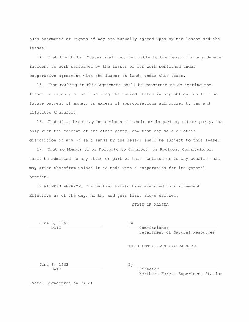
14. That the United States shall not be liable to the lessor for any damage
incident to work performed by the lessor or for work performed under
cooperative agreement with the lessor on lands under this lease.
15. That nothing in this agreement shall be construed as obligating the
lessee to expend, or as involving the Untied States in any obligation for the
future payment of money, in excess of appropriations authorized by law and
allocated therefore.
16. That this lease may be assigned in whole or in part by either party, but
only with the consent of the other party, and that any sale or other
disposition of any of said lands by the lessor shall be subject to this lease.
17. That no Member of or Delegate to Congress, or Resident Commissioner,
shall be admitted to any share or part of this contract or to any benefit that
may arise therefrom unless it is made with a corporation for its general
benefit.
IN WITNESS WHEREOF, The parties hereto have executed this agreement
Effective as of the day, month, and year first above written.
STATE OF ALASKA June 6, 1963 By DATE Commissioner Department of Natural Resources THE UNITED STATES OF AMERICA June 6, 1963 By DATE Director Northern Forest Experiment Station (Note: Signatures on File)
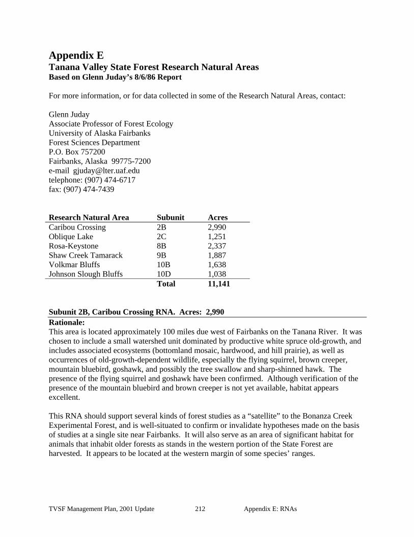
Appendix E Tanana Valley State Forest Research Natural Areas Based on Glenn Juday’s 8/6/86 Report For more information, or for data collected in some of the Research Natural Areas, contact: Glenn Juday Associate Professor of Forest Ecology University of Alaska Fairbanks Forest Sciences Department P.O. Box 757200 Fairbanks, Alaska 99775-7200 e-mail [email protected] telephone: (907) 474-6717 fax: (907) 474-7439 Research Natural Area Subunit Acres Caribou Crossing 2B 2,990 Oblique Lake 2C 1,251 Rosa-Keystone 8B 2,337 Shaw Creek Tamarack 9B 1,887 Volkmar Bluffs 10B 1,638 Johnson Slough Bluffs 10D 1,038 Total 11,141 Subunit 2B, Caribou Crossing RNA. Acres: 2,990 Rationale: This area is located approximately 100 miles due west of Fairbanks on the Tanana River. It was chosen to include a small watershed unit dominated by productive white spruce old-growth, and includes associated ecosystems (bottomland mosaic, hardwood, and hill prairie), as well as occurrences of old-growth-dependent wildlife, especially the flying squirrel, brown creeper, mountain bluebird, goshawk, and possibly the tree swallow and sharp-shinned hawk. The presence of the flying squirrel and goshawk have been confirmed. Although verification of the presence of the mountain bluebird and brown creeper is not yet available, habitat appears excellent. This RNA should support several kinds of forest studies as a “satellite” to the Bonanza Creek Experimental Forest, and is well-situated to confirm or invalidate hypotheses made on the basis of studies at a single site near Fairbanks. It will also serve as an area of significant habitat for animals that inhabit older forests as stands in the western portion of the State Forest are harvested. It appears to be located at the western margin of some species’ ranges.
TVSF Management Plan, 2001 Update 212 Appendix E: RNAs
Description: The RNA is characterized by extensive upland mature white spruce with occasional old aspen. Some 200- to 300-year old trees are present, but 10 dominant white spruce sample trees ranged in age from 120 to 170 years. A fire-remnant population of the largest white spruce occurs at very thin stocking levels in some portions of the upland stand; those trees may be 50 to 100 years older. The western portion of the area supports a species-rich hill prairie. Three vascular plant species range extensions were noted from the site work: Carex rossii, Carex lasiocarpa, and Cystopteris fragilis subsp. dickieana. Some site work was conducted June 29-July 2, 1986, including sampling soils and establishing and marking permanent forest plots totaling ½ hectare. In general, the stand showed the same age relationships as Bonanza Creek Experimental Forest, but was somewhat smaller and not quite as productive. However, the upland stand is in the upper range of volume and productivity for the Tanana Valley State Forest. Subunit 2C, Oblique Lake RNA. Acres: 1,251 Rationale: This area offers two contrasting lake types: an upland dune lake lying oblique to the dune-building wind direction, and a bottomland oxbow lake near the Kantishna River. There is good potential for the occurrence of some uncommon aquatic plant species. South-facing sand bluffs support open meadows, which may be a special habitat for uncommon plants. Outlines of old parabola dunes can be found in the area. Description: Float planes can land on Oblique Lake. The landscape is an aeolian dune system with a light, variable silt cap. Oblique Lake was named for a nearby oblique dune. Erosion of the soft sediment by the low-gradient lower section of the Kantishna River has produced oxbow lakes, which are a contrasting aquatic system to the dune lake. This area has large, continuous expanses of forest not broken up by wetland and permafrost openings. The level of Oblique Lake rises and falls, and there are actually two separate lakes when the water is low. Trumpeter swans nest on Oblique Lake. The driest, south-facing bluffs support a Pumpelly brome grass community. There are many giant ant colonies in the sand, and the vegetation is very much affected by ants. Forest research plots include Middle Point West, an old white spruce stand on sand, and Little Oblique Lake, a maturing birch forest. Subunit 8B, Rosa Keystone Dunes RNA. Acres: 2,337 Rationale: This area represents a spectacular series of dunes and dune hollow basins built up over at least the last two Ice Ages and probably more (as much as 500,000 years). The dune-building winds were an unusual southeasterly direction. Buried wind-polished rocks and other ventifacts, along with Ice Age animal remains, are of interest to scientists and have been recovered nearby. Cold air appears to collect in the undrained basins, probably producing ultra-cold temperatures. Trees are unable to survive on the floors of the basins, which are interesting and species-rich meadows. A lake formed by a stream dammed by the dunes occupies the center of the area. There are signs of wolf use, and the area may be used as a denning site.
TVSF Management Plan, 2001 Update 213 Appendix E: RNAs
Description: At least 66 vascular plant species were collected and cataloged from the Rosa-Keystone Dunes area. Several are mountain species found in the cold air drainage basins. Major dune waves are ¼ mile wide and ½ to 1 mile long. They terminate in steep slip slopes as tall as 200 feet. There is a second set of smaller dunes superimposed on the larger ones. The smaller dunes are only 10 to 20 feet tall and are one-third to one-tenth the size of the larger ones in width and length. The tops of elongate linear dunes are covered with a forest of mixed poor aspen and excellent black spruce growth. Fire frequency appears to be very high in that type. Some moderately good birch forest growth is achieved on the crests and south-facing slopes above the tall slip slopes. Basins are meadows bordered with a shrub-dominated treeline. Some small trees below ½ meter tall are present in the basin meadows, but portions sticking above the snowline are apparently killed in the winter. Some white spruce forest is present on a south-facing dune surface at the low southeast corner of the area, as well as on residual “normal” soils offers the opportunity for studies to contrast these very different soils and the forests they support. The dune-dammed lake is a special feature of the area. Very heavy wildlife use in the area has left an excellent system of trails on the straight, elongate axes of the dune crests. South-facing slopes above the inversion layer are apparently warmer sites which support prairie-like vegetation. Signs of wolf kills around at least one basin suggest the presence of a den on one of the warmer sand slopes. Subunit 9B, Shaw Creek Tamarack RNA. Acres: 1,887 Rationale: This area includes a major lake and its shoreline, as well as upland and bottomland sites with good growth of tamarack. The Shaw Creek Flats are known as one of the best areas for the growth and development of tamarack, which is apparently favored by the extensive fen (non-acid peaty) surfaces. There are few lakes of this size (approximately 300 acres) in the TVSF without shoreline developments. Peaty wetlands apparently support palsa mounds, a unique permafrost feature. Description: A small sample of representative diameters was taken in a larch-dominated, raised sand ridge on the Shaw Creek Flats. Diameters of larch ranged from 6 to 12 cm. Soil samples were taken from two sand exposures. Sand probably underlies much, if not all, of the flats. Upland stands with a considerable larch component are present near the west shore of the lake. A mosaic of upland forests occurs with at least three fire-origin age classes present. A fire approximately 35 years old partially burned a south-facing slope northeast of the lake and in the southern portion of the RNA. A fire-access trail of similar age rims the lake. It is impassible in the summer and has undergone thaw subsidence into the permafrost. The hardwood and pole-sized white spruce stand on the slope west of the lake probably originated 70 to 75 years ago. Older forest remnants occupy the northwest portion of the area. At least one species of aquatic plant collected here represents a range extension: Carex chordorrhiza. The lake is a particularly significant wildlife habitat feature. Birds seen included red-necked phalarope, snipe, yellowlegs, alder flycatcher, Wilson’s warbler, yellow-rumped warbler, red-
TVSF Management Plan, 2001 Update 214 Appendix E: RNAs
tailed hawk, trumpeter swan, white-winged scoter, surf scoter, mew gulls, and canvasback. Three moose were also seen feeding together in the lake. Subunit 10B, Volkmar Bluffs. Acres: 1,638 Rationale: Volkmar Bluffs are probably the largest contiguous hill prairie in the Tanana Valley State Forest if not central Interior Alaska. They have experienced some encroachment from woody vegetation recently, but they are still large. They are also unusual in that they are on especially gentle slopes, as low as 18 degree slopes, and that the Tanana River is not now actively carving the toe of the slope to over-steepen the bluff. The bluffs support several uncommon plant species, only some of which occur at Johnson Slough bluffs. The bluffs may be maintained on such a gentle slope in a non-forested condition by 1) thin, rocky soils, 2) extreme rain shadow effect and low annual precipitation, and 3) active and relatively recent fire history. The area is designed to also encompass a much more typical small hill prairie bluff along the active channel of the Tanana River in the southern portion of the area for contrasting studies. Description: Volkmar Bluffs is probably the best example of the low elevation hill prairie, and the associated vegetation complex, available for inclusion in a system of research sites. This site is more typical of the central Interior hill prairie type, and lacks the alpine element found at Johnson Slough Bluffs. During site documentation work, four transects of 20 stations at one meter intervals were marked and sampled in four different meadows at the site. Soil samples were collected. All the northern meadows were similar enough to be considered one system. Bees and other pollinators which may have evolved to endemic species were collected. Identification is still pending. Results were presented at the Alaska Science Conference, and plans are being developed to publish information about this and other hill prairies of Interior Alaska. Noteworthy plant records include the following species on the “type needs” submitted at the time of the RNA planning criteria: Silene williamsii and Erigeron caespitosus. Two other hill prairie species found at the site are relatively uncommon in this region: Artemisia laciniata and Agropyron spicatum. Further work needs to be done in documenting the forest types and structure of the ridge. Subunit 10D, Johnson Slough Bluffs. Acres: 1,038 Rationale This RNA is located approximately 55 miles southeast of Delta Junction, and is three miles north of the Alaska Highway on a steep slope on the north bank of the Tanana River. It was chosen to include an exceptionally well-developed hill prairie on an over-steepened bluff which is being actively carved by the Tanana River. It includes several uncommon plants largely restricted to hill prairie sites, and is located at an apparent boundary between lower elevation hill prairies to the west, and an alpine-influenced set of bluff meadows of eastern Interior Alaska. Wildlife, especially moose, apparently use the area heavily in the late winter or very early spring. The bluff meadows of the area are of interest also because they may provide information about the kind of vegetation that was dominant over Interior Alaska during the Ice Age, and clues to how the modern vegetation developed.
TVSF Management Plan, 2001 Update 215 Appendix E: RNAs

TVSF Management Plan, 2001 Update 216 Appendix E: RNAs
Description The RNA is approximately 50% non-forested. It makes up a slope system rising steeply from the north bank of the Tanana River. A dry ravine in the center of the area has its headwaters within ¾ mile of the Tanana River. A peak on the northern boundary reaches 246 feet in elevation, while the Tanana River elevation is about 1350 feet on the southern border. The site was documented in July of 1985, and four permanent transects of 20 locations one meter apart were established on the hill prairies. Collections were made and deposited in the University of Alaska Herbarium of at least 57 herbaceous hill prairie plants. At least four species collected were range extensions: Agropyron spicatum, Castilleja elegans, Minuartia yukonensis, and Oxytropis splendens. Three other relatively rare hill prairie species were also found: Artemisia laciniata, Dodecatheon puchellum, and Plantago canescens.

Appendix F Table F-1. Northern Region forest road standards Level of Use Curve Radius Grade Drivable Surface Turnouts Primary all-season road1
Moderate to heavy. Long-term. Year-round.
300’ normal design. 100’ minimum2. Curve widening on minimum-radius curves.
8% normal. 10% maximum.
16’-20’ width and rock surfacing may be required.
Not required if at least 18’ width drivable surface. Otherwise: 1000’ maximum interval, intervisible. 25’ ingress, 25’ egress, 50’ full. 12’ width.
Secondary all-season road
Light to moderate. Medium to long-term. Year-round.
100’ normal design. 60’ minimum2.
15% maximum favorable. 10% maximum adverse.
12’-16’ width.
Same as above.
Spur road Light. Short-term.
Same as secondary all-season road.
20% maximum. 10’ to 16’ width. Not required.
Primary winter road
Moderate to heavy. Long-term.
Same as primary all-season road. Same as primary all-season road.
16’ to 20’ width. Same as primary all-season road.
Secondary winter road
Light to moderate. Same as secondary all-season road.
Same as secondary all-season road.
Same as secondary all-season road. Same as primary winter road. Medium to long-term.
1Higher construction standards may be needed for site-specific projects and conditions. 2To be applied only under topographically limiting conditions.
TVSF Management Plan, 2001 Update 217 Appendix F: Road Standards

Clearing3 Grubbing Debris Disposal Permafrost Cut and Fill
Fill slope castings 1½:1 angle maximum. Cut slopes at 1:1 angle maximum, except that loess soils may be cut vertically. See also 11 AAC 95.290(c).
5’ beyond cuts or fills, or minimum of 35’ width. Merchantable timber cut and decked ahead of construction.
Removal of stumps, roots, and organics from the road bed to outside of ditches unless top of stumps under 2’ of fill.
If at least 2’ beyond ditches, may be windrowed or placed in push-outs. If closer, buried under at least 1’ of fill.
Avoid exposing thaw-unstable permafrost through routing or using raised fill construction. If exposed, minimize sedimentation with effective erosion control measures. See also 11 AAC 95.290 (c).
Primary all-season road1
Same as above. 5’ beyond cuts or fills, or minimum of 30’ width.
Same as above. Same as above. Same as above. Secondary all-season road Merchantable timber cut and
decked ahead of construction.
Avoid where feasible and prudent.
Minimum 12’. Under drivable surface. Use windrowing or push-out techniques as appropriate.
Avoid exposure of thaw-unstable permafrost. If exposed, stabilize by treating with effective and appropriate measures such as recovering exposed soils, seeding, drainage structures, and settling basins. (See also 11 AAC 95.290(c), (g); .295(g).)
Spur road Merchantable timber cut and decked ahead of construction.
Minimize cuts and fills in thaw-unstable permafrost. Avoid where feasible and prudent, cuts in thaw-unstable permafrost; exceptions will be identified in the FLUP.
Minimum 16’. Partial removal of surface organics only as needed to provide a level running surface.
Same as spur road. Same as spur road. Primary winter road
Avoid where feasible and prudent. Exceptions will be identified in the FLUP.
Minimum 12’. Same as Primary winter road. Same as spur road. Same as spur road. Secondary winter road
3 Minimum is used for safety and snow storage reasons. 1Higher construction standards may be needed for site-specific projects and conditions.
TVSF Management Plan, 2001 Update 218 Appendix F: Road Standards

TVSF Management Plan, 2001 Update 219 Appendix F: Road Standards
Ditches Culverts Maintenance Primary all-season road1
1.0’ minimum depth. 2.0’ minimum width. Block ditch on downhill side of culvert inlet, where needed.
Minimum diameter 12” except as stated in 11 AAC 95.295. Installed at or below natural ground line. Installed at natural stream gradient.
Grading and ditching as necessary.
Secondary all-season road
Block ditch on downhill side of culvert inlet where needed.
Same as above. Grading and ditching as necessary. Maintained or closed after logging use.
Spur road As needed. Same as above. Closed or treated as per 11 AAC 95.315(c) after logging use.
Primary winter road
None. Same as above. Open drainages before breakup.
Secondary winter road
None. Same as above. Closed or treated as per 11 AAC 95.315(c) after logging use. Open drainages before breakup.
1 Higher construction standards may be needed for site-specific projects and conditions.

Appendix G Bibliography Alaska Wildland Fire Coordinating Group. 1998. Alaska Interagency Wildland Fire
Management Plan. Alaska Wildland Fire Coordinating Group. 61p. Ball, W.J., N.R. Walker. 1997. Stand development after partial cutting of mature mixed stands
of white spruce and aspen in Manitoba. Northern Forestry Centre Information Report NOR-X-353.
Can. J. For. Res. 1983. Special issue on Structure and function of Alaskan taiga forest
ecosystems, Vol. 13: 695-916. Collins, W.B. 1996. Wildlife habitat enhancement in the spruce-hardwood forest of the
Matanuska and Susitna River valleys. Alaska Department of Fish and Game Fed. Aid in Wildlife Restoration Final Research Report. Juneau. 52p.
Collins, W.B., D.J. Helm. Moose (Alces alces) habitat relative to riparian succession in the
boreal forest, Susitna River, Alaska. (submitted to Canadian Field-Naturalist) Crimp, P.M., S.J. Phillips, G.T. Worum. 1997. Timber Resources on State Forestry Lands in
the Tanana Valley. State of Alaska Department of Natural Resources, Division of Forestry. 80p. plus appendices.
Densmore, R.V., G.P. Juday, J.C. Zasada. 1999. Regeneration alternatives for upland white
spruce after burning and logging in interior Alaska. Can. J. For. Res. 19: 413-423. Densmore, R.V., J.C. Page. 1992. Paper birch regeneration on scarified, logged areas in
southcentral Alaska. North. J. Appl. For. 9(2): 63-66. Drake, J.B. 1996. Predicting climate change, in ORNL Review. Oak Ridge, TN: Oak Ridge
National Laboratory. Dunster, Julian, K. Dunster. 1996. Dictionary of Natural Resource Management. UBC Press.
363p. Dyrness, C.T., L.A. Viereck, M.J. Foote, J.C. Zasada. 1988. The Effect on Vegetation and Soil
Temperature of Logging Flood-Plain White Spruce. USDA Forest Service, Research Paper PNW-RP-392. 45p.
Eyre, F.H., Editor. 1980. Forest Cover Types of the United States and Canada. Society of
American Foresters. 148p. plus map. Farr, Wilbur A. 1967. Growth and Yield of Well-Stocked White Spruce Stands in Alaska.
USDA Forest Service Research Paper PNW-53. 30p.
TVSF Management Plan, 2001 Update 220 Appendix G: Bibliography

Fairbanks Industrial Development Corporation. 1995. Interior Birch Tests Okay as Veneer Product. The Fairbanks Development Quarterly Volume 7, Number 2.
Fogarty, L.G., M.E. Alexander. 1999. A field guide for predicting grassland fire potential:
derivation and use. Fire Technology Transfer Note, Forest and Rural Fire Research. 10p.
Foote, M. Joan. 1983. Classification, Description, and Dynamics of Plant Communities After
Fire in the Taiga of Interior Alaska. USDA Forest Service, Research Paper PNW-307. 108p.
Forbes, Reginald D., Editor. 1961. Forestry Handbook. The Ronald Press Company. 1102p.
plus index. Ford-Robertson, F.C., Editor. 1971. Terminology of Forest Science, Technology Practice and
Products, The Multilingual Forestry Terminology Series No. 1. Society of American Foresters. 349p.
Fowells, H.A. 1965. Silvics of Forest Trees of the United States, Agriculture Handbook No.
271. USDA Forest Service. 761p. Froning, K. 1980. Logging Hardwoods to Reduce Damage to White Spruce Understory.
Northern Forest Research Centre Information Report NOR-X-229. 19p. Gregory, R.A., P.M. Haack. 1965. Growth and Yield of Well-Stocked Aspen and Birch Stands
in Alaska. USDA Forest Service Research Paper NOR-2. 28p. Helms, John A., Editor. 1998. The Dictionary of Forestry. The Society of American Foresters.
210p. Holsten, E.H., R.A. Werner, T.H. Laurent. 1980. Insects and Diseases of Alaskan Forests.
USDA Forest Service, Alaska Region Report Number 75. 187p. Holsten, E.H., P.E. Hennon, R.A. Werner. 1985. Insects and diseases of Alaskan forests. USDA
Forest Service, State and Private Forestry, Forest Pest Management, Alaska Reg. Rep. No. 181, Juneau, AK. p. 217.
Hoyt, M.J. 1992. Site index of paper birch in Alaska. M.Sc. thesis, University of Alaska
Fairbanks. Fairbanks, AK. p. 72. Johnson, D., L. Kershaw, A. MacKinnon, J. Pojar. 1995. Plants of the Western Boreal Forest &
Aspen Parkland. Lone Pine Publishing and the Canadian Forest Service. 392p. Juday, G.P. 2001. Contribution to Tanana Valley State Forest plan on climate change (e-mail).
Fairbanks, AK.
TVSF Management Plan, 2001 Update 221 Appendix G: Bibliography
Kasischke, E.S., B.J. Stocks. 2000. Fire, Climate Change, and Carbon Cycling in the Boreal Forest. Springer-Verlag New York, Inc. 101p.
Kearns, Frank W. 1965. Report of the Technical and Economic Feasibility of Establishing A
Sawmill Operation at the Native Village of Minto, Alaska. Institute of Business, Economic and Government Research, University of Alaska. 110p.
Lieffers, V.J., S.E. MacDonald, E.H. Hogg. 1993. Ecology of and control strategies for
Calamagrostis canadensis in boreal forest sites. Canadian Journal For. Res. 23:2070-2077.
Lutz, H.J. 1953. The effects forest fires on the vegetation of interior Alaska. USDA Forest
Service, Alaska Forest Res. Ctr. Sta. Pap. 1, Juneau, AK. p. 36. Lutz, H.J. 1956. The ecological effects of forest fires in the interior of Alaska. USDA Tech.
Bull. 1133, Washington, DC. p 121. Lutz, H.J. 1959. Aboriginal man and white man as historical causes of fires in the boreal forest,
with particular reference to Alaska. Yale Univ. Sch. For. Bull. 65., New Haven, CT. p. 49.
Mann, D.H., C.L. Fastie, E.L. Rowland, N.H. Bigelow. 1995. Spruce succession disturbance,
and geomorphology on the Tanana River floodplain, Alaska. Ecoscience Vol. 2. Pages 184-199.
National Assessment Synthesis Team, US Global Change Research Program. 2000. Climate
change impacts on the United States: the potential consequences of climate variability and change. Washington, D.C.
Navratil, S., K. Branter, J. Zasada. 1991. Regeneration in the mixedwoods, in Northern
mixedwood ’89, Proc. Symp. Sept 12-14, 1989, Ft. St John, BC, (A. Shortreid, ed.), For. Canada, Pacific-Yukon Region, Pac. For. Res. Ctr., FRDA Rep. 164, Victoria, BC. pp. 32-48.
Ott, Robert A. 1998. The Impact of Winter Logging Roads on Vegetation, Ground Cover,
Permafrost, and Water Movement on the Tanana River Floodplain in Interior Alaska. For AK Department of Natural Resources, Division of Forestry, Cooperative Agreement AK-DF-A97-RN0006 10-97-052. 31p.
Packee, E.C. 1990. White spruce regeneration on a blade-scarified loess soil. North. J. Appl.
For. 7: 121-123. Packee, Edmond C. 1999. Initial Forest Stand Density and Wood Quality: A preliminary report.
Agroborealis Vol. 31 No. 1. 3p.
TVSF Management Plan, 2001 Update 222 Appendix G: Bibliography
Parsons, Marty. 2000. Tanana State Forestry Lands, Periodic Sustainable Yield Analysis. Parsons & Associates, Inc. 18p. plus appendices.
Perala, D.A., A.A. Alm. 1988. The Reproductive Ecology of Birch: A Review. Revision:
Manuscript FORECOL 962 intended for Forest Ecology and Management. 90p. Peterson, E.B., R.D. Kabzems, N.M. Peterson. 1989. Hardwood Management Problems in
Northeastern British Columbia: An Information Review. FRDA Report, ISSN 0835-0752; 066. 77p.
Phillips, Steven J. 1994. Tanana Basin Forest Inventory, 1993. State of Alaska Department of
Natural Resources, Division of Forestry Forest Inventory. 14p. Putman, W., J. Zasada. 1986. Direct seeding techniques to regenerate white spruce in interior
Alaska. Can. J. For. Res. 16: 660-664. Samoil, J.K., editor. 1988. Management and Utilization of Northern Mixedwoods. Proceedings
of a symposium held April 11-14, 1988, in Edmonton, Alberta. Information Report NOR-X-296, Northern Forestry Centre.163p.
Scholtes, John. 1992. Tree Improvement, Nursery and Research for Interior and Southcentral
Alaska. Alaska Department of Natural Resources and The Alaska Reforestation Council. 109p. plus appendices.
Smith, David M. 1962. The Practice of Silviculture. John Wiley & Sons. 578p. Spindler, M.A., B. Kessel. 1980. Avian populations and habitat use in interior Alaska taiga.
Syesis 13:61-104. State of Alaska. 2000. Alaska Statutes, Volume 8, Title 33 to Title 39. The Alaska Legislative
Council. 840p. State of Alaska. 2000. Alaska Statutes, Volume 9, Title 40 to Title 44. The Alaska Legislative
Council. 801p. State of Alaska. 1994. The Constitution of the State of Alaska. Reproduced by the Lieutenant
Governor. Online document. State of Alaska, Department of Natural Resources. 1983. Tanana Basin Area Plan, Phase I,
Resource Inventory, Forestry Element. USDA Soil Conservation Service, Fairbanks, AK. 98p.
State of Alaska, Department of Natural Resources. 1991. Tanana Basin Area Plan for State
Lands. Department of Natural Resources, Division of Land and Water Management, Fairbanks, AK. 370p. plus maps.
TVSF Management Plan, 2001 Update 223 Appendix G: Bibliography
State of Alaska, Department of Natural Resources, Division of Forestry. 1987. Tanana Valley State Forest Forest Management Plan, Resource Analysis. State of Alaska, Department of Natural Resources. 321p.
State of Alaska, Department of Natural Resources, Division of Forestry. 1988. Tanana Valley
State Forest Forest Management Plan. State of Alaska, Department of Natural Resources. 238p. plus maps.
Steil, W.M. 1976. White spruce: Artificial Regeneration in Canada. Canadian Forestry Service,
Forest Management Institute Information Report FMR-X-85. 275p. Stoddard, C.H, G.M. Stoddard. 1987. Essentials of Forestry Practice. John Wiley & Sons.
407p. Symposium. 1969. Birch Symposium Proceedings. The Birch Symposium, held at the
University of New Hampshire, Durham, N.H. 19-21 August 1969. 183p. Symposium. 1971. Fire in the Northern Environment – A Symposium, sponsored by Alaska
Forest fire Council and Alaska Section, Society of American Foresters at the University of Alaska Fairbanks. Proceedings, Pacific Northwest Forest and Range Experiment Station, USDA Forest Service. 275p.
Symposium. 1977. North American Forest Lands at Latitudes North of 60 Degrees.
Proceedings of a Symposium held at the University of Alaska Fairbanks September 19-22, 1977. 332p.
Symposium. 1991. Northern Mixedwood ’89. Proceedings of a symposium held at Fort St.
John, B.C. September 12-14, 1989. 137p. Technical Workshop. 1998. Managing for Forest Condition in Interior Alaska: What are our
options? Proceedings, April 9 & 10 1988 workshop sponsored by AK Boreal Forest Council, Inc., AK Cooperative Extension Service, Forest Sciences Department School of Agriculture and Land Resources Management, University of Alaska Fairbanks. 88p.
Trummer, Lori. 1999. Tomentosus Root Rot, Alaska Region Leaflet, R10-TP-80. USDA Forest
Service. TVSF Planning Team Working Groups. 1997. Working Group Recommendations on Issue
Questions for the Tanana Valley State Forest Management Plan Review. Unpublished. 307p.
Van Cleve, K., L. Oliver, R. Schlentner. 1983. Productivity and nutrient cycling in taiga forest
systems. Can. J. For. Res. 13: 747-766. Van Cleve, K., J. Zasada. 1976. Response of 70-year-old white spruce to thinning and
fertilization in interior Alaska. Can. J. For. Res. 6:145-152.
TVSF Management Plan, 2001 Update 224 Appendix G: Bibliography

Van Cleve, K., T. Dyrness, L. Viereck. 1994. Fire: examining its forest regeneration potential.
Forest Sciences Notes, No. 2. 4p. Viereck, L.A. 1970. Forest succession and soil development adjacent to the Chena River in
interior Alaska. Arctic Alp. Res. 2(1): 1-26. Viereck, L.A., C.T. Dyrness, A.R. Batten, K.J. Wenzlick. 1992. The Alaska Vegetation
Classification. USDA Forest Service, General Technical Report, PNW-GTR-286. 278p. Viereck, L.A., C.T. Dyrness, K. Van Kleve. 1983. Vegetation, soils, and forest productivity in
selected forest types in interior Alaska. Can. J. For. Res. 13: 703-720. Viereck, L.A., E.L. Little, Jr. 1972. Alaska Trees and Shrubs, Agriculture Handbook No. 410.
Forest Service, USDA. 265p. plus map. Weller, G., P.A. Anderson, Editors. 1999. Assessing the Consequences of Climate Change for
Alaska and the Bering Sea Region, Proceedings of a Working Group at the University of Alaska Fairbanks 29-30 October 1998. Center for Global Change and Arctic System Research, University of Alaska Fairbanks. 94p.
Wenger, Karl F. 1984. Forestry Handbook. John Wiley & Sons. 1335p. Winters, Robert K., Editor. 1977. Terminology of Forest Science, Technology Practice and
Products, Addendum Number One. Society of American Foresters. 17p. Wolff, J.O., J.C. Zasada. 1979. Moose habitat and forest succession on the Tanana River
floodplain and the Yukon-Tanana upland. Pages 213-245 in Vol. 15 of the Proceedings of the North American Moose Conference and Workshop. HG Cumming, ed. School of Forestry, Lakehead University, Thunder Bay, Ont.
Workshop. 1987. Proceedings of the Alaska Forest Soil Productivity Workshop. USDA Forest
Service, General Technical Report PNW-GTR-219. 120p. Workshop. M. Murray, R.M .VanVeldhuizen, editors. 1980. Forest Regeneration at High
Latitudes, an International Workshop sponsored by the University of Alaska, USDA Forest Service, BLM and St. of AK Department of Natural Resources. Proceedings, USDA Pacific Northwest Forest and Range Experiment Station. 52p.
Workshop on Forest Regeneration. 1986. The Yield Advantages of Artificial Regeneration at
High Latitudes. USDA Forest Service General Technical Report PNW-194. 60p. Wurtz, Tricia L. 2000. Interactions Between White Spruce and Shrubby Alders at Three Boreal
Forest Sites in Alaska. USDA Forest Service General Technical Report PNW-GTR-481. 29p.
TVSF Management Plan, 2001 Update 225 Appendix G: Bibliography
Yang, R.C. 1989. Growth response of white spruce to release from trembling aspen. Northern Forestry Centre Information Report NOR-X-302. 24p.
Yarie, J., L. Viereck, K. VanCleve, P. Adams. 1998. Flooding and Ecosystem Dynamics along
the Tanana River. BioScience Vol. 48 No. 9. 6p. Youngblood, Andrew. 1993. Community Type Classification of Forest Vegetation in Young,
Mixed Stands, Interior Alaska. USDA Forest Service Research Paper PNW-RP-458. 42p.
Youngblood, Andrew P. 1990. Effect of shelterwood removal methods on established
regeneration in an Alaska white spruce stand. USDA Forest Service. Pages 1378-1381. Youngblood, Andrew P. 1990. Effect of Mechanical Scarification and Planting Method on
Artificial Regeneration of Flood-Plain White Spruce in Interior Alaska. For. Can. Inf. Rep. N-X-271. Pages 13-24.
Youngblood, Andrew P. 1990. Radial growth after a shelterwood seed cut in a mature stand of
white spruce in interior Alaska. Canadian Journal of Forest Research. 21:410-413. Youngblood, A., T. Max. 1992. Dispersal of White Spruce Seed on Willow Island in Interior
Alaska. USDA Forest Service Research Paper PNW-RP-443. 17p. Youngblood, A.P., J.C. Zasada. 1991. White spruce regeneration options on river flood plains
in interior Alaska. Canadian Journal of Forest Research, Vol. 21 Number 4. Pages 423-433.
Zasada, John. 1990. Developing Silvicultural Alternatives for the Boreal Forest – An Alaskan
Perspective on Regeneration of White Spruce. USDA Forest Service Forest Industry Lecture Series Lecture No. 25. 44p.
Zasada, John C. 1972. Guidelines for Obtaining Natural Regeneration of White Spruce in
Alaska. USDA Forest Service. 16p. Zasada, John C. 1985. Production, dispersal, and germination of white spruce and paper birch,
and first year seedling establishment after the Rosie Creek fire, in Early results from the Rosie Creek Research Project 1984, (Juday, G.P. and C.T. Dyrness, eds.). University of Alaska Fairbanks, Sch. Agr. And Land Res. Mgmt., Misc. Pub. 85-2. Fairbanks, AK. pp. 34-37
Zasada, J. 1986. Natural regeneration of trees and tall shrubs on forest sites in interior Alaska, in
Forest ecosystems in the Alaskan taiga – A synthesis of structure and function, (Van Cleve, K., F.S. Chapin III, P.W Flanagan, L.A. Viereck, and C.T. Dyrness, eds.). Springer-Verlag, Inc., New York. pp. 44-73.
TVSF Management Plan, 2001 Update 226 Appendix G: Bibliography

TVSF Management Plan, 2001 Update 227 Appendix G: Bibliography
Zasada, J.C., M.J. Foote, F.J. Deneke, R.H. Parkerson. 1978. Case history of an excellent white spruce cone and seed crop in interior Alaska: Cone and seed production, germination and seedling survival. USDA Forest Service, Gen. Tech. Rep. PNW-65, Portland, OR. p. 53.
Zasada, J.C, R.A. Gregory. 1969. Regeneration of white spruce with reference to interior
Alaska; a literature review. USDA Forest Service, Res. Pap. PNW-79, Portland, OR. p. 37.
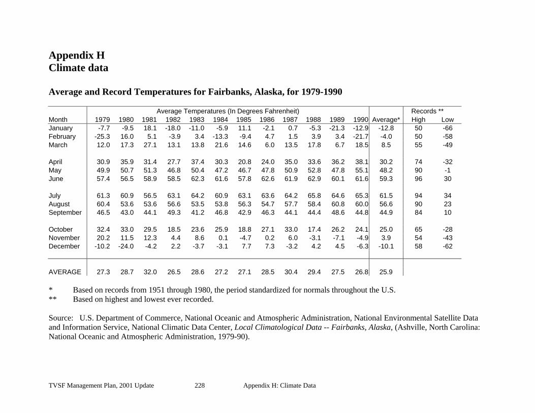
Appendix H Climate data Average and Record Temperatures for Fairbanks, Alaska, for 1979-1990 Average Temperatures (In Degrees Fahrenheit) Records ** Month 1979 1980 1981 1982 1983 1984 1985 1986 1987 1988 1989 1990 Average* High Low January -7.7 -9.5 18.1 -18.0 -11.0 -5.9 11.1 -2.1 0.7 -5.3 -21.3 -12.9 -12.8 50 -66 February -25.3 16.0 5.1 -3.9 3.4 -13.3 -9.4 4.7 1.5 3.9 3.4 -21.7 -4.0 50 -58 March 12.0 17.3 27.1 13.1 13.8 21.6 14.6 6.0 13.5 17.8 6.7 18.5 8.5 55 -49 April 30.9 35.9 31.4 27.7 37.4 30.3 20.8 24.0 35.0 33.6 36.2 38.1 30.2 74 -32 May 49.9 50.7 51.3 46.8 50.4 47.2 46.7 47.8 50.9 52.8 47.8 55.1 48.2 90 -1 June 57.4 56.5 58.9 58.5 62.3 61.6 57.8 62.6 61.9 62.9 60.1 61.6 59.3 96 30 July 61.3 60.9 56.5 63.1 64.2 60.9 63.1 63.6 64.2 65.8 64.6 65.3 61.5 94 34 August 60.4 53.6 53.6 56.6 53.5 53.8 56.3 54.7 57.7 58.4 60.8 60.0 56.6 90 23 September 46.5 43.0 44.1 49.3 41.2 46.8 42.9 46.3 44.1 44.4 48.6 44.8 44.9 84 10 October 32.4 33.0 29.5 18.5 23.6 25.9 18.8 27.1 33.0 17.4 26.2 24.1 25.0 65 -28 November 20.2 11.5 12.3 4.4 8.6 0.1 -4.7 0.2 6.0 -3.1 -7.1 -4.9 3.9 54 -43 December -10.2 -24.0 -4.2 2.2 -3.7 -3.1 7.7 7.3 -3.2 4.2 4.5 -6.3 -10.1 58 -62 AVERAGE 27.3 28.7 32.0 26.5 28.6 27.2 27.1 28.5 30.4 29.4 27.5 26.8 25.9 * Based on records from 1951 through 1980, the period standardized for normals throughout the U.S. ** Based on highest and lowest ever recorded. Source: U.S. Department of Commerce, National Oceanic and Atmospheric Administration, National Environmental Satellite Data and Information Service, National Climatic Data Center, Local Climatological Data -- Fairbanks, Alaska, (Ashville, North Carolina: National Oceanic and Atmospheric Administration, 1979-90).
TVSF Management Plan, 2001 Update 228 Appendix H: Climate Data
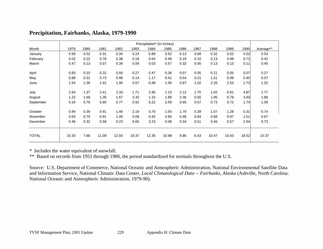
Precipitation, Fairbanks, Alaska, 1979-1990 Precipitation* (In Inches) Month 1979 1980 1981 1982 1983 1984 1985 1986 1987 1988 1989 1990 Average** January 0.58 0.52 0.31 0.34 0.24 0.89 0.52 0.13 0.68 0.32 0.52 0.52 0.53 February 0.02 0.22 0.78 0.38 0.18 0.64 0.48 0.19 0.10 0.13 0.98 0.72 0.42 March 0.47 0.13 0.07 0.39 0.09 0.03 0.57 0.32 0.00 0.13 0.13 0.11 0.40 April 0.83 0.10 0.32 0.93 0.27 0.47 0.36 0.07 0.05 0.21 0.05 0.07 0.27 May 0.88 0.31 0.73 0.96 0.14 1.17 0.41 0.54 0.21 1.51 0.99 0.40 0.57 June 1.54 1.38 1.91 1.96 0.57 0.48 1.06 0.87 1.02 2.26 2.53 1.73 1.32 July 2.54 1.37 2.41 2.33 1.71 2.95 1.13 2.12 1.70 1.02 0.91 4.87 1.77 August 1.22 1.68 1.35 1.67 3.33 1.15 1.88 2.36 0.56 1.95 0.78 3.60 1.86 September 0.19 0.76 0.80 0.77 0.92 0.22 2.59 0.65 0.57 0.73 0.72 1.74 1.09 October 0.94 0.39 0.91 1.48 2.19 0.70 1.00 1.79 0.39 1.07 1.28 0.31 0.74 November 0.63 0.70 0.91 1.49 0.08 0.42 0.90 0.48 0.64 0.68 0.97 1.51 0.67 December 0.49 0.32 0.58 0.23 0.65 3.23 0.08 0.34 0.51 0.46 0.57 2.94 0.73 TOTAL 10.33 7.88 11.08 12.93 10.37 12.35 10.98 9.86 6.43 10.47 10.43 18.52 10.37 * Includes the water equivalent of snowfall. ** Based on records from 1951 through 1980, the period standardized for normals throughout the U.S. Source: U.S. Department of Commerce, National Oceanic and Atmospheric Administration, National Environmental Satellite Data and Information Service, National Climatic Data Center, Local Climatological Data -- Fairbanks, Alaska (Ashville, North Carolina: National Oceanic and Atmospheric Administration, 1979-90).
TVSF Management Plan, 2001 Update 229 Appendix H: Climate Data

TVSF Management Plan, 2001 Update 230 Appendix H: Climate Data
Snowfall Fairbanks, Alaska, 1979-1990
Snowfall (In Inches) Month 1979 1980 1981 1982 1983 1984 1985 1986 1987 1988 1989 1990 Average* January 9.7 10.8 6.2 7.6 4.8 13.8 8.1 2.3 12.0 6.3 10.8 10.4 9.9 February 0.5 4.4 10.2 7.0 3.6 11.1 8.0 2.6 1.5 2.5 13.4 16.0 9.0 March 7.7 3.2 0.9 7.2 2.1 0.8 7.4 3.7 0.0 2.6 3.9 2.6 7.0 April 3.1 0.8 1.9 11.4 1.9 6.7 5.9 1.0 1.0 0.2 0.4 T 3.7 May 0.0 0.0 0.0 0.3 0.4 T 1.0 0.0 0.0 0.3 0.8 0.0 0.6 June 0.0 0.0 0.0 0.0 0.0 0.0 0.0 0.0 0.0 0.0 0.0 0.0 T July 0.0 0.0 0.0 0.0 0.0 0.0 0.0 0.0 0.0 0.0 0.0 0.0 0.0 August 0.0 0.0 0.0 0.0 0.0 0.0 0.0 0.0 0.0 0.0 0.0 0.0 T September T 3.4 0.3 0.6 0.4 0.0 2.1 T 0.0 0.2 0.5 1.6 1.0 October 6.5 5.1 7.8 25.9 17.3 11.3 5.4 11.8 3.5 12.9 19.7 6.9 10.7 November 4.4 10.6 16.2 27.8 2.4 8.5 14.7 7.4 14.1 15.2 18.1 37.3 13.1 December 11.0 4.8 10.6 3.8 14.4 50.7 1.8 6.0 10.4 10.5 11.1 47.5 12.0 TOTAL 42.9 43.1 54.1 91.6 47.3 102.9 54.4 34.8 42.5 50.7 78.7 122.3 65.1 T: trace * Based on records from 1951 through 1980, the period standardized for normals throughout the U.S. Source: U.S. Department of Commerce, National Oceanic and Atmospheric Administration, National Environmental Satellite Data and Information Service, National Climatic Data Center, Local Climatological Data -- Fairbanks, Alaska (Ashville, North Carolina: National Oceanic and Atmospheric Administration, 1979-90).

Appendix I INDEX
1 17(b) easements, 26
A abbreviations, 10, 11, 161, 181 access
along pipeline, 26, 27 fire protection, 7 in FLUPs, 7 public, 8, 10, 14, 24, 25, 26, 34, 64, 70,
72, 78, 166 recreation, 29, 30, 31, 32, 45, 63, 64, 65,
187, 190 resource development, 26, 43, 45, 47, 70,
71, 196 restrictions, 20, 21, 26, 42, 43, 68, 70, 73,
74 through RNAs, 38, 40, 171, 182 timber sales, 6, 53, 61, 70, 72, 74, 75, 76,
78, 155, 159, 165, 170, 177 traditional, 2 trails, 66, 67, 68, 214 unit-by-unit specifics, 81, 82, 83, 84, 85,
87, 88, 91, 92, 94, 95, 97, 98, 99, 101, 103, 104, 107, 109, 111, 112, 113, 115, 116, 117, 118, 120, 121, 122, 124, 125, 126, 127, 128, 130, 131, 133, 138, 141, 142, 143, 145, 146, 148, 149, 150
additions to TVSF, 81, 92, 96, 161 aesthetic values, 2, 67 aesthetics, 67, 70, 72, 77 agriculture, 2, 85, 111, 133, 161 air boats, 115, 119 Alaska Heritage Resources Survey, 12 Allen Creek - Dunbar Trail, 69, 95, 97, 104,
107 allotments, 84, 148 allowable cut, 7, 39, 50, 51, 52, 53, 56, 61,
177 all-season roads, 76, 91, 92, 116, 121, 122,
126, 128, 146, 147, 177, 217, 218, 219
amendments, 8, 9, 38, 39, 40, 68, 84, 103, 153, 156, 161, 164, 177, 182
Anaconda Creek Trail, 113 anadromous fish, 18, 22, 34, 73, 74, 78, 80,
170 annual allowable cut, 51 applications, 3, 40, 44, 51, 53, 60, 67, 120,
152, 153, 155, 166, 178 AS 41.17, 1, 2, 7, 9, 14, 18, 28, 30, 33, 51,
56, 57, 63, 65, 68, 72, 73, 74, 77, 119, 153, 158, 161, 174, 176, 178, 179, 182, 187, 190, 193. See also Forest Resources and Practices Act
aspen, 3, 18, 53, 57, 58, 59, 100, 131, 169, 193, 213, 214, 220, 221, 226
B Baker Creek, 36, 80, 81, 87, 158 Baker Trail, 81, 82 balsam poplar, 3, 18, 54, 55, 57, 58, 59 Bear Creek, 36, 142 bears, 18, 20, 84, 85, 91, 94, 103, 104, 111,
115, 119, 124, 130, 138, 141, 145, 148 berry picking, 32, 94 big game hunting, 80 biking, 32 Billy Creek, 36, 138, 141, 142 biodiversity, 95, 99, 181. See also biological
diversity biological diversity, 4, 5, 55, 172, 181. See
also biodiversity birch, 3, 18, 53, 54, 55, 57, 58, 59, 104, 169,
213, 214, 220, 221, 226 birch bark baskets, 104 Birch Lake, 115, 117 birds, 85, 104, 130, 174, 193 Black Creek, 36 Blue Trail, 133 Bluff Cabin Ridge, 130 boat launches, 29, 31, 63, 94, 96, 101, 103,
105, 109, 112, 114, 131, 158 boating, 32, 65, 80, 85, 103, 105, 130, 132,
145, 148, 187
TVSF Management Plan, 2001 Update 231 Appendix H: Climate Data

Bonanza Creek, 39, 40, 48, 50, 62, 73, 79, 103, 104, 105, 106, 107, 152, 183, 192, 193, 194, 195, 196, 205, 212, 213
Bonanza Creek Experimental Forest, 48, 104, 110, 183, 193
Boreal Ecology Cooperative Research Unit, 8, 40, 49, 104, 105, 106, 107, 108, 183, 193, 194
boreal forest, 4, 5, 19, 49, 159, 220, 222 buffers, 47, 78 Bureau of Land Management, 26, 166, 181,
225
C cabins
historic, 111 private, 30, 69, 83, 86, 88, 93, 94, 101,
109, 111, 114, 115, 118, 122, 124, 125, 126, 127, 128, 130, 132, 135, 140, 144, 147, 151, 183
public use, 29, 31, 63, 64, 81, 83, 86, 88, 96, 101, 105, 109, 112, 114, 132, 135, 152, 158, 159
trapping, 38, 109, 141, 155 Cache Creek, 9, 94, 95, 98, 99, 100, 101,
102 campground, 101, 109, 141, 142, 148, 158,
183, 190, 191 camping, 32, 38, 63, 85, 94, 103, 105, 145,
148 campsites, 32, 96, 103, 105, 132, 135, 190 canoeing, 32, 63, 85, 91, 148 caribou, 18, 119, 124, 130, 138, 145 Caribou Creek, 36, 69, 112, 119, 120, 121,
122 Caribou Crossing Research Natural Area,
40, 85, 193, 212 Chatanika River, 48, 50, 62, 94, 95, 96, 98,
101, 158, 167, 182, 185, 187, 190 Chatanika State Recreation River, 167 Chena Bluff, 111 Chena Hot Springs Winter Trail, 66, 68, 113 Chena Lakes Trail, 25, 112 Chena River, 36, 111, 112, 113, 158, 159,
225 Citizens' Advisory Committee, 8, 84, 154
Citizens’ Advisory Committee, 3, 6, 7, 8, 52, 98, 153
classifications, 161, 175 clearing, 22, 23, 42, 56, 75, 85, 87, 218 Clearwater Creek, 36, 69, 148, 149, 190 climate change, 4, 5, 220, 221, 222 climate data, 228 coal, 42, 44, 45, 48, 96, 101, 109, 183, 187 comments
public, 6, 8, 9, 52, 67, 96, 98, 155, 196 commercial development, 28, 63 commercial forest types, 30, 52, 103 commercial timber, 1, 40, 52, 70, 84, 86, 88,
94, 112, 115, 116, 119, 121, 124, 125, 132, 156, 163, 165, 178, 183
composition of State Forests, 1 consultation
definition, 127, 134 with agencies, 9, 15, 20, 21, 23, 38, 42,
43, 46, 72 with DOF, 12
Country Trail, 69, 82 cranes, 130 Cripple Creek – Rosie Creek Trail, 69 cross-country skiing, 32, 85, 103, 113, 130 Cultural Resources, 12, 72, 80, 84, 91, 94,
95, 103, 111, 112, 115, 116, 119, 120, 124, 130, 131, 138, 139, 141, 142, 145, 148, 149
cultural sites, 12, 13, 95, 112, 116, 120, 131, 139, 142, 149
culverts, 219 cut and fill, 218
D debris disposal, 218 deletions, 161 Delta Five-Year Schedule of Timber Sales,
127, 134 Dennison Fork, 69, 145, 146 Department of Community and Economic
Development, 8 Department of Environmental Conservation,
8, 11, 20, 21, 23, 33, 43, 44, 46, 52, 60, 78, 181
TVSF Management Plan, 2001 Update 232 Appendix H: Climate Data

Department of Fish and Game, 8, 11, 15, 16, 17, 18, 20, 21, 22, 23, 39, 43, 44, 46, 52, 60, 72, 73, 84, 97, 100, 116, 119, 121, 146, 148, 149, 158, 174, 181, 196, 220
Department of Natural Resources, 1, 2, 5, 6, 7, 8, 9, 10, 11, 12, 15, 17, 18, 20, 21, 22, 23, 24, 25, 26, 27, 29, 30, 34, 38, 39, 40, 42, 43, 44, 45, 47, 49, 51, 53, 55, 56, 60, 68, 71, 72, 73, 74, 77, 78, 79, 84, 99, 105, 106, 107, 116, 121, 126, 127, 133, 138, 142, 143, 152, 153, 156, 158, 161, 169, 173, 175, 176, 180, 181, 182, 183, 186, 188, 189, 191, 192, 193, 194, 195, 196, 220, 222, 223, 224, 225
Department of Transportation & Public Facilities, 8, 11, 26, 46, 74, 181
Director, 153, 154, 156, 186, 189, 194 diseases, 4, 5, 20, 22, 23, 53, 54, 60, 106,
126, 133, 159, 169, 221 disposal, 1, 30, 43, 47, 80 disturbance, 4, 14, 16, 40, 46, 49, 53, 54, 55,
60, 73, 159, 171, 177, 182, 192, 196, 222 ditches, 218 Division of Forestry, 6, 7, 11, 12, 24, 28, 29,
31, 37, 39, 40, 51, 60, 67, 70, 72, 82, 97, 99, 100, 107, 127, 134, 146, 149, 152, 153, 154, 155, 156, 158, 159, 170, 181, 196, 220, 222, 223, 224
Division of Geological and Geophysical Surveys, 11
Division of Mining, Land and Water, 26, 66, 67, 81, 152, 155, 181, 186, 189, 194
Division of Parks and Outdoor Recreation, 11, 12, 13, 29, 46, 127, 134, 152, 181, 189, 190
dog mushing, 32, 85, 94, 103, 115, 119, 130, 141, 145
Dot Lake, 130, 133, 138, 142, 143, 166 Dot Lake Village Corporation, 133 Doyon Limited, 85, 87, 139 Dredge and Fill Permit, 78 dredging, 14, 15, 78 drivable surface, 217, 218 Dugan Hills, 80, 81, 82, 83 Dunbar – Brooks Trail, 91 Dunbar - Livengood Trail, 97
Dunbar-Minto-Tolovana Trail, 25, 81, 87 dunes, 40, 84, 85, 119, 193, 213, 214
E Eagle Trail, 141, 142, 143, 149, 150, 190 Eagle Trail State Recreation Site, 31, 148,
149, 158, 183, 189, 190, 191 eagles, 16, 45, 61, 130 easements, 25, 26, 68, 73, 74, 81, 87, 117,
131, 133, 138, 142, 149 economic development, 29, 42, 49, 64 ecosystem management, 154, 173 education, 29, 37, 64, 86, 182, 192, 193,
195, 196 Elliot Highway, 27, 80, 81, 82, 91, 92, 95 employment, 5, 55, 64 equestrians, 111. See also horseback riding Ester - Dunbar Trail, 25, 81, 87 Experimental Forest. See Bonanza Creek
Experimental Forest
F Fairbanks, 3, 4, 6, 9, 16, 84, 85, 94, 95, 98,
103, 111, 112, 134, 158, 164, 187, 212, 228, 229, 230 Management Area, 52, 83, 88, 92, 93, 97,
101, 107, 109, 112, 114, 116, 118, 127 Fairbanks - Manley Hot Springs Trail, 81,
85, 87, 97 Fairbanks Area Five Year Schedule of
Timber Sales, 92, 97, 107, 112, 116 Fairbanks North Star Borough, 4, 6, 8, 11,
67, 97, 98, 100, 107, 117, 154 falcons, 15, 16, 111 fill, 15, 28, 78, 218 finding of incompatibility, 2, 9, 11, 28, 44,
52, 62, 64, 74, 174, 178, 182, 185, 187, 190, 193
fire hazard, 126, 133 management, 7, 26, 39, 49, 53, 59, 64,
159, 160, 174 prescribed, 49, 54, 55, 159, 172, 176 suppression, 4, 7, 39, 49, 53, 55, 60, 169
Fireplug 500 Sled Dog race, 104 firewood, 55, 80, 81, 112, 113, 132, 148
TVSF Management Plan, 2001 Update 233 Appendix H: Climate Data

fish and wildlife habitat, 1, 10, 14, 17, 18, 29, 33, 34, 47, 61, 64, 73, 77, 96, 115, 122, 130, 141, 144, 145, 179, 187
Fish Lake, 36, 142 fishing, 27, 39, 45, 80, 84, 85, 91, 94, 103,
115, 119, 132, 138, 141, 145, 148, 187 Five-Year Schedules of Timber Sales, 6, 12,
30, 65, 153, 158 Flat Creek, 69, 113 floodplain forests, 54 floodplains, 45, 46, 47, 54, 55, 85, 103, 106,
116, 121, 164, 169, 174, 193, 222, 225 Forest Land Use Plans, 3, 7, 12, 35, 56, 57,
61, 67, 71, 74, 82, 86, 92, 96, 97, 98, 106, 107, 112, 116, 121, 126, 133, 139, 143, 146, 149, 153, 155
forest practices, 156, 169, 173 forest products, 1, 6, 49, 71, 86, 132, 154,
159, 173, 179 Forest protection, 10, 70, 71, 106 Forest Resources and Practices Act, 2, 14,
33, 56, 59, 65, 77, 161, 170, 176. See also AS 41.17
forest road, 24, 72, 74, 104, 162, 217. See also roads
Fortymile - Big Delta Trail, 69, 126 Fortymile caribou. See caribou fuelwood. See firewood funding, 11, 26, 29, 30, 31, 65, 79, 142, 158,
180 furbearers, 18, 111, 119, 124, 130, 138
G Generally Allowed Uses, 38, 40, 182 geologic history, 4 George Creek, 36, 132, 138, 139, 159 George Lake, 69, 131, 132, 133, 138 Gerstle River, 130, 131, 133, 135 Gilles Creek, 69, 116, 117, 121 glaciation, 4 global changes, 5 Glossary, 172 gold, 4, 120 Goldstream Creek, 36, 94, 96, 103, 106 Goldstream Valley, 95
Goodpaster River, 7, 25, 36, 124, 125, 126, 127, 130, 132, 133
grade, 125, 172, 173 gravel. See materials grayling, 119 grazing, 2, 10, 20, 21, 22, 23, 37, 95, 101,
155, 182, 183, 187, 190 grizzly bear. See bears grouse, 18, 94, 103, 104, 146, 149, 158, 169 grubbing, 175, 218
H habitat. See Fish and Wildlife Habitat habitat enhancement, 14, 56, 147, 159, 220 habitat improvement. See habitat
enhancement hardwoods, 3, 18, 53, 54, 55, 58, 62, 70, 81,
85, 91, 95, 111, 116, 120, 138, 146, 148, 149, 158, 162, 164, 169, 177, 212, 214, 220, 223
harvest methods, 7, 57, 131 harvest practices, 56, 65 Healy River, 36, 138, 139, 140 herbicides, 60 hiking, 32, 63, 130, 141, 145 historic trails, 66, 81, 87 horseback riding, 113, 130 house logs, 86, 132, 148 human disturbance. See disturbance hunting, 18, 27, 28, 32, 39, 45, 63, 80, 84,
85, 91, 94, 103, 111, 120, 130, 131, 138, 141, 145, 148, 149, 183, 187, 190
Hutlinana River, 36, 80, 81
I ice bridge, 72, 87, 98, 107, 113, 133, 143,
144, 145, 151, 170 Iksgiza Lake, 36, 85, 86 implementation, 11, 17, 39, 103, 156, 170,
176 incompatibility. See finding of
incompatibility incompatible activities. See finding of
incompatibility Indian Creek, 69, 125, 126 insects, 4, 54, 60, 106
TVSF Management Plan, 2001 Update 234 Appendix H: Climate Data
Institute of Northern Forestry. See Boreal Ecology Cooperative Research Unit
instream flow, 34, 64 Interagency Fire Management, 7, 39, 49, 59,
159 interpretive sites, 29, 30, 31, 63, 64, 65, 105,
158 inventory, forest, 12, 50, 51, 52, 77, 172 Iowa Creek, 69, 112, 113
J Jenny M. (East and West) Trail, 69, 113 jet boats, 115 jobs. See employment Johnson Slough Bluffs, 40, 131, 193, 212,
215 joint use, 71
K Kantishna Area Five Year Schedule of
Timber Sales, 82, 86 Kantishna River, 3, 36, 84, 85, 86, 158, 193,
213 Keystone Creek, 36, 98, 120 Keystone Ridge Trail, 69, 97
L Lake George Trail, 25, 138 land clearing. See clearing land use authorizations, 3, 9, 34 larch sawfly, 124 Leasehold Location Order, 44, 48, 86, 120,
125, 131, 182, 192, 193, 196 leases, 6, 10, 83, 88, 93, 95, 101, 109, 114,
118, 122, 128, 135, 140, 144, 147, 151, 155, 174, 182, 187 and habitat, 16, 77 and trail use, 67 grazing, 21 mining, 9, 43, 196 remote parcels, 111 right-of-way, 40, 120 tourism, 28, 63, 65
Left Fork Trail, 69, 95, 97 legislation, 1, 28, 39, 45, 103, 166 Lincoln Creek, 69, 94, 97, 98, 99, 100
Liscum Slough, 36, 124, 125 livestock, 20, 22 locatable minerals, 42, 44, 86, 120, 125,
131, 182, 192, 193 logging roads, 76, 94, 103, 131, 141, 145 lumber, 131, 177 Lyrad Creek, 69, 113, 158
M maintenance, 29, 30, 31, 45, 46, 55, 70, 71,
72, 73, 74, 83, 98, 107, 158, 159, 179 Mansfield Creek, 36, 142 Mansfield Lake, 36, 141, 142 markets, timber, 51, 53, 55, 56, 61, 63, 159,
169 Martin - Dunbar Trail, 97 materials, 10, 38, 42, 45, 47, 116, 155, 174 McCoy Creek, 36, 116 mean annual increment, 50, 51, 173, 177 Mendas Chaag Corporation, 133 Michigan Creek, 25, 69, 138, 139 mineral entry, 42, 43, 44, 48, 83, 88, 93, 96,
101, 104, 109, 114, 118, 122, 128, 135, 140, 142, 144, 147, 149, 151, 156, 183, 185, 187, 189, 190, 192
mineral exploration, 39, 48, 86, 104, 119, 120, 125, 131, 152, 154, 182, 192, 193
mineral licks, 97, 100 mineral orders, 185 mineral resources. See subsurface resources mining, 2, 42, 43, 192
adverse effects, 43 and habitat, 16 and illegal structures, 43 and other activities, 183 and salvage harvest, 56 applications, 155 closure, 44, 45, 186, 187, 188, 189, 190 in wetlands, 78 leasehold location, 182 leasehold location orders, 192, 195, 196 recreational, 32 rehabilitation, 47 unit-by-unit specifics, 85, 86, 91, 106,
111, 112, 115, 116, 117, 119, 120, 124, 125, 127, 131, 133, 138, 145, 148, 149
TVSF Management Plan, 2001 Update 235 Appendix H: Climate Data

minor changes, 161 Minto (Unit 2), 40, 82, 84 Minto Flats State Game Refuge, 80, 84, 87,
91, 94, 167 mitigation, 12, 15, 17, 18, 45, 96 modification, 3, 9, 15, 22, 23, 156 monitoring, 22, 37, 55, 107, 169, 170, 193 moose, 18, 19, 80, 84, 85, 91, 94, 103, 104,
111, 115, 138, 141, 145, 146, 148, 149, 158, 169, 215
mosaic, 4, 28, 49, 54, 55, 63, 159, 212, 214 multiple use, 1, 2, 5, 7, 20, 28, 31, 42, 61,
63, 68, 71, 98, 152, 161, 166, 175, 176, 177
N Native allotments. See allotments Native corporations, 7, 12, 24, 138 Natural Resources Conservation Service, 11,
20, 181 navigable waters, 34 Nenana Ridge, 103, 104, 105, 109, 158, 162,
190 Nenana River, 87, 163 Nenana-Tanana Trail, 25, 87 non-timber products, 61, 67 North Fork Fortymile – Big Delta Trail, 25
O Oblique Lake, 36, 40, 84, 85, 86, 193, 212,
213 Office of History and Archaeology, 12, 13,
72, 84, 94, 103, 115, 119, 130, 138, 141 off-road vehicles, 73, 131, 138, 142 oil and gas, 21, 45, 85, 96 Old Mail Trail, 25, 104, 107 Old Minto, 84, 85 older forests, 212
P
Parks Highway, 103, 104, 105, 106, 119, 162
participation, public, 7 pasture, 20, 37 peregrine falcons. See falcons
permafrost, 3, 5, 85, 86, 168, 179, 193, 213, 214, 218
permits, 6, 10, 174 and access, 43 and habitat, 15, 16 and reclamation, 43 gravel extraction, 46 grazing, 21 in RNAs, 86, 120, 125, 131, 182, 193 in trail corridors, 67 in wetlands, 78 off-road vehicle use, 73 pesticides, 60 prospecting, 42 reviewing, 155 tourism, 65
personal use fisheries, 18 timber harvest, 1, 49, 56, 72, 80, 81, 92,
94, 106, 115, 130, 145, 146, 149, 154, 163
pest management, 60, 221 pesticides, 60 physical setting, 2, 3 pipeline, 27, 40, 91, 93, 118, 120, 122 plan changes, 156 planning area, 102, 132, 164 planning process, 6, 7, 8, 51, 56, 59, 62, 74,
84, 156, 177 planning team, 8, 59, 99, 156, 177, 224 plans of operation, 43, 196
mineral leases, 43 Porcupine Creek, 36, 145, 146, 147 posting signs, 38 prairie, 40, 85, 130, 131, 132, 164, 193, 212,
213, 214, 215, 216 precipitation, 3, 215 prehistoric resources, 12, 111, 119, 130, 141 private land, 10, 24, 29, 61, 72, 86, 95, 96,
98, 99, 121, 132, 138, 142 productivity, 2, 4, 5, 18, 22, 44, 49, 51, 57,
85, 104, 124, 138, 141, 145, 169, 176, 179, 181, 213, 225
Prospect Trail, 126 public notice, 127, 134, 156
TVSF Management Plan, 2001 Update 236 Appendix H: Climate Data

public review, 5, 7, 8, 9, 24, 29, 30, 57, 65, 68, 158, 187, 190
public safety, 2, 26, 70, 74, 126, 133 Public use cabins. See cabins, public use
R range management plan, 20, 23 Rapid Creek, 36, 124, 125, 126, 128 rearing, 15, 18, 77, 80, 111, 121, 170, 187 reclamation, 43, 196 recreation
facilities, 31, 45, 158 opportunities, 28, 29, 30, 31, 32, 45, 63 sites, 158, 190
Redmond Creek, 36, 69, 115, 116, 117 reduction factor, 39, 50, 61, 62, 177 reforestation, 6, 7, 51, 54, 55, 56, 59, 107,
109, 126, 127, 132, 134, 153, 159, 169, 177
rehabilitation, mining sites, 43, 47, 73 renewable resources, 4, 5, 49, 179 reproduction cuts, 57 research natural areas, 40, 53, 62, 79, 85, 86,
119, 120, 122, 124, 125, 128, 130, 131, 132, 135, 159, 164, 171, 212 access through, 182 and fire management, 39 and incompatible activities, 37, 38, 50,
73, 84, 182 and mineral exploration, 39, 48, 182 leasehold location order, 192, 193
research needs, 169 reserves, 37, 39 resident fish, 18, 34, 80, 94, 119, 141, 170,
187 resource development, 14, 26, 30, 31, 71 revegetation, 43 reviewing applications, 155 rights-of-way, 25, 26, 38, 68, 72, 73, 74, 81,
87, 121, 139, 142, 155 Rika's Roadhouse, 130, 131 Riparian and Instream Flow, 18, 30, 31, 81,
86, 92, 96, 106, 112, 116, 120, 125, 132, 139, 142, 146, 149
riparian areas, 10, 33, 72, 74, 78, 170 road
construction, 16, 39, 55, 72, 74, 75, 79, 88, 122, 152, 159, 175
standards, 3 roads
across wetlands, 78 and grazing, 22 and habitat, 15, 72, 74 and private land, 24 and resource development, 26 crossing trails, 68 for resource development, 71 forest, 72, 76, 82, 83, 84, 85, 86, 87, 94,
95, 96, 97, 98, 99, 101, 107, 109, 111, 112, 113, 114, 115, 117, 118, 120, 121, 131, 135, 143, 146, 147, 150
from trails, 67 in RNAs, 38 map, 3 mining, 42, 43, 47, 196 pipeline, 27 recreation, 28, 30, 32 restricting access, 26 restrictions, 74 RNAs, 182 screening, 73 tourism, 63 winter, 75, 170
roads into trails, 67 Robertson River, 36, 141, 142, 158, 159,
190 Rosa Creek, 36, 69, 120, 121 Rosa Keystone Dunes, 40, 119, 213 Rosie Creek, 69, 103, 104, 107, 226 rotation age, 50, 51 Round Lake, 36, 142 RS 2477 trails, 25, 66, 92
S Salcha River, 36, 115, 116 Salcha-Caribou Sled Road, 25, 116 salmon, 18, 80, 84, 91, 94, 103, 111, 115,
116, 119, 121, 130, 170, 187 salvage harvests, 7, 39, 42, 51, 54, 56, 72,
106, 107, 109, 119, 145, 177 Sand Creek, 36, 69, 133, 138, 139, 142 sandhill cranes. See cranes
TVSF Management Plan, 2001 Update 237 Appendix H: Climate Data

sawtimber, 53, 81, 85, 104, 111, 120, 124, 138, 141, 148
scenic values, 4, 30, 86, 94, 103, 125, 132, 148, 162
Schedule of Timber Sales. See Five-Year Schedule of Timber Sales
scientific resources, 7, 49, 73, 80, 85, 86, 91, 95, 104, 111, 115, 119, 120, 124, 125, 130, 132, 138, 141, 145, 148, 159, 182, 192
screening, 47, 68, 73, 125, 132 selective harvest, 24 Shaw Creek, 36, 40, 119, 120, 121, 122,
124, 125, 126, 193, 212, 214 Shaw Creek Tamarack, 40, 124, 193, 212,
214 sheep, 20, 148 silvicultural
methods, 58, 65, 103, 146, 149, 158 practices, 1, 19, 49, 55, 60 research, 169 systems, 54, 56, 57, 126
skiing. See cross-country skiing Slana-Tanana Crossing, 25 Smallwood Creek, 69, 112, 113 snowfall, 229, 230 snowmachines, 38, 63, 80, 91, 103, 104,
111, 130, 148 soil, 2, 4, 20, 21, 22, 23, 26, 29, 34, 57, 59,
64, 73, 75, 105, 108, 169, 176, 177, 180, 222, 225
soil erosion, 21, 29, 64, 108, 180 spawning, 15, 18, 46, 94, 111, 115, 121,
130, 170, 187 special exceptions, 9 special management zones, 18, 31, 33, 36,
61, 81, 86, 92, 96, 106, 112, 116, 120, 125, 132, 139, 142, 146, 149, 183
Special Use Lands, 38, 182 sportfishing, 94 spruce, 3, 5, 18, 50, 53, 54, 55, 58, 62, 81,
85, 91, 95, 104, 111, 116, 120, 124, 131, 138, 141, 148, 162, 163, 164, 168, 169, 193, 212, 213, 214, 220, 222, 223, 224, 226, 227
State Recreation River, 96, 187, 188
stream crossings, 170 subsistence, 14, 18, 45, 64, 84, 131, 138,
141, 148, 154 subsurface resources, 10, 42, 48, 73, 81, 85,
91, 95, 104, 111, 115, 120, 124, 131, 138, 141, 145, 148
sustained yield, 1, 5, 14, 50, 51, 52, 62, 106, 161, 173, 174, 179
swans, 16, 213
T T Lake, 36, 141, 142, 143 tamarack, 3, 124, 193, 214 Tanacross, 13, 142, 145 Tanacross-Ketchumstuck Trail, 25, 142, 143 Tanana Basin Area Plan, 6, 40, 71, 81, 92,
96, 127, 132, 134, 161, 175, 176, 182, 187, 223
Tanana Crossing-Grundler Trail, 131 Tanana River
disturbance, 54 habitat, 15 planning area, 3, 4, 153 public use cabins, 158 recommended additions, 163, 164, 165 research, 170, 212, 215, 216 special management zone, 36 tourism, 65 unit-by-unit specifics, 84, 85, 86, 87, 103,
104, 105, 106, 107, 109, 115, 116, 118, 119, 121, 122, 130, 131, 132, 133, 135, 138, 141, 142, 143, 145, 146
Tatalina River, 36, 91, 92, 93 Taylor Highway, 145, 146 temperatures, 3, 5, 213, 228 Tenderfoot Subdivision, 119, 120 threatened and endangered species, 15, 45,
72 timber harvest, 82, 85, 86, 88, 92, 93, 95, 96,
98, 111, 112, 121, 122, 126, 127, 128, 133, 135, 142, 148 and access, 26, 30, 31, 72 and allowable cut, 50, 51, 52 and experimental forest, 152 and fire, 159 and habitat, 14, 19, 170
TVSF Management Plan, 2001 Update 238 Appendix H: Climate Data
and incompatible activities, 183 and pipelines, 27 and recreation, 183, 190 and reserves, 37 and RNAs, 39, 40, 182, 192 and tourism, 65 reduction factors, 61 upland forests, 53
timber management, 7, 12, 16, 30, 39, 42, 49, 51, 60, 62, 65, 87, 96, 98, 103, 106, 107, 126, 143, 150, 152, 159, 163
timber sales, 6, 9, 49, 52, 55, 56, 62, 67, 70, 74, 81, 83, 84, 87, 95, 97, 99, 101, 106, 112, 114, 116, 121, 122, 126, 127, 133, 134, 144, 151, 155, 159
Tok River, 36, 76, 145, 148, 149, 151 Tolovana River, 36, 80, 81, 82, 85, 86, 91,
92, 166, 167 Tolovana Roadhouse, 84 tourism, 2, 8, 10, 29, 61, 63, 64, 65, 80, 84,
91, 94, 95, 101, 103, 115, 119 Tower Bluffs, 141, 144 traditional uses, 2, 64, 68 trail
crossings, 67, 68 rerouting, 67
trails, 3, 6, 10, 20, 22, 26, 28, 30, 31, 32, 38, 43, 61, 63, 65, 66, 67, 68, 76, 77, 80, 81, 82, 84, 87, 92, 95, 96, 97, 98, 99, 103, 104, 107, 111, 112, 114, 117, 118, 120, 121, 124, 125, 126, 130, 133, 139, 142, 143, 149, 158, 169, 183, 190, 214
Trans-Alaska Pipeline, 26, 91, 92, 116, 120 transportation, 10, 31, 34
and cultural resources, 72 and habitat, 72 and scenic resources, 72 and timber salvage, 56 and tourism, 63, 65 for resource development, 45, 46, 71, 73 in floodplains, 34 in FYSTS, 6, 56, 153 in special management zones, 33 in wetlands, 43 setbacks, 78 system, 70, 71, 72
trails, 68, 183, 190 unit-by-unit specifics, 81, 82, 85, 87, 91,
92, 95, 97, 98, 99, 104, 107, 112, 113, 116, 117, 120, 121, 125, 126, 131, 133, 138, 142, 143, 145, 146, 149, 150
traplines, 124, 125 trapping, 18, 32, 39, 45, 80, 84, 88, 91, 94,
103, 111, 120, 122, 124, 128, 131, 135, 141, 145, 148, 155, 187
trespass, 86, 112, 132, 133, 142 Trumpeter swans. See swans Tschute Lake. See Oblique Lake turnouts, 98, 217 Twelvemile Lake, 36, 132 Two Rivers woodcutting road, 111
U Unit 01, 80 Unit 02, 84 Unit 03, 91 Unit 04, 94 Unit 05, 103 Unit 06, 111 Unit 07, 115 Unit 08, 119 Unit 09, 124 Unit 10, 130 Unit 11, 138 Unit 12, 141 Unit 13, 145 Unit 14, 148 University of Alaska, 1, 39, 41, 100, 103,
212, 216, 221, 222, 224, 225, 226 upland forests, 55, 159, 162, 214 USDA Forest Service, Boreal Ecology
Cooperative Research Unit. See Boreal Ecology Cooperative Research Unit
utility corridors, 45, 56
V value-added, 49, 55, 154 vegetation types, 4, 31, 54, 62, 99, 169 visual impacts, 43, 100, 125, 132 Volkmar Bluffs, 40, 130, 132, 164, 193,
212, 215 Volkmar Lake, 130, 131, 132
TVSF Management Plan, 2001 Update 239 Appendix H: Climate Data
TVSF Management Plan, 2001 Update 240 Appendix H: Climate Data
Volkmar River, 36, 132, 139
W Washington Creek, 36, 95, 96 water intake structures, 15 water quality, 2, 18, 21, 23, 33, 34, 46, 62,
72, 73, 75, 77, 78, 171, 179 water resources, 72 waterfowl, 14, 15, 18, 34, 103, 119, 138,
141 watershed management, 2 waysides, 31 wetland setbacks, 61 wetlands, 15, 18, 34, 43, 45, 46, 61, 64, 71,
77, 78, 138, 141, 167, 214
whitefish, 130 wildland fires, 4, 7, 49, 53, 54, 55, 56, 159 wildlife management, 1, 14 wildlife viewing, 32, 80, 85, 94, 104, 111,
187 winter roads, 32, 75, 83, 87, 88, 99, 107,
109, 113, 126, 133, 135, 143, 144, 151, 170, 177
winter trails, 76 withdrawals from the TVSF, 81, 92, 96, 166 working groups, 8
Y Yukon 800, 85