l'influence du climat et de la végétation sur les remblais...
TRANSCRIPT
Influence of climate and vegetation on railway embankments L'influence du climat et de la végétation sur les remblais de chemin de fer
J.M. Scott, F. Loveridge & A.S. O’Brien Mott MacDonald, United Kingdom
ABSTRACT
The serviceability and stability of old railway embankments formed from end tipped high plasticity clay fill is controlled by the seasonal variation of pore pressures within the slope, which is directly dependant on the climatic conditions and the vegetation present. This paper uses long term monitoring data and observations of real behaviour to explore the critical factors for embankment performance within this framework. Numerical modelling provides insight into both the governing parameters for changes in pore water pressures and the development of progressive failure due to strain softening of the fill subject to seasonal cycles.
RÉSUMÉ
L'aptitude à l'usage et la stabilité des remblais de chemin de fer anciens construits par le dépôt sans compac-tion de l'argile à haute plasticité sont gouvernés par la variation saisonnière des pressions pores à l'intérieur de la pente, ce qui dépend directement sur les conditions climatiques et sur la végétation qui est présent. Cette note emploie les données pris de surveillance à long terme et les observations du comportement réel des pentes pour étudier les facteurs critiques ayant une action sur le fonctionnement des remblais dans ce cadre. La modélisation numérique fournie l'aperçu des paramètres qui gouverne la variation des pressions pores et de la rupture progressive occasionné par l'adoucissement mécanique du remblai porté aux cycles saisonniers.
Keywords: railway embankments, seasonal shrink swell, progressive failure, vegetation, climate
1 INTRODUCTION
1.1 Effect of earthworks on railway performance
In the United Kingdom there are approximately 5000km of embankment, which support the coun-try’s railway infrastructure. Typically in the South of England many of the rail embankments were con-structed in the 19th century from end tipping high plasticity clay fill (such as London Clay, Gault Clay, etc), as described by Skempton (1996). Depending on the vegetation present these embankments have experienced seasonal deformation, (Andrei, 2000) and wet periods have triggered deep seated instabil-ity, McGinnity (1998). The owners and operators of the infrastructure are increasingly concerned about these assets as they are financially penalized if they fail to achieve a prescribed level of performance.
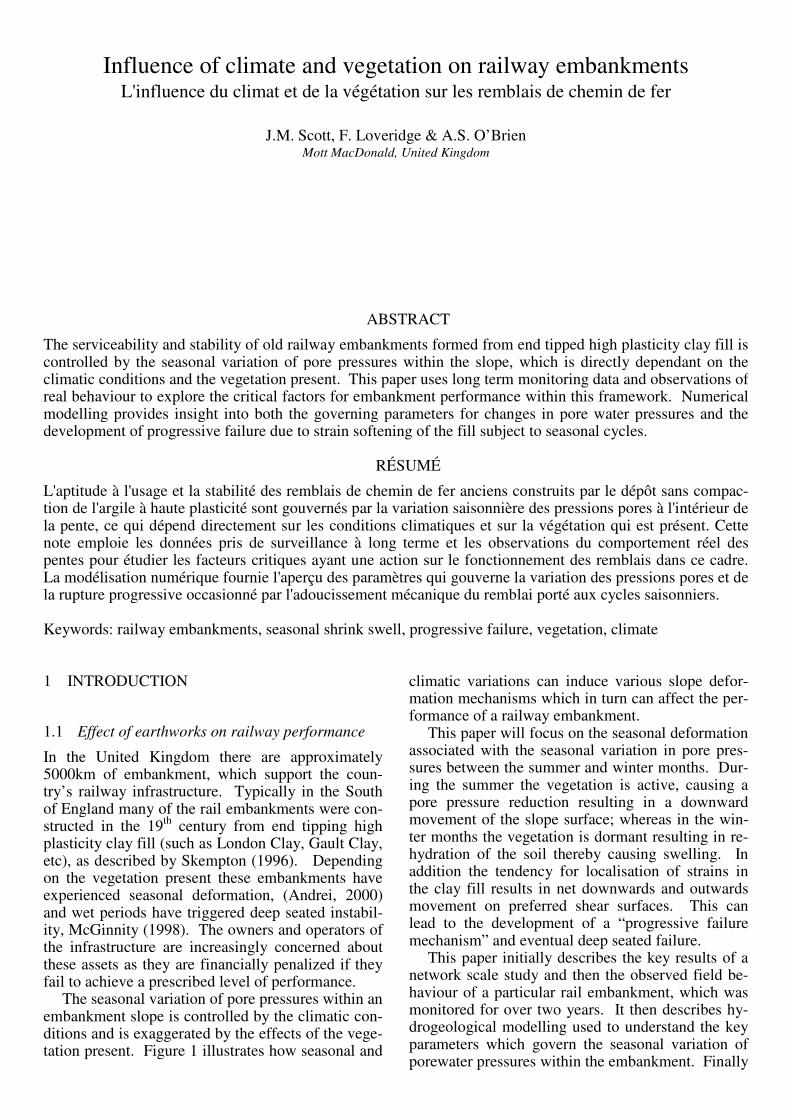
The seasonal variation of pore pressures within an embankment slope is controlled by the climatic con-ditions and is exaggerated by the effects of the vege-tation present. Figure 1 illustrates how seasonal and
climatic variations can induce various slope defor-mation mechanisms which in turn can affect the per-formance of a railway embankment.
This paper will focus on the seasonal deformation associated with the seasonal variation in pore pres-sures between the summer and winter months. Dur-ing the summer the vegetation is active, causing a pore pressure reduction resulting in a downward movement of the slope surface; whereas in the win-ter months the vegetation is dormant resulting in re-hydration of the soil thereby causing swelling. In addition the tendency for localisation of strains in the clay fill results in net downwards and outwards movement on preferred shear surfaces. This can lead to the development of a “progressive failure mechanism” and eventual deep seated failure.
This paper initially describes the key results of a network scale study and then the observed field be-haviour of a particular rail embankment, which was monitored for over two years. It then describes hy-drogeological modelling used to understand the key parameters which govern the seasonal variation of porewater pressures within the embankment. Finally
it describes a series of FLAC numerical models used to replicate the observed seasonal ground move-ments and assess the potential of progressive failure.
Figure 1. Influence of Climate/Vegetation on Embankment Performance
1.2 Network Rail asset performance data
The UK rail network is owned and maintained by the company Network Rail. In order to compensate Train Operating Companies for train delays resulting from the condition of the network, all incidents that cause delays are recorded, along with a cause. By studying the timing and distribution of incidents at-tributed to geotechnical causes it is possible to make inferences about the performance of the earthwork assets. NR have estimated that over the period 2000-2003 “Delay Minutes”, as a result of geotechnical causes, totalled 400,000 at a cost of £26m.
Such studies have determined that there is a strong correlation (coefficient of determination, R2 > 0.8) between occurrence of incidents and asso-ciated delay minutes and the plasticity of the local geology (Mott MacDonald, 2005). In this relation-ship the British Geological Survey Geosure geohaz-ard ranking scheme (BGS, 2003) has been used as an indicator of plasticity and the incidents and de-lays minutes have been normalized by the amount of the network underlain by that geohazard ranking category. Hence high plasticity sites are confirmed as more problematic for the network than low plas-ticity sites.
This relationship is a reflection of the impact of plasticity in the development of seasonal deforma-tions from cyclic shrink-swell behaviour, as well as
the greater susceptibility of high plasticity materials to ultimate deep seated failure.
It was also observed that 5 times as many geo-technical incidents occur in the winter than the summer, and that these incidents cause approxi-mately 10 times the amount of delay minutes (Mott MacDonald, 2006).
2 OBSERVED BEHAVIOUR
To gain a better understanding of the effects of vege-tation a “grass” covered slope and a “tree” covered slope of a London Underground Ltd (LUL) em-bankment has been monitored for over two years. The automated instrumentation installed in July 2004 is described by Scott (2006). The embankment is up to 5m high with an average slope angle of 1:3. It was constructed in 1929 from ending tipping Lon-don Clay and is capped with 1-2m of ash. The fill has a plasticity index of 50% hence has a high po-tential for volume change according to the BRE Di-gest 240.
Historically the embankment has suffered from instability and currently requires significant track maintenance particularly in the summer. The LUL assessment Standard E3321 suggests for a mature tree covered slope lower pore water pressures will be present compared to a grassed slope. Hence a simple limit equilibrium stability assessment gave a factor of safety (FoS) of 1.1 for the grass slope whereas the tree covered slope had a FoS of 1.2-1.3.
2.1 Desiccation induced by vegetation
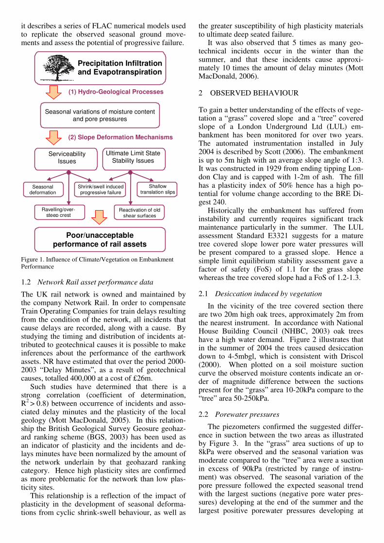
In the vicinity of the tree covered section there are two 20m high oak trees, approximately 2m from the nearest instrument. In accordance with National House Building Council (NHBC, 2003) oak trees have a high water demand. Figure 2 illustrates that in the summer of 2004 the trees caused desiccation down to 4-5mbgl, which is consistent with Driscol (2000). When plotted on a soil moisture suction curve the observed moisture contents indicate an or-der of magnitude difference between the suctions present for the “grass” area 10-20kPa compare to the “tree” area 50-250kPa.
2.2 Porewater pressures
The piezometers confirmed the suggested differ-ence in suction between the two areas as illustrated by Figure 3. In the “grass” area suctions of up to 8kPa were observed and the seasonal variation was moderate compared to the “tree” area were a suction in excess of 90kPa (restricted by range of instru-ment) was observed. The seasonal variation of the pore pressure followed the expected seasonal trend with the largest suctions (negative pore water pres-sures) developing at the end of the summer and the largest positive porewater pressures developing at
(2) Slope Deformation Mechanisms
Ultimate Limit State Stability Issues
Seasonal deformation
Ravelling/over-steep crest
Precipitation Infiltration and Evapotranspiration
Seasonal variations of moisture content and pore pressures
Poor/unacceptable performance of rail assets
(1) Hydro-Geological Processes
Serviceability Issues
Shrink/swell induced progressive failure
Shallow translation slips
Reactivation of old shear surfaces
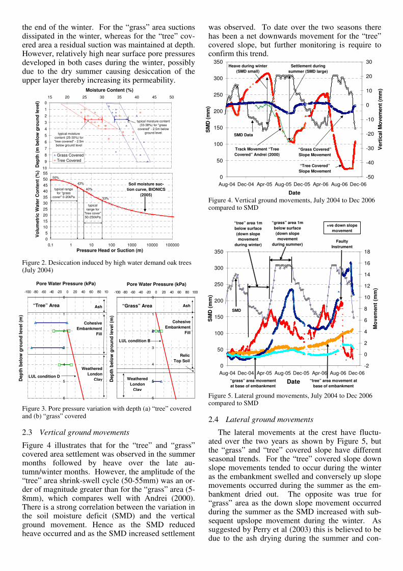
the end of the winter. For the “grass” area suctions dissipated in the winter, whereas for the “tree” cov-ered area a residual suction was maintained at depth. However, relatively high near surface pore pressures developed in both cases during the winter, possibly due to the dry summer causing desiccation of the upper layer thereby increasing its permeability.
Figure 2. Desiccation induced by high water demand oak trees (July 2004)
Figure 3. Pore pressure variation with depth (a) “tree” covered and (b) “grass” covered
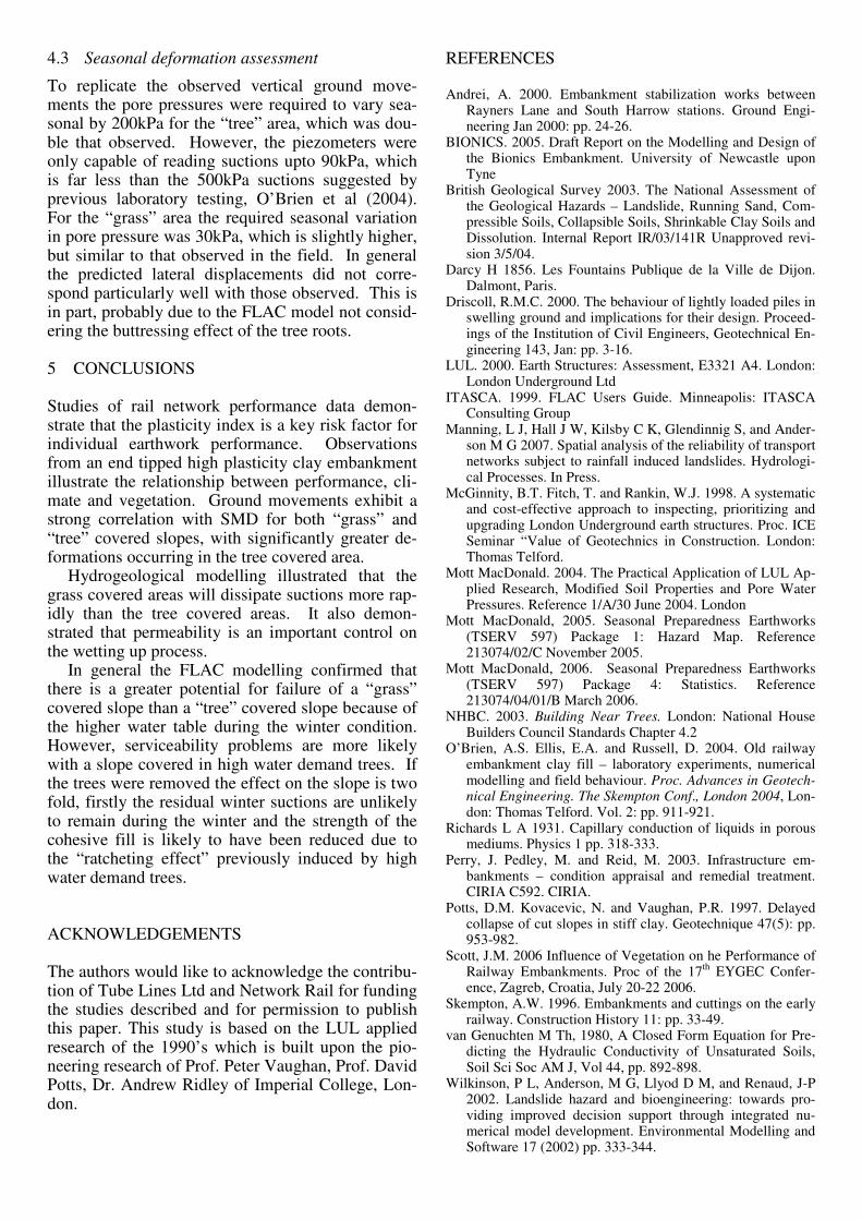
2.3 Vertical ground movements
Figure 4 illustrates that for the “tree” and “grass” covered area settlement was observed in the summer months followed by heave over the late au-tumn/winter months. However, the amplitude of the “tree” area shrink-swell cycle (50-55mm) was an or-der of magnitude greater than for the “grass” area (5-8mm), which compares well with Andrei (2000). There is a strong correlation between the variation in the soil moisture deficit (SMD) and the vertical ground movement. Hence as the SMD reduced heave occurred and as the SMD increased settlement
was observed. To date over the two seasons there has been a net downwards movement for the “tree” covered slope, but further monitoring is require to confirm this trend.
Figure 4. Vertical ground movements, July 2004 to Dec 2006 compared to SMD
Figure 5. Lateral ground movements, July 2004 to Dec 2006 compared to SMD
2.4 Lateral ground movements
The lateral movements at the crest have fluctu-ated over the two years as shown by Figure 5, but the “grass” and “tree” covered slope have different seasonal trends. For the “tree” covered slope down slope movements tended to occur during the winter as the embankment swelled and conversely up slope movements occurred during the summer as the em-bankment dried out. The opposite was true for “grass” area as the down slope movement occurred during the summer as the SMD increased with sub-sequent upslope movement during the winter. As suggested by Perry et al (2003) this is believed to be due to the ash drying during the summer and con-
0
1
2
3
4
5
6
7
8
9
10
15 20 25 30 35 40 45 50
Moisture Content (%)
Dep
th (m
bel
ow g
roun
d)
Grass CoveredTree Covered
typical moisture content (25-30%) for "tree covered" - 2.5m below ground level
typical moisture content (33-38%) for "grass
covered" - 2.5m below ground level
05
10152025303540455055
0.1 1 10 100 1000 10000 100000Pressure Head or Suction (m)
Vol
umet
ric
Wat
er C
onte
nt (%
)
`
43%
typical range for "grass
cover" 0-20kPa
50%
typical range for
"tree cover" 50-250kPa
40%
33%
Soil moisture suc-tion curve, BIONICS
(2005)
Pressure Head or Suction (m)
Moisture Content (%)
Dep
th (m
bel
ow g
roun
d le
vel)
Vol
umet
ric
Wat
er C
onte
nt (%
)
0
50
100
150
200
250
300
350
Aug-04 Dec-04 Apr-05 Aug-05 Dec-05 Apr-06 Aug-06 Dec-06
Date
SM
D (m
m)
-50
-40
-30
-20
-10
0
10
20
30
Ver
tical
Mov
emen
t (m
m)
Heave during winter (SMD small)
Settlement during summer (SMD large)
SMD Data
“Tree Covered” Slope Movement
“Grass Covered” Slope Movement
Track Movement “Tree Covered” Andrei (2000)
+ve down slope movement
“grass” area movement at base of embankment
“tree” area movement at base of embankment
“grass” area 1m below surface (down slope movement
during summer)
“tree” area 1m below surface (down slope movement
during winter)
SMD
Faulty Instrument
0
50
100
150
200
250
300
350
Aug-04 Dec-04 Apr-05 Aug-05 Dec-05 Apr-06 Aug-06 Dec-06
Date
SM
D (m
m)
-2
0
2
4
6
8
10
12
14
16
18
Mov
emen
t (m
m)
0
1
2
3
4
5
6
-100 -80 -60 -40 -20 0 20 40 60 80 100
Pore Water Pressure (kPa)
Dep
th B
elow
Gro
und
Leve
l (m
)
Ash
Weathered London
Clay
Cohesive Embankment
Fill
LUL Conditon D
0
1
2
3
4
5
6
-100 -80 -60 -40 -20 0 20 40 60 80 100
Pore Water Pressure (kPa)
Dep
th B
elow
Gro
und
Leve
l (m
)
Ash
Weathered London Clay
Cohesive Embankment
Fill
RelicTop Soil
LUL Conditon B
Pore Water Pressure (kPa) Pore Water Pressure (kPa)
Dep
th b
elow
gro
und
leve
l (m
)
Dep
th b
elow
gro
und
leve
l (m
)
Cohesive Embankment
Fill
Cohesive Embankment
Fill
Ash Ash
Weathered London
Clay
Weathered London
Clay
LUL condition B
LUL condition D
Relic Top Soil
“Tree” Area “Grass” Area

versely becoming more stable in the wetter winter months due to a capillary menisci developing be-tween the ash particles resulting in an apparent co-hesion. At depth there is not a seasonal trend for the “grass” covered slope, however for the “tree” cov-ered slope there has been continual outward move-ment at the base of the embankment albeit very small (3mm) which may be indicative of gradual creep/progressive deep seated movement.
3 HYDROLOGICAL MODELLING
Changes in pore pressures in embankments are con-trolled by two factors, the rate and duration of infil-tration and the permeability and permeability con-trasts within the embankment fill. In order to better understand the process of seasonal porepressure changes a hydrogeological model of the embank-ment described above has been produced using the software CHASM (eg Wilkinson et al, 2002).
CHASM allows rainfall to infiltrate the surface of a slope, whereby vertical flow in the unsaturated zone is governed by Richards Equation (Richards, 1931) and flow in the saturated zone is governed by Darcy’s law (Darcy, 1856). CHASM was designed for use with tropical soils and climate. Consequently there are a number of limitations with its use for long duration models which are required to simulate the winter wetting up of embankments over a num-ber of months. These limitations have been de-scribed by Manning et al (2007), and include the ap-plicability of the evaporation model. For this reason the embankment has been modeled based on an as-sumed end of summer condition and considers only the winter period when evaporation can be assumed to be negligible. Assumed initial conditions for the modelling are summarised in Table 1 and Figure 6. Table 1 CHASM Initial End of Summer Conditions
Vegetation Cover
Surface Suction
Depth to Water Table Crest / Toe
Tree 200 200kPa 5m / 2m Grass 100 100kPa 2m /2m Grass 20 20kPa 2m / 2m
3.1 Permeability of Embankment Fill
Whilst, in-situ parent clays may be of low perme-ability, for example 10-10 m/s, the end-tipped con-struction of the embankments mean that the derived fill is much more permeable. Average in-situ per-meability measurements for London Clay fill are 3x10⁻⁸ m/s (O’Brien et al, 2004). In addition, sig-nificant variability may exist within the embank-ment. Desiccation on the embankment slopes may result in increased permeability by up to three orders of magnitude. Sandy layers within the fill or past drainage measures may also result in higher perme-ability conduits being present.
The presence of the ballast and granular fill layers at the top of the embankment provides a high per-meability cap to the structure through which rain water can easily infiltrate and then pond. This pro-vides a sump which allows infiltration to the core of the embankment. The desiccated embankment slopes can also function in a similar way.
Figure 6. Geometry of CHASM Model Table 2 CHASM soil input parameters
van Genuchten constants (van Genuchten, 1980) Material Ksat m/s θsat θres α m-1 m Ballast 5 x 10⁻³ 0.45 0.05 5 2 Ash / Granu-lar Fill
1 x 10⁻⁵ 0.40 0.06 1.1 1.5
Clay Fill 3 x 10⁻⁸ 0.5 0.15 1 1.2 Clay Foun-dation
3 x 10⁻¹⁰ 0.45 0.15 1 1.2
As a result of the factors described above, perme-
ability is a key input parameter to the CHASM model. Consequently, although the model presented is highly simplified, it is designed to address the ef-fect of two variables. Firstly the initial conditions re-sulting from the combined effects of summer climate and vegetation type, and secondly, the permeability of the embankment fill. Initial parameters are given in Table 2; subsequently variation in permeability was also investigated and this is discussed below.
Figure 7. CHASM pore pressures at Profile 1(a) “tree” - suc-tion 200kPa and (b) “grass” – suction 100kPa
3.2 Results of Modelling
The results of the CHASM model, using the initial conditions indicated in Table 1 and subject to 34mm
Pro
file
1
Pro
file
2
1A1B
2A
2B
Initial Water Table Tree
Initial Water Table Grass
Ballast
Ash/Granular Fill
Clay Fill
Clay Foundation
0
1
2
3
4
5
6
-200 -150 -100 -50 0 50
pore pressure kPa
met
res
belo
w s
urfa
ce
day 0
day 5
day 10
day 20
day 57
day 96
0
1
2
3
4
5
6
-200 -150 -100 -50 0 50pore pressure kPa
met
res
belo
w s
urfa
ce
day 0
day 5
day 10
day 20
day 57
Pore Pressure (kPa) Pore Pressure (kPa)
Met
res
Bel
ow S
urfa
ce
Met
res
Bel
ow S
urfa
ce
“Tree”
Area “Grass”
Area

0
1
2
3
4
5
6
-200 -150 -100 -50 0 50
pore pressure kPa
met
res
belo
w s
urfa
ce
k=3e10-6k=3e10-7
k=3e10-8k=3e10-9
rainfall per week are given in Figure 7 and Figure 8. This precipitation rate is based on actual rainfall that fell in the area over a 3 month period at the start of the wet winter of 2000/2001, and therefore repre-sents a realistic worst case scenario.
Figure 8. Dissipation of suctions with time (for location of points see Figure 6)
The results demonstrate the marked difference in behaviour between a “grass” slope and a “tree” cov-ered slope. Whilst a “grass” slope would have dissi-pated suctions by 57 days, a “tree” covered slope re-
tains residual suctions of around 35kPa at depth after 3 months.
Sensitivity to the effect of permeability of the embankment fill is shown in Figure 9. This indicates that for values of around 10-6 to 10-7 m/s this precipi-tation rate matches well the rate at which the soil can take up moisture. However, for lower permeability, there is a significant lag at depth, with leads to the preservation of the residual suctions.
Figure 9 CHASM pore pressures at Profile 1 for tree covered slope after 30 days.
4 DEFORMATION/STABILITY MODELLING
4.1 Basis of FLAC model
Numerical modelling was undertaken using the fi-nite difference program FLAC, ITASCA (1999) to identify the potential of the embankment to fail in a progressive manner and to replicate the seasonal ground movements. The modelling methodology was based on previous LUL applied research, O’Brien et al (2004), which was calibrated against research undertaken by Potts el al (1997). For the London Clay embankment fill a strain softening strength model was adopted, which defined strengths at peak, post rupture and residual states as given in Table 3. The initial embankment construction was
modeled undrained. Subsequently a series of shrink-swell cycles were applied to the embankment to simulate the seasonal variation of pore pressure from an extreme “summer” to “winter” condition. Table 3 FLAC – Embankment Fill Material Parameters
London Clay Fill Bulk unit weight
18.8 kN/m3
Young’s modulus
75(p′+100), min. 5000 kPa
Poisson’s ratio 0.2 Peak strength (Bulk)
c′ = 7.0 kPa, φ′ = 21.0°
Post-rupture strength
c′ = 2.0 kPa, φ′ = 21.0°
Residual strength
c′ = 2.0 kPa, φ′ = 13.0°
Plastic strain at peak strength, γ p 3 % Plastic disp. to post-rupture strength, δ p 5 mm Plastic disp. to residual strength, δ p 100 mm
4.2 Progressive Failure Assessment
It was shown that the rate at which a progressive failure develops is related to the magnitude of the seasonal change in pore water pressure and the pres-ence of a residual winter suction. On the basis of applying a summer surface suction of 100kPa and there not being a residual winter suction a progres-sive failure occurred after the 35th shrink swell cy-cle, as shown in Figure 10. The embankment was constructed in the early 1930’s and there is evidence of remedial measures being implemented from the 1960’s through to the 1990’s. Therefore the sug-gested rate at which slope stability degraded (i.e. over a 35 to 50 year period) seems consistent with anecdotal evidence.
For the model representing the “tree” covered slope with a winter residual suction of 30kPa a pro-gressive failure did not develop after 50 cycles de-spite applying a much large summer suction of 250kPa. This is because the residual winter suction maintained stability during the winter condition, de-spite significant strain softening at the toe of the slope. However, if the residual suction was not maintained during the winter (i.e. if the tree was felled) then the previous historical strain softening resulted in a deep slip.
Figure 10. Failure of grass slope after 35 shrink swell cycles
γp = plastic shear strain
δp = plastic displacement
Subscripts:
p = peak; pr = post-rupture
r = residual
γpp
δprp
δrp
τ
γ p or δ p
cp′, φp′
cpr′, φpr′
cr′, φr′
FLAC (Version 4.00)
LEGEND
24-Feb-06 13:14 step 2906331Cons. Time 3.4875E+01 6.000E+00 <x< 2.850E+01 3.800E+01 <y< 6.020E+01
Max. shear strain increment 0.00E+00 2.50E+02 5.00E+02 7.50E+02 1.00E+03 1.25E+03 1.50E+03 1.75E+03 2.00E+03 2.25E+03
Contour interval= 2.50E+02Displacement vectorsMax Vector = 5.094E+03
0 1E 4 4.000
4.400
4.800
5.200
5.600
(*10^1)
0.800 1.200 1.600 2.000 2.400 2.800(*10^1)
JOB TITLE : Queensbury Emb. Sec4 - B086/JSB 0100 "Grass Covered" 1.15m of ash
Mott MacDonald
Progressive Failure
Pore Pressure (kPa)
Met
res
Bel
ow S
urfa
ce
residual suction after 96 days
01224364860728496
1A 1B 2A 2B
days
to z
ero
suct
ion
tree 200
grass 100
grass 20
-4.7kPa -18.3kPa -16.5kPa
Initial conditions
4.3 Seasonal deformation assessment
To replicate the observed vertical ground move-ments the pore pressures were required to vary sea-sonal by 200kPa for the “tree” area, which was dou-ble that observed. However, the piezometers were only capable of reading suctions upto 90kPa, which is far less than the 500kPa suctions suggested by previous laboratory testing, O’Brien et al (2004). For the “grass” area the required seasonal variation in pore pressure was 30kPa, which is slightly higher, but similar to that observed in the field. In general the predicted lateral displacements did not corre-spond particularly well with those observed. This is in part, probably due to the FLAC model not consid-ering the buttressing effect of the tree roots.
5 CONCLUSIONS
Studies of rail network performance data demon-strate that the plasticity index is a key risk factor for individual earthwork performance. Observations from an end tipped high plasticity clay embankment illustrate the relationship between performance, cli-mate and vegetation. Ground movements exhibit a strong correlation with SMD for both “grass” and “tree” covered slopes, with significantly greater de-formations occurring in the tree covered area.
Hydrogeological modelling illustrated that the grass covered areas will dissipate suctions more rap-idly than the tree covered areas. It also demon-strated that permeability is an important control on the wetting up process.
In general the FLAC modelling confirmed that there is a greater potential for failure of a “grass” covered slope than a “tree” covered slope because of the higher water table during the winter condition. However, serviceability problems are more likely with a slope covered in high water demand trees. If the trees were removed the effect on the slope is two fold, firstly the residual winter suctions are unlikely to remain during the winter and the strength of the cohesive fill is likely to have been reduced due to the “ratcheting effect” previously induced by high water demand trees.
ACKNOWLEDGEMENTS
The authors would like to acknowledge the contribu-tion of Tube Lines Ltd and Network Rail for funding the studies described and for permission to publish this paper. This study is based on the LUL applied research of the 1990’s which is built upon the pio-neering research of Prof. Peter Vaughan, Prof. David Potts, Dr. Andrew Ridley of Imperial College, Lon-don.
REFERENCES
Andrei, A. 2000. Embankment stabilization works between Rayners Lane and South Harrow stations. Ground Engi-neering Jan 2000: pp. 24-26.
BIONICS. 2005. Draft Report on the Modelling and Design of the Bionics Embankment. University of Newcastle upon Tyne
British Geological Survey 2003. The National Assessment of the Geological Hazards – Landslide, Running Sand, Com-pressible Soils, Collapsible Soils, Shrinkable Clay Soils and Dissolution. Internal Report IR/03/141R Unapproved revi-sion 3/5/04.
Darcy H 1856. Les Fountains Publique de la Ville de Dijon. Dalmont, Paris.
Driscoll, R.M.C. 2000. The behaviour of lightly loaded piles in swelling ground and implications for their design. Proceed-ings of the Institution of Civil Engineers, Geotechnical En-gineering 143, Jan: pp. 3-16.
LUL. 2000. Earth Structures: Assessment, E3321 A4. London: London Underground Ltd
ITASCA. 1999. FLAC Users Guide. Minneapolis: ITASCA Consulting Group
Manning, L J, Hall J W, Kilsby C K, Glendinnig S, and Ander-son M G 2007. Spatial analysis of the reliability of transport networks subject to rainfall induced landslides. Hydrologi-cal Processes. In Press.
McGinnity, B.T. Fitch, T. and Rankin, W.J. 1998. A systematic and cost-effective approach to inspecting, prioritizing and upgrading London Underground earth structures. Proc. ICE Seminar “Value of Geotechnics in Construction. London: Thomas Telford.
Mott MacDonald. 2004. The Practical Application of LUL Ap-plied Research, Modified Soil Properties and Pore Water Pressures. Reference 1/A/30 June 2004. London
Mott MacDonald, 2005. Seasonal Preparedness Earthworks (TSERV 597) Package 1: Hazard Map. Reference 213074/02/C November 2005.
Mott MacDonald, 2006. Seasonal Preparedness Earthworks (TSERV 597) Package 4: Statistics. Reference 213074/04/01/B March 2006.
NHBC. 2003. Building Near Trees. London: National House Builders Council Standards Chapter 4.2
O’Brien, A.S. Ellis, E.A. and Russell, D. 2004. Old railway embankment clay fill – laboratory experiments, numerical modelling and field behaviour. Proc. Advances in Geotech-nical Engineering. The Skempton Conf., London 2004, Lon-don: Thomas Telford. Vol. 2: pp. 911-921.
Richards L A 1931. Capillary conduction of liquids in porous mediums. Physics 1 pp. 318-333.
Perry, J. Pedley, M. and Reid, M. 2003. Infrastructure em-bankments – condition appraisal and remedial treatment. CIRIA C592. CIRIA.
Potts, D.M. Kovacevic, N. and Vaughan, P.R. 1997. Delayed collapse of cut slopes in stiff clay. Geotechnique 47(5): pp. 953-982.
Scott, J.M. 2006 Influence of Vegetation on he Performance of Railway Embankments. Proc of the 17th EYGEC Confer-ence, Zagreb, Croatia, July 20-22 2006.
Skempton, A.W. 1996. Embankments and cuttings on the early railway. Construction History 11: pp. 33-49.
van Genuchten M Th, 1980, A Closed Form Equation for Pre-dicting the Hydraulic Conductivity of Unsaturated Soils, Soil Sci Soc AM J, Vol 44, pp. 892-898.
Wilkinson, P L, Anderson, M G, Llyod D M, and Renaud, J-P 2002. Landslide hazard and bioengineering: towards pro-viding improved decision support through integrated nu-merical model development. Environmental Modelling and Software 17 (2002) pp. 333-344.