lincoln reconnaissance report - mass.gov · mark whitehead june 2006 . ... lincoln reconnaissance...
TRANSCRIPT

LINCOLN RECONNAISSANCE REPORT
FREEDOM’S WAY LANDSCAPE INVENTORY
MASSACHUSETTS HERITAGE LANDSCAPE INVENTORY PROGRAM
Massachusetts Department of Conservation and Recreation
Freedom’s Way Heritage Association
PROJECT TEAM Massachusetts Department of Conservation and Recreation Jessica Rowcroft, Preservation Planner Division of Planning and Engineering Freedom’s Way Heritage Association Mary Whitney, President Marge Darby, Chair, Advisory Committee Project Consultants Shary Page Berg Gretchen G. Schuler Local Project Coordinator Mark Whitehead Local Heritage Landscape Participants Ken Bassett Margie Brown Neil Feinberg Angela Kearney Sue Klem John LeGates Jack Maclean Peggy Marsh Peg Martin Ellen Meadors John Ott, FWHA Paul Suetz Mark Whitehead June 2006

CONTENTS Introduction . . . . . . . . . . . . . . . . . . . . . . . . . . . . . . . . . . . . . . . . . . . . . . . . . . . . . 1 Lincoln History . . . . . . . . . . . . . . . . . . . . . . . . . . . . . . . . . . . . . . . . . . . . . . . . . . 2 Priority Heritage Landscapes . . . . . . . . . . . . . . . . . . . . . . . . . . . . . . . . . . . . . . 3
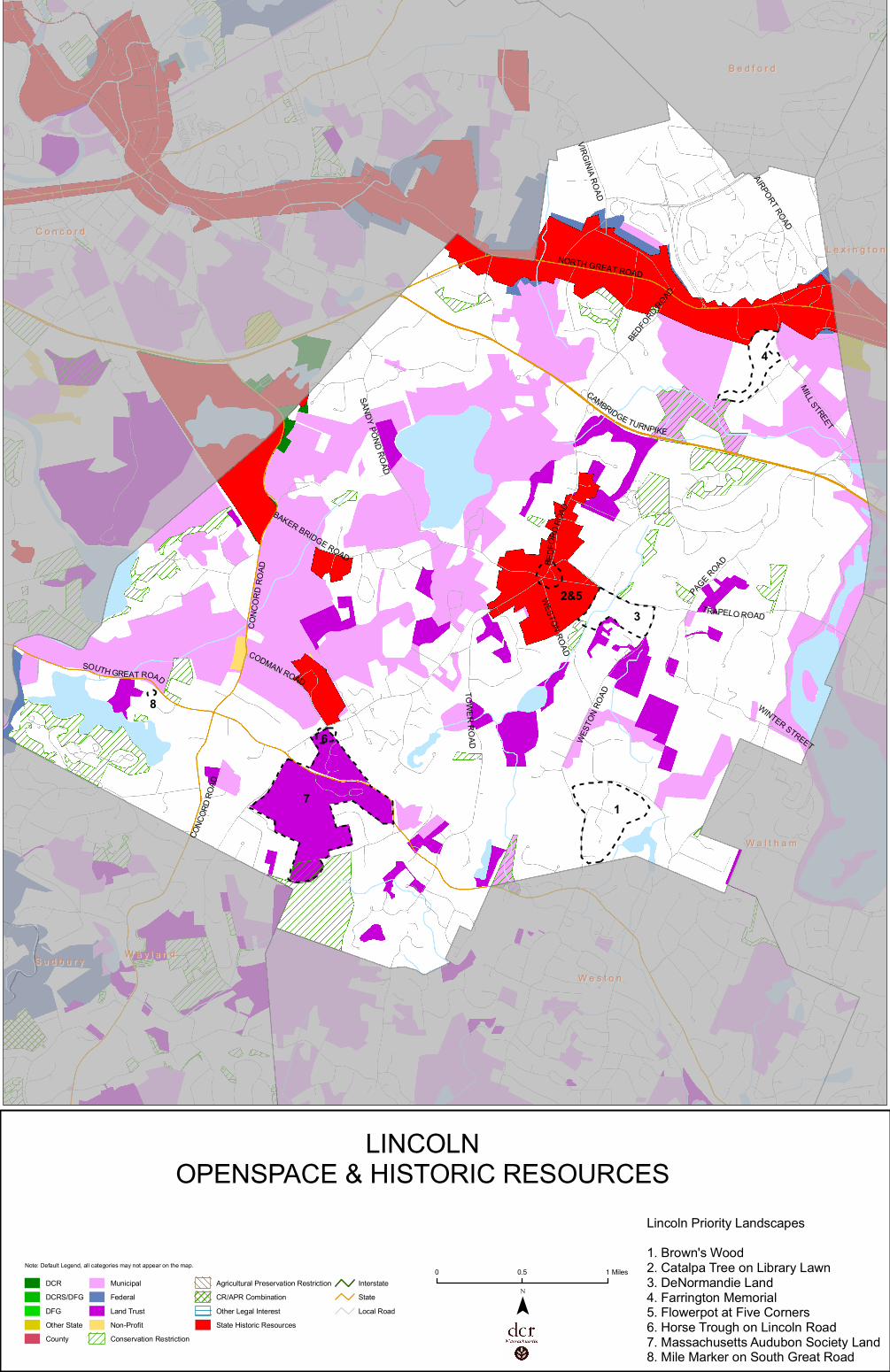
Brown’s Wood Catalpa Tree on Library Lawn DeNormandie Land Farrington Memorial Flowerpot at Five Corners Horse Trough on Lincoln Road Massachusetts Audubon Society Land Mile Marker on South Great Road
Critical Concerns. . . . . . . . . . . . . . . . . . . . . . . . . . . . . . . . . . . . . . . . . . . . . . . . . 8
Agriculture Churches as Community Focal Points Dark Sky Historic Houses
Land Stewardship, Trails and Regional Landscapes Minute Man National Historical Park Scenic Roads Stone Walls Water Quality and Access
Existing Resource Documentation and Planning Tools . . . . . . . . . . . . . . . . 12 Inventory of Historic and Archaeological Assets State and National Registers of Historic Places Planning Documents and Tools General Preservation Planning Recommendations . . . . . . . . . . . . . . . . . . . . 14 Inventory of Heritage Landscapes National Register Program Agricultural Landscapes Village and Neighborhood Character Scenic Roads Funding of Preservation Projects Conclusion . . . . . . . . . . . . . . . . . . . . . . . . . . . . . . . . . . . . . . . . . . . . . . . . . . . . . 19 Appendix: Heritage Landscapes Identified by Community . . . . . . . . . . . . . 21
Massachusetts Heritage Landscape Inventory Program 1 Lincoln Reconnaissance Report
INTRODUCTION The Freedom’s Way Heritage Association includes 37 Massachusetts communities that are linked by historic events that helped to shape America’s democratic form of governance and the intellectual traditions that underpin American freedom, democracy, conservation and social justice. Freedom’s Way communities extend from Arlington on the east to Winchendon on the west. They represent a wide range of cities and towns, each shaped by the relationship between nature and culture. Heritage landscapes are special places created by human interaction with the natural environment that help define the character of a community and reflect its past. They are dynamic and evolving; they reflect the history of a community and provide a sense of place; they show the natural ecology that influenced land use patterns; and they often have scenic qualities. The wealth of landscapes is central to each community’s character, yet heritage landscapes are vulnerable and ever changing. For this reason it is important to take the first steps towards their preservation by identifying those landscapes that are particularly valued by the community – a favorite local farm, a distinctive neighborhood or mill village, a unique natural feature or an important river corridor. To this end, the Massachusetts Department of Conservation and Recreation (DCR) and the Freedom’s Way Heritage Association (FWHA) have collaborated to bring the Heritage Landscape Inventory program (HLI) to communities in the Freedom’s Way area. The primary goal of the program is to help communities identify a wide range of landscape resources, particularly those that are significant and unprotected. The focus is on landscapes that have not been identified in previous survey efforts in a given community. Another important goal of the program is to provide communities with strategies for preserving heritage landscapes. The methodology for the Heritage Landscape Inventory program was developed in a pilot project conducted in southeast Massachusetts and refined in Essex County. It is outlined in the DCR publication Reading the Land which has provided guidance for the program since its inception. In summary, each participating community appoints a Local Project Coordinator (LPC) to assist the DCR-FWHA consulting team. The LPC organizes a heritage landscape identification meeting at which interested residents and town officials offer community input by identifying heritage landscapes. This meeting is followed by a fieldwork session including the consulting team and the LPC, often accompanied by other community members. This group visits the priority landscapes identified in the meeting and gathers information about the community. The final product is this Reconnaissance Report, prepared for each participating community. It outlines the history of the community; describes the priority heritage landscapes; discusses planning issues identified by the community; identifies planning tools available in the community; and concludes with preservation recommendations. A list of all of the heritage landscapes identified by the community is included in the Appendix.

Massachusetts Heritage Landscape Inventory Program 2 Lincoln Reconnaissance Report
LINCOLN HISTORY The Native American history of Lincoln dates back to the Middle Archaic Period (8,000-6,000 B.P.) with confirmed sites from this period through the Contact Period (1500-1620). The banks of the Sudbury River and areas along the brooks made good campsites with hunting and fishing nearby. In the Contact Period the Massachusetts Indians were active in the area, especially along rivers, and established an early trail system that became the basis of later roads.
Most of Lincoln was initially the easterly part of Concord, which was settled by Europeans in 1635, the first Massachusetts settlement inland of the tidewater. Small westerly sections of Lexington and Weston were included in the area that, in 1746, became the second precinct of Concord. In 1754, Judge Chambers Russell petitioned the General Court to incorporate the precinct as the town of Lincoln. By the mid-18th century, Lincoln Center had become an important crossroads. Routes radiating out from the meetinghouse included Trapelo, Bedford, Lexington, Weston, Lincoln and Baker Bridge Roads. The primary east-west roads were North Great Road and South Great Road and the north-south road was the portion of Concord Road near Fairhaven Bay. Settlement was scattered, with the old town center developing around the meetinghouse circa 1750. The Colonial economy was primarily agriculture and grazing, which were practiced on small farms, many of which also included extensive orchards, initially apple and later peach. Hay was also an important crop. Seasonal sawmills provided lumber. During the 19th century Lincoln remained largely agricultural, with a small town center. Roads improved during the early 19th century. The coming of the railroad in 1844 helped to expand the agricultural base beyond production for local consumption to providing produce for Boston markets. Location of the depot also helped to establish South Lincoln as a distinct place. By the late 19th century, the town center had increased in size and rural properties (especially hilltops) were purchased by wealthy Boston residents who were attracted to the rural atmosphere and convenient access. Institutional buildings such as churches, schools, public library and town hall were built during this period, some designed by well-known Boston architects. With the advent of the automobile, roads improved in the early 20th century, notably Concord Turnpike (Route 2), South Great Road (Route 117) and Concord Road (Route 126). Agriculture declined after World War II with greatly increased residential development in the late 20th century. Commuters moved to Lincoln, residential subdivisions were constructed and the population grew to 8,000 in 2000, including residents of Hanscom Air Force Base (part of which is in Lincoln) who accounted for nearly 3,000 people.
Massachusetts Heritage Landscape Inventory Program 3 Lincoln Reconnaissance Report
PRIORITY HERITAGE LANDSCAPES Lincoln's Heritage Landscape Identification meeting, attended by approximately a dozen residents, some representing town boards and local non-profit organizations, was held on March 3, 2006. During the meeting residents compiled a lengthy list of the town's heritage landscapes, which is included in the Appendix. Once the comprehensive list was created, attendees were asked to articulate the value of each landscape and the issues relating to its preservation. Based on the information gathered, community members identified a group of priority landscapes to be visited by the consulting team during the fieldwork. Each of the priority landscapes is highly valued, contributes to community character and is not permanently protected or preserved. These landscapes, which are listed alphabetically, represent a range of scales and types of resources. The descriptions and recommendations included here are an initial step in identifying resources valued by the community and suggesting action strategies. Brown’s Wood Brown’s Wood, located east of Weston Road near Valley Pond, is a modest mid-20th century neighborhood that was developed after World War II as a non-profit cooperative by young couples seeking modern architecture at an affordable price. It remains notable for its semi-cooperative organization and the fact that it involved the architects and the owners in the design and construction of the 23 houses. The area is characterized by contemporary residences on large lots in a wooded naturalistic setting. Residents value the character of their neighborhood and are interested in establishing a mechanism to preserve neighborhood character. Members of the Brown’s Wood Association have prepared a study report to document the unique character of the neighborhood and establishment of a Neighborhood Conservation District Bylaw is pending. Refer to Village and Neighborhood Character in the General Preservation Planning Recommendations section of this report for additional recommendations regarding preservation of neighborhood character. Catalpa Tree on Library Lawn The catalpa tree on the library grounds is particularly valued by Lincoln residents for the unusual whorled character of its trunk. The tree was probably planted soon after the library was dedicated in 1883. It is believed to be a Southern Catalpa (Catalpa bignonioides), which is slightly different than the Northern Catalpa typically found in New England. Library donor Grosvenor Tarbell had contacts in Lexington, Kentucky and it may have been that association that brought the tree to Lincoln. It is likely that there were actually several small saplings planted in close proximity and they were twisted together to create the unique appearance of the trunk.

Massachusetts Heritage Landscape Inventory Program 4 Lincoln Reconnaissance Report
Recommendations The primary goal for the catalpa tree is to preserve it for future generations. A secondary goal would be to learn more about the history of the tree. The tree warden would be the logical person to implement the first goal and the Historical Commission to implement the second. � Arrange for regular inspection of the tree by a qualified arborist and
implement appropriate measures as recommended.
� Conduct further research on the history of this particular tree (perhaps in local newspapers or town reports). Also investigate whether planting three together was a common technique and if there are other extant examples. The Arnold Arboretum Library is a good source of information on historic trees. Consider an exhibit at the library about this and other special features of the town such as the flowerpot, horse trough and mile marker.
� Seek assistance from tree programs administered by DCR. Review types of
programs available for planting, protection and maintenance of public trees at http://www.mass.gov/dcr/stewardship/forestry/urban/urbanGrants.htm.
DeNormandie Land The DeNormandie Farm on Trapelo Road is one of the largest land holdings in Lincoln and one of the most visible farms in the community. It is particularly valued for the scenic quality of the barn and pond, which are visible from the road, and for the sledding hill, which the DeNormandie family has informally allowed town residents to use for years. The farm was home to a herd of prize-winning Guernsey cows until recently and today is used primarily for haying. As in most Metro-West communities, land values for housing far exceed the profits that can be derived from farming and farms are increasingly vulnerable to development. An important goal of the community is to maintain farming activity in Lincoln. If this is not possible the next best option is to protect some of the land as open space. Recommendations The town and local non-profit groups have worked together on land conservation and agricultural preservation for years and have a solid track record of success. Two important distinctions with the DeNormandie land are the long history of public use of the sledding hill and the importance of the agricultural buildings, particularly those that are visible from the road, as tangible reminders of Lincoln’s agricultural past. � Assemble an informal group to formulate a plan for preservation should the
DeNormandie land become available. Include history of farm and description of farming activities as well as historic resources seen from the public way.

Massachusetts Heritage Landscape Inventory Program 5 Lincoln Reconnaissance Report
� Consider purchase options, preservation and conservation restrictions, agricultural preservation restrictions and partial CPA funding of restrictions or purchase of the property.
� Consider possible role of Sudbury Valley Trustees in fundraising. If partial
development is the only option, consult with SVT and Wayland residents regarding lessons learned in the 1995 purchase of the Paine Estate.
Farrington Memorial Charles Farrington established the Farrington Memorial in honor of his parents, Ebenezer and Eliza Farrington. His goal was to maintain a non-sectarian philanthropic resource for enriching the lives of urban children. The Farrington Memorial opened in July 1912 to care for sick children from Children's Hospital who needed a temporary stay in the country to recuperate. Until World War II, the Farringtons took in sick children after they were released from Children's Hospital. The hospital provided nurses and a cook to care for these children at the Farrington estate where they regained their strength in the country before returning home to their "cold water flats." After World War II, Children's Hospital could not afford to maintain the cost of caring for the children at Farrington. Since then, the memorial has served a variety of people in need, including the Rosemary Project, programs run by the City Mission Society and the Gould Farm Program.
The 80-acre property at 291 Cambridge Turnpike includes the large brick building that was constructed specifically as a hospital, a farmhouse and related agricultural buildings. Its primary frontage is along Route 2 but the buildings are set well back from the road. The gently sloping land includes a mix of open fields and woodland with some wetlands. The site is currently used in the summer for an environmental program for low-income culturally diverse children living in Boston and its suburbs. The Farrington Trustees wish to expand the summer program to provide children with more educational activities, and to return to Charles Farrington's original mission to provide a healthy country environment for city children. Recommendations Like many heritage landscapes, the Farrington Memorial includes both historic and natural resources. As a charitable institution it also serves an important civic function. It has been a relatively stable institution for nearly a century but like all institutions it is also vulnerable to change. It is a large parcel in a critical location and it is of particular interest to the town. � Maintain open communication between town and Farrington Memorial
trustees to identify issues of mutual concern and resolve them in an amicable manner. These might include documentation of the historic resources of the property on MHC inventory forms, land stewardship issues and trail linkage opportunities.

Massachusetts Heritage Landscape Inventory Program 6 Lincoln Reconnaissance Report
� Work with trustees to preserve land in its current use. If change appears imminent, consider purchase options, preservation and conservation restrictions and partial CPA funding of restrictions or purchase of property.
Flowerpot at Five Corners This small feature, located in the traffic island in front of the library, is one of the smallest heritage landscapes identified to date but it is a town icon and a symbol of the community’s rural heritage. It is an 1892 horse trough that has been converted to a decorative planter. It was originally topped by a gas light on the central pipe, one of the first street lights in Lincoln. The MHC inventory form indicates that it was designed by architect Henry F. Jenks. The area immediately around it has recently been re-landscaped to provide some protection from cars and to make it easier for pedestrians to cross the street.
Recommendations The primary goal for the flowerpot is to preserve it for future generations. A secondary goal would be to learn more about its history. � Inspect flowerpot regularly for signs of deterioration. Establish a
maintenance program that includes regular painting. If deterioration becomes evident, consult an architectural conservator.
� Conduct research on the history of the flowerpot and consider an exhibit at
the library about this and other special features of the town such as the catalpa tree, horse trough and mile marker.

Massachusetts Heritage Landscape Inventory Program 7 Lincoln Reconnaissance Report
Horse Trough on Lincoln Road The large granite horse trough located on Lincoln Road at the corner of Codman Road is another important historical feature of the community. It is dated 1883, a period when many civic improvements were made in town. At that time the intersection was an important crossroads in an area where there was extensive agriculture. The trough was also used by those going to the Lincoln School and to the depot. Recommendations The goals for the horse trough are similar to those for the flowerpot. In addition to the recommendations listed above, the Historical Commission should: � Document horse trough on an MHC inventory form. Massachusetts Audubon Society Land The Massachusetts Audubon Society owns a large amount of land in South Lincoln. There are two main parcels, the Drumlin Farm property south of Route 117, the core of which is operated as a historic farm, and the former Hatheway Estate north of Route 117, which is now the Society’s headquarters. While much of the Audubon land is under permanent conservation restrictions, some parts along Lincoln Road are not permanently protected. In addition, the historic resources associated with past use of the land, especially the Hatheway Estate, have not been documented on MHC inventory forms. Recommendations The town already has a working relationship with the Massachusetts Audubon Society that relates to many areas of mutual concern, including wildlife management, trail system, land stewardship and traffic impacts of Drumlin Farm. � Document historic resources of Hatheway Estate on an MHC inventory form.
� Use the next town open space plan as an opportunity to expand the dialogue
between the town and the Audubon Society to include other areas of shared interest such as possible documentation of historic resources on the Hatheway Estate and establishing permanent conservation restrictions on all remaining unprotected Audubon land.
Mile Marker on South Great Road This stone marker was probably erected around the 1840s when the road system through the Lincoln area was improved. It is rough-cut granite with block letters indicating that Boston is 16 miles to the east and Fitchburg is 34 miles to the west. It is vulnerable because it is located on busy Route 117 adjacent to a residential driveway, is often covered with salt during winter months and is not particularly visible or well known.

Massachusetts Heritage Landscape Inventory Program 8 Lincoln Reconnaissance Report
Recommendations The goals for the mile marker are similar to those for other small historic features described above. � Document mile marker on an MHC inventory form. � Verify whether mile marker falls with the public right-of-way or on private
property and determine who actually owns it. Work with abutters to assure that they understand the importance of the mile marker and can serve as watchdogs for it. If it is privately owned, explore feasibility of public acquisition or a preservation easement.
� Include mile marker in interpretive brochure about Lincoln’s special features. CRITICAL CONCERNS In addition to the priority landscapes listed in the previous section, residents also identified critical concerns related to heritage landscapes and community character. These are town-wide issues that are linked to a group or category of heritage landscapes, not to a particular place. They are listed in alphabetical order. Community members also expressed interest in learning about preservation tools and strategies that have been effective in other Massachusetts communities and in identifying sources for preservation funding. Agriculture Farmland preservation includes not only preservation of farming activities whenever possible but also the related issue of documenting and preserving historic barns, farmhouses, outbuildings, fences and other agricultural features. There are still a few family-owned farms in town but traditional farms are rapidly disappearing in Lincoln as in other Massachusetts communities. The family farms that remain are particularly vulnerable to change. Much of the farming that does exist in Lincoln is on leased land and Lincoln is recognized as a leader in innovative agricultural partnerships such as Codman Farms and the Food

Massachusetts Heritage Landscape Inventory Program 9 Lincoln Reconnaissance Report
Project. The town is also involved in sophisticated partnerships to preserve farmland through complex arrangements that meet a variety of public and private needs. See Agricultural Landscapes in the General Preservation and Planning Recommendations for recommendations regarding agriculture. Churches as Community Focal Points Churches are landmarks within the community that serve as physical place makers, particularly those that are prominently sited within the community. Some are also neighborhood centers that are the focal point of social and community activities. Some churches are vulnerable to closing and others may have difficulty maintaining their historic structures. Loss of active churches and deterioration of church buildings are issues not just for the congregation but for the whole community.
Dark Sky Lincoln was one of several communities in the Freedom’s Way area to mention the importance of moderating light pollution at night. This is known as the dark sky initiative, a national movement that began in the late 1980s to protect the nighttime environment. Goals are to reduce adverse effect of artificial light including sky glow, glare, light trespass, light clutter, decreased visibility at night and energy waste. This requires partnerships with adjoining communities as often the light pollution comes from afar. Historic Houses Lincoln has an outstanding collection of well-preserved historic houses and out buildings that are visually prominent and play an important role in community character. They range from Colonial homes to mid-20th century modern buildings. Very few buildings have been documented on MHC inventory forms and most are not in local historic districts. The current trend towards tearing
Massachusetts Heritage Landscape Inventory Program 10 Lincoln Reconnaissance Report
down older houses to erect new, larger ones is a particular concern to Lincoln residents. Refer to Village and Neighborhood Character in the General Preservation Planning Recommendations section of this report. Land Stewardship, Trails and Regional Landscapes
Lincoln is fortunate to have large areas of public and institutionally owned landscapes. These areas include agricultural land, woodlands, historic houses, riverfront land, wetlands, as well as parcels that serve specific institutional uses. Primary owners include the town, the National Park Service, U.S Fish and Wildlife Service, Hanscom Field/Air Force Base, Mass. Department of Conservation and Recreation, Lincoln Land Conservation Trust, Massachusetts Audubon Society, Farrington Memorial, Historic New England and the City of Cambridge. In many cases parcels are intertwined and boundaries are visually indistinguishable. For example, preserving open fields is an important goal shared by the Conservation Commission and the Land Trust, who frequently work together on joint projects. Similarly, various groups with a historic preservation mission have many shared concerns and different approaches. In each case, communication among land stewards with common interests is an important goal. In the 1960s and 70s Lincoln was a pioneer in establishing a town-wide trail system that includes well-designed paved trails laid out along major roads as well as unpaved trails that connect through conservation land. These trails now total 75 miles and are an important part of the town’s transportation system. Regional landscapes are shared by several communities. Lincoln has important land use relationships with each of the abutting communities. These include rivers, bike trails, the Bay Circuit Trail, Minute Man National Historical Park and Walden Pond State Reservation. In general there has been good communication and cooperation on most issues to date. Lincoln will need to remain alert to opportunities that involve cooperation of several communities. Minute Man National Historical Park Minute Man National Historical Park commemorates the events of April 19, 1775. The primary feature of the park is the Battle Road corridor which extends through four Freedom’s Way Heritage Area communities: Arlington, Lexington, Lincoln and Concord. Most of the Lincoln section of the Battle Road is included within the park and is under National Park Service stewardship. While the park has been established for some time, the National Park Service has been more active recently in restoring the historic landscape. At the same time the area surrounding the park has become more heavily developed and activities occurring outside the park have an increasing impact within. The traffic and airport activities associated with Hanscom Field are a particular concern. Ideally the town would work with the Park Service and conservation organizations to develop a buffer zone around the park.

Massachusetts Heritage Landscape Inventory Program 11 Lincoln Reconnaissance Report
Scenic Roads Roads are the public face of Lincoln, the threads that tie the community together and the corridors from which the landscape is viewed. Much of Lincoln’s road system dates back to the Colonial period when roads were laid out for travel by foot or on horseback. Most of Lincoln’s roads still reflect their original alignment, width and corridor characteristics despite the fact that they are now used by fast moving automobiles in increasing volume. Although roughly half of the roads in town have been designated as scenic roads under the Scenic Roads Bylaw, preserving their rural character while accommodating necessary modern use remains a constant challenge. While each road is slightly different, the primary elements of the road corridor are the alignment, roadbed, trees and stone walls. In addition, the view of adjacent fields, ponds, hills and historic buildings from the roadway plays a critical role in defining rural character. Information on documenting and preserving scenic roads as well as the land along the roads is included in the General Preservation Planning Recommendations section of this report
Stone Walls Related to the issue of roads is that of stone walls which line many of Lincoln’s historic roads and define the edges of old farm fields. In many cases property lines fall in the middle of stone walls so ownership and responsibility for maintenance are sometimes unclear. Another issue is that in some cases stone walls are being removed, sometimes without consent of the owner and in other cases because additional access is desired or because they are considered unsightly or inconvenient.
Massachusetts Heritage Landscape Inventory Program 12 Lincoln Reconnaissance Report
Water Quality and Access Lincoln’s water resources include a river, streams, several large ponds, smaller ponds and part of the Hobbs Brook Basin which functions as Cambridge’s reservoir. The reservoir also includes adjacent watershed protection land and Lincoln works closely with Cambridge to protect upstream sources. Water quality is an important issue, particularly eutrophication of ponds due to impacts from adjacent land uses. Another issue is public access to the water. Canoe landings provide important access particularly along the Sudbury River and Fairhaven Bay. Many of these operate on an informal basis and have not been not officially designated for public access. As Lincoln continues to develop and properties change hands, informal arrangements may no longer be honored, which would mean loss of public access to many waterbodies. Another factor is that as use intensifies, more formal arrangements may be needed for access, including parking, signage and safety. EXISTING RESOURCE DOCUMENTATION AND PLANNING TOOLS Lincoln already has important planning tools in place to document current conditions within the town; identify issues of concern to town residents; and develop strategies for action. This section of the Reconnaissance Report identifies existing planning documents and tools that provide information relevant to the Heritage Landscape Inventory program. Inventory of Historic and Archaeological Assets The Massachusetts Historical Commission’s (MHC) Inventory of Historic and Archaeological Assets is a statewide list that identifies significant historic resources throughout the Commonwealth. In order to be included in the inventory, a property must be documented on an MHC inventory form, which is then entered into the MHC database. This searchable database, known as MACRIS, is now available online at http://www.sec.state.ma.us/mhc. Lincoln’s inventory includes about 200 historic resources. Much of the inventory was completed by the town historian in the 1970s and includes primarily buildings located in the town center area. The remaining listings document resources associated with Minute Man National Historical Park and Walden Woods. Lincoln has 37 documented ancient Native American sites dating back to the Middle Archaic Period (8,000-6,000 B.P.) and 53 documented historic archaeological sites. Nevertheless, due to the known information about other areas in the region, as well as the probably of Native American activity in Lincoln, it is likely that there will be more archaeological sites identified in the future.

Massachusetts Heritage Landscape Inventory Program 13 Lincoln Reconnaissance Report
State and National Registers of Historic Places The National Register of Historic Places is the official federal list of districts, sites, buildings, structures and objects that have been determined significant in American history, architecture, archaeology, engineering and culture. Lincoln has three National Historic Landmarks: Gropius House, Minute Man National Historical Park and Walden Pond, all of which are also listed in the National and State Registers. There are five National Register districts in Lincoln: Grange Complex/Codman Estate, Gropius House, Lincoln Center Historic District, Minute Man National Historical Park and Woods End Road Historic District. All except Minute Man National Historical Park are also local historic districts. There are also four individually listed properties: Daniel Brooks House, Flint Homestead, Hoar Tavern, McCune Site and Walden Pond. Four properties in Lincoln - Black Rabbit Archaeological Site, Grange Complex/Codman Estate, Gropius House and the Flint farmstead, barn and garage - are protected by preservation restrictions drawn up in accordance with MGL Chapter 184, Sections 31-33. A preservation restriction (PR) runs with the deed and is one of the strongest preservation strategies available. All properties that have preservation restrictions filed under the state statute are automatically listed in the State Register. Planning Documents and Tools Lincoln has a long history of land stewardship and conservation. A 1958 planning report by landscape architect Charles Eliot noted that the following amenities were valued by Lincoln residents: pleasing character of the unspoiled open landscape; tree-lined country roads; older buildings in the center of town; and unobtrusive residences blended into the landscape by irregular setback and generous foliage barriers. Although undertaken nearly 50 years ago, this approach to identifying community values is surprisingly similar to that of the Heritage Landscape Inventory program. As background for future planning initiatives, the town recently compiled a history of Lincoln’s planning documents. Surprisingly, Lincoln has not undertaken major planning studies recently. The last open space plan was completed in 1977. The most recent planning documents include Census 2000 Demographic Profile Highlights, Consolidated Housing Plan (2003) and Hanscom Air Force Base Pre-BRAC Community Advance Planning (2005). In 2005 the town also completed a study of six at-risk properties that included one of the priority heritage landscapes, Farrington Memorial. Lincoln has also been known for its progressive tradition of land use controls and zoning that dates back to 1929. Bylaws that are relevant to heritage landscape include cluster zoning, site plan review (even for single family houses), local historic districts and demolition delay (six month). A Neighborhood
Massachusetts Heritage Landscape Inventory Program 14 Lincoln Reconnaissance Report
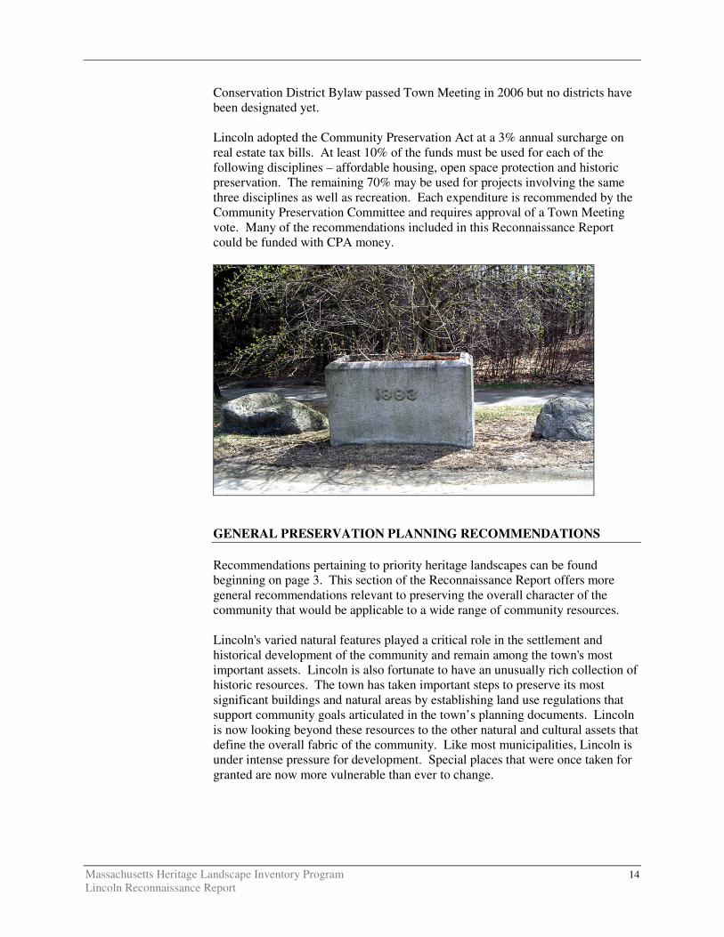
Conservation District Bylaw passed Town Meeting in 2006 but no districts have been designated yet. Lincoln adopted the Community Preservation Act at a 3% annual surcharge on real estate tax bills. At least 10% of the funds must be used for each of the following disciplines – affordable housing, open space protection and historic preservation. The remaining 70% may be used for projects involving the same three disciplines as well as recreation. Each expenditure is recommended by the Community Preservation Committee and requires approval of a Town Meeting vote. Many of the recommendations included in this Reconnaissance Report could be funded with CPA money.
GENERAL PRESERVATION PLANNING RECOMMENDATIONS Recommendations pertaining to priority heritage landscapes can be found beginning on page 3. This section of the Reconnaissance Report offers more general recommendations relevant to preserving the overall character of the community that would be applicable to a wide range of community resources. Lincoln's varied natural features played a critical role in the settlement and historical development of the community and remain among the town's most important assets. Lincoln is also fortunate to have an unusually rich collection of historic resources. The town has taken important steps to preserve its most significant buildings and natural areas by establishing land use regulations that support community goals articulated in the town’s planning documents. Lincoln is now looking beyond these resources to the other natural and cultural assets that define the overall fabric of the community. Like most municipalities, Lincoln is under intense pressure for development. Special places that were once taken for granted are now more vulnerable than ever to change.

Massachusetts Heritage Landscape Inventory Program 15 Lincoln Reconnaissance Report
Preservation planning is a three-step process: identification, evaluation and protection. Four useful documents to consult before beginning to implement preservation strategies are: � Department of Conservation and Recreation, Reading the Land
� Freedom’s Way Heritage Association, Feasibility Study
� Massachusetts Historical Commission, Survey Manual
� Massachusetts Historical Commission, Preservation through Bylaws and
Ordinances Recommendations that apply to a broad range of resources are discussed below. The recommendations are listed in the order in which they are most logically addressed when applying the three-step preservation planning process as described above. Thus the goal will be to (1) identify, (2) evaluate, (3) protect. Inventory of Heritage Landscapes The vital first step in developing preservation strategies for heritage landscapes is to record information about the resources on MHC inventory forms. One cannot advocate for something unless one knows precisely what it is – the physical characteristics and the historical development. Lincoln has an unusually small inventory for a community with such rich historic resources and much of it was compiled some time ago when inventory standards were less rigorous than they are today. Relatively little information is included about farm outbuildings, road beds, stone wall networks, cellar holes, railroad structures, garages, pipelines, small bridges and early archaeological sites, including Native American sites as well as 17th and 18th century sites. Thus, using the Massachusetts Historical Commission survey methodology, the Lincoln Historical Commission should: � Compile a list of resources that are under-represented or not sufficiently
documented, beginning with the priority heritage landscapes identified in this report.
� Document unprotected resources first, beginning with the most threatened
resources. � Document secondary features on rural and residential properties, such as
barns, stone walls and landscape elements. Record a wide range of historic and pre-historic resources including archaeological sites, landscape features and industrial resources.
� Record a wide range of historic resources including landscape features and
industrial resources. � Conduct a community-wide archaeological reconnaissance survey to identify
patterns of ancient Native American and historic occupation and to identify

Massachusetts Heritage Landscape Inventory Program 16 Lincoln Reconnaissance Report
known and probable locations of archaeological resources associated with these patterns. Known and potential ancient Native American and historic archaeological sites should be documented in the field for evidence of their cultural association and/or integrity. All survey work should be completed by a professional archaeologist who meets the professional qualifications (950 CMR 70.01) outlined in the State Archaeologist Permit Regulations (950 CMR 70.00). The Inventory of Archaeological Assets of the Commonwealth contains sensitive information about archaeological sites. The inventory is confidential; it is not a public record (G.L. c. 9, ss. 26A (1)). Care should be taken to keep archaeological site information in a secure location with restricted access. Refer to the MHC article "Community-Wide Archaeological Surveys" which appeared in the Preservation Advocate, Fall 2005 which can be found at the following MHC link:http://www.sec.state.ma.us/mhc/mhcpdf/pafall05.pdf.
National Register Program Most of Lincoln’s National Register nominations were prepared some time ago as part of historic districts and may not be up to current standards. Many other properties are undoubtedly eligible and some early nominations would most likely benefit from updating. In addition new survey work will require an evaluation as to whether resources meet the qualifications for National Register listing. Therefore, the Lincoln Historical Commission should: � Review Lincoln’s existing National Register nominations and past and new
survey work to develop a National Register listing plan taking into consideration a property’s integrity and vulnerability. Properties that are in need of recognition and preservation should be given highest priority for listing.

Massachusetts Heritage Landscape Inventory Program 17 Lincoln Reconnaissance Report
Agricultural Landscapes Preservation of agricultural landscapes means preservation of the farming activities, particularly in Lincoln where farms are declining and their character is integral to the community’s past. It is important to know what the features of these agricultural landscapes are and which features the community treasures in order to make a case for preservation of these farms. Some preservation tools are available that can assist communities in preserving the actual farming activities even if only a few farms remain. Others are tools to preserve the landscape when the farm is sold. Lincoln already has a cluster bylaw. The town may want to consider strategies that support farming activities. � Document additional farms that may not presently be included in Lincoln’s
inventory of historic resource, or update forms that focus solely on the farmhouse. Use MHC Area Form to convey the historical development of the entire farm.
� Adopt an agricultural commission to advocate for farming.
� Adopt a right-to-farm bylaw which allows farmers to carry on farming
activities that may be considered a nuisance to neighbors.
� Develop partnerships to raise funds to purchase development rights on farms or to assist a farmer in the restoration of historic farm buildings for which the owner would be required to donate a preservation restriction (PR).
� Continue public-private partnerships to preserve farm land through purchase
of conservation restrictions (CRs) or agricultural preservation restrictions (APRs). CPA funding may be used.
Village and Neighborhood Character Nearly all preservation strategies address neighborhood character in some manner. As described above, thorough documentation on MHC inventory forms is an important first step in the preservation planning process, followed by National Register listing where appropriate. Lincoln already has two important preservation tools in place, a demolition delay bylaw and a local historic district bylaw. Another preservation tool that is particularly applicable to some of Lincoln’s newer historic neighborhoods is neighborhood conservation district designation. Lincoln has recently adopted a neighborhood conservation district bylaw but has not yet designated any districts. The Lincoln Historical Commission should: � Refine study report for Brown’s Wood and prepare article for next Town
Meeting to designate it as a neighborhood conservation district under newly adopted bylaw.
� Explore options for revising the demolition delay bylaw. Consider
expanding it to one year to allow more time to negotiate.
Massachusetts Heritage Landscape Inventory Program 18 Lincoln Reconnaissance Report
Scenic Roads Scenic roads are an integral part of the historic fabric of the community. They are highly valued by Lincoln residents and visitors alike and were listed as a critical concern. Roads must also accommodate modern transportation needs and decisions regarding roadways are often made with travel requirements as the only consideration. Yet, in addition to roadway issues, much of what we value about scenic roads – the stone walls, views across open fields – is not within the public right-of-way. The preservation and protection of scenic roads therefore requires more than one approach. � Complete an inventory with descriptions and photo documentation of each
of the roads in Lincoln including the character defining features. � Amend Scenic Roads Bylaw to include design criteria to be considered
when approving removal of trees and stone walls. Consider other design criteria such as a provision allowing only one driveway cut per property on scenic roads. Coordinate procedures between Public Works Department and Planning Board.
� Consider a scenic overlay district which may provide a no-disturb buffer on
private property bordering on scenic roads or adopt flexible zoning standards to protect certain views. Such bylaws could be written to apply to the numbered routes also, which are not protected under the Scenic Roads Bylaw.
� Develop policies and implementation standards for road maintenance and
reconstruction, including bridge reconstructions that address the scenic and historic characteristics while also addressing safety. This is an important public process in which the community may have to accept responsibility for certain costs to implement standards that are not acceptable to projects funded by the Massachusetts Highway Department. Such standards should have a section addressing the way in which the local Public Works Department maintains roads, for example requiring a public hearing if any additional pavement is to be added to a town road during reconstruction or repair. Policies can be adopted by local boards having jurisdiction over roads, or can be adopted at Town Meeting through a bylaw. In developing policies consider factors such as road width, clearing of shoulders, walking paths, posted speeds. A delicate balance is required.
Funding of Preservation Projects Funding for preservation projects is an important aspect of implementing preservation strategies. Both the MHC and DCR have had funding programs to assist communities in preservation related issues. The town should investigate which of the following programs are currently funded: � Survey and Planning Grants, administered by the MHC, support survey,
National Register and preservation planning work.

Massachusetts Heritage Landscape Inventory Program 19 Lincoln Reconnaissance Report
� The Massachusetts Preservation Projects Fund (MPPF) administered by the MHC, funds restoration and rehabilitation projects.
� The Historic Landscape Preservation Grant Program (HLPGP)
administered by DCR funds planning, rehabilitation, education and stewardship projects focused on historic landscapes, including cemeteries.
Funding for state programs varies from year to year. When planning Lincoln’s heritage landscape inventory program, contact relevant agencies to determine whether funding is available. Lincoln has recently adopted the Massachusetts Community Preservation Act (CPA) and will find it to be an excellent funding source for many heritage landscape projects; Lincoln is certainly aware of the number and types of projects that are currently benefiting from this funding source across the Commonwealth. Lincoln projects eligible for CPA funding could include MHC inventory, National Register nominations, cemetery preservation, open space acquisition preservation/restoration of public buildings, conservation restrictions and preservation restrictions. Towns, like Lincoln that have a local historic district bylaw, may apply for Certified Local Government (CLG) status which is granted by the National Park Service (NPS) through the MHC. At least 10% of the MHC’s yearly federal funding allocation is distributed to CLG communities through Survey and Planning matching grants. To become a CLG, the town completes an application; after being accepted as a CLG, it files a report yearly on the status of applications, meetings, and decisions; in return the town may apply for the matching grant funding that the MHC awards competitively to CLGs annually. Presently 18 cities and towns are CLGs in Massachusetts. CONCLUSION The Lincoln Reconnaissance Report is a critical tool in starting to identify the rich and diverse heritage landscapes in Lincoln and in beginning to think about preservation strategies. Lincoln will have to determine the best way to implement the recommendations discussed above. One approach that might help Lincoln begin the process is to form a Heritage Landscape Committee, as described in Reading the Land. Landscapes identified in this report, especially the priority landscapes, will typically need further documentation on MHC inventory forms. The documentation in turn can be used in publicity efforts to build consensus and gather public support for their preservation. Implementation of recommendations will require a concerted effort of and partnerships among municipal boards and agencies, local non-profit organizations, and state agencies and commissions. Distribution of this Reconnaissance Report to the municipal land use boards and commissions will assist in making this one of the planning documents that guides
Massachusetts Heritage Landscape Inventory Program 20 Lincoln Reconnaissance Report
Lincoln in preserving important features of the community’s character. The recommended tasks will require cooperation and coordination among boards and commissions, particularly Lincoln’s Historical Commission, Planning Board and Conservation Commission. It also is advisable to present this information to the Selectmen, who are the applicants to the Heritage Landscape Inventory program on behalf of the town. Finally distribution of the report to the Lincoln Land Conservation Trust, Historical Society, neighborhood associations, and other preservation minded organizations will broaden the audience and assist in gathering interest and support for Lincoln's heritage landscapes.

Massachusetts Heritage Landscape Inventory Program 21 Lincoln Reconnaissance Report
APPENDIX: HERITAGE LANDSCAPES IDENTIFIED BY COMMUNITY This list was generated by local participants at the Heritage Landscape Identification meeting held in Lincoln on March 3 and follow-up fieldwork on April 19, 2006. There are undoubtedly other heritage landscapes that were not identified at the HLI meeting noted above. The chart has two columns, the name and location of the resource are in the first; notes about the resource are in the second. Landscapes are grouped by land use category. Abbreviations used are listed below. APR = Agricultural Preservation Restriction CR = Conservation Restriction LHD = Local Historic District NR = National Register PR = Preservation Restriction * = Priority Landscape TTOR = The Trustees of Reservations + = Part of a Priority Landscape
Agriculture
Blue Heron Organic Farm South Great Road
Grows flowers, vegetables and herbs. Farmstand. Community events.
Browning Fields Weston Road
Sanctuary for ground nesting birds, especially Bobolinks. Community horseback riding ring.
Codman Farm Codman Road
Part of former Codman Estate (Historic New England property) that was purchased by the town in 1970. Nineteen-acre parcel includes farmhouse and barns (buildings are listed in NR). Operated by Codman Community Farms (CCF) a non-profit group established in 1973. CCF produces and sells eggs, beef, lamb, pork and veal. Field crops include corn, hay and pumpkins.
DeNormandie Dairy Farm * Trapelo Road
All DeNormandie land is valued by community especially sledding hill. Large barn and pond. Very scenic. Former dairy farm with prize Guernseys.
Drumlin Farm * South Great Road
Former Boyce Farm, now owned by Massachusetts Audubon Society. Part is not permanently protected.
Flint Farm Lexington Road
Land was part of 1636 land grant. Barn was built in 1870. Oldest farm continuously farmed by one family. PR on farmhouse. APR on farmland.
Food Project Fields Concord Road
Town conservation land used for innovative agricultural program that links rural agricultural land with urban areas.
Linden Tree Farm Old Concord Road
Community-supported agriculture, organic farm near Mount Misery.
Page Farm Page Farm Road
Pig Farm
Red Rail Farm Old Concord Road
Working horse and hay farm.

Massachusetts Heritage Landscape Inventory Program 22 Lincoln Reconnaissance Report
Ricci Farm North Great Road
Town conservation land leased for agriculture.
Stonehedge Old Sudbury Rd
Pasture land for cattle. Part of McDowell Estate in Wayland.
Turtle Creek Winery 28 Beaver Pond Road
Grapes grown on private land under Chapter 61A and on leased town conservation land.
Archaeological
Adams Woods Old Concord Road
Concord Road and railroad tracks. Archaeological interest.
Black Rabbit Archeological Site Old Bedford Road
PR. At Battle Road Farm. Reported Native American burial ground. In poor condition.
Farrar Pond Area South Great Road
Source of local arrowhead collection. On south side of South Great Road. Pond feeds into Sudbury River.
Burial Grounds and Cemeteries
First Town Cemetery Old Lexington Road
NR district, LHD. Established 1756. Also known as Lincoln Cemetery and Old Town Cemetery. Behind Bemis Hall.
Triangular Cemetery Trapelo Road
NR district, LHD. Established 1796. Also known as Arborvitae Cemetery or Three-Cornered Cemetery.
Civic/Village
Lincoln Center Five Corners
NR district, LHD. Historic center of town – library, Bemis Hall, white church and stone church. Note: The NR district is slightly smaller than the LHD.
South Lincoln Lincoln Road
Also known as Lincoln Station. Includes innovative development by Rural Land Foundation of Lincoln, the Lincoln Mall commercial area and Lincoln Woods low and moderate income housing.

Massachusetts Heritage Landscape Inventory Program 23 Lincoln Reconnaissance Report
Industrial
Harrington Dam and Ponds South Great Road
Also cellarholes.
Pickle Factory Mentioned at end of meeting.
Institutional
Bemis Hall Bedford Road
Former Town Hall, built 1892, designed by Boston architect W. Langdon Warren. First Town Cemetery is behind it. Currently used by the Council on Aging and as a public meeting place. Endowed Bemis lectures held here.
Builders Club of Lincoln Lincoln Road
Civic organization housed in old school.
Carroll School 25 Baker Bridge Road
Private school, part of former Storrow Estate including Storrow House.
DeCordova Museum Sandy Pond Road
Museum and sculpture park adjacent to Sandy Pond, established 1950. Landscaped grounds with extensive pond frontage. Former home of Julian DeCordova. The town owns the museum and land.
Farrington Memorial * 291 Cambridge Turnpike
80 acres of privately owned open space that is not permanently protected. Used for summer camps.
Old Town Hall Lincoln Road
Greek Revival building ca. 1848 originally on Bedford Road, later moved to present location on Lincoln Road. Was used as town hall until 1892 when Bemis Hall was built. Now owned by Lincoln Town Hall Corporation and used as a post office, store and offices. Opposite current town hall.
Pierce House Weston Road
Town-owned house set in larger park. The facade is based on the Vassall-Craigie-Longfellow house in Cambridge, MA.
Public Library 3 Bedford Road
NR district, LHD. Built 1884, with later modifications. Bronze eagle located on the lawn is a memorial of World War I.
Thoreau Institute 44 Baker Farm Road
Center for research and education focused on the literary achievements and philosophy of Henry David Thoreau.
Town Hall Lincoln Road
Located in former Center Elementary School, built 1908. In Pierce Park complex.

Massachusetts Heritage Landscape Inventory Program 24 Lincoln Reconnaissance Report
Military
Battle Road Corridor
Runs through Arlington, Lexington, Lincoln and Concord, all participating in the FWHA program. Lincoln participates in Battle Road Scenic Byway Study Group which is hoping to identify resources along the corridor that are outside the national park.
Bunker Baker Bridge Road
Located at Carroll School.
Nike Site South Geaat Road
On Drumlin Farm property. Only road trace and base of tower remain.
Miscellaneous
Catalpa Tree * Trapelo and Bedford Roads
NR, LHD. Distinctive specimen with whorled bark on library grounds.
Flower Pot * Five Corners
NR, LHD. Erected in 1883 as a watering trough, now used as a decorative planter. Located at major intersection in center of town.
Horse Trough * Codman and Lincoln Roads
Granite. Across from Fire/Police Station.
Stone Marker for Lincoln Chestnut Tree Bedford Road
On town common next to Bemis Hall. Former site of American chestnut tree on the town seal.
Natural
Baker Bridge Boulder Sandy Pond and Baker Bridge Roads
Flint’s Esker Lexington Road
Flint’s Great Meadow Lexington Road

Massachusetts Heritage Landscape Inventory Program 25 Lincoln Reconnaissance Report
Open Space /Parks Great Meadows National Wildlife Refuge
Along Sudbury River.
Massachusetts Audubon Society Headquarters * Lincoln Road
Former Hatheway Estate left to Massachusetts Audubon Society in 1956. Part of Drumlin Farm complex.
Minute Man National Historical Park North Great Road
Commemorates the events of April 19, 1775. Includes Battle Road Corridor.
Mount Misery South Great Road
Town-owned wooded area with trails some meadows, parking lots, edge of Fairhaven Bay and Sudbury River and a small pond.
Old Pine Hill Concord Road
Conservation land adjoining Walden Pond State Reservation.
Walden Pond State Reservation Concord Road
Part of the reservation is in Lincoln, although the pond is entirely in Concord.
Walden Woods Concord Road
Part is in Lincoln, the remainder is in Concord.
Residential
Battle Road Farm Old Bedford Road
Mixed-income condominium housing.
Brown’s Wood Laurel Drive and Moccasin Hill Road
Neighborhood of circa 1950 early modern houses.
Codman Estate Codman Road
Owned by Historic New England Inc. Includes house, carriage house and landscaped grounds. Operated as a historic house museum. Part of the former Codman Estate is now town-owned as Codman Farms.
Farrar Pond Village Oxbow Road
Condominium development, R3 zoning, built in 1970s as townhouses with carports along south side of Farrar Pond and adjacent to former Nike Site in Wayland.
Gropius House Baker Bridge Road
Owned by Historic New England, includes extensive grounds. Home of Walter and Ise Gropius. Operated as a house museum. In Wood’s End Historic District, which includes other International style houses.

Massachusetts Heritage Landscape Inventory Program 26 Lincoln Reconnaissance Report
Hanscom Housing Military housing at Hanscom Air Force Base part of which is in Lincoln. Four housing areas for various ranking officers and enlisted personnel. Housing ranges from capes to modern duplexes.
Stonehedge Off Tower Road
Neighborhood with many early Deck Houses.
Sunnyside/ Morningside Sunnyside and Morningside Lanes
Mid-20th century development, one of the first after World War II.
Tabor Hill Tabor Hill Road
Mid-20th century land development. Slightly later than Sunnyside/Morningside.
Wheeler Farm Wheeler Road
First cluster subdivision. The Rural Land Foundation of Lincoln was founded in 1965 to develop this large farm in an environmentally sensitive manner.
Transportation
Baker Bridge Road
Scenic road with stone walls, large boulders where road bends, alleé of maple trees and agricultural landscape on western end.
Lincoln Road Scenic road through South Lincoln to Five Corners.
Mile Marker * South Great Road
Stone marker on south side of South Great Road in the western part of town.
Old Sudbury Road Scenic road bordered by pasture land.
Page Road Scenic road.
Railroad Fitchburg line was built through Lincoln in 1844. Today it functions as a heavily used commuter rail line.
Route 2 Cambridge Turnpike, chartered in 1803. Became a high speed thoroughfare in 1934.
Silver Hill Road Scenic road.
South Great Road (Route 117)
Scenic road. This can’t be designated a scenic road as it is a state numbered road.
Trapelo Road Scenic road.
Weston Road Scenic road.
Massachusetts Heritage Landscape Inventory Program 27 Lincoln Reconnaissance Report
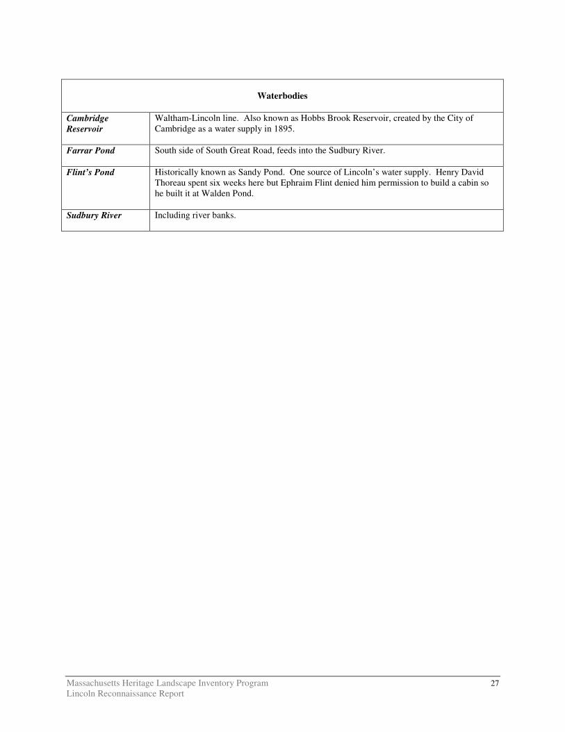
Waterbodies
Cambridge Reservoir
Waltham-Lincoln line. Also known as Hobbs Brook Reservoir, created by the City of Cambridge as a water supply in 1895.
Farrar Pond
South side of South Great Road, feeds into the Sudbury River.
Flint’s Pond Historically known as Sandy Pond. One source of Lincoln’s water supply. Henry David Thoreau spent six weeks here but Ephraim Flint denied him permission to build a cabin so he built it at Walden Pond.
Sudbury River
Including river banks.
CAMBRIDGE TURNPIKE
NORTH GREAT ROAD
VIRGINIA ROAD
AIRPORT ROADMILL STREET
BEDFORD ROAD
SANDY POND ROAD
BEDF
ORD R
OAD
PAGE ROAD
WESTON ROAD
CONC
ORD
ROAD
BAKER BRIDGE ROAD
SOUTH GREAT ROAD
CODMAN ROAD
CONC
ORD R
OAD
WEST
ON RO
ADTOWER ROAD
WINTER STREET
TRAPELO ROAD
1
2&53
4
6
7
8
C o n c o r dC o n c o r d
W e s t o nW e s t o n
W a y l a n dW a y l a n d
W a l t h a mW a l t h a m
B e d f o r dB e d f o r d
L e x i n g t o nL e x i n g t o n
S u d b u r yS u d b u r y
LINCOLNOPENSPACE & HISTORIC RESOURCES
Lincoln Priority Landscapes1. Brown's Wood2. Catalpa Tree on Library Lawn3. DeNormandie Land4. Farrington Memorial5. Flowerpot at Five Corners6. Horse Trough on Lincoln Road7. Massachusetts Audubon Society Land8. Mile Marker on South Great Road
0 0.5 1 Miles
¯DCRDCRS/DFGDFGOther StateCounty
MunicipalFederalLand TrustNon-ProfitConservation Restriction
Agricultural Preservation RestrictionCR/APR CombinationOther Legal InterestState Historic Resources
InterstateState Local Road
Note: Default Legend, all categories may not appear on the map.