lewis & clark campus land coverage analysis: lawn and forested area 1936 & 2005 meghan...
TRANSCRIPT

Lewis & Clark Campus Land Coverage Analysis:
Lawn and Forested Area 1936 & 2005
Meghan Cleland

LC 1936/LC 2005 GPS Points
Campus Safety
Carriage circle
Manor House

LC Campus Coverage 1936
Green= forested area White/Green dashed= Lawn

LC Campus Coverage 2005
Green= forested area White/Green dashed= Lawn

Discussion Pt. 1
• Why these years? Why these variables?
– 1936 (oldest image) vs 2005 (recent) gives a nice historical perspective
• Looking at two aspects of the campus that are aesthetically prized, but dramatically altered
– Environmental impacts of aesthetic features

Discussion Pt. 2: Results
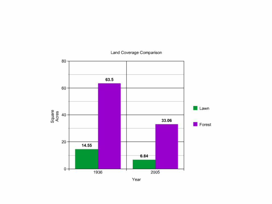
• Forested area: Reduced from 63.5 to 33.06– Nearly halved
• Less habitat= less biodiversity • Less habitat= increased competition• Reduced trees= increased erosion• Lost to construction= increased impermeable surface
– Increased runoff
• Lawn/grassy area: Reduced from 14.55 to 6.84– Over half lost
• Less grass= less permeable area– Increased runoff– Question of fertilizer use and maintenance over time

Errors & Bias
• Not all GPS points imported to GIS• Differences in image quality and alignments• Imperfections in polygon figures• Smaller exact details cannot be shown