levelling final
TRANSCRIPT
SCHOOL OF ARCHITECTURE • BUILDING • DESIGN
BACHELOR OF QUANTITY SURVEYING (HONOURS)
QSB 60103 – SITE SURVRYING
Fieldwork Report 1
Levelling
Name Student ID Marks
Yong Seen Yee 0315883
Yeoh Pooi Ching 0315540
Yee Algel 0315890
Yong Boon Xiong 0321754
ContentsPage
Introduction to Levelling.....................................................................3
Objective.............................................................................................6
Outline of Apparatus...........................................................................7
Levelling Results.................................................................9
Adjusted Data (Error Distribution)....................................................11
Discussion.........................................................................................13
Conclusion.........................................................................................14
Reference...........................................................................................15

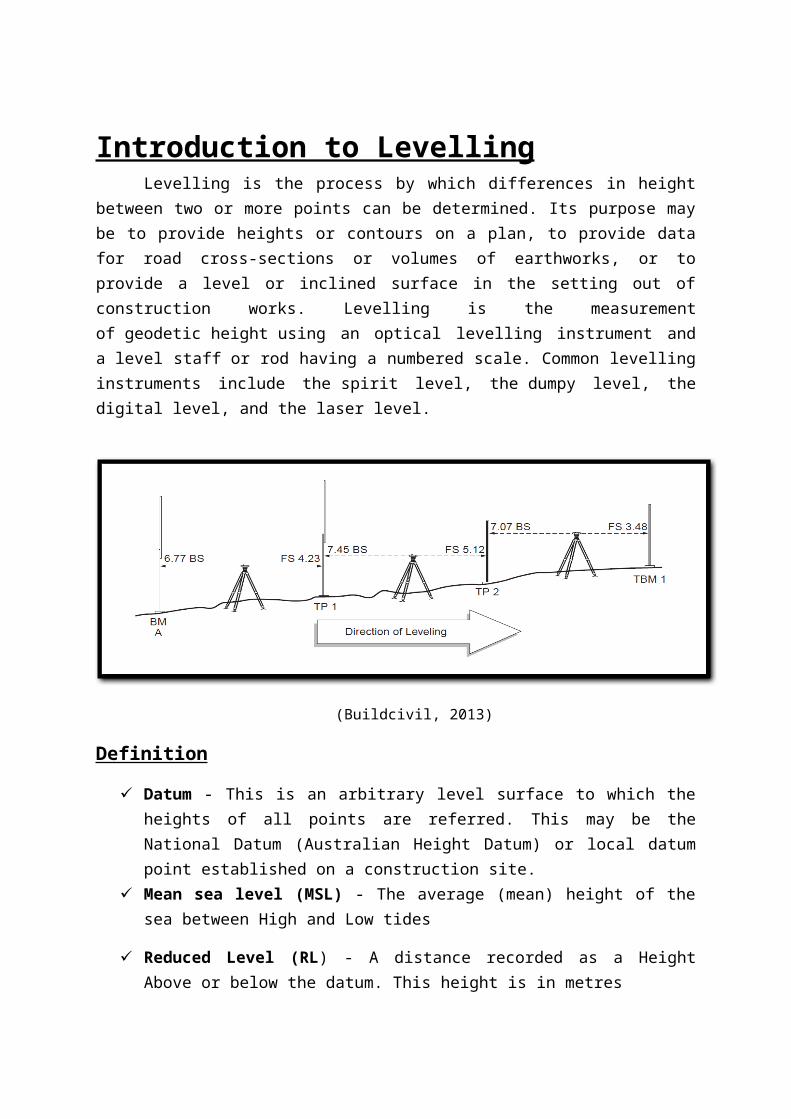
Introduction to LevellingLevelling is the process by which differences in height between two or more points
can be determined. Its purpose may be to provide heights or contours on a plan, to provide data for road cross-sections or volumes of earthworks, or to provide a level or inclined surface in the setting out of construction works. Levelling is the measurement of geodetic height using an optical levelling instrument and a level staff or rod having a numbered scale. Common levelling instruments include the spirit level, the dumpy level, the digital level, and the laser level.
(Buildcivil, 2013)
Definition
Datum - This is an arbitrary level surface to which the heights of all points are referred. This may be the National Datum (Australian Height Datum) or local datum point established on a construction site.
Mean sea level (MSL) - The average (mean) height of the sea between High and Low tides
Reduced Level (RL) - A distance recorded as a Height Above or below the datum. This height is in metres
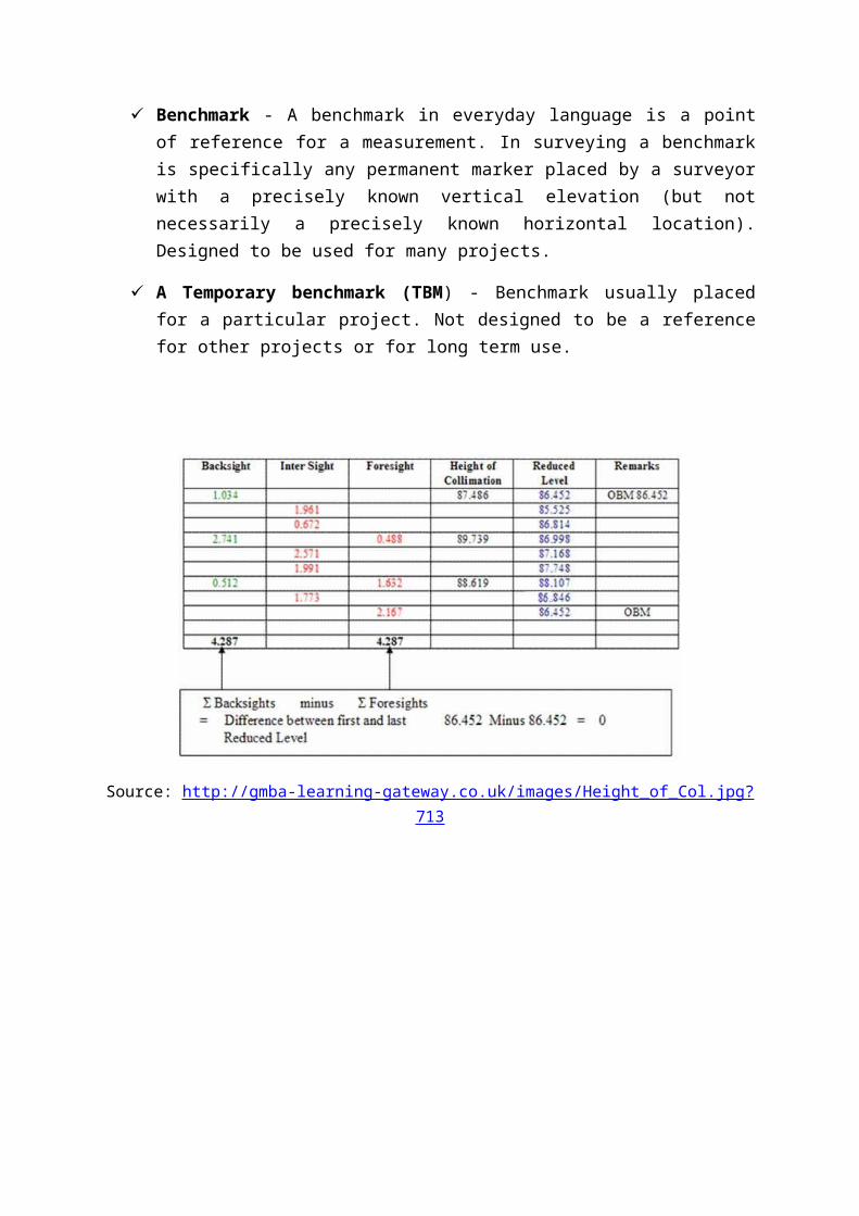
Benchmark - A benchmark in everyday language is a point of reference for a measurement. In surveying a benchmark is specifically any permanent marker placed by a surveyor with a precisely known vertical elevation (but not necessarily a precisely known horizontal location). Designed to be used for many projects.
A Temporary benchmark (TBM) - Benchmark usually placed for a particular project. Not designed to be a reference for other projects or for long term use.
Source: http://gmba-learning-gateway.co.uk/images/Height_of_Col.jpg?713
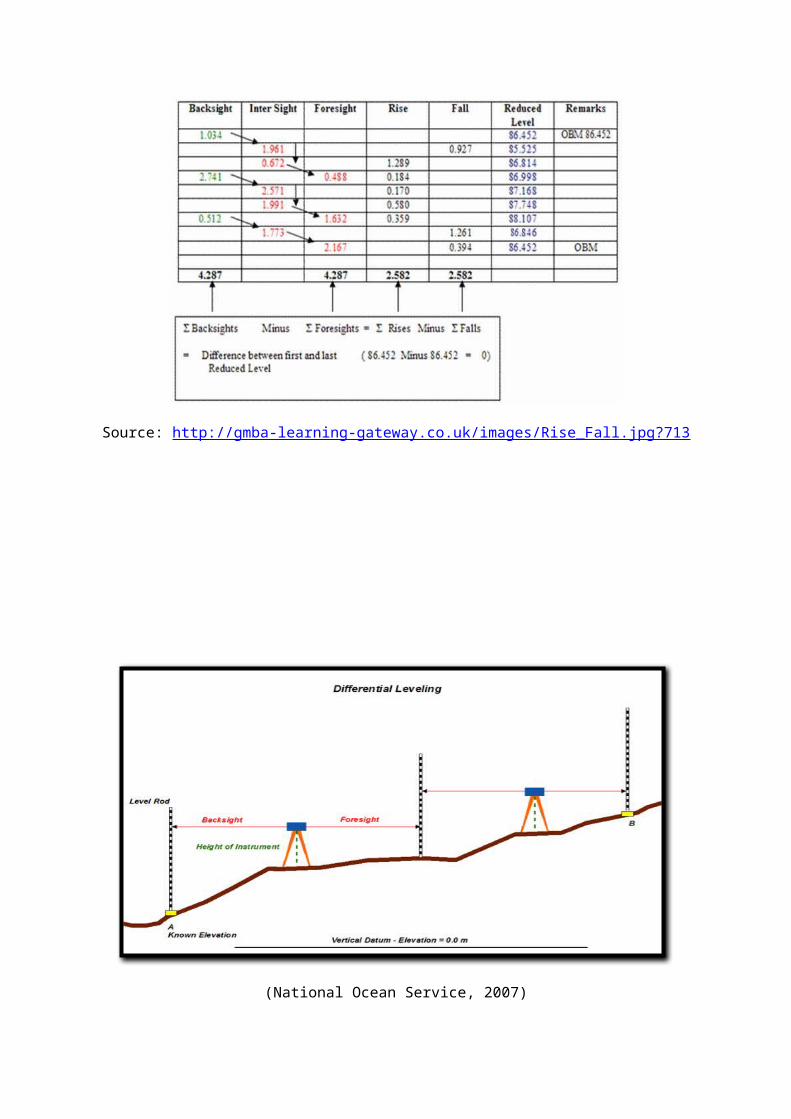
Source: http://gmba-learning-gateway.co.uk/images/Rise_Fall.jpg?713
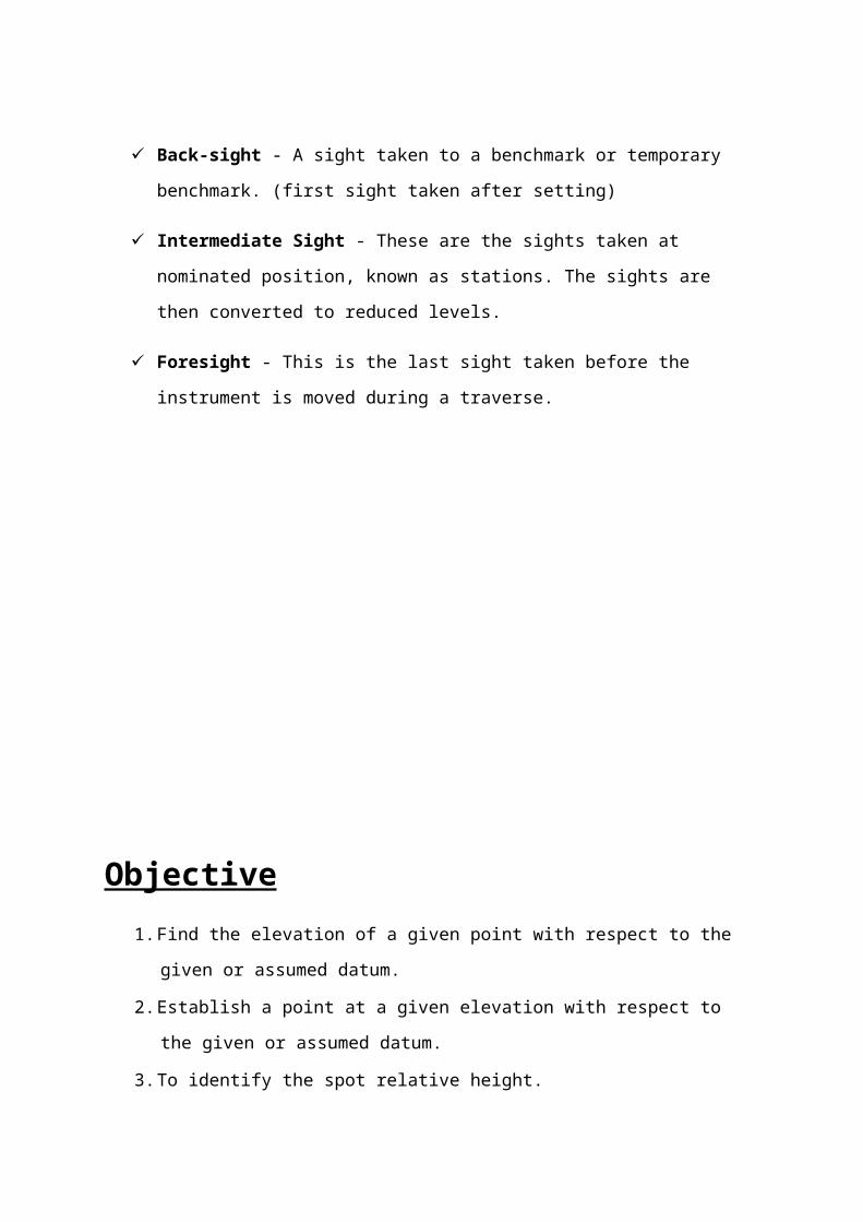
(National Ocean Service, 2007)
Back-sight - A sight taken to a benchmark or temporary benchmark. (first sight taken
after setting)
Intermediate Sight - These are the sights taken at nominated position, known as
stations. The sights are then converted to reduced levels.
Foresight - This is the last sight taken before the instrument is moved during a
traverse.
Objective
1. Find the elevation of a given point with respect to the given or assumed datum.
2. Establish a point at a given elevation with respect to the given or assumed datum.
3. To identify the spot relative height.
4. To identify possible errors occurred.
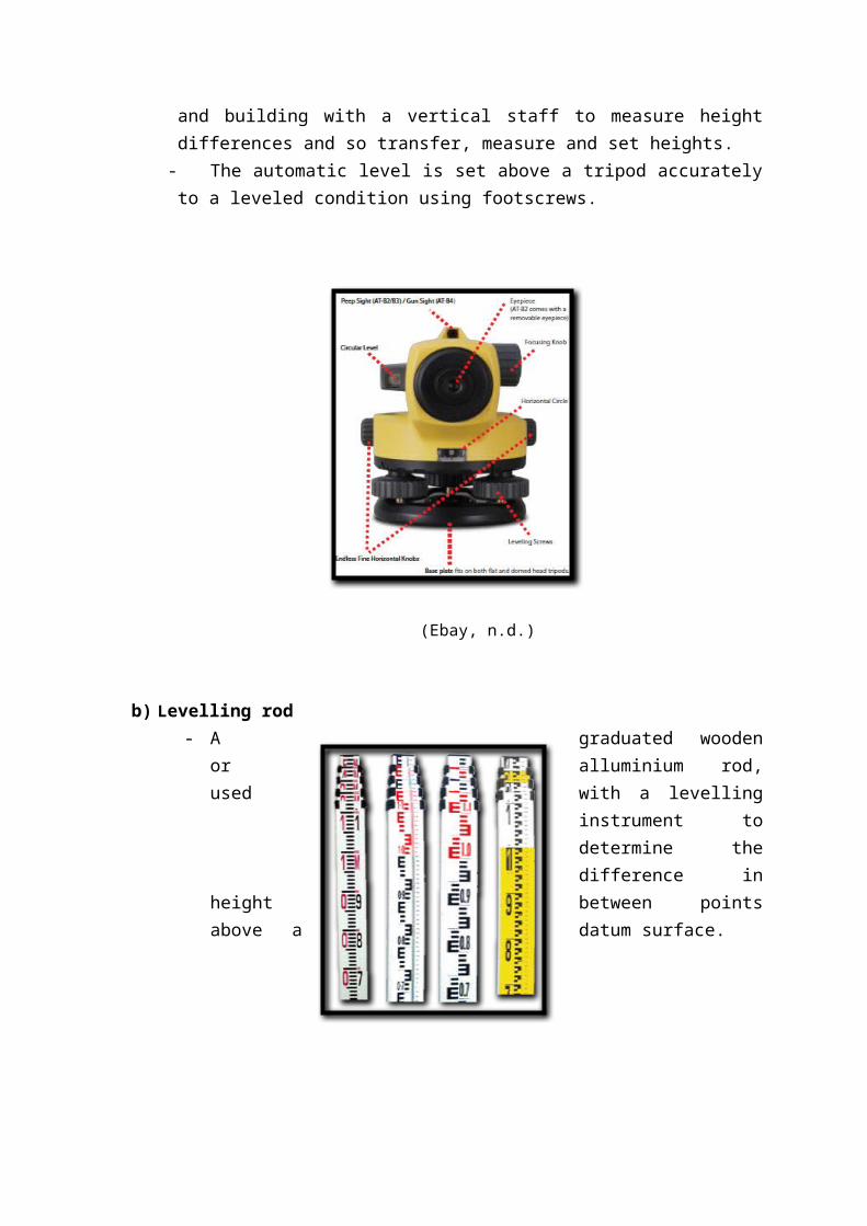
Outline of Apparatus a) Automatic Level
- Used by land surveyor to establish points in the same horizontal plane. It is used in surveying and building with a vertical staff to measure height differences and so transfer, measure and set heights.
- The automatic level is set above a tripod accurately to a leveled condition using footscrews.
(Ebay, n.d.)
b) Levelling rod- A graduated wooden or alluminium rod, used with a levelling instrument to
determine the difference in height between points above a datum surface.
(JimTrade.com, n.d.)
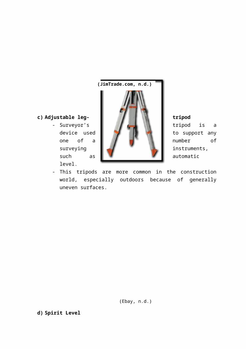
c) Adjustable leg- tripod- Surveyor’s tripod is a device used to support any one of a number of surveying
instruments, such as automatic level. - This tripods are more common in the
construction world, especially outdoors because of generally uneven surfaces.
(Ebay, n.d.)
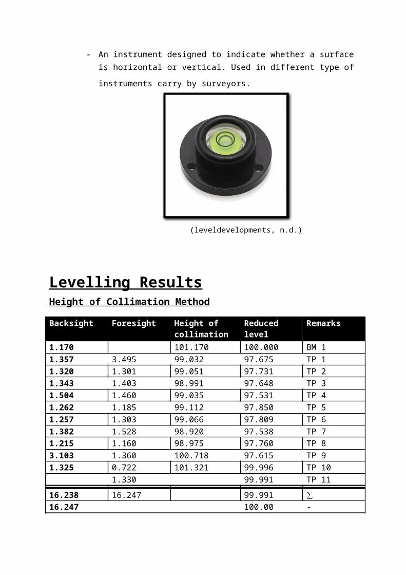
d) Spirit Level- An instrument designed to indicate whether a surface is horizontal or vertical.
Used in different type of instruments carry by surveyors.
(leveldevelopments, n.d.)
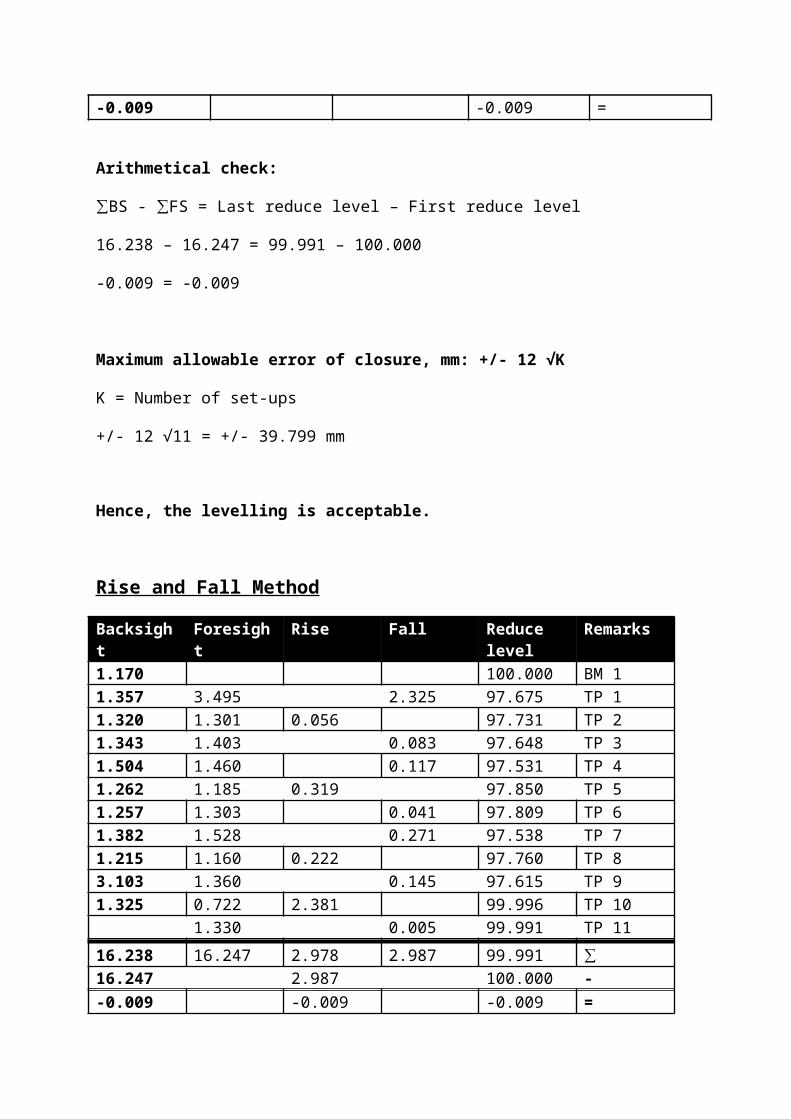
Levelling ResultsHeight of Collimation Method
Backsight Foresight Height of collimation
Reduced level Remarks
1.170 101.170 100.000 BM 11.357 3.495 99.032 97.675 TP 11.320 1.301 99.051 97.731 TP 21.343 1.403 98.991 97.648 TP 31.504 1.460 99.035 97.531 TP 41.262 1.185 99.112 97.850 TP 51.257 1.303 99.066 97.809 TP 61.382 1.528 98.920 97.538 TP 71.215 1.160 98.975 97.760 TP 83.103 1.360 100.718 97.615 TP 91.325 0.722 101.321 99.996 TP 10
1.330 99.991 TP 11
16.238 16.247 99.991 ∑16.247 100.00 --0.009 -0.009 =
Arithmetical check:
∑BS - ∑FS = Last reduce level – First reduce level
16.238 – 16.247 = 99.991 – 100.000
-0.009 = -0.009
Maximum allowable error of closure, mm: +/- 12 √K
K = Number of set-ups
+/- 12 √11 = +/- 39.799 mm
Hence, the levelling is acceptable.
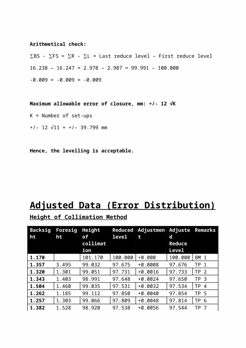
Rise and Fall Method
Backsight Foresight Rise Fall Reduce level
Remarks
1.170 100.000 BM 11.357 3.495 2.325 97.675 TP 1 1.320 1.301 0.056 97.731 TP 21.343 1.403 0.083 97.648 TP 31.504 1.460 0.117 97.531 TP 41.262 1.185 0.319 97.850 TP 51.257 1.303 0.041 97.809 TP 61.382 1.528 0.271 97.538 TP 71.215 1.160 0.222 97.760 TP 83.103 1.360 0.145 97.615 TP 91.325 0.722 2.381 99.996 TP 10
1.330 0.005 99.991 TP 11
16.238 16.247 2.978 2.987 99.991 ∑16.247 2.987 100.000 --0.009 -0.009 -0.009 =
Arithmetical check:
∑BS - ∑FS = ∑R - ∑L = Last reduce level – First reduce level
16.238 – 16.247 = 2.978 – 2.987 = 99.991 – 100.000
-0.009 = -0.009 = -0.009
Maximum allowable error of closure, mm: +/- 12 √K
K = Number of set-ups
+/- 12 √11 = +/- 39.799 mm
Hence, the levelling is acceptable.
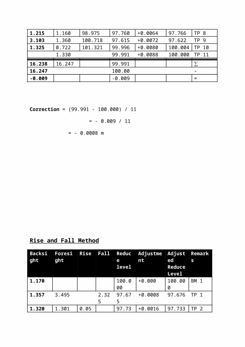
Adjusted Data (Error Distribution)Height of Collimation Method
Backsight Foresight Height of collimation
Reduced level
Adjustment Adjusted Reduce Level
Remarks
1.170 101.170 100.000 +0.000 100.000 BM 11.357 3.495 99.032 97.675 +0.0008 97.676 TP 11.320 1.301 99.051 97.731 +0.0016 97.733 TP 21.343 1.403 98.991 97.648 +0.0024 97.650 TP 31.504 1.460 99.035 97.531 +0.0032 97.534 TP 41.262 1.185 99.112 97.850 +0.0040 97.854 TP 51.257 1.303 99.066 97.809 +0.0048 97.814 TP 61.382 1.528 98.920 97.538 +0.0056 97.544 TP 71.215 1.160 98.975 97.760 +0.0064 97.766 TP 83.103 1.360 100.718 97.615 +0.0072 97.622 TP 91.325 0.722 101.321 99.996 +0.0080 100.004 TP 10
1.330 99.991 +0.0088 100.000 TP 11
16.238 16.247 99.991 ∑16.247 100.00 --0.009 -0.009 =
Correction = (99.991 - 100.000) / 11
= - 0.009 / 11
= - 0.0008 m
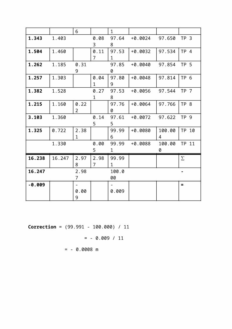
Rise and Fall Method
Backsight Foresight Rise Fall Reduce level
Adjustment Adjusted Reduce Level
Remarks
1.170 100.000 +0.000 100.000 BM 11.357 3.495 2.325 97.675 +0.0008 97.676 TP 1 1.320 1.301 0.056 97.731 +0.0016 97.733 TP 21.343 1.403 0.083 97.648 +0.0024 97.650 TP 31.504 1.460 0.117 97.531 +0.0032 97.534 TP 41.262 1.185 0.319 97.850 +0.0040 97.854 TP 51.257 1.303 0.041 97.809 +0.0048 97.814 TP 61.382 1.528 0.271 97.538 +0.0056 97.544 TP 71.215 1.160 0.222 97.760 +0.0064 97.766 TP 83.103 1.360 0.145 97.615 +0.0072 97.622 TP 91.325 0.722 2.381 99.996 +0.0080 100.004 TP 10
1.330 0.005 99.991 +0.0088 100.000 TP 11
16.238 16.247 2.978 2.987 99.991 ∑16.247 2.987 100.000 --0.009 -0.009 -0.009 =
Correction = (99.991 - 100.000) / 11
= - 0.009 / 11
= - 0.0008 m
Discussion
In this field work, the reduce level of the Bench Mark (BM) 1 is given which is
100.000m. Therefore, the reading of the backsight (BS) and the reading of the foresight (FS)
are measured and recorded through the levelling process. This process is repeated for 10
times by shifting the auto level from one point to another point at the site.
After obtaining the field data, we used both methods which are the height of
collimation method and rise and fall method to calculate the reduce level of each station. For
rise and fall method, the sum of the back-sights minus the sum of the foresights is equal to
the sum of the rises minus the sum of the falls, and is also equal to the last reduced level
minus the first reduce level. While for the height of collimation method, the sum of the back-
sights minus the sum of the foresights is equal to the last reduce level minus the first reduce
level.
However, in this data, the final reduce level is less than the initial reduce level. Thus,
there are some of the errors occurred during the levelling process. In this case, we can use
error distribution method to adjust the reduce level result.
After we calculated the reading, the error of disclosure is -0.0008 and the maximum
allowable error of closure is +/- 39.799mm. Thus, our levelling is acceptable.
To distribute the error, the correction is calculated according to the number of the
instrument setups. The correction per setup is +0.0008 and is shown in the table provided in
the adjusted data section.
ConclusionIn conclusion, we manage to obtain the data needed by using the leveling equipment
provided by our lecturer. We did this fieldwork twice because the error of misclosure in our
first set of data was too large. Hence, we had decided to redo this fieldwork. Even though we
had to spend more time, but in the end we managed to obtain a set of data with acceptable
range of error of misclosure.
After identifying the errors are in an acceptable range, we did adjustments to the data
obtained by distributing the errors. We used both rise and fall method and height of
collimation method to calculate the reduced level of each staff station. Then, we are able to
complete our fieldwork report with this complete set of data.
Reference
1.) Levelling and surveying. (n.d.). Levelling and surveying. (Website) Retrieved from http://moodle.najah.edu/pluginfile.php/47165/mod_resource/content/0/Levelling_2.pdf3
2.) Manchester 1824. (n.d.). Surveying: Using a level. (Website) Retrieve from http://media.humanities.manchester.ac.uk/humanities/flash/HumeL046_FionaSmyth_SED_2/surveying/surveying.html
3.) Engineersupply. (n.d.). automatic levels. (Website) Retrieved from http://www.engineersupply.com/automatic-levels.aspx
4.) Dictionary of Construction.com. (n.d.). Leveling rod. (Website) Retrieved from http://www.dictionaryofconstruction.com/definition/leveling-rod.html
5.) Environmental Field Techniques. (n.d.). Surveying 1: Differential Leveling. (Website) Retrieved from http://www.colorado.edu/geography/courses/geog_2043_f01/lab01_4.html
6.) Encyclopaedia Britannica. (n.d.). Spirit Leval. (Website) Retrieved from http://global.britannica.com/technology/spirit-level