letter 1 and introduction - placer county, ca
TRANSCRIPT

SS cont.
TT

UU
VV

VV cont.
WW


Placer Vineyards Specific Plan Letter 15 October, 2006 Final EIR
LETTER 15 WILLIAM D. KOPPER, ATTORNEY AT LAW Response 15A: The commenter requests that Placer County plan regionally for habitat preservation and Placer Parkway. The commenter’s concerns are noted. The Revised Draft EIR acknowledges the “Framework Agreement regarding the Planning, Development and Implementation of the Placer Legacy Program” (Revised Draft EIR page 4.4-75) which established the framework for cooperation and collaboration among State and federal agencies and local governments in the development and implementation of the Placer Legacy Program. The proposed Specific Plan is subject to the interim project review guidelines included in the Agreement which have been summarized in the Revised Draft EIR (page 4.4-74). The Revised Draft EIR also presents an Open Space/Biological Resources Mitigation and Management Strategy for the Specific Plan. The County has proposed a comprehensive mitigation strategy (refer to Mitigation Measure 4.4-1a through 4.4-1j) for this project. The Biological Resources Mitigation and Management Strategy (comprehensive mitigation strategy) proposes to mitigate impacts through off-site in-County land purchases. At least 3,520 acres will be mitigated at a 1:1 replacement ratio of impact to open space. The Open Space/Biological Resources Mitigation and Management Strategy presented in the Revised Draft EIR is intended to dovetail with the possible requirements of the draft Placer County Conservation Plan (PCCP). The Revised Draft EIR acknowledges that the PCCP has not been officially adopted; however, the comprehensive mitigation strategy will allow the PVSP project to move forward without the PCCP program in place, and also provides the opportunity for the PCCP program to be utilized, if adopted in the future. The Revised Draft EIR includes the traffic analysis under existing and cumulative (2025) conditions, and also includes an evaluation of a circulation scenario with Placer Parkway (page 4.7-65). The Placer Parkway is considered a regional facility that would help mitigate traffic impacts of not only the proposed Placer Vineyards project but the traffic impacts from other proposed developments in western Placer County as well, and thus was considered a key improvement in the Mitigated Transportation Network. The County, in conjunction with the Placer County Transportation Planning Agency, Roseville, Rocklin and Lincoln are currently reviewing alternative alignments and an environmental document is being prepared comparing the alternatives. The agencies are also considering various funding scenarios for construction of the facility. The commenter is reminded that the project site has been planned for urban development since 1994 and was so designated as part of a comprehensive General Plan update. It is the County’s position that the area has, and is, being planned regionally, as evidenced by the PCCP, work in progress on Placer Parkway, and the Placer Vineyards Specific Plan’s recognition of and incorporation of these regional initiatives in its planning and in the Revised Draft EIR. Further, the Placer Vineyards Specific Plan is being planned (as required by the Placer County General Plan) through the use of specific plan mechanisms enacted by State law to allow comprehensive planning of substantial land areas (see Exhibit 1 to Community Plan at time of General Plan adoption).
Placer Vineyards Specific Plan Letter 15 October, 2006 Final EIR
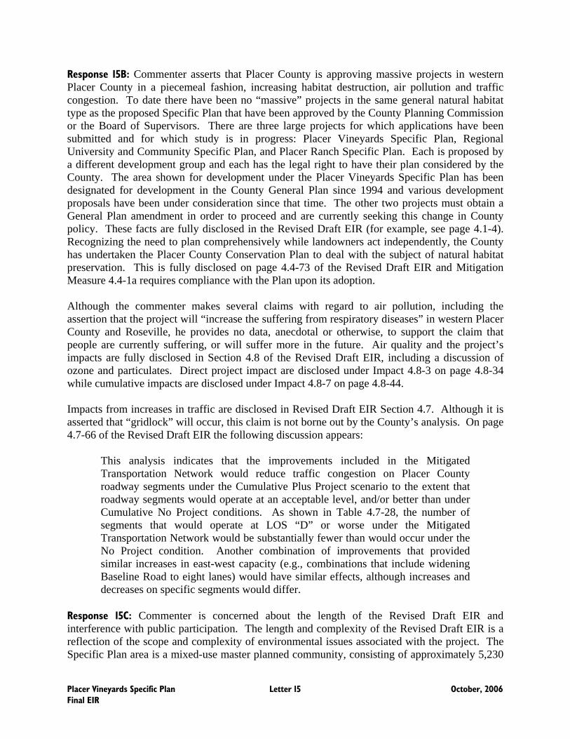
Response 15B: Commenter asserts that Placer County is approving massive projects in western Placer County in a piecemeal fashion, increasing habitat destruction, air pollution and traffic congestion. To date there have been no “massive” projects in the same general natural habitat type as the proposed Specific Plan that have been approved by the County Planning Commission or the Board of Supervisors. There are three large projects for which applications have been submitted and for which study is in progress: Placer Vineyards Specific Plan, Regional University and Community Specific Plan, and Placer Ranch Specific Plan. Each is proposed by a different development group and each has the legal right to have their plan considered by the County. The area shown for development under the Placer Vineyards Specific Plan has been designated for development in the County General Plan since 1994 and various development proposals have been under consideration since that time. The other two projects must obtain a General Plan amendment in order to proceed and are currently seeking this change in County policy. These facts are fully disclosed in the Revised Draft EIR (for example, see page 4.1-4). Recognizing the need to plan comprehensively while landowners act independently, the County has undertaken the Placer County Conservation Plan to deal with the subject of natural habitat preservation. This is fully disclosed on page 4.4-73 of the Revised Draft EIR and Mitigation Measure 4.4-1a requires compliance with the Plan upon its adoption. Although the commenter makes several claims with regard to air pollution, including the assertion that the project will “increase the suffering from respiratory diseases” in western Placer County and Roseville, he provides no data, anecdotal or otherwise, to support the claim that people are currently suffering, or will suffer more in the future. Air quality and the project’s impacts are fully disclosed in Section 4.8 of the Revised Draft EIR, including a discussion of ozone and particulates. Direct project impact are disclosed under Impact 4.8-3 on page 4.8-34 while cumulative impacts are disclosed under Impact 4.8-7 on page 4.8-44. Impacts from increases in traffic are disclosed in Revised Draft EIR Section 4.7. Although it is asserted that “gridlock” will occur, this claim is not borne out by the County’s analysis. On page 4.7-66 of the Revised Draft EIR the following discussion appears:
This analysis indicates that the improvements included in the Mitigated Transportation Network would reduce traffic congestion on Placer County roadway segments under the Cumulative Plus Project scenario to the extent that roadway segments would operate at an acceptable level, and/or better than under Cumulative No Project conditions. As shown in Table 4.7-28, the number of segments that would operate at LOS “D” or worse under the Mitigated Transportation Network would be substantially fewer than would occur under the No Project condition. Another combination of improvements that provided similar increases in east-west capacity (e.g., combinations that include widening Baseline Road to eight lanes) would have similar effects, although increases and decreases on specific segments would differ.
Response 15C: Commenter is concerned about the length of the Revised Draft EIR and interference with public participation. The length and complexity of the Revised Draft EIR is a reflection of the scope and complexity of environmental issues associated with the project. The Specific Plan area is a mixed-use master planned community, consisting of approximately 5,230

Placer Vineyards Specific Plan Letter 15 October, 2006 Final EIR
acres, with residential, employment, commercial, open space, recreational and public/quasi-public land uses. The Specific Plan provides for approximately 14,132 homes in a range of housing types, styles and densities. At full build-out, projected to occur over a twenty year time frame, Placer Vineyards is anticipated to have a population of approximately 33,000 people, 422.5 acres of employment centers, 140 acres of retail commercial centers and approximately 930 acres of new parks and open space. It is estimated that full buildout of the Specific Plan will occur over a 20- to 30-year time period (Revised Draft EIR, pages 3-1 to 3-2). CEQA Guidelines Section 15141, drafted in what might be termed a simpler era, provides that “[t]he text of draft EIRs should normally be less than 150 pages and for proposals of unusual scope or complexity should normally be less than 300 pages” (italics added). As the discussion accompanying Guidelines Section 15141 notes, these are only recommended page limits designed to encourage agencies to reduce unneeded bulk and to help documents disclose the key environmental issues to the decision makers and the public. This recommendation does not preclude an EIR for an unusually large and complex project, such as the Placer Vineyards Specific Plan, from being considerably longer if necessary to serve its function under Public Resources Code Section 21061. An EIR is an informational document whose purpose is to provide public agencies and the public in general with detailed information about the effect which a proposed project is likely to have on the environment; to list ways in which the significant effects of such a project might be minimized; and to indicate alternatives to such a project. The complexity of this project, and the impossibility of analyzing all of its impacts in 300 pages, is underscored by the numerous instances in which the commenter has asked for more analysis on various topics. Such analysis would expand the scope of the document even beyond its current length. The commenter also suggests that 45 days was insufficient time to allow adequate public participation and comment on the Revised Draft EIR. The commenter does not cite any support for the proposition that a lengthier EIR necessitates a longer public review period. The 45-day period that was provided on the Revised Draft EIR complied with CEQA, which requires a minimum 30 day public review period for a Draft EIR, excluding Draft EIRs which are submitted to the State Clearinghouse (Pub. Resources Code, Section 21091, subd. (a)). Notably, the Revised Draft EIR is the second version of the Draft EIR for the Specific Plan to be released for public review and comment. In September 2004, the County published the first Draft EIR for the Specific Plan and circulated the document for review and comment for 60 days by responsible and trustee agencies as well as interested members of the public. Following the receipt of written comments on the Draft EIR, the applicants modified the project to address concerns raised in the comments. Therefore, the Revised Draft EIR includes all sections of the original Draft EIR, which have been updated and revised in response to all written comments received on the first Draft EIR. The commenter also asserts that the County “interfered with public participation” because of a delay in providing certain traffic modeling data to a single requester. The delay was de minimus in the context of the overall 45-day comment period. The information was not requested until the comment period was well underway, and was received in time to be incorporated by the commenter in a response. The County does not agree that the public was unable to meaningfully participate in
Placer Vineyards Specific Plan Letter 15 October, 2006 Final EIR
the process due to the slight delay in distribution of some information in response to one request when the remainder of the document was available for review by all. Response 15D: Commenter asserts that project documents were incomplete because the Financing Plan was not available during the review period. Commenter also asserts that fee-based mitigation is inadequate. In accordance with Public Resources Code Section 21092.1 and CEQA Guidelines Section 15088.5, Placer County decided to partially recirculate the Revised Draft EIR in July, 2006. As part of this partial recirculation effort, Placer County also elected to make available for public review the proposed Placer Vineyards Public Facilities Draft Financing Plans for both the Project as proposed (14,132 dwelling units) (“the Base Plan”) and for the Blueprint Alternative (21,631 dwelling units). The County’s decision to release the Draft Financing Plans for public review and comment fulfilled the County’s previously-stated commitment, as set forth in the text of the Revised Draft EIR, to make these documents available for public inspection during the period of review of the Revised Draft EIR (see Revised Draft EIR, page 3-34). As stated in the Revised Draft EIR, the County intended to release the Financing Plans for public review simultaneous with release of the Revised Draft EIR; however, the drafts of the Financing Plans were not complete at the time the Revised Draft EIR was released for public review. The County’s decision to allow public review of the Draft Financing Plans in conjunction with the Revised Draft EIR as part of this recirculation should not be perceived as the County’s concurrence with the commenter, who suggested that a Financing Plan is required by CEQA, should the project be approved, or that CEQA requires public review of whatever documents comprise the “financing measures” required for specific plans (see Gov. Code, § 65451, subd. (a)(4)). The Board of Supervisors will consider a Final Financing Plan in association with the project separate and apart from any action on the EIR. The County’s decision to make the Draft Financing Plans available for public review rendered moot the commenter’s assertion that Government Code Section 65451, subdivision (a)(4) requires an EIR to include a financing plan. In Save Our Peninsula Committee v. Monterey County Board of Supervisors (2001) 87 Cal.App.4th 99 (Save Our Peninsula), the appellate court recognized that “fee-based infrastructure mitigation programs have been found to be adequate mitigation measures under CEQA” There, the court stated that the payment of fees and phased improvements was an appropriate mitigation measure, with respect to traffic impacts which have not yet reached the threshold trigger (Save Our Peninsula at page 140). The CEQA Guidelines also recognize that when an impact is not unique to a single project, but is instead the result of cumulative conditions, the only feasible mitigation may involve adoption of ordinances or other regulations designed to address the cumulative impact (Save Our Peninsula, at page 140; CEQA Guidelines, § 15130, subd. (a)(3)). Section 15130 of the CEQA Guidelines now specifically provides that an EIR may determine that a project’s contribution to a cumulative impact may be mitigated by requiring the project “to implement or fund its fair share of a mitigation measure or measures designed to alleviate the cumulative impact” (CEQA Guidelines, § 15130, subd. (a)(3)).

Placer Vineyards Specific Plan Letter 15 October, 2006 Final EIR
As stated by the appellate court in Save Our Peninsula at page 141 “[w]e do not believe, however, that CEQA requires that the EIR set forth a time-specific schedule for the County to complete specified road improvements. All that is required by CEQA is that there be a reasonable plan for mitigation.” The problems plaguing the financing measures at issue in Napa Citizens for Honest Government v. Napa County Board of Supervisors (Napa Citizens) (2001) 91 Cal.App.4th 342, 363-365, do not exist here. The Napa Citizens court noted at page 163 that “[f]ee-based infrastructure can be an adequate mitigation measure under CEQA, and can be particularly useful where, as here, traffic congestion results from cumulative conditions, and not solely from the development of a single project.” The Napa Citizens court at page 364 held the fee-based infrastructure mitigation inadequate “because the Project will cause only a small percentage of the projected traffic congestion, the County cannot insist that developers within the Project area shoulder the bulk of the expense for the needed highway improvements as a means of alleviating that congestion;” see CEQA Guidelines, Section 15126.4, subd. (a)(4)(B) (mitigation measures must be roughly proportional to the impacts of a project)). The appellate court also noted that “[a]though the existing mitigation fee appears to be a reasonable attempt to have developers pay their proportionate share of the cost of needed highway improvements, and the continued use of such funds undoubtedly would be useful, it cannot reasonably be argued that the funds that the County already has or that it reasonably can expect to raise in the future, will be enough to mitigate the effect on traffic that will result from cumulative conditions.” Here, not only does the Project account for a substantial portion of projected traffic congestion, but it is reasonable to conclude that through the establishment of a single agreement or multiple agreements with the City of Roseville, Sacramento County, Sutter County, and Caltrans, Placer County would be able to achieve, within a reasonable time period after approval of the Specific Plan, commitments for the provision of adequate fair share mitigation payments from the Specific Plan for its out-of-jurisdiction traffic impacts and its impacts on federal and State freeways and highways (see Revised Draft EIR Mitigation Measure 4.7-2a). As part of the Partially Recirculated Revised Draft EIR issued in July 2006, the County set forth additional financial details regarding the costs associated with various proposed off-site transportation improvements, both within the unincorporated portion of Placer County and in other jurisdictions. This information showed that the dollar figures at issue – $2,161.00 per dwelling unit equivalent under the proposed project and $2,587.00 per dwelling unit equivalent under the Blueprint Alternative – are clearly feasible, and can be borne by the future residents and businesses within the project area. The commenter is not entirely correct in asserting that the funding in accordance with the Specific Plan Public Facilities Financing Plan is necessary to implement those mitigation measures identified in the Revised Draft EIR that require funding. This statement is accurate only with respect to on-site fee-based mitigation. Thus, the Draft Financing Plans released for public review in conjunction with the Partially Recirculated Revised Draft EIR did not include provisions for funding off-site open space mitigation, as no fee-based mitigation strategy is proposed with respect to such mitigation.

Placer Vineyards Specific Plan Letter 15 October, 2006 Final EIR
The Revised Draft EIR’s discussion and analysis of air pollution impact mitigation measures is adequate under CEQA. As discussed in Mitigation Measure 4.8-3g of the Revised Draft EIR, “[a]ll projects requiring issuance of residential and non-residential building permits shall participate in an off-site mitigation program coordinated through the PCAPCD to offset NOx and ROG emissions not mitigated through on-site measures” (Revised Draft EIR, pages 4.8-38 to 4.8-39). Thus, pursuant to Mitigation Measure 4.8-3g, all qualifying projects must pay a fee to PCAPCD, an independent agency with an established fee-based mitigation program. It is the responsibility of PCAPCD, not the County or the Project applicant, to determine air quality mitigation fees using calculation methodology established in practice and routinely applied to other, similar, contemporaneous land use development projects. Therefore, this mitigation program is not required to be included in the Project’s Financing Plans. Response 15E: The commenter suggests that the hearing notice did not comply with law, including the fact that it did not treat the Blueprint Alternative as a “project.” The notice complies with the requirements of Government Code Section 21092 by specifying the period during which comments would be received, included the date, time and place of a public hearing held by the Planning Commission to receive comments. The notice also provided a brief description of the proposed project, its location, the significant effects on the environment anticipated as a result of the project and the addresses where a copy of the document and all documents referenced in the report were available for review. It is also worth noting that the Blueprint Alternative is an alternative under CEQA, not a proposed project. The County believes that the notice as provided fully complied with the requirements of the law. In any event, the notice was clearly in substantial compliance, and any inadequacy may not be construed in a manner that results in a finding of invalidity of the document on that basis. Response 15F: The commenter is concerned that the Revised Draft EIR is excessively long and written in a way that is difficult to understand. The County believes that the Revised Draft EIR fully complies with CEQA Guidelines Sections 15140, 15141 and 15121. The Revised Draft EIR fulfills two important CEQA goals – fostering public participation and providing complete informational disclosure of the project’s potentially significant environmental impacts to the public and other responsible agencies. To place the issue in context, it is important to recognize that the Revised Draft EIR is a project level EIR for an area that encompasses more than 5,000 acres. Placer Vineyards Specific Plan is a “new town,” with all of the complexities associated with the concept, and proposed in an area that requires full development of supporting infrastructure, including extensive off-site improvements. Because a long-term water supply must be developed, the analysis includes an extensive discussion of the regional and statewide effects of water demand for a project of this magnitude. The Revised Draft EIR also discusses two different wastewater treatment and disposal alternatives. Further, the Revised Draft EIR includes a project level analysis for two Specific Plans: a 14,132 unit Specific Plan and a 21,632 unit Blueprint Alternative. A recent EIR prepared for another Specific Plan in the western Placer County region in another jurisdiction (West Roseville Specific Plan, City of Roseville) was approximately 1,100 pages in length, even though the project contained fewer residential units (8,430) than Placer Vineyards and had fewer infrastructure constraints.

Placer Vineyards Specific Plan Letter 15 October, 2006 Final EIR
Response 15G: The commenter is concerned that the Revised Draft EIR figures do not show the City of Roseville city limit line and Sphere of Influence. The project area is not within the Roseville city limits or Sphere of Influence and the precise location of the two referenced lines has nothing to do with a CEQA assessment of the physical environmental implications of project implementation. Potential environmental effects of the project on City of Roseville roads, water, and wastewater systems are extensively evaluated in the Revised Draft EIR, including traffic modeling consistent with City of Roseville protocols. Both Figures 3-1 and 3-2 show the City of Roseville’s general location in relation to the project. In summary, because the project was not located within the City’s Sphere of Influence and was not proposed for annexation, the precise location of the referenced lines was not relevant to the environmental analysis. Response 15H: The commenter states that the Revised Draft EIR does not describe how buffers contained in the Specific Plan differ from the General Plan. The Revised Draft EIR contains several discussions of General Plan requirements and buffers as proposed by the project. Pages 4.1-34, 4.1-35, and 4.1-36 contain a complete discussion of General Plan requirements, including the current General Plan provision that provides that the exact dimensions of buffer zones are to be determined through the specific plan process. Page 4.1-48 contains a description of various proposed buffers and how they may or may not achieve General Plan objectives. On page 4.1-49, it is concluded that although proposed buffers may not fully meet current General Plan standards and guidelines, these inconsistencies are viewed a matters of policy to be resolved by the Board of Supervisors, rather than being resolved in a CEQA document that deals with environmental impacts. The issue of buffers and General Plan consistency is again dealt with under Impact 4.1-7 and Impact 4.1-9. Buffers are also dealt with in Revised Draft EIR Section 4.2. For example, page 4.2-48 contains a description of proposed Specific Plan open space buffers, and Impact 4.2-5 deals with the subject in the context of Gibson Ranch Park and the SPA (see page 4.2-59). In summary, it is the County’s opinion that the requested information is provided in the Revised Draft EIR. Response 15I: The commenter questions the location of the project’s proposed mitigation lands. In accordance with the legislative intent and substantive mandate of CEQA, the purpose of the project’s proposed mitigation lands is to mitigate the project’s open space, agricultural, and biological resources impacts at the mitigation properties identified in Table 4.4-8, or at alternative locations providing comparable replacement and preservation habitat. Neither CEQA, nor the proposed project contemplate the establishment of mitigation lands for the purpose of discouraging future development, as the commenter suggests. The County believes that the project’s proposed global mitigation strategy (see Revised Draft EIR, Mitigation Measure 4.4-1) strikes a reasonable balance between on-site resource avoidance and off-site preservation and restoration, and provides a single, all-inclusive mitigation measure that would simultaneously mitigate for all biological resources of concern, while also mitigating impacts on open space and agricultural lands. In devising the proposed mitigation strategy, the County’s intent is to create a mitigation program that could simultaneously satisfy the requirements of CEQA, the Placer County General Plan, the California Endangered Species Act, the Clean Water Act, Fish and Game Code provisions dealing with the Streambed Alteration Agreements, and the federal Endangered Species Act.

Placer Vineyards Specific Plan Letter 15 October, 2006 Final EIR
As the Revised Draft EIR notes, and as illustrated in Figure 4.4-7 of the Revised Draft EIR, the Placer Vineyards property owners have begun to acquire lands to satisfy the proposed mitigation requirements (Revised Draft EIR, page 4.4-97). Although none of the mitigation land is connected to another, at least two of them include highly valuable existing habitat, and all mitigation lands occur in areas the County has designated for open space/agricultural land uses. Ultimately, the County will assess the pros and cons of each piece of land proposed for preservation at the time an individual open space plan is proposed. The project’s proposed global mitigation strategy is consistent with the Third District Court of Appeal’s recent ruling in Environmental Council of Sacramento v. City of Sacramento (Sept. 11, 2006, C049527) __ Cal.App.4th __ <http://www.courtinfo.ca.gov/opinions> (ECOS). The ECOS court held that, in light of the project’s entire mitigation strategy, the purchase of a half acre for habitat reserves for every acre of development under the project satisfied the mitigation requirements under CEQA and the California Endangered Species Act. Refusing to disturb the lead agencies’ decision to reject a 1:1 mitigation ratio based on issues of feasibility, practicality in meeting planned objectives, and other overriding considerations, the appellate court noted that the project mitigated for impacts on covered species in a variety of ways beyond the purchase of a half acre for every acre developed. Adherence to “historic ratios” is not required by CEQA, which does not mandate similar mitigation for all similar projects. The ECOS court made clear that the mitigation ratio should not be viewed in isolation, but should be seen as part of a larger comprehensive and integrated mitigation program involving long term management of properties, enhancement and restoration of some portions of some of the properties, and preservation against future development prospects. In upholding the mitigation ratio employed in ECOS (0.5 to 1), the court noted that every acre within the project area must be replaced at the mitigation ratio, whether or not the land proposed for development provides habitat, and regardless of the quality of habitat or existence of known or documented species occurrences. Finally, the ECOS court underscored the principle that mitigation under CEQA must be “roughly proportional” to the impacts caused by the project. (CEQA Guidelines, Section 15126.4, subd. (a)(4)(B); Napa Citizens for Honest Government v. Napa County Bd. of Supervisors (2001) 91 Cal.App.4th 342, 360.) In ECOS, the lead agencies found the 1:1 ratio alternative infeasible expressly because it would result in developers paying mitigation fees at a level that would exceed the impact caused by their projects. In upholding this approach, the appellate court affirmed that CEQA permits a lead agency to point to legal feasibility constraints on the mitigation ratio. Mitigation Measures 4.4-1a through 4.4-1j of the Revised Draft EIR constitute the project applicants’ proposed global mitigation strategy. Notably, the project’s proposed mitigation ratio is twice the ratio at issue in ECOS; the proposed Specific Plan requires one acre of open space to be preserved within Placer County for each acre of open space impacted within the Specific Plan area (see Mitigation Measure 4.4-1a of the Revised Draft EIR). Further, the proposed project establishes a core preserve area to address the fragmentation of open space in the Specific Plan area. Subsequent Specific Plan projects would be required to mitigate through the establishment of preserve areas that, to the extent feasible and appropriate, are located adjacent to the core preserve or are associated with other existing preserve sites. Viewing the applicants’ proposed mitigation strategy as a whole, as the ECOS court suggests, the County has determined that the

Placer Vineyards Specific Plan Letter 15 October, 2006 Final EIR
impacts of the project are satisfactorily mitigated under CEQA. Taking into consideration economic feasibility and practicality in meeting the County’s planning objectives and the applicants’ stated project objectives, the County believes that the proposed mitigation strategy satisfies these concerns as well as the objectives and mandates of CEQA. Response 15J: As noted by the commenter, the Specific Plan area proposes use of recycled water for its agricultural water supply. Impact 4.1-13 of the Revised Draft EIR states that potential impacts may occur as a result of compliance with Standard 8 (Agricultural Water Supply) of Exhibit 1 of the Dry Creek/West Placer Community Plan. As described in the Revised Draft EIR, Standard 8 states that “[d]evelopment within the Specific Plan area should assist in the provision of affordable agricultural water to surrounding agricultural lands. Sources of such agricultural water include reclaimed and retained water and newly developed surface water sources.” Based on extensive consultation with representatives from PCWA and others, the Specific Plan proponents propose to satisfy Standard 8 by paying a fee to the County or PCWA, which would expend the funds obtained in a manner that would facilitate the provision of affordable water to agricultural users within western Placer County. Standard 8 of Exhibit 1 reflects a policy commitment made by the Board of Supervisors; it is not a mitigation measure with which CEQA requires compliance. Therefore, the commenter’s suggestion that expansion of the City of Lincoln’s recycled wastewater storage and conveyance facilities is a “mitigation measure” of the project is incorrect. As reflected in the Revised Draft EIR, the County has made every effort to ensure project compliance with Standard 8; however, the Board of Supervisors will ultimately decide whether the Project complies with Standard 8, as a matter of policy interpretation. As the Revised Draft EIR states, because the policy language found in a County’s general plan is susceptible to varying interpretations, it is often difficult to determine, in an EIR, whether a proposed project is consistent or inconsistent with such policies. Case law interpreting the Planning and Zoning Law (Gov. Code, Section 65000 et seq.) makes it clear (i) that the meaning of such policies is to be determined by the Board of Supervisors, as opposed to County staff, EIR consultants, applicants, or members of the public, and (ii) that the Board of Supervisors’ interpretation of such policies will prevail if they are “reasonable,” even though other reasonable interpretations are also possible (see No Oil, Inc. v. City of Los Angeles (1987) 196 Cal.App.3d 223, 245-246, 249). When reviewing an agency’s decision for consistency with its own general plan, courts accord great deference to the agency’s determination because “the body which adopted the general plan policies in its legislative capacity has unique competence to interpret those policies when applying them in its adjudicatory capacity” (Save Our Peninsula Committee v. Monterey County Board of Supervisors (2001) 87 Cal.App.4th 99, 142). Courts have also recognized that, because general plans often contain numerous policies emphasizing differing legislative goals, a development project may be determined by the policy makers to be “consistent” with a general plan, taken as a whole, even though the project appears to be inconsistent or arguably inconsistent with some such policies (Sequoyah Hills Homeowners Association v. City of Oakland (1993) 23 Cal.App.4th 704, 719 Response 15K: Commenter is concerned about groundwater use in dry years or a series of dry years. As described on pages 3-26 and 3-27 of the Revised Draft EIR, the project will rely on

Placer Vineyards Specific Plan Letter 15 October, 2006 Final EIR
surface water supplies (some of which is recycled water for irrigation of parks and landscape corridors). Groundwater is utilized only as a back-up and emergency supply in the event of dry year cutbacks in surface water (drought) or short term delivery problems with the surface supplies such as emergencies or planned maintenance shut downs. PCWA has recently completed an Integrated Water Resource Plan (IWRP) (August 2006), which evaluated projected County-wide demands and available supplies. The IWRP is reprinted in its entirety in Final EIR Appendix FEIR-A herein. The following paragraphs and tables prepared by Brown and Caldwell introduce and summarize the IWRP:
PCWA prepared an Integrated Water Resources Plan (IWRP) that presents a detailed assessment of the water supply and demand situation in western Placer County. The IWRP plans the integration of the variety of available water supply resources to meet future water needs. The IWRP updates the water supply and demand assessment done in 2001. The key conclusion in the 2001 Discussion Paper was that PCWA had adequate surface water supply entitlements to match the demands that would occur at build out of the general plans at that time within its west Placer County service area. The 2001 assessment assumed that groundwater and reclaimed water would not constitute any of the supply, instead relying only on surface water for supply. The IWRP includes both groundwater and reclaimed water as part of the total available supply. There are several areas in west Placer County that were not included in the 2001 projection of water demands. These areas that are now included are the City of Roseville, Nevada Irrigation District (NID), San Juan Water Districts’ service areas in Placer County, the Sheridan area, and lands that lie to the west of the existing boundaries of the cities of Lincoln and Roseville. Growth Scenarios This study looked at four alternative land use scenarios for future growth in west Placer County. Scenario 1 is based on the currently approved general plans. Scenario 2, Enhanced General Plan, is based on Scenario 1 plus proposed projects that are in the approval process. A sub-scenario, 2b, includes a recently submitted update to the Placer Vineyards development to reflect the higher dwelling unit densities desired in the Sacramento Area Council of Governments (SACOG) Preferred Alternative. Scenario 3, SACOG Preferred Alternative, is based on the SACOG Blueprint Preferred project, which is based on increased dwelling unit densities. The resulting build out population and dwelling unit projections for each scenario are presented in Table 1.

Placer Vineyards Specific Plan Letter 15 October, 2006 Final EIR
Table 1 Current and Projected Population and Dwelling Units by Growth Scenario
Scenario Total Populationa Total Dwelling Unitsb 2001 Development 208,108 90,483 2006 Developmentc 248,313 114,674 Scenario 1 Existing General Plans 473,234 175,272 Scenario 2 Existing General Plans Enhanced 602,710 223,226
Scenario 2b Existing General Plans Enhanced – Placer Vineyard Blueprint
622,876 230,695
Scenario 3 SACOG Blueprint Preferred 568,000 253,249 Notes: a Population for Scenarios 1, 2, and 2b based on assumed 2.7 people per dwelling unit. This is based on year 2000 US Census data for the PCWA service area. Population for 2001 existing development and Scenario 3 provided by SACOG. b Total dwelling units for Scenarios 1, 2, and 2b are estimated for this study based on the existing median number of dwelling units per net acre in each residential land use category. This is based on the analysis of PCWA customer database and assessor parcel information, as described in Chapter 4 of this report. Total dwelling units for 2001 existing development and Scenario 3 provided by SACOG. c Estimated based on California Department of Finance Placer County 2006 estimate times 2001 west Placer County proportions to total 2001 Placer County population and dwelling units.
Water Demand Projections The residential water demands for each growth scenario were determined based on the number of dwelling units at buildout for each land use category combined with the dwelling unit demand factor from Table 2. The buildout dwelling units were calculated based on the number of acres for each land use category combined with a gross to net acre factor that is generally 0.8. The nonresidential treated water demands were computed based on the number of acres of each applicable land use category. The total demands were adjusted to include unaccounted-for water of 16 percent. The total water demand was also adjusted with a maximum year demand factor of 1.045 to account for the higher demands that occur during years in which the spring is dry and the irrigation season begins early. The results are presented in Table 3. Since the water demand projections are based on 2004 unit water use, any future additional water conservation efforts would result in water demands lower than presented in Table 3.
Table 2 Placer County Land Use Water Use Factors
Upper Area Lower Area Land Use Classification Gpd/du Gpd/ac gpd/du gpd/ac High Density Residential 20.1+ DU/ac 212 230
High Density Residential 15.1-20.0 DU/ac 232 371
High Density Residential 10.1-15.0 DU/ac 326 386
Medium Density Residential 440 539

Placer Vineyards Specific Plan Letter 15 October, 2006 Final EIR
Table 2 Placer County Land Use Water Use Factors
Upper Area Lower Area Land Use Classification Gpd/du Gpd/ac gpd/du gpd/ac 7.1-10.0 DU/ac Medium Density Residential 5.1-7.0 DU/ac 495 608
Low Density Residential 3.1-5.0 DU/ac 613
703 1,802a 1,857b
Low Density Residential 1.1-3.0 DU/ac 783
857 1,802a 1,857b
Low Density Residential 0.05-1.0 DU/ac 769
998 1,802a
Commercial 2,299 2,759 Professional Office 2,682 3,219 Industrial 2,682 3,219 Public/schools (average) 2,816 3,379 Agricultural or Timberland 5,251 5,251 Resort/Recreation 5,251 5,251 Recreation/Conservation 5,251 5,251 Open Space 5,251 5,251 Notes: Water use factors include maximum year demand and unaccounted-for water adjustments. Water use factors are applied to net acreage. a 1,802 gpd/DU for Low Density Residential and Rural Residential land uses in Granite Bay - SJWD subarea. b 1,857 gpd/DU for Low Density Residential land uses in Granite Bay - PCWA subarea. DU/ac = dwelling units per acre gpd/ac = gallons per day per acre gpd/DU = gallons per day per dwelling units
Table 3 Total Water Demand Projections*
Demand Areas
Scenario 1 Exist General
Plans, ac-ft/yr
Scenario 2 Enhanced
General Plans, ac-ft/yr
Scenario 2b Enhanced
General Plans and Placer
Vineyards BP, ac-ft/yr
Scenario 3 SACOG
Blueprint Preferred,
ac-ft/yr
Auburn 12,188 12,188 12,188 13,278 City of Lincoln 29,959 44,243 44,243 35,192 Rocklin 27,841 27,841 27,841 25,795 Loomis/Granite Bay Area 16,284 16,284 16,284 18,641
West Placer 30,129 49,078 52,125 43,839 PCWA Plus Lincoln Subtotal 116,400 149,634 152,681 136,745
Roseville 57,825 65,970 65,970 51,924 San Juan Water District 16,415 16,415 16,415 14,339 Roseville and SJWD 74,240 82,385 82,385 66,263

Placer Vineyards Specific Plan Letter 15 October, 2006 Final EIR
Table 3 Total Water Demand Projections*
Demand Areas
Scenario 1 Exist General
Plans, ac-ft/yr
Scenario 2 Enhanced
General Plans, ac-ft/yr
Scenario 2b Enhanced
General Plans and Placer
Vineyards BP, ac-ft/yr
Scenario 3 SACOG
Blueprint Preferred,
ac-ft/yr
Subtotal: Remainder area 1,469 1,643 1,643 3,754 NID demand areas 9,355 9,364 9,364 31,659 Subtotal: 10,823 11,007 11,007 35,413 West Placer County Treated Total: 201,463 243,026 246,073 238,421
Raw Water: 75,000 75,000 75,000 75,000 West Placer County Total: 276,463 318,026 321,073 313,421
Notes: * Demand includes treated water, municipal groundwater, private groundwater, and reclaimed water. Raw water includes PCWA deliveries to canal customers. ac-ft/yr = acre-feet per year BP = Blueprint
Water Supplies Surface water, reclaimed water, and groundwater are the water supply sources available in west Placer County. PCWA’s water supply sources consist of water purchased from Pacific Gas and Electric (PG&E) from the Yuba and Bear Rivers, Middle Fork Project (MFP) water from the American River, and CVP water from the American River. Surface water supplies in normal, single dry, and multiple dry years are summarized in Table 4. Dry year restrictions for the CVP supply are based on the US Bureau of Reclamation (USBR) stated maximum reduction of 25 percent for CVP water used for municipal and industrial purposes. Due to the large amount of storage capacity in the MFP compared to its consumptive water rights, the MFP supply is assumed not to be impacted during dry years, which was the case during the 1977 drought. The PG&E supply is assumed to have reductions up to 50 percent based upon data from the 1977 drought. Reclaimed water supply is currently available from two sources, City of Lincoln and City of Roseville. Indirect reclaimed water is also available from City of Auburn’s WWTP, as its effluent is discharged to the Auburn Ravine where it is available to meet agricultural demands during the irrigation season. Reclaimed water demand estimates used for this analysis are based on the assumption that the reclaimed water use will be limited to large common area landscapes. The reclaimed water supply is assumed to be equal to the reclaimed demand. This analysis assumes there is no change in reclaimed water supply or demand during dry years.

Placer Vineyards Specific Plan Letter 15 October, 2006 Final EIR
Existing groundwater use in west Placer County is mostly limited to supplying agricultural demands. The City of Lincoln does supplement their surface water with groundwater when necessary during peak periods. The City of Roseville has existing groundwater supply capacity, but little actual historic use. There is some groundwater use by private wells. Preliminary findings from an ongoing PCWA groundwater study indicate the maximum average annual yield within the Placer County portion of the groundwater basin is approximately 95,000 acre-feet per year (ac-ft/yr). This study assumes that groundwater yield is not impacted by dry years. Table 4 Surface Water Supplies Agency holding water right or contract entitlement
Normal year, ac-ft
Multiple dry year, ac-ft
Single dry year,ac-ft
PCWA Middle Fork Project 120,000 120,000 120,000 Central Valley Project 35,000 26,250 26,250 PG&E (Drum – Spaulding Project) 100,400 75,300 50,000
South Sutter Water District 5,000 0 0 PCWA Subtotal: 260,400 221,550 196,250 City of Lincoln surface water (agreement with NID/PCWA) 3,300 2,475 1,650
City of Roseville Central Valley Project 32,000 24,000 24,000 Total 295,700 248,025 221,900 Note: ac-ft = acre-feet
Allocation of Water Shortages from the Yuba-Bear River System The Yuba-Bear River supply purchased from PG&E (the PG&E supply) has historically been the primary water supply for western Placer County. The original water system dates back to the California gold rush and the Zone 1 facilities operated by PCWA today were purchased from PG&E in 1968. All of PCWA’s Zone 1 raw water customers and the Auburn/Bowman treated water system are served exclusively from the PG&E supply. Most of the present demands on the Foothill/Sunset treated water system and some of the irrigation demands in Zone 5 are also met with the PG&E supply. The remainder of the Foothill/Sunset and Zone 5 demands are currently met from diversion of MFP water from the American River at Auburn. As the treated water demands on PCWA’s system grow in the future it will be necessary to further develop PCWA’s currently unused MFP and CVP supplies to meet these demands. As shown in Table 4, surface water supplies from the Yuba-Bear River system are subject to reductions during dry periods. In any dry year, the South Sutter Water District supply is reduced to zero. It is assumed that a PG&E supply cutback of 25 percent would occur in multiple year droughts and 50 percent in the driest single year event.

Placer Vineyards Specific Plan Letter 15 October, 2006 Final EIR
Due to the physical and geographic layout of PCWA’s water supply and raw water delivery system (open channel configuration, location, and altitude), dry year reductions in the PG&E supply cannot be reasonably mitigated with other sources of supply. Water which is delivered from the Yuba-Bear River serves a geographical area that will continue to be mostly separated from PCWA’s other water sources as they are developed to meet the urban development proposed in western Placer County. There are physical, environmental, and economic constraints that will likely prevent supplying any significant backup water from other sources to supply PCWA’s raw water system. As a result, raw water customers that are supplied by the Yuba-Bear River System would be subject to more significant supply reductions than other customers during dry years. An analysis of the allocation of the PG&E supply indicates that in a future multi-year drought, the reduction in deliveries through the Yuba-Bear system would be 30,000 ac-ft/yr. Figure ES-7 from the IWRP (Final EIR Appendix FEIR-A) depicts graphically the allocation of Zone 1 and 5 water supplies. Although it would be the subject of Board policy at the time it occurs, it is assumed in the modeling that raw water cutbacks would be allocated as follows: • Raw water to Zone 5 would be cut to zero first because they have greatest
access to groundwater to replace PCWA deliveries. • Zone 1 raw water customers would be cut to 92 percent of their normal supply
(55,000 ac-ft versus 60,000 ac-ft).
• 10,000 ac-ft/yr of treated water demands in the Foothill/Sunset system would be supplied by groundwater.
This conjunctive use of groundwater recognizes the physical limitations of the raw water system and benefits both treated and raw water customers. Zone 1 raw water customers would see limited demand reductions because less PG&E water would be supplied to the treated water customers, and instead would be supplied to raw water demands. Zone 1 treated water customers would see no demand reductions, even though the PG&E supply would be greatly reduced, because groundwater would be used to make up the difference. The conjunctive strategy provides the greatest drought supply reliability for the PCWA system overall, and for the raw water and treated water systems individually. In the single driest year, the reduction in Yuba-Bear system deliveries would be 55,000 ac-ft/yr. The modeling for this scenario is driven primarily by the inability to shift much additional water within the Yuba-Bear system from treated water deliveries to raw water deliveries. All of the rest of the loss in Yuba-Bear supply must be allocated to the raw water system. The result is that raw water deliveries would be reduced from a normal year supply of 75,000 ac-ft/yr to only 34,000 ac-ft/yr (57 percent supply in Zone 1, 45 percent overall) in a single driest year

Placer Vineyards Specific Plan Letter 15 October, 2006 Final EIR
event. Zone 1 treated water demands would still rely on 10,000 ac-ft groundwater to maintain total supply needs under this scenario. Water Supply to Demand Comparison Water demands can be met through an integrated water resources approach that incorporates groundwater and reclaimed water supplies in addition to surface water supplies. Table 5 presents the total demand and integrated supply available for normal and dry years. Table 6 presents the water supply to demand comparisons for PCWA’s west Placer County service area, including the City of Lincoln. The water supply to demand comparison is based on Scenario 2b, which results in the highest demands for PCWA, which results in a conservative planning approach. Table 5 West Placer County Supply to Demand Comparison, Scenario 2b, ac-ft/yr
Supply Normal Multi Dry Years Single Driest YearPCWA
MFP 120,000 120,000 120,000 CVP 35,000 26,250 26,250 PG&E 100,400 75,000 50,000 South Sutter WD 5,000 0 0
Lincoln NID 3,300 2,475 1,650
Roseville CVP 32,000 24,000 24,000
Total Recycled 21,261 21,261 21,261 Private Groundwater 5,273 5,273 5,273 Groundwater
Roseville 0 6,790 6,790 Lincoln/PCWA 0 10,000 10,000
Total 322,234 291,049 265,224 Demand Treated water demand factor 100% 100% 97%a
PCWA Auburn 12,188 12,188 11,822 Lincoln 44,243 44,243 42,916 Rocklin 27,841 27,841 27,006 Loomis/Granite Bay 16,284 16,284 15,795 West Placer 52,125 52,125 50,561 Roseville 65,970 65,970 65,970
San Juan Water District 16,415 16,415 16,415 Treated water subtotal 235,066 235,066 230,485 Raw water 75,000 55,000 34,000
Total 310,066 290,066 264,485 West Placer Net 12,168 983 739
Groundwater recharge sale to SSWD 29,000 29,000 29,000
Net -16,832 -28,017 -28,261 Note:

Placer Vineyards Specific Plan Letter 15 October, 2006 Final EIR
Table 5 West Placer County Supply to Demand Comparison, Scenario 2b, ac-ft/yr
Supply Normal Multi Dry Years Single Driest Yeara Applied only to PCWA demands. ac-ft/yr = acre-feet per year
Table 6 PCWA (Including Lincoln) Supply to Demand Comparison, ac-ft/yr
Supply/Demand Normal Multi Dry Years Single Driest Year Supply MFP 77,490 76,280 76,280 CVP 35,000 26,250 26,250 PG&E 100,400 75,000 50,000 NID to Lincoln 3,300 2,475 1,650 South Sutter WD 5,000 0 0 Recycled water 13,386 13,386 13,386 Private residential groundwater 5,273 5,273 5,273
Groundwater 0 10,000 10,000 Total Supply 239,849 208,664 182,839 Demand Treated water 152,681 152,681 148,101 Raw water 75,000 55,000 34,000 Total demand 227,681 207,681 182,101 PCWA net 12,168 983 738 Groundwater recharge sale to SSWD 29,000 29,000 29,000
Net -16,832 -28,017 -28,262 Note: ac-ft/yr = acre-feet per year Findings and Conclusions Several conclusions are made based on the analysis presented in this study: 1. Using an integrated resources approach that combines surface water,
reclaimed water, and groundwater, there is adequate water supply to reliably meet all of the projected PCWA western Placer County service area demands under normal climate, multiple year, and single year drought conditions.
2. Under multiple year (moderate) drought conditions, PCWA would be required
to implement drought restrictions on raw water customer usage sufficient to reduce raw water demands to balance supply and demand.
3. Under single year (severe) drought conditions, PCWA would be required to
implement drought restrictions on treated and raw water customer usage sufficient to reduce demands to balance supply and demands.
4. Under drought conditions, raw water customers would likely experience a
larger cutback than treated water customers because of physical limitations of the PCWA water delivery system.

Placer Vineyards Specific Plan Letter 15 October, 2006 Final EIR
5. Due to the physical separation of PCWA’s historic systems served exclusively
by the PG&E supply and PCWA’s new systems built to serve the west Placer County demands, cutbacks to the PG&E supply during droughts or due to regulatory action do not impact the supply for the new west Placer County demands.
6. Under drought conditions PCWA, Roseville, and Lincoln will all need to rely
on groundwater to improve the reliability of their system. 7. Reclaimed water supply is an important supply source, and its use is required
to meet buildout demands. 8. The buildout of the existing Placer County General Plan within the San Juan
Water District service area will not require all of the 25,000 ac-ft/yr currently contracted to San Juan Water District to serve that area.
9. The surface water being supplied to the Sacramento Suburban Water District
will be reduced in normal years but not eliminated as water demands increase within Placer County.
The IWRP identifies the need for 10,000 acre-feet of groundwater in a single dry year for the entire PCWA Zone 1 Service Area (Table 6 above). This represents approximately 4 to 5 percent of the total urban water demand. In addition to the IWRP, PCWA completed a report entitled Western Placer County Groundwater Storage Study in December of 2005. This report is referenced in the Revised Draft EIR in Section 4.3 beginning on page 4.3-49. On page 4-8 the report concludes that the sustainable yield of the groundwater basin for Western Placer County is 95,000 AF. On page 7-3 of the IWRP, 2003 groundwater use in Western Placer County is estimated to be 97,371 AFA, which approximates the assumed sustainable yield for the groundwater basin (95,000 AFA). Of the 97,371 AFA, approximately 90,000 AFA is devoted to agriculture. According to the IWRP, the groundwater basin is not in an overdraft condition. Although declines in water levels occur during drought years, in its current condition, the basin is capable of recovery during wet cycles. On pages 7-5 and 7-6 of the IWRP, the effects of future agricultural land conversion are discussed. It is estimated that approximately 20,000 AFA will be removed from agricultural use as urbanization in Western Placer County displaces irrigated agriculture. This would reduce groundwater withdrawal to approximately 77,000 AFA. With the addition of 10,000 AFA for urban use, total groundwater withdrawal would then be approximately 87,000 AFA, which is well within the safe yield for the groundwater basin (95,000 AFA). The IWRP concludes that “…it is anticipated that some portion of groundwater will be used during dry years in conjunction with demand reductions in order to meet demands when surface water supply is reduced.” Although it would be a relatively rare event: “It is anticipated that

Placer Vineyards Specific Plan Letter 15 October, 2006 Final EIR
groundwater pumping exceeding the safe yield during dry periods is feasible as long as the long term (multiple years) average does not exceed the safe yield of 95,000 ac-ft/yr.” In summary, the IWRP provides that: • There is adequate water supply to meet all of the demands for each of the growth
scenarios. • Groundwater supplies are not needed to meet normal climate year demands. • Dry year supplies must include groundwater to meet demand for most scenarios. The Western Placer County Groundwater Storage Study analyzed historical groundwater use, future groundwater use, and impacts to the groundwater basin. The study area included the land bordered by Sacramento County line on the south, Sacramento River on the west, Bear River on the north, and the eastern boundary of the groundwater basin on the east. Figures 2-3 and 2-4 (numbered herein as Figures 3A and 3B) from the report appear at the end of this section. Figure 2-3 provides a snapshot of the Department of Water resources cropping land use survey data for 1994 in Placer County. Figure 2-4 presents the average annual irrigation demand based on the methodology presented in the report. The area is divided into quarter sections from the Public Land Survey Grid, with each quarter section representing 640 acres. The Placer Vineyards study area is approximated on the figure. Using this outline, there are approximately 2 grids with average demand 20-40 inches per year, and 2.5 grids at 1-20 inches per year. Converting the lower and upper demands to annual demand, groundwater usage would range from 2,250 to 6,900 AFA, respectively within the Placer Vineyards Specific Plan area. Because the amount of irrigated land has declined within the Specific Plan area since 1994, the Revised Draft EIR conservatively assumes current groundwater use to be approximately 2,650 AFA. Of this amount approximately 2,400 AFA is used for irrigated agriculture which would phased out as the area urbanizes. The 2,400 AFA is a portion of the 20,000 AFA reduction in agricultural groundwater use described in the IWRP. The commenter states that the City of Roseville could be reduced to 50% of its surface water supply in a series of dry years. Although this could be true, it is not relevant to the Placer Vineyards Specific Plan project because the Specific Plan project does not rely on the City of Roseville for its water supply. Also see Responses 15N, 15DD, and 33L. Response 15L: Commenter is concerned about whether intersections were observed or subject only to calculations. The existing levels of service at all intersections evaluated in the Revised Draft EIR were based on both calculations and field observations during peak hours. Calculations were made based on traffic count data, the existing intersection geometrics and the existing traffic control measures (i.e. the number and location of stop signs and the presence and phasing of traffic signals). The difference between the calculated LOS and the observed LOS at the intersections along Baseline Road and Riego Road is primarily caused by the fact that the calculation was based on

Placer Vineyards Specific Plan Letter 15 October, 2006 Final EIR
the counted volume that actually gets through the intersection during an hour. That count did not include the vehicles queued up on some intersection approaches which were unable to pass through the intersection during that one hour period. It has been observed that there are significant queues on some legs of some intersections along Baseline Road and Riego Road. At the Baseline/Pleasant Grove Road intersection, if the volume of vehicles in the queue were added to counted volumes, the volume to capacity ratio would exceed 1.0 and the LOS would be F. The stop-sign controlled intersections along Riego Road are closely spaced and vehicle queing from one intersection affects the amount of traffic that can pass through adjacent intersections. When these conditions were observed in the field, it was noted in the DEIR. At all other intersections, the calculated LOS was deemed to be consistent with field observations. Placer County, Sacramento County and the City of Roseville have used the Circular 212 methodology for 15 to 20 years to evaluate levels of service at hundreds of intersections. They have adjusted the capacities to match the calculated LOS level with their “comfort level” of an observed LOS. Based on many years of experience and field observations, these jurisdictions have confidence that the Circular 212 methodology provides reasonable estimates of existing levels of service in their jurisdictions. The Circular 212 methodology is discussed further in Response to Comment 15HH. Commenter states that LOS policy in Specific Plan should parallel language in General Plan. General Plan Policy 3.A.7 establishes a standard of LOS “C” or better, except within one-half mile of a state highway, or as otherwise specified in a community plan or specific plan. Consistent with this policy, the Placer Vineyards Specific Plan establishes a service level of LOS “D”, which is more in keeping with the type of urban development proposed by the Specific Plan. Commenter states that Mitigation Measure 4.7-2a does not provide mitigation for impact on other jurisdictions. Section 4.7 of the Revised Draft EIR does identify mitigation for traffic impacts in other jurisdictions (see Mitigation Measures 4.7-4, 4.7-5, 4.7-6, 4.7-8, 4.7-9, 4.7-14, 4.7-15, 4.7-16, 4.7-18 and 4.7-19). Recognizing that Placer County cannot construct improvements in another jurisdiction or cause another jurisdiction to construct such improvements, the Revised Draft EIR concludes that these impacts would be significant and unavoidable. However, Mitigation Measure 4.7-2a identifies a process and commitment of the County to enter into agreements with other jurisdictions in order to determine and assess fees on Placer projects (in this case, Placer Vineyards Specific Plan) for their fair share of project impacts. Mitigation Measure 4.7-2a also recognizes that the County cannot compel other jurisdictions to enter into such agreements. Furthermore, any inter-jurisdictional agreements must be consistent with the County General Plan. For these reasons, the relevant impacts are found to be significant and unavoidable. Although the actual costs of improvements in other jurisdictions are not known at this time, an estimate of these costs was prepared and circulated for public review from August 1 to September 14, 2006. Note that the Revised Draft EIR does not assume that mitigation would be ineffective. To the contrary, the Revised Draft EIR provides the post-mitigation service level for road segments and intersections (see Mitigation Measures 4.7-4, 4.7-5, 4.7-6, 4.7-8, 4.7-14, 4.7-15, 4.7-16, and 4.7-18). The discussion for each of these mitigation measures specifies whether

Placer Vineyards Specific Plan Letter 15 October, 2006 Final EIR
or not the identified traffic improvements would reduce the impact to a less-than-significant level. For mitigation that must be partially or wholly implemented by another jurisdiction, the Revised Draft EIR concludes that the impact is considered significant and unavoidable, because Placer County cannot compel another jurisdiction to take action. Commenter states that Revised Draft EIR appears to differ with the Specific Plan. The Revised Draft EIR analyzes the impacts of the Specific Plan. Where an improvement is identified in the Specific Plan, it is considered part of the project. As stated in the comment and on page 3-10 of the Revised Draft EIR, the Specific Plan would improve several intersections outside of Placer County. The project applicants are prepared to pay for the improvements as part of the backbone infrastructure. Therefore, the analysis assumes that the improvements are in place and are in addition to fair share participation. There is, therefore, no contradiction or difference between the Specific Plan requirements and the mitigation set forth in the Revised Draft EIR. Commenter states that the Revised Draft EIR contains no discussion of potential inconsistency of the project with LOS requirements of the General Plan. The standards of significance for Placer County road segments and intersections are based on the General Plan policy (see pages 4.7-16 and 4.7-29). Impacts 4.7-2, 4.7-3, 4.7-12 and 4.7-13 report whether the County service level policy would be met under existing and cumulative conditions. In some cases, service levels would not meet the General Plan threshold. However, exceeding the service level standard does not mean that the project is inconsistent with the General Plan. General Plan Policy 3.A.7 allows exceptions to the service level standards, based on, for example, the number of hours per day that the affected intersection or road segment would operate at conditions worse than the standard, right-of-way needs, aesthetics, air quality and noise impacts, safety and so on (see page 4.7-27 of the Revised Draft EIR). When considering the proposed project, the Board of Supervisors would need to determine that exceptions would be allowed in the case of the proposed project, based on the considerations identified in Policy 3.A.7. If the Board does not find that an exception to the service level standard can be made, then the proposed project could not be approved. Commenter cites General Plan Policy 6.F7 regarding minimization of direct and indirect air pollutants and notes that traffic impacts in other jurisdictions are found to be significant and unavoidable in the Revised Draft EIR. As explained in the Revised Draft EIR, the finding of significant and unavoidable is primarily a function of the fact that Placer County cannot compel other jurisdictions to act. It is anticipated that funding arrangements will be worked out with other jurisdictions and that recommended improvements will be made. Although the actual costs of improvements in other jurisdictions are not known at this time, an estimate of these costs was prepared and circulated for public review from August 1 to September 14, 2006. Also see Response to Comment 15D. Commenter states that the Revised Draft EIR does not consider the air pollution impacts of pre-mitigation traffic flow. The air quality analyses do not assume that mitigation measures are in place. The URBEMIS model, which estimates vehicular and other emissions, uses land use data (e.g., number of single and multi-family dwelling units), rather than traffic congestion. The URBEMIS analysis does not use the traffic model for inputs (see Appendix J of the Revised Draft EIR). The CALINE-4 model, which estimates localized carbon-monoxide levels at intersections, is based on the traffic model. For both existing and cumulative conditions, the

Placer Vineyards Specific Plan Letter 15 October, 2006 Final EIR
unmitigated traffic model is used, so the CO emissions reported in Table 4.8-9 on page 4.8-41 of the Revised Draft EIR are the “worst-case” or unmitigated condition. Commenter wants modeling done for AM peak hour traffic. Placer County recognizes that the traffic volumes during the PM peak hour are typically higher than the AM peak hour since many commercial businesses are not open during the AM peak period. In the vast majority of cases, improvements required during the PM peak hour will accommodate traffic flows in the AM peak hour at an equal or better LOS. Also see Response to Comment 15EE. Commenter requests Financing Plan and cost information for improvements in other jurisdictions. Please see Response to Comment 15D. Response 15M: The commenter states that the Revised Draft EIR did not comply with the requirements of CEQA Guidelines Appendix F regarding energy conservation. The County disagrees, as the commenter’s assertion is incorrectly premised on the assumption that Appendix F contains mandatory, rather than advisory, directives. Furthermore, as discussed below, the Revised Draft EIR includes numerous air quality mitigation measures that require reduced energy consumption, and includes discussions of energy issues in connection with the extension of Electrical and Natural Gas services to the project area. The commenter’s assumption that Appendix F to the CEQA Guidelines is “mandatory” rather than advisory is not a correct reading of the purpose of this provision when such language is viewed in light of other provisions of the CEQA Guidelines. The starting point for understanding the extent to which CEQA requires lead agencies to address energy conservation is the language of Public Resources Code Section 21100, subdivision (b)(3), which provides that EIRs must contain
[m]itigation measures proposed to minimize the significant effects on the environment, including, but not limited to, measures to reduce the wasteful, inefficient, and unnecessary consumption of energy.
While it might be argued that this language may seem to support the commenter’s position, the California Resources Agency does not agree, and has not agreed for many years. In promulgating former CEQA Guidelines Section 15126 (now Section 15126.4), the Resources Agency interpreted the above-quoted statutory reference by requiring mitigation measures addressing energy conservation only “where relevant.” The pertinent language provides as follows:
(a) Mitigation Measures in General.
(1) An EIR shall describe feasible measures which could minimize significant adverse impacts, including where relevant, inefficient and unnecessary consumption of energy.
* * *
Placer Vineyards Specific Plan Letter 15 October, 2006 Final EIR
(C) Energy conservation measures, as well as other appropriate mitigation
measures, shall be discussed when relevant. Examples of energy conservation measures are provided in Appendix F.
(Italics added.)
This interpretation has the force of law behind it. Although the word “Guidelines” in “CEQA Guidelines” might suggest that they are merely advisory, this is not the case. Section 15000 of the Guidelines states that they are “regulations . . . to be followed by all state and local agencies[.]” (Italics added). Not all elements are “mandatory,” however, as some are either “advisory” or “permissive” (CEQA Guidelines Section 15005). In light of these long-established legal principles giving deference to the Resources Agency in its interpretations of CEQA statutes, Placer County has followed the Resources Agency’s interpretation of Public Resources Code Section 21100, which, as construed in Section 15126.4, requires that energy conservation measures be addressed in EIRs only “where relevant” in light of significant energy-related impacts. The County also notes, in response to the commenter’s reference to Appendix F, that it must be interpreted and applied in light of the unambiguous language of Section 15126.4. The County further notes that the State Clearinghouse within the Governor’s Office of Planning and Research, in personal communications with County staff, has verified that Appendix F is only “advisory,” and has confirmed that the Clearinghouse typically sees few EIRs that include separate sections on energy, particularly since late 1998 when the subject of energy impacts was deleted from the state’s model Initial Study Checklist (contained in Appendix G of the CEQA Guidelines). (pers. comm. County Planner Jennifer Dzakowic with Terry Roberts, OPR, Aug. 29, 2006.) This paucity of EIRs with energy chapters is not surprising in light of the fact that, after the 1976 promulgation of Appendix F (at the height of the 1970s “energy crisis”) the State of California adopted comprehensive energy efficiency and energy conservation standards for buildings, found in Title 24 of the California Code of Regulations which are applicable to all building construction. These standards, like many other California regulations are much more advanced and stringent than those found in most other states, and generally obviate the need for local governments to formulate their own standards to apply to individual projects. Absent the statewide standards found in Title 24, a patchwork of conflicting standards might result should local agencies engage in their own standard-making in connection with CEQA review for individual projects. Because Appendix F is only an appendix to the Guidelines, while Section 15126.4 is a duly enacted regulation, the language of Section 15126.4 should be understood to govern in the event of any conflict between its language and that of Appendix F. The language quoted by the commenter – that CEQA “requires” EIRs to address energy issues – therefore cannot be taken literally. Notably, moreover, even Appendix F itself includes language suggesting its advisory character, including the following:
[p]otentially significant energy implications of a project should be considered in an EIR. The following list of energy impact possibilities and potential conservation measures is designed to assist in the preparation of an EIR . . . [a]

Placer Vineyards Specific Plan Letter 15 October, 2006 Final EIR
Project Description may include . . . Environmental Setting may include . . . Environmental impacts may include . . . Mitigation Measures may include . . . Alternatives should be compared in terms of overall energy consumption . . . (emphasis added)
Regardless of whether or not Appendix F is purely advisory or contains any mandatory elements, the County did consider the potential energy impacts of the project when preparing the Revised Draft EIR. The absence of any statement in the Revised Draft EIR suggesting that energy-related impacts are significant, either before or after mitigation, reflects the fact that the County considers them less than significant, even before mitigation. This conclusion results from the fact that, in light of the beneficial effects of Title 24 compliance and the existence of various Specific Plan policies, the County does not perceive that the project, even without mitigation imposed by the County, would result in “the inefficient and unnecessary consumption of energy.” (See CEQA Guidelines, Section 15126.4, subd. (a).) Nor would the project’s use of energy be “wasteful,” to use a word found in Public Resources Code Section 21100. Even so, the Revised Draft EIR, where relevant, includes an extensive discussion of energy saving measures. Although these measures are included primarily in order to reduce air quality impacts, the measures have the simultaneous, salutary effect of reducing energy usage. As recognized by the commenter, “[t]he EIR does include information about the supply of energy to the Project site, and it does include some possible energy conservation provisions. In the air pollution and utility sections, there is a provision to promote passive solar building design and landscaping conducive to passive solar energy. Additionally, Mitigation Measure 4.8-3b requires residential consumption of energy to be reduced 10-20% below the requirements of Title 24. Mitigation Measure 4.8-3f promotes transit usage.” Although not cited by the commenter, the Revised Draft EIR also discusses commitment of energy resources on page 5-100 and includes a complete section on Electrical and Natural Gas Service (Section 4.11.10), which discusses energy efficiency standards and natural gas and electricity consumption. The Specific Plan also includes several energy conservation measures that are reflected in the Revised Draft EIR analysis. As an example, Section 4.7 of the Specific Plan provides as follows:
The Specific Plan’s land use patterns and transportation systems are designed to encourage efficient energy use through the use of nonmotorized transportation and the close proximity of residential uses to jobs and services. Goal 4.12 Encourage efficient energy use and conservation. Policy 4.36 All residential units will be developed in compliance with State of
California Title 24 energy conservation measures. Policy 4.37 Use of passive and active solar devices such as solar collectors,
solar cells, and solar heating systems, integrated into the building designs, are encouraged.

Placer Vineyards Specific Plan Letter 15 October, 2006 Final EIR
Policy 4.38 Building and site design should take into account the solar orientation of buildings during design and construction.
Energy sources come from a variety of sources and are consumed in a similar fashion regardless of specific project location. The Placer Vineyards Specific Plan has taken steps to ensure that energy efficiencies are incorporated into project design and specific energy conservation mitigation measures have been proposed where they would have a meaningful effect consistent with the purpose and intent of CEQA. Public Resources Code, Section 21002.1 requires lead agencies to focus the discussion in an EIR on potential environmental effects that the lead agency has determined are or may be significant (also see Section 21100, subd. (c) and CEQA Guidelines, Section 15128). These provisions underscore the importance of devoting the bulk of an EIR to those impacts that are or may be significant, as reflected by the NOP process and other required consultations. The commenter makes several statements that are clearly incorrect, including the statement that there are no energy consumption calculations in the Revised Draft EIR, yet Table 4.11-14 on page 4.11-115 contains such calculations. The paragraphs following the table also include a discussion of energy sources. Other examples of energy conserving measures discussed in the Revised Draft EIR include Section 4.11-5, which contains an extensive discussion of recycling efforts and includes mitigation to ensure that this energy reducing measure is incorporated in all aspects of the project. The County has no authority to try to impose clean or energy-efficient engines on motorists who might live in or work on the project site, as the California Air Resources Board has exclusive authority over tailpipe emissions in California. (Health & Saf. Code, Sections 39002, 40000.) In summary, it is the County’s opinion that the subject of energy conservation has been dealt with appropriately and thoroughly in the Revised Draft EIR to the extent that the subject matter is relevant. In order to ensure that the above points are understood, the Revised Draft EIR is hereby amended to add the following heading and paragraph to page 4.11-3 of the Revised Draft EIR immediately following the discussion concerning the Public Facilities Financing Plan:
Energy Conservation Public Resources Code Section 21100, subdivision (b)(3), and the CEQA Guidelines provide that EIRs must contain mitigation measures to reduce the wasteful, inefficient, and unnecessary consumption of energy when relevant. Energy conservation has been considered in the preparation of this Revised Draft EIR and such impacts have been found to be less than significant without mitigation. This conclusion results from the beneficial effects of Title 24 compliance and the inclusion of various energy conserving policies in the Specific Plan. Therefore, the project is not viewed as resulting in “the inefficient and unnecessary consumption of energy” (CEQA Guidelines, Section 15126.4, subd. (a)) and would not promote the “wasteful” use of energy as that word is used in Public Resources Code Section 21100. The Revised Draft EIR does include various mitigation measures that promote energy conservation, in particular under Air Quality, where such measures also lead to other beneficial results, such as

Placer Vineyards Specific Plan Letter 15 October, 2006 Final EIR
cleaner air. The Public Services/Infrastructure section includes a discussion of Electrical and Natural Gas Service, including a discussion of energy conserving Specific Plan policies and energy efficiency standards.
Response 15N: The commenter asserts that “[t]he only true water that is available is water that can be legally diverted and used for urban use.” Although it is theoretically possible that “the actual available water to PCWA may be much less than calculated by the sum of its permits and contracts,” this assertion, even if accurate, does not support a conclusion that the Revised Draft EIR’s discussion of water supply issues fails to satisfy CEQA. CEQA does not require that lead agencies predict the future with absolute accuracy. Rather, “the sufficiency of an EIR is to be reviewed in the light of what is reasonably feasible” (CEQA Guidelines, Section 15151). Thus, courts reviewing CEQA documents “look ‘not for perfection but for adequacy, completeness, and a good faith effort at full disclosure’” (River Valley Preservation Project v. Metropolitan Transit Development Bd. (1995) 37 Cal.App.4th 154, 178 [43 Cal.Rptr.2d 501], quoting CEQA Guidelines, Section 15151). Placer County recognizes that only “true water” can be used to support homes and businesses, and for that reason the County has included mitigation measures (discussed below) that will ensure that increments of development within the Specific Plan area will only occur as the Placer County Water Agency (PCWA) makes water available to serve such increments of development. Through the Water Supply Assessment it prepared pursuant to Water Code Section 10910 et seq. (also known as S.B. 610), PCWA has stated that it has sufficient existing supplies from the American River to support partial buildout of Placer Vineyards, and has identified a proposed new 35,000 afa diversion on the Sacramento River that, if and when approved, would provide for the balance of the water needed for the project. For these reasons, the County has good reason to believe that full build-out of the project can be accomplished. The County has satisfied CEQA by conducting a good faith analysis of all of the environmental impacts of proposed new water supplies that might be required, and by proposing mitigation that would pace development so that it only occurs as “true water” materializes. Details are discussed below. The County cannot predict what the future will look like 20 years or more from now with respect to the California water supply picture without basis in fact or reliable growth projections. Any further attempt to do so would be pure speculation. The Revised Draft EIR adequately addresses all potential water supply impacts of the project, and in fact includes a level of detail about water supply that may be unprecedented in an EIR for a land use plan. Notably, the Revised Draft EIR was not prepared for a stand-alone water supply project, but instead has been prepared for a land use plan that will require water in order to develop. The applicable standards here are therefore less exacting than might be required of an EIR for an actual water diversion proposal. The commenter is asking for more information and certainty about future events than it is practical or reasonable to expect. It is neither economically practical nor legally necessary for a local government, in adopting a long-term plan that may take 15 to 20 years to build out, to be able to point, at the time of plan approval, to existing, fully developed water supplies and infrastructure sufficient to serve all such projected long-term growth (See Stanislaus Natural Heritage Project v. County of Stanislaus (1996) 48 Cal.App.4th 182, 205 (“[w]e are not concluding respondent must first find a source of water for the ‘project’ before an EIR will be adequate”); Wat. Code, Section 10911, subd. (c) (permits

Placer Vineyards Specific Plan Letter 15 October, 2006 Final EIR
local governments to approve projects even in the face of a lack of a demonstrated water supply necessary for buildout). Nor are water suppliers able to operate under such conditions, as they typically lack funding to acquire and develop water supplies years or decades in advance of the development for which the water will be required. In light of the Third District Court of Appeal’s holding in County of Amador v. El Dorado County Water Agency (1999) 76 Cal.App.4th 931 (Amador), water supply planning may only occur after a local agency has made a final decision on growth issues, such as the adoption of a valid general plan. In striking down an EIR that analyzed a proposed water project to meet the needs of the County’s draft general plan, the Amador court concluded that “[m]aking 17,000 af/yr of water available for consumptive purposes removes a major barrier to growth and can virtually ensure development.” Thus, the Amador court impliedly concluded that the acquisition of water supplies sufficient to support a population beyond what a county’s general plan contemplates is likely, if not certainly, growth-inducing (see also CEQA Guidelines, Section 15126.2, subd. (d)). The law requires only that a lead agency provide, prior to approving a project, a detailed analysis of the anticipated amounts of water the identified likely sources can deliver, giving due consideration to the realities of unreliable deliveries and competition for limited supplies, especially during drought conditions (See Santa Clarita Organization for Planning and Environment v. County of Los Angeles (2003) 106 Cal.App.4th 715, 717 (Santa Clarita); see Santiago County Water District v. County of Orange, 118 Cal.App.3d 818, 830-831 (EIR must analyze, not just make conclusory statements about, the availability of water). The lead agency is not required to analyze a “worst case” scenario, such as the utter failure of an entire identified water supply system to come to fruition as expected (Napa Citizens for Honest Gov’t v. Napa County Bd. of Sup. (2001) 91 Cal.App.4th 342, 373 (Napa Citizens)). Such analysis would require pure speculation. Most notably, the Napa Citizens court held that where a lead agency has identified a possible water source for new development, but that source is not yet certain to be available at the time of discretionary project approval, the agency may approve the project subject to a mitigation measure that permits actual development only as water supplies become certain and reliable (Napa Citizens, at page 374). “As we have found that the FSEIR is inadequate in failing either to identify new sources or to report that none is available, the FSEIR also is inadequate in failing to identify and analyze appropriate mitigation measures related to the alternative sources, if any. In theory, at least, the FSEIR also could state a mitigation measure that would prevent development if the identified sources fail to materialize” (Ibid. (italics added)). Here, Mitigation Measure 4.11.7-1a ensures that development cannot outpace water supplies, and in theory – though this is unlikely – could freeze development in its tracks should unforeseen water shortfalls materialize. There can be no question that this measure more than satisfies CEQA, in that the measure is more protective than what is required by Government Code Section 66473.7 (“SB 221”), which requires a showing of water availability only for subdivisions of more than 500 residential units. Measure 4.11.7-1a, in contrast, requires such a showing even for projects with fewer than 500 units, and applies to non-residential projects as well as residential projects.
Placer Vineyards Specific Plan Letter 15 October, 2006 Final EIR
The Specific Plan identifies a comprehensive water supply system to serve the project area, based on extensive modeling and consultation with hydrology experts. The proposed initial surface water supply is presented in Chapter Three of the Revised Draft EIR, identifying an immediate (or initial) surface water supply need of 6,000 AFA. This amount is anticipated to be needed by the Specific Plan area by the time the long-term surface water supply (the proposed Sacramento River Diversion) is expected to become available (i.e., 6 to 8 years into the future) (Revised Draft EIR, page 4.3-59). The proposed 6,000 AFA surface water supply was modeled under current condition hydrology, and the impact evaluations associated with it are a reflection of the potential effects of diverting 6,000 AFA from the American River at Folsom Reservoir. In the long-term, it is recognized that the full 11,500 AFA water supply would be required to meet the buildout needs of the Specific Plan. This supply, as currently proposed, would be furnished by PCWA, and consists of CVP contract water diverted from the Sacramento River. The modeling analysis simulated diversion of the full 35,000 AFA and documented any impacts related to the full PCWA CVP contract. The additional water supplies considered for each local partner include: (1) Additional water supply of up to 35,000 AF for PCWA’s municipal and industrial (“M&I”) demand with treatment capacity of 65 MGD; (2) additional water supply of up to 29,000 AF in Water Forum average, drier, and driest years for SSWD’s M&I demand and groundwater stabilization program with a treatment capacity of 15 MGD; (3) additional water supply of up to 7,100 AF for Roseville’s M&I demand with a treatment capacity of 10 MGD; and (4) additional water supply of up to 58,000 AF with a water treatment capacity of 165 MGD for Sacramento’s M&I demand (Revised Draft EIR, pages 4.3-59 to 4.3-60). In the recently completed PCWA Integrated Water Resource Plan (IWRP, August 2006) a detailed analysis of all water demands for PCWA service area including the Cities of Lincoln, Roseville, and Rocklin as well as PCWA’s retail service area was prepared. Three demand scenarios were examined: Existing General Plan, Enhanced General Plans, which includes the Placer Vineyards Blueprint alternative and the SACOG Blueprint Preferred Plan. In all three scenarios PCWA demonstrates adequate water supplies are available to meet project demands. The commenter mixes new project demands created outside PCWA’s retail service (the proposed City of Roseville’s Sierra Vista and Creekview Specific Plans and densification projects such as the Hewlett-Packard/JMC Rezone Project) with PCWA retail demand. These plans will receive water supplies from the City of Roseville’s existing water contracts (both their own Bureau and 30,000 acre-feet purchased from PCWA) and are fully accounted for in the Integrated Water Resources Plan prepared by PCWA. Also see Response to Comment 15DD. PCWA has recently written a letter to the County dated September 8, 2006 which elaborates on certain aspects of its Water Supply Assessment (Revised Draft EIR Appendix M). The letter is reprinted in its entirety in Final EIR Appendix FEIR-B herein. Among the subjects covered in the letter is the allocation of water in extremely dry years. The commenter is referred to the Final EIR Appendix FEIR-B for information on this subject. Until the Sacramento River diversion project is operational PCWA has the capability to deliver 10 MGD on a maximum demand day (sufficient for approximately 8700 dwelling units) to Western Placer County from a delivery point at the intersection of Baseline Road and Fiddyment

Placer Vineyards Specific Plan Letter 15 October, 2006 Final EIR
Road. This capability is due to a wheeling agreement between the City of Roseville and PCWA to transmit PCWA water from the Foothill Water Treatment Plant system introduced into the Roseville pipeline system near Industrial Blvd. and Blue Oaks Blvd. This wheeling agreement allows PCWA to provide service the areas west and south of the intersection of Baseline Rd. and Fiddyment Rd. In 2005 approximately 1.32 MGD (approximately 1100 du) of this capacity has been committed to projects such as Morgan Creek. The remaining capacity of 8.68 MGD (7700 du) is available under PCWA policies on a first come first served basis. The PCWA Board and staff monitor the available capacity with every water service approval they grant and will cease connections if the capacity limits are reached until adequate additional supplies become available. Placer Vineyards will only be able to use the available supply from this source until the limitations are reached and then must rely on the Sacramento River project or other alternatives. It is also important to recognize that the project will not build out at one time. As shown on Table 3.5-1 of the Revised Draft EIR, it is anticipated that the project will be approximately 50% built out by 2015 (7,000 dwelling units). The wheeling agreement with the City of Roseville provides the 10 MGD capacity in perpetuity (sufficient water for 8,700 dwelling units). The commenter is referred to the PCWA Integrated Water Resource Plan (IWRP) to understand the cumulative availability of water supply to all the contemplated projects in Western Placer County. The IWRP is reprinted in its entirety in the Final EIR Appendix FEIR-A herein and summarized under Response to Comment 15K. The conclusion of this report states that “[t]here is adequate water supply to reliably meet all the projected PCWA western Placer County service area under normal climate, multiple year, and single year drought conditions” (page 9-11). The referenced growth scenarios include Placer Vineyards (both proposed plan and Blueprint Alternative), Placer Ranch, Regional University and Specific Plan, and build out of the West Placer/Dry Creek Community Plan which includes Morgan Creek, Riolo Vineyards and Silver Creek, all of which lie in the retail service area of PCWA. In addition the Integrated Water Resources Plan identifies the demand and supply for projects under the jurisdiction of the City of Roseville, which includes the buildout of the West Roseville Specific Plan, the second phase of the West Roseville Specific Plan, Sierraview Specific Plan and the Creek View Specific Plan. Projects approved or proposed by the City of Lincoln are also covered in the growth scenarios. The commenter has provided a table of water demand in Western Placer County and suggests that the Revised Draft EIR underestimates cumulative water demand. Calculations concerning cumulative water demand in the Revised Draft EIR were done without benefit of the IWRP, which now provides a more comprehensive and rigorous approach to estimation. The 40,000 AFA “general range” used in the Revised Draft EIR was intended to approximate future surface water demand considering the potential buildout of certain (and in some cases relatively undefined) anticipated projects. PCWA’s IWRP August 2006) now examines all the reasonably foreseeable projects in Western Placer County and compares demand and supplies before drawing the conclusion of adequate supplies. It is interesting to note, however, that Table 5-4 of the IWRP (page 5-5) appears to validate the general projection utilized in the Revised Draft EIR: 40,000 AFA (EIR) versus 43,156 AFA (IWRP). Regardless, the differences in calculations do not change the EIR’s conclusion that cumulative impacts related to long-term water supply are less than significant.

Placer Vineyards Specific Plan Letter 15 October, 2006 Final EIR
Response 15O: Commenter requests that wet weather flows be stated. The South Placer Wastewater and Recycled Water Systems Evaluation Project Technical Memorandum No. 4b dated March 28, 2006 (TM), prepared by RMC Water and Environment (RMC) was not complete at the time the Revised Draft EIR was released, but is now available. Revised Draft EIR Appendix R is hereby amended by adding RMC Technical Memorandum 4b, dated March 28, 2006. On Table 26, Average Dry Weather Flow capacity of 18 MGD is stated, along with Peak Day Wet Weather Flow (PDWWF) of 45 MGD, and Peak Hour Wet Weather Flow (PHWWF) of 54 MGD. At current peak wet weather flows of 27.8 MGD at DCWWTP (from TM 2c), the difference between capacity and actual is 54 – 27.8 = 26.2 MGD on a PHWWF basis. The addition of this information raises no new environmental issues or impacts. Commenter claims that projects and “densification” in the City of Roseville are ignored. The commenter is referred to the South Placer Wastewater and Recycled Water Systems Evaluation Project TM No 9b, dated October 24, 2005, prepared by RMC Water and Environment. This TM addresses “Methodology for Adjusting Land Use for Parcels with Approved or Near Certain Zoning or Development Changes (Rezone Parcels)” and their impact on the wastewater system. The incremental flow from the HP rezone is 0.59 MGD – 0.48mgd = 0.11 MGD, Base Sanitary Flow, and is tributary to the Pleasant Grove, not the Dry Creek, WWTP. It is being considered, as are the other rezones documented in TM 9b, in the Systems Evaluation Project, and does not limit the availability of WWTP capacity at the DCWWTP. Revised Draft EIR Appendix R has been amended to include RMC Technical Memorandum 9b. The addition of this information raises no new environmental issues or impacts. Commenter suggests that wastewater service is speculative due to the Placer County General Plan requirement that the wastewater service provider certify that service is available. Stated differently, the commenter suggests that wastewater service is speculative because there is no firm commitment to serve the project. Capacity at DCWWTP is available now to serve the project. Expansion is needed to accommodate growth in the Proposed 2005 Service Area as planned, which is programmed for 2010-2011. Supplemental CEQA analysis will be prepared at that time as needed. With regard to CEQA and issue of “speculation” concerning future service, the commenter is referred to the discussion contained in Response to Comment 15N. Relative to service at the DCWWTP, the SPWA has included the Placer Vineyards Specific Plan Area in its Proposed 2005 Service Area as an Urban Growth Area (UGA) (see RMC TM 1b, Appendix R of the Revised Draft EIR) and analyzed the flow from Placer Vineyards into the Trunk Sewers and the DCWWTP. Capacity is available to handle flows from Placer Vineyards, and expansion plans to meet anticipated flows from the Proposed 2005 Service Area are documented in RMC TM 4b, referenced above. Consequently, provision of wastewater treatment service at DCWWTP is not speculative. The Revised Draft EIR simply reflects General Plan stipulations as required by law. Commenter suggests that the EIR generally does not address the expansions of DCWWTP or the SRCSD plant, yet the Revised Draft EIR is replete with such discussion. The commenter is referred to Revised Draft EIR pages 4.1-10, 4.1-60, 4.2-61, 4.3-30, 4.3-93, 4.3-126 through 4.3-137, 4.4-114 through 4.4-130, 4.5-17, 4.6-81 through 4.6-82, 4.8-42 through 4.8-44, 4.11-33 through 4.11-57, and 4.12-40 through 4.12-41. The referenced pages include extensive

Placer Vineyards Specific Plan Letter 15 October, 2006 Final EIR
discussions and analysis of land use, aesthetic, hydrological, water quality, biological, geological, archaeological, air quality and operational implications of wastewater treatment plant expansions. The commenter states that the Revised Draft EIR does not discuss the air pollution impacts associated with DCWWTP expansion. The commenter is incorrect and is referred to Impact 4.8-6, which reads “[i]ncreased volumes of wastewater requiring treatment could cause odors and air quality degradation due to pump station and wastewater treatment plant operations.” The impact is found to be less than significant with the application of Mitigation Measures 4.8-6a and 4.8-6b. Regarding changes in dissolved oxygen, the Merritt Smith Consulting TM, dated October 27th, 2005 is fully described and evaluated under Impact 4.3.4-9 of the Revised Draft EIR (pages 4-3-126 to 4.3-137). As reported, “advanced treatment” is understood to result in lower dissolved organic or oxygen consuming material in treated wastewater, and consequently directly mitigates the DO impact by definition, with “tailoring to the constituent of concern” as explained on pages 4.3-134 and 4.3-135 of the Revised Draft EIR. Current baseline data on dissolved oxygen are presented in Table 4.3-24, on page 4.3-134; past baseline data are not required to conduct this analysis because the State Regional Water Quality Control Board Water Quality Control Plan (Basin Plan) establishes objectives for DO, as explained on page 4.3-134, and it is compliance with those objectives in the future which is at issue herein. For concerns regarding the Financing Plan, please see Response to Comment 15D. Response 15P: The commenter states that certain technical appendices were missing from the Revised Draft EIR. The commenter references Revised Draft EIR pages 5-32 and 5-33, which are in the section of the Revised Draft EIR summarizing cumulative impacts. The commenter is referred to Section 4.3.3 for a more complete discussion of water supply and the underlying modeling assumptions. The technical appendices referenced are technical appendices accompanying the PROSIM modeling effort (see Revised Draft EIR page 4.3-61) and were not included with the Revised Draft EIR due to their very technical nature. Had the commenter wished to review the referenced appendices he could have been requested them and they would have been supplied in a timely manner. Page 2-18 of the Revised Draft EIR contains the address where documents referenced but not included in the Revised Draft EIR can be obtained. Response 15Q: Commenter requests additional information about airborne construction emissions. The Revised Draft EIR contains estimates of uncontrolled emissions associated with project construction and compares them to the thresholds of significance recommended by the Placer County Air Pollution Control District (PCAPCD). The Revised Draft EIR identifies measures, programs and policies to reduce air emissions. These program, policy and mitigation requirements that would be applied to each subsequent individual development within the project area, would be subject to approval by the PCAPCD as per Mitigation Measures 4.8-1a through 4.8-1e. Because the control methods that would be required over the 20-year life of the project are not known at this time, it is not possible to determine emissions after mitigation. However, it is clear that no mitigation measures are available that would reduce emissions to a level below

Placer Vineyards Specific Plan Letter 15 October, 2006 Final EIR
the PCAPCD significance thresholds, therefore construction impacts were identified as significant and unavoidable. PCAPCD Rule 228-303 is enforced by the PCAPCD. The District could require air quality monitoring for any or all development occurring within the Specific Plan area as part of the construction emission/ dust control plan required by Mitigation Measure 4.8-1a that requires PCAPCD approval of the plan prior to ground disturbance. Comment 15R: Commenter inquires about project phasing and off-site infrastructure. As noted in Appendix J of the Revised Draft EIR, estimating construction emissions for a long-term project is difficult since the rate of construction is unknown and will change over the buildout of the project. Construction emissions were based on buildout of the initial phase of the project, assumed to occur by 2015. To account for the higher levels of activity in the initial phases it was assumed that all road building and park lands would be included in this initial phase, so the total acreages for these land uses were included in the estimate of initial phase area to be graded. While the emissions were averaged over a nine-year period, they are still “worst-case” emissions since the URBEMIS-2002 output is the peak emission over all phases of construction even though that maximum emission occurs only during a portion of the construction period. There is currently insufficient information on construction/development phasing to allow estimation of the emissions over each year through project build-out. Instead, worst-case emissions estimates were utilized to define maximum project impact. Construction impacts from off-site improvements are addressed in Impact 4.8-2 in the Revised Draft EIR. In terms of acreage and levels of activity, off-site construction activities would likely be far less than on-site activities. As stated in the Revised Draft EIR, the rate of construction activity associated with off-site improvements is unknown at this time, so average daily construction emissions were not estimated for off-site infrastructure construction activity. The Sacramento Metropolitan AQMD’s road construction model requires information on area disturbed, construction period/ timing and construction activity rates that are currently not available for the off-site improvements. Response 15S: Commenter inquires about health effects related to off-site construction and diesel emissions in general. Off-site construction activities would be subject to Mitigation Measures 4.8-1a to 4.8-1e. The PCAPCD could impose additional mitigation requirements for dust control plans where future projects impact sensitive land uses. Mitigation of potential health risks due to diesel exhaust is addressed by Mitigation Measure 4.8-1c. At present, there is insufficient information to quantify potential health risks to specific sensitive receptors or in portions of the project as it becomes operational due to the 20-30 year timeframe anticipated for full buildout, as well as other variables that will be present over time. However all rules administered by the PCAPCD in place at a future point will be applicable to all on-site and off-site aspects of the project. In the year 2000, the State of California began a program of identifying and reducing risks associated with particulate matter emissions from diesel-fueled vehicles that will affect diesel related risks in the future. The plan consists of new regulatory standards for all new on road,

Placer Vineyards Specific Plan Letter 15 October, 2006 Final EIR
off-road and stationary diesel-fueled engines and vehicles, new retrofit requirements for existing on-road, off-road and stationary diesel-fueled engines and vehicles, and new diesel fuel regulations to reduce the sulfur content of diesel fuel as required by advanced diesel emission control systems. The risk reduction program is expected to result in a 75-percent reduction in diesel particulate emissions by 2010 (compared to 2000 levels) and an 85 percent reduction by 2020. Also see Response to Comment 24P. Response 15T: Commenter requests quantification of mitigation measures. The Revised Draft EIR contains estimates of uncontrolled emissions associated with project operation and compares them to the thresholds of significance recommended by the PCAPCD. The Revised Draft EIR identifies measures, programs and policies as mitigation requirements. Mitigation Measure 4.8-3g requires that all requiring issuance of residential and non-residential building permits shall participate in an off-site mitigation program coordinated through the PCAPCD to offset NOx and ROG emissions not mitigated through on-site measures. Because the details of the required air quality mitigation fees and effectiveness of the program in reducing emissions are not known and will very likely vary over time as the project is built-out, it is not possible to determine emissions after mitigation. Furthermore, the effectiveness of some measures cannot be qualified (e.g., provision of bike lockers). Nonetheless, these measures are applicable, because they would provide some reduction in emissions (e.g., by increasing the number of commuters using bicycles). However, it is clear that no mitigation measures are available that would reduce emissions to a level below the PCAPCD significance thresholds, therefore construction impacts were identified as significant and unavoidable. Also see Response 24P for a full discussion of the PCAPCD mitigation fee program. Response 15U: Commenter requests worst case emissions for both summer and winter. The Revised Draft EIR utilized summertime emissions for ROG and NOx and wintertime emissions for CO and PM10 because of the seasonality of the air pollutant problems in the region. Ozone is a summertime problems, so ROG or NOx emissions associated with wood-burning, for example, have no effect on ozone concentrations. CO and PM10 are primarily winter problems and emissions for these pollutants peak in the winter. The County believes the approach taken is correct. Estimates of emissions of summertime pollutants such as ROG and NOx were included in Appendix J of the Revised Draft EIR. Response 15V: Commenter questions use of CALINE4 modeling and analysis. The admonition on page 37 of the BAAQMD CEQA Guidelines regarding daily trips is because of the conservative nature of the method which will over-predict concentrations. While the BAAQMD may not recommend the screening method for large projects because it is too conservative, there is no reason it can’t be used for large projects if one is mindful of its limitations. The methodology used in the Revised Draft EIR provides a conservative estimate of emissions, with adjustments made to account for the differences between the climate of the Bay area and the Sacramento Valley. The site is within an attainment area for carbon monoxide and currently has extremely low background concentrations; therefore enhanced modeling of carbon monoxide concentrations is not warranted.

Placer Vineyards Specific Plan Letter 15 October, 2006 Final EIR
Commenter notes that the input to CALINE4 for the model run was not in the appendix. The Revised Draft EIR does not state that the inputs are in an appendix. Table 4.8-8 of the Revised Draft EIR presents a summary of the inputs. Had the commenter wished to review the raw data she could have requested it and it would have been supplied in a timely manner. Page 2-18 of the Revised Draft EIR contains the address where documents referenced but not included in the Revised Draft EIR can be obtained. Revised Draft EIR Appendix J is hereby amended to include the original CALINE4 inputs. The following has been added to the discussion of carbon monoxide modeling in Revised Draft EIR Appendix J:
The EMFAC2002 program was used to generate carbon monoxide emission factors assuming winter conditions, an ambient temperature of 40 degrees Fahrenheit and 20% relative humidity. The site is within an attainment area for carbon monoxide and currently has extremely low background concentrations so any indicated violations of the CO standard from existing traffic can be attributed to the conservative nature of the project. More importantly the standard of significance for the project is an indicated exceedance of the ambient standards, which is not predicted. Therefore, enhanced modeling of carbon monoxide concentrations is not warranted.
Response 15W: Commenter is concerned about health risks from wastewater treatment plant emissions. A quantitative health risk assessment would require detailed information on emissions from the expanded treatment plants, which is currently unavailable. Such information would be generated as part of the air quality permitting of any expanded treatment plant. State law and PCAPCD rules and regulations provide that a permit would only be approved if it can be shown that an expanded plant would not result in a significant toxic air quality impact. These regulations and procedures, already established and enforced as part of the permit review process, would ensure that any potential impacts due to expansion of the wastewater plants would be reduced to a level of insignificance. Response 15X: Commenter is concerned about health risks from roadways as traffic increases. While roads within and near the project might currently be considered “rural”, the roadway system associated with the project would be urban. The California Air Resources Board Land Use Handbook identifies urban roads with traffic above 100,000 ADT as being of concern. None of the roadways within the project area are projected to carry 100,000 vehicles per day. The difference between urban and rural roads is due to the higher percentage of diesel vehicles utilizing rural roads. Key recommendations in the handbook include taking steps to avoid siting new, sensitive land uses:
• Within 500 feet of a freeway, urban roads with 100,000 vehicles/day, or rural roads with 50,000 vehicles/day;

Placer Vineyards Specific Plan Letter 15 October, 2006 Final EIR
• Within 1,000 feet of a major service and maintenance rail yard; • Immediately downwind of ports (in the most heavily impacted zones) and
petroleum refineries; • Within 300 feet of any dry cleaning operation (for operations with two or
more machines, provide 500 feet); and • Within 300 feet of a large gasoline dispensing facility.
The handbook does not establish a new threshold of significance for air quality. Because the issues raised by the handbook are site specific, consideration of the recommended setbacks would be appropriate for project-level environmental review. Although the project would result in new diesel vehicle trips and this is estimated by URBEMIS-2002, adding diesel traffic does not equate to a potential health risk. The California Air Resources Board has completed a risk management process that identified potential cancer risks for a range of activities using diesel-fueled engines.1 High volume freeways, stationary diesel engines and facilities attracting heavy and constant diesel vehicle traffic (distribution centers, truck stop) were identified as having the highest associated risk. The Specific Plan does not currently contain any of these types of uses. Should individual developments within the Specific Plan propose such uses, quantified analysis of risks would be appropriate. Also see Responses to Comments 15S and 24P. Response 15Y: Commenter wants effectiveness of mitigation measures presented and information on funding the off-site mitigation program. See Responses to Comments 15T and 24P. Response15Z: Commenter requests additional information. Comment noted. See Responses to Comments 15Q through 15Y regarding specific requests for more information and calculations. Response 15AA: Commenter stresses the need to review the project within the regional and cumulative context. The commenter also stresses the need for adequate drainage management, refers to project water supply as “possible” water sources, and refers to the project as “typical” of the area. Commenter also suggests that “new General Plan Amendments” should be put in place first before consideration of specific projects...” The Revised Draft EIR fully reviews the project in the regional and cumulative context. The Revised Draft EIR has gone to great lengths to identify and discuss all reasonably foreseeable projects (see pages 5-5 through 5-8 of the Revised Draft EIR) and all topical areas contain a cumulative impacts analysis section that considers the impacts of the Specific Plan along with the other reasonably foreseeable projects. Also see Response to Comment 15A. Drainage management is addressed in Revised Draft EIR Sections 4.3.2 and 4.11.9. Specifically Mitigation Measure 4.11.9-2 requires the formation of a drainage service area to manage and 1 California Air Resources Board, Risk Reduction Plan to Reduce Particulate Matter Emissions from Diesel-Fueled Engines and Vehicles, October 2000.

Placer Vineyards Specific Plan Letter 15 October, 2006 Final EIR
maintain the required drainage and flood control-related structures and facilities. Funding mechanisms are provided within the various mitigation measures, including Mitigation Measures 4.3.2-1a, 4.3.2-1e, 4.3.2-1f and 4.3.2-1i. For a discussion of water supply the commenter is referred to Responses to Comments 15N and 15DD. The County disagrees with the conclusion that the proposed Specific Plan is “typical” of the area. The Placer Vineyards Specific Plan is the largest land development project ever considered by Placer County. From that perspective it is not “typical.” Because it is so large, the project and environmental analysis are extensive and comprehensive, as evidenced by the amount of information contained in the Revised Draft EIR. Although several relatively minor General Plan amendments are proposed as a part of the project, for the most part they are clarifications and would have limited meaning unless accompanied by a project such as the Placer Vineyards Specific Plan where the logic of the changes could be demonstrated. If the commenter is suggesting that a General Plan amendment is necessary to allow the project to proceed, the commenter is mistaken. The site has been designated by the County for the type of development proposed since 1994. Some of the projects included in the cumulative context do require General Plan amendments (e.g., Regional University and Community Specific Plan), but these projects should not be confused with the Placer Vineyards Specific Plan. Response 15BB: Commenter is concerned that all drainage infrastructure may not be in place in timely manner. Commenter states that the Revised Draft EIR needs additional erosion control measures for construction activities. Commenter suggests that modeling may not be accurate due to unforeseen upstream development that alters conditions. Commenter also suggests that global warming may have an unknown effect on runoff and water supply over 20-30 years. The project will phase the construction of the flood control and peak flow mitigation measures to coincide with development impacts. The various mitigation measures appearing in Sections 4.3.2 and 4.11.9 will assure this outcome. The commenter is referred to those sections of the Revised Draft EIR for additional detail. Very little of the neighboring lands drain towards the Placer Vineyards project lands, with the exception of Curry Creek, and Dry Creek drainages. Where the described potential exists, Placer County requires the analysis of the “Post-project Fully Developed Offsite Unmitigated” flow rates. This analysis was provided in Section II.D of the Project Drainage Study. Erosion control during construction is addressed in Section 4.3.4 (Water Quality). Mitigation Measures 4.3.4-2a though 4.3.4-2c specifically deal with this subject. The commenter does not state how those mitigation measures may be deficient and does not provide any alternative mitigation measures. Without additional information, no further response is possible. The commenter provides no factual basis for the concern about how global warming, if it is occurring, may affect specific streams in Placer County. Although at some point in the future scientists may reach a full consensus that global warming is occurring and be able to develop complex models that predict with some level of accuracy how the global phenomenon could affect the relatively small creeks within the project area, any attempt at the present to do so would constitute speculation on the part of the County (see CEQA Guidelines Section 15145). At the present time the County assumes that, given the small size of the creeks at issue, any effects from global warming on their flows in a foreseeable time frame would be de minimus and

Placer Vineyards Specific Plan Letter 15 October, 2006 Final EIR
would not change the manner in which the project has been designed or its impacts mitigated. Project impacts are evaluated per the design events specified in the Placer County Stormwater Management Manual, as required. The commenter seems to suggest that the project will rely on groundwater as an interim water supply “until project buildout or until sufficient water supply infrastructure is put in place…” As is clearly described on page 3-27 of the Revised Draft EIR, groundwater is proposed to be used only in the event surface water allocations are reduced (temporarily due to drought) after the project has been constructed. No construction will occur without a surface water supply, as is clear from a reading of pages 4.11-80, 4.11-81 and 4.11-82 of the Revised Draft EIR. Response 15CC: The commenter is concerned about downstream flows and effects on Sankey Gap, and detention basin construction. The commenter confuses two aspects of the project, specifically in reference to the Curry Creek area. There are water quality basins and peak flow detention proposed in separate facilities. The comment appears to be directed at the detention aspect, but the project does not propose to construct the detention ponds in this area. The attenuation (detention) will be constructed in the overbank areas of the creek. The project design is based on the preliminary assessments of the soils and geology of the region, based on the US Geologic Survey. The Sankey Gap flows can occur when flooding backs up in the Pleasant Grove Canal. This usually occurs when the Sacramento River is at a very high stage, coinciding with a large runoff event on the Natomas Cross Canal watershed. Curry Creek is tributary to the Pleasant Grove Canal. The only portion of the Placer Vineyards project which could impact the Sankey Gap spills would be the areas tributary to Curry Creek. The Project Drainage Study identifies (see Table IIC2) that peak flow mitigation objectives are satisfied for the 2-year, 10-year and 100-year storm event, and the downstream project boundary and at node CUS17C downstream of the project. With regard to detention basin construction, the Placer Vineyards Specific Plan area is essentially flat, which limits the number of geological concerns related to construction. Geological stability issues are addressed in Section 4.5 of the Revised Draft EIR. On page 4.5-14, the Revised Draft EIR finds that:
Although no areas of suspected or potential ground instability were reported or noted during research, construction activities involving ground disturbance could result in a small potential for ground instability. Erosion is anticipated to occur in disturbed soil areas. Soil stockpiles could be susceptible to erosion and soil loss. These impacts are considered to be potentially significant.
The Revised Draft EIR then provides six very specific performance-driven mitigation measures to deal with this potential: Mitigation Measures 4.5-4a through 4.5-4f appearing on pages 4.5-14 through 4.5-16. With regard to the amount of earth to be moved, all earth removed for purposes of pond construction will be used on-site in other areas of the project. Shallowest groundwater depth is reported to be 55 feet on page 4.5-8 of the Revised Draft EIR and would not be intercepted by detention basin construction.

Placer Vineyards Specific Plan Letter 15 October, 2006 Final EIR
With regard to use of recycled water contributing to future low flows, it is unclear how the diversion of wastewater for recycling could contribute to flooding, which appears to be the subject of the comment. With regard to urban runoff contributing to the maintenance of perennial flows, the added runoff typically occurs in the dry portion of the year when flooding from natural events is not a concern. During naturally wet months, little outdoor use of water for landscaping, etc. occurs, therefore little runoff from such sources occurs. Increases in runoff due to the addition of impervious surfaces are typically dealt with through detention/retention so that there is no increase in runoff, as described in the Revised Draft EIR. With regard to potential “interim” runoff impacts during project buildout, the commenter is referred to Mitigation Measures 4.3.2-1a through 1i where it is clear that each increment of development will be required to provide a site-specific project drainage report that shows how it will comply with the Master Project Drainage Study and County standards. The mitigation measures are written to ensure that there are no interim impacts. Further, the applicants will install all ‘backbone” drainage infrastructure at the onset of development, ensuring that there are no interim impacts of the type envisioned by the commenter. Response 15DD: Commenter raises water supply-related concerns that are similar to those raised by Comment 15K and 15N. The reader is referred to Response to Comments 15K and 15N for additional background. The commenter states that present estimated groundwater use in the west Placer County area is 65,000-75,000 AF/yr resulting in relatively stable groundwater depths, but that the actual quantity and use within the Project area is unknown. A PCWA report entitled “Western Placer Groundwater Storage Study, December 2005” analyzed the groundwater basin and estimated the total annual usage, safe yield, and other variables in west Placer County. Historical average use in west Placer County is 89,000 acre-feet from 1970 to 1995 (Groundwater Storage Study Table 4-2). The Placer County portion of the estimated safe yield is 95,000 acre-feet per year (Groundwater Storage Study Figure 4-6). The PCWA study did not estimate groundwater use in the Placer Vineyards specifically. Using the information provided in the study, it is estimated that a range of potential use is 2,250 to 6,900 acre-feet per year The commenter states that a conjunctive use strategy does not translate to available groundwater during dry years because other nearby projects may be not be practicing conjunctive use and the basin will not recover for banked water to be available during dry years. The statement assumes that other projects will be allowed to use groundwater as yearly water supply. However, both Placer County and PCWA have policies that state that no new development will be allowed to use groundwater as its primary source. In addition, Sacramento County has placed a requirement on the planned Elverta Specific Plan, immediately to the south, through its PF-8 requirement that states there can be no net increase in groundwater usage in the plan area. In addition, the Sacramento County area north of the American River is already under a conjunctive use groundwater management program directed by the Sacramento Groundwater Authority that has proven to stabilize the groundwater basin.

Placer Vineyards Specific Plan Letter 15 October, 2006 Final EIR
The commenter states that the initial water supply arrangement with Roseville (10 MGD max day) leaves very little margin for error when comparing the demand from the first development phase to the available capacity and doesn’t account for outages, increased demands during droughts, spillage, etc. The project does not include a phasing plan; therefore it is unclear what the commenter means by “first phase.” Mitigation Measures 4.11.7-1a through 4.11.7-1c specifically tie the approval of tentative subdivision maps to a finding regarding actual water availability at the point of consideration. It is also significant to note that the Draft PCWA Integrated Water Resources Plan scaled up the average annual potable water demands to dry year demands. Therefore the Placer Vineyards Specific Plan water demands are dry year demands. In addition, the conjunctive use strategy provides water to the area during droughts or emergency outages, addressing the concerns in the comment regarding these instances.
The commenter states that all development near Placer Vineyards, including areas outside of the County and PCWA’s service area, will provide a demand that exceeds PCWA’s supplies. A table (Table 1) of said development is provided with estimated numbers to demonstrate this claim. The commenter incorrectly assumes that PCWA’s CVP water contract of 35,000 acre-feet per year will be used to serve demands outside of the PCWA service area, such as the Elverta Specific Plan and South Sutter County. PCWA has now completed the Integrated Water Resources Plan (IWRP) (August, 2006) (see Response to Comment 15K) which analyzed all existing and proposed development in Western Placer County. According to the Plan, PCWA does not intend to serve these areas with any of its water rights or contract water. The analysis provided by the commenter assumes that PCWA supplies and contract water are kept separate within the service area, and that all west Placer County development can only be served by the 35,000 acre-feet CVP contract. This is not correct, as PCWA has the ability to move water from its various sources to various demand areas. Although PCWA can not move 100 percent of any one supply to all of its service areas, the greatest flexibility is in its CVP supply and its Middle Fork American River supply. PCWA’s planned infrastructure improvements as listed in the PCWA Water System Infrastructure Plan (October 2003) present infrastructure alternatives to meet several possible growth scenarios. The net result of these planning efforts is that an analysis of total supplies versus total demand is necessary to determine supply availability. Such an analysis is conducted in the PCWA IWRP. Results from the Plan are used to address the comment that a broader analysis is needed and to provide a corrected version of Table 1 from the commenter’s letter. Table 1 from the commenter’s letter contains no reference documentation for its projected acreage and dwelling units, and is an incomplete demand analysis. Therefore the values cannot be verified. The table is included below with incorrect information noted and corrected, as appropriate, to show the actual current planning values. A comprehensive and accurate forecast of demand is contained in PCWA’s IWRP, which is reprinted in Final EIR Appendix FEIR-A herein.

Placer Vineyards Specific Plan Letter 15 October, 2006 Final EIR
Commenter also raises concerns regarding impact of development on private domestic wells in the area and references the “well insurance” program. Although it is not anticipated that a project relying primarily on surface water would have any effect on private wells, the project, by bringing in a surface water supply to the project area will give those now dependent on a groundwater an alternative water source. The purpose of the “well insurance” program is not simply to pay people for the loss of water, but to make them whole, which could include the extension of surface water to current groundwater users. Also, see Response to Comment 23-C. Response 15EE: Commenter claims that the Revised Draft EIR fails to disclose and mitigate for AM peak hour impacts. Sacramento County and Caltrans requested that both AM and PM peak hour conditions are evaluated in the Revised Draft EIR. Thus the impacts for Caltrans’ intersections were evaluated for both AM and PM peak hour conditions. The City of Roseville General Plan level of service policy is specific to the operations of its signalized intersections during the PM peak hour. They have not evaluated AM peak hour levels of service for their intersections in their EIRs. The City of Roseville and Placer County both recognize that traffic volumes are typically higher during the PM peak hour since many commercial businesses are not open during the AM peak period. Placer County also attempts to make the geometrics of its intersections “symmetrical”. That is, if a double left turn is needed in the PM peak hour for a movement from a major street to a minor

Placer Vineyards Specific Plan Letter 15 October, 2006 Final EIR
street, they would typically provide a separate right turn lane from that minor street to the major street to ensure that the reverse movement is accommodated during the AM peak hour. The County’s approach is validated by a review of AM conditions under the proposed project. The arterial roadways that would receive the largest increase in traffic from the proposed project include Baseline Road and Watt Avenue. An AM peak hour level of service analysis has been conducted at major intersections along these two roadways and is shown in the two tables below. Under Existing Plus Project conditions there are no new impacts identified in the a.m. analysis. The AM peak hour impact at Fiddyment Road and Baseline Road is also impacted in the p.m. peak hour. Mitigation Measure 4.7-3b would reduce this impact to less than significant level under both the AM and PM peak hour. Under Cumulative Plus Project conditions there is no new impacts identified in the a.m. analysis. The a.m. peak hour impacts at East Dyer Lane with Baseline Road and Watt Avenue with Dyer Lane are also impacted in the PM peak hour. The AM peak hour levels of service at these intersections with the proposed project would be somewhat better than the PM peak hour levels of service.

Placer Vineyards Specific Plan Letter 15 October, 2006 Final EIR
Final EIR Table Peak Hour Levels of Service at Study Intersections – Unincorporated Placer County Existing Plus Project Conditions
Existing Conditions Existing Plus Project Conditions Intersection
LOS Criteria LOS Criteria
North-South Roadway East-West Roadway
Level of Service
Signalized Intersection (V/C Ratio)
Unsignalized Intersection
(Delay)1
Level of Service
Signalized Intersection (V/C Ratio)
Unsignalized Intersection
(Delay)1
AM Peak Hour 3 Watt Avenue Baseline Road B 0.65 A 0.50 4 Fiddyment Rd Baseline Road D (F)2 0.88 (>1)2 F 1.37 5 Watt Avenue PFE Road B 14.8 C 0.78 13 Dyer Lane (E) Baseline Road A 0.50 29 Watt Avenue Dyer Lane D 0.88 PM Peak Hour 3 Watt Avenue Baseline Road E 0.94 B 0.61 4 Fiddyment Rd Baseline Road D (F)2 0.87 (>1)2 F 1.29 5 Watt Avenue PFE Road C 16.3 C 0.71 13 Dyer Lane (E) Baseline Road A 0.54 29 Watt Avenue Dyer Lane B 0.68 Notes: “Blank” = Intersection does not exist under this scenario. Intersection numbers refer to Figure 4.7-4. Significant impacts are highlighted in bold letters. 1 Average delay for all movements at intersection, including uncontrolled movements. Delay on some stop-signed controlled left-turn movements may be substantial, but typically impacts a limited number of vehicles. 2 Observed long queues indicate intersection operates at LOS F. Source: DKS Associates, 2006.

Placer Vineyards Specific Plan Letter 15 October, 2006 Final EIR
Final EIR Table Peak Hour Levels of Service at Study Intersections – Unincorporated Placer County Existing Plus Project Conditions
Existing Conditions Existing Plus Project Conditions Intersection
LOS Criteria LOS Criteria
North-South Roadway East-West Roadway
Level of Service
Signalized Intersection (V/C Ratio)
Unsignalized Intersection
(Delay)1
Level of Service
Signalized Intersection (V/C Ratio)
Unsignalized Intersection
(Delay)1
AM Peak Hour 3 Watt Avenue Baseline Road F 1.13 F 1.01 4 Fiddyment Rd Baseline Road F 1.27 F 1.28 5 Watt Avenue PFE Road E 0.95 C 0.79 13 Dyer Lane (E) Baseline Road D 0.81 F 1.09 29 Watt Avenue Dyer Lane F 1.08 PM Peak Hour 3 Watt Avenue Baseline Road F 1.26 F 1.11 4 Fiddyment Rd Baseline Road F 1.12 F 1.16 5 Watt Avenue PFE Road E 0.93 B 0.70 13 Dyer Lane (E) Baseline Road D 0.84 F 1.04 29 Watt Avenue Dyer Lane F 1.06 Notes: “Blank” = Intersection does not exist under this scenario. Intersection numbers refer to Figure 4.7-4. Significant impacts are highlighted in bold letters. 1 Average delay for all movements at intersection, including uncontrolled movements. Delay on some stop-signed controlled left-turn movements may be substantial, but typically impacts a limited number of vehicles. 2 Observed long queues indicate intersection operates at LOS F. Source: DKS Associates, 2006.
Placer Vineyards Specific Plan Letter 15 October, 2006 Final EIR
Response 15FF: Commenter claims LOS analysis understates the traffic impacts of the project because “moderate access control” was assumed. A typical “low access control” roadway would have access to multiple businesses and closely-spaced local roadways and would thus generate a significant amount of conflicting traffic. This situation would not exist on the roadways where “moderate access control” was assumed in the Revised Draft EIR. The urban roads have raised medians to limit access and the rural roads would not have a significant amount of conflicting traffic. Response 15GG: Commenter claims that the Revised Draft EIR fails to address freeway ramp adequacy. The increase in traffic on State highways is discussed in Impacts 4.7-9 and 4.7-19 on pages 4.7-51 through 4.7-54 and 4.7-85 through 4.7-88 of the Revised Draft EIR. The presentation of the daily ramp volumes shows that in most locations the volume change would be small and therefore would not have a significant impact on freeway ramp or mainline operations. Nonetheless, Mitigation Measure 4.7-2 calls for project developers to contribute their fair share toward the funding of improvements on state highways, if and when the County and Caltrans enter into an agreement with Caltrans for such funding. Mitigation Measures 4.7-9b and 4.7-19b identify the highway improvements that would be needed to offset the project contribution to highway congestion. The Metropolitan Transportation Plan indicates that by 2025 new interchanges would be built at the locations where under cumulative conditions the proposed project would cause the largest traffic increase to freeway ramps: Riego Road/SR 77/99 and Elverta Road/SR 70/99. These new interchanges would be designed to handle the volume of traffic anticipated to come from cumulative development in the region. A detailed merge, diverge, or weaving analysis can not be done on the Riego Road and Elverta Road interchanges since their geometrics have not yet been established. The high volume of on and off-ramp traffic from cumulative development throughout South Sutter, North Sacramento and South/West Placer counties will likely require auxiliary lanes on SR 70/99. Response 15HH: Commenter claims that Circular 212 methodology is out of date. Placer County, Sacramento County and the City of Roseville have used the Circular 212 methodology for 15 to 20 years to evaluate levels of service at hundreds of intersections. Over that time, they have independently adjusted the capacities used in that methodology and they now each use different capacities. They have adjusted the capacities to match the calculated LOS level with their “comfort level” of an observed LOS. Thus each of these jurisdictions has independently tailored the Circular 212 methodology to match their LOS policy. The staffs of these jurisdictions have compared the Highway Capacity Manual (HCM) method with the Circular 212 method and have each concluded that they should continue to use Circular 212 method since it meets their needs and expectations. For example, the City of Roseville has an LOS C standard. When setting their LOS policy, the City of Roseville staff was able to point to several intersections that would operate at LOS C conditions under the HCM method, but LOS D conditions under the Circular 212. The City Council felt that traffic operations at those intersections were not acceptable to them. This led the City to continue to use the Circular 212 method.

Placer Vineyards Specific Plan Letter 15 October, 2006 Final EIR
Unlike the Circular 212 method, the HCM method requires a substantial amount of input data, including signal timing information. It can provide a reasonable estimate of the delay incurred by motorists under existing conditions when traffic signal timing is known. However, when one is analyzing new intersections under conditions 20 years into the future, a large number of assumptions are required to use the HCM method. It is thus debatable whether this method is more accurate or useful to the public and decision makers than the Circular 212 method. Response 15II: The commenter claims that the Revised Draft EIR methodology understates traffic impacts where low volume crossroads intersect busier roadways. The criterion used to evaluate stop sign controlled intersections in the Revised Draft EIR is the same one used in other EIRs in Placer County. Just like four-way stop sign-controlled intersections, the criterion for one-way and two-way stop-sign controlled intersections measures average delay on all approaches to the intersection. This criterion is also equivalent to that used for signalized intersections which accounts for the critical traffic movements on all, not just some, of the intersection approaches. The County thus uses this criterion so that one-way and two-way stop-sign controlled intersections are measured in a similar manner as other intersections. The only existing intersection with two-way stop control that will not be signalized as part of the proposed project, the intersection of Fiddyment Road and Blue Oaks Boulevard, will be signalized as part of the West Roseville Specific Plan development. The two-way stop signs within the project area will be replaced by traffic signals as soon as signal warrants are met. Response 15JJ: Commenter questions size of study area. The travel demand model that was used to estimate traffic volume changes due to the proposed project covers the entire Sacramento region. As an early step in a traffic impact analysis, a comparison is made between “No Project” and “Plus Project” scenarios to determine the change in traffic volumes on roadways throughout the region. It is that comparison that allows the analyst to ensure that a large enough area is selected for the detailed traffic impact analysis. This model comparison was conducted for the Revised Draft EIR traffic impact analysis and it shows that traffic volume changes on roadways and intersections outside that area, such as areas east of I-80, would not be significant. The City of Roseville requested that all of its intersections be analyzed under its version of cumulative conditions since it level of service policy is based on a citywide analysis. That analysis, which included many signalized intersections east of I-80, confirmed that there would not be significant traffic impacts on Roseville’s intersections east of I-80. Response 15KK: Commenter believes that service level General Plan amendment will lead to confusion. The proposed amendment to General Plan Policy 3.A.12 (see page 3-5 of the Revised Draft EIR) is intended to provide consistency with Policy 3.A.7, which allows exceptions to the service level standards under certain conditions. With the amendment, the proposed project would be required to construct or fund improvements necessary to mitigate traffic impacts, unless the improvements are rejected pursuant to Policy 3.A.7. The proposed amendment does not alter the conditions under which an exception would be made, as those conditions are clearly spelled out in Policy 3.A.7. Given that the General Plan allows for exceptions to the service level policy, it would be inconsistent to insist that improvements are constructed or funded regardless of circumstances. CEQA allows the decision makers to reject mitigation if it is found

Placer Vineyards Specific Plan Letter 15 October, 2006 Final EIR
to be infeasible (see CEQA Guidelines Section 15091(a)(3)). In order to forego identified mitigation, the County Board of Supervisors would need to find that it meets the circumstances described in Policy 3.A.7 and find that the mitigation is infeasible. The mitigation measures that are adopted by the Board will be compiled in the final Mitigation Monitoring and Reporting Program, so there will not be any confusion over which measures must be implemented. Response 15LL: Commenter suggests that the Revised Draft EIR analysis presumes a change in General Plan policy. The service levels reported in Revised Draft EIR Section 4.7, as revised in the Partially Recirculated Revised Draft EIR, are the result of adding project traffic onto existing and cumulative baseline conditions, independent of the standard that is applied to determine if service levels are adequate. The service level standard is then used to determine which impacts are significant and in need of mitigation. For Placer County roadways and intersections within the Specific Plan and Community Plan areas, the standard is LOS D, because the proposed project includes that standard. As shown in Tables 4.7-16 and 4.7-17, under existing conditions, two road segments in the Community Plan area would operate at LOS D, Walerga Road south of Baseline Road and north of PFE Road. Under cumulative conditions, the segments of Baseline Road east of Paladay Road, east of 16th Street and Dyer Lane west of Watt Avenue would operate at LOS D (see Table 4.7-27), while the intersections that would operate at LOS D would be at Baseline Road with Brewer Road, 14th Street, 12th Street, 11th Street and 9th Street. The two road segments of Baseline Road and the intersection of Brewer Road/Baseline Road would improve under cumulative plus project conditions, so LOS D at this intersection would not be considered a significant impact even if the standard remained LOS C. The service levels at the remaining intersections are not considered significant, because the proposed project includes adoption of the standard of LOS D within the Specific Plan and Community Plan. The effect of this change is to allow LOS D at these intersections, as report in Table 4.7-29 and defined in Tables 4.7-1 and 4.7-2. Response 15MM: Commenter suggests the Revised Draft EIR fails to provide a critical assessment of proposed Specific Plan policies such as those requiring traffic calming and accessibility. The use of a connected street network would spread traffic through local neighborhood streets, rather than concentrate traffic on a small number of local streets. Traffic volumes on these local streets would be relatively low. The higher traffic volumes and speeds would occur on collectors. As indicated by the comment, traffic calming would be used where appropriate on local streets to maintain safety and quality of life. While traffic calming measures can slow vehicle speed through a neighborhood, they would not necessarily substantially degrade emergency response access or times. Most of the travel time for emergency vehicles would be on arterials and collectors, which would not have traffic calming measures. As stated in Specific Plan Policy 5.15, traffic calming measures on local streets must be designed to allow emergency access and maintain appropriate emergency response times. The specific methods to be used would be determined in consultation with the County Department of Public Works and the Fire Department to ensure that emergency access is adequate. For these reasons, traffic calming measures would not substantially alter emergency response or create safety hazards. Commenter questions the number of proposed park-and-ride spaces. The Revised Draft EIR analyzes the project as proposed, with 193 park-and-ride spaces. The comment is correct that the park-and-ride lots would serve a small portion of vehicle trips. These lots are only one aspect of
Placer Vineyards Specific Plan Letter 15 October, 2006 Final EIR
reducing vehicle use included in the Specific Plan. Others include a bike/pedestrian path network throughout the plan area, reservation of right-of-way for light rail and a trolley and other transit facilities. Commenter questions the value of Specific Plan transit policies absent a regional commitment. The Revised Draft EIR analyzes the project as proposed, which includes various transit facilities, such as bus rapid transit lanes, rights-of-way for a future streetcar system, an internal transit system, park-and-ride lots and commuter services to downtown. As stated in Impact 4.7-10 on page 4.7-56, the ongoing cost for a transit system would be substantial, and funding availability is uncertain. The Revised Draft EIR goes on to identify transit services and facilities that would be needed to serve the proposed project, and identifies mitigation requiring that a Community Service Area be established to provide the necessary funding for capital costs Commenter questions project’s commitment to fair share funding of transportation-related improvements. A development agreement will be required of the project applicants. The project must pay its fair share of mitigation measures that are adopted by the Board of Supervisors. For improvements outside of the County’s jurisdiction, the payment of fair share fees will be dependent on agreements with the affected jurisdictions. Mitigation Measures 4.7-4, 4.7-5, 4.7-6, 4.7-8, 4.7-9, 4.7-14, 4.7-15, 4.7-16, 4.7-18 and 4.7-19 recognize that the other jurisdictions may choose not to participate in such agreements or build the improvements identified in the mitigation measures (see Response to Comment 15L). The Revised Draft EIR makes this statement repeatedly, and it will be clearly stated in the Findings of Fact, which will be available to members of the public. Commenter questions value of including Specific Plan policies in the Revised Draft EIR unless a point-by-point assessment is also provided. The relevant Specific Plan goals and policies are provided in each section of the Revised Draft EIR because they are part of the project. Where those goals and policies would reduce impacts, they are discussed in the impact analysis. The Revised Draft EIR need only evaluate the effectiveness of Specific Plan policies where they are needed to reduce environmental impacts of the project. Response 15NN: Commenter claims internal traffic loads on localized roadways are uncertain. The internal project trips were assigned to the project area roadway network. Therefore the internal trips were considered in the roadway and intersection volumes used in the LOS calculations. Response 15OO: The Revised Draft EIR traffic analysis assumed land uses that would generate slightly more vehicle trips per day than those land uses that were described in the project description of the Revised Draft EIR. As shown in the following table, the trip generation assumed in the Revised Draft EIR traffic was almost 5 percent higher than trip generation for the project description. Therefore, the traffic analysis was conservative. Since the Revised Draft EIR was released, additional revisions have been made to the project and other traffic assumptions, which were analyzed in the Partially Recirculated Revised Draft EIR released on August 1, 2006.

Placer Vineyards Specific Plan Letter 15 October, 2006 Final EIR
Response 15PP: Commenter questions the Revised Draft EIR findings in absence of Financing Plan. Please see Response to Comment 15D. Response 15QQ: Commenter questions the Revised Draft EIR’s analysis of construction-related traffic impacts. Construction of the proposed project would occur over approximately 20 years. Construction of backbone infrastructure would occur prior to any residential or commercial development, so the primary roads would be fully constructed before development occurs. The construction of residential and non-residential development will depend on market and other factors, and could occur anywhere in the plan area. Therefore, it is not known at this time where and when construction would be occurring within proximity to roads used by development traffic. It can be anticipated that construction traffic will occur in various locations for relatively short periods. As development occurs within the plan area, construction traffic would interact with project traffic. These interactions would be localized and temporary. In order to ensure that delays are minimized regardless of when and where construction occurs, Mitigation Measure 4.7-1 on page 4.7-35 requires that each development project prepare and implement a
Final EIR Table Trip Generation Comparison Buildout of Specific Plan
Revised Draft EIR Traffic Assumptions
(Table 4.7-14)
Revised Draft EIR Project Description
(Table 3.4-1) Land Use Daily Trip
Ends per Unit
Units1 Daily Trip Ends
Units1 Daily Trip Ends
Single-Family 9.0 9,198 DU 82,782 9,130 DU 82,170Multi-Family 6.5 3,728 DU 24,232 3,688 DU 23,972Age-restricted 3.3 945 DU 3,119 903 DU 2,980SPA 9.0 261 DU 2,349 411 DU 3,699
Residential
Subtotal 14,132 DU 112,482 14,132 DU 112,821Retail 35.0 1,855.4 KSF 64,940 1,858.2 KSF 65,037Office 17.7 1,764.2 KSF 31,226 1,744.6 KSF 30,879Public/Quasi-Public 25.0 307.1 KSF 7,677 307.1 KSF 7,677Churches 9.3 801.5 KSF 7,454 801.5 KSF 7,454K-12 Schools 1.0 9,017 Students 9,017 8,273 Students 8,273
Parks 2.2 217 Acres 477 217 Acres 477
Non-residential
Subtotal 120,791 119,797Total Trip Ends Generated by Specific Plan 233,273 232,618
Percent of Trips Remaining Internal to Specific Plan Area 21 % 21%Total Trips Generated by Specific Plan2 192,788 183,768
Notes: 1 DU = dwelling unit and KSF = 1,000 square feet 2 Total trips = total trip ends/1.21 (to eliminate the double counting of trips that remain with the Specific Plan area) Source: DKS Associates, 2006
Placer Vineyards Specific Plan Letter 15 October, 2006 Final EIR
construction traffic management plan when actual conditions are known, which would take into account other construction occurring in the vicinity, as well as traffic levels that would be anticipated during construction. The construction traffic management plan would identify appropriate detour routes and inform the affected public. Response 15RR: Commenter questions whether internal trips assigned to the local roadway network were erased from the analysis at the trip generation stage. See Response to Comment 15-NN Commenter seeks clarification on how the output from the traffic model was adjusted during the analysis. The Placer County Travel Demand Model that was used for the Revised Draft EIR traffic impact analysis provides daily traffic volumes plus AM and PM peak hour volumes. Like SACOG’s regional travel demand model, the Placer County Travel Demand Model follows “state-of-the-practice” methodologies for a four-step model. It uses daily trip generation rates by trip purpose (i.e. home-work, home-shop, home-school, home-other and non-home-based trips) in a “production and attraction” format for input to the trip distribution and mode choice models. To produce peak hour trips for the model’s assignment process, a series of factors are applied by trip purpose and by direction (i.e. from production to attraction and visa versa). These “peaking factors” are based on the extensive household travel surveys conducted by SACOG. This complex but standard four-step model process ensures that the model produces peak hour traffic volumes that reflect directional flow imbalances where they exist and produces balanced daily traffic flows. As discussed in Item 3 below, the model is validated to daily and peak hour traffic count data to ensure it accuracy. Commenter inquires about anomalies in the Placer County traffic model. Since it was first developed in 1992, the Placer County Travel Demand Model has been periodically validated to both daily and peak hour traffic volumes. The most recent model updates in 2001 and 2004 involved collection of extensive daily and peak hour traffic count data through Placer County in a cooperative effort between Placer County and the cities of Roseville, Rocklin and Lincoln. The model validation involved a systematic comparison of model outputs to hundreds of traffic counts, including comparisons (1) across a large number of screenlines, (2) by volume ranges and (3) by facility types. Since the model results are in acceptable tolerances for each of these traffic count comparisons for both daily and peak hour conditions, the validation process has shown that the model does not exhibit any systematic errors. The process described in the Revised Draft EIR of using the model’s estimation of traffic growth for each roadway segment and each intersection turning movement and then adding those estimates to existing count data is a very appropriate method to further refine traffic forecasts from a well-validated model such as the one used for this Revised Draft EIR. Commenter questions whether the traffic analysis looked broadly enough to determine that non-project traffic that was redistributed or re-assigned would not create unexpected impacts. See Response to Comment 15-JJ. Response 15SS: Commenter questions mitigation for Walerga and PFE roads. Please see Response to Comment 15-LL.

Placer Vineyards Specific Plan Letter 15 October, 2006 Final EIR
Response 15TT: Commenter questions project’s commitment to transit. The Revised Draft EIR does not defer transit mitigation. To the contrary, Mitigation Measure 4.7-10a requires establishment of a Community Service Area (CSA) to provide funding for transit facilities. Furthermore, the project proponents have agreed, through the Development Agreement they are proposing, to construct transit facilities, such as bus shelters, the corporation and maintenance yard and bus fueling facility; purchase busses or other necessary vehicles; and form the CSA which will provide funding for operations of both local and regional transit services. The CSA will be formed by the developers prior to the sale of any units. The costs for those improvements that will serve the region, such as the maintenance yard, fueling facility and vehicles, will be distributed over other projects as they are approved. Each project will also be required to provide funds for operational costs. It is important to note, however, that the traffic analysis performed for the project is conservative and did not assume that all transit mitigation measures listed in Revised Draft EIR Section 4.7 would be implemented. Response 15UU: Commenter is concerned about impacts on bicycle travel. In addition to the extensive on-street and off-street bikeway system that would be constructed as part of the proposed project, bike lanes will be provided along Baseline Road and along the roadways that will connect the project to the future Sierra Vista development in the City of Roseville, (e.g. Watt Avenue, Westside Drive, etc.). Thus there will be several bikeways connecting the proposed project to the City of Roseville’s very extensive bikeway system, and through that system to other bikeway systems (e.g. the City of Rocklin). Recreational and commuting bicyclist from the proposed project would thus be connected to an on-street and off-street bikeway system in South Placer County that will be one of the most extensive in the Sacramento region. There are few destinations that would attract bicyclists from the proposed project to use nearby rural roadways. Just as very few residents of western Roseville would bicycle on nearby rural roadways, very few bicyclists from the proposed project would use nearby rural roadways. Response 15VV: Commenter requests an assessment of the cumulative consequences of the project’s significant and unavoidable traffic impacts. In order to understand the overall impacts of the proposed project, the reader would need to read all of the traffic impacts. Each jurisdiction has its own adopted policies and standards, and a single, uniform impact would not reflect these jurisdictional differences. As indicated in the traffic analysis, while state highways and freeways and some arterials would be congested (in most cases with or without the project), many would operate at acceptable levels, particularly with implementation of the Mitigated Traffic Network. Therefore, a “complete functional breakdown of freeway and arterial circulation…” is not anticipated as a result of the project. Many of the Revised Draft EIR mitigation measures that are located in other jurisdictions appear to be physically feasible. Placer County would encourage these jurisdictions to consider implementation of the recommended mitigation measures or similar measures to reduce or eliminated the identified traffic impacts. In some cases these other jurisdictions and agencies have already begun to study improvements on the roadways where impacts were identified. Placer County recognizes, however, that these other jurisdictions may choose not to implement

Placer Vineyards Specific Plan Letter 15 October, 2006 Final EIR
these or similar measures and has no control over there implementation. Thus the Revised Draft EIR must conclude that the identified impact is significant and unavoidable. Response 15WW: Commenter questions adequacy of the Revised Draft EIR. For the reasons discussed in Responses to Comments 15-EE through 15-VV, and throughout this response to comment document, the County believes that the traffic analysis contained in the Revised Draft EIR, as revised in the Final EIR, is adequate. Because no new significant impacts or substantially more severe significant impacts have been identified in response to comment, recirculation is not necessary.

Letter 16
A

Placer Vineyards Specific Plan Letter 16 October, 2006 Final EIR
LETTER 16 TERRY DAVIS, SIERRA CLUB Response 16A: Commenter requests extension of Revised Draft EIR public comment period. See third paragraph of Response to Comment 15C.

A
Letter 17


B

Placer Vineyards Specific Plan Letter 17 October, 2006 Final EIR
LETTER 17 JAMES PACHL, ATTORNEY AT LAW Response 17A: Commenter argues that the Revised Draft EIR must contain financial information. See Response to Comment 15D. Response 17B: Commenter requests extension of Revised Draft EIR public comment period to allow review of project financing plan. See first and second paragraphs of Response to Comment 15D.

Letter 18
A

A cont.
B

B cont.

B cont.
C

C cont.

C cont.
C cont.
D
E
F


Placer Vineyards Specific Plan Letter 18 October, 2006 Final EIR
LETTER 18 MARK WILLIAMS, ATKINSON, ANDELSON, LOYA, RUUD & ROMO Response 18A: Commenter requests additional analysis of impacts on school districts. As evaluated in Impacts 4.11.4-1, 4.11.4-2, 4.11.4-4 and 4.11.4-5 in the Revised Draft EIR, the impact of the project on the Center Joint Unified School District is considered less than significant (see Revised Draft EIR, pages 4.11-23 to 4.11-26). Thus, no mitigation measures are required. The commenter proposes a number of “mitigation measures”; however, CEQA does not require the County to adopt mitigation for an impact that has been deemed to be less than significant. As discussed in the Revised Draft EIR, the Leroy F. Greene School Facilities Act of 1998 (SB 50) and the bond procedures under Proposition 1A of 1998 regulate school facilities financing and mitigation of land use approvals by setting fee caps, removing entitlement application denial authority from lead agencies, and setting the CEQA standard for full and complete mitigation for school facilities (Revised Draft EIR, page 4.11-21). The proposed “mitigation measures” exceed what is permitted under SB 50. Moreover, with the exception of proposed “mitigation measure” number (5), the measures proposed by the commenter are not related to physical environmental impacts. Therefore CEQA does not require analysis of these issues in the Revised Draft EIR. Rather, the issues raised in these “mitigation measures” would be resolved in the Development Agreement negotiation process. In terms of proposed “mitigation measure” number (5), the location and size of all proposed school sites are consistent with Department of Education requirements. The applicants have revised the proposed school sites sizes as follows: (1) elementary school sites would be 12 acres; (2) middle school sites would be 22.5 acres; and (3) high school sites would be 50 acres under the Project as proposed (14,132 dwelling units (“the Base Plan”) and 70 acres under the Blueprint Alternative (21,631 dwelling units). Response 18B: Commenters question removal of phasing plan and requests additional mitigation. See Responses to Comments 7J and 19K for discussion of project “phasing.” As discussed in the Revised Draft EIR, at buildout, the Specific Plan area will generate approximately 8,273 new students in the region (Revised Draft EIR, page 4.11-24). According to student generation rates provided by the CUSD in 2005 (Michael Winters of Cauldwell, Flores and Winters, Inc., pers. comm., October 2005), 4,212 elementary students, 1,417 middle school students and 2,644 high school students will reside in the Specific Plan area upon full buildout (Revised Draft EIR, page 4.11-25). As the commenter correctly notes, existing educational facilities are unable to accommodate the projected growth from the Project. Therefore, the Specific Plan would set aside 140 acres of land for school district acquisition for the development of six elementary schools, two middle schools and one high school located throughout the Specific Plan area as shown on Figure 4.11-2 of the Revised Draft EIR (page 4.11-24). Since Proposition 1A was passed by the voters and SB 50 was passed by the Legislature, school fees generated by new development are currently deemed sufficient mitigation of any impacts based on generation of students on school facilities. Provided school impact fees are collected

Placer Vineyards Specific Plan Letter 18 October, 2006 Final EIR
pursuant to State law, the impact on school facilities is considered less than significant (see Revised Draft EIR, pages 4.11-24 to 4.11-25). With regard to compliance with the development standards contained in the Dry Creek/West Placer Community Plan, the commenter is referred to Response to Comment 10B. Response 18C: Commenter discusses SB 50 and the need for additional mitigation measures. For reasons explained in Response to Comment 18A, the County declines to adopt the “mitigation measures” proposed by the commenter. Therefore, the County need not consider the corresponding revisions to the Revised Draft EIR suggested by the commenter. In determining the final location of school sites in the Specific Plan area, the Project proponents will comply with the requirements of Education Code Section 17210 et seq. The applicants have revised the school site sizes to comply with the requirements set forth in the California Department of Education, Regulation 2000, “Site and Development Guide.” The revised school site sizes, which will be reflected in the Final EIR, are as follows: (1) elementary school sites – 12 acres; (2) middle school sites – 22.5 acres; and (3) high school sites – 50 acres (Base Plan or “the Project”) and 70 acres (Blueprint Alternative). The commenter’s statement concerning minimum sizes for school sites is somewhat misleading for the following reasons. First, the California Department of Education (CDE) does not set minimum site sizes, rather they publish recommended site sizes and school districts may request approval of larger (rare) or smaller (often) site sizes. The recommended site sizes are dependent on the projected enrollment of the school, grade levels served, the availability of adjacent joint-use park land, and other factors such as whether class size reduction programs are in place. Second, the 60 acre high school site calculation for the number of students generated within the Center USD (CUSD) portion of Placer Vineyards is incorrect. Using the high school students generated, the latest CDE recommended site size would be 50.1 acres. Verbal communications with Mike Winters representing Center USD confirmed CUSD's request for an even 50 acres. The 50 acres was also discussed and affirmed during a meeting with CUSD's superintendent. The commenter suggests that the Revised Draft EIR does not adequately address the potential periodic impact of school operation on traffic congestion. Because the high school site has been revised since the Revised Draft EIR was published, the issue of impacts from school traffic to the specific roadways cited in the comment has been rendered moot. As noted above, the project description has changed slightly, shifting the high school site so that it would be within the boundaries of a single school district. This would place the high school along Palladay Road between Baseline Road and A Street (see Revised Draft EIR Figure 3-12). The traffic impacts of the revised project description have been evaluated in a Partially Recirculated Revised Draft EIR released on August 1, 2006. Access to the new school site would be located on Palladay and/or A Street. The Specific Plan identifies Palladay Road as a major collector roadway with a right-of-way cross section of 86 feet. A Street is identified as a collector street with a right-of-way of 82 feet. Tanwood Avenue

Placer Vineyards Specific Plan Letter 18 October, 2006 Final EIR
(also mentioned by the commenter) would also be a major collector roadway with a right-of-way cross section of 86 feet. Palladay Road, A Street and Tanwood Avenue will have left turn lanes at major intersections and have adequate right-of-way for left turn lanes to be located at major driveways, such as school sites. The location of such left turn lanes would be identified by Placer County at the time a tentative map is submitted. The trip generation of all the school sites is fully accounted for in the traffic forecasts. Those forecasts indicate that the number of travel lanes along Palladay Road, A Street and Tanwood Avenue are adequate for the projected traffic volumes. The EIR analysis identifies where left turn lanes are required at major intersections. The site improvement issues raised by the commenter are not CEQA issues; again, these are issues that will be addressed through the Development Agreement negotiation process. Therefore, no further response is required. Response 18D: Commenter discusses backbone infrastructure and school sites. Decisions regarding timing of construction of infrastructure components, including school sites, are necessarily complex. It would be both speculative and premature to make such decisions at this time. The project applicants’ final determination of which school sites would be developed first, and if any of those sites would be developed as part of the “backbone infrastructure,” necessarily depends on a number of factors, including, but not limited to, market conditions and the pattern of residential development. The school sites preferred by the commenter to be developed as part of the “backbone infrastructure” are noted. The condition of property at the time it is sold from a landowner to a school district is a matter of negotiation. Response 18E: Commenter discusses concerns with the location of the high school site as it relates to district boundaries. As reflected in the Final EIR, the applicants have revised the location of the originally proposed high school site so that it is located entirely within Center School District. Although a school district boundary adjustment would therefore likely be unnecessary, the Revised Draft EIR still acknowledges the possibility of a school district boundary adjustment so that the consequences of such an adjustment are addressed. The inclusion of such an option in the Revised Draft EIR, however, is merely intended to preserve the option, and does not necessarily indicate that the adjustment will be pursued. Also see Response to Comment 32B. Response 18F: The commenter suggests the formation of a joint committee between the Project applicants, the Center Joint Unified School District and other interested agencies affected by development of the Project. The Project applicant is amenable to this suggestion. Since this is not an issue governed by CEQA, no further response is required.

Letter 19
A
B
C
D
E
F
G
H
I
J
K
L

L
K cont.
Placer Vineyards Specific Plan Letter 19 October, 2006 Final EIR
LETTER 19 MATT FRIEDMAN Response 19A: The commenter commends the County for its efforts in EIR preparation and suggests that the following comments suggest enhancements in the areas of transportation and community facilities. The comment is acknowledged. Response 19B: Commenter questions adequacy of traffic-related mitigation. Revised Draft EIR Mitigation Measure 4.7-2a states that project developers within the Specific Plan area shall be responsible for the project’s fair share of all feasible physical improvements necessary and available to reduce the severity of the project’s significant transportation-related impacts (see Revised Draft EIR, pages 4.7-37 to 4.7-39). The Partially Recirculated Revised Draft EIR, circulated for public review between August 1 and September 14, 2006, provides additional information on the subject of fees. (See Appendices W and Z of the Partially Recirculated Revised Draft EIR). California courts have consistently held such fair-share fee-based mitigation permissible under CEQA. As the appellate court made clear in Save Our Peninsula Committee v. Monterey County Bd. of Supervisors (2001) 87 Cal.App.4th 99, 140 (Save Our Peninsula), an agency may properly rely on fee programs as mitigation where the agency reasonably expects that such fees actually will be used for mitigation. What constitutes a “reasonable plan for mitigation” is of course dependent on circumstances. Here, the global mitigation scheme that would be established by Mitigation Measure 4.7-2b identifies both existing programs and proposed new mechanisms by which traffic improvement mitigation measures can be either constructed or funded on a fair-share basis through the collection of fees (Revised Draft EIR, pages 4.7-37 to 4.7-39). The Revised Draft EIR explains how the fee program would address various impacts and discloses the fact that the improvements are not expected to be immediately forthcoming. This is a proper form of mitigation, as the Save Our Peninsula court held that in this type of situation, an EIR is not necessarily required to set forth a specific time schedule for the implementation of the mitigation. In considering the adequacy of the approach recommended in the Revised Draft EIR, it is important to understand that there are currently only very limited institutional means by which Placer County can require development occurring within the unincorporated area to mitigate traffic impacts occurring in other jurisdictions. Such extraterritorial mitigation necessarily requires the cooperation of the political bodies that govern the affected jurisdictions. Mitigation Measures 4.7-2a therefore would require the County to take the initial steps necessary to create the new institutional arrangements needed to ensure proper coordination between Placer County, Sutter County, Sacramento County, the City of Roseville, and Caltrans. The County hopes and expects that its sister agencies will be cooperative, but absent the initiation of new arrangements, as required by Measure 4.7-2a, it is premature and impossible to provide members of the public with the kind of detailed information and assurances that would typically be available in connection with established capital improvement programs. In short, Measure 4.7-2a is a pioneering effort by which Placer County is reaching out to its neighboring jurisdictions to try to forge a regional approach to traffic mitigation. To the County’s knowledge, no other jurisdiction in the region has undertaken a comparable effort to look beyond its own boundaries to try to

Placer Vineyards Specific Plan Letter 19 October, 2006 Final EIR
ensure proper mitigation of all significant traffic-related impacts of a development project. In the past, and still in the present in many areas, the typical approach to extraterritorial impacts is to simply ignore them on the theory that the lead agency has no power to effect what occurs outside its boundaries. The result has been worsening congestion all over the region. Measure 4.7-2a embodies a new and different approach, by which the County in good faith will try to work with its neighbors to create mechanisms by which projects of regional magnitude mitigate on a regional scale. Response 19C: Commenter identifies roadway segments and locations that he believes “were not addressed” in the Revised Draft EIR. The Revised Draft EIR either addressed traffic impacts on the roadway segments or intersections that were noted, or the Revised Draft EIR analysis found that the change in traffic volumes was not significant enough to warrant a detailed analysis. As an early step in a traffic impact analysis, a comparison is made between “No Project” and “Plus Project” scenarios to determine the change in traffic volumes on roadways throughout the region. It is that comparison that allows the analyst to ensure that a large enough area is selected for the detailed traffic impact analysis. This model comparison was conducted for the Revised Draft EIR traffic impact analysis and it shows that traffic volume changes on roadways and intersections outside that area would not be significant Specific responses to the roadway segments or intersections are:
• Watt Avenue between Don Julio and Airbase Drive is covered by the roadway segment LOS analysis in the Revised Draft EIR.
• The segment of Watt Avenue between Airbase Drive and I-80 is covered by
the analysis of the intersection of Watt Avenue with Roseville Road. • The Revised Draft EIR found that there would not be an LOS impact on the
segment of Walerga Road between Antelope Road and Elkhorn Boulevard or the Walerga Road/Elkhorn Boulevard intersection. The Revised Draft EIR analysis found there would not be a significant volume change to cause impacts further away from the project, such as on the segment of Walerga Road south of Elkhorn Boulevard, the segment of Madison Avenue between Hillsdale and I-80, the Walerga Road/Hillsdale Road intersection and the Madison Avenue/Hillsdale intersection.
• While the proposed project would add traffic volume to PFE Road, it would
not create pedestrian impacts along PFE Road. Development projects along PFE Road (i.e. Riolo Vineyards Specific Plan) will provide pedestrian facilities in that area.
• Coordination of traffic signals along the noted segments of Watt Avenue and
Walerga Road is the responsibility of Sacramento County. Also see Response to Comment 15JJ.

Placer Vineyards Specific Plan Letter 19 October, 2006 Final EIR
Response 19D: Commenter requests consideration be given to separate bike/pedestrian paths. Pedestrian and bicycle paths and routes are integrated into the community-wide open space and street system throughout the Specific Plan (Revised Draft EIR, page 4.1-17). Trails, paths and sidewalks connect major elements of the community. A continuous series of east-west and north-south roadways, greenways and trails run parallel to each other connecting the neighborhoods, schools, parks and recreation facilities, and the community centers of activity (Ibid). Specific Plan Goal 5.7 states that the project would “provide a system of on- and off-street trails that connect to destinations within the Plan [a]rea and to the regional trail network” (Revised Draft EIR, page 4.7-16). This circulation goal would be achieved through Specific Plan Policies 5.21, 5.22, 5.23 and 5.24, which provide for a comprehensive system of bicycle and pedestrian trails within the Specific Plan area. The Specific Plan provides for approximately 48 miles of Class I off-street bike trails located within open space and landscape corridors along thoroughfares and arterial streets. Class II on-street bike lanes are proposed within the right-of-way of arterial and collector roadways. As the Revised Draft EIR notes, there will be a need to connect these bike trails and lanes within the Specific Plan area to the bikeway systems in adjacent jurisdictions. This includes provision of bike lanes on Baseline Road between the Specific Plan area and the City of Roseville (at Fiddyment Road) and on Watt Avenue into Sacramento County. As set forth in Impact 4.7-11 of the Revised Draft EIR, the County analyzed the project’s potential impact on demand for recreational and transportation-related bicycle trips, concluding that the proposed bikeway system in the Specific Plan area appears to meet the intent of the General Plan policies and thus is a less than significant impact (Revised Draft EIR, page 4.7-57). Response 19E: The commenter states that the Revised Draft EIR and Specific Plan do not address the interconnection of the various transit systems or intercity bus or rail transportation. The Revised Draft EIR adequately discusses and analyzes the interconnection of the various transit systems affected by development of the Specific Plan. Although it is not entirely clear what the commenter means by “intercity” bus or rail transportation, as demonstrated below, the Revised Draft EIR discusses bus transportation both within the Specific Plan and to downtown Sacramento (Revised Draft EIR, pages 4.7-54 to 4.7-56). As the Revised Draft EIR notes, Placer Vineyards will participate in regional service with connection to light rail transit on Watt Avenue in Sacramento County, Regional University, Galleria Mall and other Regional Centers (Revised Draft EIR, page 4.7-55). Impact 4.7-10 of the Revised Draft EIR analyzes the project’s impact on demand for transit services and its potential to result in unmet transit needs (see Revised Draft EIR, pages 4.7-54 to 4.7-57). As Impact 4.7-10 notes, transit does not presently serve the Specific Plan area because the area’s minimal current density does not create such a demand. The closest transit services to the Plan area are Roseville Transit and Sacramento Regional Transit (RT). The Revised Draft EIR also notes that the 14,132 residential units and a substantial amount of non-residential uses in the Specific Plan area would generate a significant demand for new transit

Placer Vineyards Specific Plan Letter 19 October, 2006 Final EIR
services (Revised Draft EIR, page 4.7-54). If significant transit services are not provided to the Specific Plan area, an unmet transit need would likely be identified prior to buildout of the Specific Plan (Ibid). Therefore, the proposed Specific Plan states that “the Plan Area will include systems and facilities to promote public transit use” including the following:
• Bus rapid transit lanes will be dedicated on Watt Avenue from Baseline Road to Dyer Lane and a transit center at Watt Avenue and Town Center Drive.
• Dedication of rights-of-way for a future streetcar system will be provided
along the northern side of Town Center Drive, extending from the transit center on Watt Avenue to the Town Center, ending at 16th Street.
• An internal transit system will be planned and implemented as the project is
constructed that connects the Village Centers with the Town Center and other areas as deemed appropriate.
• An ADA dial-a-ride service will be provided. • Commuter service will be provided to downtown Sacramento. • Placer Vineyards will participate in regional service with connection to light
rail transit on Watt Avenue in Sacramento County, Regional University, Galleria Mall and other Regional Centers.
• Park and ride lots will be constructed with a minimum of 193 parking spaces.
In addition to these transit systems and facilities required by the Specific Plan, the Revised Draft EIR also lists the following optional transit services and facilities recommended by Placer County for inclusion:
• Two internal bus routes that would originate at the transit center on Town
Center Drive, circulate through the Specific Plan area with frequent headways, and connect to other commercial centers.
• A fixed bus route connecting the Specific Plan area to the City of Roseville.
This would consist of regular route service all day, running at least hourly and connecting to the transit center at the Galleria Mall.
• A fixed bus route connecting the Specific Plan area to the Watt/I-80 Light
Rail station. This would consist of regular route service all day, running at least hourly. The route would probably originate near Watt/Dyer Lane, with timed transfers with the Roseville route and direct service to the Watt/I-80 Light Rail station. This route could be established by contracting with Sacramento RT to extend their route from Watt/Elverta 1.5 miles north to connect to Watt/Dyer Lane.

Placer Vineyards Specific Plan Letter 19 October, 2006 Final EIR
• Commuter express bus service to downtown Sacramento. This service would originate at East Dyer Lane and Baseline Road and use Baseline Road and Riego Road to travel to downtown Sacramento via Hwy 70/99. The City of Roseville has future plans to operate a commuter bus route on Baseline Road. The most efficient option would be to contract with the City of Roseville to share this route.
• A general public dial-a-ride (demand-response) service within the Specific
Plan area with potential service to important services outside the Specific Plan area (hospitals, etc.). This would serve as a feeder into the fixed routes.
• Bus stops/park and ride lots. It would be reasonable to plan for sheltered bus
stops at one-half-mile intervals along the fixed routes. This would require approximately ten pairs of passenger shelters (twenty total). Park and ride lots should be provided at the commercial centers and at the Town Center, which should have the largest lot with a pull-through bus stop for quick access/egress for the commuter bus route.
• Bus storage/fueling. Transit service provided to the Specific Plan area could
be contracted to other transit service providers (City of Roseville, Sacramento RT) or directly provided by Placer County. The City of Roseville corporation yard, which serves as their transit operation base, is located four miles from the Specific Plan area. At the outset of development, the County could explore basing transit services from this location. City services are expanding, however, and will likely use all of the space at the corporation yard. Buses could also ultimately be stored and operated out of the Placer County corporation yard to be located in the Specific Plan area (Revised Draft EIR, pages 4.7-54 to 4.7-56).
In the General Plan, the County has designated some transit corridors where high capacity transit service may be possible. The designation of these transit corridors is intended to promote transit use through land use and design standards that enhance transit accessibility. In the vicinity of the proposed Specific Plan area, the County has designated Watt Avenue as an arterial transit corridor. Ongoing planning for Bus Rapid Transit (BRT) in West Placer County envisions a BRT route that continues north of Baseline Road. In Sacramento County, Watt Avenue has been designated as a BRT corridor in SACOG’s MTP. Due to these designations, adequate right-of-way should be provided along Watt Avenue through the Specific Plan area for a potential exclusive BRT facility. The Specific Plan provides right-of-way for exclusive 10- to 12-foot BRT lanes in each direction on Watt Avenue from Baseline Road to the Dyer Lane intersection just north of Dry Creek (Revised Draft EIR, page 4.7-56). Response 19F: The commenter is concerned that the documents do not contain policy regarding the interconnection of bicycle and pedestrian facilities and their connections to adjoining areas. Impact 4.7-11 of the Revised Draft EIR states that the Specific Plan, with its 14,132 residential units, would generate a substantial demand for bicycle facilities. The Specific Plan would connect these bike trials and lanes within the Specific Plan area to the bikeway systems in

Placer Vineyards Specific Plan Letter 19 October, 2006 Final EIR
adjacent jurisdictions. The project would accomplish the trail interconnectivity requested by the commenter through the provision of bike lanes on Baseline Road between the Specific Plan area and the City of Roseville (at Fiddyment Road) and on Watt Avenue into Sacramento County (Revised Draft EIR, page 4.7-57). The County has determined that the proposed bikeway and trail system in the Specific Plan appears to meet the intent of the General Plan policies, and thus the impact on such facilities is less than significant (Ibid). Since this is an EIR for a Specific Plan, the level of detail requested by the commenter, such as specific street design, is neither required nor appropriate for purposes of environmental review under CEQA. Response 19G: The comment concerning sound walls is noted. No further response is required. Response 19H: The comment concerning Specific Plan policies 5.14 through 5.27 is noted. No further response is required. Response 19I: The comment concerning heritage trees is noted. No further response is required. Response 19J: The commenter recommends including transit friendly densities and grouping of facilities in the project. A significant portion of the Specific Plan devoted to the issues raised by the commenter, the encouragement of transit friendly densities and grouping of facilities. The Specific Plan for the proposed project incorporates many features to encourage the use of public transit including the clustering of high and medium density residential uses along public transit corridors such as Watt Avenue, along which, bus rapid transit lanes will be dedicated. A multi-modal transit center will also be developed along Watt Avenue at Town Center Drive. Additionally, the proposed local transit lines will run through the Town Center where most high density residential and commercial mixed use development will occur. The Revised Draft EIR also addresses these issues through the inclusion of the Blueprint Alternative, reflecting principles contained in the SACOG Preferred Blueprint Plan. Development under the Blueprint Alternative is demonstrably more compact than under the proposed project, and thus the Blueprint Alternative addresses SACOG’s growth principles to a greater extent than the proposed project (Revised Draft EIR, page 6-43). In residential-only land use designations, the Blueprint Alternative increases the overall density by 60% – from 5.4 dwelling units per acre to 8.6 dwelling units per acre. Commercial intensity increases are similar – with the exception of the Town Center commercial designation. Both the proposed project and the Blueprint Alternative provide for higher densities at the Town and Village Centers, although the Blueprint Alternative would increase population near these centers relative to the proposed project, with medium and lower density residential development occurring at greater distances from the centers (Revised Draft EIR, page 6-43). The Blueprint Alternative would be more compact because it would provide for more units per acre at every density and have more acreage designated Medium- and High-Density residential than the proposed project. Approximately one-third of residential development under the Blueprint Alternative would be at densities approaching or exceeding 10 units per acre, compared to less than 5% under the proposed project (Revised Draft EIR, page 6-43). The Blueprint Alternative

Placer Vineyards Specific Plan Letter 19 October, 2006 Final EIR
also includes more mixed-use commercial, which means more dwelling units in proximity to commercial services and jobs, and a potential reduction in vehicle miles traveled as well as vehicle emissions (see Revised Draft EIR, pages 4.1-57 to 4.1-58). Another Blueprint growth principle designed to reduce vehicle trips and emissions is transit-oriented development. The Blueprint Plan concentrates high-density development along the BRT Line on Watt Avenue and other major thoroughfares that could potentially support bus and/or rail lines. It should be noted that the proposed project already clusters high-density development near potential transit corridors. However, the Blueprint Plan would increase the density in transit-oriented developments, intensifying the effect. Moreover, the increased density around transit corridors would make more frequent stops by buses and trains more economical, further encouraging ridership (see Revised Draft EIR, page 4.1-58). As a result, the Blueprint Alternative would likely result in higher transit use because it provides for higher densities in proximity to the Transit Center and other potential transit hubs such as the Town Center. According to SACOG, the minimum residential density needed to support infrequent bus service is seven dwelling units per acre. Almost one-third of the housing in the Blueprint Alternative would be at or near this density, compared to less than 5% under the proposed project. Therefore, bus service and ridership would likely be increased under the Blueprint Alternative (see Revised Draft EIR, page 6-43). Response 19K: The commenter states that there is a need for a description of the timing of construction of community facilities, such as schools, libraries and parks and the phasing of residential construction. CEQA does not require a Specific Plan EIR to precisely specify the timing of construction of community facilities such as schools, libraries and parks. As noted in the Revised Draft EIR, due to the size and complexity of development within the Specific Plan area, there is no formal project phasing plan. The rate and pattern of development of the project would ultimately depend on factors such as shifts in market demand, changing long-term development goals, and the need to provide infrastructure to the Specific Plan area (Revised Draft EIR, page 3-34). For planning purposes, an initial development scenario has been described that is projected to be substantially constructed by 2015. This scenario is not a required sequencing of activity, and alternatives to this scenario are permitted, subject to satisfaction of the performance standards provided in the Specific Plan. This initial development scenario is shown in Figure 3-15 of the Revised Draft EIR, and Table 3.5-1 of the document provides an approximation of the projected residential and commercial buildout in the development scenario shown on Figure 3-15, (Initial Development Areas). A plan for the sequencing and timing of infrastructure is described in the Placer Vineyards Specific Plan Public Facilities Financing Plan, Base Case Scenario (EPS, 2006), which was made available for public review in July 2006. In terms of impacts to school facilities, the Specific Plan would be consistent with Placer County General Plan policies 4.J.6, 4.J.7, 4.J.10 and 4.J.11 (Revised Draft EIR, page 4.11-22). The timing of construction of school facilities within the Specific Plan area would also be consistent with the CUSD and GJUHSD Facility Master Plans (Revised Draft EIR, page 4.11-23). The CUSD and GJUHSD have established policies to maintain existing schools and to provide sufficient funds to accommodate students from new residential developments as the districts continue to grow (Ibid). As Impact 4.11.4-1 of the Revised Draft EIR concludes, pursuant to

Placer Vineyards Specific Plan Letter 19 October, 2006 Final EIR
Proposition 1A and SB 50, school fees generated by new development within the Specific Plan are would be deemed sufficient mitigation of any impacts based on generation of students on school facilities (Revised Draft EIR, 4.11-24). With respect to impacts of the project on library facilities, Mitigation Measures 4.11.12-1a, 4.11.12-1b and 4.11.12-1c would reduce the impacts of the Specific Plan on the City of Roseville’s library system and the Auburn-Placer County Library District to a less than significant level (Revised Draft EIR, page 4.11-125). As provided in Mitigation Measure 4.11.12-1a, the Specific Plan developers shall enter into a Development Agreement to ensure the project makes a fair share contribution toward adequate library facilities, and that such facilities are available prior to demonstrated need (Ibid). Mitigation Measure 4.11.12-1b ensures that completion of new libraries meeting the Auburn-Placer County Library Long-Range Plan shall occur concurrent with demand (Ibid). Finally, Mitigation Measure 4.11.12-1c provides that the Project developers shall ensure a funding mechanism to ensure adequate funding of the Specific Plan’s fair share for the ongoing operation and maintenance of library facilities is established prior to recordation of the first final subdivision map. The potential impacts of the Specific Plan on park facilities are discussed in Impacts 4.11.13-1 through 4.11.13-4 of the Revised Draft EIR (see Revised Draft EIR, pages 4.11-159 to 4.11-162). Pursuant to Mitigation Measure 4.11.13-1, “[a] procedure or agreement to govern the acquisition of parklands and completed park improvements acceptable to the County and/or managing agency, and in compliance with applicable General Plan standards and policies, shall be in place prior to recordation of the first final small lot subdivision map” (Revised Draft EIR, page 4.11-160). Mitigation Measure 4.11.13-3 requires that a procedure or agreement to govern park maintenance and local recordation programs shall also be finalized prior to recordation of the first final small-lot subdivision map within the Specific Plan area (Revised Draft EIR, page 4.11-161). Finally, Mitigation Measure 4.11.13-4 provides that “[a]s a condition of Specific Plan approval, proponents shall submit a phased schedule for providing community recreation facilities for approval by the County Park Division” which “shall comply with County levels of service for parks and recreational facilities” (Revised Draft EIR, page 4.11-162). Response 19L: The County acknowledges the various benefits associated with joint use facilities, as noted by the commenter. Placer County General Plan Policy 5.A.19 provides that “[t]he County shall encourage the development of parks near public facilities such as schools, community halls, libraries, museums, prehistoric or historic sites, and open space areas and shall encourage joint-use agreements whenever possible.” The issue also addressed in Response to Comment 19J. The arrangement of land uses in the land use plan encourages public/ quasi-public uses to be clustered around community nodes and centers. Public/ quasi-public uses have also been located adjacent to open space corridors and Class I trails for safe bike and pedestrian passage routes. All elementary and middle school sites are designed as joint-use sites which share facilities. This comment does not raise an issue of environmental impact that is governed by CEQA. Response 19K: The comment concerning sensitivity to wetlands is noted. No further response is required.

Letter 20
A
B

C
D
E
F

F cont.
G
H
I
J

Placer Vineyards Specific Plan Letter 20 October, 2006 Final EIR
LETTER 20 THOMAS ZLOTKOWSKI, COUNTY OF SACRAMENTO DEPARTMENT OF TRANSPORTATION
Response 20A: Commenter states that Sacramento County policy requires a project to pay the entire cost of an improvement rather than its fair share. A significant impact occurs when a project causes an environmental threshold to be exceeded, or causes an impact that already exceeds a threshold to increase substantially. Mitigation can only be required to address the portion of the impact that is attributable to the project (see CEQA Guidelines 15126.4(a)(4)(B)). In some cases, particularly under existing plus project conditions, a project’s fair share contribution may be 100 percent. In other cases, the improvement required to mitigate the project share of an impact might provide more capacity than needed simply for mitigation. In that case, the additional capacity would improve existing or future conditions beyond the level strictly necessary for mitigation. Placer County will coordinate with Sacramento County in the development of an agreement for the funding of traffic improvements in Sacramento County, as required by Revised Draft EIR Mitigation Measure 4.7-2a. Response 20B: Commenter requests fair share payments for cumulative impacts. Revised Draft EIR Mitigation Measures 4.7-15 and 4.7-16 do require that the project pay its fair share toward improvements in Sacramento County, if and when a reciprocal agreement is made between the two counties, as required by Mitigation Measure 4.7-2a. Response 20C: Commenter requests that any additional funding, in addition to fair share, be identified. Please see Response to Comment 20A. Response 20D: Commenter wants consideration given to the connection of 16th Street across Dry Creek Parkway. Extending 16th Street across the Dry Creek Parkway would provide a connection to the Raley Boulevard interchange on I-80 and could divert both project and non-project-related traffic from Watt Avenue. This could provide an alternative to some roadway improvements along Watt Avenue identified in Mitigation Measure 4.7-16b in the Revised Draft EIR. Placer County will coordinate with Sacramento County in the development of an agreement for the funding of traffic improvements in Sacramento County, as required by Mitigation Measure 4.7-2a. See Response to Comment 15D regarding the Financing Plan. Response 20E: The commenter’s support for the mitigation measures to address impacts on State highways is noted. Response 20F: Commenter requests analysis of additional roadways. The analysis of Sacramento County’s roadway system has been expanded to cover the requested roadway segments and intersections, where the project added trips, in the Partially Recirculated Revised Draft EIR released August 1, 2006. There are no project trips added to El Modena Avenue and El Verano Avenue because they are both local dead end streets that do not connect to the proposed project. Traffic volumes on Tanwood Avenue and Kasser Road would decrease with

Placer Vineyards Specific Plan Letter 20 October, 2006 Final EIR
the project due the construction of a better alternative route, including the extension of Dyer Lane and 16th Street. Response 20G: Comment concerning consistency with Elverta Specific Plan traffic analysis is noted. See the additional traffic analysis in the Partially Recirculated Revised Draft EIR, August 2006. Sacramento County staff had requested that the Revised Draft EIR analysis include buildout of the proposed Elverta Specific Plan under Cumulative (2025) conditions. The analysis concluded that a traffic signal would be warranted at the Elverta Road/16th Street intersection under Cumulative No Project conditions. See Partially Recirculated Revised Draft EIR, Mitigation Measure 4.7-6b. Response 20H: Commenter requests information about BRT right-of-way in Sacramento County. A BRT facility along Watt Avenue has been identified in a number of planning and program documents. A BRT facility was identified as an important project in the Multi-Corridor Study conducted by Regional Transit in 2000-2001 which led to its inclusion in the 2002 MTP and subsequent 2006 MTP. It was also studied by Sacramento County in 2004 as part of the “Mobility Strategies for County Corridors”. While there is currently no committed funding for this facility and it uncertain how this facility would be implemented in Sacramento County, Placer County has requested that applicants preserve exclusive right-of-way for BRT along Watt Avenue through the proposed project. Response 20I: Commenter requests that all roadways between Sacramento County and the Placer Vineyards Specific Plan remain open and be extended. See additional traffic additional traffic analysis in the Partially Recirculated Revised Draft EIR, August 2006. The proposed project provides for Elwyn Avenue, 16th Street, Palladay Road and Tanwood Road to connect the proposed project to Sacramento County. All other existing local street connections crossing the County line (El Modena Avenue and El Verano Avenue) will remain open but will not serve new development in Placer County. Response 20J: The support for the Blueprint Alternative and the observation that increases in traffic on Sacramento County roads would be slight under the Blueprint (compared to the proposed project) are noted.

Letter 21
A

A cont.
B

B cont.
C
D

D cont.
E
F


Placer Vineyards Specific Plan Letter 21 October, 2006 Final EIR
LETTER 21 STAN TIDMAN, PLACER COUNTY TRANSPORTATION PLANNING AGENCY Response 21A: Commenter provides general background on the planning process for Placer Parkway. The consistency between the conclusions on page 4.7-61 of the Revised Draft EIR and the Placer Parkway Corridor Preservation project and the status of the Tier 1 EIS/EIR for this project are noted. No further response is required. Response 21B: Commenter suggests that the County and developers facilitate Placer Parkway implementation by including habitat mitigation lands for Placer Parkway in the Placer Vineyards Specific Plan project development agreement. Comment noted. The proposed Development Agreement includes a provision that the developer(s) agree to pay the proposed Tier II Transportation Fee, which includes funding for Placer Parkway. The fee is currently under review, but was based on estimates that include funding for construction, acquisition of right-of-way, and environmental mitigation. The extent of mitigation necessary will be determined once a specific alignment is chosen and an environmental evaluation completed. The Tier II fee will be modified or adjusted to reflect a specific alignment, detailed construction costs and full project mitigation. Response 21C: Commenter points out that an interchange with Watt Avenue is not a component of the proposed Placer Parkway project. The comments about the restricted access measure for Placer Parkway are noted. As a participant in the Technical Advisory Committee and Policy Advisory Committee for the Placer Parkway Corridor Preservation project, Placer County is aware that an interchange on Placer Parkway at an extension of Watt Avenue is not a component of the proposed Placer Parkway. Placer County is also aware that the 2001 PSR for Placer Parkway calls for restricting access between Fiddyment Road and Pleasant Grove Road to one potential connection at a future extension of Watt Avenue and that the subsequent EIS would study the impacts with and without such a connection. The on-going Tier 1 EIS/EIR for the Placer Parkway Corridor Preservation project recognizes that a connection to the Parkway at Watt Avenue is an option. The Revised Draft EIR analysis assumed that a Watt Avenue connection would be made under Cumulative conditions with the Mitigated Transportation Network since 1) this connection has been shown to provide the greatest congestion relief on the surrounding local roadway system and 2) because traffic volumes along Watt Avenue would be higher with the interchange and thus represent a worst-case for traffic volumes at some key intersections near the proposed project. Response 21D: Commenter points out that there is currently no recommended Placer Parkway alignment. Commenter requests that the EIR state that the assumed alignment was used only for programming purposes. Commenter provides five corridor alignment alternatives that are being analyzed (see Final EIR Figure 4 at the end of this section). Commenter also states that each corridor alignment will be analyzed with and without a Watt Avenue interchange and that a separate environmental review would be performed for a Watt avenue interchange. Comments are noted. Placer County is aware of the five corridor alignment alternatives that are being analyzed in the Placer Parkway Corridor Preservation Tier 1 EIS/EIR and that the Tier 1 EIS/EIR will analyze each alternative with and without a Watt Avenue interchange.

Placer Vineyards Specific Plan Letter 21 October, 2006 Final EIR
The third full paragraph on page 4.7-65 of the Revised Draft EIR was modified in the Partially Recirculated Revised Draft EIR as follows:
A Project Study Report (PSR) for Placer Parkway was adopted by SACOG and the Placer County Transportation Planning Agency (PCTPA) in 2001. An ongoing environmental review process (Tier 1 EIS/EIR) will evaluate a range of alternative alignments and will select a corridor so that right-of-way can be preserved. In the 8- to 10-mile area between Fiddyment Road and Pleasant Grove Road, the adopted Conceptual Plan for the Placer Parkway calls for no access to this facility except for a possible interchange at an extension of Watt Avenue. The Cumulative Plus Project with Mitigated Transportation Network scenario assumes that (1) Placer Parkway would be implemented along one of the five alignments under consideration in the ongoing PCTPA Tier 1 EIS/EIR process as shown on Figure 4.7-19 and (2) there is an interchange on Placer Parkway near the intersection of the Watt Avenue Extension and Blue Oaks Boulevard.
Commenter also indicates that Revised Draft EIR Figures 4.7-23 and 4.7-24 show the “recommended alignment” for Placer Parkway at the wrong location. Comment noted. The two figures show the Placer Parkway alignment assumed for Placer Vineyards Specific Plan traffic modeling purposes. The PCTPA letter notes that the on-going Tier 1 EIS/EIR is evaluating 5 alignments (see Final EIR Figure 4). The PSR for Placer Parkway evaluated a number of alignments and identified a “preferred alignment for programming purposes.” The Sankey Road connection was modeled for the Placer Vineyards Specific Plan because three of the five alignments that PCTPA is considering connect at Sankey Road and it is the connection preferred by Sutter County. Response 21E: Commenter points out that there is no preferred corridor alignment for Placer Parkway. Comment noted. See Response to Comment 21D. Response 21F: Commenter requests revision to the Revised Draft EIR based on preliminary Transportation Technical Report findings. The Revised Draft EIR found that SR 70/99 would operate at LOS F conditions under Cumulative (2025) No Project Conditions from north of Riego Road to I-5. This analysis is thus consistent with the Placer Parkway Corridor Preservation project’s preliminary Transportation Technical Report findings that segments of SR 70/99 would operate at LOS F in 2020 and 2040 conditions.
Letter 22
A

Placer Vineyards Specific Plan Letter 22 October, 2006 Final EIR
LETTER 22 MARLO TINNEY, CALTRANS Response 22A: Commenter requests extension of Revised Draft EIR public comment period. Recognizing the important role played by Caltrans in the planning of infrastructure in the greater Placer County region, the County agreed to accept a late comment letter from Caltrans. A letter was received from Caltrans on September 1, 2006 and is responded to herein. See Letter 35 and accompanying responses. Also, see Letter 37 received following circulation of the Partially Recirculated Revised Draft EIR and responses thereto.
Letter 23
A
B
C
D
E

Placer Vineyards Specific Plan Letter 23 October, 2006 Final EIR
LETTER 23 KELLY SWITZLER Response 23A: Commenter is concerned about the widening of Baseline Road and its effect on her property. Impact 4.1-12 on page 4.1-60 of the Revised Draft EIR (Acquisition of existing off-site structures and alteration of existing off-site land uses would occur due to the widening of Baseline/Riego Road and Watt Avenue) discusses potential impacts to existing offsite structures and land uses resulting from the widening of Baseline Road. On page 4.1-9 the Revised Draft EIR discusses the potential for land to the north of Baseline Road to be acquired for the widening of Baseline Road. However, according to the impact discussion, although right-of-ways for road widenings are typically acquired equally on both sides of the existing roadway, the initial stages of widening Baseline Road will occur south of the roadway within the Specific Plan area in order to avoid offsite encroachments. However, as Baseline Road approaches the SPA, where the Switzler property is located, the right of way is moved northward to avoid improvements and landscaping along SPA properties. In other words, the right of way take occurs primarily north of Baseline Road, as requested. This transition can be seen by comparing Figures 3-8B, 3-8C, and 3-8D of the Revised Draft EIR. As discussed on page 4.1-61, owners of property are entitled to compensation at fair market value for any real property acquired or diminished in value from the widening of Baseline Road. According to Specific Plan Policy 6.6 and as shown on Figure 4.2-2A, a bicycle lane and 50-foot landscaped setback buffer with meandering bicycle/pedestrian trails will separate Baseline Road from all uses within the Specific Plan area. Due to noise impacts, a sound wall and/or earthen berm may also be constructed between Baseline Road and existing uses within the Specific Plan area. This buffer will provide a separation from the traffic and related hazards on Baseline Road. Furthermore, five intersections along Baseline Road will be improved including the installation of traffic signals at Locust Road to the west of the commenter’s home and at Brewer Road to the east of the commenter’s home. These improvements will increase traffic safety and access to existing uses along Baseline Road. Also, see Response to Comment 12D. Response 23B: Commenter questions how office uses will affect the keeping of horses and other domestic animals on adjoining properties. Impact 4.1-7 of the Revised Draft EIR (Land use conflicts could occur within and adjacent to the Specific Plan area between agricultural uses and proposed development) discusses potential incompatibilities between proposed uses in the Plan area and existing surrounding agricultural uses. Horses and other livestock fall within the meaning of “agricultural uses” and are addressed under current General Plan policies, which require a 50- to 200-foot buffer for nonresidential uses adjacent to livestock pasture (Revised Draft EIR page 4.1-35). The Revised Draft EIR reports on page 4.1-57 that “…Specific Plan policies have been proposed that meet the standards prescribed by the General Plan.” Therefore, a buffer of 50 to 200 feet will be provided between the commenter’s property containing horses and other domestic animals and the proposed office uses to the east. Buffers of this dimension should be adequate to mitigate any potential localized dust and odor from livestock. Further, office uses are not continuous occupancies and will generally be devoid of activity on weekends and after work hours when rural residents are most likely to be riding or otherwise caring for livestock. Existing zoning surrounding the project site will not be affected by project implementation. No changes to land use designations or zoning are proposed within the Special Planning Area (SPA).

Placer Vineyards Specific Plan Letter 23 October, 2006 Final EIR
Response 23C: Commenter is concerned about project effect on existing wells. As development occurs within the Specific Plan area, groundwater use will gradually be displaced by future surface water. Groundwater will only be used within the project area as a back up supply for use during dry years and emergency situations. Impacts to existing area wells from drilling new wells in the project area are discussed in Impact 4.3.3-8 of the Revised Draft EIR (Any wells drilled on-site for purposes of a backup groundwater supply will have the potential to affect other wells in the area). According to this impact discussion, the drilling of additional wells in the project area could result in dynamic drawdown impacts to groundwater levels in the immediate vicinity of the wells (cones of depression). Three mitigation measures are proposed (Mitigation Measures 4.3.3-8a, 4.3.3-8b, and 4.3.3-8c of the Revised Draft EIR) to reduce impacts to existing wells to a less than significant level. As described in Response to Comment 12B the surface water supply developed for the Specific Plan area will be available to residents of the SPA and could be accessed by them to replace substandard or failing systems within the SPA. Response 23D: Commenter is concerned about flooding and drainage impacts. Section 4.3 of the Revised Draft EIR provides a full analysis of drainage and flooding issues based on the Master Project Drainage Study prepared for the proposed project. The issue of drainage and flooding impacts on adjacent properties and downstream areas from increased runoff resulting from project implementation are discussed in Impacts 4.3.2-1, 4.3.2-2 and 4.3.2-3. Seventeen mitigation measures are proposed (Mitigation Measures 4.3.2-1a through 4.3.2-1i, 4.3.2-2a through 4.3.2-2b, and 4.3.2-3a through 4.3.2-3f) to reduce these impacts to a less than significant level. Also, see Response to Comment 12C. Response 23E: Commenter requests a response to concerns and information about what being a part of the SPA means. A response to each of the commenter’s concerns regarding the proposed project is provided above (Response to Comments 23A through 23D). As discussed on page 3-1 of the Revised Draft EIR, the August, 1994 Placer County General Plan identified the Specific Plan area (which includes the SPA) as appropriate for urbanization following adoption and implementation of a comprehensive Specific Plan. The boundaries of the Specific Plan area were decided by the County during the preparation of the General Plan. However, the project applicants have proposed development for only 4,251 acres of the Specific Plan area. The remaining 979 acres are reserved as a Special Planning Area (SPA) and will continue to be used for large lot rural residential development for the present time. No changes to the existing land use designations or zoning within the SPA are proposed as part of this project. Also see Response to Comment 6A.

A
Letter 24
B
C

C cont.
D

D cont.
E

E cont.
F
G

G cont.
H

H cont.

H cont.
I
I cont.

I cont.
J

J cont.
K
L

L cont.
M

M cont.
N

N cont.
O
P
Q
Q cont.
R
S

S cont.
T
U
V

V cont.

V cont.
W

W cont.
X
Y

Y cont.
Z