leppington station proposed car park...and the ’t5 leppington to richmond line’. a location map...
TRANSCRIPT
i
i TfNSW PROPOSED CAR PARK LEPPINGTON STATION - VISUAL IMPACT ASSESSMENT
envisageconsulting.com.au
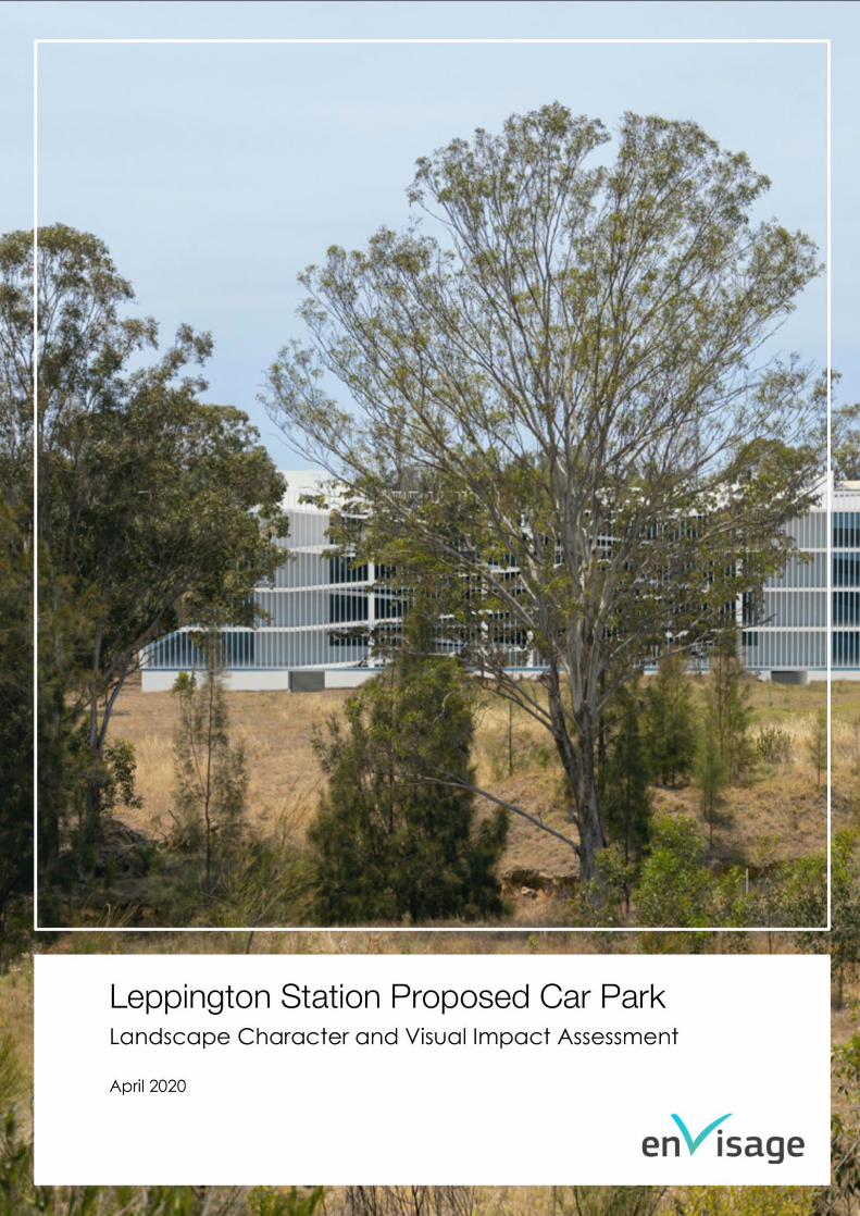
LEPPINGTON STATION PROPOSED CAR PARK
LANDSCAPE CHARACTER AND VISUAL IMPACT ASSESSMENT
DATE: 28 April 2020
PREPARED FOR: Pitt & Sherry on behalf of TRANSPORT FOR NSW
PREPARED BY: Alison Dodds, PGCert Public Policy, BPlan, BLArch
PIA Registered Planner and Stacey Brodbeck, MEnvPlan, BLArch
AILA Registered Landscape Architect and PIA Registered Planner
ENVISAGE DOCUMENT NO.: 15119
ENVISAGE CONSULTING PTY LTD
ABN 89 139 313 296 envisageconsulting.com.au
DOCUMENT CONTROL
Revision Date of Issue Revision Details Prepared by Reviewed/ Authorised by
1 2 March 2020 Draft Alison Dodds Stacey Brodbeck
2 7 April 2020 Updated draft Alison Dodds Stacey Brodbeck
28 28 April 2020 Final Alison Dodds Stacey Brodbeck

ii TfNSW PROPOSED CAR PARK LEPPINGTON STATION - VISUAL IMPACT ASSESSMENT
envisageconsulting.com.au
Contents 1 Introduction ............................................................................................................................................................. 2
1.1 Purpose of this report .................................................................................................................................. 2 1.2 Proposal overview ....................................................................................................................................... 2 1.3 Report format............................................................................................................................................... 3
2 Assessment methodology ...................................................................................................................................... 4 2.1 Assessment ................................................................................................................................................... 4 2.2 Field survey ................................................................................................................................................... 5 2.3 Photography ................................................................................................................................................ 5
3 Site context .............................................................................................................................................................. 6 3.1 Location........................................................................................................................................................ 6 3.2 Land use ....................................................................................................................................................... 6 3.3 Landform ...................................................................................................................................................... 7 3.4 Site description ............................................................................................................................................ 7 3.5 Biodiversity .................................................................................................................................................. 10 3.6 Planned development.............................................................................................................................. 10
4 Project description ................................................................................................................................................ 16 4.1 Scope of work ............................................................................................................................................ 16 4.2 Construction ............................................................................................................................................... 18 4.3 Project elements visible at operation...................................................................................................... 20
5 Impact on landscape character ........................................................................................................................ 21 5.1 Landscape character............................................................................................................................... 21 5.2 Existing character ...................................................................................................................................... 21 5.3 Planned future character ......................................................................................................................... 22 5.4 Summary of impact ................................................................................................................................... 22
6 Impact on views .................................................................................................................................................... 23 6.1 Existing viewpoints ..................................................................................................................................... 23
6.1.1 Extent of visibility ........................................................................................................................ 23 6.1.2 Assessed viewpoints .................................................................................................................. 23
6.2 Future viewpoints ....................................................................................................................................... 34 6.2.1 Extent of visibility ........................................................................................................................ 34 6.2.2 Future viewpoints identified for assessment ........................................................................... 35 6.2.3 Assessment of future viewpoints .............................................................................................. 36
6.3 Summary of visual impact ........................................................................................................................ 38
7 Mitigation measures ............................................................................................................................................. 39 7.1 Positive visual attributes of the Proposal ................................................................................................. 39 7.2 Additional measures ................................................................................................................................. 40
8 Key findings and conclusion ................................................................................................................................ 42
9 References............................................................................................................................................................. 44
iii TfNSW PROPOSED CAR PARK LEPPINGTON STATION - VISUAL IMPACT ASSESSMENT
envisageconsulting.com.au
TABLES
TABLE 2-1: LANDSCAPE CHARACTER AND VISUAL IMPACT RATING MATRIX ...................................................... 4 TABLE 3-1: PROPOSED LAND USE AND CHARACTER.............................................................................................. 12 TABLE 5-1: SUMMARY OF LANDSCAPE CHARACTER IMPACTS ............................................................................. 22 TABLE 6-1: VP1 – DICKSON ROAD ............................................................................................................................. 25 TABLE 6-2: VP2 – BRINGELLY ROAD ........................................................................................................................... 28 TABLE 6-3: VP3 –RICKARD ROAD NORTH-EAST OF SITE .......................................................................................... 31 TABLE 6-4: VP4 – RICKARD ROAD EAST OF SITE ....................................................................................................... 32 TABLE 6-5: VP5 –RICKARD ROAD SOUTH-EAST OF SITE ........................................................................................... 33 TABLE 6-6: VP6 – LEPPINGTON PUBLIC SCHOOL ..................................................................................................... 33 TABLE 6-7: VP7 – INGLEBURN ROAD/RICKARD ROAD INTERSECTION ................................................................. 34 TABLE 6-8: FVP1 – SCALABRINI CREEK CORRIDOR ................................................................................................. 36 TABLE 6-9: FVP2 –MIXED USE PRECINCT .................................................................................................................... 37 TABLE 6-10: FVP3 – MEDIUM DENSITY RESIDENTIAL ................................................................................................. 37 TABLE 6-11: ASSESSMENT OF IMPACTS TO EXISTING VIEWPOINTS ........................................................................ 38 TABLE 6-12: ASSESSMENT OF IMPACTS TO FUTURE VIEWPOINTS ........................................................................... 38 TABLE 8-1: MITIGATION MEASURES ............................................................................................................................ 40 TABLE A-0-1: SENSITIVITY RANKING CRITERIA ........................................................................................................... 45 TABLE A-0-2: MAGNITUDE OF CHANGE RANKING CRITERIA ................................................................................ 45
FIGURES
FIGURE 1-1: LOCATION OF LEPPINGTON STATION.................................................................................................... 2 FIGURE 3-1: CONTEXT OF PROPOSAL LOCATION ..................................................................................................... 6 FIGURE 3-2: VICINITY OF LEPPINGTON STATION ........................................................................................................ 7 FIGURE 3-3: PROPOSAL SITE – LOOKING SOUTH ....................................................................................................... 8 FIGURE 3-4: VIEW EAST OF PROPOSAL SITE (from eastern Site boundary) .......................................................... 8 FIGURE 3-5: VIEW NORTH OF PROPOSAL SITE (from northern Site boundary) .................................................... 9 FIGURE 3-6: VICINITY SOUTH OF SITE (view from Dickson Road looking south east) ......................................... 9 FIGURE 3-7: VICINITY WEST OF THE PROPOSAL SITE (from western Site boundary) .......................................... 10 FIGURE 3-8: LEPPINGTON TOWN CENTRE MASTERPLAN (schedule 2, DCP 2013) ............................................ 11 FIGURE 3-9: LAND ZONING AROUND THE PROPOSAL SITE .................................................................................... 12 FIGURE 3-10: ARTIST IMPRESSION – FUTURE RICKARD ROAD VIEW LOOKING SOUTH ....................................... 13 FIGURE 3-11: EXAMPLES OF HOUSING ABOVE ACTIVE RETAIL GROUND FLOOR .............................................. 13 FIGURE 3-12: EXAMPLES OF MEDIUM DENSITY HOUSING ...................................................................................... 14 FIGURE 3-13: CONCEPT - OPEN SPACE CORRIDOR INCORPORTATING RIPARIAN PROTECTION AREAS ..... 14 FIGURE 4-1: PROPOSED CAR PARK FOOTPRINT (INDICATIVE ONLY AND SUBJECT TO DETAILED DESIGN) .. 17 FIGURE 4-2: OVERVIEW OF PROPOSED CAR PARK FROM THE SOUTH WEST ...................................................... 17 FIGURE 4-3: PROPOSED CONSTRUCTION AREA ...................................................................................................... 19 FIGURE 6-1: EXISTING LANDSCAPE - APPROXIMATE VISIBILITY AND IDENTIFIED VIEWPOINTS FOR ASSESSMENT .................................................................................................................................................................. 24 FIGURE 6-2: VP1 - EXISTING VIEW ............................................................................................................................... 26 FIGURE 6-3: VP1 – PHOTOMONTAGE POST-CONSTRUCTION ............................................................................... 27 FIGURE 6-4: VP2 - EXISTING VIEW ............................................................................................................................... 29 FIGURE 6-5: VP2 – PHOTOMONTAGE POST-CONSTRUCTION ............................................................................... 30 FIGURE 6-6: TYPICAL VIEW FROM RICKARD ROAD TOWARD SITE........................................................................ 32 FIGURE 6-7: PLANNED FUTURE LAND USE - APPROXIMATE VISIBILITY AND ASSESSED VIEWPOINTS ................ 35
2 TfNSW PROPOSED CAR PARK LEPPINGTON STATION - VISUAL IMPACT ASSESSMENT
envisageconsulting.com.au
1 Introduction
1.1 Purpose of this report
Transport for NSW (TfNSW) proposes to construct a multi-level, 1000-space
(approximately) commuter car park at Leppington Station (the Proposal).
This report assesses the landscape character and visual impacts associated with
the Proposal and supports the Review of Environmental Factors (Pitt & Sherry, REF)
which has been developed concurrently.
1.2 Proposal overview
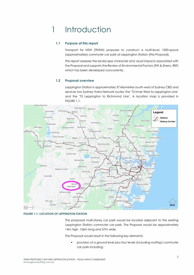
Leppington Station is approximately 37 kilometres south-west of Sydney CBD and
services two Sydney Trains Network routes: the ‘T2 Inner West to Leppington Line’
and the ’T5 Leppington to Richmond Line’. A location map is provided in
FIGURE 1.1.
FIGURE 1-1: LOCATION OF LEPPINGTON STATION
The proposed multi-storey car park would be located adjacent to the existing
Leppington Station commuter car park. The Proposal would be approximately
14m high, 126m long and 57m wide.
The Proposal would result in the following key elements:
provision of a ground level plus four levels (including rooftop) commuter
car park including:

3 TfNSW PROPOSED CAR PARK LEPPINGTON STATION - VISUAL IMPACT ASSESSMENT
envisageconsulting.com.au
o approximately1,000 commuter car parking spaces
o approximately 20 additional accessible car parking spaces in
the station precinct
o internal circulation ramps connecting the levels
o two lifts and six sets of stairs
o provision for electric vehicle charging stations
o Opal Park and Ride infrastructure
o separate vehicle exit and entry points on the eastern face of the
car park
roadworks to facilitate access and egress for pedestrians and vehicles
via the existing at-grade commuter car park
installation of renewable energy options such as solar panels and
battery storage
installation of fencing around the multi-storey car park where necessary
wayfinding signage for traffic and pedestrians
ancillary works including services diversion and/or relocation, drainage
works, landscaping, installation of lighting, installation of handrails and
balustrades and new infrastructure including CCTV cameras
A detailed project description is provided in SECTION 4.
1.3 Report format
This report is set out in the following format:
SECTION 2 Defines the methodology for the assessment
SECTION 3 Describes the location and context of the Site
SECTION 4 Describes the Proposal and its main visual changes
SECTION 5 Assesses the likely effects to landscape character
SECTION 6 Assesses the likely effects to surrounding viewpoints
SECTION 7 Describes measures that have been, and could be,
incorporated to improve the visual outcome
SECTION 8 Presents a summary of key findings and conclusion.

4 TfNSW PROPOSED CAR PARK LEPPINGTON STATION - VISUAL IMPACT ASSESSMENT
envisageconsulting.com.au
2 Assessment methodology
This section outlines the methodology for the assessment, which is based on the
NSW Roads and Maritime Services’ Guideline for Landscape Character and
Visual Impact Assessment, Environmental Impact Assessment Practice Note EIA-
N04, December 2018 (referred to hereafter as the ’Guideline’).
2.1 Assessment
Two assessments are presented in the Guideline to improve design outcomes:
landscape character assessment - the assessment of impact on the
aggregate of an area’s built, natural and cultural character or sense of
place – which helps determine the overall impact of a project on an
area’s character and sense of place.
visual impact assessment - the assessment of impact on views - which
helps define the day to day visual effects of a project on people’s views.
The method to measure impact is based on the combination of sensitivity of the
existing area or view to change, and magnitude of the Proposal on that area or
view. These terms are defined in the Guideline as:
Sensitivity: refers to the qualities of an area, the number and type of
receivers and how sensitive the existing character of the setting is to the
proposed nature of change.
Magnitude: refers to the physical scale of a project, how distant it is and
the contrast it presents to the existing condition.
The combination of sensitivity and magnitude provide the rating of the
landscape character impact for a project, or visual impact for individual
viewpoints (refer TABLE 2-1).
TABLE 2-1: LANDSCAPE CHARACTER AND VISUAL IMPACT RATING MATRIX
Magnitude
High Moderate Low Negligible
Se
nsi
tivity
High High High-Moderate Moderate Negligible
Moderate High-Moderate Moderate Moderate-Low Negligible
Low Moderate Moderate-Low Low Negligible
Negligible Negligible Negligible Negligible Negligible

5 TfNSW PROPOSED CAR PARK LEPPINGTON STATION - VISUAL IMPACT ASSESSMENT
envisageconsulting.com.au
Landscape character assessment
The Guideline sets out the tasks for landscape character impact assessment:
1. analyse existing landscape character and its sensitivity
2. identify landscape character zones (if required because of the size or
complexity of the project)
3. determine the magnitude of impact
4. assess landscape character impact (based on both the sensitivity of the
character zone and magnitude of the Proposal in that zone).
Visual impact assessment
The Guideline sets out the tasks for visual impact assessment:
1. identify the extent of visibility of the Proposal
2. identify existing viewpoints and their sensitivity to change
3. determine the magnitude of change from each viewpoint
4. assess visual impact (based on a composite of the sensitivity of the view
and magnitude of the Proposal in that view).
2.2 Field survey
The Site was inspected 17 December 2019 and included a walk-over of
Leppington Station precinct and surrounding streets. The day of the inspection
was dry and sunny. Private property was not accessed. Viewpoints were
assessed from the nearest publicly accessible locations.
2.3 Photography
Photographs included in this report have been taken using a 50mm lens on a full
frame camera with GPS positioning. The 50mm lens was used as this is closest to
the view perceived by a human eye. Unless otherwise noted, all photographs in
this report were taken by the author 17 December 2019.
6 TfNSW PROPOSED CAR PARK LEPPINGTON STATION - VISUAL IMPACT ASSESSMENT
envisageconsulting.com.au
3 Site context
This section describes the location and general context of the Proposal.
3.1 Location
Leppington Station is within the local government area (LGA) of Camden.
Camden is currently the fastest growing LGA in Australia1 and is set to undergo
significant growth over the next 20 years in association with the NSW Government
South West Priority Growth Area - a prioritised land release intended to meet the
housing needs of the Greater Sydney region.
Leppington Station was opened in 2016 to support planned growth in the area
and is the currently the terminus of the South West Rail Link. A locality map
showing the vicinity of Leppington Station (bounded by four main roads: Bringelly
Road to the north, Rickard Road to the east, Ingleburn Road to the south and
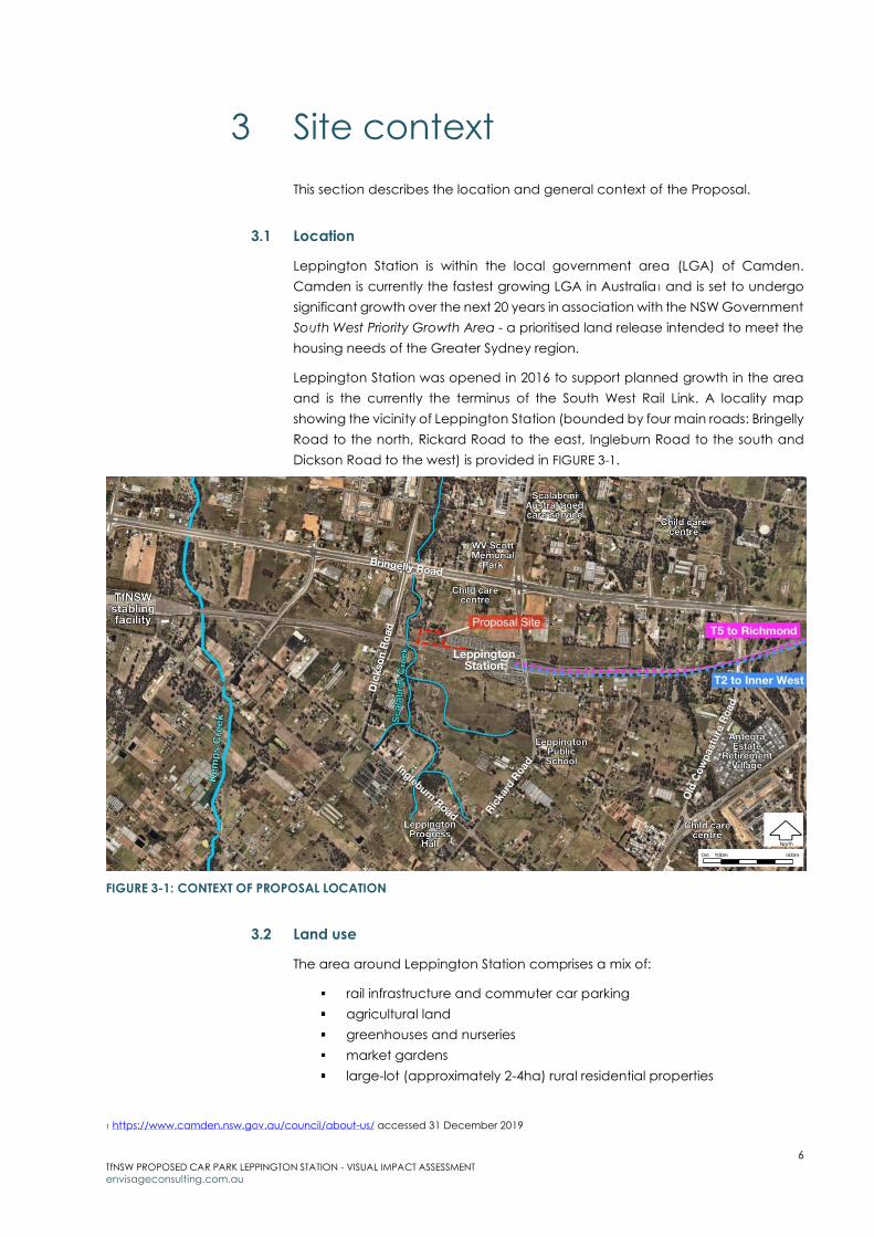
Dickson Road to the west) is provided in FIGURE 3-1.
FIGURE 3-1: CONTEXT OF PROPOSAL LOCATION
3.2 Land use
The area around Leppington Station comprises a mix of:
rail infrastructure and commuter car parking
agricultural land
greenhouses and nurseries
market gardens
large-lot (approximately 2-4ha) rural residential properties
1 https://www.camden.nsw.gov.au/council/about-us/ accessed 31 December 2019

7 TfNSW PROPOSED CAR PARK LEPPINGTON STATION - VISUAL IMPACT ASSESSMENT
envisageconsulting.com.au
new, smaller-lot (around 400m2) residential estates
residential aged care ‘lifestyle’ estates
childcare centres
places of worship
commercial and industrial businesses
green spaces (protected natural areas, parks and gardens).
The nearest school (Leppington Public School) is 0.5km to the south-east of the
Station, on the eastern side of Rickard Road. The nearest retail shopping centre
(Willowdale Shopping Centre) is 3km south of Leppington Station. A ten-road rail
stabling facility is located less than 2km to the west of Leppington Station at
Rossmore.
3.3 Landform
The vicinity is generally flat with Leppington Station being on a slight ridge.
Around the Station, land is gently undulating (fall is approximately 1 in 100)
sloping toward Scalabrini Creek immediately west of the Proposal Site.
The nearest high natural, elevated vantage point (approximately 40m higher in
elevation) is Raby Reservoir, over 2km to the south.
3.4 Site description
The Proposal Site is located on the northern side of Leppington Station, west of
an existing at-grade commuter car park. An image showing the vicinity of the
Proposal Site is provided at FIGURE 3-2.
FIGURE 3-2: VICINITY OF LEPPINGTON STATION

8 TfNSW PROPOSED CAR PARK LEPPINGTON STATION - VISUAL IMPACT ASSESSMENT
envisageconsulting.com.au
The Site is vegetated with tall grasses, shrubs and trees, and separated from the
existing commuter car park via a security fence. An image of the Proposal Site is
shown at FIGURE 3-3.
FIGURE 3-3: PROPOSAL SITE – LOOKING SOUTH
A view of the existing commuter car park is shown at FIGURE 3-4. The car park
includes semi-mature trees to approximately 5-7m tall and is accessible via
Rickard Road.
FIGURE 3-4: VIEW EAST OF PROPOSAL SITE (from eastern Site boundary)
Two detention basins (with vegetated berms) lie north of the Site. Beyond which
is former rural land (now vacant awaiting redevelopment); Bringelly Road (a six-
lane road with two rows of trees planted in the median strip, approximately 300m
from the Site); a childcare centre (on the southern side of Bringelly Road); and
residential properties north of Bringelly Road. A view north is shown in FIGURE 3-5.

9 TfNSW PROPOSED CAR PARK LEPPINGTON STATION - VISUAL IMPACT ASSESSMENT
envisageconsulting.com.au
FIGURE 3-5: VIEW NORTH OF PROPOSAL SITE (from northern Site boundary)
A view of the area south of the Site is shown at FIGURE 3-6. The railway corridor
Borders the Site. Between the railway corridor and Ingleburn Road are rural
properties. Residential properties and Leppington Public School are located
along Rickard Road.
FIGURE 3-6: VICINITY SOUTH OF SITE (view from Dickson Road looking south east)
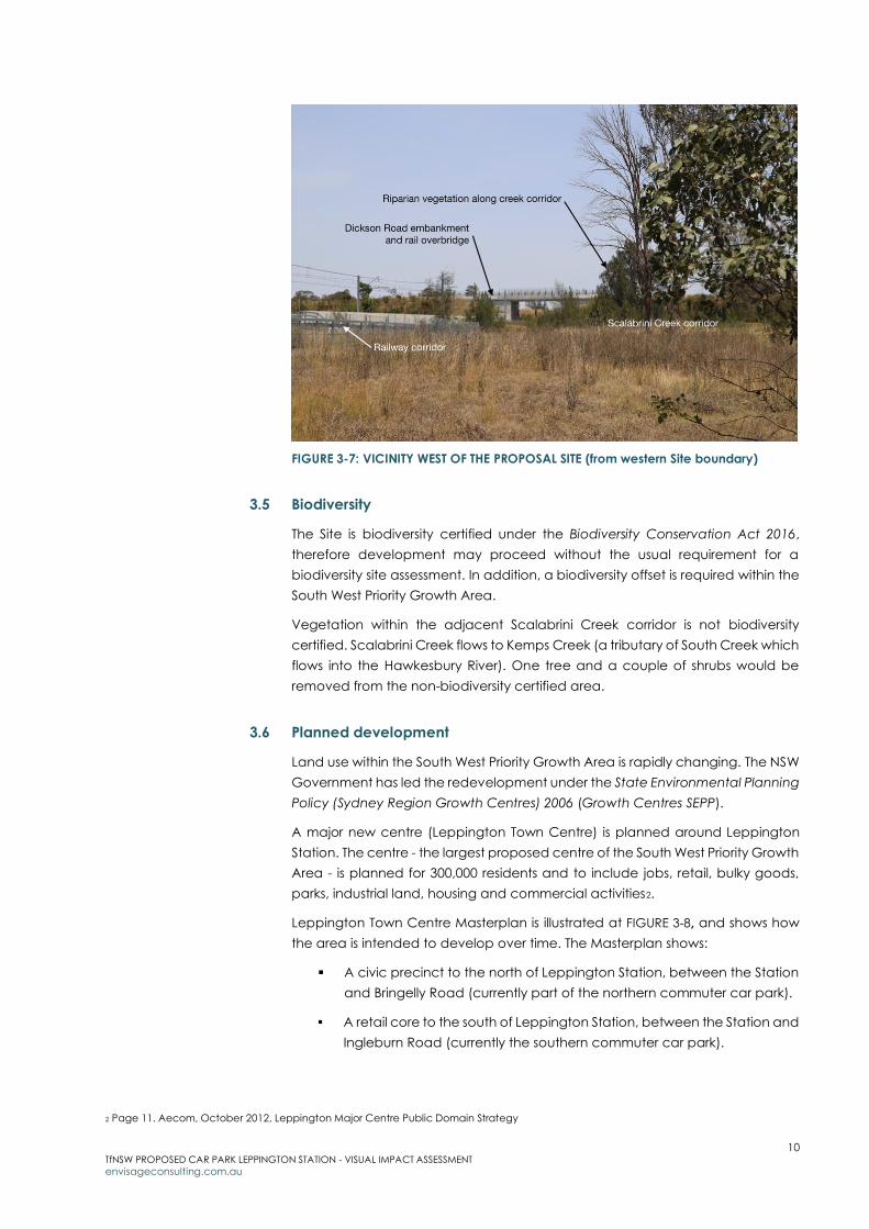
West of the Site, land slopes toward Scalabrini Creek before the steep
embankment to Dickson Road rail overbridge. A view west of Leppington Station
is shown at FIGURE 3-7.
10 TfNSW PROPOSED CAR PARK LEPPINGTON STATION - VISUAL IMPACT ASSESSMENT
envisageconsulting.com.au
FIGURE 3-7: VICINITY WEST OF THE PROPOSAL SITE (from western Site boundary)
3.5 Biodiversity
The Site is biodiversity certified under the Biodiversity Conservation Act 2016,
therefore development may proceed without the usual requirement for a
biodiversity site assessment. In addition, a biodiversity offset is required within the
South West Priority Growth Area.
Vegetation within the adjacent Scalabrini Creek corridor is not biodiversity
certified. Scalabrini Creek flows to Kemps Creek (a tributary of South Creek which
flows into the Hawkesbury River). One tree and a couple of shrubs would be
removed from the non-biodiversity certified area.
3.6 Planned development
Land use within the South West Priority Growth Area is rapidly changing. The NSW
Government has led the redevelopment under the State Environmental Planning
Policy (Sydney Region Growth Centres) 2006 (Growth Centres SEPP).
A major new centre (Leppington Town Centre) is planned around Leppington
Station. The centre - the largest proposed centre of the South West Priority Growth
Area - is planned for 300,000 residents and to include jobs, retail, bulky goods,
parks, industrial land, housing and commercial activities2.
Leppington Town Centre Masterplan is illustrated at FIGURE 3-8, and shows how
the area is intended to develop over time. The Masterplan shows:
A civic precinct to the north of Leppington Station, between the Station
and Bringelly Road (currently part of the northern commuter car park).
A retail core to the south of Leppington Station, between the Station and
Ingleburn Road (currently the southern commuter car park).
2 Page 11. Aecom, October 2012, Leppington Major Centre Public Domain Strategy

11 TfNSW PROPOSED CAR PARK LEPPINGTON STATION - VISUAL IMPACT ASSESSMENT
envisageconsulting.com.au
A business park to the east of Rickard Road (currently the site of
Leppington Public School).
Commuter car parking to the west of the Station (north of the railway
corridor) – including the location of the Proposal Site.
Passive open space and drainage corridor between the commuter car
park and Dickson Road.
Mixed use north of the commuter car park and south of the railway
corridor.
FIGURE 3-8: LEPPINGTON TOWN CENTRE MASTERPLAN (schedule 2, DCP 2013)
The Proposal is located within Camden LGA, however, the area covered by the
Masterplan is partially in Liverpool Council LGA and partially in Camden Council
LGA. Camden City Council Growth Centres Precincts Development Control Plan
2016 and Liverpool Growth Centre Precincts Development Control Plan (DCP,
2013) apply. The DCPs provide detailed guidance on development
characteristics to achieve the intended urban design and amenity outcomes for
Leppington Town Centre.
Rezoning of the area occurred in 2013, allowing a range of planned land uses
such as housing, retail, commercial and industrial to proceed. Zoning around the
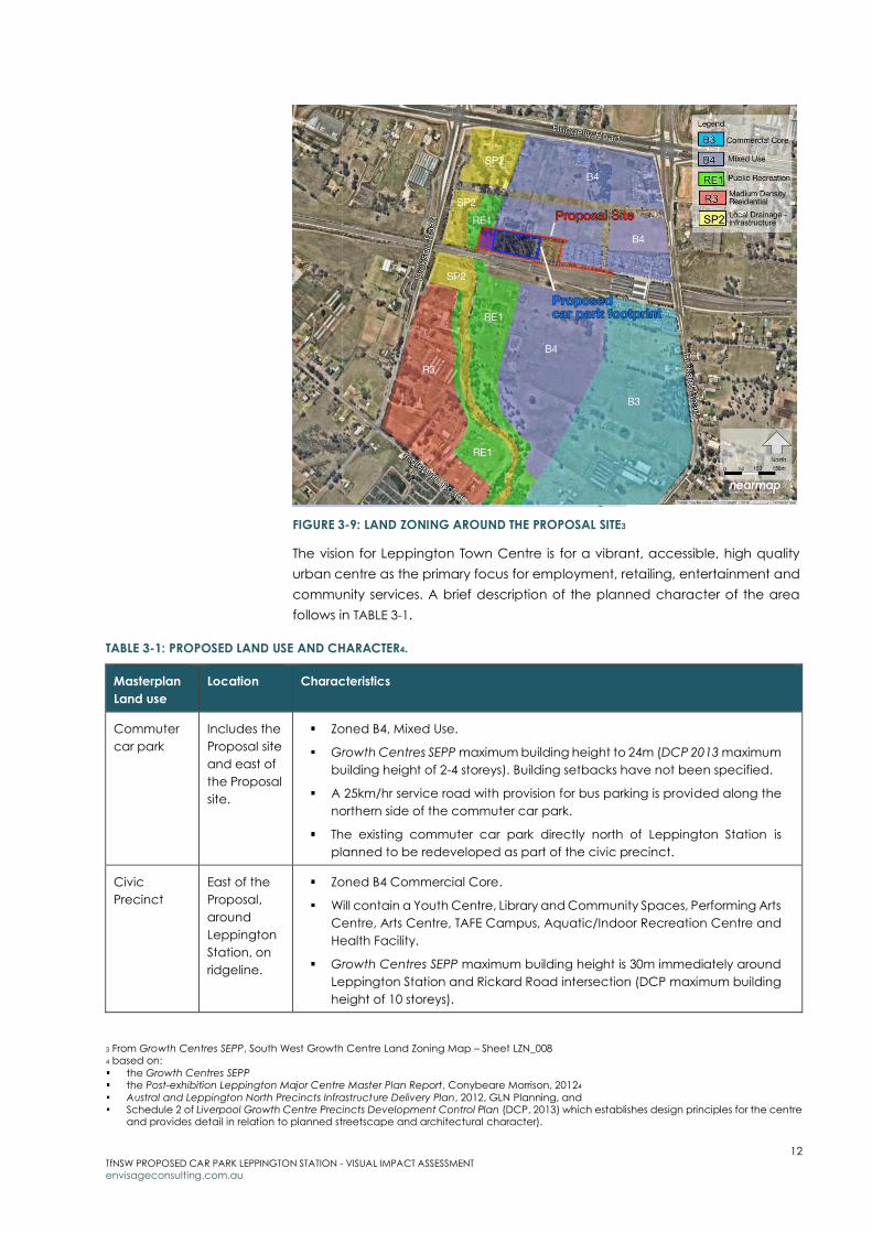
Proposal Site is shown at FIGURE 3-9.
12 TfNSW PROPOSED CAR PARK LEPPINGTON STATION - VISUAL IMPACT ASSESSMENT
envisageconsulting.com.au
FIGURE 3-9: LAND ZONING AROUND THE PROPOSAL SITE3
The vision for Leppington Town Centre is for a vibrant, accessible, high quality
urban centre as the primary focus for employment, retailing, entertainment and
community services. A brief description of the planned character of the area
follows in TABLE 3-1.
TABLE 3-1: PROPOSED LAND USE AND CHARACTER4.
Masterplan
Land use
Location Characteristics
Commuter
car park
Includes the
Proposal site
and east of
the Proposal
site.
Zoned B4, Mixed Use.
Growth Centres SEPP maximum building height to 24m (DCP 2013 maximum
building height of 2-4 storeys). Building setbacks have not been specified.
A 25km/hr service road with provision for bus parking is provided along the
northern side of the commuter car park.
The existing commuter car park directly north of Leppington Station is
planned to be redeveloped as part of the civic precinct.
Civic
Precinct
East of the
Proposal,
around
Leppington
Station, on
ridgeline.
Zoned B4 Commercial Core.
Will contain a Youth Centre, Library and Community Spaces, Performing Arts
Centre, Arts Centre, TAFE Campus, Aquatic/Indoor Recreation Centre and
Health Facility.
Growth Centres SEPP maximum building height is 30m immediately around
Leppington Station and Rickard Road intersection (DCP maximum building
height of 10 storeys).
3 From Growth Centres SEPP, South West Growth Centre Land Zoning Map – Sheet LZN_008 4 based on:
the Growth Centres SEPP the Post-exhibition Leppington Major Centre Master Plan Report, Conybeare Morrison, 20124
Austral and Leppington North Precincts Infrastructure Delivery Plan, 2012, GLN Planning, and Schedule 2 of Liverpool Growth Centre Precincts Development Control Plan (DCP, 2013) which establishes design principles for the centre
and provides detail in relation to planned streetscape and architectural character).

13 TfNSW PROPOSED CAR PARK LEPPINGTON STATION - VISUAL IMPACT ASSESSMENT
envisageconsulting.com.au
Masterplan
Land use
Location Characteristics
A 40km/hr Main Street is proposed south (though the retail core) and north
(through the civic precinct).
An artist’s impression of the future civic precinct from Rickard Road looking
south is shown FIGURE 3-10 (Leppington Station on the right).
FIGURE 3-10: ARTIST IMPRESSION – FUTURE RICKARD ROAD VIEW LOOKING SOUTH5
Mixed use Located to
the north of
the Proposal
site.
Zoned B4, Mixed Use.
Ground floor retail with potential for office and professional suites at first floor
level. Residential apartment accommodation, incorporating a component
of adaptable Seniors Living, for the upper levels.
The Growth Centres SEPP maximum building height is 24m (DCP 2013
maximum building height is 4-6 storeys).
An example of the type of residential apartments that might appear above
ground floor retail is shown at FIGURE 3-11.
FIGURE 3-11: EXAMPLES OF HOUSING ABOVE ACTIVE RETAIL GROUND FLOOR6
Medium
density
Residential
South of the
Proposal
Site, east of
Dickson
Road with
frontages to
Ingleburn
Road and
Dickson
Road
Zoned R3, Medium Density Residential.
Aims to provide a variety of housing types within a medium density
residential environment: townhouses, small lot housing and apartments with
views over a revegetated creek corridor and easy walking proximity to the
Station and retail core.
Dwelling density would be 25 dwellings per hectare7.
5 Conybeare morrison, Leppington Town Centre Masterplan, 2012, p8 6 DPIE, Sydenham to Bankstown – Draft Urban Renewal Corridor Strategy. Building Types 7 Growth Centres SEPP, South West Growth Centre Residential Density Map Sheet RDN_008

14 TfNSW PROPOSED CAR PARK LEPPINGTON STATION - VISUAL IMPACT ASSESSMENT
envisageconsulting.com.au
Masterplan
Land use
Location Characteristics
Growth Centres SEPP maximum building height of 21m (DCP 2013 maximum
building height is 4-6 storeys). An example of the type of residential
apartments that might be developed is shown at FIGURE 3-12.
FIGURE 3-12: EXAMPLES OF MEDIUM DENSITY
HOUSING8
Scalabrini
open space
corridor
West of the
Proposal site
Zoned RE1, Public Recreation adjacent the Proposal Site.
Zoned SP2, Local Drainage between Dickson Road and Scalabrini Creek.
The Scalabrini Creek floodplain would be part of a green corridor providing
a recreational open space network, with lakeside parks, pedestrian
promenades and outdoor eating areas.
Within the RE1 zone:
o will be a 3m wide shared pedestrian/cycle path. It will travel south
under the railway corridor, and north to connect to the Civic Precinct
via a dedicated cycle path within a 50km/hour collector road.
o The shared pedestrian/cycle path will not travel along the service road
proposed north of the commuter car park.
Within the SP2 zone:
o development would be limited as the land would be dedicated to
stormwater flows.
o Scalabrini Creek is a Riparian Protection Area and native vegetation is
protected along the creek9.
The concept design for open space corridors incorporating Riparian
Protection areas is shown at FIGURE 3-13.
FIGURE 3-13: CONCEPT - OPEN SPACE CORRIDOR INCORPORTATING RIPARIAN
PROTECTION AREAS10
8 DPIE, Sydenham to Bankstown – Draft Urban Renewal Corridor Strategy. Building Types 9 SEPP (Sydney Region Growth Centres) 2006. South West Growth Centre Residential Density Map Sheet RPN_008 and NVP_008 10 Schedule 2 of Liverpool Growth Centre Precincts Development Control Plan (DCP, 2013), Figure 4-17
15 TfNSW PROPOSED CAR PARK LEPPINGTON STATION - VISUAL IMPACT ASSESSMENT
envisageconsulting.com.au
Rail
An extension to the South West Rail Link is planned11 to connect Leppington
Station to the North South Rail Line corridor and Western Sydney Airport. The new
corridor would be generally 60m wide and accommodate up to four railway
tracks, comprising two tracks in each direction.
Road
Roads in the area are being upgraded to cater for the planned heavier traffic
loads:
Bringelly Road was upgraded (2018) from a two-lane to a six-lane
divided road to become a principal arterial transport corridor.
Rickard Road (upgrade in progress) will be a key north-south transport
link and include dedicated bus lanes in each direction12.
Dickson Road upgrade (2018) included a new rail over bridge and
extended to Bringelly Road.
11 TfNSW, North South Rail Line and South West Rail Link Extension corridor identification, https://www.transport.nsw.gov.au/corridors/nsrl-swrl accessed 15 December 2019 12 https://www.rms.nsw.gov.au/projects/rickard-road-upgrade/index.html accessed 31 December 2019
16 TfNSW PROPOSED CAR PARK LEPPINGTON STATION - VISUAL IMPACT ASSESSMENT
envisageconsulting.com.au
4 Project description
This section outlines the major components and work items of the Proposal.
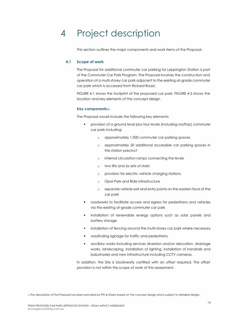
4.1 Scope of work
The Proposal for additional commuter car parking for Leppington Station is part
of the Commuter Car Park Program. The Proposal involves the construction and
operation of a multi-storey car park adjacent to the existing at-grade commuter
car park which is accessed from Rickard Road.
FIGURE 4-1 shows the footprint of the proposed car park. FIGURE 4-2 shows the
location and key elements of the concept design.
Key components13
The Proposal would include the following key elements:
provision of a ground level plus four levels (including rooftop) commuter
car park including:
o approximately 1,000 commuter car parking spaces
o approximately 20 additional accessible car parking spaces in
the station precinct
o internal circulation ramps connecting the levels
o two lifts and six sets of stairs
o provision for electric vehicle charging stations
o Opal Park and Ride infrastructure
o separate vehicle exit and entry points on the eastern face of the
car park
roadworks to facilitate access and egress for pedestrians and vehicles
via the existing at-grade commuter car park
installation of renewable energy options such as solar panels and
battery storage
installation of fencing around the multi-storey car park where necessary
wayfinding signage for traffic and pedestrians
ancillary works including services diversion and/or relocation, drainage
works, landscaping, installation of lighting, installation of handrails and
balustrades and new infrastructure including CCTV cameras.
In addition, the Site is biodiversity certified with an offset required. The offset
provision is not within the scope of work of this assessment.
13 The description of the Proposal has been provided by Pitt & Sherry based on the concept design and is subject to detailed design.

17 TfNSW PROPOSED CAR PARK LEPPINGTON STATION - VISUAL IMPACT ASSESSMENT
envisageconsulting.com.au
FIGURE 4-1: PROPOSED CAR PARK FOOTPRINT (INDICATIVE ONLY AND SUBJECT TO DETAILED DESIGN)14
FIGURE 4-2: OVERVIEW OF PROPOSED CAR PARK FROM THE SOUTH WEST15
Design features
The key design features of the Proposal include:
Construction of a multi-storey car park (ground level plus four levels
(including roof-top parking), approximately 14m high, connected by
internal circulation ramps, with provision of approximately 1,000
commuter car parking spaces.
Roadworks to facilitate access and egress for pedestrians and vehicles
via the existing at-grade car park.
14 Figure provided by Pitt&Sherry 15 Subject to detailed design. Figure provided by Pitt&Sherry
18 TfNSW PROPOSED CAR PARK LEPPINGTON STATION - VISUAL IMPACT ASSESSMENT
envisageconsulting.com.au
Way-finding signage for pedestrian circulation.
New fencing around all sides of the site.
Ancillary works including services diversion and/or relocation, drainage
works, installation of lighting, installation of handrails and balustrades
and new infrastructure including CCTV cameras.
The Proposal would be designed having regard to the following design
standards:
o Disability Standards for Accessible Public Transport 2002 (issued
under the Commonwealth Disability Discrimination Act 1992)
o National Construction Code
o Relevant Australian Standards
o Asset Standards Authority standards
o Infrastructure Sustainability Council of Australia (ISCA) Infrastructure Sustainability Rating Scheme (v1.2)
o TfNSW Urban Design Guidelines
o Guidelines for the Development of Public Transport Interchange Facilities (Ministry of Transport, 2008)
o Crime Prevention Through Environmental Design (CPTED) principles
o Other TfNSW policies and guidelines
o Relevant council standards.
Materials and finishes
The Proposal involves a ground floor concrete slab and the addition of four
suspended levels above for the multi-storey car park.
Selection of materials and finishes would be confirmed during the detailed
design process, and would include consideration of the following:
Colour options - most likely to be based on a natural design scheme with
colours and tones to blend the car park with the natural elements of the
neighbourhood, and to create a less obtrusive façade.
Structural screening treatments for the façade - which could be applied
to maintain optimum ventilation to comply with the requirements of an
open-deck car park.
4.2 Construction
The proposed construction area is shown FIGURE 4-3.
Timing
Construction is expected to commence in mid 2020 and take around 15 months
to complete, subject to approval. Standard (NSW EPA) construction hours are
anticipated (7.00 am to 6.00 pm Monday to Friday, and 8.00 am to 1.00 pm
Saturdays). Night and weekend work may be periodically required. Approval
from TfNSW would be required for any out of hours work and the affected
community would be notified.

19 TfNSW PROPOSED CAR PARK LEPPINGTON STATION - VISUAL IMPACT ASSESSMENT
envisageconsulting.com.au
FIGURE 4-3: PROPOSED CONSTRUCTION AREA16
Site establishment
Access during construction would be from Rickard Road, via the existing,
northern, at-grade car park.
A material handling / storage area would be located within the Site along the
railway corridor and western boundaries. Temporary construction compounds /
worker amenities would be established along the eastern Site boundary, within
the existing commuter compound.
Vegetation identified for removal (trees, shrubs and grasses) would be cleared.
Major works
Earthworks would occur for car park foundations and support structures, roads,
pathways, drainage/stormwater works and underground services. Excavated
material volume is expected to be small.
Substructure pile foundations would be installed, then the concrete
superstructure floors, ramps, stairs and lift shafts formed and poured. Building
services, balustrades and external cladding would be installed, and associated
works such as footpaths, ramps, kerbs, fences and road surfacing completed.
Plant and equipment
Construction would require use of large equipment, including:
Trucks Lighting towers Bobcat
Crane (20 tonne) Excavator Mulcher
100 tonne mobile crane
Elevated working platform
Small mobile crane
16 Figure provided by TfNSW
20 TfNSW PROPOSED CAR PARK LEPPINGTON STATION - VISUAL IMPACT ASSESSMENT
envisageconsulting.com.au
Completion
Upon completion of the proposed construction works, all disturbed areas would
be rehabilitated. Demobilisation works include removal of the construction
compound/s, temporary fencing and storage areas; and covering or
vegetating exposed surfaces.
4.3 Project elements visible at operation
Once completed, the main Proposal elements that would be visible would be:
A 14m high (approximately) multi-storey carpark, approximately 126m
long and 57m wide. Comprised of:
o concrete slab construction
o finished in colours and tones to blend with the natural
environment
o with structural screening treatments for the façade.
New landscaping, signage and lighting.
Extended footpaths and possibly new configuration of existing car park
roads.

21 TfNSW PROPOSED CAR PARK LEPPINGTON STATION - VISUAL IMPACT ASSESSMENT
envisageconsulting.com.au
5 Impact on landscape character
This section assesses the likely impact of the Proposal on landscape character
based on the combination of two criteria: sensitivity and magnitude of change.
5.1 Landscape character
The existing landscape is undergoing rapid and significant re-development. The
low-density rural character of the area is in the process of changing to a high-
density urban form. Very little of the existing rural character will be retained under
the planned Leppington Town Centre development.
Due to the rapidly changing nature of the landscape around the Site, impact
on landscape character is assessed in terms of existing landscape character
(refer to Section 5.2) and planned landscape character (refer to Section 5.3).
5.2 Existing character
Sensitivity
Existing landscape character is rated as having low sensitivity:
The Site is quite densely vegetated and near to Scalabrini Creek,
however, it is biodiversity certified to enable development.
There is significant infrastructure near the Site (railway corridor, Dickson
Road rail overbridge, Leppington Station, commuter car parking).
The vicinity is undergoing major transformation including the upgrade of
local roads to arterial routes, construction of residential and senior
residential care estates within the surrounding rural landscape, and has
been rezoned for the planned Leppington Town Centre which will cater
to 300,000 people.
Magnitude of change
The Proposal would have a moderate magnitude of change on existing
landscape character:
The Proposal would result in total loss of vegetation at the Site. However,
vegetation within Scalabrini Creek corridor would be retained,
maintaining the green, treed character along the creek line and
adjacent to Dickson Road.
The Proposal is a relatively minor component of the overall infrastructure
plans for Leppington Town Centre. However, until neighbouring facilities
and buildings are constructed, the Proposal would be the tallest and
largest structure in the vicinity.
As the Proposal would be constructed on lower lying land and adjacent
the vegetated creek corridor, the scale and bulk of the Proposal would
be less visible than if located on higher land.

22 TfNSW PROPOSED CAR PARK LEPPINGTON STATION - VISUAL IMPACT ASSESSMENT
envisageconsulting.com.au
Impact
The low sensitivity ranking, combined with the moderate magnitude of change
during, leads to an overall moderate-low level of impact to landscape
character.
5.3 Planned future character
Sensitivity
The planned future landscape character is rated as having moderate sensitivity:
An attractive community has been planned.
All built elements within Leppington Town Centre will contribute to its
overall character as a vibrant, high-quality destination, therefore the
design of each is important.
The Site is near a planned major public recreational corridor (Scalabrini
Creek) which is intended to hold public events and facilitate a key
pedestrian and cycle network.
Magnitude of change
The Proposal would have a low magnitude of change on the future landscape
character:
The Proposal would include high quality finishes and colours that are
muted and complement the recreational corridor.
The Proposal height (approximately 14m: four storeys with roof-top
parking) is within the SEPP maximum building height (24m) and generally
consistent with the DCP 2013 requirements for the commuter car park
site (2-4 storeys).
The Proposal is consistent with the planned use for the Site in
accordance with the Leppington Town Centre Masterplan.
Impact
The moderate sensitivity ranking, combined with the low magnitude of change
during, leads to an overall moderate-low level of impact to future landscape
character.
5.4 Summary of impact
A summary of impact to landscape character is provided in TABLE 5-1.
TABLE 5-1: SUMMARY OF LANDSCAPE CHARACTER IMPACTS
Character Sensitivity Magnitude Landscape character impact
Existing Low Moderate Moderate-low
Planned future Moderate Low Moderate-low
23 TfNSW PROPOSED CAR PARK LEPPINGTON STATION - VISUAL IMPACT ASSESSMENT
envisageconsulting.com.au
6 Impact on views
This section assesses the likely impact of the Proposal on representative public
and private viewpoints based on the combination of two criteria: sensitivity and
magnitude of change.
Visibility is assessed in terms of existing viewpoints (refer to Section 6.1) and
potential future viewpoints within the planned Leppington Town Centre (refer to
Section 6.2).
6.1 Existing viewpoints
6.1.1 Extent of visibility
The Proposal would have limited visibility due to:
Existing trees within the surrounding rural properties, along Scalabrini
Creek, within Rickard Road and Dickson Road reserves, and within the
existing commuter car park.
The generally flat landform coupled with Dickson Road being elevated
(preventing views from further west), and Leppington Station/Rickard
Road being on a ridgeline and elevated (preventing views from further
east).
An approximate visual envelope is shown at FIGURE 6-1.
6.1.2 Assessed viewpoints
The nearest existing sensitive viewpoints (VPs) are residences on Bringelly, Rickard
and Ingleburn Road; Leppington Public School on Rickard Road; and a child
care centre on Bringelly Road. Less sensitive viewpoints are from surrounding
roads (Dickson Road, Bringelly Road and Rickard Road).
Seven viewpoints have been identified for assessment - all within 1km of the Site.
They are listed below by distance from the Site and are shown at FIGURE 6-1:
VP1: Dickson Road (approximately 175m west)
VP2: Bringelly Road (approximately 250m north)
VP3: Rickard Road north-east of Site (approximately 360m north-east)
VP4: Rickard Road east of Site (approximately 425m east)
VP5: Rickard Road south-east of Site (approximately 525m south-east)
VP6: Leppington Public School (approximately 775m south-east)
VP7: Ingleburn Road/Rickard Road intersection (approximately 900m
south).
Existing viewpoints are described and assessed in TABLE 6-1 to TABLE 6-7.

24 TfNSW PROPOSED CAR PARK LEPPINGTON STATION - VISUAL IMPACT ASSESSMENT
envisageconsulting.com.au
FIGURE 6-1: EXISTING LANDSCAPE - APPROXIMATE VISIBILITY AND IDENTIFIED VIEWPOINTS FOR ASSESSMENT
25 TfNSW PROPOSED CAR PARK LEPPINGTON STATION - VISUAL IMPACT ASSESSMENT
envisageconsulting.com.au
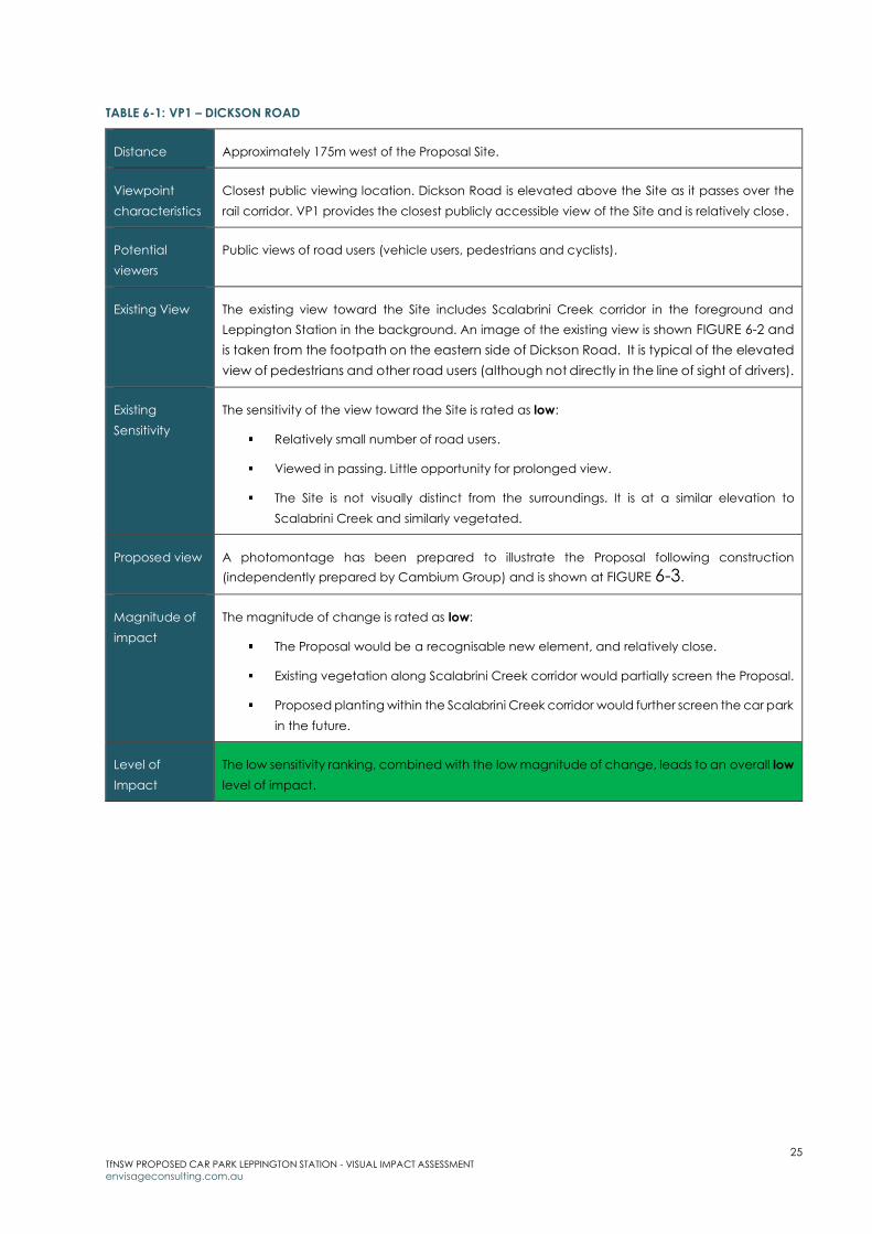
TABLE 6-1: VP1 – DICKSON ROAD
Distance Approximately 175m west of the Proposal Site.
Viewpoint
characteristics
Closest public viewing location. Dickson Road is elevated above the Site as it passes over the
rail corridor. VP1 provides the closest publicly accessible view of the Site and is relatively close.
Potential
viewers
Public views of road users (vehicle users, pedestrians and cyclists).
Existing View The existing view toward the Site includes Scalabrini Creek corridor in the foreground and
Leppington Station in the background. An image of the existing view is shown FIGURE 6-2 and
is taken from the footpath on the eastern side of Dickson Road. It is typical of the elevated
view of pedestrians and other road users (although not directly in the line of sight of drivers).
Existing
Sensitivity
The sensitivity of the view toward the Site is rated as low:
Relatively small number of road users.
Viewed in passing. Little opportunity for prolonged view.
The Site is not visually distinct from the surroundings. It is at a similar elevation to
Scalabrini Creek and similarly vegetated.
Proposed view A photomontage has been prepared to illustrate the Proposal following construction
(independently prepared by Cambium Group) and is shown at FIGURE 6-3.
Magnitude of
impact
The magnitude of change is rated as low:
The Proposal would be a recognisable new element, and relatively close.
Existing vegetation along Scalabrini Creek corridor would partially screen the Proposal.
Proposed planting within the Scalabrini Creek corridor would further screen the car park
in the future.
Level of
Impact
The low sensitivity ranking, combined with the low magnitude of change, leads to an overall low
level of impact.

26 TfNSW PROPOSED CAR PARK LEPPINGTON STATION - VISUAL IMPACT ASSESSMENT
envisageconsulting.com.au
FIGURE 6-2: VP1 - EXISTING VIEW

27 TfNSW PROPOSED CAR PARK LEPPINGTON STATION - VISUAL IMPACT ASSESSMENT
envisageconsulting.com.au
FIGURE 6-3: VP1 – PHOTOMONTAGE POST-CONSTRUCTION
28 TfNSW PROPOSED CAR PARK LEPPINGTON STATION - VISUAL IMPACT ASSESSMENT
envisageconsulting.com.au
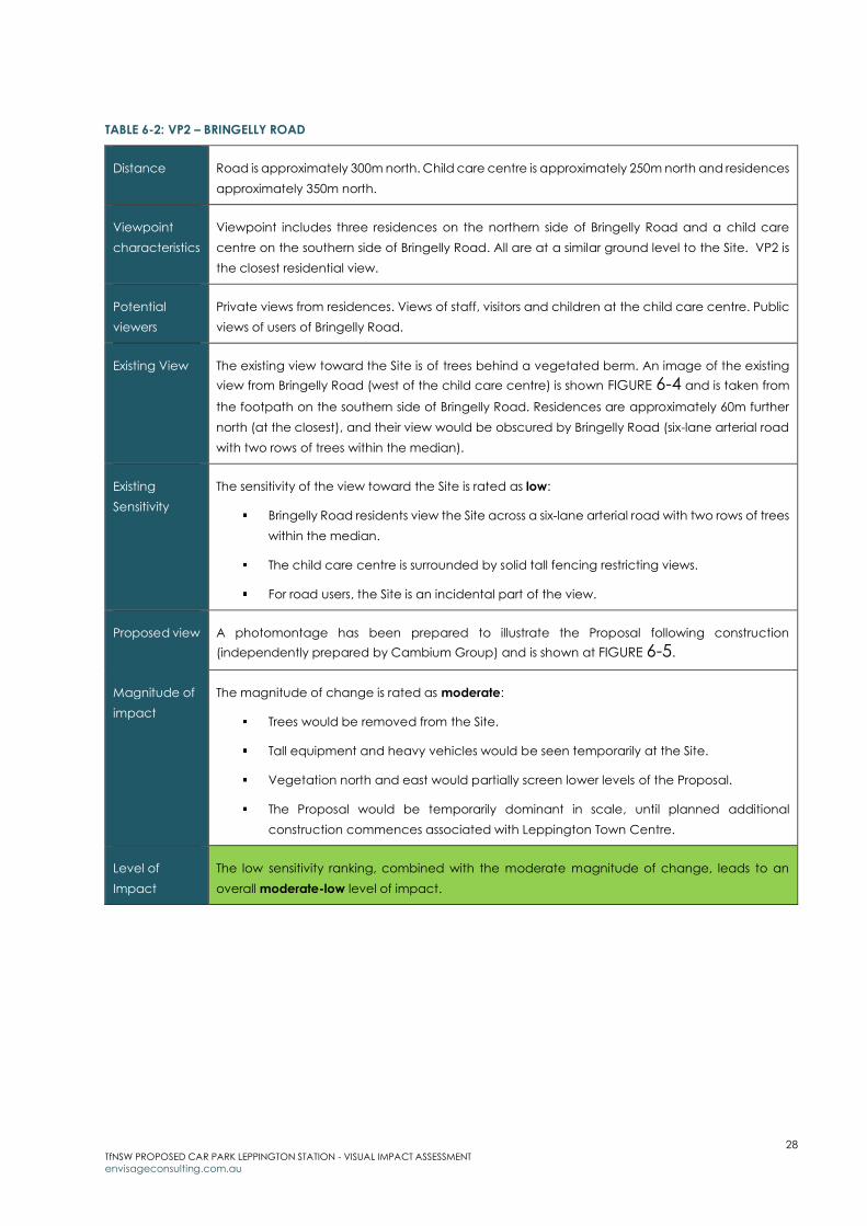
TABLE 6-2: VP2 – BRINGELLY ROAD
Distance Road is approximately 300m north. Child care centre is approximately 250m north and residences
approximately 350m north.
Viewpoint
characteristics
Viewpoint includes three residences on the northern side of Bringelly Road and a child care
centre on the southern side of Bringelly Road. All are at a similar ground level to the Site. VP2 is
the closest residential view.
Potential
viewers
Private views from residences. Views of staff, visitors and children at the child care centre. Public
views of users of Bringelly Road.
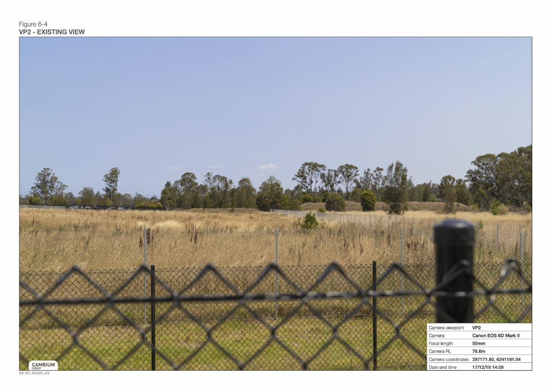
Existing View The existing view toward the Site is of trees behind a vegetated berm. An image of the existing
view from Bringelly Road (west of the child care centre) is shown FIGURE 6-4 and is taken from
the footpath on the southern side of Bringelly Road. Residences are approximately 60m further
north (at the closest), and their view would be obscured by Bringelly Road (six-lane arterial road
with two rows of trees within the median).
Existing
Sensitivity
The sensitivity of the view toward the Site is rated as low:
Bringelly Road residents view the Site across a six-lane arterial road with two rows of trees
within the median.
The child care centre is surrounded by solid tall fencing restricting views.
For road users, the Site is an incidental part of the view.
Proposed view A photomontage has been prepared to illustrate the Proposal following construction
(independently prepared by Cambium Group) and is shown at FIGURE 6-5.
Magnitude of
impact
The magnitude of change is rated as moderate:
Trees would be removed from the Site.
Tall equipment and heavy vehicles would be seen temporarily at the Site.
Vegetation north and east would partially screen lower levels of the Proposal.
The Proposal would be temporarily dominant in scale, until planned additional
construction commences associated with Leppington Town Centre.
Level of
Impact
The low sensitivity ranking, combined with the moderate magnitude of change, leads to an
overall moderate-low level of impact.
29 TfNSW PROPOSED CAR PARK LEPPINGTON STATION - VISUAL IMPACT ASSESSMENT
envisageconsulting.com.au
FIGURE 6-4: VP2 - EXISTING VIEW
30 TfNSW PROPOSED CAR PARK LEPPINGTON STATION - VISUAL IMPACT ASSESSMENT
envisageconsulting.com.au
FIGURE 6-5: VP2 – PHOTOMONTAGE POST-CONSTRUCTION
31 TfNSW PROPOSED CAR PARK LEPPINGTON STATION - VISUAL IMPACT ASSESSMENT
envisageconsulting.com.au
TABLE 6-3: VP3 –RICKARD ROAD NORTH-EAST OF SITE
Distance Approximately 360m north-east.
Viewpoint
characteristics
Viewpoint includes two residences on the western side of Rickard Road. Viewpoint is slightly elevated
compared to the Proposal Site.
Potential
viewers
Private views from residences.
Existing View The existing view toward the Site is of tall trees beyond the northern commuter car park. (An image
from this viewpoint was not possible).
Existing
Sensitivity
The sensitivity of the view toward the Site is rated as low:
The Site is not visually prominent.
The view is relatively wide, including Scalabrini Creek corridor, the commuter car park, and
rural land south of the railway corridor.
The Site occupies a relatively small proportion of the view.
Magnitude of
impact
The magnitude of change is rated as low:
The removal of trees, tall equipment and heavy vehicles would be seen temporarily at the
Site.
Once constructed, the Proposal would be lower in height than trees along the Scalabrini
Creek corridor. Background vegetation would help conceal the Proposal and reduce its
visual prominence.
Vegetation within the commuter car park would partially screen the lower levels of the
Proposal.
Level of
Impact
The low sensitivity ranking, combined with the low magnitude of change, leads to an overall low
level of impact.
32 TfNSW PROPOSED CAR PARK LEPPINGTON STATION - VISUAL IMPACT ASSESSMENT
envisageconsulting.com.au
TABLE 6-4: VP4 – RICKARD ROAD EAST OF SITE
Distance Approximately 425m east the Site.
Viewpoint
characteristics
Viewpoint is elevated as it passes over the railway corridor.
Potential
viewers
Public views from users of Rickard Road and customers of Leppington Station.
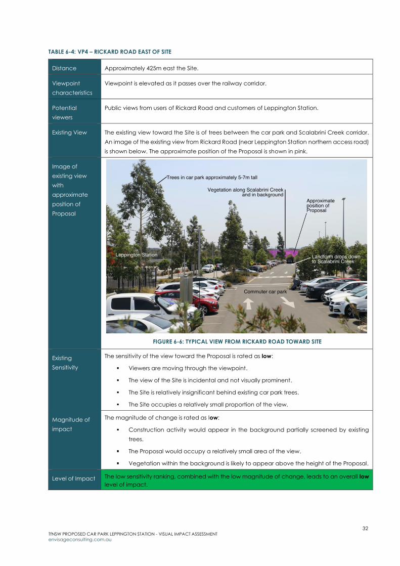
Existing View The existing view toward the Site is of trees between the car park and Scalabrini Creek corridor.
An image of the existing view from Rickard Road (near Leppington Station northern access road)
is shown below. The approximate position of the Proposal is shown in pink.
Image of
existing view
with
approximate
position of
Proposal
FIGURE 6-6: TYPICAL VIEW FROM RICKARD ROAD TOWARD SITE
Existing
Sensitivity
The sensitivity of the view toward the Proposal is rated as low:
Viewers are moving through the viewpoint.
The view of the Site is incidental and not visually prominent.
The Site is relatively insignificant behind existing car park trees.
The Site occupies a relatively small proportion of the view.
Magnitude of
impact
The magnitude of change is rated as low:
Construction activity would appear in the background partially screened by existing
trees.
The Proposal would occupy a relatively small area of the view.
Vegetation within the background is likely to appear above the height of the Proposal.
Level of Impact The low sensitivity ranking, combined with the low magnitude of change, leads to an overall low
level of impact.
33 TfNSW PROPOSED CAR PARK LEPPINGTON STATION - VISUAL IMPACT ASSESSMENT
envisageconsulting.com.au
TABLE 6-5: VP5 –RICKARD ROAD SOUTH-EAST OF SITE
Distance Approximately 525m south-east of the Site
Viewpoint
characteristics
Viewpoint includes up to three residences on Rickard Road. The location is elevated approximately
15m higher than the Site.
Potential
viewers
Private views from residences.
Existing View The Site is not readily visible from Rickard Road, but is potentially visible from the rear of some
residential properties along Rickard Road. An image from this viewpoint was not possible.
Existing
Sensitivity
The sensitivity of the view toward the Proposal is rated as low:
The view from residences is wide and oriented toward the west. The Site is an incidental
part of the wider view.
The Site is seen behind railway corridor infrastructure.
Viewers are not in close proximity (approximately half a kilometre away).
Magnitude of
impact
The magnitude of change is rated as low:
Trees in the background along Scalabrini Creek would appear above the height of the
Proposal, reducing its potential impact.
Trees proposed between the Proposal and the railway corridor (under the Leppington
Town Centre Masterplan) would screen the lower levels of the Proposal and reduce its
visibility overtime.
Muted colours of the Proposal would reduce contrast.
Level of
Impact
The low sensitivity ranking, combined with the low magnitude of change, leads to an overall low
level of impact.
TABLE 6-6: VP6 – LEPPINGTON PUBLIC SCHOOL
Distance Approximately 775m south-east of the Site
Viewpoint
characteristics
Viewpoint includes Leppington Public School and residences near the school on the eastern side
of Rickard Road. The location is elevated approximately 10m higher than the Site.
Potential
viewers
Views of School visitors, staff and students. Private views from residences.
Existing view Vegetation along Scalabrini Creek and some trees within the Proposal Site would be visible.
Existing
Sensitivity
The sensitivity of the view toward the Proposal is rated as low:
The Site occupies a relatively small proportion of the available view.
Trees and farm infrastructure in the foreground limit visibility.
Views are only possible from the southern-most school building and school entry point.
Viewers are not in close proximity (over half a kilometre away).
Relocation of the School is planned under the Leppington Town Centre Masterplan.
Magnitude of
impact
The magnitude of change is rated as low:
34 TfNSW PROPOSED CAR PARK LEPPINGTON STATION - VISUAL IMPACT ASSESSMENT
envisageconsulting.com.au
Trees in the background along Scalabrini Creek would appear above the height of the
Proposal, reducing its potential impact.
Trees in the foreground would partially screen the Proposal.
Future trees proposed between the Proposal and the railway corridor (under the
Leppington Town Centre Masterplan) would reduce visibility of the Proposal overtime.
Muted colours of the Proposal would reduce contrast.
Level of
Impact
The low sensitivity ranking, combined with the low magnitude of change, leads to an overall low
level of impact.
TABLE 6-7: VP7 – INGLEBURN ROAD/RICKARD ROAD INTERSECTION
Distance 900m south of the Site
Viewpoint
characteristics
Viewpoint includes residences near, and on the northern side of, the intersection of Ingleburn Road
and Rickard Road. The location is elevated approximately 10m higher than the Site.
Potential
viewers
Private views from rear of residences.
Existing view The Site is not readily visible from the vicinity of the intersection but is potentially visible from the rear
of some residential properties near the intersection.
Existing
Sensitivity
The sensitivity of the view toward the Proposal is rated as low:
The Site occupies a very small area of the existing view.
Trees and farm infrastructure in the foreground limits views.
Viewers are not in close proximity (almost 1km away).
Magnitude of
impact
The magnitude of change is rated as low:
The Proposal would occupy a relatively small area of the view.
Vegetation in the foreground would partially screen the Proposal. Trees in the background
would appear slightly above the height of the Proposal.
Muted colours of the Proposal would reduce contrast.
Level of
Impact
The low sensitivity ranking, combined with the low magnitude of change, leads to an overall low
level of impact.
6.2 Future viewpoints
6.2.1 Extent of visibility
The Proposal would have limited visibility in the future due to the surrounding
planned land use and approved maximum building heights. North, south-east
and east of the Proposal, views would be limited by:
Mixed use development to the north and south of the Proposal - up to
24m building height (or 4-6 storeys as per DCP 2013).
Planned Civic Precinct to the north around Leppington Station (up to
30m in height (or 10 storeys as per DCP 2013).
35 TfNSW PROPOSED CAR PARK LEPPINGTON STATION - VISUAL IMPACT ASSESSMENT
envisageconsulting.com.au
Vegetation within the protected riparian area of Scalabrini Creek,
proposed parks and along the railway corridor.
Elevated Dickson Road to the west.
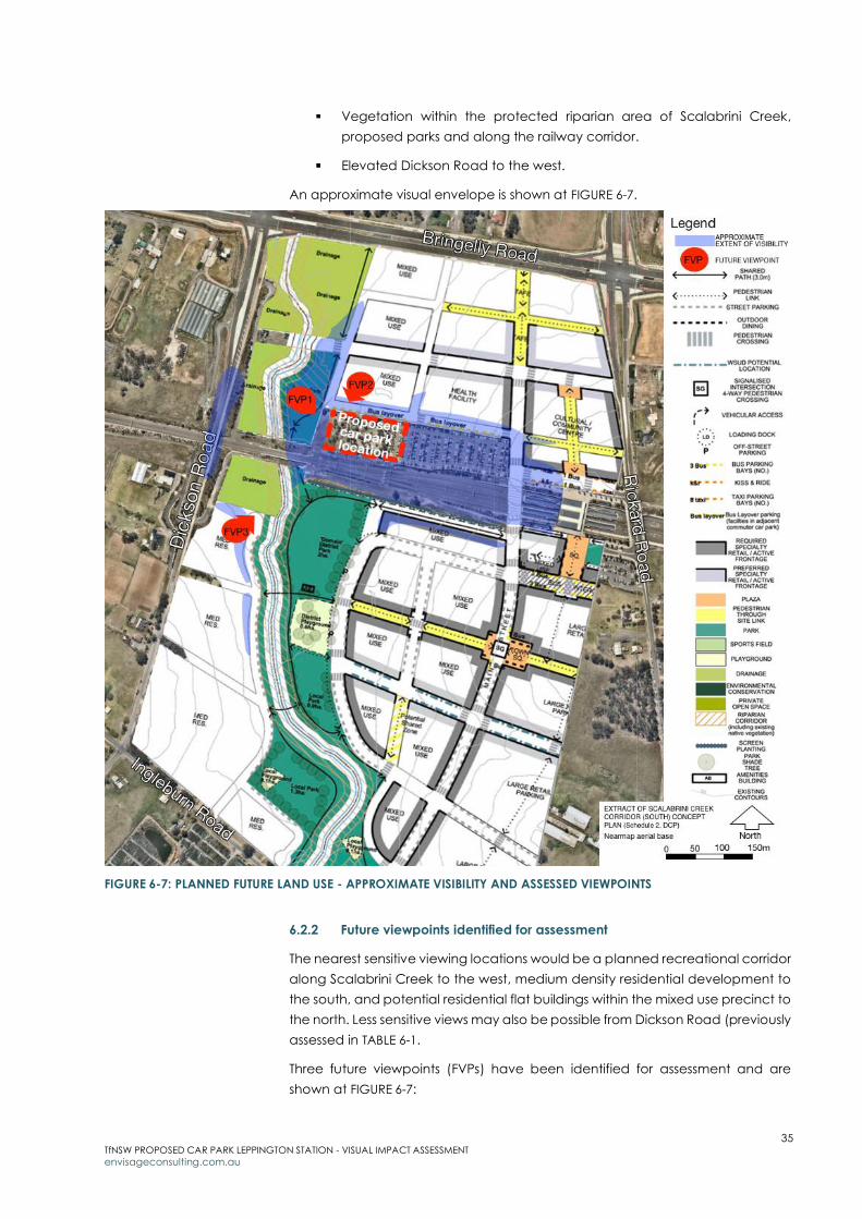
An approximate visual envelope is shown at FIGURE 6-7.
FIGURE 6-7: PLANNED FUTURE LAND USE - APPROXIMATE VISIBILITY AND ASSESSED VIEWPOINTS
6.2.2 Future viewpoints identified for assessment
The nearest sensitive viewing locations would be a planned recreational corridor
along Scalabrini Creek to the west, medium density residential development to
the south, and potential residential flat buildings within the mixed use precinct to
the north. Less sensitive views may also be possible from Dickson Road (previously
assessed in TABLE 6-1.
Three future viewpoints (FVPs) have been identified for assessment and are
shown at FIGURE 6-7:
36 TfNSW PROPOSED CAR PARK LEPPINGTON STATION - VISUAL IMPACT ASSESSMENT
envisageconsulting.com.au
FVP1: Scalabrini Creek corridor (west of the Proposal)
FVP2: Mixed use precinct (north of the Proposal)
FVP3: Medium density residential (south-west of the Proposal).
6.2.3 Assessment of future viewpoints
Viewpoints are described and assessed in TABLE 6-8 to TABLE 6-10.
TABLE 6-8: FVP1 – SCALABRINI CREEK CORRIDOR
Distance Immediately adjacent the Proposal site to the west.
Future
viewpoint
characteristics
The Scalabrini Creek corridor has been reserved as Local Open Space (RE1) under the Growth
Centres SEPP. It is planned to be developed as an attractive green space for recreation with
linkages through the centre and to surrounding residential areas.
Future
potential
viewers
Public views from the open space corridor - users using the planned pathways, recreational
nodes and green spaces.
Future
sensitivity
The sensitivity of the view toward the Proposal is rated as moderate:
The open space corridor is intended to be the major north-south connecting open
space element for the new Town Centre. Its linkages are likely be accessed by large
numbers of people.
It is likely to be valued by the public as an important green space close to the new
Leppington Town Centre.
The open space will be designed as a focus for community events and passive
recreation and is intended to be well-used.
Its setting will be important to its identity and longevity as an attractive community
space.
Magnitude of
impact
The magnitude of change is rated as low:
The Proposal is within the planned building height for the Site.
The Proposal would be a generally similar scale to, and lower in height than, the mixed
use precinct to the north (also adjacent the open space corridor).
Viewers would be within very close proximity to the Proposal.
Level of
Impact
The moderate sensitivity ranking, combined with the low magnitude of change, leads to an
overall moderate-low level of impact.

37 TfNSW PROPOSED CAR PARK LEPPINGTON STATION - VISUAL IMPACT ASSESSMENT
envisageconsulting.com.au
TABLE 6-9: FVP2 –MIXED USE PRECINCT
Distance Approximately 20m from the Proposal Site to the mixed use precinct.
Future
viewpoint
characteristics
The mixed use precinct (zoned B4 Mixed Use) provides for the inclusion of residential apartment
accommodation. The DCP 2013 maximum building height is 4-6 storeys.
Future
potential
viewers
Private views may be possible from residential apartments which would be on the upper floors
of mixed use buildings.
Future
sensitivity
The sensitivity of the view toward the Proposal is rated as low:
Private viewers could potentially be in close proximity directly opposite the Proposal.
Some viewers could potentially have an elevated viewing position and look over the
car park to the Scalabrini Creek open space corridor (car park would appear in the
foreground of views).
For most viewers, however, views to the car park (if available) would be limited by other
buildings within the mixed-use zone.
Magnitude of
impact
The magnitude of change is rated as low:
The Proposal is generally within the planned building height for the Site.
For residents on upper levels, glare from rooftop cars may be a potential issue.
The Proposal design (including structural screening, muted colours, textures and
landscaping) would help reduce potential visual dominance of the Proposal.
Level of
Impact
The low sensitivity ranking, combined with the low magnitude of change, leads to an overall low
level of impact.
TABLE 6-10: FVP3 – MEDIUM DENSITY RESIDENTIAL
Distance Approximately 160m (at the closest) south-west of the Site.
Future
viewpoint
characteristics
Medium density residential buildings (including townhouses, small lot housing and apartments)
around 4-6 storeys in height overlooking Scalabrini Creek. The elevation of the residential zone
is similar to that of the car park.
Future
potential
viewers
Private views may be possible from the upper floors of taller residential buildings.
Future
sensitivity
The sensitivity of the view toward the Proposal is rated as low:
The view from residential building would focus on the open space corridor in the
foreground and on taller buildings in the civic precinct to the north-east.
Views of the Proposal, if possible, would be from upper floors of the residential buildings,
and the Proposal would be seen across the railway corridor.
Views from upper floors would be quite wide, and the Proposal would be a relatively
small component of the view.

38 TfNSW PROPOSED CAR PARK LEPPINGTON STATION - VISUAL IMPACT ASSESSMENT
envisageconsulting.com.au
Magnitude of
impact
The magnitude of change is rated as low:
The Proposal would likely be lower in height than buildings within the mixed use precinct
and civic precinct, and not be visually dominant within the view.
If visible, it is likely only the top of the Proposal (possibly the top two levels) that would
be visible above existing and proposed trees.
Screening vegetation planned along the railway corridor, within the protected Riparian
Protection Area along Scalabrini Creek, and trees planted within the recreational open
space corridor would, over time, likely screen views to the Proposal.
The car park would be constructed ahead of residential development. There would be
no visual impact from construction.
Level of
Impact
The low sensitivity ranking, combined with the low magnitude of change, leads to an overall low
level of impact.
6.3 Summary of visual impact
The assessed impact of the Proposal on existing views is summarised in TABLE 6-11.
The assessed impact of the Proposal on future views is summarised in TABLE 6-12.
TABLE 6-11: ASSESSMENT OF IMPACTS TO EXISTING VIEWPOINTS
Viewpoint Sensitivity Magnitude Assessed visual
impact
VP1: Dickson Road Low Low Low
VP2: Bringelly Road Low Moderate Moderate-low
VP3: Rickard Road north-east of Site Low Low Low
VP4: Rickard Road east of Site Low Low Low
VP5: Rickard Road south-east of Site Low Low Low
VP6: Leppington Public School Low Low Low
VP7: Ingleburn Road/ Rickard Road intersection Low Low Low
TABLE 6-12: ASSESSMENT OF IMPACTS TO FUTURE VIEWPOINTS
Viewpoint Sensitivity Magnitude Assessed visual
impact
FVP1: Scalabrini Creek corridor Moderate Low Moderate-low
FVP2: Mixed use precinct Low Low Low
FVP3: Medium density residential Low Low Low

39 TfNSW PROPOSED CAR PARK LEPPINGTON STATION - VISUAL IMPACT ASSESSMENT
envisageconsulting.com.au
7 Mitigation measures
This section describes the positive design measures of the Proposal and
additional measures that are recommended to improve the visual outcome.
Consistency with the Growth Centres SEPP provisions and design guidelines in
DCP 2013 will be required to create the intended vibrant, high quality design,
Leppington Town Centre.
7.1 Positive visual attributes of the Proposal
The Proposal has incorporated a number of positive characteristics which would
reduce its potential landscape character and visual impacts:
The Proposal would be located on land specified under the Growth
Centres SEPP for the purposes of a commuter car park.
The location, on lower-lying land, reduces potential visibility.
The height of the Proposal is within the Growth Centres SEPP
requirement of 24m and generally compatible the DCP 2013 maximum
building height of 2-4 storeys for the commuter car park site.
The height of the Proposal would be slightly lower than trees within
Scalabrini Creek corridor, and potentially lower than buildings within
the planned mixed use precinct to the north (which has a DCP 2013
maximum building height of 4-6 storeys) and civic precinct to the north-
east (which has a DCP 2013 maximum building height of 10 storeys).
The Proposal would have an attractive finish (texture and colour).
Colours and tones are most likely to be muted to blend the Proposal
with the natural elements of the neighbourhood, and to create a less
obtrusive façade.
The Proposal aligns with the planned mixed use precinct development
envelope to the north.
Appropriate structural screening treatments would be applied to the
facade.
All lighting would be designed and installed in accordance with the
requirements of AS4282 Control of the Obtrusive Effects of Outdoor
Lighting.
Unnecessary loss or damage to vegetation external to the Site would
be avoided by protecting trees prior to construction and/or trimming
vegetation (if necessary).
An Urban Design Plan would be prepared which includes landscaping.

40 TfNSW PROPOSED CAR PARK LEPPINGTON STATION - VISUAL IMPACT ASSESSMENT
envisageconsulting.com.au
7.2 Additional measures
In addition to the above, the following measures listed in TABLE 7-1 are
recommended to further improve the outcome for the planned community.
TABLE 7-1: MITIGATION MEASURES
Mitigation Measure Relationship to DCP 2013
Provide an attractive Proposal façade along the frontage with
the open space corridor.
Locate ancillary activities, such as bin storage, away from the
open space frontage, and screen them from public view.
As per clause 5.1.1 (7): Buildings are to be
orientated to provide attractive, active
building frontages and passive surveillance to
public open space, land zoned for drainage
purposes, plazas, squares and pedestrian
through-site links.
As per clause 2.2.4 (1): the design, orientation,
size and bulk of buildings compliment the
public domain.
As per clause 2.2.4 (10): Ancillary activities
such as parking, loading and service areas
are visually screened from the public domain.
Use landscaping along/near the frontage with the open space
corridor to filter views to the car park while maintaining passive
surveillance sightlines.
As per clause 5.5 (9): Car parks are not to be
visible from public parks, squares or plazas).
Use local species characteristic of the Scalabrini Creek corridor
for the planting palette.
As per clause 5.3 (6): Landscaping of
development sites adjacent to Scalabrini
Creek and Bonds Creek is to integrate with
the natural characteristics of the existing
vegetation or vegetation to be re-
established along these creek corridors.
Native (locally indigenous) plant species are
to be the dominant landscape species in
these locations.
Provide dense screen planting along the railway corridor. As per the Leppington Town Centre
Masterplan, 2012.
Materials used for new structures to be non-reflective and colours
to be recessive.
Paint ancillary features to decrease their visibility and contrast
(dark grey is generally considered a good colour for ancillary
infrastructure).
Fences should have a dulled, darkened finish to reduce contrast.
Black or dark grey is generally a suitable colour.
N/A
Prior to construction, avoid unnecessary loss or damage to
vegetation within the Scalabrini Creek corridor by protecting
N/A

41 TfNSW PROPOSED CAR PARK LEPPINGTON STATION - VISUAL IMPACT ASSESSMENT
envisageconsulting.com.au
Mitigation Measure Relationship to DCP 2013
trees and/or trimming vegetation (if necessary) to avoid total
removal.
Following completion of the Proposal, actively remove weeds
during operations and maintain landscaping and grounds to a
high standard.
N/A
Clause 5.5 (3) of DCP 2013 discourages rooftop parking to preserve the future
amenity for residential flat buildings located in the centre), however, this
measure was not feasible.

42 TfNSW PROPOSED CAR PARK LEPPINGTON STATION - VISUAL IMPACT ASSESSMENT
envisageconsulting.com.au
8 Key findings and conclusion
The Proposal is to construct a multi-level commuter car park near Leppington
Station, adjacent an existing commuter car park, at a Site zoned for the purpose
of commuter car park.
Context
The vicinity of Leppington Station is planned to change significantly within the
next 10 or so years. The planned future development of the area will lead to a
significant transition from an environment that is predominantly rural in character
to a high-density urban character. Existing rural properties, agricultural/industrial
and market gardens in the area will re-develop under the Growth Centres SEPP
into Leppington Town Centre - a major regional centre of Sydney.
The Proposal
The Proposal would result in removal of all vegetation at the Site and construction
of a multi-storey car park (ground level, plus four levels including rooftop parking
- approximately 14m high, 126m long and 57m wide) of concrete slab
construction, finished in muted colours and tones, with structural screening
treatments for the facade.
Impact on landscape character
Due to the rapidly changing nature of the landscape around the Site, impact on
landscape character has been assessed in terms of existing and planned
landscape character.
Existing
The Proposal would result in total loss of vegetation at the Site, and until planned
neighbouring buildings are constructed, the Proposal would be the largest and
tallest built structure in the vicinity. However, vegetation within Scalabrini Creek
corridor would be retained, maintaining the dominant green, treed character
along the creek line. Taller trees along Scalabrini Creek would exceed the height
of the Proposal, reducing its overall impact. The assessed impact to landscape
character is moderate-low.
Planned
The Proposal is consistent with the planned use for the Site. The height of the
Proposal (provisionally 14m) is within the Growth Centres SEPP maximum height
limit (24m), and generally consistent with the DCP 2013 height for the planned
commuter car park site (2-4 storeys). The scale of the Proposal would be similar
to planned buildings within the mixed use precinct to the north, and smaller than
civic centre buildings (up to 30m) located on higher land closer to Leppington
Station.
All built elements within Leppington Town Centre will contribute to its overall
character. The success of Leppington Town Centre as the intended vibrant, high-
quality destination will require consistency with the Growth Centres SEPP
provisions and design guidelines in DCP 2013. Proposed and additional
mitigation measures included in this report align the design of the Proposal to the
43 TfNSW PROPOSED CAR PARK LEPPINGTON STATION - VISUAL IMPACT ASSESSMENT
envisageconsulting.com.au
intended town centre character. The assessed impact to the future landscape
character is moderate-low.
Impact to views
Due to the planned redevelopment of the area, impact to views has been
assessed in terms of existing and future viewpoints within the redeveloped
Leppington Town Centre.
Existing
Seven existing viewpoints have been assessed, including four residential
viewpoints (the closest being 360m to the north, the furthest almost one kilometre
to the south), a school and child care centre, and public views from nearby road.
The assessed visual impact from all viewpoints is moderate-low or low.
The most significant impact occurs due to the removal of trees at the Site. This
change is expected as part of the development of Leppington Town Centre. The
Proposal would be temporarily dominant in scale, until planned additional
construction commences associated with Leppington Town Centre.
Future
Three future viewpoints have been assessed, including potential views from the
proposed Scalabrini Creek recreational corridor (west) and from two planned
residential areas: the mixed use precinct (north), and the medium density
residential precinct (south). The assessed visual impact from future viewpoints is
moderate-low or low.
Potential issues include the interface of the Proposal with the recreational
corridor; and possible close, elevated views of residents living within the mixed
use precinct. Mitigation measures have been included in this report to improve
the design outcome such as landscaping.
Conclusion
In summary, the Proposal would result in temporary adverse visual impacts to
existing viewpoints (due to loss of trees and the introduction of a new, large
structure). However, following the ongoing development of the planned
Leppington Town Centre, views within the area will change significantly, and the
Proposal would integrate within the new urban environment.
44 TfNSW PROPOSED CAR PARK LEPPINGTON STATION - VISUAL IMPACT ASSESSMENT
envisageconsulting.com.au
9 References
Aecom, October 2012, Leppington Major Centre Public Domain Strategy
Camden Development Control Plan , 2013
Conybeare Morrison (September 2012) Leppington Town Centre Masterplan
Final Report
GLN Planning for NSW Department of Planning and Infrastructure, 2012, Austral
and Leppington North Precincts Infrastructure Delivery Plan
Liverpool Growth Centre Precincts DCP 2013 - Schedules 1 & 2 (Austral and
Leppington North & Leppington Major Centre)
Roads and Maritime Services (December 2018) Guideline for Landscape
Character and Visual Impact Assessment, Environmental Impact Assessment
Practice Note EIA-N04
State Environmental Planning Policy (Sydney Region Growth Centres) 2006
Transport for NSW (22 July 2019) Vegetation Management (Protection and
Removal) Guideline
Transport for NSW (23 August 2019) Vegetation Offset Guide
Transport for NSW (23 August 2019) Weed Management and Disposal Guide