legacy lasalle, llc– 89 lasalle avenue site buffalo, new ... · 625 broadway . albany, ny...
TRANSCRIPT
REMEDIAL INVESTIGATION WORK PLAN
Legacy LaSalle, LLC– 89 LaSalle Avenue Site Buffalo, New York Brownfield Cleanup Program Submitted To: Chief, Site Control Section New York State Department of Environmental Conservation Division of Environmental Conservation 625 Broadway Albany, NY 12233-7020 Submitted By: Golder Associates Inc. 2430 North Forest Road, Suite 100 Getzville, NY 14068 USA Distribution: 1 copy NYSDEC – Albany 1 copy NYSDEC – Region 9 1 copy Legacy LaSalle LLC 1 copy Phillips Lytle LLP 1 copy Golder Associates Inc. December 2013 Project No. 1300732
REPO
RT
(j'GOlder~Associates

December 2013 i 1300732
g:\projects\2013 buffalo projects\1300732 legacy lasalle bcp\ri workplan\legacy lasalle ri work plan (12-03-13).docx
Table of Contents 1.0 INTRODUCTION ............................................................................................................................... 1
1.1 Site History .................................................................................................................................... 1 1.2 Purpose and Scope ....................................................................................................................... 2 1.3 Summary of Previous Investigations ............................................................................................. 3
1.3.1 Phase I ESA .......................................................................................................................... 3 1.3.2 Previous Soil/Fill Investigations ............................................................................................. 4
1.3.2.1 April 2013 Limited Phase II Environmental Site Assessment ........................................... 5 1.3.2.2 Supplemental Phase II Investigation – 67 LaSalle Ave. Parcel ........................................ 6
1.4 Project Organization and Responsibilities .................................................................................... 6 2.0 DATA OBJECTIVES ......................................................................................................................... 8
2.1 Acceptance or Performance Criteria ............................................................................................. 8 2.2 Data Evaluation Procedures ......................................................................................................... 8
3.0 INVESTIGATION SCOPE ............................................................................................................... 10 3.1 Soil/Fill Investigation ................................................................................................................... 10
3.1.1 Supplemental Subsurface Investigation Program ............................................................... 10 3.1.1.1 Soil/Fill Sampling ............................................................................................................. 11 3.1.1.2 Groundwater Monitoring Well Installation and Sampling ................................................ 12
3.2 Site Mapping and Survey ............................................................................................................ 14 4.0 REMEDIAL INVESTIGATION/ALTERNATIVES ANALYSIS REPORT .......................................... 16
4.1 Remedial Investigation Report .................................................................................................... 16 4.2 Alternative Analysis Report ......................................................................................................... 16
5.0 INVESTIGATION SUPPORT DOCUMENTS .................................................................................. 18 5.1 Quality Assurance Project Plan (QAPP) ..................................................................................... 18 5.2 Health and Safety Plan (HASP) .................................................................................................. 18 5.3 Community Participation Plan (CPP) .......................................................................................... 19
6.0 PROJECT SCHEDULE AND SEQUENCE OF THE WORK .......................................................... 20 7.0 REFERENCES ................................................................................................................................ 21
~-..
~.. Golder. Associates

December 2013 ii 1300732
g:\projects\2013 buffalo projects\1300732 legacy lasalle bcp\ri workplan\legacy lasalle ri work plan (12-03-13).docx
List of Tables Table 3-1 Analytical Program Summary – Remedial Investigation
List of Figures Figure 1-1 Site Location Plan Figure 3-1 RI Sampling Location Plan Figure 6-1 Project Schedule
List of Appendices Appendix A Phase I ESA Report & Limited Phase II Investigation Reports (electronic files on CD) Appendix B Quality Assurance Project Plan Appendix C Health and Safety Plan Appendix D Citizen Participation Plan
~-..
~.. Golder. Associates

December 2013 1 1300732
g:\projects\2013 buffalo projects\1300732 legacy lasalle bcp\ri workplan\legacy lasalle ri work plan (12-03-13).docx
1.0 INTRODUCTION Legacy LaSalle LLC (Legacy) has prepared this Remedial Investigation (RI) Work Plan in support of the
submittal of a Brownfield Cleanup Program (BCP) application in accordance with the provisions of the
New York State Department of Environmental Conservation’s (NYSDEC) Subpart 375-3. The BCP
application is requesting entry into the BCP for Legacy’s property or parcels located at 67 and 89 LaSalle
Avenue and portions of the City of Buffalo parcel (71 NY L&W RR, also referred to as 71 Cordova Ave.)
for which Legacy has received designated developer status. All parcels are located in the City of Buffalo,
New York (Site). The Site consists of three parcels comprising a total of approximately 10.6 acres located
in the Main-LaSalle neighborhood just to the north of McCarthy Park (refer to Figure 1-1). Portions of the
site encompass the former Buffalo Crushed Stone quarry Legacy is proposing to construct a high density,
multifamily student housing community primarily for rent to the State University at Buffalo students. The
project will consist of 4 - 6 separate residential buildings, a community building, parking facilities, a
maintenance building and common area. Buildings will range in height from 3 to 5 stories and will contain
approximately 300,000 square feet of space.
The Site development uses will encompass residential housing, support facilities, parking and vehicle
access infrastructure. Golder Associates Inc. (Golder) was retained by Legacy to prepare this RI Work
Plan to address the NYSDEC BCP requirements.
1.1 Site History Based on the results of a recently conducted Phase I Environmental Site Assessment, the southern
portions of the 89 LaSalle parcel and associated unaddressed parcels to the south including the City of
Buffalo parcel were used as a stone quarry from approximately 1915 through 1950 by the Buffalo
Crushed Stone company. Subsequently the quarried areas were used by the City of Buffalo as a landfill
in the 1950s and 1960s for the disposal of a variety of demolition debris, ash, railroad ballast and
reportedly some municipal waste. A building located on the northern portion of 89 LaSalle (proximate to
LaSalle Ave.) was apparently constructed in the 1950’s and at various times has housed a residential
heating contractor, catering service and most recently, a local radio station. Several towers and antennas
associated with the radio station are located to the south and southwest of the building on the 89 LaSalle
Avenue parcel.
According to a recently performed Phase I ESA, the 67 LaSalle parcel has a history of use as a lumber
yard since the early 1900s, more recently some of the structures on the parcel have been used for
automotive storage after lumber yard operations ceased. The buildings remain on the parcel but are now
vacant. There were no other noted uses of this property.
The parcel at 71 Cordova Avenue is generally vacant with the exception of a parking lot and tennis courts
that are in need of repairs and upgrades. The portions of the 71 Cordova parcel associated with the
parking lot and tennis courts have been excluded from BCP Site metes and bounds definition (i.e., they
~-..
~.. Golder. Associates

December 2013 2 1300732
g:\projects\2013 buffalo projects\1300732 legacy lasalle bcp\ri workplan\legacy lasalle ri work plan (12-03-13).docx
are ineligible under the BCP program) as shown on Figure 3-1 and are therefore not part of the proposed
RI.
1.2 Purpose and Scope The Site has not been comprehensively characterized, therefore Legacy intends to investigate soil/fill and
groundwater, if feasible, within the Site for the purpose of more fully characterizing the Site and
identifying/evaluating remedial alternatives under the New York State BCP. Data collected during the RI
will be used to identify potential health risks and to evaluate remedial alternatives.
The Work Plan proposes the following activities to identify and delineate, if present, soil/fill and
groundwater impacts on the Site:
Advancement of fifteen (15) subsurface soil borings to a depth of approximately 15-20 feet below ground surface (bgs) and collection/analysis of representative soil/fill samples to establish concentrations of specified Target Compound List contaminants of concern parameters.
Manual collection of three (3) shallow soil/fill samples from test pits excavated to bedrock. Based on previous investigations the assumed depth of proposed test pits will be 3 to 4 feet below grade surface (bgs) on the 67 LaSalle parcel and at the northern border of the 89 LaSalle parcel. Analysis of representative soil/fill samples at each test pit location to establish concentrations of specified Target Compound List contaminants of concern parameters.
Installation of up to three (3) on-site monitoring wells and collection/analysis for Target Compound List parameters of on-site groundwater samples to assess Site groundwater quality. Collection of groundwater potentiometric data will also be performed in conjunction with the sampling activities.
The data obtained from this RI, with the results of previous investigations (presented in Section 1.3) will
be used to:
Describe the amount, concentration, persistence, mobility, state (e.g., solid, liquid), and other relevant characteristics of the contaminants present.
Define hydrogeological factors (i.e., depth to saturated zone, groundwater gradients, proximity to wetlands, etc).
Define the potential human and environmental exposure pathways from the Site and the extent to which contaminants of concern from these pathways have the potential to pose a threat to human health or the environment.
Determine the extent to which contaminant levels on the Site, if applicable, pose an unacceptable risk to human health or the environment.
Develop Remedial Action Objectives (RAOs for the Site based on the contaminant characterization results, exposure pathways and risk valuation data.
Provide sufficient information to allow for the identification of potentially feasible remedial alternatives.
Based on the current knowledge of potential Site impacts, the RAOs for the Site may require
implementation of remedial actions designed to remove or cover impacted soil/fill material. It is Legacy’s
intent to propose a remedy that will meet the BCP’s Track 4 clean up approach for achieving Restricted
~-..
~.. Golder. Associates

December 2013 3 1300732
g:\projects\2013 buffalo projects\1300732 legacy lasalle bcp\ri workplan\legacy lasalle ri work plan (12-03-13).docx
Residential use. Depending on the results of the RI, this remedy is anticipated to consist of a
combination of soil/fill excavation of identified “hot-spot” shallow soils, if any, that exceed Part 375
restricted residential Soil Cleanup Objectives (SCOs) combined with a soil cover system over exposed
residual soil contamination that complies with the use-based SCOs in 6NYCRR Table 375-6.8(b0 levels
for the top two feet.
1.3 Summary of Previous Investigations Several investigations encompassing portions of the proposed BCP Site were previously performed for
other proposed development activities on or adjacent to the BCP Site and are briefly summarized below.
1.3.1 Phase I ESAs 1985 RECRA Environmental Phase I Engineering Investigation
In 1985 RECRA Environmental completed a Phase I Engineering Investigation for the NYSDEC of the so-
called LaSalle Reservoir site that encompassed approximately 50 acres and a substantial portion of the
BCP Site. No environmental sampling was conducted as part of this study and the resulting conclusions
were based on a US EPA hazard ranking system that is no longer in use and therefore of limited
informational value. The report did reiterate the site history of the use of the northern portion of the quarry
as a landfill area by the City of Buffalo from approximately 1951 through 1972.
2013 Phase I Environmental Site Assessment
A Phase I ESA was completed by LCS Inc.in September 2013 in conjunction with preparation of the BCP
Application. The known or suspect Recognized Environmental Conditions (RECs) and de minimis
conditions found during the conduct of the ESA are listed below as presented in the LCS Phase I ESA
summary if findings:
The subject property and adjacent properties were initially identified as being part of a quarry from at least 1916 until at least 1950. Sanborn maps indicate a gasoline tank on-site from at least 1935 until 1950.
The subject property and/or its immediate adjacent properties were identified as a Historic VCP site, two State Sites, a Federal Brownfield site and a CERCLIS NFRAP site. The LaSalle Reservoir site includes two State sites and a CERCLIS NFRAP site. The narrative in the third party database states that this site was an approximately 50 acre limestone quarry. The limestone quarry was later utilized by the City of Buffalo as a landfill for municipal refuse, incinerator ash, household appliances, tree parts and construction and demolition debris, and may have also received suspected paint wastes mixed with sawdust, floor sweepings. The prior investigations completed at this LaSalle Reservoir site identified several potential concerns associated with typical solid waste landfill operations. It should be noted that within the third party database there is limited information regarding the geographical limits the 50-acre site, including the extent of the investigation, if any, completed on the subject property.
LaSalle Reservoir, addressed at East Amherst Street, was identified in the Orphan Summary of the EDR report as a CERCLIS-NFRAP site; this listing may in part be
~-..
~.. Golder. Associates
December 2013 4 1300732
g:\projects\2013 buffalo projects\1300732 legacy lasalle bcp\ri workplan\legacy lasalle ri work plan (12-03-13).docx
associated with portions of the subject property historically utilized as a quarry and municipal landfill.
A railroad track extended onto a portion of the property from at least 1935 through at least 1950.
Railroad tracks have been historically located south adjacent from at least 1935 through at least 1950 and west adjacent to the subject property from at least 1916 until at least 1990.
South and east adjacent properties were identified as being a portion of a quarry from at least 1916 until at least 1950.
A west adjacent property was utilized as an iron/steel works facility from at least 1957 until at least 2005.
A filling station with automotive repair was located north adjacent to the subject property in at least 1935 until at least 1950.
An automotive repair facility is located north of the subject property.
A north adjacent property was identified in the RCRA Non-Generator, FINDS database and Manifest databases.
. The following de minimis conditions in connection with the Site were identified in the Phase I ESA:
Partially hydric soils are located on portions of the subject property.
A complete copy of the September 2013 Phase I ESA is provided on a CD in Appendix A.
1.3.2 Previous Soil/Fill Investigations
1.3.2.1 1989 Phase II Investigation – LaSalle Reservoir Site In 1989, the NYSDEC contracted Ecology and Environment to conduct a Phase II environmental site
investigation of the LaSalle Reservoir Site that included portions of the BCP Site. The investigation
included an electromagnetic terrain conductivity survey, a magnetometer survey, completion of 3 bedrock
monitoring wells and collection and analysis of soil, fill and groundwater samples. The results of the
investigation indicated that:
The depth of the quarry is approximately 45 feet below the adjacent ground surface;
The depth to groundwater in the bedrock wells ranged from 33 to 45 feet below grade surface, with flow to the northwest;
Soil samples had concentrations of polycyclic aromatic hydrocarbons (PAHs) at concentrations which, at that time, exceeded NYSDEC’s recommended Soil Cleanup Objectives presented in NYSDEC Technical and Administrative Guidance Memorandum;
Groundwater samples had exceedences of Class GA Ambient Water Quality Standards for iron and magnesium only; and
“Waste:” samples exhibited concentrations of lead which exceeded the typical background levels for soils in the eastern United States.
~-..
~.. Golder. Associates

December 2013 5 1300732
g:\projects\2013 buffalo projects\1300732 legacy lasalle bcp\ri workplan\legacy lasalle ri work plan (12-03-13).docx
1.3.2.2 September 1995 Environmental Site Assessment / Cordova Street Extension Area In September 1995, Frontier Technical Associates conducted an ESA of 5 acre parcel (referred to as
Parcel 16) located in the northern portion of the LaSalle Reservoir Site that encompasses a portion of the
proposed BCP Site. This assessment included a review of historical records, completion of 7 soil borings
and analysis of 4 composite samples.
The results of the investigations indicated that the area had been backfilled with up to 44 feet of fill
materials including gravel, sand, clay, bricks, glass, ash, wood, metal and miscellaneous debris. There
appeared to be between zero and two feet of water above the top of bedrock (at the bottom of the fill).
Contaminants identified in the fill materials included total petroleum hydrocarbons, elevated
concentrations of lead, zinc and mercury and PAHs (in one sample). These findings were consistent with
the 1989 LaSalle Reservoir Site investigation findings.
1.3.2.3 April 1997 Main-LaSalle Revitalization Project- Site Investigation Report Investigations were conducted in August, November and December of 1996 by URS under contract to the
Buffalo Urban Renewal Agency to further investigate the general 50 acre area known as the LaSalle
Reservoir Site. It appears that approximately 25 test pits were completed within the limits of the proposed
BCP Site and at nine of these test pits shallow (i.e., 2- 4 inches below grade surface) soil samples were
collected for the analysis of TCL VOCs, SVOCs, pesticides and PCBs as well as TAL metals and
cyanide. The contamination identified consisted primarily of PAHs and metals which were described as
“widespread across the site at concentrations which exceed both recommended cleanup levels and
RBCs” (Main-LaSalle Revitalization Project, Site Investigation Report, Rev. April 1997, URS Greiner,
Inc.).
The report also provided the results of an extensive depth to bedrock assessment in portions of the
proposed BCP Site which delineated the former quarry high wall location o differentiate between shallow
bedrock and the deeper quarried areas where more extensive landfilling occurred. This delineation is
included on the survey plans submitted as part of the BCP application.
1.3.2.4 April 2013 Limited Phase II Environmental Site Assessment Legacy retained EnSol Inc. to conduct a limited environmental investigation of the 89 LaSalle properties
and the City of Buffalo property (i.e., 71 Cordova Ave.) to assess the potential eligibility of these parcels
for the New York Brownfield Cleanup Program.
The investigation of these properties consisted of:
Advancement of 10 test pits to a maximum depth of 15 feet below ground surface with a minimum of two test pits in the area of a suspected Underground Storage Tank (UST) (no tank was found in the field);
~-..
~.. Golder. Associates
December 2013 6 1300732
g:\projects\2013 buffalo projects\1300732 legacy lasalle bcp\ri workplan\legacy lasalle ri work plan (12-03-13).docx
Visual and olfactory inspection of soil samples as well as headspace screening with a photoionization detector; and,
Analysis of six soil samples for target compounds list (TCL) volatile organic compounds (VOCs), TCL semi volatile organic compounds (SVOCs), target analyte list (TAL) metals, cyanide, polychlorinated biphenyls (PCBs), herbicides, and pesticides via United States Environmental Protection Agency (USEPA) SW-846 Test Methods 8260, 8270, 6010/7470, 9012, 8082, 8151, and 8081, respectively.
The results of the test pit soil sampling investigation indicated that concentrations of certain SVOC,
metals and pesticide compounds were detected at concentrations exceeding the 6 NYCRR Part 375 soil
cleanup objectives for residential or restricted uses at several locations on the properties. No definitive
pattern of impact was found and concentrations in excess of SCOs in soil/fill were found to be widespread
across the six sample locations.
A summary of the soil sampling results for the test pit locations is presented in Table 1 of the Limited
Phase II ESA (a full electronic file of the report is included on the CD attached in Appendix A) and a site
map illustrating sample locations on the property is presented on Figure 2 – Test Pit Location Map in the
report.
1.3.2.5 Supplemental Phase II Investigation – 67 LaSalle Ave. Parcel A supplemental Phase II investigation of the 67 LaSalle Avenue parcel was conducted by Golder
Associates on August 6, 2013. This investigation consisted of collecting two composite soil samples from
the sidewalls and bottom of shallow test pits located on the parcel. Each test pit was excavated to
bedrock refusal approximately 3 to 3.5 feet below grade surface. The lithology of the test pits indicated a
predominant layer of dark fill (possibly consisting of cinders or ash-like material) mixed with gravel in the
upper 1 to 1.5 feet of both test pits with the remaining depth consisting of soils with large quantities of
stone or gravel. A representative composite sample was collected from each test pit for the analysis of
TCL SVOCs, TAL metals, PCBs, and TCL herbicides and pesticides. The location of these test pits are
shown on Figure 4-1 included as a separate electronic file on the CD in Appendix A.
In one of the test pits (TP67-1), a total of seven (7) semi-volatile organic compounds (SVOCs) and one
metal were detected at concentrations exceeding the 6NYCRR Part 375 Restricted Residential Soil
Cleanup Objectives (SCOs). No other compounds analyzed were detected above Part 375 SCOs. Table
4-1 included as a separate electronic file on the CD in Appendix A presents a summary of the sample
results for all detected constituents in both test pits.
1.4 Project Organization and Responsibilities Legacy has submitted the 89 LaSalle Avenue Site for entrance into the BCP as a volunteer per ECL§27-
1405. Golder Associates Inc. (Golder) will manage the brownfield cleanup on behalf of Legacy. The
proposed responsibilities of the key staff are summarized below:
~-..
~.. Golder. Associates

December 2013 7 1300732
g:\projects\2013 buffalo projects\1300732 legacy lasalle bcp\ri workplan\legacy lasalle ri work plan (12-03-13).docx
Partick T. Martin, P.E., will be the Project Manager for the BCP program. In this capacity Mr. Martin will
be responsible for overall coordination of all phases of the project from implementation of the Work Plan
and subsequent reporting and documentation of the work performed.
Russell Marchese, will be the Project Geologist, responsible for the implementing the remedial
investigation tasks. Responsibilities will include sample collection, well development and directing
drilling subcontractors’ activities.
Brian C. Senefelder, CHMM, will serve as Project Director and be responsible for the overall quality
assurance and review of all project deliverables. He will interface with the Project Manager to address
any technical issues and provide quality control for the entire project.
~-..
~.. Golder. Associates
December 2013 8 1300732
g:\projects\2013 buffalo projects\1300732 legacy lasalle bcp\ri workplan\legacy lasalle ri work plan (12-03-13).docx
2.0 DATA OBJECTIVES
2.1 Acceptance or Performance Criteria Acceptance or performance criteria specify the quality of data required to support decisions regarding
remedial response activities and are based on the data quality objectives. The data quality and level of
analytical documentation necessary for a given set of samples will vary depending on the intended use of
the data.
Site-specific remedial action objectives will be developed during the RI process. Sampling data will be
used to evaluate whether or not remedial alternatives can meet the objectives. Two data confidence
levels will be employed in the RI: screening level data and definitive level data. In general, screening
level confidence will apply to field measurements, including photo-ionization detector (PID)
measurements, groundwater elevation measurements, and field analyses (i.e., pH, temperature, specific
conductivity, and turbidity). Definitive level confidence will apply to samples submitted to an independent
laboratory for chemical analysis.
Sampling and analytical acceptance and performance criteria such as precision, accuracy,
representativeness, comparability, completeness, and sensitivity, will be defined in the QAPP (refer to
Appendix B).
2.2 Data Evaluation Procedures The RI scope of work is focused on providing reliable data to identify areas of the Site potentially requiring
remediation, defining chemical constituent migration pathways, qualitatively assessing human health and
ecological risks, and performing the remedial alternatives evaluation. The investigation will include the
collection and analysis of soil/fill and groundwater samples to support remedial action objectives.
Definitive level data quality will be required for chemical analysis of groundwater and soil/fill samples.
Field team personnel will collect environmental samples in accordance with the rationale and protocols
described in the QAPP. United States Environmental Protection Agency (USEPA) and NYSDEC-
approved sample collection and handling techniques will be used. Samples for chemical analysis will be
analyzed, in accordance with USEPA SW-846 methodology to meet the definitive-level data
requirements, by a New York State Department of Health (NYSDOH) Environmental Laboratory
Accreditation Program (ELAP) Contract Laboratory Protocol (CLP)-certified laboratory. A full (Category
B) deliverables package will be provided for all site characterization samples. Analytical results for site
characterization samples will be evaluated by a third-party data validation expert for evaluation of the
accuracy and precision of the analytical results. A Data Usability Summary Report (DUSR) will be
prepared to describe the compliance of the analyses with the analytical method protocols detailed in the
NYSDEC Analytical Services Protocol (ASP). The DUSR will provide a determination of whether the
~-..
~.. Golder. Associates

December 2013 9 1300732
g:\projects\2013 buffalo projects\1300732 legacy lasalle bcp\ri workplan\legacy lasalle ri work plan (12-03-13).docx
data meets the project-specific criteria for data quality and data use. The validation effort will be
completed in accordance with NYSDEC Division of Environmental Remediation DUSR guidelines.
~-..
~.. Golder. Associates

December 2013 10 1300732
g:\projects\2013 buffalo projects\1300732 legacy lasalle bcp\ri workplan\legacy lasalle ri work plan (12-03-13).docx
3.0 INVESTIGATION SCOPE The proposed RI will focus on investigating the Site for potential contaminants in soil/fill and groundwater
that have not previously been characterized through the previous limited Phase II investigations.
The proposed RI investigation of the approximately 10.6-acre Site will supplement the soil/fill data across
the entire Site were data gaps from previous investigations exist. A total of three (3) shallow soil
locations, seventeen (15) subsurface soil borings, and three (3) groundwater monitoring locations are
proposed for collection of representative soil/fill and groundwater samples for the RI.
Subsequent to receiving NYSDEC approval for the RI Work Plan, NTC will conduct the RI and prepare a
report on the findings. The major components of the proposed RI tasks are described in detail below.
Proposed RI sample and groundwater monitoring well locations are illustrated on Figure 3-1. Table 3-1
provides a summary of the proposed samples and analyses to be collected/performed as part of the RI.
3.1 Soil/Fill Investigation
3.1.1 Supplemental Subsurface Investigation Program As previously noted the historical LaSalle Reservoir Site investigations performed for NYSDEC or BURA
and the limited Phase II soil sampling program performed by Legacy on the Site in 2013 provided
characterization of residual contaminant concentrations primarily in the upper 10 feet (or less depending
on the depth to bedrock) of soil/fill across portions of the site. The results of these investigations indicate
that consistently the primary contaminants of concern detected at relevant concentrations at a majority
sampling locations are RCRA metals and SVOCs (specifically PAHs). PCBs and VOCs were not
detected at concentrations exceeding Part 375 SCOs, with the exception of two VOCs, methylene
chloride and acetone that are common laboratory contaminants and are believed to be anomalous
detections. Two low level detections of pesticides/herbicides were found at one location, TP-15 as part of
the 2013 limited Phase II investigation.
The LaSalle Reservoir and limited Phase II samples were not collected uniformly across the entire BCP
site. In addition, groundwater was not encountered in the test pits performed as part of the limited Phase
II investigations and very limited groundwater monitoring data was collected from a few wells installed as
part of the scope of these investigations. Therefore, a soil boring program will be implemented to
thoroughly characterize the subsurface soil/fill and groundwater media to better characterize the overall
Site soil/fill overburden material and shallow groundwater, if present, for potential contaminants of
concern. The subsurface soil sampling program proposes a total of fifteen (15) soil samples (B-1 through
B-15) at evenly spaced intervals drilled to refusal depth (assumed to be top of bedrock) across the Site
(except where grid locations overlap with limited Phase II test pits). Proposed borehole locations as
depicted in Figure 3-1 may be adjusted in the field based on Site conditions, accessibility, NYSDEC
preferences or other logistical concerns. If saturated soils or water is detected during soil boring
~-..
~.. Golder. Associates

December 2013 11 1300732
g:\projects\2013 buffalo projects\1300732 legacy lasalle bcp\ri workplan\legacy lasalle ri work plan (12-03-13).docx
activities, three of the proposed borehole locations are proposed to be completed as temporary
monitoring wells (MW-1 through MW-3) for characterization of Site groundwater.
3.1.1.1 Soil/Fill Sampling A drilling rig capable of advancing a borehole using direct push drilling methods via a Geoprobe® drill rig
equipped with a concrete core barrel will be used to advance the twelve subsurface soil borings that will
not be completed as monitoring wells (i.e., all borings except B-1, B-11, and B-15) through the soil/fill to a
maximum of twenty feet . The planned drilling method uses a 1.5-inch diameter, 4-foot core sampler with
a dedicated PVC sleeve to advance and retrieve soil core samples at four foot intervals. The total depth
of the borings is anticipated to be a maximum of twenty (20) feet or refusal, whichever occurs first.
However, if the fill characteristics, contaminant impacts or saturated conditions warrant, select borings
may be advanced deeper to better characterize subsurface conditions.
Three soil/fill boring locations (B-1, B-11 and B-15) will be advanced to a maximum depth of 45 feet bgs
or refusal and completed as monitoring wells if saturated soils and or groundwater are encountered
during drilling. The borings will be advanced and sampled using standard drill-rig mounted hollow stem
auger methods. The drilling and sampling approach for these locations is described in detail in Section
3.1.1.2.2 below. The sample selection criteria however will be identical to the approach discussed below
for the direct push soil/fill sampling locations.
Upon retrieval of each soil/fill core, the soil/fill samples will be screened for total organic vapors using a
photo-ionization detector (PID). The organic vapor measurements will be recorded and the soil/fill
material described on boring logs by a Golder field representative. The recovered soils will be
characterized/classified by visual observation in accordance with ASTM Method D2488, Standard
Practice for Description and Identification of Soils (Visual-Manual Procedure). Subsurface soil samples
will be collected for chemical analysis at the boring locations shown on Figure 3-1. The depth from which
samples are collected will be determined based on screening results of visual and olfactory observations
and PID measurements. Samples will be collected from the discrete depth interval that displays the
greatest evidence of contamination, if present. If there is no discernable difference across the entire
boring depth based on the visual, olfactory or PID screening methods, the default sample collection
approach will consist of collecting a composite from the 0 to 12 feet bgs strata. Subsurface soil/fill
samples will be analyzed for, semi-volatile organic compounds (SVOCs), target compound list (TCL)
pesticides, PCBs, target analyte list (TAL) metals, and cyanide. Based on the results of the previous
investigations, VOCs, pesticides/herbicides and PCBs will not be analyzed in the samples to be collected
during the RI, as these compounds were not detected or consistently detected at in concentrations
exceeding Part 375 SCOs. A summary of proposed samples and analyses is provided in Table 3 -1.
All non-dedicated, downhole sampling equipment will be decontaminated between soil boring locations in
accordance with accepted drilling practices using a high-pressure hotwater “steam” cleaner or scrubbed
~-..
~.. Golder. Associates
December 2013 12 1300732
g:\projects\2013 buffalo projects\1300732 legacy lasalle bcp\ri workplan\legacy lasalle ri work plan (12-03-13).docx
using Alconox® and a hot water wash followed by clean potable water rinse. Subsequent to borehole
advancement and soil/fill sampling at boring locations B-1, B-11 and B-15, a temporary monitoring well
will be installed if saturated conditions are identified within the planned maximum 45-foot boring depth or
if refusal is reached. If saturated conditions are not encountered within the maximum 45 foot boring depth
the boring will be grouted from total depth to ground level with a grout mixture of 95% cement and 5%
bentonite. All other boring locations advanced only for soil/fill sampling purposes will also be grouted in
the same manner.
3.1.1.2 Groundwater Monitoring Well Installation and Sampling
3.1.1.2.1 Site Hydrogeology Test pits advanced on the Site during the March and August 2013 soil/fill investigations were typically
completed to the top of bedrock which varied across the site depending on extent of historical quarrying in
a particular area. The maximum depth encountered was 10-12 feet bgs at TP-1, TP-3 and TP-14.
Groundwater or saturated soils were not encountered in any of the test pit locations. Historical
groundwater information is very limited within the footprint of the proposed BCP Site and not generally
available based on a lack of historical monitoring well data with the exception of three bedrock wells
installed in 1989 as part of the Phase II environmental site investigation performed by Ecology and
Environment. Based on the location map provided in the April 1991 report, the monitoring well locations
appear to all be outside the boundary of the quarried area and with the exception of MW-2 were located
outside the proposed BCP Site boundary. The groundwater samples collected from these wells were
analyzed for VOCs and metals and only exceedences of iron and magnesium were noted. Therefore no
definitive interpretation with respect to saturated soil/fill conditions and depth to groundwater can be made
within the proposed BCP Site boundary. Reliable information on the Site hydrogeology is complicated
by the significant man-made bedrock elevation differential that exists across the site resulting from the
historical rock quarrying activities.
Based strictly on the historical quarrying activities and the presence of a small surface water body located
south/southeast of McCarthy Park in what was a portion of the former quarry, the general direction of
localized groundwater flow in the vicinity of the Site is inferred to be to the south and south east. The
proposed location of the three monitoring wells is intended to provide sufficient data to assess
groundwater flow and elevations, if present.
3.1.1.2.2 Monitoring Well Installation As noted in Section 3.1.2.1, three soil borings will be advanced using a standard drilling rig employing
hollow-stem auger and completed as 2-inch wells to be used for measuring water levels and collecting
groundwater samples. The proposed locations (B-1, B-14 and B-16) are illustrated on Figure 3-1. The
final well installations will also depend on the presence of saturated soils in the soil/fill unit at the
proposed monitoring well locations. The wells will be installed after the soil borings have established the
~-..
~.. Golder. Associates
December 2013 13 1300732
g:\projects\2013 buffalo projects\1300732 legacy lasalle bcp\ri workplan\legacy lasalle ri work plan (12-03-13).docx
presence of saturated conditions (and any soil samples have been collected from the selected borings). If
the borings are determined to be dry holes, completion of these borings as monitoring wells will not be
performed and the Department will be consulted to assess the feasibility of installing well(s) at a different
location or abandoning the well installation.
Shallow overburden well borings will be advanced using 4.25-inch I.D. hollow stem augers (HSA). A 2-
inch diameter, 2-foot long split spoon sampler will be advanced ahead of the auger string with a standard
140-pound hammer. Recovered samples will be examined by qualified Golder personnel and
characterized in accordance with ASTM Method D2488, Standard Practice for Description and
Identification of Soils (Visual-Manual Procedure), scanned for total volatile organic vapors with a
calibrated PID equipped with a 10.6 eV lamp (or equivalent), and characterized for impacts via visual
and/or olfactory observations. All non-dedicated drilling tools and equipment will be decontaminated
between boring locations using potable tap water and a phosphate-free detergent (i.e., Alconox).
Soil/fill samples from each boring will be collected from the discrete depth interval that displays the
greatest evidence of contamination, if present. Subsurface soil/fill samples will be analyzed for TCL
SVOCs, TAL metals, and cyanide. A summary of proposed samples and analyses is provided in Table 3
-1.
Subsequent to boring completion, each monitoring well will be constructed of 2-inch I.D. flush-joint
Schedule 40 PVC solid riser and machine slotted screen (0.010-inch slot size). The monitoring well
screen will be approximately 10 feet in length. Approximately 6 inches of silica sand will be placed at the
bottom of each boring as a base for the well screen and as part of the sand pack. The well screen and
attached riser will be placed within the borehole on top of the 6-inch sand layer and the remainder of the
sand pack will be installed within the borehole annulus to a level of about 3 feet above the top of the well
screen. A bentonite seal (2 feet thick) will be installed immediately above the sand layer. The bentonite
seal will be constructed with 3/8-inch bentonite pellets or medium bentonite chips and allowed to hydrate
sufficiently to mitigate the potential for down-hole grout contamination. The top of the well riser pipe will
extend approximately 3 feet above grade and will be fitted with a lockable J-plug.
Provided that each of the wells yields sufficient water, groundwater samples will be collected from each of
the wells using low flow sampling methods. The total depth of the wells is expected to be within 45 feet of
ground surface.
3.1.1.2.3 Well Development The newly installed monitoring wells will be developed no sooner than 24 hours after construction has
been completed. The development procedure will require purging of the groundwater and periodically
surging the water in the well to loosen and remove suspended fines from the well screen and sandpack.
~-..
~.. Golder. Associates

December 2013 14 1300732
g:\projects\2013 buffalo projects\1300732 legacy lasalle bcp\ri workplan\legacy lasalle ri work plan (12-03-13).docx
Measurements of the water volume removed and water quality parameters including temperature, pH,
conductivity, and turbidity will be recorded at regular intervals throughout the development process.
Development will continue until water quality measurements stabilize to within 10 percent of the previous
measurement.
3.1.1.2.4 Groundwater Sample Collection Groundwater will be collected from each well using low flow sampling techniques (typically less than 0.1
L/min) via dedicated plastic flex tubing and a peristaltic pump. If low-flow sampling is not feasible due to
insufficient groundwater recharge rate, new and dedicated disposable bailers may be used to collect the
groundwater samples. If sufficient groundwater volume is available, each well will be sampled for VOCs,
SVOCs, TCL Pesticides, PCBs, TAL metals, and cyanide.
Field measurements for pH, specific conductivity, temperature, turbidity and water level as well as visual
and olfactory field observations will be periodically recorded and monitored for stabilization during well
purging prior to sampling. Purging will be considered complete when pH, specific conductivity and
temperature stabilize and when turbidity measurements fall below 50 NTU or become stable above 50
NTU. Stability is defined as variation of between field measurements of 10 percent or less and no overall
upward or downward trend in the measurements.
Prior to and immediately following collection of groundwater samples, field measurements for pH, specific
conductivity, temperature, turbidity and water level as well as visual and olfactory field observations will
be recorded. All groundwater samples will be collected in the pre-cleaned and pre-preserved laboratory
sample bottles in accordance with protocols for analyses shown on Table 3-1. Quality Assurance/Quality
Control (QA/QC) samples will be collected for the groundwater sampling event in accordance with the
QAPP (Appendix B) including one trip blank (accompanying VOC samples only), one matrix spike (MS),
one matrix spike duplicate (MSD), and one field duplicate sample. Subsequent to sample collection all
groundwater samples will be placed on ice and shipped under chain of custody to the selected analytical
laboratory.
The laboratory will be required to furnish an equivalent ASP Category B deliverables package to facilitate
data evaluation and preparation of a DUSR by a third party validation expert. Accordingly, the samples
will be analyzed by an NYSDOH ELAP-approved laboratory certified to perform CLP work.
3.2 Site Mapping and Survey The existing topographic base map of the Site (revised March 2013, McIntosh and McIntosh) will be
revised to locate RI monitoring well and sample locations. Soil/fill surface and boring locations will be
field located based on measurements from known benchmarks (e.g., rebar, pins, etc.) established during
~-..
~.. Golder. Associates

December 2013 15 1300732
g:\projects\2013 buffalo projects\1300732 legacy lasalle bcp\ri workplan\legacy lasalle ri work plan (12-03-13).docx
the 2013 boundary survey of the Site. Final monitoring well locations and elevations will be surveyed after
installation.
The Site map was prepared by a New York State licensed surveyor and all modifications and additions
will be performed by a licensed surveyor. The surveyor has established the horizontal and vertical
elevations using the New York State Plane Coordinate System and most recent vertical datum.
Elevations of the ground surface and top of PVC riser will be measured and recorded for each monitoring
well.
~-..
~.. Golder. Associates

December 2013 16 1300732
g:\projects\2013 buffalo projects\1300732 legacy lasalle bcp\ri workplan\legacy lasalle ri work plan (12-03-13).docx
4.0 REMEDIAL INVESTIGATION/ALTERNATIVES ANALYSIS REPORT Upon completion of the RI fieldwork, a comprehensive RI/AA Report will be completed summarizing the
tasks completed as described below.
4.1 Remedial Investigation Report The RI section of the RIAA Report will include the following information and documentation, consistent
with the NYSDEC’s DER-10 Technical Guidance for Site Investigation and Remediation (Ref. 3).
Introduction and background.
A description of the site and the overall scope of the investigation activities.
A description of the field procedures, methods performed during the RI.
A discussion of the nature and rationale for any significant variances from the scope of work described in this Work Plan.
The data obtained during the RI and historical data considered to be of useable quality.
The results of an assessment of the achievement of RI acceptance/performance criteria as specified in the QAPP.
Comparative criteria that may be used to calculate cleanup levels during the alternatives analysis report (AAR) process, such as NYSDEC Soil Cleanup Objectives and other pertinent regulatory standards or criteria.
A discussion of contaminant fate and transport. This will provide a description of the hydrologic parameters of the Site, and an evaluation of the lateral and vertical movement of groundwater.
Conclusions regarding the extent and character of environmental impact in the media being investigated.
The conclusions of the qualitative exposure assessment and fish and wildlife impact analysis, if applicable.
Conclusions regarding the effectiveness of the Interim Remedial Measures conducted with respect to the comparative criteria and remedial action objectives (RAOs) established for the Site.
Supporting RI data. These will include boring logs, monitoring well construction diagrams, laboratory analytical reports, etc.
In addition, Golder will require third-party data review by a qualified, independent data validation expert.
Specifically, a Data Usability Summary Report (DUSR) will be prepared, with appropriate data qualifiers
added to the results. The DUSR will follow NYSDEC format per the NYSDEC’s September 1997 DUSR
guidelines and DER-10 guidance. The DUSR and any necessary qualifications to the data will be
appended to the RI report.
4.2 Alternative Analysis Report The Alternative Analysis Report (AAR) will include a remedial alternatives evaluation for on-site
groundwater and soil/fill on portions of the Site if determined, based on the results of the Remedial
~-..
~.. Golder. Associates
December 2013 17 1300732
g:\projects\2013 buffalo projects\1300732 legacy lasalle bcp\ri workplan\legacy lasalle ri work plan (12-03-13).docx
Investigation and reasonably anticipated future Site use, to exhibit elevated concentrations of constituents
of concern.
The AAR will meet the requirements identified in NYSDEC Standards, Criteria, and Guidance (SCGs)
(e.g., Part 375 SCO’s and GA Groundwater Quality Standards).
Based on the remedial action objectives (RAOs) and cleanup goals established for the Site, volumes and
areas of media potentially requiring remediation, if required, will be calculated/estimated. General
Response Actions will then be delineated to address each of the Site problem areas. These response
actions will form the foundation for the development and screening of applicable remedial alternatives
against the following criteria as described in 6NYCRR 375-1.8(f):
Protection of Human Health and the Environment
Compliance with Standards, Criteria, & Guidance (SCGs)
Short-term Effectiveness & Impacts
Long-term Effectiveness & Permanence
Reduction of Toxicity, Mobility, or Volume
Implementability
Cost
Land Use
In addition, the criteria of Community Acceptance will be considered based on public comments on the
RI/AAR Report and proposed remedial action. Following the screening of alternatives, a comparative
analysis will be performed against the above criteria. The comparative analysis will allow for better
understanding of the relative advantages and disadvantages of each of the alternatives, and will facilitate
recommendation of further remedial action, if required.
~-..
~.. Golder. Associates
December 2013 18 1300732
g:\projects\2013 buffalo projects\1300732 legacy lasalle bcp\ri workplan\legacy lasalle ri work plan (12-03-13).docx
5.0 INVESTIGATION SUPPORT DOCUMENTS
5.1 Quality Assurance Project Plan (QAPP) A Quality Assurance Project Plan (QAPP) will be prepared as a stand-alone document (refer to Appendix
B) for the RI activities described herein. The QAPP dictates implementation of the investigation tasks
delineated in this Work Plan. A Sampling and Analysis Plan (SAP) identifying methods for sample
collection, decontamination, handling, and shipping, is provided as Section 4.0 of the QAPP. The RI
project management methods, organizational structure, and schedule are also included in the QAPP.
The QAPP will assure the accuracy and precision of data collection during the site characterization and
data interpretation periods. The QAPP identifies procedures for sample collection to mitigate the potential
for cross-contamination, as well as analytical requirements necessary to assure compliance with USEPA
SW-846 methodology. The QAPP has been prepared in accordance with USEPA’s Requirements for
Quality Assurance Project Plans for Environmental Data Operations (EPA QA/R-5); the EPA Region
IICERCLA Quality Assurance Manual, and NYSDEC’s May 2010 DER-10 Technical Guidance for Site
Investigation and Remediation.
5.2 Health and Safety Plan (HASP) A Site Health and Safety Plan (HASP) has been prepared in accordance with 40 CFR 300.150 of the
NCP and 29 CFR 1910.120 for the proposed BCP RI activities. A copy of the HASP is included as
Appendix C of this Work Plan. The HASP will be enforced by Golder and any Golder subcontractors
engaged in RI/IRM field activities in accordance with the requirements of 29 CFR 1910.120. The HASP
covers on-site investigation and interim remedial activities. Golder’s HASP is provided for informational
purposes in Appendix C. Subcontractors will be required to develop and implement a HASP as or more
stringent than Golder’s HASP. Health and safety activities will be monitored throughout the Remedial
Investigation. A member of the field team will be designated to serve as the on-site Health and Safety
Officer throughout the field program. This person will report directly to the Project Manager and the
Corporate Health and Safety Coordinator. The HASP will be subject to revision as necessary, based on
new information that is discovered during the field investigation.
The HASP also includes a contingency plan that addresses potential site-specific emergencies, and a
Community Air Monitoring Plan (CAMP) that describes required particulate and vapor monitoring to
protect the neighboring community during intrusive site investigation activities. The CAMP is consistent
with the requirements for community air monitoring at remediation sites as established by the New York
State Department of Health (NYSDOH) and NYSDEC. Accordingly, it follows procedures and practices
outlined under NYSDOH’s Generic Community Air Monitoring Plan (dated December 2002) and NYSDEC
Technical Assistance and Guidance Memorandum (TAGM) 4031: Fugitive Dust Suppression and
Particulate Monitoring Program at Inactive Hazardous Waste Sites.
~-..
~.. Golder. Associates
December 2013 19 1300732
g:\projects\2013 buffalo projects\1300732 legacy lasalle bcp\ri workplan\legacy lasalle ri work plan (12-03-13).docx
5.3 Community Participation Plan (CPP) In accordance with NYSDEC’s Brownfield Cleanup Program guidance, a Citizen Participation Plan (CPP)
is required for the 89 LaSalle Avenue Site RI activities. The CPP, included as Appendix D, meets the
requirements of Attachment 2 of the NYSDEC Technical Administrative Guidance Memorandum (TAGM)
DER-97-4058 and NYSDEC’s DER-10 guidance. Golder will coordinate and assist Legacy with
community relations throughout the course of the project.
~-..
~.. Golder. Associates
December 2013 20 1300732
g:\projects\2013 buffalo projects\1300732 legacy lasalle bcp\ri workplan\legacy lasalle ri work plan (12-03-13).docx
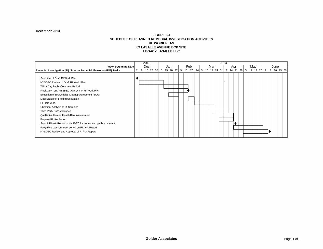
6.0 PROJECT SCHEDULE AND SEQUENCE OF THE WORK Figure 6-1 presents the tentative schedule for planned remedial investigation, interim remedial measures
and assessment of remedial alternatives. As noted, the start of field activities is dependent on NYSDEC
approval of the RI/IRM Work Plan.
~-..
~.. Golder. Associates
December 2013 21 1300732
g:\projects\2013 buffalo projects\1300732 legacy lasalle bcp\ri workplan\legacy lasalle ri work plan (12-03-13).docx
7.0 REFERENCES 1. New York State Department of Environmental Conservation, DER-10; Technical Guidance for
Site Investigation and Remediation, May 2010.
~-..
~.. Golder. Associates

TABLES

Golder Associates Page 1 of 1
December 2013 1300732
Field Samples Duplicates
MS/MSD Samples
Trip Blanks
Test Pit Shallow Soil Samples 3 1 1/1 0 TCL SVOCs
TAL Metals and Cyanide
Subsurface Soil/Fill 15 1 1/1 0 TCL SVOCsTAL Metals and cyanide
Groundwater (3 temporary monitoring wells)
3 1 1/1 1
TCL VOCsTCL SVOCsTCL Pesticides, Total PCBsTAL Total Metals and cyanide
Notes: MS =MSD =VOCs =
SVOCs =TAL =TCL =
TABLE 3-1
Analytical Program SummaryRemedial Investigation
Legacy LaSalle - 89 LaSalle Avenue BCP Site
Number of Samples
Analyses
Matrix Spike
Volatile Organic Compounds
Sample Media
Target Analyte ListTarget Compound List
Matrix Spike Duplicate
Semivolatile Organic Compounds

FIGURES


Golder Associates Page 1 of 1
December 2013
2 9 16 23 30 6 13 20 27 3 10 24 3 10 17 24 31 7 14 21 28 5 12 19 26 2 9 16 23 30
Submittal of Draft RI Work Plan NYSDEC Review of Draft RI Work Plan `Thirty Day Public Comment PeriodFinalization and NYSDEC Approval of RI Work Plan Execution of Brownfields Cleanup Agreement (BCA)Mobilization for Field InvestigationRI Field WorkChemical Analysis of RI SamplesThird Party Data ValidationQualitative Human Health Risk AssessmentPrepare RI /AA ReportSubmit RI /AA Report to NYSDEC for review and public comment Forty-Five day comment period on RI / AA ReportNYSDEC Review and Approval of RI /AA Report
20142013Dec Jan Feb Mar Apr May June
FIGURE 6-1SCHEDULE OF PLANNED REMEDIAL INVESTIGATION ACTIVITIES
RI WORK PLAN89 LASALLE AVENUE BCP SITE
LEGACY LASALLE LLC
Remedial Investigation (RI) / Interim Remedial Measures (IRM) TasksWeek Beginning Date
17